ay n
W
S W Stea r ns
Dr SW
&
ar Cl
ay kW
2. CIRCULATION
4. GEOLOGIC Geotech City Park/Rose Garden Area Conflicts
Le
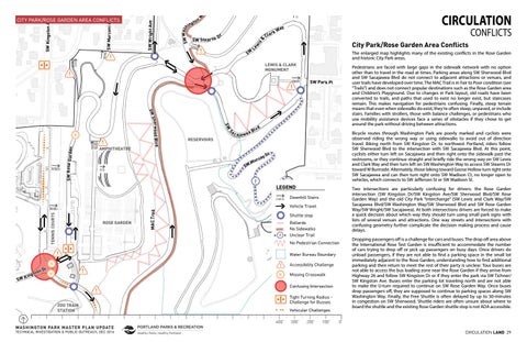
STORMWATER Stormwater&Utilities The enlarged map highlights 5.many of the existing conflicts in the Rose Garden and historic City Park areas. 6. SOCIAL VIsitor Experience/Recreation
Pedestrians are faced with large gaps in the sidewalk network with no option other than to travel in the road at times. Parking areas along SW Sherwood Blvd and SW Sacajawea Blvd do not connect to adjacent attractions or venues, and user trails have developed over time. The MAC Trail is in Fair to Poor condition (see “Trails”) and does not connect popular destinations such as the Rose Garden area and Children’s Playground. Due to changes in Park layout, old roads have been converted to trails, and paths that used to exist no longer exist, but staircases remain. This makes navigation for pedestrians confusing. Finally, steep terrain means that even when sidewalks do exist, they’re often steep, unpaved, or include stairs. Families with strollers, those with balance challenges, or pedestrians who use mobility assistance devices face a series of obstacles if they chose to get around the park without driving between attractions.
SW Park Pl
SW
S
ood Blvd Sherw
SW Rose G a rden
SW
AMPHITHEATRE
ac
d Blv a aja w e
SW
rr a Mu
?
Bicycle routes through Washington Park are poorly marked and cyclists were observed riding the wrong way or using sidewalks to avoid out of direction travel. Biking north from SW Kingston Dr. to northwest Portland, riders follow SW Sherwood Blvd to the intersection with SW Sacajawea Blvd. At this point, cyclists either turn left on Sacajawea and then right onto the sidewalk past the restrooms, or they continue straight and briefly ride the wrong way on SW Lewis and Clark Way and then turn left on SW Washington Way to access SW Stearns Dr toward W Burnside. Alternately, those biking toward Goose Hollow turn right onto SW Sacajawea and can then turn right onto SW Madison Ct, no longer open to vehicles, which connects to SW Jefferson St or SW Madison St.
t yS
LEGEND
Two intersections are particularly confusing for drivers: the Rose Garden intersection (SW Kingston Dr/SW Kingston Ave/SW Sherwood Blvd/SW Rose Garden Way) and the old City Park “interchange” (SW Lewis and Clark Way/SW Sacajawea Blvd/SW Washington Way/SW Sherwood Blvd and SW Rose Garden Way/SW Wright/SW Sacajawea). At both intersections drivers are forced to make a quick decision about which way they should turn using small park signs with lists of several venues and attractions. One way streets and intersections with confusing geometry further complicate the decision making process and cause delays.
Downhill Stairs
MAC Tra il
TENNIS COURTS
Vehicle Travel
ROSE GARDEN
Shuttle stop
?
Bollards No Sidewalks Unclear Trail No Pedestrian Connection Water Bureau Boundary
SW
Accessibility Challenge
r on D t s g K in
Missing Crosswalk Confusing Intersection Tight Turning Radius Challenge for Busses
ZOO TRAIN STATION
Vehicular Challenges 400’
WASHINGTON PARK MASTER PLAN UPDATE
TECHNICAL INVESTIGATION & PUBLIC OUTREACH, DEC 2016
CONFLICTS
3. HABITAT Natural resources
LEWIS & CLARK MONUMENT
RESERVOIRS
CIRCULATION
1. BUILT Historical/land use/structural
is
to ing
w
a SW W sh
SW Wright Ave
SW Kingston Ave
SW Marconi Ave
CITY PARK/ROSE GARDEN AREA CONFLICTS
300’
200’
100’
Dropping passengers off is a challenge for cars and buses. The drop off area above the International Rose Test Garden is insufficient to accommodate the number of cars trying to drop off or pick up passengers on busy days. Once drivers do unload passengers, if they are not able to find a parking space in the small lot immediately adjacent to the Rose Garden, understanding how to find additional parking and then return to meet the rest of their party is unclear. Tour buses are not able to access the bus loading zone near the Rose Garden if they arrive from Highway 26 and follow SW Kingston Dr or if they enter the park via SW Tichner/ SW Kingston Ave. Buses enter the parking lot traveling north and are not able to make the U-turn required to continue on SW Rose Garden Way. Once buses drop passengers off, they are supposed to continue to parking spaces along SW Washington Way. Finally, the Free Shuttle is often delayed by up to 30-minutes in congestion on SW Sherwood. Shuttle riders are often unsure about where to board the shuttle and the existing Rose Garden shuttle stop is not ADA accessible.
0’ CIRCULATION LAND 29