GEOTECHNICAL & RESILIENCY
e St
LANDSLIDE HAZARDS
Dr hner Tic W S
Introduction Significant areas within Washington Park are at a 1:1 slope (45 degrees) or steeper. The elevation ranges from 200 feet to 900 feet. The contact between the Portland Hills Silt and the underlying unweathered basalt represents a plane of weakness that is associated with landslides.
SW Kingston Ave
W Burnsid
SW Park Pl
SW
lvd SW
d oo
B
Ki ng sto nD r
wB
SW
vie Fair
Kn i
B ts gh
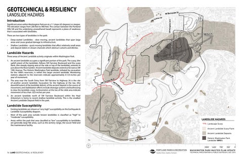
1. An ancient landslide occupies a significant portion of the park. The scarp, (the uphill extent of the landslide), follows SW Fairview Boulevard and the scarp flank, (the steeply sloping area at the side or top of the landslide), extends to just above the Rose Garden. Ancient landslide deposits extend as far east as SW 19th Avenue. The Historic Washington Park landslide, initiated by excavation for the 1890’s reservoirs, is within this larger ancient landslide. Monitoring stations adjacent to the reservoirs indicate approximately 0.125-inches per year of movement. 2. The area near the South Entry from SW Fairview to Highway 26 is the site of another ancient landslide. Excavation for the highway at the toe, (the downhill extent of the landslide debris), of the ancient deposit is the source of movement, and stabilization efforts include drainage systems and buttressing to slow the landslide creep. Inclinometers at the toe of the slide area indicate movement of less than .025-inches per year. 3. An ancient landslide north of SW Fairview Boulevard within the Hoyt Arboretum is home to recent shallow landslide activity. This is the smallest Ancient Landslide Deposit field in the park.
SW Fi s
Three areas of Ancient Landslide activity originate within Washington Park.
lvd
Landslide Hazards
SW She rw
•
Deep-seated Landslides - slow moving, ancient landslides that span large areas and cause gradual damage to infrastructure. Shallow Landslides - quick moving landslides that affect relatively small areas and deposit debris in stream channels which obstruct culverts and ditches. c h e r Ln
•
S W Rose Garden Way
There are two types of landslides in the park:
lv d
Landslide Susceptibility • • •
Existing landslides are shown as “very high” susceptibility on the Earthquake & Landslide Susceptibility diagram. Most of the park area outside known landslides is classified as “high” to “moderate” susceptibility. Areas within the park that area classified as “low” susceptibility to landslides are generally large flat areas, such as the archery range, the soccer field and the maintenance facility.
LANDSLIDE HAZARDS Landscape Scarp Ancient Landslide Scarp Flank Ancient Landslide Deposits
wy 26
U.S. H
Historic Washington Park Landslide 1890’s 2800’
14 LAND GEOTECHNICAL & RESILIENCY
1400’
700’
350’
0’
WASHINGTON PARK MASTER PLAN UPDATE
TECHNICAL INVESTIGATION & PUBLIC OUTREACH, DEC 2016