Stormwater Concepts and Site Programming Study
Strawbery Banke Museum
8.1.2024


Strawbery Banke Museum
8.1.2024
This report builds upon the Stormwater Management Plan of 2023 and is the work of Strawbery Banke Museum staff members, the consulting design team, and numerous contributors from the City of Portsmouth and neighboring organizations that share the desire to create a more resilient campus through a comprehensive stormwater management approach to better manage both the on-site and off-site water runoff. Strawbery Banke Museum would like to thank the many contributors for their efforts and insights during the development of the Stormwater Concepts and Site Programming Study. We look forward to working together to improve storm water management throughout this section of the City.
• Linnea Grim, President & CEO
• Rodney Rowland, Director of Environmental Sustainability
• Elizabeth Farish, Chief Curator
• Alexandra Martin, Archaeologist
• Matthew Kochka, Horticulturist
• Joe April, Director of Development
• Jon Brown, Director of Visitor Services
• Bekki Coppola, Director of Education
• Veronica Lester, Director of Marketing
• Rachel Novak, Administrative Assistant
• Chris Smith, Interpreter
• Dawn Hamilton, Interpreter
• Wendy McCoole, Corporate and Community Engagement Manager
• Claudia Wu, Trustee
• Tamera Henderson, Trustee
Consulting Team
• Placework
* Brian Murphy, AIA, LFA
* Liz Nguyen, AIA
• Stimson
* Greg Tuzzolo, RLA
* Sara Lawrence, RLA
* Jiin Choi
• Horsley Witten Group
* Brian Kuchar, PE, RLA
* Ellen Biegert, RLA
• GZA GeoEnvironmental
* Andrew Fournier
* David Lamonthe, PE
• Planning Department
* Peter Britz, Planning Director
• Department of Public Works
* Brian Goetz, Director of Water Resources
* Erich Fielder, City Engineer
* Jamie McCarty, GIS/Stormwater Manager
• City Government
* Kate Cook, City Councilor and South End Resident
• Polly Crocker, NHDES and NH Coastal Adaptation Working Group
Community Advisory
• Bill Arcieri, Volunteer and Environmental Consultant
• Mary Beth Lambert, South End Resident
• Richard Candee, Resident and Historian
• Proposed Seasonal Ice Skating Rink, Strawbery Banke
Marcy Street
Portsmouth, New Hampshire
Amended Permit Site Plans
Ambit Engineering, Inc. May 25, 2018
• Geotechnical Investigation New Orientation Building, Strawbery Banke
Portsmouth, New Hampshire
R.W. Gillespie & Associates, Inc.
• A Plan for Prescott Park
City of Portsmouth
Weston & Sampson Design Studio
January 31, 2017
• 1813 Hales Map
• 1877 Ruger’s Bird’s Eye View
• Coastal Resilience Initiative
City of Portsmouth
• SeaLevelRise.org
• New Hampshire Coastal Flood Risk Summary Part I: Science
University of New Hampshire, August 2019
• New Hampshire Coastal Flood Risk Summary Part II: Guidance for Using Scientific Projections
University of New Hampshire
Draft for Public Review Released September 2019
• Flood Insurance Rate Map # 33015C0259E
Effective Date May 17, 2005
• GIS Utilities and Drainage Data
City of Portsmouth, NH
All photos are courtesy of Strawbery Banke Museum unless otherwise noted.
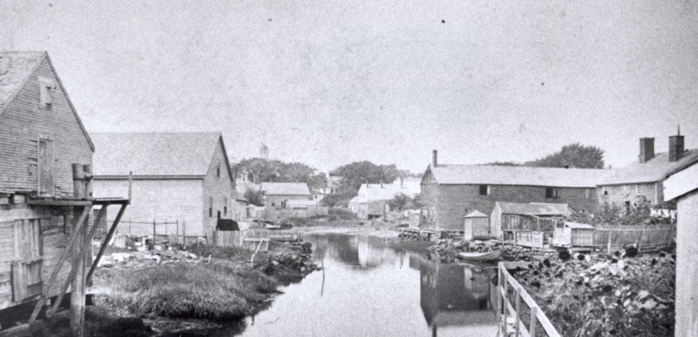
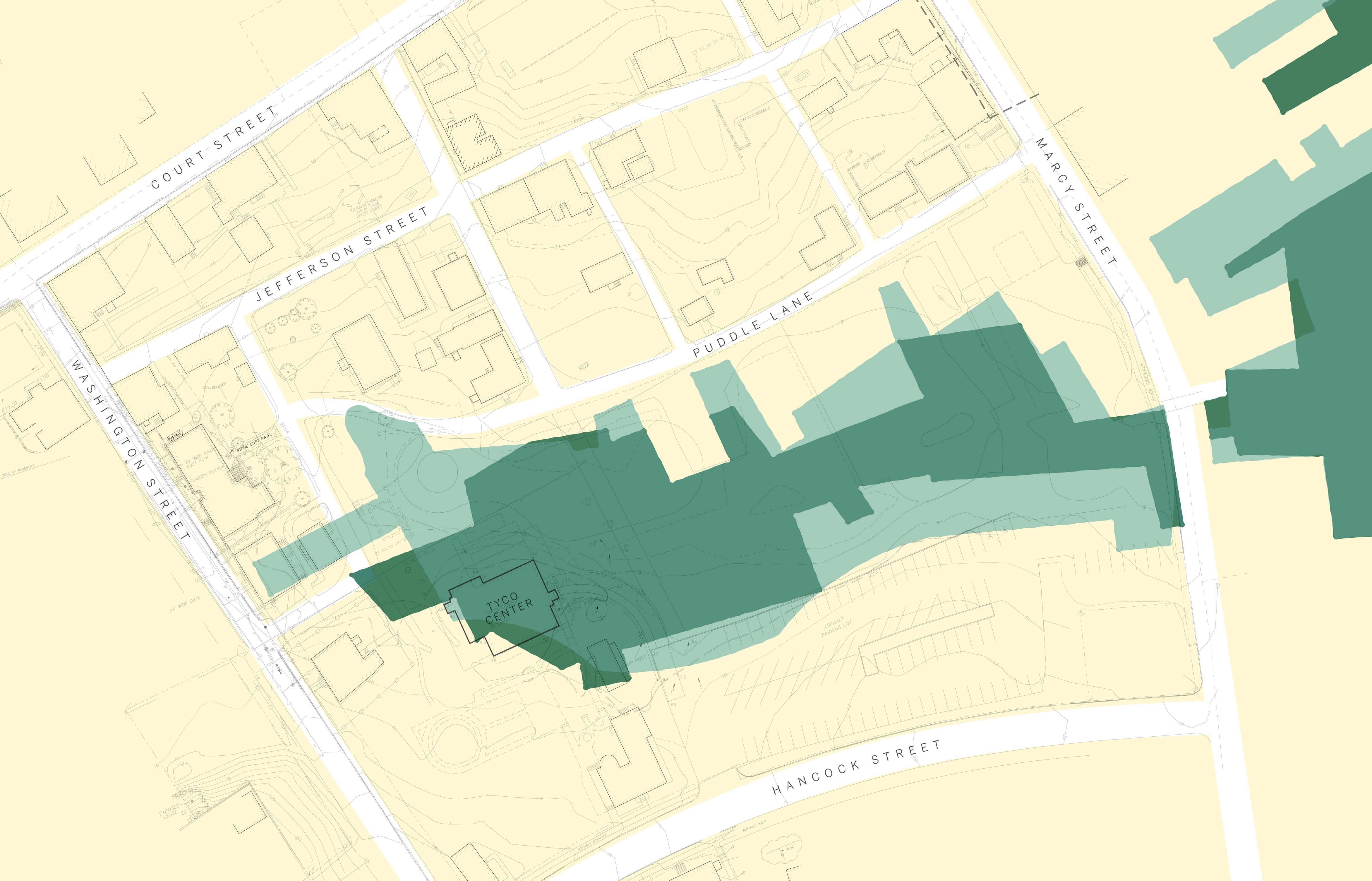
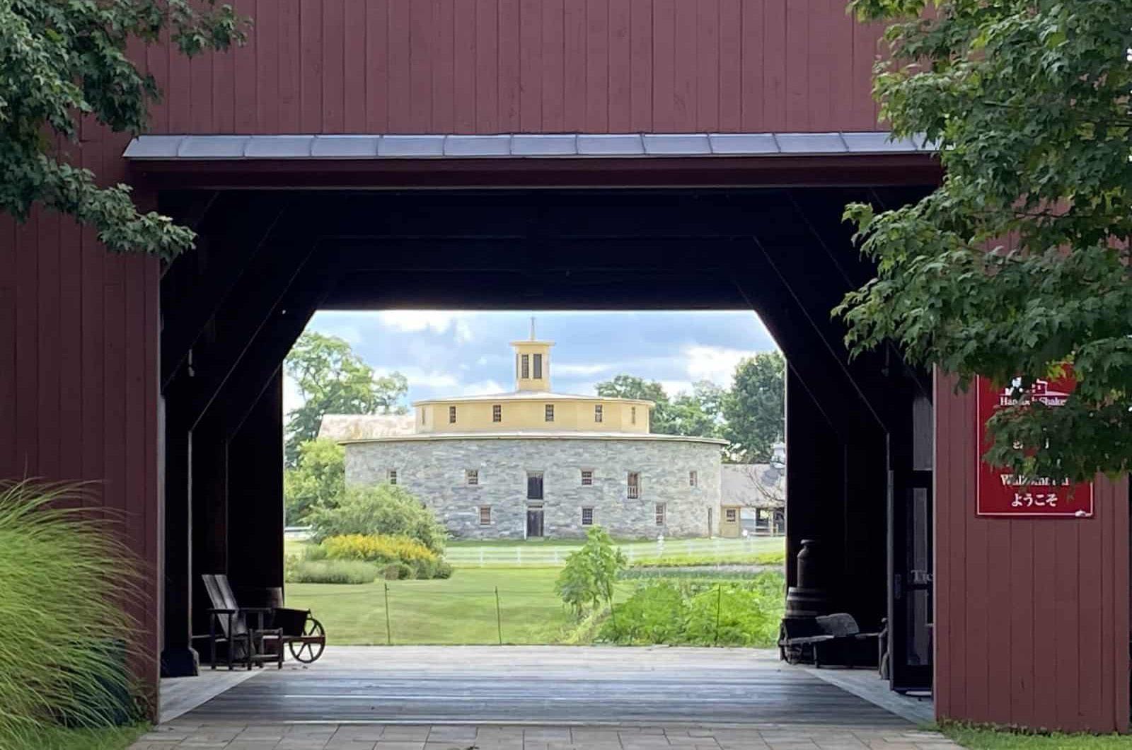
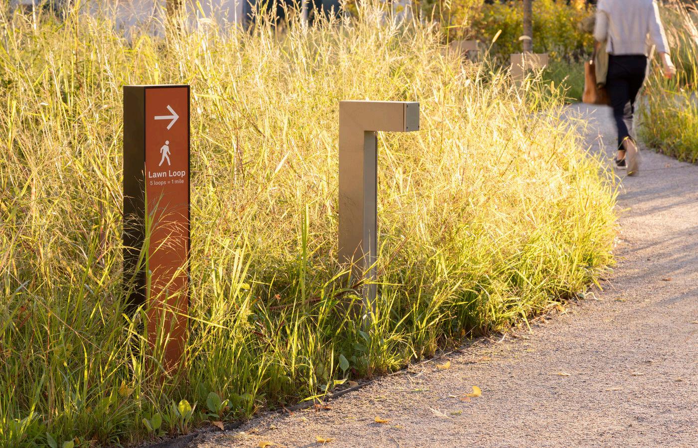
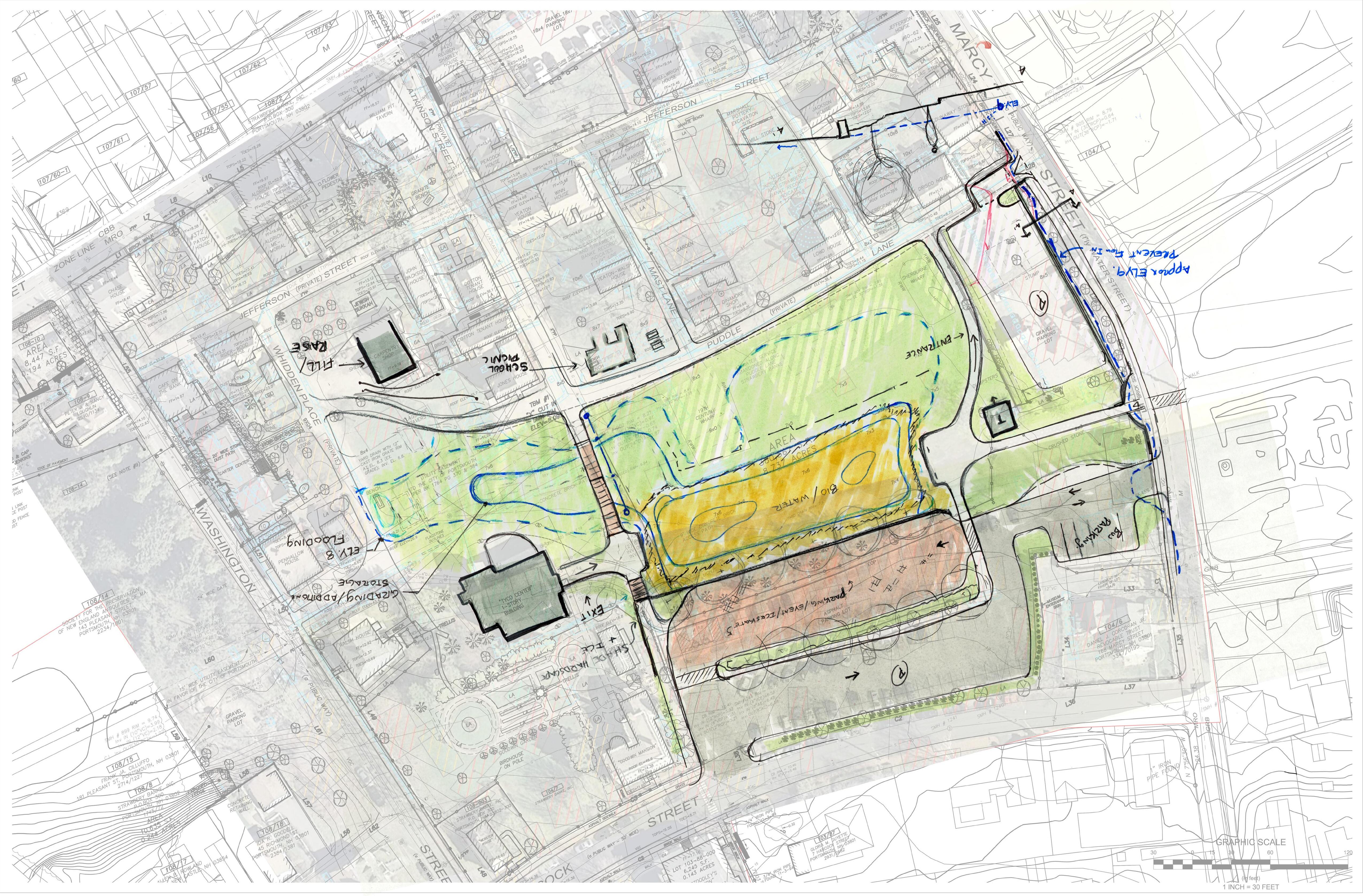
Puddle Dock is the organizing center of Strawbery Banke Museum – both a social hub and a historic vantage point from which to explore the buildings and grounds of this former industrial waterfront. To address stormwater management on Puddle Dock, the museum has invited the design team to consider the impacts of any interventions on preservation, archaeology, horticulture, education, events, the ice rink, parking lots, visitor approach, and the public interface along Marcy Street.
Given the broad scope of this project, this study seeks to advance the initial concepts for the proposed stormwater improvements in the Puddle Dock area, comprised of the Carpenter’s Shop, ice rink, and central lawn area as identified in the Stormwater Management Plan. Through a series of workshops on campus, this phase defines the scope of work in order to target fundraising efforts through both private donations and state and federal grant programs.
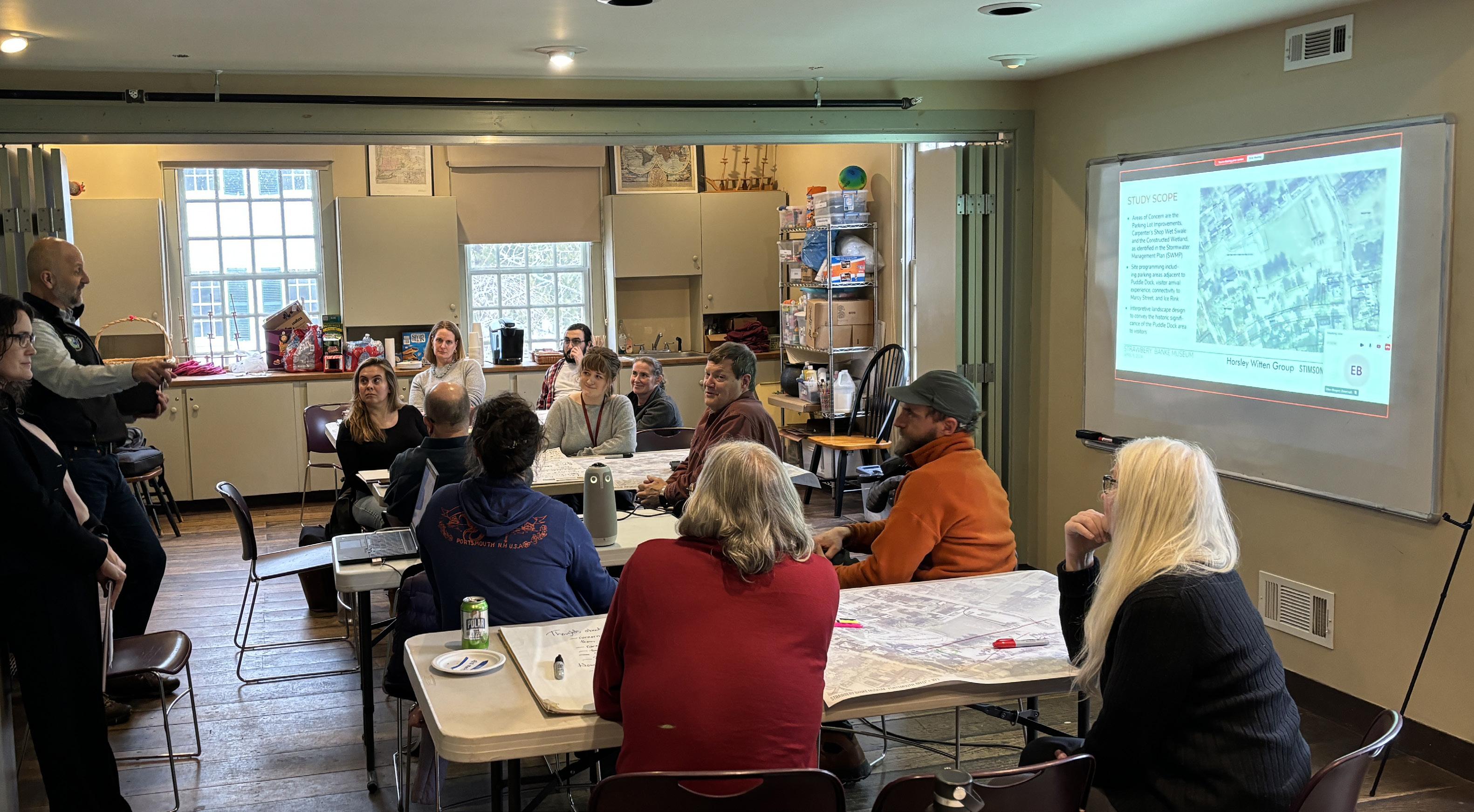
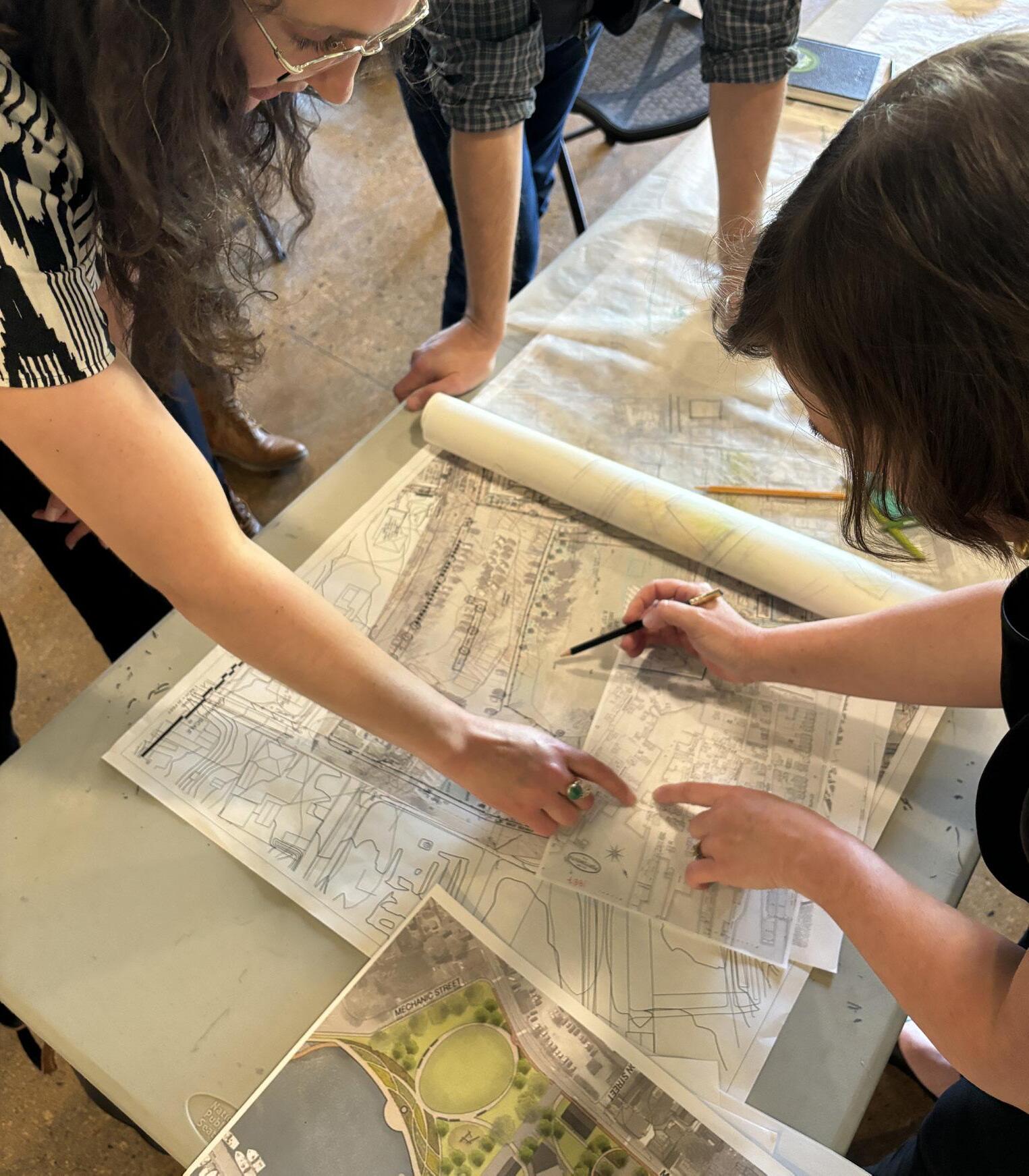
The design team conducted multiple meetings and workshops including a preliminary meeting with museum leadership, a staff workshop at Stoodley’s Tavern, and a two-day Design Charette at the Yerdon Visitor Center which brought a large group of community and museum participants into the process and specific program areas were explored in depth. The charette culminated in several design concepts, which have been distilled into one scheme that is the focus of this report. The initial design concepts can be found in the addenda to this report.
Following the discoveries of this Concept Study the design team will have sufficient information to prepare a proposal for the Schematic Design and Design Development phases that will refine scope, costs, and additional project requirements needed for the Construction Documentation phase and ultimately, Construction.
The mission of Strawbery Banke Museum is to promote understanding of the lives of individuals and the value of community through encounters with the history and ongoing preservation of a New England waterfront neighborhood.
Water began to infringe on the museum’s ability to serve this mission when both localized and large-scale flooding began to damage both landscape and built features throughout the site. In fact, management of water has been an issue for the campus since the Puddle Dock inlet was filled in over one hundred years ago. As the low point of the neighborhood, the campus has long had an issue with stormwater runoff. In recent years, stormwater has flooded the central lawn, preventing its use as an event space, creating safety hazards when paths are blocked, or maintenance problems when paths are washed away. Even more concerning, both an increase in stormwater and rising groundwater due to climate change have begun to have a negative effect on the primary asset of the museum: its historic buildings.
Recognizing these ongoing challenges, Strawbery Banke Museum collaborated with Placework and the Horsley Witten Group to create the campus-wide Stormwater Management Plan of 2023. The plan takes a watershed approach to identify the problems and provide recommendations to improve localized stormwater management within the surrounding neighborhoods and the Strawbery Banke Museum campus. Thinking long-term, the Plan aims to alleviate stormwater impacts while maintaining alignment with the Museum’s mission to preserve historic buildings and cultural landscapes for today’s visitors and for future generations.
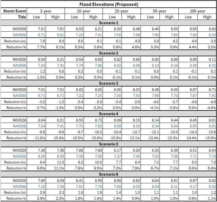
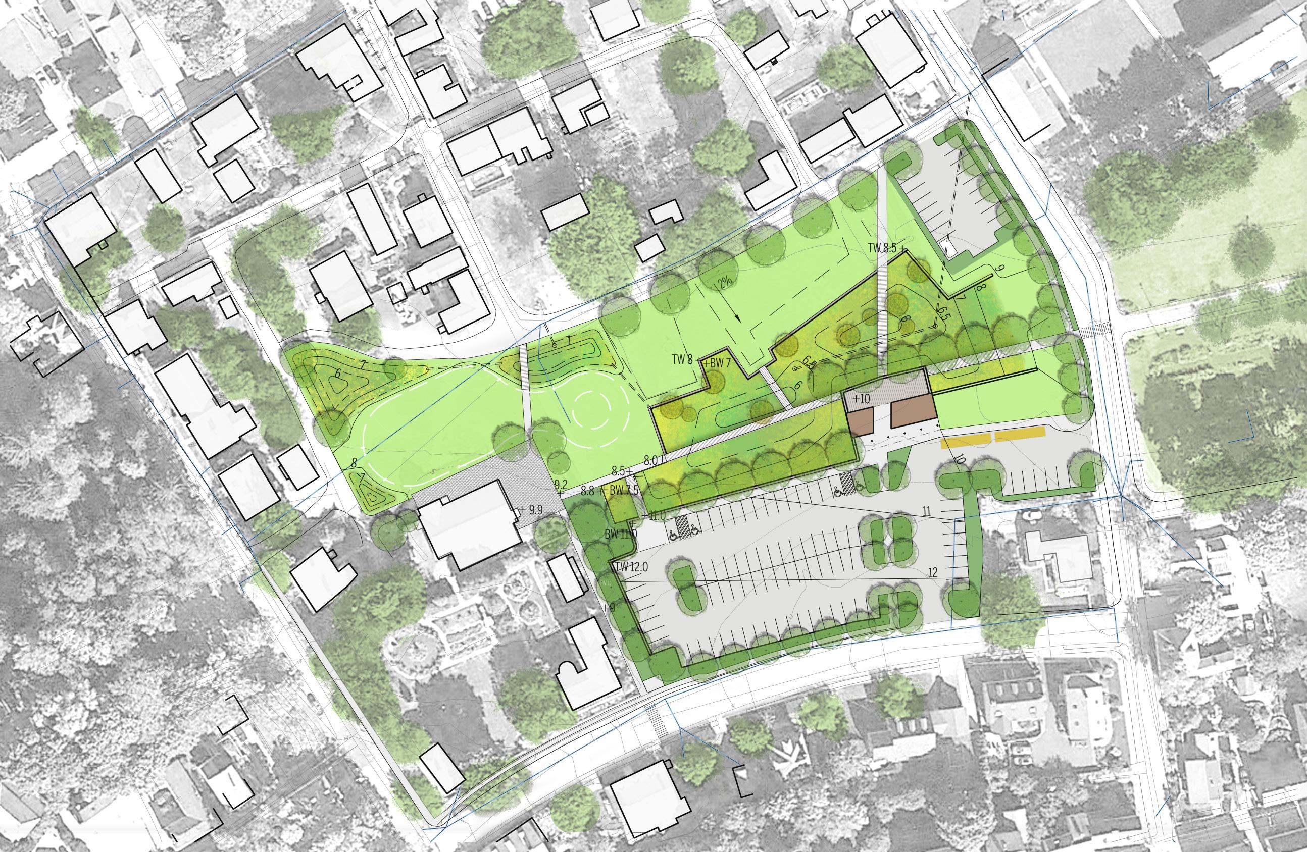
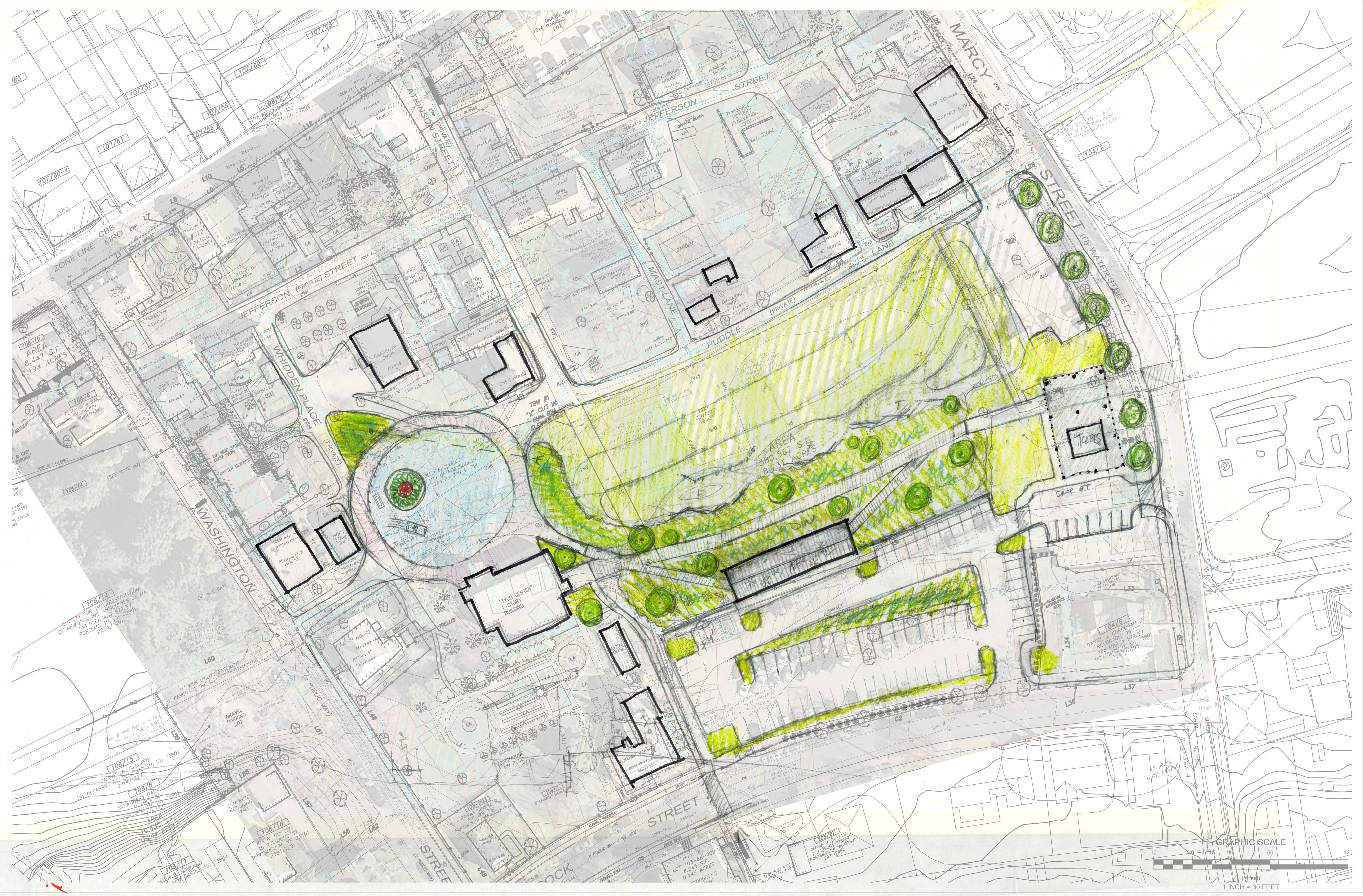
This report builds upon the recommendations of the Stormwater Management Plan for the Puddle Dock area and it’s immediate surroundings, including the three identified areas of concern: the carpenter’s shop wet swale (5), the constructed wetland in the puddle dock lawn (6) and the designed floodplain in the puddle dock lawn (7). Adjacent program areas that feed into or directly impact those identified scopes are addressed in this study, including the parking lots, visitor center access, ice rink, and Puddle Lane, as outlined in the image at right. This report summarizes both the technical groundwork undertaken to understand and control stormwater on site and the opportunities any site interventions could offer to further the mission of the museum.
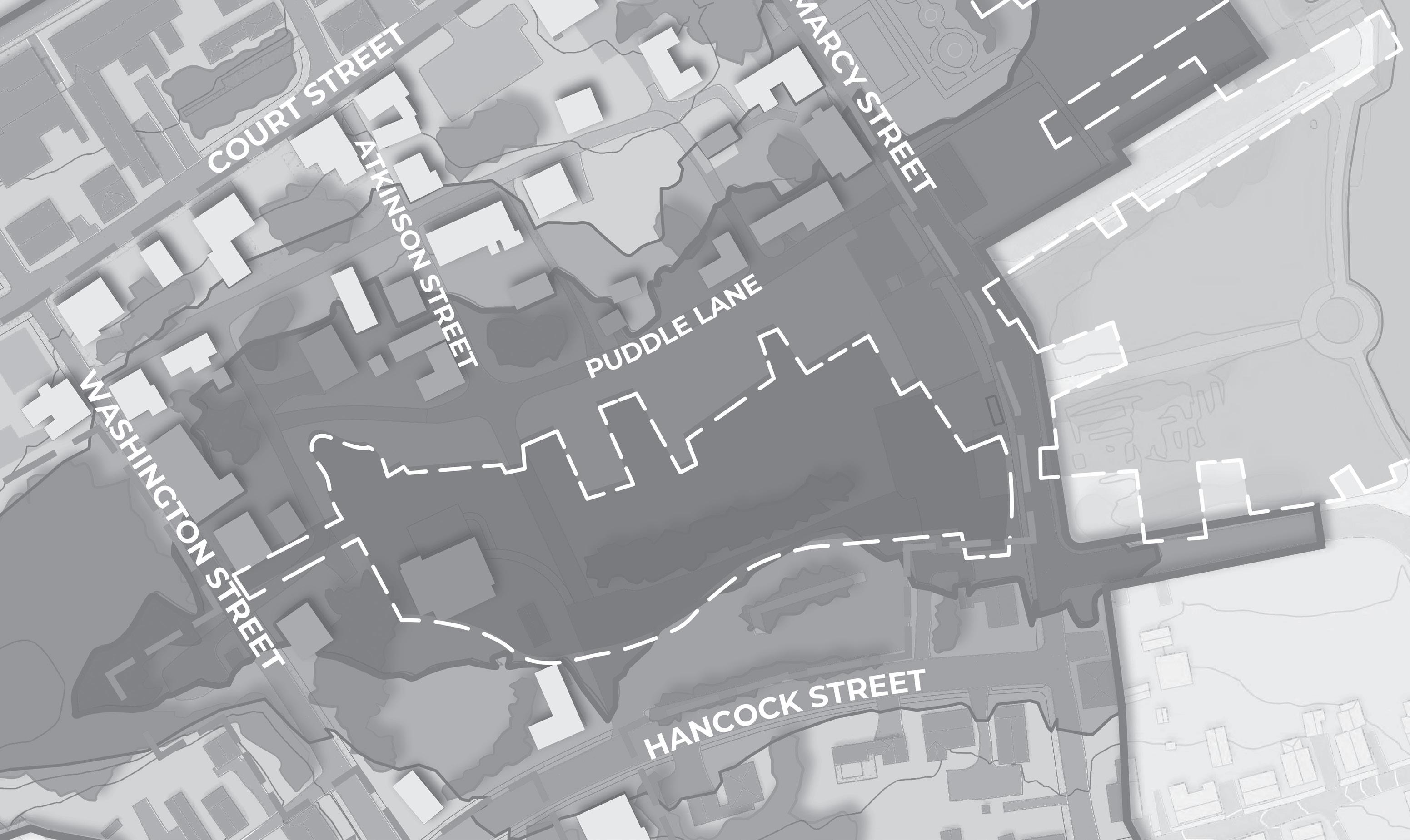
Historic Wharves
Lanes and footpaths
Tidal surface flooding path
Approximate Scope of Work Area

The following guiding principles and stormwater goals, as defined in the Stormwater Management Plan, were applied during the planning and conceptual design process for the proposed Puddle Dock improvements.
Throughout the planning process the following principles were reiterated and woven into conversation and design decisions beyond stormwater management. They acted as guidelines when considering the overall visitor experience, day to day function of the area, circulation and many other layers that were considered in the Puddle Dock area.
• How can the museum become more resilient to the effects of climate change?
• How can this work become a new education opportunity?
• How do we continue to preserve the history of this place?
• How can we be become a role model for our community and beyond?
The goals established in the Stormwater Management Plan provided guidance during the planning and design process. The main objective for the proposed improvements within the central lawn space is to address stormwater management around Puddle Dock. However, Strawbery Banke Museum, and the Puddle Dock area in particular, have many important overlapping layers to consider. The goals from the Stormwater Management Plan were expanded to ensure the site and its many uses are consistent with Strawbery Banke’s mission and vision as a museum. These expanded goals were established based on the initial visioning session and conservations with the museum staff followed by a two-day charette workshop on the Strawbery Banke campus. Through these conversations and exercises it became clear that the design must carefully consider the integration of design elements beyond the stormwater issues to improve the visitor’ s experience and be consistent with their mission.
reconsider visitor flow and public access on grounds demonstrate functional plantings and historic landscapes
make artifacts visible for interpretation
improve facilities for rental events
make rink energy efficient and support stormwater and event needs
framed by the guiding principles of
preserve buildings and improve access
improve bus circulation, lighting, and accessibility
Resiliency Leadership • Historic Preservation • Interpretation & Education • Community Engagement
The following is a high-level summary of the goals established during the planning process. The original goals established in the Stormwater Management Plan are included in black and the additional goals in bold. For a more detailed summary of the Workshop and Charette discussions, see the Discovery section of this report.
• Create a sense of arrival and presence on Marcy Street
• Reconsider visitor flow and public access on grounds.
• Improve bus and vehicular circulation.
• Identify opportunities to reduce localized flooding.
• Manage, control and move water through the campus.
• Reduce erosion along internal roadway surface materials while preserving historic character, and improving accessibility.
• Redesign the campus use areas to embrace stormwater runoff, while embracing the history of water on the site.
• Incorporate educational components during each phase of implementation, use the landscape as an opportunity for interpretation.
• Preserve historic artifacts.
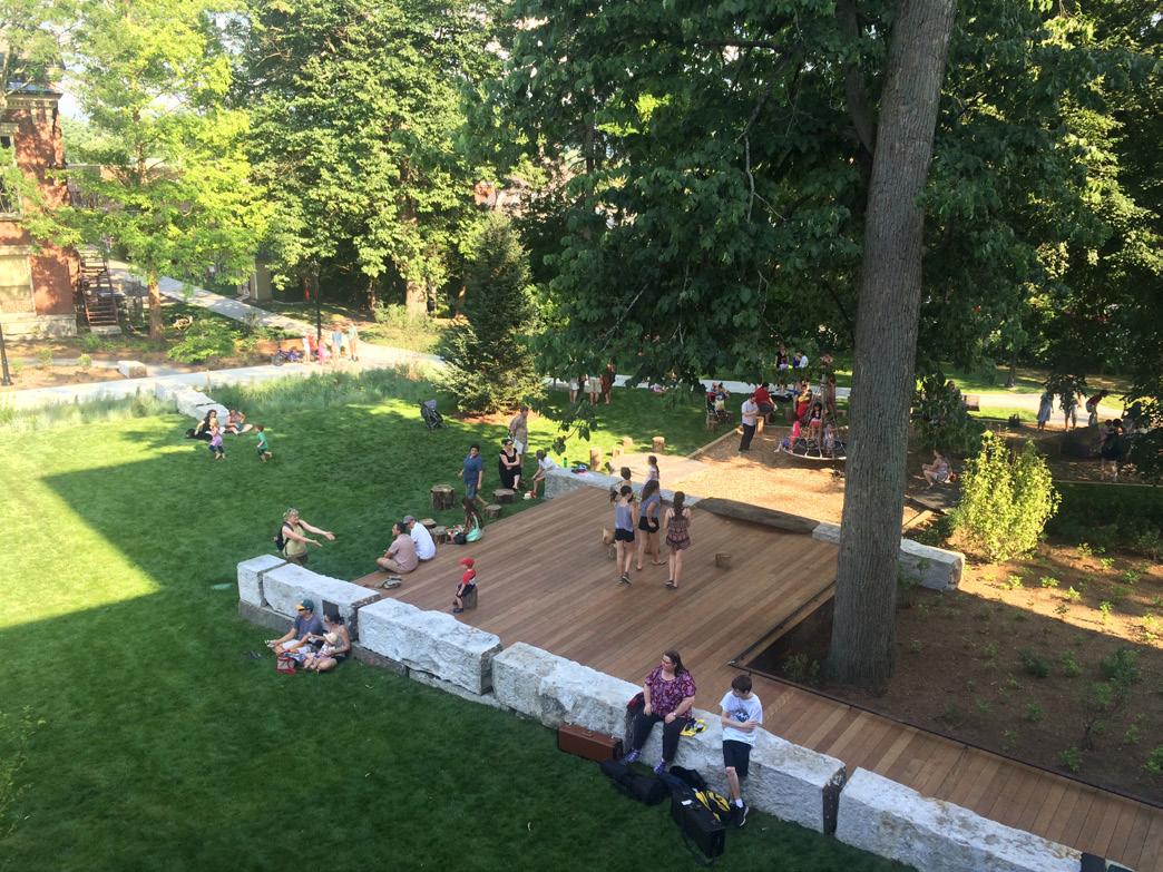
• Maintain and improve usable open space for events and the community.
• Seek grant funding along with other funding sources.
• Eliminate off-site contributing stormwater runoff by diverting it or disconnecting it from the campus.
• Continue to work with the City to implement stormwater controls and improvements to the contributing roadways and drainage infrastructure.
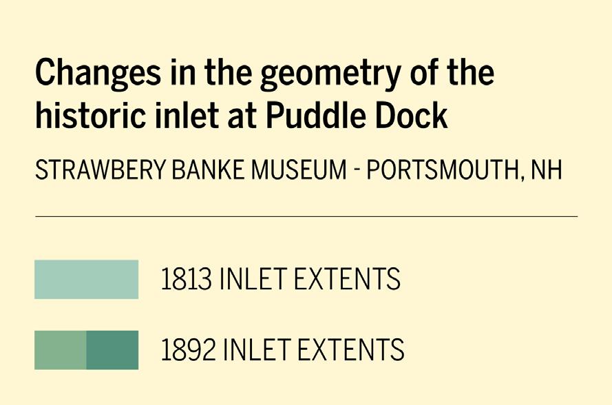
The first step in the design process, as outlined in the Stormwater Management Plan’s Action Plan, was to complete additional field assessment of the existing conditions in the Puddle Dock area. Due to the historic uses and the changes in the geometry (filling) of the historic Puddle Dock inlet (see diagram on page 14), along with its location in a low-lying flood prone area, a preliminary soil assessment was completed by the design team in February 2024. This included a site soil evaluation completed by Horsley Witten Group, Inc. to estimate the seasonal high-water table and a preliminary subsurface assessment completed by GZA GeoEnvironmental (GZA) to better understand the quality of the fill material in the project area. Further investigation of the existing stormwater infrastructure of the campus was also completed along with the development of a stormwater model to assess the existing conditions and the impacts of any proposed changes.
The soil evaluation, along with empirical evidence of tidal influence on basement water levels at Strawbery Banke, suggests a correlation between high tide and high groundwater levels within the historic Puddle Dock area. Groundwater levels were observed to be between 3.1 and 3.7 feet below the ground surface at the time of the evaluation, which occurred following the morning high tide. In general, the soil and depth to groundwater encountered during the soil boring observations appears to be suitable for stormwater management. Based on the observed depths of groundwater, the creation of a constructed wetland may require the excavation of up to 5 feet of material in certain locations to create both shallow and deep pools of open water, which may be problematic due to the soil conditions.
Based upon GZA’s preliminary findings, the site soils generally consisted of deleterious fill overlying a marine deposit and GZA recommends reusing any excavated soils on-site to the extent practicable and covering the relocated fill with a minimum of one foot of clean, uncontaminated soil. If soils cannot be reused on-site, soils will need to be stockpiled and sampled prior to off-site disposal. Given the past usage of the site, the presence of ash and other potential contaminants, it is GZA’s opinion that there is a high probability that the soils contain concentrations of compounds that exceed the state Soil Remediation Standards (SRS). Please note that if the soil sample results exceed the state SRS, Strawbery Banke will need to report the results to New Hampshire Department of Environmental Services (NHDES) in accordance with the New Hampshire Code of Administrative Rules Chapter Env-Or 600. NHDES would likely require additional environmental characterization of the site to determine the extent, potential source(s), and the nature of the contamination.
Based on these findings, additional stormwater management techniques such as vegetated swales, rain gardens (bioretention areas), and vegetated stormwater basins, were considered during the conceptual design process. Further, any proposed stormwater management system will need to take into consideration the specific soil characteristics, the seasonal and storm-induced variable depth to groundwater, the salinity content of the groundwater and off-site soil disposal. The full summary of findings memo for the site soil evaluation and preliminary soil assessment can be found in the Addenda to this report.
The Federal Emergency Management Agency (FEMA) Flood Insurance Rate Map (FIRM) 33015C0259F shows Strawbery Banke within a FEMA AE Flood Zone with a base flood elevation (BFE) of 8 feet. An AE Zone indicates an area inundated by 100-year flooding, for which a base flood elevation (BFE) has been determined. For Strawbery Banke, this area encompasses the entire Puddle Dock, Puddle Lane, up to the Carpenters Building, and the Penhallow House. It is important to note the topographical survey used for the conceptual designs and the FIRM are based on different vertical datum. The survey datum is based upon National Geodetic Vertical Datum of 1929 (NGVD 29) and the FIRM is based on North American Vertical Datum of 1988 (NAVD 88). The difference between the two datums is approximately 0.6.’ The proposed conceptual design grading and stormwater modeling is based on the survey (NGVD29) and has been converted to NAVD88 to correspond with the FEMA BFE.
The contributing watershed, associated land cover and stormwater infrastructure at Strawbery Banke campus was delineated and assessed during the development of the Stormwater Management Plan. Building upon this data, a preliminary existing conditions drainage analysis was completed to evaluate the runoff rates and volumes currently generated and contributing to localized flooding in the Puddle Dock area.
The drainage analysis was completed by performing the following series of tasks:
• Preliminary overall assessment of the contributing drainage area for the Strawbery Banke campus.
• Refining the watershed boundary, land coverage and individual subcatchments within the project area.
• Confirming the existing infrastructure based upon the best available data.
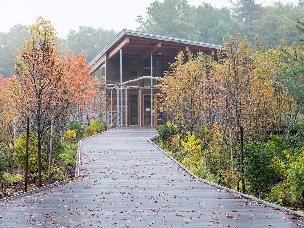
• Preliminary modeling of the existing and proposed drainage with HydroCAD® software for the 2, 10-, 25-, 50- and 100-year storms.
Please note, the assessment and modeling does not address the impacts of flood related issues caused by the large contributing areas that currently drain through the site via a 30-inch drain pipe or the impacts of rising sea levels and flooding from the Piscataqua River.
Rainfall amounts for the specified storm events are based on the most current 90th percentile precipitation estimates from the National Oceanic and Atmospheric Administration (NOAA) Atlas 14 Point Precipitation Frequency Estimates for the area.
Modeling scenarios were run for high and low tide conditions. For high tide it was assumed that the 30-inch pipe and outlet structure to the river were inundated, and the stormwater could only leave the site via over land flow near a low point in the gravel parking area. During low tide it was assumed the existing drainage infrastructure in the Puddle Dock area is functioning at normal capacity. Below is a table summarizing the findings. Given the difference in vertical datum between the topographic survey and the FEMA Flood Insurance Rate Map the preliminary
modeling results are presented in both NGVD29 and NAVD88.
leave the site leaving the site would be via over land flow near the a low point in the gravel parking area. During low tide it was assumed the existing drainage infrastructure in the Puddle Dock area are is functioning at normal capacity. Below is a table summarizing the findings. Given the discrepancies difference in vertical datum between the topographic survey data and the FEMA Flood Insurance Rate Map the preliminary modeling data results is are presented in both NGVD29 &and NAVD88
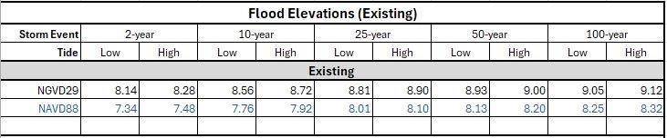
The elevations shownresults indicate that during most storm events the flooding reaches back to the elevations near the Carpenters Shop of 8.XX. feet. However, this model is based on survey data, which is most likely outdated given that t predates any grading that has occurred to accommodate the ice-skating rink. It is also important to note that the model does not account for the available capacity of the 30-inch drain pipe running through Strawbery Banke during the rain events.
Permitting
Shoreland Protection
It is important to note that the model is based on 2007 topographic survey data provided by Strawbery Banke and is most likely outdated given that it predates any grading that has occurred to accommodate the ice-skating rink. It is also important to note that the model does not account for the available capacity of the 30-inch drain pipe running through Strawbery Banke during the rain events. It is recommended that the topographic survey be updated and coordination with any City engineering department’s stormwater modeling of the 30-inch drain line be completed during the next phase of design.
The New Hampshire Shoreland Water Quality Protection Act (SWQPA) establishes a 250’ protected shoreland buffer from the edge of the Piscataqua River at its full volume Proposed land development and site improvements within the protected shoreland is regulated by the NH Department of Environmental Services (NHDES) and requires a shoreland permit. The proposed Puddle Dock improvements are located beyond 250 feet from the river and a permit will not be required.
Alteration of Terrain
The New Hampshire Shoreland Water Quality Protection Act (SWQPA) establishes a 250’ protected shoreland buffer from the edge of the Piscataqua River at its full volume. Proposed land development and site improvements within the protected shoreland is regulated by NHDES and requires a shoreland permit. The proposed Puddle Dock improvements are located beyond 250 feet from the river and a permit will not be required.
An Alteration of Terrain (AOT) permit regulated by NHDES is required if a project proposes to disturb more than 100,000 square feet of contiguous terrain (50,000 square feet, if any portion of the project is within a protected shoreland). AOT "General Permits by Rule" apply to smaller sites, which do not require applications or notifications. The estimated area of disturbance for the Puddle Dock Improvements is approximately 3.5 acres (152,500 sf +/-) and an AOT permit will be required.
City
Coordination with the City of Portsmouth’s engineering department is required for the proposed additional connections to the 30-inch drain line. Additional permitting may also be required at the city level.
EPA National Pollution Discharge Elimination System (NPDES) - General Permit
An Alteration of Terrain (AOT) permit regulated by NHDES is required if a project proposes to disturb more than 100,000 square feet of contiguous terrain (50,000 square feet, if any portion of the project is within a protected shoreland). AOT “General Permits by Rule” apply to smaller sites, which do not require applications or notifications. The estimated area of disturbance for the Puddle Dock Improvements is approximately 3.5 acres (152,500 sf +/-) and an AOT permit will be required.
Coordination with the City of Portsmouth’s engineering department is required for the proposed additional connections to the 30-inch drain line. Additional permitting may also be required at the city level.
EPA NATIONAL POLLUTION DISCHARGE ELIMINATION SYSTEM (NPDES) GENERAL PERMIT FOR DISCHARGES FROM CONSTRUCTION ACTIVITIES (CONSTRUCTION GENERAL PERMIT OR CGP)
Any “construction activity” that will disturb one or more acres of land and discharges stormwater to waters of the U.S. must obtain NPDES permit coverage. “Construction activities, includes clearing, grading, and excavation of land, and other construction-related activities (e.g., grubbing, stockpiling of dredged or fill materials)”.
Strawbery Banke Museum devoted significant staff time and invited numerous external participants into the visioning effort for this study, as recognized in the Acknowledgments section of the Executive Summary. While the Goals section of this report lists the key goals guiding the design effort, a more complete summary of the comments and feedback follows. Participants were generous with their time and ideas, many of which this summary does not capture in their specifics. Our intent is that the detailed notes will help guide the design as it is furthered in the next phases. The design proposal sketches generated at the charette can be found in the Addenda to this report
• This project should be a catalyst to the city and beyond to be forward thinking and address climate change.
• Manage water to protect historic assets and maintain continuity of museum operations. (See Goals section for specifics regarding water management).
• Elevate the importance of native plant species and indigenous landscapes to the history and future of this place.
• Showcase design adaptations that elevate visitor experience and further the mission and vision of Strawbery Banke.
• Be a leadership model for other institutions and educate our community.
• Strategies should better connect the site across Puddle Dock, including the physical relationship between the Visitor Center, the restaurant, and Sherburne House.
• The storytelling covers well over 400 years. Strawbery Banke is uniquely positioned to consider the impact of our actions on future generations
• Open questions for further investigation:
• Reconsider visitor flow and public access on the grounds. Can we create clearer boundaries around the public use of the site without compromising good relationships?
• Could the parking lot become a flexible, multipurpose space? Could it occasionally serve uses other than car parking?
• What is the highest and best use of the Visitor Center building?
• What is the optimal way to provide ticketing services? Location, flexibility, adaptability?
• Could the support system for the skating rink be less taxing on facilities and the environment?
• Flood prevention is needed along Marcy Street to deter water entering the site during high tide flood events.
• The rink blocks water moving through the site and holds water from Whidden Place by the carpenter shop. It creates a low area next to it, with no drains. The catch basin that was added gets clogged with sand. The rink area soil is more compacted too. The initial grading is constantly shifting. On the other hand, the rink may act as a dam to
protect the Visitor’s Center. The rink surface needs to drain in the right direction, so it doesn’t contribute to flooding.
• Any re-grading of the site needs to address the concern for possible contamination and debris in the soil, as it is known that coal ash was used as fill. This has been identified at several locations around the dock, a few feet below grade. Other contaminants are likely present. The goal is to keep excavations as shallow as possible for archaeological reasons.
• While the depth of the water table and soil contamination makes a wetland challenging, a stormwater feature is possible and can have wetland characteristics due to the collection and storage of stormwater during rain events and the depth to groundwater. Plant material could absorb pollutants. A maintenance plan would need to consider disposal of cut plant material. Berming may be a creative means to keep the soil on site and keep the river off the site.
• Consider everything on the Visitor’s Center end of the Puddle Dock area as more flexible, as the buildings aren’t original to that area. Water management at the Goodwin House Children’s Garden is a concern. The Visitor’s Center is the only building sitting inside the historic tidal inlet and it may be only a matter of time before it floods.
• Archaeological preservation and interpretation is paramount, including post-fill assets.
• The stormwater problem tells both the story of climate change and the integral nature of the waterfront neighborhood and the role of historic preservation.
• Create a sense of arrival and presence on Marcy Street.
• An elevated viewing area would offer vista across the Puddle Dock and possibly to the river as well.
• There is a social history to the area and how it was viewed by the city in the past.
• Idea of a functional landscape can be both native, functional, and BEAUTIFUL.
• “Every square inch should be curated”
• The lawn doesn’t reflect any historical period on the Puddle Dock, but the use of native plants to mimic a marsh environment could be interpreted as a symbolic return to the indigenous landscape.
• Improving the parking lot is key to improving visitor experience; it would be great to solve the stormwater problem with this. Need to find balance between gorgeous and function.
• Improve bus and vehicular circulation.
• The parking lot should have better lighting, walkability, and safety, but
also a “wow” moment upon arrival.
• Improve navigation for wheelchair users and set an example for the city to improve accessibility. There is only so much to be done in the houses, so it would be key to make the outdoor experience meaningful.
• Visitor experience extends beyond regular season ticket holders. This is a chance to touch everyone on site – ice skaters, dog walkers, perimeter walkers. How can we connect with these more passive audiences?
• Connect the museum with a more inclusive audience, introducing science to the landscape and historical narrative.
• Skating Rink and tent events require re-seeding of the grass annually and constant watering. It might be beneficial to shift events towards the rink area and visitor’s center, onto a permanent surface for the rink and tents. This would improve the efficiency of the rink for facilities.
• This project is a venue to improve our standing as a national leader in addressing climate change impacts and it broadens our fundraising by merging the scientific and other communities to help foundations and granters find Strawbery Banke. This will also attract visitors from afar. The project helps to grow the institution’s value among an expanded group of stakeholders and investors, from neighbors to peer institutions, to science-based and ecological studies.
• The viewshed from the parking lot and Marcy Street can be a bigger asset – this is a chance to grab visitors before they even buy a ticket.
Building upon the guiding principles and goals identified in the Stormwater Management Plan and further developed during the design process, the proposed improvements for Puddle Dock address the following stormwater related issues:
• Reduce localized flooding, maintenance, and erosion.
• Control the flow of stormwater.
• Capture sediment and debris in an organized manner.
• Store water during storm events.
• Allow for the overflow of water into the improved city drainage system located under Puddle Lane.
By incorporating the additional goals and priorities identified during the visioning workshop and charette, the design also strives to enhance the visitors’ experience, improve the pedestrian and vehicular circulation, organize the event spaces for more efficient use, serve as an educational component of the museum and create a more interpretive, natural and native landscape that reflects the evolution of the Puddle Dock area over time.
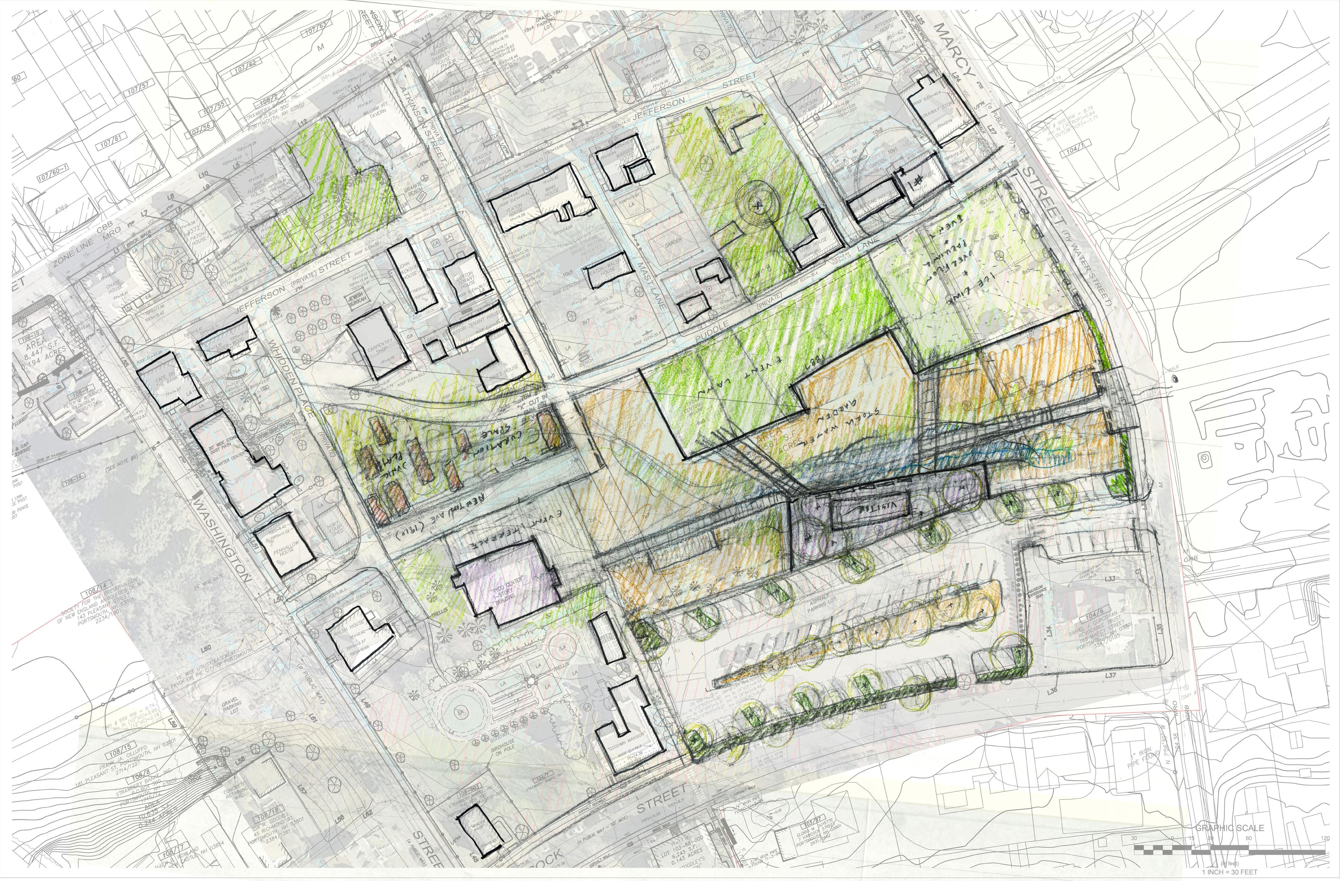
Based on the understanding improved stormwater movement within Puddle Dock area is a primary objective of the design. The area is re-graded to allow water from the upgradient contributing sources to be collected, controlled, and stored in a reimagined landscape. In lieu of a monoculture, non-native, mowed landscape that experiences frequent and extended periods of ponding, a portion of the lawn is repurposed to intentionally accept stormwater and create a more diverse native landscape. A series of small, vegetated depressions (basins) and swales, connected by piped culverts, are used along the southern edge of the pathway in front of the Carpenter’s Shop (North of the rink) to collect, store and move water to alleviate the localized flooding experienced in this area. The water slowly drains to a larger stormwater system comprised of two shallow depressions in the landscape that create a naturalized vegetated stormwater basin or “stormwater garden” that serves as a central feature of the design. Three new drainage outlet structures are proposed with piped connections to the City’s 30-inch drain line to provide overflow and draw down during rain events. An overland emergency spillway is also recommended in the location of the low point in the existing gravel parking lot. It is our understanding that the City plans to repair the existing drainage structure and damaged outfall pipe in Marcy Street. It is recommended that Strawbery Banke coordinate the proposed drainage connections with the City engineering department in the upcoming year and consider installing the outlet structures and connections in the first phase of the drainage improvements.
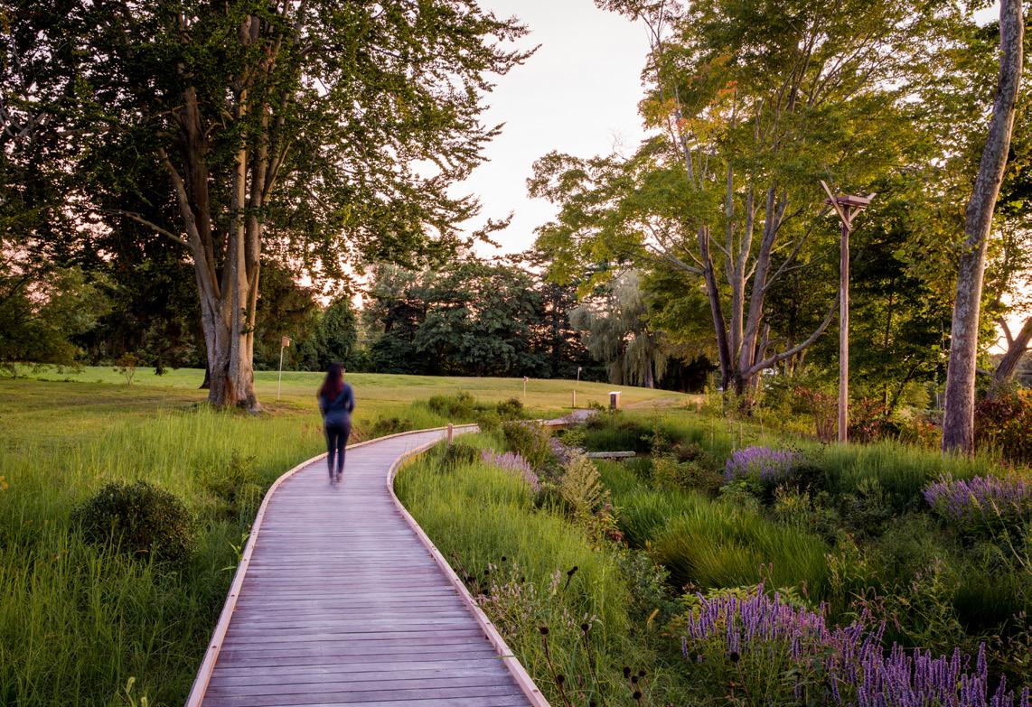
A combination of new pathways and boardwalks provide opportunities to walk through the native landscape and improve overall connectivity within Strawbery Banke and to Marcy Street. Two retaining walls are located along the north and south perimeters of the stormwater garden to assist with the site grading and create opportunities to re-use the excavated soils on site. The geometric alignment and appearance of the walls is intended to mimic the appearance of the historic Puddle Duck bulkheads with the landscape, located between the walls, being more representative a pre-colonial, tidal marsh, landscape.
Excavated material from the lawn is used to fill (a maximum of 2 feet) and re-grade the parking lot to alter the existing drainage patterns and collect stormwater from the paved surface in bioswales or tree trenches located along the northern edge of the parking lot. The water from larger rain events could then be directed to an existing drain line located under the parking lot, as suggested by the City, or discharged into the stormwater garden if the existing drain line proves to not be a viable option. The existing parking lot entrance from Hancock Street would be eliminated and a small retaining wall is required along the road and the edge of the Goodwin Mansion property.
To further vet the concepts presented in the Stormwater Management Plan and advance the stormwater design, a preliminary HydroCAD stormwater model was developed, with several scenarios, to represent the various existing and proposed drainage conditions. Based upon the available data and the conceptual grading, the scenarios take into consideration the tidal conditions, the outlet structures and grading options which include raising the elevations along the edge of Marcy street to act as a resiliency flood barrier during high water river conditions.
The option to connect to a new outlet device proposed by the City during the charette and as described above was also included in the analysis to assess the impacts of diverting the parking lot runoff from the central lawn area directly into the City drainage. This option needs to be further investigated, as the current GIS and survey plan data does not indicate a structure is located in the parking lot and the pipe size is shown as 12-inch diameter, which may be undersized to accommodate the increased stormwater flow.
The following scenarios for the proposed design were modeled:
1. Maintain Marcy Street overland flow and include a 24-inch Outlet
2. Maintain Marcy Street overland flow and existing outlets remain.
3. Raise Marcy Street overland flow and include a 24-inch Outlet.
4. Raise Marcy Street overland flow and existing outlets remain.
5. Maintain Marcy Street overland flow, remove parking lot and include 24-inch Outlet
6. Maintain Marcy Street overland flow, remove parking lot and existing outlets remain.
The table at right is a summary of the modeling outputs.
Based on the modeling, the proposed regrading of the lawn area and filling of the parking lot does not provide significant additional on-site stormwater storage. A major reason for this is because of the need to balance cut / fill, and the inability to grade to deeper elevations in the Puddle Dock area.
Additionally, it is clear from Scenarios 1-4, that the outlet structure is crucial for reducing flood elevations. Creating a berm along Marcy Street could be beneficial for reduce flooding risks from the river, however, it could create a bigger stormwater flooding issue if an outlet is not provided, and an overland flow (emergency spillway) option is eliminated.
The option of connection to a city storm drain located under the parking lot and redirecting the runoff from the Puddle Dock area (scenarios 5 & 6) may provide the best option for reducing localized flooding. However, further understanding of the City’s drainage network in this area is needed to determine if this is a realistic option. Below is a summary of the modeling outputs
Based on the modeling, the proposed regrading of the lawn area and filling of the parking lot does not provide significant additional on-site stormwater storage. A major reason for this is because of
The following items should also be considered when moving to the next phase of design development.
1. It is recommended that a topographic survey be completed to reflect the current site conditions and topography and the conversion to NAVD 88 vertical datum.
2. The model does not account for the upstream contributing drainage area to the City owned 30-inch drain line that runs through Strawbery Banke
3. Strawbery Banke should coordinate with any stormwater modeling completed by the City for the proposed outlet structure improvements.
4. Outlets for the proposed scenarios rely on assumed elevations and they need to be confirmed with the existing utilities crossings in Marcy Street and the recommended new topographic survey.
A cut and fill analysis was completed for the conceptual grading to estimate the rough soil volumes required to remain on site and can be found in Addenda. Due to the concerns related to exporting soil, the concept design strives to keep any excavated soil on site and the grading generally represents a site balance for the cut and fill. To keep soil on site and solve the existing parking lot grading issues, it is recommended that the grades in the western portion of the parking lot be raised with retaining walls incorporated into the design. The soil removed from Puddle Dock is relocated under the proposed raised parking lot with the paved surface serving as the soil cap. The amount of material relocated to this area is dependent upon the depth of the existing asphalt and subbase material. This should be verified with sub-base core samples as part of the next phase of the project.
Additionally, it is assumed only a portion of the newly created stormwater garden in Puddle Dock (approximately 15,000 SF) would require the recommend 1 foot soil cap since most of the area will require only a maximum cut of 6 inches.
From the start of the design process, the museum was committed to a vision that allowed the site to serve as an educational feature, enhancing the interpretation of Puddle Dock’s rich history. The stormwater issues on the site reveal historic drainage patterns where water naturally flowed towards the location of the now-filled inlet. Building on the design studies from the Stormwater Management Plan, the design team has created a stormwater management system that functions as a very visible and central feature of the site.
The stormwater garden, covering 27,600 square feet, closely mirrors the historical outline of the inlet, making it a visual and educational tool for conveying the site’s
transformation over time. Beyond its role in managing stormwater, the garden will significantly increase the site’s biodiversity by providing habitat for various birds and pollinators, thereby enhancing the ecological health of the area.
The historical inlet into the Puddle Dock neighborhood originally flowed from the edge of the Piscataqua River and through what is now known as Prescott Park. In response to this context, the stormwater garden has been designed to evoke the presence of this historical water feature through thoughtful planting and grading strategies. The garden serves as a visual link between the park and the river across Marcy Street, creating a cohesive narrative for visitors as they transition from the park to the museum or vice versa.
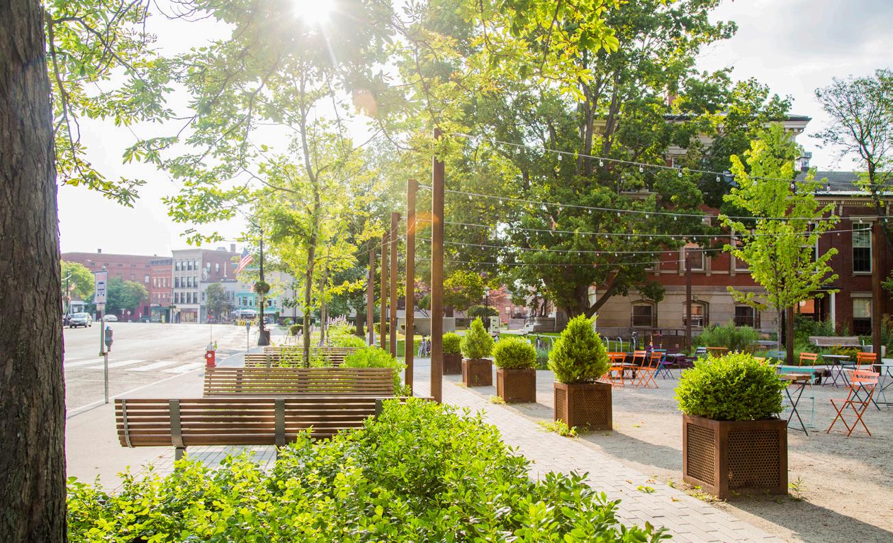
To further enhance this connection, the streetscape on Marcy Street has been widened, featuring an expanded sidewalk, new planting areas, and additional seating. This streetscape design increases the museum’s visibility and encourages visitors to explore the museum after visiting the park or participating in activities along Marcy Street.
The concept plan introduces a new vehicular entry point off Marcy Street, designed for one-way circulation with an exit onto Hancock Street. This new entry establishes a welcoming arrival sequence for visitors as they approach the museum site. A newly designed entry pavilion and dedicated drop-off area for buses provides a safe space for young visitors arriving on school trips. The pavilion is strategically positioned with views towards Puddle Lane and the historic Sherburne House, the starting point of the museum’s guided tours. The pavilion would serve as an educational orientation space for visitors, secondary ticketing location, and event space.
Pedestrian circulation throughout the site is carefully planned to guide visitors through the stormwater garden via ADA-accessible boardwalks towards the visitor center or Sherburne House. The north edge of the parking lot has been elevated to accommodate fill material from the stormwater garden excavation, enhancing the site’s stormwater management capabilities. An entry terrace and ADA ramp through planting provides direct circulation between the parking and visitor center.
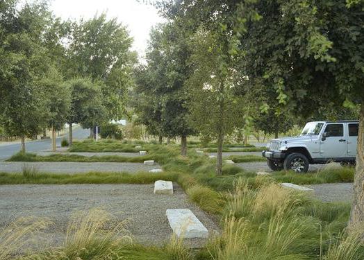
The parking lot design prioritizes both functionality and aesthetics, balancing the need for parking spaces with opportunities for planting and tree canopy. This approach enhances the visitor experience, offering an immersive environment from the moment they arrive.
The museum’s robust events program is a vital component of the greater Portsmouth community, featuring activities throughout the year. To support this program while also addressing the site’s stormwater management needs, the team
needed to balance the creation of flexible open spaces suitable for large events and tented gatherings with the size of the stormwater gardens.
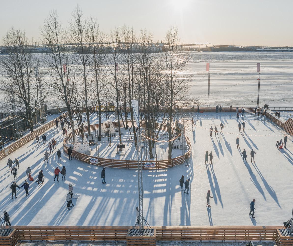
One of the key features of the museum’s events program is the seasonal ice-skating rink, which serves as a significant asset for both the museum and the local community. However, the yearly assembly and disassembly of the rink pose several challenges, including substantial disturbance to the site and drainage issues.
To mitigate these issues, the design team has proposed the following strategies:
1. New Stormwater Gardens: The addition of smaller stormwater gardens along the north edge of the ice rink site will intercept and manage runoff from areas up-hill from the rink, redirecting that water towards the larger central stormwater garden.
2. Grading for Flexibility: The grading of the lawn and terrace area to the north of the visitor center is designed to be as flat and even as possible. This approach aims to minimize disturbance during the ice rink’s assembly and disassembly, while also providing a flexible, open space that can accommodate large groups and tents for events.
3. Further Study of Rink Shape: Adjusting the shape of the ice rink itself could reduce site disturbance. Ongoing study is needed to find a configuration that minimizes impacts on surrounding paths and infrastructure while maintaining the rink’s functionality and appeal.
The proposed concept can be broken down into several phases.
The first phase is related to infrastructure that should be tied to the proposed outlet improvements being completed by the City. Aligning with the City’s permitting schedule creates an opportunity to coordinate on infrastructure upgrades, modeling, and permitting. This first phase would focus on controlling flooding through outlets and would leave major earthwork / regrading for larger site improvements that can better balance cut and fill. This phase would take into consideration future improvements to ensure infrastructure improvements are in the right locations.
The second phase of work would include the larger site improvements including the earthwork required for the central stormwater garden, paths and circulation improvements, and regrading and construction of the parking lot.
Future phasing opportunities would include the construction of the pavilion structure and potential upgrades to the Visitor Center.
STRAWBERY BANKE STORMWATER MANAGEMENT
SUB-SURFACE PIPES AND CULVERTS
STORMWATER SHEET FLOW
CITY STORMWATER INFRASTRUCTURE
STRAWBERY BANKE MUSEUM Portsmouth, NH 1” = 60’
MAJOR STRAWBERY BANKE EVENTS AND TENT REQUIREMENTS:
Baby Animals/Vintage + Vine (x1) 45’x103’ (x1) 45’x83’
Pride (x1) 75’x130’ (x1) 15’x30’ (x74) Pop up tents
Riverfest (x1) 30’x60’ (x25) Pop up tents
4.0 Hardscape
5.0
7.0 Landscaping
• Hazardous waste, environmental testing, or soils contamination
• Costs incurred from unforeseen utilities or underground structures
• Delays or changes due to archeological requirements
• Impacts from the City’s adjacent infrastructure improvement and/or maintenance activities

Project:
1 - Based on proposed surface comparison with existing surface from CAD - does not take into account
4 - The calculations are based upon a 2007 Topographic survey prepared by James Vierra & Associates, Inc. provide by Strawbery Banke Museum and the conceptual grading as shown in Charettet Concept Sketch 1 included in the Addenda
March 12, 2024
Mr. Rodney Rowland
Director, Facilities and Environmental Sustainability
Strawbery Banke Museum
15 Hancock Street
Portsmouth, NH 03801
Dear Rodney:
Horsley Witten Group, Inc. (HW) is pleased to submit the attached summary of findings for both the site soil evaluations completed by HW and preliminary subsurface assessment completed by our subconsultant GZA GeoEnvironmental, Inc. (GZA). The work was completed in accordance with our proposal dated December 1, 2023 Eight geoprobe test borings (designated GP-1 through GP-8) were completed by New England Geotech, LLC, of Jamestown, Rhode Island on January 22, 2024 The borings were drilled to depths ranging from approximately 5 to 10 feet below grade using direct push drilling methods and backfilled upon completion. The borings were observed by HW, GZA, and Strawbery Banke Museum (SBM) staff and the observations are recorded in boring logs. Attached are the site soil evaluation Summary of Findings memo (HW) dated February 22, 2024, and the Summary of Subsurface Investigations letter (GZA) dated February 15, 2024. The contents of these documents are subject to the limitations identified in each document
In general, the historic fill material and depth to groundwater encountered during the soil boring observations appears to be suitable for stormwater management However, the creation of a constructed wetland may require the excavation of up to 5 feet of material in certain locations due to the observed depths of groundwater ranging from 3.1 feet to 3.7 feet. As described in GZA’s findings, detectable concentrations of total volatile organic compounds (VOCs) in soil are indicative of background levels. However, given the history of the site and presence of ash in the soil samples, the soil likely contains detectable concentrations of metals, semi-volatile organic compounds, and/or other analytes that cannot be detected with a PID. This can make off-site soil disposal a challenge and cost prohibitive. It does appear the excavated soil can be re-used on site to raise the level of the adjacent parade lawn, to provide a dedicated usable space for SBM visitors and seasonal events, assuming that the relocated fill is covered with a minimum of one foot of clean soil.
Based on these findings, additional stormwater management options may need to be considered and any proposed stormwater management system will need to take into
Rodney Rowland March 12, 2024 Page 2 of 2
consideration the specific soil characteristics, the seasonal and storm-induced variable depth to groundwater, off site soil disposal, and the ability to withstand these variable groundwater levels and salinity content.
Please refer to both HW’s and GZA’s full summary of findings (attached) for more detailed information and further recommendations. We look forward to continuing to work with you and the SBM staff on this exciting project. If you have any questions or comments, please do not hesitate to contact me.
Sincerely,
HORSLEY WITTEN GROUP, INC.

Brian Kuchar, R.L.A. P.E.
Associate
Principal
Attachments:
HW Site Soil Evaluation Summary of Findings Memo GZA Summary of Subsurface Investigations

To: Rodney Rowland
Director, Facilities and Environmental Sustainability
Strawbery Banke Museum 15 Hancock Street Portsmouth, NH 03801
From: Michael Laham, P.E.
Date: March 12, 2024
Re: Strawbery Banke Museum Site Soil Evaluation
cc: Brian Kuchar, RLA., P.E., Joe Henderson, P.E.
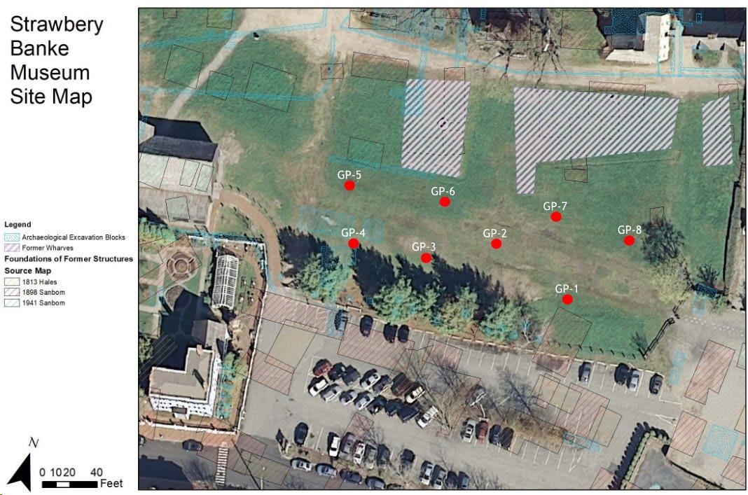
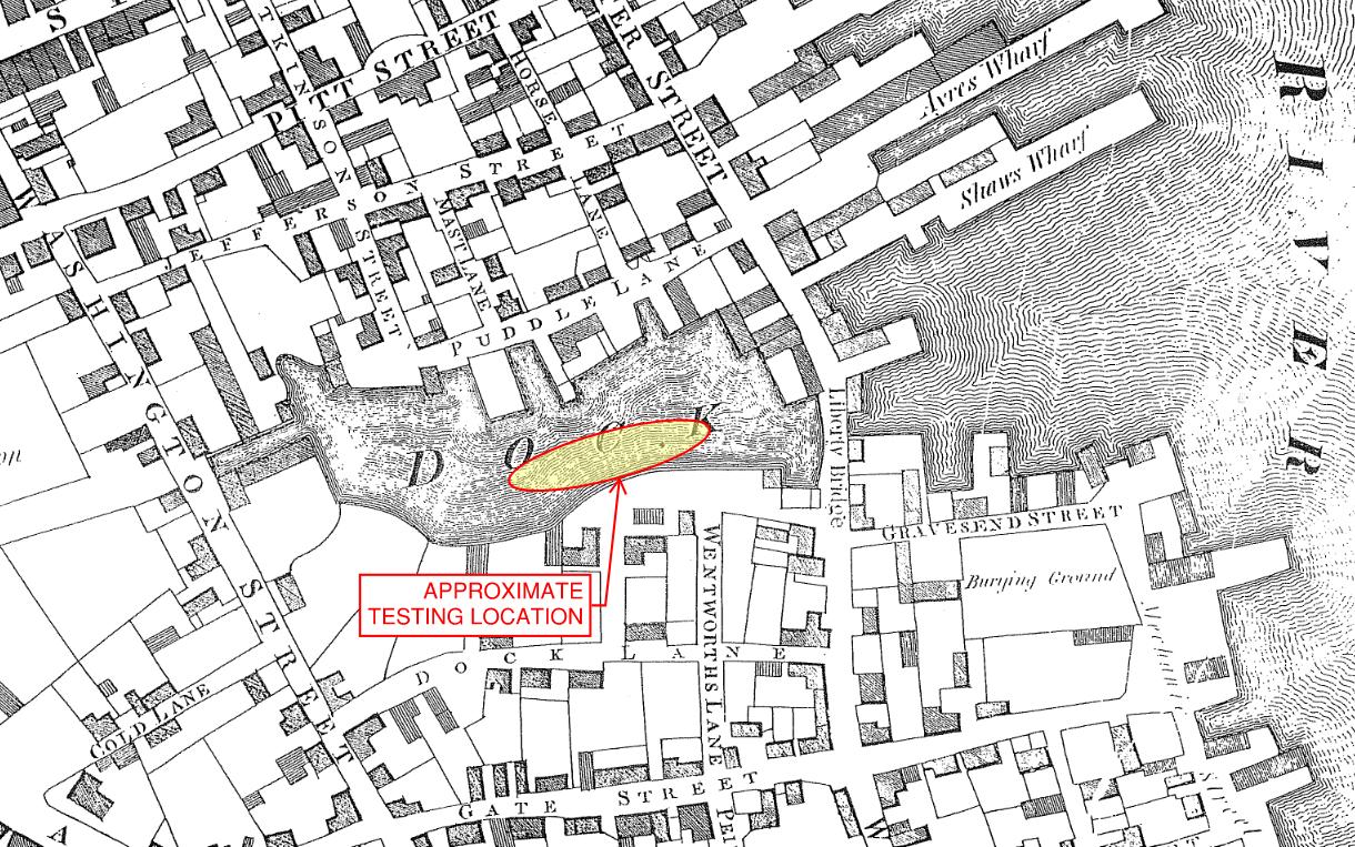
The Horsley Witten Group, Inc. (HW) completed a site soil evaluation at Strawbery Banke Museum (SBM) in Portsmouth, NH on January 22, 2024 for the purpose of determining the feasibility of the proposed stormwater improvements within the historic Puddle Dock area, as identified in the Strawbery Banke Museum Stormwater Management Plan (Plan) prepared by HW dated June 30, 2023. The work consisted of eight (8) geoprobe tests conducted by New England Geotech, which provided a low-impact method of determining the soil and groundwater conditions in this location. The geoprobe tests were also witnessed by Andrew Fournier from GZA GeoEnvironmental, Inc. (GZA) to assist in the evaluation of the site soil for potential environmental concerns that may impact construction of the stormwater improvements An important consideration for the project is to develop an understanding of the groundwater conditions at the project site, and how they are influenced by the local tidal cycles in the Piscataqua River – located to the east of SBM on the opposite side of Prescott Park A site map of the testing locations is shown in Figure 1.
According to the USDA Natural Resources Conservation Service Soil Map, the site’s underlying native soils are identified as “Urban Land”, which means that it consists of unclassified humanplaced fill. As such, the purpose of the testing was to determine the characteristics of the historic fill material and identify any possible environmental concerns.
Strawbery Banke Museum – Site Soil Evaluation
March 12, 2024
Page 2 of 5
The approximate locations of the eight (8) geoprobe borings are identified in Figure 1. All tests were performed in the former location of the historic Puddle Dock tidal inlet, which was identified in the Plan as the preferred location for proposed stormwater improvements due to the anticipated absence of archeological artifacts, including the former wharves. This is also the location where intermittent surface water ponding occurs following significant rain events. The ground surface elevation at the testing locations range from 7.6 feet to 8.3 feet, based on the North American Vertical Datum of 1988 (NAVD88). The SBM visitor center is located to the west of the testing location, and Marcy Street, Prescott Park and the Piscataqua River are located to the east. The SBM parking lot borders the testing location to the south, and Puddle Lane runs along the north side.
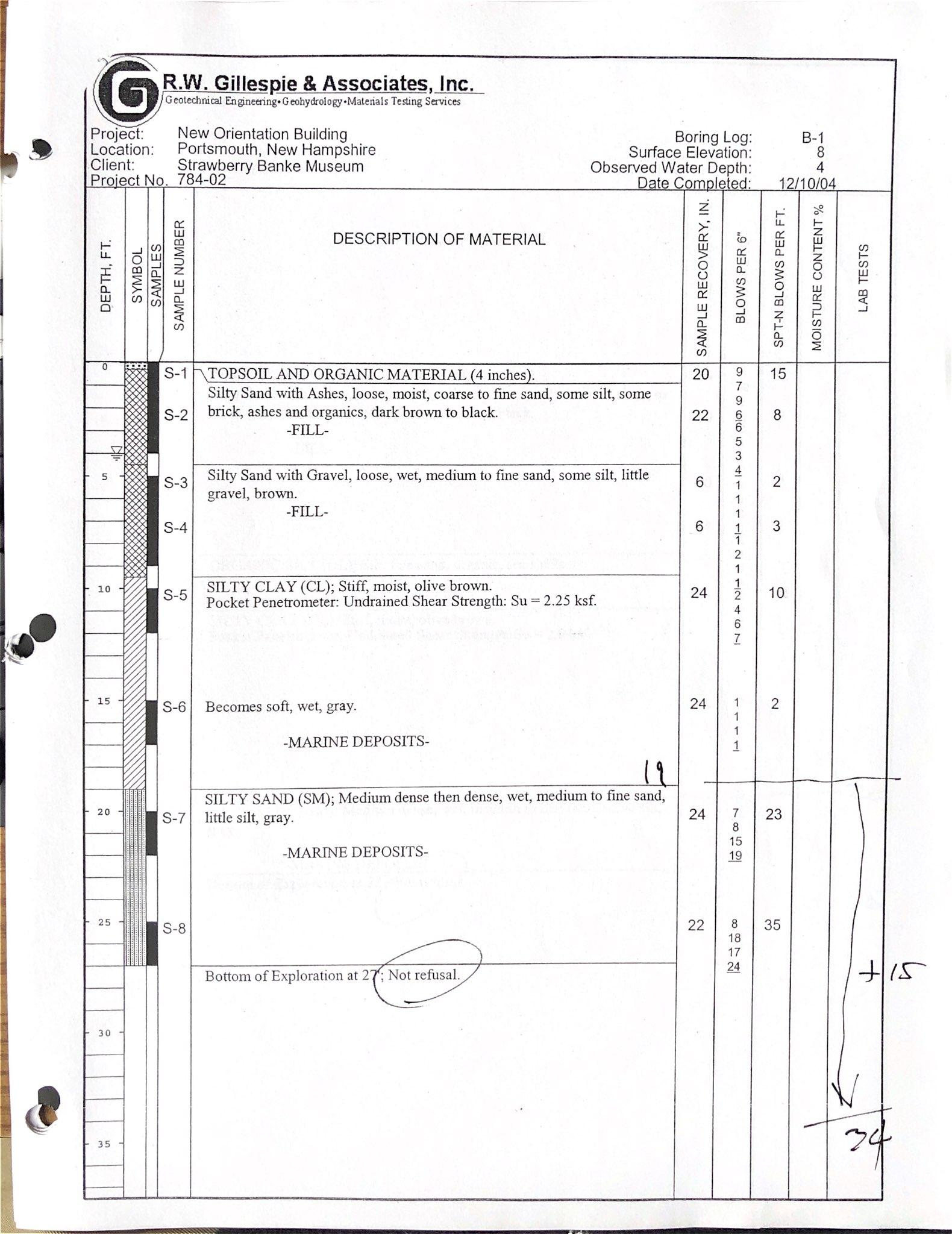
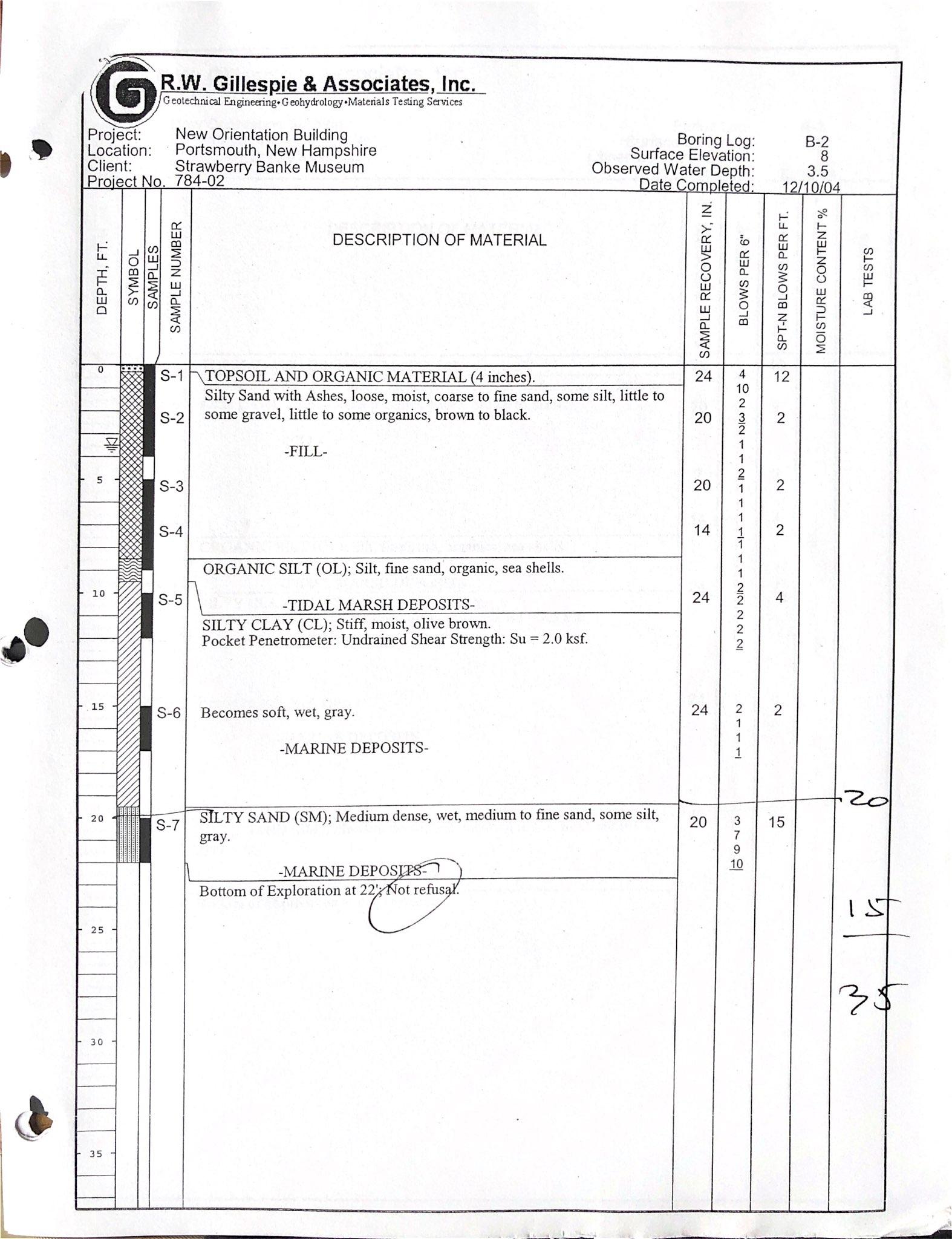
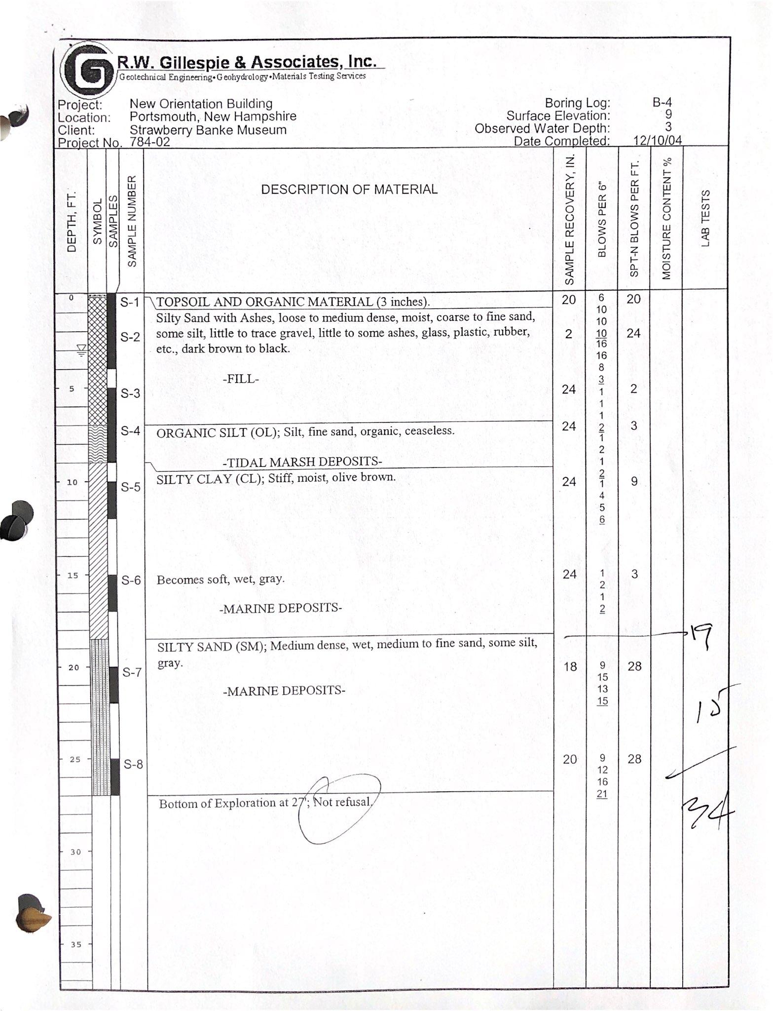
The soils observed within the geoprobe samples are generally consistent with what was observed by R.W. Gillespie & Associates, Inc. during their December 10, 2004, geotechnical investigation conducted in the vicinity of the SBM visitor center. The geoprobe soil logs were completed by GZA and are attached as part of the GZA Summary of Subsurface Investigations Letter date February 15, 2024, which characterizes the soil within the top 5 to 10 feet. The sampling intervals for the borings are 5 feet, which is the maximum depth reached by the majority of borings. Sample recovery was difficult between 5 and 10 feet due to the very wet and
H:\Projects\2021\21141
Strawbery Banke Museum –
March 12, 2024
Strawbery Banke Museum – Site Soil Evaluation March 12, 2024
Page 4 of 5
loose soils encountered at that depth. However, full-depth recovery was obtained at GP-1 and GP-2, which indicated that the fill material extends down to a depth of at least 9 to 10 feet before transitioning to a more natural marine deposit. A brick fragment was discovered at a depth of approximately 9 feet in GP-2, providing further indication of the depth of historic fill. The 2004 R.W. Gillespie boring logs documented that the underlying marine deposits, comprised of layers of silty sand and silty clay, extended to a depth of at least 22 to 27 feet at their boring locations near the visitor center
Based on the geoprobe observations, the subsurface material present within the top 10 feet of the filled Puddle Dock tidal inlet consists primarily of fine to coarse sand with some silt, which is intermixed with a small percentage of miscellaneous debris such as ash, brick, organics, and other debris from past human activity along Puddle Dock. Remnants of degraded asphalt were observed in GP-2 & GP-6, corresponding to an old road that used to extend through this area.
The geoprobe samples also allowed for a basic analysis of the hydraulic conductivity of the historic fill material. Hydraulic conductivity is a measurement of how easily water can pass through soil, with higher values associated with sandy soils and lower values associated with silt or clay soils. The soils observed from the ground surface to a depth of 10 feet are considered to have a higher rate of hydraulic conductivity, indicating that groundwater and surface water can pass through the soil with relative ease. This soil property helps explain the observed correlation between tidal cycles and groundwater levels within the historic Puddle Dock area, given the proximity of the Piscataqua River on the opposite side of Prescott Park. The image below shows the approximate soil testing location within the historic Puddle Dock area, as depicted on the 1813 Hales Map.
Page 3 of 5 H:\Projects\2021\21141
Groundwater
Groundwater was observed in the geoprobe samples at depths ranging from 3.1 feet to 3.7 feet, which corresponds to an average groundwater elevation of approximately 4.4 feet (NAVD88) at the time of testing. High tide at the Seavey Island, ME tide station was at 8:42 am on January 22, 2024, and the testing was conducted between 9:00 am and 10:30 am. The timing of the testing and the observed groundwater levels suggest a correlation between groundwater fluctuation and the local tidal cycles. The tidal influence on groundwater levels at SBM is corroborated by additional groundwater studies that indicate that water levels within certain historic basements are elevated during high tide.
The morning high tide on January 22, 2024, reached an elevation of 8.8, based on the Mean Lower Low Water (MLLW) vertical datum which is the standard for coastal navigational purposes. For engineering design and floodplain analysis, the NAVD88 datum is typically used instead of MLLW. The conversion factor from MLLW to NAVD88 at the Seavey Island, ME tide station is - 4.71 feet, which equates to a high tide elevation of 4.1 feet in the NAVD88 datum. Accordingly, the groundwater elevation within the filled Puddle Dock tidal inlet was observed to be approximately 0.3 feet (4 inches) above the morning high tide level on the day of testing.
Below is a summary of the pertinent data from the geoprobe tests (elevations are NAVD88):
Brown to dark brown sand, some silt. Trace gravel and shale fragments. Intermixed with historic debris consisting of coal ash, brick, and organics. Moist to wet. Degraded asphalt observed in GP-2 & GP-6, at depths ranging from 12” to 24”.
* Approximate groundwater elevation is based on visual observation of the transition from moist to wet soil, and a measurement of the smear depth on the outside of the plastic geoprobe sleeve. See GZA Geoprobe Logs for a detailed description of the soils encountered.
The observations presented above, along with empirical evidence of tidal influence on basement water levels at SBM, suggest a correlation between high tide and high groundwater levels within the historic Puddle Dock area. Groundwater levels were observed to be between 3.1 and 3.7 feet below the ground surface at the time of testing, which occurred directly following the morning high tide. In general, the soil and depth to groundwater encountered during the soil boring observations appears to be suitable for stormwater management, will limit the stormwater volume and function of the system. Due to the observed depths of groundwater, the creation of a constructed wetland may require the excavation of up to 5 feet of material in
H:\Projects\2021\21141 Strawbery Banke Museum\Reports\Site Soil Evaluation\240312_Soil Testing Memo 21141A.docx
March 12, 2024
Page 5 of 5
certain locations to create both shallow and deep pools of open water Based on these findings, additional stormwater management options may need to be considered and any proposed stormwater management system will need to take into consideration the specific soil characteristics, the seasonal and storm-induced variable depth to groundwater, off site soil disposal, and the ability to withstand these variable groundwater levels and salinity content.
Please note that use of the geoprobe over a backhoe and excavated test pits limited the ability to visually observe the depth to groundwater. The approximate depths were based on visual observation of the transition from moist to wet soil, and a measurement of the smear depth on the outside of the plastic geoprobe sleeves. Due to the cold temperatures and lack of rainfall for the week preceding the testing, groundwater levels are not expected to have been significantly influenced by direct infiltration of surface water or snow melt within the Puddle Dock watershed. It is anticipated that during times of astronomical high tides or high-intensity rain events, the groundwater elevations could be measurably higher than those observed during the testing; especially when these two events occur at the same time. HW recommends that the observed depths to groundwater be cross referenced with the recorded groundwater depths of the surrounding monitoring wells and the data collected from the ongoing UNH study, which is monitoring sea level rise impacts on the groundwater at SBM.
HW also recommends review and coordination with the City of Portsmouth on future stormwater or flood management options within the SBM campus. Any proposed improvements must be evaluated in the context of projected sea level rise and its impact on both the City’s and SBM’s existing drainage infrastructure and its ability to drain water from the site.
Refer also to GZA’s Summary of Subsurface Investigations for the soil boring logs and further recommendations.
Attached
R.W. Gillespie Boring Logs (Dec. 2004)
H:\Projects\2021\21141 Strawbery Banke Museum\Reports\Site Soil Evaluation\240312_Soil Testing Memo 21141A.docx

Via Email
March 12, 2024
File No. 04.0191656 00 Rev1
Mr. Brian Kuchar, P.E., RLA, LEED AP Associate Principal, Principal Landscape Architect
Horsley Witten Group
90 Route 6A, Unit 1 Sandwich, Massachusetts 02563
Re: Summary of Subsurface Investigations
Strawbery Banke Museum
Portsmouth, New Hampshire
Dear Mr Kuchar:
GZA GeoEnvironmental, Inc. (GZA) is pleased to submit this letter report to Horsley Witten Group (HWG; Client) summarizing GZA’s observations made during the subsurface investigations conducted for the proposed flood storage area along the Central Lawn of Strawbery Banke Museum in Portsmouth, New Hampshire GZA completed this work in accordance with our proposal dated December 1, 2023 The contents of this report are subject to the Limitations contained in Appendix A
The Strawbery Banke Museum is subject to periodic flooding during extreme weather events and king tides. HWG has developed a master plan to mitigate the impacts of flooding on the museum, including constructing a flood storage area within the Central Lawn adjacent to the Museum’s Welcome Center, the subject of this study. The current flood storage design under consideration consists of a vegetated swale anticipated to extend up to 36 inches below existing grade.
The Central Lawn is the former location of the historic Puddle Docks, which was once an open waterway that connected to the adjacent Piscataqua River. The Puddle Docks were filled in around 1900, and subsequently utilized for a variety of uses including residential housing, salvage yards, and a former roadway.
The objectives of GZA’s Scope of Services were to observe test borings (geoprobes) conducted by others, screen the excavated soils with a photoionization detector (PID), and prepare a report summarizing our findings including recommendations for the project based on our field observations.

GZA observed a subsurface exploration program consisting of eight geoprobe test borings (designated GP-1 through GP-8), as shown on Figure 1, Exploration Location Plan. New England Geotech, LLC, (NE Geotech) of Jamestown, Rhode Island, coordinated Dig Safe® utility clearance and provided drilling services under contract to Strawbery Banke.
The drilling was performed on January 22, 2024, under the oversight of GZA, HWG, and Strawbery Banke personnel. The borings were drilled to depths ranging from approximately 5 to 10 feet bgs. The borings were drilled using direct push drilling methods. The borings were backfilled with the soil cuttings upon completion.
GZA personnel screened the soils for the presence of total organic vapors using a TIGER photoionization detector (PID) equipped with a 10.6eV lamp, referenced to an isobutylene-in-air standard, visually observed the soils for staining, and prepared the boring logs included in Appendix B. GZA recorded total volatile organic compound (VOC) detections of 0.3 parts per million (ppm) or less at the test boring locations which, in our opinion, are indicative of background levels. Soil samples were visually classified according to the Modified Burmister soil classification system.
The approximate as-drilled boring locations were located by HWG personnel and are shown on Figure 1 The ground surface elevations at the test boring locations were estimated by GZA from a 2016 survey plan prepared by Ambit Engineering, Inc. of Portsmouth, New Hampshire transmitted by HWG to GZA via electronic mail on February 8, 2023. Elevations referenced in this report are in feet and refer to the North American Vertical Datum of 1988 (NAVD88).
SUBSURFACE CONDITIONS
Two soil units were encountered in test borings GP-1 through GP-8: Deleterious Fill and a Marine Deposit. The approximate thicknesses and generalized descriptions of the subsurface units are presented in the following table, in descending order from existing ground surface. Detailed descriptions of the materials encountered at specific locations are provided in the boring log in Appendix B.
GENERALIZED SUBSURFACE CONDITIONS
Subsurface Unit Approx. Thickness (ft)
Deleterious Fill >5 to >10
Marine Deposit >0.5 to >0.8
Generalized Description
Brown to dark brown, fine to coarse SAND, little to some Silt, some Clay, trace to some Gravel, some Coal Ash, trace to little Brick, trace Ash, trace to little Organics TO BRICK, little Gravel, little fine to medium Sand, trace to little Ash and Organics. Encountered in test borings GP-1 through GP-8. PID measurements ranged from non-detect (ND) to 0.3 ppm. The bottom of this deposit was not encountered in test borings GP-3 through GP-8.
Dark gray, fine SAND and Silt TO SILT & CLAY, trace Shale Fragments. Encountered in test borings GP-1 and GP -2. PID measurements ranged from ND to 0.2 ppm. The bottom of this deposit was not encountered in test borings GP-1 and GP-2.
Groundwater was observed during drilling at depths ranging from approximately 3.1 to 3.7 feet bgs, corresponding to elevations ranging from Elevation 4.0 to 4.8 The groundwater observations were made at based on moisture
March 12, 2024
Strawbery Banke Museum
04.0191656.00 Rev1
Page | 3
observed along the geoprobe sleeve and under the conditions stated on the boring log. Fluctuations in groundwater levels will occur due to variations in tide, season, precipitation, and other factors. Consequently, water levels during and after construction are likely to vary from those encountered in the borings at the time the observations were made.
Soils generally consisted of deleterious fill overlying a marine deposit. GZA recorded (VOC) detections of 0.3 parts per million (ppm) or less at the test boring locations which, in our opinion, are indicative of background levels. However, given the history of the site and presence of ash in the soil samples, the soil likely contains detectable concentrations of metals, semi-volatile organic compounds, polychlorinated biphenyls, and/or other analytes that cannot be detected with a PID. Therefore, any contractor working on the site should be made aware of possible soil contamination and take the proper precautions.
Due to the deleterious nature of the fill, GZA recommends reusing on-site soils to the extent practicable and covering the relocated fill with a minimum of one foot of clean, uncontaminated soil If soils cannot be reused on-site, soils will need to be stockpiled and sampled prior to off-site disposal.
Soils destined for off-site disposal should be sampled and submitted for laboratory analysis prior to off-site disposal. Off-site disposal should be handled in accordance with applicable local, State, and federal requirements. Soil sampling and characterization of material for off-site disposal will be based on the disposal facilities requirements as defined by the facility’s waste profile requirements.
Given the past usage of the site, the presence of ash and other potential contaminants, it is GZA’s opinion that there is a high probability that the soils contain concentrations of compounds that exceed the state Soil Remediation Standards (SRS). Please note that if the soil sample results exceed the state SRS, Strawbery Banke will need to report the results to NHDES in accordance with the New Hampshire Code of Administrative Rules Chapter Env-Or 600. NHDES would likely require additional environmental characterization of the site to determine the extent, potential source(s), and the nature of the contamination.
We appreciate this opportunity to provide HWG with the attached documentation in support of the work described above. Please do not hesitate to contact Andrew Fournier at (603) 232-8717 or David Lamothe at (603) 232-8716 if you have any questions.
Very truly yours,

Andrew D. Fournier Project Manager

David G. Lamothe, P.E.

Jay L. Hodkinson, P.E. Associate Principal Consultant Reviewer
ADF/DGL/JLH:idim P:\04Jobs 0191600s\04.0191656.00 - Strawbery Banke\Report\DRAFT 04.0191656.00 Strawbery Banke Memo 021524.docx
Attachments: Figure 1 – Exploration Location Plan Appendix A – Limitations Appendix B – Boring Logs


APPENDIX A LIMITATIONS
1. GZA GeoEnvironmental, Inc. (GZA) prepared this report on behalf of, and for the exclusive use of our Client for the stated purpose(s) and location(s) identified in the Proposal for Services and/or Report. Use of this report, in whole or in part, at other locations, or for other purposes, may lead to inappropriate conclusions; and we do not accept any responsibility for the consequences of such use(s). Further, reliance by any party not expressly identified in the agreement, for any use, without our prior written permission, shall be at that party’s sole risk, and without any liability to GZA.
STANDARD OF CARE
2. GZA’s findings and conclusions are based on the work conducted as part of the Scope of Services set forth in the Proposal for Services and/or Report and reflect our professional judgment. These findings and conclusions must be considered not as scientific or engineering certainties, but rather as our professional opinions concerning the limited data gathered during the course of our work. Conditions other than described in this report may be found at the subject location(s).
3. GZA’s services were performed using the degree of skill and care ordinarily exercised by qualified professionals performing the same type of services, at the same time, under similar conditions, at the same or a similar property. No warranty, expressed or implied, is made. Specifically, GZA does not and cannot represent that the Site contains no hazardous material, oil, or other latent condition beyond that observed by GZA during its study. Additionally, GZA makes no warranty that any response action or recommended action will achieve all of its objectives or that the findings of this study will be upheld by a local, state or federal agency
4. In conducting our work, GZA relied upon certain information made available by public agencies, Client and/or others. GZA did not attempt to independently verify the accuracy or completeness of that information. Inconsistencies in this information which we have noted, if any, are discussed in the Report.
SUBSURFACE CONDITIONS
5. The generalized soil profile(s) provided in our Report are based on widely-spaced subsurface explorations and are intended only to convey trends in subsurface conditions. The boundaries between strata are approximate and idealized, and were based on our assessment of subsurface conditions. The composition of strata, and the transitions between strata, may be more variable and more complex than indicated. For more specific information on soil conditions at a specific location refer to the exploration logs. The nature and extent of variations between these explorations may not become evident until further exploration or construction. If variations or other latent conditions then become evident, it will be necessary to reevaluate the conclusions and recommendations of this report.
6. Water level readings have been made, as described in this Report, in and monitoring wells at the specified times and under the stated conditions. These data have been reviewed and interpretations have been made in this report. Fluctuations in the level of the groundwater however occur due to temporal or spatial variations in areal recharge rates, soil heterogeneities, the presence of subsurface utilities, and/or natural or artificially induced perturbations. The observed water table may be other than indicated in the Report
7. We used reasonable care in identifying and interpreting applicable codes and regulations necessary to execute our scope of work. These codes and regulations are subject to various, and possibly contradictory, interpretations. Interpretations and compliance with codes and regulations by other parties is beyond our control.
APPENDIX A LIMITATIONS
8. GZA collected environmental samples at the locations identified in the Report. These samples were analyzed for the specific parameters identified in the report. Additional constituents, for which analyses were not conducted, may be present in soil, groundwater, surface water, sediment and/or air. Future Site activities and uses may result in a requirement for additional testing.
9. Our interpretation of field screening and laboratory data is presented in the Report. Unless otherwise noted, we relied upon the laboratory’s QA/QC program to validate these data.
10. Variations in the types and concentrations of contaminants observed at a given location or time may occur due to release mechanisms, disposal practices, changes in flow paths, and/or the influence of various physical, chemical, biological or radiological processes. Subsequently observed concentrations may be other than indicated in the Report.
11. Our opinions are based on available information as described in the Report, and on our professional judgment. Additional observations made over time, and/or space, may not support the opinions provided in the Report.
12. In the event that the Client or others authorized to use this report obtain additional information on environmental or hazardous waste issues at the Site not contained in this report, such information shall be brought to GZA's attention forthwith. GZA will evaluate such information and, on the basis of this evaluation, may modify the conclusions stated in this report.
13. GZA recommends that we be retained to provide services during any future investigations, design, implementation activities, construction, and/or property development/ redevelopment at the Site. This will allow us the opportunity to: i) observe conditions and compliance with our design concepts and opinions; ii) allow for changes in the event that conditions are other than anticipated; iii) provide modifications to our design; and iv) assess the consequences of changes in technologies and/or regulations.