Strawbery Banke Museum
Stormwater Management Plan 06.30.2023
REPORT
CONTENTS
5 Vision Introduction
Guiding Principles Goals
11 Site + Context
Watershed + Subcatchments
Land Coverage
Drainage Infrastructure
Historical Features + Critical Elevations Areas of Concern
17 Strategies
A Stormwater Toolbox Applied Stormwater Solutions Opportunities for Intervention
39 Action Plan
Enacting Change Recommendations
Acknowledgments
This report is the work of Strawbery Banke Museum staff members, the consulting design team, and numerous contributors from the City of Portsmouth and neighboring organizations that share the desire to create a more resilient campus through a comprehensive stormwater management approach to better manage both the on-site and off-site water runoff. Strawbery Banke Museum would like to thank the many contributors for their efforts and insights during the development of the Stormwater Management Plan. We look forward to working together to improve storm water management throughout this section of the City.
References
• Proposed Seasonal Ice Skating Rink, Strawbery Banke Marcy Street
Portsmouth, New Hampshire
Amended Permit Site Plans Ambit Engineering, Inc. May 25, 2018
• Geotechnical Investigation New Orientation Building, Strawbery Banke Portsmouth, New Hampshire R.W. Gillespie & Associates, Inc.
• Linnea Grim, President & CEO
• Lawrence Yerdon, President & CEO (retried, January 2023)
• Rodney Rowland, Director of Facilities and Environmental Sustainability
• Elizabeth Farish, Chief Curator
• Alexandra Martin, Archaeologist
• Matthew Kochka, Horticulturist
Consulting Team
• Horsley Witten Group
* Brian Kuchar, PE,. RLA
* Brian Laverriere, RLA
• Placework
* Brian Murphy, AIA
* Alice Carey, AIA
City of Portsmouth
• Planning Department
* Peter Britz, Planning Director
Community Advisory
• Richard Candee
• Connie White
• David Burdick
• A Plan for Prescott Park City of Portsmouth Weston & Sampson Design Studio Januar y 31, 2017
• 1813 Hales Map
• 1877 Ruger’s Bird’s Eye View
• Coastal Resilience Initiative City of Portsmouth
• SeaLevelRise.org
• New Hampshire Coastal Flood Risk Summary Part I: Science University of New Hampshire, August 2019
• New Hampshire Coastal Flood Risk Summary Part II: Guidance for Using Scientific Projections University of New Hampshire Draft for Public Review Released September 2019
• Flood Insurance Rate Map # 33015C0259E Effective Date May 17, 2005
• GIS Utilities and Drainage Data City of Portsmouth, NH
Photos
All photos are courtesy of Strawbery Banke Museum unless otherwise noted.
Strawbery Banke Museum Stormwater Plan | June 30, 2023 2
Strawbery Banke Museum
VISION


STREET WA WHIDDEN PLACE INSON STREET ASTLANE MARCY REET COURT STREET JEFFERSON STREET PUDDLE LANE PRESCOTT PARK
PORTSMOUTH
LAWN
PISCATAQUARIVER
DOWNTOWN
CENTRAL
Introduction
Background
The mission of Strawbery Banke Museum is to promote understanding of the lives of individuals and the value of community through encounters with the history and ongoing preservation of a New England waterfront neighborhood.
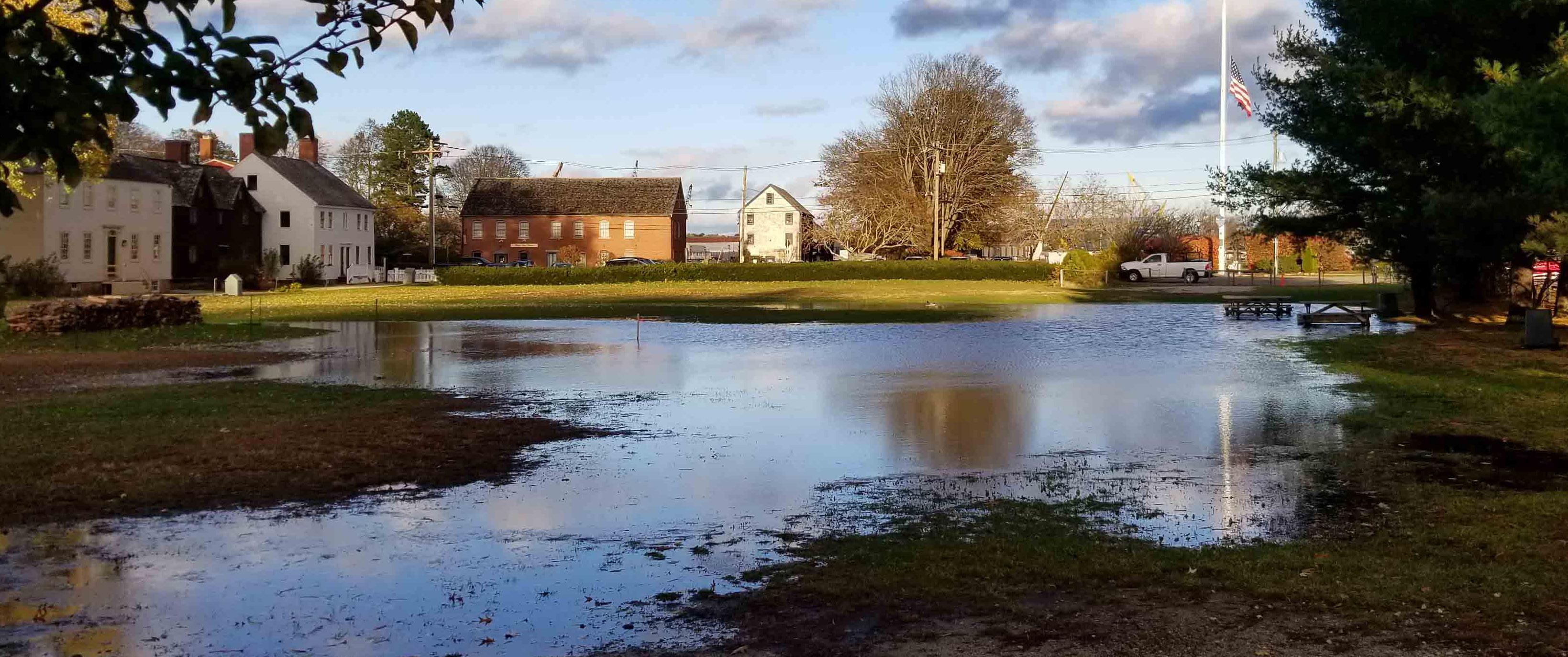
Water began to infringe on the museum’s ability to serve this mission when both localized and large-scale flooding began to damage both landscape and built features throughout the site. In fact, management of water has been an issue for the campus since the Puddle Dock inlet was filled in over one hundred years ago. As the low point of the neighborhood, the campus has long had an issue with stormwater runoff. In recent years, stormwater has flooded the central lawn, preventing its use as an event space, creating safety hazards when paths are blocked, or maintenance headaches when paths are washed away. Even more concerning, both stormwater and rising groundwater have begun to have a negative effect on the primary asset of the museum: its historic buildings.
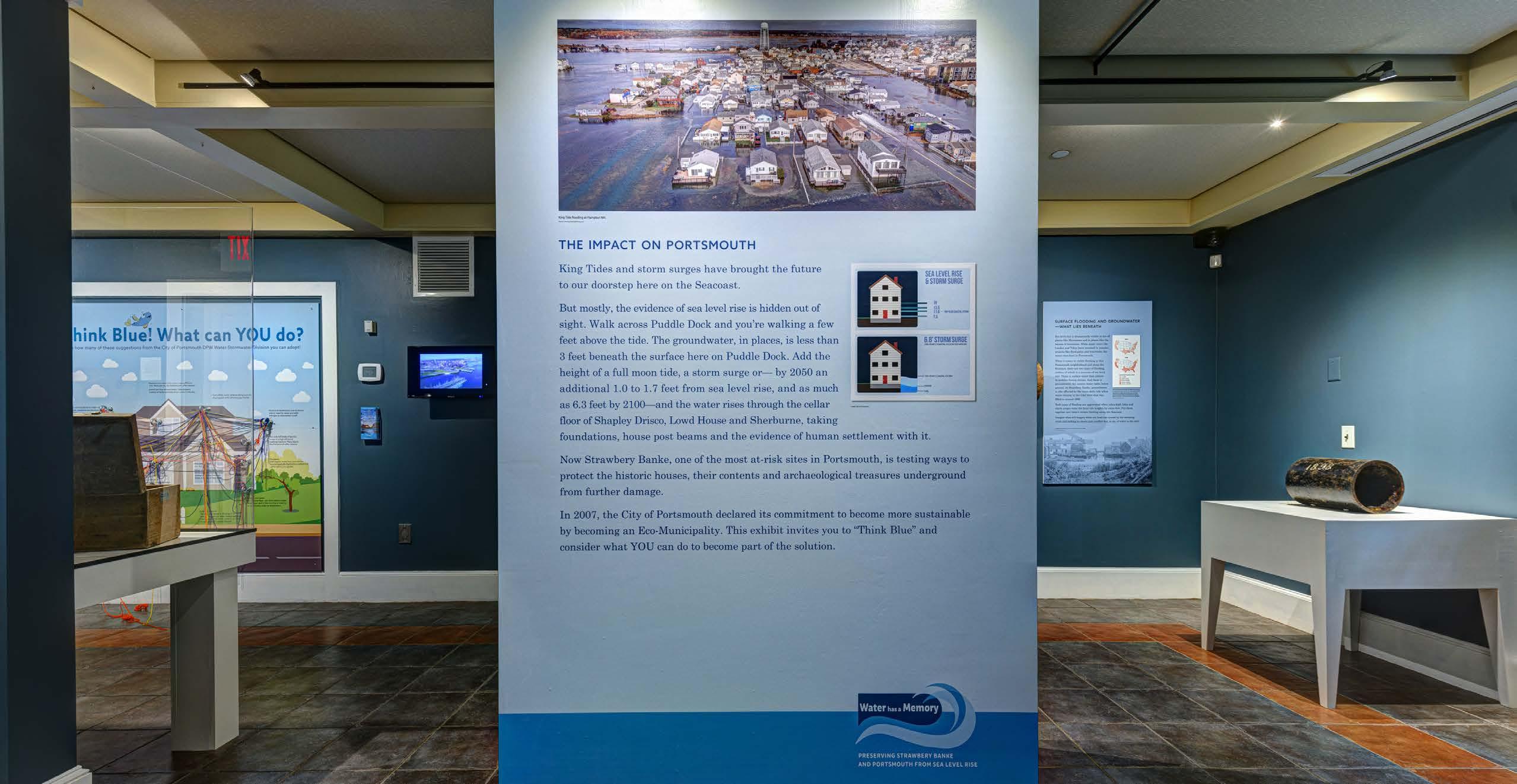
In 2021, Strawbery Banke Museum curated an exhibit “Water Has a Memory: Preserving Strawbery Banke & Portsmouth from Sea Level Rise” and staff members have spoken at numerous conferences in recent years to communicate the ways in which a changing climate is endangering the coastal historic resources. Three interconnected issues: management of stormwater, sea level rise, and the resultant groundwater rise have been identified as threats to the buildings and landscape.
Recognizing these ongoing challenges, Strawbery Banke Museum has collaborated with Placework and the Horsley Witten Group to create this campus-wide Stormwater Management Plan (the Plan). To address this issue, the Plan takes a watershed approach to identify the problems and provide recommendations to improve localized stormwater management within the surrounding neighborhoods and the Strawbery Banke Museum campus. Thinking long-term, the Plan aims to alleviate stormwater impacts while maintaining alignment with the museum’s mission to preserve historic buildings and cultural landscapes for today’s visitors and for future generations.
Approach
The Plan began with an analysis of the existing conditions within the campus, and developed site-specific interventions. The opportunities identified recognize and have incorporated the following ideas into their approach:
• The site is part of a larger neighborhood watershed, and therefore most mitigation opportunities involve coordination with the City of Portsmouth and/or neighboring sites.

• Strategies in this report take advantage of the existing stormwater management infrastructure, and seek to retrofit systems already in place.

• The opportunities maximize the use of existing open space to retain and store excess stormwater.


• At least three of the current buildings have elevations that put them at immediate risk of flooding, and approximately half of the Strawbery Banke Museum campus lies within the current and/or future 500-year flood plain.

It is important to note that this Plan focuses on addressing the localized stormwater flooding issues within the Campus and does not include a long term resiliency strategy related to climate change and sea level rise. It is outside of the scope of this report to provide guidance on adaptations to any existing buildings, but it should be noted that many buildings will require future adaptations to incorporate either wet- or dry-flood proofing techniques.

The Plan summarizes the existing conditions and provides preliminary planning and guidance for both maintenance and improvements throughout the Strawbery Banke Museum campus.
Several strategies have been identified and a flexible Action Plan presented. The Plan allows for different strategies to be implemented over time, as specific needs and funding opportunities allow. Ongoing change will necessitate ongoing decision making to best support the needs of the museum.
5
Write a desc ription for you m ap Legend 300 N
Untitled Map
1813: Hale Map Puddle Dock inlet located at the heart of present day Strawbery Banke Museum.
1870: Rugger’s Bird Eye Illustration Liberty Bridge once spanned the Puddle Dock inlet connecting north and south.
WASHINGTONST.
ST. ATKINSON ST.
ST.
Present Day : Google Earth Bird’s Eye. Liberty Bridge and the Puddle Dock Inlet have been filled in and replaced with the Prescott Park and the central lawn.
COURT
WATER

Guiding Principles
How can the museum remain RESILIENT?
Resilience is the ability to withstand or recover quickly from difficult events. For a landscape, this often means sustaining ecological functions over time. When storms occur, can Strawbery Banke Museum manage excess water without disrupting day-to-day activities or causing long-term damage to their facilities?
The goal is not to prevent flooding, but rather to reduce the amount of human intervention required to manage its flow and avoid costly clean-up after the rain subsides. Anticipating opportunities to use natural systems will position the museum to embrace future floods.
The Plan will address localized drainage problems under current conditions and future challenges based upon the “latest projections of sea-level rise, coastal storms, groundwater rise, precipitation, and freshwater flooding for coastal New Hampshire,” per the 2019 NH Coastal Flood Risk Summary Part 1: Science -pg.1.
As the museum builds a more resilient infrastructure, a guiding principle will be to distribute the stormwater burden across the campus.
How do we preserve HISTORY?
Over one hundred years ago, the Puddle Dock tidal inlet brought the center of commerce to what is today Strawbery Banke Museum. Evidence of rising groundwater infiltrating the museum buildings now recalls the neighborhood’s original relationship to the Piscataqua River. How will it be possible to make this history visible to the modern visitor while simultaneously keeping culturally significant artifacts safe from the water?

To preserve the history of this coastal New England waterfront neighborhood, the Plan will integrate historic preservation requirements and adaptive stormwater management strategies to provide a flexible toolkit for how best to employ the museum’s resources moving forward.
How can we EDUCATE the public?
The water management issues that Strawbery Banke Museum faces are not unique. Many coastal communities are beginning to confront the challenges of sea level rise, groundwater rise, and storm surge. Strawbery Banke Museum has a unique platform to showcase a variety of practices to embrace and adapt to the water. As a living history museum, Strawbery Banke’s unfolding adaptation to climate change may be the next chapter.
Implementation of stormwater initiatives should consider public outreach and educational opportunities to share in a broader context on how individuals, towns, cities, and regions can best adapt to protect our natural and cultural resources, all while “keeping history above water.”
How can we be a role model for our COMMUNITY?
Strawbery Banke Museum exists today because the Portsmouth community recognized the importance of preserving the Puddle Dock neighborhood. Now, the museum is taking a new opportunity to inspire peers and demonstrate how adaptation can be applied to preservation. The intent is to be a leader, to take proactive steps that inspire action for similar communities up and down the coast. Strawbery Banke Museum is invested in being part of solutions for a resilient coast.
This work will require community involvement, commitment, and collaboration. Recognizing that communities in seacoast New Hampshire will confront the future challenges together, Strawbery Banke Museum will be an instrumental leader to serve as a platform for sharing ideas, solutions, and lessons learned.


7

Goals
The following goals are established to mitigate local flooding on the campus in the short term and create a more sustainable and resilient Strawbery Banke Campus in the long term, while respecting and preserving the historic character. The goals address stormwater management both within the campus (on-campus) and outside of the campus in the surrounding neighborhoods (off-campus).
ON-CAMPUS
• Identify opportunities to reduce localized flooding.
• Manage, control and move water through the campus.
• Reduce erosion along internal roadways surface materials while preserving historic character.


• Redesign the campus use areas (ice rink, open space, parking lot, entrances, etc.) to embrace stormwater runoff.
• Incorporate educational components during each phase of implementation.
• Seek grant funding along with other funding sources.
OFF-CAMPUS
• Eliminate off-site contributing stormwater runoff by diverting it or disconnecting it from the campus.
• Continue to work with the City to implement stormwater controls and improvements to the contributing roadways and drainage infrastructure.
In order to meet these goals, a number of projects, both on and off campus, have been recommended for implementation as part of this Plan and are described in Strategies and Opportunities.
It is also necessary to preserve usable open spaces, which are highly valuable for museum events and the Labrie Family Skate at Puddle Dock Pond. It is also possible that buried archaeological artifacts may inhibit the museum’s ability to implement stormwater solutions throughout the campus.
For example the stormwater goals might be integrated into a near-term parking lot project, or the parking lot might be part of a larger initiative to deal with localized flooding in the open lawn. Another project may be landscape centric to create a swale on the northeast side of the campus that could help stabilize the circulation path for visitors while also helping to mitigate flooding on the lawn. Lastly, some projects may require coordination with the City of Portsmouth and offer benefits to both parties.
9
Strawbery
Plan | June 30, 2023 10
Banke Museum Stormwater
SITE + CONTEXT
Watersheds and Subwatersheds
A WATERSHED APPROACH TO LOCALIZED DRAINAGE PROBLEMS

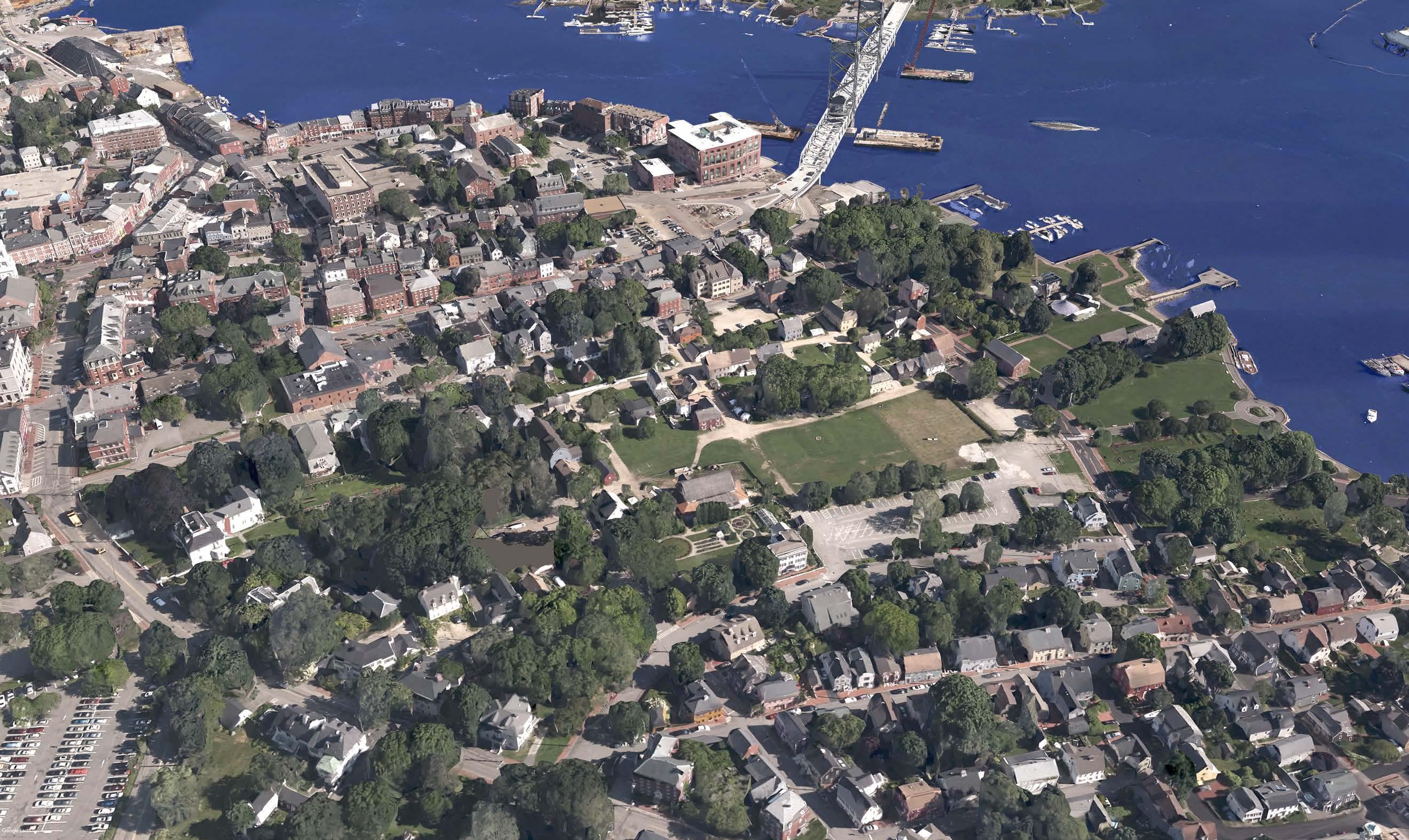
A watershed is a definitive boundary from which all water drains, running downhill, to a shared destination — a river, pond, stream, lake, estuary, or in the case of Strawbery Banke Museum, the now-filled Puddle Dock Inlet. Within the watershed, there are smaller sub watersheds which further divide and direct water flow. In the urban setting, curbs, gutters, and roof lines change the dynamic of how the landscape drains.
The diagram to the right illustrates the delineated watershed in which the Strawbery Banke Museum is located and its pervious and impervious surfaces. The diagram below illustrates the direction of surface flow in the subcatchments.

Today, rain that falls within the museum’s watershed is collected and directed to the City storm drain system and eventually enters the Piscataqua River via an outfall structure located within Prescott Park. Each subwatershed within the larger watershed is hydrologically connected by the subsurface drainage network.
Historical maps and photos show that the “Puddle Dock” area of the Strawbery Banke Museum campus was once a tidal inlet. As the low point, it was the primary source of relief to the watershed. Since this inlet was filled at the turn of the 20th century, the primary source of relief shifted to the closed pipe infrastructure located under both Strawbery Banke Museum and Prescott Park.
This presents a risk to Strawbery Banke when the drainage infrastructure is unable to release runoff from the watershed. During high tide, the stormwater pipe outfall located in Prescott Park is submerged and therefore stormwater cannot properly discharge from the system. When a high tide coincides with a significant rainfall, unmanaged stormwater within the Strawbery Banke Museum watershed accumulates on campus with no means of escape.
WATERSHED
WATERSHED BOUNDARY
HISTORIC PUDDLE DOCK
SUBWATERSHED BOUNDARY
MUSEUM EXTENTS
SURFACES
BUILDING ROOFTOPS (CONTRIBUTE TO STORMWATER BURDEN)
ROADWAYS & SIDEWALKS (CONTRIBUTE TO STORMWATER BURDEN)
GARDENS, LAWN, & WOODLANDS (MITIGATE STORMWATER BURDEN)
SURFACE FLOW
MUSEUM EXTENTS
WATERSHED BOUNDARY
SUBWATERSHED BOUNDARY

PISCATAQUA RIVER COURTSTREET
WASHINGTON STREET HANCOCK
PUDDLELANE
MARCY STREET
STREET
Stormwater Plan | June 30, 2023 12
Strawbery Banke Museum
Approximately 45% of the total watershed is outside of the campus limits. A true, cohesive solution will require collaboration with private property owners as well as the City of Portsmouth.
Land Coverage
UNDERSTANDING THE SOURCE OF THE PROBLEM
Throughout the Strawbery Banke Museum campus and the larger watershed, there are a variety of conflicting land uses that are incompatible with implementing stormwater controls. Stormwater management techniques must be integrated into the landscape and work in tandem with the museum’s many active and passive uses of the site.
The more impervious cover (roofs, pavement, compacted surfaces, etc.) in a watershed, the more stormwater will flow to the low point. Conversely, the more green space, the less stormwater flows to the low point.
The pie charts below represent the land cover breakdown for the watershed (purple) and Strawbery Banke Museum (pink dashed). The campus represents approximately 55% of the total watershed area, including the low point, which gives the museum significant influence over water management.


13 COURTSTREET MARCY STREET WASHINGTON STREET ATKINSON STREET HANCOCKSTREET PUDDLELANE PISCATAQUA RIVER
Opportunities to find relief to control and store excess stormwater during severe storms exist within the current open space.
18.4% PAVEMENT 14.9% ROOFTOPS 14.8% 4% WOODLAND DIRTROAD 47.8% OPENLAWN IMPERVIOUSCOVER(37.4%) GREENSPACE (62.6%) 19.2% PAVEMENT 11.2% ROOFTOPS 10.6% DIRT ROADS 19.2% WOODLAND 47.8% OPEN LAWN IMPERVIOUSCOVER(41 .0%) GREENSPACE (59.0%) WATERSHED SURFACE AREA MUSEUM SURFACE AREA 239,000 SF+/51,700 SF+/193,150 SF+/620,000 SF+/192,650 SF+/93,150 SF+/51,700 SF+/54,400 SF+/212,200 SF+/73,750 SF+/-
Drainage Infrastructure


ASSESSING HOW STORMWATER IS MANAGED


The adjacent diagram illustrates the existing infrastructure and delineates direct (connected to the Strawbery Banke Museum campus) and indirect networks (disconnected from the campus.) The direct network ties into the indirect network under Marcy Street. The stormwater runoff from the museum campus therefore competes for pipe volume when the watershed runoff is combined in the outlet pipe. Both pipe networks tie into the same outfall structure in Prescott Park.
Today there is a window of approximately four to six hours during each tide cycle where the outfall sees daylight and therefore is capable of draining the closed pipe network. During the current king tide or under future extreme tides and storm surges, the outfall will be underwater and portions of the pipe network will be filled of seawater.
The strategies outlined in this report aim to utilize the existing closed pipe infrastructure during low tide. The addition of several of short-term detention techniques and overland, overflow controls will provide additional relief during severe storms.

ON-CAMPUS (DIRECT DRAINAGE INFRASTRUCTURE)
DRAIN MANHOLE
CATCH BASIN INLET
PIPE CONNECTION
OFF-CAMPUS (INDIRECT DRAINAGE INFRASTRUCTURE)


DRAIN MANHOLE


CATCH BASIN INLET
PIPE CONNECTION


STORMWATER OUTFALL (IN PRESCOTT PARK)

Strawbery
Stormwater Plan | June 30, 2023 14 COURTSTREET MARCY
Banke Museum
STREET WASHINGTON STREET HANCOCK STREET PUDDLELANE ATKINSON STREET
Photo of stormwater outfall location in Prescott Park at high and low tide. September 2022
OUTLET HIGH WATER MARK
As sea levels rise, the window to outlet stormwater via the Prescott Park outfall will diminish and increase the frequency of flooding.
Historic Features & Critical Elevations
STORMWATER MANAGEMENT MEETS PRESERVATION
Reviewing historic maps over present day aerial imagery reveals how the flooding problems today correlate to the historic landscape. The Puddle Dock tidal inlet that once brought ships and commerce to Strawbery Banke has since been filled in but the tendency for this area to be wet remains. Although restoring the Piscataqua riverbank to its original form is not feasible, the museum can use nature as a guide to inform the decision-making process.
The purple outline on the adjacent map and diagram illustrates how the historic Puddle Dock tidal inlet relates to the modern landforms and development. A portion of the Strawbery Banke Museum campus was once inundated twice daily: home to fringing salt marsh and hydric soils. The passage beneath the former Liberty Bridge flushed freely, independent of drainage structures or pipes, letting rain find its own path to the river. Today, Marcy Street, Prescott Park, and surrounding development prevent this landscape from draining at high tide.
The blue outline illustrates our approximate 500-year floodplain. The finished floor elevation (FFE) of each building on the campus illustrates its relationship to the floodplain. Although it is beyond the scope of this study, the museum must prepare to make necessary adaptations to these historic building while adhering to historic preservation standards.
For any buildings with elevations that fall below the 500-year floodplain, the museum will need to decide how
BUILDINGS
FLOOD ELEVATIONS

CURRENT 500-YEAR FLOODPLAIN ELEV. 10.0’ (NAVD88)
FUTURE 500-YEAR FLOODPLAIN ELEV. 13.0’ (NAVD88)
HISTORIC PUDDLE
BUILDING VULNERABILITY INDEX
HIGH VULNERABILITY (FFE BELOW ELEV. 10.0’)
MODERATE VULNERABILITY (FFE BELOW ELEV. 13.0’)
LOW VULNERABILITY (FFE ABOVE ELEV. 13.0’)
PISCATAQUARIVER COURTSTREET MARCY STREET PUDDLELANE WASHINGTON STREET ATKINSON STREET PISCATAQUARIVER COURTSTREET MARCY STREET PISCATAQUARIVER COURTSTREET MARCY STREET HANCOCK STREET PUDDLELANE WASHINGTON STREET ATKINSON STREET
The diagram to the right identifies the current and future 500-year floodplain. Buildings that sit within this flood plain are currently noted to be at high vulnerability (elevations below 10.0) or moderate vulnerability (elevations below 13.0) to flooding.
to best adapt these structures to either allow the floodwaters in (wet floodproofing) or prevent floodwaters from entering (dry floodproofing).
DOCK EXTENT
1. LAWRENCE J. YERDON VISITORS CENTER
2. GOODWIN MANSION
3. STOODLEY’S TAVERN
4. WEBSTER HOUSE
5. WALSH HOUSE
6. PENHALLOW HOUSE
7. PENHALLOW GARAGE
8. CARTER COLLECTIONS CENTER
9. CONANT HOUSE
10. CHASE HOUSE
11. PATCH HOUSE
12. RIDER-WOOD HOUSE
13. ALDRICH HOUSE & MUSEUM
14. STABLE/CARPENTER’S SHOP
15. SHAPIRO HOUSE
16. COTTON TENANT HOUSES
1 2 3 4 5 6 7 8 9 10 11 12 13 14 15 16 17 34 33 21 22 23 24 25 26 27 28 29 30 31 32 20 19 18
17. COTTON TENANT HOUSE POTTERS
19.
20.
21.
22.
23.
24.
25.
26.
27.
28.
29.
30.
31.
32.
33.
34.
18. PITT TAVERN
SHAPLEY HOUSE
PEACOCK HOUSE
WINN-YEATON HOUSE
MARDEN-ABBOTT STORE & HOUSE
WHEELWRIGHT HOUSE
SHAPLEY TOWNHOUSE
HOUGH HOUSE
JACKSON HOUSE
JEFFERSON HOUSE
THE DUNAWAY STORE
SHAPLEY-DRISCO HOUSE
SHERBURNE HOUSE
LOWD HOUSE
DINSMORE SHOP
YEATON-WALSH HOUSE
JONES HOUSE
Areas of Concern
CURRENT PROBLEMS ARE FUTURE OPPORTUNITIES
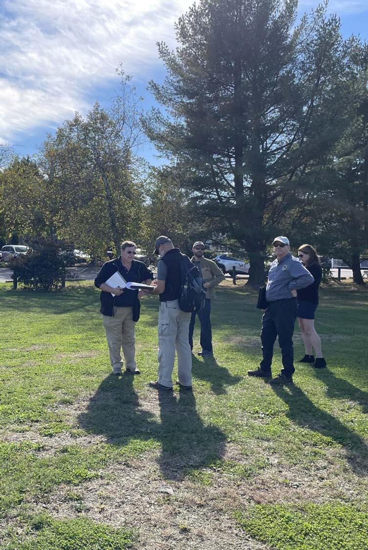
Several site visits and meetings with both museum and City staff were completed during the development of this Plan to verify the accuracy of the existing conditions data, inspect existing drainage infrastructure, and identify areas of stormwater concern and possible opportunities for creative solutions. Based on the site visits and museum staff input, nine areas of stormwater concern were initially identified. The original nine areas were further consolidated into the final seven areas of concern as presented in this plan.
These areas all experience ongoing issues with erosion, clogging, maintenance and ponding water, which all contribute to the localized flooding problems experienced on campus during rain storms. Some of these problem spots are caused by off-campus runoff from the surrounding city street which makes it way onto the Strawbery Banke campus. Although these areas of uncontrolled off-site runoff further contribute to the campus flooding, they present unique opportunities to partner with the City on shared solutions to create a more resilient campus. Brief descriptions of the problems and a map of the seven areas of concern are provided on the following pages. The areas are numbered sequentially and designated with rain drop symbols. The rain drop size indicates the magnitude of the problem and the color of the drop identifies if it is an on-campus or off-campus problem.


Stormwater Impacts


Plan | June 30, 2023 16
Strawbery Banke Museum Stormwater
7
2
Water bypasses the city catch basin and overflows into the campus at Whidden Place and Washington Street.
3
Existing parking lot conditions do not meet current and future parking, wayfinding, and stormwater management needs.
4
5
Erosion and stormwater runoff issues along Horse Lane.
6
Inundation at the Carpenter’s Shop and Jones House after a large storm event.
Inundation of the central lawn after a large storm event.
1
Water ponding and overflow access constraints along Marcy Street.
Location of Impact Localized Campus-wide Off-Campus On-Campus
Water bypasses the city catch basin and curb at the intersection of Court and Atkinson Streets.


PORTSMOUTH HANCOCK STREET WASHINGTONSTREET INSON STREET MARCYSTREET COURT STREET PUDDLE LANE CENTRAL LAWN 2 1 5 4 6 3 7
PISCATAQUARIVER DOWNTOWN
Strawbery Banke Museum Stormwater Plan | June 30, 2023 18
STRATEGIES
A Stormwater Toolbox
REDUCE
Reduces sources of stormwater runoff and erosion. Remove, convert, stabilize, and disconnect.
CONTROL
Controls and moves the stormwater runoff. Divert, interrupt, slow, and convey.


A comprehensive approach to stormwater management will often require multiple solutions integrated systematically to filter and treat stormwater at or near where it falls. These systems, called Green Stormwater Infrastructure (GSI), can be thought of as a “stormwater toolbox” with components that can be combined to treat any number of stormwater concerns.

To successfully integrate GSI at Strawbery Banke Museum, a variety of techniques should be employed. The following pages illustrate a suite of recommended techniques, their function, and site-specific opportunities for integration into the campus. Icons are used as a quick reference and to demonstrate where these techniques can be applied. In many instances, the best GSI solution for a site may include multiple techniques designed as a system to provide multi-functional campus-wide benefits.
Consistent with the overall stormwater approach, the techniques available in the “stormwater toolbox” are categorized by five defined strategies further described in the next section


1. REDUCE
2.
CONTROL
3.
CAPTURE
4.
STORE
5.
OVERFLOW
Beyond providing tangible solutions, the stormwater toolbox also helps to simplify the stormwater management design into a more manageable system. As options are explored and GSI is implemented on a site-specific basis within the Museum’s watershed, over time we will create a web of water smart spaces which reduce, control capture, store and overflow stormwater more efficiently. To that end, prior to beginning each project, the Strawbery Banke staff meet to discuss the stormwater goals, strategies, techniques, maintenance responsibilities, and expectations. Also identifying the site context can provide valuable information about existing or future uses and considerations for the implementation of GSI. Some techniques may be better suited for a specific location or site contexts than others.
Finally, a thorough site analysis prior to implementation should be completed to ensure that the GSI is properly applied, mimics the natural environment, functions as designed, minimizes maintenance burdens and perhaps most importantly respects the historic landscape of the Museum.
PAVEMENT REMOVAL is the ideal option when looking for stormwater solutions. By removing pavement, impervious cover within the stormwater watershed is reduced and therefore less rain accumulates at the low point.
BROAD-BASED DIP interrupts and diverts the stormwater flow path. A broad-based dip is ideal for unstabilized (dirt) roads as it allows for vehicular circulation but also breaks up the flow path to reduce erosion and scouring.

PERMEABLE PAVEMENT / PAVERS are the next best option. In high-traffic areas where space is in high demand for a variety of intense uses, permeable pavement or pavers can alleviate the total burden by allowing a portion of stormwater to percolate into the soil profile below.
MATURE CANOPY TREES are often undervalued as a GSI technique. A robust tree canopy helps reduce erosion caused by falling rain, and provide surfaces area where rain water lands and evaporates. Tree roots can also take up water and help create conditions in the soil that promote infiltration.
RAIN BARRELS collect and store small amounts of stormwater from a controlled source. Rain barrels are perfect for disconnecting rooftops. However, at Strawbery Banke Museum, certain historic buildings may not be compatible for gutter and downspout connections and will need to employ different solutions.
STABILIZED SOILS provide a different opportunity to reduce the adverse impacts during high-intense storm events. Although stabilized soils do not promote the infiltration of rainfall, they do reduce erosion by replacing unstable surfaces on steep slopes.
MOUNTABLE CURB is a dual-function technique designed to allow vehicular access up and over the curb while also maintaining the gutter line. Mountable curbs may be used along the campus perimeter streets to control off-campus runoff.
CONTAINMENT BERM is a landscape feature that can be used to control runoff. With subtle changes in elevation to the central lawn and the historic road configuration, positive pitch inside the containment zone can be more easily maintained.
COBBLESTONE SWALE is a hard surface linear technique to convey stormwater. The hardened, cobblestone channel will provide a historically consistent solution to control road runoff. Cobblestone channels can be applied where space is limited and along the edge of roads and paths.
VEGETATED SWALE is a linear landscape that conveys stormwater. The planted channel not only moves stormwater, but can also add ornamental beauty and an environmental habitat. Vegetated swales are best used where ample space is available.

Strawbery Banke Museum Stormwater Plan | June 30, 2023 20
CAPTURE
Captures and cleans stormwater close to its source. Collect, retain, and filter.
PAVED INLET FLUME intercept stormwater from paved surfaces and direct the runoff into a sediment forebay or storage area. Paved inlet flumes are most compatible with surface-level GSI options.
STORE
Stores stormwater intentionally for future release. Detain, infiltrate, and disperse.

WET SWALE is a linear, wet option where a combination of groundwater and stormwater may be visible for part or all of the year. Similar to a marsh setting where the tide cycle fills and releases, a wet swale will be an extension of the constructed wetland, giving rain a path to find the wetland.
OVERFLOW
Releases stormwater by controlled overland flow. Direct, bypass, and control.


SPILLWAYS are surface features located to release detained stormwater from the site. A spillway is a surface technique to move stormwater from the campus in a controlled manner.
SEDIMENT FOREBAY is designed to capture sediment and debris before directing stormwater into the next component of the stormwater management. Sediment forebays are important to isolate maintenance efforts and reduce potential eyesores.
CONSTRUCTED WETLAND is the centerpiece of our stormwater intervention, creating an intentional space for stormwater to accumulate within the campus. Due to current limitations with the City’s storm drain at high tide, intentionally designing areas to temporarily store stormwater on campus during severe storms may be the best option to embrace more frequent flooding.
STRUCTURES & PIPES allows stormwater to be moved below ground and discharged to an outlet. Found throughout the watershed, pipes and structures can serve as the primary overflow mechanism when low tide allows discharge at the outfall.

RAIN GARDEN is often a simple, shallow depression in the landscape, providing limited storage and promoting positive drainage. Rain gardens scattered throughout Strawbery Banke Museum could capture rain closer to the contributing source, disconnecting stormwater during smaller storm events.
STORMWATER TREE TRENCH can be designed to capture small amounts of stormwater both at or below the surface for infiltration and tree toot uptake. Stormwater tree trenches may be viable at higher elevations on campus where groundwater separation is more sufficient for healthy tree growth.
DETENTION/INFILTRATION BASIN is a storage technique that is designed to temporarily hold and infiltrate (when possible) excess water during larger rain events and high tides. The principal function is to disperse stormwater storage and reduce the flooding in the central lawn.
BOX CULVERT & BOARDWALKS permit surface flow of stormwater underneath roads and pathways. They can be used to provide surface overflow from one area to another while maintaining pedestrian and vehicular circulation paths.

Applied Stormwater Solutions


Strategies Serving a Variety of Functions
Today, most of the land use surrounding and within the Strawbery Banke campus contributes to increasing stormwater runoff, rather than managing it at the source. Both on and off-site runoff flows uncontrolled through the campus and contributes to erosion, on-going maintenance issues, damage to buildings and the landscape, and localized flooding. Strawbery Banke Museum must start at the source of the problem and identify opportunities to better manage stormwater within the entire watershed. Therefore, the Plan recommends implementing a more holistic watershed approach relying on GSI to move stormwater and mitigate the impacts within the Campus based on the following five stormwater strategies:
1. REDUCE The first step is to reduce contributing sources of runoff and erosion. Examples include removing unnecessary paved surfaces, converting pavement to permeable surfaces and green space, stabilizing dirt & gravel surfaces, adding tree canopy, and disconnecting roof runoff where possible.
2. CONTROL. The next goal is to better control the stormwater runoff. Examples may include incorporating diversion techniques to interrupt long flow paths and divert runoff, or increasing the flow path and retention times with conveyance swales.
3. CAPTURE. Once the stormwater is better controlled, low flows should be captured as close to the contributing source as possible. Paved inlet flumes and sediment forebays can be used to direct and pretreat stormwater prior to capturing the stormwater in rain gardens and tree trenches. The techniques can be applied to disconnect and retain small volumes of water and help reduce localized flooding downhill by distributing the burden of collection across the campus.
REDUCE CONTROL CAPTURE STORE OVERFLOW
4. STORE Due to poor draining soils and a highwater table, infiltration of stormwater is limited. For larger storm events, when runoff exceeds the capacity additional water must be stored until the storm subsides or high tide passes, and water can be released. Examples may include retrofitting areas as detention basins, adding linear wet swales, and creating a constructed wetland.
5. OVERFLOW. Last, but perhaps most important, is considering adverse impacts during the worst-case scenario, when storage systems are at capacity and the City storm drain is inundated by high tide. It will be critical to allow water to be released from the campus by overland flow to avoid the inundation of the Lawrence J. Yerdon Visitor Center and other low-lying structures. Examples include integrated overland spillways, bypass structures and pipes, and box culverts.
GREEN STORMWATER INFRASTRUCTURE TECHNIQUES
For each strategy, specific Green Stormwater Infrastructure (GSI) techniques are identified. GSI is a nature-based solution to stormwater management problems often caused by urban runoff. GSI provides benefits such as beautified
communities, creation of ecological habitat, and environmental sustainability and resiliency. These techniques can be applied individually or combined to create a hydrologically connected system to better manage runoff at the source and build resiliency across the campus with a web of interconnected solutions. These site specific techniques must also be designed with maintenance in mind. At a practical level, sand, salt, and debris are more prevalent near the paths, roads and parking lots. Designs should include sediment forebays to provide pretreatment and to reduce maintenance burdens by capturing debris in a designated location. Pretreatment and regular maintenance will allow these stormwater systems to perform more effectively. Using a nature-based approach to stormwater management can also be an effective way to incorporate native and historically appropriate plants into the landscape, contributing to the museum’s preservation and education mission.
Icons are incorporated into the Plan to identify the specific type of GSI technique and their proposed locations within the campus. The icons are further color coded to identify which of the five strategies they can be applied to.


Strawbery Banke Museum Stormwater Plan | June 30, 2023 22
pavement maintenance erosion flow paths visual impact small storms debris sediment larger storms largest storms

23
Opportunities for Intervention
CURRENT PROBLEMS ARE FUTURE OPPORTUNITIES
By applying a watershed stormwater approach and implementing GSI on the Strawbery Banke Campus, both on-site and off-site problems can be addressed holistically to accomplish multiple goals Proposed solutions are proposed to combine a variety of GSI techniques at the seven identified areas of concern. The projects adhere to the goals identified in the Plan and can be completed in any order, as funding becomes available and time permits. Each project looks to address stormwater management, but also improve parking lot efficiency, connectivity throughout the campus, and the overall visitor experience.
The following matrix summarizes the areas of concern, briefly describes the proposed solution, identifies the project goals, suggests a time frame to complete the project and provides a comparison of the estimated costs relative to each other (outlined below).
$ - Low Cost (shared with the City.)
$$ - Medium Cost with low-level improvements.
$$$ - High Cost and includes improvements beyond stormwater. $$$$ - Most Expensive, includes significant campus improvements beyond stormwater.
Additional stormwater improvements can also be included in other campus improvement projects to Reduce, Control, Capture, Store and Overflow. Such projects may include disconnecting building downspouts and roof runoff, addressing grading and drainage within the small satellite parking lots along the perimeter of the campus or additional road repairs using GSI techniques to stabilize the surfaces to reduce erosion and better control stormwater runoff.
A map accompanies the matrix to identify the project location and stormwater toolbox techniques to be applied.
Atkinson & Court Streets Intersection
Eliminate off-site contributing stormwater, reduce erosion and localized campus flooding.
Reduce and control off-site stormwater runoff from Atkinson Street to prevent it from entering Court Street.
1-2 years $
Washington Street Runoff
Eliminate off-site contributing stormwater, reduce erosion and localized campus flooding.
Reduce and control off-campus stormwater runoff on Washington Street to prevent it from entering the campus at the driveway access.
1-2 years $
Main Parking Lot — Layout & Runoff
Manage, control and move water through the campus, re-design campus use areas, incorporate educational components.
Re-design of the parking lot area to increase parking efficiency and capacity, provide better connectivity and wayfinding, and control, capture and store stormwater.
3-5 years $$$$
Internal Pathways and Side Streets (Jefferson & Atkinson Streets & Mast & Horse Lanes)
Manage, control and move water through the campus, reduce erosion along internal roadways and localized flooding, re-design the campus use areas, incorporate educational components.
Create a foundation infiltration basin by diverting surface flow to existing Marshall House foundation.
1-2 years $$
Carpenter’s Shop — Localized Flooding
Reduce localized flooding, manage, control and move water through the campus, re-design the campus use areas.
Create a vegetated wet swale to control, capture, store and overflow stormwater runoff away from the Carpenter’s Shop.
2-3 years $$
Puddle Dock Lawn — Localized Flooding
Reduce localized flooding, manage, control and move water through the campus, re-design the campus use areas, incorporate educational components.
Convert a portion of the existing lawn area to a constructed wetland to control and store stormwater on the campus.
4-5 years $$$
Existing Floodplain, Marcy Street Edge Reduce localized flooding, manage, control and move water through the campus.
Create a controlled overflow from the campus to allow water to leave the campus to reduce impacts of flooding.
4-5 years $
Strawbery Banke Museum Stormwater Plan | June 30, 2023 24
Area of Concern Goals & Opportunities Proposed Solution Time Frame Est. Cost
2 1 5 4 6 3 7


HANC K T INSON STREET COU T STREE PUDDLE LANE PISCATAQUARIVER PRESCOTT PARK DOWNTOWN PORTSMOUTH 1 5 4 6 3 7 WASHINGTONSTREE 25
Disconnect Court Street
Area of Concern: Atkinson & Court Streets Intersection
Proposed Solution: Disconnect Court Street to prevent off-campus stormwater runoff


PISCATAQUA RIVER ATKINSON STREET

DESIGN INTENT AREA OF CONCERN BEFORE AFTER 1 1
Work with the City to reset the vertical granite curb along Court Street to eliminate the vulnerability. Direct pedestrian traffic to a more visible and properly designated crosswalk. Reduce erosion down Atkinson Street and the total amount of stormwater reaching the central lawn. By resetting the vertical curb, stormwater generated by off-campus impervious areas will be directed towards the existing catch basin found on Court Street. In the event this catch basin clogs from leaf litter or debris, a raised planter is also proposed behind the sidewalk to hold the campus perimeter and isolate the low point surrounding the catch basin.
Shapley House
RAISED PLANTER TO RETAIN PONDING WITHIN ROAD IF CATCH BASIN CLOGS PROVIDE 6” REVEAL RETAIN STORMWATER IN ROAD PUDDLELANE
Pitt Tavern
Stormwater Plan | June 30, 2023 26
Strawbery Banke Museum
Photo rendering showing proposed solutions to prevent off-campus runoff from entering the Strawbery Banke Museum campus. Reset granite curb, monitor catch basin within Court Street to prevent clogging, and install raised planter for perimeter defense.
Photo taken at intersection of Atkinson Street & Court Street, looking south into Strawbery Banke campus.
RESET GRANITE CURB COURTSTREET MARCY STREET WASHINGTON STREET HANCOCK STREET
Court Street defines the northern extent of Strawbery Banke and exists at a higher elevation than the Campus itself. As stormwater makes its way down Atkinson Street, it eventually reaches the intersection at Court Street, shown below. During large storms, stormwater from Atkinson Street runs across Court Street, into the Court Street southern gutter line.
A vulnerability exists where the vertical curb is set flush to meet Court Street. Typically, a flush transition from road to sidewalk is found where an accessible ramp and crosswalk allow pedestrians to cross the street. In this case there is no ramp or striped crosswalk, creating an opportunity for stormwater to “jump” the curb and flow down Atkinson Street. The result is off-campus runoff draining through the campus and causing repeated erosion down Atkinson Street.
Disconnect Washington St.
Area of Concern: Washington Street Runoff
Proposed Solution: Disconnect Washington Street to prevent off-campus stormwater runoff
Similar to the conditions found at the Intersection of Atkinson and Court Streets, an existing curb cut at the low point along Washington Street allows stormwater to bypass the existing catch basins and enter the Strawbery Banke campus. When debris (sand, snow or leaf litter) clogs the existing catch basins, or when the outflow pipe is underwater during high tide, stormwater will overtop and enter the campus. Although the contributing drainage area has less impact than the Atkinson and Court Street site, Washington Street provides another opportunity to reduce and control off-site runoff entering the campus.


In order to preserve the existing vehicular access point into the campus center and the historic character of Washington Street, install a mountable, granite curb along to elevate and continue the existing brick sidewalk. The mountable curb maintains vehicular access into the campus while maintaining the existing gutter line and keeping the stormwater within the road.
To make up the difference in elevation on the inside of the new brick sidewalk, a stabilized surface is proposed to gradually slope into the campus to meet the existing grades. The stabilized surface should be designed to provide H-20 loading, which might be accomplished with granite cobblestones or similar materials to match the historic character.
FLUSH GRANITE CURB STABILIZED TRANSITION
ELEVATED BRICK SIDEWALK
MOUNTABLE
GRANITE CURB
27 DESIGN INTENT AREA OF CONCERN
Rendering showing proposed solutions to prevent off-campus runoff from entering Strawbery Banke Museum campus. Install a mountable granite curb, monitor catch basin within Washington Street to prevent clogging, and elevate brick sidewalk for perimeter defense.
Photo taken on Washington Street sidewalk. Looking south down Washington Street.
COURTSTREET MARCY STREET WASHINGTON STREET HANCOCK STREET PUDDLELANE PISCATAQUA RIVER ATKINSON STREET
Penhallow House
2 2 BEFORE AFTER
Parking Lot Improvements

Area of Concern: Main Parking Lot - Layout + Runoff


Proposed Solution: “Parking Garden” capacity, better and improved stormwater collection/retention


Strawbery Banke Museum Stormwater Plan | June 30, 2023 28
MARCY STREET WASHINGTON STREET HANCOCK STR PUDDLELANE ATKINSON STREET
COURTSTREET
Photo taken at Main Entrance, looking northeast toward Prescott Park.
Photo taken at center of Parking Lot, looking southwest toward Hancock St.
STREET 3 MARCY STREET
HANCOCK
AREA OF CONCERN
The existing parking lot fails to meet the museum’s growing demands for visitor and bus parking (up to eight school buses.) The existing parking geometry and circulation patterns are inefficient. Beyond lack of capacity and stormwater controls, the parking lot lacks wayfinding and strong pedestrian connections. The museum has also identified a need for improved signage to guide newcomers towards the Lawrence J. Yerdon Visitor Center.
There are several archaeological sites identified by Strawbery Banke Museum under the existing parking area. Below ground, obstructions may impact where trees can and cannot be planted, where excavation beyond 1-foot can and can not occur, and where stormwater conveyance versus storage may be best located. The landscape must also be designed in harmony with the historic context, and not detract from it.

Design options, infiltrating stormwater, and plant selection are limited due to a rising seasonable groundwater table.


DESIGN INTENT
The basis of design uses native plants that take advantage of the existing wet conditions while expanding needed parking. The conceptual design illustrated on the previous page expands the parking lot footprint., with drive aisles and bus-slips designed for school bus turning radii. The design offers a total of five bus slips and sufficient space for three more parallel bus parking spots to provide parking capacity for eight buses.
The design also recommends a dedicated bus drop-off area and entrance walkway to improve the sense of arrival at the campus entry. A gentle reconfiguration of the exiting curb cut at the main gate pivots the angle and approach to be more inviting. Safety is further addressed with the addition of solar-powered lampposts to improve visibility at night.
To improve stormwater management, the design integrates GSI techniques at a variety of scales to manage parking lot runoff at the contributing source. Broadbased dips are incorporated to allow unimpeded vehicular movement, while also controlling the conveyance of overland stormwater runoff towards inlet flumes and into vegetated depressions. The design also adds canopy trees to reduce heat island effect, adds to species diversity campus-wide, and softens both visual and runoff impacts of a large, paved surface.
Museum stakeholders expressed a strong desire to better connect the Strawbery Banke Museum campus to adjacent destinations. The design includes improved sidewalks and an elevated boardwalk linking the parking lot to the Lawrence J. Yerdon Visitor’s Center as well as Marcy Street and Prescott Park. Wayfinding and educational signage could be installed across this linear connection to educate visitors about the site’s history, native plants and the climate change. Beyond the physical connection, the boardwalk will also serve as a strong visual connection, enticing Prescott Park visitors and pedestrians along Marcy Street to explore the campus.

The vision of the new parking lot at Strawbery Banke aims to bring an array of benefits beyond its primary parking function. The “parking garden” concept welcomes visitors old and new, controls and captures stormwater, provides habitat for native species, an protects the future by celebrating the past.
PAVED INLET FLUME
SOURCE: HORSLEY WITTEN GROUP
RAIN GARDEN
SOURCE: HORSLEY WITTEN GROUP
BROAD-BASED DIP
SOURCE: INHABITAT; PRATT
MATURE CANOPY TREES
SOURCE: HORSLEY WITTEN GROUP
29
Foundation Detention Basin


Area of Concern: Internal Pathways and Side StreetsRunoff + Erosion


Proposed Solution: Stabilizes road surfaces and creates a foundation infiltration basin diverting surface flow to existing Marshall House foundation

Impervious Liner Perforated Underdrain

Broad-based Dip Marshall House Foundation Stormwater Detention

Plan | June 30, 2023 30
PUDDLELANE
Strawbery Banke Museum Stormwater
COURTSTREET MARCY STREET WASHINGTON STREET HANCOCK STREET
PISCATAQUA RIVER ATKINSON STREET
Photo taken on Horse Lane, looking south towards central lawn.
Photo taken on Jefferson Street, looking southwest over Marshall House
Jackson House
JEFFERSON STREET
HORSE LANE
4
Sherburne House & Garden
Erosion on Horse Lane has been an ongoing maintenance burden for many years. Every spring and frequently throughout the year, the surface of Horse Lane requires supplemental material and regrading. The eroding material and stormwater coming down Horse Lane ultimately flow towards a small catch basin at the bottom of the hill at the intersection with Puddle Lane. In the event this inlet is either clogged or full of groundwater and/or seawater, the structure overflows and accumulates within the central lawn.
There are several contributing factors:
• Uncontrolled stormwater path runs down the road corridor.


• Steep slopes with long flow path lead to erosive, concentrated flow.
• Unstable surface material is susceptible to erode.
Ultimately, all stormwater and associated debris coming down Horse Lane contributes to the greater area of concern within the central lawn. Remnants of the historic foundation of the Marshall House are visible today at the intersection of Jefferson Street and Horse Lane. While the foundation today is subtle, it does provide a sense of form and shape that presents an opportunity to be part of the solution to this area of concern.
DESIGN INTENT
Stabilizing surface materials will help reduce erosion and frequent maintenance. Adding diversion techniques and adjusting the cross slope of Horse Lane can shift the path of least resistance off the road corridor, creating intentional space for stormwater flow. Although the steep slopes found on Horse Lane can not be adjusted, diversion techniques can be used to intercept and slow stormwater as it makes its way downhill. Rain barrels or other small footprint collection devices can also be used to disconnect rooftop runoff for reuse. In tandem, all of the options described can be used to interrupt the long flow and reduce the erosive force of concentrated stormwater flow.
A broad-based dip at the intersection of Jefferson Street and Horse Lane is proposed to divert stormwater flows normally running down the road corridor to be re-directed across the road and into the Marhsall House foundation. Soil conditions within the foundation will need to be evaluated to assess the level of earthwork required and feasibility for stormwater use, but the Marshall House foundation could be re-purposed to provide short-term stormwater detention and expose another historical element within the campus. The foundation detention basin would provide storage during smaller storm events. At a minimum, this solution would increase the flow path, add detention and reduce the frequency of stormwater directed directly to the downhill drainage infrastructure.
Beyond the stormwater detention benefits, this project also serves as an opportunity to reinvent and celebrate an under-appreciated resource found at Strawbery Banke. Native fieldstone will be used to mimic the historic foundation visible today. If suitable, subsurface enhancements will be included to ensure proper drain-down times and to control overflows, such as amended well-drained soils, and perhaps even perforated underdrains and an impermeable outside liner. None of these features will be visible, thereby retaining the historic sense of place.
SEDIMENT FOREBAY
SOURCE: HORSLEY WITTEN GROUP
STABILIZED SURFACE (STABILIZED STONEDUST)
SOURCE: HORSLEY WITTEN GROUP
BROAD-BASED DIP
SOURCE:©AMAR SJAUW EN WA
FOUNDATION DETENTION BASIN

SOURCE: HORSLEY WITTEN GROUP
VEGETATED SWALE
SOURCE: HORSLEY WITTEN GROUP
COBBLESTONE SWALE
SOURCE: STONE FARM LLC

31
AREA OF CONCERN
Carpenter’s Shop Wet Swale
Area of Concern: Carpenter’s Shop - Localized Flooding


Proposed Solution: Vegetated Wet Swale


Plan | June 30, 2023 32 COURTSTREET MARCY STREET WASHINGTON STREET HANCOCK STREET PUDDLELANE PISCATAQUA RIVER ATKINSON STREET
Strawbery Banke Museum Stormwater
Jones House
Carpenter’s Shop
Carpenter’s Shop
Walking Path Wet Swale
Existing Patio
Visitor’s Center
Photo taken beside Carpenter’s Shop, looking east towards central lawn.
PUDDLELANE ATKINSON STREET 5
Carpenter’s Shop
Jones House
LabrieFamilySkate
ATKINSON STREET
VISITOR CENTER COURTYARD
Frequent localized flooding outside the Carpenter’s Shop is among the highest areas of concern for Museum staff. The Carpenter’s Shop is set at the lowest finished floor elevation (FFE) across the entire campus at 9.19.’ It sits between the 100-year floodplain (elevation 9.0’) and 500-year floodplain (elevation 10.0’). Furthermore, the Carpenter’s Shop has very little foundation reveal, allowing floodwater to come in contact with wooden clapboard and trim that is susceptible to rot. The surrounding topography is flat, which encourages stormwater to settle and pond.
In the winter when the Labrie Family Skate at Puddle Dock Pond rink is installed, the Carpenter’s Shop experiences additional drainage challenges. As the ground freezes, the ice rink acts as a barrier, preventing stormwater from draining away from the Carpenter’s Shop and towards Atkinson Street and a series of catch basins. The existing dirt road also segregates these spaces between the central lawn and the seasonal ice rink. The sand used to level and construct the rink can often clog the surrounding catch basins. The weight of the ice rink also compacts the soil, further exasperating the runoff problem when the soils begin to thaw. These contributing factors lead to a pinch point outside the Carpenter’s Shop and an inability for the soils and catch basins to properly drain the site.
As the Carpenter’s Shop relates to the central lawn, which varies in surface elevation from 7.5’ to 8.5,’ the Carpenter’s Shop FFE establishes our first critical grade as we begin to look at the larger area of concern and how these two areas are interconnected.
DESIGN INTENT

Positive drainage requires a consistent pitch away from buildings and structures. As it relates to protecting a building foundation, the landscape that directly abuts the foundation should slope away. Where gutters and downspouts aren’t possible due to historic preservation standards, adding a stone drip edge around the perimeter of the foundation may provide an opportunity to capture and infiltrate smaller rain events and prevent scouring and erosion during larger events.
Similar to the previous area of concern, stormwater surrounding the Carpenter’s Shop must cross several dirt roads to reach the existing drainage system. Due to this area being used as a temporary ice rink during the winter months, two options were considered. The first option includes maintaining the space for the ice rink, reducing the width of the dirt path, and creating a wet swale between the modified path and the rink. The second option, as presented here, aims to reduce the width of the dirt road immediately south of the Carpenter’s Shop to re-establish the walking path and introduce a broad-based dip to control the stormwater by directing it to a vegetated swale. The vegetated wet swale will receive stormwater from the broad-based dip as well as the patio space north of the Lawrence J. Yerdon Visitor Center. During seasonal high groundwater, the wet swale and its planted habitat will intercept the groundwater and the water may be visible at the surface.
Although the main function of the swale will be to control and move stormwater, it can also provide natural beauty and seasonal color to the campus landscape. In alignment with the museum’s preservation and education mission, the wet swale could transform the current mown lawn into a more natural, riparian edge that recalls the former tidal inlet, which once existed on the site.

STABILIZED SURFACE (POROUS PAVER)
SOURCE: HORSLEY WITTEN GROUP
STORMWATER RUNNEL (ALTERNATIVE TO BROAD-BASE DIP)


SOURCE: SF BETTER STREETS
STABILIZED SURFACE (INTERLOCKING PAVERS)
SOURCE: HORSLEY WITTEN GROUP
WET SWALE
SOURCE: HORSLEY WITTEN GROUP
33
SPILLWAY (WAVY TRENCH GRATE)
SOURCE: HORSLEY WITTEN GROUP :
BOX CULVERT
SOURCE: HORSLEY WITTEN GROUP
AREA OF CONCERN
The Constructed Wetland

Area of Concern: Puddle Dock Central Lawn - Localized Flooding


Proposed Solution: Constructed Wetland in portion of existing lawn

LabrieFamilySkate
Plan | June 30, 2023 34 COURTSTREET MARCY STREET WASHINGTON STREET HANCOCK STREET PUDDLELANE PISCATAQUA
STREET
Strawbery Banke Museum Stormwater
RIVER ATKINSON
Photo taken within central lawn, looking north towards Atkinson Street.
Photo taken on Atkinson Street, looking east over the central lawn.
Atkinson Street Box Culvert Constructed Wetland Deep Pool
Accessible Boardwalk crossing Wetland
Stone Wall Visitor’s Center
CENTRAL LAWN
6
The central lawn was once a tidal inlet, providing an outlet for the stormwater runoff from the surrounding drainage area. Today the large central lawn is the museum’s most high-intense use area, supporting many Strawbery Banke Museum events throughout the year. The central lawn is also the absolute low point within the campus and the surrounding watershed. During high tide, when the tidal culvert outfall is submerged under several feet of seawater, the city’s drainage infrastructure can not release the accumulating stormwater from the watershed.
Most of the stormwater within the campus finds its way to the central lawn. At times, this can create extensive flooding within the lawn area. Controlling and diverting stormwater elsewhere on site will not be enough to alleviate the visible burden that accumulates in the central lawn each spring and or throughout the year when storm events coincide with high tide.
DESIGN INTENT
This intervention aims to create a constructed wetland where it is already wet. The proposed shape would move stormwater from the Carpenter’s Shop wet swale beneath Atkinson Street and into two deep pools to temporarily store water at high tide. During severe storms, the wetland configuration will also promote lateral flow across the Campus towards Marcy Street.
Positioned between the central lawn and parking lot, the wetland can act as a soft visual buffer, screening the view of parked cars and buses, which can detract from the museum experience. The proposed wetland vegetated slopes adjacent to the central lawn are imagined as low growing, maintaining the long viewsheds of today while also creating a more immersive opportunity with the natural environment. The southern slope of the wetland, between the boardwalk and parking lot, is imagined as a more natural riparian habitat with mixed native shrubs and herbaceous ground cover.

The constructed wetland and accessible boardwalk crossing could become a new Strawbery Banke Museum feature and local landmark. Opportunities for interpretive signage describing the plants, habitats and its role in water control are myriad. The Museum can highlight its wetland ecosystem, how it is planning for groundwater rise, and how drawing working with the past can help steer our future.
PAVED INLET FLUME

SOURCE: HORSLEY WITTEN GROUP
RAIN GARDEN
SOURCE: HORSLEY WITTEN GROUP
RAIN GARDEN

SOURCE: HORSLEY WITTEN GROUP
VEGETATED SWALE


SOURCE: HORSLEY WITTEN GROUP
SPILLWAY (PLANK-STYLE PAVERS)
SOURCE: UNILOCK
BOARDWALK CROSSING CONSTRUCTED WETLAND
SOURCE: KLOPFER MARTIN DESIGN GROUP

35
AREA OF CONCERN
The Designed Floodplain
Area of Concern: Existing Floodplain, Marcy Street Edge


Proposed Solution: A Designed Floodplain, creating controlled, overland relief points during severe storms

Strawbery
Plan | June 30, 2023 36 COURTSTREET MARCY STREET WASHINGTON STREET HANCOCK STREET PUDDLELANE PISCATAQUA RIVER ATKINSON STREET PUDDLELANE MARCY STREET
Banke Museum Stormwater
Photo taken beside emergency spillway, looking east towards Marcy Street.
Photo taken at crosswalk connection, looking east towards Prescott Park.
Conceptual illustration color-coding surface contours at six-inch intervals. Blue arrows show intended flow paths and detention / extended detention storage areas during severe storm events.
7
The final strategy addresses the “worst-case scenario.” The central lawn is underwater. The groundwater table is inflated, filling most of the low-lying basements. A historic king tide swells the Piscataqua River up and over the inlet banks of Prescott Park, submerging the stormwater outfall several feet under. Seawater surges up the city storm drain competing for space in the pipes and structures beneath Marcy Street. The constructed wetland is full and spills outward on to the parking lot and upland central lawn. Floodwaters are rising near the elevation of the Lawrence J. Yerdon Visitor Center. Storm clouds sweep in as it begins to pour.
In this worst-case scenario, Strawbery Banke Museum can not depend upon the city storm drains and outlet infrastructure. The existing outfall will be inundated every day, twice a day, unless the closed pipe infrastructure tying Washington Street to Prescott is adapted by the city of Portsmouth. Absent this change, Strawbery Banke will need to find alternative methods to store and release floodwater during severe events.
DESIGN INTENT
The design of the future parking lot and its relationship to Hancock Street, Marcy Street, and Lawrence J. Yerdon Visitor Center will play a key role in identifying and setting critical elevations. As stormwater is directed away from the Jones House, Carpenter’s Shop, Shapley-Drisco-Pridham House, and Visitor Center, the wet swale and wetland will provide lower elevations. The conceptual design also proposes to elevate the surrounding road network of Puddle Lane and Atkinson Street to create a containment area within the central lawn.
The diagram on the previous page depicts conceptual contours at six-inch intervals, setting our designed floodplain at the 100-year elevation of 9.0’ NAVD88. The Carpenter’s Shop currently sits at elevation 9.19,’ giving this building approximately two-inches of freeboard (degree of separation) as floodwaters attempt to escape. To the east, the elevation of Marcy Street and Prescott Park are fundamental components to maintain positive drainage off and away from the campus.
Two overflow spillways are proposed within the eastern parking lot to pass floodwaters through a defined channel, across the sidewalk, and into the Marcy Street corridor. The primary spillway is disguised with plank-style pavers to extend the boardwalk feel through the parking lot. The hardscape pavers offer a stable surface for floodwaters to flow across without eroding the ground beneath.

From here, changes will need to coordinated with the City of Portsmouth to allow floodwaters to bypass Marcy Street and enter Prescott Park. As the storm subsides and high tide passes, flooded areas will gradually be released by forces of evaporation, infiltration, city storm drain conveyance, and plant absorption.
PAVED INLET FLUME

SOURCE: HORSLEY WITTEN GROUP
RAIN GARDEN


SOURCE: HORSLEY WITTEN GROUP
OVERFLOW STRUCTURE (BEEHIVE GRATE IN FOREGROUND)
SOURCE: HORSLEY WITTEN GROUP
BROAD-BASED DIP
SOURCE: ALCIAN ARAUJO
BOX CULVERT

SOURCE: HORSLEY WITTEN GROUP
EMERGENCY SPILLWAY
SOURCE: HORSLEY WITTEN GROUP
37
AREA OF CONCERN
Strawbery Banke Museum Stormwater Plan | June 30, 2023 38
ACTION PLAN
Enacting Change
A CALL TO ACTION
The experience of the Strawbery Banke Museum staff and visitors over the past several years is evidence that water management is a pressing issue for the museum. Water is causing damage to both the landscape and historic resources that the museum is charged with preserving. This report has outlined the many ways in which stormwater can be better managed on the Strawbery Banke Museum campus. Embracing the adaptive strategies outlined in this Plan must be incorporated into the museum’s preservation mission going forward.
INCREMENTAL ADAPTATION: PROJECTS AND BEST PRACTICES

The concepts outlined in this report are just that: concepts that intend to address the adverse conditions and move the museum towards long-term resilience. Each project will need to be reviewed and the designs advanced according to priorities of the museum and available funding. The following Action Plan outlines a high-level approach to project implementation. Techniques for implementing the museum’s long-terms stormwater management goals should be reviewed as part of the standard process for design and construction projects of any nature going forward. Each project the museum undertakes can incorporate some piece of the overall stormwater management plan, ever moving closer to the long-term goals.
MEASURING SUCCESS
Success can be measured by monitoring the plan on an annual basis, to celebrate any projects realized and incorporate new projects into ongoing maintenance or capital planning budgets. Several short-term goals should be accomplished by the end of 2025, and as a result adverse conditions should improve. The off-campus projects should address pathway erosion and decrease the overall amount of stormwater flowing through campus. Rain events should continue to be documented and measured, so that progress can be perceived and celebrated. Partnerships with the City of Portsmouth and the implementation of the Prescott Park Master Plan will be essential to success in this regard.
Plan | June 30, 2023 40
Strawbery Banke Museum Stormwater
Action Items
IMPLEMENTATION OF THE STORMWATER MASTER PLAN


To meet the goals identified in the Plan, seven projects of varying scale and costs have been identified for implementation. Each project is identified as an Area of Concern contributing to the localized campus flooding, The projects are not dependent on each other, but all contribute to improved water management. Strawbery Banke staff must now prioritize and select the first project(s) to be advanced and implemented. Upon the selection of the priority projects the following step would need to be taken for the implementation of one or move projects:
• Further explore the feasibility of the prioritized project sites, which may include the following:
• Soil borings, sampling and testing to identify any potential challenges related to groundwater, infiltration, soil disposal or archaeological issues
• Develop Schematic (30%) design level plans, details and cost estimates.
• Internal review and discussion with the Strawbery Banke stakeholders
• Continue collaboration with the City and the identified permitting agencies.
• Develop 60% design level plans, details and cost estimates.
• Submit plans and documentation for the necessary permitting.
• Develop construction documents and final cost estimates for bid and construction.
Both private and public grant opportunities should also be explored for full or partial funding of the projects.
RESILIENCY PLANNING
Beyond the goals of this Plan, Strawbery Banke will move towards becoming a model for a resilient coastal campus that embraces both structural and naturebased solutions to better manage stormwater and address the long-term effects of sea level rise. This will require the Strawbery Banke staff to continue and expand upon their planning efforts. The next step to move Strawbery Banke towards becoming a model resilient coastal campus and adapt to the pressures of climate change is to develop a campus wide Climate Change Action Plan to address the following:
• Sea level rise and storm surge inundation.
• Groundwater rise and basement flooding
• Transition towards using sustainable materials
• Assess energy use and conversion to renewables
This will require continued collaboration with the City of Portsmouth to address the larger challenges facing the campus, which includes:
• The impacts of sea levels rise on the city storm drain outlet located within the Strawbery Banke Campus.
• The localized flooding of Marcy Street and the overflow of stormwater from larger storm event from the Strawbery Banke Campus
• The impacts of the proposed improvements/changes to Prescott Park and their impacts on the Strawbery Banke Campus.
MOVE TOWARDS A RESILIENT CAMPUS
The ultimate goal is to protect the historic assets from rising waters and continue to offer a rich museum experience to visitors by addressing the impacts of both localized flooding and long-term sea level rise. In order to meet this goal, Strawbery Banke will move towards becoming a model for a resilient coastal campus by committing the necessary resources to the following:
• Develop a culture of sustainability and stewardship of natural resources.
• Update the Stormwater Master Plan and continue to implement GSI techniques within the campus, beyond the projects identified in the Plan, such as rain water harvesting and re-use.
• Increase the % Tree Canopy Cover across the campus.
• Honor the past through material use, native plantings, and water reuse.
• Reduce the carbon footprint through the use of renewable energy
• Serve as a resource for education and outreach.
• Improve campus resiliency
• Continue coordination with our neighbors, community organizations, academic institutions and local, state and federal agencies.
• Address basement flooding and groundwater rise.
• Adapt the campus to storm surge inundation.
Strawbery Banke Museum will become an ever more visible model of a resilient and thriving coastal campus for years to come.

41
TODAY 5 YEARS
YEARS
RESILIENCY PLANNING RESILIENT CAMPUS
10
IMPLEMENTATION OF THE STORMWATER MASTER PLAN


“ A dr op of water, if it could write out its own history, would explain the universe to us.”
Lucy Larcom
