PIERE BORDEAUX
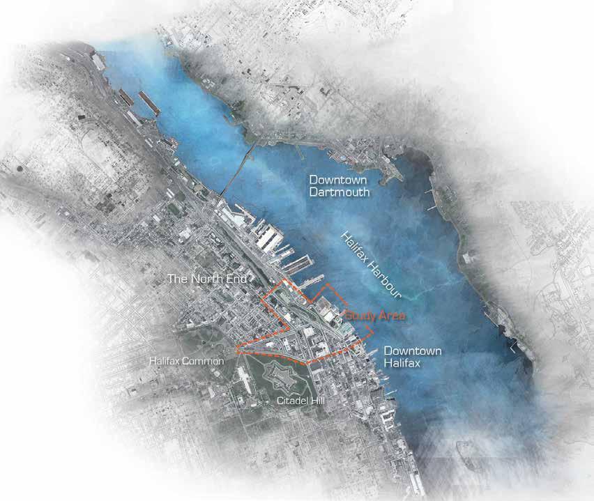
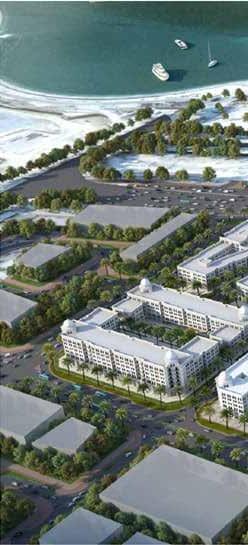
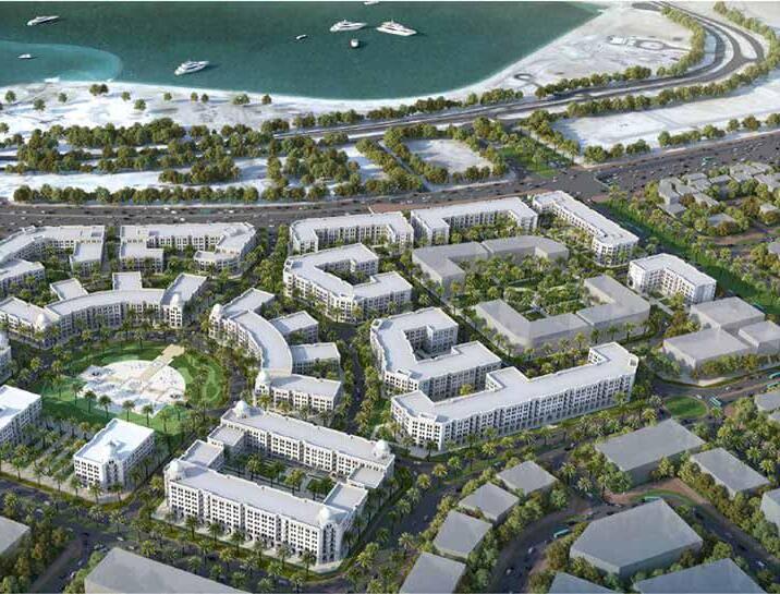
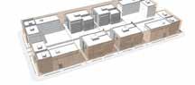
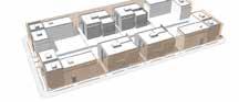
The state of Qatar is thriving to meet the infrastructure requirements to host the Fifa World Cup 2022. As part of the state pursuits, a plan to add a significant reserve to residential developments in the sistainable city of Lusail. Buildings, landscape and municipal networks areas were expected to meet the Global Sustainability Assessment System GSAS - a sustainability assessment system, developed by Gulf Organization for research and Development in Qatar GORD that adopts sustainable measures to metigate and adapt to arid zones. Meanwhile the deign should be contemporary in style and architectural form, it was expected to preserve the heritage of the state.
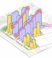
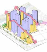
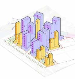
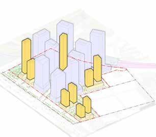
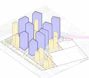
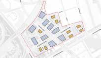
The district is designed to be the home of more than 200,000 residents with further significant employment provided by a range of offices, leisure, entertainment, retail and education facilities. The development incorporated the following elements:
• Residential: Luxury villas & apartments.
• Community services: Civic offices, schools, clinics, mosques, parks and open spaces.
• Hospitality: Hotels, residents’ clubs.
• Entertainment: Arenas, stadia, theme parks and Water-related venue activties.
• Commercial Development: Open retail (boutique shops & restaurants), local/ neighbourhood shops, corporate offices, mixed use development.
• Amenities: beaches, golf, marina berths.
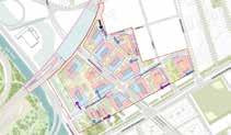
Strategy
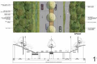
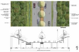
The urban plan has considered open space, climate-controlled pedestrian streets and services by entertainment attractions and access to parks, recreation areas and waterfront in the creation of superb liveable districts and Neighbourhoods.
Transportation Strategy
Lusail features a range of city-wide transport and infrastructure initiatives to ensure its seamless connection with greater Doha and elsewhere. This includes LRT tram, bus and ferry networks, as well as facilities for cyclists and pedetrians. This transit network was designed to provide interconnected circulation between home, work, open space and recreation areas. Proposed road network will form the spine for its utility infrastructure, by incorporating its electrical, water supply, surface water drainage, irrigation, sewerage and telecommunications distribution networks and systems. All services will be available at the boundary limits of each subdivision parcel.
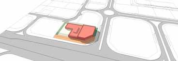
Developer/s: Lusail City, Qatar Team: AECOM, Al Darwish Eng., Bandary Int.
Location: Lusail City, QATAR
Year: 2012-2017
+ Inclusive Urban Development
Vehicle access to plots and building plots is permitted only from the access roads and points indicated in the Plot Building Regulation sheets unless otherwise agreed with Master Developer and subject relevant Authority standards and permits.
My Role: Project Manager - Urban Design - Sustainability Manager
AECOM had to be certified GSAS developer in Qatar, I was one of two candidates from AECOM were trained at GORD and pursued the GSAS-CGP examination. Though, I was the only successful in the examination, and hence was selected to be the project and sustainability manager. I was the representative of AECOM at a pre-consultation meeting with
the city of Lusail to identify the requirements and expectations.
I led a multidisciplinary team of engineers, surveyors, architects, urban designers, CAD drafters, environmentalists and construction managers from AECOm and fom the main contractor of the project ( Bandary Int.). I also analyzed GSAS measures and decided that a gold rating could be achived as per AECOM resourses
• Responsible for conceptual design development, schedule, data collection and analysis, workshop preparation, meeting facilitation, report writing and layout,
• Developed zonning provisions and project controls, visualizations, graphics and rendering using AutoCAD 2D, 3D, Adobe Suite, 3D Max and Maya.
• Served as day-to-day project liaison with client and main contractor, and took decisions on the selection of sub-consultants and sub-contractors
• Supervised daily work production of the Urban Design Studio, and assured that it meets the project controls and guidlines of the city of Lusail as well as the sustainable measures of GSAS as our gold rating goal
• Participated in the development of design guidelines and project controls and communicated it to internal staff
• Reviewed, directed and mentored internal staff and subconsultants


Service activity for retail must be accessed from the road with less traffic circulation, separating servicing traffic from all other traffic & pedestrians access, maintaining a pleasant streetscape and retail frontage at the main road (especially where residential uses overlook).

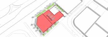
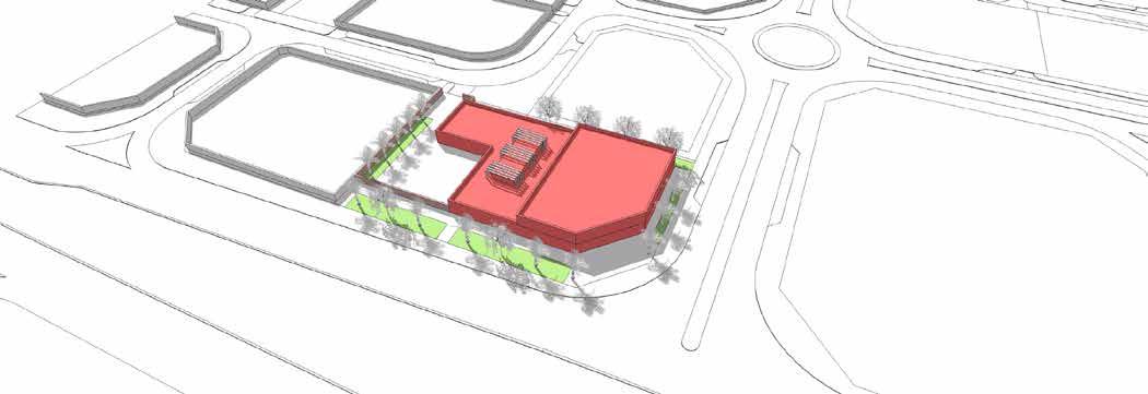
Service access, in/out.

Visitor vehicular access egress for drop off visitors and parking.
Pedestrian entrance separated from vehicular movements

Pedestrian entrance should be located in close proximity to existing LRT station and with all adequate considerations for pedestrian connection.
Retail development to provide a positive image at the entry portal of the District, promote community interaction and serve as a local hub.
Party walls abutting residential plots to be enclosed by 2.5m wall for privacy and noise
Delivery and servicing areas to be at the rear of the store and screened from residential units.
All outside storage to be screened from view.

Servicing is encouraged at the back and should provide clearance of 3m minimum from residential plot. Provision should be made for on-site turning of service vehicles at GF level. Storage of refuse to be screened, secured, designed to control odours and accessible to municipal collector trucks. Screens or parapet walls must be provided with a min. 1m height for

To meet the current Official Plan residential intensification targets within the urban area. The targets increase incrementally • 2022-2026: 42 per cent and • 2027-2031: 44 per cent.
The Official Plan policy directions required that urban expansion support adopted City directions with respect to climate change, growth management, transportation, and the efficient use of infrastructure. To achieve these policy directions, urban expansion areas had to:
• Be at locations that will generate high transit ridership and round out some suburban communities first and extend others on new expansion lands
• Create complete communities on new expansion lands
• Require a secondary plan process, similar to current CDPs
• Avoid Agricultural Resource Areas and achieve an overall density of 36 units per net hectare in each community and provide a minimum share of 10% apartments
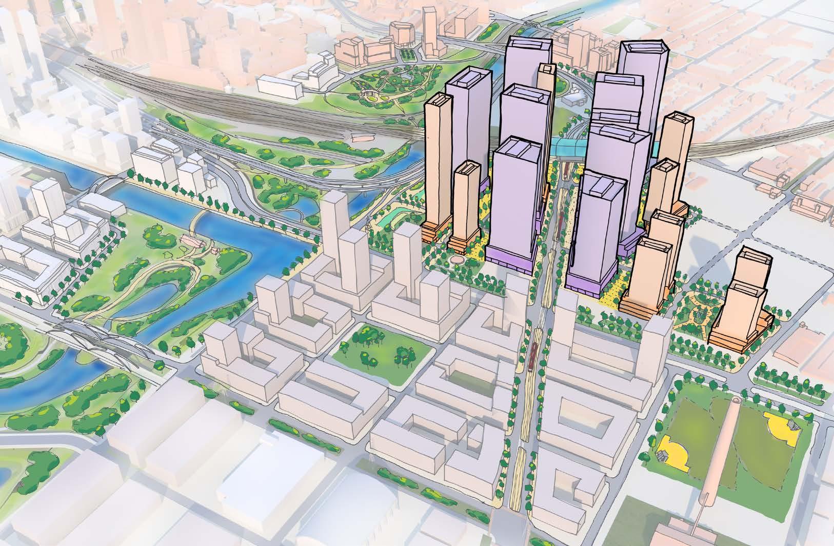
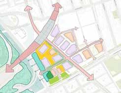
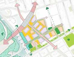
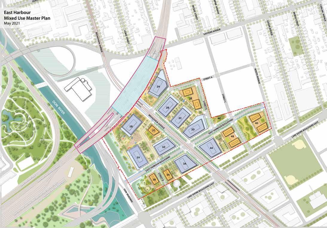
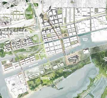
redevelopment of the East Harbour lands (“the Development”) represents a generational citybuilding opportunity that will transform a former industrial site into a significant new transit-oriented district and mixed use community, supported by high-quality public realm and open space network, range of amenities and community facilities.
• Policy that requires a mix of built forms to avoid the cumulative impacts generated by high concentrations of narrow-frontage, front-driveway housing types and establish minimum thresholds of service
Led the project from proposal stages, Site nalysis, zonning provisions, compliance with policies and legeslations through conceptual design, construction, monitoring, evaluation and post operation. Directed a team of urban analyzers to collect primary data, take photographs, while Stantec studio has taken responsibility of land syrvey and mapping. I was the pont ofcontact and the coordinator of tasks of design development: I was responsible for coordinating technical and analysis teams’ input and output, data management, communicating and connecting stakeholders, facilitating meetings and reviewing design and validating process efficiency and reporting progress and results to the higher management. In the design stage, I developed a conceptual design maps and diagrams using ArcGIS, Sketchup, Adobe Illustrator, In Design, and presented using Prezi. While Stantec enhanced the visualization in developing rendered 3D shots
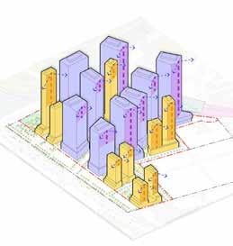
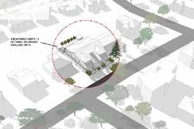
development includes 9 office towers and 9 residential which are supported by retail uses at grade. Office towers height from 31 storeys (143m) to 48 storeys (214), while residential buildings range in height from 23 storeys (75m) to storeys (207m). The total proposed gross floor area (GFA) of 1,228,000 m2 is comprised of 926,000 m2 of non-residential GFA 302,000 m2 of residential GFA. The proposed 9 residential will collectively introduce approximately 4,300 new onto the lands. A range of community and cultural uses facilities will also be provided within the development, specific designs and locations to be determined through subsequent Site Plan Approval applications.
of parks and open spaces is included in the Master including the proposed introduction of three public parks consisting of approximately 7,000 m2 of parkland area to be conveyed to the City. In addition to these parks, five publicly accessible open spaces, totaling 8,000 m2 in area will be introduced, in accordance with the 2018 approved Zoning By-law site. Key plazas include the East Harbour Plaza and the Hub Plazas. The proposed flood protection landform along
Developer/s: East Don, Infrastructure Ontario, City of Toronto
Team: City of Toronto, Stantec, Urban Strategies
Location: Toronto, Ontario
Year: 2022 - Present + Urban Retrofitting and Mobility Network
Data were collected form dfferent governmental parties, like InfraStructure Ontario, Municipality of Toronto, and Toronto Community Housing. Social, demographic, economic and environmental to comprehend how could the retrofitting meet the evolved requirements of the official plan, places to grow act and Ontario’ provencial policy statement. In taking photographs and videographs as primary data, and synthatizing literature review in form of governmental reports and statistics, a full picture of the challenges were illustrated. One of the challenges was that the measurement of impact of high-rise development on the existing heat island effect, which was addressed by using services of a research and analysis firm specialized in infra-red heat mapping to detect the negative impact. The outcome had been entered into our design input to enhance the design efficiency. Accordingly, a conceptual design was developed, and revised to make sure it alligned very
well with the defined challenges and provisions of the analysis stage’ outcome. Three ateliers were organized to show case the project to clients, stakeholders, and to receive feedback and provide answers to inquiries and concerns. In the construction stage, continuous monitoring and environmental evaluations have taken place and discepencies were reported and rectified.
Highlights of my role
• Was the key contact between main stakeholders and clients and coordinated teams using BIM 360 and Revit.
• Developed conceptual design, using sketchup, and developed and reviewed designs, 3D visualizations using Arc GIS, AutoCAD 2D and 3D, Rhino 3D, lumion, and reported progress using Adobe Photoshop, InDesign, Illustrator and presented using Prezi software.
• Communicated and answered clients demands and inquiries that involve profit and financial aspects.
• Directed a team of engineers, surveyors, architects, analyzers to collect data and analyze site conditions and the exixting brown field environmentally,
• organized workshops, facilitated meeting, reported progress, challenges, inquiries, and was involved in layout, graphics and 3D visualizations development
• Served as day-to-day project liaison with clients and supervised daily work production of the Urban Design Studio
• Assigned work to professional staff and ensured appropriate training is provided
• Participated in the development of design guidelines and project controls and communicated it to internal staff
• Reviewed work by internal staff, directed and mentored internal staff and subconsultants
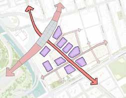
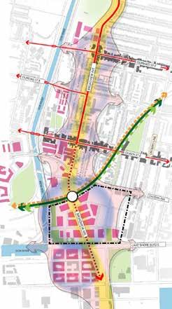
Development at East Don has been strategically distributed across the district, with the greatest building heights located closest to the Transit Hub and along the Broadview spine, consistent with the approved planning framework. Office and residential space will be layered above ground floor retail and animation uses, and will be accommodated in a variety of tower forms to meet a diversity of tenant and resident needs and to provide a distinctive built form character for the district.
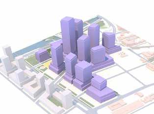
Previous Master Plan distributed building heights across the site to establish a height peak at the commercial core of the district, and to enable a gradual transition in scale down to the edges of the site.

The Mixed Use Master Plan has redistributed office heights across the lands to intensify certain nodes, particularly along the Broadview civic spine, adjacent to the Transit Hub
The Mixed Use Master Plan establishes a development and public realm framework that is intended to guide the redevelopment of the 15 hectare. The structuring elements identified are largely consistent with the development framework established in the Unilever Precinct Secondary Plan, with the exception of the addition of mixed-use buildings into the district.
The Mixed Use Master Plan establishes a development and public realm framework that is intended to guide the redevelopment of the 15 hectare East Harbour lands. The structuring elements identified below are largely consistent with the development framework established in the Unilever Precinct Secondary Plan, with the exception of the addition of mixed-use buildings into the district.
East Don River sits amid a dynamic and evolving neighbourhood context, with new mixed use communities emerging across the east side of the downtown and along the waterfront, all within walking distance of the site. As a former industrial property, East Don is set to benefit from major infrastructure investments that will significantly improve access to the site, unlock its redevelopment potential, and provide connectivity with surrounding neighbourhoods.
The Mixed Use Master Plan establishes a development and public realm framework that is intended to guide the redevelopment of the 15 hectare East Harbour lands. The structuring elements identified below are largely consistent with the development framework established in the Unilever Precinct Secondary Plan, with the exception of the addition of mixed-use buildings into the district.
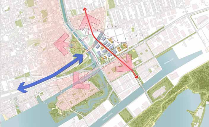
Lands Planning Framework
In response to the generational city building infrastructure that is planned and being delivered in Toronto’s Port Lands, a comprehensive planning framework has been established to guide the long-term growth of the area. This planning framework for the Port Lands has been established through a collaborative initiative between the City of Toronto and Waterfront Toronto, which investigates land uses, densities, urban structure, street networks as well as the parks and open spaces necessary to transform the Port Lands into a new mixed use, vibrant and livable waterfront community.
The previous Master Plan was developed in May of 2018 in parallel with a City-led study for the broader Unilever Precinct, a 25-hectare planning area which included adjacent lands around the East Don River site. On the basis of the May 2018 Master Plan and the City-led Unilever Precinct Plan, Toronto City Council approved an Official Plan Amendment for the area, and a new Zoning By-law in July 2018, which secured a flexible framework to support the development of up to 926,000 m2 of non-residential space.
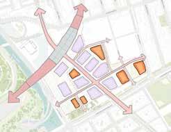
Structuring Framework:
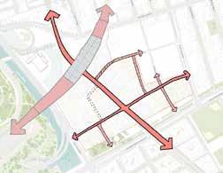
1- Connected Transit Hub 2- Street Network
The Port Lands Planning Framework identifies the lands immediately south of the Subject Site as Mixed Use Residential and the lands immediately west as Productions, Interactive and Creative Mixed Use. The Port Lands Planning Framework also identified and brought forward a series of modifications to the 2003 Central Waterfront Secondary Plan (CWSP), which outlined the initial policy directions for growth and development of Toronto’s waterfront and Port Lands. Portions of the CWSP remain under appeal at the Local Planning Appeals Tribunal.
Through the Port Lands Planning Framework, the CWSP and the ongoing Port Lands Acceleration Initiative, the long-term vision for the Port Lands includes a diverse, transit-supportive and mixed-use community, supporting a range of creative industries and employment uses.
3- Broadview COmmercial Spine 4- Residential Buildings at Key Locations 5- Critical flood protection 6- Interconnected Parks & Open Space Network
The Tall Building Design Guidelines were adopted by Council in May 2013. The Guidelines consolidate the former Design Criteria for the Review of Tall Building Proposals (2006) and the Downtown Tall Building Vision and Performance Standards Design Guidelines (2013) to establish a unified set of measures to evaluate tall building development applications in the City.
The document states that, as guidelines, they should be afforded some flexibility in their application, particularly when looked at cumulatively. The Guidelines should also be read together with the Official Plan, applicable Zoning By-laws, Secondary Plans and other applicable policies, standards or guidelines.
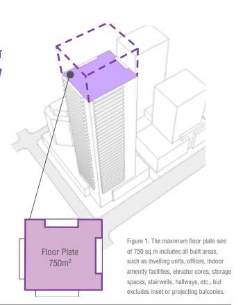
The Guidelines provide direction around four broad themes: Site Context, Site Organization, Tall Building Design and Pedestrian Realm. Among the most relevant guidelines are those relating to (with exceptions for very tall buildings), as well as tower separation distances of 25 metres on the same site and 12.5 metres from the side and rear property
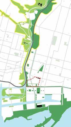
3. Expanding the City’s Green Space Network
The redevelopment of East Harbour will significantly enhance the local and regional green space system. Open spaces at East Harbour will expand on and connect to the surrounding park network which runs along the Don River valley and along the waterfront.
4. Celebrating Broadview Avenue as a Major Corridor Through the City
Broadview Avenue is an important artery through the east side of the City, currently connecting from Eastern Avenue to Danforth Avenue. The planned extension of Broadview southward through the East Harbour district will reinforce the corridor as a major civic spine. Broadview will be the focal point for development in East Harbour, envisioned as a signature street supported by an attractive and generous public realm. In addition, with the delivery of the future streetcar along the Broadview Ave extension, the corridor will help connect residents, workers and visitors from the future Port Lands with East Harbour, and the broader city’s transit network.
placement and address; the provision of publicly accessible open space; and the location and design of servicing and parking access
3. Expanding the City’s Green Space Network
The redevelopment of East Harbour will significantly enhance the local and regional green space system. Open spaces at East Harbour will expand on and connect to the surrounding park network which runs along the Don River valley and along the waterfront.
4. Celebrating Broadview Avenue as a Major Corridor Through the City
Broadview Avenue is an important artery through the east side of the City, currently connecting from Eastern Avenue to Danforth Avenue. The planned extension of Broadview southward through the East Harbour district will reinforce the corridor as a major civic spine. Broadview will be the focal point for development in East Harbour, envisioned as a signature street supported by an attractive and generous public realm. In addition, with the delivery of the future streetcar along the Broadview Ave extension, the corridor will help connect residents, workers and visitors from the future Port Lands with East Harbour, and the broader city’s transit network.
Expanding the City’s Green Space Network and Celebrating Broadview Avenue as a Major Corridor Through the City
A detailed review of how the development conforms with the Tall Buildings Guidelines is contained within Section 4 of this report, which analyzes, tower and base building design including tower floorplates, separation distances, site organization and the overall massing strategy. In general, the development meets the intent of Tall Building Design Guidlines
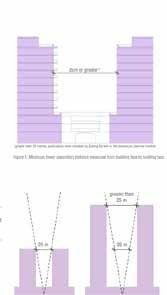
The Guidelines provide direction around four broad themes: Site Context, Site Organization, Tall Building Design and Pedestrian Realm. Among the most relevant guidelines are those relating to a maximum floorplate size of 750 m2 (with exceptions for very tall buildings), as well as tower separation distances of 25 metres on the same site and 12.5 metres from the side and rear property lines.
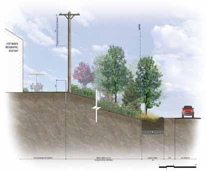
The largest eco-responsible project in Canada, a development of an area of 1220 hectares is located in Terrebonne, North east of the greater metropolitain area of Montréal with 40% of which are protected to create a Biodiversity Corridor. The development is designed to welcome more than 35,000 residents without compromising the natural habitat. Financial uncertainties due - in particular - to inflation and rising interest rates required an evolutionary urban planning and a design that offers a solution to the exponential increase of carbon footprint, and contributes to the climate change challenge. A design that reduces travel needs and promotes sustainable transportation which positevly enhances the real estate industry which will benefit from the relatively good performance while preserving the environment.
The design meets the principles of sustainable development. The development party is reflected in the choice of sustainable materials, in situ rainfall management, increased space for pedestrians and cyclists, an increase in the quality of life and an offer of activities related to history and heritage.
Data collected form dfferent governmental parties, stakeholders, governmentl reports, cycling agencies, Greater Montréal Metropolitain Area, and Montréal Community Housing. Social, demographic, economic and environmental analysis has been established to assess best approaches and highest profit on the operation long term. A drone was used to capture the present site conditions and major intersections and served as our primary data collection. Literature has been reviewed and best practices were studied and an approach was determined with the help of Université de Québec researchers. Statistics Canada was contacted and up-to-date data were released regarding demographics and social aspect. Société des assurance des automobieles de Québec released also data concerning fatalities and accidents involving pedestrians and cyclists over the last 10 years.
Design Concept and Responding to Challenges
There were two main stream challenges in this project. First was concerned with growth management policy directions and intensification strategy-related that required a minimum per centage of residential units with three or more bedrooms for certain types of development.
Second challenge have been withdrawn from residents participants who were able to share some of their input and fedback in a series of community envolvement and public participation sessions. their ideas were illustrated in a number of design proposals and expressed concerns over development of parks. The main issues that have been identified include:
• Accessibility for all components of the park;
• Safety related to traffic and uses;
• Tranquility related to the park’s programming;
• Maintenance and cleanliness;
• Maintenance of existing uses (skatepark and children’s playground).
Developer/s City of Terrebonne, Team Université de Québec, Greater Montréal, SNC-Lavalin, AECOM
Location Terrebonne, Québec
Year 2018 - 2019
+ Sustainable Urban Development
+ Urban Mobility
+ Landscaping
Se détendre
Se promener Piqueniquer Bouger et jouer Socialiser
Glisser
Observer
Patiner/skier Promenade en raquette Jardiner Bouger et jouer
Jouer dans la neige
Participation citoyenne - Nouveau parc Irma-Levasseur Ville de Montréal-NIPPAYSAGE-L’OEUF Architectes
Highlights of my role and responsibilities
• Was the key contact between main stakeholders and clients and organized workshops, facilitated meeting, reported progress, challenges, inquiries, and was involved in layout, graphics and 3D visualizations development, and project coordination using Revit and BIM 360.
• Developed conceptual design and reviewed design studio progress and 3D visualizations using Arc GIS, AutoCAD 2D and 3D, Sketchup, Rhino 3D, lumion, and presented using Adobe InDesign, Illustrator, Photoshop and Prezi software.
• Served as day-to-day project liaison with clients and supervised daily work production of the Urban Design Studio
• Assigned work to professional staff and ensured appropriate training is provided
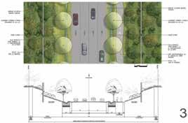
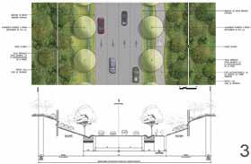


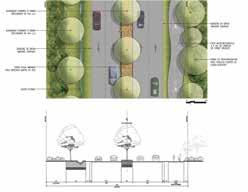

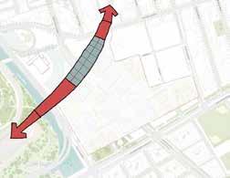
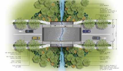
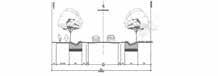
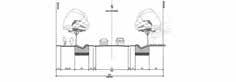
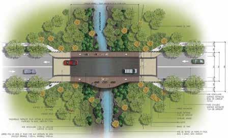
trAVErSE dE courS d’EAuruiSSEAu à dÉBit FAiBLE
Design Criteria
CRITÈRES
• general appearance: contemporary model,
• aspect général : facture contemporaine,
• la largeur maximale du pont est 15 mètres et intègre un sentier piétonnier et une voie cyclable de chaque côté;
• the maximum width of the bridge is 15 metres and each side,
• la surface véhiculaire est en pavé et un motif contemporain, sous la thématique de l’eau est suggérée pour souligner la présence du cours d’eau. La surface devra présenter un traitement qui confère un intérêt et un caractère dynamique;
• l’utilisation de pavés de format 150mm x 150mm est suggérée afin de permettre de créer des motifs organiques et fluides;
• The Automobile surface is paved in a contemporary emphasize the presence of the river. The surface have
• the use of 150mm x 150mm pavers is suggested to
• at the ends, a strip of pavers clearly emphasizes the
• aux extrémités, une bande de pavés souligne clairement la transition des espaces; une bordure de granite de 400mm L x 150mm de haut sépare la voie véhiculaire de la voie cyclable/piétonne et améliore la sécurité des usagers;
• intégrer le ponceau dans un muret en pierre. Le revêtement de pierre utilisé devra contribuer à accentuer le caractère du site;
• a 400mm L x 150mm high granite curb separates and improves user safety;
• le muret de pierre du ponceau servira d’assise de fixation pour la main-courante éclairée. La main-courante en métal aura un traitement sobre et contemporain;
• les pentes des talus doivent respecter la pente naturelle du terrain ou avoir une pente maximale de 35%;
• Integrate the culvert into a stone wall. The stone character of the site;
• densifier la végétation dans le but de prolonger le milieu naturel existant et privilégier des végétaux indigènes La composition végétale sera composée essentiellement de :
• The stone wall of the culvert will serve as a fixing will have a sober and contemporary treatment;
• arbustes feuillus 70% • arbres 30%
• slopes of embankments must respect the natural slope
• densify vegetation in order to extend the existing vegetal composition will be composed essentially of:
• deciduous shrubs 70%
traverses de cours d’eau
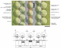
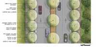


and incorporates a pedestrian path and a bike lane on contemporary style, under the theme of water is suggested to have a treatment that confers interest and dynamism; to create organic and fluid patterns; the transition of spaces; separates the vehicular lane from the bicycle/pedestrian lane stone cladding used should contribute to enhancing the seat for the illuminated handrail. The metal handrail slope of the land or have a maximum slope of 35%; existing natural environment and favor native plants. The of:
2023