resume

PATRICIA PADILLA
BA in Architecture I Minor in Sociology
CONTACT INFORMATION
Guayaquil, Ecuador
patr.padilla.a@gmail.com
+593 98 468 4224
ABOUT ME
I am Patricia, a young architect with a minor in sociology, passionate about creative writing, travel, and volunteering. I graduated with honors in 2022 from Universidad San Francisco de Quito in Ecuador. My professional career has focused on real estate architecture and social habitat management. Experience in both realms has enabled me to uncover the art of spatial conception rooted in user and societal needs.
I believe it’s crucial for spaces to promote cohesion and community development across various scales. I am intrigued by the interplay between architectural and urban scales and society, especially in conflict areas and regions of inequality. My aim is to leverage my interests, skills, and experiences to drive meaningful change within the architectural field.
EDUCATION
SAN FRANCISCO DE QUITO UNIVERSITY
2017-2022
2020-2022
Bachelor in Architecture
Minor in Sociology
WORK EXPERIENCE
JP COSTA ARCHITECTS
01/2023 - present Architectural Designer
03/2022 - 12/2022 Junior Architect
TECHO ECUADOR
03/2023 - present Housing, Habitat and Construction Coordinator
TECHO ECUADOR / UNICEF
08/2022 - 02/2023 WASH Specialist - Social Project Developer
LONG WAY HOME
06/2021 - 10/2021 Junior Architect
IMPU QUITO
01/2020 - 06/2020 Research Assistant
AWARDS AND ACHIEVEMENTS
PREDUCA
02/2023 Winner in “New Campus of Balandra Cruz del Sur Elementary School” Competition
DIARIO EXPRESO
02/2023
2017-2022
SAN FRANCISCO DE QUITO UNIVERSITY SKILLS
SOFT SKILLS
Honorable Mention in the ‘Rescue of Nueve de Octubre Avenue and Commercial Center’ Competition
L.B. Alberti Excellence Scholarship
Adaptability, teamwork, leadership, analytical skills, curiosity, time management, emapathy, motivation
SOFTWARE
AutoCAD, Rhinoceros 3D, Revit, SketchUp, 3Ds Max, Lumion 11, Vray 6.2, Photoshop, Illustrator, Indesign, Adobe Premiere, Q Gis, Microsoft Office Suite
Spanish (native), English (proficient), Portuguese (beginner) LANGUAGES
03

EMERGENCY SHELTER 3.0
Role: Solo project for TECHO Ecuador
Location: Guayas, Ecuador
Year: 2024
The core of Latin America’s social crisis is centered on its informal settlements. In this region, which is both the most urbanized and unequal globally, around 165 million people inhabit these areas. Within these communities, citizens live in poverty, enduring constant rights violations, CEPAL (2023). TECHO, a civil organization, is dedicated to tackling poverty and social exclusion in Latin America and the Caribbean through housing and habitat construction, and the promotion of community development.
Emergency Shelter 3.0 is a prototype for the Ecuadorian coast. It is a temporary shelter used in emergency situations such as natural disasters, extreme poverty, and violence, aiming to provide refuge to affected families. These homes protect its users from harsh weather conditions and offer them a safe and comfortable space to live while permanent housing construction is underway, allowing them to focus on professional and academic development.
01 04
Ecuadorian rural coastal zone - Site of implantation
In the Ecuadorian coast, poverty and inequality persist alongside the growing climate crisis. Communities face constant threats of flooding and erosion, worsening their vulnerability and hindering their development, (Secretary of Risk Management of Ecuador 2022). According to a report by the Ministry of Urban Development and Housing (Miduvi), 27% of coastal homes are impacted by natural disasters during the annual rainy season, with this percentage on the rise, (Primicias, 2023).
IMPACTS OF HOMELESSNESS ON SOCIETY
THE USER AND THE DESIGN
Four participatory design sessions were held with community leaders to identify functional and aesthetic needs, as well as to select materials readily available in the communities that promote the local economy.

“How about we put something in the front to sit and chat with the neighbors?”
“Y sí ponemos algo al frente para sentarnos y conversar con los vecinos” - Don Daniel

“Make it high like Doña Mariana’s house, it doesn’t flood there.”
“Qué sea alta como la casa de Doña Mariana, esa no se inunda” Don Antonio
work locations mapped across mainland Ecuador
The prototype was conceived as a structural and constructive modular system that allows each project to be adapted and designed according to the conditions of each site location, so that the construction technology of envelopes and facades varies depending on each project.
It has a life cycle of 12 to 24 months; its structure can be assembled in any rural area without the need for specialized machinery or labor force. It is a progressive prototype that consists of three modules: the basic module (m1), the social module (m2), and the private module (m3).


“With windows up front, in case I wanna sell my stuff or say hi to the neighbor.”
“Con ventanas al frente en caso de que quiera vender mis cositas o saludar al vecino” - Doña Carmen

MORE OPTIONS MODULE MATRIX M1 M2 M3 M1 M2 M3
“Qué entre luz en el día para que los chicos hagan deberes” - Doña María
“Let light in during the day so that the children can do their homework.”
Basic: public + private Public Private Basic: public + private Public Private Deterioration
mental, physical health, and social exclusion 01 Increased risk of victimization 02 Difficulty accessing basic services 03
of
05
Community
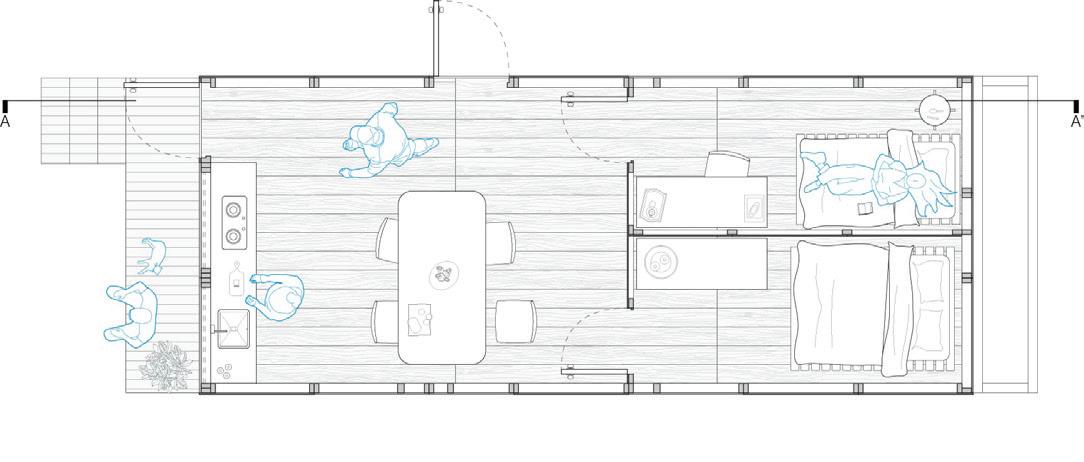
MODULE
floor Lev +- 0.00 m


07 ROOF
06 BEAMS

Structural system comprising wooden trusses
04 WALLS - OSB MODULES


Walls modules of OSB panels with RH anti-humidity system, dimensions: 2440mm x 1220mm, structured with natural wood


It has 4 types of walls modules which provides an adaptative design that responds to the site of implantation.


02 GROUND FLOOR STRUCTURAL SYSTEM
Four primary structural timber beams (d: 250mmx10mm) supported by 3 wooden piles (Ø 20cm).

-The prefabrication strategy is based on designing the module using industrialized materials that are less expensive and more common in Ecuador.


-The entire structure can be built in three days with a team of 6 to 10 people.

Walls modules of OSB panels with RH anti-humidity system, dimensions: 2440mm x 1220mm, structured with natural wood


04 WALLS - POLYCARBONATE MODULES


Walls modules of polycarbonate panels, dimensions: 2440mm x 1220mm, structured with natural wood.

03 FLOOR Natural wood plank flooring with a framework of joists (d: 100mm x 100mm ).
01 FOUNDATION
Lightweight concrete footings (d: 300mmx300mmx200mm)
Section A-A’
Ground
BASIC
BASIC
MODULE
06


 Basic module - front view of the emergency shelter
Basic module - side view of the emergency shelter
Basic module - front view of the emergency shelter
Basic module - side view of the emergency shelter
07
Basic module - front view of the emergency shelter

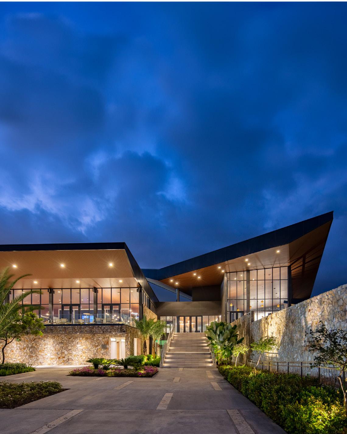
GUAYAQUIL COUNTRY CLUB - CLUB HOUSE AND LOBBY
Role: Floor plan and facade designer in association with JP Costa Architects
Location: Samborondon, Ecuador
Year: 2022
For decades, the Guayaquil Country Club has embodied traditions of sports, social life, and nature enjoyment. Recognizing the need to adapt to a cosmopolitan, digital era while preserving its essence, a masterplan for the new headquarters was crafted by Gómez Platero and PCDO. In pursuit of realizing the architectural vision outlined in the masterplan, the country club initiates an internal competition for the architectural design of the buildings and project management.
As the initial built piece of masterplan that expands one edge of the city, Guayaquil Country Club aims to be a joyful gathering place for 2,000+ families. It is a social and sports club that harbors tradition and social interchange surrounded by nature. 90 years after its first establishment, Guayaquil Country Club moves to its third location as a way to play along with current residential developments and the young, flourishing population of Guayaquil.
02
Guayaquil Country Club - Clubhouse and lobby
08
The project’s site, formerly a rice field, is a vast flatland engulfed by blues skies, Babahoyo river, and bright equatorial sun. The clubhouse reinterprets a series of timeless architectural elements in a fresh composition. It was conceived as the heart of the project, it serves a platform for new memories, but more importantly, is the welcoming space where visitors can experience the club’s legacy.


This structure soars over the rest of the built elements whilst facing both east and west, where strategically inclined roof planes shield from sun’s impact and allow a connection between the interior spaces and ever ending greenery. Materiality and façades of the clubhouse seeks coherence and respect to its previous versions and the site’s chroma.


 Masterplan Guayaquil Country Club - The enclosed building is the Clubhouse-Lobby.
A A’ B B’ 0 5 15 30 Ground floor Lev +- 0.00 m 09
BABAHOYO RIVER
D1 CURTAIN WALL DETAIL - BEAM

D2 CURTAIN WALL DETAIL - INTERMEDIATE BEAM


D3 CURTAIN WALL DETAIL - LOW WALL
0 5 15 30 Section B-B’ 0 5 15 30 Section A-A’ 10


 Secondary entrance access to the pool and open social area.
Clubhouse main entrance atrium.
Secondary entrance access to the pool and open social area.
Clubhouse main entrance atrium.
11
Concierge hall in clubhouse.

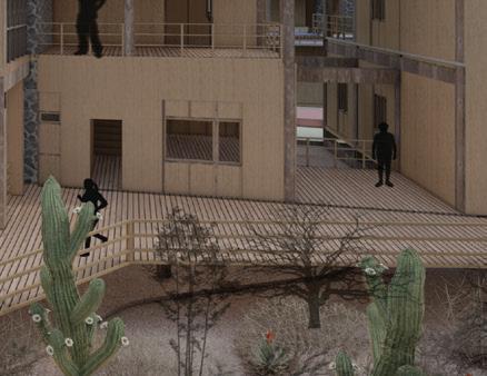
GALAPAGOS’ COUPLED CELL HOUSING
Role: In partnership with Clara Andrade Location: Galapagos, Ecuador Year: 2020
The project is developed with the aim of achieving a balanced Galapagos. The design is based on the premise of the Couple Urban System. This system seeks to address the shortcomings between the urban system and humans through a symbiotic relationship with the natural environment. Based on this community processes can be strengthened through training aimed at maintaining and expanding homes, fostering families’ creativity through the use of technological, resistant, low-cost, and locally produced materials.
As a design strategy, the concept of the housing module is embraced, centered on furnishing a core of premium materials with essential services. This is augmented by a wooden framework slated to house additional rooms. Additionally, community involvement begins through participatory design methodology, stimulating the creation of a broad and suitable layout for their needs, which can be complemented by building furniture tailored to the space using accessible materials.
03 12
Conceptual collage of the housing project in Galapagos’
The Galapagos Islands, recognized as a UNESCO World Heritage Site due to their unparalleled biodiversity and unique ecosystems, are inhabited by a diverse population of approximately 30,000 individuals, comprising residents, researchers, and tourists alike.

Despite challenges posed by tourism and environmental conservation, local communities strive to maintain a delicate balance between economic development and ecological preservation.


The housing project introduces an Urban Coupled System, strategically integrating sustainable infrastructure to harmonize with the island’s unique environmental natural and urban dynamics.

The project aims to reintegrate natural soil into the city to promote a balance between nature and settlers. To achieve this, it is proposed to remove the concrete fill, elevate the housing blocks, and leave the natural ground exposed, allowing wild flora and fauna to reclaim the landscape in common areas and become part of everyday memory.

ENVIRONMENTAL DEGRADATION RESOURCES ENERGY AND MATERIALS NATURAL TO URBAN SYSTEM CULTURAL AND SOCIAL NORMS ECONOMIC POLICIES ENVIRONMENTAL POLICIES URBAN SYSTEM NATURAL SYSTEM KNOWLEDGE TECHNOLOGY ORGANIZATION NATURAL SELECTION AND ADAPTATION URBAN TO NATURAL SYSTEM DATA WEATHER WATER FLORA-FAUNA SOIL ENERGY 13
0 5 15 30 Site Plan
THE CONCEPT
Galapagos Islands Samya Cruz Island Puerto Ayora, Santa Cruz Pampas Colorados, Puerto Ayora
THE VOLUME COMPOSITION
The height of the block is adjusted to the current scale of buildings in the urban area. Varied offset of blocks for the creation of balconies, endemic vegetation, visual interaction, and commercial spaces.
The blocks are raised, revealing the natural ground, while also connecting with a structural wall that serves as a water processing system.
Collage of the natural amd artifcial landscape of Santa Cruz, Galapagos
Typology A - 4 users


THE SCENARIOS

Typology B - 2 users with limited abilities
Typology C - 2 users
Typology C - 6 users
Typology C - 6 users

14
THE TYPOLOGIES
THE SYSTEMS
Pressure pump Piped water Potable water Pressure PVC pipe 1/2” Volcanic stone structural wall Coarse gravel Fine gravel Sand gravel Rainwater Bamboo cortado Filtration mesh Air chamber Water collection
Wetland for water reuse Sewage water Coarse gravel Fine gravel Permeable geotextile mesh Clean water conduit Outlet collector Wastewater Natural ventilation Input channel for uniform waste distribution Aquatic plants
and filtration system


15
Facade towards the interior communal area
Street-facing facade of the housing project
Elevated walkways surrounded by endemic and native vegetation

CONNECTING AUSTIN: GASTRO-CREATIVE HUB
Role: Solo project
Location: Austin, Texas, USA
Year: 2021
Over time, the built environment has played a significant role in shaping the relationships among urban inhabitants. These relationships are often perceived as contingent on the diverse elements that define physical space. In the 1950s, the emergence of Interstate 35 (I-35) had a profound impact on downtown Austin, disrupting the architectural landscape and fragmenting the limited social cohesion that existed along the west-east axis of the city center (Christiansen, 2005).
The ‘Connecting Austin’ project aims to strengthen community ties and rejuvenate urban areas with architectural interventions, promoting historical appreciation. I-35’s revitalization integrates educational and cultural initiatives, aligning with the ‘Up and Down’ Masterplan. Architectural structures play a central role, with the Gastro-Creative Hub becoming a focal point atop the interstate. The hub supports marginalized residents with educational and entrepreneurial spaces, aiding business launches and promoting economic empowerment and community cohesion.
16 04
View from the exterior plaza and entrance of the Creative Hub - Masterplan Up and Down
Throughout history, the built environment has shaped urban relationships, influenced by dominating physical elements (Sommer, 2006). The construction of I35 in the ‘50s drastically impacted Austin’s downtown, dividing it and disrupting connectivity (Christiansen, 2005).
IMPACTS OF HOMELESSNESS ON SOCIETY
Despite Austin’s current perception as a youthful, culturally vibrant city and a tech investor hub, I-35 remains a divisive element, exacerbating disparities in services and amenities between the two sectors of the city.


17
I-35 I-35 I-35 I-35 I-35
Colorado River
Colorado River
Intervention area in the city of Austin, with emphasis on the Colorado River and I-35.
Social stratification at the district level in Austin, Texas. Source: “History of Austin’s Racial Divide in Maps,” 2015.

WHAT IS HAPPENING IN AUSTIN?

1800s-1860s:
Explosive growth of African-American population during Civil War, increasing by 57% in the 1860s.
Emancipated Black population established communities.
1928: “1928 City Plan” consolidates Black communities to east side, naming it as the “Negro district.”
2010s:
Segregation continued especially evident along physical barrier of I-35.
Housing and equipment remains largely segregated despite advancements in other areas.
WHAT ARE THE CITIZENS OF AUSTIN DOING?
“Austin has become a destination for immigrant households. This highly entrepreneurial population has opened new businesses, purchased restaurants, made loans available to their network, and acquired properties.”
Austin Government, 2020
“Working-class families suffer because the step above them on the socioeconomic scale has been eliminated, making it difficult for them to achieve upward social mobility due to lack of opportunities.”
Austin Government, 2020
KEY

African American Population
Latino Population
Asian Population
The intervention point has the potential to connect the Cultural District, Medical District, and the residential area in the east of the city. Currently, it is an inaccessible area that has contributed to the polarizations of the city.
The site is surrounded by various landmarks and activities that reflect current social dynamics, which can leverage existing connections and strengthen Austin’s identity as a connected, entrepreneurial, and creative city.

18
MASTERPLAN: UP AND DOWN
This proposal is based on accepting and acting upon I-35. Urban intervention acts on the dividing element, transforming it from a marked boundary into a point of convergence of the city. It acts on two points of the highway, the underpass and the elevated bridge, that will be connected by a urban memorial walkway that links both points.
It also proposes connecting the main with the perpendicular axes, which will serve as cohesive elements, incorporating strategies for: - pedestrian inclusion -green corridors -urban catalysts.


THE ARCHITECTURAL INTERVENTION IS UP:

UP. The selected parcel sits amidst 11th and 12th streets, spanning 6015.55 square meters. Despite access challenges, the site’s strategic location and visual connection to I-35 promise revitalization, potentially becoming a vibrant city hub.
19
Masterplan proposal
A recreational area should be based on social and statistical analyses, fostering community exchanges, (Sommer, 2006). The Hub becomes this space of unity and community development. Located on I-35, recognized as a divisive element, it seeks to change the perception of urban infrastructure into a unifying the city.
SITE CHARACTERISTICS
The building embodies Austin. The proposal incorporates the formal and social characteristics of the city, from reinterpreting the typology of endemic food courts organizing around a central plaza to encompassing the diversity of current social activities and experiences.


The building embodies Austin. The proposal incorporates the formal and social characteristics of the city, from reinterpreting the typology of endemic food courts organizing around a central plaza to encompassing the diversity of current social activities and experiences. Function diagram of public-private spaces and natural lighting.
20
THE GASTRO-CREATIVE HUB
THE
PLAZA INTERNA HALL P R V A T E P U B L C COMMERCIAL NATURAL LIGHTNING ARTIFICIAL LIGHTNING COLABORATION EXHIBITION COMEDOR ABIERTO W O X2 LOCAL GAST O LOCAL GAST C O C N O D G B O D E G A LOCAL COM LOCAL COM O U N G A E R X2 T A L L E R 2 X2 A U L A X6 O M O B B L O D A Y C A R O F N O C O M P W O G O D G LEVEL 2 O LEVEL A U A G A X2 A G A X3 X1 LEVEL 3 W O D G C C X3 X3 X3 X3 G A C O F D E P O F P R N Q A G R A B A E S T F O T O C F O Y E R E X H B C Ó N O U T D O O R C Ó O O E X H B C Ó N N D O O R S A L A C N A C A M E R N O S A A T A L L P A C ACCESS / STREET INTERNAL PLAZA / OPEN HALL COMMERCIAL BLOCK EXHIBITION BLOCK COLLABORATION BLOCK WORKSHOPS ADMINISTRATION BLOCK 1 COMMERCE BLOCK 2 COLLABORATION BLOCK 3 - EXHIBITION 1300 m2 1700 m2 700 m2 GASTRONOMY MUSIC VISUAL/PLASTIC ART TOTAL : 5100 m2 Walls and circulation (30%) 1000 m2 Outdoors 400 m2
BUILDING IS AUSTIN THE PROGRAM
Programmatic relationship diagrams.


21 SITE PLAN
BASEMENT FLOOR
GROUND FLOOR


22
SECTION B-B’
SECTION D-D’


23
View from the external plaza and entrance of the Hub
Indoor exhibition space that connect to blocks of the building.
Basement foyer with view to the I-35
Axonometric view


URBAN COLLAGE: REACTIVATING GUAYAQUIL’S HEART
Role: In partnership with J.Costa and J.Gomez Year: 2022
Location: Guayaquil, Ecuador
Throughout history, the downtown area of Guayaquil has been characterized by its commercial and social exchange vocation. However, in the collective memory of its users, the cultural relevance of the “9 de Octubre” boulevard has been lost. In the absence of a real project to improve public spaces in the historic center of the main port city and its boulevard, Diario Expreso launched a contest aimed at developing proposals to recover the downtown area under the premise of “minimal intervention with maximum impact.”
Cultural enrichment is a greatway to achieve a habitable and dynamic city, specially when citizen identity is at risk. The project aims to turn the city into an open museum, a gallery that can be visited by all, by using a collage technique in which all the ingredients can be seen under and above while experiencing Guayaquil. URBAN COLLAGE can and will explore shapes to relive the past, acknowledge the present and create new relationships between future city users acting as catalysts for the economy, culture, and social cohesion.
Aerial view of downtown Guayaquil - Conceptual montage of the project
05 24
Once a vibrant hub of commerce and social life, the historic central area of Guayaquil, spanning about 2 kilometers, now faces neglect and insecurity. Despite its daytime bustle, residents avoid it due to growing safety concerns, with insecurity having increased by over 50%, (El Comercio, 2022).


Neglecting Guayaquil’s historic arcades and plazas disconnects citizens from their cultural heritage and erodes their sense of belonging. Originally providing shelter, these features have deteriorated into hazardous spaces, detracting from the area’s historical significance and cultural value.


URBAN COLLAGE proposes “sticking” visual, artistic, and functional elements to revitalize urban spaces throughout the city, creatively leveraging existing dynamics, stimulating place for all its inhabitants through specific interventions in different circuits.

THE CIRCUITS

OPEN MUSEUM AND CULTURAL CIRCUIT
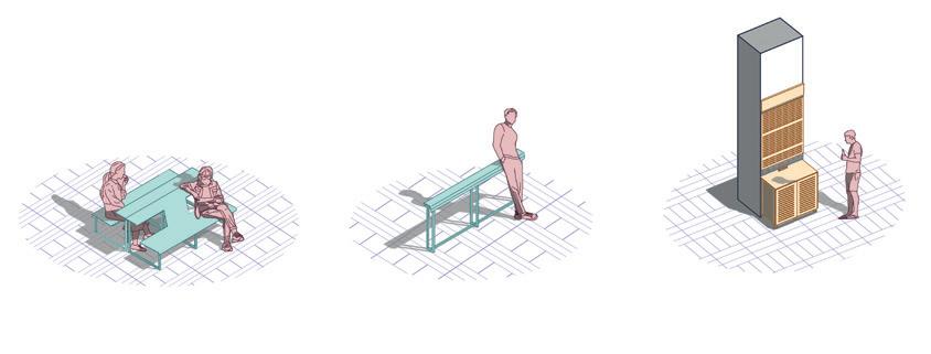
Floating installations in the air utilize previously unused urban space, offering a sense of limitless potential akin to a newly discovered area. They will be located along certain streets connecting the proposed opportunity lots.
ACTIVATION OF ARCADES IN THE CITY
A series of arcades that are in the citizens’ memory have been mapped for renovation. We aim to organize economic activities that occur around them in a more orderly and appealing manner, responding to current activities.
CITY VOIDS AND OPPORTUNITY LOTS
Abandoned spaces within the city have been identified, which, due to the lack of a specific functional purpose and integration to the urban tissue. These spaces will be integrated into a cultural and activity network designed to catalyze the social, economic, and cultural dynamics.
Three points have been selected on the boulevard for the initial implementations of the strategies:


Artifacts Cultural Activation Arcades New Historic District of Guayaquil
B C
Urban landscape of the center of Guayaquil
RUMICHACA BOYACÁ SAN FRANCISCO SQUARE
1 2 3
25 THE CONCEPT Land Use Mobility Arcades Building height A THE FIRST STEPS Map of the initial interventions on the 9 de Octubre

A.


 Intervention B . Artifacts implanted in Av.9 de Octubre and Boyacá
Intervention A . Artifacts implanted in Av.9 de Octubre and Rumichaca
Intervention B . Artifacts implanted in Av.9 de Octubre and Boyacá
Intervention A . Artifacts implanted in Av.9 de Octubre and Rumichaca
