Impact Assessment of Ambient Air Quality at Enyimba Dumpsite Aba, Abia State Nigeria
1I. E. Nwosu, 2N.B.B. EwurumDepartment of Physics, Imo State University Owerri, Nigeria
E-mail address: koonwosu2@yahoo.com
Abstract: Air pollution has continued to be a great concern all over the world due to the negative impact it imposes on human health and welfare. Unless controlled, regulations should be enforced by Abia State Environmental Protection Agency (EPA) to ensure compliance of scavengers dumping refuse in the region of our study to standard rules, else they would deteriorate the fine air quality and thus, threaten the ecosystem of the study area. This Paper characterizes air quality prediction (H2S, NO2, CH4) over the dumpsite at Enyimba, Aba, Abia State Nigeria and its environs by retrieving meteorological parameters (Temperature, Wind speed, Relative humidity) using Non Dispersive infra red (NDIR) analyzer AZ 77535 with the atmospheric pollutants and the results were compared. The study area covered Lat. 5o 6’ 50.5”N - 5o 6’ 59”N and Long. 7o 19’ 42.5”E - 7o 19’ 37.7”E. Our findings indicate that concentrations of air pollutant within the surroundings of the dumpsite are found to be above standards of ambient air quality. The retrieval first present the preliminary stage and maintains diurnal pattern.
Keywords: Air quality, Biomass burning, Dumpsite, EPA, Environment, Pollution.
1. INTRODUCTION
Air pollution has been a major problem in our modern society. This can be attributed to high level of industrialization that is always found in cities and also unlawful conversion of land to dumpsites [1] reported that there exist significant correlations between polluted environment and certain diseases like lungs cancer, chest pain, nausea and shortness of breath. [2] estimated that 2.4million people die each year from causes attributed to air pollution. Adding to its negative impacts, pollutant air is known to cause injuries to animals, vegetation, metal structures by causing cracks and deterioration [3]. Improper management of solid waste is one of the main causes of environmental pollution and degradation in many cities, especially in developing countries. Many of these cities lack solid waste regulations and proper disposal facilities, including for harmful waste. Such waste may be infectious, toxic or radioactive. Municipal waste dumping sites are designated places set aside for waste disposal. Depending on a city’s level of waste management, such waste may be dumped in an uncontrolled manner, segregated for recycling purposes, or simply burnt. Poor waste management poses a great challenge to the well-being of city residents, particularly those living adjacent the dumpsites due to the potential of the waste to pollute water, food sources, land, air and vegetation. The poor disposal and handling of waste thus leads to environmental degradation, destruction of the ecosystem and poses great risks to public health. [4] and [5] quoted that extreme effects of air pollution include cardiovascular problems and high blood pressure. This can also result to climate change. It became increasingly clear that the observed climate changes are mostly anthropogenic as a result of the enhanced atmospheric greenhouse gas concentrations caused in fossil fuel burning, increase in agricultural and industrial production due to fast growth in human population (eg [6], [7], [8]). [9] assessed the radiation emission from two cities of Lagos State in Nigeria using RADALERT 50. Five sampling stations were monitored and the results obtained recorded a higher emission of 29.80µSnhr-1 Diurnal measurement of atmospheric pollutants and meteorological datasets were used to quantify Enyimba dumpsite emission rate, using AZ 77535 analyzer and GARMIN GPsmap 76CSX to retrieve its altitude and Coordinates. The objectives of this experiment are to (i) address air quality impact from the
Vol. 5, Issue 1, pp: (27-35), Month: April 2018 – September 2018, Available at: www.paperpublications.org
dumpsite. (ii) to identify the possible impact the dumpsite have posed on its surroundings. (iii) to recommend appropriate mitigation measures which could assist people staying around to comply with Nigerian Ambient Air Quality Standards (NAAQS).
Aba located at (5.52oN, 7.49oE) has climate characterized by extreme heat during the day, rapid cooling at night and regular rainfall. Temperatures from observation may rise above 40o C during dry season. And from our assessment, this dumpsite poses all these characteristics to its environs.
From our observations, smoke generated from the dumpsite are being transported to the main road by wind. The impact of such activities would cause road accident and restrict vehicular movement on the road. This might affect business activities within the state. The arial extent of the dumpsite is an indicator of the seriousness of the pollution. Although, environmental factors such as atmospheric pollution from biomass burning, household cooking and water availability may also bias the relationship between pollution and dumpsite emission. It is obvious that the large diversity of dumpsite morphology, climatology, level of activity and economic and social factors complicate a comprehensive comparison between the state urban areas.
2. MATERIALS AND METHODS
Field campaign observations of atmospheric H2S, CH4, NO2 and meteorological dataset of temperature, relative humidity, wind speed, and dew point were carried out at 10 sites in Aba (5.52oN, 7.35oE) with an elevation of 148m for just one day as indicated in table 1. Aba is situated on the South-East region of Nigeria (4.15°N - 7.17°N, 5.05°E - 8.68°E). These meteorological in-situ measurements exhibit large diurnal (Morning, Afternoon and Evening) periods. To measure polluted air samples at the selected stations, we used a Non Dispersive Infra red Radiation meter P.R.O.C AZ77535 for long term continuous retrieval. The measurement obtained from these sites can provide essential information on sources and sink within the city.
3. RESULTS OF ANALYSIS AND DISCUSSION
Analysis performed in this experiment were used to characterize air quality prediction involving H2S, NO2, and CH4 over the dumpsite and its environs by retrieving meteorological parameters (Temperature, Wind speed, Relative humidity) using Non Dispersive infra red (NDIR) analyzer (AZ 77535) with the atmospheric pollutants and the results were compared. Our findings indicate that concentrations of air pollutant are found to be above standards of ambient air quality. Although, this retrieval first present the preliminary stage and maintains diurnal pattern. Further research is still needed to develop reliable emission estimates over the dumpsite.
From results obtained in table 2, we use statistical analyses to observe that locations 3, 5 and 6 have more H2S emission influence. The same were also observed for CH4 in table 3. Figures 1 and 2 were used to depict the trends. Although, this bi-variant plot captured the elevations of the locations with pollutants, elevation is simply the angle made from the tropopause to adjacent of the Earths boundary layer. So, using the elevation of locations 3, 5, and 6, it can clearly show the influence.
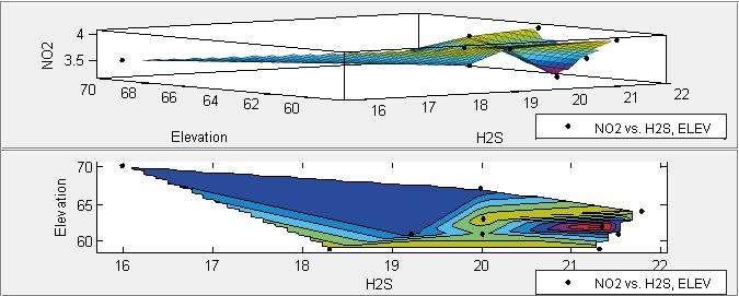
Table 4 shows location 10 as NO2 emission zone which also show high temperature in table 5. Figures 3 shows a peak trend despite having a high wind speed and dew point as shown in tables 6 and 7. And the relative humidity analysis using variance captured the water content of location 10. Figures 8 clearly show wind speed influence towards emission transport. Figure 9 shows the comparison between hydrogen sulfide and nitrous oxide emission when checked with elevation. It could be observed from the graph that these pollutants are of higher emission, which indicates dumpsite polluting its environment, mostly when there is lower continental air mass. The results obtained from the analysis are used to characterize the dumpsite and its surroundings.
4. CONCLUSION
Our findings indicate that concentrations of air pollutant are found to be above standards of ambient air quality. From the environmental evaluation conducted, it is obvious that the dumpsite will exposes the residents around it to unacceptable levels of environmental pollutants with adverse health impacts. A high number of children and adolescents living around the dumping site had illnesses related to the respiratory, gastrointestinal and dermatological systems such as upper respiratory tract infections, chronic bronchitis, asthma, fungal infections, allergic and unspecified dermatitis/pruritis –
International Journal of Recent Research in Physics and Chemical Sciences (IJRRPCS)
Vol. 5, Issue 1, pp: (27-35), Month: April 2018 – September 2018, Available at: www.paperpublications.org
inflammation and itchiness of the skin. Although, this retrieval first present the preliminary stage and maintains diurnal pattern. Further research is still needed to develop reliable emission estimates over the dumpsite. Regulations should be enforced by Abia State Environmental Protection Agency (EPA) to ensure compliance of scavengers dumping refuse in the region may deteriorate the fine air quality and thus, threaten the ecosystem of the study area.
Table 9 shows the correlation coefficient between the morning and evening measurement. Where temperature and wind speed shows positive relationship.
REFERENCES
[1] Dockery, D.W. and Pope, C.A. (1994). Acute Respiratory Effects of Particulate Air Pollution. Auun. Rev. Publ. Health 15: 107–132.
[2] World Health Organization (2007). Estimated Deaths & DALYs Attributable to Selected Environmental Risk Factors, by WHO Member State, 2002. Department of Public Health & Environnment, January 2007.
[3] Boubel, R.W., Fox, D.L., Turner, D.B. and Stern, A.C. (1994). Effects on Materials and Structures, Fundamentals of Air Pollution, 3rd ed. Academic Press, New York.
[4] Pope, C.A, Burnett, R.T., Thun, M.J., Calle, E.E., Krewski, D., Ito, K. and Thurston, G.D. (2002). Lung Cancer, Cardiopulmonary Mortality, and Long-term Exposure to Fine Particulate Air Pollution. J. Am. Med. Assoc. 287: 1132
1141.
[5] Sanjay, R. (2008). Exposure to Bad Air Raises Blood Pressure, Study Shows, Science Daily, Ohio State University, Proce. Nat. Acad. Sci. (104) 2, 10288 - 10293.
[6] Barnett, T. P., Pierce, D. W., and Schnur, R. (2001). Detection of anthropogenic climate change in the world's oceans. Science 292(5515), 270-274.
[7] Stott P. A., Tett S. F. B., Jones G. S., Allen M. R., Ingram W. J., and Mitchell J. F. B. (2001). Attribution of twentieth century temperature change to natural and anthropogenic causes. Climate Dynamics 17(1), 1-21.
[8] Stone, D. A., Allen M. R., and Stott P. A. (2007) A multimodel update on the detection and attribution of global surface warming. Journal of Climate 20(3), 517-530.
[9] Olubosede, O., Akinnagbe, O.B., Adeboya, O. (2012): Assessment of radiation emission from west dumpsites in Lagos State of Nigeria. International Journal of computational Engineering Research. (3)2250-3005.
APPENDICES-A
International Journal of Recent Research in Physics and Chemical Sciences (IJRRPCS) Vol. 5, Issue 1, pp: (27-35), Month: April 2018 – September 2018, Available at: www.paperpublications.org
Table 2: Statistical characteristics of observed H2S over selected stations
Note: o A = average, o = standard deviation, 2 XS = variance, Table 3: Statistical characteristics of observed CH4 over selected stations