

Outside Lands
San Francisco History from Western Neighborhoods Project
Volume 20, No.4 Oct–Dec 2024

OUTSIDE LANDS
History from Western Neighborhoods Project (Previously issued as SF West History)
Oct-Dec 2024: Volume 20, Number 4
editor: Chelsea Sellin
graphic designer: Laura Macias
contributors: Amanda Bartlett, Thomas Beutel, Richard Brandi, Chris Carlsson, Norio Fujikawa, Dave Glass, Judy Hitzeman, Jim Jenkins, John Martini, Nicole Meldahl, Margaret Ostermann, Rhonda Michele Smith, Yameen
Board of Directors 2024
Carissa Tonner, President Edward Anderson, Vice President Joe Angiulo, Secretary
Kyrie Whitsett, Treasurer
Lindsey Hanson, Rebekah Kim, Nicole Smahlik
Staff: Nicole Meldahl, Chelsea Sellin
Advisory Board
Richard Brandi, Christine Huhn, Woody LaBounty, Michael Lange, John Lindsey, Alexandra Mitchell, Jamie O’Keefe, and Lorri Ungaretti
Western Neighborhoods Project 1617 Balboa Street
San Francisco, CA 94121
Tel: 415/661-1000
Email: chelsea@outsidelands.org Website: www.wnpsf.org facebook.com/outsidelands instagram.com/outsidelandz
Cover: View north from Great Highway near Balboa, December 11, 1932. (Laurie Hollings Photo Album; James R. Smith Collection / wnp66.066)
Right: Conservatory of Flowers, February 1887. (Courtesy of a Private Collector / wnp26.669)
EXECUTIVE DIRECTOR’S MESSAGE
Nicole Meldahl
I don’t know about you, but this time of year I get the urge to bake. Maybe it’s the weather, the frequent festive gatherings, or simply the nostalgia of making treats in my grandmother’s kitchen to the sound of Nat King Cole. It might also have something to do with all The Great British Baking Show I watch during the holidays.

I love that show; it soothes and inspires me. For those who aren’t familiar with it: 12 to 13 people compete in a series of elimination challenges for the title of Best Amateur Baker in the UK. Unlike most American cooking competition shows, everyone is so wonderful and supportive of each other! These competitors arrive as strangers, do their best, and leave as a close-knit group of friends.
Call me crazy, but (aside from the elimination challenges) doesn’t that sound like WNP?? There are many things I’m proud of as the card-carrying head of this little nonprofit that could, but I’m most proud of the positive, supportive community we’re fostering here around a shared sense of place. Our volunteers and collaborators become our friends and befriend one another. In the process, we bring to life some truly incredible History that amplifies unheard stories, supports local artists and businesses, and connects the past to the present. And we do all of this while having an obscene amount of fun because we take our role as your friendly neighborhood history group very seriously. Learn more about the lovely people who made this work possible in 2024 in Inside the Outside Lands.
Speaking of lovely people, this issue features a history of the Central Ocean Road written by our longtime friend and former board member, Richard Brandi. This exploration of how the Outside Lands became the west side—one in which we can see how sand dunes gave way to the infrastructure San Franciscans rely on—is humbling in many ways. The human effort and imagination involved in making the Sunset livable is awesome, according to the true definition of that word.
If you have holiday guests visiting from out of town, I suggest they stay at the Ocean Park Motel, but don’t take my word for it; take Margaret Ostermann’s recommendation in this issue’s Where in West S.F.?, which provides the story of the business and family behind one of the city’s most iconic neon signs. Oh, and if you like neon signs, you’ll also find our newest enamel pin—a tiny replica of the “It’s History Time” clock in our Clubhouse window, both of which were designed by Randall Ann Homan of SF Neon—in the WNP shop. It’s the perfect gift for the history nerd in your life.
We’ve seen an uptick in orders for high resolution images from our OpenSFHistory archive, purchased by people who are printing and framing them as gifts. It’s hard to believe it’s been 10 years since we launched OpenSFHistory. In that time, the archive has grown and its purpose has evolved from an ambitious digitization project to a multi-faceted program that encourages people to invest in their city. We not only take these photos out of the archive and place them in situ with the places that created them, we connect the work of photographers from the past to photographers working today. In 10 Years of OpenSFHistory, some of our favorite local photographers and collaborators tell us about their favorite images from our archive.
We are really cookin’ at WNP these days, even though it’s the end-of-year hinterland where our public programs pause and we focus on planning for 2025. I hope you also have time to pause, reflect, and plan for what’s to come. The older I get, the more I realize that time to sit with ourselves and be with the people we love here in San Francisco is the most precious gift imaginable. With that in mind, here’s wishing you the happiest of restful holidays, history friends. Please don’t be a stranger if you see us out and about in the neighborhood this season. Otherwise, we’ll see you next year. Xoxo.


WHERE IN WEST S.F.?
By Margaret Ostermann
As a traveling salesman in the early 20th century, C.L. “Larry” Smith had developed some opinions about the overnight accommodations then available. So when he opened his own motel, he leaned into a few new trends.
The motel was itself a fresh concept. In 1925, what is credited as the world’s first motel opened in San Luis Obispo. It provided motorists a convenient drive-up option more comfortable than a roadside tent, but without the expense of a formal hotel. Those roadtripping guests were themselves trend setters, inaugurating the driving vacation, which San Francisco, with two new bridges, was more than eager to be a part of.
So out near the ocean, where the Fleishhacker Pool and Zoo were drawing crowds, Smith capitalized on those motoring trends with a new motel—San Francisco’s first—at 46th Avenue and Wawona. The Ocean Park Motel opened for business on April 20, 1937, with an architectural design expressing the sleek new Machine Age: rounded corners, porthole windows, ‘speed line’ piping, and a low horizontal orientation.
Although it was then common for older storefronts to
46th Avenue and Wawona, circa 1940. (Courtesy of a Private Collector / wnp27.7621)
be remodeled with Streamline Moderne elements, the depression years yielded few commercial buildings originally designed in this uniquely American style. Perhaps that’s why our mystery photo of the Ocean Park Motel yielded quick responses from Glenn Bachmann, Bob Cherny, Roger Goldberg, Harry Henderson, Judy Jacobs, Jenny Kuo, Phil Millhollon, Martin Szeto, and Peter Tannen. Validating architect Conrad Kett’s intent, Mike Dadaos reported that on childhood bike rides he and his friends “thought it looked like a ship in the fog.”
A courtyard surrounded by 11 bungalow units (with a manger’s home above the office) was soon followed by the construction of larger family-size units in a second building. When two residential homes were built adjacent to the property on 46th Avenue, Smith immediately purchased them and put them into service as motel units. Recalling the neighborhood during his childhood in the late 50s and early 60s, Tim Dineen placed the Ocean Park Motel as a sort of “buffer zone between residential and open space.” “It was a big, white cluster of buildings with green trim. It didn’t really look like a motel—more like a cluster of houses and apartments painted the same color.”
Confessing to some childhood antics, Tim shared that “one early morning, we planted an egg bomb in the tunnel entrance of one of the buildings that looked like flats.” A firecracker placed under a pile of eggs was set off by a fuse poked through a lit cigarette. While egg splattered everywhere, “a thunderous roar from the echoing tunnel entrance” carried as the “perpetrators were innocently blocks away.”

Charles and Ethel McGlashan owned the Ocean Park Motel around that time, and that egg splatter would have taken more effort to wipe up than the usual dusting routine Ethel was known to do with her apron front. After her husband passed, Ethel sold the motel to Owen Mears, who had a knack for buying older properties and fixing them up. Although he also owned a motel in Palo Alto and an apartment building at Market and Gough, the Ocean Park was his pride.

As Mears’s health declined, his daughter Vicki and her husband Marc Duffett found themselves thrust into the hospitality business. The couple took over ownership in 1977 and moved into the residence above the office after Mears’s passing. As unplanned as this career shift was, with support from the proprietors of the neighboring Roberts Motel (since demolished), the Duffetts passionately threw themselves into both the business and neighborhood preservation issues.
After 47 years of running the Ocean Park Motel, it’s easy to understand the blur of time Marc confronts when asked about changes they’ve made to the motel. He figures it was the late 80s or early 90s when the motel first donned its now-iconic blue paint. The color scheme took two years of deliberation, and many coastal scouting trips, to decide upon! Concluding it just had to be blue, the Duffetts had the shade custom mixed and dubbed “Ocean Park Blue.” Seeking an antidote to the notorious fog, it was also around this time that
Marc and Vicki Duffett with their two children behind the front desk at the Ocean Park Motel, July 1995. (Richmond Review Newspaper Collection; courtesy of Paul Kozakiewicz, Richmond Review / wnp07.00093)
San Francisco Examiner, March 21, 1958.

a hot tub was added into a well-sheltered nook off the courtyard. The fill taken out to install the hot tub was used to level the lawn, where a play structure and chairs invite guests to relax and linger. Standing in the main courtyard, looking at lush grass and rose bushes, it’s hard to believe Marc’s claim that he’s “not a gardener” as he talks passionately about the palm tree, and later a Monterey pine, that stood here until taken out by storms.
But for all the updates the Duffetts have made, the motel’s charm and longevity must be linked with its nostalgic charisma. For regular guest Frank Dunnigan, the Ocean Park is “so reminiscent of my house at 22nd and Pacheco where I lived from 1979-1997. The fireplace…is absolutely what I had.” Vintage tiles define the bathrooms, and when a storm took down the motel’s signage in the early 2000s, the Duffetts were

The Ocean Park Motel warmly welcomed Charlie the History Poodle. When dogs come to stay, their name is often listed first on the reservation. (Courtesy of Margaret Ostermann)
Today’s courtyard, contrasted with the 1940s courtyard. (Courtesy of Margaret Ostermann)


sure to replace it with a neon design that accentuates the Streamline Moderne architecture. Marc jokes that the harsh toll of the elements has guests thinking it’s actually historic.
As a neighborhood fixture, David Friedlander fondly recalled riding his bike past the motel on childhood trips to the zoo. Now he and wife Susan call the Ocean Park Motel their “home away from home” when back in the city. Likewise, it’s the obvious accommodation Bill Ruck refers friends to when they visit from out of town. As San Francisco’s hospitality industry slowly recovers from the pandemic, it’s this type of established customer base with repeat guests—some 4th generation—who help keep the Ocean Park Motel afloat.
Many of the attractions that spread out along the Great Highway when the motel opened in 1937—Sutro Baths, Playland at the Beach, Fleishhacker Pool— have since closed. But the Ocean Park Motel lives on, perhaps thanks to the time portal it offers. Its nautical embellishments and family-run ambience are a landmark against which to feel the passage of time.
Let’s see who is familiar with this west side building.
Send your best guess to chelsea@outsidelands.org
Entrance to the motel lobby and office, 2024. (Courtesy of Margaret Ostermann)

Phantoms in the Sand
By Richard Brandi
View west of Pine Lake, circa 1910; the water level was higher in the 1890s.
(Photo by Willard E. Worden; courtesy of a Private Collector / wnp15.658)
Old maps show a mysterious road running across the Sunset District from the Western Addition, along today’s 19th Avenue. Why was it built, and what happened to it? This was the Central Ocean Macadamized Toll Road. It was constructed in 1864 to reach a bizarre subdivision laid out in 1861 in the Sunset. The road took revelers to the Lake Merced roadhouses, Lake House, and Ocean House.
Central Homestead Association
By the early 1860s, San Francisco’s economy was booming due to the discovery of silver in Nevada’s Comstock Lode. In 1861, two squatters, James Reilly and William Bryan, thought it was a good time to launch a subdivision. They staked a claim to land located in the sand dunes of the future Sunset District, roughly between Judah to Pacheco and 9th to 24th Avenues, and called it the Reilly and Bryan Tract. However, there was no way to get there. Reilly and Bryan launched the subdivision first and later built a road to reach it: the Central Ocean Road.
Not only was the subdivision far from town, but land titles in the Sunset were unsettled. Both the City of San Francisco and the federal government claimed jurisdiction over the so-called Outside Lands, roughly the western half of today’s San Francisco. The dispute arose because this land had not been disposed of under either Spain or Mexico. It had not been Mission lands, or granted under Mexican sovereignty, or been part of the pueblo under Spanish law. Land titles in San Francisco were already a tangle of conflicting claims, from grants under the Mexican alcaldes and the early American authorities, to homesteaders and adverse possession principles. The California Supreme Court issued conflicting rulings through the 1850s, further confusing land titles in San Francisco and the Outside Lands.
Undaunted, Reilly and Bryan launched the Central Homestead Association in 1861, five years before the Outside Lands Act of 1866 ended the city versus federal fight over the area. They laid it out as a traditional street grid but turned it at an odd angle. It was a few degrees

The Central Ocean Macadamized Toll Road on the 1869 U.S. Coast Survey Map of the San Francisco Peninsula. (David Rumsey Map Collection, Stanford Libraries)
off due north. Coincidentally, the angle matches that of the Western Addition several miles away. Did Reilly and Bryan have special foresight that the city would expand to meet up with their tract, or was it wishful thinking? They went to the trouble of picking street names to lend a feeling of substance, but no streets were ever graded or defined.
Congressional and state legislation finally put an end to the jurisdictional disputes between the city and the federal government, but not before years of litigation over competing claims. In 1865, Alexander Badlam Jr. sued and won a judgment against the Central Homestead Association. Badlam was no stranger to land deals, having worked for Sam Brannan.

Central Ocean Macadamized Toll Road
Before the lawsuits started flying back and forth, the investors in the Central Homestead Association figured they had better build a road so people could reach the subdivision. They decided to use a macadamized pavement and charge tolls, hoping to recoup the cost and perhaps turn a profit. Also, one of the investors, Benjamin S. Brooks, planned to construct a resort on the beach near the end of the road. He purportedly was the prime mover in building the road, so it would reach his resort.
Another pioneer, John Treat, claimed he was the rightful owner of the association’s land. John and his brother George arrived in 1849 and settled in the Mission District growing foodstuffs, raising cattle, and eventually owned large tracts in both the Mission and Outside Lands. John Treat sued George Turner, James Reilly, John Kerrigan, four supervisors, the mayor, and the Outside Lands Committee, alleging that Turner defrauded them out of 74 blocks in the Outside Lands. In 1870-71, decisions were ordered in favor of Treat, but further details are lacking.
In 1878, T.S. Culverwell claimed he was cheated by John Treat of the 75 blocks in the Central Homestead worth $750,000. According to Culverwell, the association purchased the land from previous owners in 1859, presented the necessary documentation to the Outside Lands Committee, paid taxes for five years as required by the ordinance, and received a grant from the Board of Supervisors in 1870. Culverwell alleged that in 1872, John Treat, the ex-Tax Collector, and ex-members of the Outside Lands Committee conspired through fraud and false statements to convince the committee to rescind the grant and turn the land over to Treat.
While the haggling was going on, the subdivision was a bust, nothing was built, and the land was probably sold to speculators who held it for many years.
The Central Ocean Macadamized Toll Road started from the then-city limits in the Western Addition, near the San Souci Road House at Fulton and Divisadero Streets. It ran southwest through the future Golden Gate Park and Inner Sunset to present-day Rivera Street, then diagonally to 36th Avenue and Sloat. It ended close to the Lake Merced resorts, right next to the Ocean View Course racetrack, which opened in 1865. The road also ran through the Central Homestead Association, providing a direct connection from the built-up parts of the city. It would be the only road through the Sunset for many years.
On April 25, 1863, the legislature authorized John F. Hill, William Bryan, J.C. Tredwell, and their associates to build the Central Ocean Macadamized Toll Road. The tolls were typical for the time:
Vehicle drawn by four or more animals: 50 cents
Two-horse vehicle: 20 cents
Horseman or one horse-drawn vehicle: 10 cents
Horses, mules, or cattle: 5 cents each
Sheep, hogs, etc.: 2 cents
It took more than a year to line up investors, but on November 24, 1864, they announced their intention to build the Central Ocean Macadamized Toll Road (or sometimes Central Ocean Road). The investors were: Louis Cohn, J. Seligman & Co., M. Guerin, S.S. Culverwell, Cornelius Collins, A. Homes, D. Mendes, B.S. Brooks (who planned to build the Ocean Side House), and the two squatters, James Reilly and William Bryan.
In December 1864, company officers were elected and they hired engineers Turner & Shortt to construct the road. Turner & Shortt were reputable engineers but the company must have had second thoughts, because they engaged the services of a noted civil engineer, Colonel Leander Ransom, to review the plans. He
The Central Homestead Association on the 1864 James Butler Map of San Francisco. (David Rumsey Map Collection, Stanford Libraries)

San Souci Road House, September 1924. (Jesse Brown Cook scrapbooks, BANC PIC 1996.003--fALB, The Bancroft Library, University of California, Berkeley)
recommended delaying construction until the winter due to drifting sands.
Ransom was a prominent civil engineer and surveyor. In 1851, he established the Mount Diablo Initial Point for Meridian and Base Lines, the true east/west and north/ south. This initial point became the basis for property boundaries throughout most of Northern California and all of Nevada. Ransom conducted the first Public Land Survey in California and served as Chief Clerk in the California Surveyor General's Office. His daughter, Amelia Ransom Neville, wrote about San Francisco’s social life and traveled on the Central Ocean Road.
Ransom was right about the drifting sands. Surveying the route was difficult—there were no landmarks—and surveyors’ stakes could not be seen or located due to drifting sand. Despite these difficulties, the road was constructed, although blowing sand repeatedly buried it. The Daily Alta California reported soon after it opened that the road was already covered with sand: “In driving over the Central Road…sand drifts had in many places covered up the turnpike, knocked over fences put up to
protect the road, and buried fathoms deep the aqueduct of the Spring Valley Water Company.”1 Only a physical barrier could prevent the road from being covered, and this would have been far too expensive for the investors to contemplate. The problem was never solved.
Ocean Side House
Blowing sand or no, B.S. Brooks was determined to build a resort on the beach. The newly-opened Cliff House was a big success and he probably thought another beach resort would do well. In 1866, Brooks built Ocean Side House on a rocky promontory between today’s Ulloa and Vicente Streets, along Great Highway. (The block has since been considerably cut down.) Borrowing $40,000 to construct a two-story resort, Brooks filled it with extravagant furnishings. He hyped the location, saying the weather was as good as Santa Cruz. Brooks dreamed it would become another Manhattan Beach.
This is a strange claim coming from a man who knew better and was a leading citizen. Brooks was a prominent


land use attorney and major land owner, including 52 blocks in the Sunset. When he died, the entire Society of California Pioneers and the San Francisco Bar Association attended his funeral; his pallbearers were judges from federal, state, and local courts. Brooks was also a champion of the rights of Chinese immigrants and defended them before a congressional committee. The Chinese Six Companies awarded him with a “magnificent” 19-piece silver set and tea set for his service. Brooks said he believed the Chinese would soon enjoy the same rights and privileges accorded all.
Brooks placed the first ad for the Ocean Side House in the Daily Alta California on December 28, 1866 and advised pleasure seekers to take the Central Ocean Road. Initially, the Ocean Side House was fashionable. Brooks’s neighbors on Rincon Hill, Mr. and Mrs. Cutler McAllister, celebrated their 10th anniversary there. Ninety-seven guests consumed 4,000 oysters and 36 terrapins in a 14-course dinner.
Amelia Ransom Neville, daughter of the Central Ocean Road’s engineer, was a keen observer of San Francisco society. She noted that “For a short time the Ocean Side House was a favorite resort…But the place soon deteriorated into a shabby beer-hall.”2 With the loss of the carriage trade, the place quickly fell from favor. Brooks was forced to rent it out for $250/month. Then storms damaged the resort. Brooks became over extended and
the bank foreclosed on the property. By the 1880s, it was abandoned. In 1891, real estate promoter Clifton E. Mayne bought and fixed up the resort but he fared no better than Brooks. After Mayne, the Ocean Side House (no longer a roadhouse) survived under new owners and different uses but was finally destroyed by fire in 1931.
Dynamite and Chickens
The Sunset remained remote, making it perfect for dynamite factories that had a habit of exploding. During the 1870s, three of these factories set up shop along the Central Ocean Road before they blew up and relocated out of San Francisco: the California Powder Works, Hercules Powder Works, and Giant Powder Works. Dynamite workers used the Central Ocean Road to bring in supplies and move finished products to market. It became known as the Powder House Road.
The California Powder Works set up shop on 120 acres in the Byfield Tract (today’s Inner Sunset). On July 9, 1870, it blew up, killing Superintendent John Harry and injuring two Chinese workers. The Hercules Powder Works was located on the Central Ocean Road near 4th Avenue, at the eastern end of Golden Gate Park. It blew up twice in 1872 and was finally destroyed in 1877.
In 1870, Giant Powder Works relocated from Glen Park (after an explosion destroyed the factory) to the
Tait's at the Beach (the former Ocean Side House), 1919. (Courtesy of a Private Collector / wnp26.946)
Larsen’s Chicken Ranch and Central Ocean Road, circa 1900. (Courtesy of a Private Collector)


New grounds of the Olympic Athletic Club on Lincoln Way, 1890. (Marilyn Blaisdell Collection; courtesy of a Private Collector / wnp37.04148)
area between 19th and 23rd Avenues and Lawton and Noriega. L.L. Robinson formed the Giant Powder Company to supply his mining operations and it became the first commercial manufacturer of dynamite in the United States. The Sunset complex contained living quarters for employees, with white and Chinese workers living in separate barracks. The superintendent and chemist had their own quarters. Except for a fire in March 1877 that damaged the drying and heating room, operations proceeded uneventfully. But then on January 14, 1879, the factory blew up, killing five. After this, the dynamite factories in the Sunset relocated to other parts of the Bay Area, where they continued to blow up.
With the relocation of the dynamite factories, there was no traffic on the Central Ocean Road, except for Carl Larsen’s chicken ranch at 17th Avenue. Larsen was the owner of the Tivoli Café downtown, and became a major property owner in the Sunset as well as a city benefactor. Fresh eggs were delivered daily from the ranch to Tivoli Café.
The Central Ocean Road faded away both physically and mentally. Chunks of the road were lost when the city advanced westward from the Western Addition and when Golden Gate Park was created. The park spurred land speculation south along Lincoln and Judah Streets and eventually led to a halfhearted effort to keep the road open.
In 1891, the Southside Improvement Club and several developers asked the Board of Supervisors to stop the Olympic Club from tearing up the Central Ocean Road between Lincoln, Irving, 7th, and 8th Avenues. The club was constructing an athletic field, and the petitioners wanted them to wait until another outlet to the Sunset was made. Nothing came of this plea.
The last gasp for the Central Ocean Road was Alfred Clarke’s farfetched scheme to build a wharf on “Lake Farragut” (Pine Lake) and ferry sugar beets on a steam boat across the lake to the road. There is no evidence that sugar beets were ever planted or grown. The San Francisco Examiner called it “a more crazy petition than usual” from Clarke.3 The Board of Supervisors summarily rejected his proposal, and the Central Ocean Road eventually disappeared under the blowing sands.
1. “Local Intelligence,” Daily Alta California, May 23, 1868.
2. Amelia Ransom Neville, The Fantastic City: Memoirs of the Social and Romantic Life of Old San Francisco (Boston: Houghton Mifflin, 1932), page 173.
3. “Clarke’s Latest,” San Francisco Examiner, October 13, 1891.


YearS of
OpenSFHiStory

For 10 years, the OpenSFHistory program has served as a window into San Francisco’s past. While today it is a major cornerstone of Western Neighborhoods Project, the decision to launch the program was not a simple one. It represented a huge commitment of time and money, in an era when WNP did not have any full time employees. It also meant expanding the scope of WNP’s work beyond our west side borders. But our nonprofit has often found its greatest successes when we take a deep breath and jump into the deep end of the pool.
OpenSFHistory began when WNP was approached by a local photographer/collector with thousands of historical San Francisco images. Accepting a collection—especially one this large—is not unlike adopting a child. It’s a commitment to care and nurture, in perpetuity. In order to be sure we were ready for such a responsibility, WNP began with a pilot project in early summer 2014. The Private Collector (who prefers to remain anonymous) transferred 1,600 8x10 prints and 40 or so glass and acetate negatives to WNP for inventory, rehousing, and digitization. The images were initially uploaded on outsidelands.org, garnering plenty of interest and media attention. OpenSFHistory was born, and our generous Private Collector worked closely with WNP around their expansive collection of original prints, 35mm slides, glass negatives, stereoviews, film negatives (nitrate/acetate), postcards, lantern slides, and copy negatives that date from the 1850s through
However, inventory and digitization were only the beginning; making the collection accessible to the public was always the goal. To do so, WNP launched opensfhistory.org in November 2015, a website built with incredible intention by our co-founder, David Gallagher. The site sought to remedy systemic issues we, as community historians, often encountered while researching in existing archives. The result is a community resource built by San Franciscans, for San Francisco. All images can easily be downloaded and used for free, and a large
“Contact” button encourages people to provide feedback. San Franciscans know their city best, and allowing folks out in the neighborhoods to reach us quickly with observations and corrections is vital to the strength of this crowdsourced endeavor.
Opensfhistory.org debuted with approximately 3,700 images from the Private Collector. Since that time, the program has grown to include other private collections, like those of west side entrepreneur Marilyn Blaisdell, transit expert Emiliano Echeverria, historic preservationist Judith Lynch, and theater expert Jack Tillmany. OpenSFHistory has also evolved to include partnerships with local organizations, like Guardians of the City and the Golden Gate National Recreation Area Park Archives, which don’t have easy ways to digitize and host their collections online.
Thousands of volunteer hours have gone, and continue to go, into helping WNP digitize, identify, create metadata, and review submitted corrections for every image on the website. To date, over 54,000 images have been made accessible online. But putting an image online is a beginning, not an end. The ongoing discovery, research, and interpretation of these images—not just by historians but by anyone who visits the website— keep OpenSFHistory going. It’s become clear that there is an unbroken lineage of photographers who have captured San Francisco in all its beauty, from all its different angles. That’s why we’ve hosted programs that connect the work of contemporary photographers to those in our archive, highlighting how the city might change but the people who see it and save it on film are part of an invaluable continuum. And so to celebrate the program’s 10th anniversary, we put out an open call, asking folks to submit a favorite photo and tell us why they love it. We hope you enjoy their selections and make your own discoveries.


View north on Scott Street between Page and Oak, 1899. (Goecker Family Album; courtesy of O’Keefe Family / wnp130.00089)
This photo brings up a lot of memories for me. Firstly, my grandma lived in a flat on Scott between Oak and Page and every Christmas my mom would make me put on a dress for a visit. I also have a lot of other connections to the area as both of my parents also grew up in the area and later on I also lived some of my childhood nearby—for about six years. About 15 years after that I had my first ever solo photography show at a local business in the area—Her Urban Herbs.
-Rhonda Michele Smith, @ronadsf
View west toward intersection of Falcon Street (now Market) and Moss Alley (now 19th Street), 1905. (Courtesy of a Private Collector / wnp15.1723)
I have gone through this area [corner of Market and 19th Street] so many times on foot and by bicycle, by bus and by car, over many years before I saw this photo. It was a revelation! This is more or less the site of the pastoral mural along upper Market, the wall that blocks access from below to "Al's Park," the one-time luminous patch of community creativity, art, and nature (that is slowly resuming its former state, but with a ways to go). But this photo helped reveal how that thoroughfare was the original extension of 19th Street, as it is still labeled on digital maps today. A perfect example of how the layers of history are buried in plain view, but with historic photos, we can peel those layers back to get a better understanding of how we got here...
-Chris Carlsson

For those of us mapping images for OpenSFHistory, the ones noted as having an unknown location can become obsessions. This was the first of those for me. This dark, moody, and mysterious image grabbed my imagination and wouldn't let go. After many months I finally succeeded in identifying the church and location. The effort polished my researching skills and taught me more about my city. Since then I have had other “aha!” moments; always fun and satisfying.
-Judy Hitzeman
Old First Presbyterian Church, southeast corner of Sacramento and Van Ness, October 23, 1905. (Photo by John Henry Mentz, United Railroads; courtesy of a Private Collector / wnp15.462)

There are so many photos I don’t know where to start!!But I decided to use this one since it’s a very unique view of the interior of Sutro Baths and shows a little-photographed corner of the building. While doing my research on the baths for the Golden Gate National Recreation Area and my subsequent book, “Sutro’s Glass Palace ” I relied heavily on photos like this one. It shows the platform and minuscule bandshell at the extreme north end of the baths. What makes it special is the myriad of details that can’t be seen from almost any other view: potted plants, the clock on the wall, slides and ladders, and the myriad of signs on the walls and railings. I’ve actually been able to put together a timeline of changes to the interior of the baths based on OpenSFHistory images. For example, this photo’s date is based on a feature that’s missing: a large sign reading FOR LADIES ONLY that used to be mounted on the railing over Pool 5 in the foreground. In 1909, the ladies’ pool was relocated to Pool 3.
-John Martini
Sutro Baths, circa 1910. (Courtesy of a Private Collector / wnp4/wnp4.0308b)

east on Ortega near 21st Avenue, 1936. (Courtesy of a Private Collector / wnp14.1456)
When I saw this photo, I thought, “Wait, what? Streetcar tracks on Ortega Street?” That led me down a rabbit hole of research where I discovered that the Market Street Railway had a homemade excavator stationed at 22nd and Pacheco for 30 years. The bespoke "sand conveyor" excavated sand from a large sand dune and transferred it to the dump car depicted in this photo, which then took the sand to wherever it was needed on the system. The machine was a true Outside Lands original, purpose built for our dunes!
-Thomas Beutel

Judah and La Playa, circa 1937. (Courtesy of a Private Collector / wnp27.0199)
Wherever you go in this City, you stand, walk, and sit with all San Franciscans who have been there before you. This image of a sailor on shore leave in 1937 at the corner of Judah and La Playa reminded me that I walked with his ghost many a foggy night as I was making my way home just two doors north of the cafe in the background, now Java Beach. That was in the 1990s, before things got a little too precious in the Outer Avenues, and it was time to move on. I hope he survived the war.
-Jim Jenkins, @jd_jenkins_ii
View

Aftermath of the 1906 earthquake at an unknown location. (Marilyn Blaisdell Collection; courtesy of a Private Collector / wnp37.01209)
I love looking at WNP’s rich photo archive. So many great photographs, especially the vast number of images of the 1906 earthquake. Such an intriguing haunting image, the tilting corner surrounded by mesmerized local citizens captures the shock of that great disaster. It still amazes me how many photographers took to the streets to document the aftermath of the quake, considering the circumstances. The photo’s location is listed as unknown, but my guess is that this is somewhere in the Mission District in the vicinity of 17th and Folsom where buildings were built on the liquefaction area where the lagoon was filled. I’m also assuming that this photo was taken shortly after the quake but before the fires swept through.
-Dave Glass, @daveglass_foto

Colorized view of fire burning around the foot of Howard Street, April 18, 1906. (Pillsbury Picture Co., Zelinsky Collection; courtesy of Dan Zelinsky / wnp59.00072)
The image is part photograph and part painting that is both tragic and beautiful. It captures an accurate representation of a disastrous time in the city’s history, as well as the artist’s impressions of what they experienced in that moment. You can almost feel the heat of the fire burning in the vibrant crimson and orange. I often scan the OpenSFHistory posts for ways I can add a bit of my imagination into a photograph of a time gone by, but nothing compares to the reality of this image.
-Norio Fujikawa, @noriofujikawa

Marx Meadow, Golden Gate Park, 1976. (Photo by Greg Gaar; courtesy of Greg Gaar / wnp72.2701)
Cue the John Williams score, because I need to see whatever sci-fi coming-of-age drama this young biker gang is featured in. I was instantly drawn in by the story of these six friends and the sense of adventure that brought them together onto this quiet hill shaded by cypress trees in Golden Gate Park. Their collective presence fills up the entire shot with a mixture of curiosity, apprehension, and fear directed toward an unseen entity just out of frame. Is it change that’s yet to come? Or are they preparing to set off on a precarious journey (with possible UFOs involved)? Either way, I want to ride along with them—or at least hold onto that same childlike wonder.
-Amanda Bartlett
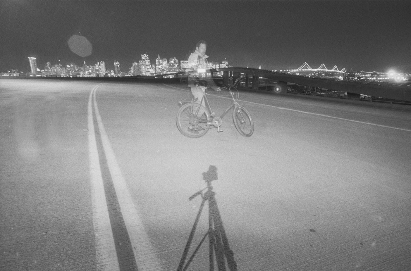
Greg Gaar on Interstate 280 above Mission Creek, November 1989.
(Photo by Greg Gaar; courtesy of Greg Gaar / wnp72.15997)
An insurmountable task: Open SF History has asked me to choose a single favorite photograph from their extensive archive. Inconceivable! As I often do when digging into this invaluable resource of San Francisco history, I find myself venturing down countless rabbit holes, exploring the varied and fascinating collection it offers. I frequently reference modern maps and Street View, marveling at what has changed and what has remained the same. The image I chose comes from a San Francisco street photographer I greatly admire, Greg Gaar. His extensive collection of photographs from the 1970s to the 1990s is nothing short of inspiring. From landscapes frozen in time to intimate portraits, the sheer amount of ground Greg must have covered in the City sparks the imagination. His portraits, in particular, are masterfully executed, capturing magical, unrepeatable moments in a way that makes the process appear effortless. One standout is a “selfie” Greg took on an entirely deserted I-280 at night, after the highway was closed due to structural damage from the 1989 Loma Prieta earthquake. Equal parts creative, technical, and haunting, the image shows Greg posing in front of a San Francisco skyline illuminated at night, with the Bay Bridge masterfully framed in the background. His camera’s long exposure captures a ghostly, translucent likeness of Greg alongside his bicycle. Whether this effect was a “happy accident” or a deliberate choice by Greg—only he knows for certain—the result is a striking and unique perspective, born out of one of San Francisco’s most defining natural disasters. It offers a view that few were able to witness in person, but through Greg’s lens, we can all experience it together. -Yameen, @filmhowyalike, @filmhowyabnw

2024.
Inside the Outside Lands
The last Inside the Outside Lands article of the year is a space for us to acknowledge all who have had a meaningful impact on WNP in 2024. We’re so lucky to work with exceedingly kind, talented, and insightful people.
We want to make space for two people in particular this year: John Martini and Margaret Ostermann (even though they will hate the attention this brings). The inimitable John Martini has done so much for us, for years. From history walks to collections cataloging, John’s encyclopedic knowledge has been invaluable. It’s an honor to work alongside him, and we’ve had so much fun making his idea for WNP Film Club happen this year. His love of this city in all its forms is infectious, and his camaraderie has kept us going even when the going has gotten tough.
Regular readers should be familiar with Margaret and her adorable pooch, Charlie the History Poodle. But they might not know just how much she’s become a vital member of the WNP family. From co-authoring
Where in West S.F.? to bringing order to our library, emplacing HER(E) exhibition posters along Great Highway, packaging postcards, and more, Margaret has never said no when asked to pitch in. She even brought a homemade sandwich and coffee to sustain Nicole at the Lincoln High School Alumni Association’s car show. Truly above and beyond. We’re so grateful that she and her husband Ben chose to put down roots in the western neighborhoods.
WNP had an all-star lineup of guests and collaborators at our public programs this year: the Aloha Uke Squad, Amanda Bartlett, Bay Area Movies (a.k.a. Jason Moore), Supervisor Connie Chan, Peaches Christ (a.k.a. Joshua Grannell), James Delgado, Dave Glass, Steve Haller, Peter Hartlaub, John Lindsey, Paul Madonna, Supervisor Aaron Peskin, Morgan Schlesinger, SF Neon (a.k.a. Randall Ann Homan and Al Barna), Jason Slamovich, Raul Velez, Yameen, and Nate Zak. We’re also incredibly indebted to Another Planet Entertainment, Busvan for Bargains, Butter Love Bakeshop, CinemaSF, Fort Point Beer Company,
Rebekah Kim, Nicole Meldahl, and Drew Moss recording a podcast episode, December 7,
Gaspare’s Pizza House, Great Highway Park, Internet Archive, Java Beach Café, The Riptide, The Royal Cuckoo, SF Maritime, SF Municipal Transportation Authority, and SF Planning Department, all of whom have been invaluable partners—either directly funding what we do or offering us their space, time, and expertise. Others who have answered the call for volunteers at programs include Stephanie Brown, Deb Denison, Rhian Miller, Monica Morse, Kristine Poggioli, Ken Spielman, and Pam Wright. Big kudos to Krissy Kenny, who created a streamlined kit for outdoor street festivals so west side history can travel MUCH MORE easily.
We have just as many people helping us behind the scenes. We’re constantly in awe of Gary Stark and the stalwart enthusiasts who research and add materials to cliffhouseproject.com. Oral history interviews recorded by Sarah Wille we’ve added to our archive this year include Richard Brandi, Laurie Colton, John Freeman, Greg Gaar, and Jamie O’Keefe. Frank Dunnigan continues to mine our photo archive to share stories about San Francisco then and now. This magazine is made possible by our exceptionally talented designer, Laura Macias, and contributors like Dale Blosser and her son, Stephen Powers, Ray Casabonne, Nicole Hallenbeck, Paul Judge, Nancy Myrick, and Peter Starzhevskiy. Anything we’ve mailed you (aside from this magazine) in 2024 was designed by Hannah Claire Somerville, and comprehensively reviewed by Nick Wolf, whose fundraising and development expertise has been phenomenally helpful.
In addition to assisting with whatever surprises come our way, Drew Moss has seamlessly taken over production of our podcast, which is lovingly transcribed by Tilly Clark, Arlene Money, King Rhoton, and Ken Spielman Our volunteer webmasters—Marc Bertone, Daniel Lucas (a.k.a. Mr. Meldahl), and Thiago Robert—calmly answered our panicked emails. Although you haven’t seen the same volume of updates on our websites as in years past, the collections work of cleaning, rehousing, cataloging, and improving our metadata has continued apace thanks to our conservation partner, Alexandra Thrapp and ACT Art Conservation, all of the Beutels (Eli, Thomas, and Joyce Wong), California Revealed, Barbara Cannella, Emiliano Echeverria, Nikki Flynn, Judy Hitzeman, Paul Judge, Andrew Roth, Art Siegel, Amanda Williford, and Christy Yaeger. We’re also indebted to Atthowe Fine Art Services and Marcus Koenen of the Golden Gate National Recreation Area for helping us navigate the complicated stewardship of our Whitney Family Totem Pole.
Our collection grew this year thanks to many generous donors, including Cindy Sturgeon, who has been carefully dispersing a collection amassed by her

mother—legendary San Francisco historian Edie Epps, who passed away last year. Often, when a collector passes, their life’s work is scattered to the wind by family members who can’t comprehend the value of what they’ve left behind. Cindy has painstakingly ensured Edie’s artifacts went to the right homes, and San Francisco history is richer for it.
A big part of our success over the years has been our commitment to fostering a positive and productive environment because our work reflects that kind of energy. The civility and joy that permeates all we’re doing is intentional and crafted with care, thanks in large part to guidance from our Board of Directors. Ed Anderson, Joe Angiulo, Nicole Smahlik Chernev, Michelle Forshner, Lindsey Hanson, Rebekah Kim, Carissa Tonner, and Kyrie Whitsett have been thoughtful stewards of WNP’s path in 2024, and have set our nonprofit up for an exciting year ahead.
What a privilege it is to work with all of you mentioned here and everyone else we’ll meet in 2025. Thank you, history friends, for being with us.
Stephanie Brown and Carissa Tonner at the debut of the HER(E) exhibition, August 24, 2024.


