
Surface Water Delineation Report
Crossroads Solar Grazing Center
Cardington, Westfield, and Lincoln Townships
Morrow County, Ohio
Prepared for:
Crossroads Solar I, LLC
1105 Navasota Street
Austin, Texas 78702
Prepared by:
Verdantas LLC
6397 Emerald Parkway, Suite 200
Dublin, Ohio 43016 (614) 793-8777
Verdantas Project No: 17078
July 2025

This page intentionally left blank.
Figures
Figure 1 Project Location Map
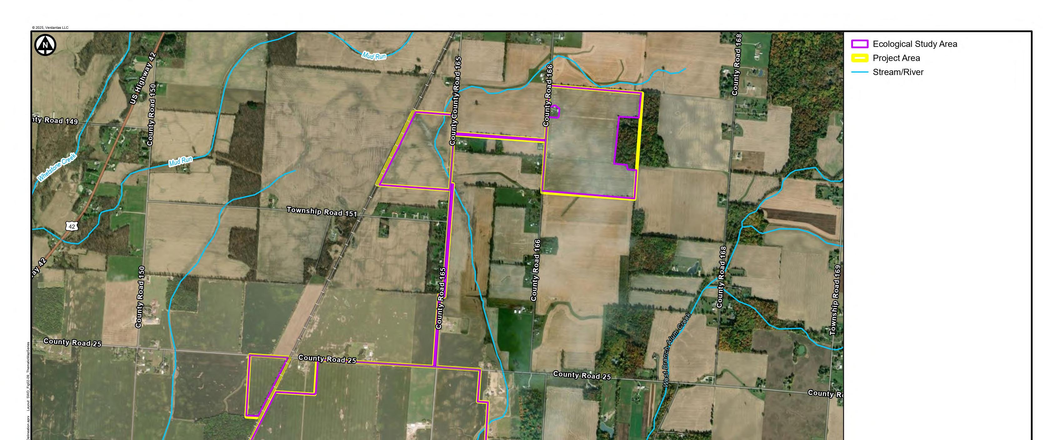
Figure 2 Project Vicinity Map
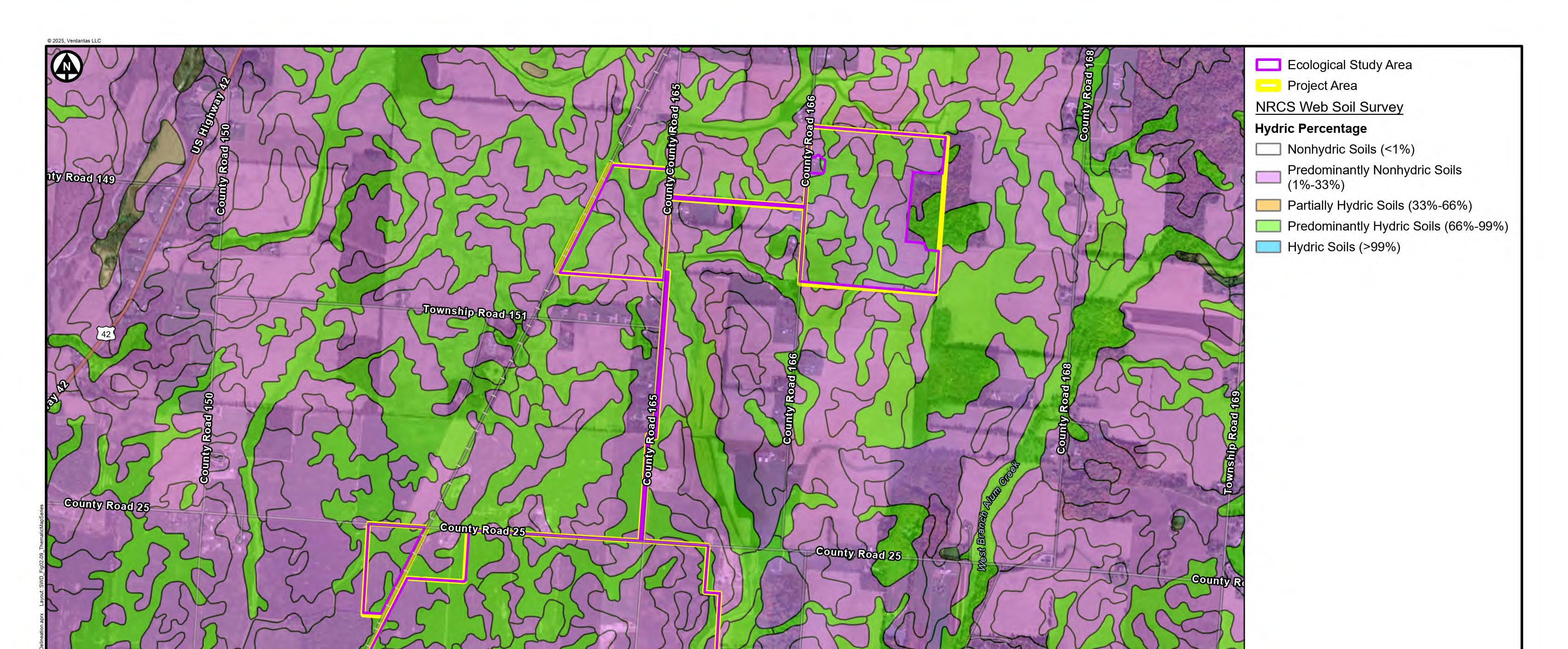
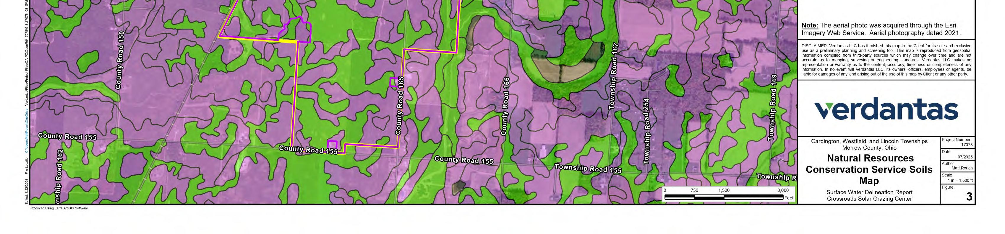
Figure 3 Natural Resources Conservation Service Soil Map
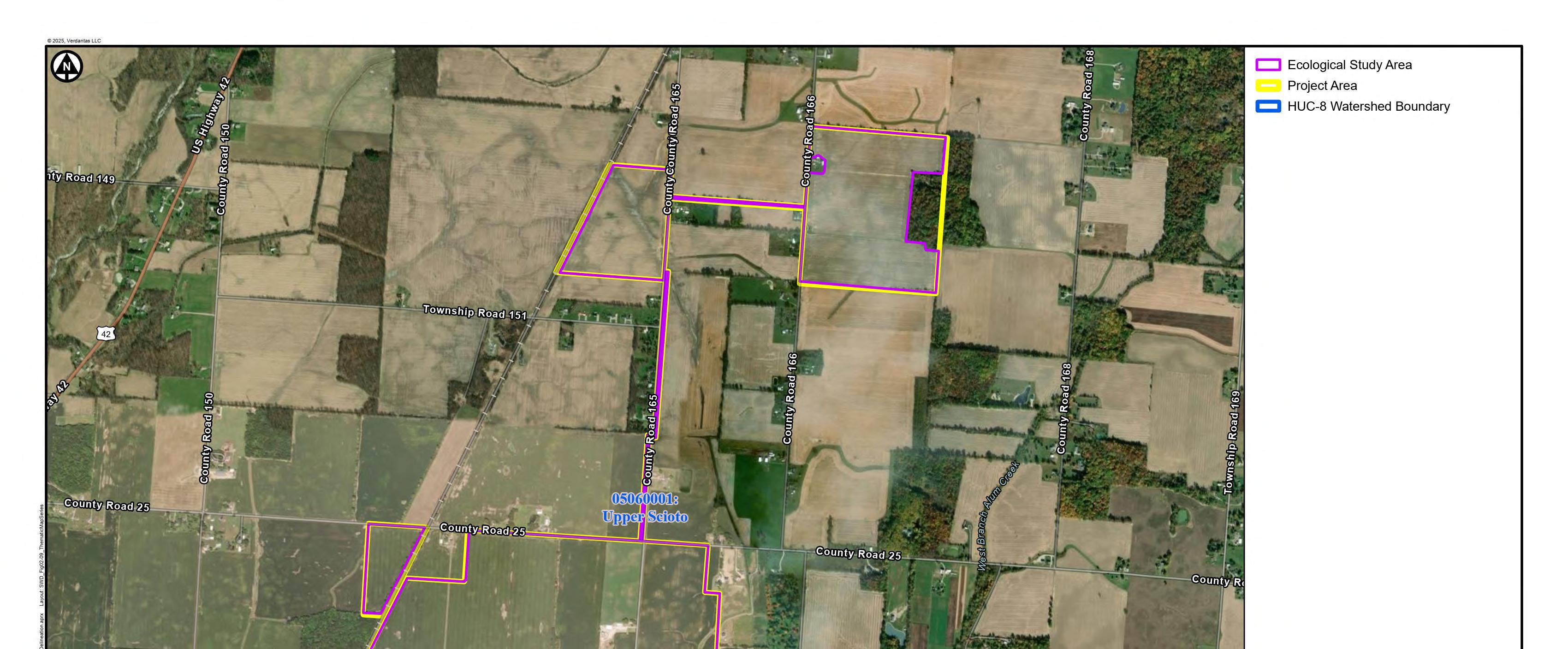
Figure 4 HUC-8 Watershed Map
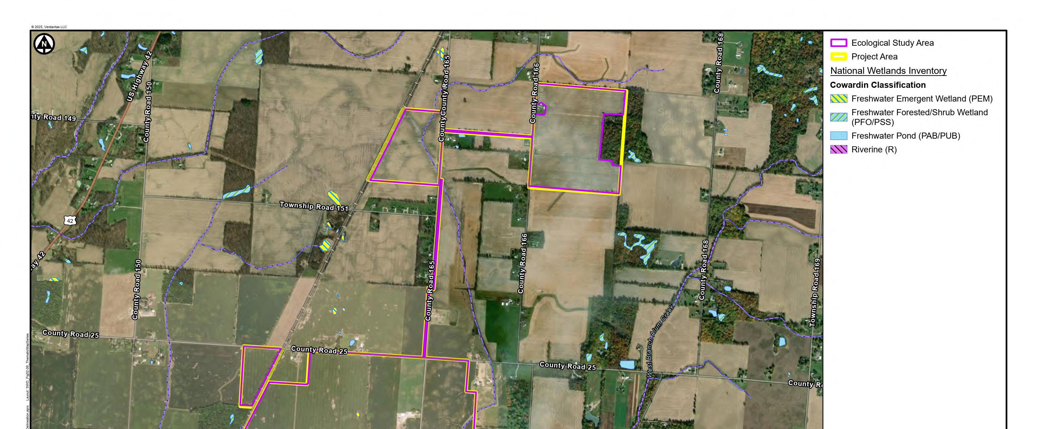
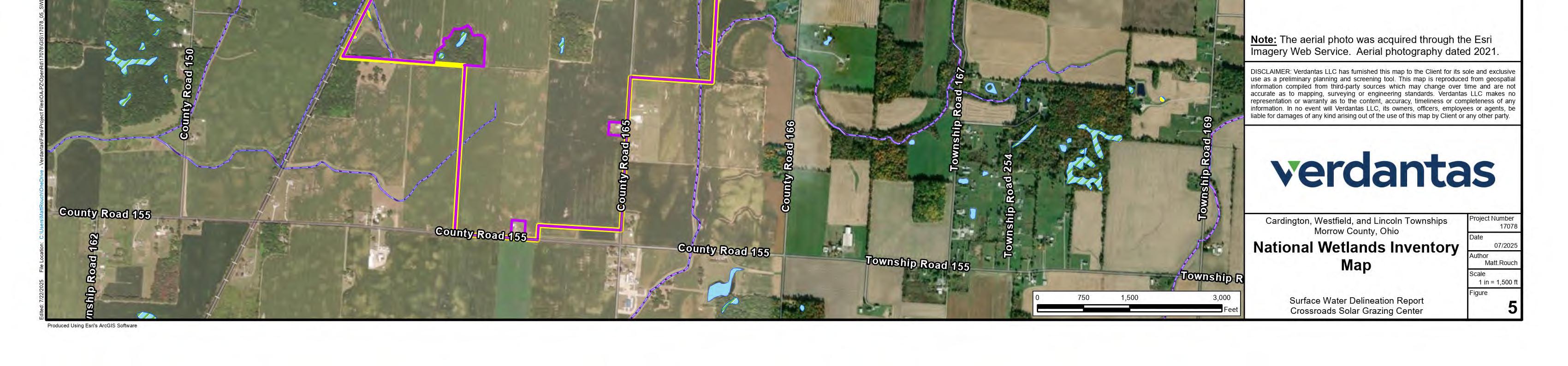
Figure 5 National Wetlands Inventory
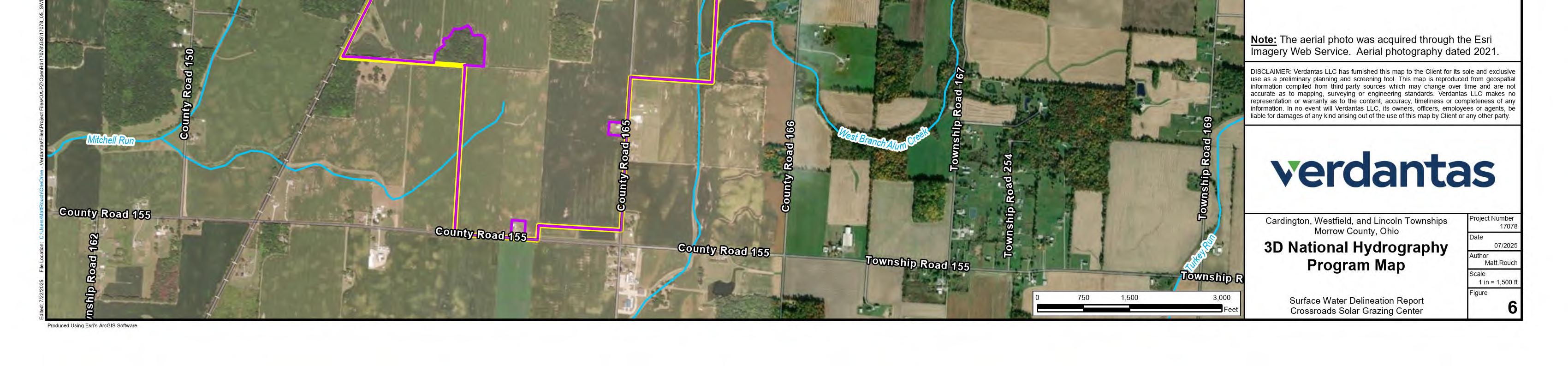
Figure 6 National Hydrography Dataset Map
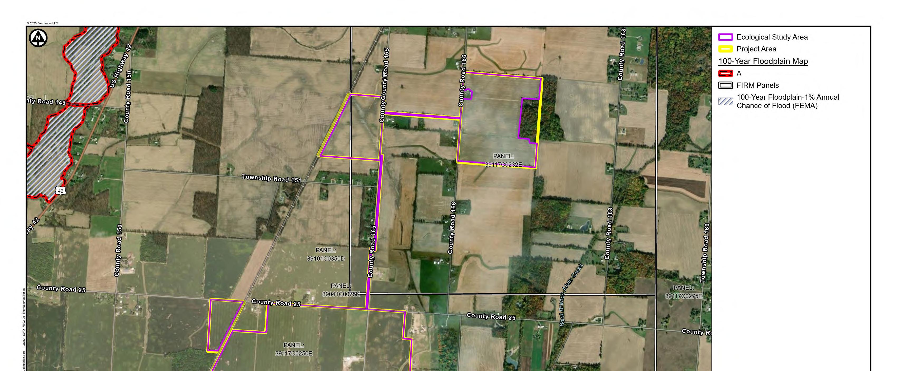
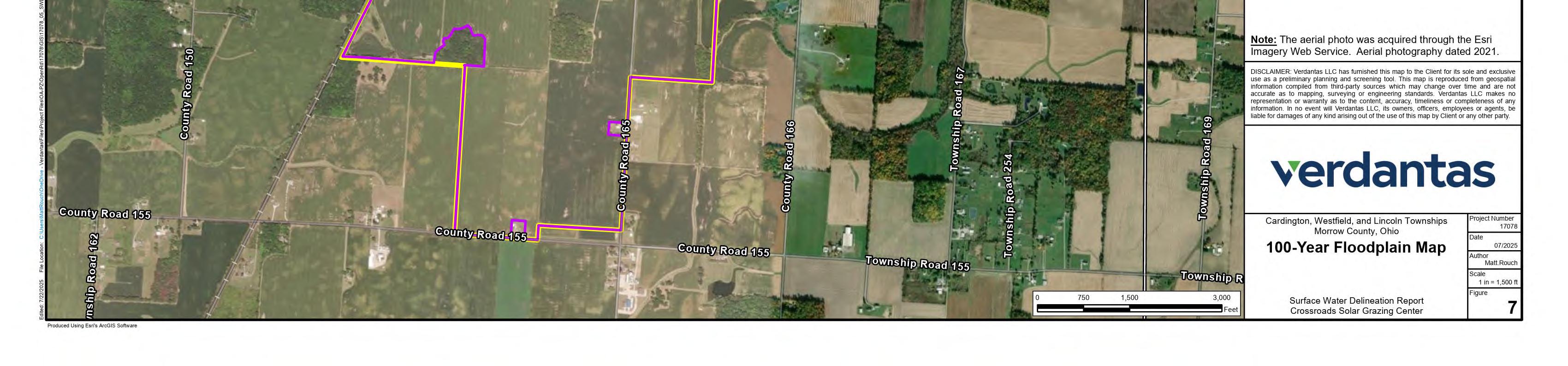
Figure 7 100-Year Floodplain Map
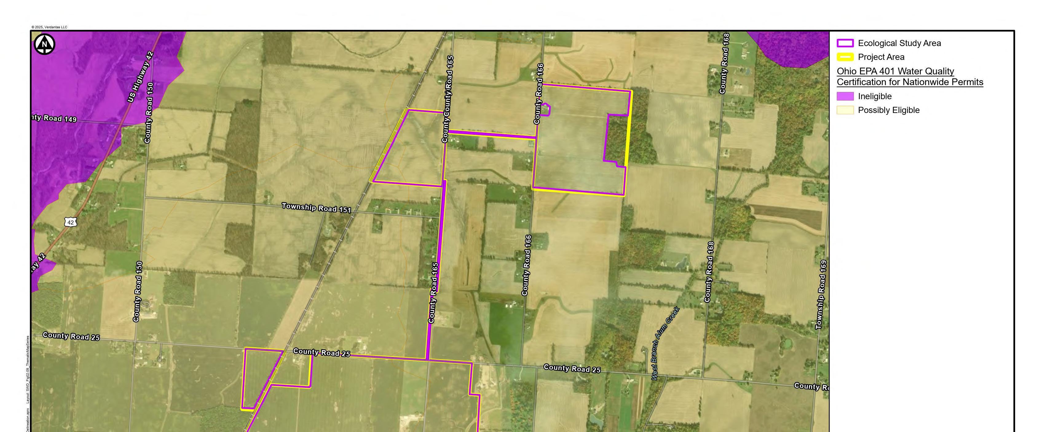
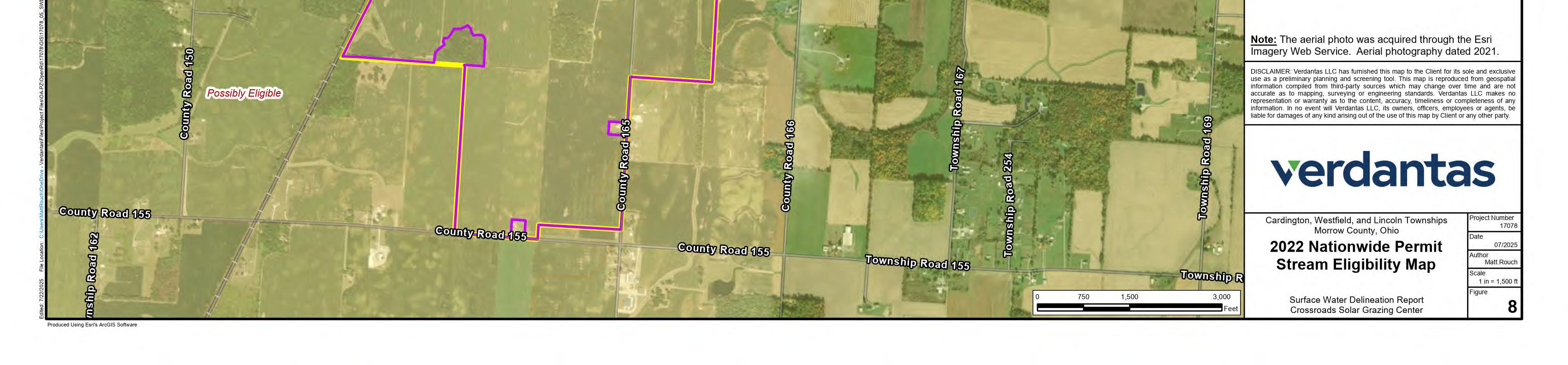
Figure 8 2022 Nationwide Permit Stream Eligibility Map
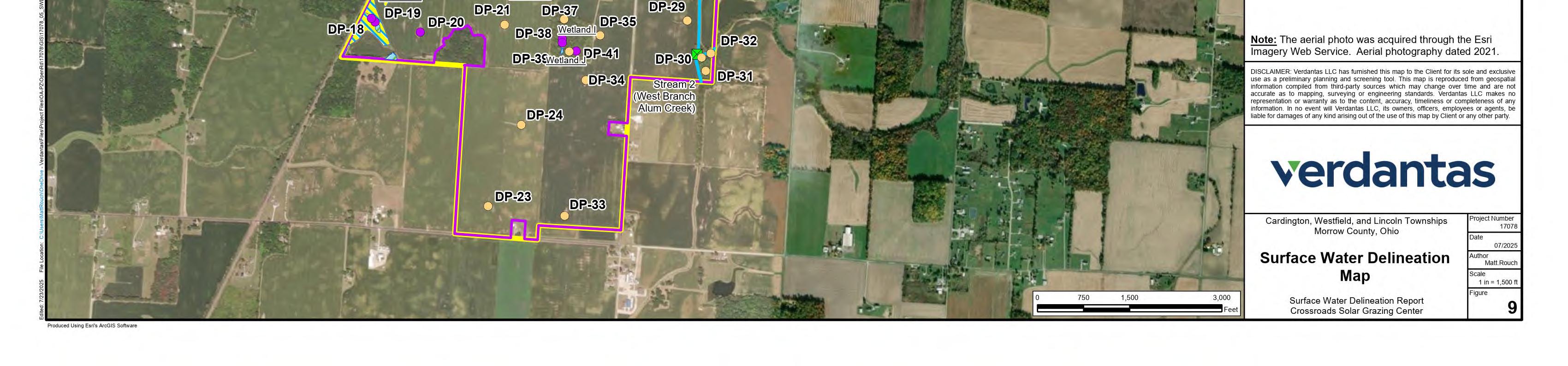
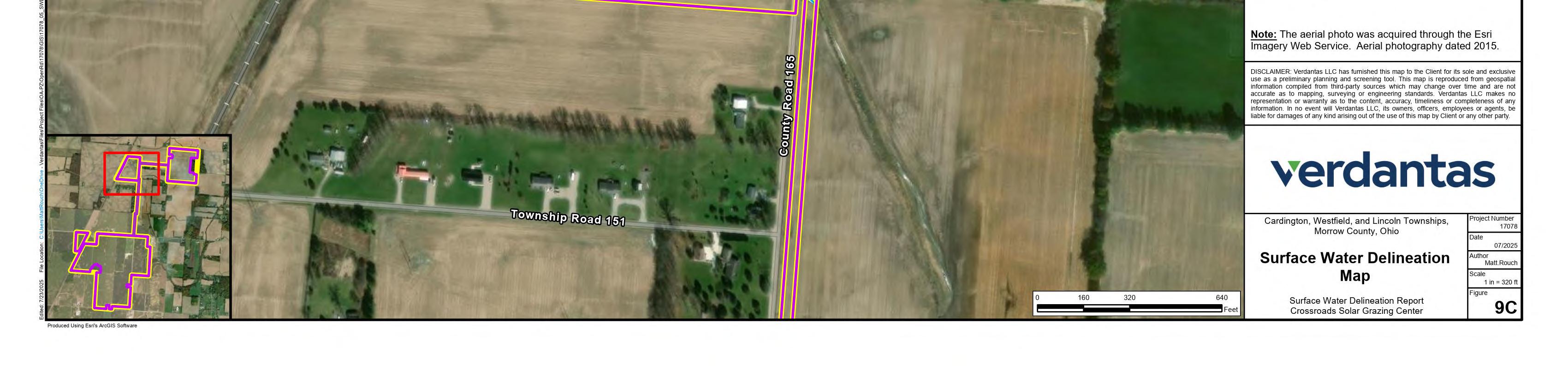
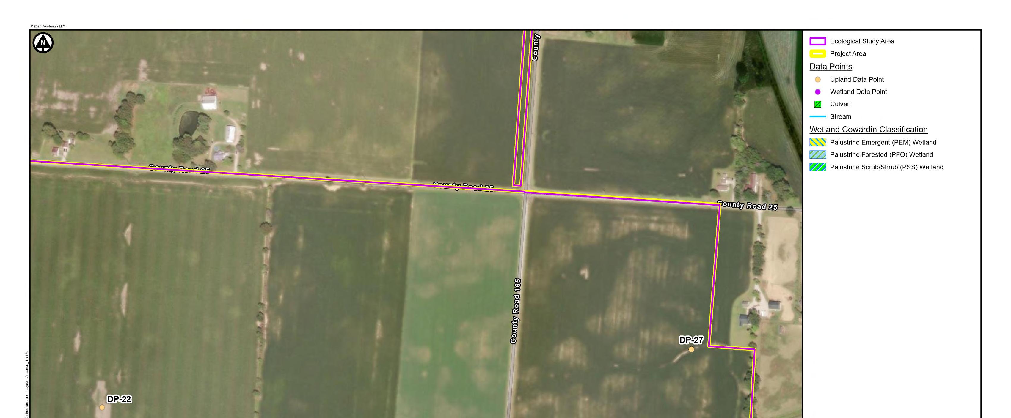
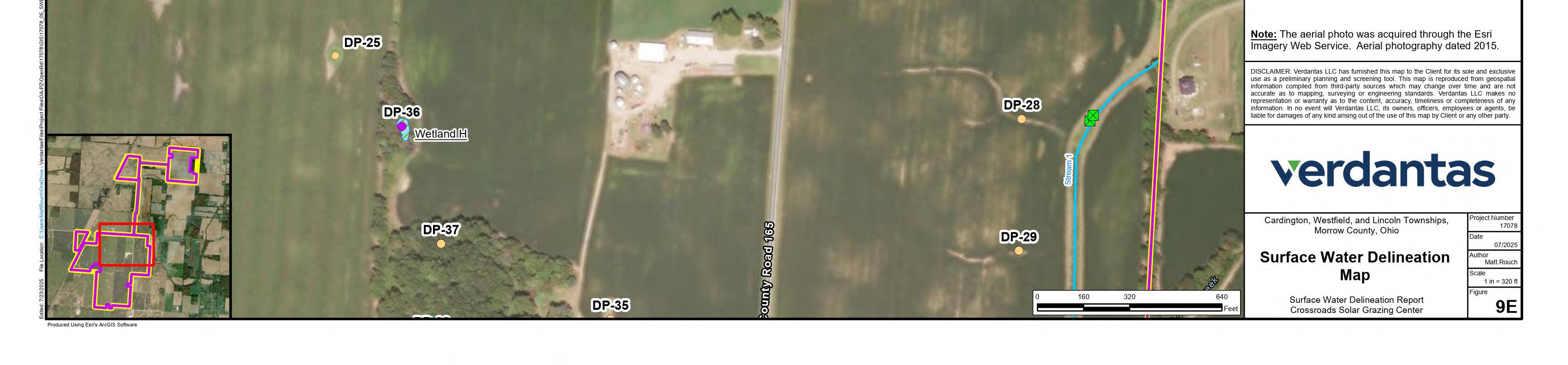
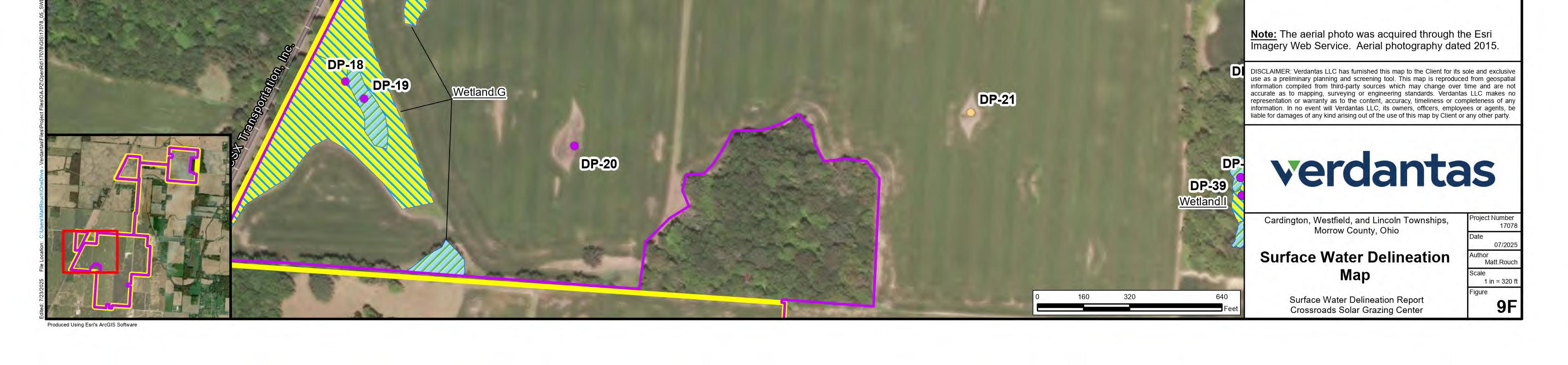
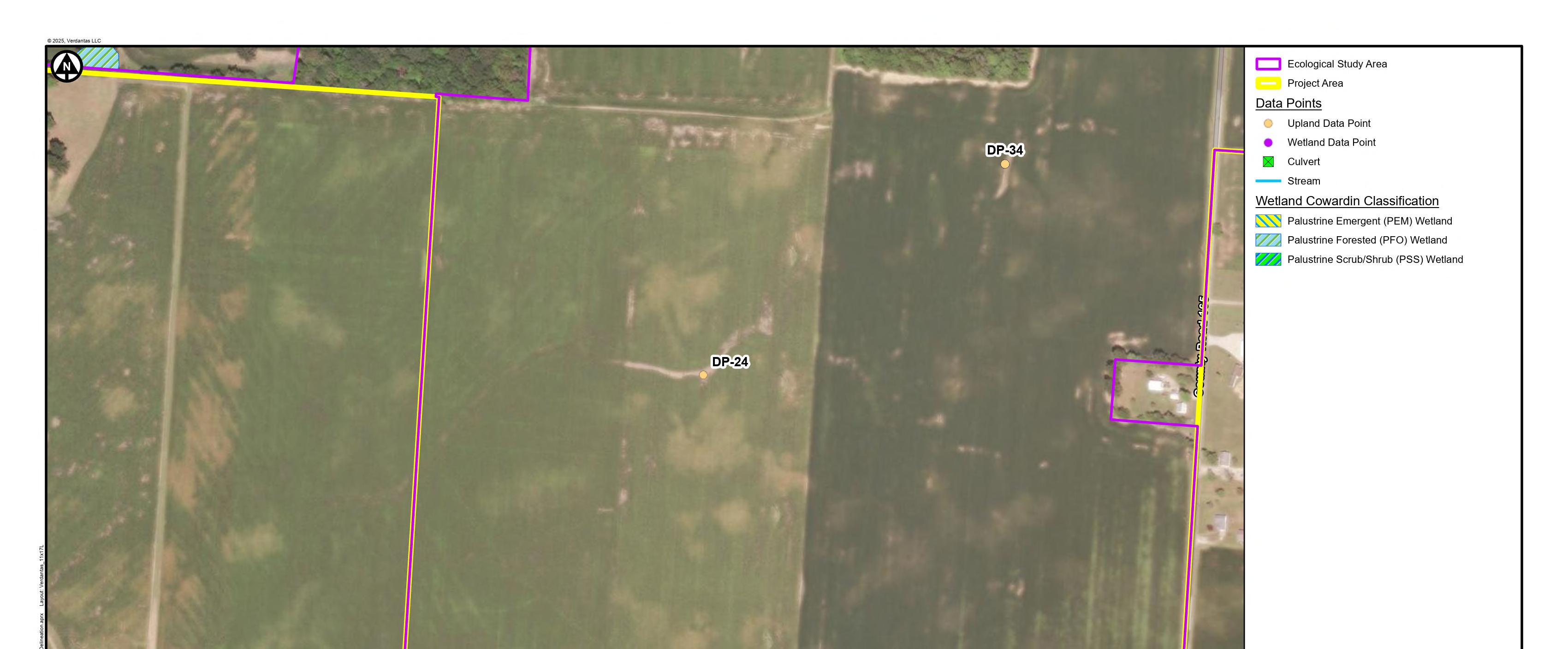
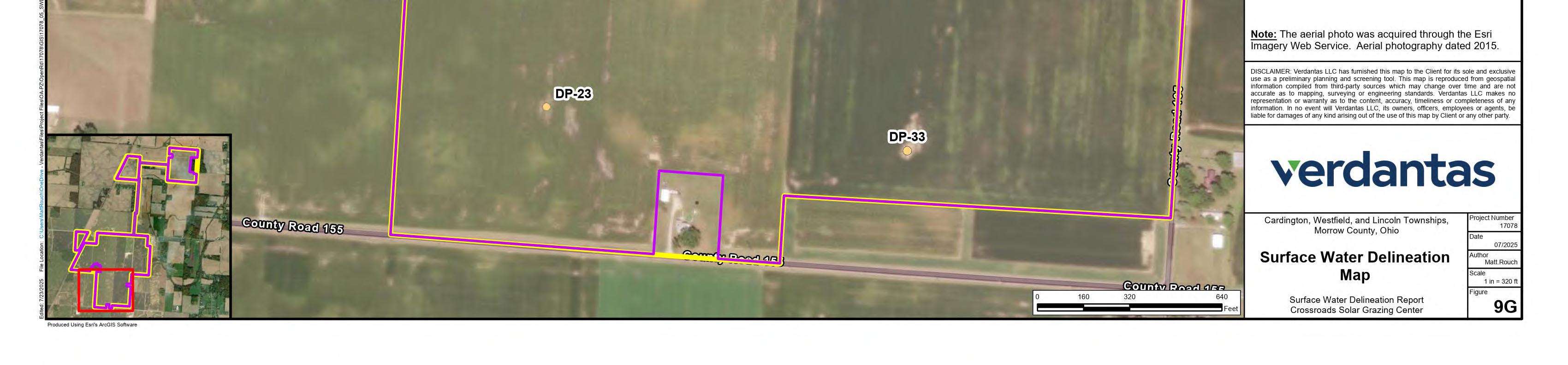
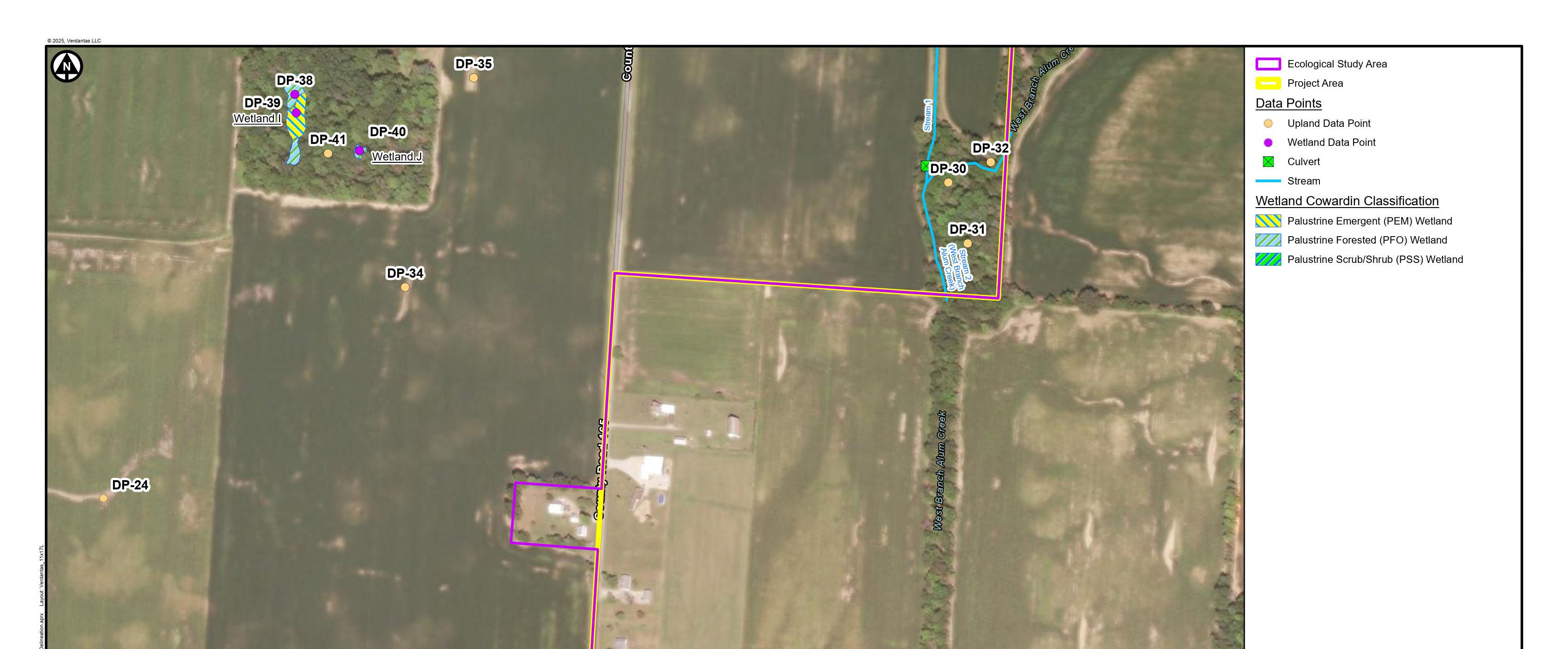
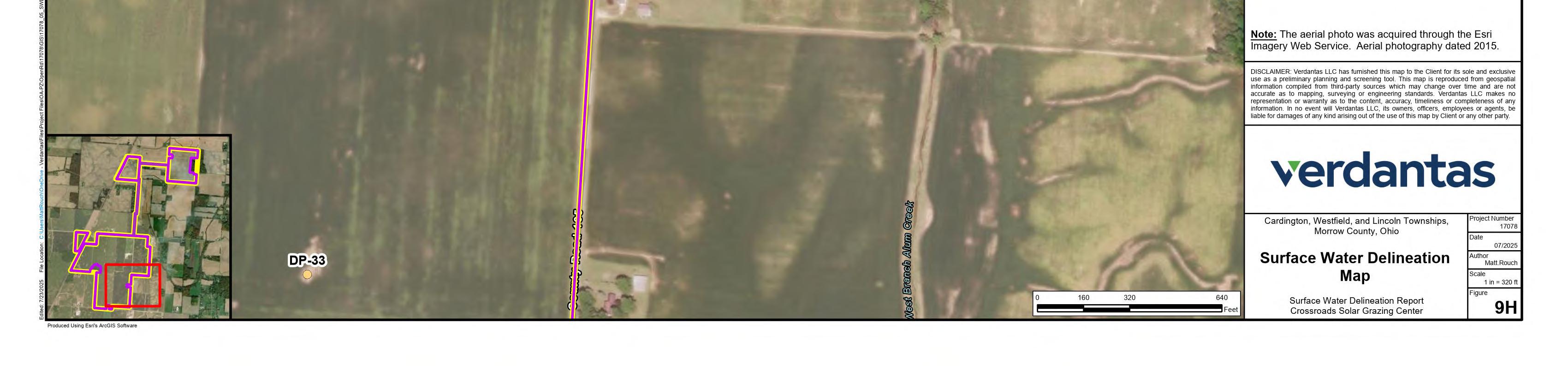
Figure 9 Surface Water Delineation Map
Appendices
Appendix A Tables
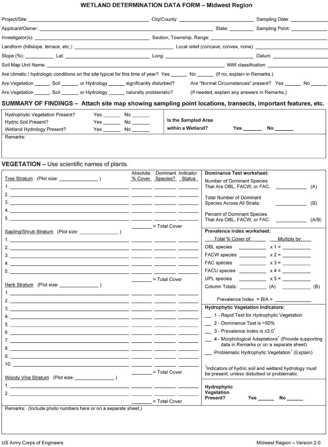
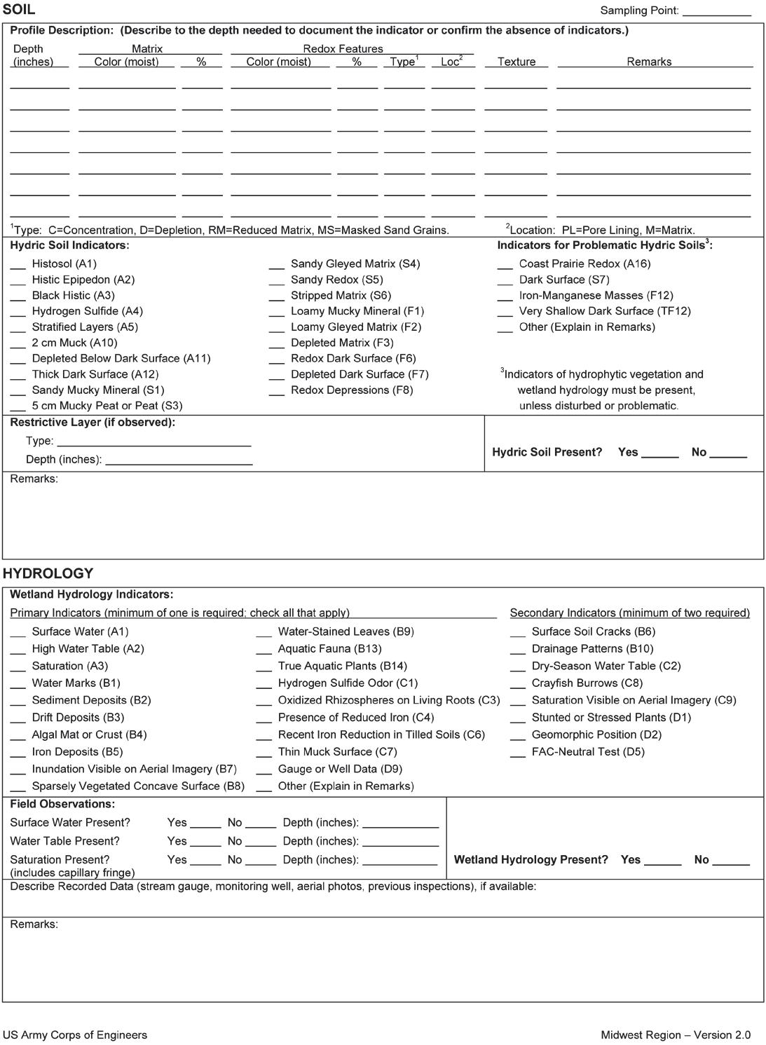
Appendix B Wetland Determination Data Forms
Appendix C ORAM Wetland Evaluation Data Forms
Appendix D HHEI/QHEI Stream Evaluation Data Forms
Appendix E Project Area Photographs

1. Introduction
This Surface Water Delineation Report (“Report”) has been prepared for the Crossroads Solar Grazing Center (“Crossroads”). Crossroads is proposing to construct a combined utility-scale solar energy and sheep grazing facility in Cardington, Lincoln, and Westfield Townships in Morrow County, Ohio (the “Project” or the “Facility”). The Project will use rows of ground-mounted solar panels to supply up to 94 megawatts AC (MWac) of wholesale power to the existing electric grid while also providing pasture for livestock. All of the Project’s above-ground infrastructure will be located within agricultural-style fences, which also will confine the livestock and protect them from predators. The fenced area will be up to 559 acres (the “Solar & Grazing Area”) of an area totaling approximately 726 acres (the “Project Area”).
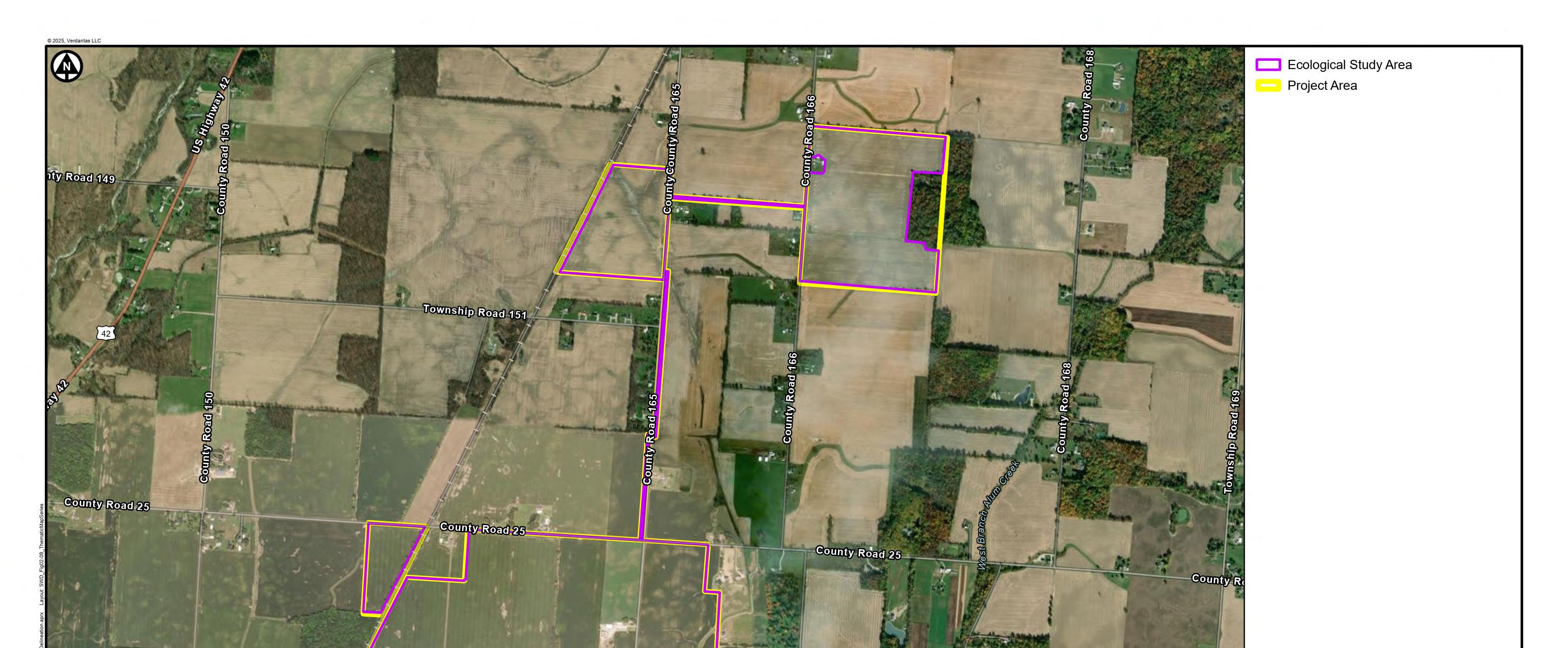
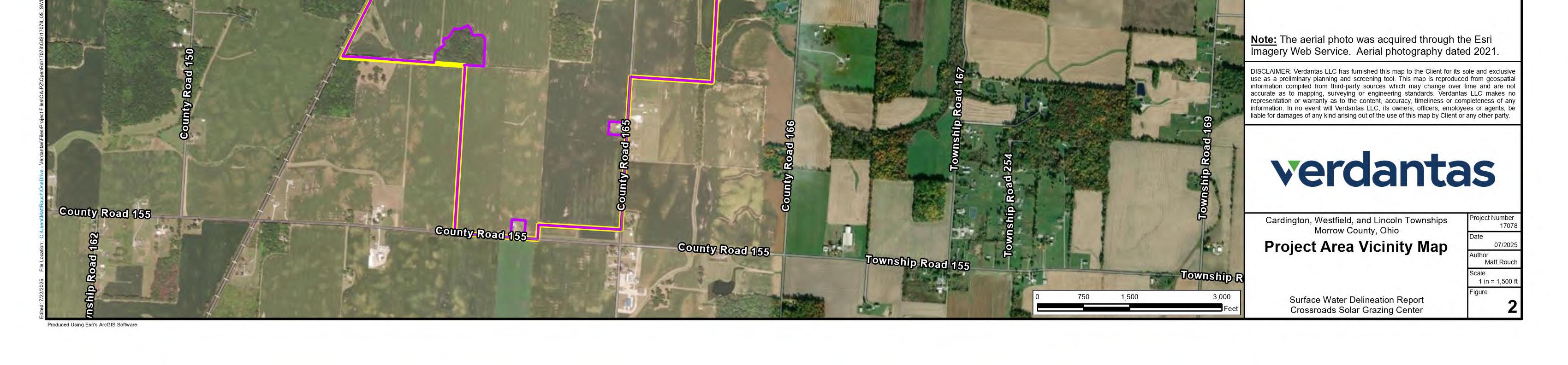
Verdantas LLC (Verdantas) was contracted by Crossroads Solar I, LLC to conduct a surface water delineation of wetlands and waterbodies within the Project Area boundary (Figure 1, Figure 2). The Ecological Study Area represents the maximum area considered to site the Project, and it comprises 694.1 acres. Buffers applied around easement corridors make the Ecological Study Area larger than the Project Area in some locations. The purpose of this surface water delineation was to determine the extent and quality of surface waters within the Ecological Study Area that may be subject to regulation under the Rivers and Harbors Act of 1899, Section 10; Clean Water Act (CWA), Sections 401 and 404; Code of Federal Regulations (CFR), Title 33 Parts 328 and 329; Executive Order 11990; the National Environmental Policy Act (NEPA); and Ohio Revised Code (ORC), Sections 6111.03, 6111.021, and 6111.022. This report summarizes the methodologies and results of the surface water delineation for the Project.
2. Surface Water Delineation Criteria
A surface water delineation involves the identification of wetlands, streams, and other relatively permanent surface water features that may be subject to federal and/or state jurisdiction.
2.1 Wetland Criteria
Federal regulations define wetlands as:
“…areas that are inundated or saturated by surface or ground water at a frequency and duration sufficient to support, and that under normal circumstances do support, a prevalence of vegetation typically adapted for life in saturated soil conditions (Environmental Laboratory, 1987).”
Ohio regulations define wetlands as:
“…those areas that are inundated or saturated by surface or ground water at a frequency and duration that are sufficient to support, and that under normal circumstances do support, a prevalence of vegetation typically adapted for life in saturated soil conditions. "Wetlands" includes swamps, marshes, bogs, and similar areas that are delineated in accordance with the 1987 U.S. Army Corps of Engineers wetland delineation manual and any other procedures and requirements adopted by the U.S. Army Corps of Engineers for delineating wetlands (3745-1-02 OAC).”
According to current regulatory wetland criteria, a wetland must have hydric soils, evidence of inundated or saturated conditions, and a predominance of hydrophytic vegetation. When all three of these criteria are met, a wetland is present and is subject to federal and/or state regulations and permitting.
Hydric soils are those that have formed under conditions of saturation, flooding, or ponding long enough during the growing season to develop anaerobic conditions in the upper part of the soil column (Environmental Laboratory, 1987). The presence or absence of hydric soils is determined in the field by digging a soil pit or bore sample, characterizing the soil profile, and applying the criteria for hydric soils contained in Field Indicators of Hydric Soils in the U.S., Version 8.2 (USDA NRCS, 2018).
Wetland hydrology refers to a landscape which is periodically inundated or has soils that are saturated to the surface during the growing season with a duration that influences the vegetative community because of the development of anaerobic soil conditions (Environmental Laboratory, 1987). The presence of wetland hydrology is determined using field indicators including directly observable evidence such as inundation and soil saturation, and evidence of recent inundation such as water marks on trees and sediment or drift deposits. Evidence of current or recent soil saturation may also be present, such as the presence of reduced iron or crayfish burrows.
Hydrophytic vegetation is described by the U.S. Army Corp of Engineers (USACE) as the community of macrophytes that occurs in areas where inundation or soil saturation is either permanent or of sufficient frequency and duration to influence plant occurrences (Environmental Laboratory, 1987). Plants are placed into indicator status categories depending on their probability of occurring in a wetland. These categories were originally developed and defined by the U.S. Fish and Wildlife Service (USFWS) National Wetlands Inventory (NWI) and subsequently have been modified by the National Plant List Panel. There are five indicator status categories for plants:
1. Obligate wetland plants (OBL) almost always occur in wetlands;
2. Facultative wetland plants (FACW) usually occur in wetlands but may occur in nonwetlands;
3. Facultative plants (FAC) occur in both wetlands and non-wetlands;
4. Facultative upland plants (FACU) usually occur in non-wetlands, but may occur in wetlands; and
5. Upland plants (UPL) almost never occur in wetlands.
2.2 Stream Criteria
The location and length of each stream channel is determined from existing mapping information and/or via surveying streams in the field. Note that some streams that are too small to be included on U.S. Geological Survey (USGS) topographic maps may nevertheless be under federal or state jurisdiction. Regulated streams generally have a defined channel, an Ordinary High Water Mark (OHWM), and discernible bed and bank features. Streams may have other morphological features including riffles and pools, meanders, and a floodplain.
Verdantas considers the greater landscape, habitat, and land use when evaluating the jurisdictional nature of agricultural and other ditch networks. Wetlands that are located solely within an agricultural or roadside ditch are typically considered non-jurisdictional under the current state and federal guidelines (33 CFR Part 328 and 3745-1-02 OAC). Ditches containing wetlands, which bisect larger wetlands or contain wetlands adjacent to the ditch boundaries, may be considered jurisdictional connections between surface water features subject to federal or state regulation.
2.3 Jurisdictional Determination
Preliminary jurisdictional determinations are made by Verdantas based on current federal and state regulations. The USACE has sole authority to determine whether wetlands, streams, and other waterbodies are regulated under federal jurisdiction. Jurisdictional Determinations made by the USACE are typically valid for a period of five years. Consistent with this practice, Verdantas considers delineation data to remain likely accurate for a period of five years. Surface waters determined by USACE to be non-jurisdictional (e.g., isolated wetlands) may be subject to regulation by the State of Ohio
3. Methods of Investigation
3.1 Desktop Review
Verdantas reviewed preliminary information to screen the entirety of the Project Area. Desktop review included consulting agency sources including USGS topographic maps, county Natural Resources Conservation Service (NRCS) maps, NWI maps, and USGS 3D Hydrography Program (3DHP) maps.
The USGS 7.5-minute Topographic Maps provide an indication of the general topography and elevation of the Project Area and surrounding areas. Recent aerial imagery of the Project Area and surrounding areas provide an indication of potential wetlands (darkened areas) as well as areas where streams may be present. Additionally, vegetation and habitat type can preliminarily be assessed using aerial imagery. Aerial imagery is used as supplemental information and cannot replace field observation of the Project Area due to age of mapping data and varying quality of aerial mapping available
The NRCS soil survey for Morrow County, Ohio identifies soil mapping units within the Ecological Study Area, including hydric soil mapping units, predominantly hydric soil mapping units, partially hydric soil mapping units, predominantly nonhydric soil mapping units, non-hydric soil mapping units that may contain inclusions of hydric soil units, and non-hydric soil mapping units. Nonhydric soil mapping units that may contain inclusions of hydric soil units can occur on terraces, in depressions, on floodplains, and in drainage ways.
The USGS 8-digit Hydrologic Unit Code (HUC) Maps indicate within which river watershed or watersheds the Project Area is located. HUC mapping can assist in determining drainage pathways beyond the Project Area and nexus to downstream waters including Traditionally Navigable Waters (TNWs).
The USFWS NWI maps provide an indication of the presence of wetland and open-water areas as defined by their classification system (Cowardin et al., 1979). The notation of a wetland on an NWI map indicates that wetlands might occur or have occurred in the area. Often, those wetlands depicted on NWI maps are the wettest spots in an area. NWI map information is used to supplement knowledge about a site and cannot take the place of field observations due to minimal ground truthing, age of the map, mapping scale, and wetlands criteria that differ from USACE wetlands criteria.
The 3DHP maps provide information regarding water drainage networks within the Project Area and may indicate the presence/absence of streams. 3DHP map information is used to supplement knowledge about a Project Area and cannot take the place of field observations due primarily to stream criteria that differ from USACE stream delineation criteria.
The Federal Emergency Management Agency (FEMA) National Flood Hazard Layer (NFHL) contains effective flood maps and Letters of Map Change (LOMC) that show areas of high, moderate, and minimal flood hazard. The NFHL maps the presence and relative extent of 100year floodplains, 500-year floodplains, and regulated floodways.
3.2 Wetland Delineation
Wetland boundaries were located in the field using procedures outlined in the 1987 Corps of Engineers Wetlands Delineation Manual (Environmental Laboratory, 1987) and the Regional Supplement to the Delineation Manual for the Midwest Region Version 2.0 (USACE, 2010),
subsequent USACE memoranda and regulatory guidance, and basic principles of plant community ecology.
The plant communities identified within the Ecological Study Area were investigated in detail using the three-criterion wetland delineation approach. The wetland indicator status of plant species was determined using the National Wetland Plant List (Lichvar et al., 2020). After characterizing the vegetation, hydrology, and soils of a plant community type and becoming familiar with the soil, vegetation, and/or hydrologic cues that indicated the upland-wetland boundary, Verdantas recorded the wetland boundaries using Global Positioning System (GPS) technology and periodically collected additional soil, vegetation, or hydrologic data to refine the upland-wetland break. A minimum of one data point was collected in each wetland or wetland mosaic and there was a corresponding upland data point taken outside of the wetland boundary, which was used to describe the upland community surrounding the wetland.
3.3 Wetland Evaluation
Verdantas performed an evaluation of wetlands mapped within the Ecological Study Area using the Ohio Rapid Assessment Method for Wetlands, Final Version 5.0 (ORAM; Mack, 2001). The ORAM value assessment is based on review of resource materials, data obtained in the field, and the acreage as determined by delineation and mapping. The wetland value information is provided to the Ohio EPA during permitting coordination for the purpose of placing wetlands into the appropriate wetland Antidegradation Category described in Ohio’s Wetland Water Quality Standards (Sections 3745-1-05 and Sections 3745-1-50 through 3745-1-54).
There are three Ohio Wetland Antidegradation Categories to which wetlands may be assigned:
• Category 1 wetlands are generally small, low-diversity wetlands and wetlands with a predominance of non-native invasive species.
• Category 2 wetlands are of moderate diversity but do not contain rare, threatened, or endangered species. They are generally degraded but are capable of attaining higher value. Most wetlands in Ohio are expected to fall into this category.
• Category 3 wetlands may be large; diverse; represent rare plant community types; contain rare, threatened, or endangered species; or any combination of these and several other factors.
3.4 Stream Channel Delineation
Stream channels identified on USGS topographic maps are generally found to be under the CWA jurisdiction of the USACE. Additional streams may be identified in the field by the presence of an OHWM, defined bed and bank, and other stream morphological features. The USACE Regulatory Guidance Letter No. 05-05 provides guidance for identifying the OHWM. Where possible, stream channels are investigated upstream to identify the source of water and downstream to determine if the channel ends in a wetland, a confluence with another stream, a culvert inlet, or another resource.
3.5 Stream Evaluation
Verdantas utilizes the Ohio Qualitative Habitat Evaluation Index (QHEI) scoring method to evaluate streams with a drainage area greater than one square-mile and/or pools greater than 40 centimeters deep. The Ohio Headwater Habitat Evaluation Index (HHEI) is used to evaluate the habitat quality of streams with a drainage area less than one square-mile and pools less than 40
centimeters deep. These methods yield a numerical score for the stream reach evaluated, which in combination with other physical observation data, is used to estimate the habitat quality of each stream.
The boundaries of the Ecological Study Area are evaluated utilizing the Ohio EPA Stream Eligibility Web Map (OEPA, 2022) to determine if the stream is eligible for coverage under the 401 Water Quality Certification (WQC) for the 2022 Nationwide Permits (NWP) for Ohio or if an individual 401 WQC or Ohio EPA Director’s Authorization is required. At stream locations in possibly eligible areas where surface water is present, pH values are taken utilizing an Oakton pH2+ pen meter.
3.6 Surveying and Mapping
Once delineated using the three-criterion approach, the wetland/non-wetland boundaries and the sample locations are surveyed, and a map is produced. The boundaries of all wetland areas, sample points, and streams are located in the field using Eos Arrow 100 GNSS receivers with submeter-capable accuracy. All wetland areas, sample points, and stream locations are placed in a Geographical Information System (GIS) database and assembled with other available geographically referenced information using ArcMap v.10.8.2 GIS software. The length of each stream and acreage of each wetland is calculated using GIS.
4. Results
4.1 Desktop Review Results
The USGS topographic map for the Ashley Quadrangle indicates that topography within the Project Area is relatively flat but generally slopes east towards West Branch Alum Creek (Figure 1). The Project Area and vicinity have been shaped by a history of agricultural land use and drained by subsurface tiles and channelized ditch systems (Figure 2).
NRCS soil map units, their hydric rating, and their extent within the Project Area are provided in Table 1 in Appendix A and in Figure 3. Hydric and predominantly hydric soils make up 48.5% of the soils present within the Project Area.
The Project Area is located within the Upper Scioto Watershed (05060001; Figure 4). The NWI maps one freshwater forested/shrub wetland, one emergent freshwater wetland, and two riverine wetlands within the Project Area (Figure 5). The 3DNHP maps three streams within the Project Area (Figure 6).
The Project Area is within several FEMA Flood Insurance Rate Maps (FIRMs): 39101C0350D, 39117C0232E, 39041C0075K, and 39117C0250E, all of which indicate that the Project Area is in Zone X (unshaded), an area of minimal flood hazard (Figure 7) The Project Area is located within an area where streams are Possibly Eligible for permitting through the Ohio 401 WQC for the 2022 NWPs of Ohio (Figure 8). If a 2022 NWP is used to authorize impacts to streams within the Project Area, the flow charts provided by Ohio EPA should be used to clarify when streams that score high on the HHEI or QHEI, and are mapped in possibly eligible areas, may be subject to individual 401 WQC or Director’s Authorization procedures. Even if a specific stream necessitates an individual 401 WQC or Director’s Authorization, the use of a 2022 NWP is still a valid option to permit the associated impacts.
4.2 Surface Water Delineation
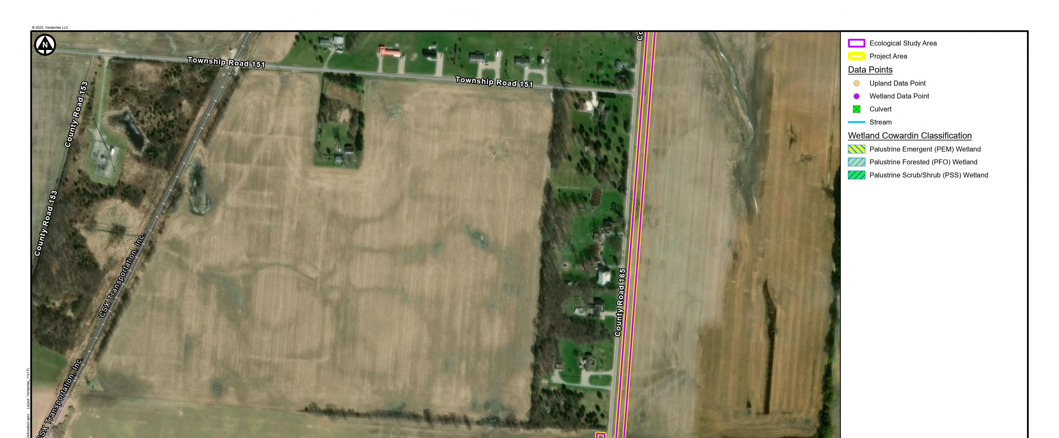
Verdantas ecologists performed surface water delineations within the Ecological Study Area on December 18-19, 2023; January 18, 2024; April 18, 2024; and November 14-15, 2024. The Ecological Study Area was dominated by agricultural cropland consisting primarily of corn (Zea mays) and soybeans (Glycine max). Fringe woody habitat was observed in the form of tree lines and edges of woodlots within some portions of the Ecological Study Area. Dominant tree species in these areas included northern red oak (Quercus rubra), pin oak (Quercus palustris), and common hackberry (Celtis occidentalis).
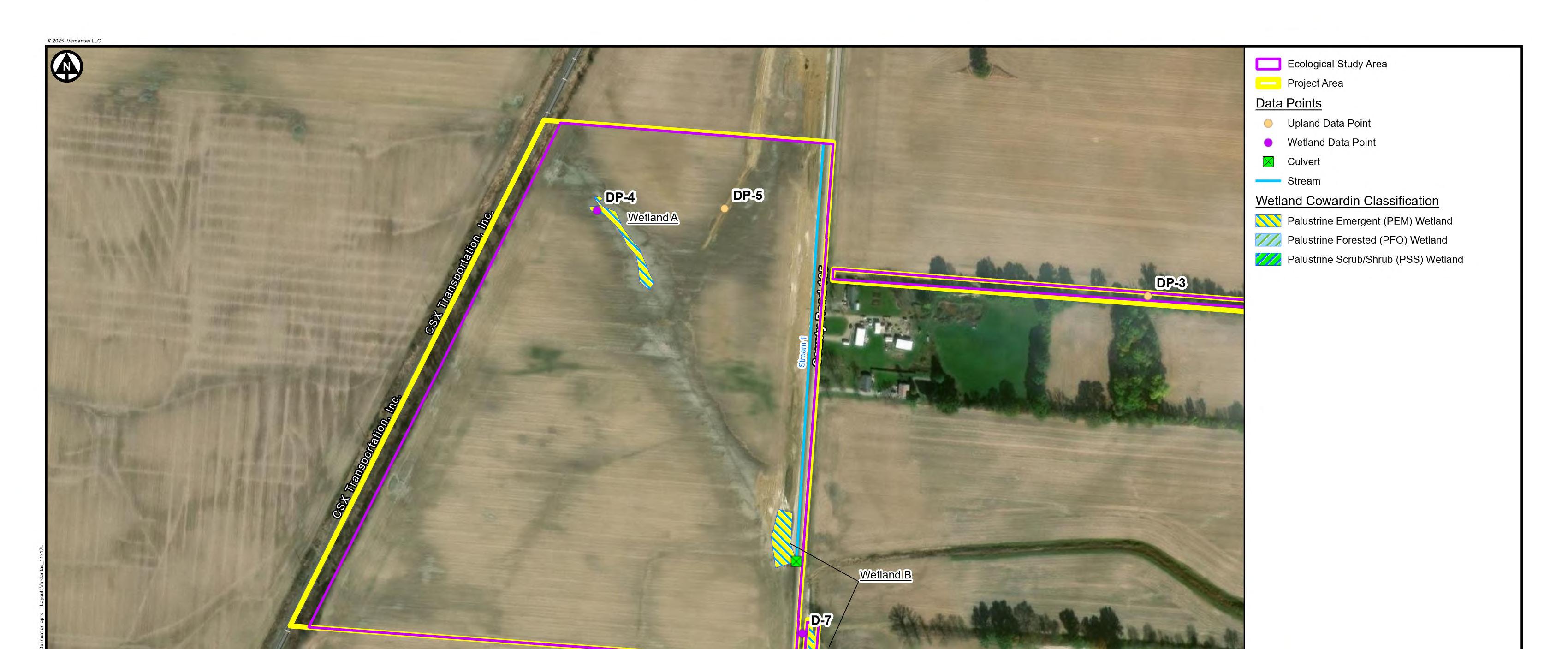
Eight (8) wetlands were delineated, comprising a total of 6.46 acres within the Ecological Study Area (Figure 9; Table 3 in Appendix A). Of these, one wetland, Wetland B, was determined to contain a continuous surface connection to a relatively permanent water, making it likely
jurisdictional under current federal guidelines (33 CFR Part 328)1. The remaining seven (7) were determined to not contain continuous surface connections to relatively permanent waters, likely making them non-jurisdictional under current federal guidelines (33 CFR Part 328). Because isolated wetlands are regulated in Ohio, these wetlands would likely fall under the jurisdiction of the state of Ohio (3745-1-02 OAC and 3745-1-50 OAC). Two (2) wetlands were evaluated as a Category 2 and the rest were evaluated as Category 1 based on ORAM scoring (Appendix C).
Two (2) streams were delineated, comprising 2,827 linear feet within the Ecological Study Area (Figure 9; Table 4 in Appendix A). Both streams were determined to be relatively permanent waters with perennial flow regimes, making them likely jurisdictional under current federal guidelines. In addition, both streams were evaluated using the QHEI assessment method (Appendix D).
Verdantas collected hydrology, soil, and vegetation data at 34 locations within the Ecological Study Area (see Table 2 in Appendix A, and wetland determination data forms in Appendix B). Representative views of the Ecological Study Area including surface water resources were documented in a photolog (Appendix E). For regulatory purposes, final verification of any wetland and waterbody boundaries and their jurisdiction can be formally established through a Jurisdictional Determination (JD) review by the USACE.
1 The May 25, 2023, Sackett vs. EPA decision limited the scope of federal jurisdiction over wetlands under Section 404 of the Clean Water Act. The USEPA and USACE published an amendment to the Revised Definition of ‘Waters of the United States’ rule on August 29, 2023, to be consistent with the Supreme Court decision. Because there is significant regulatory uncertainty, and there is ongoing litigation challenging the amended rule in Ohio, federal jurisdictional status as assessed in this report follows pre-Sackett vs. EPA guidance. As written, the amendments to the Revised Definition of ‘Waters of the United States’ rule will limit the scope of federal jurisdiction of wetlands. However, it is important to emphasize that surface water features not subject to federal regulation usually fall under the purview of Ohio state regulations. Consequently, it is anticipated that all the surface water features presented in this report will be subject to regulation, although the specific regulatory jurisdiction might undergo changes.
5. Report Limitations
The conclusions presented herein are based on the level of effort and investigative techniques defined under the Scope of Work between Verdantas and Crossroads. Verdantas has conducted this investigation in a manner consistent with published guidance, sound ecological practices, and best professional judgment. No other warranty or guarantee, expressed or implied, is made. This report does not attempt to evaluate past or present compliance with Federal, State, and Local environmental or land use laws and regulations. Furthermore, Verdantas makes no guarantees regarding the completeness or accuracy of any information obtained in review of public or private files or previous investigations at the Project Area not conducted by Verdantas. The results of the surface water delineation and the surface water evaluation are subject to verification by the USACE and Ohio EPA, respectively.
Prepared by:

Emily Ott Staff Ecologist III eott@verdantas.com
Helena Hayter Ecologist hhayter@verdantas.com

Jordan Rofkar Senior Project Manager jrofkar@verdantas.com
6. References
Cowardin, L.M., V. Carter, F.C. Golet and E.T. LaRoe, 1979. Classification of Wetlands and Deepwater Habitats of the United States, US Department of the Interior, Fish and Wildlife Service, BSP, Washington DC, 103p.
Environmental Laboratory, 1987. Corps of Engineers Wetlands Delineation Manual, Technical Report Y-87-1, US Army Engineer Waterways Experiment Station, Vicksburg Miss.
Lichvar, R.W., M. Banks, D.L., Kirchner W.N., and Melvin, N.C. 2023. The National Wetland Plant List: 2023 Wetland Ratings. Phytoneuron 2016-30: 1-17.
Mack, John J. 2001. Ohio Rapid Assessment Method for Wetlands v. 5.0, User’s Manual and Scoring Forms Ohio EPA Technical Report WET/2001-1. Ohio Environmental Protection Agency, Division of Surface Water, 401/Wetland Ecology Unit, Columbus, Ohio.
Ohio Environmental Protection Agency, Division of Surface Water, 2018. Field Methods for Evaluating Primary Headwater Streams in Ohio. Columbus, Ohio.
Ohio Environmental Protection Agency, Division of Surface Water, 2006. Methods for Assessing Habitat in Flowing Waters: Using the Qualitative Habitat Evaluation Index (QHEI). Columbus, Ohio.
Soil Survey Staff, Natural Resources Conservation Service, United States Department of Agriculture. Web Soil Survey. Available at: http://websoilsurvey.nrcs.usda.gov.
U.S. Army Corps of Engineers, 2010 Regional Supplement to the Corps of Engineers Wetland Delineation Manual: Midwest Region (Version 2.0), ed. J.S. Wakeley, R.W. Lichvar, C.V. Noble. ERDC/EL TR-10-16. Vicksburg, MS: U.S. Army Engineer Research and Development Center.
U.S. Department of Agriculture, Natural Resource Conservation Services, 2018. Field Indicators of Hydric Soils in the United States: A guide for Identifying and Delineating Hydric Soils, Version 8.2. L.M. Vasilas, G.W. Hurt and J.F. Berkowitz (eds.) USDA, NRCS, in cooperation with the National Technical Committee for Hydric Soils.
U.S. Environmental Protection Agency and US Army Corps of Engineers, 2008. Memo entitled: Clean Water Act Jurisdiction following the US Supreme Court’s Decision in Rapanos v. United States and Carabell v. United States December 2008, 12 pp.
U.S. Fish and Wildlife Service (USFWS). 2023. National Wetlands Inventory. U.S. Fish and Wildlife Service, St. Petersburg, FL.
U.S. Geological Survey (USGS). Topographical quadrangle maps (7.5-minute series). Ashley, Ohio quadrangle. U.S. Department of the Interior. Washington, D.
Figures


Appendix A
Tables- Soil map units within the project area, wetland data point summary, wetlands summary, and streams summary
Table 1. Soil Map Units within the Project Area Crossroads Solar Grazing Center Morrow County, Ohio
SymbolSoil Map Unit NameHydric RatingAcreagePercent
Blg1A1Blountsiltloam,groundmoraine,0to2percentslopes9%162.633.4%
Blg1B1Blountsiltloam,groundmoraine,2to4percentslopes9%30.96.3%
Gwg1B1Glynwoodsiltloam,groundmoraine,2to6percentslopes6%57.511.8%
MfMilfordsiltyclayloam,0to2percentslopes93%29.26.0% PmPewamosiltyclayloam,0to1percentslopes91%206.942.5%
TOTAL
487.0100.0%
2. Wetland Data Point Summary Crossroads Solar Grazing Center Morrow County, Ohio
DP-1NoNoNoN/A
DP-2NoNoNoN/A
DP-3NoNoNoN/A
DP-4YesYesYesWetlandA
DP-5NoNoNoN/A
DP-7YesYesYesWetlandB
DP-13NoNoNoN/A
DP-14YesYesYesWetlandE
DP-15YesYesYesWetlandF
DP-16NoNoNoN/A
DP-17NoNoNoN/A
DP-18YesYesYesWetlandG
DP-19YesYesYesWetlandG
DP-20NoNoNoN/A
DP-21NoNoNoN/A
DP-22NoNoNoN/A
DP-23NoNoNoN/A
DP-24NoNoNoN/A
DP-25NoNoNoN/A
DP-26NoNoYesN/A
DP-27YesNoYesN/A
DP-28YesNoNoN/A
DP-29YesNoNoN/A
DP-30NoYesNoN/A
DP-31NoNoNoN/A
DP-32YesYesNoN/A
DP-33NoNoNoN/A
DP-34YesNoYesN/A
DP-35NoNoYesN/A
DP-36YesYesYesWetlandH
DP-37NoNoYesN/A
DP-38YesYesYesWetlandI
DP-39YesYesYesWetlandI
DP-40YesYesYesWetlandJ
DP-41NoNoNoN/A
Table
Table 3: Wetlands Summary Crossroads Solar Grazing Center
Morrow County, Ohio
Coordinates Resource ID USGS 8Digit HUC ORAM Score3 ORAM Category3 Hydrologic Connection1
Regulatory Jurisdiction1
Wetland Area within Project Area (ac)
WetlandA40.483471-82.90579405060001IsolatedOhioEPAPEM1210.24
WetlandB40.479326-82.90300605060001AdjacentUSACEPEM13.510.59
WetlandE40.467987-82.91733105060001IsolatedOhioEPAPEM1210.14
WetlandF40.464270-82.91978105060001IsolatedOhioEPAPEM/PFO1410.13
WetlandG40.461675-82.92003905060001IsolatedOhioEPAPEM/PFO3025.06
WetlandH40.462958-82.90949405060001IsolatedOhioEPAPFO2710.06
WetlandI40.460785-82.90909105060001IsolatedOhioEPAPEM/PFO34.520.36
WetlandJ40.460409-82.90830605060001IsolatedOhioEPAPFO29.510.003
NOTES:
1DeterminedbyVerdantasbasedoncurrentregulatoryguidance,subjecttoverificationbytheUSACE. Cowardin Classification2
2TheCowardinclassificationsystemisusedtodistinguishwetlandsbasedonvegetativecommunitiesandhydrologicsetting;PalustrineEmergent(PEM),PalustrineScrubShrub(PSS),andPalustrineForested(PFO).
3DeterminedbyVerdantas,subjecttoverificationbytheOhioEPA.
ACRONYMS:
USGS:U.S.GeologicSurvey
HUC:HydrologicUnitCode
ORAM:OhioRapidAssessmentMethod
USACE:U.S.ArmyCorpsofEngineers
OhioEPA:OhioEnvironmentalProtectionAgency
Stream1
NOTES:
1DeterminedbyVerdantasbasedoncurrentregulatoryguidance,subjecttoverificationbytheUSACE. 2DeterminedbyVerdantas,subjecttoverificationbytheOhioEPA.
ACRONYMS:
USGS:U.S.GeologicSurvey
HUC:HydrologicUnitCode
QHEI:QualitativeHabitatEvaluationIndex
OEPA:OhioEnvironmentalProtectionAgency
OAC:OhioAdministrativeCode
WQC:WaterQualityCertification
NWP:NationwidePermit
OHWM:OrdinaryHighWaterMark
USACE:U.S.ArmyCorpsofEngineers
OhioEPA:OhioEnvironmentalProtectionAgency
Table 4: Streams Summary Crossroads Solar Grazing Center Morrow County, Ohio
Appendix B
Wetland Determination Data Forms
Crossroads Solar Grazing Center Morrow County 2023-12-18
Crossroads Solar, LLC Ohio DP-1 Helena H. And Jacob G. QNW T7N R17W
Upland
None
0 40.48034463 -82.89021579 WGS 84
Blg1A1 - Blount silt loam, ground moraine, 0 to 2 percent slopes None
0 14 10YR 3/2100
14 20 10YR 4/29510YR 5/65CM Clay
Sandy Clay Loam
Loam
Crossroads Solar Grazing Center Morrow County 2023-12-18
Crossroads Solar, LLC Ohio DP-2 Helena H. And Jacob G. QNW T7N R17W
Upland
None
0 40.48207564 -82.89024527 WGS 84
Blg1A1 - Blount silt loam, ground moraine, 0 to 2 percent slopes None
0 14 10YR 3/2100
14 20 10YR 4/29510YR 5/65CM Clay
Sandy Clay Loam
Loam
Crossroads Solar Grazing Center Morrow County 2023-12-18
Crossroads Solar, LLC Ohio DP-3
Helena H. And Jacob G. QNW T7N R17W
0 20 10YR 3/2100
Silty Clay Loam
Crossroads Solar Grazing Center Morrow County 2023-12-18
Crossroads Solar, LLC Ohio DP-4
Helena H. And Jacob G. QNW T7N R17W Depression Concave
1 40.48348859 -82.9057746 WGS 84
Pm - Pewamo silty clay loam, 0 to 1 percent slopes None ✔
Vegetation is considered significantly disturbed due to farming. Sample point taken within Wetland A.
Hydrophytic vegetation is assumed though not observed due to significant disturbance caused by farming.
0 7 10YR 3/2100
7 18 10YR 3/29010YR 5/610CM Clay Loam
18 20 10YR 3/18510YR 4/615CM Clay Loam
Silty Clay Loam
Crossroads Solar Grazing Area Morrow County 2023-12-18
Crossroads Solar, LLC Ohio DP-5 Helena H. And Jacob G. QNW T7N R17W
Upland, Swale Convex
3 40.48347743 -82.90420045 WGS 84
Pm - Pewamo silty clay loam, 0 to 1 percent slopes
Recent construction disturbance. Filling and grading
0 20 10YR 3/3100
Silt Loam Rocks present due to recent disturbance.
2
Crossroads Solar Grazing Center Morrow County 2023-12-18
Crossroads Solar, LLC Ohio DP-7
Helena H. And Jacob G. QNW T7N R17W
Swale Concave
Sample point taken with Wetland B.
0 6 10YR 3/2100
6 20 10YR 3/19010YR 4/610CM
Silt Loam
Silty Clay Loam
Crossroads
Grazing
Crossroads Solar, LLC Ohio DP-13
Helena H. And Jacob G. QSW T7N R17W Upland
0 20 10YR 3/31
Silt Loam
Crossroads Solar Grazing Center
Crossroads Solar, LLC Ohio DP-14
Helena H. And Jacob G. QSW T7N R17W Depression
Sample point taken within Wetland E.
0 8 10YR 3/29810YR 4/62CM Silt Loam
8 20 10YR 3/19010YR 4/610CM Clay Loam
Crossroads Solar Grazing Center
Crossroads Solar, LLC Ohio DP-15
Helena H. And Jacob G. QSW T7N R17W
Sample point taken within Wetland F.
0 8 10YR 2/29910YR 4/61CM Silt Loam
8 20 10YR 2/19510YR 4/63DM Clay Loam 2% redox concentrations 10YR 4/6.
Crossroads Solar Grazing Center
Crossroads Solar, LLC Ohio DP-16
Helena H. And Jacob G. QSW T7N R17W
0 20 10YR 3/31
Silt Loam
Crossroads Solar Grazing Center Morrow County 2023-12-19
Crossroads Solar, LLC Ohio DP-17
Helena H. And Jacob G. QSW T7N R17W
Upland
None
0 40.46337033 -82.91889211 WGS 84
Blg1A1 - Blount silt loam, ground moraine, 0 to 2 percent slopes
0 15 10YR 3/3100
15 20 10YR 3/2100
Silt Loam
Silty Clay Loam
Crossroads Solar Grazing Center
Crossroads Solar, LLC Ohio DP-18
Helena H. And Jacob G. QSW T7N R17W
Sample point taken within PEM portion of Wetland G.
0 8 10YR 2/29910YR 4/61CM Silt Loam
8 20 10YR 2/19510YR 4/63DM Clay Loam 2% redox concentrations 10YR 4/6.
Crossroads Solar Grazing Center Morrow County 2023-12-19
Crossroads Solar, LLC Ohio DP-19
Helena H. And Jacob G. QSW T7N R17W
Sample point taken within PEM portion of Wetland G.
0 8 10YR 2/29910YR 4/61CM Silt Loam
8 20 10YR 2/19510YR 4/63DM Clay Loam 2% redox concentrations 10YR 4/6.
Crossroads Solar Grazing Center Morrow County 2023-12-19
Crossroads Solar, LLC Ohio DP-20
Helena H. And Jacob G. QSW T7N R17W
Upland
None 0 40.4612265
WGS 84 Pm - Pewamo silty clay loam, 0 to 1 percent slopes
0 15 10YR 3/3100
15 20 10YR 3/2100
Silt Loam
Silty Clay Loam
Crossroads Solar Grazing Center Morrow County 2023-12-19
Crossroads Solar, LLC Ohio DP-21
Helena H. And Jacob G. QSW T7N R17W
0 15 10YR 3/3100
15 20 10YR 3/2100
Silt Loam
Silty Clay Loam
Crossroads Solar Grazing Center Morrow County 2023-12-19
Crossroads Solar, LLC Ohio DP-22
Helena H. And Jacob G. QSW T7N R17W
Upland
None
0 15 10YR 3/3100
15 20 10YR 3/2100
Silt Loam
Silty Clay Loam
Crossroads Solar Grazing Center Morrow County 2023-12-19
Crossroads Solar, LLC Ohio DP-23
Helena H. And Jacob G. QSW T7N R17W
Upland
None
0 15 10YR 3/3100
15 20 10YR 3/2100
Silt Loam
Silty Clay Loam
Crossroads Solar Grazing Center Morrow County 2023-12-19
Crossroads Solar, LLC Ohio DP-24
Helena H. And Jacob G. QSW T7N R17W
Upland None
0 15 10YR 3/3100
15 20 10YR 3/2100
Silt Loam
Silty Clay Loam
Crossroads Solar Grazing Center Morrow County 2024-01-18
Crossroads Solar, LLC Ohio DP-25
Helena H. And Jacob G. QSW T7N R17W
0 15 10YR 3/3100
15 20 10YR 3/2100
Crossroads Solar Grazing Center Morrow County 2024-11-14
Crossroads Solar, LLC Ohio DP-26
Helena H. And Jacob G. NW T7N R17W Upland Convex 3 40.46900604
0 10 10YR 3/2100
10 20 10YR 4/17010YR 5/630CM Silty
Silty Clay Loam
Clay
Crossroads Solar Grazing Center MorrowCounty 2024-11-14
Crossroads Solar, LLC Ohio DP-27
Helena H. And Jacob G. SW T7N R17W
Upland, Swale
Gwg1B1
0 5 2.5Y 3/2100
5 20 10YR 4/28010YR 5/430CM
Silty Clay Loam
Silty Clay
2
Crossroads Solar Grazing Center
Crossroads Solar, LLC Ohio DP-28
Helena H. And Jacob G. SW T7N R17W
Upland, Swale
Gwg5C2
0 18 10YR 4/2100
18 20 10YR 3/18510YR 4/615CM
Silty Clay Loam
Crossroads Solar Grazing Area MorrowCounty 2024-11-14
Crossroads Solar, LLC Ohio DP-29
Helena H. And Jacob G. SW T7N R17W
Upland, Swale
So
0 17 10YR 4/2100
17 20 10YR 3/18010YR 4/620CM
Silty Clay Loam
Crossroads
Helena H. And Jacob G.
0 20 10YR 3/2100
Silt Loam
Crossroads
Helena H. And Jacob G.
0 20 10YR 3/2100
Silt Loam
Crossroads Solar Grazing Center
Crossroads Solar, LLC Ohio DP-32
Helena H. And Jacob G. SW T7N R17W
0 20 10YR 3/2100
Silt Loam
Crossroads Solar Grazing Center Morrow County 2024-11-15
Crossroads Solar, LLC Ohio DP-33 Helena H. And Jacob G. SW T7N R17W
Upland, Swale Linear
2 40.45306682 -82.90890129 WGS 84
Blg1A1 - Blount silt loam, ground moraine, 0 to 2 percent slopes
0 18 10YR 3/2100
18 20 10YR 3/18510YR 4/615CM
Silty Clay Loam
Crossroads Solar Grazing Center
Crossroads Solar, LLC
Helena H. And Jacob G.
Gwg1B1
0 6 10YR 3/1100
6 20 10YR 5/18010YR 5/820CM Silty
Sandy Clay
Clay Loam
Crossroads Solar Grazing Center 2024-11-15
Morrow County
Crossroads Solar, LLC Ohio DP-35
Helena H. And Jacob G. SW T7N R17W Upland Convex
3 40.46111732 -82.90688353 WGS 84
Gwg1B1 - Glynwood silt loam, ground moraine, 2 to 6 percent slopes None
0 10 10YR 3/2100
10 20 10YR 4/17010YR 5/630CM Silty Clay
Silty Clay Loam
Crossroads Solar Grazing Center Morrow County 2024-11-15
Crossroads Solar, LLC Ohio DP-36
Helena H. And Jacob G. SW T7N R17W
Blg1A1 - Blount silt loam, ground moraine, 0 to 2 percent slopes
Sample point taken within Wetland H.
0 5 10YR 4/17010YR 4/630CM
5 10 10YR 3/1802.5YR 3/620CM
Silty Clay Loam
Silty Clay Loam
Crossroads Solar Grazing Center Morrow County 2024-11-15
Crossroads Solar, LLC Ohio DP-37
Helena H. And Jacob G. SW T7N R17W Upland Convex 5 40.46183466
Blg1A1 - Blount silt loam, ground moraine, 0 to 2 percent slopes
0 5 10YR 3/3100
5 15 10YR 4/1902.5YR 3/610CM Roots
Silt Loam
Crossroads Solar Grazing Center
Crossroads Solar, LLC Ohio DP-38
Helena H. And Jacob G. SW T7N R17W
Sample point taken within the PFO portion of Wetland I.
0 3 10YR 4/17010YR 4/630CM
3 10 10YR 3/1802.5YR 3/620CM
Silty Clay Loam
Silty Clay Loam
Crossroads Solar Grazing Center Morrow County 2024-11-15
Crossroads Solar, LLC Ohio DP-39
Helena H. And Jacob G. SW T7N R17W
Sample point taken within the PEM portion of Wetland I.
0 5 10YR 4/1100
5 20 10YR 2/19510YR 4/65CM
restrictive layer roots at 10in
Silty Clay Loam
Silty Clay Loam
Crossroads
Crossroads
Helena H. And Jacob G. SW T7N R17W
Sample point taken within Wetland J.
0 6 10YR 4/17010YR 4/630CM
6 10 10YR 3/1802.5YR 3/620CM
Silty Clay Loam
Silty Clay Loam
Crossroads
Crossroads
Helena H. And Jacob G. SW T7N R17W
0 5 10YR 3/3100
5 15 10YR 4/1902.5YR 3/610CM
Roots 15 ✔
Silt Loam
This foregoing document was electronically filed with the Public Utilities Commission of Ohio Docketing Information System on 9/5/2025 3:08:49 PM in Case No(s). 25-0142-EL-BGN
Summary:Application Exhibit V - Surface Water Delineation Report (Part 1 of 2) electronically filed by Mr. Michael J. Settineri on behalf of Crossroads Solar I, LLC.