Master’s Thesis: "Creating a future vision for the Community of Tamburi in Taranto" / 2020
Dedicated to my mother .
Acknowledgement
Firstly, I would like to express my gratitude to Professor Antonio Emilio Alvise Longo, who started with me this path and helped me to find my direction.
Secondly, I would like to express my deep and sincere gratitude to my research supervisor, Professor Grazia Concilio for providing invaluable guidance throughout this work. Her support, insights, and creativity have made this an inspiring experience for me.
And also I am deeply thankful to Professor Alessandro Balducci who made some crucial suggestions during the work.
I thank my closest ones: Matteo, Alberto and Silvia for the patient and the support.
Finally, I would like to recognize the biggest support that came from my family throughout the whole process.
Grazie! Thank You!
Oggigiorno viviamo in un mondo in continuo cambiamento,e questa sua natura dinamica influenza ogni sfera della vita umana. La città è diventata una piattaforma per esperimenti urbanistici, che spesso generano incertezza e complessità nel futuro. Questi cambiamenti hanno aumentato l'interesse e la necessità di un approccio di pianificazione alternativo e creativo tra il governo, le parti interessate e gli urbanisti. Questa nuova realtà induce dunque ad esaminare in modo sistematico i problemi legati all'implementazione della visione futura sul processo di pianificazione urbana e territoriale;che includa una visione a lungo termine e comprenda tecniche per gestire le incertezze critiche.
La città di Taranto in Puglia, Italia, è una delle molte città che lotta contro le minacce ambientali dovute all’industria e si batte per un futuro migliore. In particolare, il quartiere Tamburi,localizzato in prossimità della acciaieria ArcelorMittal Italia S.p.A. (ex-ILVA) ha una vastità di problematiche sociali, economiche ed urbane causate dall'industria metallurgica. Il quartiere, che fu sviluppato per ospitare i lavoratori della fabbrica, oggi e’ sinonimo di un'area marginale con un futuro incerto
Il lungo conflitto tra ILVA e i cittadini non può essere risolto in tempi brevi a causa dell'importanza economica della società – sia su scala regionale e nazionale sia per la sua valenza nel commercio mondiale. Un futuro senza ILVA ad oggi risulta ancora utopistico per I cittadini di Taranto, e in particolar modo gli abitanti di Tamburi. Pertanto, la ricerca di una possibile soluzione deve essere di primaria importanza. Per affrontare le future minacce e creare un futuro migliore per la popolazione di Tamburi, questa tesi verte sul re-insediamento di tutta la popolazione in una nuova area urbana.
L’approccio utilizzato in questo lavoro (cioè il future visioning tool) potrebbe divenire un punto di svolta per uno sviluppo per il quartiere di Tamburi e per i suoi abitanti. Questo lavoro comprende l'indagine del passato dell’area, l'analisi delle sue conseguenze nella realtà odierna, la ricerca di possibili soluzioni e la creazione di una visione per il popolo di Tamburi. Come risultato, due possibili scenari futuri possono rappresentare un tentativo di risolvere uno dei più lunghi conflitti in Tarano. Gli scenari sono stati creati come progetti multidimensionali, che miglioreranno significativamente la vita delle persone a livello sociale, economico e su scala urbana. Pertanto, gli scenari potrebbero aiutare le persone a vedere il loro futuro più sicuro e stabile, diventando partecipanti e testimoni di questi cambiamenti.
Nowadays we are living in a rapidly changing, its dynamic nature affects every sphere of human life. The city became a platform for experiments, which often bring uncertainty and complexity into the future These changes increased interest and need in alternative and imaginative planning approach among government, stakeholders, and urban planners.
The new reality leads to systematical examining the problems connected with the implementation of future visioning into the process of urban and spatial planning, which covers a long-term vision and includes the techniques for dealing with critical uncertainties.
The city of Taranto in Puglia, Italy, is one of the multiple cities, which struggling with the Industrial environmental threats and fighting for their better future.
In particular, the city's district -Tamburi, which is located right near the steel plant of the ArcelorMittal Italia S.p.A. (ex- ILVA) has a vast spectrum of social, economical, and urban issues caused by industry. The neighborhood, that has been developed in order to host the factory workers now represents the marginal area with an uncertain future.
The long time conflict between ILVA and citizens can not be solved soon due to the economical importance of the industry for the regional and national economy and its importance on the world's trade arena. Citizens, and inhabitants of Tamburi, in particular, keep losing the fight for their future without ILVA.
Therefore, the search for a possible solution has to be in urgent mode. In order to deal with future threats and create a better future for the Tamburi people, this work proposes the initiative of resettlement of the whole Tamburi population in a new area of Inhabitat.
The approach that will be applied in this work (i.e. the future visioning tool) could become a turning point for the Tamburi neighborhood and its local.
This work includes the investigation of the past, analysis of its consequences in today's reality, searching for possible solutions, and the creation of a vision for the Tamburi people. As the result, two possible future scenarios represent an attempt to solve one of the longest conflicts of Tarano.
The scenarios have been created as a multidimensional project, which will significantly improve people's lives in social, economical, and urban scales. Therefore, scenarios could help people to see their future more secure and stable becoming participants, and witness of these changes.
0.1.
0.2.
2.1.
2.6.
2.7.
3.1. Introduction
3.2. Development of Community Indicators in Ballymun, Dublin. The Visioning method
3.4. “Kiruna - 4ever” project as a practical ongoing project
3.5. Lessons to learn and apply
THE SCENARIO METHOD IN URBAN PLANNING
4.1. Introduction
4.2. General overview of the method
4.3. Constructing a scenario
List of Figures and Illustrations
PART 1. INTRODUCTION
•Fifure 1.1 018
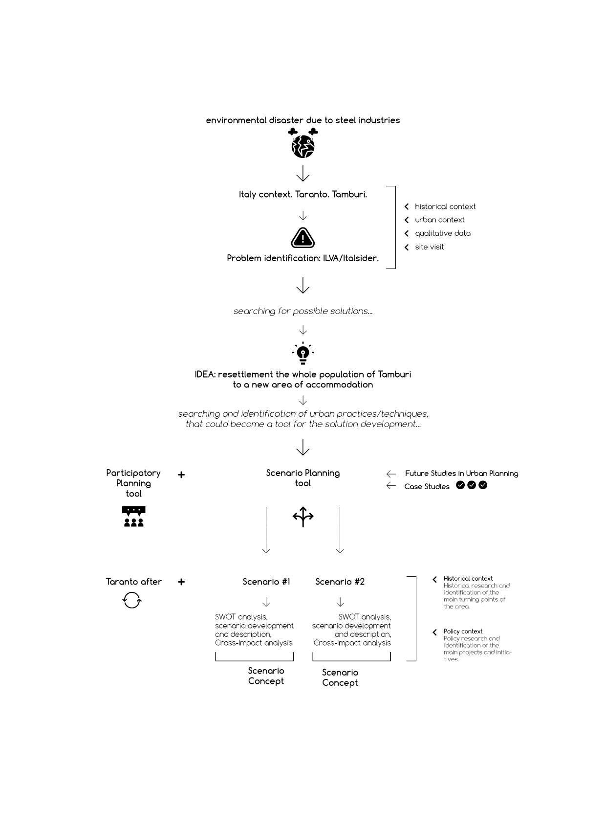
Research methodology scheme. The Scheme developed by the author;
•Image 1.1 013
Statue of the Spartan king Leonidas in Sparta, Greece. http://www.filonidetaranto.it/2015/12/i-simboli-spartani-che-si-ritrovano.html;
•Image 1.2 014
View of the Taranto from above. https://www.michelemossa.it/en/research/some-laboratory-facilities/ automatic-monitoring-of-the-sea-mar-piccolo-taranto-italy/26;
•Image 1.3 015
View of Tamburi from the water. https://www.europaverde.it/tag/tamburi/;
PART 2. TARANTO
•Fifure 2.1 (top) 023
Taranto/ ISTAT data 2011. Resident population;
•Fifure 2.2 (right) 023
The railway network in Puglia, the network operators. The figure developed by the author;
•Figure 2.3 025
Trend of the resident population.
Municipality of Taranto - ISTAT Data at 31 December of each yearElaboration TUTTIITALIA.IT
(*) post-census;
•Figure 2.4 025
Natural population movement.
Municipality of Taranto - ISTAT Data at 31 December of each yearElaboration TUTTIITALIA.IT
(*) post-census;
•Figure 2.5 025
Population by age, sex and marital status.
Municipality of Taranto - ISTAT Data 1st January 2019 - Elaboration TUTTIITALIA.IT (*) post-census;
•Figure 2.6 045
Socio-economic level.
The figure developed by the author;
•Figure 2.7 054
Map of the average annual concentration of benzo (a) pyrene (BaP) 2010-2016. Report on the Health Damage Assessment - ILVA Taranto plant 2013;
•Image 2.1 026
Lupa capitolina/Capitoline Wolf;
•Image 2.2 026
Coin, Taranto, Statere, knight, 275-235 BC;
•Image 2.3 and 2.4 026
Roman Coin;
•Image 2.5
Coat of arms of the Kingdom of Italy;
•Image 2.6 027
Taranto, Italy, 1940.
Aerial view showing the aftermath of action against the Italian fleet in Taranto harbor.
*note the two damaged cruisers in the inner harbor. Donor C. Oliver, the original album held in AWM Archive store;
Woodcut of the original bridge, Barberis ,1898, Giuseppe Barberis - Strafforello Gustavo, The homeland, geography of Italy / Part 4 (continuation). Provinces of Bari, Foggia, Lecce, Potenza, Unione Typografico-Editrice, Turin, 1899.
Taranto: (closed) rotating bridge over the canal that joins the Mar Grande with the Piccolo mare. (woodcut by Barberis 1898).
https://en.wikipedia.org/wiki/Ponte_Girevole
•Image 2.12 027
21/08/1889-Taranto Arsenal inaugurated. https://en.difesaonline.it/news-forze-armate/storia/21-agosto- 1889-inauguratolarsenale-di-taranto;
•Image 2.13 027
The Aldo Moro Bridge. https://www.greenroutes.it/il-ponte-punta-penna-piz zone-le-tre-p-che-unis cono-taranto/;
•Image 2.14
Plan of the old city after completion. Ferdinando Bonavolta, 1933. www.rapu.it/ricerca/jpg/Taranto018.jpg;
29
•Image 2.15 030
The master plan of A. Calza Bini - 1954. https://www.rapu.it/ricerca/jpg/Taranto021.jpg;
•Image 2.16 030
Industrial Development Plan of the Taranto area drawn up by TEKNE 1964.
https://www.rapu.it
•Image 2.17
034
Taranto late 1970s of the past century. To the north, near the Tamburi district, the new industrial area.
From: AA. VV., The port of Taranto, edited by C. Indellicati, Industrial Development Area Consortium, Rome, 1978;
From TESI DI DOTTORATO of Prof.ssa Marisa Tortorelli, “Taranto dall’Unità al 1940: industrializzazione, quadri ambientali e demografici, politiche urbane”. Dottorato di Ricerca in Storia XXI ciclo. p.15.
UNIVERSITA’ DEGLI STUDI DI NAPOLI FEDERICO II. Dipartimento di Discipline
Redevelopment of the Old Town of Taranto. Masterplan. www.mateng.it;
•Image 2.21 046
Angelo Cannata, Tarantino Doc /President of the cultural association Le Sciaje. https://twitter.com/angelocannataTa/status/1180571008216027138/photo/1;
The environmental disaster of the ILVA of Taranto violates the international obligations of protection of human rights. https://www.peacelink.it/editoriale/a/45272.html;
•Image 2.28 053
Environmental recovery of the Italsider plant (today Ilva). https://www.urbanit.it/wp-content/uploads/2017/10/BP_Greco_Panico_ Rotondo.pdf;
•Image 2.29
Dr. Anna Maria Moschetti https://civicosette.wixsite.com/civicosette/annamaria-moschetti;
•Image 2.30
057
057
ILVA contamination distribution scheme. The scheme was developed and provided by PhD students of the Politecnico di milano in 2019. Led by Professor Alessandro Balducci.
Source: Popper R, Klusáček J. Website of spin-off company Futures Diamond, http://www.futuresdiamond.com/en/the-diamond (retrived 10.07.2016);
•Figure 4.2 115
The scenario’s methodology scheme. The scheme developed by the author.
•Image 4.1
Herman Kahn. https://afflictor.com/tag/herman-kahn/;
102
•Image 4.2 102
Pierre Wack. https://alchetron.com/Pierre-Wack;
•Image 4.3 103
Dr. Hasan Özbekhan. http://environment-ecology.com/general-systems-theory/534-hasan-ozbekhan.pdf;
•Image 4.4 103
Club of Rome logo. http://richardsandbrooksplace.org/ian-johnson/development-club-rome;
PART 5. SCENARIO#1 “TO PAOLO VI”
•Figure 5.1 125
Scheme of the railway mobility proposal of the scenario "to Paolo VI".
The scheme developed by the author;
•Figure 5.2 138
Population density of Tamburi. Istat 2011.
•Image 5.1 119
Paolo VI apartment blocks. http://www.leccecronaca.it/index.php/2016/10/11;
•Image 5.2
View on the Paolo VI neighborhood from the top. http://www.cdpimmobiliare.it/en/sales/tarantoquartiere-paolo-vi.html;
•Image 5.3 and 5.4
Architecture by Studio Nizzoli Associati. Source: Casabella n. 362, gennaio 1971;
120
121
•Image 5.5 127
Part of the Circummarpiccolo railway path, general proposal
The image developed by the author;
•Image 5.6 129
Metropolitana leggera nella citta’ di Taranto. www.digilander.libero.it/feedback.ta/tram/AMAT_Metrotram_(Taranto).pdf;
•Image 5.7
Project for recovering the railway on the Circumarpiccolo. www.diegodelorenzis.it/ferrovie-turistiche-circummarpiccolo-opportunita-dacogliere.php;
129
•Image 5.11
Plan of the main commercial and public nodes of the Paolo VI area.
The image developed by the author;
•Image 5.12
Concept scheme of Scenario "to Paolo VI". The image developed by the author;
PART 6. SCENARIO#1 “TO CITTÀ VECCHIA”
•Figure 6.1
Concept of the smooth mobility exchange.
The scheme developed by the author;
•Image 6.1
Roman Taranto topographic map V B.C. http://www.righel40.altervista.org/Tar/tar.htm
•Image 6.2
140
145
162
149
149
Adapted and geographically inverted topography of the square shape of the Roman fort of Taranto III B.C. designed by Palladio to describe the siege of Hannibal. http://historic-cities.huji.ac.il/italy/taranto/taranto.html;
•Image 6.3
•Image 6.13
Example of the Urban Acupuncture implementation, “green houses”.
166
The image developed by the author;
•Image 6.14
View on The square/La piazzetta. The image developed by the author;
6.15
Concept scheme of the socio-economic guidelines. The scheme developed by the author;
•Image 6.16
Types of urban blocks of Città Vecchia. The scheme developed by the author;
•Image 6.17
Scheme of Città Vecchia building condition. The scheme developed by the author;
•Image 6.18
Privat green zones of Città Vecchia. The scheme developed by the author;
•Image 6.19
Concept scheme of Scenario "to Città Vecchia". The scheme developed by the author;
149
Plan with the indication of the findings and with the hypothesis of localization drawn by A.Conte (1984). Roman period;
•Image 6.4
Tarentum by Jodoco Hondio, Leida 1625. https://www.fondazioneterradotranto.it/tag/cartografia-della-puglia/;
•Image 6.5
Tommaso Bucci, Plan of Taranto, 1863 https://www.rapu.it/ricerca/index.php;
•Image 6.6
Plan of Taranto. Early 1900;
•Image 6.7
Plan of the old town before the fascist demolitions. https://www.movio.beniculturali.it/asta/palazzinobilitarantofra700e800/it/38/il-centro-storico-di-taranto;
•Image 6.8
Bonavolta’s plan of 1931. http://archeotaranto.altervista.org/archeota/taras78/piante.htm;
•Image 6.9
Città Vecchia view. https://www.corriereditaranto.it/2020/05/22/cis-taranto-pioggia-di-milioni-sulla-citta-vecchia4/;
•Image 5.8
MOBILITY SUB-SCENARIO for Paolo VI.
The image developed by the author;
•Image 5.9
the Dialogue Centre.
The image developed by the author;
•Image 5.10
Plan of the main commercial and public nodes of the Paolo VI area.
Scenario proposal for the mobility network of Città Vecchia of Taranto.
The scheme developed by the author.
•Image 6.12
Scenario proposal for the rail mobility network.
The scheme developed by the author;
160
•Image 7.1
Coordinated project for the rehabilitation of the Tamburi Quarter, Taranto.
171
174
177
PRESENTATION 18.03.2015 - Coordinated Project for the Rehabilitation of the Tamburi District - Integrated financing: CIPE Resolution n.3 / 2006, City Plan. http://asset.regione.puglia.it/assets/files/PS%20TA%202018/analisi%20di%20sistema/All.7_%20DOCUMENTO%20PRELI MINARE%20DI%20INTENTI%20PER%20IL%20PUG.pdf;
•Image 7.2
“Taranto after” concept scheme. The scheme developed by the author;
PART 8. “CROSS-IMPACT ANALYSIS OF THE SCENARIOS”
181
183
•Figure 8.1 185
Cross-Impact grid.
•Figure 8.2
The concept of the scenario implementation sequence for Paolo VI.
The scheme developed by the author;
•Figure 8.3
The concept of the scenario implementation sequence for Città Vecchia.
The scheme developed by the author;
189
193
INTRODUCTION
Image 1.1 Statue of the Spartan king Leonidas in Sparta, Greece.
1.1.
why Taranto? why Tamburi?
The city of ancient history, culture, traditions, which has passed through its greatest economic, demographic, and urban development since the II World War, now suffers by the problems so complex that seems unsolvable.
Taranto became a tragic example of how industrial development made a dramatic and in some places, irrevocable impact on the environment and citizens' health and due to this weakened the social and economic fabric of the city.
The destiny of Taranto tightly intertwined with the ex-ILVA and its future also has a significant influence on the city and the society (closure, conversion, or renaturalization of the plant).
The future of the city without or with the industry has to take into consideration all spectrum of the possibilities through the rediscovery and promotion of its value as a cultural, social, and economic centrality, a possible engine for the whole municipality of Taranto. The new prospects for development would help to overcome that crisis and those problems to which the city seems to have resigned itself.
‘Our neighborhood has beautiful spaces, there is a desire for the future. We don't miss anything if only Ilva wasn't there!’
The Taranto urban development 'boost' fell on the XX century under the domination of these four main actors, which attracted the new citizens from the countryside, and all over the South. The population statistic data gave the picture of the population growth (at the beginning of the century the number of inhabitants was 60.000; in the 50s the number increased to 170.000; in the next 20 years to 230.000).
The accommodation of this amount of residents has led to the massive (re)settlement to the new peripheral districts, for instance, Tamburi, Salinella, Paolo VI, etc., which are characterized by large-scale structures, 'aggressive' architectural forms, isolation from the city and structural lack in services.
The focus on the Tamburi district occurred due to the mortality rates in the area because of the proximity to the Italsider plant. The mortality increase or decreases appears according to the production levels of the steelworks. The high rates of incidence have been observed between 2006 and 2012 in the entire province: over 3.000 cases of cancer per year (such as lung cancer and pleural mesothelioma).
The obvious danger of living in the areas, which are border with a steel plant depreciates any attempt of government and professionals to improve life inside the area Any kind of future scenario for Tamburi (the limitation of the plant, application new policy restrictions, implementation of eco-sustainable/protection projects, etc.) will require time, which the population does not have. In our power to make a crucial change right now, which will directly answer the needs of the residents.
Inhabitants of Tamburi Combattent Association of Tamburi
(Planning and Design PhD Research Workshop 2019. Dealing with Wicked Problems: the Case of Taranto Old Town è un workshop organizzato dal Corso di Dottorato in Urban Planning, Design, and Policy del Dipartimento di Architettura e Studi Urbani del Politecnico di Milano. A.A. 2018/2019 -p.50)
The main actors of the economic and industrial history of Taranto were: the Military Arsenal which has been constructed by the Navy on the South of the city; in parallel on the Northern parts of the city the rise of the industrial cores of the city - ArcelorMittal Italia S.p.A. (ILVA), ENI, and Cementir.
•Image 1.2
View of the Taranto from above.
•Image 1.3
View of Tamburi from the water.
1.2.
Research question, aim and objective
Research methodology 1.3.
The solution to complex problems within conditions of deep uncertainty requires the exploration of different opportunities of action able to create new imaginaries. Within this awareness the research question of the thesis work is:
How futures scenario development can help in creating new knowledge and opening new possible trajectories of strategic action?
The aim of the research work is to explore answers to the research question by combining futures scenarios techniques with evaluation tools to embed reflective resources in the scenario contents.
The objective of this work is to outline a direction to a pathway towards the development of a participatory process that could eventually consider scenario development as a tool to structure involvement.
The work will represent a process of rethinking and designing of a possible solution set, that could be implemented as a resolvent of the Tamburi's conflict.
The issue which became a starting point for the research development has been formulated by the health-threatening environment of the Taranto's district -Tamburi.
The physical proximity to the industrial plant of ILVA caused irreparable consequences on the social, economical and environmental sectors of the municipality. This situation became a catalyzation for the searching of the possible solution.
To have a full vision of this problem the collection of qualitative data has been performed.
The primary data collection has been performed through the Istat latest updates database, which image the main trends of natural population movement, population composition, mortality rates, birth rates, occupation, morbidity statistics, and causes, etc.
The qualitative data collection was represented through the accumulation of the crucial official documents/reports of the EU Commission, SENTIERI - National Epidemiological Study of Territories and Settlements Exposed to Pollution Risk, scholar research articles, related documents, and laws, etc. This approach became an appropriate answer to this research's questions. The case of Taranto represents the situation in which the city is trying to deal with future uncertainties and threats. Thus, the approach that has been chosen to deal with Taranto's issues - is the implementation of future visioning, namely scenario planning
This method became one of the possible solution techniques in which the multiple alternatives could be observed by all main stakeholders and citizens. Thus, the promotion of the local’s engagement could enrich any of the scenarios that will be chosen; this justified, first of all, by the considerations of justice and equality, which implies that each and every citizen has rights for a qualitative urban environment.
In order to confirm the initial assumptions and outline a further action plan for the research development, it has been organized the trip to Taranto During the one-day visit, it has been accomplished several observations: the visit of the Tamburi neighborhood and outskirts of the ArcelorMittal Italia S.p.A. (ILVA) site, walk around the main attraction points of the city, transportation nodes, and the Old City. The site observation implied mapping, photographing, video shooting, tracking, and counting. Furthermore, it has been successfully organized an unofficial meeting with a local activist and President of the cultural association Le Sciaje - Angelo Cannata, who gave an efficient "inside look" on the city and its inhabitants.
Due to the uniqueness of every urban context the designing of the scenario implies the creation of a special combination of tools and practices. Thus, the methodology, that has been applied in this work, represents the accounting of the specificness of the area's history, the urbanization process, policy framework, laws, and undergoing urban projects. By creating the main context framework, the scenario's development and its implementation could be successfully integrated into the city's reality and decrease the concerns and fears of the main stakeholders and inhabitants
Research methodology scheme
Thesis logic 1.4.
The structure of this work is represented through nine chapters, which could be united into two main parts:
1. Creation the research framework.
The first part is represented from 1st until 4th chapters, which create a framework of the study: introduction into the reasons and choice of the area of project development, methodology, and aims; a deeper excursion into the historical and urbanization process of Taranto; observation of the ILVA's history and its impact on the city; In order to support the approaches, that are applied in this work three case studies have been selected as supporting examples; these studies create an implementation's examples base of the future visioning techniques; are the practical confirmation of the method efficiency; The research framework concludes with the theoretical description of the future studies namely scenario planning construction techniques and evaluating tool - the Cross-Impact analysis.
2. Developing the scenarios.
The second part represents the core of the work and consists of the 5th 6th, 7th, and 8th chapters. Within this part it is described the two future scenarios with the detailed description of included projects and initiatives, supported by diagrams and images. Subsequent Cross-Impact Analysis for each scenario results with the concept schemes of the scenarios implementation sequence. The concluding part - chapter 8, narrates about the "Tamburi after" project - the possible redevelopment project for the future abbondoned area of the Tamburi district, which could be integrated into existing municipality projects.
The work closes with a general conclusionchapter 9.
TARANTO
Foundation: by the Spartans in the 8th century BC.
Names: Taras, Tarentum, Taranto, Greek Taras, Latin Tarentum.
Location: southeastern Italy, Puglia (Apulia) region, the capital of the Province of Taranto. The city locates at the base of the Salentine Peninsula on the northern inlet (Mare Grande) of the Gulf of Taranto.
Inhabitants: 196.102 (31/03/2019)
Surface: 249.86km².
Significance: commercial port, main Italian noval base, ILVA/Italsider.
“Dove è ora campagna, lì fu la capitale della Magna Grecia; dove è Taranto, là sorgeva una rocca ardita; tu Quinto Fabio Massimo, voi Goti e Saraceni non gloriatevi. Distruggeste crudelmente la città, ma potevate annullare le sue delizie, lo straordinario spettacolo della natura?”
Giuseppe Regaldi - Iscrizione del 1845
2.1. General observation
«Taranto, sol per ancore ed ormeggi assicurar nel ben difeso specchio, di tanta fresca porpora rosseggi? A che, fra San Cataldo e il tuo più vecchio muro che sa Bisanzio ed Aragona, che sa Svevia ed Angiò, tendi l’orecchio? Non balena sul Mar Grande né tuona. Ma sul ferrato cardine il tuo Ponte gira, e del ferro il tuo Canal rintrona. Passan così le belle navi pronte, per entrar nella darsena sicura, volta la poppa al ionico orizzonte.»
- Gabriele D’Annunzio
The city Taranto represents the view on the homonymous gulf of the Ionic Arch it develops along three natural peninsulas and the historical core of the city - an artificial island which has been formed during the construction of the moat of the Aragonese Castle.
"The city of the two seas" Taranto with its settlements has been formed around the Mar Grande and Mar Piccolo. The first one washes the outer coast by the natural bay which ends with the Cheradi Islands. Mar Grande joins the Mar Piccolo in two points: by the natural canal of Porta Napoli and the navigable artificial canal which separates the old city from the new parts of the city. The Mar Piccolo can be considered as an inland sea which perfectly divided into two parts by the Punta Penna Pizzone bridge. In the Mar Grande and in the north part of the Mar Piccolo are located points of springs and citri*, which, by bringing fresh water to the salty, they create an ideal hydrobiological condition for the cultivation of mussels.
The municipality of Taranto is divided into six districts
- The First District (Paolo VI) is made up of the homonymous district, which rises north of the city, by far the largest in the city, which has about 18,000 inhabitants. It is the most recent in terms of training, having arisen ideally as a residential area for the workers of the steel neighboring in the sixties. Due to the abandonment of the more dilapidated buildings of the ancient village, popular housing centers were also built in this neighborhood to meet the needs of the population.
*in the Taranto area, this name indicates freshwater springs that flow from the underwater crust
- The Second District (Tamburi - Lido Azzurro) unites a vast territory to the north-west of the city covering about 38 sq.km, consisting of two main districts (Tamburi and Lido Azzurro) and two other more sparsely inhabited (Croce and Porta Napoli). The Tamburi district, adjacent to the steel plant, is considered among the most polluted in Europe: a large part of the approximately 17,000 inhabitants of the district resides there. The Porta Napoli area represents the link between the Tamburi district and the island of the old city and includes the city's main railway station. The Croce district, located near the industrial area, is sparsely inhabited, while the Lido Azzurro district contains the only swimming area in the district.
- The third district (Old Town - Borgo) includes the two historic districts of the city: the island of the Old Town, with its ancient districts called Pittaggi (Baglio-San Pietro-Turripenne and Ponte) the first fulcrum of the town, and the Borgo , separated from the ancient part by the Swivel Bridge, on which the first housing settlements of the "new city" were built. The district, which also includes the Cheradi Islands, is among the most populous, with its approximately 43,000 inhabitants. Here are the most important historical testimonies of the city of Taranto and the current institutional reference points.
- The fourth district (Tre Carrare - Solito) includes the Tre Carrare - Battisti and Solito - Corvisea districts.
- The V District (Montegranaro - Salinella) includes the districts of Italy - Montegranaro, Salinella and Taranto 2.
- The VI District (Talsano - Lama - San Vito) extends over the Talsano - Palumbo - San
Donato, San Vito - Lama - Carelli and Tramontone (Sant'Egidio) districts, plus the related administrative islands.
Taranto’s road infrastructure components are mainly:
-A14 Bologna-Taranto Motorway;
-Highway 106 Jonica Taranto-Reggio Calabria;
-State road 100 Taranto-Bari;
-State road 7 Appia Matera-Taranto-Brindisi.
Trenitalia provides a railway connection through the Taranto-Bari, Taranto-Crotone and Taranto-Brindisi lines. With the rest of Puglia region, it connected by the South East Railways.
Moreover, Taranto is a base for the most important industrial and commercial ports in the Mediterranean and to an arsenal of the Navy, as well as the main naval station.
The Taranto-Grottaglie "Marcello Arlotta" Airport, historically built for military purposes, currently, it is the headquarters of the MARISTAER of the Navy and performs cargo services, despite the numerous proposals for the activation of passenger flights.
The company that manages the public transport service throughout the municipal area is AMAT
The waterway service was established in 2003 , thanks to the use of the two motorboats "Clodia" and "Adria" , acquired by the Venice Transport Consortium : they connect Piazzale Democrate to Capo San Vito, passing from the Small Sea to the Large Sea through the waterway . During the summer they reach the Cheradi Islands by docking at the pier of the Island of San Paolo.
Between 1922 and 1950 an urban tramway network was active which, mainly used by the workers who worked at the arsenal, adopted a peculiar technological solution to cross the city mobile bridge.
Paolo VI, 17494
Tamburi-Lido Azzurro, 16346
Città Vecchia-Borgo, 39169
Tre Carrare-Solito, 38767
Montegranaro-Salinella, 44122
Talsano-San Vito-lama, 44256
Fifure 2.1 (top) Taranto/ ISTAT data 2011. Resident population.
Fifure 2.2 (right)
The railway network in Puglia, the network operators.
Montemesola Grottaglie
Monteiasi
Carosino
Monteparano Roccaforzata
Giorgio Ionico
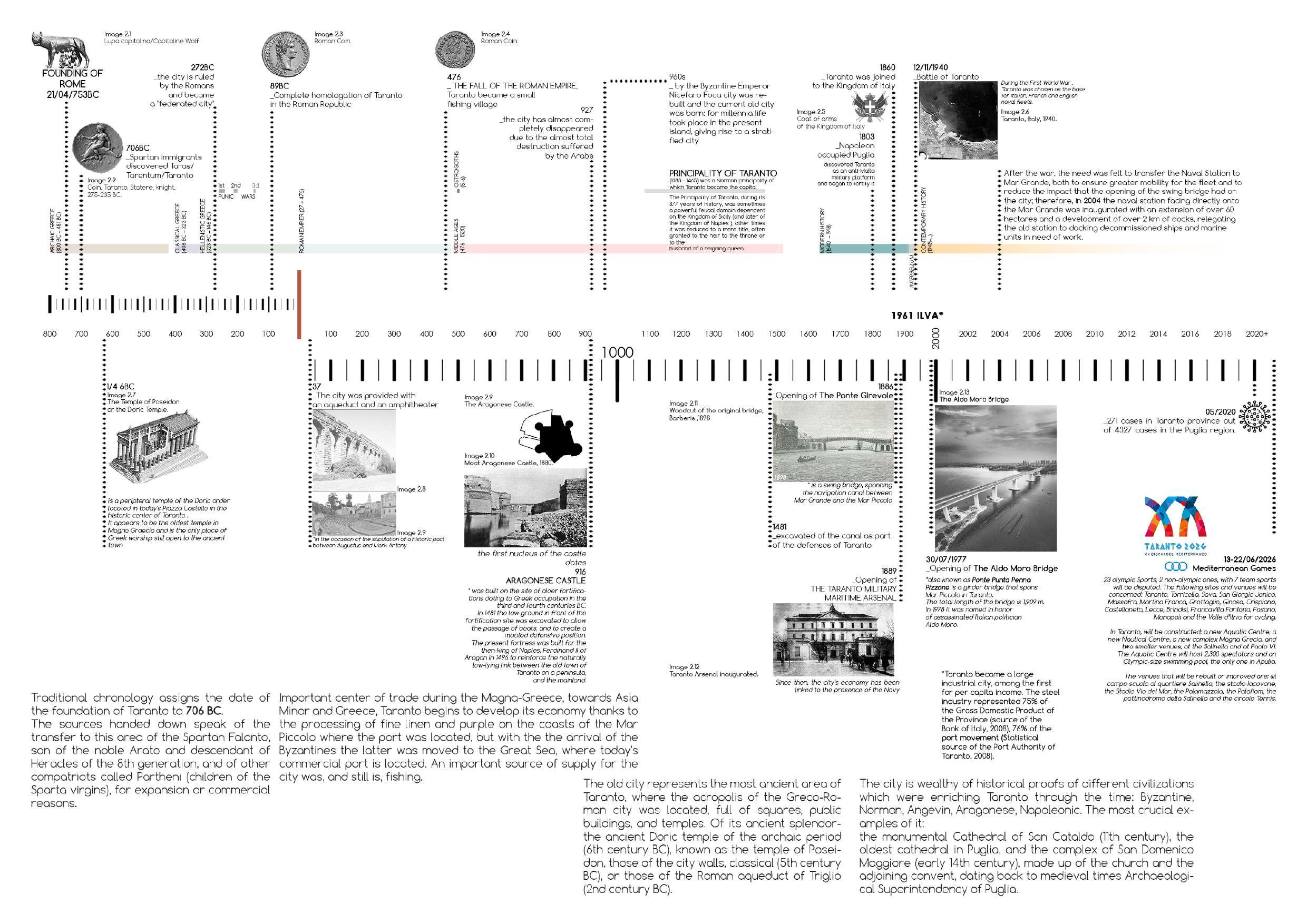
2.2. Historical Timeline
2.3. Urbanization process of Taranto
I. Conversano Plan, 1862
The "Conversano Plan" has been formed in 1862 and signed by the architect Davide Conversano and representatives of the charged commission Colli, Montecchini, and Greco. The plan described the city's expansion in the east and west suburbs
The plan was designed on the idea of a city with the production and economic function, where the management was in the hands of the private sector, which was typical urban regulation in post-unified Italy.
The characteristic feature of the urban expansion in the XIX century with its symmetry, homogeneity, and linearity reignthe eastern suburb of Taranto, which has been planned to host around 25 000.
The city's west expansion was focused on the protection of the productive and commercial activities that stayed beyond the Naples gate, which were connected to the commercial port and the railway station, which were placed in that area.
The western part of the plan has been aimed to accommodate around 35 000 inhabitants. The urban pattern of this area had axes, which continue the western extension of the city starting from the railway station. It is important to say, that this plan had a huge impact on the population increase: from 28 000 before the unification until 68 000 in 1911.
The plan's intention of the expansion happened only in the Tambuti district's borders, and when Italsider came to the area, the western direction has been “forgotten”. Meanwhile, the eastern part was under the spontaneous processes illegal and land speculations seem unstoppable up to today. It has been already expected, that the Italian maritime has an intention to implement its base in the South, Conversano took this into consideration and fact anticipate its location in the eastern part of the city, beyond Porta Lecce.
One of the first signs of inequality between the eastern and western pars of the city
was the construction of the schools in the last one because in the eastern part public offices had already been located; this action represents the perception of these suburbs: the eastern suburb conceived as the most beautiful and prestigious, and the western one were focused on the industry. Thus, that can be seen as the first inequity diversification of Taranto's areas it can be observed through the distinctions of Tamburi and Borgo districts.
II. Galeone Plan, 1910
The Conversano plan has the provision for the city expansion until the beginning of the 1900s. The following demographic growth had a stable character, thus, the question of new houses arose. The response from the developers was to continue expansion policy to the east, which could accommodate 52 000 inhabitants.
The next architect how was in charge of designing the new plan of the city was Vincenzo Galeone in 1910, his duty was to consolidate the Conversano plan, which will pleas the bourgeoisie's requests.
The plan has been approved by the City Council, while the Higher Council of Public Works opposed it. This entailed spontaneous buildings' expansion beyond the limits foreseen further development according to the plan. That happed due to unstoppable population growth, the industrial development of the area, trades, Arsenal, the port, and the railway, which became a strong attraction point for the new population. All these conditions led to the uncontrolled and unregulated expansion of the city: in 1911 the city's population was 68 000, while in 1921 it reached 104 000 inhabitants.
III. Tian Plan, 1921
In 1921, the City Council feel the need for a new plan for Taranto city which continued to uncontrollably expand. The responsible for the new city plan became the engineer Giulio Tian. His aim was to design a regula-
tion plan for the eastern area of the city of 200 hectares, which had to accommodate 50 000 inhabitants for the next 25 years
The Tian Plan has never been approved by guardian bodies due to its "too academic" design. But despite this, it has been followed, despite that, the "actual" was the Galeone one.
Plan of Giulio Tian was contested because it had the intention to construct low-density residential blocks, which were not favored the interests and needs of landed property and speculation on land.
In the end, the Tian's successor - the engineer Ferdinando Bonavolta proposed the ideas, which were similar to the previous ones.
IV. Rehabilitation plan of Città Vecchia, 1931
Image 2.14 Plan of the old city after completion. Ferdinando Bonavolta, 1933.
1931 was marked as the year when the redevelopment project by Ingenieur Ferdinando Bonavolta of the Old City started. At that time, the historical center had the highest population density of the city, 36 000 inhabitants, which has been considered tolerable. The main guidelines of Bonavolta's Plan were formed on the two-parts intervention into the urban fabric:
- the upper part, which was overlooking Corso Vittorio Emanuele, needed some redecoration and refreshing actions, and which were inhabited by noble and wealthy families;
- the lower part, which was undergoing total demolition of several blocks; all accompanied by a rethinking of the road schemes.
In the end, 37 000 square meters of land have been demolished, 21 000 of which
would have been dedicated to the build-up. This entailed the eviction of non-owners with low-income and their resettlement to new-built homes in other neighborhoods (i.e. Tre Carrare and Tamburi, built by the IACP (Istituto Autonomous Popular Houses)).
The Bonavolta's vision was to make the Piazza Castello surrounded by public buildings into the historic center's core while Piazza Fontana would take the commercial function.
The rehabilitation phase started in 1934, after five years of demolitions. Unfortunately, the turning point in the Plan's implementation happened due to the private individuals, who were considering the project as too onerous and unproductive, and as a result - failure of the plan, block of demolitions, and construction actions.
Image 2.15
The master plan of A. Calza Bini - 1954.
All these time city continued to suffer from spontaneous ad disordered urban sprawl. And again, the need for a new masterplan occurred in the city, which could review the current development of the city and to curbing land speculation; an additional aspect was the presence of the Navy, which's intention was to revive the Arsenal with its territory.
Therefore, in 1936, Calza Bini has been requested to design a new masterplan for Taranto city (later, the Bini's Plan will not be
approved due to two reasons: the come near war and the penalization of land rent).
After the IIWW, Calza Bini returned to his duties, but the layout of the post-war city complicates by economic and social difficulties.
The plan of Alberto and Giorgio Calza Bini has been approved in 1954 and continue the city's expansion on the east. But the recurring problem of the Citta Vecchia's rehabilitation was complicated by the absence of collaboration with the Bonavolta Plan.
VI. TEKNE Plan, 1961
The post-war city struggled due to the decrease in production from the Arsenale and the Tosi shipyards, which were supply 50 percent of the workforces, and which before the IIWW represented the unique economical force of Taranto.
The Plan of Taranto which has been created by the TEKNE (TEKNE Company of Milan, specialized in urban and socio-economic planning) in 1964 was the first experiment of the crucial meaning of territorial planning in the south and of the operational plan for industrialization of the Italian south. The plan was focused on the implementation of a large base complex TEKNE Plan started from the identification of the future location of the steel site and its related activities (planners took into consideration the distribution of the various industrial areas and their management, avoiding excessive expenditure on road
infrastructures, services, etc.).The idea of the plan was that instead of remaining an external fact, industrial development should organically fit into the political, cultural, economic, social and urban development of the Taranto area.
The location of the Steel Center, made before the start of the studies for the drafting of the master plan, blocked the direction of urban expansion to the north-west precisely where it had already taken place, in confusing terms and with poor urban values, the expansion of the city.
In 1981 the TEKNE Plan assumed the population of Taranto around 350 000 by also taking into consideration the immigration growth due to the installation of the steel plant. The real data of 1981 show that the population reached only 250 000.
In spite of the specific plan of the industrial area, the problems of its proximity to the city have been overlooked, a coexistence of which should have been considered during the designing process.
The birth and enlargement of the Italsider plant and consequently progressive pop lation growth contributed to the creation of new villages which have been formed in the areas which laid down far from the ancient city walls. That required the relocation of many families towards the new houses of Borgo Nuovo, which, obviously led to the depopulation of the original core. That sol tion for the Land use plan was the most convenient in the situation of the enviro mental degradation of the Borgo Antico in demographic thining and building.
VII. Blandino Plan, 1971
The Blandino Plan of 1971 has been approved by City Council and represented a vision of the environment recover as a complex of men and "things" around him, not the monuments.
Three main principles formed the Plan: preserve, re-evaluate, and restore. At the same time, the demolition activities were still actual and emerged as controlled
action in the areas, where it was necessary, without disordering the urban morphological tissue.
Therefore, the plan's implementation process was based on the precise analysis of the buildings, their condition, and architectural value. With support from the Office for the Redevelopment Plan of the Old City, a planning unit with the other sections of the plan is ensured, and it must be considered that The Plan is a part of Barbin and Vinciguerra plan, which sees the Old City as a future cultural pole, representation, collective activity, leisure, and civic education.
1975 became a turning year in the Old City's development, the restoration was about to start soon, a building collapsed and six citizens died. This tragedy made people leave the island due to the fear of further collapse. The population of Citta Vecchia in 1971 was 12 750 inhabitants, in last years the number of people who risked to stay is about 2 000. This tendency represents a huge migration to suburbs, which has been encouraged by the local government. The Public Administration continued to sell non-urbanized outskirt areas of Taranto to building cooperatives, apparently for pre-electoral promotion.
This initiative ended up with a situation where the transition started from the areas with primary and secondary urbanization (Città Vecchia - Borgo) to the new build-up areas without primary services such as water and sewers.
As history showed, the Old City decadence happened in urban, construction, and social spheres. The "eviction" practice among inhabitants became a popular strategy to rise in the waiting list for the allocation of social housing in the new areas of the city. That caused the fall of the Old City's estate market due to the high risks to remain in the buildings, with no opportunity to make restoration works.
In the end, The Plan has been accepted as a failure also by Blandino.
V. Calza Bini Plan, 1954
Image 2.16
Industrial Development Plan of the Taranto area drawn up by TEKNE 1964.
VIII. Variant Barbin - Vinciguerra, 1978
The Plan of 1936 by Calza Bini has been designed in order to manage the changes than the Arsenale brought to the city. These changes matched those, which industrial giant ItalSider brought: environmental, economic, cultural, and social.
In the second part of the XXth century, the city characterized by spontaneous growth even over the city's border, and by the illegal construction. An Italian politician Mario Guadagnolo defined this tendency as "urban anarchy in which an industrial master plan could not replace the master plan of a city".
Those urban sentiments led to that the General Layout was included in the Master Plan. To solve this task there were involved in the architect Giovanni Barbin and the engineer Francesco Vinciguerra. Their work became the main guideline document for the city's further urban planning development.
Barbin and Vinciguerra variant suppose a significant increase in Taranto's population, namely that by the 1990s the number of inhabitants will increase up to 365 000. That prediction was not precise due to the fact that the new population, that have been attracted by the ItalSider steel plant distributed not into the city center, but in the outskirts ( due to traffic, high rents, and pollution). The city continues to grow on the background of the industrial crisis in international steel markets and declining birth rates, following the strategy to provide services, infrastructure, and housing for an "expected" population of 365 000 inhabitants (which will never be achieved; in 2003 the number of Taranto's population reached only 235 000 (including the former State neighborhood)).
The Plan's strategy was to create a decentralized, polycentric city with autonomous cores. This idea was aimed to "unload" the city center, to prevent speculation, and to restore Citta Vecchia The new urban policies started to be implemented only in new-build areas, such as public parks, school equipment, spaces of common inter-
est and parking lots, etc. In parallel with newareas development, instead, the Old City was in decline; the nearby villages turned into ghettos, the social connections between the city and countryside have been ruined;
All these events became the guide to action, that The Plan was focused on:
- implementation of the city's rehabilitation and conservative restoration plan of Città Vecchia;
- recovering of the existing building heritage of the Borgo;
- definition a new axis (east-west);
- equipment of the hamlets of Statte, Talsano, Taranto North, and Taranto Northeast of the city with new functions, avoiding a greater peripheralization.
Moreover, the new Plan has to function according to the hinterland of the city and the TEKNE Plan's design of infrastructural guidelines.
Other crucial directions, that were identified by the planners, were the diversification of the local businesses, promotion of technological innovation, and the searching for new markets. These initiatives were accompanied by the intention to avoid a concentration of the industrial area around the port and communication networks. That would provided the interaction with other production, agricultural, and commercial sectors, and avoiding the usage monopolization of port by industry.
The main development direction has been chosen the North-East axis as the direction for industrial development, towards the industrial area of Grottaglie.
The planners, Barbin, and Vinciguerra were involved in the beginning stages of the Plan's implementation process, which will subsequently be improved with the drafting of detailed plans.
IX. Detailed Plan of The Borgo, 1986
The next detailed plan that has been adopted in 1988 focused on the Borgo area of Taranto. The plan was developed by a group of various technicians and engineers
and had a goal to recover the area from a physical and human perspective. The interventions, that have been listed included the reduction of the Borgo's fragmentation, revision of its possible functions and uses, and supplying it with needed services and facilities
The first target that has been described in The Plan was to open the city to the Mar Piccolo waterfront, which was, at that time "cut off" by the Military Arsenal (through the returning to the city some spaces).
The second aim was focused on the viability takes up the general variant of the PRG ( Il Piano regolatore generale comunale / Municipal general plan), and not neglecting the viability of penetration into the city's fabric.
The Plan has not been applied to the Borgo area, shortly it has been forgotten, partially because of the new national and regional regulations in the urban planning field and due to the construction sector's crisis. The Municipal Administrations closed up supporting projects of private entrepreneurs in the expansion areas provided for by the PRG.
X. Detailed Plan Overlooking the Mar Grande Coast, 1988
In the same decade, the Plan of recovering the city view on the Great Sea has been designed, but as the previous one has not been approved
But instead has been authorized by the Municipal Administration due to the funding of the ex-law n. 64/1986 The Administration argued, that "the renovation project of the seafront of Paranto, tralottiire, in accordance with the Plan of the Coastal View on the Great Sea", and later this project was realized and returned the waterfront to the city
XI. URBAN II, 2004
Urban is an initiative of the European Community designed to support about seventy
urban realities in the member states which present typical problems of modern society: poverty, economic and social marginalization, environmental degradation, overcrowding, crime, intolerance and racism, lack of solidarity (Barnier, 2003).
In the city of Taranto, at that time led by the Mayor Rossana Di Bello, this program seeks to stimulate economic and social regeneration, through EU funding from 2001 to 2006 of 15.13 million euros; these loans will also attract 16.64 million investments from the public sector and 6.97 million from the private sector (Urban II).
The Urban II program in favor of the City of Taranto, aims to stimulate an economic and social regeneration of the area through various measures that include the adoption of training activities, activities for the improvement of the environment physical, actions to improve the working environment and various measures to promote the inclusion, especially in the world of work, of the most marginalized groups. All these measures should be undertaken by the Program through the adoption of five distinct axes of action:
Priority I: Multifunctional and environmentally compatible re-urbanization and requalification of territorial spaces;
Priority 2: Economic development, entrepreneurship and employment pacts;
The target area identified by the Municipality of Taranto includes three districts: Tamburi, Città Vecchia, Porta Napoli, and Borgo, (509 hectares and a population of 47,400 inhabitants). These neighborhoods present forms of decay and imbalance linked to the strong conditioning that the large industrial groups have exerted on the economy of the city. The most marked delays and disparities in the city of Taranto mainly concern employment, environment, quality of life, infrastructural accessibility, urban decay; the environment in Taranto is heavily degraded and polluted at the air level (URBAN II);
Fragment of the Taranto’s Master plan 1978.
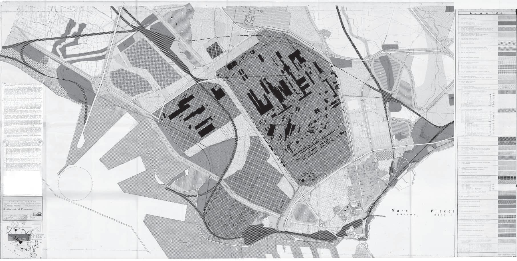
The General Regulatory Plan (P.R.G.) of the Municipality of Taranto, adopted in September 1974 and approved with Regional Decree no. 421 of 20/03/1978 is still in force. Subsequently, with a general variant intended for the Production Settlements Plan approved with Regional Council Resolution No. 1036 of 02/03/1990, the P.R.G. has undergone a further modification. The area originally occupied by the Steel Center, for industrial use, was included in the Master Plan drawn up by the then A.S.I. Consortium. (today S.I.S.R.I.) of Taranto, approved by Decree of the President of the Council of Ministers on 27/04/1964 and subsequently implemented by the municipality of Taranto. The expansion of the plant was then supported by the variant on the Master Plan Industrial A.S.I. approved with Decree n. 58 dated 17/05/1972 from the Puglia Region.
Image 2.18
Image 2.17
Taranto late 1970s of the past century.
To the north, near the Tamburi district, the new industrial area.
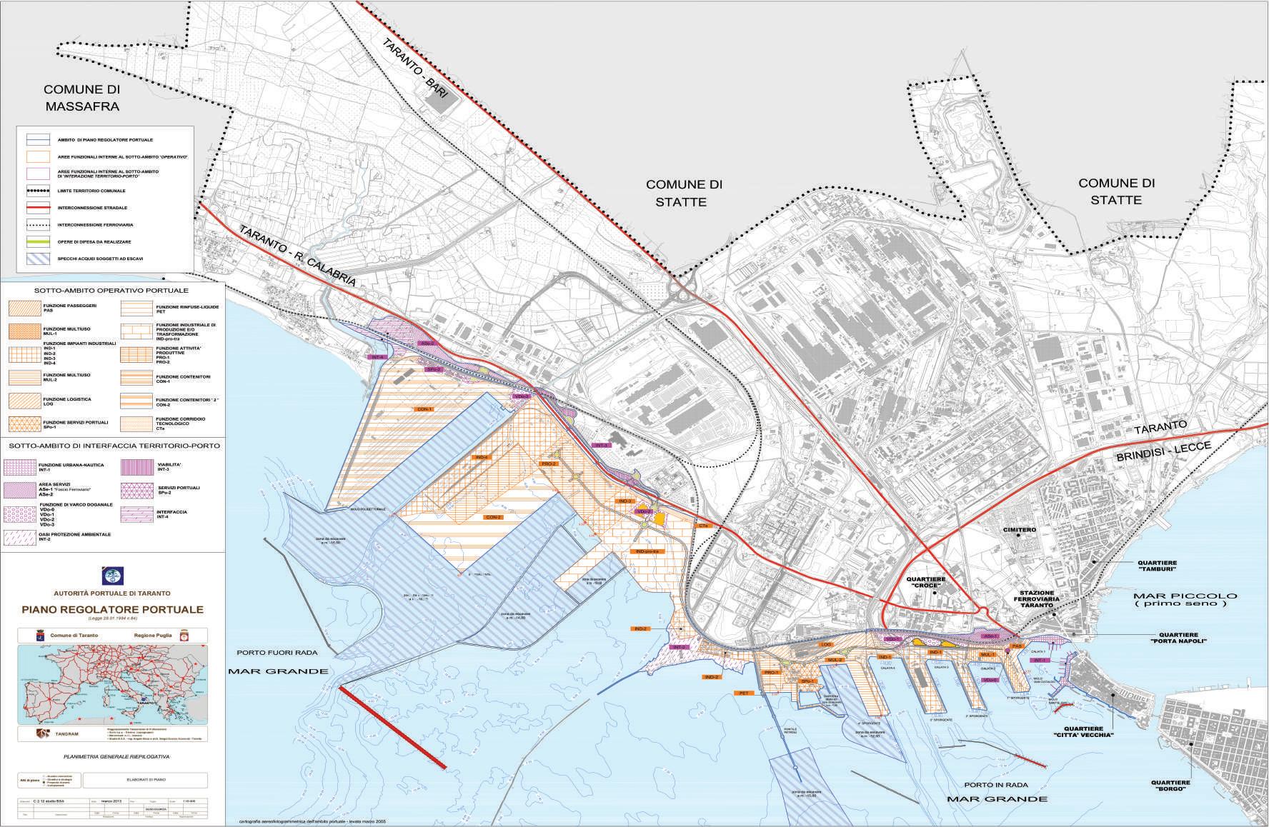
Image 2.19
Regulatory Plan of the Port of Taranto (variant to the current PRG) 2014.
The city of Taranto is also provided with the New Port Master Plan - Variant to the urban planning instrument in force. The "variation to the PRG for the implementation of the New PRP of the Port of Taranto is part of the changes to the general municipal urban plans which:
- do not entail an increase in the overall settlement dimension;
- do not lead to an increase in the territorial or sector manufacturing indexes or in the coverage ratios (or in the corresponding parameters governed by the municipal urban plan);
- do not transform into building areas for agricultural use (however defined in the municipal urban planning instruments);
- do not result in a decrease in the allocation of public spaces or spaces reserved for collective activities, public parks or parking lots”.
For now, not all interventions have been finished, due to the collapse that occurred in last years, but some of the investments were recovered later, managing to conclude some interventions.
XII. Extraordinary Commissioner for remediation, 2012
In 2012, the critical environmental situation Taranto demanded an urgent intervention, when the city has been designated as an area in a situation of complex industrial crisis. The Commissioner was prescribed to prepare a set of urgent interventions to deal with environmental problems.
In the beginning, each intervention got a different level of priority. The highest ones were dedicated to the safety and redevelopment of the five Tamburi's school buildings, and the upgrade of the mooring quay of the multi-sector pier.
The permanently prioritized interventions encluded: the reclamation and redevelopment of the San Brunone cemetery; a new breakwater, the safety measures permanent groundwater of the Statte PIP (Piano per gli Insediamenti Produttivi / Plan for Production Settlements) and the emergency securing of the PIP of Statte, etc.
Furthermore, Mar Piccolo got into the list of “system interventions”, which are aimed at the regeneration and environmentalization of the sea.
The remediation, environmentalization, and redevelopment work to be done are not quantifiable, but the Commissioner's work is assumed as considerable, as long as there are certain contributions to pollution solutions.
XIII. Regional Territorial Landscape Plan, 2015
"... the Plan is an instrument of in-depth knowledge of everything that exists in a territory, and is the agenda of good practices to value everything that exists in that territory ..." - Nichi Vendola, former President of the Puglia Region.
(Vendola N. (2015), the speech during the PPTR signing: In Puglia the first Landscape Plan of Italy, Edilportale, www.edilportale.com)
The crucial turning point for the Puglia region when Councilor Angela Barbanente "brought" the introduction of the PPTR and introduction in 2008 of Regional Law no.14, aimed at improving the urban quality of built-up areas, which establishes the criteria for recovering certain parts of the city. The Regional Territorial Landscape Plan is the crucial plan for the Puglia region which is carried out by the Councilor for Quality of the Territory Angela Barbanente.
This plan stems from the awareness of the issues addressed in the European Landscape Convention of 2000 and: "it is aimed at ensuring the protection and conservation of environmental values and social and cultural identity, as well as the promotion and implementation of sustainable development regional territory" (Barbanente, 2015).
The interdisciplinary process of the PPTR creation have been involved administrations, technicians, institutional, social, economic, and cultural subjects, both public and private, as well as the local communities, for "social construction of the plan", preparatory to a more conscious "social construction of the landscape".
The PPTR is made up of: the atlas of assets, the strategic scenario and the regulatory apparatus (NTA). The heritage atlas offers a cognitive picture of the territory, the strategic scenario offers guidelines for the design and, finally, there is the regulatory apparatus that has a regulatory value (PPTR).
The PPTR, therefore, deals with defining:
- the general objectives to be achieved, the directives that must be implemented by the sectoral and local plans, the requirements that regulate the uses and permissible transformations,
- the safeguarding and utilization measures - the guidelines aimed at guiding the drafting of planning tools.
Meantime, the strategic scenario, which is located between the Atlas of Heritage and the regulatory apparatus (NTA), has no regulatory value, and is composed of five main territorial projects for the landscape:
- the regional ecological network;
- the infrastructural system for soft mobility;
- the city-countryside pact;
- the integrated enhancement and requalification of coastal landscapes;
- territorial systems for the use of landscape cultural assets (Marra, 2015).
In the Taranto area, the PPTR proposes various strategies: the creation of a CO2 park, forestation that environmentally compensates for the presence of neighboring production and industrial areas; sustainable mobility with the strengthening of the railway line and the creation of coastal cycle paths; and greater enhancement and attention to the areas of naturalistic interest of the Ionian coast and the Mar Piccolo (Puglia Region, Department of territorial planning, 2015).
XIV. Institutional Development Contract, 2015
The CIS (Institutional Development Contract), introduced in the city of Taranto in 2015, deals with regulating interventions aimed at solving environmental, socio-economic and urban redevelopment criticalities (CIS).
All the subscribers of the CIS take part in the Tip (permanent institutional table), established in Taranto on 6 May 2016, a unitary subject that plans the various interventions in the city (Martinelli, 2017).
The implementation of the CIS is entrusted to Invitalia which supports companies that intend to make new investments, and is signed by: the Presidency of the Council of Ministers, the Ministry of Economic Development, the Ministry of Infrastructure and Transport, the Ministry of environment and protection of the territory and the sea, the Ministry of Cultural Heritage and Activities and Tourism, the Ministry of Defense, the Extraordinary Commissioner for the reclamation, environmentalization and redevelopment of Taranto, the Extraordinary Commissioner of the Port of Taranto and Port Authority the Puglia Region, the Province of Taranto, the Municipality of Statte, the Municipality of Crispiano, the Municipality of Massafra, the Municipality of Montemesola, the Chamber of Commerce of Taranto, the National Agency for the attraction and development of company (Invitalia). (CIS Institutional Development Contract, www.cistaranto.coesionemezzogiorno.it).
Weak actor in the management of the Taranto crisis, however, is the Municipality, which is almost completely missing (Martinelli, 2017).
XV. Intervention plan for the recovery, redevelopment and enhancement of the Citta Vecchià of Taranto, 2016
Taranto in 2016, within the CIS program, welcomed a competition “Open Taranto”, promoted and supported by the Presidency of the Council of Ministers, the Puglia Region and the Municipality, to revive the Old City of Taranto. The required objectives were: to favor urban and environmental requalification, to support social regeneration, to create a regional and national cultural attraction and, finally, to identify a program of priority interventions in terms of innovation and accessibility (CIS).
The municipal administration's objectives are mainly: to create a new residential area; provide services for slow, constant and experiential tourism; incentivize smart businesses and new professions; aim for quality trade; enhance university and research (Calò, 2018).
The main topics covered by the competitors were the "relationship with the sea, mobility, the use of open spaces, the use of public housing, the environment and attractiveness". The Municipality will promote a debate on the ideas that emerged from the projects, with exhibitions and conferences and then plan an urban regeneration project (economic, social and environmental). 1st place: Mate Cooperative Society, 2d place: Stefano Boeri Architetti Srl, 3d place: Studio Bargone Architetti, and Special Mention: Mario Cucinella Architects Srl and Ove Arup & Partners International Limited.
Image 2.20
Redevelopment
XVI. Strategic plan of Taranto
ASSET - Agenzia Sviluppo Ecosostenibile Territorio Regione Puglia / Ecosustainable Development Agency for the Puglia Region.
With the regional law n. 41 of 02/11/2017, the Regional Council suppressed the Regional Agency for Mobility in the Puglia region (AREM) and established the Regional Strategic Agency for the Ecosustainable Development of the Territory.
Since January 2018 ASSET has replaced Arem (Regional Agency for Mobility of the Puglia Region) by expanding its functions. It is an operational technical body supporting the Region for the definition and management of policies for mobility, urban quality, public works, ecology and the landscape, for the prevention and protection of the territory and hydrogeological and seismic risk. Asset is therefore the new regional agency dedicated, as public engineering, to strategic planning, integrated programming, design and implementation of public works (ASSET).
The medium-term objective, to be shared with entities and stakeholders, is to analyze the territorial ecosystem of the Taranto area, from an economic, environmental, territorial and social point of view. The mapped projects are divided into macro-sectors: economy and blue economy; mobility, logistics, infrastructure; environment; public building; people and quality of life; governance (Sannicandro, 2018).
In particular, ASSET has the task of operating in support of the Region and, where required, of local authorities, in the field of:
- sustainable mobility of passengers (infrastructural improvement of Regional and Local Public Transport) and goods (elaboration of the Regional Plan of Goods and Logistics);
- public works
- housing policies (urban regeneration, territorial redevelopment, recovery, and reuse of the existing building heritage);
- reorganization of healthcare buildings;
- monitoring and governance of regional road safety
- landscape protection
- enhancement of cultural and environmental heritage;
- alternative energy production and reduction of energy consumption;
- prevention and protection of the territory from hydrogeological and seismic risks in support of civil
protection, regional authorities, local authorities and concessionaires of public works (prevention and protection of the regional territory through orthophotography surveys, computerized mapping of geological and geothematic maps, analysis of plans settlements and guidelines for sustainable planning, diagnostics and anti-seismic structural analysis of buildings, assessment of the vulnerability of the building heritage and historic centers, restoration, and safeguarding of historical and monumental heritage);
- strategic planning of investments in the area of environmentally sustainable development;
- strategic research and development projects in the areas of institutional competence of the Agency.
It is importaint to mention, that ASSET do not have an intention to "replace" the municipality and other stakeholders of the area, but instead has an intention to start a more complex reflection with them. The main topics of the "dialogue" will represent a search of the paths to follow to link resources, therefore to create effects of urban and social quality. Meanwhile, ASSET created 9 tables and 8 meetings, which were held in Taranto on specific issues, to get ideas for the construction of future strategies.
The ASSET projects are still in progress, to date the nine thematic focusesVII have already been held and work is underway on the development of strategies.
XVII. General Urban Plan
As part of the activities planned for the revision of the General Town Plan, the drafting of the DPP (Preliminary Planning Document) is in the planning stage, which includes the objectives and criteria for setting the P.U.G. (General Urban Plan)
The Barbin - Vinciguerra variant (1978) regulatory plan, which was the last one in force in Taranto, obsolete and no longer corresponds with the new urban and regional laws, with the reclamation program and with the PPTR (Piano Paesaggistico Territoriale Regionale/Regional Territorial Landscape Plan) as it was designed for a city of 300,000 inhabitants (a figure that Taranto still not reach). Thus, Taranto decided to rethink the Masterplan of the with the first steps: construction of the DPP (Preliminary Planning Document), and organization of
meetings with citizens.
The main guidelines of DPP have been identified as:
- the enhancement of the territorial heritage;
- the recognition of disused and disposable state-owned areas;
- the enhancement of waterways;
- the rethinking of the existing public transport network and the promotion of the Mar Piccolo area;
- urban reuse;
- urban rebalancing between the different districts and hamlets;
- territorial rebalancing, when attention is paid to the city's relationship with water and state-owned areas;
- rebalancing of a tourism policy;
- rebalancing of defense policy and support for the agricultural area;
- rebalancing of the production system;
- rebalancing of infrastructural networks (DPP - VAS, 2012).
In the summer of 2019, the Council approved the DPP, which has been elaborated on the basis of the work of a large group of technicians at the service of urban planning and a wide consultation of citizens, through questionnaires in schools, dialogue with associations and eight thematic meetings around the city. The regulatory plan currently in force, complete with all the variants, has been digitized and made freely available to citizens (webgis.sit-puglia.it).
«Soon we will be able to collect the indications of the majority forces and to move forward quickly on the PUG and also on a series of urban transformations that will surely be the driving force of the socio-economic rebirth of Taranto. We already register great interest and excitement, despite the crisis in the traditional sectors and the lockdown, it is a sign that this innovative administrative program has entered the ropes of citizens and businesses and is changing our attitude towards common goods. The city is changing its face, an important part of the economy and cultural initiatives of the coming years passes through the regeneration of our neighborhoods ",
- Mayor of Taranto Rinaldo Melucci.
TARANTO projects
Socio-economic overview
The process of smooth deindustrialization affected all European countries, and Italy in particular. That phenomenon has a significant impact on the population rates and on the increase of decadent areas in the city (whose main features include unemployment, poverty, injustice, and social exclusion). The Taranto province has a weak entrepreneurial sector of the economy, due to almost entirely dependent of the area on the steel plant.
However, it has been observed a gradual recovery starting from 2014 of the factors of the entrepreneurial system of the territory and work.
The handicraft sector is in decline, due to a contraction in artisan knowledge, in the sector of cultural activities and the tourism sector (Panzetta, 2017). Moreover, the presence of Italsider (ex ILVA) in the province means that in the industrial sector recorded about 20% of the total number of employees, clearly higher than 11.3% in the sector agricultural.
Despite the presence of a large plant like the Ilva one, unemployment records high levels in the province which, in 2016 with reference to the active population surveyed, recorded 29.42% of unemployed looking for work, 14.52% of unemployed looking for their first job, and 56.06% employed (Servizi per l’Impiego Della Provincia di Taranto, 2016 / Employment Services of the Province of Taranto, 2016).
The most recent data dates back to 2017, the year in which unemployment amounts to 34,000 units, about 12% of the regional total, a higher unemployment rate concerns the age group between 25 and 34 years and the female population (IPRES, 2018).
It is no coincidence that it is the neighborhoods closest to the plant that have the greatest economic difficulties (Mataloni, 2012).
The interconnection between various factors of the city creates its dynamics. Taranto city proofs this correlation by considering that socio-economic inequalities, mortality rates, and socio-economic conditions happen simultaneously. For instance, the most frequent regularity is that the lowest social classes of the population have the highest mortality and hospitalization rates. In the case of Taranto, the part of the population that is most affected by this phenomenon is that found in the districts of Paolo VI and Tamburi (Assessment of health damage. ILVA plant in Taranto, 2016).
The districts with a lower socioeconomic level are the Isola - Porta Napoli, Tamburi, and Paolo VI districts (Banca dati Anagrafe del Comune di Taranto, 2014).
The obvious reason for these statistics is their proximity to the industrial site, where they accept all its negative and strong impacts on life and health. This geographical aspect makes a direct impact on people's primary rights: to life; to security; to liberty; to decent work; to education and last, but not least the right to freedom of thought and opinion; and the right to health; The inhabitants of these "depressed" districts, those who have a possibility, leave their home and thus isolating those, who cannot afford it; this inevitably leads to a faster fragmentation process of the city; Those who stayed have no choice. These people are struggling with the addition of poverty, disease, low quality of life, and an aesthetically neglected living space, but lose and become demoralized. These factors force people to accumulate the worst "social disease" and to change this situation becomes more and more difficult every time. The "teamwork" of Arsenale and ILVA created favorable conditions for the city's fragmentation development, 2.4.
“The factory never sleeps. This is a concept that I have fixed in my head, I have always believed. The grandeur of the blast furnaces, their eternal work, is a constant image of the nights in Taranto, when the sky is tinged with red in depth and the stars have not been seen for years. Taranto ends with the Tamburi district: the rest is all Ilva for three or four kilometers. The countryside is violated by the factory and she, the factory, is always there, an impassive metallic sphinx, staring at the city to which she has given work and working class and which she is now slowly leading with her into an irreversible crisis "
- Leogrande A. (2018), From the rubble, Milan, Feltrinelli, p.23.
which is weighing on fundamental aspects such as spatial, social, and environmental spheres. As a result, the city has been transformed into an "archipelago", divided into unequal parts and lost its vision of the future. Today, the main aim of the citizens is to survive and to live in spite of anything. Therefore, for the further development of any kind of revitalization projects in the city, it has to be considered three main guidelines: the social, the environmental, and the spatial.
“La fabbrica non dorme mai. È un concetto, questo, che ho fisso in testa, credo da sempre. L’imponenza degli alti forni, il loro eterno lavorio, è un’immagine costante delle notti tarantine, quando il cielo in profondità si tinge di rosso e le stelle, ormai da anni, non si vedono più. Taranto finisce con il quartiere Tamburi: il resto è tutto Ilva per tre, quattro chilometri. La campagna è violata dalla fabbrica e lei, la fabbrica, è sempre lì, sfinge metallica impassibile, fissa a osservare la città a cui ha dato lavoro e classe operaia e che ora lentamente sta conducendo con sé nella crisi irreversibile”
LEGENDA:
Figure 2.6
Socio-economic level.
Apart from the quantity of articles, official documents, interviews, comments “from the inside” and videos, I have decided to see Taranto by myself
I landed at the airport of Bari at Saturday night of 1st of June 2019. I took a car and next day, in the morning I arrived to the Taranto city. It was sunny with a clean blue sky which have created an expected impression of the sud-italian city. Only one thing makes me feel a bit suspicious –banner “Benvenuto a Taranto” was fully covered with a rusted dust. But still, it was a not a “wind day” and I was feeling the breeze of Ionic sea.
Choosing the role of tourist, I made a general pedestrian journey, which started from Piazza Fontana, trough the abandoned historical city entre – Citta Vecchia. Via Duomo led us to the Castello Aragonese –the fortress of the then-king of Napels. Well-restored fortress decisively made and impression of a well-being city, as well as the Citta Nuova along the Corso Due Mari. (Good seafood completely euthanized my vigilance).
Then the change happend.
I met Angelo Cannata who showed “his Taranto”.
Signore Cannata with his resilient energy challenging the difficulties and obstacles of a city that lives in disarray and chaos. The true tarantino which organizes, loves, promotes and guards every single piece of the historic center and the city as a whole.
The second part of the day with Signore Cannata give me a general perspective of the “true” current situation of the city. The history of Taranto can be divided into to parts: BEFORE and AFTER ILVA. The industrial site goes with a red thread trough the history of each and every person and family of this area. Changing of the way how people refers to the plant, which in the beginning signified as the rescue – new jobs, new districts, new infrastructure, new future for the then-new generation of people who truly believed in ILVA and today turned into a mortal threat to themselves.
We took Strada Provinciale 49 to make a loop around the ILVA’s site. Two fences: the high fence of the plant site, through which u cannot see anything, apart the clouds of smog and the ancient aqueduct, which physically and mentally represents the history which existed before, during and (I hope) and after the ILVA.
The aqueduct begins near the Tamburi neighbourhood. (One of the hypothesis of the Tamburi’s name etymology is because of the sound of water which were running through the water conduit – sounds similar to tambourine). The area which has been constructed as the “efficiency-closed to work” home for the workers, now, as soon as You enter, gives you overwhelming feeling. Somehow You know that You can only whispering. Area gives You a rule not to make photos in the courtyards, where you can physically feel the atmosphere of sorrow.
Families who lost their relatives found their shelter in the Church of Jesus the Worker of the Murialdo Fathers C.S.J. (Chiesa di Gesu’ Divin Lavoratore Dei Padri Giuseppini Del Murialdo), which has been specifically constructed for the workers of ILVA.
Altar. Jesus and ILVA. The church represents the flourishing economic period of the Taranto’s economy. Now the current situation creates a visual dissonance of the presence of ILVA’s image on the Altar’s mosaic…
After all of the quantity of articles, official documents, interviews and comments “from the inside” and videos I discovered, the trip made me see a different future of different Taranto.
Image 2.21
Angelo Cannata Tarantino Doc /President of the cultural association Le Sciaje.
Image 2.22 Taranto road signs.
Image 2.23 View from Provincial Road 49.
Image 2.24
Church of Jesus the Worker of the Murialdo Fathers C.S.J.
2.6. ILVA
ArcelorMittal Italy S.p.A.
Foundation: 1905 in Genoa.
Founded by Elba anonymous company of mines and blast furnaces.
Company form: Joint stock company.
Headquarters: Milan (registered office), Taranto (main plant)
Group: ArcelorMittal.
Branches: Cornigliano, Novi Ligure, Racconigi, Marghera.
Key people: Lucia Morselli , CEO.
Sector: iron metallurgy.
Products: hot rolled, galvanized rolled, rebar, bars, pipes, semi-products.
Revenue: 2.2 billion € (2016).
Employees: 14 690 (2016).
The ILVA Group, owned by ILVA Spa, is Italy’s largest steelworks and multinational steel-producing and processing company; for 2015 it has 15 plants with a total annual production capacity of 8 million tons, generating revenue of €2.2 billion.
The Group has factories in both France and Italy.
Thirteen of them, including Taranto steelworks, are located in Italy, and as the ILVA Group itself affirms, the Taranto plant is Europe’s largest steel production facility (surface area: 15 million sq. m.) using a complete cycle process i.e. starting with raw materials such as iron ore and coal, which are then processed to obtain the finished product - steel (ILVA site).
ILVA’s Taranto factory (formerly Italsider, now ArcelorMittal Italia S.p.A.), was built in 1960 with funds from the Italian government and inaugurated in 1964 (a video of the inauguration of the plant is available on the site: http://senato.archivioluce.it).
It was the fourth-largest Italian steelworks, with five blast furnaces over 40 meters high and 10-15 meters in diameter.
Taranto was chosen on the basis of a number of different criteria. To begin with, there was the widespread conviction that locating a steel plant in Taranto would, in the short term, be the best form of investment to promote the positive effects of upstream and downstream economic growth. Moreover, locating a complete cycle steel plant in a coastal town would make it possible to replace imports with national production to satisfy growing domestic demand. Other considerations were the cost-effectiveness of the location, the availability of qualified labor, a vast expanse of flat land with abundant supplies of lime, and proximity to a port to facilitate the transport and shipping of materials in line with the policy of increasing exports (Cerrito, 2010). These economic considerations, therefore, took precedence over building regulations which had specified as early as 1934 that industrial plants had to be built outside inhabited areas (Royal Decree n. 1265/1934).
In the early stages, Italsider, with 4,500 workers, was able to produce 3 million tons of steel per year. The production capacity increased to 4.5 million tons in 1970 and reached 11.5 million tons in 1975, while the number of workers went up to 43,000 in 1981.
In the space of 10 years, the factory had multiplied its production capacity nearly four-fold, inevitably worsening pollution in the surrounding area.
Unfortunately, the increase in the plant’s production capacity was not accompanied by a strategic development plan for the surrounding area, which remained entirely dependent on steelmaking; as a consequence, all the other local companies in a position to promote and enable endogenous development vanished (Viesti, 1996).
Revenue from steelmaking went into consumption, not investment. As a result, the steel crisis that began in the 1980s led to an abrupt halt in the city’s growth, significant job losses and mass emigration (Cerrito, 2010).
In 1995, as part of a widespread drive to privatise state-owned economic assets, the Italian government decided to sell the company to the Riva Group (Affinito, 2010), property of the Riva family, who owned and managed the factory until 2015 when it was placed under extraordinary administration.
As of today, ILVA (ArcelorMittal Italia S.p.A.) still employs around 11.000 workers and accounts for about 75% of the GDP of Taranto Province and 76% of well handled in the city port. Moreover, many people (about 3.000) work in ancillary companies.
Image 2.25
View of Tamburi from the water.
Image 2.26
Ilva rowing club.
Image 2.27
ILVA Blast furnaces and Acciaierie d'Italia, poster.
Italsider
ArcelorMittal Italia S.p.A. timeline
ILVA’s impact on health and the environment
Before to have a vision of the environmental impact which ILVA generates, it is needed to list its “creators”:
190 km of conveyor belts, 50 km of roads and 200 km of railway; a shipping and import fleet made up of 8 barges and 4 towboats, together with 6 docks to moor the ships. The site also includes 8 mineral parks, 2 pits, 10 batteries to produce the coke with which the blast furnaces are fed, 5 blast furnaces, 2 steel plants with LD converters and 5 continuous casts, 2 hot strip mills for the belts, a hot strip mill for metal sheets, a cold rolling mill, 3 galvanising lines and 3 tube production plants. There are 215 industrial chimneys, of which the biggest is 210 meters high (Rapporto Ambiente e Sicurezza, 2011).
The port of Taranto hosts about 800 ships for ILVA every year. After, means of conveyor belts transport iron ore to the mineral parks sites, where it collects into the “mountains” around 20 meters high (which cover a surface similar as 90 football fields) (B.Ruscio, 2015).
Every day, enormous quantities of iron dust spread into the air whenever the moved/transferred or the wind comes; the result - constant pollution of the surrounding areas.
Moreover, during the construction of the parks, the base ground has not been waterproof protected, in consequence of this, groundwater is polluted, especially when the parks are doused with water to limit the scattering of iron dust.
This illustrates the environmental impact that has a need in specific and expensive interventions in order to fully cut down the hassard of emission, to control the disposal of toxic waste and avoid the dispersion of polluting dust into the air (Autorizzazione Integrata Ambientale, 2011).
The crucial point is that ILVA has been built in the middle of the Taranto: the mineral parks and coking plants are located respectively 170 meters and 730 meters from the residential area, and the enclosing wall is 135 meters from the closest house in the Tamburi district (where about 18,000 people live) (Ruscio, 2015).
A plant of such size and proximity to habitable areas requires, even in the case of right management, considerable efforts to implement effective prevention and supervision measures in order to mitigate the high risks to health and the surrounding environment.
ILVA's managers have been sent to the trial due to the total disregard of environmental protection regulations from 1995 to 2015 by the Italian judge of preliminary investigations (GIP).
This decision also has been supported by the fact that the company managers (Managing Director, President and Vice President of the Board of Directors, Plant Director) developed “a criminal conspiracy with the aim of committing several crimes against public safety”, intentionally overlooking the application of suitable risk management measures, as required by law (Court of Taranto, 2013).
Below are some charges held against ILVA’s managers, identified by the preliminary investigations judge (GIP) in order to authorize the order to seize the hot area and indict the firm’s managers:
- Emissions of Polycyclic Aromatic Hydrocarbons (PAH), benzopyrene, dioxins, metals and harmful dust from coke ovens, the park area, the built-up area, and the steelworks area;
- Production and discharge of toxic and hazardous liquid and solid waste without authorization;
- Production and recovery of toxic sludge contaminated by micropollutants and its unsupervised storage without authorization;
- Unauthorized production and recovery of the slurry;
- Contamination of surrounding agricultural land;
- Failure to adopt necessary measures to identify and reduce the industrial risks linked to the plant’s activities, as required by both national and European law and domestic contingency plans (Ibid). The criminal investigations and proceedings for these crimes, which are only summarised above, are still ongoing. The trial has brought to light data relating to the heavy impact on environmental and human rights of ILVA’s activities. These are contained in several official documents annexed to the judicial decision of 2012. Among them, the most relevant and recent ones are two expert reports, one chemical and one epidemiological, commissioned by Taranto’s Prosecutor in 2012 and which constituted the basis for the seizure order. According to the chemical report, ILVA emits substances which are harmful to the health of Taranto’s workers and inhabitants: “In 2010, ILVA emitted over 4,000 tons of dust, 11,000 tons of nitrogen dioxide and 11,300 tons of sulfur dioxide, 338,5 kilos of PAH, 52 grams of benzopyrene, 14,9 grams of benzo dioxins and PCDD/F. These substances are both inhaled by people in areas around ILVA and absorbed through contaminated food.” (www.epiprev.it).
Image 2.28
The environmental disaster of the ILVA of Taranto violates the international obligations of protection of human rights.
The mortality rate which has been calculated between 2004 and 2010 argued that : “174 deaths were caused by ILVA, 83 of which were due to the exceeding of maximum environmental dust levels (PM10). In surrounding areas, this figure reached 91” Within the same report it was highlighted “the strong scientific evidence”. It declares the direct link between the ILVA’s emission and the increase of heart and respiratory diseases, cancer and leukaemia among tarontini (epiprev.it).
These statistics were also approved by the epidemiological study commissioned by the National Institute of Health, overlap the areas and settlements at risk of pollution published in 2010 and 2012 (SENTIERI, 2010). The first study focuses on 1995-2002 and the update on 2003-2009 and highlights for example the Ministry’s data concerning high death rates in the Taranto area. (SENTIERI, 2010).
The study specifically highlights:
- a 54% increase in cancer among children compared to regional average rates, while the rise in child mortality was 11% compared to mean regional levels. The study attributes this increase to ILVA’s emissions and dumping;
- a 20% increase in cancer among women compared to the provincial average; - a 30% increase in cancer among men compared to the provincial average.
The hazard impact on the ILVA’s workers has been highlighted by the epidemiological study commissioned by the Public Prosecutor during the 2012 procedure presents the following percentages among them:
+ 107% stomach cancer;
+ 71% pleural cancer;
+ 50% prostate cancer;
+ 69% bladder cancer.
An increase by 14% in heart diseases has been recorded as well as a 64% increase in neurological illnesses - other types of diseases (epiprev.it).
Among workers who work inside the production sites (not those who works in the office) there was recorded high mortality rates for pleural and brain tumours. Moreover there is still no date which concerns the workers exposed the carcinogenic agents, as required by Legislative Decree 155/2007.
Wind Days
THE WIND DAY «giorno di vento» - meteorological event in which the wind speed overcomes certain limits and takes particular directions.
On the occasion of Wind Days in Taranto the wind comes from the NORTH - WEST sector
In these conditions the wind blowing from the industrial area disperses in some districts of the city (Tamburi and Paolo VI) pollutants of industrial origin, in particular PM10 and benzo(a) pyrene, at a speed ≥ 7 m/s.
The dispersion of these pollutants can determine an increase in the risk to the health of the citizens of Taranto, in particular for people who live near the industrial area. Therefore, whenever the forecast models of ARPA Puglia signal, due to the weather conditions, a possible increase in PM10 beyond the 50ug / m3 threshold we will be in the "WIND DAY" condition (tarantosociale.org).
During the days when the winds are stronger than 7 km/sec from the north-west for 3 consecutive hours - “Wind Days”, mortality rates also rise due the pollutants are sprawled faster (arpa.puglia.it).
Actually, some researches states the “positive and statistically significant connection between mortality rates and heart, cardiovascular and respiratory conditions in the Tamburi area throughout the 2-3 days following such climatic conditions”.
Preventive measures specifically for Taranto during windy days are also recommended by Arpa Puglia (Regional Agency for Environmental Prevention and Protection), which gives the Asl (local health offices) and the firms subjected to an AIA (Integrated Environmental Authorisation) a 48-hour warning, so that they can adopt necessary measures (sanita. puglia.it).
The Taranto’s local health office of Asl listed several warnings to people lives in dangerous proximity to ILVA’s site to adopt some precautionary measures during periods of high pollution levels (closing windows, not performing outdoor activities, etc.). One of the most crucial subjects in these situation is the presence of some primary schools (children 6-11 y.o.) close to the industry area.
The Mayor of Taranto created a strict regulations in which he has prohibited any activities in green spaces, burying and exhuming bodies in the cemetery next to the plant, and using groundwater.
But, obviously, such kind of warning cannot be considered as the efficient practice in order to minimize the risks and hazard of exposure from such levels of pollution, emissions and contamination.
In August 2016 the Centro Ambiente e Salute Puglia (Apulian Environmental and Health Centre), which is funded by the Region of Apulia, published the final report on the study examining the effects of environmental and occupational exposure on the disease and mortality rates of Taranto’s inhabitants (sanita.puglia.it).
This study presents 321/356 Taranto, Statte and Massafra citizens in the time frame from January 1998 till December 2010. All of them have been monitored until December 2014, 36 580/321 356 people died. The direct hazard from higher concentrations of PM10 ((particulates with a diameter below 10 mm) and SO2 (sulphur dioxide)), which has been already reported. Between the period 2008-2010 it was reported the decline in disease incidence due the recession of the industrial production during the crisis. The disease rose in the period of 2010-2012 when economy started to restore, before declining again in 2013-2014.
Consequently, the mortality rate curves have reflected production trends
In addition, the study clarifies that the deaths are not linked to external risk factors and states that “the continued exposure to pollutants emitted by the steelworks has caused and causes degenerative phenomena among the population, leading to both illness and death”.
Also in August 2016, Istituto Superiore di Sanità (Italian National Institute of Health) in cooperation with the Asl of Taranto and the University of Brescia published a study “Definition of exposure to types of metal with neurotoxic properties (As, Cd, Hg, Mn and Pb) in fluids and tissues of developing individuals (6-12 years) residing in areas surrounding Taranto, considered as study and control groups, with the purpose of identifying potential exposure discrepancies and assessing possible associations with neuro-behavioural and cognitive deficiencies”(www.iss.it).
It highlights “A potential presence of clinical and preclinical disorders linked to neurological development in the Taranto area, which are not acknowledged and not adequately subjected to preventive, therapeutic and rehabilitative interventions”.
Image 2.7
Map of the average annual concentration of benzo (a) pyrene (BaP) 2010-2016.
In August 2016 the Centro Ambiente e Salute Puglia (Apulian Environmental and Health Centre), which is funded by the Region of Apulia, published the final report on the study examining the effects of environmental and occupational exposure on the disease and mortality rates of Taranto’s inhabitants (www.sanita.puglia.it).
This study presents 321/356 Taranto, Statte and Massafra citizens in the time frame from January 1998 till December 2010. All of them have been monitored until December 2014, 36 580/321 356 people died. The direct hazard from higher concentrations of PM10 ((particulates with a diameter below 10 mm) and SO2 (sulphur dioxide)), which has been already reported. Between the period 2008-2010 it was reported the decline in disease incidence due the recession of the industrial production during the crisis.
The disease rose in the period of 2010-2012 when economy started to restore, before declining again in 2013-2014. Consequently, the mortality rate curves have reflected production trends
In addition, the study clarifies that the deaths are not linked to external risk factors and states that “the continued exposure to pollutants emitted by the steelworks has caused and causes degenerative phenomena among the population, leading to both illness and death”.
Also in August 2016, Istituto Superiore di Sanità (Italian National Institute of Health) in cooperation with the Asl of Taranto and the University of Brescia published a study : “Definition of exposure to types of metal with neurotoxic properties (As, Cd, Hg, Mn and Pb) in fluids and tissues of developing individuals (6-12 years) residing in areas surrounding Taranto, considered as study and control groups, with the purpose of identifying potential exposure discrepancies and assessing possible associations with neuro-behavioural and cognitive deficiencies”(www.iss.it).
It highlights “A potential presence of clinical and preclinical disorders linked to neurological development in the Taranto area, which are not acknowledged and not adequately subjected to preventive, therapeutic and rehabilitative interventions”.
The study of 2017 whish highlights today's toxicity levels of dust in Taranto was published by the periodical ‘Ecotoxicology and Environmental Safety’, it presents a report which looks at the angiogenic effect produced by several polluting sources through an in vivo study on chicken embryos. The results of it: the dust currently present in Taranto contains higher toxicity levels compared to other cities (when taking into account the same mass of dust) (Catino, 2017).
This also was confirmed by EPIAIR studies in which the investigated how Taranto PM10 are much more toxic than the same type of dust in other cities (mortality rates around 2.2 higher), because of the differing “chemical quality of the dust”.
Officially, the legal annual limit for fine particles of 40 micrograms/ cubic metre.
In 2016, the 25 micrograms/cubic metre concentration was exceeded for 158 days in the Tamburi area of Taranto (www.senato.it).
– a paediatrician in charge of the Associazione Culturale Pediatri di Puglia e Basilicata (Cultural Association of Apulia and Basilicata Paediatricians) for illnesses affecting children and linked to pollution, President of the Commissione per l’Ambiente dell’Ordine dei Medici di Taranto (Environmental Commission of the Association of Taranto Doctors) and a member of President Emiliano’s regional board of experts, together with the Commissioni Ambiente, Salute e ILVA (Environment, Health and ILVA Commissions), – stressed in an interview with the Italian NGO Mani Tese as part of the project « bambini di Taranto vogliono vivere » (“Taranto’s children want to live”):
“We don’t want to experiment when it comes to the effects of toxic substances on the population, because we know that we must stop this exposure immediately. However, in order to prove this, unfortunately scientific studies had to be carried out. Such damage did not need confirming but rather preventing” - Mani Tese, 2017
Dr. Anna Maria Moschetti
Image 2.30 ILVA contamination distribution scheme.
Image 2.29
Recent history
The environmental issues linked to the industrial activity of ILVA’s Taranto plant have been common knowledge for a long time. As early as 1990, the Italian government declared the Taranto province an area “at high risk of an environmental crisis” (The Deliberation of the Council of Ministries of 30 November 1990 puts Taranto between the «areas of high environmental risk» instituted by the Law n. 349 of 8 July 1986. This was also confirmed by the subsequent Deliberation of the Council of Ministeries of 11 July 1997).
ILVA’s polluting emissions have engendered a number of legal proceedings over the years, – some of them ongoing, – on charges of pollution, an environmental disaster caused deliberately and with negligence, contamination of food products, deliberate failure to warn employees about workplace injuries, aggravated damage to public goods, the pouring, and dumping of hazardous substances, and air pollution.
In 2012, the public prosecutor’s office of Taranto ordered the arrest of a number of the Group’s management and some politicians for having deliberately created high levels of pollution damaging the environment and the health of Taranto’s residents. Also in 2012, Taranto’s preliminary investigation judge (GIP) Patrizia Todisco ordered the seizure, without right of use, of ILVA’s “hot working area” on the grounds that “ILVA’s past and present managers have knowingly and willingly continued their polluting activity for the pursuit of profit, thereby infringing the most basic rules of public health and safety”. The judicial order estimated the cost of the cleanup at 8 billion euros (Tribunal of Taranto, Office of the Preliminary Investigation Judge, Preventive Seizure Decree, 22 May 2013, following the recourse n. R.G.N.R. 938/2010).
In the wake of the seizure, the Italian government adopted a series (10 to date) of extraordinary laws (Decreto Legge), com-
monly referred to as the “Save ILVA” decrees, which enable production to continue despite the findings of the judiciary and despite the evidence of the devastating impact that ILVA has on the population and the local environment. The first of these measures, Decree Law 207/2012, provides that “the Minister of Environment is empowered to authorize the continuation of production at a plant of national strategic interest for a period not exceeding 36 months, even if the seizure of facilities has been ordered by the judiciary in cases of judicial order of attachment” (Law Decree n. 207/2012 transformed in Law with the Law n.231/2012).
Subsequently, the public prosecutor raised the question of the constitutionality of the law before the Constitutional Court which ruled, in its judgement No. 85/2013, that the question was inadmissible because “the combination of an administrative act such as the integrated environmental authorisation Autorizzazione Integrata Ambientale (AIA) and a legislative provision (Art. 1 of Legislative Decree No. 207 of 2012) determines the conditions and limits of the lawfulness of continuing a productive activity for a defined period of time, in all cases in which a plant, – declared, in the manner prescribed in the law, of national strategic interest, – has caused environmental pollution to the extent of causing the precautionary intervention of the judicial authorities. The contested legislation does not, in fact, provide for the pure and simple continuation of the activity under the same conditions that necessitated the repressive intervention of the judicial authority; rather, it imposes new conditions, compliance of which must be continuously monitored, with all the legal consequences provided for in general by current laws for unlawful conduct that is harmful to health and the environment. The law is therefore motivated by the aim of striking a reasonable balance between the principles of health and employment protection, and not of the total destruction of the former (health)” (Italian Constitutional Court, Decision n. 85/2013).
On 5 June 2017, the Ministry of Economic Development signed a decree backing an offer for ILVA from AM Investco Italy, the joint venture formed by Arcelor Mittal Italy Holding (51%), Arcelor Mittal SA (31%) and Marcegaglia Carbon Steel Spa (15%) (The decree for the award of the industrial complex of the Ilva Group to Am Investco Italy has been signed, 2017).
This opens up the negotiation procedure provided for by law between the commissioners and the buyers, based on the binding offer and acceptance. Investco’s bid foresees an investment of €1.25 billion to implement the environmental plan*, the contents of which were revealed in July.
Italian environmental agency ARPA recently criticised the plan as it provides for a delay in the environmental clean-up measures, now postponed to 2023, and lacks substantial technological innovations to modernize the plant that could result, according to the agency, in a violation of EU environmental laws requiring the use of the BAT (Best Available Technology). Lastly, ARPA emphasizes the risks posed by the proposal to restart Blast Furnace Five (the facility that produces the most carcinogenic dioxins) (Article on ilfattoquotidiano.it).
In 2017, on 30 September, the Apulia Region and the municipality of Taranto, together with environmental organisations and civil society, went before the Regional Administrative Court claiming the illegality of the Decree of 29 September 2017 extending the deadline for the integrated environmental authorisation to 2023 and asking for the immediate suspension of industrial operations.
The government convened a negotiating table dedicated to ILVA (comune.taranto.it) and consequently issued a Memorandum of Understanding to strengthen the implementation of the Decree of 29 September 2017 and asking for
*following a tax investigation started in 2012, it emerged that the RIVA family had an account at UBS in Switzerland where they deposited the total amount of 1,3 billions of euro owned by a trust of the same family and registered in Jersey. This sum, that is the result of tax evasion, could be used for the reparation of the environmental damage of ILVA, however, the necessary judicial procedure to transfer the money from Switzerland to Italy is not yet concluded (Article on ilsole24ore.com);
the approval of the local authorities (comune.taranto.it). The latter presented a draft containing amendments and additions to the Memorandum of Understanding which was then rejected by the government (On the 6th March 2018 the Administrative Court of Apulia region declared itself not competent to judge the recourse of the local entities and send the proceeding to the Administrative Court of Lazio Region). The political debate surrounding the ILVA case seems to be destined to increase after the results of the political elections in Italy of 4 March 2018 (the elections of the 4 March 2018 have seen the rise of the ‘5 star movement party’ that has gained a large majority in the south of the country as well as among ILVA employees. The 5 stars movement has always declared to be in favor of the closure and reconversion of ILVA. Since then, the major of Taranto declared to not be interested in the judicial action anymore and has fired a member of the municipal council, Dr. Franco Sebastio, the former judge who decided the seizure of ILVA in 2012).
Finally, the Court of Appeal of Lecce on the 31 January 2018 published its decision n. 45/2018 ascertaining the right to compensation for damages for citizens living in Taranto who were obliged to leave their homes because of the dust emitted by ILVA.
2.7. Tamburi neighborhood
Tamburi - Lido Azzurro is a constituency of Taranto located at the north-western outskirts of the town, with a population of 17,644 inhabitants. It consists of the Tamburi, Lido Azzurro districts and the area called Porta Napoli.
Tamburi neighborhood.
In 1543, when, under the direction of the architect Marco Orlando from Taranto, the construction of special arches began (203 in number and still partially visible) for the flow of water from the ancient Triglio plantprobably dating back to the VII century - in the city, through a later canal. Just in the dialectal etymology attributed to the cistern of the aqueduct in question - Tamburro - it is possible to trace the genesis of its name. There is no doubt that precisely by virtue of the noise caused by the water, quite similar to the drum rolling, the toponym was coined. It was still early to speak of a first residential area in the zona, until at least the mid XIX century. It is not at all excluded, considering the existence of ancient olive trees and the various types of crops practicedas evidenced by Gagliardo, that in the period in question there were farms and buildings inhabited by peasants, some of which were reduced to ruins.
In 1837 the S. Bruno Cemetery was established.
The railway station came into operation with the first section Taranto-Gioia del Colle in 1869 followed by the expansion of the merchant port and the installation of various wholesale warehouses and small factories.
Today’s Tamburi neighborhood appeared in the early XX century along a green area ironically famous for the healthiness of the air.
The first housing complexes were built beyond the Porta Napoli and arose with the need to reside in the families of the employees of the railway systems present nearby. Later, with the development of the industrial area and above all with the construction of the Italsider steel plant, this district began to expand along the road arteries leading to the Valle d'Itria and the western part of the province.
Meanwhile, the continuous housing expansion of the seaside village of Lido Azzurro, located along the SS106, brought the two territories closer together and in fact lengthened the territorial extension of the city, making it necessary to create the district №2.
The area, although urbanized, continuesas it has been happening for some time now - to be a favorite destination for tarantini for picnics and outdoor weekends. At the end of the 20s of XX century, the cult for Sant'Antonio appeared, with related processions and demonstrations involving all citizens: it is one of those rare occasions of 'movida' within the new district.
The first elementary school, Giusti, dates back to 1936, in via Galeso.
Erected the Italsider and displaced a good part of the inhabitants of the Old City, - consequently to the precarious building conditions - the district expands further north until it occupies a large area.
In 1947 with the Fanfani House Plan - the intervention of Public Construction called INA CASA* First Settennium.
In 1960 the work of the Church of Jesus the Divine Worker was completed and in 1961 the Church of the Holy Guardian Angels.
In 1960 there was the other Economic and Popular Building Plan, Gescal, IACP, INA CASA which almost completely saturated the area of the Tamburi.
Due to the negative impact of ILVA, in 1972, a landscape architect Porcinai has been attracted to landscape mitigation works. It has been made in order to find a solution to the problem of loose dust (the mountains of raw materials stored in the mineral park of the factory that, raised by the wind, pour over the city).
Signore Porcinai was seeking the solution by proposing the “creation of hills 30-35 meters high, including the height of the trees, with the function of a windbreak barrier which has the effect of diverting the airflow coming from the plant upwards, according to a method used in the built-up areas of the Ruhr”. These hills are designed using the same blast furnace slag and slag and covering everything with fertile soil and vegetation. The project, which was to occupy a total area of about 50 hectares, was partially completed and the problem of isolating the Tamburi neighborhood, adjacent to the plant, still persists.
Image 2.34
An image of the Tamburi neighborhood in the 1950s.
Image 2.35
Environmental recovery of the Italsider plant (today Ilva).
Image 2.32 INA CASA.
* INA-Casa - the intervention plan of the Italian State for the construction of public residential buildings throughout the territory. Conceived in the immediate post-war period, the funds managed by a special organization at the National Insurance Institute (INA), INA-Casa Management.
Image 2.31 Triglio Aqueduct.
Image 2.33
Via Orsini corner piazza Madonna di Pompei. INA CASA PLAN.
03 CASE STUDIES
3.1. Introduction
This chapter is dedicated to case studies, which will present examples of the scenario planning methodology implementation. The cases have been chosen within the European Union due to stay in its policy framework. The cases are all united by the common concerns about the future uncertainties but diverse by the context, reasons for the emergence and time frameworks. Three cases have been chosen to investigate how other countries dealing with a vague future through future studies' techniques, and what should be done after the scenario is chosen:
1. The Visioning method. Development of Community Indicators in Ballymun, Dublin. The case represents how the visioning method has been performed as a part of the regeneration project for Ballymun with the creation of a common vision for the future for the area and its inhabitants based on local values, fears, and wishes.
2. The Exploratory Scenarios method
“Our future: Linz 21” in Linz, Austria. Within the project, it has been designed The exploratory scenario, which reflected the effects of different action alternatives and provided support to the strategy's development, in which the main target was to create favorable conditions for the design of the Linz future in the XX century.
3. Sustainable long-term vision. "Kiruna - 4ever" in Kiruna, Sweeden. The project includes a sustainable vision for the 100-year process of the city's relocation, which will affect each and every aspect of the urban, social, and economical life of the area. The case represents a process example of the implementation of the changes in each city's layers (morphology, mobility, economy, density, meeting places, ecology).
Particular attention in chose of the case study was directed on the presence of the participatory practices which consider the importance of the citizens' opinions, fears, wishes, and needs.
3.2
Development of Community Indicators in Ballymun, Dublin The Visioning Method case study /01
Location: Ballymun, Dublin, Ireland
Year: 20012017 Initiative/leadership: Ballymun Regeneration Limited (BRL) and “It Takes Two” Group
Participation: Global Action Plan Action Teams
Dublin City Council, Ballymun Regeneration Ltd. and local community groups and organisations
Image 3.1
Ballymun, 1979. Photograph: Pat Langan
The past regeneration projects which had a different level of success are in need of substitution. It concerns not only the general process of the stakeholder's involvement, economic sector, masterplan development, infrastructure development, service facilities, and etc., but the application of a different approach which would be sufficient in a long-run perspective. The diverse forms of strategic planning and future-oriented approaches can respond to the challenges of contemporary changes.
Dublin understood the need of change in the urban region, municipal authority, and local community level. Following the ideas the European project “It-Takes-Two”* the Ballymun Regeneration Limited (BRL) in association with the Global Action Plan (GAP Ballymun) carried the project Development of Community Indicators in Ballymun as a part of the large-scale regeneration of Ballymun.
The aim of this project was to develop a selection of community indicators that might be applied to track the process of Ballymun achieving sustainability. The method of visioning as a type of future study has been used to identify the wishes and fears of the community regarding the future of the neighborhood, to create a shared vision of the future, and to engage local citizens in the process of change.
*“It-Takes-Two” is a project co-ordinated by the International Institute for the Urban Environment (IIUE) with financial support from the European Commission. It aims at reducing barriers for technological innovation in sustainable urban environment It concentrates on five post-war high-rise districts in the cities of Antwerp, Dublin, Gothenburg, Leipzig and Naples. A combination of futures related methods such as SWOT-analysis (i.e. Strengths, Weakness, Opportunities, Threats) Technology Assessment, European Awareness Scenario Workshops, Visioning was brought together and incorporated into an integrated approach. (http://www.urban.nl/projects/ItTakesTwo/ittakest.htm searched on 12.03.2002).
The Visioning method & its indicators
The future method of visioning became well-known and well-used in the contemporary world. Its main function is to create pictures of the future, which is based on the hypothesis that these pictures might be used to influence the current behavior of people, to direct their choices, and in the sum to affect their future decisions
The process of creation of common pictures for groups, organizations, and communitiesis the process of visioning which is focused on the developing and observation of the alternative and wishful futures. Throughout the process of visioning, the community finally starts to see the future that they really need, want, and which will improve their lives. Moreover, it examines feasible actions and formate strategies for further implementation.
What is important to underline is that these visions could be reorganized into an operated and tangible kit of community targets and action plans These kits could be assembled by wide public participation.
The indicator tool in this process has a crucial role in giving the information and warning about the possible problems ere they will reach the level of a serious hazard Over the last decade, the indicators became a useful tool in the evaluation of the realization of the governments’ actions/policies, the achievement of the national aims, and international obligations. They became an important tool for proper feedback on policy performance. The direct participation of the community in the process of the indicators' pick assists to main actors to evaluate the locals' value system(s). In this way, this process promotes to form the feeling of responsibility for the changes among locals, and also it facilitates developing an efficient dialogue between policymakers and people. It is hard to deny, that most successful results are reached when they were based on the partnership which includes not only the public and private sectors, but also on the 'voices of regular people'.
Visioning is one of the methods used to create images of futures. It is based on the hypothesis that images of the future lead our present behaviours, steer our choices, and effect decisions (Puglisi 2000).
Sustainability indicators are definable, measurable features of the world, whose levels or rates and directions of change demonstrate the distance from achieving a sustainable state, and help us to assess if the changes lead us in the required direction (Scully 2002).
Ballymun (Irish: Baile Munna) historically a rural area, is an outer suburb of Dublin, Ireland, at the northern edge of the Northside, the development of which began in the 1960s to accommodate a housing crisis in inner city areas of Dublin. The area became well known for its high-rise tower blocks and flat complexes. It has several sub-districts such as Sillogue and Poppintree, and is in close proximity to Dublin Airport. Ballymun neighbours Finglas, Glasnevin and Santry.
History & Background
In the 60s the housing stock of Dublin experienced the pressure of the increase of its population and was in a bad condition
In 1963 the collapse of several buildings and deaths of 4 people forced the Dublin Corporation to deal with the crisis. The main action to eliminate the building crisis in inner-city areas of Dublin was the design of a high-rise flat complex
With the contract signed on the February 2, 1965 for the next four years the constru tion of 36 high-rise blocks containing 2820 flats and 400 two-storey housing units was planned. The flats were contained within 7 fifteen-storey towers, 19 eight-storey blocks and 10 four-storey blocks. Shortly afterwards a further 1600 two-storey public housing units were added to the estate.
The original plan prepared for the new town in Ballymun stated development of a new integrated community. The plan declared provision of all facilities demanded for a new town among with new housing. It was felt that many of the planned components, such as shopping facilities, schools, health services, entertainment and leisure amenities, e.g. meeting halls, dance hall, clinic, library, swimming pool, bowling alley, cinema etc., were essential for the proper community functioning, however many of them were never built (Community Action Programme Ballymun 2000).
The common vision was that the Ballymun became a part of the new optimism. Thousands of families would move not just from Dublin’s dark, disgraceful slums to bright, airy towers with cool lifts, a swimming pool and an ice rink but also from an era of hopelessness into a long-promised but long-delayed future. The project was seen as a symbol of Irish progression and the future of housing; a move forward from De Valeras’s method of self-sufficiency to the more modern Lemass who held export orientated industrialisation as the key the economic growth (O’Hearn, 1998).
But not everyone fully shared this optimistic vision. On the 8th of February of 1965, in one of the columns for The Irish Times, Myles Na gCopaleen expressed his concerns: “Another spasm of ‘planning’ has taken possession of the notorious Department of Local Government Board. Again faithfully following British improvisation, a ‘new town’ is going to be run-up in a jiffy in the Ballymun area, and thousands of indigent town dwellers, who have harmed nobody, permanently exiled there. It will inevitably and quickly become a new concrete slum, like Crumlin and Ballyfermot, and workers drafted there can face a lifetime of poverty by having a substantial slice of their earnings earmarked for extortionate bus fares. Scarcity and malnutrition will be a lot of their families.”
By the mid-1980s, the tower blocks were occupied by single mothers and their children, by single men and by people who had been homeless. Few of them had access to the income, jobs, services, and supports they needed.
A turning moment came in 1984 when Bank of Ireland closed its Ballymun branch. Mainstream Ireland was withdrawing from Ballymun. "Ballymun was part of Ireland’s experiment with modernity, one that has never found a formula that works for the whole population. The people of Ballymun were unknowingly taking part in somebody else’s experiment with their lives. As with all experiments, the ones that don’t work are quickly discarded" (O'Toole, 2016).
The gaps in planning, deficiency in basic services, lack of the sense of ownership, and also a combination of policies and practices adopted by Dublin Corporation and Central Government reduced perspectives for healthy and sufficient development of the area and led to its degeneration
These factors, problems, and needs of the area contributed to emergence of many voluntary and community groups, which were established to address the demands and look for solutions to the most severe problems and emergence of a need in a strong community spirit and active participation of the local community in civic life. The initiative of the local community organizations and their "pressure" on the authorities led to two regeneration programs:
- In 1988 the Dublin Corporation announced the complex refurbishment which was focusing on the physical refurbishment of tower blocks and development of structures for tenant participation as a form of public involvement;
- In 1997 the Regeneration Programme which has been proposed by Central Government. The project implied at the demolition of old and building new housing stock in parallels with conducting a range of socio-economic programs addressed at the disadvantaged social groups.
The latest regeneration project that was finished, have been performed by Ballymun Regeneration Limited company controlled by Dublin City Council which initiated the beginning of the demolition of the Ballymun flats and the emergence of a "new town" of Ballymun
On 2008, six out of seven towers, three eight-story blocks and seven four-story blocks have been demolished, with most residents resettled in new "state of the art" housing in Ballymun. The residential aspects of the "new Ballymun" were largely completed by 2013.
In the 2016 population of the area was 21 626 inhabitants and Ballymun is described as “a bleak, windswept place with a gloomy, underdeveloped shopping center and little in the way of basic amenities. It is among the State's most disadvantaged areas with an unemployment rate hovering around 50 percent its people are also struggling to cope with serious crime and drugs problems” (”THE NEW BALLYMUN”, 1997), and was impacted by negative media coverage of the area.
Image 3.3
Ballymun in 1968.
Image 3.2
Ballymun plan 1960s.
Image 3.4
One of last Ballymun tower block residents prepares to move, 2013.
In the 2016 population of the area was 21 626 inhabitants and Ballymun is described as “a bleak, windswept place with a gloomy, underdeveloped shopping center and little in the way of basic amenities. It is among the State's most disadvantaged areas with an unemployment rate hovering around 50 percent its people are also struggling to cope with serious crime and drugs problems” (”THE NEW BALLYMUN”, 1997), and was impacted by negative media coverage of the area.
The origins & aims of the project
One of numerous activities that were undertaking within the regeneration project was the activity of visioning. It creates a favorable environment for the engagement of the community, for the creation of a sense of belonging and involvement in their own and common future.
It is a stated objective of the regeneration program to engage the local community in the renewal process. It is recognized that the active participation of indigenous residents is critical to the success of the regeneration process (Community Action Programme Ballymun, 2000).
The solution for the growth of social and economic exclusion of Ballymun is a priority for today's agenda. Usually, the decline of the area has its "roots" from different aspects of its life, due to this the propper estimation and identification of causes and factors which brought to the critical situation are the crucial actions for the successful implementation of the regeneration.
First of all, the actions that would be applied have to eliminate the reasons of 'disease', but not symptoms.
The fair acceptance and understanding of the people's needs, their priorities, worths, aspirations, and, maybe, even dreams are crucial for the whole process of change.
Among a variety of methods that the “It-Takes-Two” project proposed, the visioning method has been chosen for the Ballymun project of developing of community indicators. The reason for this choice is the need to evaluate the community's preferences and values, this technique should attract the inhabitants of the neighborhood to built a sustainable society and approve in
them the responsibility of their own future. The visioning has been used as a tool for the identification of the most problematic areas and the value systems within the uniqueness of this community, and also to develop a set of community indicators that would represent the people of Ballymun.
Approach
The process of development of the community indicators set started in the second half of 2001. It consisted of two separate one-day workshops with the participation of local residents and the development of an action plan, which controlled Ballymun’s progress towards a sustainable society through:
• identification of the wishes and fears of the community regarding the future of Ballymun;
• creation of a shared vision of the future;
• engaging of local citizens in the process of change.
Participants of both workshops included: GAP Action Teams, Dublin City Council, Ballymun Regeneration Ltd and local community groups and organisations.
First Workshop. The ‘Visioning Day’
Participants:
• GAP Action Teams (Action Teams form groups of local residents interested in environmental issues as well as sustainability, with the purpose to decrease the negative impact on the environment on their own individual level),
• Dublin City Council,
• Ballymun Regeneration Ltd.,
• local community groups and organizations.
The purpose:
to create a common vision of the future, which arising from individual wishes and fears, and comprised aims for the future that should be worked on.
The process:
The participants have been asked to list their ideas and thoughts of their visions of Ballymun in 20 years. The responses have been collected and resulting formed into 5 themes.
At the next stage, the participants were divided into five groups, which developed these five ‘idea clusters’ into five future scenarios:
Four out of five visions were positive, only one - “Characterless Suburb” was negative. This scenario was a reaction to the fear that the strong community spirit existing today in Ballymun might be lost during the regeneration process (Scully, 2002).
The remaining four scenarios presented positive visions of the town, where people would like to live and work. Common goals for how to avoid an unwanted future and to build desirable ones arose out of the scenarios. The use of the visioning process enabled to creation the images of the area’s future helped to identify the goals, which community was willing to work on in regard to create the most desired future.
The last part of the workshop involved the identification of key benchmarks within scenarios that would indicate whether Ballymun was heading towards the desired future. These benchmarks became a foundation for the establishment of the initial community indicators (Scully, 2002).
Second Workshop
Participants:
• GAP Action Teams (Action Teams form groups of local residents interested in environmental issues as well as sustainability, with the purpose to decrease the negative impact on the environment on their own individual level),
• Dublin City Council,
• Ballymun Regeneration Ltd.,
• local community groups and organizations.
Image 3.5 Ballymun in 2007.
The purpose:
to formulate a list of 12 indicators, one for each theme/area that was important to the residents and should be measured by them.
The process:
The incessancy of the project was supported by the presentation of the developed scenarios in the format of the articles in the future “Local paper”. This type of representation has been developed on the base of scenarios, which showed the vision of how Ballymun could be like in the year 2017
After, the indicator idea has been shown to the participants, who worked in groups to propose three indicators for each of the subheading
The result:
Categories for Ballymun Indicators
For every subheading, there have been chosen one indicator. The participants had an opportunity to point her/his precedency through the point system. Important to say, that the participants was given a free choice of the group to indicate which heading was the most interesting for them to discuss. Out of 29 participants 15 have chosen ‘Social’ Group, 9 ‘Environmental’, and 5 ‘Economic’. This highlights the main area of concern - the social issues. Subsequently, the indicators which gained the most points have been selected. This task gave the diapason of indicators that illustrates the crucial issues/problems that the residents of Ballymun were concerned about, the spheres of their life that have to be improved.
Indicators for Ballymun:
Environmental:
• number of people buying eco-products;
• number of facilities available for recycling (including composting) in Ballymun;
• number of homes with better insulation features;
• improved energy conservation awareness;
• ease of access to key services, e.g. number of public transport routes that run in Ballymun and link Ballymun to the rest of the city.
Social:
• increase in school attendance;
• percentage of pupils completing Post Primary Cycle;
• reduction in anti-social behaviour measured by:
• number of broken trees,
• number of broken street lamps,
• number of fires started,
• number of dumped furniture/appliances,
• number of incidents of graffiti,
• number of animals abandoned;
• number of people voting in local and national elections.
Economic:
• number of childcare places and jobs with liveable wage;
• development of improved management and maintenance arrangements and the role of residents and local organisations;
• number of jobs (with liveable wages) available in the area;
• number of sites available for economic/social use and take up of that.
The range of that participants have selected identify which kind of issues are in the priority to Ballymun residents and in which specific areas they are looking for improvements first. The detailed overlook of the discussions of the indicators that have been chosen let to capture the ' emotional weight'.The bright example of it was the provision of a sufficient number of miscellaneous childcare places, which was a needed requirement that allowed mothers to be able back to work or/and education.
The development of an action plan
The third step of the process has been dedicated to the development of an action plan, which means that it will specify the list of actions that needed to be done in order to provide the sustainable development process for the Ballymun neighborhood
First, it was the identification of the stakeholders who were responsible for the changes in the areas that have been mentioned in the chosen indicators.
Second, it has been organized the number of workshops in order to embrace all the actors who are responsible for the change to identify the techniques of monitoring and to inform about the work that has been already done; to set a list of aims that have to be achieved in the future.
Using a tool of workshops would bring the local community and stakeholders to a common dialogue.
The RESULTs:
• by November 2005 more than 5,550 homes have been built;
• land and property values have greatly increased;
• the Town Centre Sports Centre has been opened, as has the AXIS cultural center, which hosts theatre and art programs;
• Ballymun’s first new park, including a playground for children opened in December 2004;
• IKEA store created of 500 permanent jobs;
• Business Park.
• a reduction of 27.5% in unemployment has been achieved during the regeneration process from 2,173 in 1997 to 1,575 in 2002;
• FÁS* ,have reported a high uptake of education and skills courses by Ballymun’s unemployed.
Unfortunately, the problem of drug abuse still remains.
*(Foras Áiseanna Saothair - a state agency in Ireland with responsibility for assisting those seeking employment).
Image 3.6 BALLYMUN CIVIC CENTRE
Fifure 3.1
for Ballymun Indicators;
Concluding Thoughts
It has been multiple times proven that the partnership between local authorities, the private sector, and citizens is winning in the accomplishment of a regeneration program.
Stimulation of active participation of different actors, especially citizens/local community, and, moreover, the creation of a platform for the constructive dialogue between different players provides a better understanding of a current situation and allows to eliminate the reasons, but not the symptoms.
A variety of approaches and methods might be applied in order to increase public participation and its involvement in the processes of decision-making and planning, and the visioning is one of them.
The Visioning which has been performed as a part of the regeneration project for Ballymun presents one of the ways how the cooperation between local authorities and local communities could be encouraged. Moreover, this project shows how the visioning method could be applied with an eye to creating a common vision for the future for the area and its inhabitants based on local values, fears, and wishes.
October of 2001 has changed the future of Linz city and its municipal area when the City Council gave the order to develop scenarios that describe various visions of the future.
The “Our future: Linz 21”/"Unsere Zukunft: Linz 21" became an ambitious project with an attempt to outline the development strategies for the city, and, moreover, to consider comprehensive relationships.
The problems, which modern society faces every day, became a starting point for the analysis of the possible developments, accounting of the interactions, and based on them, designing the future strategies.
The main target of it was to create favorable conditions for the design of the city's future in the XX century with a clear understanding of the set of problems that the municipality is facing.
This action plan became a chance for Linz to be a competitive city for quality of life and economic stability in the long term.
The process was created with a public participation technic. In the period between 2002 and 2004, some exploratory scenarios were designed, which reflected the effects of different action alternatives and provided support to the strategy's development.
The Explorative Scenario method
Among the multiply types and approaches in the scenario planning methods, the most used types of them, which are often found in practice, are descriptive, exploratory, and normative
Due to the diverse complex of external forces that are hard to manage, exploratory scenarios are focus on the events that could happen in the future
The first step of this type of scenario planning is the imagining of different future scenarios. The second step is focusing on the creation of strategies, which will work successfully regardless of a range of plausible futures.
In the field of exploratory scenario planning, there is another distinction between expert-driven processes and multi-stakeholder processes. The expert-driven approach focuses on people with expertise in specific disciplines, geographies, or issue areas, which specify and clarify key determinants of change.
When the scenario planning concerns the multi-stakeholder aspect, the delegates of them are assembled to participate in the most efficient outcome, which would satisfy everyone's needs.
The successful performance of this kind of meetings depends on social learning, development of a common language for discussing the focus issue, and achieving alignment with regard to the nature of the issue.
Exploratory scenario planning (XSP) can help communities prepare for uncertainties posed by climate change, pandemics, automation, and other unprecedented XXth century challenges. Through the XSP process, stakeholders envision and develop various potential futures (i.e., scenarios) and consider how to measure and prepare for each, rather than working toward a single shared vision for the future (Stapleton, 2020).
Linz (/lints, linz/, German: [Lints]; Czech: Linec) is a city in Austria, which was founded by the Romans. The name Linz was first recorded in AD 799.
The third-largest in the country; the capital of the state of Upper Austria. Located in the north of Austria, on the Danube 30 kilometers south of the Czech border. For 01/12/2019 the population is 206,604 inhabitants.
The
origins & aims of the project
On September 21, 1995, the municipal council unanimously decided to promote the sustainable development of the city of Linz.
1. The natural riches of Linz should be preserved and developed.
2. Efficiency is to be increased in production and services.
3. As a prerequisite for a sustainable city, the social balance should be striven for.
4. Land use structures should be future-proof.
5. The structures of urban mobility should be future-proof.
6. The city of Linz makes its contribution to responsibility for the global climate.
7. Citizens should be involved and the local community involved in the process of sustainable development.
8. The local government should be geared toward sustainability.
Took as a base these sustainable principles, in 1998 the administration of the municipality started to design a concrete action program, with the name "Local Agenda 21"*. This program should include sustainability goals, possible measures for implementation, and indicators, which function was to evaluate the goal performances.
*‘Local Agenda 21’ (LA21) refers to the general goal set for local communities by Chapter 28 of the ‘action plan for sustainable development’ adopted at the Earth Summit in Rio in 1992. Chapter 28 is an appeal to ‘local authorities’ to engage in a dialogue for sustainable development with the members of their constituencies. This dialogue seeks for a new participation process where the communication between local authorities and all local stakeholders goes beyond existing and traditional consultation. By nature LA21 is therefore a participatory reform. What is unique about LA21 as a participatory reform is that Chapter 28 of the Agenda was developed at the supra-national level. LA21 is being actioned in more than 6,400 local authorities in 113 countries (CSD, 2002).
The development of this sustainable program has been based on three pillars of ecology, economy, and social issues.
A joint complexity of the social and economic fabrics of the city in the atmosphere of the every-day change is accompanied by brutal competition and by this poses huge challenges for the modern society. Due to these circumstances, the city of Linz understood the necessity to perform the analysis of possible development vectors; all these have been done due to being able to survive in this competition; to be a strong rival for the good quality of life and economic strength in a long-run period. These arguments were enough for the Linz City Council to issue a directive and to arrange the scenarios, which described the potential/possible future for the city in the upcoming 10-15 years. The action started in October 2001 in which scenarios have to be used as landmarks for a Linz future broad-based discussion, and guidelines for the city’s activities. The participatory process has been initiated in 2002 by the City Council.
Participants:
84 project participants: experts from Johannes Kepler University, the Linz University of Art, Linz AG, LIVA, top managers of private and public companies, media experts, architects, and many others worked together with representatives of political parties and executives of the magistrate in six sub-project groups the development of scenarios that appear to be possible.
The activity course:
Due to the complexity of the process performance, it has been decided that the scenario development procedure would have a three-phase structure (Figure 3.2):
1. Selection of the six central focus areas and several "raw' scenarios/sub-scenarios, which have been drafted for each of these areas.
2. A combination of sub-scenarios and the reference to specific subjects created global scenarios for the Linz future.
3. Adaptation and refinding of the global scenarios according to each focus area.
A group of experts (“project sub-group”) was designated for each of six subject areas:
• education, science, research, innovation, technology and development;
• efficiency and efficacy of municipal service providers;
• arts and culture, athletics, recreation, information and the media;
• health, social affairs and promoting social involvement;
• business, labor market, and tourism;
• residential issues, traffic and transit, urban planning and development, and inter-municipality cooperation.
The first actions that these project sub-groups have been focused on were: complaining, systematization, and description of the most critical trends and development projects that affect the city and its national, European, and global settings in every six areas.
Using this set of trends as a base, “key factors” have been formed for several topic areas. These trends will have a decisive effect in the near future.
Every project sub-group drafted, in a workshop, three sketchlike scenarios for its topic area. Thes sub-scenarios later formed the starting point for the construction of the global scenarios.
Global
scenarios.
The large scenario workshop, that took place in January of 2003, combined the results of the project sub-groups; this workshop has been attended by more than 80 representatives of government and administration and public life.
The 18 topic-specific sub scenarios were joint to create four global scenarios that picture the alternative blueprints for Linz in the next 10-15 years.
The tool that has bee used to form the global scenarios - software support within the interaction matrix method.
To refined scenarios.
As soon the global scenarios have been drafted, the next step was to make them more concrete and to enrich them (so that in each case they offered a detailed picture of Linz at the beginning of the XXI century).
Meanwhile, the topic-specific sub scenarios have been improved – against the background of the global scenarios – and more precise. That was achieved through intensive feedback in the project sub-groups and with the project team.
The concrete global scenarios and the topic-specific detailed scenarios came down to the creation of four detailed scenarios for the future of Linz:
• cooperation and participation;
• disjointed knowledge society;
• concentration on the essentials;
• new values in the urban sphere. The future scenarios of Linz were presented to the public in the spring of 2004.
Fifure 3.2 Outline of the ‘Local Agenda 21’ (LA21) process.
Scenario 1:
Linz as a functioning metropolitan area
The title “Cooperation and participation” was most of all focused on the Linz metropolitan area. It was clarified that the region owns "common interests, unified and requiring cooperative arrangements to the extent that adjacent municipalities are joined primarily by complementary or reciprocal relationships like e.g. housing, employment, and shopping locations" (“Linz 21” Foresight Brief No. 085). Also, it was mentioned the need for sufficient support in running the synergies of common policies, which would boost economic power in the region.
The received additional revenues can be used to finance investments in sustainable development for “Linz and its environs”, (such as in the fields of traffic and transit, health, and social aspects).
+ improved options for governing the “soft factors” such as recreational and sports facilities within then conurbation; - extremely complex and complicated implementation of a metropolitan area that actually functions;
...”Since these key factors also harbor considerable uncertainties, each project sub-group drafted, in a workshop, three sketchlike scenarios for its topic area. The basic question here was, “Which potential future developments in certain key factors dovetail with potential future developments for other key factors?” To answer this question, each of the groups conducted a consistency analysis with the aid of the “morphological box” where cross-consistencies in the various embodiments of the key factors were sought. It was on this basis that sub-scenarios specific to the particular topics were identified. These sub scenarios later formed the starting point for the construction of the global scenarios.”...
(“Linz 21” Foresight Brief No. 085)
Scenario 3:
Limited public services and devolution
The main interpretation of the “Concentration on the essentials” is that Linz and its administration chose this action direction due to its budgetary constraints, which means to focus on its essential objectives. The government position itself as the guarantor for basic public services, which means their delivery has an appropriate framework.
+ elimination of a social gap between men and woman, and, in a wider perspective, the activation of the population resources;
+ increase in practicing of the preventive medicine in the healthcare sector;
+ enabling and acceptance of diversity (keywords: immigration and integration) in economically unsettled times;
Figure 3.3
Context of detailed scenarios and global scenarios (morphological box).
Scenario 2:
The knowledge-divide
In the description of the scenario “Disjointed, Knowledge-Driven Society” the city appears with strong support and the increased significance of education and research.
The stimulation of the economic development in Linz and its metropolitan area would be stimulated through the union of businesses, academic and extra-academic research institutes, as well as the innovative, “future-motivated” citizens and workers.
It will create an atmosphere of dynamism and flexibility in every knowledge-driven industries.
- creation of a “two-thirds society” where in the knowledge-driven society will become one of the reasons for widening the gap between “rich and poor” and the divergence of the population;
The main targets for the government became the rise of the efficiency and reduction of the expenditures in the city budget. This follows, that the city waives delivering the full spectrum in arts and culture. Subsequently, the individual carries a bigger responsibility, for instance in education, in preventive healthcare, etc. fields.
Meanwhile, the suburban area is taken to be set and accepted with all consequences for traffic, transit, and infrastructure.
- the hazard as a result of excessive outsourcing or reducing too severely its own options for designing the future, the municipality will experience a sharp loss in political influence;
- (consequently), critical sectors are allowed to make their own decisions, without any government intervention.
Scenario 4:
Multiple cultures and diversity
The fourth scenario represents an inspiring alliance of “New values in the urban sphere” an “multicultural climate” This union implies that the local government will provide sufficient support and promotion of the elements of the urbanization process:
- cultural diversity, - multiple city centers, - abundant traffic, - transit infrastructures, - innovative architectural and urban planning.
- the strong concentration of the city on itself and its own qualities would make him neglect sectors associated with new technologies, thus, Linz could miss out on the opportunities that international development could bring to it.
The final four scenarios present the possible future developments in the city from the perspective of 10-15 years. Each of the scenarios is based on a guiding principle, which shows to Linz the designing principles. Obviously, each of them has a set of pros and cons, but the project has no ranking, which gives an opportunity to use the aspects of one scenario with elements of another scenario
“The present scenarios can include only a finite number of measures and concrete examples. To give the residents of Linz an opportunity to embellish the scenarios with their own new ideas, critical comments and creative additions, the city administration has made the scenarios available to the public via the Internet.
They present ranges for action and, as regards to the approach, are explorative in nature. As such, they can be used to depict plausibly the effects of action alternatives and thus serve to support active, sustainable strategy development”.
(Schulz-Montag et al. 2008)
So far mission statements for the future development of Linz still have to be formulated. The people of Linz thus have an opportunity to question the existing “development proposal”, to examine the relevance and plausibility of the scenarios introduced, and to filter desirable developments out of the sum of all those possible. The objective is to derive, from the various futures scenarios, orientation for an individual policy and design fields, and to formulate a mission statement for municipal action (Landeshauptstadt Linz 2004).
Concluding Thoughts
The foresight's tools and methods provide new and various approaches to programs of urban planning. The "Linz21" project shown that this tool is capable to deliver an urban vision in a long perspective and in a multidimensional scale
Moreover, it has been proved that foresight is valuably in the process of stakeholders and citizens' participation. But it is important not to forget, that urban foresight is not a "cure for all diseases" for long-range planning problems on the city and town levels. Foresight has a set of specific limitations, such as suffering from levels of availability/accessibility of data or its quality; struggles it faces on the way from long term visions to strategic performance.
This case showed how the participation of citizens can be ensured with the installation of the open public platforms for the dialogue and discussion of formed scenarios. The public is invited to participate, comment on possible futures. This practice contributes to the design and development of the commonly formed future and ideas of the city. The same strategy can be applied to provide support to decisions, which concerns strategic vectors in urban development.
Project group: Ghilardi+Hellsten Arkitekter, White Architects
Plan/size: 23.000 m2
Typology: Masterplan, Mixed use
Illustrations: Ghilardi+Hellsten, Tegmark
Image 3.9 Kiruna vision.
3.4
Kiruna is the northernmost municipality in Sweden and to the surface the nation’s largest with more than 20,000 sq.km. Agglomeration Kiruna (20:22 Island; 67.85 N) is 145 km north of the Arctic Circle, in the middle of the subalpine birch region between the bare mountains and the montane coniferous forest. Kiruna is located 120 km to Gällivare, 180 km to Narvik, 180 km to Karesuando and 340 km to Luleå.
The city of Kiruna was founded in year 1900 when rich findings of iron ore started a rush for mining in the north region of Sweden, Norrland. Although the Sami people* had known of the iron in the region for several years it was first in the end of the 19th century, with the birth of the railroad, that it was profitable to extract and transport the ore. With the decision to build the railroad of the Ofoton line, also called the Ore line, between the cities of Luleå and Narvik, the gate to the natural resources of Norrland was opened, and Swedish navvies and mine workers began to settle along the railroad (Brunnström, 1981). The mine in Kiruna is the largest underground mine in the world and its ore is of high quality. Since the founding of the mining company LKAB (Loussavaara-Kiirunavaara Corporation) in 1890, more than a billion tonnes of iron ore has been extracted from the mine, and LKAB has continued to be the largest employer in the city throughout the century (the LKAB story, 2013).
During the first half of the 20th century the ore was extracted in opencast mines and it was natural for the city to develop within a close distance to the mine. However, the body of ore slopes down below the city, and the extraction from underground mine that started in 1962, has during the decades resulted in deformations in the ground. This has impacted on the built structures in the city (LKAB website).
In 2004 the Municipality of Kiruna sent out a press release headed “We’re moving a town” The iron ore slab in Kiruna inclines steeply underneath the built community and since the mining industry is so important for Kiruna, the municipality is prepared to move parts of the communities and hand over land for the benefit of LKAB’s mining operations. The majority of the central area, the Bolagsområdet district, the railway area and parts of the Norrmalm and Östermalm districts will be affected. The move will take place gradually, with Mine City Parks being constructed as the areas are phased out. This will create a gentle transition between mine and town. LKAB’s aim is that nobody should have to live next to a fenced-off industrial area. As the urban transformation progresses the parks will increase in number until the affected area becomes one big green space. A large part of the built community affected is of cultural historical value, so LKAB and the municipality have agreed that the company will be responsible for certain buildings being preserved. Hjalmar Lundbohmsgården is one of the buildings that has been moved, and the church is also to be moved.
LKAB is financing and running extensive documentary projects in cooperation with the Municipality of Kiruna as part of its compensation to the community. This is based on the requirements from the County Administrative Board and the Swedish National Heritage Board that the built heritage and cultural settings are preserved before buildings are moved or phased out. Consideration must also be given to other national interests. Bolagshotellet, the Ullspiran district and the City Hall are examples of buildings and areas that have been depicted in books, films and images in order to preserve these memories for future generations.
Instead of relocating the mine, the authorities decided to demolish Kiruna’s city center and rebuild it 3km east of its current location.
An international architecture competition was launched in 2013 – The White Architects Studio became a winner with its project “Kiruna-4ever” - proposes a moving but persisting city, forever.
*the Sámi people (also spelled Sami or Saami) are a Finno-Ugric people inhabiting Sápmi, which today encompasses large northern parts of Norway and Sweden, northern parts of Finland, and the Murmansk Oblast of Russia. Their traditional languages are the Sámi languages and are
Image 3.10
The Saami - Samisk - Sámi people.
Image 3.11 Kiruna railway.
Ancient remains show that the first people arrived more than 6,000 years ago, after the inland ice cap retreated. This means there were functioning communities in the Kiruna area when еthe capital, Stockholm, was still on the sea bed.
the city of Kiruna was founded in year when rich findings of iron ore started a rush for mining in the north region of Sweden;
Kiruna’s town plan was established on April 27 and designed by Po Hallman;
Kiruna Kyrka / Kiruna Church the church is built in a national romantic spirit with neo-Gothic features, and the shape of the church is taken from the Sami horn;
the belfry was erected first and was completed in 1907
In June Kiruna invited ten teams of architects to take part in a competitionconcerning the vision, strategy and design of a new city centre for a new Kiruna.
The competition was arranged by the Municipality of Kiruna in partnership with the Swedish Association of Architects.
LKAB sends letter to Kiruna Municipality about the ground deformation; The Municipality announced the “We’re moving a town” intention;
3.16
founding of the mining company LCA B *
** the extraction from underground mine has started and during the decades resulted in deformation in the ground;
The Jury has unanimously chosen the entry entitled Kiruna 4-ever as the winning entry in the competition authors: White Arkitekter, together with Ghilardi + Hellsten Arkitekter, Spacescape AB, Vectura Consulting AB.
*LKAB, Kirunavaara and the mine
The Luossavaara-Kiirunavaara Aktiebolag (LKAB) is a Swedish mining company specializing in the exploitation of iron. Founded in 1890, it was nationalized in 1907. Its main operating sites are in Kiruna and Malmberget, in the north of Sweden.
The mineral-rich subsoil and the position of Kiruna, on the important Malmbanan / Ofot rail route linking Luleå on the Baltic to Narvik on the North Atlantic make it a strategic location for the mining trade. The development of the city is closely linked to that of the mine.
Kirunaavara, the mountain of Kiruna, overlooking the city to the west, is today recognized as a national symbol. A vein of iron 4km long and 100m wide crosses it, sinking into the ground at an angle of 60 degrees below the city.
Today, the mining company employs 2,100 residents of Kiruna, or one in ten. This figure does not take into account subcontractors and businesses indirectly benefiting from the activities of the mine. It is not hidden at LKAB that the high salaries make the company, owned 100% by the state since 1976, an extremely attractive employer. Since the opening of the mine in 1898, 950 million tonnes have been mined and it is estimated that there is still 684 million tonnes of pure ore at about 47%. An additional 328 million tonnes could be added.
Image 3.17
Image 3.18
Distribution of the deformation area.
The mining of
the
(Loussavaara - Kiirunavaara Corporation); Kiruna Town Hall was completed; architect Artur Von Schmalensee;
Image 3.13 Kiruna Church.
Image 3.12 Kiruna’s coat of arms.
Image 3.14 Kiruna 1900s.
Image 3.15 Kiruna Town Hall.
Image
Kiruna vision.
Kiirunavaara.
“...to make the most democratic urban transformation in the world...”,
- Viktoria Walldin, Social Anthropologist, White Architects
Everyone is going to participate - is the way in which the municipality creates the world's most democratic social transformation
Alongside the political process, a citizen dialogue enriches the ideas of the new society. The dialogue includes all the variations of the city’s “stories”, this is its identity.
“Everyone paricipate” means that different forms of living and renting, as well as different price and rental levels, will make room for everyone.
“Everyone” is going to mean that the development of the new Kiruna gives life chances for everyone.
“Everyone” is going to mean that the city is built with a central and attractive urban area where city life is concentrated - where everything meets and where everyone can work and be seen. With a public transport that supports its inhabitants in the life puzzle, everyday and weekend creates proximity to everything This provides an easier everyday life with "pick up and leave", workout, party down town or an excursion from there.
“Everyone” is going to mean that future Kiruna develops from the existing Kiruna and that the city never have been divided into two cities - the new and the old. Kiruna moves.
Kiruna does not move - it evolves! We leave no one behind!
Kiruna uses three tools in the world's most democratic urban transformation:
• The Kiruna Dialogue - to provide rich input and well-founded direction for long-term planning.
The dialogue is conducted between those who live and work in Kiruna, those who can in various ways come to redevelop Kiruna and those who are responsible for the planning, Kiruna's politicians and officials. The dialogue reaches all groups in the community by having it in several places but always visible.
The dialogue invites and seeks to hear everyone's voices so that no one is left behind the development
•• Kiruna portal - for anyone who wants to realize Kiruna in different ways. The planning and cultivation of the city's social and professional networks
The Kiruna portal is a physical and a virtual meeting place that shows the vision and the plan for Kiruna's development. It is for old and new residents, associations, commercial players, business, real estate developers, brokers and construction companies. The portal aims to make Kiruna go from idea to reality.
••• Kiruna Biennale - celebration and test of Kiruna's and global urban development.
The Kiruna Biennial is a recurring exhibition that every two years invites curious people from cities all over the world.
The Biennale highlights what is happening in urban development, architecture and art which are being discussed in cities from all over the world. It is a framework where Kiruna as a collective and individuals can also deal with concerns about the future, grief over what goes away and at the same time feel joy, comfort and security over what comes in its place.
Biennale: provides festivals, arts and cultural events. City Hall is relocated, parks are established with Landart projects and ice installations during winter.
Dialogue: current themes are the city's development, identity and future content. Points for information and reflection are marked with so-called speech bubbles at current points.
Portal: first position is at the People's House, a public space with a miniature
Bienniale focuses on the street space as a coherent central body.
Dialogue spread around the city and open to new directions.
Portal focuses on the construction and development of the city street.
Bienniale: the Changing Landscape. Future areas for development and the deformation zone will receive focus.
Dialogue: on the city's continued expansion.
Portal: continued densification and expansion of new nodes in a larger field.
/future/
/premature/
Bienniale: the theme is public spaces and construction production.
Dialogue: speech bubbles for discussions and consultations are spread on the site, focus on active areas of use and which activities should be established first.
Portal: focuses on the construction of public spaces and the nodes. Recovers everything from tile stoves to solid mirror doors to newly built houses.
Bienniale several public projects are behind in western Kiruna. The Bienniale discusses development of the city in relation with nature.
Dialogue: speech bubbles about the city's identity and plant, time for reflection.
Portal: produces new solutions to the relationships between the city and nature. Preparations for the Winter Olympics in Kiruna - Narvik.
Biennale reuse of Kirunavaara as a tourist magnet and research center for green mining and the industrial landscape.
Dialogue Kirunavaara will be developed into research centers, tourism and industrial parks.
Portal constructs various contacts to Kirunavaara.
2018./ 2028./ 2050./
2023./ 2033./
Image 3.19
The Kiruna Portal.
Image 3.20 Project timeline.
Obviously, the case of Kiruna has attracted the attention of professionals from architectural, urban, economic, sociological and other scientific fields, but also it presented to the citizens and “users” the power of collective work and participation in the project. Kiruna's case showed that each voice is important and has to be heard.
The process of the project’s development created, as might be said, “project in project” - it introduced a sufficient model how the urban project can be presented not as a final output, but the ongoing process.
The attention to the heritage, to history, to people, to the land and preserving them made this “project in project” as an example of conscious design.
For today, the Kiruna - 4ever project is on its first 5-year stage in which the city challenged its first transformations which included the creation of the new urban and transportation nodes, demolishing, relocation and construction of the new housing. Moreover, the Kiruna Portal started to work on the priority programs which are also focused on tourism, commercial activities, and recycling-related economies. What is concerns the new green infrastructure it creates temporary and permanent activities that will take place.
The uniqueness of Kiruna's project proofs that the complex approach with a wide spectrum of professionals, full involvement of local authorities, government, and locals through the qualitative dialogue leads to a qualitative future, which starts to be not scary and unknown anymore.
CONCLUSION_//
Kiruna - 4ever project has been taken as a practical example of how the city, which is struggling with industrial hazard could find a realistic solution and, design a process, which will not only make a change in people's lives in a long run but also provide a "smooth" and less stressful day-by-day process of resettlement
This case will help to answer the question of how the chosen scenario could be developed in details. The complex approach of professionals from different fields, their collaboration with government, stakeholders, and citizens make the Kiruna project more stable and efficient. The relocation here perceived as an opportunity to plan a sustainable city when it is room for urban planning from scratch.
The real picture of the process, which is on-the-go, becomes a manual for Taranto's projects, recommendation source, and a guarantor of that this ambitious project can become a reality, where each and everyone see themselves as equal participants and a decision-maker. Citizen participation is a key to sustainable development. Participation in planning has the potential to empower citizens and create social trust and as a result, can make a better plan of urban projects. This can allow for participants’ concerns to be heard and incorporated within the planning process.
LESSONS TO LEARN_//
Of course, each and every urban context represent a uniqueness of the area, but still, the vision of sustainability represents the features of the future city, which are in some aspects of their development are similar. Thus, taking as the main guidelines of sustainable development the Kiruna - 4 ever project, actions of the Taranto's scenario initiatives could base on the same ideas; but at the same time paying the attention to the economical, social, urban morphology, history, etc. aspects of the area. The balance between these two fields will lead to the successful implementation of the Taranto's scenario.
Practically it is represents through the allocation of the areas of intervention as morphology, mobility, density, green areas, etc.
Image 3.21
Kiruna-4 ever Masterplan “Now”.
Image 3.22
Kiruna-4 ever Masterplan “In 100 years”.
The direction and the first modern and cornerstones are placed.
Sealing of the industrial area and the definition of street space.
E10 and 870 are connected to Malmgatan. The railway is pulled into the station square. Adolf Hedin's road is introduced as the main street through old Kiruna. The cable car's first stop is in place; Airport Station Square - Portal ÖsterledenKiirunavaara. A section of Malmvägen converts to the city street and is expanded for shops and public life. The Little Kiruna Portal at the People's House is introduced as the first node in the urban transformation Commercial activity is gradually developing more on Malmgatan. The beginning of a bead band is formed by the exciting trade area, the portal and the city hall. Step by step > People's House - Sports Hall - Sami Parliament ÖsterledenPortal - Station Square. A city street for public life is established between Österleden and Stationstorget. In 2018, 100 apartments and 10,000 square meters of commercial and public premises have been built in addition to those that disappear. This means that already in 2018, a new density core have been formed around central Malmgatan and the new town. The landscape is mapped and future plots and parks are prepared and planted. Nursery is established.
The east trail connects with the E10. New continuous contact is planned along Jägaregatan and Lappgatan. Extra railway tracks are added for industrial operations east of Lombolo. Malmgatan's street section is further adapted for a main street with people's life and urbanism. The cable car makes contact with Kirunavaara.
The emphasis in western Kiruna is shifted to the east with a new node for health care and hospitals Several smaller programs related to tourism, research, culture and sports The portal stimulates the industrial area and recycling-related economies
Several connections in the north-south direction are established. Local streets with features are being developed. Walking, cycling and scooter networks are introduced in the cityscape.
The band of urban structure is densified and full before future expansions to the east.
city is expanded with new nodes in the north-south direction.
Stadsgatan continues to develop between the nodes. TresuryPark is fully established, replenished with memories of relocated Kiruna. Everything from Ink Tower villas, club rooms down to the street corner and football goals. Between the years 2018 and 2023, only around 30,000 square meters of housing and living space are demolished and built. The density in the new center node therefore only increases marginally.
Commercial activity in the West is starting to decline and Malmgatan's supply is starting to become complete. The Biennale and the Portal have stimulated new local businesses
The street network has been expanded and more integrated with Tuolluvaara.
of green spaces.
and permanent activities will take place.
The nodes continue to be established east. The pearl band is growing. After 2023, soil deformation will seriously affect today's central Kiruna. A large number of homes and functions are being relocated around Malmgatan, which is gaining in importance in the city as a whole.
Malmgatan appears as a pearl band with several active nodes that anchor activities and variety in the city The nodes are active meeting places in the city with different focus on Kiruna's future identity.
Railway is given the opportunity to continue under the city to mining areas in the north, Lappmalmen, the Rector, Toulluvaara and others. Bypass contact to 870 through the airport road.
Ring road around Kiirunavaara with the mining town park road as a central element. Bypass to E10.
The street and public spaces merge into a continuous, structuring urban space with sequences. Around 2033, all center functions have moved to Malmgatan and a new viable center has been formed.
Nodes are strengthened and changed. New nodes in the north-south direction are being developed.
The pearl band has become a network of places and activities Kiirunavaara's industrial premises have been reprogrammed into a knowledge center, tourism and research.
The city is expanding north - south with more nodes, the city rooms are getting more contacts. By 2050, the demolition has reached Lombolo. The new center is further strengthened and is reaching farther east.
Kiruna's city structure consists of large and small landscape spaces that structure the city and ensure city qualities and its proximity to nature and outdoor life By the year 2100, almost all of today's Kiruna has been
and the settlement at Luossavaara has been separated from the rest of the city. Malmvägen is still the central street, but the city is now growing mainly on the banks.
fingers are
are
and park
joints are opened through deformation area.
becomes a landmark for sustainability and destination for exploration and culture.
The city is growing together with Tuolluvaara.
The
Kiruna has a clear core and the city grows with 'catches' along north-south streets and links.
Lessons to learn and apply
The choice and combination of case studies were targeting several goals: to observe the future studies methods in action, see how its tools work within participatory planning practices, and to investigate the process development and implementation of a large-scale urban project.
Having a vast spectrum of world-wide projects, that have been already implemented or in the realization stage, it has been decided not to go beyond the European Union (EU) borders in order to analyze and implement those tools, which are in an EU policy framework. This decision narrowed the list of projects, that could become a useful guide for this work.
The first case study that attracted the attention was the Development of Community Indicators in Ballymun, Dublin. This project was a part of a large-scale regeneration strategy of this area. The main goal was to develop a selection of community indicators that might be applied to track the process of Ballymun achieving sustainability.
The method that has been applied - the visioning method, is a part of the Future studies "family". The implementation of its tool was focused on the identification of wishes and fears of the community regarding the future of the neighborhood, to create a shared vision of the future, and to engage local citizens in the process of change.
The same term of the "fears of the community" is also emerging in the Taranto. Therefore, the practices, that have been implemented in Ballymun also could be seen as a solution in Taranto: a partnership between local authorities, the private sector, and citizens could simplify and speeds up the process of regeneration. Installation of the "social nodes", where locals can share, make questions, propose, participate in workshops and surveys, etc. becomes a crucial tool for any urban project. This type of practice would be useful to implement in Tamburi's resettlement project in order to create a desirable future for people that will live in a renewed urban environment.
The second case study has a wider scale: the area/city performs not as a "final receiver" but exists in a part of a big metropolitan system. “Our future: Linz 21” represents an ambitious project to promote the sustainable development of the city of Linz and has been based on three pillars of ecology, economy, and social issues. The strategy that has been chosen was in the creation of the scenarios, which will describe the potential/possible future for the city in the upcoming 10-15 years. The result was four future scenarios for the future of Linz and has been developed in cooperation with citizens. And again, the strong presence of participatory planning techniques proofs the necessity of their implementation in any scale urban projects, as well as in the creation of a future vision of the area. Therefore, an example of the explorative scenario method implementation and the "general-to-specific" approach will guide to identify the priority guidelines, to list Tamburi’s “pillars”, and to identify the sequence of the actions
The final case has been chosen from the principle of coincidence of cause-and-effect relationships of the emergence of the project namely the citizens' lives are in danger due to the heavy industry, which is one of the main employers in the area. "Kiruna-4ever" - a 100-year vision strategic vision for the city of Kiruna, where productive cooperation between professionals, planners, government, and locals is one of the main techniques in such an emergency situation. Tamburi has a need for fast actions, as well as Kiruna; it needs a project, that has to be developed, guided, and implemented in a strict, efficient, and transparent manner, due to the lack of time. For further work, the project of Kiruna teaches how to identify the stakeholders and actors, that has to be involved and tools for the process construction "Kiruna-4ever" example shows how to design an efficient, practical, and organized project, that in a clear, consistent, and collaborative way makes it possible to successfully implement any kind of urban interventions in less time
Therefore, the combination of these case studies creates an example base of diverse scale urban projects. Together they provide a spectrum of necessary tools practices and algorithms, that will be useful and applicable for the development of the Tamburi resettlement future scenarios.
THE SCENARIO METHOD IN URBAN PLANNING
4.1. Introduction
The rapid transformation of a “today” city, a growing uncertainty, and complexity in it creates a need for the alternative and imaginative planning approach.
Future urban development, economic changes, urbanization challenges require a long-term horizon of research taking into account new technologies, innovations, demography, climate, culture, and socio-economic development. Moreover, urban society is a dynamic, complex, and uncertain system, it cannot be planned by the rational approach, and based on the linear processes.
Due to these circumstances we witnessed a growing interest of planners and decision-makers in various approaches and methods to deal with the reality and future.
All this leads to the need of systematical examining the issues associated with the implementation of future planning methods in the process of urban and spatial planning.
The search for alternative approaches that could improve the solution methods for issues that cities face, that accept a long-term perspective, long-term vision and deals with the uncertainties led to the development of the urban planning scenarios. The Scenario process allows thinking "outside the box", favors innovations, and supports planners and decision-makers in the intention to explore the opportunities future will bring, help them to understand the complex nature of the urban environments, and predict the changes and the consequences that it will bring.
Another benefit from the scenario method is that it could be used as a tool to solve upcoming conflicts, stimulates strategic dialogues, and boost the cooperation network between the actors.
Although the scenario methods generally use in the business sector, it might be integrated into wide strategic patterns and frameworks, by creating essential competitive advantages for cities. The most distinctive feature of this method that it does not have the fixed procedures and techniques for its development, due to this every scenario is unique by its context it placed, it drives by different stakeholders and actors and implements different methodologies.
At the end of the XXth century in many parts of Europe have appeared new efforts to develop strategies for cities and regions in order to achieve a coherent spatial logic for land use, resource protection, investments in regeneration and infrastructure. Through time many definitions of scenarios have been declared, each of which defines it in a specific way.
The seeds of scenario planning methodology were planted in the late 1940s by Herman Kahn who became the father of scenario construction for futures research and policy analysis. He introduced the term ―scenario into planning in connection with military and strategic studies conducted by the RAND Corporation in the 1950s. Kahn further popularized the concept in the 1960s as director of the Hudson Institute, a private nonprofit research center devoted to issues related to U.S. public policy, international development, and defense. On Escalation: Metaphors and Scenarios by Herman Kahn first published in 1965 by the Hudson Institute introduced the idea of distilling scenarios into an escalation ladder.
Kahn defined scenarios as ‘a narrative descriptions of the future that focus attention on causal processes and decision points’ (Kahn 1967).
Herman Kahn tended to think in terms of three alternative scenarios applied to any subject:
• surprise-free or business-as-usual that simply extrapolates current trends with interplay of the trends;
• worst-case scenario based on mismanagement and bad luck:
• best-case scenario based on good management and good luck.
Image 4.1
* Herman Kahn (1922 - 1983)
American physicist, strategist, founder of the Hudson Institute and one of the preeminent futurists of the latter part of the XXth century; best known for his controversial studies of nuclear warfare.
In the mid-1960s, Kahn's methods became a mechanistic approach which has been serving up dozens of possible forecasts, frequently with computers. Due to its performance complexity, the methods could have been abandoned in favor of less-effort approaches if it has not been discovered by Pierre Wack**, the head of planning at Shell Française who successfully applied the Kahn's method in the Shell. The Anglo-Dutch oil giant became a pioneer in developing scenarios to explore the future and deepen its strategic thinking for almost 50 years. •••
du Plan in France. But planning doesn't deserve to be viewed in this way being a conscious rational activity in which all of us are engaged when we want to project into the future our desires and aspirations, in one word our values”.
Uncharted Waters Ahead" and "Scenarios: Shooting the Rapids" are considered among the first to bring the thoughts and theories of futurist Herman Kahn into business strategy.
In the period between the mid-1960s to the mid-1970s, the futurological tools spread in the planning community and began to be considered as ways of planning a change in the non-technological system. Ad hoc commissions to national planning systems in Europe - the Netherlands, Sweden, France, West Germany, UK, and Japan have been inspired by debate over future research as a new planning tool from 1972. The methods of forecasting, system analysis, global modeling, and scenario analysis laid the basis for new communities of planners, oftentimes consultants, who moved between national planning commissions and transnational sites such as the Club of Rome***, IIASA, or Interfutures (Christian, Kott, Matejka, 2018).
At that period Dr. Hasan Özbekhan**** of Turkis origin, had worked in strategic planning with General Electric, was co-founder and first director of The Club of Romeand had attended the Club of Rome meetings in 1968. These meetings marked the beginning of the end for concepts of centralized planning.
In 1969 Özbekhan participated in Bellagio planning Symposium "Long-range Forecasting and Planning", organized by the forecaster Eric Jantsch, was charged with writing its first world model, entitled, The Predicament of Mankind. Özbekhan argued that “we are used to see planning in the form of centralized national plans produced by centralized organisms like the Gosplan in the previous Soviet Union or the Commissariat
Acoording to Özbekhan, modeling was a way of imagining plural futures in a complex and dynamic system which included, importantly, values as a dynamic factor for entirely reshaped worked system organized around human needs and the basic idea that humanity had holy one future: "Mankind's future depends upon it coming to terms with these differences, with developing a new understanding and awareness, based on interdependence and mutual interest of working and living together. Recent discontinuities in the process of change has placed Mankind at the threshold of new choices. In choosing between them, it will have to accept that perhaps contrary to previous time, it has just one future, or no future at all" (Tinbergen, 1976).
Image 4.3
*** Dr. Hasan Özbekhan (1921 - 2007)
was a cyberneticist, philosopher and planner of Turkish origin who was Professor Emeritus of Management at the Wharton School of the University of Pennsylvania. During his twenty-two years' tenure there he was Professor of Operations Research and Statistics, then Professor and Chairman of the Social Systems Sciences Department. In 1986 he became Professor of Management. Concurrently with these positions he held the Chairmanship of the Graduate Group in Social Systems Sciences.
He applied the field-of-systems theory to global problems, helped inspire the group of planners, diplomats, scientists and academics who came together as the Club of Rome.
4.4
*** Club of Rome Founded in 1968 by Aurelio Peccei, an Italian industrialist, and Alexander King, a Scottish scientist at Accademia dei Lincei in Rome, Italy. The Club of Rome consists of current and former heads of state, UN bureaucrats, high-level politicians and government officials, diplomats, scientists, economists, and business leaders from around the globe. Central to the formation of the club was Peccei's concept of the problématique It was his opinion that viewing the problems of mankind.
In 1970, Peccei's vision was laid out in a document written by Hasan Özbekhan, Erich Jantsch, and Alexander Christakis, The Predicament of Mankind; Quest for Structured Responses to Growing Worldwide Complexities and Uncertainties: A PROPOSAL.
Image 4.2
** Pierre Wack (1922–1997) an unconventional French oil executive who was the first to develop the use of scenario planning in the private sector, at Royal Dutch Shell’s London headquarters in the 1970s. His 1985 articles "Scenarios:
Image
Future Studies
Scenarios belong to the field of futures studies, which includes many different theories and methods closely related to the specific goals of each particular study. Reflecting this diversity, the literature is abundant on definitions of scenario planning and foresight, backcasting and forecasting, etc.
Below are given some distinctions between terms that are sometimes loosely used as synonyms in different studies.
Foresight “a kind of structured thinking which makes it possible to predict the future, manage it, and (often) create it” (Rogut & Piasecki, 2011).
Futures studies: “a discipline that aims to discover or invent, examine and evaluate, and propose possible, probable and preferable futures” (Ratcliffe & Krawczyk, 2011).
Foresight and Futures Studies: some authors use ‘foresight’ and ‘futures studies’ interchangeably, for “activities that lead to ‘knowledge’ about possible, preferable and plausible futures” (Steen & Twist, 2012); others opt for using both terms jointly “Foresight and Futures Studies” to describe the field (Oner, 2010).
Scenario building/scalarization: a foresight and futures studies’ technique consisting of the development of scenarios for the future; it involves scenario thinking and may be used for scenario planning. (Balula, Bina, 2013).
Scenarios: “narratives of alternative environments in which today’s decisions may be played out. They are not predictions. Nor are their strategies. Instead, they are more like hypotheses of different futures specifically designed to highlight the risks and opportunities involved in specific strategic issues” (Ogilvy & Schwartz, 1998).
Scenario thinking: “a mode of thinking that is grounded in seeing multiple futures, with
different possibilities and options for action towards different outcomes” (Wright et al., 2013).
Scenario planning: “a strategic management tool with an emphasis on the improvement of the decision-making process ... useful in dealing with uncertainty” (Varum & Melo, 2009).
Forecasting: a technique and a step on the process of scenario building (Bishop et al. 2007). Unlike traditional probabilistic forecasting based on dominant trends and using sophisticated statistical techniques to make predictions (more relevant for applied sciences), when used in the context of scenario building forecasting is “an approach that is designed to accommodate the complex and uncertain interactions of indeterminate forces that can result in discontinuous change” (MacKay & Tambeau, 2013).
Backcasting a technique and a step on (normative) scenario building processes. It can be defined as “generating a desirable future, and then looking backward from that future to the present in order to strategize and to plan how it could be achieved” (Vergragt & Quist, 2011); it is also considered an alternative to traditional planning (Balula and Bina, 2013).
Main aspects in futures studies and scenarios
• The importance of future studies and scenario planning increased as a response to uncertainties and risks which have been brought with globalization and technological progress.
• The scenario planning approach is a long-term planning tool This method especially has a focus to inform policymakers and actors who have direct power in the decision-making process of the uncertain future consequences in an every-minute-changing world.
• The main aims of future studies and scenarios are:
- to sort out and adapt to the complexity and uncertainty in a changing environment;
- to determine and foresee future tendency;
- to investigate complex sets of the interplay between multiple factors;
- to manage with the unforeseen;
- to 'boost' the creative and strategic thinking which leads to decision-making;
- to enlarge the alternatives;
- to create a common space between various stakeholders / actors / fields or research;
- to dispute established assumptions (also of the core decisionmakers).
• Scenario planning relies upon intuitive logics and methods and thus differs in important ways from traditional strategic planning, which is usually characterized by rationalistic approaches based on probabilistic forecasting techniques in order to formulate ‘evolutionary’ strategies (Balula and Bina, 2013).
• The impact of future studies and scenarios on public policy has been limited because these studies focus on the long-term future while decision-makers typically focus on short-term horizons and issues.
• ‘Actor based’ scenarios approaches are better for ensuring that long-term goals and targets are effectively translated into short term actions and policies.
Requirements: (i) a convincing scenario description; (ii) clear identification of the actions of particular actors towards transition; (iii) some authors also stress the “connective capacity” of foresight studies.
• For now, three major categories of scenarios can be identified:
1_exploratory scenarios (“what can happen”) starts from past and present trends and leads to likely futures; used to identify drivers (frequently using qualitative data). Methods: forecasting; foresight; strategic scenarios.
2_anticipatory/normative (“what should
happen”) describes the desired future or the feared future; used to assess how a specific target can be reached. Methods: normative scenarios; backcasting. Both of them could be created retrospectively ("backcasting" scenarios). Advantages of backcasting: it decreases the tendency to extrapolate the future based on the past and the present, so it can potentially provide new insights and creative breakthroughs. Disadvantages: the end-scenario might look too distant from expectations, which reduces its credibility close to stakeholders/audiences
3_Börjeson, Hoyer, and Dreborgb add a third category – predictive scenarios (“what will happen”), which describe the most probable future and clarify how specific drivers will develop. Methods: trend extrapolations; BAU scenarios. (Vergragt & Quist, 2011; and Nowack et al. 2011.)
• Typical time horizon in backcasting studies is 50 years. This temporal scale “is both realistic (it spans two generations, and thus everyone can imagine it as the time when our grandchildren are about our age), and it is far enough away to allow major changes and even disruptions in technologies, lifestyles, and even cultural norms and values” (Vergragt & Quist, 2011).
• When it comes to the ideal number of scenarios the absolute minimum should be two. Most scenario planning studies suggest, however, that there should be three or a maximum of four. Too many scenarios are counterproductive: some will be just irrelevant variations with blurred distinctions from others. Also, participants have “great difficulty discussing or even remembering more than four scenarios” (Ogilvy & Schwartz, 1998).
A WARNING: Focusing on one best scenario as a goal should be avoided. “Scenarios are meant to illuminate different futures, complete with negative and positive dimensions. Choosing one scenario as a goal may blind you to other developments and possibilities” (Ogilvy & Schwartz, 1998).
Scenario Planning for Urban Planners
Scenario planning is used widely in various disciplines ranging from business strategy to military applications as a tool that allows participants to think critically about how the future might unfold (Van der Heijden, 1996) and to identify new insights that may not emerge through conventional decisionmaking processes (Malinga, Gordon, Lindborg, & Jewitt, 2013; Schoemaker, 1991).
Although the broader concept of a scenario as a depiction of a hypothetical future has a long history in planning, in recent years, interest has grown in scenario planning methods among urban planning practitioners engaged in forms of long-range planning. Originally inspired by methods developed for corporate strategic planning, scenario planning specifies that planners should create multiple plausible scenarios through a prescribed sequence of steps, instead of using either a single preferred vision or a forecast as the basis for planning (Avin & Dembner, 2001; Chakraborty & McMillan, 2015; Hopkins & Zapata, 2007; Xiang & Clarke, 2003; Zapata & Kaza, 2015).
Scenario planning improves on traditional urban planning techniques in a number of ways. It allows planners to add qualitative inputs into forecasts (Huss, 1988), which are otherwise not adept at dealing with situations with high levels of uncertainty (Schoemaker, 1991). Scenario planning also provides an opportunity for planners to involve non-technical stakeholders in the plan making (Al-Kodmany, 1999) and opens the possibility of creating a process that is inclusive and systematic. By associating planning with thinking about the future (Cole, 2001; lsserman, 1985), scenario planning has the potential to encourage visionary thinking, or "visioning" (Khakee, 1991).
Exploratory Scenario Planning
At one time, qualitative research methods were the hallmark of social science research. The understanding of urban society was greatly influenced by such classic field research analyses as: ‘Urban Villagers’ (Gans, 1982), ‘The Death and Life of Great American Cities’ (Jacobs, 1961), and ‘Tally’s Corner’ (Liebow, 1967).
Exploratory scenarios describe events and trends as they could evolve based on alternative assumptions on how these events and trends may influence the future, i.e ‘What can happen?’. The exploratory scenario type provides a plurality of plausible alternative futures, in which active strategies to adapt (or not) have been pursued (Centre for Research in Futures and Innovation 2010).
These types of scenarios should be: plausible (logical, consistent, and believable), relevant (highlight key challenges and dynamics of the future), divergent (differ from one another in strategically significant ways), and challenging (challenge fundamental beliefs and assumptions).
Qualitative tools primarily use data gathered through interviews, essays, or opinion surveys, or constructed through narrative forms such as stories or personal experiences, which involve stakeholders to participate directly or indirectly in the scenario planning development.
Participation and Engagement in Scenario Building Process
Typically scenarios are constructed by developing a storyline or narratives, based around first prioritizing the most uncertain and most important driving forces.
How might participation improve the planning and decision-making process? Fiorino (1990) identifies three main rationals for increasing participation The first is substantive: the public's judgments about risk are equally sound, and sometimes better than those of experts; increasing participation can improve the outcomes of planning.
Combining factual information and analytical techniques with ‘local knowledge and subjective perceptions’ (Pahl-Wostl, 2002) from different stakeholders groups can help to build consensus on the current conditions and key driving forces (Andersson et.al., 2008) and lead to more accurate scenarios reflecting local realities (Patel et. al., 2007; Reed et. al., 2013).
The second rationale for participation is instrumental: decisions that involve citizens are seen as more legitimate; hence, increasing participation ensures better buy-in, which leads to better results. Increasing participation in the scenario building may help to ensure ‘that all stakeholders groups involved have a high degree of confidence’ (Andersson et. al.,2008). It is crucial to ensure future scenario storylines are credible, legitimate and salient, particularly ‘with respect to personal beliefs, the equifinality of alternative development pathways, the validation, and uncertainty of assumptions, stakeholder engagement in visions development, and participatory methods’ (Rounsevell and Metzger, 2010).
The third rationale is normative: the best judge of citizens' interests are citizens themselves, hence, increasing participation is the right thing to do. This normative drive for participation is derived from the need for dialog to clarify problems, identify unavoidable trade-offs and negotiate viable solutions to complex and uncertain environmental and societal problems (Patel et.al., 2007; Voinov and Bousquet, 2010; Ravera et. al, 2011).
The participatory process can help trigger conversations and future developments between stakeholders who might never typically engage with each other (Volkery et. al., 2008). If managed effectively, such engagement can ‘increase the level of understanding between the various groups and therefore ameliorates the potential for future conflicts’ (Andersson et. al., 2008).
The Use of Survey in Scenario Planning
Interviewing is one of the most common and powerful ways in which planners attempt to understand society at large and one another individually. The practice of interviewing embraces a wide variety of forms and performs a multiplicity of uses. Indeed, reliance on interviewing to acquire information has become so pervasive that it has been said that we live in an ‘interview society’ (Silverman, 1997).
The stakeholder engagement component highlights the nature of the participants involved in the process. The engagement is classified as the general public when the public is involved directly. For example, engagement may involve collecting data from the general public, such as through semistructured interviews, assembling focus groups, distributing questionnaires, or holding public meetings Also, it might be classified scenario workshops that are open to all as general public. Interviews with stakeholders, scientists, experts, and elected-members are a good way to collect information and knowledge on: the ecosystem studied; the interaction between the ecosystem services and human activities; the data available, gaps and uncertainties; the different perceptions of stakeholders.
To have a full picture of responses the survey has to be answered by ‘internal’ and ‘external’ participants The purpose of ‘360° stakeholder feedback’ is to identify and challenge existing perceptions and mental evidenced by all participants in the planning process. This crucial step adds an external perspective to the scenario development process. Internal stakeholders (such as local authorities, nonprofit associations, and regular inhabitants) and external stakeholders (such as politicians, experts, urban planners, architects, etc.) are asked to participate in the survey process. The aim is to identify a comprehensive list of factors of influence that could drive and shape future developments
The traditional way to complete the stakeholder feedback is to conduct the survey on paper by mailing questionnaires to participants and having them return in the same way upon completion. Alternatively, the same process can take place online using a standardized survey tool (such as SurveyMonkey or Unpark).
Combining the results of external and internal questionnaires is very important to exercise when is trying to identify the blind spots of the proposed scenarios. Blind spots can be brought to light by comparing the weak signals and factors of influence mentioned by survey participants from different backgrounds.
The effectiveness of scenario planning is thought by some to be based on the ability of facilitators to engage organizational members in genuine conversation (Chermack, 2005;). Many would agree that effective conversation and communication between and among organizational decision-makers is important (Georgantzas & Acar, 1995). In this view, scenario planning is a tool for fostering the strategic conversation - ana ongoing dialogue about possibilities, opportunities, and change/execution.
•
Concluding Thoughts
Coping with uncertainty is a major challenge to many individuals, organizations, communities and even the governmental actors who make decisions about the future. The situations in which these actors function are naturally very complex, affected by various changes such as social, economic, political and environmental changes (Lundsgaarde, 2008). Thus, planning for the future in the face of such uncertainties can be daunting. However, at this critical juncture, thinking ahead is both an important responsibility and an invaluable opportunity. The objective of scenario planning is not to forecast or predict future developments, but to imagine a variety of possible and plausible futures. The scenario tool gives a future a chance to be awaited without fear of uncertainty. It gives us an understanding of which kind of decisions have to be made at each stage to achieve the desired goal. Moreover, scenarios might be used as a 'boost' to a discussion, to stimulate public discourse, to support decisions on complex issues with long-term implications and cooperation between policy-makers, stakeholders, and whom it might be a concern. Hence, scenarios are also can be considered as a participatory tool that can be adapted to different tasks. They should always be used within a 'culture of curiosity' and with good working practices.
Having this instrument to foresee and be MORE ready for the future makes “today” more secure.
4.3. Constructing a scenario
Constructing the process
The scenario planning tool helps professionals and the public to react to the uncertainty of the future. When the future becomes a reality this tool helps them to think in advance how the future could evolve and how they can make themselves more effective, responsive, responsible, and effective.
Although the broader concept of a scenario as a depiction of a hypothetical future has a long history in planning, in recent years, interest has grown in scenario planning methods among urban planning practitioners engaged in forms of long-range planning (Bartholomew, 2007; Chakraborty & McMillan, 2015; Myers & Kitsuse, 2000). Originally inspired by methods developed for corporate strategic planning, scenario planning specifies that planners should create multiple plausible scenarios through a prescribed sequence of steps, instead of using either a single preferred vision or a forecast as the basis for planning (Avin & Dembner, 2001; Chakraborty & McMillan, 2015; Hopkins & Zapata, 2007; Xiang & Clarke, 2003; Zapata & Kaza, 2015).
The majority of projects that have been realized, by using the scenario planning methods in urban planning have been targeted to identify a preferred scenarionormative one. Lately, the frames of normative scenarios have been moved beyond. The shift happens to the use of the scenarios, which were focused on the wider spectrum of the uncertainties of the future - exploratory scenario planning Thus, this move led to the emergence of a wide range of approaches and methods of how, where, when to use a scenario.
The models of exploratory scenario-building which are in use of today's corporate world practices do not provide guidelines
on how to construct scenarios Thus, it is recommended to apply the exploratory scenario planning methods of tailoring them to the needs of the planning process by binding them in concrete values and aims. The planners should develop scenarios in the situation when there are appropriate empirical conditions and resources; there is adequate support from key stakeholders.
The final scenarios should lean on detailed analysis, present internal consistency and, obviously, be strictly organized. Developed plans could describe the actions and decisions that have been applied, and which head in the direction of a desired exploratory scenario, but at the same time do not choose a favored scenario due to their foundation on unpredictable external powers
Having a freely available archive of different application of scenario planning method creates a possibility of a multiply combination of techniques and approaches. These examples are united by the field of future studies planning, but at that time diversify by their uniqueness of the context, combination of tools and methods, etc.
Making a unique and combined process of the scenarios' construction for the Tamburi is the creation of a collective image of its future.
The following part will describe the methodology of the scenarios' construction, which combines different methods and tools of their creation.
Future-oriented SWOT method
The development of the SWOT method
SWOT analysis is a method used for evaluating Strengths, Weaknesses, Opportunities abs Threats of an organization or a project. SWOT analysis was initially developed as a tool for strategic planning and has been most commonly used by business policy academics and organizations when they design new strategies (Hill & Westbrook, 1997). The goal of the SWOT method is o identify strengths and build on them, eliminate weaknesses, exploit opportunities, and find a way around threats (Dyson 2002). As the method has been used in relation to business organization's internal affairs, whereas the threats and opportunities are used to portray attributes of the external environment, covering political, economic, social, and technological contexts (Mintzberg 1998).
The element that always has been used as a tool in the SWOT analysis and has been used to create new strategies is a future-oriented one.
In the work of Meristö et al. (2007) it has been explained how SWOT analysis and scenario planning could be a blend that allows organizations to reach better and more in-depth strategic planning. The term that has been given for this approach isfuture-oriented SWOT method. The research presented the methodic in which changes (threats and opportunities) of the present environment are observed fro the perspective of the future. Instead of the weaknesses and strengths of the organization were estimated with the purpose of designing a strategy in which the organization could seize or avoid the challenges (opportunities or threats) of the future. Dyson (2002) has urged that scenario building and the SWOT analysis method can enhance one another
Critique of the SWOT method
Obviously, the method of SWOT analysis is well-known and frequently used in strategic planning work, but still has critiques. For instance, Mintzberg (1998) claimed that this method is limited in the sense that it simplifies planning and providing strategies processes. At the same time, Mintzberg described the issues of SWOT analysis, his main argument was that "the method places too much emphasis on descriptions and lists". That means that the formation of the strategy is taken as a conception act rather than a learning one: "the thinking" is divided from "the doing". The work of Hill and Westbrook (1997) also confirms that the outcome of SWOT analysis is frequently not implemented. The view of Dyson (2004) indicates that this type of analysis in some cases could be outdated but at the same time he values its utility of "focusing simultaneously on the internal and external factors" Contrary to his opinion Hill & Westbrook (1997) do not support the method's implementation and how it separates the internal factors fro the external.
Assessment of the internal environment and the external is an important step in the process of foresight. Internal factors (e.g. industry, company, region, or sector) may be classified as strengths and weaknesses, while external factors (e.g. social, economic, technological, and legal, etc.) represent opportunities and threats. It is important that in projects foresight SWOT analysis was carried out by a suitably prepared for this process group of experts using different sources of knowledge (Popper, Korte, 2004), (Unido Technology Foresight Manual, 2005).
SWOT analysis in foresight studies
The implementation of foresight projects requires the integration of different research methods (Magruk, 2015). A special role is played here the strategic management methods, which include a SWOT analysis (Borodako, 2009). Research methods used in foresight studies are often ordered using futures diamond taking into account the four dimensions (representing four sources of knowledge) of foresight methods: creativity, interaction, evidence, expertise (Fig. 1) SWOT represents 3 dimensions: creativity, expertise, and interaction with an emphasis on creativity dimension (Nazarko, Ejdys, 2011).
Scenario Planning & SWOT Analysis.
The usage of scenario planning and SWOT analysis should be considered as complementary with each process informing the other. The evaluation of the environment tries to identify the current condition of reality and place of stakeholders in it. The SWOT tools allow a planner to list the project's strengths and weaknesses as well as to make assumptions of opportunities (and use a benefit from it) and threats (proactively prepare a response to them).
Cross impact analysis
The cross-impact analysis is a methodology developed by Theodore Gordon and Olaf Helmer in 1966 to help determine how relationships between events would impact resulting events and reduce uncertainty in the future (Gordon, Jay, 1994).
systems that have too complex interactions to be meaningfully analyzed by qualitative reasoning (Weimer-Jehle, 2006; Gordon, Hayward, 1968).
It is important to mention that SWOT performs best when trends actually predict the future, instead of when it faces subversive innovation, significant shifts in regulatory, or unexpected actions of competition. These allow planners to make revisions of assumptions of strengths and weaknesses by making a direct question to stakeholders of how do they deal with uncertainties and unexpected changes. The strengths of the management in a sustained environment could turn into weak points in a scenario, that might be characterized as unstable and continuously changing. Planning of scenario helps o planner to make a revision of threats and opportunities. What if an electric car would supplant petrol vehicles in next ten-fifteen years? The set of high-possible scenarios could incline stakeholders to choose to allocate today's resources in a way that makes them prepared for "tomorrow".
It is normal when any of the scenarios would not be performed as it has been planned. The planning process itself gives to planners a set o different perspectives on the organization process and the future as it all.
In between the late 1960s and early 1970s the CIA (Central Intelligence Agency) noticed the methodology as a technique for the analytical predictions of how a variety of different factors alternatives could made an impact on future decisions. Later, in the middle of the 1970s, cross-impact analysis became well-used in the futurists' field as a tool of forecasting/predicting the level of probability of specific events and as a determination of what kind of impact the related events make on one another.
In the beginning XXI century, the cross-impact analysis transformed into a group of methodologies that have been multiplied applied in the business and community by futurists and analysts.
Cross Impact Matrix tool answers a simple question: “Can forecasting be based on perceptions about how future events may interact?”.
The implementation of the cross-impact method is frequently used in the scenario development process.
There are a few existing types of Cross-Impact Analysis which have been used for the analysis of the complex interaction of some processes. The main idea of the analyses is that they are formed on expert evaluations about these systematic interactions, which are analyzed to create a base for the construction of the future scenario
Cross-Impact methods can be used in cases where computational models cannot be used due to the variety of utilized theoretical or methodological approaches or due to the unavailability of required numerical data. The Cross-Impact methods also provide possibilities to analyze
The cross-impact analysis might be also considered as a mode to process expert opinions in a systematic and formalized manner. The assembly and processing of expert views are oftentimes central methodological issues in futures studies. Cross-impact methods are tools to do this in a structured mode.
In practice, the initial data kit for the Cross-Impact Analysis is given by experts which are posed as professionals in a selected field. In some cases, involved experts could work in a team, which collaborates during the provision of the data; the initial data kit might be presented by a questionnaire or some kind of combination of approaches. For instance, this process could be done by the voting fo the inputs anonymously via an online questionnaire, then discuss the results and conclude the process by another voting procedure. A major part of the intelligence analysis style of cross-impact analysis is the Cross-Impact Matrix*. The matrix is a visualization of the cross-impact analysis and allows for modification. It also allows an analyst to find both the most influential variables and those variables that are impacted by most other variables, not just direct, one-to-one relationships (Heuer, Richards, Pherson, 2010). While several traditional Cross-Impact Analysis methods suggest the creation of a matrix, the priority still relies on probabilities, one-to-one relationships, and the order of events (Gordon, Jay, 2011).
Figura 4.1
Positioning SWOT method in futures diamond.
4.4. The scenarios' creation methodology
The future-oriented studies have been turned into a strategic management tool with an emphasis on the improvement of the decision-making process and dealing with uncertainties of the future. Scenario planning became a useful tool for planners, who want to create an efficient strategic plan, which could be still functional despite the unexpected obstacles. As a supporting tool which forms the scenarios' guidelines has been chosen the SWOT analysis
The advantage of this tool is that the list, which highlights the advantages, weaknesses, possibilities, and threats that the project could face in the future, will give to planners a "wider" picture project's perspective
The scenarios' designing process that is implemented in this work consists of several steps:
1. Description of the general features of the Scenario
2. Creation of the Scenario's SWOT analysis, which represents the main guidelines for the scenario.
3. Scenario description through its division into sub-categories.
4. Creation of the scenario concept scheme
The formation of sub-categories appeared due to revealing the main "blocks" of needed interventions, which in turn, appeared through the SWOT analysis.
The methodology of scenario developing appears from the SWOT analysis observation and definition of the common urban aspects in it; in all four parts it has been found the "blocks" of transportation network issues and advantages, social, economical sectors, building conditions and urban blocks types, the diverse green fabrics and public awareness and sentiments. Further, the "blocks" transformed into three scenarios guidelines: mobility, key nodes + economy, and morphology + green network.
These guidelines exist in the synergy of the political, economical and urban development environment of the area. Both scenarios took into consideration the several regional, municipal, local, and private initia-tives, that took place in the close past or undergo now. Thus, the scenario's position about smooth and realistic integration is not only into the urban fabric design but as a part of the system of policies, projects, and initiatives that are could collaborate and enrich its implementation.
The "blocks" that have been defined are:
1. Mobility
The crucial urban aspect - mobility, which permeates private and public vehicle relations, vehicles and pedestrian relations, pedestrians and alternative mobility transportation, pedestrians and pedestrians. The approach of different-scales and different levels of mobility perception creates a base on which the city and its inhabitants live and communicate.
Each scenario specifies several types of mobility, which are in-use in the area, could be improved, or restored, or implemented.
In the scenario "to Paolo VI" there are: rail-rubber intermodality railway station, railway, tram line, pedestrian and cycling paths; while "to Citta Vecchia" scenario focuses on water mobility network, tram line, pedestrian paths, and proposes to eliminate the mobility of the car;
2. Key nodes + Economy.
The next "block" represents cumulative guidelines and proposals that could attract and enrich the social and economical aspects of the new area of settlement. The spectrum of initiatives: from the implementation of the tourist's attraction points, businesses, to community spaces, which all could "boost" life in a new area
An importance of providing to people a vision of "where do we go" and "what we will find there" is crucial; the network of key nodes which will represent the economical and social security in the new place of
accommodation would decrease peopleconcerns about their future; the confidence
that they will find a (place for) business, find a job, become a part of a community withsafe common spaces will enforce the projected image. Therefore, the significant part of the scenario's planning is the participatory practices, which will fully involve new and current inhabitants into the process of resettlement.
In the "to Paolo VI" scenario this initiative will find its embodiment through the community centre, where people can observe, critique and discuss the project; common spaces which will help to create a community; and creation of, for instance, an Education Pole as a key node, which will "boost" the economical development of the area; Instead, in the scenario "to Citta Vecchia" the implementation of the key nodes will occur through the engagement and diversification of the tourist's services, which increase the economical profit of the island and the city; while "urban acupuncture" practice will multiply the nodes of attraction for inhabitants;
3. Morphology + Green Network.
The third "block" is dedicated to the physical changes in the new area. The tandem of the new urban morphology and green zones creates a picture of the future place of accommodation.
While previous "block" focuses on strategies of social and economical empowerment, this part concentrates exclusively on physical changes that scenarios will make; the aim of this part is not to present an architectural or landscape designs of the area but to show the possible directions in which area could be changed; by leaning on the government's projects and policies, competitions, local initiatives, etc. scenarios propose to create a better future of the area on their bases;
The creation of the Paolo VI fabric morphology could be applied through the "rebirth" of the last year's/ following ongoing initiatives, of course, with considering today's
actualities. The area is characterized by the multiple presences of green, agricultural areas, which could be transformed into a larger green network.
The Citta Vecchia’s future is seen more clearly, due to the multiply projects of its rehabilitation. Take them as a base, but implement the scenario with reference to citizens' opinions within a transparent process.
Having a freely available archive of different application of scenario planning method creates a possibility of a multiply combination of techniques and approaches. These examples are united by the field of future studies planning, but at that time diversify by their uniqueness of the context, combination of tools and methods, etc. This is shown on the example of the Scenario's planning for the resettlement of the Tamburi inhabitants into a new area. The uniqueness of the story makes the scenario planning tool a most suitable to apply. Its combination with another supporting tool (SWOT analysis) creates a methodology that design a vision of the future, which becomes less and less uncertain.
Figure 4.2
The scenario’s methodology scheme.
SCENARIO#1
“TO PAOLO VI”
5.1. Introduction
The scenario "to Paolo VI" presents a full relocation of the Tambuti district population to the Paolo VI district, which initially has been designed as the residential district for the growing population of Taranto and its workers in the industrial sector. The new place of residence is located in a more safe health environment area, approximately 7 km far from the origins. The presence of diverse urban services (hospitals: San Giuseppe Moscati Hospital, Citadel Hospital, public schools, universities: Faculty of Engineering of Politecnico of Bari, commercial center, green, sports zones, and recreation areas) significantly superior the Tamburi's ones. The new area possesses opportunities which will improve the life quality of new inhabitants
The scenario construction tool that has been chosen - SWOT analysis, which highlights all general strengths, weaknesses, opportunities, and threats of the proposed scenario. On the basis of the SWOT analysis, the scenario has been constructed. The scenario description will be presented through the three sub-scenarios: mobility, key nodes + economy, morphology + green network. Each sub-scenarios will be introduced through the description of the process, the concluding summary and final scheme.
PAOLO VI. Macchie
A city in the city, suburban neighborhood in the shadow of the largest steelworks in Europe - the Paolo VI district of Taranto. From the photographic circle Il Castello, led by Raimondo Musolino, they recall that “it was born as a residence for the employees of the then Italsider”.
It started on December 16, 1963 when ITALSIDER presented to the Municipality of Taranto a first project for the construction of 92 housing units to be assigned for enjoyment, with the possibility of thirty years' deduction, to some employees with family. The building area, owned by ITALYSIDER, was identified in a very distant and unreachable area, north of the city. The then ICLIS (Institute of Iron and Steel Industry Workers' Homes) participated in the real estate initiative. The first lodgings were delivered in 18 June 1966 and this year therefore the neighborhood - named after the Pope who celebrated Mass in 1968 Christmas among the blast furnaces - it takes half a century of life. From time to time the ward has become a variegated satellite that contains the contradictions and the desire to redeem an entire city.
The assigned area was called Macchie, it stood along the road that from SS for Martina led to Monteiasi; the area was paved with rocks and stones that sloped down to the Mar Piccolo; incolutable land typical of the Mediterranean scrub with farms (some abandoned), olive groves and almond groves.
The Municipality of Taranto approved the project, provided for the building permit and in 1966 the first 92 houses were completed. Thus was born the first batch of Case Italsider.
The original color of the houses was white and they were contrasted with the black asphalt and the green all around. Each cottage had its own small garden and a shade tree. The color of the doors and windows, brown or green, diversified the structure.
On June 18, 1966, there was the inauguration with the ribbon cutting, the handing over of the keys in the presence of Municipal Authorities and Itasider Executives also coming from Genoa.
Work began on the construction of the second lot "Italsider houses", another 120 families while the Municipality had an urban line called "Special Service" set up, which brought the kids who attended middle school to the city.
The six areas are located inside the Paul VI district. The Moscati Hospital, a business center, the Court and an important shopping center. The center of Taranto and the airport are about 8 km away.
The three main areas located in the northern part are located along the municipal border near Viale Nenni, Viale Bruno Buozzi and one is located within the IACP residential complex called Emiciclo.
The two areas south of the compendium are located as follows: one adjacent to Viale del Turismo - close to the ICLIS district and one, accessible from the Provincial Road n. 21, adjacent to the Faculty of Engineering and the health center of the Citadel of Charity.
There were 4 types of houses The assignment criterion took into account the number of children. The streets had no name but only the numbers from 1 to 92.
The cost of each home was around six million lire (appx. 3 300 euro), to be discounted in thirty years, with direct deduction from the pay (about thirty thousand lire, appx. 16 euro).
But, at the same time the neighborhood was out of the world, there was no public transportation, and individual car availability was limited to a few families.
In autumn, the block for commercial activities was completed: a small market, the butcher, the tobacconist, the barber, the hardware store, a small playground with two slides, two swings and a carousel. For adults, the Italsider had purchased, renovated and adapted a farmhouse that can still be seen on the road, thus creating the "Italsider Circle", a kind of after-work where recreational and social activities took place. At the same time, work began on the construction of football, basketball and other sports field.
Image 5.1
Paolo VI apartment blocks.
PAOLO VI. Bronx of Taranto
From 1967 to 1971 Nizzoli Associati (G. Mario Oliveri, Alessandro Mendini, P. Viola and collaborators) drafted the Plan for Taranto 2 and built the houses for Italsider employees. The general plan provides for a huge central "urban spine", with a north-south position, and four residential areas symmetrically positioned - two to the east and two to the west - perpendicular to the plug itself; the southwest part, partially pre-existing, is the only one built and corresponds to the Paul VI district.
The linear "central macrostructure" has abnormal dimensions and - explains Oliveri - “The concept behind our design behavior is heterogeneity, assumed as the generator of formalization. (...) The aim is to avoid the uniformity of rationalist settlements“.
Bruno Zevi continues: "Taranto 2, sized for 100,000 inhabitants in 1981, takes on the role of an alternative to ancient Taranto 1 (...). Can we talk about 'New-Town'? No, here the discussion is not independent, it is linked to the large communities of Massafra and Grottaglie located to the north, to the transport network and to the fabric of the existing city”.
In the end, the central spine was never built, same as the three residential areas - the area which was opposite to the Paolo VI district was transformed into two parts: “transparent” in the sense of using a tower building, the second one “circular envelope”. The area located south-east of the “center” (5000 apartments), which has been created by the Nizzoli Associati. Architects applied a morphological solution which can be defined by large irregular greeks, alternating with green spaces with four-story in-line volumes marked in the corner by nine-story towers.
The building’s steel structure exposed, which creates regular facade grid filled with bricks, which a partially decorated with geometric ornaments or other pop elements like a “large meter” or a full-height wire mesh.
The next intervention which the Nizzoli Associati made happend in 1971 - the social and commercial center, in a central position, consisting of three low volumes: two semicircular juxtaposed and mirrored, one of which is attached to an element in line. It included shops, library, municipal delegation, meeting room, and other collective functions.
Also Nizzoli Associati created the building of the Direction of the Italsider Steel Center, from 1970, located in the countryside along the Via Appia, west of the industrial plant.
Considered one of the most degraded and "difficult" districts, it was the subject of a redevelopment plan with regional PIRP financing in 2007. The intentions were based on the establishment of a "control room" which brings together experts, on sustainability, environmentally friendly technologies and above all to the active participation of the inhabitants. Anyone wishing to feel a bit of anguish - to put it mildly - can take a virtual aerial look at the former Italsider plant now Ilva;
Studio Nizzoli Associati, Paolo VI District, Taranto (1972).
Photo published on Casabella n. 362. In the photo can be seen some particular details of the structures designed by the Nizzoli studio, first of all, the breakthrough of the fourth floor, and the related terrace, derived in part from the pozzolan experiences of Marcello Nizzoli, although it is not yet known how much of Nizzoli, who died in 1969, is in this project.
The exposed steel structure frames the curtain walls and the park of olive trees finds its natural continuation in the pilotis plan. To date, the structure remains among the most interesting and best preserved in the entire neighborhood. Even the treatment of greenery, through pedestrian walkways and a small park that connects the different buildings of the complex, denounces a difference in the architectural and urban quality of this complex compared to the subsequent development of the neighborhood, which took place, moreover, in an area different from that envisaged from the Nizzoli studio.
Studio Nizzoli Associati, Paolo VI district, Taranto (1972).
Another of the buildings published on Casabella n. 362. In this case it can be observed how the detail of the color, with the geometric inversion of light and dark, refers to an idea of stereometric trompe l'oeil which, joining the naturalistic detail of the park, generates in the observer a duplicity of points of view, the first more architectural, linked to the fact that color, as experimented by Nizzoli and Cosenza in Pozzuoli, plays a decisive role in "poor" architecture, the second linked to the semi-foundation of the pilotis plan, in a vision " heretics ”of the five points, but which allows, at the same time, to open to the landscape behind, and to insert small shops at street level, further qualifying the area.
Image 5.2
View on the Paolo VI neighborhood from the top.
Image 5.3
Architecture by Studio Nizzoli Associati.
Image 5.4
Architecture by Studio Nizzoli Associati.
5.2.
i. creation of a new community
ii. more safety health environment
S
iii. “re-birth” of the new settlement area and increase in population density
iv. economical “boost”; development of the “quaternary sector” (increasing the quantity of people with high eduacation, consequently iprovement in the various sectors of the economy; decreesce the criminal component in the area)
v. improvement of local public services
vi. redesign of the existing public transportation routs; Taranto’s City Council in cooperation with A.M.A.T.* – S.p.A., and C.T.P. (local public transport) has provided a fast line that goes from Parco Cimino to via Margherita and vice versa
vii. district lies on the junction of territorial connection roads that reach Grottaglie, State, Vocchiaro and Montemesola
viii. the decrease in using private cars in favor of public transportation and alternative vehicle (bike sharing, scooter sharing, etc.)
ix. rehabilitation and increase the number of urban spaces and green areas
x. (re)construction new residential buildings/areas
xi. direct dialogue between people and authorities and administration
*The A.M.A.T – S.p.A. in July 2008 has presented a project on sustainable mobility (still not approved) that involves:
• creation of exchange parking areas in Cimino between private and public vehicles and a landing place for the waterway service;
• creation of an integrated area of interchange and intermodality in Croce locality (near the active railway station);
• waterway service in support of the tourism development (itinerary “Mar Piccolo”, itinerary “Isole Cheradi”, itinerary “Spiagge”, itinerary “Mari di Taranto”).
Wi. the complexity of the scenario's implementation process - to prepare a “new” settlement area for “new” inhabitants; wast urban rehabilitation project which requires a significant investments;
ii. the relocation process will not fully reduce the dangerous influention of the Italsider plant;
iii. “environmental disaster”/environmental degradation of a whole commune, which needs a rehabilitation project on the municipality level;
iv. distance from the city centre; the connection between Paolo VI area and city center serves only by road transport (cars and busses) through the two routes SS7ter and SS172;**
v. the existence of one active railway station (Taranto F.S.) which is considered as an external from the city center; its location has been established with an industrial and commercial function, not as a public one;***
vi. the area that covered by the railway network serves only long-distant direction and the city harbor;
vii. the predominance of the private urban voids over the buildings;
viii. the absence of a urban continuum is incremented by the presence of imposing “floating building volumes” in empty space and emphasized by the presence of empty spaces either not yet built or wastelands;
ix. low-income population issuee;
x. the exploitation of the ports is focused exclusively on the industrial and commercial potential of the city's area;****
xi. heavy criminal situation which needs a huge partisipation with a local police structures
xii. no functional cycle paths
** the routes of the bus lines 11, 17 and 24 are long the frequency of departure is above 20 minutes (at certain times it is above 35 minutes);
***only the SS172 road allows the residents of Paolo VI district to reach the (active) train station; the distance factor forces to public transport (busses) or private in order to take advantage of the railway service.
****today, there are only two routes that partly involve the internal basins (only in the first inlet of mar Piccolo); the latter is exclusively used for tourism purposes to reach S.Pietro island;
Oi. correct past mistakes; ii. collaboration and approaching participatory planning with the local community.
iii. reactivation of the inactive train station adjacent to Paolo VI district; reactivation of the “dead” route as the urban surface rail line, with a diversion towards San Giorgio Ionico;
iv. intermodal station (subway, rail, bicycle paths, Circum Mar Piccolo road, urban streets) near the shopping center, at the end of the Via Della Liberazione
v. new fast bus line with a final stop at the currently inactive station parking area Nasisi and Parco Cimino parking area;*
vi. improvement of the efficiency of public transportation; redesign of the bus lines; two new lines will connect Paolo VI district with the town centre; a third, internal, line will exclusively serve Paolo VI district;
vii. retrieval of the environmental park in the vicinity of Paolo VI district;
viii. requalification of the wastelands within the district;
ix. popularization of “agriculture of proximity” systems;
x. building compaction/thickening of the settlement fabric to solve the urban discontinuities;
xi. design of an infrastructural axis for sport and leisure activities;
xii. (re)design of the cycle paths and routes
xiii. implementation of a new technologies/ smart city;
xiv. force less dependency in ITALsider
xv. CircumMarPiccolo as a resource to connect the points of attraction;
i. the public transportation service which is provided by bus lines is not efficient due to the waiting time factor; due to this the most convenient, fast, and straight connection between the Paolo vi district and other parts of the city is private vehicles which creates traffic jams and environmental hazard;
ii. the compulsion autonomy of the Paolo VI district distancing it from the city center and its east parts;
iii. the existence of the Shopping center in the eastern periphery complicates the development of small businesses/competitive market (which is composes a substantial part of the residential fabric) at the retail level;
iv. the isolated structure of the hippodrome which could propose a great potential not yet exploited;
v. the actual zoning that operates on the district created a wide territory of wastelands it can be observed how the common open spaces are presented by voids instead of spaces of relation;
vi. the reputation of the dormitory district; vii. social inequity and stratification;
viii. population’ prejudices and confrontation
ix. people loss interest of moving;
x. administrative and bureaucratic constraints;
xi. risk of two cities centres;
5.3. Scenario proposal
MOBILITY
I. TEN-T* as a boost for a new mobility
Among the nine core corridors that form the backbone of the TEN-T network, four concern Italy, crossing it from north to south and from west to east: the Baltic -Adriatic, Scandinavian-Mediterranean, Rhine-Alps, Mediterranean.
On the national sections of the four corridors, RFI, together with the other European infrastructure managers and with the financial support of the European Union, develops investments and interventions capable of ensuring, by 2030, the strengthening, efficiency and adaptation of the infrastructure to the interoperability parameters
In the case of the Puglia region as a whole, The European Regional Development Fund (ERDF) is invested EUR 67.5 million in modernization works on the railway line connecting the port of Taranto to the port of Bari, Puglia. This section, which forms part of the Trans-European Transport Network (TEN-T), is on the Adriatic railway line that connects the south of Italy to the north (the works were scheduled for completion at the end of 2018).
The railway road begins/ends at the Central Station of the Taranto, which decides the Tamburi neighborhood, the main concern of this work, with a city.
“As well as promoting an environmentally friendly mode of transport, this EU-funded project will encourage tourism and trade in Southern Italy by reducing the journey time for passengers and goods, while improving safety for traffic,”
- Commissioner for Regional Policy, Corina Cretu
*The Trans-European Transport Network (TEN-T) policy addresses the implementation and development of a Europe-wide network of railway lines, roads, inland waterways, maritime shipping routes, ports, airports and railroad terminals. More information You could find in the Appendix 1.
II. NASISI
new station of Taranto
_Taranto-Brindisi railway**
The Taranto-Brindisi railway is an Apulian railway line that connects the Ionian side of the region, starting from Taranto, with the Adriatic side, in Brindisi. The main centers visited are Mesagne, Latiano, Oria, Francavilla Fontana and Grottaglie.
The railway is a electrified single track. The trains are all classified as regional and their runs are limited between the two terminals, except for an Intercity Night Milan-Bari -Taranto-Brindisi-Lecce with 2nd class seats, berths and sleeping cars. Passenger traffic remains at normal levels. The interchange nodes with other lines are in the stations of Brindisi, Francavilla Fontana and Taranto. The line is sometimes considered as a stretch of the Potenza-Brindisi railway. The railway station of Taranto-Nasisi today equipped with only one track and is no longer authorized to passenger service. Its location very close to the Paolo VI district makes it ideal for the interchange between rail services and the numerous suburban road services.
Fortunately, in the spring of 2019, the regional government sign the Disciplinary Pact aimed at regulating relations between the Puglia Region and the Italian Railway Network for the realization of the project relating to the new Taranto-Nasisi station, on the Taranto-Brindisi line, with an intermodal iron-rubber terminal. This intervention cost has a cost of 15 million euros and in the long-run has a great strategic value for the entire Ionian province.
** Official name is "Potenza-Brindisi" by RFI; the historical denomination of "Taranto-Brindisi" used at the time of the opening of the line is used.
The project implies by itself the construction of the new station as the addition unit to the square in front (which will be used as a parking area).
Moreover, with an additional 7 million euros, which have been allocated under the same Pact, it become possible to realize further accessory interventions to improve the existing road network. This kind of improvement will make connections with the new terminal safer and more efficient.
The entire project, which will be carried out by RFI, is fully funded from the 2014-2020 Development and Cohesion Fund and is part of the interventions envisaged under the "Development Pact of the Puglia Region" signed with the Government.
This is a wide-ranging project, long-awaited by Taranto and the whole Ionian area will allow rail connections to be strengthened by focusing on rail-rubber intermodality in order to encourage the use of an alternative to a private car since the Nasisi station has the optimal location to ensure good accessibility from the south-eastern part of the territory, thanks to the traffic system to which it is connected.
This project will provide to the province of Taranto with another very important infrastructure as soon as possible to improve the quality of life of citizens and give new impetus to the economic growth of the territory
The new station of Nasisi - the mixed port serving passengers of the port of Taranto, the station which will be the entrance door of the new Ionic intermodal terminal. The project plans to build a station with three tracks and two sidewalks, in addition to ancillary works including a new parking lot. The idea, from the transport point of view, is to create an interchange point for those arriving by suburban buses (or even by car) from Bari and Brindisi, and then continue with a sort of light rail.
The point?
Implementation of a new transportation node - Nasisi station, will make Paolo VI neighborhood “closer” to the city, to the old town and subsequently closer to its south part and its facilities. Moreover, the improvement of the accessibility to the ILVA fabric site will smooth the whole moving process from the Tamburi neighborhood.
-
Figure 5.1
Scheme of the railway mobility proposal of the scenario "to Paolo VI".
III. Nasisi-Taranto Arsenale raiway "Circummarpiccolo"
Military and goods interest railway line is surrounded by the Mar Piccolo and connecting the ammunition depot of the navy, the arsenal, and the naval base, also used for the service of military personnel travelers. Length 18.288 km with ordinary track gauge.
The first stretch, from Nasisi to the Arsenale junction (2.51 km), was opened in 1916 as part of the Nasisi - Buffoluto link. Subsequently, in 1917 the line was extended from the Arsenale junction to Taranto Arsenale. The closure also took place in several stages: from 1967 to 1978.
The trace runs parallel along a big part of the coast of the Mar Piccolo and turns then in direction of the outskirts of the close village San Giorgio Ionico. Geographically it starts at the Central Station and then reaches Porta Napoli and follows to the East.
(On the South-East part of the city there is another neglected railway line which starts/ends at Cimino Park and goes in the direction the same San Giorgio Ionico village.)
This line’s resumption of work can become a crucial point for city mobility. Such kind of renovation will affect different scales: from the urban to the out-urban fabrics. The fact that a huge part of the traffic load appears due to the commuters that daily arrive in town from the near settlements and residential areas for work and other reasons. This kind of intervention would improve not only the logistics sector but also the cultural one in the sense that it can push the visitors/citizens to (re)discover the Mar Piccolo surroundings (characterized by the presence of several farms, archeological and natural sites). Obviously, from the transportation point of view, it would lighten the road traffic that daily affects the city (due to the 'bottleneck' shape) creates traffic jams.
The first attempts to realize the projects of the light rail in Taranto has been started in 2010. The official announcement of the construction of the city metro was made by Italian politician Michele Pelillo (Councilor for the Budget of the Puglia Region), Mario Loizzo (Councilor for transport and communication route) and the Mayor of Taranto, Ippazio Stefàno.
The project presented the construction of a mixed tram line (for the urban part) and train (for the extra-urban one) that would have connected the whole area around the Mar Piccolo to the city center, through a quadrilateral that would have exploited the former military tracks existing on the Circummarpiccolo.
The ancient military railway if used would also connect the central station with the Borgo. For the first part, it would use the little-used route of the Taranto-Brindisi section, overlooking the first part of the Mar Piccolo; from here it would pass upstream of Buffoluto on the second Seno, behind the source of the Battendieri, downstream of the former masseria S. Pietro - current Relais Histò - would cross the channel d'Aiedda Leverano d'Aquino and touch the agrotourism structure San Giovanni in San Giorgio countryside; it would then pass upstream of the Palude La Vela and continue along the Manganecchia district, the Pineta Cimino up to the interior of the Arsenale della Marina in the center of the village.
Unfortunately, then this project did not succeed due to the bureaucracy issues but took a second chance in 2016 when it has been announced of funding and new projects for Taranto. The Government finance these works: the third and final lot of the South Ring Road, the connection of Taranto-Grottaglie airport with State Road 7, the redevelopment of the Troilo and Carducci palaces in the Old City, the recovery of the Fusco theater and the recovery of the Nasisi station for the "iron-rubber exchange" in local transport
The railway on the Circummarpiccolo lends itself to many design alternatives: it could be used with the "velorail" or create, alongside, a cycle path that matches the Francigena cycle route, the extension of the cycle route of Magna Grecia and the cycle route of the three seas.
•Image 5.5
Part of the Circummarpiccolo railway path, general proposal
The Taranto-Grottaglie "Marcello Arlotta" Airport historically built for military purposes, currently, it is the headquarters of the MARISTAER of the Navy and performs cargo services, despite the numerous proposals for the activation of passenger flights
IV. Light metro line
In 2008 AMAT foreseen several hypotheses to recover the current abandoned railway sections.
The hypothesis of building a light rail in Taranto arises from the need for:
• change the modal distribution of urban transport in favor of public transport;
• safeguard the city center by implementing interventions that contain the increase in movements, to that addressed, carried out by means of private vehicles;
• contain the time needed for transfers between the various areas of the city;
• increase the efficiency of the connections between the city center and the peripheral neighborhoods, where today an important portion of the city population resides;
• reduce the pollution levels induced by mobility in urban areas.
The assessments carried out led to the identification of a possible design solution relating to the construction of a public rail transport system: an entirely surface-mounted track, of the tramway type, which uses the most modern interpretations of the tramway, guarantees an efficient transport model in terms of passenger volumes.
The project was made up of two infrastructures. One, 13,696 meters long, is the underground line around the Mar Piccolo departing from the Cimino pine forest, an intermediate passage in Nasisi, and arriving at Paolo VI. Here, a tram ring around the Paolo VI neighborhood of 5,080 meters will be built from scratch.
The connection will be guaranteed by five "double-box wagons", such as jumbo buses; there are seven stops, one in Cimino, five in the town of Paolo VI, one at the Motorization. It will integrate perfectly, it has been observed, with the new San Raffaele del Mediterraneo hospital, the Polytechnic, the University, the Court of Appeal, the municipal offices. No intermediate stops are planned for now because there is no user along the track, but nothing will prevent those simple sidewalks can be created according to new needs.
Taranto tramway network
The two lines that made up the Taranto tramway network characterized the urban landscape of the Apulian city from 1922 to 1950. Intensely used by the workers who worked at the arsenal, the plant adopted a peculiar technological solution to cross the city mobile bridge.
In 1948, the trams formed the Tramvie e Autobus Taranto (STAT), a limited liability cooperative, and it was decided to progressively eliminate all tramways and to buy the first buses, which slowly replaced the trams, the last ones ran took place in 1950. From the union of the two existing tram routes, line 1/2 was born, which remained the main axis of Tarantino's public transport.
Image 5.6
Metropolitana leggera nella citta’ di Taranto.
Image 5.7
Project for recovering the railway on the Circumarpiccolo.
SUMMARY
For today, the dominant mobility in the city is the rubber one. But even this type of transportation can not reach some territories, this complicates their economical and social development. On the other hand, the reachable territories suffer from the overloads of the city's urban system.
One of the issues, that came up from the analysis of the current transportation system of Taranto, is that it can not provide a sufficient connection of various resources of the city.
Indeed, the linear conjunctions that cross the urban fabric superficially, without proper relations within, that could be seen through the lack of the connection between the city and its nature and archeological heritage.
Access to these resources is provided by extra-urban infrastructure with its complexity and "waiting' factor, it contributes to the degradation of the prereferral areas with big potential.
The deficit of the efficient network between various urban services creates a precedent for their isolation.
The city, which was compelled to accept the "everyday traffic" feel the need for changes. Keeping in mind these oversights, the idea of the smooth shift from the rubber to the rail mobility became a possible solution. Thus, the "re-birth" of the usage of railways on the city level could give the city a needed alternative.
The TEN-T program with its wide policy program and investment projects has been taken as a starting point, specifically its project of modernization works on the railway line connecting the port of Taranto to the port of Bari, Puglia. It could be taken as a chance to improve the current condition of the railway yards along this way - the Taranto-Brindisi railway. The extension of the Taranto-Brindisi rail's potential through the installation of the additional stations could benefit the city and its inhabitants. How? First of all, the Implementation of a new transportation node - Nasisi station
with an intermodal iron-rubber terminal. The Disciplinary Pact of 2019, which regulates relations between the Puglia Region and the Italian Railway Network took into consideration the "re-birth" of the Nasisi station. This will bring “close” Paolo VI area to the city and unload the traffic network on the city's border, reduce the quantity of the vehicles in the city.
Mobility "inside" Paolo VI neighborhood suffers due to is fragmented land use. The distances than average citizen should cover within the area, again, force him/her to use or private vehicle, or the public buses (route lines № 11, 17 and 24), which are long and their frequency of the departures is above 20 minutes (at some times even above 35 minutes). The stops within the district and the town are on average 400 meters apart. There are no direct and fast lines (without intermediate stops) connecting the urban poles (Station – New Hospital – Campus – Shopping center ...) The possible solution could be the "Circummarpiccolo", today's military and goods interest railway line. In 2008, AMAT foresaw several hypotheses to recover the current abandoned railway sections, including the Paolo VI area. There, the agency also proposed a tram ring around the Paolo VI neighborhood of 5,080 meters that will be built from scratch. The connection will be guaranteed by five "double-box wagons", such as jumbo buses, with five stops in Paolo VI. This will diverse trips variants within the neighborhood and increase the usage of public transportation due to its efficiency. The complex approach "from the general to the specific" takes into the consideration the regional, urban, and rural scales of the city. Connecting the previous initiatives from public and private sectors, considering the mistakes and experiences of the past creates a vision of the future mobility of the city and municipality.
The project of the "accession" of the Paolo VI neighborhood to the city through the new mobility network will benefit the inhabitants. The facilitation of the usage of public transportation would decrease the environmental hazard rates, present new opportunities for the citizens and businesses.
KEY NODES + ECONOMY
In the entire Paolo VI district, and in particular, in the PIRP area, economic activities are of little importance and are essentially related to trade and tertiary activities connected with the Court of Appeal, the Municipal Offices and, to a marginal extent, the seat of the Polytechnic of Bari.
As has been shown by the practice, the presence of these activity spots is not enough for providing to the area a sustainable economic environment. The need for the integration of new businesses, services, public sector entities is rise with the implementation of the scenario. The creation of a sustainable economic environment for the increased quantity of the inhabitants becomes a crucial task for the successful implementation of the project.
The proposal that the scenario is putting forward - is the creation of a point of attraction that could "boost" the economical development of the area, which will create new jobs and generate concomitant services and activities.
This initiative has to "go hand in hand" with account the opinion of the townspeople. Therefore, the creation of the "Dialogue Centre" is the logical step.
I. The place for dialogue
The successful future of Paolo VI depends on the knowledge of the people who live there and who is going to move into this area - only they know how they want to move, to participate, to work, to live. Only true Tarantini can show the possibilities and potential in Paolo VI. This in turn attracts other people and companies to move here. The tool which can be used to increase the participation of the citizens - the vitrual or direct, open, transparent dialogue between them, stakeholders, and planners. Here appears the physical representation of this - a propper meeting space, where everyone can come and freely declare his/her opinion and be heard.
The main guidelines for the implementation of this initiative will include:
- launch of the virtual and physical spacesfor dialogue where the current and future residents could follow the scenario project realization;
- demonstration of the project's proposals and the models in the Dialogue Center;
- after finishing the project, the Dialogue Centre will be enlarged into the Community Centre with diverse activities for all citizens (after-school activities, nursery, sports clubs, activities for elderly people, etc.).
II. Common spaces
The importance of sports education is not to be needed to mention, but still, the need for its enhancement is on the everyday agenda. The inconsistency of the strong desire of Tarantini and their history with a lack of sports facilities highlights the urgency in bringing them back. Implementation of the sports playgrounds, gyms, swimming pools, etc. not only improves the health of the citizens but will create a team and community spirit.
Unfortunately, the story of Tamburi's football is literally "under the dust". The favorite Italian game turned into survivor competition. Providing to the renewed community the wide spectrum of outdoor facilities will also improve the feeling of safeties, belonging, and important.
For instance, one of the most recognizable apartment complexes of Paolo VI is located on its north border - "circular envelope" exists without a core. The complex which hosts hundreds of families should have been provided by the playgrounds, according to the initial masterplan. The new community node could make try to enrich the ordinary life of this isolated block. This approach could be applied in other areas that are in need; this could be openly discussed with citizens in the Dialogue Centre alongside with other projects. Another underused area, which has huge potential - Myrtle Park. The central position in the district naturally could be transformed into thematic/orto/recreation/etc. the park depends on citizens' preferences and needs.
Thus, creating a multi-node network within the area will create a constant people's flows, which will revive the streets and courtyards.
III. The education pole
The Municipal Administration has favored the construction of the “Magna Grecia” Scientific-Technological Pole of Taranto, for which there was already a Memorandum of Understanding (signed by the Municipality, by the Province of Taranto, by the Polytechnic of Bari, the University of Bari, the ARPA Puglia, the CNR, Confindustria, and the AS).
The scientific and technological center arose in the area of the Paolo VI district adjacently with the Faculty of Engineering of the Polytechnic of Bari, the Faculty of Sciences of the University of Bari, Space Software Italy, the Moscati Hospital, the Citadel of Charity-S. Raffaele Foundation in Milan and the Italy Puglia Development Service Center.
The scenario supports the vision of the University Pole. The further development of this Pole would be of great interest to the Taranto area because, unlike Bari (Tecnopolis), Brindisi (Cittadella della Ricerca) and Lecce (Ekotekne), the province of Taranto is currently still not the area that can be considered as a center of training and technological development.
That kind of “enlargement” promotes the enhancement of the neighborhood and large vacant spaces will host the new development initiatives, small/middle businesses, and investments.
The shift of the functional focus of the territory could happen through:
- the construction of residences, dormitories and canteens, and the creation of areas with sports facilities/equipment;
- the attraction of even bigger quantity scientific and/or public or private research and/or companies interested in technological development;
- the establishment of aggregation centers (parks and cinemas), as well as parking lots.
"... a new project scenario for the implementation of Taranto’s University Center, for which the Polytechnic of Bari is searching for new development strategies, as a laboratory for urban and environmental experimentation, able to cope with the current territorial issues and respond to the even more intricate needs of the university and urban community..."
“The
by
University Campus as a model of environmental and settlement sustainability”
Carla Chiarantoni & Calogero Montalbano, International Conference “ZEMCH” | Bari - Lecce, Italy, 2015.
Image 5.9 the Dialogue Centre.
Image 5.10
Plan of the main commercial and public nodes of the Paolo VI area.
SUMMARY
The monocity image of Taranto should be change in favor of poli-activity. The identification of the possible fields of alternative occupation through the analysis of the education levels and fields of inhabitants, educational institutions, which can serve the sufficient education in the field, or revealing those in which the area has a need could be the initial step for the introduction of the scenario. The tool which could be used is setting the online and offline platform for the sharing/discussing/design the ideas and projects of all stakeholders - Dialogue Centre. Through the gathering of each and every "voice" and their statistic analysis, voting, the center would become a control point of the all resettlement process. The wise implementation of the key nodes/attraction points of the neighborhood will give the inhabitants the needed security of the life diversity in it.
Other points of attraction could become the sprawl of the sports facilities within the Paolo VI district (football, basketball, volleyball, tennis playgrounds, swimming pools, zones of work out, etc.) which will vary the after-school/work activities and promote the nation's health in a long-run. As an alternative to the sports activities is the recreation green network of different scale with the playground facilities and calm green zones.
The tandem of the Dialogue Centre, sport, and recreation zones would promote the creation of social connections, trust, sense of belonging/community among citizens.
But apart from the social aspect of the implementation of the key nodes - is the creation of the new image of the area through the further development of the education pole - “Magna Grecia” with collaboration support of the Polytechnic di Bari. The economical input of the Pole's enlargement would happen through the implementation of related services, dormitories, etc. as well as the attraction of the new temporary population - students, professionals, researchers, scientists.
This "new wave" of people and activities would "boost" the economical, social, welfare development of the district and the city as a whole.
The idea of the systematic approach of the collaboration of the actors, design, and project ideas, cooperation among all sectors of the economy, and consistent performance of all project's stages will bring to the inevitable success
MORPHOLOGY + GREEN NETWORK
I. Relocation morphology
The renewed buildings' morphology of Paolo VI will have to meet resettlers in a better condition. Construction of new apartment buildings and renovation of the old ones has to be considered as one of the first steps in this scenario implementation. The fragmented build-up pattern of the area should be used as an opportunity to enrich the core of the neighborhood through the filling-in the vacant spots, instead of creating another isolated "islands" of the apartment districts.
The number of people who will be provided new homes composes around 14.799 inhabitants (ISTAT, 2011). The diversity of buildings of the settlement varies by high, number of apartments, presence of services on the first floors, condition, etc. In this situation is very important to consider the preferences of citizens their material opportunities, physical abilities, family compositions, etc. The whole project of the smooth resettlement should be based on the collaboration between people, professionals, stakeholders, and municipality representatives. By answering the question: "What we would do 10 years ago if we knew that what we know now?" we have all the possibilities to succeed.
Fortunately, several initiatives that happened in the past could become a part of this scenario. One of these initiatives was held by Region of Puglia happen in 2006.
II. PIRP
The Public Residential Construction Sector of the Department of Territorial Planning of the Puglia Region, issued on June 29, 2006 an open call to the participation of Municipalities to promote PIRPs: tools with which the Puglia Region allows access to financing for the redevelopment of the suburbs, in reference to the regional law n. 20/2005. The goal is the "regeneration" of urban suburbs affected by physical, social and economic degradation, through actions aimed at improving environmental quality, promoting employment and the use of local entrepreneurship.
PIRPs are promoted by the Municipalities and implemented by Municipalities, IACPs and other public bodies, companies, cooperatives, as well as, with their own resources, by other bodies, associations and individuals.
i.i. The objective of the PIRP
The PIRPs promote the eco-sustainable regeneration of urban spaces providing for actions aimed at ensuring the saving of the use of natural resources (soil, energy, water), the reuse of abandoned areas, the solution of housing situations of environmental incompatibility due to the proximity of polluting production plants, the provision of routes for cycle mobility, the rehabilitation of urban soil.
i.ii. Recipients and beneficiaries of PIRP
The recipients of the PIRPs are municipalities with urban areas characterized by marked urban degradation and economic and social hardship while the indirect beneficiaries are the communities residing in urban areas characterized by urban degradation and economic and social hardship, families with social and welfare services, families benefiting from rent subsidies, families registered in the public housing construction rankings, vulnerable groups such as the elderly, children, the disabled and the unemployed .
III. The redevelopment of Paolo VI
In Taranto, the redevelopment of one of the most fragile and socially problematic fabrics in the city has been underway for a few years: a portion of the Paolo VI district, admitted to the ranking for regional funding for PIRPs in 2007.
The prerogative of PIRPs is to be elaborated with the active participation of the inhabitants, aimed at ensuring interventions that respond to their needs, desires, expectations, to improve their quality of life and safety. The maximum involvement of trade unions and tenants, social forces, business representatives, the world of cooperation and social volunteering, as well as the resident community is promoted in the development and implementation of the PIRP.
Unfortunately, there is no lack of problems: in reality, interfacing with local residents is difficult, almost impossible; confronted with prejudices of all sorts that arise from a previous habit of treating one's habitat as something acquired at the cost of every sacrifice; most of the families in this neighborhood live in poverty or in any case in precarious economic situations and are recipients of ERP (Edilizia Residenziale Pubblica/Public Residential Building) housing that sometimes had to occupy by force because of the bureaucratic procedures that would have left them homeless. Thinking about upsetting a balance that has arisen around the so-called “White Houses”/“Сase Bianche”- sort of dormitory quarters where the most basic services are already a luxury - proposing changes in the arrangements outside the buildings or acting to restore building abuses of all sorts, from the closure of a veranda up to the fence and undue acquisition of a common condominium space, is a risk that must be taken to improve the existing situation.
It is proposed the so-called "control room"/“cabina di regia” set up within the municipal Technical Office with the Director of Construction and Urbanity of the Munici-
pality of Taranto, Arch. Silvio Rufolo and a pool of experts, motivated by the desire to redevelop the Ionian capital starting from the "most difficult" areas such as Talsano, the Old City and precisely Paolo VI.
In drafting the relocation project for Tamburi to Paul VI, consideration must be given to compliance with the indications of the Regional Council resolution of 14 December 2010, n. 2753 final approval of the "regional general organization document (drag) criteria for the formation and localization of the executive urban plans (PUE) (regional law 27 July 2001, n. 20, art. 4, paragraph 3, lett. Be art. 5, paragraph 10 bis); which, verbatim, reads:
“… The criteria, through the indications relating to the pursuit of environmental, economic and social sustainability objectives, guide the location choices of the PUEs, in compliance with the principles already set out in the PUG Guidelines: the containment of soil consumption, preferring the locations of the new interventions in areas already urbanized and served by existing mobility and technological networks; for example, within the peripheral urban contexts or new plant whose construction is foreseen in the PUG / P, the locations closest to the consolidated or consolidation contexts should be preferred, and in any case those that involve a lower incidence of costs and consumption for urbanization and urban management (transport, waste, urban maintenance, etc.); morphological and functional qualification of marginal and peripheral urban contexts, often characterized by monofunctionality, to be carried out through interventions of integration with neighboring contexts, rearrangement, requalification and complexification of existing fabrics; the restoration of the urban environment, to be pursued through energy saving and the use of environmentally friendly and sustainable technologies, the reduction of atmospheric, acoustic, electromagnetic, light pollution, etc.; the increase in the permeability of urban soils and urban greenery also through the provision of specific indices of vegetation, tree and shrub density, permeability and ecological networks as factors of environmental regeneration of urban settlements; the removal of architectural barriers and the development of forms of sustainable mobility, such as pedestrian and bicycle ..."
Figure 5.2
Population density of Tamburi. Istat 2011.
Image 5.11 Build-up plan and blocks morphology.
V. The Fabric
Paolo VI has a meager organization of the fabric and almost full absence of basic services the territory of the district, in general, has a characteristic dispersion area (degraded green areas/simple wastelands) what is the consequence of the zoning policy of the 70s.
The significant misdemeanor of the district's development is a big shopping mall because it prevents the development of retail trade, decrease the number of small businesses, which is a historical, mental and economical characteristic of the Italian economy. Thus the commercial first-floor businesses, which practically shape a substantial part of the residential fabric of a town, turned into abandoned spaces, which in turn, created an unwelcome and unattractive street environment. In other words, it “took life” from the streets.
Another recognizable feature of the Paolo VI - the building's compositions, which have a significant distance between the units, as well as the inhuman scale and high demonstrates the absence of the urban continuum, which is consequently terns the area into unpleasant and socially fragile dormitory district.
The scenario's vision for the district's development is the thickening of the urban fabric through the residential, commercial, and buildings for the students' accommodation; i.e. creation throughout the Via del Turismo the identical blocks of the houses, both for hosting students and accommodation of the citizens; creation diverse types of buildings (villas, townhouses, multi-apartment buildings, terraced houses, etc.) will significantly decrease the urban discontinuities;
VI. Green zones and ‘green axis’
The improvement and creation of the green zones are not the only an act of design, but a practical development of the district's "lungs". At first, the development of the continuous “green spines” along the streets, creates the needed shadow from the southern sun, which will facilitate the presence and pedestrian mobility of the citizens. Secondly, creation of the network of green spaces of different scales:
• the green core of the district - Myrtle Park with a diversity of sports playgrounds, zones for children, recreation zones, etc.;
• courtyards with community gardens with beds and greenhouses and eco gardens with a nursery of herbal species;
• rebirth of wastelands as an easy way to "escape" from the city, through the creation of equipped parks and urban gardens;
The scenario proposes the promotion among citizens of the “agricultural proximity” systems that would support the management and preservation of the agricultural zones. Thus, the commercial networking development of the "zero kilometer" production could become a competitor to the globalization representatives - shopping malls and chain business. The initiative would happen through the creation of the "green axis" - paths of connection to the neighborhood and agricultural and new-created green zones.
The vast environmental system on the Paolo VI border, which facing from the south the Shopping Mall needs in the revitalization. The area is characterized by the presence of farmlands, archaeological areas, and the environmental system of a river, which has a huge potential to be transformed into an environmental park.
SUMMARY
The scenario's proposal which concerns the renewed morphology and green network of the Paolo VI has several guidelines:
- use of the vast potential areas of the district and connect them with already existing district urban fabric;
- thickening the build-up pattern of the area by following the existing blocks' pattern (fell-in the empty spaces such as wastelands);
- promotion of the agricultural proximity and implementation of the zero kilometer economy (use the proximity of the area of significant environmental and agricultural value);
- implementation of the "green corridors" pedestrian network;
- creation of continuous parks/recreation/sport zones network with no-car mobility*;
The physical changes should happen with the common vision of the main stakeholders, municipal representatives, and the public.
The shift from industrial-oriented to originally agricultural focus would create a more safety economical environment. Having an alternative "life plan" could enforce to the community to make a more radical step in changing their lives; in tandem with the physical and mental proximity to green and agricultural areas could also support this shifts;
The more dense urban fabric will promote neighbor relationships, thus creating a safe street environment and common voice.
*a long-run vision - is the design of the continuous, green and safe cycling path;
Image 5.12
Concept scheme of Scenario "to Paolo VI"
“TO CITTÀ VECCHIA”
5.1. Introduction
The "oblivion" of the Citta Vecchia started with the first collapses of the buildings in 1975. Due to these accidents the city started to initiate the evacuation of the island citizens to more safe and more distant residential areas.
The statistic data of 2019 argue that the approximate amount of people who live in Isola Madre is around 2-3 thousands people. This aspect shows how impractical the island lives with its high residential capacity - over a quarter of all buildings are abandoned and unused.
The particularly complex situation of Citta Vecchia is characterized by its unsolved issues: ILVA, pollution, underemployment, uncontrolled urban growth, and so on. Moreover, and additional significant conflict is the ubiquitous skepticism of the citizens. Years and years of 'loud' projects, investments, restorations, competitions which have been presented as the main ‘panacea’ for the island and a city as a whole did not give significant or visual results. There was no certain "technical" solution that could revolutionize the situation. All of this eventually undermined the confidence of citizens and potential actors who could play a role in the revitalization of the city.
Taranto is one of those situations which are in a state of chaos - the permanent delema of what to choose: health or work. Unfortunatelly, today in Taranto citizens could choose only one.
The resettlement proposal of Tamburi district's inhabitants into historical city coreCitta Vecchia, could be seen as the possibility to "back to roots" - enriching the historical center by returning its inhabitants. This variant of relocation is 'soft' in the sense that the new place of residence will be located across the Ponte di Porta Napoli which will preserve the habitual way of life and social connections.
From the other side, new inhabitants will found themselves much closer to the eastern part of the city with its wider spectrum of services and transportation.
Città Vecchia.
Isola del Borgo Antico
The urban fabric of the historic center, which was born on a small rock surrounded by the sea and closed by high and impenetrable walls, has been determined by the course of a millennial history during series of influences that made the city to renew itself and at the same time also contributed to strengthening their identity, creating a strong relationship between the sea and the land.
THE GREEK TOWN
The arrival of the Parthenians on the coasts of Saturo caused the diaspora of the apigian populations that inhabited the territories of the future polis. The Greeks moved to north-east, occupying or destroying the indigenous villages and then stopping on the promontory that overlooked the natural isthmus connecting the two seas. The territory has been divided into three distinct areas: acropolis (today the Old City), inhabited center, and necropolis. The inhabited center started from the current Navigable Canal up to Piazza Maria Immacolata; from the center, up to the Salinella area, the large necropolis extended.
Taranto in the middle of V century was equipped with a new defensive wall, including the new town (with homes and public buildings). The town was organized according to a Hippodamian scheme and further expansion would consist of regular blocks of 4x2 actus, aligned along the major arteries parallel oriented east-west and intersected by minor roads that ran along the north-south direction.
THE ROMAN CITY
The city has been subdued to Rome in 272 B.C. and has been obligated to provide military aid if necessary - maintain a military
garrison in the city, and to deliver hostages on request.
With the deportation and emigration, the contraction of the traffic, and the exclusion of the city from the new trade routes, it opens the period of decay of the former capital of Magna Grecia, turned from a noisy market of international scope into a quiet suburban.
THE TRANSITION PERIOD
The VII century is the start of the medieval history of Taranto, as evidenced by inscriptions of Christianity the introduction; by the III century, the first Christian symbols appear.
The Byzantine duke Giovanni occupied the town with an intention to make an important military port from where he could dominate the entire Gulf and access to Calabria. The plan was to separate the isthmus, to build a wall that ran from a sea to the other, and making dig a deep ditch in front of it. This is proof of how little was the population if in the ancient acropolis could accommodate the local resident and the Byzantine garrison This period can be characterized by small walled cities that collect the sparse population in the rural surrounding areas.
THE BYZANTINE TOWN
The Byzantine domination throughout the south of Italy, and their preference for the Adriatic ports, brought a depression of the commercial role of Taranto.
Followed by this the forty-year "desolation" period from The attack by Sabir the Slave, head of the Saracens, when on the 15th August of 925 when they set fire to the city. The reconstruction, organized by Nichephorus II, is presumably dated 967. Due to the reconstruction is attributed to the filling sea
Image 6.2
Adapted and geographically inverted topography of the square shape of the Roman fort of Taranto III B.C. designed by Palladio to describe the siege of Hannibal. http://historic-cities.huji.ac.il/italy/taranto/taranto.html
Image 6.3
Plan with the indication of the findings and with the hypothesis of localization drawn by A.Conte (1984). Roman period.
in the northern part of the acropolis, with a significant increase of space, designed to accommodate the poor group of the population. Was also dig an internal channel to allow the water to come inside the city, along “Via Marina”, now Via Garibaldi. The urban scheme abandons the ancient Hippodamian scheme and is consistent with the Byzantine new settling one the elongate shape of the city, the main street that crosses it longitudinally, prepared for the expansion into new districts. Solid walls surrounded the city connected to the land by gates. The city was connected to the west with a bridge that made it possible to reach the city without travel the long road that ran along with the Mar Piccolo.
THE NORMAN AGE
Normans' attack led by Godfrey in 1063 conquered the city. In the following years born the “Principality of Taranto” The established Norman policy of the great southern monasteries had numerous implications in a town like S. Maria del Galeso, which has survived to the present day. The city returned to be included in the most important routes of travel and trade.
THE SWAIBA PERIOD
During the Swabian period, the city settled in the basic lines that will define the main of its subsequent history.
The main access to the city is from the west, by a bridge that leads directly to the customs - “Marina”. The main activity of the city is fishing, exercise not only as a collection but as real fish marine farming. Fearing a Turkish or Venetian attack, in the XV century, a significant fortification project took place in Taranto. Further digging the moat that protected the ancient fortress carried the separation of the city from the mainland After some changes to the original design, the castle complemented by the tower of S. Angelo. Two drawbridges put in communication the city with the mainland.
Image 6.1
Roman Taranto topographic map V B.C.
THE SPANISH AGE
In the XVI century, Taranto enters its Spanish age.
Fortification massive project has been designed in 1573, which included a huge fortress that would defend the independent city on the eastern side.
In the XVIII century, the city sees the most significant architectural transformations. The arrangement of Via Duomo, which makes carriageway connecting the upper town to the harbor and Piazza Fontana, increases the separation processes, social as well as physical.
During this period, moreover, takes place a real spoliation of the ruins and monuments, already hardly recognizable, looking for marble and high-quality materials, thus compromising the survival of the ruins, permanently deleted from the construction of the new village.
In the early XIX century, Taranto is sold to Napoleon that, engaged in the campaign of Egypt, highlights the exceptional strategic role of the port and the bay underestimated for a long time.
Image 6.4
THE CONVERSANO PLAN
The opening of the Suez Canal, between 1861 and 1865, returned Taranto to its historical role of the national and international harbor.
On November 27, 1862, was organized the meeting headed by Colli, Conversano, Greek, and Montecchini, in favor to design exclusively to new suburbs of Porta Napoli and Porta Lecce without deepening the already existing local strategic plan The project included the new roads and the city texture organized in a rectangular way, all the squares were enhanced by fountains and pools of water. The design concerned the general aesthetics of the city.
The suburb of Porta Napoli presents a number of problems: the irregular altitude, the necessity to design the railway in the trenches, the unfortunate location of the cemetery, the presence of numerous warehouses on flat areas, adjacent to the most attractive commercial port, and the need to fill the remaining shallow soils on Mar Piccolo for agricultural, manufacturing and livestock markets.
The forecast of 25,000 inhabitants in the eastern suburb, and 35,000 in the West, hypothesis that triples the existing population, confirms the expansion policy of Taranto in that period.
After Conversano's death the changes of the city continued: the construction of the swing bridge and the new waterway, to service the new Arsenal, initiate a phase of expansion even faster than the new settlements on the mainland.
In the Old town had started public initiatives: the building in front of Piazza Fontana and S. Eligio, the demolition of the fortifications on the Mar Grande side, and the construction of a road that connects the station to Piazza Fontana. Colonialism, nationalism, and war, brought an uninterrupted flow of public funds to the growth of the Arsenal and the final arrangement of the bay of the Great Sea.
The presence of the obvious dependency of all the functions of the city to the maritime military without a rational solution of problems, like the continuous increase in
population, a profound redistribution, and the growing of social tensions. Over the bridge, Taranto Vecchia becomes more and more peripheral and isolated, gradually taking on the role of the district inhabited by the poorest and most numerous part of the population.
THE TIAN PLAN
After the War, the return of the troops, inflation, employment problems, and the difficulties of industrial restructuring, social tensions in Taranto escalated dramatically. The issue of housing and its availability on the market has become one of the main problems of the city.
In 1921 Giulio Tian, an urban planner started to work on the new local strategic plan and expansion guidelines for the city. Tian prepared the plan which forecasts the demographic development of the city up to
150,000 inhabitants with a critique of the existing city.
The plan Tian was never approved and, in 1925, the government orders another study “within the circle of boundaries already provided by Tian, but adapting it to the local mentality, the local economy and the actual needs of the city.”
Renouncement the assumptions of polycentrism, of comprehensive zoning, in return it has been chosen the policy of drawing of undifferentiated lots or building areas, available to the realization of a predominantly marginal and intensive building.
THE FASCIST PERIOD
During the 20s was unfolded a vivid debate around the themes of a public rehabilitation of Città Vecchia. In the XIXth century, in the village was the continuous construction of houses for the middle-class white collar. However, due to limited funding, it was impossible to fulfill the request of those who were still forced to live in dense or sublease conditions and buy housing on the open market at still inaccessible prices. But the need for new housing quantifies by ISTAT around 3,000 rooms per year, cannot be covered by a small business family or just from 'tops'. It was necessary to resume the expansion into new areas, begin more complex demolition interventions and reconstruct the body of the city itself, revive the activities about social and popular housing realization of which, if connected to a social reclamation project, may activate new financing channels.
In preparation of new jobs for the expansion of the Arsenal and the realization of
Tarentum by Jodoco Hondio, Leida 1625.
Image 6.5
Tommaso Bucci, Plan of Taranto, 1863
Image 6.6
Plan of Taranto. Early 1900
Image 6.7
Plan of the old town before the fascist demolitions.
Buffoluto deposits, and the subsequent reopening of the debate about the development of the city is the discussed prefect Grassi raising the issue of the Città Vecchia as the hub of this historic moment and inspiration for a new time for private enterprise. His building program included a total gutting of the historic center, a human reclamation, construction of temporary barracks, and social housing.
On the 8th of February 1931, Bonavolta was commissioned in the drafting of the “Project for the rehabilitation of the Città Vecchia of Taranto”. The planner opposed the industrialist policy, helping the expulsion of the less affluent, but not forgetting the need to protect and re-evaluate the small property. Once the time has changed the intervention must not be totally managed by the Public Housing, but by a consortium of owners required, thus making a great deal of confidence in the small and middle bourgeoisie intervention. This, according to Bonavolta, is the strategy to the economic and social recapture of the historic center, from the exclusion of the lower classes and their forced relocation in the suburbs of “Tre Carrare” and “Tamburi”.
The worsening of the living conditions and overcrowding in Taranto Vecchia favors a renewed commitment in the expansion of the new town, where, together with the construction of new residential buildings, are rising new and numerous public buildings that qualify more the directional role. The Taranto of these years itself is a large working site that invests the old city, the extensions of Via Amedeo, via Cesare Battisti, Oberdan, Dante Di Palma, and the areas between Mazzini and Viale Virgilio.
THE CRISIS
The collapse of the shipbuilding industry produces a huge crisis, unemployment, disjointed and unsuccessful industrial conversion attempts, often thwarted by poor efficiency of large infrastructures network (port, rail, road), the substantial absence of a development project in the city from the historical subordination of local entrepreneurship, grew up in the shadow of public procurement contracts and subcontracts. The crisis overcoming (20000 unemployed in 1954) is solved, thanks to a non-local decision, with origins in national and international strategies.
In 1956 in Taranto arrives the steel plant Italsider with the same uncritical determination: the city is hit by an intervention that brings new wellness, and a “breath of fresh air” to all that entrepreneurship sectors now exhausted.
Taranto Vecchia is located, in these years,
compressed between two realities in rapidtransformation. To reopened a public confrontation about the urban destiny of the historical center, once abandoned the rhetoric of the "steel in the country”, took part in the most qualified national culture.
NEW REFURBISHMENT PLAN FOR CITTÀ VECCHIA
In 2001 the Municipal Administration delegated to the architect Antonio Liscio to create the “Plan of Restoration and Conservative Rehabilitation of Taranto Vecchia”, which has to include new guidelines for the intervention on the island since due modification in the national and regional laws (Blandino’s plan approved in 1977 was no longer relevant). The plan was led by that intervention that during the previous years had changed the face of the city: the settling of the University Campus, the realization of scientific and health center on the Dolphin Island, the recovery of the archaeological, preservation of the cultural and artistic heritage, establishing museums. All of these were localized interventions, but capable of pulling the population toward a process of physical, functional, and social regeneration The plan was also possible to provide a flexible tool for the protection and development of properties with well-defined rules and diverse destinations use. The future plan has been preceded by the investigations, analyzing the housing and distinguishing them by residential, non-residential, and non-occupied, the members of families, divided between males and females, average family composition, and the physical condition of the island. This research presented a picture of a semi-abandoned town, with a population of around 2’200 units with a demographic loss of about 87% in the last 40 years, with an unemployment rate of more than 22%.
The only activities allowed to be settled were: residences, hotels, guest houses or hotels, personal offices, public/private offices, stores/shops, kindergartens, private/public schools, cultural center, libraries, meeting and shows rooms, leisure meeting point and work of worship and for religious institutions.
URBAN II
The European Union, following the success of the first pilot project “Urban I” (1994-1999), decided to continue the experience with the “Urban II” experience for the period 2000-2006.
For Italy were funded 112.4 million of euro, later divided among ten national projects, including the Taranto’s one. The target area was identified in Taranto Vecchia, Tamburi, and Porta Napoli neighborhoods. The need for this intervention appeared due to the phenomena of abandoning and degradation, the result of migration, and the closure of much commercial activity dedicated to the residential population.
The target area bound a surface of 509 he with a settled population of 47,400 people. The strategic plan has attempted to reconnect the island to the city, having as a final result the effect to create conditions for a unique city made up of different parts.
Example of some interventions:
• the refurbishment of buildings with historical and artistic value;
• creating new jobs by the redevelopment and reuse of abandoned and underused buildings;
• redevelop green areas and public spaces reconnecting them by saving paths;
• enhancing the environment quality by the development and the diversification of transport system;
• promote and form entrepreneurship for the conservation and management of architectural heritage;
• promote work experience and integrated training for the reintegration of vulnerable and disadvantaged subjects.
The target was pursued through a combination of organic and interconnected actions organized by fields, measures, and activities related to each other:
1. Re-urbanization and multi-functional requalification compatible with the environment;
2. Economic development, entrepreneurship, and employment pacts; 3. Mobility qualification;
4. Environmental qualification;
5. Technical assistance.
Image 6.8
Bonavolta’s plan of 1931.
Image 6.8
Bonavolta’s plan of 1931.
Forgotten island Conclusion
The "oblivion" of the Citta Vecchia started with the first collapses of the buildings in 1975. Due to these accidents the city started to initiate the evacuation of the island citizens to more safe and more distant residential areas.
The statistic data of 2019 argue that the approximate amount of people who live in Isola Madre is around 2-3 thousands people. This aspect shows how impractical the island lives with its high residential capacity - over a quarter of all buildings are abandoned and unused.
The particularly complex situation of Citta Vecchia is characterized by its unsolved issues: ILVA, pollution, underemployment, uncontrolled urban growth, and so on. Moreover, and additional significant conflict is the ubiquitous skepticism of the citizens. Years and years of 'loud' projects, investments, restorations, competitions which have been presented as the main ‘panacea’ for the island and a city as a whole did not give significant or visual results. There was no certain "technical" solution that could revolutionize the situation. All of this eventually undermined the confidence of citizens and potential actors who could play a role in the revitalization of the city.
Taranto is one of those situations which are in a state of chaos - the permanent delema of what to choose: health or work Unfortunatelly, today in Taranto citizens could choose only one.
i. significant improvement of the people’ life quality; maintenance of cultural identity of the relocated community;
ii. more safety health environment; iii. population’ sense of belonging;
iv. “re-birth” of the area and increase in population density;
v. economical “boost” development of the tourist sector (attraction of the tourists and locals); creation of new jobs;
vi. presence of tourist harbor;
vii. improvement of local public services;
viii. the decrease of private cars usage in favor of public transportation and alternative vehicle (bike sharing, scooter sharing, etc.); pedestrian accessibility;
ix. (pedestrian) proximity to the central station of Taranto (Taranto F.S.)
x. rehabilitation and increase the number of urban spaces and green areas
xi. reconstruction/building residential buildings, areas;
xii. conservation of historical buildings and archeological sites;
xiii. direct dialogue between people and authorities and administration;
xiv. proximity to the tourist harbour and fishing dock;
Wi. complex initial part of the implementation scenarios - to prepear a new sattlement area for “new” inhabitants; requires a significant investments;
ii. the relocation process will not fully reduce the dangerous influention of the Italsider plant;
iii. the process which will has a long time horizon
iv. the presence of a single railway station, external to the core centre of the town; its position has been conceived in function of the industrial and commercial activities, rather than public transport;
v. physical partition from other parts of the city, which complicates accessibility on the island;
vi. jeopardizing neighborhood bonds;
vii. the marginality of the area near the railway respect to the city;
viii. environmental degradation of a whole commune;
ix. sea traffic within Mar Grande; access to Mar Piccolo extrimly limite;
x. discontinuity with the green areas
xi. the decay of the basins and its ecosystem;
xii. visual and physical barriers in the relationship between old city and the sea by the driveways;
Oi. correct past mistakes;
ii. collaboration and approaching participatory planning practice with the local community;
iii. for the support of the development of the tourist sector enlargement of the waterways service (rout “Mar Piccolo”, rout “Isole Cheradi”, rout “Spiagge”, rout “Mari di Taranto”);
iv. possibility to apply the policy which will prohibit cars to enter to the Citta Vecchia;
v. improvement of the efficiency of public transportation;
vi. less dependency in ITALsider;
vii. possibility to reconnect archeologically relevant sites to the urban fabric;
viii. use the universities as sources for regeneration of the area;
ix. multiple implementations of the "green acupuncture";
x. wast spectrum of urban/architectural/design/landscape proposals and projects, which could be applied or singly, and/or combined, and/or partially;
Ti. population’ prejudices and confrontation
ii. loss of interest in moving;
iii. administrative and bureaucratic constraints;
iv. social stratification between the settlement with the city;
6.3. Scenario proposal
MOBILITY
I. General overview
The dense urban fabric of the island Città Vecchià creates difficulties for mobility, such as lack of parking area, impossibility to design, and realize an efficient viability plan, unsuitableness of its streets to fit the modern traffic need, etc.
Because of the expansions and changes during the last two centuries, the Città Vecchià ended up between two city poles: the main residential, commercial quarter, the Village, and the industrial, productive, and logistic core node.
The mobility on the island is organized by a concentric scheme: the general traffic goes one way counterclockwise around the perimeter of the island (the traffic of heavy vehicles, both private and public).
The more active part Mar piccolo surpasses the Mar Grande by the presence of commercial activities; the latter has smaller activities due to the size of the road.
The traffic which permeates the island with a medium intensity presents by private cars and vans.
The pedestrians' traffic, organized in total anarchy, goes deepest into the city, creating many problems due to the lack of parking and the small size of the road.
II. The scenario's proposal
ii.i Water mobility network
According to Resolution of the Municipal Council n.102 of 18.04.2018 - Adoption of the proposal of the Urban Plan for Sustainable Mobility valid for ten years 2018 - 2028 (PUMS) of the Municipality of Taranto*, the city will have a possibility to connect the existing piers by the implementation of the systems of the waterways which will use the vast potential of the sea.
The waterways network mobility has been
examined by the City Council and planned to be equipped by:
* The Plan is also including the design of the exchange car parks in the areas of Croce and Cimino, the restoration of the Rota pier for the further exploitation as the main stopover for Amat vehicles in the Great Sea.
- the omnibus connection: Porticciolo Mariscola, Cittadella delle Imprese, Pontile Rota, Rampa L. da Vinci, Piazzale Democrate;
- the fast connection: Porticciolo Mariscola, Rampa L. da Vinci, Piazzale Democrate;
- the "Mar Piccolo" route: the motor ships excursions in the two breasts of the Mar Piccolo; that will allow to (re)discover for visitors and citizens the areas of natural and historical-architectural interest of the entire land-sea area;
- the "The Cheradi Islands" route: the focus is on the enhancing the natural-historical and historical qualities of the Cheradi Islands;
By the enhancement, the usage of the alternative public transportation - steamboats, the whole transportation of the area would experience the drastic change: the decrease in usage of private cars, motorbikes, etc. in favor of the boats and bikes (which are easier in transportation) and, consequently the positive impact on the environment
Further, the implementation of the waiting and disembarkation places with particular regard to the landing points of the waterways. As has been said by the city planning councilor Augusto Ressa "... the context conditions relating to climatic factors and the overcoming of the differences in height between the quays and the pedestrian level of the relative urban destination will have to be resolved, also through the inclusion of elevators or protected escalators". By creating a comfortable and efficient mobility environment around/on the piers/boats the scenario proposal will encourage the use of public transport by all users (especially regard to the elderly, children, and the disabled).
The scenario sees the city, which is formed on an efficient network of public connections - waterways, that will allow the citizens to travel around the city, for necessity or pleasure, with no stress, with the certainty of travel and waiting times
Image 6.10
"Metrò Marittimo" project.
The map of the various stages foreseen by the "Metrò Marittimo" service with which the network of landings on the Small Sea and on the south-eastern coastline of the city on the Mar Grande is set up.
6.11
Image
Scenario proposal for the mobility network of Città Vecchia of Taranto.
Legenda:
ii.ii. Vehicles mobility
Following the main guidelines and planning tools of Piano Urbano della Mobilità Sostenibile, PUMS 2015/Urban Sustainable Mobility Plan, 2015 the scenario supports its main goal - “to free” the Città Vecchia from the cars, which pass through the historical center without stops/without functional interest. The idea to "clean" it from parked cars is following the idea of PUMS to reorganize the mobility network of the island with the all town perspective. For today, the island is located between two crucial areas of the city: Central Station of Taranto (with ItalSider and Tamburi settlement behind) and the Borgo area. Città Vecchia works as a buffer zone, where the citizens see no interest interest in a stop. Instead of changing the value of one area over another, the scenario proposes to integrate the island into the city mobility network and by these "boost" it Instead of the aggressive presence of passing cars, it is offered to implement the variety of alternative public transportation - to change the balance of power among public and private vehicles.
a. railway line
The first action is the design of collective transport - railway lines, as the key to the logistic tourist connection among the diverse urban, service, and natural fabric which are located around the Mar Piccolo. The revitalization of the Circumarpiccolo railway ring could bring the city to its sustainable development, (re)opening of the rich landscape stocks through the penetration into all central areas of Taranto, and further interconnection of them with the slow traffic system thanks to the buffer stops for intermodal exchange. The prolongation of the Circumarpiccolo tram line starts from the Punta Penna Bridge (Aldo Moro) until the Taranto Station. This project will create a "ring" line and will give an alternative to citizens and tourists in terms of efficient free-car mobility. Città Vecchia will acquire a new station in front of the pier of the public ferries; creation of an efficient multi-mobility network could be represented through the connection between sea and land transportation, which offered a complete spectrum of the landscape from an urban context to naturalistic,
urban and cultural context. The process of road adaptation to the reduction of vehicular traffic will be performed through the formation of public transportation routes and its proper "place" on the road. By this initiative, which has a town scale, solutions for the traffic situation, not only on the Isola Madre but in all Taranto, will be designed; it will create efficient ring mobility around Mar Picollo and will provide fast access to all urban and natural fabrics of the city. Also, it is important to mention, that accessibility to the points of tourist attraction will increase and enrage the implementation of the services.
b. road mobility
The main guideline of the scenario's proposal is to eliminate the usage of private vehicles and presents as an alternative the range of different forms of mobility (collective or individual) on the land and the sea, which connect and cross the Isola Madre. As it has been mentioned in the general overview part, the current mobility on the island is organized by a concentric scheme (the general traffic goes one way counterclockwise around the perimeter of the island; the traffic of heavy vehicles, both private and public).
For instance, to "unload" the city and consequently the Isola Madre, the implementation of two projects could be performed: - design of the parking zones on the freed areas of Tamburi near the Central Station; - the practice of the “In town, without my car!” (ITWMC)*, when the island turned into the pedestrian area when the public transportation (ferries and trams) become the basic one;
The idea of the implementation of the parking zones near the area of railways could be a best option to those, who come to the city from the outskirts and thus would make a shift from the private to public transportation; the obvious benefits from this are: understanding of the precise time of arrival; no time-consuming in searching for the parking lot; reduction of the traffic stress; decrease in hazard emission; increase in quantity and improvement of the services; this project will show to citizens/users the benefits that the usage of public transportation could bring in their lives;
The practice of the In town, without my car! (ITWMC) becomes popular among cities, which are "tired" from the infinitive traffic, gas emissions and has no place for the citizens. The general idea of this event is to encourage the use of alternative forms of transportation and to aware of the population of what is dangerous long term mobility in towns and the risks connected with pollution.
Thus, the implementation of this practice will encourage people to back to the city's historical core, to have a safe walk/bike ride and be worry that there is no place for them on the streets.
Additional implementation of the "urban acupuncture"** and "tactical urbanism"*** will bring the city back to people. (These approaches will be discussed in further parts, which concerns the Key-nodes chapter of the scenario's proposal.)
**In the book “Urban Acupuncture” by Jaime Lerner the author defines urban acupuncture as “...a series of small-scale, highly focused interventions that have the capacity to regenerate or to begin a regeneration process is dead or damaged spaces and their surroundings.”
*In town, without my car! (ITWMC) - a European Union campaign which promotes the usage of alternatives vehicles than the car; it aims to contribute to improving the health and quality of life of European citizens. It started in 1998 as a one-day practice in autumn. The campaign is guided by the Directorate-General for the Environment (DG Environment) of the European Commission.
***Tactical urbanism includes low-cost, temporary changes to the built environment, usually in cities, intended to improve local neighborhoods and city gathering places. (Pfeifer, Laura. "The Planner's Guide to Tactical Urbanism"). Tactical urbanism is also commonly referred to as guerrilla urbanism, pop-up urbanism, city repair, or D.I.Y. urbanism. (Lydon, Mike; Bartman, Dan; Garcia, Tony; Preston, Russ; Woudstra, Ronald (March 2012). Tactical Urbanism Short-term Action Long-term Change Volume 2. The Street Plans Collaborative). Tactical urbanism is often citizen-led but can also be initiated by government entities.
iii. Pedestrian mobility
Developing the strategy for pedestrian mobility on the island is a significant part of the old city’s rehabilitation process. It is clear, that the process implementation timeframe is a long one, but the need for visible changes is the crucial attraction point for new and current residents. Thus, application of the technique “In town, without my car!” (ITWMC) could become the first step.
This campaign is focusing on three general directives, which are designed to:
- promote the usage of alternative ways of transportation and traveling differ from private cars;
- increase to awareness and sprawl the knowledge the citizens of what is at stake so far as concerns long-term mobility in cities, and risks that bring i.e. pollution;
- represent the city from another perspective, in particular in the reduction of motorized traffic in limited zones.
The city that is applying the ITWMC day will be obliged to establish the time period, set aside the routes for two-wheeled transport, public transport, and clean cars, and above all make the required regulations to traffic tracery. These guidelines have been presented in European charter in "Terms of reference".
Implement this practice 1-2 times per month and analyze the reaction of the businesses, inhabitants, and city's traffic; according to the results increase or decrease the amount of ITWMC days.
These initial steps will "grope" the places, where mobility plays a crucial role or where the old city enjoys the free-car spaces. For instance, the elimination of the penetration into the island's streets, and leave for the car circulation only on Via G. Garibaldi, will open the city's gaze to the Mar Grande. As the alternative solution; leave to cars only the circular route on the Corso Vittorio Emmanuele II and one-way on the Via G. Garibaldi. The radical intervention could be the full elimination of the cars to enter the island and left the role of main transporter to trams, ferries, and buses.
Any of these scenarios should be discussed, voted, funded according to the collective dialogue.
The smooth mobility exchange would make the usage of the private vehicles, not the prevailing way of traveling around the city and the Citta Vecchia.
European Mobility Week (EMW) - is an annual campaign on sustainable urban mobility, organized by the European Coordination Secretariat with the political and financial support of the Directorates-General for the Environment and Transport of the European Commission. The aim of the campaign – which runs from 16 to 22 September every year – is to encourage European local authorities to introduce and promote sustainable transport measures and to invite their citizens to try out alternatives to car use
The Week culminates in the ‘In Town Without My Car!’ (ITWMC) event when participating towns and cities set aside one or several areas solely for pedestrians, cyclists, and public transport for a whole day.
A total of 7,506 permanent measures were implemented, mainly focusing on infrastructure for cycling and walking, traffic calming, improving transport accessibility, and raising awareness about sustainable travel behavior (ec.europa.eu).
Local authorities wanting to take part in EMW have to meet three criteria:
- organize a week-long series of activities on a special theme e.g. climate change;
- implement at least one permanent measure to contribute to modal transfer to environmentally sound transport;
- and organize ITWMC including the closure of a street to traffic.
SUMMARY
The dense fabric of Citta Vecchia spawned the traffic problems lack of parking lots, hard to design an efficient and functioning mobility plan, and the ancient streets, which cannot suite the modern traffic.
The current role of the island is that it is located between two crucial city's poles: the main residential and commercial (Borgo), and the industrial, productive, and logistic node beyond Porta Napoli. These factors turned Città Vecchia into a traffic zone. The absence of limitations allows the presence of private/public heavy vehicles.
The congestion of the commercial activities on the side of Mar Piccolo made it more occupied that the opposite side - Mar Grande; also the later has slower viability due to the size of the road;
Following the traffic of heavy intensity it goes the medium one, where there is still the presence of vans and cars, but no buses, which could penetrate inside the island.
The most "deep" mobility is the prerogative of the pedestrians, with a minimal presence of commercial vehicles. This kind of traffic has no hierarchy, it has a random system of mobility, which aggravated by the lack of parking and narrow of the streets.
The pedestrians' system based on the spine of Via Duomo which connects two polar squares: Piazza Fontana and Piazza Castello. The contrast between the physically isolated and almost abandoned island and at the same time the historical center, which plays a transition role between poles, needs to return the vision of the Citta Vecchia as a historical core and the place of destination, but not to pass is the main objective of the scenario.
The initial step of this "return" is the implementation of the stops: stops of public transportation (ferries, trams, buses, etc.). and nodes of exchange. Enriching the area with comfort mobility both for vehicles and pedestrians, where everyone knows its place.
The promotion of sea transportation, which is a "golden grail" of the city will benefit the city in economic, social, environmental, and transportation sectors. The influx of tourists will boost the development of related services and commercial activities, which in term will
create jobs and economic growth in the zone. At the same time, the usage of the alternative transportation units will make a beneficiary input into the environment of the area and decrease the traffic hazards ( traffic jams, stress, emission, lack of parking lots, etc.)
The "land" mobility will be presented through the already existing bus routes and the new tram line which will be the continuation of the Circummarpiccolo railway line. The presence of frequent and comfortable alternative ways to travel around the city will, hopefully, push inhabitants and tourists to use public transportation.
But it is important to implement this project from the "from general to specific" perspective, which means to integrate the idea into a wider-scale urban mobility system of the region, municipality, and the city levels and then continue with the neighbour. Thus, the scenario has to be developed in the collaboration of all stakeholders, who can make a drastic change of the city's mobility.
The third direction of the scenario's mobility vision is the pedestrians' role on the island Obviously, the ancient pattern of the Citta Vecchia's streets created a "natural" barrier from the heavy vehicles' occupation. But at the same time prevent the development of the services inside it. Because of this, creation of the service "arteries" which will cross the main street - Via Duomo, will fulfill the core of the island.
The scenario Pays due attention to all participants of the mobility network and it will benefit the citizens, municipality, economic, and tourism sectors. The complex approach and collaboration between all society and government inevitably lead to efficient, comfort, and dominant usage of alternative mobility vehicles.
It is clear, that the process of the scenario's implementation requires time, but to show the positive perspectives to citizens are in need now. Thence, the practice of the “In town, without my car!” (ITWMC) could become a first step in the "unloading" the Citta Vecchia.
Figure 6.1
Concept of the smooth mobility exchange.
I. Pedestrian routes
The "historical body" of the island consists of a charming maze of small ancient streets that could be created into diverse pedestrian paths. The historical heritage richness of the old city represented through archeological sites, churches, fortresses, etc. Creation of the system of different paths which would cross on the inside piazzas and thus creating a comfortable environment for citizens and tourist.
That kind of internal development will answer the different needs of different users: the need for sightseeing, the need for green and recreation zones, the need for services, and commercial activities. The intersection nodes will be functioning as the places of the change of paths or places to meet, which is crucial for Italian people.
i.i “The spine”
As it has been mentioned, Via Duomo represents the spine of the island; it starts from the Chiesa di San Domenico Maggiore and goes through the island until Piazza Castello. Here, on this route happens hidden "internal" life of the old city. Here passerby could find bars, restaurants, craft shops, cultural centers, schools, and universities, etc; the spectrum of services, which are now fragmentally located along the street Reconstruction of the buildings along by the Via Duomo and filling them with the services, facilities, and small businesses (hotels, B&B, restaurants, local shops, bars, pharmacies, bottegas, etc.). By bringing the atmosphere of a "living city" the economical and tourist sector will start to flourish. Further sprawl of commercial activities will step-by-step revive the area's businesses and urban fabric and will attract more inhabitants and visitors.
i.ii. The culture path
The representation of the “cultural thread” through the path could attract the tourists, local history and school excursions, and to enforce the sense of belonging and the proudness of the citizens. The path will consist of a consistent walk through all crucial heritage and art sites
The strong presence of the Christian tradition in Italian culture is submitted first of all by the numerous churches, the majority of which are represented through the artistical and historical significance (i.e. Basilica Cattedrale di San Cataldo (Dumo di Taranto) and Chiesa di San Gaetano). Thus, they become central stops along the walk.
As the additional spots that could be included in the walk are the street-art spots. The "inside need" of inhabitants to make their life on the island more colorful led to the sprawl of street arts. Graffiti has a generally negative reputation, but under specific circumstances, it make a positive effect. That, from the perspective of this scenario, could become an interesting feature of the area and places of interest.
i.iii The seas’ path
The uniqueness of the Isola Madre is that it is located between two seas - Mar Piccolo and Mar Grande, which gives the visitors/inhabitants to experience two different waterfronts
Leaning on the main axis of the island - Via Duomo, the scenario proposes to create several paths that will connect two seas' embankments and cross at the same time the main street; that will give to people access both to the main arteria with its services and fast-track exit to the seas. For the further rehabilitation of the area, the streets' net will create a structure and functional division of the urban fabric.
-
TO THE THIRD GENEATION CITY” by Marco Casagrande, "La ville rebelle. Démocratiser le projet urbain", 2015 Gallimard
Contemporary cities face a spectrum of issues: conservation and rehabilitation and development, especially their historical build environment; particularly in the case of the presence of "old city" the projects of urban regeneration due to its dense urban fabric and the threats of harming the areas of historical value.
Urban acupuncture is more efficient in densely built and densely populated urban fabric (Walker, 2015), usually characteristic of the historic urban environment. historic urban environment, according to Vienna Memorandum (2005), here „refers to ensembles of any group of buildings, structures, and open spaces, in their natural and ecological context, including archaeological and palaeontological sites, constituting human settlements in an urban environment over a relevant period of time, the cohesion and value of which are recognized from the archaeological, architectural, prehistoric, historic, scientific, aesthetic, socio-cultural or ecological point of view.“
It is considered, that the term "urban acupuncture" has been originally coined by Barcelonan architect and urbanist, Manuel de Sola Morales. The further development and popularization of this theory belong to Finnish architect and social theorist Marco Casagrande This practice avoids mass urban renewals projects, and apply a more localized and community approach, which could democratically and in a low-budget way offer a respite to urban inhabitants.
The technique of urban acupuncture scoops its philosophy from traditional Chinese medicine and “pricks” it to the part of town where “acupuncture” revival is so desperately needed.
Now, the common definition of the “urban acupuncture” term refers to an action, which locally intervenes or treats with the aim to revitalize and (re)create an area/city through the targeting strategic points, pushing, or activating networks into action.
The movement and activities of people, the
ecological flows, the information flows and exchange can be considered as “energy” in urban acupuncture; meanwhile elements of urban structure, including streets, squares, green areas, buildings, etc. can be meta-phorically considered as the “organs” of the city (Casagrande, 2010; Khaerani, 2014; Lerner, 2014).
The “needles” of urban acupuncture can be various types of interventions and events ranging from the building or park to street festival or any other positive happening in public spaces (Lerner, 2014)
One of the biggest assets of this method is the active involvement of communities in the revitalization projects in which the area is located. The idea focuses on local resources rather than capital-intensive municipal programs and promotes the idea of citizens installing and caring for interventions. These small changes will boost community morale and catalyze revitalization.
The potential benefits of the implementation of the "urban acupuncture" practice can be listed as:
- implementation of the urban acupuncture into a historical environment could be useful for the heritage's actualization, the designation of its value and attraction of the population' attention;
- this practice let to develop, improve or add to the network of public spaces of the historical part of the city new features;
- the urban acupuncture's interventions can make a significant impact on the ecological system, the psychological condition of the community/population, create the connections between humans and nature, help to create new social connections and support the old ones, etc.
Urban Acupuncture
is a biourban theory, which combines sociology and urban design with the traditional Chinese medical theory of acupuncture.
“FROM URBAN ACUPUNCTURE
III. The green spots
The meager greenery of the Citta Vecchia is represented by part of the green belt around Mar Piccolo's side. Historically, the island did not have any planned green zones; the old city was born on the rock. Only recent changes - Blandino’s Plan of the 1930s allocated territory for some green interventions, as well as the last reconstruction project of Arsenale, revived some green area around it.
The spontaneous growth of the plants and trees on the abandoned territories can be turned into an advantage. The scenario's proposal for these territories is the project is the creation of the "greenhouses" where these unkempt green areas turned into community gardens. The practice that will be used - "urban acupuncture";
IV. The squares. Le piazzette
The further step of the implementation of the scenario is the arrangement of the small plazas/piazzette on the crossing of the commercial path - Via Duomo and the paths, which connect two seas’ waterfronts. By the creation of these piazzette new and current inhabitants would find a place of communication, discussion, integration, meeting, and relaxation. The previously mentioned "urban acupuncture" practice will be also applied there, through the implementation of, first, temporary places of meeting, and further developed into the efficient community space. The significance of the piazza in Italian culture will be used as a tool to implement participation planning techniques. The key node of the commercial, social, environmental cooperation between inhabitants, professionals, municipality representatives - the Piazza.
Image 6.15. Concept scheme of the socio-economic guidelines.
Image 6.13 Example of the Urban Acupuncture implementation, “greenhouses”.
Image 6.14 View on The square/La piazzetta.
SUMMARY
The presence of points of economical and social attraction is one of the main conditions of the smooth resettlement of Tamburi's population. Formation of a "safe" environment on the place of future accommodation will ensure citizens that life on Città Vecchia will offer them a better perspective of health, work, and life.
Thus, the scenario's concepts include the transformation with the full involvement of citizens into the relocation process. The physical and conceptual shift from the island's transit function, with the focus on the vehicle's comfort, to the idealogy where people and their environment is the core of the area - is the main guideline.
First, the creation of safe pedestrian mobility with the implementation of services which, first of all, benefit the people became a starting point. The physical representation of it is Via Duomo - the historical spine of the Isola Madre. Filling it with a variety of services, small and middle businesses, will reinforce its economical position. Important economic support of the island is obviously provided by tourism. Therefore, the design of a continuous "culture path" which will "collect the treasures" of the island, including religious and cultural ones, is the fundamental one.
To support the unique feature of the island - it is placed between two seas, and to diversify the pedestrian mobility within the island, the further step will be the implementation of the "seas' paths", which will work as the direct connection of the two seas' waterfronts. This kind of walk pattern will allow people to efficiently reach the needed place in the shortest period/to cross the island.
The paths' crossing point will naturally create a key node, a small square/la piazzetta. These areas represent the places of paths' change, of rest and communication, a meeting point, and a place of dialogue between citizens and the representatives of the relocation initiative.
On a par with areas of commercial and cultural activities, the need in places of calm and relaxation should be concerned equally. Take into consideration the complexity and time-consuming features of the resettlement project the immediate physical change are very important for the attraction of new inhabitants. The creation of green zones often is not the first stage of the project implementation, thus the appliance of the "urban acupuncture" technique became a solution. This practice represents a low-budget intervention into area, which is under the revitalization process. The multiple amounts of abandoned and ruined buildings could be transformed into a network of the community gardens, which will be equipped by greenhouses, transformed into playgrounds, open-air cafes, places for exhibitions and art practices, places that help to create a sense of a community; as a variant, one of this zones could become a meeting point, where the issues and doubts of relocation process could be commonly discussed and solved.
A combination of the practices which are targeted on the citizen, who back to his/her origins - to Città Vecchia will win over the newcomers. Importance of the small but multiple changes, when the citizens do not wait until the project complete and will enjoy the improvements now
MORPHOLOGY + GREEN NETWORK
The Città Vecchià of Taranto illustrates a cumulative footprint of the urban cultural processes which were succeeded each other during the centuries. Unfortunately, most of these footmarks has been destroyed, lost because of the negligence, barbarism, or economic interest.
I. Urban morphology
The morphological diversity of the urban fabric between the upper and the lower part of the Old City has its own characteristics. The upper part, which egress to the Mar Grande has a more defined network with wider roads, larger and more regular plan building often with internal courtyards. Instead, the lower part of the city has a less organized pattern, which, historically, has been inhabited by the wealthiest citizens. This part has been developed by the administrative and religious buildings which were placed along the Via Duomo.
The lower part of the island historically has been occupied by the proletariat citizens. This complex part of the city is deprived of the historical architectural value, but by this, it creates the maze of streets and lanes, its the vernacular architecture which has a characteristic of the byzantine pattern.
The Turripenne “Pittaggio”, in the north-eastern part, bring the sign of the Fascist intervention of Bonavolta’s plan. Practically, here the urban fabric has no orientation, no scale, no connection with the historical organization of the island structure. The obvious presence of the dissonance between social housing, which has been organized by a rhythmic scheme and Pittaggio Ponte, which still has a visible structure of the lower part that has been preserved until 1932.
It is important to mark that the pattern of the buildings along the Via di Mezzo main axis (which has been one of the main commercial streets), which creates the cross-connection in the area, created the
connection between commercial and fishing activities.
The sharp classification of the residential buildings' can be defined by three main types:
- the 'cubicle': the poorest citizens occupied one-room;
- the 'palaziata' house: several-floor building; the ground floor had a commercial function while upper floors have been taken by rooms;
- the Nobel palace: the building which surpasses the 'palaziata'; during the Spanish period, the noble palace lost its 'practical' function and transformed into 'representative' of the power and the authority of the family; It is hard to identify the structure of the palaces because each of the buildings has been designed in a unique way.
The most significant open spaces are the Piazza Castello, Vasto drop, Mar Piccolo waterfront, Piazza Fontana, and the touristic port St. Eligio.
II. Building ownership and condition
Today, half of the buildings are owned by the Municipality and abandoned. These spaces are “privatized”, defined by illegal walls and fences, increasing the insecurity feeling, already strongly felt due to the presence of petty crime (Pignatelli, 2012).
The Municipality proprieties are mostly located between in Pittaggio Ponte, in the less-visited part of the town, half of the buildings are abandoned.
Another portion of buildings belong to private owners, who do not live in the old town anymore, or who inherited the buildings, or people have been lived there for generations. This creates the phenomena of informal appropriation, by some inhabitants, of open spaces.
Trough a municipal policy, refurbishing the building and dedicate them to social housing, would be possible to reactive one of the most unsafe part of Taranto Vecchia.
At first sight, Città Vecchia could be seen as a dense and rich core, but instead, it has a significant physical and mental damages: The need for the intervention is divided into three main categories:
• mild instability: small works are necessary (painting of the facade, balcony plaster detachment, waterproofing of terraces), and elimination lesions that not compromise the stability of the building.
• serious instability: implied lesions to supporting structures or stairs, due to failure or crushing of the masonry.
• critical instability: the entity of lesion is such to constitute a danger for the entire building.
The most critical part is located between Via di Mezzo and Via Nuova, and the part around Piazza Fontana. Here, apart from the crumbling situation, are also numerous collapsed buildings, creating a real urban ruin
Today, the concentration of public and cultural interests is located between Via Duomo and Mar Grande embankment, which is the historically formed seat of the administrative, bureaucratic, and educative activities.
Via di Mezzo
Baglio
S. Pietro
Turripenne
Image 6.17
Scheme of Citta Vecchia building condition.
Image 6.16
Types of urban blocks of Città Vecchia.
III. Government programs
A number of attempts have been undertaken by the municipality of Taranto to revitalize the Citta Vecchia, some of them, like "Case a 1 euro" and international competition "Open Taranto" created a vision of how the Old City could be saved.
iii.i “Case a 1 euro”
www.casea1euro.it
"Case a 1 euro" - is the initiative of the Municipality of Taranto with an aim to repopulate the Old City the announcement published by the municipal administration included the publication of the tender for the sale of public buildings for 1 Euro
The approximate amount of the municipal properties is 1300 units; the municipality started from the 7 units for sale, three of them are located in the Postierla Immacolata, two in Via di Mezzo, one in Vicoletto Serafico, and last one in Via Santa Chiara. On the initial stage of the project, the plan was to start from three houses, however, the multiply requests, which have been sent even from the abroad; the vast resonance, which happened thanks to the activity on social media on the first months after the announcement, that made administration expand the offer. This big interest conditioned by that Puglia does not have the property's highest market price. Each and every proposal has been evaluated according to three general parameters, which have been used to create a ranking: eco-sustainability, project destination, and sponsorship contract. The winner of the tender has one year to start the construction site. The buyers can be the private citizen business, company, or agency, which has to present all the needed documentation yo make a purchase offer. The deal goes under several circumstances: buyers should settle in the same building, renovating it and making it accessible and their expenses.
As soon as the buyer took possession of the property, the house cannot be resold. This project is part of the measures of the "Taranto Ecosystem"*.
The initiative is aimed not only on the reconstruction of the buildings but also on the creation of social housing in favor of those who need a home. The city may reach the repopulation of the Città Vecchia by the resettlement of the Tamburi's inhabitants and implementation of the "Case a 1 euro", thus revitalize the island fabric. Those who will become new inhabitants will have the concession with the surface right for 100 years and will have the task of providing for the renovation of the apartment or building at their own expense.
The physical implementation of the initiative will happen by: demolition and building reconstruction for buildings that are in too bad shape, re-evaluating the volumes of entire neighborhoods, conversion of the apartments and of the abandoned buildings and public places both owned by the Municipality and by other entities.
The strategic planning of the Municipal Administration happens through the management of the Urban Transition Center in order to start the execution of the provision adopted with Council resolution n.198 / 2019.
*"Taranto Ecosystem" - an ecological, economic, and energy transition plan, towards 2030, which goal is to encourage the repopulation of the historic center of the city of Puglia. The program is aimed at creating a form of governance of urban and territorial regeneration in which the public-private partnership has an active role, coming into direct contact with the public administration and contributing to the elaboration of public policies more appropriate to intervene in the complex reality of the city of Taranto, facilitating the use of resources, material and intangible, underutilized to overcome the territorial emergency and monoculture with the creation of an alternative circular economy compliant with the sustainability paradigm of the 2030 Agenda. (www.comune.taranto.it)
iii.ii “Open Taranto”
- the international competition to revive the Old City of Taranto is one of the measures of the Institutional Development Contract (CIS) for Taranto provided for by law n. 20 of 4 March 2015 and coordinated by the Presidency of the Council which will be managed by Invitalia.
Thanks to the Open Taranto competition a vast amount of professionals and experts, who came from different scholar and practice fields and who have different backgrounds and experiences, created visions for the revival of the Citta Vecchia of Taranto. If to take into consideration only those who have been admitted to the final phase, the amount of them is impressing: over 500 professionals involved in various directions of the project's development, including over 160 professional studios, firms, and individuals, 250 consultants, and also more than 100 young professionals.
It is important to notice, that the competition has been performed in full transparency - the process of the idea's development could be freely observed and it was not distorted by administration's interventions. Further, the winning proposals have been directly published after the evaluation, which allowed all stakeholders to analyze the projects.
The whole initiative of the Citta Vecchia’s recovery represents a collaboration of the government which, together with the other institutions involved in the Institutional Development Contract (CIS) for the Taranto area, primarily the Municipality of Taranto and the Puglia Region, considered this project the priority one; it has been defined as a long-term strategy aimed at outlining a new vision of the role and functions of the Old Town, and then to identify specific interventions of a real redevelopment plan.
The competition, for the first time, perhaps after decades, stimulated positive and organized reasoning that focuses on the historical "heart" of this city; it helped to bring back the discussion about the complex urban system of Taranto, considering its everyday characteristic social relations, which are diverse from its industrial reality, which almost turned it into the "mono-city" model.
Of course, Ilva/ItalSider represents the fundamental base of the local economy, but the idea that it will be no longer the only one source of future, economy, and social development of the territory cheered the Taranto's people.
Open Taranto represents the action of reopening the treasures, which, unfortunately, have been abandoned, hidden, and forgotten.
Lastly, due to the projects that have been created, Citta Vecchia has in its has at its disposal the spectrum of its possible futures, which have been created by the local professionals, as well as the foreigners, which all showed the ways of how the Old City can be "returned".
As it has been said by the Minister for Territorial Cohesion and Southern Italy Prof. Claudio De Vincenti: "This synergy between different experiences and skills have contributed on the one hand to spread the idea of a Taranto that already has within itself the desire to change and, vice versa has brought to Taranto external points of view, not "distorted" by the love for its territory."
Thus, the scenario's intention to collaborate and support the cumulative vision of the winning projects, to integrate into the visions and strategies, which concern the morphological development of the island's urban fabric and its functional distribution. After all, we are all united by the idea of the revival of Citta Vecchia, where new inhabitants could finally "back to their roots".
“Ripartiamo dal cuore della nostra città”,- Rinaldo Melucci, mayor of Taranto from 29 June 2017.
IV. Green Ecology
As it has been previously mentioned, the meager greenery of the Citta Vecchia is represented by part of the green belt around Mar Piccolo's side. Thus, the increase in green fabrics within the island has to emerge not only in the public spaces but in the private ones
The saturation of the public greenery will happen on the Mar piccolo waterfronts and on the west and east sides of the island.
Maintaining of the green spots around the Arsenale area, the revival of the lawns of the Blandino’s Plan, and plant the higher herbs and trees along the embankment for better visual separation from the road and creation of a "necessary" shadow - is the main guidelines for the beautification of public zones. Another important feature of this initiative is to create a continuous green path around the Mar Piccolo waterfront, which will "take away" the waterfront from cars. Along the Mar Piccolo's seaside, it will be implemented the whole spectrum of pedestrian and bike infrastructure
Moreover, enlargement of the fish market zone through the construction of a new pavilion with all needed communications.
What concerns the implementation of the private green zones, it has to be separated from, first of all, tourists and street life. The small courtyard will represent the internal life of the community, will provide a private atmosphere for neighbors. It is not needed to mention how it is good to have a "green island" ready to hand: in these private zones, people will be allowed to implement gardens, green beds, patios, etc.
SUMMARY
Citta Vecchia already has a big history of projects and initiatives which could revive, enrich, and prevent the current decline of the island. It is clear, that the municipality has a strong position, which is concerns the future of the Old City and has support through the European Union's sustainable policies.
Thus, the scenario takes the position as an action that will integrate into the existing set of projects that the government approved. Some of the initiatives could be highlighted as the most important ones: "Case a 1 euro" and "Open Taranto" international competition. In this way, the ideas, that scenario is presenting are formed on the already existing projects' base with the implementation of small projects that will enrich the development.
The small changes in the urban fabrics almost have the same value as the big restoration projects. Through the delicate interventions of greenery and the creation of the compact private areas, the scenario is trying to create a sense of belonging among the inhabitants, which is the fundament for the future community.
The green network took an image of the green pedestrian paths, acupuncture nodes, and finally as the equally important urban fabric - waterfronts. The complex of the green intervention of different scales and private/public ownership will support the environmental guidelines and satisfy the need of the population in the recreation and rest zones.
Image 6.18
Privat green zones of Città Vecchia.
Image 6.19
Concept scheme of Scenario "to Città Vecchia"
“TAMBURI AFTER”
7.1. Introduction
Whichever scenario vision is will be chosen the question of the derelict Tamburi area has to be discussed and developed within the whole process of the resettlement. Thus, within the process of the work's development, it has been decided to propose a possible future development of the are. During the observation of the storyline of the municipality projects and initiative, it has been discovered, that with the Resolution of the Extraordinary Commissioner n. 874 of June 8, 2007, also has been approved the sub-project 1 of urban redevelopment providing for the north and south urban forest, the northern part of which has been approved lately. This project implies creating a natural barrier from the ILVA plant. In the framework of this research, the "Foresta Urbana" could be transformed into a wider project, but at the same time saving its main target - to create a natural and experimental barrier that will protect the people of Taranto.
The future vision for Tamburi in this work's context -"Tamburi after"- represents the step-by-step process of "substitution" of lefted houses to the green areas. This chapter highlights the policy and project contexts with a concept vision of this proposal.
7.2. Policy context
I. Urban regeneration program of the Tamburi District. Foresta Urbana
The Plan has a wide spectrum of directions which are aimed to improve from the whole agglomeration of Taranto to its fragments. The focal case for this work is the Tamburi district and that are being implemented with the CIS of Taranto, divided by implementing entity.
RUP NAME AND REFERENCES APPOINTMENT ACT
DCS. n. 821/2007, the RUP was identified in arch. Mario Francesco ROMANDINI, with subsequent DGC n.33 of 27.07.2007, the support office of the RUP was set up.
With Resolution of the Extraordinary Commissioner n. 874 of June 8, 2007 the modified and adequate program was approved in compliance with the conditions set by the Region and by the competent Ministries, simultaneously approving the preliminary plans of sub-projects 1-2-3-4 constituting the same remodeled program.
It foresees various interventions:
The sub-project 1 of urban redevelopment providing for the north and south urban forest and arrangement of the neighboring areas and services of the monumental cemetery, after necessary characterization and remediation;
Sub-project 2 with sports-type interventions and market and directional service structures (already built) and for urban mobility; The sub-project 3 of arrangement of the terraced promenade on the Mar Piccolo; the sub-project 4 which provides for the urban redevelopment of the inhabited area, after characterization and remediation (now the area is affected by the remediation for the overcoming of the health risk and by the supplementary investigations concerning the underground aquifer) as preliminary facts to the urban redevelopment (decision at the signatory table of 30.11.2009 with reprogramming of CIPE Resolution no. 3/2006).
Following this, on 13 July 2007 the final signing of the agreement between the Puglia Region, the Ministry of Infrastructures and the Ministry of Economy was finalized, for the completion of the granting of the loans provided for the Recovery Plan of the Tamburi district.
II. City Plan - Remediation of sub-project areas 1
-Urban Forest Phitoremediation/Tamburi District
RUP NAME AND REFERENCES APPOINTMENT ACT
Arch. Silvio Rufolo - Urban Planning Director
The intervention consists in the reclamation of the areas included in sub-project 1, for the subsequent execution of the intervention called "Urban Forest Phitoremediation" aimed at creating a natural barrier from the ILVA plant
Urban Forest / Tamburi District
RUP NAME AND REFERENCES APPOINTMENT ACT
Arch. Silvio Rufolo - Urban Planning Director
The intervention "Foresta Urbana Phitoremediation" consists of a natural and experimental barrier to be created in the spaces that will become free following the demolition of houses near the factory, in order to create a green area to crown and protect the consolidated urban space from the factory, to be carried out after carrying out a remediation intervention.
III. Main stakeholders
• Ministero delle Infrastrutture e dei Trasporti (MIT) / Ministry of Infrastructure and Transport - administration responsible for financial resources;
• Municipality of Taranto;
• Comune di Taranto;
• CIS Taranto;
• Il Comitato Interministeriale per la Programmazione Economica (Cipe) / The Interministerial Committee for Economic Planning;
Image 7.1
Coordinated project for the rehabilitation of the Tamburi Quarter, Taranto. Progetto coordinato per il Risanamento del Quartiere Tamburi, Taranto. Intervention area identification.
LEGENDA:
n.1 Progetto coordinato per il Risanamento del Quartiere Tamburi_Taranto.
“Tamburi after” vision
The idea of "Tamburi after" arises from the concern of the occurrence of a marginal area in the abandoned area Thus, the creation of a Tamburi’s post-resettlement vision became equally important as the scenarios.
The district's area represents a wide build-up area which will have to be "cleaned up" and re-functionalize.
As the main target of the project is to resettle inhabitants to a new area of accommodation due to its proximity to the ILVA industrial site and the health hazard that it creates, the formation of any urban fabric for permanent and even temporary habitation is excluded Therefore, the idea of the creation of a physical barrier in order to decrease the dangerous influence of the steel plant became the main guideline. Throughout the process of the city's context investigation, there have been identified a list of government initiatives that are targeting the Tamburi area one of which became a formation base for the "Taranto after" vision - Urban regeneration program of the Tamburi District, namely its sub-project "Foresta Urbana"/"Urban forest". This project has the same vision that "Taranto after" intends to apply, so, it does not only support the city's initiative but enlarges it to achieve better results.
The idea of "Tamburi after" represents a smooth step-by-step process of the "substitution" of the neighborhood's abandoned built-up areas to a green one. (During the pre-stage of the chosen scenario, inhabitants will get the description of the whole process.)
The first stages will follow the guidelines on the "Foresta Urbana" masterplan and then, the sequence of the areas that will be demolished will be negotiated by inhabitants and stakeholders. In parallel, there will be some undergoing actions of demolishing the abandoned buildings and structures on the district's borders.
By attracting "green" specialists (biologists, ecologists, landscape scientists, etc.) the
project will be supported by professional opinion and the result will be represented through the vegetation masterplan, that will meet all the requirements, targets, and rules of the territory and the project. Furthermore, the area that borders with the railway yard will be equipped with its complementary services and structures for instance, hangars, warehouses, storages, parking lots, etc. The idea is that the buildings and structures that are still in a satisfactory condition and located along the railway will be preserved/reconstructed and if it is needed to be constructed additional ones. Thus, the area will be returned to its initial function - the service of the railway.
Another area of potential is laying along the Mar Piccolo waterfront, which accordingly to the Urban regeneration program of the Tamburi District could be transformed into "Lungomare Terrazzato su Mar Piccolo"/"Terraced promenade on the Mar Piccolo" and "Riqualificazione Ex Mercato ittico e Nuovo punto di Sbarco Pescherecci"/"Redevelopment of the former fish market and new fishing boat landing point” (www.comune.taranto.it/attachments/article/1488/PRESENTAZIONELLPP2020.pdf).This will enrich the waterfront areas of Mar Piccolo, increase and diversify the recreation zones of the city
During the process of the chosen scenario implementation, Tamburi will be in a process of transformation into a wide green massive which will create physical separation from the industrial site, decrease the damage to health, prevent the formation of the ghetto area, change the landscape and panorama of the city, and fortunately initiate further sustainable development of the area.
The design of the "Tamburi after" supports both scenario's visions, and practice the inhabitant's involvement in every step. Considering that it is developing within the government's projects' framework and successions, it efficiently fits in a city's sustainable development vision.
“Taranto after” concept scheme
Image 7.2
CROSS-IMPACT ANALYSIS OF THE SCENARIOS
*The process of construction of the Cross-Impact Matrix starts with the definition of a list of variables (actions/events that have some effect on the issue when they are changed). That followed by the proper formation of the matrix layout with all listed variables. The next step is the consistent comparison of all of each variable going across the matrix from left-to-right. The process concludes with the analysis of the matrix, which includes the following actions:
- determination of independent variables;
- determination of dependent variables;
- determination of the cause and effect relationships; - search for significant interactions between variables; - combining some of the variables (that seem to be related to each other) and see how they interact with other variables;
- determination of the causal linkages between all of the variables and how they interact as a whole system;
- examination of all assumptions about the relationships between variables.
Figure 8.1 Cross-Impact grid.
NODES+ECONOMY
Scenario “ to Paolo VI”. Cross-Impact analysis.
NASISI - new station of Taranto NASISI - new station of Taranto
Nasisi -Taranto Arsenale raiway "Circummarpiccolo" o mutually complementary mobility systems; part of rail-rubber intermodality node;
Light metro line The place for dialogue Common spaces The education pole The redevelopment of Paolo VI urban fabric Green zones and “green axis”
mutually complementary mobility systems; provides an efficient connection from the station to the Paolo VI area;
identification of the priority derections, trips, frequency, routes etc. by inhabitants and professionals (i.e.transportation department);
no direct mutualinfluence; projects exist in parallel;
one of the strong argument to implement the Nasisi station due to the need for distribution/host of the travelers/transportation users;
mutually complementary projects; improve the whole area’s environment and condition; thus, (re)creates another city’s center;
no direct mutualinfluence; projects exist in parallel;
discussion of the intersection connection to increase the efficiency of this part of the railway;
no direct mutualinfluence; projects exist in parallel;
no direct mutualinfluence; projects exist in parallel;
education pole Common spaces The place for dialogue Light metro line
mutually complementary mobility systems; connects the Paolo VI neighborhood with the rail-rubber intermodality node;
mutually complementary mobility systems; “boost” to further development of the public transportation network within the area;
no direct mutualinfluence; projects exist in parallel;
no direct mutualinfluence; projects exist in parallel;
serves mobility within the area; an easy way to reach the “place for dialogue”;
collaboration between main stakeholders and current/future inhabitants in order to identify the possible routes/stops/frequency/etc.;
the location of the commons space will identify the future light metro lines route;
mutually complementary projects; supports the community creation initiative; supports the diversity of public spaces for communication;
no direct mutualinfluence; projects exist in parallel;
provision of access of inhabitants to the areas around the Mar Piccolo; integration the common spaces of the Paolo VI into a wider network;
serves mobility within the area; an easy way to reach all common/public spaces;
efficient mobility system to reach The Pole;
The redevelopment of Paolo VI urban fabric Green zones and “green axis”
by simplifying the access to the area by the new transportation node it will increase of population and built-up areas; a decrease in the usage of private transportation;
efficient mobility system to reach The Pole;
physical and mental “approximation” of the Paolo VI district to the city;
simplifying the access to the area will lead to the increase of visitors flows (i.e. to revitalized wastelands, agricultural areas, "zero kilometer" production sites, agritourism, etc.)
simplifying the access to the area will lead to the increase of visitors flows (i.e. to revitalized wastelands, agricultural areas, "zero kilometer" production sites, agritourism, etc.)
serves mobility within the area; efficient everyday trip (i.e. home/dormitoryeducation pole - after work/study activitieshome);
mutually complementary projects; supports the community creation initiative; supports the diversity of public spaces for communication;
mutually complementary projects; works as a complementary public structure;
the common spaces provide to the inhabitants, temporary inhabitants/”guests” of the education pole the high-quality diverse urban environment;
o mutually complementary projects; works as a complementary education structure; o
improves the ecological situation of the area by reducing the usage of private transportserves; an efficient connection to the “green axes” of the district;
no direct mutualinfluence; projects exist in parallel;
the redeveloped area of Paolo VI will become an additional "stop", which will enrich and diversify the "Circummarpiccolo" route; +
no direct mutualinfluence; projects exist in parallel;
creates and additional common spaces, where people can communicate, create and empower the social connections, and relax;
building compaction along the Light Metro line route and vice versa; serves the inhabitants of the Paolo VI district; promotes a decrease in the usage of private transportation; o building compaction along the Light Metro line route and vice versa; o
no direct mutualinfluence; projects exist in parallel;
no direct mutualinfluence; projects exist in parallel;
no direct mutualinfluence; projects exist in parallel;
one of the strong argument to implement the light metro line distribution/host of the travelers/transportation users within the area; + provides a public participation practice, which will have significant input into the whole renovation project; + provides a public participation practice, which will have significant input into (re)connection of the population with nature;
mutually complementary projects; enriching the build-up pattern with public spaces;
the project of renovation and construction of new accommodation areas will provide homes and services for new inhabitants of the area and its guests;
funds(?) and supports the build-up projects due to the necessity of dormitories, apartments for the Education Pole’s “guests”;
mutually complementary projects; enriching the build-up pattern with public spaces; o
mutually complementary projects; use the green fabrics proximity to apply them as an open-air-Lab, urban experiment areas, etc.
the increase of population will led to the implementation of the green areas and places for recreation;
o mutually complementary projects; supports the implementation of multi-scale green and public zones; o mutually complementary projects; supports the implementation of multi-scale green and public zones; o
mutually complementary projects; use the green fabrics proximity to apply them as an open-air-Lab, urban experiment areas, etc.
the revitalization of the green zones will create a unique mutually penetrating urban fabric of build-up and green zones;
Conclusions
The Cross-Impact Analysis (CIA) of Scenario "to Paolo VI" showed that the first step, that will involved in each and every stage of the project's discussion, design, and implementation is the creation of the Dialogue Center. At the very start, it might be installed temporarily in both districts - Tamburi and Paolo VI. These centers will play a crucial role in the decision-making process, the way of its design, and the implementation process. Later, the Dialogue Centre will be implemented in the Paolo VI district central area. (As one of the possible solutions for its physical creation could become a launch of the international architectural competition, which later could become another point of attraction of the area and the city as a whole).
Thus, the Dialogue Centre will represent the implementation of the participatory planning technique in the area which will benefit the citizens, especially current and future inhabitants of the Paolo VI neighborhood, and main stakeholders and the municipality of Taranto. (This kind of practice has been already proposed by the municipal Technical Office with the Director of Construction and Urbanity of the Municipality of Taranto, Arch. Silvio Rufolo and a pool of experts, motivated by the desire to redevelop the Ionian capital starting from the "most difficult" areas such as Talsano, the Old City, and precisely Paolo VI - "control room"/“cabina di regia”).
Along with the implementation of "Dialogue Centre", the scenario proposes to: resume the mobility initiatives which will (re)connect the resurgent neighborhood of Paolo VI, and to reorganize its urban fabric
The second stage starts with two parallel mutually complementary projects: redevelopment of Paolo VI urban fabric, by densifying it, and implementation of the AMAT's project of the light metro line in Paolo VI part.
The first project implies the creation of a new masterplan of the area by professionals, municipality, and current future inhabitants, designing of an efficient and safe urban fabric with restored building, and construction of new ones. One of the main points of attraction and economical development - The education Pole will got the reorganization and enlargement of its areas; the Pole's need in the accommodation units (apartments for professors,
guests, and dormitories for students) will be also designed in teamwork.
At the same time, another team of professionals and inhabitants will be occupied by the (re)design of the public transportation network which will include the implementation of a new tram/light metro line route within the area, and which will connect the district with the Nasisi station.
The work of both teams must be collaborative and transparent in order to create a mutually effective transport and urban fabrics.
In order to integrate the Paolo VI area into the city's mobility network and benefit the city, in general, the scenario supports the municipality of Taranto in the reconstruction process of the Nasisi station as a rail-rubber intermodality node; this project will encourage the city to decrease the usage of private cars and physically and mentally “bring closer” the Paolo VI neighborhood; As an important strategy, which follows the same goals, the revitalization of the Circummarpiccolo (the project presented the construction of a mixed tram line (for the urban part) and train (for the extra-urban one) that would have connected the whole area around the Mar Piccolo to the city center)as the same network with a tramline inside the Paolo VI area.
The third stage will start during the resettlement in order to analyze people's behavior when they make outdoor activities. The design and construction of commons spaces (sport and playgrounds, parks and squares, alleys and small recreation zones, etc.) will consider the accumulative results of the population's opinions and ideas, and the practical observation of the people's outdoor preferences and activities. As the green core of the neighborhood could be chosen the Myrtle Park, which has good structure and location (could be transformed into thematic/orto/recreation/etc. the park depends on citizens' preferences and needs).
The conclusion stage will be dedicated to the creation of the "green axises" to the near wastelands and agricultural fields; this initiative will become an initial step of another big project which will create a network of natural parks, agricultural production, farms, businesses, etc. These new natural areas will encourage people to see the alternative life and work occupation.
Figure 8.2
The concept of the scenario implementation sequence for Paolo VI.
Scenario “ to Città Vecchia”. Cross-Impact analysis.
Railway line Water mobility network
Water mobility network
Railway line Road mobility (ITWMC)
Pedestrian mobility
o mutually complementary mobility systems; a decrease in the usage of private transportation; takes over passenger flows;
+ promotes the usage of alternative transportation, i.e ferries;
no direct mutualinfluence; projects exist in parallel;
o mutually complementary mobility systems; a decrease in the usage of private transportation; takes over passenger flows;
Pedestrian mobility Pedestrian routes The green spots Road mobility (ITWMC)
o mutually complementary mobility systems; a decrease in the usage of private transportation; takes over passenger flows;
o mutually complementary mobility systems; a decrease in the usage of private transportation; takes over passenger flows;
+ promotes the usage of alternative transportation, i.e trams;
no direct mutualinfluence; projects exist in parallel;
o mutually complementary mobility systems; creation the feeling of safeness on the streets among inhabitants;
Pedestrian routes The green spots
no direct mutual influence; projects exist in parallel;
no direct mutual influence; projects exist in parallel;
no direct mutual influence; projects exist in parallel;
no direct mutual influence; projects exist in parallel;
promotes a project for the development of water transport and related services;
no direct mutual influence; projects exist in parallel;
no direct mutual influence; projects exist in parallel;
no direct mutual influence; projects exist in parallel;
no direct mutual influence; projects exist in parallel;
no direct mutual influence; projects exist in parallel;
promotes a project for the revival and development of the tram network in the city;
no direct mutual influence; projects exist in parallel;
o mutually complementary mobility systems; during ITWMC two initiatives will create a strong pedestrian system;
no direct mutual influence; projects exist in parallel;
the provision of the common spaces and promotion of a wider squares' network;
no direct mutual influence; projects exist in parallel;
mutually complementary systems; supports the initiative to free the island from cars;
no direct mutualinfluence; projects exist in parallel;
no direct mutualinfluence; projects exist in parallel;
+ facilitates the accessibility of the area for tourists; provides access to wider touristic zones;
+ facilitates the accessibility of the area for tourists; provides access to wider touristic zones;
+ pedestrian safety; promotes alternative mobility ways; promotes physical activity among citizens; + pedestrian safety; promotes alternative mobility ways; promotes physical activity among citizens;
o mutually complementary initiatives;
no direct mutualinfluence; projects exist in parallel;
no direct mutualinfluence; projects exist in parallel;
no direct mutualinfluence; projects exist in parallel;
no direct mutualinfluence; projects exist in parallel;
o mutually complementary mobility systems; pedestrian routes as a system of a bigger pedestrian network;
no direct mutual influence; projects exist in parallel;
o mutually complementary initiatives; diversity of the pedestrian system; paths lead to recreation green zones;
o mutually complementary mobility systems; paths "collect" the green spots and bring people in them;
Green Ecology “Open Taranto” “Case a 1 euro” The squares. Le piazzette.
no direct mutualinfluence; projects exist in parallel;
no direct mutualinfluence; projects exist in parallel;
attracts potential property buyers by a variety of public transport;
supports the competition's guidelines and proposals;
improves the ecological situation of the area by reducing the usage of private transport;
attractis potential property buyers by a variety of public transport;
supports the competition's guidelines and proposals;
improves the ecological situation of the area by reducing the usage of private transport;
increase in number of temporary public areas as an addition of the permanent ones;
increase of the zone’s attractiveness for the potential inhabitants;
supports the competition's guidelines and proposals;
improves the ecological situation of the area by reducing the usage of private transport;
supports the ITWMC initiative days; decrease in parking lots;
+ supporting the idea of an "eyes of security" which is provided by the (increased) residents by itself;
+ promotes and supports the idea of prioritizing pedestrians on the island;
+ increase in safe pedestrian areas and zones; increase in recreation zones;
o mutually complementary mobility systems; creation of "squares-stops" for changing directions, rest, etc.
+ renovated and improved streets create a favorable atmosphere for amusement;
mutually complementary systems; promotes and supports the idea of prioritizing pedestrians and services for them on the island;
no direct mutual influence; projects exist in parallel;
o mutually complementary mobility systems; creation of "squares-stops" for changing directions, rest, etc.
+ supports the diversity of public spaces; + supports the diversity of public spaces;
diversity of the pedestrian system; paths lead to the squares with their services; + diversity of the pedestrian system; paths lead to the squares with their services;
increase the number of spots for community gardens;
no direct mutual influence; projects exist in parallel;
no direct mutual influence; projects exist in parallel;
o mutually complementary initiatives; creates a multi-scale green network;
mutually complementary systems; promotes and supports the idea of the diversity of public areas;
mutually complementary initiatives for the better citizen environment;
no direct mutualinfluence; projects exist in parallel;
+
increase of the zone’s attractiveness for the potential inhabitants;
mutually complementary initiatives;
increase of the zone’s attractiveness for the potential inhabitants; + increase of the zone’s attractiveness for the potential inhabitants; + increase of the zone’s attractiveness for the potential inhabitants;
supports the competition's guidelines and proposals;
supports the competition's guidelines and proposals;
no direct mutual influence; projects exist in parallel;
no direct mutual influence; projects exist in parallel;
+ provides the constant flows of green areas’ users;
brings people to the recreation green zones;
o mutually complementary initiatives; creates a multi-scale green network;
no direct mutual influence; projects exist in parallel;
mutually complementary initiatives;
no direct mutual influence; projects exist in parallel;
mutually complementary systems; supports the idea of increasing the green areas;
mutually complementary systems; supports the idea of increasing the green areas;
The squares. Le piazzette.
“Case a 1 euro”
“Open Taranto” Green Ecology
Conclusions
According to the results of the Cross-Impact Analysis (CIA) of the Scenario "to Citta Vecchia", it is hard, from the first sight, to identify the priority directions, that have to be implied first.
As it can be observed from the matrix, there are two dominant blocks that are slightly prevailing over others: morphology and mobility To create the storytelling layout of the implementation process it should be identified several initial projects. As it has been identified, the first steps could be the realization of the main guideline proposals of the "Open Taranto" winning projects. This step will show the consistent process of the strategic vision that the government of Taranto has. Taking this competition as a fundament for the scenario's implementation will create a layout for the future city's development, namely the scenario's implementation. Here, in parallel, the matrix shows the vast spectrum of benefits that the ITWMC (“In town, without my car!”) will bring to the island and to its new inhabitants. This initiative, that has been properly described in the scenario's proposal, will make immediate effect of "now"-change
The process of resettlement is a long one, which will start to show the "visual" changes not right away. Thus, organizing the ITWMC days in Old City will allow people to "meet and greet" the island, explore it, and start to know it as a new place of accommodation. Moreover, it will make the island "take a break" from the traffic.
These initiative leaders to the next step of the scenario's proposal: mobility. The current situation of the island's mobility is fully represented by the private vehicles' transit, which makes the subject of public transportation network the initial step to implement. The smooth mobility exchange between tram, bus, ferries, and bikes/scooter - the strategy that will (re)connect the island with other parts of the city, in a more efficient way, less time-consuming, and in a more eco-sustainable way. This improved network has to be equally developed will the followed step: pedestrian mobility
Pedestrian mobility represents the second-wave block of the resettlement project. The matrix shows the number of positive effects that the implementation of pedestrian mobility and pedestrian paths on other projects that are included in the scenario's program. If the first one will concern the relationships between pedestrian and transportation, the second, instead, will concentrate on the pedestrian and his/her interaction with the streets and commercial activities on them.
After the provision of the island with transportation and pedestrian accessibility, the scenario starts to promote the implementation of the accompanying services for public transportation users and the tourist sector, which has to revitalize the economical situation of the island and create jobs for new inhabitants.
The third stage, which has been identified by the matrix, will become the promotion and support of the "Casa a 1 euro" program (is the initiative of the Municipality of Taranto with an aim to repopulate the Old City) among future inhabitants. The collective work of the municipality, main stakeholders, planners, architects, legal authorities, and new inhabitants will result in a successful realization of a cumulative goal of saving and repopulating the Città Vecchia
Continuing the concept of "now"-change, the process of gradual resettlement will be accompanied by the implementation of the (at first) temporary common public spaces by practicing the "urban acupuncture" technique. This method will provide people the place, where not only the discussion about the resettlement can happen but will help inhabitants and professionals "to grope" areas, where the temporary common places could be turned into permanent ones.
Figure 8.3
The concept of the scenario implementation sequence for Città Vecchia.
CONCLUSION
This work has become an attempt to answer the questions: Does the collective development of the scenario planning generate a proactive approach to the reality of Taranto? and How future scenario planning could be integrated into today's urban planning situation in Taranto? But the emergence of this questions has deeper roots. The crucial aim was to find justice for the people of Tamburi of Taranto. The choice fell on this city due to the strong presence of injustice at an environmental level, which is consequently made a significant negative input on the quality of life, urban spaces, and society, which in turn play a fundamental role in the definition of any conflicts.
The conflict, that the city is experiencing now has its beginning in the second half of the XX century when the ILVA industry formed its industry in the city and continuing until today. But what has become a crucial point for the work's further development is to preserve the conflict not only in bad perceptions but as a tool for the innovation generation
So, it has been decided to assume the conflict's solution as an innovation, which will encourage politics actors to collaborate with the project's idea; it becomes crucially important to promote this cooperation because politics is forcing a decision leads to the conflict and the conflict in defending one's idea prevents politics. And that is why in order to avoid and eliminate conflicts, the social aspect has to become one of the main governance tools of contemporary city development
The city of today represents a complex system of mutually interdependent variables, which continuously changing its structure. That is why the teamwork of heterogeneous planners, stakeholders, and governments is to make everything to preserve the fragile balance of these variables and manage this complex urban system Urban planning is challenging and testing in having to find solutions that are facing such complexity, unpredictability, and future uncertainty every day.
Moreover, the demands for projects that will be implemented have to be not only a technicality, theoretically, and scientificity correct, but has to be implemented to the proper context, reality trends, practically efficient, and have the social dimension aspects.
The last term has been left outside for a long time, while the public and private sectors played a leading role in the decision-making process, meanwhile, the society was playing only the role of a "receiver" of the action
Fortunately, the changes have come and the distribution of the forces was shifted. The need for new quality urban living standards makes a revision of the previous norms of planning and governance.
As a more developed and complex city urban fabric becomes, as more unpredictable consequences of the implemented decisions could be. Therefore, the urban planner has to implement the techniques that can efficiently deal with future uncertainties. In order to realize an efficient, practical, and beneficial for all actors project the method of scenario planning has been implemented
The current urban, social, and environmental conditions made citizens of Taranto stuck in between the choice: health or work From one side, the environmental hazard that permanently covers the city should be the reason for moving out, but on another hand, the current distribution of the job occupation belongs to the ILVA/Italsider industry, which makes inhabitants, due to the lack of alternative, stay in Tamburi. But before to start designing the visioning process it was important to have a "wider picture". The initial steps of the historical research help to investigate a storyline of the city's urban development highlights main turning points and explains the reasons why the city has its characteristic features by which we recognize it now. This in-depth overview gave an understanding of cause and effect relationships that brought the city to the current condition. Further investigation has been enlarged
after the first part of the XX century - the beginning of the “era of ILVA”, when everyone saw it as an opportunity, which brought the irreparable consequences and threats to health. This entering research helped to understand the reasons why the city of Taranto living in a "survival mode", in the condition of non-transformability and immobility. During the city's visit, it was experienced a feeling of humility and disagreement in Taranto.
This experience helped to understand that not only the environmental condition aspect should be prioritized (,which is still the main one), but to see the evolution of the city's formation, as the result of the succession of plans, which generated its fragmentation. It is a commonly used opinion, that the city is defined as an archipelago, due to its composition of many isolated parts, which are not only physically, but socially isolated
Today, the actually used city's Master Plan of 1978, which has been projected with a vision of the city of 365 000 inhabitants (the number which is not even close reached), absolutely does not reflects the reality. That means, that Taranto continues to follow the guidelines, which do not respond to the city's needs
Along with health and environmental aspects, the urban fabric also flays a fundamental role. During the socio-economical observation, it has been concluded, that the data is diversified from neighborhood to neighborhood, which means that the poorest and most sick people are those who live near the industrial site.
This observation proves that the correlation between spatial, environmental, and social justice exists in parallel directions. The first area, that receives the damaging influence from the production site - Tamburi neighborhood Today's Tamburi appeared at the beginning of the XX century along a green area ironically famous for the healthiness of the air. Later, with the development of the area and above all with the construction of the Italsider steel plant, this district began to expand along the road arteries. Uncontrollable expansion of the area was triggered to accommodate the worker and
their families without any consideration of the consequences it will bring. The city became an industry's servant
After the decades of the existence in the "mono city" model, Taranto almost lost or significantly damaged its other sectors of economical and social attraction: clean landscapes, flora and fauna, Old City's heritage, fishing, agricultural potential, efficient (public) transportation network, sense of community and belonging.
By creating a list of ideas of how the city, and especially the Tamburi area can be rehabilitated, the concept of the full relocation of the Tambuti's neighborhood became the one, which could not only physically, but mentally regenerate and improve area and people's lives Having this intention in mind, the search for existing efficient examples of such kind of problems became a further step in the work's development. Thus, three main argument-projects became a supporting part of the thesis. To have wider access to the urban practice's tools the case studies have been chosen by several criteria: implementation of the future vision practices, usage of the participatory planning techniques and community involvement practices, and last, but not least, an example of an action plan implementation strategy.
The cases "Development of Community Indicators in Ballymun, Dublin" and “Our future: Linz 21” in Linz, Austria helped to understand how to organize the pre-project activities, to work with locals and how diverse is the toolbar of the future visioning methods, which could be applied with the consideration of the uniqueness of the situation and urban and historical context. At the same time, the third study case represents a strong urban and architectural planning involvement. "Kiruna - 4ever" represents a project with a long-term perspective. Its idea teaches to apply the solution to the emergency situation, not as a "finished project", but as a possibility to re-think the city's reality and design the future. All in all, this combination created a guideline vision for the further scenarios' devel-
opment for the Tamburi's resettlement initiative with an integration of the participatory techniques.
The process of the scenarios' design has begun with the concept of social resource as the catalyzation of urban transformation Lack of justice and the minimal government's response to the environmental and “social tragedies” led to the creation of two future visions for Tamburi
At first, each of them was perceived by the SWOT analysis, which identified in which course the main guidelines should be directed and which are the weakest points. Based on that, the future scenario has been divided into three groups, which will form the transportation, social, economical, and urban fabrics of the area. SWOT analysis helped to make an initial prediction of the future and its obstacles. This common tool made a significant input for the scenario's framework creation.
Each of the two scenarios were described by three groups: mobility, key nodes + economy, and morphology + ecology, they have been identified as the "pillars" of the scenario
Meanwhile the scenario "to Paolo VI" generally tries to improve and enrich the transportation mobility within the area, the "to Città Vecchia" main intention is to minimize, or, even better, eliminate the vehicles' presence. But to both of them has been developed with the intention to integrate any of them into the existing city's future vision. The following sub-scenario was dedicated, mainly, to the implementation of the participatory practices of the locals: those, who “come” (inhabitants of Tamburi) and those who "welcome" (inhabitants of Paolo VI and Città Vecchia). Considering the different contextualities of two areas, it was important to consider how the process of assimilation will be performed.
In the case of Paolo VI, into the "social dialogue" have to be involved in the current population and the "new-arrived" ones. This implies the long process with a bigger amount of participants (such as actors, stakeholders, and government representatives, and locals) and negotiations between
all of them. Meanwhile, the "to Città Vecchia" scenario focused on how new inhabitants see their future in the new area of accommodation and the designing process is focusing on their involvement.
The provision of further economical development of both areas was developed within the existing, ongoing, proposed, or postponed municipality's projects.
The third "pillar" of the scenario's proposal focuses on the action that has to be implemented to make an urban and green fabric regeneration a "real thing"
Due to the radical differences of the areas' origins, further development of the districts has been developed with great attention. The area of Paolo VI represents a fabric with multiple vacant spaces and voids, that could be transformed into an urban experimental zone, change its reputation, and benefit each and every citizen.
Another scenario implies that the revitalization of urban fabric has to be performed, obviously, with the consideration of the historical, scientific, legal, urban, archeological, social, economical points of view. The Old City has to be preserved not only as a world's heritage site but as a symbol of culture, continuity, and belonging among citizens. By showing respect to the Old City, the people of Taranto will show to their heirs, that their culture, their heritage is what makes them rich, but not does the ILVA.
Knowing the most common destiny of the abandoned areas, which could be easily transformed into the areas for criminal activities, marginal areas, or even the dislocation of homeless or immigrants, the plan of the Tamburi's future after the full relocation has to be drafted. Therefore, the idea of the "Tambuti after" project occurred and become a prolongation of the municipality's project of "Foresta Urbana"
This kind of project has to become a normal practice in urban decision-making. By having in the practice the "protocol of lefted territories" the whole field of urban planning will enforce and promote the eco-sustainable policies. This will not only benefit the city but, country, the world.
The concluding part of this work is dedicated to the scenario's evaluation, but what is more interesting, that by implementing the Cross-Impact analysis, this action gave the understanding of the action's sequence.
The Cross-Impact analysis is targetted to determine how relationships between events would impact resulting events and reduce uncertainty in the future, but at the same time, it became a useful tool to construct a concept timeline of the actions, that have to be implemented according to the scenario.
Thus, the evaluation stage led to the draft for the action plan.
The whole development process of the thesis created a learning experience of how urban planning could be involved yesterday, today, and tomorrow. How the actions of the pasts, became a lesson for today, and how today can change tomorrow.
The multi-issues situation of Taranto can become an example of how the municipality, decision-makers, stakeholders, actors, and citizens' cumulative future vision can be performed through the future visioning method and implemented by the scenario vision. This unique case could become a process of regeneration, which focuses on the social component, with the hope that it would lead to an evolution of the urban space, if not even territorial.
Starting the work from the addressing to the issue of justice in the correlation of politics and conflicts, identifying historical causation, learning from the realized projects of regeneration processes, and observing the Taranto city from another point of view, these formed a conclusion, that today's urban, architectural and design practices are performing in a traditional and in an ineffectiveness way. Thus, the new urban reality is demanding a shift not only the regeneration processes themselves but also the participants' ratio within the process. Taranto can become a site for the implementation of these new techniques. Taranto can win.
bibliography
PART 1. INTRODUCTION
•Planning and Design PhD Research Workshop 2019. Dealing with Wicked Problems: the Case of Taranto Old Town è un workshop organizzato dal Corso di Dottorato in Urban Planning, Design, and Policy del Dipartimento di Architettura e Studi Urbani del Politecnico di Milano. A.A. 2018/2019, -p.50
PART 2. TARANTO
•Affinito M., De Cecco M., Le privatizzazioni nell’industria manifatturiera italiana Donzelli editore, 2010;
•ArcelorMittal Italia https://italia.arcelormittal.com;
•Archeologia, Storia, Architettura a Taranto, http://archeotaranto.altervista.org;
•ARPA Puglia. Wind days., http://www.arpa.puglia.it/web/guest/wind_days;
•Article on ilfattoquotidiano.it newspaper “Ilva, Arpa demolisce il piano della nuova società: “Marcia indietro su tecnologie”. Anche Comune e Cgil contro Am Investco.” https://www.ilfattoquotidiano.it/2017/09/05/ilva-arpa-demolisce-il-piano-della-nuova-societa-marcia-indietro-su-tec nologie-anche-comune-e-cgil-contro-am-investco/3838640/;
•Article on ilsole24ore.com newspaper “Quel tesoretto della famiglia Riva che non finirà nelle casse dell'Ilva” di Angelo Mincuzzi, 2017, https://www.ilsole24ore.com/art/quel-tesoretto-famiglia-riva-che-non-finira-casse-ilva-AEpwXLUB;
•ASSET, Agenzia regionale Strategica per lo Sviluppo Ecosostenibile del Territorio, http://asset.regione.puglia.it;
•The provisions and interventions contained in the Ministry’s 2011, Autorizzazione Integrata Ambientale (Integrated Environmental Authorisation), http://aia.minambiente.it/DettaglioAutorizzazionePub.aspx?id=4822;
•Banca dati Anagrafe del Comune di Taranto (2014), Distribuzione della popolazione residente nella città di Taranto nel giugno 2014 in: Analisi del complesso territoriale, allegato R.2 del Piano industriale dei Servizi di Igiene Ambientale per il Comune di Taranto – Contratto di servizio – progetto definitivo, Comune di Taranto – Direzione Ambiente Salute Qualità della Vita; https://www.amiutaranto.it/images/trasparenza/contra to_di_servizio/Analisi_del_complesso_territoriale.pdf;
•Barbanente A. (2015), Foreword in: Official Bulletin of the Puglia Region-Deliberation of the Council and the Executive, Bari, Puglia Region, p.10080;
•Barnier M., (2003): Commissione Europea, Il partenariato con le città, l’iniziativa comunitaria Urban, Brochure 2003; https://ec.europa.eu/regional_policy/sources/docgener/presenta/cities/cities_it.pdf;
•Calò E., Grasso A. (2018), The policies for Taranto, IPRES Pugliese Institute of Economic and Social Research;
•Catino S. et al., Angiogenic activity in vivo of the particulate matter (PM10) Econotxocology and Environmental Safety, Vol. 140, June 2017, pp. 156-161;
•Cerrito E., La politica dei poli di sviluppo del Mezzogiorno: elementi per una prospettiva storica, Banca di Italia, Quaderni di Storia economica N. 3, 2010;
•CIS. Contratto istituzionale di sviluppo Taranto, https://www.invitalia.it/cosa-facciamo/contratti-istituzionali-di-sviluppo/cis-taranto;
•Contratto istituzionale di Sviluppo per l’area di Taranto (2018), Piano interventi per la Città Vecchia di Taranto:elementi per la definizione della strategia e del modello di attuazione;
•Court of Taranto, Examining Judge Office, Preventive Seizure Decree, 22nd May 2013, following appeal R.G.N.R. 938/2010;
•DPP – VAS, valutazione ambientale strategica. Rapporto Preliminare di orientamento, PUG Piano Urbanistico Generale; Piano Urbanistico generale (PUG). Adozione del documento programmatico preliminare (D.P.P.) e del rapporto preliminare di orientamento della valutazione ambientale strategica (V.A.S.) ai sensi dell'art. 11 della L. R. 20/2001 e della L.R. 44/2012;
•Enciclopedia Treccani, http://www.treccani.it/;
•https://www.epiprev.it/
•Firmato il decreto di aggiudicazione del complesso industriale del Gruppo Ilva ad Am Investco Italy/The decree for the award of the industrial complex of the Ilva Group to Am Investco Italy has been signed, 05 June 2017, https://www.sviluppoeconomico.gov.it.
•Forastiere F., Biggeri A., Interventi di sanità pubblica a Taranto: la sorveglianza ambientale ed epidemiologica. Public health actions in Taranto (Italy): environmental and epidemiological surveillance; e&panno 36 (6) novembre-dicembre 2012;
•Guida ai Comuni, alle Province ed alle Regioni d'Italia, https://www.tuttitalia.it/;
•Greco F., Panico A., Rotondo F. (2017), Paesaggio e rigenerazione urbana nelle città in declino demografico: tra assenza e inefficacia, Working papers. Urban@it-1/2017;
•Guadagnolo M., (2005), Taranto: l’evoluzione urbanistica dall’età greca ai nostri giorni: immagini a confronto, Taranto, Scorpione;
•Group study on the effects of environmental and work exposure on illness and death rates of Taranto inhabitants, https://www.sanita.-puglia.it/web/csa/news-in-primo-pianodet/-/journal_content/56/890301/studio-di-coorte-suglieffet ti-delle-esposizioni-ambientali-ed-occupazionali-sulla-moro sita-e-mortalita-della-popolazione-residente-ataranto;
•I BAMBINI DI TARANTO VOGLIONO VIVERE. https://www.manitese.it/bambini-taranto-vogliono-vivere;
•https://www.invitalia.it/;
•IPRES (2018), Il lavoro nella provincia di Taranto nel 2017;
•IPRES. Istituto Pugliese di Ricerche Economiche e Sociali. (2019), Rapporto Puglia 2018. Studi ed approfondimenti per le politiche regionali
•Istituto Superiore di Sanità, https://www.iss.it/;
•Leogrande A. (2018), From the rubble, Milan, Feltrinelli, p.23.
•Martinelli N., Calvano G., Carrera L. (2017), Taranto after steel: between policies, rebirth strategies and regeneration processes, Working papers. Urban @ it1 / 2017 online magazine;
•Marra A. (2015), The first Italian Landscape Plan in Puglia, Edilportale, www.edilportale.com;
•Mataloni F., Stafoggia M., Alessandrini E., Triassi M., Biggeri A., Forastiere F., (2012), Studio di coorte sulla mortalità e morbosità nell’area di Taranto, in: E&P Epidemiologia & Prevenzione Rivista dell’Associazione italiana di epidemiologia;
•Panzetta P. (2017), Lavoro e immigrazione: analisi dei dati del territorio tarantino, in: Panico A., a cura di (2017), Immigrazione, protezione internazionale e lavoro, una ricerca sul territorio ionico, Pubblicazioni Italiane pp.67-94;
•Pignatelli F., (2012), Il progetto dello scarto. Taranto Shrinking City Maggioli Editore, Collana Politecnica;
•Rapporto Ambiente e Sicurezza (Environment and Safety Report), 2011, p. 19;
•Royal Decree n. 1265/1934, Article n. 216;
•Ruscio B., Legami di ferro (Iron bonds) Narcissus, 2015;
•Italian National Institute of Health, S.E.N.T.I.E.R.I (National Epidemiological Study of Territories and Settlements Exposed to Pollution Risks). Assessment of epidemiological evidence, 2010, http://www.epiprev.it/pubblicazione/epidem ol-prev-2010-34-5-6-suppl-3;
•Sannicandro E., Milella F., Gallo T., Pietropaolo L., Luisi M., Denora D. (2018), Guidelines for the Strategic Plan of Taranto Asset www.asset.regione.puglia.it;
•Servizi per l’Impiego Della Provincia di Taranto 2016
•Taranto 2020 lavori in corso per la rinascita - Comune di Taranto (pdf), http://www.comune.taranto.it/attachments/article/1488/PRESENTAZIONELLPP2020.pdf;
•Urban II Taranto, https://ec.europa.eu/regional_policy/it/atlas/programmes/2000-2006/european/urbanii-taranto;
•Valutazione del danno sanitario Stabilimento ILVA di Taranto (2016), in: PeaceLink;
•Viesti G., (1996), Modelli e percorsi di sviluppo: alcune riflessioni intorno al caso della Puglia in Economia Marche, 3, p. 359;
•http://webgis.sit-puglia.it/taranto;
•Quaderni di Taranto, http://quadernitaranto.forumflash.com/.
PART 3. CASE STUDIES
case study _ //01
•Ballymun Regeneration Limited (1998) Masterplan for the new Ballymun, Dublin, Ballymun Regeneration Limited;
•Community Action Programme Ballymun (2000). On the (Community Action Programme Ballymun 2000) of a new millennium; Regenerating Ballymun: Building on 30 years of community experience, expertise and energy, Dublin: CAP;
•Doolan D., The View From Ballymun. Policy Developments Required to Reduce Drug use In Ballymun. Community Action Programme Ballymun. February 2000;
•Article in “The Irish Times by O'Toole F., 2016, ”Ballymun at 50: From high hopes to sink estate”;
•Puglisi M., (2000) The study of the futures: an overview of Futures Studies Methodologies CIHEAM Paris;
•Scully F., (2002) The development of sustainability indicators for Ballymun, Paper presented at European Summer Course, 9-14 June, Delft, Netherlands;
•“THE NEW BALLYMUN”, “The Irish Times”, March 18, 1997;
case study _ //02
•Coenen F., (2008), Local Agenda 21: ‘Meaningful and Effective’ Participation?;
•Hartmann C., From Urban Foresight to Urban Futures? Potentials and Limitations of Forward Looking Activities for Integrated Urban Developement REAL CORP 2011: CHANGE FOR STABILITY: Lifecycles of Cities and Regions;
•LANDESHAUPTSTADT LINZ: Unsere Zukunft: Linz 21 - Zukunftsszenarien für die Landeshauptstadt Linz. Linz, 2004;
•LINZ 21 https://linz.at/linz21
•Stapleton J., (2020) How to Use Exploratory Scenario Planning (XSP). Navigating an Uncertain Future Lincoln Institute of Land Policy;
case study _ //03
•Furuto A., Relocation of the City Center of Kiruna Winning Proposal / White Architects, ArchDaily https://www.archdaily.com/339657/relocation-of-the-city-center-of-kiruna-winning-proposal-white-ar chitects
•LKAB. Integrated report. Annual and sustainability report, 2013;
•Stott R., (2016), How Migration Will Define the Future of Urbanism and Architecture https://www.archdaily.com/790818/how-migration-will-define-the-future-of-urbanism-and-architecture;
•Szpak A., (2018), Relocation of Kiruna and building the Markbygden wid farm and the Sami rights;
•WHITE https://whitearkitekter.com/
PART 4. TARANTO FUTURE SCENARIOS
the SCENARIO METHOD in Urban Planning
•Al-Kodmany, K. (1999). Using visualization techniques for enhancing public participation in planning and design: Process, implementation, and evaluation Landscape and Urban Planning, 45(1), 37-45;
•Andersson, L., Alkan Olsson, J., Arheimer, B. & Jonsson, A. (2008) Use of participatory scenario modelling as a platform in stakeholder dialogues. Water SA 34(3), 439–447;
•Avin, U. P., & Dembner, J. L. (2001). Getting scenario-building right. Planning, 67(11), 22-27, http://www.pla ning.org/planning/;
•Balula L., Bina O., (2013), Summary Literature Review of Key References for Scenario Building
•Bishop, P., Hines, A. and Collins, T. (2007), The current state of scenario development: an overview of techniques Foresight - The journal of future studies, strategic thinking and policy, 9, 1, 5-25,10.1108/14636680710727516;
•Centre for Research in Futures and Innovation, (2010) Scena io Workshop Guide Univeristy of Glamorgan, IMCORE, 28pp.;
•Christian M., Kott S., Matejka O., Planning in Cold War Europe: Competition, Cooperation, Circulations (1950s-1970s) Walter de Gruyter GmbH & Co KG, 2018 г., p.325;
•Cole, S. (2001). Dare to dream: Bringing futures into planning. journal of the American Planning Association, 67( 4), 372-383. doi: 10.1080/01944360108976246;
•Fiorino D. J. "Citizen Participation and Environmental Risk: A Survey of Institutional Mechanisms." Science, Technology and Human Values 15(2): 226-243, 1990;
•Georgantzas N., Acar W., (1995), Scenario-driven Planning: Learning to Manage Strategic Uncertainty (Cambridge Applied Linguistics) Hardcover – 28 Feb. 1995;
•Huss, W. R. (1988). A move toward scenario analysis. International journal of Forecasting, 4(3), 377-388. doi:10.1016/0169-2070(88)90105-7;
•Isserman, A. (1985). Dare to plan: An essay on the role of the future in planning practice and education. Town Planning Review, 56(4), 483- 491. http:/ /www.liverpooluniversitypress.co. uk/ index.php?option=com_content&view=article&id=57:town-planningreview&catid=8;
•Kahn H., (1965), On Escalation: Metaphors and Scenarios.,Pp. xvii, 308. New York: Frederick A. Praeger;
•Kahn H., Wiener A. J., (1967), The Year 2000: A Framework for Speculation on the Next Thirty-Three Years; Macmillan, January 1, 1967;
•Khakee, A. (1991). Scenario construction for urban planning. Omega, 19(5), 459-469. doi:10.1016/0305-0483(91)90062-X;
•MacKay, B. and Tambeau, P. (2013), A structuration approach to scenario praxis, Technological Forecasting and Social Change, 80, 4, 673-686;
•Malinga, R., Gordon, L. J., Lindborg, R., & Jewitt, G. (2013). Using participatory scenario planning to identify ecosystem services in changing landscapes Ecology and Society 18(4), 10. doi:10.5751/ ES-05494-180410;
•Ogilvy, J., & Schwartz, P. (1998). Plotting your scenarios. In L. Fahey & R. Randall, (Eds.), Learning from the future (pp. 57-80). Hoboken, NJ: John Wiley;
•Öner A., (2010), On theory building in Foresight and Futures Studies: A discussion note, Futures 42(9):1019-1030;
•Pahl-Wostl C., Participative and Stakeholderbased policy design, evaluation and modeling processes. Integrated Assessment 3, 3–14. 2002a;
•Patel M, Kok K, Rothman DS. 2007. Participatory scenario construction in land use analysis: An insight into the exper ences created by stakeholder involvement in the Northern Mediterranean. Land Use Policy 24(3):546–561;
•Ratcliffe J., Krawczyk E., (2011), Imagineering city futures: The use of prospective through scenarios in urban planning,Futures, 43, 7, 642-653;
•Ravera, F., Hubacek, K., Reed, M. & Tarrason, D. (2011), Learning from experiences in adaptive action research: a critical comparison of two case studies applying participatory scenario development and modelling approaches. Environmental Policy and Governance, 21, 433–453;
•Reed M.S., Kenter J., Bonn A., Broad K., Burt T.P., Fazey I.R., Fraser E.D.G., Hubacek K., Nainggolan D., Quinn C.H., Stringer L.C., Ravera F., (2013), Participatory scenario development for environmental management:A methodological framework illustrated with experience from the UK uplands, Journal of Environmental Management Volume 128, 15 October 2013, Pages 345-362;
•Schoemaker, P. J. H. (1991). Choices involving uncertain probabilities:Tests of generalized utility models. journal of Economic Behaviour & Organization, 16(3), 295-317. doi:10.1016/0167-2681(91)90016-Q;
•Silverman, D., (Ed.). (1997). Qualitative research: Theory, method and practice. Sage Publications, Inc.;
•Steen M, Twist M., (2012), Beyond use: Evaluating foresight that fits; Futures 44 (5), 476;
•Tinbergen J., ed., RIO: Reshaping the International Economic Order, 23;
•Varum, C. A. and Melo, C. (2010), Directions in scenario planning literature – A review of the past decades, Futures, 42, 4, 355-369;
•Vergragt, P. J. and Quist, J. (2011), Backcasting for sustainability: Introduction to the special issue Technological Forecasting and Social Change, 78, 5, 747-755;
•Voinov, A. & Bousquet, F. (2010) Modelling with stakeholders. Environmental Modelling & Software, 25, 1268–1281;
•Wright, G., Bradfield, R. and Cairns, G. (2013), Does the intuitive logics method – and its recent enhancements – produce “effective” scenarios? Technological Forecasting and Social Change, 80, 4, 631-642.
constructing scenarios
•Avin, U. P., Dembner, J. L., (2001), Getting scenario-building right. Planning, 67(11), 22–27, https://planningorg-uploaded-media.s3.amazonaws.com/document/ScenarioBuilding-Planning-2001-11.pdf;
•Bartholomew, K. (2007). Land use-transportation scenario planning: Promise and reality Transportation, 34(4), 397–412;
•Borodako K., (2009), Foresight w zarządzaniu strategicznym (Foresight in strategic management) Warszawa: Wyd. C.H. Beck; 2009. , 22);
•Chakraborty, A., & McMillan, A. (2015). Scenario planning for urban planners: Toward a practitioner’s guide. Journal of the American Planning Association, 81(1), 18–29;
•Dyson, R., (2002). Strategic development and SWOT analysis at the University of Warwick European Journal of Operational Research, 152, 631-640;
•Gordon, T.J., (1994) Cross-Impact Method United Nations University Millennium Project, 1994, p. 1;
•Gordon, T. J., Hayward, H., (1968), nitial experiments with the cross-impact matrix method of forecasting. Futures, 1968, 1(2):100-116);
•Richards J. Heuer Jr., Randolph H. Pherson, Structured Analytic Techniques for Intelligence Analysis, p 106.
•Hopkins, L. D., & Zapata, M. (2007). Engaging the future: Forecasts, scenarios, plans, and projects. Lincoln Institute of Land Policy;
•Magruk, A., (2015), The process of selection of the main research methods in foresight from different perspectives. Business, Management and Education 2015;13(2): 229-231);
•Meristö, T., Molarius, R., Leppimäki, S., Laitinen, J., Tuohimaa, H. (2007) Laadukas SWOT: Työkalu pk-yrityksen innovaatiovetoisen tulevaisuuden menestyksen turvaamiseksi. Corporate Foresight Group CoFi / Åbo Akademi, Turku 2007. (Excellent SWOT: A Tool for SMEs to Ensure the Innovation-Driven Future Success) (In Finnish)
•Mintzberg, H., Ahlstrand, B., Lampel, J., (1998), Strategy Safary: A Guided Tour through the Wilds of Strategic Management The Free Press, USA, ISBN 0-684-84743-4;
•Myers, D., & Kitsuse, A. (2000). Constructing the future in planning: A survey of theories and tools. Journal of Planning Education and Research, 19(3), 221–231;
•Nazarko, J., Ejdys, J., editors. Methodology and research procedures in the NT Technology Foresight for the Podlaskie 2020 project: regional strategy for the development of nanotechnology Białystok: Oficyna Wydawnicza Politechniki Białostockiej: 2011;
•Weimer-Jehle W., (2006), Cross-impact balances: A system-theoretical approach to cross-impact analysis. Technological Forecasting and Social Change, 2006, 73:334-361;
•Xiang, W.-N., & Clarke, K. C. (2003). The use of scenarios in land-use planning. Environment and Planning B: Planning and Design, 30(6), 885–909;
•Zapata, M. A., & Kaza, N. (2015). Radical uncertainty: Scenario planning for futures. Environment and Planning B: Planning and Design, 42(4), 754–770.
•Paper R, Korte WB. Xtreme Euforia: combining foresight methods. Seville: EU-US Seminar: New Technology Foresight, Forecasting & Assessment Methods; 2004), (Unido Technology Foresight Manual. Organization and Methods Volume 1. Vienna: United Nations Industrial Development Organization, Industrial Development Organization; 2005).
PART 4. Scenario 1 _ “to Paolo VI”.
•AMAT, https://www.amat.taranto.it/;
•Article in TarantoBuonasera newspaper “Buon compleanno quartiere Paolo VI. Il 18 giugno del 1966 la consegna dei primi alloggi.”
•Article in Corriere di Taranto newspaper “FAI “Luoghi del Cuore”, la Circummarpiccolo e quarta”, (2020), https://www.corriereditaranto.it/2020/07/23/fai-luoghi-del-cuore-la-circummarpiccolo-e-quarta/;
•Article in LaGazzettaDelMezzogiorno newspaper “Taranto, oggi ok ai lavori della seconda stazione” https://www.lagazzettadelmezzogiorno.it/news/taranto/1129688-taranto-oggi-ok-ai-lavori-della-seconda-stazione. html;
•Comune di Taranto. PIRP AMBITO 2 Q. PAOLO VI_STRALCIO http://www.comune.taranto.it/index.php/elenco-aree-temaiche/urbanistica-e-mobilita/direzione-pianificazione-urb anistica-piano-mobilita/pianificazione-programmazione-urb anistica/programmi-complessi/pirp-ambito-2-q-paolo-vi-str alcio;
•Prina, V,. (2015), PERIFERIA E ORRORE. Ruggine e Lasciami entrare sono due film che raccontano realtà di grande durezza ambientate in zone urbane stralunate. Lontane geograficamente ma collegate intimamente., http://magazine.larchitettoarchiworld.awn.it/magazine/gennaio-2015/gli-argomenti/attualita/periferia-e-orrore.html;
•Amministrazione Comunale di Taranto “PROGRAMMI INTEGRATI DI RIQUALIFICAZIONE DELLE PERIFERIE” (PIRP), Deliberazione della Giunta Regionale 19 giugno 2006, n. 870 Art. 11 legge regionale 30 dicembre 2005, n. 20 e deliberazione di Giunta Regionale n. 1585 del 15/11/2005, http://www.comune.taranto.it/images/areetematiche/Direzone_Panificazione_Urbanistica/PROGRAMMI_COMPLESSI/PI RP_AMBITO_1_-_TALSANO-S.VITO-LAMA/Atti_amministrativi_2 006-2007/39267_PIRP_TA_18dic2006.pdf
•Trans-European Transport Network (TEN-T), https://ec.europa.eu/transport/themes/infrastructure/ten-t_en;
•Tursi M., (2016), Article in La Ringhiera newspaper “Taranto: quartiere Paolo VI, 50 anni ai margini della città”, https://www.laringhiera.net/taranto-quartiere-paolo-vi-50-anni-ai-margini-della-citta/;
PART 5. Scenario 2 _ “to Città Vecchia”.
•Accogli M., (2019), “Taranto e la scienza degli snalfabeti. Tracce e simboli della preistoria nel territorio tarantino”, Publisher: Scorpione;
•Peluso S., (2004), “Il principato di Taranto”, Publisher: Edizioni Dal Sud;
•Sapio O., Cofano R., (2003), “Taras, le gocce e il mare. Spigolando tra cronaca e storia”, Publisher: Archita;
•Peluso G., (2008), “Storia di Taranto”, Publisher: Scorpione;
•Quero S., (2019), “Delizie tarantine. Fatti e misfatti, detti e ridetti, uomini e donne, cose case e chiese: piccola storia delle bellezze intramontabili di una città antichissima”,Publisher: Edita Casa Editrice & Libraria;
•Somaini F., Vetere B., (2010), “I domini del principe di Taranto in età orsiniana (1399-1463). Geografie e linguaggi politici alla fine del Medioevo”, Publisher: Congedo;
•Mastrocinque G., (2010), “Taranto. Il paesaggio urbano di età romana tra persistenza e innovazione”, Publisher: Naus;
•Ricci F., (2012), “Francesco di Giorgio e il castello aragonese di Taranto”, Publisher: Scorpione;
•Labalestra A., “Il palazzo del Governo di Taranto. La politica, progetti e il ruolo di Armando Brasini”, Quaderni di Architettura e Design. Monographs , 1;
•URBAN II Taranto
https : //ec euro p a eu/re gio n al _po li cy/ i t/at l as/ p ro g ra mmes/2000-2006/european/urban-ii-taranto;
•Article in www.madeintaranto.org “PRESTO A TARANTO IL METRÒ DEL MARE, UNA RETE DI IDROVIE PER MUOVERSI IN CITTÀ” (2020), https //www.madeintaranto.org/metro-de -mare-a-taranto-nascono-le-idrovie/
•PUMS - Piano Urbano della Mobilità Sostenibile, htt p: // www .c o mune tar a n to. it/index php/ e lenc o -serv zi /modulca - dei - procedimenti/dpp-documento-programmatico-preliminare/pums;
•Article in Corriere di Taranto newspaper “FAI “Luoghi del Cuore”, la Circummarpiccolo e quarta”, (2020), https://www.corri e redi t aran t o.it/2020/07/23 / -fai-luoghi-del-cuore-la-circummarpiccolo-e-quarta/;
•Casagrande M., (2015), “FROM URBAN ACUPUNCTURE TO THE THIRD GENEATION CITY”by Marco Casagrande, "La ville rebelle. Démocratiser le projet urbain", 2015 Gallimard;
•CASE A EURO, https://casea1euro.it/taranto-puglia-come-funziona-il-progetto-case-a-1-euro-a-taranto/;
• Trans-European Rail network*, which includes the Trans-European high-speed rail network as well as the Trans-European conventional rail network
• Trans-European Inland Waterway network and inland ports
• Trans-European Seaport network**
• Motorways of the Sea (added by Decision No 884/2004/EC (https://eur-lex.europa.eu/LexUriServ/LexUriServ.do?uri=OJ:L:2004:167:0001:0038:EN:PDF))
• Trans-European Airport network
• Trans-European Combined Transport network
The Trans-European Transport Network (TEN-T) policy addresses the implementation and development of a Europe-wide network of railway lines, roads, inland waterways, maritime shipping routes, ports, airports and railroad terminals. The ultimate objective is to close gaps, remove bottlenecks and technical barriers, as well as to strengthen social, economic and territorial cohesion in the EU. The current TEN-T policy is based on Regulation (EU) No 1315/2013.
Besides the construction of new physical infrastructure, the TEN-T policy supports the application of innovation, new technologies and digital solutions to all modes of transport. The objective is improved use of infrastructure, reduced environmental impact of transport, enhanced energy efficiency and increased safety.
• Trans-European Shipping Management and Information network
• Trans-European Air Traffic Management network, which includes the Single European Sky and SESAR concepts
• Trans-European Positioning and Navigation network, which includes the Galileo.
- The Comprehensive Network covers all European regions and is to be completed by 2050.
The backbone of the Core Network is represented by nine Core Network Corridors, which were identified to streamline and facilitate the coordinated development of the Core Network. Two horizontal priorities, the European Rail Traffic Management System (ERTMS) and Motorways of the Sea complement these. Oversight of the Corridors and of the two Horizontal Priorities lies with European Coordinators, nominated by the European Commission. (https://ec.europa.eu/transport/themes/infrastructure/ten-t_en)
* The Trans-European Rail network is made up of the Trans-European high-speed rail network as well as the Trans-European conventional rail network. The rail network is one of a number of the European Union's Trans-European transport networks (TEN-T).
According to Article 10 of the Decision No 1692/96/EC[1] of the European Parliament and of the Council of 23 July 1996 on Community guidelines for the development of the trans-European transport network, the rail network should include the infrastructures and the facilities which enable rail and road and, where appropriate, maritime services and air transport services to be integrated. In this regard, particular attention should be paid to the connection of regional airports to the network.
One or more of the following functions should be met by any component of the rail network:
•it should play an important role in long-distance passenger traffic;
•it should permit interconnection with airports, where appropriate;
•it should permit access to regional and local rail networks;
•it should facilitate freight transport by means of the identification and development of trunk routes dedicated to freight or routes on which freight trains have a priority;
•it should play an important role in combined transport;
•it should permit interconnection via ports of common interest with short sea shipping and inland waterways.
Standards for the rail network are set by the European Railway Agency, in the form of ERA Technical Specifications for Interoperability.
** The Trans-European Seaport network is one of a number of the Trans-European Transport Networks (TEN-T) of the European Union.
According to Article 12 of the Decision No 1692/96/EC of the European Parliament and of the Council of 23 July 1996 on Community guidelines for the development of the trans-European transport network, the Trans-European Seaport network should permit the development of sea transport, and should constitute shipping links for islands and the points of interconnection between sea transport and other modes of transport. They should also provide equipment and services to transport operators. Their infrastructure should provide a range of services for passenger and freight transport, including ferry services and short- and long-distance shipping services, which also includes coastal shipping, within the Community and between the latter and non-member countries.
The seaports included in the Trans-European Transport network must correspond to one of the following three categories:
A. International seaports: Ports with a total annual traffic volume of not less than 1.5 million tonnes of freight, or 200,000 passengers. These ports are connected with the overland elements of the Trans-European Transport network, unless that is physically impossible, and therefore play a major role in international maritime transport.
B. Community seaports: These ports have a total annual traffic volume of not less than 0.5 million tonnes of freight or between 100,000 and 199,999 passengers, and are connected with the overland elements of the Trans-European Transport network, unless that is physically impossible, and are equipped with the necessary transhipment facilities for short-distance sea shipping.
C. Regional ports: These ports do not meet the criteria of categories A and B but are situated in island, peripheral or outermost regions, interconnecting such regions by sea and/or connecting them with the central regions of the Community.
“The Trans-European Transport Network (abbreviated as TEN-T) will close infrastructure gaps between member states, remove bottlenecks that currently still interfere with the smooth functioning of the single market, will overcome technical barriers, for instance incompatible standards in rail transport and will offer opportunities for start-ups and SMEs.
Ambitious environmental goals, for instance embedded in the European Commission’s White Paper on transport and limited financial resources, both underline the importance of making the TEN-T especially sustainable and efficient, as well as to ensure innovative financing mechanisms. This is how we meet our responsibility to pass on an intact environment and sufficient financial leeway, which will be required for generations to come in order for them to face future challenges.
The TEN-T core network that will be implemented until 2030 is a united European answer to these challenges. The expansions of railways, roads, ports and airports, as well as accompanying policy measures, co-ordinately developed by member states, guarantee prompt and visible network effects. Until 2050 the comprehensive network will be implemented, which will add further connections to the core network”.
SMD Scandinavian-Mediterranean Corridor
The Scandinavian-Mediterranean Corridor is the longest core network corridor within the Trans-European Transport Network (TEN-T).
It is used by passenger and freight traffic and connects Scandinavia with important city regions in Germany and Italy.
The Scandinavian-Mediterranean Corridor spreades over almost all of the Continent of Europe. From the northern borders to the Malta island, through seven European countries as well as Norway the Corridor connects regions of EU.
In the TEN-T framework, the base network includes those corridors, which have the crucial strategical appropriateness for the successful completion of the transport network.
The Scan-Med Corridor is one of nine multimodal* transport corridors in this base network. Hence the corridor includes all types of transport and is very important for rail, road, shipping and also air traffic. The aim of the Scan-Med Corridor is to collaborative development of all means of transport in a Trans-European transport network. The route is made up of important individual routes and connections between relevant hubs. The largest proportion of the corridor is over land, whereas the Alps form its greatest topographical barrier. At its northern and southernmost part the route crosses the Baltic Sea and the Mediterranean. The Scan-Med Corridor runs through densely populated and economically powerful regions.
In the Baltic Sea area the corridor connects all the capital city regions of four adjoining states: Helsinki, Stockholm, Oslo and København. In Germany it passes through Berlin, through its northern trading cities and also through important industrial cities in central and southern Germany. The transalpine section in Austria and northern Italy is one of the wealthiest areas of the whole of Europe. But this area is also exposed to heavy traffic that is channelled through the Alps.
The Scan-Med Corridor then traverses the densely populated and economically important Po Valley, the capital region of Roma and also the important central and southern Italian metropolitan areas. Finally, Malta is connected to the international sea trade network with two seaports.
In total the Scan-Med Corridor contains roughly 9400 km of railroad tracks, 6900 km of motorways and expressways and 19 airports. 25 sea ports are located on the Baltic and the North Sea and on the Mediterranean parts of the Scan-Med Corridor. The corridor does not include any relevant inland waterways or inland ports and therefore includes no inland shipping activity.
GOALS of Scandinavian-Mediterranean Corridor
The main goal of the Scandinavian-Mediterranean Corridor is to get over narrow spots and to complete missing chains, focusing on the cross-border areas of the TEN-T core network.
Apart from that, the transportation system inside the Scandinavian-Meditteranean Corridor is planned to be extended inside and among EU countries and Norway as well. The main focus - the guarantee of the efficient and uninterrupted flows of traffic across borders.
The TEN-T core network ensures the optimal integration of all types of transportation from the multimodality point of view. The functional compatibility of national and trans-European transportation networks is provided through the erasion of the technical and administrative hurdles.
The TEN-T program argues that each and every region which is the part of Scandinavian-Mediterranian Corridor has to be provided with quality transport infrastructure, which means that is to overlap all needs of its users within the EU as well as with its relations with third countries. All these actions have to improve the connection of all EU countries and their accessibility.
The crucial aspect of the TEN-T core network programs is environmental protection. The promotion of transportation with low emission, in particular, railway, alternative fuels, and innovative drive systems. Especially it is relevant for ecologically sensitive parts of the TEN-T core network, for instance, the transalpine part of the Scandinavian-Mediterranean Corridor.
The goals of the infrastructure extension of the Scandinavian-Mediterranean Corridor are corresponding with the concept vision and strategy of the White Paper on Transport*. Till the end of 2050, the implementation of the Scandinavian-Mediterranean Corridor brings a significant contribution to the creation of the competitive and environmentally- and climate-friendly transportation system. Private initiatives which are presented in the White Paper of Transport are realized in the framework of the TEN-T core network in general phases as well as in specific terms which are based on the Scandinavian-Mediterranean Corridor.
Pat Cox
EU-Coordinator for the Scandinavian-Mediterranean Corridor
*_White_Paper_on_Transport: The White Paper on Transport (in full: Roadmap to a Single European Transport Area – Towards a competitive and resource efficient transport system) was published by the European Commission in 2011. The main goal is to reduce traffic induced CO2 emissions by at least 60 % until 2050, compared to1990.
“ The new TEN-T policy can make a vital contribution to boosting the long-term competitiveness, sustainable growth and development of the European economy. The Scan-Med Corridor, as well as the other core network corridors, is an instrument that acts as the centre of gravity around which our work on modal integration, interoperability and coordinated development of infrastructure orbits.”