Ocean Observatories Initiative (OOI) Science Plan: E xciting O pp O rtuniti E s using OO i D ata OCEAN OBSERVATORIES INITIATIVE FACILITY BOARD JANUARY 2021
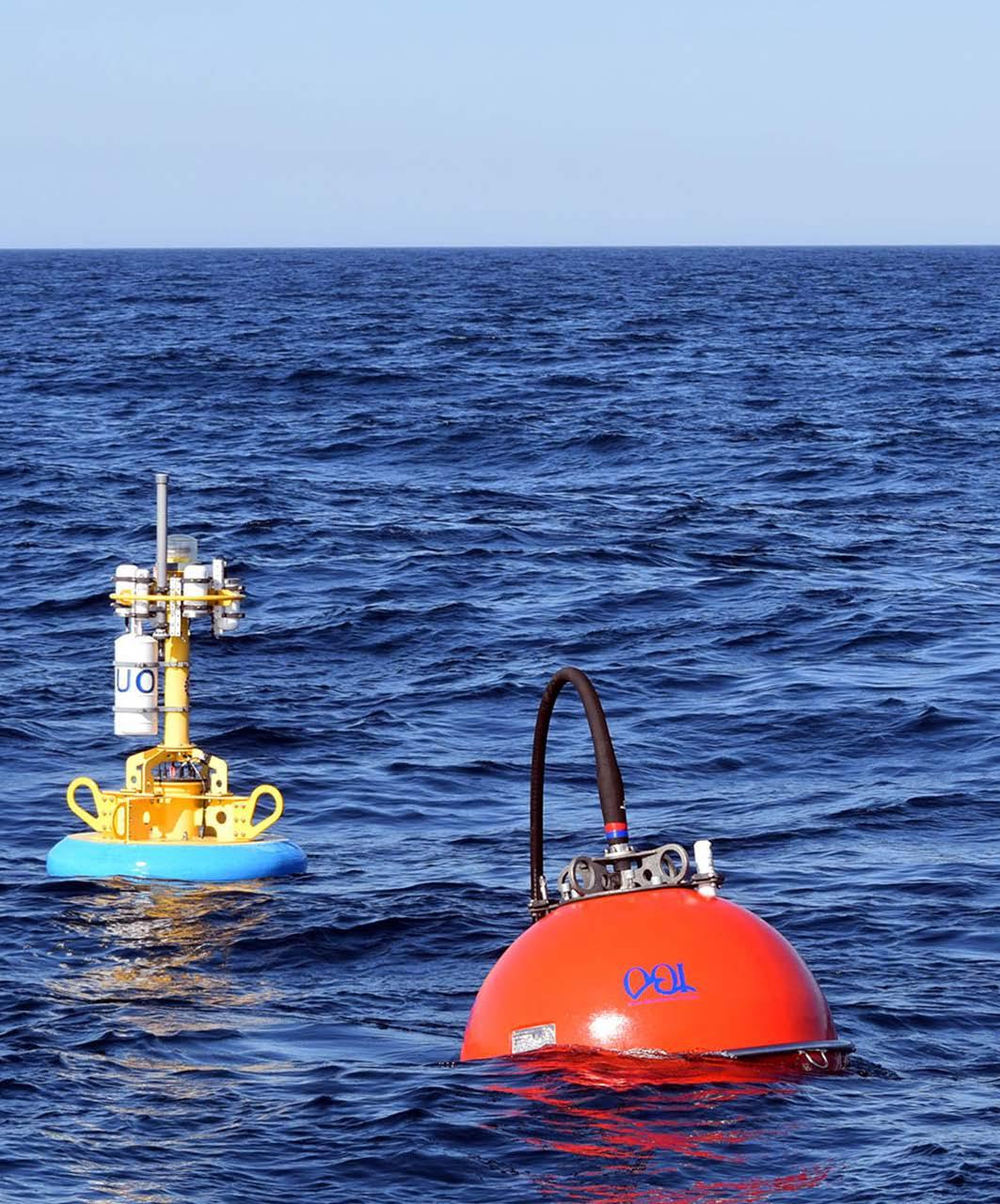
Cover Photo: The Upstream Offshore (UO) Profiling Mooring Buoy and Subsurface Flotation Sphere are shown during deployment to the Pioneer Array. The black cable connected to the sphere allows the buoy to move with the wind, currents, and waves independently of the instrumented mooring riser below the buoy. Credit: Rebecca Travis (Woods Hole Oceanographic Institution).
Ocean Observatories Initiative (OOI) Science Plan:
Exciting Opportunities using OOI Data
Ocean Observatories Initiative Facility Board of the National Science Foundation
Funding for the production of this Science Plan was provided by the National Science Foundation. For citation of this document: Ocean Observatories Initiative Facility Board. 2021. Ocean Observatories Initiative (OOI) Science Plan: Exciting Science Opportunities using OOI Data. <https://ooifb.org/reports/ooi-science-plan >. https://doi. org/10.23860/ooi-science-plan-2021-01.
January 2021
https://ooifb.org
Version 1.1
i OOI Science Plan: Exciting Opportunities using OOI Data Version 1.1
The Ocean Observatories Initiative Facility Board
The National Science Foundation Ocean Observatories Initiative Facility Board (OOIFB) provides independent input and guidance regarding the management and operation of the Ocean Observatories Initiative (OOI). It provides a way to expand scientific and public awareness of OOI, and ensure that the oceanographic community is kept informed of developments of OOI.
Members of the OOIFB during the production of this Science Plan include:
• Kendra Daly, (Chair) University of South Florida
• Larry Atkinson (Past Chair), Old Dominion University
• Tim Crone, Lamont-Doherty Earth Observatory (DDCI Committee Chair)
• Ed Dever, Oregon State University (OOI appointee)
• Sarah Gille, Scripps Institution of Oceanography
• Brian Glazer, University of Hawaii
• Ruoying He, North Carolina State University
• Deborah Kelley, University of Washington (OOI appointee)
• Dax Soule, Queens College, City University of New York
• John Wilkin, Rutgers, The State University of New Jersey
ii OOI Science Plan: Exciting Opportunities using OOI Data Version 1.1
Acknowledgements
This Science Plan was a collaborative effort. The contributions from members of the Ocean Observatories Initiative (OOI) program, as well as the science community are greatly appreciated.
We thank the original authors of the 2007 document, Ocean Observatories Initiative: Scientific Objectives and Network Design: A Closer Look. The document was a useful starting point for this Science Plan. The science themes and most of the science questions identified in the 2007 document still apply today.
We would like to recognize the individuals who helped to draft sections of this document, including:
• John Delaney (University of Washington)
• Ed Dever (Oregon State University)
• Cheryl Greengrove (University of Washington)
• Deb Kelley (University of Washington)
• Sage Lichtenwalner (Rutgers University)
• Janice McDonnell (Rutgers University)
• Eric McRae (University of Washington)
• Anna Pfeiffer-Herbert (Stockton University)
• Al Plueddemann (Woods Hole Oceanographic Institution)
• Leslie Smith (Your Ocean Consulting LLC)
• Darlene Trew Crist (Woods Hole Oceanographic Institution)
• John Trowbridge (Woods Hole Oceanographic Institution)
• Sheri White (Woods Hole Oceanographic Institution)
Members of the science community who authored Sidebars:
• Simone Alin (Pacific Marine Environmental Laboratory, NOAA)
• Adrien Arnulf (University of Texas at Austin)
• Dan Ayres (Washington Department of Fish and Wildlife)
• Suzanne Carbotte (Lamont-Doherty Earth Observatory)
• Francis Chan (Oregon State University)
• Tim Crone (Lamont-Doherty Earth Observatory)
• Julie Huber (Woods Hole Oceanographic Institution)
• Simon Josey (National Oceanography Centre)
• Wu-Jung Lee (University of Washington)
• Andy Leising (Southwest Fisheries Science Center, NOAA)
• Sage Lichtenwalner (Rutgers University)
• Doug Luther (University of Hawaii)
• Parker MacCready (University of Washington)
• Yann Marcon (University of Bremen, Germany)
• Janice McDonnell (Rutgers University)
• Dennis McGillicuddy (Woods Hole Oceanographic Institution)
iii OOI Science Plan: Exciting Opportunities using OOI Data Version 1.1
• Jan Newton (University of Washington)
• Hilary Palevsky (Boston College)
• Rachel Scott (University of Washington)
• Samantha Siedlecki (University of Connecticut)
• Joe Schumacker (Quinault Marine Resources Program)
• Dax Soule (Queens College, City University of New York)
• Veronica Tamsitt (University of South Wales & CSIRO Oceans and Atmosphere)
• Bob Weller (Woods Hole Oceanographic Institution)
• John Wilkin (Rutgers University)
• Weifeng ‘Gordon’ Zhang (Woods Hole Oceanographic Institution)
We thank the many individuals who helped to review the final draft of the Plan; including members of the OOIFB and Karen Besson from the OOIFB Administrative Support Office. We are also grateful to Annette DeSilva for all of her support and for editing and formatting the final report.
A very special thank you is extended to Kendra Daly for her many hours spent drafting sections, recruiting authors, and tirelessly reviewing drafts. Her extensive knowledge of the history of the OOI facility and program are reflected in this document.
The generous support provided by the National Science Foundation to draft this document is appreciated.
iv OOI Science Plan: Exciting Opportunities using OOI Data Version 1.1


v OOI Science Plan: Exciting Opportunities using OOI Data Version 1.1 Table of Contents ‘LOOKING’ FORWARD 1 Executive Summary 5 SECTION 1. Introduction 7 A. Purpose 7 B. Project Background 8 C. Project History 10 SECTION 2. Science Questions 15 SECTION 3. Network Design 51 A. Management Structure 51 B. The Arrays 55 C. OOI Data Delivery System 70 D. Quality Assurance 75 E. Data Explorer 77 SECTION 4. Innovative Platforms and Technologies 79 A. Fiber Optic Cable 79 B. Profiling Moorings 80 C. Surface Moorings 84 D. Novel Core Sensors 85 SECTION 5. OOI Best Practices 89 A. Instrument Testing 89 B. Cables and Connectors 89 C. Biofouling Mitigation 90 D. Field Verification, Sampling Design, and Data QA/QC 91 E. Platform Communication and Tracking 91 F. Platform Design 92 G. Deployment and Recovery 92 SECTION 6. OOI Education: Using Real-World Data from the Ocean Observatories Initiative in Teaching 95 A. OOI Undergraduate Educational Resources 96 B. OOI Education Community of Practice 97
vi OOI Science Plan: Exciting Opportunities using OOI Data Version 1.1 C. Recommendations and Future Directions 98 SECTION 7. Community Engagement 103 SECTION 8. National and International Partnerships and Collaborations 109 A. National Partnerships and Collaborations 109 B. International Partnerships and Collaborations 110 C. Partnerships with Industry 111 D. Externally-Funded Instrumentation 111 SECTION 9. Interested in adding instruments or platforms to the OOI? 113 SECTION10. Concluding Remarks 115 References 116 APPENDIX A. Acronym List 122 APPENDIX B. Document Version Control 128
‘LOOKing’ FORWARD
The transformational nature of the OOI strategies showed considerable promise during the very early discussions of the elements that have evolved into the NSF’s full OOI program. Community planning was well-underway by the mid-1990’s. Work on the initial OOI Science Plan began in the 2001-02 time frame. Funds for OOI finally arrived in 2009, and deployment of the OOI components was completed by 2015. This document is the third Science plan (OOISP3) produced for the Initiative. It is an exciting, powerfully articulated blue-print for evolving use of the key infrastructural elements underpinning a forward-looking perspective on research/ educational programs developed since completion of OOI construction. At the outset of the OOI, the nominal lifetime for operation of OOI infrastructure was to be 25 years.
With the successes over the past two to three decades of the Argo Float Program, Ocean Obs, various Glider Programs, and operating OOI frameworks, it is clear that there has been a significant shift toward ocean observing programs that complement ship-based research in our community, with measurements acquired by semiautonomous mobile and fixed sensing platforms, all using some level of regular data transmission throughout the deployment. Given this multidecade progress, it is appropriate to muse on the future of a comparable duration, for which we can imagine evolving ocean science opportunities and alternative pathways. I am offering a slightly modified version of a conventional Forward by appending (in small letters) the word “looking” to an otherwise simple title.
Several engaging and potentially important developments in our greater Ocean Sciences Community are emerging in the approximate time-
frame of the release of OOI-SP3. For example, the UN Decade of Ocean Science for Sustainability (2021-2030) will be a major international opportunity to attract novel, bold collaborative efforts to push forward on many frontiers related to ocean investigations (https://www.youtube. com/watch?v=_F5g9uZv6YI). The Ocean Studies Board, of the US National Academy of Sciences, Engineering, and Medicine, is encouraging submission of transformative, multi-disciplinary ideas, “Ocean-Shots,” that will address scientific challenges for reaching Decade goals (https://www. nationalacademies.org/our-work/us-nationalcommittee-on-ocean-science-for-sustainabledevelopment-2021-2030). Selected “Ocean-Shots” will be featured in special webinars to provide a platform for sharing and aligning innovative research ideas across our overall ocean science community.
One aspect of “Next Generation” Ocean Science will no doubt involve increasingly pervasive efforts to fully assess the characteristics and dynamic behavior of Marine Ecosystems, because they underpin most global, regional and local environmental “eco-services” provided to human beings by our planetary ocean. These oceanic ecosystems involve major, complex, interactions that buffer environments we depend upon for, among other things, absorbing greenhouse gases, and releasing significant oxygen into the atmosphere. To be fully understood, because the interactions are changing constantly, these systems must be studied from within the actual environment using a combination of real-time mobile sensing of many parameters, rapid communication, and comprehensive modeling for both assimilation and ultimate prediction.
We should not be shy about thinking boldly -
1 OOI Science Plan: Exciting Opportunities using OOI Data Version 1.1
especially if we wish to foster engagement by new groups of philanthropists, as well as established national and international funding agencies. Within the same process, we must encourage new generations of diverse, early- and pre-career individuals to help pioneer increasingly wise uses of the oceans for the long term. Such partnerships, building on ocean science successes, can promote, perhaps accelerate, a host of challenging scientific, technological, and policy innovations focused on expanding human efforts to more fully understand the bounds of oceanic resiliency.
A very different additional suite of opportunities may be arising from the space program. Beyond Earth, at least four other bodies in the solar system harbor significant concentrations of fluid, either water or hydrocarbons. As a global society, we are on the threshold of exploring some of those bodies of water directly. The best place to develop and thoroughly test the autonomous robotic-sensor systems that will be needed for such exploration is at selected sites within our own ocean. We ocean scientists must work closely with Space Scientists to ensure success in the searches that may lead to discovery of life beyond earth The NASA Road Map to Ocean Worlds: https://www.liebertpub. com/doi/full/10.1089/ast.2018.1955.
Indeed, partly because of our evolving infrastructural asset base, improved understanding of the complex interplays among myriad components and processes that constitute a wide array of ever-changing marine eco-subsystems may lie just within our grasp during this coming decade. Part of the solution to that challenge will be to routinely “be there, without being there”. By this, I mean that the key to major progress requires developing the ability to collect many tens of observations and measurements per second from hundreds of sensor arrays mounted on swarms of highly intelligent mobile platforms and arrays of fixed vertical-profiling platforms operating within nested scales over seconds-to-decades and ranging from sub-mm to kilometers.
As daunting as that sounds, a third emergent development over the past few decades, exponential change in developmental progress, may ease the
transition to these cutting-edge sensing systems that must ultimately be able to communicate all data in virtual real-time to interconnected data hubs serving our global community, while supporting continuously operating models of entire ecosystems of interest. This, of course, is a major challenge, but additional, multiple factors that, at times, are overlooked in our community, should be viewed as significant sources of encouragement. Recall, for example, the Human Genome Project was to take 30+ years to complete; it happened much faster because of focused and recursively reinforcing technological innovations. Based on a number of similar examples, in the early 2000’s, Ray Kurzweil hypothesized a ‘Law of Accelerating Returns’, (https://www.kurzweilai.net/the-law-ofaccelerating-returns)
Most of us still think linearly, yet much of the world around us is changing in non-linear ways that can be both positive and negative. The classic example of Moore’s Law is well-worn. But in the last three decades, unprecedented advancements in big data mining and synthesis, genomic assessment, bioengineering, sensor-development, machine learning/artificial intelligence, nanotechnology, robotic swarms, high-bandwidth communications, and high resolution systems-modeling, are some of the rapidly evolving tools we have at our disposal in considering a decadal-scale period of focused progress in Ocean Sciences.
Assuming that similar patterns of technological innovation as those involved in accelerating the Genome Project will enhance the abilities of a diverse, inventive ocean community, then a very important factor to consider in terms of planning and goal setting on decadal scales, is the potential power of recursive exponential enhancement of our collective capabilities to conduct sophisticated realtime investigations and experiments throughout entire volumes of the ocean without the need for human presence. Modeling the processes and results could ultimately culminate in predictive assessments of ocean futures.
According to an ancient Chinese proverb: “Times of chaos are times of opportunity”. For the OOI program, and Ocean Sciences in general, in
2 OOI Science Plan: Exciting Opportunities using OOI Data Version 1.1
order to grow and evolve in our current challenging, and rapidly changing, world, we, as part of the Ocean community, must be engaged in pursuing real-time science throughout entire oceanic subsystems. We should make concerted efforts to be well ahead of the curve by preparing for moments when significant opportunities arise. One approach to that philosophy might include a series of regular - annual? - gatherings via electronic conferencing, to explore and foster powerful community-wide themes with transformational potential. One idea would be to hatch bold ideas and plans that could be viewed as ready to evolve rapidly, so that the community is prepared when difficult times change. Resources, and/or societal awareness levels, may shift suddenly to provide opportunities we can take advantage of with well-thought-out plans, when the time is right.
Another reason for adopting such an approach is that we must constantly be building a broader, more inclusive, and more youthful community with the potential of carrying forward multiple challenging long-term projects in the oceans when opportunities arise. The experience we have all had
with the pandemic has introduced our community to the power of remote conferencing, as a routine mechanism for community innovation that does not require extensive/expensive travel, or major investment of time. The idea of developing a much more vigorous, well-connected international community is likely to offer a myriad of attractive opportunities to a wide range of early and precareer investigators, who care deeply about how we come to understand enough to secure a sustainable planetary life-support system -The Ocean- for the future they will help craft.
Finally, we might consider launching an oceanwide theme of crowd-sourcing scientific aspects of our growing real-time efforts, similar to the way NASA did with their Galaxy Zoo concept. For example, development of a Digital Twin Ocean System could offer many engaging aspects of community interest ranging across our entire field, and capture public participation at the same time.
John R. Delaney University of Washington
3 OOI Science Plan: Exciting Opportunities using OOI Data Version 1.1

4 OOI Science Plan: Exciting Opportunities using OOI Data Version 1.1
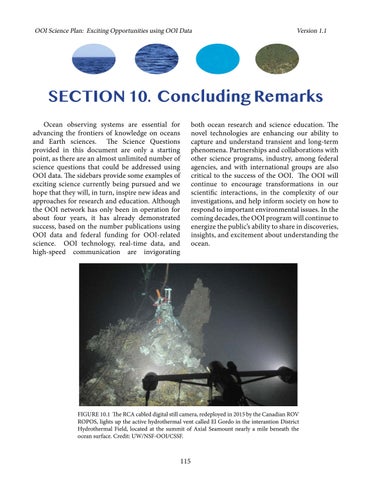
FIGURE A. A Regional Cabled Array instrumented Deep Profiler deployed off the fan tail of R/V Thomas G. Thompson during the 85-day 2014 installation cruise led by Chief Scientist John R. Delaney, University of Washington. Credit: M. Elend, University of Washington, V14.
Executive Summary
Although the ocean covers nearly 70% of the planet and is central to the quality of life on Earth, it is largely unexplored. Rapid growth in our understanding of the complex exchange among processes throughout ocean basins is severely limited by the paucity of infrastructure able to support sustained and interactive observations of the dynamic ocean environment. Biological, chemical, physical, and geological processes interact at the air-sea interface, in the ocean, and at the seafloor in complex ways. Developing a more fundamental scientific understanding of these relationships requires new and transformational approaches to ocean observation and experimentation.
The Ocean Observatories Initiative (OOI) was based upon a community vision resulting from two decades of workshops, meetings, and reports, which established science drivers for the proposed infrastructure investment. The OOI enables powerful new scientific approaches by capitalizing on a confluence of “disruptive technologies” that are often related to exponential growth in fields, including telecommunications, computer science, and genomics. The OOI has deployed a networked grid of sensors, which collects ocean, atmospheric, and seafloor data at high sampling rates, and will continue to do so for many years to come. Researchers can obtain simultaneous, interdisciplinary measurements to investigate a spectrum of phenomena including episodic, short-lived events (tectonic, volcanic, biological, severe storms), to more subtle, longer-term changes or emergent phenomena in ocean systems (circulation patterns, climate change, ocean acidity, ecosystem trends). Distributed research groups have formed virtual collaborations to collectively analyze and respond to ocean events in near-real
time, for example the underwater eruption by Axial Volcano in 2015. The introduction of ample power and bandwidth to remote parts of the ocean by the OOI have provided the ocean science community with unprecedented access to high-frequency data on multiple spatial scales, required to investigate complex interactions in coastal, regional, and high latitude ocean regions. Mobile assets (autonomous underwater vehicles, gliders, and vertical profiling) complement fixed-point mooring observations.
The use of large numbers of interconnected, space- and time-indexed, remote, interactive, fixed, and mobile assets by a global user community, collaborating through the Internet and Internetenabled software, represents the most fundamental shift in oceanic investigative infrastructure, since the arrival of satellites. Ocean observing is stimulating major changes in funding strategies, our community structure, the nature of our collaborations, the style of modeling and data assimilation, the approach of educators to environmental sciences, the manner in which the scientific community relates to the public, and the recruitment of young scientists. Two metrics of the OOI’s success are that to date > 170 OOI-related peer-reviewed publications have been published and 84 NSF proposals have been funded, totaling an investment of > $52M. The discoveries, insights, and the proven new technologies of the OOI program also will be transferred to more operationally oriented ocean observing systems operated by other agencies and countries. In this manner, OOI is playing a key role in keeping the U.S. and international science community at the cutting edge of ocean knowledge.
5 OOI Science Plan: Exciting Opportunities using OOI Data Version 1.1

6 OOI Science Plan: Exciting Opportunities using OOI Data Version 1.1
FIGURE B. The Oregon shelf surface mooring is lowered to the water using R/V Oceanus ship’s crane. Credit: OOI Endurance Array Program, Oregon State University.
SECTION 1. Introduction
A. Purpose
The Ocean Observatories Initiative (OOI) facility is funded by the National Science Foundation (NSF) to deliver data and data products from more than 800 ocean-based instruments, measuring more than 200 different parameters. The measurements are acquired as high-resolution time-series data and critical spatial information at five key, community-chosen sites in the Western Hemisphere. Measurements include physical, chemical, biological, and geological properties from the air-sea interface to the seafloor, permitting ocean research and inquiry at scales of centimeters to kilometers and milliseconds to decades. Since the OOI was commissioned in 2016, the research and education platform has accelerated understanding of processes in the ocean and seafloor and their respective roles in the planetary environment. The OOI Cyberinfrastructure currently serves over 250 terabytes of data, which are freely available to users worldwide, changing the way scientists and the broader community interact with the ocean. It is envisioned that the distributed OOI Network will have a 25-year operational lifetime.
The purpose of this document is to articulate the exciting research, educational opportunities, and pathways to advancing the understanding of high-priority science questions using OOI data. Specifically, this document is intended to inspire and enable the research endeavors of ocean scientists and educators, encourage collaborations, and motivate the training of future generations of scientists. Section 2 of this document highlights the broad science themes and provides examples of important multidisciplinary science questions that require the OOI’s novel technology. Sidebars from scientists using OOI data illustrate the novel
approaches being used to address long-standing science questions that are hard to address using shipbased expeditionary practices. Section 3 is a highlevel synopsis of the current ocean network, OOI program management, and data quality control and delivery. Section 4 showcases innovative platforms and technologies that make the OOI exceptional as an observatory platform. Section 5 delineates the best practices developed by the OOI program, including new scientific and engineering insights for the operation of a sustained ocean observing system. Section 6 presents examples of educational opportunities and new applications provided by OOI data and ocean observing concepts. Section 7 discusses Community Engagement activities promoted by the OOI. Section 8 describes the ways in which current U.S. interagency partnerships and international collaborations make use of the OOI network in unique ways. Section 9 offers information on how scientists and educators can participate in the OOI.
This document is intended for a marine science audience and assumes some familiarity with the OOI. The OOI website (https:// oceanobservatories.org) provides in-depth, and up-to-date information on the network’s sensors and platforms, how to submit proposals to add instrumentation to the OOI network or to propose adaptive sampling measurements, and procedures to access the Data Portal, including tutorials on how to search, discover, plot, and download data. This document, Ocean Observatories Initiative (OOI) Science Plan: Exciting Opportunities using OOI Data, is an update of previous OOI science plans, (1) the Ocean Observatories Initiative: Scientific Objectives and Network Design (2005) (https://oceanobservatories.org/science-plan) and
(2) the Ocean Observatories Initiative: Scientific
7 OOI Science Plan: Exciting Opportunities using OOI Data Version 1.1
Objectives and Network Design: A Closer Look (2007), and was prepared by key personnel on the OOI Facilities Board (OOIFB) and in the OOI program, with contributions from scientists and educators using OOI data. It is intended to be a living document and will be updated at regular intervals or as major program changes occur.
B. Project Background
Biological, chemical, physical, and geological processes interact in the ocean, at the seafloor, and at the air-sea interface in complex ways, strongly influencing our quality of life (Fig. 1.1). Marine ecosystems are especially difficult to study and are largely unexplored, in part, because they operate far from routine human presence. The ocean system modulates climate, produces major energy and raw-material resources, supports the largest biosphere on Earth, absorbs greenhouse gases, produces as much as half of the oxygen we breathe, significantly influences rainfall and temperature patterns on land, and fuels devastating coastal storm events, such as hurricanes. The heat capacity of the top 2.5 meters of the ocean is equivalent to the heat capacity of the entire Earth’s atmosphere. The ocean is nearly 4.5 billion years old and has been continuously driven by solar energy and internal thermal energy, absorbing and redistributing heat and chemicals from both above and below, throughout its history. At some point in its history, probably between 4.0 and 3.8 billion years ago, life emerged in the ocean and the complexity increased dramatically. Ship-based expeditionary research and satellite imagery contribute enormously to our knowledge of the ocean, but the spatial and temporal limitations imposed by these methods mean that many critical ocean phenomena remain unexplored.
The ocean is a challenging environment for collecting data. It is opaque to radio frequencies, it is corrosive, it exerts tremendous pressure at depth, and it harbors marine life that fouls sensor surfaces. The ocean’s strong storms can destroy mechanical structures. Most of its volume is not readily accessible and is far from shore-based power
sources and signal cables. Progress in developing capabilities to collect long-term observations essential to ocean science has been hard won, at times slow, and in many cases remains insufficient. Unlike observational scientists on land, until OOI, ocean scientists did not have access to sustained high-resolution, multidisciplinary time series. They cannot routinely run sophisticated analyzers in situ or command event-driven sampling responses. While real-time data transmission capabilities are expanding, ocean scientists still cannot always access their in situ data in real- to near-real time because of power and telemetry constraints, requiring them to study events that, at best, occurred months previous. In some locations, such as high latitudes, scientists still lack the capability to deploy long-term moorings that collect data from the sea surface to the seafloor.
The OOI is meeting these challenges through its deployed network of instrumented platforms and discrete sensors that collect ocean and seafloor data at high sampling rates over years to decades. These sensors are linked to shore using the latest communications technologies, enabling scientists to use incoming data in real- to near-real time in models. Scientists and educators from around the country, from large and small institutions, and from fields other than ocean science, are taking advantage of OOI’s open data policy and emerging cyberinfrastructure capabilities in distributed processing, visualization, and integrative modeling. Although the OOI infrastructure will not populate all oceans, nor answer all pressing ocean science questions, this investment is and will continue to catalyze ocean science research for decades to come. The ability to provide sufficient power continuously to complex instrumentation, to retrieve data with minimal delay, and to interact with instruments and platform sampling strategies in real- to near-real time will continue to stimulate the development of more sensors, durable hardware, autonomous vehicles, accurate ocean models, and other observing capabilities. Increased temporal and spatial coverage of ocean sampling, the growth of technical capability, development
8 OOI Science Plan: Exciting Opportunities using OOI Data Version 1.1

9
FIGURE 1.1 The figure represents some of the hundreds of processes which operate throughout the global ocean, demonstrating the complexity of the ocean and Earth systems. Credit: John R. Delaney and Mark W. Stoermer, with graphics by the Center for Environmental Visualization, University of Washington.
of new and more precise predictive models, and increasing public understanding of the ocean will all be tangible measures of the OOI’s contribution to transforming ocean science.
C. Project History
Tthe OOI is based upon a community vision resulting from two decades of workshops, meetings, and reports, which established science drivers for the proposed infrastructure investment. In 1988, the ocean sciences community began discussions about the science, design concepts, and engineering of ocean research observatories. During the 1990s, workshops were held on a variety of topics, including undersea cables, seafloor observatories, and moored buoys. In addition, NSF held a series of disciplinary workshops, culminating in the Ocean Sciences at the New Millennium report in 2001. The report noted the difficulties in adequately sampling the ocean due to its size and limited access by ships. As a result, the ocean has in the past been under sampled. Although satellite oceanography has provided increasingly accurate measurements of the ocean surface layer, in situ observations are critical to understanding the ocean interior. The Ocean Sciences at the New Millennium report recommended a national effort to support sustained high-quality global observations over decades, given recent developments in instrumentation and computational resources needed for such an endeavor. High-frequency measurements were considered essential to investigate a range of science questions from climate change to non-equilibrium ecosystem dynamics to underwater volcanic eruptions and geochemical cycling between the solid earth and the hydrosphere.
In 1998, the National Ocean Partnership Program (NOPP) funded an engineering study of the cabled component, which was called NEPTUNE at that time. The report, which was released in June 2000, documented that the cabled observatory was scientifically driven and technologically feasible, consisting primarily of commercially available system components. In October 2000, the National Science Board approved the OOI as a Major Research Equipment and Facilities Construction (MREFC) account project. The NSF
Division of Ocean Sciences formed the Dynamics of Earth and Oceans Systems (DEOS) Committee in 2001, to start planning what would become the OOI. The OOI design for seafloor and water column observatories developed from two main technical directions: submarine cable observatories to provide power and Internet connectivity from land; and moored observatories that provide locally generated power to seafloor, water column, and meteorological instruments, and use a satellite link to send data back to land via the Internet. In addition, the integration of mobile assets, such as gliders and autonomous underwater vehicles (AUVs), were recognized as essential to provide information on mesoscale variability.
Two National Research Council (NRC) reports (NRC, 2000; NRC, 2003) and 14 nationally circulated science and technical reports reflect the broad community involvement in planning the OOI (see Figure 1.2 for a summary of major milestones in OOI history). Two high-visibility documents, the Pew Ocean Commission’s 2003 report (The Pew Ocean Commission, 2003), America’s Living Oceans: Charting a Course for Sea Change, and the U.S. Commission on Ocean Policy’s 2004 report, An Ocean Blueprint for the 21st Century (U.S. Commission on Ocean Policy, 2004), also highlighted the importance of science-driven ocean observing. In 2007, the National Science and Technology Council’s Joint Subcommittee on Ocean Science and Technology issued the report, Charting the Course for Ocean Science for the United States for the Next Decade: An Ocean Research Priorities Plan and Implementation Strategy, which identified the OOI’s key role in addressing near-term national priorities (NSTC JSOST, 2007). The Millennium Report and other reports mentioned above provided a framework of strategic science questions that were refined by participants in numerous OOI workshops. These reports, workshops, and planning efforts led to the vision of three observatory scales—coastal, regional, and global—within one distributed, integrated network. The National Research Council report, Enabling Ocean Research in the 21st Century: Implementation of a Network of Ocean Observatories, articulated the OOI goals
10 OOI Science Plan:
Opportunities
OOI Data Version 1.1
Exciting
using
The National Science Board approves the OOI as a NSF MREFC Project (Oct 2000)
NRC releases Illuminating the Hidden Planet: the Future of Seafloor Observatory Science (Dec 2000)

NSF funds the Monterey Accelerated Research Systems (MARS) observatory test bed in Monterey Bay (Sep 2002)
NSF -Ocean Sciences releases Ocean Sciences at the New Millenium (Spring 2001) NOPP funds NEPTUNE system engineering program office & science planning (Mar 2002)
W. M. Keck Foundation grants award for proto-NEPTUNE experiment (July 2001)
An updated science plan, the Ocean Observatories Initiative: Scientific Objectives and Network Design: A Closer Look is released (2007)

NSF and Consortium for Ocean Leadership sign a Cooperative Agreement, which began the construction phase of the OOI (Sep 2009)
OOI Preliminary Design Review, Arlington, VA (Dec 2007)
Design & Implementation Workshop. Salt Lake City, UT, presented draft Conceptual Network Design for community comment (Mar 2006)
OOI Conceptual Design Review, Moss Landing, CA (Aug 2006)
OOI Cyberinfrastructure IO awarded to UCSD (May 2007) Installation of cable for NEPTUNE Canada begins (Aug 2007)
OOI Coastal/Global IO awarded to WHOI (Aug 2007)
Conceptual Network Design Revised Infrastructure Plan released (Mar 2007)
OOI Regional Cabled Nodes Design Support Services awarded to UW (Mar 2007)
The Pew Ocean Commission releases America’s Living Ocean: Charting a Course for Sea Change (June 2003)

ORION Workshop held in San Juan, Puerto Rico for OOI science and education planning (Jan 2004) Project Office established at JOI (Mar 2004)
The US Commission on Ocean Policy releases An Ocean Blueprint for the 21st Century, Final Report (Sept 2004)
NRC releases Enabling Ocean Research in the 21st
Century: Implementation of a Network of Ocean Observatories (Spring-Summer 2003)
Request for Assistance for Conceptual Science Experiment to help with the design of the OOI released (Apr 2005)
OOI is listed in the President’s FY2007 as a new MREFC start at $309.5 M (Feb 2006)
Revised Conceptual Network Design (Jan 2006)
Joint Subcommittee on Ocean Science & Technology releases Charting the Course for the Ocean Science in the US for the Next Decade: An Ocean Research Priorities Plan & Implementation Strategy (Jan 2007)
Ocean Observatories Science Plan (May 2005)
NSF awards Cooperative Agreement with the Woods Hole Oceanographic Institution to lead OOI 2.0 (Oct 2018 – Oct 2023)

Southern Ocean Global Array is decommissioned (2020)
Argentine Basin Global Array is decommissioned (2018)
NSF forms the OOI Facility Board (May 2017)


OOI is fully commissioned! (2016)
Rutgers University becomes the Cyberinfrastructure IO (2014)

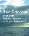
National Research Council report, Sea Change: 20152025 Decadal Survey of Ocean Sciences, recommends descoping OOI (2015)
11
1.1 2000 2002 2006 2008 2009 2007 2005 2003 2004 2001 2010 2011 2012 2013 2014 2015 2016 2017 2018 2019
OOI Science Plan: Exciting Opportunities using OOI Data Version
2020 and Beyond
FIGURE 1.1 Milestones in the development of the Ocean Observatories Initiative. Credit: Annette DeSilva, University of Rhode Island.
OOI Science Plan: Exciting Opportunities using OOI Data Version 1.1
for the network: (1) continuous observations at high temporal resolution for decades; (2) spatial measurements on scales ranging from millimeter to kilometers; (3) the ability to collect data during storms and other severe conditions; (4) twoway data transmission and remote instrument control; (5) power delivery to sensors between the sea surface and the seafloor; (6) standard sensor interfaces; (7) AUV docks for data download and battery recharge; (8) access to facilities to deploy, maintain, and calibrate sensors; (9) an effective data management system that provides open access to all; and (10) an engaging and effective education and outreach program that increases ocean literacy.
In 2004, through a cooperative agreement with the NSF Division of Ocean Sciences, Joint Oceanographic Institutions (JOI) established the Ocean Research Interactive Observatory Networks (ORION) Project Office to coordinate further OOI planning. The ORION Project Office then formed a large Science Technical Advisory Committee (STAC), which included six subcommittees comprising > 85 community members, including scientists, engineers, and educators, to assist in guiding the development of the OOI. The ORION Workshop was held January 4-8, 2004 in San Juan, Puerto Rico to formulate the science priorities and educational opportunities for the ocean observatory. Two outcomes of that large community meeting were an Oceanography article (Schofield and Tivey, 2004) and the first OOI Science Plan, which was prepared by the ORION Program Office and Executive Steering Committee and released in 2005. Also in 2005, JOI issued a broadly focused Request For Assistance (RFA) solicitation that resulted in 48 experimental design proposals, representing the efforts of 549 investigators and spanning 137 research and education institutions, agencies, and industries. These proposals were reviewed by an interdisciplinary panel for innovative science and feasibility of infrastructure requirements. The highly ranked proposals, along with other program activities, were used as the basis for the Conceptual Network Design (CND) (JOI, 2006a; JOI, 2006b; JOI, 2006c; JOI, 2006d). In March 2006, about 300 participants reviewed the draft
CND at a Design and Implementation Workshop in Salt Lake City (Daly et al., 2006). In August 2006, NSF convened a formal Conceptual Design Review to assess OOI scientific goals and merit, the proposed facility’s technical feasibility and budget, the project’s management plan, including schedules and milestones, and education and outreach plans. In its report (NSF, 2006), the 20-member panel affirmed that the OOI as proposed would transform oceanographic research in the coming decades, and that the CND provided a good starting point for developing the OOI network.
In 2007, JOI merged with the Consortium for Oceanographic Research and Education (CORE) to form the Consortium for Ocean Leadership (COL). The OOI Project Office remained under this non-profit D.C. organization. Three OOI Implementing Organizations (IO) were selected in 2007 by an acquisition process similar to that used in large federal acquisitions, including the University of Washington (UW) as the IO for the Regional Cabled Array (RCA), the University of California San Diego (UCSD) as the IO for the Cyberinfrastructure, and the Woods Hole Oceanographic Institution (WHOI) with two consortium partners, Oregon State University (OSU) and UCSD, as the IO for the Coastal and Global Scale Arrays. These groups worked together to plan construction of the OOI. An NSF Large Facilities panel accepted the Preliminary Design Review in December 2007. An updated science plan, the Ocean Observatories Initiative: Scientific Objectives and Network Design: A Closer Look, with a revised network design also was released in 2007. The panel for the Final Design Review in November 2008 noted that the OOI Project was technically ready and recommended that the OOI proceed with construction in July 2010. The National Science Board authorized the Director of NSF to award funds for the construction and initial operation of the OOI on May 14, 2009 and on September 2, 2009, NSF and the COL signed a Cooperative Agreement, which began the construction phase of the OOI. In 2011, Rutgers University was awarded a subcontract for the Education and Public Engagement software infrastructure component, with its partners
12
the University of Maine and Raytheon Mission Operations and Services, and in 2014 Rutgers also became the IO for Cyberinfrastructure. The OOI was fully commissioned and accepted by the NSF in 2016, 28 years after the initial discussions and due to the vision and persistent dedication by many members of the ocean science community!
In 2013, the NSF/ Division of Ocean Sciences asked the National Research Council’s Ocean Studies Board to undertake a decadal survey to provide guidance on the ocean sciences community’s priorities for research and facilities for the coming decade, given the funding constraints imposed by flat or declining budgets. The committee’s report, Sea Change: 2015-2025 Decadal Survey of Ocean Sciences, recommended descoping the Southern Hemisphere global moorings. Subsequently, the Argentine Basin Array was removed in January 2018 and the Southern Ocean Array southwest of Chile was removed in January 2020.
The OOI is based on the legacy of large multidisciplinary oceanographic research programs, that encouraged new approaches and collaborative investigations over the last three decades (e.g., WOCE, JGOFS, RIDGE, ODP, GLOBEC, IRONEX,
CLIVAR, CoOP). These programs provided training in interdisciplinary science and ultimately raised new questions about ocean systems that required high temporal resolution measurements. In addition, the OOI was built on the success and experience gained with pioneering observatory projects in both the coastal (e.g., LEO-15, MVCO) and open (e.g., HOT, BATS, TOGA-TAO, NeMO) ocean, as well as engineering knowledge gained as a part of cabled pilot experiments and testbeds (e.g., MARS and VENUS).
COL led the OOI program through the initial years of operation until September 2018, when NSF awarded a Cooperative Agreement with the Woods Hole Oceanographic Institution to lead the OOI for five years. The current Implementing Organizations include the University of Washington, Oregon State University, Rutgers University, and the Woods Hole Oceanographic Institution.
13 OOI Science
OOI
Version 1.1
Plan: Exciting Opportunities using
Data

14 OOI Science Plan: Exciting Opportunities using OOI Data Version 1.1
FIGURE 1.3. Sub-surface floating spheres and controllers for two flanking moorings and the Global Profiling Mooring await deployment in the Irminger Sea Array. These instruments measure water velocity from the depth of the spheres (500 meters) to the sea surface. Credit: Sheri N. White, Woods Hole Oceanographic Institution.
SECTION 2. Science Questions
The OOI cutting-edge technology and instrumentation enables novel and exciting research on a wide range of topics in the Earth and ocean sciences. The data can be used to investigate science questions directly or through the use of different models, or data can be used in support of additional process-based research projects. The high-level science themes identified in OOI program documents include:
• Climate variability, ocean food webs, and biogeochemical cycles
• Ocean-atmosphere exchange
• Coastal ocean dynamics and ecosystems
• Turbulent mixing and biophysical interactions
• Global and plate-scale geodynamics
• Fluid-rock interactions and the sub-seafloor biosphere
While the OOI themes are broad and encompassing, specific science questions are at the heart of the research enabled by the OOI infrastructure. Below, we provide some examples of science questions, many of which are complex and multidisciplinary in nature, and among the suite of questions identified by the research community as requiring advanced ocean observing technologies and infrastructure. The OOI Program provides consistent, well-documented open access data, which are available to the entire scientific and educational community. The sensors deployed as part of the OOI were the measurements required to support a rich set of interdisciplinary science questions, focused on processes at the air-sea interface, the water column, and the sea floor, and interactions among these processes. However, no one owns any specific science questions. In the model of NASA satellite and the Argo array data, OOI data are available to everyone, and anyone can start with the germ of an idea to analyze OOI data and publish results. Data users determine the science that can be accomplished using OOI data, which allows for the possibility of serendipitous science. Interspersed in this section are examples of novel approaches and results by Earth and ocean scientists, which highlight the exciting science that has been or can be accomplished using OOI data.
How is climate change influencing ocean ecosystems?
What is the ocean’s role in the global carbon and other biogeochemical cycles? How have ocean biogeochemical and physical processes and their interactions contributed to today’s climate and its variability, and how will ocean systems change over the coming decades? What are the dominant physical, chemical, and biological processes that control the exchange of carbon and other dissolved and particulate material (e.g., gases, nutrients, organic matter) across the air-sea interface, through the water column, and to the seafloor? What is the spatial (coastal versus open ocean) and temporal variability of the ocean as a source or sink for atmospheric CO2? What is the seasonal to interannual variability in the biological carbon pump and particulate flux? What factors control the distributions of marine organisms? How are the oceans changing and what are the consequences for our living resources and food webs? How productive are our ocean ecosystems and how does primary productivity vary over space and time? How will the effects of climate change in the ocean, superimposed on other natural and anthropogenic stressors, alter the carrying capacity and recovery potential of marine ecosystems?
15 OOI Science Plan: Exciting Opportunities using OOI Data Version 1.1
siDEbar: The Biological Carbon Pump: A New View from the OOI

Hilary I. Palevsky, Department of Earth and Environmental Sciences, Boston College, Boston, MA, USA
The ocean’s biological carbon pump plays an important role in the global carbon cycle by transferring photosynthetically-fixed organic carbon from the surface into the deep ocean, sequestering it from contact with the atmosphere (Le Moigne, 2019; Volk and Hoffert, 1985). Historically, shipboard measurements of the biological pump’s rates and mechanisms have been concentrated in the spring and summer during the period of peak photosynthetic production (e.g. the North Atlantic Bloom Experiments), with observations of the full seasonal cycle limited to time-series sites in regions more conducive to year-round shipboard sampling (e.g. the Hawaii Ocean Time Series and Bermuda Atlantic Time Series). However, a growing body of work has shown that year-round observations are needed to fully constrain the biological pump, especially in regions such as the OOI array sites that experience strong seasonality in both biological and physical processes (e.g. Boyd et al., 2019; Palevsky and Doney, 2018).
Autonomous biogeochemical sensors deployed at the OOI arrays capture high temporal-resolution year-round data throughout the water column
that can be used to improve our constraints on rates and mechanisms of the biological carbon pump in regions that have historically been undersampled. Dissolved oxygen data from the first two years of observations at the Global Irminger Sea Array in the subpolar North Atlantic provide an example of the new insights into the biological pump enabled by the OOI (Fig. 2.1; Palevsky and Nicholson, 2018). Surface measurements show the seasonal cycle expected based on numerous prior studies of the strong spring bloom in this region (e.g. Briggs et al., 2011), with the bloom driving oxygen super-saturations that indicate net photosynthetic production and export of organic carbon from the stratified seasonal mixed layer. However, subsurface profiler observations show that much of the organic carbon exported from the surface is remineralized within the seasonal thermocline and ventilated back to the atmosphere during deep mixing the subsequent winter, rather than being sequestered long-term. This interplay between the biological processes driving seasonal export and the physical processes driving winter ventilation is being further explored at the Irminger Sea Array by considering interannual variability
FIGURE 2.1 Observations of oxygen saturation over the first two years of measurements at the OOI Irminger Sea Array, illustrating the seasonal cycle of the biological carbon pump. Surface measurements are from fixed-depth moored sensors within mixed layer (Flanking Mooring A in 2014-15 and the Apex Surface Mooring’s near-surface instrument frame in 2015-2016) and subsurface measurements are from the Apex Profiling Mooring. The black lines indicate the onset of winter ventilation (deepening mixed layer) in each year and springtime restratification in 2015. For full data analysis details, see Palevsky and Nicholson (2018).
16 OOI Science Plan: Exciting Opportunities using OOI Data Version 1.1
in subsurface respiration and winter convection (Wanzer, 2019) and by employing a new approach to oxygen calibration using gliders with modified sensor mounts (Nicholson and Feen, 2017) that will provide the high-accuracy data needed to constrain the rate of air-sea oxygen exchange and the total amount of carbon sequestered below the winter ventilation depth.
Beyond the work to date focused on dissolved oxygen data at the Irminger Sea Array, a strength of the OOI program is that every array combines sensors for multiple biogeochemical tracers –including nitrate, carbon (pH and pCO2), and bio-optical measurements of chlorophyll and backscatter from particles, as well as oxygen –providing unprecedented temporal resolution and depth-resolved coverage for multi-tracer year-round observations. This combination of multiple tracers offers the potential for greater mechanistic understanding of the biological pump by quantifying the separate contributions of particulate and dissolved organic matter to the total organic carbon flux, and distinguishing among fluxes driven by gravitational settling, eddy-driven subduction, and cycles of mixed layer deepening and detrainment (e.g. Lacour et al., 2019; Llort et al., 2018). The full depth coverage achieved by including biogeochemical sensors across all platforms – including surface and subsurface moorings, profiling moorings, and autonomous vehicles – provides opportunities to consider not only biological carbon flux from the surface ocean, but also transfer efficiency through the mesopelagic and effectiveness of long-term sequestration below the winter ventilation depth. The high temporal resolution of measurements (~minutes to hours across platforms) also opens opportunities to consider processes such as rapid bloom onset in spring and mixing/re-stratification events in winter that are more difficult to capture using methods such as Biogeochemical-Argo floats, which provide broader spatial coverage than possible with moored
platforms but must sample less frequently in order to last multiple years (Claustre et al., 2020).
Finally, the OOI Program offers the opportunity to compare detailed time-series observations of the biological pump across multiple sites, complementing both ship-based process studies (e.g. EXPORTS; Siegel et al., 2016) and more globally wide-spread observations from Biogeochemical-Argo floats and satellites. The OOI arrays represent a diverse set of complementary physical and biogeochemical settings that together could be used to better constrain how interactions between biological and physical processes influence the biological pump. The two Southern Hemisphere sites, though now decommissioned, provided data in two highly undersampled regions: a site of high biological productivity and strong currents and eddies in the Argentine Basin, and a region of strong heat and carbon fluxes and deep winter convection in the Southern Ocean. At the Northern Hemisphere Global Arrays, the Irminger Sea site features both the classic North Atlantic seasonal spring bloom and exceptionally deep winter mixing, while Station Papa at a similar latitude in the subarctic Northeast Pacific provides a contrasting physical setting with a strong halocline that restricts winter mixing and a more tightly coupled ecosystem during the productive season. The Pioneer and Endurance Coastal Arrays, as well as the Oregon slope profiling moorings on the Regional Cabled Array, capture the spatial and temporal variability of two very different, but both highly dynamic and productive coastal margins, providing new constraints on coastal biological carbon fluxes. Continued observations and new syntheses of OOI data across sensors and sites promise many new and important insights into our regional and global understanding of the biological pump and its role in the ocean carbon cycle.
17 OOI Science Plan: Exciting Opportunities
OOI Data Version 1.1
using
siDEbar: Accelerating Marine Ecological Research using OOI Echosounder Data
Wu-Jung Lee, Applied Physics Laboratory, University of Washington, Seattle, WA, USA
Mid-trophic level organisms, such as zooplankton and forage fish, play a critical role in mediating energy transfer from primary production to top predators in the marine ecosystem. Many of these animals are also primary targets for fisheries harvest, upon which a significant portion of the society depend. High-frequency active acoustic systems, known as “echosounders,” are the workhorse for observing the distribution and abundance of mid-trophic animals. These instruments work by transmitting sounds into the water column and listening to the echoes bounced off objects. The amplitude and spectral features in the echoes can then be used to infer the type and number of animals in the observed aggregations. As a form of remote sensing, echosounders allow scientists to make continuous observations across large swaths in time and/or space in the ocean, effectively “connect the dots” between discrete locations or times where net trawl samples are collected. The 17 echosounders deployed across OOI’s regional and global arrays (ZPLS Bioacoustic Sonar [OOI Bio-acoustic Sonar. https:// oceanobservatories.org/instrument-class/zpls/ ]) are great examples of this type of observation.
The continuously flowing, openly accessible OOI echosounder datasets provide an excellent opportunity for me to develop new analysis methods and computational tools to efficiently transform active acoustic data to mid-trophic biological information. In an ongoing project funded by the NSF, we are developing novel data-driven methodologies to automatically discover prominent spatio-temporal patterns in the echogram (images formed by echoes, Fig. 2.2 bottom panel), and use these patterns to summarize and describe changes in long-term echosounder time series (Lee et al., 2007). In parallel, we created an open-source software package echopype (Lee et al., 2020) to enable interoperable and scalable processing of echosounder data to extract biological information.
These developments are timely and crucial,
because technological advancements in the past decade have resulted in a deluge of echosounder data from a variety of ocean observing platforms, including moorings and autonomous surface and underwater vehicles. The spatial and temporal coverage and the complexity of these data greatly surpass those from ship-based surveys. As a result, the data have overwhelmed the traditional echosounder data processing pipelines. In other words, there is currently a mismatch between instrumentation capacity (to collect large amount of data) and interpretation capability (to analyze these large datasets), and this mismatch is limiting progress in understanding ecosystem response to major environmental disturbance.
My research specifically uses data collected by the network of six upward-looking echosounders in the OOI Coastal Endurance Array. These echosounders flank the Columbia River mouth from the north and the south, running roughly in parallel along two cross-shelf moored array lines offshore of Grays Harbor, WA and Newport, OR. Each mooring additionally hosts a large number of sensors for physical, chemical, and lower-trophic biological ocean variables, offering a comprehensive dataset to study causal ecological relationships in this highly dynamic environment within the northern California Current System.
An interesting example of OOI data use is to observe zooplankton’s response to the solar eclipse on August 21, 2017. The diel vertical migration (DVM) of many other marine organisms is a wellknown and ubiquitously observed phenomenon in the global ocean that occurs at dawn and dusk (Brierley, 2014). However, during the eclipse as the moon passed in front of the sun and blocks its light, many animals began to migrate up toward the surface, only to swim back down again once the ambient light level returned to normal. This series of events was captured in high resolution by the echosounder deployed on the Endurance Oregon Offshore Cabled Shallow Profiling Mooring (Fig.
18 OOI Science Plan: Exciting Opportunities using OOI Data Version 1.1
2.2), due to the fortunate coincidence that this site is located on the path of total eclipse. This example demonstrates the power of persistent ocean observatories, such as the OOI, in delivering multi-faceted and multi-use data for addressing a wide range of scientific questions, as well as in
broadening the reach of oceanographic research through open data.

19 OOI Science Plan: Exciting Opportunities using OOI Data Version 1.1
FIGURE 2.2 Solar eclipse disrupted the regular diel vertical migration (DVM) pattern of zooplankton. Top: Short-wave radiation measured at sea surface level. Bottom: high-frequency echosounder observation of the top 200 m water column.
How does ocean circulation and the distribution of heat in the ocean and atmosphere respond to natural and anthropogenic drivers? How are marine heat waves influencing ocean ecosystems? What processes dominate mixing in the ocean and on what space and time scales? How does topography-driven mixing maintain the observed abyssal stratification? What processes are responsible for enhanced near-boundary mixing? How is heat transported into the ocean interior? What is the role of mean seasonal versus episodic processes? What is the importance of the abyssal stratification and how is it maintained? How do changes in mixing and circulation affect nutrient availability and ocean productivity? What is the spatial and temporal distribution of ocean mixing, turbulence, and stirring, and how might these processes be represented in climate-scale ocean models?

20 OOI Science Plan: Exciting Opportunities using OOI Data Version 1.1
FIGURE 2.3 Deployment of the main float of the Profiler Mooring from R/V Melville at the Global Station Papa Array. Credit: Station Papa Science Team.
siDEbar: Marine Heatwaves
Andrew Leising, Southwest Fisheries Science Center, NOAA, San Diego, CA, USA
Marine heatwaves have been recognized as events that can have major impacts on the ocean, its ecosystems, and ocean-related human activities. Marine heatwaves have commonly come to be defined as regions of the ocean that have temperatures within the top 10% of all recorded temperatures for that location and time of year, and that persist for more than five days (Hobday, 2016). It was not really until the extremely large event that began in the Gulf of Alaska in fall of 2013, and lasted until mid 2015 – an event that became colloquially known as “The Blob” – that the potential importance and impact of non-El Niño, large-scale marine heatwaves was realized (Fig. 2.3). Impacts of the “Blob” included changes in species distributions, reduced overall productivity, reduced numbers of economically important species, closure of fisheries, harmful algal blooms, and the occurrence of rare and novel species (i.e. tropical venomous sea snakes washing up on the coast of California; Cavole et al., 2016). In May 2019, a second large marine heatwave formed, which rivaled the “Blob” in terms of size and intensity, however it lasted only until February 2020, and did not have nearly the impacts of the 2013-2015 event. Nevertheless, research suggests heatwave frequency is expected to increase, and that the heatwaves themselves will possibly be of longer duration and intensity in the future, thus likely increasing their impacts on our marine ecosystems.
Marine heatwaves are caused by various forces, depending on the location and possibly season (Holbrook et al., 2019). In the Northeast Pacific (NEP), both the 2013-2015 and 2019 events are thought to have been initiated by changes in atmospheric patterns (Bond et al., 2015; Amaya et al., 2020). Essentially, changes in large scale atmospheric patterns change atmospheric pressure fields, which in turn alter winds over the surface of the ocean. When the wind decreases for a substantial enough time, this in turn leads to a lack of surface ocean mixing, changes in horizontal advection and, therefore, a reduction in the normal
cooling that would occur; hence, the warming of the surface layers. Given time, this surface heating penetrates to deeper depths, further strengthening and perpetuating the heatwave. Anomalous atmospheric pressure patterns can also help to maintain a heatwave by steering storms away from the heatwave that would normally mix and cool surface waters. Lastly, given longer time periods, feedback loops between the warm water and atmosphere can develop, further affecting winds, heat flux, and even cloud cover, thus perpetuating the feature.
Ocean observing systems are a key tool in measuring and monitoring marine heatwaves. Remote observation of sea surface temperature (SST) from satellites has been an important tool for observing heatwaves, however, SST only provides data from the surface mixed layer, whereas heatwaves such as the “blob” had extensive subsurface warming. Bond et al. ( 2015), McCabe et al. (2016), McKibben et al. (2017), and Barth et al. (2018) all used data from various OOI assets, particularly the Endurance Array, the RCA, and the Global Array at Ocean Station Papa, to monitor the approach of the “Blob” and its links to ecosystem impacts on the US west coast. What makes these OOI assets so valuable for the purposes of sampling and monitoring heatwaves is that: 1) they sample at high enough frequency to detect rapid changes that can be associated with the advection of heatwaves, 2) they sample subsurface and sub-mixed layer properties, 3) they are placed in an opportune location to detect features as they near the coast, and 4) they have been sampling over a long enough time period for the calculation of local climatologies – this is a key element for detecting anomalies such as marine heatwaves.
Moving forward, OOI assets such as the Endurance Array are poised to provide exactly the kind of data needed for marine heatwave detection and monitoring. However, the strengths of such a system also help identify possible gaps and
21 OOI Science Plan: Exciting Opportunities using OOI Data Version 1.1
challenges that could occur. Loss of sampling over time due to instrument failure, etc. would introduce gaps in data collection, thus additional redundancy of sensors and platforms would be preferred. Also, due to the extremely heterogenous shape of marine heatwaves (Fig. 2.3), it would be preferable to add additional arrays to other locations along the US west coast; indeed the Endurance Array and RCA were uniquely positioned in 2014 to sample the “Blob” as it intersected the coast in that region, but
might miss future events. Additional sub-surface sampling further offshore would increase our ability to monitor the coastward propagation of heatwaves, and further delve into the mechanisms which drive their persistence. In summary, the sub-surface sampling abilities of the OOI system provide a unique opportunity for future research into marine heatwaves.
known as “The Blob” on the date when it reached its maximum size. Color represents sea surface temperature anomaly from NOAA’s OISST dataset (https://www.ncdc.noaa.gov/oisst), dark contour denotes the region which classifies as a “heatwave” by the definition of Hobday, 2016.

22 OOI Science Plan: Exciting Opportunities using OOI Data Version 1.1
FIGURE 2.4 The 2013-2015 Northeast Pacific marine heatwave
siDEbar: Internal Tide Impacts on Ocean Circulation – An Exceptional OOI Opportunity
Douglas S. Luther, School of Ocean and Earth Science and Technology, University of Hawai’i at Manoa, Honolulu, HI, USA
Internal tides (ITs) provide over half of the ~2 TW of power needed to maintain the deep ocean’s stratification via mixing of upper warm water with deep cold water. Accordingly, they have critical roles in determining the meridional overturning circulation and oceanic heat budget (e.g., Wunsch and Ferrari, 2004; Waterhouse et al., 2014). Generated by the surface tide flowing over topography, ITs propagate throughout the ocean interior (e.g., Morozov, 2018). Unfortunately, the great uncertainties of how and where tidal energy flows and transforms through the ITs from their globally distributed sources to their equally well-dispersed sinks, significantly hinders understanding of how the structures of the abyssal stratification and the global ocean thermohaline circulation are produced (e.g., Garrett and Kunze, 2007; Ferrari and Wunsch, 2009; Melet et al., 2016; Oka and Niwa, 2018; Vic et al., 2019).
The OOI profiling current meter and CTD data now extend to six years of high temporal and vertical resolution observations at many sites, especially within the Cabled and Endurance Arrays. These data are an incredible novelty for internal tide studies, enabling the delineation of the relative contributions of many processes that provide pathways for energy through the ITs and on to dissipation and mixing. The long duration enables discrimination of processes in frequency space that have very similar frequencies. The high vertical resolution enables the differentiation of reversible (i.e., vertical advection) and irreversible (i.e., diapycnal mixing) processes via the definition of a semi-Lagrangian coordinate system, based on tidal isopycnal displacements. The long duration also enables calculation of the statistics of the impacts of intermittent inertial waves, long period currents (e.g., eddies; upwelling), and seasonal stratification changes on the shear, strain, and turbulent mixing associated with the ITs. We know these interactions occur, but over a long period of time how important is each one?
The value of long duration, high-verticalresolution observations for studying ITs can be discerned from Figure 2.4. It shows the horizontal
velocity power spectral density (PSD; m2/(rad/s)) of the semidiurnal ITs, as a function of depth for six months, obtained via a mooring at Kaena Ridge in Hawaii in 2002 (Carter et al., 2008). The spectra show a “beam” of semidiurnal IT energy peaked at roughly 600 m, that we now know is propagating southwestward from its origin on the north edge of the Ridge. The beam’s vertical structure varies strongly in time, as does its spring-neap tidal cycle; longer-period variability is due in part to an eddy (within the dark blue contour) interfering with the beam (e.g., Chavanne et al., 2010). Clearly, these six months of data are too brief to reliably disentangle the probable processes revealed in the figure. [N.b., the solid white curves at the bottom indicate the local amplitude variations of the barotropic, semidiurnal tidal sea level based on TPXO 6.2 (Egbert, 1997; Egbert and Erofeeva, 2002). Shaded regions are where the data quality dropped below an arbitrary threshold.]

23 OOI Science Plan: Exciting Opportunities using OOI Data Version 1.1
FIGURE 2.5 The horizontal velocity power spectral density (PSD; m2/(rad/s)) of semidiurnal ITs over a six-month time period, as a function of depth. Data are from a mooring at Kaena Ridge in Hawaii collected during 2002 (Carter et al., 2008).
How important are extremes of surface forcing (high wind and waves) in the exchange of momentum, heat, gases, and water between the ocean and atmosphere? What is the effect of extreme wind, buoyancy forcing, and turbulent mixing on the structure of the upper mixed-layer? What are the effects of ocean-atmosphere interactions on ocean properties and large-scale thermohaline circulation? What are the air-sea fluxes of aerosols and particulates? In what ways do severe storms and other episodic mixing processes affect the physical, chemical, and biological watercolumn processes? What are the effects of variable strength storms on surface boundary layer structure and nutrient injection into the photic zone? How do storm-induced nutrient injections influence primary productivity, and the vertical distribution and size structure of particulate material? At what depth does primary productivity occur and how does this vary over space and time?

24 OOI Science Plan: Exciting Opportunities using OOI Data Version 1.1
FIGURE 2.6 The Offshore Surface Mooring is ready for deployment on the stern of R/V Armstrong on Leg 2. Credit: Sheri N. White, Woods Hole Oceanographic Institution.
siDEbar: Southern Ocean Air-Sea Interaction
Veronica Tamsitt, Climate Change Research Centre, University of New South Wales, Sydney, NSW, Australia and Centre for Southern Hemisphere Oceans Research, CSIRO Oceans and Atmosphere, Hobart, TAS, Australia
The Southern Ocean plays a critical role in the global ocean uptake of heat and carbon. One key component of understanding the Southern Ocean’s role in climate is the air-sea exchange of heat, carbon dioxide and the input of momentum into the ocean by winds at the sea surface. Historically, we have relied primarily on shipboard observations to measure Southern Ocean air-sea interaction. However, the remoteness, extreme wind and sea states, and seasonal sea-ice cover in the Southern Ocean have resulted in sparse observations and a strong seasonal bias toward the summer (see Figure 2.5, Ogle et al., 2018; Swart et al., 2019). As a result, there is a large spread in the net air-sea heat flux between different satellite and reanalysis products in the Southern Ocean (e.g. Liu et al. 2011, Swart et al. 2019), and ongoing uncertainty in the magnitude of the Southern Ocean carbon sink (Landschutzer et al., 2015; Gray et al., 2018).
The rapid development of relatively cheap autonomous surface vehicles in recent years has allowed unprecedented access to the Southern Ocean air-sea interface year-round, but these platforms tend to be deployed for limited time periods and have challenges with spatiotemporal aliasing of data (Thomson and Girton, 2017; Swart et al., 2019). Recent deployments of surface flux moorings, specifically the OOI Southern Ocean surface mooring along with the Southern Ocean Flux Site (SOFS) mooring deployed south of Australia (data available at https://portal.aodn.org. au/), provide the first ever high-quality, detailed, continuous time series of air-sea interaction in the Southern Ocean.
The OOI Southern Ocean surface mooring, deployed for almost five years from 2015 until 2020, was the southernmost, multi-year air-sea flux mooring ever deployed. The mooring design was specially designed to withstand the strong currents and waves of the Southern Ocean, and collected near-continuous meteorological and upper ocean
data throughout four separate deployments. The mooring was located in a region where Southeast Pacific Subantarctic Mode Water is formed, which is also a region of high interannual variability in subduction of mode waters that are particularly important for anthropogenic heat and carbon storage in the ocean (Tamsitt et al., 2020; Meijers et al., 2019). The mooring observations provide a unique opportunity to study air-sea interaction from hourly to interannual timescales in the Southern Ocean and to greatly improve weather prediction and reanalysis products in this region (Ogle et al., 2018).
Ogle et al. (2018) used the OOI Southern Ocean mooring data to identify the key role of extreme heat loss events driven by cold Antarctic winds in driving the seasonal mixed layer deepening in the region. The mooring has also captured dramatic year-to-year variations in the wintertime surface ocean heat loss and corresponding mixed layer depth, particularly the winter of 2016, where highly unusual atmospheric conditions following an El Niño event led to unusually weak ocean heat loss and shallow mixed layers (Ogle et al., 2018; Tamsitt et al., 2020). Comparing and contrasting the OOI Southern Ocean mooring with SOFS in the Indian sector of the Southern Ocean has revealed key similarities and differences in the variability of air-sea heat flux in the two regions (Tamsitt et al., 2020).
Although there are no plans to redeploy the Southern Ocean mooring, there is great value in further retrospective analysis of the existing mooring data. These mooring data should be leveraged to further evaluate and improve numerical weather prediction products. The existing five years of OOI Southern Ocean mooring data is hugely valuable, but the time-series is insufficient to evaluate whether reanalysis products accurately represent interannual and decadal variability.
25 OOI Science Plan: Exciting Opportunities using OOI Data Version 1.1
Another important priority for the scientific community is reducing uncertainty in our current quantification of Southern Ocean air-sea CO2 flux and developing the capacity to both predict and monitor how air-sea CO2 flux in this region may change under future climate change. The suite of biogeochemical sensors that were deployed on the OOI Southern Ocean surface mooring provide a unique opportunity to make advances in this quantification of carbon fluxes. In particular, the mooring data provide a valuable opportunity to validate and complement other Southern Ocean in situ carbon system measurements, particularly from biogeochemical Argo floats, as they provide in situ measured wind/atmospheric variables needed to calculate carbon fluxes, high temporal frequency
not available on other platforms.
Finally, results and success of the OOI Southern Ocean mooring deployments can help inform future Southern Ocean air-sea interaction observing system design. Such moorings have both the potential to form a Southern Ocean-wide airsea flux monitoring system (e.g. Wei et al., 2020), and also to act as a core component of process studies to better understand the role of ocean fronts, eddies and other small-scale features in airsea interaction.

26 OOI Science Plan: Exciting Opportunities using OOI Data Version 1.1
FIGURE 2.7 (a) Map of region near the OOI mooring array (black rectangle) with the climatological monthly mean August mixed layer depth; (b) total number of ship‐based meteorological reports in the ICOADS3.0 data set with sufficient data to estimate latent heat flux obtained within 500 km of the OOI mooring site for each month of 2015 and 2016, excluding all OOI mooring deployment and recovery cruises. After Ogle et al. (2018).
siDEbar: OOI Surface Flux Mooring Observations in the Irminger Sea Reveal the Drivers of the Ocean Overturning Circulation
S. A. Josey1 and R. A. Weller2
1National Oceanography Centre, Southampton, UK, 2Woods Hole Oceanographic Institution, Woods Hole, MA, USA
Ocean-atmosphere interaction at mid-high latitudes is of particular importance as it plays a key role in driving variability in ocean properties and in the large-scale thermohaline circulation. In turn, these variations can feedback on the atmosphere modifying the weather and climate of North America and Eurasia.
While the summer season warms the ocean surface, heat and moisture lost to the atmosphere in the winter from the surface of ocean makes surface water more dense. These dense waters sink to great depths in the ocean’s interior, and better understanding of the winter surface fluxes and year to year variability in the overturning is needed. However, obtaining accurate air-sea heat flux measurements under the severe weather conditions experienced at these latitudes is extremely challenging. As a consequence, until the advent of the OOI, there were very few useful high latitude surface flux records in the historical record and none of the multiyear time series needed to develop our understanding of this key component of the climate system.
This situation changed dramatically with the deployment of the Irminger Sea OOI Surface Mooring. This mooring is equipped with the state-of-the-art sensors necessary to accurately characterize the air-sea heat, water and momentum exchanges. It provided the first multi-winter observations from a high northern latitude surface flux buoy and related them to both localized (100500 km) intense weather conditions and larger scale (~3000 km) modes of atmospheric variability.
The buoy is located in the Irminger Sea between Greenland and Iceland, recently recognized as a key deep ocean convection site (see Figure 2.6 for mooring location). We developed and led a collaboration (US, UK, German, Dutch and Canadian scientists) that carried out a ground-
breaking study using the multi-winter observations collected by this OOI mooring (Josey et al., 2019). Previously, model studies and a pilot surface mooring deployment (Vagle et al., 2008) had indicated that Irminger Sea heat loss is strongly influenced by intense atmospheric jets that form at the tip of Greenland. These are caused by the mountainous Greenland terrain which focuses the prevailing westerly wind flow into narrow, very strong jets over the ocean. However, multi-winter observations of the jet impacts on heat loss were lacking.
Our analysis provided the first multi-winter characterization of air-sea exchange in the high latitude North Atlantic from observations. Of great interest was year to year variability in the influence of the Irminger Sea tip jet on winter heat loss. Furthermore, it identified a new mechanism by which the atmosphere controls ocean heat loss leading to dense water formation. The results are particularly important as the connection between air-sea exchanges and the ocean circulation is still poorly understood hindering attempts to understand climate change induced slowdown of the Atlantic circulation and its climate feedbacks.
The analysis revealed not only the jet impacts – extremely strong daily heat loss up to 800 Wm-2 - but also strong variability in their frequency of occurrence. The causes of this variability were a puzzle, which we resolved in terms of a mode of atmospheric variability termed the East Atlantic Pattern (EAP). We analyzed data from the highest resolution weather simulation currently available, in conjunction with the OOI observations, to show that although the EAP center is close to the UK it has a previously unknown far-field influence on atmospheric circulation along the Greenland coast that suppresses jet formation. This research is of wider significance for the global ocean circulation, as the Irminger Sea is one of a few locations in
27 OOI Science Plan: Exciting Opportunities using OOI Data Version 1.1
which deep waters of this overturning (conveyor belt-like) circulation form. Better understanding of this formation is needed to determine historical and future ocean circulation variations and our
OOI-based study reveals potential impacts via the EAP on the circulation beyond those currently recognized.

28 OOI Science
OOI Data Version 1.1
Plan: Exciting Opportunities using
FIGURE 2.8 Top left – The OOI Irminger Surface Mooring. Top right – Mooring deployment location (white circle) together with ERA5 reanalysis ocean heat loss (colour, Wm-2) and winds (arrows). Bottom – Time series of the hourly mean net air-sea heat flux in an example month (January 2015) with intense Greenland Tip Jet related ocean heat loss up to 800 Wm-2.
How do cyclical climate signals at the El Niño Southern Oscillation, North Atlantic Oscillation, and Pacific Decadal Oscillation time scales structure the water column, and what are the corresponding impacts on ocean chemistry and biology? What are the effects of climate signals on variability in water column structure, nutrient injection in the photic zone, primary productivity, and vertical distribution and size structure of particulate material? Are secular climate change trends detectable in the oceans? How are wind-driven upwelling, circulation, and biological responses in the coastal zone affected by the El Niño Southern Oscillation, water mass intrusions, and inter-decadal variability?
How do coastal ecosystems and communities respond to multiple stressors? What is the impact of decreasing pH (ocean acidification) on ocean chemistry and biology? What is the impact of decreasing pH (ocean acidification) on ocean chemistry and biology? What are the dynamics of hypoxia (low oxygen) on continental shelves? What are the relative contributions of low-oxygen, nutrient-rich source water, phytoplankton production from local upwelling events and along-shore advection, and local respiration in driving shelf water hypoxia? What are the impacts of shelf hypoxic conditions on living marine resources? How do harmful algal blooms affect marine ecosystems and how are these blooms related to environmental forces? How do anthropogenic and natural stressors affect the productivity, resilience, and connectivity of marine communities?

29 OOI Science Plan: Exciting Opportunities using OOI Data Version 1.1
FIGURE 2.9 Brittle stars and feather stars encase a wet-mate connector frame on the Oregon Offshore Shallow Profiling Mooring Leg in ~ 210 m water depth. Credit: University of Washington/National Science Foundation-OOI/Woods Hole Oceanographic Institution: V19.
siDEbar: Ocean Acidification
Francis Chan, Department of Integrative Biology, Oregon State University, Corvallis, OR, USA
Over the past decade, ocean acidification (OA) has emerged as a leading threat to marine ecosystems, and the fisheries and shellfish growers that depend on a productive and vibrant ocean. The rapid emergence of OA has also placed new demands on our nation’s ocean observing systems. Understanding the exposure risks that different regions, habitats, and industries face not just today, but how those risks will change through time, and in relation to other environmental stressors, such as hypoxia (low oxygen) and warming, is vital to sound management and policy planning. An example of the connections between ocean observations and decision making can be seen in the US West Coast. As part of a federal-state partnership, an extensive inventory (https://tinyurl. com/WCOAHinventory) was created to catalog the location, duration, and technologies of sensors used to monitor OA and hypoxia. This inventory is being used to inform assessments of monitoring gaps across the region. Outcomes of one assessment conducted for California (http://westcoastoah.org/ taskforce/products/monitoring/) highlight the essential need for long-term, sustained, coupled physical-biogeochemical-biological monitoring in supporting activities ranging from pollution control, advancing end-to-end models, to development of mitigation practices, among others. At the same time, the assessment also highlights the scarcity of such crucial, sustained, and integrative observing efforts.
One notable exception is the OOI Endurance Array. This Pacific Northwest array is situated in an epicenter for early impacts from the cooccurrence of OA and hypoxia. The costs of such global change stressors are well known for both shellfish growers and the Dungeness crab fishery in the region. By deploying carbonate chemistry and dissolved oxygen sensors in coastal and offshore environments, the Endurance Array provides a frontline view of how deep water and shallow shelf processes interact to govern exposure risk to corrosive and oxygen-poor waters that cover fishing
grounds and feeds into shellfish farms each year. The value of the Endurance Array also lies in its synergies with other ocean observing and research activities active in the region. Parts of the Endurance Array occupy the Newport Hydrographic line where crucial multi-decadal time-series observations of zooplankton community structure are ongoing. The Array is also nested within a broader network of marine reserves, fisheries, and coastal water quality observing efforts. How best to marry and translate these varied data streams into decision-relevant knowledge is not yet clear, but such networks provide key opportunities for an observing system that serves the ocean’s varied stakeholders and offer a truly integrated system for detected and tracking ocean ecosystem changes.
Ocean ecosystems and the resources that coastal economies depend on will face unprecedented changes in carbonate chemistry, even in the near future. The changes in pH, pCO2 (Fig. 2.7) or the corrosivity of the waters to shell-bearing marine life will be accompanied by lower levels of dissolved oxygen and seawater temperatures that will manifest as episodic hypoxic zones and marine heat waves. Much remains to be learned about the trajectory of these changes, their impacts, and solutions that can be mobilized to protect ecosystems and fisheries. Will OA risks be amplified or dampened by climate change? Will our ability to anticipate ecological surprises erode as OA, hypoxia, and warming intensifies in concert? What management practices can be employed to lessen both such surprises and their impacts? As the adoption of science-informed OA Action Plans across West Coast States attests, planning for change is essential, and sustained ocean observing will play a vital role in guiding the actions we will take.
30 OOI Science Plan: Exciting Opportunities using OOI Data Version 1.1
FIGURE 2.10 Surface water pCO2 for the Spring 2017 deployment of the Endurance Oregon shelf mooring (Wingard et al., 2020). Note the high degree of variability during the summer, which is similar to other observations made on the Oregon Shelf (Evans et al., 2011). This plot also shows the observed offsets between the surface water pCO2 measurements (blue dots, •) and the discrete bottle samples (yellow asterisks, *) and the LDEO Underway Database (yellow open circles). Detailed views in the lower two panels show the offsets during the periods of over-lapping deployments. The independent measurements obtained by the separate systems, and the close agreement between them, provide measures of confidence in the accuracy and applicability of the data.

31 OOI Science Plan: Exciting Opportunities using OOI Data Version 1.1
siDEbar: OOI Application Example: Forecasting Hypoxia to Sup- port the Dungeness Crab Fishery in Washington Waters
Samantha Siedlecki1, Jan Newton2, Parker MacCready3, Simone Alin4, Dan Ayres5, and Joe Schumacker6
1Marine Sciences, University of Connecticut, Groton, CT, USA
2Applied Physics laboratory, University of Washington, Seattle, WA, USA
3School of Oceanography, University of Washington, Seattle, WA, USA
4Pacific Marine Environmental Laboratory, NOAA, Seattle, WA, USA
5Washington Department of Fish and Wildlife, Olympia, WA, USA
6Quinault Marine Resources Program, Taholah, WA, USA
Seasonally, the upwelling region of Washington, British Columbia, and Oregon coastal waters experiences a decline in oxygen levels on the shelf that is well observed and simulated historically (Hales et al., 2006; Connolly et al., 2010; Peterson et al., 2013; Adams et al., 2013; Siedlecki et al., 2015). This seasonal decline is primarily driven by respiration of locally produced organic matter, that results from high productivity fueled by source waters rich in nutrients, and influenced by transport. The same processes that enrich the source waters with nutrients cause them to be lower in oxygen relative to other regions, as well. Hypoxia is regularly experienced in the region and is expected to increase in frequency and severity with deoxygenation and climate change (Siedlecki et al., in review). Increases in hypoxia will lead to a decrease in biodiversity in the affected habitats (Levin et al., 2009), challenging managers in the region who manage species sensitive to these changes.
Hypoxia has already been linked to mass mortality events of hypoxia-intolerant species of invertebrates and fish, and in particular crab, off the coast of Oregon (Grantham et al ., 2004; Chan et al ., 2008; Barth et al., 2018). The Dungeness crab fishery is the most valuable single-species fishery on the U.S. West Coast, with landed values up to $250 million per year (Pacific States Marine Fisheries Commission, 2019) and plays an enormous cultural role in the lives of tribal communities in the region. While Dungeness crabs can reposition themselves out of hypoxic waters (Bernatis et al., 2007; Froehlich et al., 2014), mass mortality events
have been recorded for crabs exposed to hypoxia for more than a few days within fishery pots in Washington and Oregon waters (Grantham et al., 2004; Barth et al., 2018).
Seasonal and short-term forecasts of hypoxia and other ocean conditions have been made in the region by JISAO’s Seasonal Coastal Ocean Prediction of the Ecosystem (J-SCOPE) in Washington and Oregon outer coast waters since 2013 (http://www.nanoos.org/products/jscope/). J-SCOPE forecasts have significant skill in forecasting ocean conditions, including bottom oxygen on seasonal timescales (Siedlecki et al., 2016; Kaplan et al., 2016; Norton et al., 2020; Malick et al., in review). The skill from the forecasts is thought to emerge from El Nino and Southern Oscillation (ENSO) teleconnections (Jacox et al., 2017), but subsurface oceanic teleconnections likely also contribute (Jacox et al., 2020; Ray et al., 2020). January forecasts have out-performed the April-initialized forecasts historically. The onset of hypoxia has been successfully forecasted at mooring locations (Siedlecki et al., 2016).
LiveOcean, supported by the Washington State Ocean Acidification Center, has been providing 72-hour forecasts of Washington and Oregon waters, including coastal estuaries and the Salish Sea, since 2015 (http://faculty.washington.edu/ pmacc/LO/LiveOcean.html). A comparator is available in real-time for this system, which allows direct comparison of the forecast with real-time observations. This kind of transparency in model performance is essential to building trust with stakeholders.
32 OOI Science Plan: Exciting Opportunities using OOI Data Version 1.1
Both forecasts are hosted through the regional IOOS portal for the Northwest Association of Networked Ocean Observing Systems, called NANOOS, which provides a connection to regional stakeholders through existing long-term relationships. NANOOS has established working partnerships with local user communities since its Implementation Charter in 2003. Its Governing Council, now with over 70 member institutions, has provided direction, but much of the work comes from individual connections that NANOOS has fostered for years. An example is the need by state and tribal managers for understanding hypoxia effects on crab. The inclusion of J-SCOPE has enabled managers to have easy and direct access to data and forecasts. But the partnership extends beyond that. These managers also provide input into development of the products, including extensive input within J-SCOPE’s development of crab habitats and oxygen forecast products. Regular calls and webinars with the forecast scientists and managers help to assure that the products meet their needs. Together with real-time observations, these forecasts empower the region’s community with advance knowledge about the upcoming season’s ocean conditions to use in their decisionmaking process.
For example, in late June of 2018, emails were sent around to the J-SCOPE team initiated by the managers and NOAA scientists, relaying fishers’ experience in the region pulling up dead crabs in pots without knowing the cause. Scientists on the email chain pulled up real-time OOI observations through the NANOOS data portal, and found that the Washington Inshore Surface Mooring of the Endurance Array (CE06ISSM) had measured hypoxia from June 7th onwards (Recovered, Fig. 2.8). While retrospectively there were QA/QC concerns for the oxygen data from this deployment, the “recovered” data stream is plotted here as an example of real-time conditions, with less focus on the specific value. The oxygen concentration
threshold below which crabs perish is elusive, but there has been some discussion of it falling around the “severe” hypoxia threshold—22 μmol/kg or 0.65 mg/L, which is lower than the traditional hypoxia definition of 65 μmol/kg or 2 mg/L (Barth et al., 2018). J-SCOPE forecasts had forecasted onset of hypoxia earlier than usual, and LiveOcean forecasts indicated the spatial extent of the event was widespread nearshore (Fig. 2.8). Managers suspect the widespread low oxygen waters impacted the distribution of crabs that year, forcing them out of typically productive regions. The Quinault Indian Nation did take management action based on observations and J-SCOPE forecasts to close the 2018 fishery early due to recurring hypoxic conditions in the summer. A similar event occurred in 2017, but the NOAA-funded project had not yet begun at that time. The 2017 event is documented in Barth et al. (2018).
Ocean forecast systems can be relied on to help manage these events sustainably by providing guidance as to regions that will likely require soak time limitations to ensure crabs are captured alive, and aid in spatial management of the fishery itself. Observing systems like the OOI can continue to aid forecast system development in this region by extending observations into the poorly monitored winter months, helping to identify thresholds for crabs by ensuring the historical data are both available and quality controlled, and continuing to stream the observed fields in real-time. Future projections under the most severe emissions scenario explored predict that the region will continue to experience hypoxic events of greater duration and severity in the future (Dussin et al., 2019; Siedlecki et al., in review], making forecast tools on short timescales critical for the effective management into the future of the West Coast’s most valuable fishery.
33 OOI Science Plan: Exciting Opportunities using OOI Data Version 1.1
FIGURE 2.11 Forecasted and observed hypoxia along the Washington and Oregon coasts in 2017 and 2018 as depicted by the dissolved oxygen concentration (DO) along the bottom. Maps of the LiveOcean forecasted bottom oxygen fields for the (a) 2017 and (b) 2018 events respectively. The time series of 2017–2018 is provided in (c) from the moored observations form the “host” and “recovered” data streams at the Washington Inshore Surface Mooring of the OOI’s Regional Endurance Array (CE06ISSM, blue line, blue star on (a) and (b)). Forecasts are also provided in (c) over the same time period for the same location from LiveOcean (black) and J-SCOPE (grey, three ensemble members, January-initialized). Hypoxic and severe hypoxic conditions are highlighted in all panels by red and dark red respectively. Figure assembled by Emily Norton.

34 OOI Science Plan: Exciting Opportunities using OOI Data Version 1.1
How do shelf/slope exchange processes structure the physics, chemistry, and biology of continental shelves? What processes lead to heat, salt, nutrient, and carbon fluxes across shelf-break fronts? What is the relationship between the variability in shelf-break frontal jets and along-front structure and how does this impact marine communities? What aspects of interannual variability in stratification, upwelling, offshore circulation patterns, jet velocities, and wind forcing are most important for modulating shelf/slope exchange of dissolved and particulate materials? How do warmcore rings influence cross-shelf exchange? How do submesoscale physical processes influence marine biogeochemical properties?

35 OOI Science Plan: Exciting Opportunities using OOI Data Version 1.1
FIGURE 2.12 The Pioneer Team recovers the Inshore Surface Mooring after deployment in the water for 12 months. Credit: Dee Emrich, Woods Hole Oceanographic Institution.
siDEbar: Shelf Water Subduction and Cross-Shelf Exchange at the Pioneer Array
Weifeng (Gordon) Zhang, Applied Ocean Physics & Engineering, Woods Hole Oceanographic Institution, Woods Hole, MA, USA
The Mid-Atlantic Bight (MAB) continental shelf off the US northeast coast is a region of high biological productivity and economic importance (Sherman et al., 1996). A persistent shelfbreak front separates the cold fresh shelf water from the waters in the Slope Sea (Linder and Gawarkiewicz, 1998) and helps maintain the shelf biological productivity. Gulf Stream warm-core rings can break the shelfbreak front and induce major water exchange across the shelfbreak. A warm-core ring impinging on the shelfbreak could draw a substantial amount of shelf water offshore, forming a shelf water streamer ---- a filament of shelf water moving into the Slope Sea (e.g., Joyce et al., 1992). Shelf water streamers, characterized by low surface temperature, can be distinctively identified in satellite data. The streamers carry salt, nutrients, and carbon across the shelf edge and affect water characteristics and biological production in the continental shelf and Slope Sea (Vaillancourt et al., 2005). In recent years, the Gulf Stream in the Northwest Atlantic has become increasingly unstable (Andres, 2016) and sheds more rings in the Slope Sea (Gangopadhyay et al., 2019). It is thus imperative to study how warm-core rings are affecting cross-shelf exchange at the MAB shelfbreak and modifying the water properties and biological productivity on the continental shelf.
Studies of shelf water streamers in the past had focused on their surface expression, and their subsurface structure was largely unknown, due to the lack of in situ measurements. Meanwhile, historical observations have shown isolated subsurface pockets of shelf water in the Slope Sea on the ring periphery, separated from surfacevisible shelf-water streamers (e.g., Kupferman and Garfield, 1977). Thus, warm-core rings might have induced subsurface offshore transport of the shelf water with no surface expression. The dynamics of the possible subsurface transport and its connection
to the surface-visible shelf water streamer were unclear. To quantify the total offshore transport of the shelf water induced by rings, information on the vertical structure of the transport is crucial.
The OOI Pioneer Array (Gawarkiewicz and Plueddemann, 2018) at the MAB shelf edge provides a unique opportunity for studying subsurface offshore transport of the shelf water. One example is that Pioneer Array moored profilers and gliders captured clear signals of frontal subduction of the shelf water on the edge of an impinging warmcore ring in June 2014 (Zhang and Partida, 2018). The data showed a layer of cold, less-saline, highoxygen and high-CDOM shelf water moving downward underneath a surface layer of ring water, as highlighted by the striped black lines in Figure 2.9. The subducted shelf water is carried offshore by the anticyclonic ring flow underneath a surface layer of ring water and is invisible on the ocean surface. It represents a form of offshore transport of the shelf water that had not been realized previously. The water mass characteristics captured by Pioneer Array allowed the development of an ocean model to study the dynamics of the frontal subduction and to quantify the surface-invisible part of the shelf-water offshore transport.
Through combining Pioneer Array data, satellite data, and an ocean model, we revealed that the submesoscale frontal subduction results from the onshore migration of the ring that intensifies the density front on its interface with the shelf water. The subduction is a part of the cross-front secondary circulation trying to relax the intensifying front. Offshore transport of the subducted shelf water by the ring flow explains historical observations of isolated subsurface packets of shelf water in the Slope Sea. Modelbased estimates suggest that the surface-invisible transport could be a major part of the overall shelf-
36 OOI Science Plan: Exciting Opportunities using OOI Data Version 1.1
water offshore transport induced by warm-core rings. The offshore transport of the subducted shelf water directly affects the distribution of heat, salt, nutrients and oxygen across the shelf edge. Future analysis of the Pioneer Array data should focus on providing a more robust quantification of the cross-
shelf exchanges at the shelfbreak and the influence of warm-core rings on the physical and biological properties of the MAB continental shelf.

37 OOI Science Plan: Exciting Opportunities using OOI Data Version 1.1
FIGURE 2.13 (a) Sea surface temperature on June 8, 2014, showing a warm core ring impinging on the shelfbreak near the Pioneer Array moorings (diamonds). Time series of (b) temperature, (c) salinity, (d) DO, and (e) CDOM from the Offshore mooring (black in (a)). Grey contours in (b–e) are isopycnals, with a contour interval of 0.25 kg m–3 and the 26.5 kg m–3 isopycnal bold.
siDEbar: SPIROPA: Shelfbreak Productivity Interdisciplinary Research Operation at the Pioneer Array
 Dennis McGillicuddy, Applied Ocean Physics & Engineering, Woods Hole Oceanographic Institution, Woods Hole, MA, USA
resolution. This provides an ideal four-dimensional (space-time) context in which to conduct a detailed study of frontal dynamics and plankton communities needed to test the aforementioned hypotheses.
The continental shelfbreak of the Mid-Atlantic Bight supports a productive and diverse ecosystem. Current paradigms suggest that this productivity is driven by several upwelling mechanisms at the shelfbreak front. This upwelling supplies nutrients that stimulate primary production by phytoplankton, which in turn leads to enhanced production at higher trophic levels. Although local enhancement of phytoplankton biomass has been observed in some synoptic measurements, such a feature is curiously absent from time-averaged measurements, both remotely sensed and in situ. Why would there not be a mean enhancement in phytoplankton biomass as a result of the upwelling? One hypothesis is that grazing prevents accumulation of biomass on seasonal and longer time scales, transferring the excess production to higher trophic levels and thereby contributing to the overall productivity of the ecosystem. However, another possibility is that the net impact of these highly intermittent processes is not adequately represented in long-term means of the observations, because of the relatively low resolution of the in situ data and the fact that the frontal enhancement can take place below the depth observable by satellite.
A unique opportunity to test these hypotheses has arisen with deployment of the OOI Pioneer Array south of New England. The combination of moored instrumentation and mobile assets (gliders, AUVs) is yielding observations of the frontal system with unprecedented spatial and temporal
The SPIROPA project (http://science.whoi.edu/ users/olga/SPIROPA/SPIROPA.html) has carried out a set of three cruises (Fig. 2.10) to obtain crossshelf sections of physical, chemical, and biological properties within the Pioneer Array. On the first and third of these, voyage 29 of the R/V Neil Armstrong and voyage 368 of the R/V Thomas G. Thompson, we carried out two-ship operations with the R/V WarrenJr.from which OOI was deploying a REMUS 600 AUV as part of their routine observations. Coordination of these deployments with our field work provided tremendous opportunity for adaptive sampling. Immediately following recovery of the AUV, the data were uploaded to the OOI server on shore, from which the SPIROPA team could download it at the very same moment the entire world had access to the same data. Having these ultra-high resolution measurements from the AUV at our fingertips improved our ability to resolve the fine-scale variability characteristic of the front, and target our shipboard measurements of biological “hotspots.” A short video describing the two-ship operation with voyage #29 of the R/V Neil Armstrong is available at https://vimeo. com/272671048.
Mini-documentaries (~10 min each) of the SPIROPA voyages are also available:
• Part 1 – https://www.youtube.com/ watch?v=7fgzS9PPcnM&feature=youtu.be
• Part 2 – https://www.youtube.com/ watch?v=DDyz1jRV5TQ
38 OOI Science Plan: Exciting Opportunities using OOI Data Version 1.1


39 OOI Science Plan: Exciting Opportunities using OOI Data Version 1.1
FIGURE 2.14 Drone footage of at-sea operations from Capt. Kent Sheasley. Images courtesy of Science.Media.
siDEbar: OOI Data and Models: A Data Assimilative Reanalysis at the Pioneer Array
John Wilkin, Department of Marine and Coastal Sciences, Rutgers University, New Brunswick, NJ, USA
In the atmospheric sciences so-called reanalysis products are widely used for scientific discovery. These are the merger of observations with a dynamical model through a formal data assimilation process. In oceanography, due to novel observing technologies and burgeoning networks in which OOI is a key component, we are witnessing the emergence of high-resolution ocean reanalysis and forecast products that can support collaborative research in much the same way as in meteorology. Founded on Bayesian maximum likelihood principles, data assimilation balances a model with inaccuracies with data that incompletely sample the ocean to deliver an analysis that satisfies mass and tracer conservation principles and kinematic controls exerted by topography, while also being consistent with available knowledge of the true ocean state. Arguably, a skillful reanalysis offers the best possible estimate of the time varying ocean state from which to infer such quantities as acrossshelf transport of mass, heat and salt.
Using 4-Dimensional Variational (4D-Var) Data Assimilation (DA) (Moore et al., 2011) and the Regional Ocean Modeling System (ROMS; www.myroms.org), (Levin et al., 2020a, b) have undertaken a 4-year retrospective reanalysis (20142017) of ocean circulation at the Pioneer Coastal Array site. Starting from a 7-km resolution model identical to the MARACOOS real-time ocean forecast system (Wilkin et al., 2018), a hierarchy of two further 1-way nested grids refined the model resolution by a factor of three at each step to achieve ~700 m horizontal grid resolution at an innermost nest that fully encompasses Pioneer.
Applying 4D-Var DA within each successive grid, with appropriate background error covariance scales and data thinning etc., the system captures circulation features that range from Gulf Stream rings and meanders through an energetic mesoscale eddy field down to o(1) Rossby number flows that characterize the inhomogeneous, rapidly evolving
and ephemeral submesoscale circulation. As an example, Figure 2.11 shows surface temperature and relative vorticity during an across-shelf intrusion event studied by Zhang and Gawarkiewicz (2015) that was an early application of OOI data.
Beyond computing ocean circulation reanalyses, which is mostly straightforward though at this resolution very computationally intensive (a 2-year simulation of the 700-m grid with 4D-Var DA took two months on 144 cores of a high-performance cluster computer), the DA system can be used to gain insight as to the information content of the observing network itself.
One approach to this is Observation Impact analysis (Langland and Baker, 2004) which deduces the contribution that each individual observation makes to some chosen scalar index that characterizes an important feature of the circulation; here, some 100,000 observations are assimilated each day from in situ platforms and satellites. Defining flow indices that quantify the net fluxes of mass, heat and salt across a transect following the 200-m isobath through the center of the Pioneer Array, (Levin et al., 2020a,b) applied Observation Impact analysis to each successive nested grid data assimilation reanalysis.
Despite being an order of magnitude fewer in number, in situ observations of temperature and salinity from Pioneer moorings and gliders had two to three times the impact of satellite sea level and temperature data on the across-shelf fluxes in the 7-km resolution parent grid. Interestingly, while the influence of velocity observations was modest in the parent grid, this grew substantially as model resolution was refined to the extent that moored ADCP velocity data were twice as impactful as in situ T and S in the 800-m grid. This can be explained by noting that as the model resolution increases, vigorous sub-mesoscale motions spontaneously emerge with a higher ratio of kinetic to potential energy and the 4D-Var assimilation system is better
40 OOI Science Plan: Exciting Opportunities using OOI Data Version 1.1
able to utilize velocity data to inform a dynamically balanced analysis.
These studies have shown that it is feasible to compute sub-mesoscale resolution data assimilative ocean reanalyses, that are meaningfully constrained by dense observing networks such as Pioneer. Achieving event-wise correspondence between observed and modeled sub-mesoscale features, with
a dynamically self-consistent analysis of velocity and density throughout the full water column, can provide context to the interpretation of other Pioneer data, and opens further opportunities, such as coupling the circulation model to companion models of biogeochemical and ecosystem processes.

41 OOI Science Plan: Exciting Opportunities using OOI Data Version 1.1
FIGURE 2.15 Surface temperature and relative vorticity during an across-shelf intrusion event studied by Zhang and Gawarkiewicz (2015).
What processes govern the formation and evolution of ocean basins? What information is needed to improve the ability to forecast geohazards like megaearthquakes, tsunamis, undersea landslides, and volcanic eruptions? How can risk of these major events be better characterized? Where does magma form and what are its pathways to the surface to form the oceanic crust? What are the forces acting on plates and plate boundaries that give rise to local and regional deformation and what is the relation between the localization of deformation and the physical structure of the coupled asthenosphere-lithosphere system? What are the boundary forces on the Juan de Fuca Plate and how do the plate boundaries interact? What are the causes and styles of intraplate deformation? How much oceanic mantle moves with and is coupled to the surface plate? How and why do stresses vary with time across a plate system?

42 OOI Science Plan: Exciting Opportunities using OOI Data Version 1.1
FIGURE 2.16 A deep sea skate swims at the summit of Axial Volcano, 5,000 ft beneath the ocean’s surface. Credit: NSF-OOI/ UW/CSSF: V13.
siDEbar: Discovery of a Deep Melt-Mush Feeder Conduit beneath Axial Seamount
Suzanne M. Carbotte1 and Adrien Arnulf2
1Lamont-Doherty Earth Observatory, Columbia University, Palisades, NY, USA
2Institute
for Geophysics, University of Texas at Austin, TX, USA
Recent geophysical observations at Axial Seamount provide new seismic images of the deep magma plumbing system at this submarine volcano and reveal a stacked sill complex extending beneath the main magma reservoir that underlies the Axial summit caldera (Fig. 2.12). This pipe-like zone of stacked sills is interpreted to be the primary locus of magma replenishment from the mantle beneath Axial and indicates localized melt accumulations are present at multiple levels in the crust (Carbotte et al., 2020). How and where melt accumulations form, how melt is transported through the lower crust to feed shallower reservoirs, and how eruptions are triggered are fundamental questions in volcanology about which little is known. The discovery of this deep melt-mush conduit at Axial, where longterm monitoring observations supported by the OOI are available, is providing new insights into these questions that are broadly relevant for understanding magmatic systems on Earth.
Background: The new observations are derived from previously acquired multi-channel seismic data reprocessed using modern techniques. The data reveal a 3-5 km wide conduit of vertically stacked quasihorizontal melt lenses, with near-regular spacing of 300-450 m, extending to depths of ~ 4.5 km below seafloor into the mush zone of the mid-to-lower crust. The stacked sill conduit is roughly centered beneath the southern shallowest and melt-rich portion of the broad upper crustal melt reservoir called the Main Magma Reservoir or MMR (Arnulf et al., 2014) that, based on previous studies, is interpreted to be the source initiation region for the three documented seafloor eruptions at Axial that occurred in 1998, 2011, and 2015. We conclude that magma flux within the deep pipe is linked to the initiation of all three eruptions. This melt-mush conduit also underlies the International District hydrothermal vent field at Axial Seamount and likely plays a critical role in maintaining the robust hydrothermal system at this location.
Long-term monitoring arrays of geodetic sensors
and seismometers deployed at Axial Seamount as part of the OOI provide constraints on the history of seamount inflation and deformation and the nature of magma transport during pre- and syn-eruption phases at this volcano. Seafloor geodetic studies conducted since the late 1990’s document a history of steady seamount inflation during inter-eruption periods and rapid deflation associated with the three eruptions (Nooner and Chadwick, 2016; Hefner et al., 2020). From modeling of the OOI geodetic records prior to and during the 2015 event, these studies obtain a best fit pressure source that corresponds to a steeply dipping prolate spheroid centered at 3.8 km below seafloor, extending well beneath the MMR. The pressure source derived from the geodetic modeling is similar in geometry and depth extent to the quasivertical conduit of stacked lenses imaged in our study. Likewise, continuous seafloor compliance data derived from two OOI broadband seismometers also suggest a narrow lower-crustal conduit beneath the summit caldera (Doran and Crawford, 2020). We interpret the deep melt lens column revealed in the seismic reflection images as the inflation/deflation source for the recent eruptions, with the MCS data defining its location and revealing an internal structure composed of a series of melt lenses embedded within a more crystalline mush. Magma replenishment from the lower crust and upper mantle is interpreted to be focused within this conduit region with magma transport by steady porous flow inferred from the record of uniform rates of inflation prior to the recent eruptions.
Magma replenishment sourced from the deep melt sill column may also explain the spatial patterns of microseismicity detected using the OOI prior to and during the 2015 eruption (e.g. Wilcock et al., 2016; 2018). The detected seismicity is largely confined to the shallow crust, above the MMR and is concentrated on outward facing ring faults along the south-central portion of both east and west caldera walls, as well as along a two diffuse bands of seismicity that crosses
43 OOI Science Plan: Exciting Opportunities using OOI Data Version 1.1
the caldera floor one of which coincides well with the interpreted northern edge of the deep melt column (Fig. 2.12). We interpret this distribution of inflation-related seismicity to fracturing of the shallow crust linked to inflation centered within the imaged melt column.
The origin of the conduit of quasi-horizontal melt lenses, in a region where magma replenishment via steady porous flow is documented, is attributed in our study to processes of melt segregation from a compacting mush (Carbotte et al., 2020). This interpretation is supported by results from 1D viscoelastic modeling which, for plausible melt fractions, viscosities, and permeabilities, predict a series of porosity waves with similar quasi-regular spacings and over a similar depth range as the observed melt lenses. Other processes can contribute to melt sill formation, such as dike intrusion and formation of sills at permeability boundaries or through conversion of mush to magma with arrival of hotter magmas from depth, but the available data are inadequate to further constrain processes within this deep conduit.
Research Opportunities: At Axial Seamount, the OOI infrastructure combined with constraints on the
architecture of the magma plumbing system obtained using marine active source seismic, provides the opportunity to tie dynamic volcano processes of magma recharge and eruption directly to individual magmatic structures imaged within the volcano interior. Our findings of a localized deep stacked sill-mush conduit beneath the shallow broad MMR at Axial raises important questions of how melt accumulations form at these levels, whether they are sources of erupted magmas requiring rapid magma transport from depth during eruptions, and whether there may be deep magma movements in other parts of the volcano away from the conduit region. While the detected seismicity at Axial is largely confined to the upper crust above the MMR, the aperture of the existing seismometer array is narrow and insufficient to detect deeper seismicity. Future studies of the deep magma plumbing system would require wider aperture seismometer and geodetic arrays and could be conducted at Axial leveraging the OOI. Such studies of the deep magma plumbing, conducted within the framework of the even higher-resolution 3D multichannel seismic imaging data recently acquired at Axial Seamount (Arnulf et al., 2019), would be unprecedented for at any volcano on Earth.
FIGURE 2.17 A. Bathymetric map showing location of mid-lower crust melt-mush conduit (red line) and relationships with other magmatic features including upper-crustal Main and Secondary Magma Reservoir (MMR and SMR) identified in Arnulf et al (2014; 2018) in blue with shallowest portion (2.9 km bsl) in thinner line. Recent lava flows are color coded for eruption year as in legend and hydrothermal vent fields indicated with purple dots. Green star marks centroid of pressure source from Nooner and Chadwick (2016) and white star is revised location from Hefner et al., (2020). Black dots show seismicity detected prior and during the 2015 eruption (Arnulf et al., 2018). B. Reverse Time Migration image showing melt lens conduit beneath MMR at Axial, along lines 51. Blue line indicates interpreted top and bottom of MMR. Red lines delineate melt column region. Figure modified from Carbotte et al. (2020).

44 OOI Science
Version 1.1
Plan: Exciting Opportunities using OOI Data
How does plate-scale deformation mediate fluid flow, chemical and heat fluxes, and microbial productivity? What are the temporal and spatial scales over which seismic activity impacts crustal formation, deformation, and hydrology? How does seafloor heat flow and crustal circulation vary over time? How do the temperature, chemistry, and velocity of hydrothermal flow change temporally and spatially in subsurface, black smoker, diffuse, cold seep, and plume environments? How are these systems impacted by tectonic and magmatic events, and on what time scale, and how long do resultant perturbations last? What is the permeability of the oceanic crust and overlying sediments? How do the chemical and physical characteristics of the oceanic crust vary over time and affect crustal permeability?

45 OOI Science Plan: Exciting Opportunities using OOI Data Version 1.1
FIGURE 2.18 A large sablefish swims past an encrusted benthic experiment platform at the Oregon Shelf site (~80 m water depth), under the watchful ‘eyes” of the ROV Jason during the 2019 RCA annual maintenace cruise. Credit: UW/NSF-OOI/ WHOI; V19.
siDEbar: Integrating the Regional Cabled Array with Ocean Drilling to Facilitate Observatory-Based Subseafloor Science at Axial Seamount
Julie A. Huber1, Timothy J. Crone2, and Dax Soule3
1Marine Chemistry and Geochemistry, Woods Hole Oceanographic Institution, Woods Hole, MA
2Lamont-Doherty Earth Observatory, Columbia University, Palisades, NY, USA
3School of Earth and Environmental Sciences, Queens College - CUNY, Flushing, NY, USA
As much as 80% of the volcanism on Earth occurs beneath the ocean’s surface, and seafloor hydrothermal systems impact global ocean chemistry and heat budgets, and host novel microbial ecosystems that provide insight into biogeochemistry in the deep ocean, origins of life on Earth, and potentially into other ocean worlds of our solar system. Axial Seamount is located on the Juan de Fuca Ridge and is the most active submarine volcano in the northeast Pacific, having erupted most recently in 1998, 2011, and 2015 and forecasted to erupt again in 2022–24 (e.g. Wilcock et al., 2018). For nearly 30 years, Axial has been the focus of interdisciplinary studies aimed at understanding linkages between magmatic cycles, subseafloor hydrology, hydrothermal vent formation and geochemistry, heat and chemical fluxes, as well as the diversity and evolution of microbial and animal communities. As part of the NSF’s OOI Regional Cabled Array (RCA), Axial now supports a suite of geophysical, chemical, and biological sensors and experiments that stream data to shore. An important aspect of the OOI is that the data can provide the environmental conditions and background within which to propose ancillary, process-based studies. Here, we highlight how the six-year record of real-time data flowing from the RCA forms an unparalleled foundation on which to build one such ancillary study: an ocean drilling program with the International Ocean Discovery Program (IODP) to understand the relationships between microbial, hydrological, geochemical, and geophysical processes in zero-age, hydrothermally active oceanic crust.
Proposed Axial drilling will provide a unique opportunity to determine the nature of subseafloor hydrological properties and processes, quantifying their influence on fluid flow patterns, associated heat
and solute fluxes, reactive transport processes, and their collective impact on fluid and crustal evolution, oceanic geochemical cycles, and microbiological activity in young oceanic crust (Huber et al., 2017). For example, there is very little information about the in-situ extent of the subseafloor biosphere in zero-age oceanic crust; most available data are from venting fluids and seafloor deposits (e.g. Fortunato et al., 2018). Future work at Axial using ocean drilling and the RCA will enable researchers to determine the distribution and composition of crustal subseafloor microbial communities, their association with mineral surfaces, rates of activity, and role in biogeochemical cycling of carbon, iron, nitrogen, hydrogen, and sulfur. Furthermore, through these coordinated efforts scientists will be able to determine the 4-D architecture of an active hydrothermal system and understand how the connectivity of the hydrological, chemical and physical properties of the upper oceanic crust are linked to magmatic and tectonic deformation through a volcanic cycle. While multiple sites have been drilled along fluid flow pathways in older oceanic crust, drilling at Axial, coupled to the RCA, will help to develop a 3-D understanding of subseafloor processes in unsedimented crust. This is unprecedented.
Scientists have proposed drilling operations adjacent to the Axial RCA, that will enable the creation of a network of drill holes in an area of active hydrothermal circulation, leveraging drilling activity many times over: facilitating interactive observatory-based subseafloor science, installing instrumentation and connecting it to the RCA post-drilling, and allowing for novel manipulative experiments, real-time long-term monitoring, and cross-hole studies (Figure 2.13), (IODP Proposal 955-Full, currently in revision). Importantly, the
46 OOI Science Plan: Exciting Opportunities using OOI Data Version 1.1
perturbation of drilling itself, coupled to monitoring at nearby vents during and after drilling, will enable inferences of permeability, fluid flow dispersion patterns, subseafloor mixing, and responses of microbial communities. Real-time assessment of drilling-induced disturbances and post-expedition downhole experiments and investigations will be unparalleled because of the real-time data flowing
from the RCA at Axial. By combining the OOI assets at Axial with the ocean drilling program, this cutting-edge infrastructure will provide a legacy to serve mid-ocean ridge scientists for decades to come.

47 OOI Science Plan:
OOI Data Version 1.1
Exciting Opportunities using
FIGURE 2.19 Bathymetric map with proposed drill sites as part of IODP 955-Full. Site AXIAL-01B is situated approximately 50 m southwest of International District, and between RCA cable junction boxes MJ03C and MJ03D.
How do tectonic, oceanographic, and biological processes modulate the flux of carbon into and out of the submarine gas hydrate “capacitor,” and are there dynamic feedbacks between the gas hydrate reservoir and other benthic, oceanic, and atmospheric processes? What is the role of tectonic, tidal, and other forces in driving the flux of carbon into and out of the gas hydrate stability zone? What is the significance of pressure change on hydrate stability and methane fluxes due to winter storms and pressure pulses, and bottom currents interacting with topography? What is the fate of hydrate/seep methane in the ocean and atmosphere and how is climate change impacting the release of methane from the seafloor?
engulfed
soft sunlight, rises to 5 m beneath the ocean’s surface. Sensors on the profiler include measurements of temperature, salinity, irradiance, nitrate, dissolved oxygen, seawater acidity, chlorophyll, and carbon dioxide concentrations at high temporal and spatial resolution, controlled from >200 miles onshore through the Internet at the University of Washington. Credit: NSF-OOI/UW/ISS; V15.

48 OOI Science Plan: Exciting Opportunities using OOI Data Version 1.1
FIGURE 2.20 The Oregon Slope Base Shallow Profiler,
in
siDEbar: Long-Term Monitoring of Gas Emissions at Southern Hydrate Ridge
Yann Marcon, MARUM – Center for Marine Environmental Sciences, University of Bremen, D-28359 Bremen, Germany
Natural methane gas release from the seafloor is a widespread phenomenon that occurs at cold seeps along most continental margins. Since their discovery in the early 1980s, seeps have been the focus of intensive research, partly aimed at refining the global carbon budget (Judd and Hovland, 2007). The release of gaseous methane in the form of bubbles is a major vector of methane transfer from the seabed to the water column (Johansen et al., 2020), of which the magnitude remains poorly constrained. Methane bubble plumes cause strong backscattering when ensonified with echosounders, and there are several studies that have used sonars to monitor deep-sea gas bubble emissions (Heeschen et al., 2005; Greinert, 2008; Kannberg et al., 2013; Römer et al., 2016; Philip et al., 2016; Veloso‐Alarcón et al., 2019).
Most previous studies relied on repeated discrete surveys with ship-echosounders or on short-term continuous monitoring with autonomous, batterypowered hydroacoustic platforms to study the dynamics of gas emissions and concluded that the intensity of the bubble release is generally transient. However, the timescales and the reasons for the variability are still poorly known. This knowledge gap is largely due to a lack of systematic monitoring data, acquired over longer periods of time (months to years). Identifying the parameters that control or influence the seabed methane release is important in order to refine our understanding of the carbon cycle.
Located at 800 m water depth on the Cascadia accretionary prism offshore Oregon, Southern Hydrate Ridge (SHR) is one of the most studied seep sites where persistent, but variable gas release has been observed for more than 20 years. The OOI’s Regional Cabled Array (RCA) supplies power and two-way communications to SHR, providing a unique opportunity to power long-term monitoring instruments at the summit of this highly dynamic system.
In 2018 and 2019, during the University of Washington RCA cruises, rotating multibeam and singlebeam sonars, a CTD instrument, and a 4K camera from the MARUM Center for Marine Environmental Sciences of the University of Bremen, Germany, were connected to the array to monitor gas emissions and seepage-related features at the SHR (Bohrmann, 2019). The sonars collected data at a much higher sampling rate than previous studies at SHR, and were at the site for several months (Marcon et al., 2019). An overview sonar detects active gas emissions over the entire SHR summit every two hours. A quantification sonar monitors seafloor morphology changes and the strength of selected gas emissions at an even higher sampling rate (Ts < 30 min). A 4K camera provides ground truthing images used to facilitate the analysis of sonar observations and new information on the dynamics of seabed morphology changes. Finally, a CTD instrument measures environmental parameters to allow the possible correlation of long-term parameter changes, possibly driven by the climate.
Preliminary results show that the location and size of the bubble plumes at SHR vary considerably over time (Fig. 2.14) and indicate that a correlation may exist between more intense bubble release and lower bottom-water pressure. This implies that tides may partially influence methane bubble release activity at SHR. Seafloor images reveal that seepage activity triggers significant changes in seafloor morphology and biological communities, which may also explain part of the bubble plume variability.
High resolution and bandwidth ocean observing data from myriad, collocated instrument arrays, such as those provided by the RCA, are crucial to building timeseries spanning months or years that are required to quantify the flux of methane from the seafloor, possible impacts of ocean warming and seismic events, and the
49 OOI Science Plan: Exciting Opportunities using OOI Data Version 1.1
evolution of these highly dynamic environments. Short term or nonsystematic monitoring systems do not provide enough data to produce statistical correlations, nor detect low-frequency cycles with high degrees of confidence. In the years to come, we plan to achieve longer time-series to detect potential non-periodic, low-amplitude influences, possibly from climatic forcing. Such influences can only be reliably inferred with the kind of long-term
systematic sampling methodology made possible by the OOI observatory.
This work is funded by the German Ministry of Education and Research (Bundesministerium für Bildung und Forschung), grant numbers 03F0765A and 03F0854A.

50 OOI Science Plan: Exciting Opportunities using OOI Data Version 1.1
FIGURE 2.21 Methane bubble emissions detected by the MARUM overview sonar over the Southern Hydrate Ridge summit. The location and size of the bubble plumes vary considerably over time.
SECTION 3. Network Design
A. Management Structure
The OOI is funded by the NSF as one of its Large Facilities providing research infrastructure. The OOI involves ~ 160 scientists, engineers, and data experts, who collectively keep five marine arrays operational and continually relaying ocean observing data to shore and to the community. The five arrays are outfitted with some 800 instruments – of 36 different types—measuring more than 200 different parameters. In addition, more than 200 unique data products are provided by the OOI. Table 3.1 includes the most significant science data products collected by the OOI network, listed by their primary sampling regime. The OOI website includes an expanded Data Product list with descriptions.
Teams at the Woods Hole Oceanographic Institution (WHOI), Oregon State University (OSU), the University of Washington (UW), and Rutgers, the State University of New Jersey, are each responsible for implementing specific parts of the project.
WHOI hosts the Program Management Office (PMO). The PMO is staffed by the Principal Investigator, Senior Program Manager, Program Engineer, Senior Manager of Cyberinfrastructure, Senior Finance Manager, and Community Engagement Manager, in addition to software resources supporting Cyberinfrastructure. The PMO is supported by the WHOI Assistant Director of Grant & Contract Services & Associate General Counsel.
Operation of the Coastal and Global Scale Nodes (CGSN) is also done at WHOI. The CGSN currently consists of the Coastal Pioneer Array, consisting of seven mooring sites plus gliders and AUVs sampling the New England continental shelf
and slope, and the Global Irminger Sea and Global Station Papa Arrays, which consist of triangular mooring arrays augmented by gliders. The WHOI CGSN team WHOI was also responsible for the Global Argentine Basin and Global Southern Ocean Arrays, which were discontinued in 2018 and 2020, respectively. Data from these decommissioned arrays are available for research and education through the OOI Data Portal.
OSU is responsible for the uncabled portion of the Coastal Endurance Array, which includes two cross-shelf moored array lines in addition to mobile gliders. Each of the lines contain three fixed sites associated with unique physical, geological, and biological processes across the shelf and slope.
UW is responsible for the operation and maintenance of the Regional Cabled Array (RCA), which consists of ~900 km of high power and bandwidth fiber optic cables that span the Juan de Fuca plate, providing real-time streaming of data to shore and two-way communication from over 150 instruments, seafloor platforms, and instrumented moorings with profilers. The RCA powers three arrays conducting different scientific investigations: The Cabled Continental Margin Array, the Cabled Axial Seamount Array, and the Cabled Endurance Array.
Rutgers and OSU maintain the cyberinfrastructure needed to ensure OOI data are served continually in real-time, 24 hours each day, every day of the year. The East Coast Cyberinfrastructure (CI) currently located at Rutgers, including the primary computing servers, data storage and backup, and front-facing CI portal access point, will be shifted to OSU during 2021. These capabilities are mirrored to the West Coast CI over a highbandwidth Internet2 network link.
51 OOI Science Plan: Exciting Opportunities using OOI Data Version 1.1
52 OOI
Version 1.1 Air-Sea Interface Water Column Seafloor/ Crust 16s rRNA sequence of filtered physical sample X Air Temperature X Air Temperature at 2 m X Barometric Pressure X Benthic Flow Rates X Bottom Pressure X Broadband Acoustic pressure waves X Broadband Frequency X Broadband Ground Acceleration X Broadband Ground Velocity X CO2 Mole Fraction in Atmosphere X CO2 Mole Fraction in Surface Sea Water X Conductivity X Density X Direct Covariance Flux of Heat X Direct Covariance Flux of Momentum X DNA (microbial) Downwelling Longwave Irradiance X X Downwelling Shortwave Irradiance X Downwelling Spectral Irradiance X Echo Intensity X Fluorometric CDOM Concentration X Fluorometric Chlorophyll-a Concentration X Flux of CO2 from the Ocean into the Atmosphere X Freshwater Flux X HD Video X Horizontal Electric Fields X Hydrogen Concentration X Hydrogen Sulfide Concentration X Latent Heat Flux X Low Frequency Acoustic pressure waves X Mean Point Water Velocity X Mean Wind Velocity X Momentum Flux (Wind Stress) X Multi-Frequency Acoustic Backscatter X Nano-resolution Bottom Pressure X Net Heat Flux X
Science Plan: Exciting Opportunities using OOI Data
TABLE 3.1 Data Products from OOI
53 OOI Science Plan:
OOI Data Version 1.1 Air-Sea Interface Water Column Seafloor/ Crust Net Longwave Irradiance X Net Shortwave Irradiance X Nitrate Concentration X Optical Absorbance Ratio at 434nm X Optical Absorbance Ratio at 620nm X Optical Absorbance Signal Intensity at 434nm X Optical Absorbance Signal Intensity at 578nm X Optical Absorption Coefficient X Optical Backscatter (Red Wavelengths - 700 nm) X Optical Beam Attenuation Coefficient X ORP Volts X Oxygen Concentration from Fastrep DO Instrument X Oxygen Concentration from Stable DO Instrument X Partial Pressure of CO2 in Atmosphere X Partial Pressure of CO2 in Surface Sea Water X Partial Pressure of CO2 in Water X PCO2A Gas Stream Pressure X PCO2W Thermistor Temperature X pH X X Photosynthetically Active Radiation (400-700 nm) X PHSEN Thermistor Temperature X Physical Fluid Sample – Diffuse fluid chemistry X Platform Direction and Tilt (3 axes) X Practical Salinity X Precipitation X Pressure (Depth) X Rain Heat Flux X Rain rate X Reference Absorption X Reference Beam Attenuation X Relative Humidity X Resistivity R1 X Resistivity R2 X Resistivity R3 X Roundtrip Acoustic Travel Time (RATT) X Sea Surface Conductivity X Sea Surface Salinity X Sea Surface Temperature X
Exciting Opportunities using
54 OOI Science
OOI Data Version 1.1 Air-Sea Interface Water Column Seafloor/ Crust Seafloor High-Resolution Tilt X Seafloor Pressure X Seafloor Uplift and Deflation X Sensible Heat Flux X Short Period Ground Velocity X Signal Absorption X Signal Beam Attenuation X Specific Humidity X Specific Humidity at 2 m X Still Image X X Suite of Dissolved Gas Measurements (10-20 individual gases) vs. Time X Temperature X Temperature Array in Spatial Grid X Temperature from OPTAA X Thermistor Temperature X Thermocouple Temperature X Turbulent Air Temperature X Turbulent Point Water Velocity X Turbulent Velocity Profile X Velocity Profile X Vent Fluid Chloride Concentration X Vent Fluid Oxidation-Reduction Potential (ORP) X Vent Fluid Temperature from RASFL X Vent Fluid Temperature from THSPH X Vent Fluid Temperature from TRHPH X Vertically Averaged Horizontal Water Velocity (VAHWV) X Water Column Heat Content X Water Property Profile Time Series X Wave Spectral Properties X Wind Velocity at 10 m X Wind Velocity in 3 Dimensions X
Plan: Exciting Opportunities using
The NSF has designated an Ocean Observatories Initiative Facility Board (OOIFB) to provide independent input and guidance regarding the management and operation of the OOI. The OOIFB provides pathways to expand scientific and public awareness of the OOI, and ensure that the oceanographic community is kept informed of OOI developments.
Data by the Numbers
Seven years of data (and growing)
73 billion rows of data stored
36 terabytes of data provided
189 million download requests
B. The Arrays
The OOI currently consists of five arrays continuously collecting ocean data (Fig. 3.1). Two coastal arrays expand and greatly enhance existing observations off both U.S. coasts. A submarine cabled array ‘wires’ a region in the northeast Pacific Ocean, with a high-speed optical and high-power grid that powers data gathering and observation. Global components address high-latitude changes in ocean processes using moored openocean infrastructure linked to shore via satellite. Complete information on the arrays, sensors, and instrumentation is provided on the OOI website at https://oceanobservatories.org/observatories/ Further descriptions of the novel OOI platforms and technologies are provided in Section 4.
B.1 Global Ocean Arrays
The Global Irminger Sea and Station Papa Arrays consist of moorings and autonomous vehicles that provide time-series observations and mesoscale spatial sampling at high-latitude regions critical to our understanding of climate, the carbon cycle, and ocean circulation. Although the Argentine Basin and Southern Ocean global arrays are decommissioned, the data collected during the three to five years they were in operation are available through the OOI Data Portal.
The Global moorings and gliders can be reprogrammed from shore to gather measurements of an unexpected event or change in conditions. Two types of gliders are utilized. Open Ocean Gliders sample within and around the triangular array, and are equipped with acoustic modems. When these gliders get close to a subsurface Flanking Moorings, which don’t have a surface expression, they download data from the mooring through the water via an acoustic modem. They then surface and transmit the data to a satellite for transmission to OOI’s servers. Profiling Gliders sample the upper water column near the Apex Profiling Mooring. Any data that are not downloaded during the deployment are available after recovery.
B.1.1 Global Station Papa
50oN, 145oW 4200 meters
The Global Station Papa Array (Fig. 3.2) is located in the Gulf of Alaska near the NOAA Pacific Marine Environmental Laboratory (PMEL) Surface Buoy. The region is a high nutrient low chlorophyll (HNLC) area, where iron fertilization experiments have been conducted. It is vulnerable to ocean acidification, deoxygenation, marine heat waves, and has a productive fishery and low eddy variability. It is impacted by the Pacific Decadal Oscillation and adds to the broader suite of OOI and other observatory sites in the Northeast Pacific.
The Global Station Papa Array is a combination of fixed platforms (moorings) and mobile platforms (ocean gliders) (Fig 3.3). The gliders provide simultaneous spatial and temporal sampling within the upper 1000 m. The two Flanking Moorings and the Apex Profiling Mooring form a triangular array ~40 km on a side. The Apex Profiling Mooring includes two wire-following profilers, one operating from ~300 m to 2200 m and the second from ~2200 m to 4000 m. Flanking Moorings have their uppermost flotation at ~30 m depth and instruments at discrete depths along the mooring riser to a depth of 1500 m. Surface meteorological and upper water column measurements are available from the nearby NOAA PMEL surface mooring.
55 OOI Science Plan: Exciting Opportunities using OOI Data Version 1.1

56 OOI Science Plan: Exciting Opportunities using OOI Data Version 1.1
FIGURE 3.1 The OOI consists of five arrays outfitted with some 800 instruments that measure more than 200 different parameters. Credit: Center for Environmental Visualization, University of Washington.


57 OOI Science Plan: Exciting Opportunities using OOI Data Version 1.1 G L O B A L S TAT I O N PA PA
FIGURE 3.2 Located in the Gulf of Alaska, Global Station Papa is in a region with a productive fishery, low eddy variability, and is vulnerable to ocean acidification. Credit: Center for Environmental Visualization, University of Washington.
FIGURE 3.3 Global Station Papa Array is a combination of fixed platforms (moorings) and mobile platforms (ocean gliders). Credit: Center for Environmental Visualization, University of Washington.
B.1.2 Global Irminger Sea Array

60oN, 39oW 2800 meters
The Global Irminger Sea Array (Fig. 3.4) in the North Atlantic is located in a region with high wind and large surface waves, strong atmosphere-ocean exchanges of energy and gases, carbon dioxide (CO2) sequestration, high biological productivity, and an important fishery. It is one of the few places on Earth with deep-water formation that feeds the large-scale thermohaline circulation. Moorings in the Irminger Sea Array support sensors for measurement of air-sea fluxes of heat, moisture and momentum, and physical, biological and chemical properties throughout the water column. The location of the array was slightly modified to integrate with OSNAP (Overturning in the Subpolar North Atlantic Program), an international project designed to study the mechanistic link between water mass transformation at high latitudes and the meridional overturning circulation in the NorthAtlantic.
The Irminger Sea Array consists of a triangular set of moorings (Fig. 3.5), with the sides of the triangle having a length roughly 10 times the water depth to capture mesoscale variability in each region. The array consists of a combination of three mooring types: the paired Global Surface Mooring and subsurface Apex Profiling Mooring are at one corner of the triangle, with the other two corners occupied by Flanking Moorings.
B.1.3 Global Southern Ocean Array
50oS,
The Global Southern Ocean Array (Fig 3.6), southwest of Chile, was in place from February 2015-January 2020, when it was removed. Data from this array remain available for research at OOI’s Data Portal.
The Southern Ocean Array was located in the high-latitude South Pacific, west of the southern tip of Chile in an area of large-scale thermohaline circulation, intermediate water formation, and CO2 sequestration. It permitted examination of linkages between the Southern Ocean and the Antarctic
58 OOI Science Plan: Exciting Opportunities using OOI Data Version 1.1
90oW 4800 meters
FIGURE 3.4 The Irminger Sea Array was selected as one of OOI’s array sites because it is one of the few places on Earth with deep-water formation that feeds the large-scale global thermohaline circulation. Credit: Center for Environmental Visualization, University of Washington.


59 OOI Science Plan: Exciting Opportunities using OOI Data Version 1.1
G L O B A L S O U T H E R N O C E A N
FIGURE 3.5 The Global Irminger Sea Array consists of a three mooring types with two types of gliders deployed within the array. Credit: Center for Environmental Visualization, University of Washington
FIGURE 3.6 The Global Southern Ocean Array was discontinued in 2020, but its data are still available and continue to provide insight into ocean conditions in this important area. Credit: Center for Environmental Visualization, University of Washington
continent, including strengthening westerly winds and upwelling. The array sampled the datasparse, Southern Hemisphere, providing critical information to calibrate remote sensing and air-sea flux products.
The Global Southern Ocean Array consisted of a triangular set of moorings, with the sides of the triangle having a length roughly 10 times the water depth to capture mesoscale variability in each region. The array consisted of a combination of three mooring types: the paired Global Surface Mooring and subsurface Apex Profiling Mooring were at one corner of the triangle, with the other two corners occupied by Flanking Moorings. Open-Ocean and Profiling Gliders were deployed within the array.

B.1.4 Global Argentine Basin Array
42oS, 42oW 5200 meters

The Global Argentine Basin Array (Fig. 3.7) in the South Atlantic was in operation from March 2015 to January 2018, when it was removed. Data from this array remain available at the OOI’s Data
Portal for research.


The Argentine Basin Array measurements are useful to explore the global carbon cycle because of its high biological productivity fueled by ironladen dust from the nearby continent. With strong currents persisting to the seafloor and water mass mixing, this region has elevated levels of eddy kinetic energy similar to those in the Gulf Stream.
The Global Argentine Basin Array consisted of a triangular set of moorings, with the sides of the triangle having a length roughly 10 times the water depth to capture mesoscale variability in each region. The array consisted of a combination of three mooring types: the paired Global Surface Mooring and subsurface Apex Profiler Mooring were at one corner of the triangle, with the other two corners occupied by Flanking Moorings. Open-Ocean and Profiling Gliders were deployed within the array.
B.2 Regional Cabled Array
The first U.S. ocean observatory to span a
60 OOI Science
OOI
Version 1.1
Plan: Exciting Opportunities using
Data
G L O B A L A R G E N T I N E B A S I N A R R AY
FIGURE 3.7 Data collected from the Global Argentine Basin Array provide valuable insights into the movement of the global carbon cycle. Credit: Center for Environmental Visualization, University of Washington.
tectonic plate, the RCA provides a constant stream of real-time data from the seafloor and water column across the Juan de Fuca plate (Fig 3.8). A network of 900 kilometers of electro-optical cables and seven subseafloor power stations called Primary Nodes (e.g. PN1A) supply unprecedented power (10 kilovolts, 8 kilowatt), bandwidth (10 Gigabit Ethernet (GbE), and two-way communication to scientific sensors on the seafloor and on profiling moorings throughout the water column. Terrestrial power and communications are supplied to two backbone cables. One branch extends ~480 km due west to Axial Seamount, the largest volcano on the Juan de Fuca Ridge. The second branch extends 208 km southward along the base of the Cascadia Subduction Zone (2900 m) and then turns east extending 147 km to 80 m water depth offshore of Newport, Oregon. The system is designed for a 25year lifetime.
Eighteen cabled substations (junction boxes) and 33,000 m of extension cables running from the Primary Nodes provide power and communications
to more than 150 cabled instruments, and six instrumented profiling moorings connected to the RCA. The submarine network has significant expansion capabilities. Data, at up to 1.5 Gb/second, are transmitted at the speed of light through a variety of telecommunications sub-sea fiber optic cables.
The RCA is comprised of three main arrays, making it possible to monitor volcanic and hydrothermal activity, methane seeps, earthquakes, and myriad ocean processes in coastal and blue water environments.

B.2.1 Cabled Axial Seamount Array
Axial Seamount (Fig 3.9) is the largest and most magmatically active volcano off the OregonWashington coast having erupted in 1998, 2011 and 2015. Real-time data from RCA instrumentation show that it is poised to erupt again. The submarine network at Axial Seamount focuses on two main experimental sites that include Axial Base, with emphasis on processes operating in the water column >500 km offshore at the outer edge of the
61 OOI Science Plan: Exciting Opportunities using OOI Data Version 1.1
FIGURE 3.8 The Regional Cabled Array is a network of 900 kilometers of electro-optical cables and power stations, providing a constant stream of real-time data from the seafloor and water column across the Juan de Fuca plate. Credit: Center for Environmental Visualization, University of Washington.


62 OOI Science Plan: Exciting Opportunities using OOI Data Version 1.1
FIGURE 3.9 Data from the Cabled Axial Seamount Array is helping scientists close in on when this undersea volcano may next erupt. Credit: Center for Environmental Visualization, University of Washington.
FIGURE 3.10 Axial Base is in an open-ocean environment that permits collection of data linking ocean dynamics, climate, and ecosystem response from basin to regional scales. Credit: Center for Environmental Visualization, University of Washington.
California Current, and Axial Caldera, hosting instrumentation focusing on magmatic, volcanic, and hydrothermal processes.
Axial Base, is in an open-ocean environment that permits collection of data linking ocean dynamics, climate, and ecosystem response from basin to regional scales (Fig. 3.10). Here, largescale currents (North Pacific/California Currents, and the subpolar gyre) interact, transporting heat, salt, oxygen, biota, and other crucial elements of the region’s ecosystem. At Axial Base, observations are made from the seafloor (2600 m water depth) to near the sea surface using instrumented junction boxes paired with a Cabled Deep Profiling Mooring (see Section 5.B.1) and a Cabled Shallow Profiling Mooring (see Section 5.B.1) with an instrumented science pod that rises from 200 meters to just below the surface. Included in the seafloor instrumentation is a Horizontal Electrometer Pressure-Inverted Echosounder platform (HPIES) that provides insights into the vertical structure of current fields and water properties throughout
the water column, including temperature, salinity, specific volume anomaly, separation of sea surface height variation and temperature, and near-bottom water currents.
Axial Caldera, the summit of the seamount (Fig. 3.11), hosts the most advanced underwater volcanic observatory in the global ocean. Using data from this site, scientists examine formation and alteration of the oceanic crust, the relationships between seismic activity, volcanic eruptions, and fluid flow in diffuse and black smoker sites, and how changes in fluid temperature and chemistry impact microbial and macrofaunal communities.
Infrastructure located in the active caldera of Axial Seamount includes five medium-power junction boxes that provide power and bandwidth to a diverse array of over 20 core OOI seafloor instruments. Instrumentation includes geophysical sensors (seismometers and hydrophones) paired with pressure-tilt devices to monitor volcanic inflation and deflation, earthquakes, and underwater

63 OOI Science Plan: Exciting Opportunities using OOI Data Version 1.1
FIGURE 3.11 Axial Caldera, the summit of the seamount, hosts the most advanced underwater volcanic observatory in the world ocean. Credit: Center for Environmental Visualization, University of Washington.
explosions (see Wilcock et al., side bar). Processes active in hydrothermal vents within the ASHES and International District Hydrothermal Fields are examined using high definition video and digital still cameras. These sites include some of the most advanced instrumentation technologies including a myriad of sensors to examine vent fluid and volatile chemistry (including a mass spectrometer), a platform that allows collection of fluid and microbial DNA samples for follow-on shore based analyses, and a 3D thermistor array. In addition to the core instrumentation, Axial Seamount is also an area of intense interest to scientific community members developing advanced instrumentation. There are over 13 PI-driven, externally funded instruments now installed or soon to be installed (summer 2021) sensors at Axial, that include high resolution pressure sensors and tilt meters for geodetic observations, three CTD’s to examine brine emissions associated with eruptions within
the caldera, a multibeam sonar for quantifying heat flux at the vents, and a platform to be installed in 2021 that includes a spectrometer to measure chemistry of the sulfide Inferno, fluid and organic chemistry, and stereo cameras for microbathymetric measurements of an active chimney. This effort, known as InVADER is an astrobiology program focused on future missions to detect life on other watery bodies.
B.2.2 Cabled Continental Margin Array
The Cabled Continental Margin Array (Fig. 3.12) of the RCA spans coastal to blue-water environments.. The Continental Margin Array is located just off the continental slope near the Cascadia subduction zone (2900 m), on the continental slope at Southern Hydrate Ridge (an area with methane hydrates) (800 m), and then connects further up the slope to the Cabled Endurance Array Offshore (600 m) and Shelf (80 m) sites.

64 OOI Science Plan: Exciting Opportunities using OOI Data Version 1.1
FIGURE 3.12 Continental Margin Array infrastructure is located just off the continental slope near the Cascadia subduction zone, on the continental slope at Southern Hydrate Ridge (an area with methane hydrates), and then connects further up the slope to the Endurance Array Oregon Line at the Offshore, and Shelf sites. Credit: Center for Environmental Visualization, University of Washington.
The Slope Base (Fig. 3.13) site is located in the core of the California Current and is just west of the Cascadia Subduction Zone, where megaearthquakes have occurred, producing tsunamis that impacted both NW coastal communities, as well as those along the east coast of Japan. Primary Node PN1A provides power and bandwidth to junction boxes hosting seafloor geophysical sensors for detection of seismic and tsunami events associated with earthquakes along the Cascadia Subduction Zone and within the accretionary prism. It also provides power and bandwidth to Shallow Profiling and Deep Profiling moorings, with a complementary set of seafloor sensors directed at understanding water column processes. The coastal region of the Pacific Northwest is a classic wind-driven upwelling system, where nutrientrich deep waters rise to replace warmer surface waters. This productive region is sensitive to ocean acidification, low oxygen, and marine heat waves. Just to the east of this site is the steep, continental
slope that may result in strong topographic forcing effects on ocean currents.
The Southern Hydrate Ridge (Fig. 3.14) study site (780 m water depth), hosts abundant deposits of methane hydrates that are buried beneath, and exposed on, the seafloor. It is one of the most wellstudied hydrate systems. Here vigorously venting seeps emit methane-rich fluids and bubbles reach >400 m above the seafloor, possibly supporting life in the upper water column. Three junction boxes at the summit of the ridge host a set of interdisciplinary sensors to image and measure the rising plumes, and fluid samplers to measure seep chemistry and to quantify material fluxes from the seafloor to the hydrosphere. Similar to Axial Seamount, PI-provided cabled instrumentation includes a long-term effort funded by Germany (see Marcon sidebar), that has provided two multibeam sonars for methane flux measurements, a 4K camera, and a CTD.

65 OOI Science Plan: Exciting Opportunities using OOI Data Version 1.1
FIGURE 3.13 Slope Base: Junction Boxes host geophysical instruments and others focused on water column processes. These are paired with a Cabled Deep Profiling Mooring and a Cabled Shallow Profiling Mooring. Credit: Center for Environmental Visualization, University of Washington.
Science drivers include bubble plume formation and periodicity, biogeochemical coupling associated with gas hydrate formation and destruction, and linkages between seismic activity and methane release. The real-time and interactive capabilities of the cabled observatory are critical to studying gas-hydrate systems because many of the key processes may occur over short time scales. Methane is a powerful greenhouse gas and, therefore, quantifying the flux of methane from the seafloor into the overlying ocean is critical to understanding carbon-cycle dynamics and the impacts of global warming on methane release.
B.2.3 Cabled Endurance Array
The RCA extends to the Oregon Endurance Offshore and Shelf Sites (Fig. 3.15), which include both uncabled and cabled infrastructure: Oregon State University leads the efforts with respect to the uncabled infrastructure (See Section 3.B.3.1). It is a multi-scale array utilizing fixed and mobile assets to observe cross-shelf and along-shelf variability in

the coastal upwelling region off the Oregon coast, while at the same time providing an extended spatial footprint that encompasses prototypical eastern boundary current regime (the California Current). This integrated infrastructure bridges processes from the coastal zone (OOI Coastal/ Global Scale Nodes) through their transition into the ocean basin interior (OOI Cabled Array), and outward to the North Pacific (Station Papa). Power and bandwidth to the cabled Oregon Offshore and Shelf sites are provided by Primary Node PN1C and PN1D.
Cabled infrastructure at the Offshore site (600 m) includes a Deep and Shallow Profiling system, augmented by a Benthic Experiment Platform (BEP) hosting a broadband hydrophone, 75 kHz ADCP, CTD-O2, current meter-temperature, pCO2, pH, and optical attenuation sensors, as well as a digital still camera. Here the Platform Interface Assembly on the Shallow Profiling Mooring hosts a zooplankton sonar instead of a digital still camera. The Oregon Shelf Site (80 m water depth), hosts a
66 OOI Science Plan: Exciting Opportunities using OOI Data Version 1.1
FIGURE 3.14 Southern Hydrate Ridge: Three junction boxes at the summit of the ridge host a set of interdisciplinary sensors to image and measure the rising plumes, and fluid samplers to measure seep chemistry and to quantify material fluxes from the seafloor to the hydrosphere, as well as PI-provided cabled instrumentation. Credit: Center for Environmental Visualization, University of Washington.
medium-powered junction box associated with a zooplankton sonar and digital still camera, and a Benthic Experiment Platform (BEP). This area is a highly productive, dynamic upwelling environment. Upwelling brings nutrients to the surface sparking primary production and fueling the food web. In recent years, upwelling has also brought onto the shelf low oxygen and low pH waters that can be harmful to organisms in the area. Harmful algal blooms also occur in this region.
B.3 Coastal Arrays
The two coastal arrays are composed of crossshelf moored arrays and autonomous vehicles that observe the dynamic coastal environment, enabling examination of upwelling, shelf break fronts, and cross-shelf exchanges. The Coastal Endurance Array is in the Pacific Ocean and the Pioneer Array is in the Atlantic Ocean.
B.3.1 Coastal Endurance Array
The Coastal Endurance Array (Fig 3.16) consists

of two cross-shelf moored array lines off Oregon and Washington together with gliders deployed in the region. The Oregon Line is located at 44° 35’N, from 125°W to coast. The Washington Line is located at 47oN, from 125oW to the coast. Gliders move and collect data around, along, and between these lines. At the Oregon and Washington lines, gliders collect data out to 128°W, extending the footprint of the Endurance Array. As described above, the Oregon Offshore and Shelf sites include platforms connected to the Cabled Endurance Array.
The Coastal Endurance Array is designed to observe cross-shelf and along-shelf variability in the region. Each line contains three sites spanning the slope (~500-600 m), shelf (~80-90 m) and inner-shelf (~25-30 m). The three sites across the shelf and slope are associated with characteristic physical, geological, and biological processes. All six sites contain fixed sensors at the top and bottom of the water column paired with an adjacent water column profiler.
67 OOI Science Plan: Exciting Opportunities using OOI Data Version 1.1
FIGURE 3.15 The multi-scaled Cabled Endurance Array uses fixed and mobile assets to observe cross-shelf and along-shelf variability in the coastal upwelling region off the Oregon coast, providing an extended spatial footprint that encompasses prototypical eastern boundary current regime (the California Current). Credit: Center for Environmental Visualization, University of Washington.


68 OOI Science Plan: Exciting Opportunities using OOI Data Version 1.1
FIGURE 3.16 The Coastal Endurance Array is designed to observe cross-shelf and along-shelf variability in the region, with lines that span the slope (~500-600 m), shelf (~80-90 m) and inner-shelf (~25-30 m). Credit: Center for Environmental Visualization, University of Washington.
FIGURE 3.17 The Washington Line, off Grays Harbor Washington, is located at 47oN, from 125oW to the coast. Gliders move and collect data around, along, and between the array’s two lines. Credit: Center for Environmental Visualization, University of Washington.
The Oregon and Washington Lines are both affected by wind-driven upwelling and downwelling, but shelf stratification and upperocean properties are influenced differently by the Columbia River. The Washington Line (Fig. 3.17) is north of the Columbia River outflow and the Oregon Line is south of it. Observations on both sides of the river outflow allow for a greater understanding of regional coastal ocean ecosystem responses. Mooring lines provide synoptic, multiscale observations of the eastern boundary current regime. Coastal gliders bridge the distances between the fixed sites and allow for adaptive sampling.
B.3.2 Coastal Pioneer Array
The Coastal Pioneer Array (Fig. 3.18) is located off the coast of New England, centered about 70 miles south of Martha’s Vineyard. The continental shelf and slope in this region are highly productive. In particular, the shelf break front serves as a dynamic intersection where waters with different
temperature and salinity characteristics meet, and where nutrients and other properties are exchanged from the bottom boundary layer to the surface, as well as between the coast and the deep ocean. The Pioneer Array is designed to capture key shelfslope exchange processes, including wind forcing, frontal instabilities, and interactions with warm core rings from the Gulf Stream (Gawarkiewicz and Plueddemann, 2020). In addition to examining property exchange between shelf and slope ecosystems, data from the array provides broader insight into atmospheric forcing and air-sea gas exchange in the coastal ocean.
The Pioneer Array contains a combination of fixed and mobile platforms. The moored array is centered near the shelfbreak front and samples the shelf waters inshore and the slope sea offshore. Coastal Gliders patrol the frontal region as well as the slope sea to the south. Propeller-driven Autonomous Underwater Vehicles (AUVs) provide “snapshots” of cross- and along-shelf structure in

69 OOI Science Plan: Exciting Opportunities using OOI Data Version 1.1
FIGURE 3.18 The Coastal Pioneer Array is s designed to capture key shelf-slope exchange processes, including wind forcing, frontal instabilities, and interactions with warm core rings from the Gulf Stream. Data from the array are providing broader insight into cross-shelf exchange, atmospheric forcing, and air-sea gas exchange in the coastal ocean. Credit: Center for Environmental Visualization, University of Washington.
the vicinity of the front.
The rectangular mooring portion of the array includes seven sites between 95 and 450 m depth and utilizes two different mooring types (Fig. 3.19). Surface Moorings have instrumented buoys, as well as multidisciplinary instrument packages at 7 m below the surface and on the seafloor. Profiling Moorings contain wire-following profilers and upward-looking Acoustic Doppler Current Profilers. The mooring array spans along- and across-shelf distances of 9 km and 47 km, respectively, and the mooring sites are separated from each other by distances of 9.2 km to 17.5 km. In winter, there are ten moorings occupying the seven Pioneer sites; all sites contain Profiling Moorings and three sites contain both Profiling and Surface Moorings. In summer, the Profiling Moorings at the Central and Inshore sites are replaced by Profiling Gliders to observe near-surface stratification that would be missed by the profilers.

Five track-line following gliders are piloted along pre-defined routes within the glider operating area of 185 km by 130 km to observe frontal characteristics as well as Gulf Stream rings, eddies, and meanders in the slope sea. The two Pioneer AUVs are operated in campaign mode from ships, with a goal of six missions per year at nominal twomonth intervals. The AUV missions are 14 km by 47 km rectangles centered on the mooring array, one oriented along-shelf and one oriented crossshelf. The AUVs capture synoptic “snap-shots” of the rapidly evolving shelf break frontal system.
C. OOI Data Delivery System
The OOI was designed with the goal of providing a continual stream of ocean observing data that would serve to enhance scientific investigations of the ocean, and ultimately increase understanding of ocean processes.
Data are delivered through the Data Portal on OOI’s website, where users can view and download
70 OOI Science Plan: Exciting Opportunities using OOI Data Version 1.1
FIGURE 3.19 Pioneer’s mooring array utilizes two different mooring types-- Surface Moorings and Profiling Moorings. Moorings are supplemented by coastal gliders , profiling gliders, and autonomous underwater vehicles (AUVs). Credit: Center for Environmental Visualization, University of Washington.
raw data and data products. Users can also avail themselves of a recently added tool, Data Explorer, which makes it possible to compare datasets across regions and disciplines and generate and share custom data views. All data are available to anyone with an Internet connection.
Data Delivery and Cyberinfrastructure (DDCI) is the computational infrastructure that serves data to OOI users and, here, the infrastructure is considered primarily from the perspective of the end user. The OOI DDCI comprises numerous subsystems for serving data to users. The description below includes a basic technical overview of these systems, how they deliver data to users, and how the components interact with each other and with users.
C.1 Back-End Data Delivery System
The “CI back-end” refers to the core software components of the OOI cyberinfrastructure responsible for storing, processing, and delivering OOI data and metadata to the end user. These systems include primarily the Apache Cassandra data store (http://cassandra.apache.org), a PostgreSQL database (https://www.postgresql. org/), Stream Engine, EDEX, the Thematic RealTime Environmental Distributed Data Services (THREDDS) server (UCAR, 2018) and the ERDDAP file store. These components, along with many others that handle processes such as asset management and data ingestion and parsing, comprise what is called “uFrame” or the “Universal Framework”, which makes up almost the entirety

71 OOI Science Plan: Exciting Opportunities using OOI Data Version 1.1
FIGURE 3.20 Simplified diagram showing the relationship of OOI CI back-end components and three of the user-facing data service systems. Credit: Woods Hole Oceanographic Institution.
of the OOI cyberinfrastructure. CI front-end components such as the Data Portal and the Machine to Machine (M2M) interface are built on top of the CI back-end and are described separately below. Figure 3.20 shows a simplified view of the CI back-end components and their approximate relationship to front-end components from the point of view of the end user.
C.2 Cassandra and PostgreSQL
The OOI data store is built on Apache Cassandra, a free and open-source (FOSS) NoSQL database management system. The Cassandra database is where most of the parsed (but not yet processed) OOI data reside after ingestion into the system, and thus forms the core of stored OOI data. Other CI back-end systems move data from Cassandra to OOI users. A PostgreSQL database operates alongside the Cassandra database as an index into the database.
C.3 Stream Engine and EDEX
Stream Engine is the software framework that processes data from Cassandra, applying data product algorithms (DPA) as needed to generate data products, applying QC tests and annotations,
and packaging data products for end users. EDEX is the software framework that serves as an interface between Stream Engine and Front-End systems like the Data Portal and M2M. Stream Engine and EDEX are the parts of the OOI cyberinfrastructure that perform the “calculate-on-demand” processes of OOI data delivery. That is, when a user requests a data product, Stream Engine and EDEX fetch data from the Cassandra data store, process it into a data product using calibration coefficients and other information, and place it into the THREDDS server or serve it up to the Data Portal for plotting.
C.4 THREDDS Server
The THREDDS server houses data generated by Stream Engine/EDEX for temporary storage and for pickup by the end user. Users who request asynchronous data delivery receive an email from Stream Engine, when the requested data are available on the THREDDS server.
C.5 OOI Data Portal
The Data Portal, sometimes called the User Interface or UI, is the web-based graphical user interface to the CI back-end for end users. The Data Portal includes data search and discovery

72 OOI Science Plan: Exciting Opportunities
OOI Data Version 1.1
using
FIGURE 3.21 Screenshot showing a typical OOI Data Portal data access page.
functionality, rudimentary plotting capabilities, and systems for requesting data delivery, which typically result in the OOI system creating a dataset on the THREDDS server and sending email notifications when user requests have been fulfilled. The Data Portal operates directly on top of the CI back-end software stack, and is the primary endpoint through which end users find OOI data and request that data be delivered to them through the THREDDS server. A screenshot showing a typical view of the OOI Data Portal is shown in Figure 3.21.
data requests from the CI back-end data delivery system using a RESTful interface (Wikipedia, 2020) rather than the interactive Data Portal. M2M is useful for scripting the extraction of data from the CI back-end, and for obtaining data in near-realtime. However, data search and discovery using M2M is not available using OOI tools. Figure 3.22 shows an example of M2M usage inside of a Jupyter lab notebook.
C.7 ERDDAP
M2M is a “machine-to-machine” service Application Program Interface (API) that allows OOI users to trigger synchronous or asynchronous
ERDDAP is a web service that provides standardized and efficient programmatic access to oceanographic data using a RESTful API. Using constructed URLs, users specify data requests and ERDDAP returns the data in a variety of formats, including but not limited to: CSV, NetCDF, Matlab,

73 OOI Science Plan: Exciting Opportunities
OOI Data Version 1.1
using
C.6 M2M
FIGURE 3.22 Screenshot showing the use of the M2M interface using standard Python libraries in a Jupyterlab notebook. Knowledge of the OOI asset naming conventions are required to use M2M.
and JSON. The OOI ERDDAP implementation is backed by NetCDF files that have been extracted from the system using M2M on a regular schedule (Fig. 3.23). Because ERDDAP does not process data from raw data in response to user requests, and because it has optimizations for the efficient delivery of data, data access via ERDDAP is typically faster than M2M. ERDDAP is one of the standards supported by the US Integrated Ocean Observing System (IOOS), and has become a de facto community standard for oceanographic sensor data.
Figure 3.23 shows a screenshot of one ERDDAP interface to construct data request URLs. The OOI ERDDAP serves Cabled, Telemetered, and Recovered data utilizing the ERDDAP provided in the new Data Explorer tool (See Section 3.E.).

C.8 Raw Data Server
The OOI Raw Data Server (RDS), sometimes referred to as the “Raw Data Archive”, is a basic service providing access to OOI raw data from an Apache web server over HTTPS and is in most
ways separate from the CI back-end, Data Portal, and other user data interfaces. The files on the RDS are stored in a hierarchical structure organized by site, platform, node, or asset, and instrument that generates data. Files on the RDS contain “data as they are received directly from the instrument, in instrument-specific format”, which may “contain data for multiple sensors (interleaved), be in native sensor units (e.g., counts, volts) or have processing steps already performed within the instrument (e.g., primary calibration)” (OOI Raw Data Server, n.d.). A screenshot of the RDS is shown in Figure 3.24.
Raw data are not “archived” per se on the RDS, because according to the OOI website, data will be retained based on a data retention schedule (OOI Raw Data Server, n.d.):
• All uncabled raw data for an initial period of 10 years
• All cabled raw data (minus Antelope and HD Video) for an initial period of 10 years
• An initial period of 6 months of broadband
74 OOI Science Plan: Exciting Opportunities using OOI Data Version 1.1
FIGURE 3.23 Screenshot showing part of a typical OOI ERDDAP data search page.
hydrophone (HYDBB) data
• An initial period of 6 months of full-resolution HD Video data (.mov files)
• An initial period of 10 years of compressed HD Video data (.mp4 files)
• All uncabled raw data currently in the system = ~7.3TB, cabled non-A/V raw data currently in the system = ~11.0 TB, and large format A/V data (HYDBB and HD Video) = ~316 TB.
Despite this published schedule, no data have yet been removed from the RDS. If data are removed from the RDS for space reasons, they would not be deleted from OOI archive systems, and any data not on the RDS would be made available to users upon request.
There are no native search, subsetting (slicing), or conversion tools available directly on the RDS. However, users can apply parsing/processing routines on the data using their own scripts to obtain processed data from the RDS. The RDS is currently the only public-facing repository of data from the cabled high-definition video camera installed at Axial Seamount, and from the cabled broadband hydrophones.

C.9 IRIS
In 2014, through a formal NSF-IRIS agreement, the OOI provides data from the broadband and short-period seismometers and low frequency hydrophones at Axial Seamount, Slope Base, and Southern Hydrate Ridge through a different delivery system managed by the Incorporated Research Institutions for Seismology (IRIS) (https:// www.iris.edu) Data Management Center (DMC). IRIS is a consortium of academic and research institutions dedicated to facilitating the study of seismic sources and Earth properties using seismic and other geophysical methods. Among their many data and educational products is a widely used data portal that is the primary source for seismic data in the geophysical community. When a user requests IRIS-served data on the OOI Data Portal, the user is provided a link to an external website operated by IRIS that details all the information needed to query, obtain, make plots, and do basic filtering from the IRIS DMC. A screenshot of the IRIS interface is shown in Figure 3.25.
D. Quality Assurance
Along with the vast array of data collected is a
75 OOI Science Plan: Exciting Opportunities using OOI Data Version 1.1
FIGURE 3.24 Screenshot showing a typical access page on the OOI Raw Data Server.
commensurate commitment to ensuring its quality
The OOI has a team of dedicated operators who constantly monitor the state of the observatory infrastructure as well as the incoming data streams. Along with continuous monitoring of observatory function and data flow, there is a commitment to ensuring data quality. Observatory metadata (information about what is deployed where, calibration history, instrument configuration, etc) is rigorously checked. Any discrepancies are corrected and declared to users through a webbased lookup tool. Major events impacting data availability or quality are included as annotations available to the user during data visualization. These events may be recognized in real time (e.g. a failed sensor) or determined after data recovery (e.g. improper configuration or erroneous calibration). The team also staffs an OOI help desk that responds
to user questions and concerns about data quality and/or data access.
The OOI implements real-time data quality control procedures, which are being augmented and updated with the goal of meeting the U.S. Integrated Ocean Observing System (IOOS) Quality Assurance of Real Time Ocean Data (QARTOD) standards. The standards are stringent, ranging from providing a quality descriptor for each observation to ensuring that metadata describe any quality issues that may impact the reliability of the collected data and how those issues have been resolved. The combination of metadata review, data annotations, automated checks following QARTOD and manual checks will provide documented, high quality data for users.

76 OOI Science Plan: Exciting Opportunities using OOI Data Version 1.1
FIGURE 3.25 Screenshot showing a typical data search page on the IRIS data access system.
E. Data Explorer
Data Explorer (Fig. 3.26) is a new web based graphical user interface (GUI) tool for OOI data exploration. The first iteration was recently made available and has primarily been driven by user feedback to the current Data Portal and Beta version of the Data Explorer. Data Explorer combines the responsiveness of the pre-calculated data of an ERDDAP server with the advantages of GUI based data exploration.
The tool takes advantage of two primary ERDDAP servers, one containing the data at its most granular level and one where the data is combined and processed into a single set. This architecture allows Data Explorer to generate graphs faster and show multiple data sets at a time on one page. The ability to search and combine search terms is a core strength of the tool. Users have the ability to create (and share) their own data view across platforms, instruments and measurements.

77 OOI Science Plan: Exciting Opportunities using OOI Data Version 1.1
FIGURE 3.26 The new Data Explorer tool allows users to explore, use, and visualize OOI data in new and expanded ways.


78 OOI Science Plan: Exciting Opportunities using OOI Data Version 1.1
FIGURE 3.27 Aerial view of the R/V Neil Armstrong deck with equipment loaded for an OOI Irminger Sea Array service cruise. Photo credit: James Kuo, Woods Hole Oceanographic Institution.
FIGURE 3.28 The fantail of the R/V Thompson as it enters Newport, Oregon after completion of an RCA cruise.to recover equipment including platforms and instruments for maintenance. Photo Credit. Skip Denny, University of Washington.
SECTION 4. Innovative Platforms and Technologies
An important outcome from many of the ocean science community planning meetings in the 1990s and early 2000s was the recognition that improved platforms and sensors were needed to support ocean observing science requirements. For example, fixed instruments at a limited number of depths on a mooring line were not sufficient to capture many aspects of ocean variability. Scientists requested profiling moorings, surface piercing profiling moorings, and surface buoys with higher power and bandwidth, that could communicate and control sensors through the water column and on the seafloor. The OOI, as NSF’s contribution to the U.S. Integrated Ocean Observing System (IOOS), was intended to be a facility for science and engineering innovation, that would provide significant improvements in methodology and technology required to expand and advance IOOS ocean observations. In this spirit, the OOI was developed to deliver unprecedented power and bandwidth to the water column and seafloor and needed technologically advanced platforms and instruments to match that capability. The OOI Conceptual Network Design called for highly capable cabled and uncabled moorings, with twoway communication to-from shore in coastal, deepwater, and remote high-latitude environments and improved power and communication for surface buoys. To meet this need, the OOI held numerous community meetings on buoy design, profiling moorings, sensor capabilities, readiness levels, and requirements for interfaces with platforms and cyberinfrastructure to achieve these advances. The 80 scientists, engineers, and educators on the OOI planning committees (e.g., Science Technical Advisory, Engineering, Sensor, Cyberinfrastructure, and Education committees) played a significant
role in developing the early designs for the OOI. Smith et al. (2018) provided an overview of the network design and technology development. The OOI program continues to refine its technologies and software, as the program gains experience with the novel platforms, is challenged by harsh environmental conditions, works with vendors to improve the reliability of platform components and instruments, and obtains feedback from users.
There are seven principal areas in which the OOI has developed new technologies and/or capabilities:
(1) fiber optic cables with primary and secondary nodes (seafloor substations); (2) high power and bandwidth cabled profiling moorings; (3) uncabled profiling moorings, with surface expressions for satellite telemetry; (4) higher power surface buoys, some designed to withstand extreme, high latitude environments; (5) command and control hardware and software to manage sensors, data, and the physical infrastructure; (6) a new data portal to explore, visualize, and download data (see Section 3), and (7) best practices for ocean observatories (see Section 5).
A. Fiber Optic Cable
One of the most transformational technologies of the OOI is the powered, fiber optical cables that forms the ~900 km submarine backbone of the RCA. The cable provides unprecedented levels of power and communication bandwidth to water column moorings and seafloor observing capabilities, that support multiple arrays of sensors and other types of instruments (>150) necessary to address the OOI’s high priority science questions. The build and installation were a partnership between the University of Washington and L3 MariPro. The
79 OOI Science Plan: Exciting Opportunities using OOI Data Version 1.1
RCA was initially planned with a Ring Topology, but industry professionals on the UW team recommended a Star Topology. The arguments for and against the two configurations are captured in the article, Comparison of Fiber-Optic Star and Ring Topologies for Electric Power Substation Communications (Scheer, 1999). Primary Nodes distribute power (8 kW) and bandwidth (10 Gbs) among secondary infrastructural elements, which includes 33,000 m of extension cables, junction boxes, instrumentation and moorings. Realtime communication to shore enables direct interaction with ports on the junction boxes and with individual instruments, allowing adjustment of sampling protocols (e.g., HD camera missions), and to monitor and respond to health and status of the network elements. A Science Interface Assembly (SIA) in six of the seven Primary Nodes houses five wet-mateable science ports with 1 gigabit Ethernet (GbE) and 375 V capabilities and two high bandwidth ports (10 GbE, 375 V) for network expansion. An important design decision was the use of wet-mate connectors from the oil industry on cables and junction boxes to optimize efficiency in operations. Another key element in the design to optimize efficiency is that the heavy (SIA) module can be recovered with a Remotely Operated Vehicle (ROV) hosted on a UNOLS ship, such that it does not require a cable laying ship from industry. Primary Nodes do not contain instrumentation and are used to convert 10 KVDC primary level voltage from the Shore Station to lower 375 VDC levels and distribute that power and communication to junction boxes distributed around each site. Secondary Nodes (junction boxes) are connected to the Primary nodes by extension cables and are designed to access specific experiments. Each junction box includes eight configurable ports that provide 12, 24, and 48 Volts DC at either 50 or 200 Watts of power. Pulse per second timing is available on all ports with ~10 μS accuracy. Communications from each instrument port are converted, if necessary, to Ethernet at 100 Mbps. All science data are timestamped at ~10 μS accuracy. Engineering circuitry in each node detects electrical failures of in-water instruments and allows shutting off of instruments as appropriate. Physically and logically
separate data channels allow ultimate engineering control over all aspects of system operation. If a device were to fail in a way that disrupted normal network traffic, it can be isolated and powered down. Mission execution programs are written for individual platforms and instruments to automate sampling, turning on and off power etc.
Key to the design of the underwater observatory was that the system be highly expandable with respect to power and bandwidth, allowing substantial future growth, which is now being realized. The secondary infrastructure (e.g. junction boxes and moorings) was designed and built by the University of Washington Applied Physics Laboratory (UW/ APL). This resulted in a lower cost than going with industry and provides significant and rapid response capabilities to refresh components due to rapidly expanding technologies. In addition, the junction boxes are rapidly configured to meet the growing requirements of the community (PI’s funded by NSF, NASA, ONR, Germany) to add new cabled instruments and platforms each with unique power and communication requirements. There are currently 17 PI-funded cabled instruments included on the RCA network.
B. Profiling Moorings
A Profiling Mooring Workshop (Daly et al. 2008) was held in July, 2007 to: (1) assess the current status of profiling mooring capabilities, including development in progress; (2) compare the current capabilities to the program’s expectations and requirements for profiling moorings; and (3) provide recommendations for further development, where needed. Profiling platforms are among the infrastructure considered to be an essential component of the OOI facility. Profilers are critical to achieving the high vertical resolution sampling necessary to determine both episodic events and long-term trends over decades from the air-sea interface to the sea floor. A significant OOI goal is to resolve the strong vertical property gradients associated with phenomena, such as biological thin layers, inertial wave propagation, and mixed-layer deepening and entrainment. Profilers also are cost effective as they minimize the number of sensors needed to obtain a simultaneous water column
80 OOI Science
OOI Data Version 1.1
Plan: Exciting Opportunities using
profile of many parameters. Design criteria specific to the OOI were enhanced power options, satellite and underwater communication technology for uncabled moorings, secondary paths for power and data transmission, expandable architecture to add future science experiments, mitigation of knockdowns (vertical excursions) and fish bites, and remote control for adaptive sampling. None of the existing profiling moorings or those under development met all of the OOI criteria; therefore, OOI engineers and project scientists worked together to build several different kinds of profilers to support specific applications, which are described below.
The OOI has five types of profiling moorings: Cabled Shallow Profiling Moorings, Cabled Deep Profiling Moorings, Coastal Profiling Moorings, Coastal Surface-Piercing Profiling Moorings, and Global Profiling Moorings. All cabled moorings have a 25 – 30 % expansion capability for additional instruments and were designed so that they could be deployed, serviced, and recovered by Remotely Operated Vehicles (ROVs). Lessons learned include using titanium connectors instead of stainless steel on electronics and increasing stretch hose strength on Uncabled Profiling Moorings. A challenge in diagnosing and improving the off-shelf profilers is that they are only retrieved once a year and it is another year before the re-engineered profiler is deployed again. Thus, improvements take time, but they are successful.
B.1 Cabled Moorings
A mix of profiler technologies was used by engineers at the UW/APL to meet OOI science requirements. Real-time data connections to the fiber-optic cables allow for missions and parameters to be changed in response to events (e.g., detection of thin layers) through real-time commands from shore. The Shallow Profiling Mooring (Fig. 4.1) was specifically designed and built for the OOI by the UW/APL (McRae, 2016). The mooring design is composed of a 4 m wide syntactic foam platform with sensors
at 200 m depth. The 7,000 lb platform is anchored by two mechanical wire legs, one hosting a fiber optic cable that provides power and bandwidth to the main platform. Both the instrumented platform, which hosts 5 to 8 instruments, and the winched profiler, are easily recovered and redeployed in less than a day by an ROV. A winch on the platform has an attached science pod, which hosts a diverse array of 10 instruments, and profiles from 200 m to near surface nine times a day, to characterize tidal and inertial variability and to mitigate possible aliasing of tidal variability in the time series. A pressure depth sensor on the science pod detects the largest difference of surface waves in a sliding 30 second window. The mission control program then determines the safe profiling ceiling, which is either 5 m (minimum) or three wave heights depending on the measured sea state. The winch’s cable allows real-time data transmission from all sensors during profiling missions. Engineering models indicated that the optimum upward transit rate was about 5 cm sec-1 and the descent rate is 10 cm sec-1, so that

81
Version 1.1
OOI Science Plan: Exciting Opportunities using OOI Data
FIGURE 4.1 The Shallow Profiling on the Cabled Array showing the 200 m platform and the science pod with instruments, as it begins its profile towards the surface. Credit: NSF-OOI/University of Washington.
successive independent samples would be no more than 10 cm apart and to reduce bubble and wake interference. Two times a day, about midday and midnight, the downward transit has an automated step function to stop the science pod at specific depths, to allow instruments that have operational constraints (e.g., limited volume of wet chemicals, limited lamp life) and/or require equilibration time and stationary measurements, to turn on and off (e.g., pH, CO2, nitrate SUNA). The mooring platform has a service life of five years and the science pod and sensors are replaced annually. The Shallow Profilers have had some issues with vendor supplied components (see McRae, 2018), biofouling on the 200 m platform, rare vertical “knock-down” excursions of up to 7 m, and one was dragged off by a fisherman on the Oregon shelf and recovered. Since 2015, the three profilers have logged >40,000 cycles with continuous live transmission of data back to shore.
The Cabled Deep Profiling Moorings use a McLane Mooring Profiler (MMP), modified by the UW/APL team. This wire-crawling profiler has a single anchor point and a top float at ~90 m, so that it overlaps the lower depths sampled by the Shallow Profiler. The ~2 m tall crawler package holds a variety of sensors and five lithium ion batteries, which drive the motor on the crawler. The batteries are recharged at a dock connected to the RCA’s cable. An inductive modem enables continuous real-time communications and downloading of subsets of acquired data as the profiler crawls up and down the wire. When the profiler is docked, Wifi communication in the dock enables downloading of all acquired data. The profiler transits the cable at 25 cm s–1 and the total profiling depth range is 150 m to 9 m above the seafloor, with the deepest depth ~2,900 m. Due to battery power and travel speed limitations, the sampling scheme has the crawler transiting the upper half of the water column several times, returning to the dock to recharge and download data, then transiting the lower half of the water column several times and repeating the recharge/download sequence. The primary issues with the Deep Profilers include connector failures, an inductive modem failure, and charging system failures. Nevertheless, there have
been major improvements. One profiler ran for the entire 2018-2019 deployment and between 20192020, the three profilers made almost 8,000 profiles. Since 2014, the three profilers have collected highfrequency sensor measurements over > 7 million meters of the water column.
B.2 Uncabled Coastal Profiling Moorings
The Pioneer Array and the uncabled components of the Endurance Array have two types of profiling moorings: Coastal Profiling Moorings (Palanza and Lund, 2019) and a Coastal SurfacePiercing Profiling Mooring. Coastal Profiling Moorings were developed by the Woods Hole Oceanographic Institution and have a surface buoy containing batteries, an on-board computer, and telemetry modules, and use McLane wire-following profilers, with a suite of low power instruments. Alkaline batteries provide the only power source. A subsurface flotation sphere keeps the mooring line taut. The mooring riser includes a 50-foot stretch hose between the sphere and the buoy that serves to de-couple surface motion from the rest of the mooring. A stronger stretch hose had to be added to the Endurance offshore moorings to meet winter conditions. The Profiler instruments sample at 0.25–2.0 Hz during ascent and descent and are programmed to run along the mooring line from 28 m below the surface to 28 m above the bottom. At the Pioneer Array shallow sites (≤ 150 m), the internal batteries are sufficient for round-trips over the full profiling distance every 3 hours. At the Endurance Array Offshore sites (>500 m), roundtrips over the full profiling distance are made every 6-8 hours. Data are acquired on both the upcast and downcast. The profiler is parked at the bottom to reduce biofouling and minimize slippage. At the Pioneer Array deep sites, the interval is three hours, alternating up and down profiles, and every other descent stops at 200 m. Below the bottom profiler depth, an ADCP is connected mechanically and electrically to the mooring wire. Both the profiler package and the ADCP transmit data inductively to a receiver in the surface buoy after every other profile. The moorings are replaced about every six months.
Coastal Profiling Moorings are designed with
82 OOI Science Plan: Exciting Opportunities using OOI Data Version 1.1
recoverable anchors. The mooring line above the anchor contains a ‘line pack’ (spooled synthetic line on a frame) with an integral acoustic release, a buoyancy element, and another release above the buoyancy. The upper release allows the mooring riser to be separated from the anchor and recovered. The line pack release frees the line pack frame (but not the line) from the anchor. The buoyancy brings the line pack to the surface, offspooling the line as it rises. The anchor is then recovered by hauling in on the line.
The uncabled coastal profiling moorings have had very good performance. As noted above, the stretch hose for these moorings has been strengthened. The anchor design has also been improved for better handling on deck and during recovery and to enable recovery by ROV if necessary. One early Coastal Pioneer Profiling mooring update was the addition of an ADCP on the Pioneer Offshore Profiling Coastal Moorings. The addition of ADCPs to these moorings provides co-located density and velocity profiles at these sites.
The Coastal Surface-Piercing Profilers (CSPPs) were manufactured by WET Labs (now Sea-Bird) to OOI specification under a subcontract to OSU. They are remarkable in that they provide extensive sensor data from the air-sea interface to about 4 m above the sea floor. The sensor package includes CTD, UV-nitrate, multispectral optical attenuation and absorption, dissolved oxygen, 3-channel fluorescence and optical backscatter, spectral irradiance, photosynthetically active radiation, and point velocity. The profiling package contains all electronics and rechargeable batteries, including the winch that controls its up and down movement. The winch line is connected to a recoverable anchor via a length of mooring chain. The profiler telemeters data to shore at the top of its profile when it breaks the sea surface. Command and control from shore occurs at this time or via an acoustic modem on a nearby surface mooring. The CSPP is capable of profiling in seas up to 3 m significant wave height. Its baseline profiling interval is 12 hours at the Oregon and Washington shelf sites and 6 hours at the Oregon and Washington inshore sites. The baseline sampling can be increased by the operator
during deployment at the expense of profiling duration (three months for baseline sampling). Over its five years of operation, the design has performed well at the Oregon and Washington inshore sites (about a 70% data return at these sites) and less well at the shelf sites (40% Oregon shelf, 15% Washington shelf). Some of the data loss at the shelf sites is caused by weather and ship availability, and the design has been improved significantly in response to identified failure modes. Telemetry to shore was improved at the inshore and Oregon shelf units by switching from Iridium to cellular modems (Iridium is still necessary at the Washington shelf site due to poor cell coverage). Connectors and cables have also been upgraded throughout as have a number of mechanical components (e.g., anchor design, solid frame, improved ballast foam). While challenges with this platform exist, its ability to carry an extensive sensor package to the air-sea interface is unique within OOI. Because its sampling rate can be changed from shore, it is well suited to user proposals for higher sampling rates for process studies and short duration field campaigns.
B.3 Global Profiling Moorings
Subsurface Global Profiling Moorings are at the apex of the array triangle. The top flotation spheres of the Global Profiling Moorings are located at 161 m depth. They operate in a similar manner to Coastal Profiling Moorings and are co-located with Global Surface Moorings and Global Profiling Gliders to provide sampling of the full water column. The Station Papa mooring (4320 m water depth) has two wire-following profilers to cover the depth range. The upper profiler samples from 161-2095 m, while the lower profiler samples from 2129-4063 m. The shallower Irminger Sea Array (2800 m water depth) only has one profiler, sampling from 161-2560 m. Global Profiling Moorings communicate to shore and send sensor data via acoustic links with nearby gliders. This approach works well when the gliders are able to maintain their planned track lines, passing near the subsurface moorings on a regular basis. When gliders are diverted due to storms or strong currents, delays in profiler data delivery can occur (all data are available after mooring recovery, regardless of the success of the glider data pathway).
83 OOI Science Plan: Exciting Opportunities using OOI Data Version 1.1
C. Surface Moorings
C.1 Coastal Surface Moorings
Coastal Surface Moorings (Fig. 4.2) include an instrumented surface buoy with a 4 m tall tower, a near-surface instrument frame deployed at 7 m depth, a mooring riser, and an anchor. For some Coastal moorings, an instrumented seafloor package is used instead of a traditional anchor.
The mooring riser on a Coastal Surface Mooring includes specially designed stretch hoses that allow mechanical extension and compression of the mooring riser, while still providing electrical connectivity for power and communication from the buoy to instruments. At Endurance inshore locations, where significant wave heights in winter can exceed 13 m, submersible surface buoys (no meteorological sensors) are used to allow the buoy

84 OOI Science Plan: Exciting Opportunities using OOI Data Version 1.1
FIGURE 4.2 The Oregon shelf surface mooring is released from the crane by EA science party field chief, Walt Waldorf. Credit: OOI Endurance Array Program, Oregon State University.
to be pulled underwater if the stretch hose reaches its full extent (Paul, 2004). These moorings only use batteries and no other power generation. Large capacity batteries charged by wind and solar power (photovoltaic panels) supply power to the OOI Coastal Surface Moorings, and each mooring has ethernet connectivity from the buoy to the seafloor. Communication systems on the buoy include GPS for location and timing, two-way satellite telemetry (buoy to shore), and line-of-sight communications (buoy to ship). Overlapping communication systems offer redundancy while providing for near-real-time data telemetry as well as command and control from ship or shore. Managing power consumption is necessary because wind and solar panels may not produce enough power during some times of the year.
The Coastal Surface Moorings have recoverable anchors, conceptually similar to those of the Coastal Profiling Moorings. The design utilizes a flat-plate anchor suspended within a bottom frame and attached to spooled synthetic line within a foam buoyancy element. One set of acoustic releases separates the bottom frame from the anchor and allows the mooring riser to be recovered. The buoyancy element is then released from the anchor allowing it to rise to the surface while offspooling line that is used for anchor recovery.
C.2 Global Surface Moorings
Global Surface Moorings are very similar to their coastal counterparts, with alterations to handle conditions of open-ocean, high-latitude deployments, where full ocean depths, harsh weather, and annual maintenance limitations impose additional challenges for sustained operations. These moorings are the only mooring platforms at the OOI Global Arrays with surface expressions. The Surface Buoy has a 5 m tower to account for anticipated sea states and freezing spray. The surface mooring uses chain and wire rope near the surface where instrumentation can be attached, but relies on buoyant and stretchable synthetic rope at depth to provide compliance. The Global Surface buoy is the only platform on each global array capable of supporting satellite telemetry. It incorporates a comprehensive and redundant set of
telemetry systems, including Inmarsat and Iridium. Rechargeable lead-acid batteries, wind turbines, and solar panels support these systems, providing power up to about 200 W for the instrumentation. Improvements have been made over time. For example, the size of the wind vane was increased, which improved buoy stability, tower legs were changed for improved rigidity, and sensors were moved to areas that are protected, but obtain cleaner air. At the Irminger Sea site, icing due to sea spray in high winds with low air temperatures can impact the instrumentation, and potentially destabilize the buoy. Heating elements for the buoy tower were designed and field tested, but it was found that the level of icing mitigation was not beneficial relative to the amount of power needed. The current approach is for shore-side operator to monitor weather forecasts for potential icing conditions (also observed by a buoy-mounted camera) and be prepared to shut down sensitive equipment to avoid damage.
D. Novel Core Sensors
Most of the cabled instruments stream 100% of the total data back to shore in real-time, but four instruments collect physical samples. The OsmosisBased Water Sampler (OSMOI) is an uncabled instrument that collects diffuse flow and seep fluids for major and trace element chemistry. The Benthic Fluid Flow (FLOBN) instrument, using similar technology, collects time-series samples to calculate benthic fluid flow rates both into and out of sediments at Southern Hydrate Ridge, a highly dynamic methane seep site. Novel instruments in some of the most extreme environments on Earth - underwater hot springs - include the Remote Fluid Access Sampler (RASFL), which streams temperature in real-time and has an automated or on command execution program, that drives collection of fluid samples for follow on major and trace element chemistry, H2S, and pH. The RAS is directly coupled to a Particulate DNA Sampler (PPSDN) that collects filtered DNA for followon identification and quantification of microbial communities at an underwater hot spring (Figs. 4.3 and 4.4). The samples collected by these instruments are recovered annually and then processed post-
85 OOI Science Plan:
OOI Data Version 1.1
Exciting Opportunities using
recovery in onshore analytical laboratories, at which point the data are ingested into OOINet and delivered to OOI users. A cabled underwater mass spectrometer provides real-time analyses of dissolved gases that include methane and carbon dioxide. Finally, a cabled high definition camera

with a dedicated 10 Gb/s cable streams live video of a hydrothermal vent (Mushroom) at full resolution to shore from 500 miles off the Oregon coast and from 1500 m beneath the oceans’ surface at the summit of Axial Seamount.

continuously monitor temperature
data flowing back to shore in real-time.
tubes within the chamber feed 1) a remote access fluid sampler that “sucks” fluids into sterile bags for follow-on chemical analyses and a sampler that filters for microbial DNA, and 2) an in situ mass spectrometer measuring gas concentrations in real-time. Credit:
86 OOI Science Plan:
OOI Data Version 1.1
Exciting Opportunities using
FIGURE 4.3 The RAS (Remote Access Sampler) allows time-series temperature measurement in real-time and in situ sampling of hydrothermal vent fluids. Credit: NSF-OOI/University of Washington.
FIGURE 4.4 An RCA titanium “vent cap”, which prevents mixing of hydrothermal fluids and seawater during sampling, sits atop the Tiny Towers vent site in the International District Hydrothermal Field. Three interior sensors
with
Two
UW/OOI-NSF/WHOI/V19.
siDEbar: OOI in the Cloud
Tim Crone, Lamont-Doherty Earth Observatory, Columbia University, Palisades, NY, USA
OOI’s large network of sensors has generated over 500 TB of data, and the system is now generating approximately 5 TB of data per month. Many scientific investigations require access to large swaths of these data for effective analysis and the development of insights into a wide range of Earth and oceanographic processes. However, downloading such large datasets to local computer systems is not only inefficient, in part because it creates a second copy of the data, but often it is simply not practical. Investigations can require days and sometimes weeks to move, analyze, and visualize data from the OOI repository using the “download model”. This approach can make reproducibility difficult, limit discovery, and ultimately, reduce the overall value of OOI data.
Fortunately cloud-computing platforms offer an alternative to the download model for oceanographic and Earth science investigations using OOI data. Cloud systems make it possible to bring distributed computing and data analysis to the data, so that the data under study do not need to be copied or downloaded. Cloud-performant storage paradigms allow for efficient distributed access to data from remote compute clusters, enabling the development of advanced data analysis pipelines and the application of machine learning methods best suited to very large datasets. Moving OOI data to the Cloud will make these data available to a much wider potential user community, and create new scientific opportunities by connecting the OOI to the burgeoning analysis methodologies being developed for cloud-hosted data. The computational flexibility of cloud-computing architecture will foster new workflows that will help users create correlational models and allow the oceanographic community to build system-level predictive models which are critical for understanding the linkages
between the seafloor lithosphere and the biosphere, and for gaining deeper insights into these dynamic systems.
Cloud computing also has the potential to greatly enhance the usefulness of OOI data as a teaching tool for the next generation of oceanographic scientists, in part by addressing the limited availability of sufficient computing resources for computationally intensive problems in the teaching space. Student computers are often outdated and variations in their installed operating systems and software create constant challenges. The Cloud can make it possible to bring the world’s most important Earth and oceanographic data to students and to institutions that have not been engaged with these types of data in the past.
Several projects are currently underway that will help change how OOI data is accessed, analyzed and disseminated, and provide models for transitioning OOI data to the Cloud. The Pangeo Project (pangeo.io) is a community of scientists working to develop the software and infrastructure needed to utilize big data in geoscience research in cloud-hosted environments. As part of a collaboration with Microsoft and Pangeo, the OOICloud Project (ooicloud.org) is creating a cloud-based mirror of the largest OOI datasets, including the high-definition video data, and providing computational resources to analyze these data with a Pangeo system built on Azure Kubernetes Services (AKS). The Interactive Oceans website (https://interactiveoceans.washington.edu) is a UW-supported project featuring a data portal in the Cloud that provides scientists, educators, and students easy access to over 600 data streams from RCA and uncabled Endurance instruments. This interface includes a user-friendly interactive map with high-resolution bathymetry, advanced search capabilities and data visualization tools. These projects and others are helping to pave OOI’s pathway to the Cloud.
Cloud computing platforms provide an

87 OOI Science Plan: Exciting Opportunities using OOI Data Version 1.1
opportunity for the OOI to transform its scientific landscape by reducing barriers to the analysis of large OOI datasets, replacing the download model by positioning large-scale computing and visualization resources proximal to OOI data, opening new pathways for scientific insight using cloud-based tools, and providing exciting new on ramps for non-traditional users of oceanographic data.
As the OOI’s data system evolves to meet the needs of the oceanographic community, our
forward-looking plans should fully engage the possibilities that will come with moving toward a Cloud-oriented cyberinfrastructure. Supporting the longer-term incorporation of these new technologies into the OOI data ecosystem will encourage wider leveraging of new technologies and methods for advancing oceanographic data discovery, processing, and interoperability.
88 OOI Science Plan: Exciting Opportunities using OOI Data Version 1.1
SECTION 5. OOI Best Practices
The OOI provides new scientific and engineering insights and has assembled a long list of Best Practices for the operation of a sustained ocean observing system. Since the initial deployment in 2014, OOI has gone through multiple cycles of infrastructure deployment, recovery, and refurbishment, building on the knowledge and experience gained through the need to be efficient and effective in order to maintain continuous operations. Areas where Best Practices have been developed include, (1) instrument testing, (2) cables and connectors, (3) biofouling mitigation, (4) field verification, sampling design, and data QA/QC, (5) platform communication and tracking, and (6) platform design (see Section 4). Given the volume of instruments and cables deployed, OOI acts as a de facto lab and field test group for manufacturers. As a result, the OOI has helped to improve sensor, instrument, and platform performance for the entire ocean science community and has shared these Best Practices with national and international planning efforts. A summary of OOI best practices is provided in Smith et al. (2019). Some examples are provided below.
A. Instrument Testing
Most of the OOI core instruments are commercially available, and are built, serviced and calibrated by vendors. Instruments are built, serviced, and calibrated by vendors. After they are shipped to the OOI, they go through a rigorous work flow in the lab, which includes physical inspection, power on test, pressure tests, electrical isolation, and burn-in testing in air and in salt water. Burn-in is the process by which components of a system are tested prior to use. Burn-in takes place after the components are assembled into platforms, when the complete system is run and exercised
under controlled conditions. This testing process may detect early failures of the system that can be remedied before deployment. Because burn-in done in air may not catch ground faults, improvements, such as testing instrumentation and electronics housings in saltwater tanks to find potential ground faults in sub-assemblies, have enhanced testing capability and improved reliability. To improve efficiency, similar instruments are now tested together, traveling document folders are used to better track issues, and post-recovery cable testing is documented. The OOI is tracking engineering and science (data delivery) performance on all instruments, moorings, mobile platforms, and cabled nodes. Metrics of success have been implemented to track performance.
Broad categories of instrument issues that have been encountered include vendor workmanship (mis-wired, pinched O-rings, wrong components), firmware (frequent resets, unrecoverable states), component quality (material degradation, poor durability), design flaws (improper materials, electronics not isolated, improper O-ring groove), configuration (user and vendor configurations), and data quality (incorrect calibration, sent wrong calibration information, sensor malfunction). OOI has worked with vendors to improve instrumentation by providing failure statistics and photos and documenting expectations and test procedures. The rare case when a vendor is not responsive, those instruments are replaced by new vendors.
B. Cables and Connectors
The marine implementing organizations (MIOs) are now using similar technology to test cables and connectors, resulting in improvements
89 OOI Science Plan: Exciting Opportunities using OOI Data Version 1.1
in testing speed and accuracy. In 2016, the program shifted from manual testing to an automated cable test system for all copper wire cables, thereby reducing the time and number of employees needed. The MIOs have engaged with vendors to improve quality control and are capturing data to calculate component life cycle, predict failure, and improve platform reliability. All cables are now serialized and tracked to identify trends and determine appropriate replacement cycles (e.g., neoprene cables do not appear to hold up as well as polyurethane). Furthermore, a visual inspection has been implemented along with cable protection and handling best practices. To improve asset tracking, a spreadsheet of serial numbers and pass/ fail test results is kept. Cables are tested as soon as possible after recovery, because faults can disappear when cables are tested dry. Over time appropriate replacement intervals will be determined for different types of cables. For example, it was discovered that the majority of failed cables used one specific connector. By working closely with the vendor, a leak path was discovered, generated by cathodic delamination between the metal connector shell and the polyurethane material that molds it to the polyurethane cable. After the vendor modified
the connector design and molding process, < 5% of the cables failed the manual 50 V insulation test. In addition, stretch hoses need regular inspections as they do not appear to be returning to their original length. Stretch hoses may become entangled with fishing gear or damaged by fish bites, resulting in reduced or failed data transmission. By engaging with vendors, these technological enhancements and best practices are made more broadly available to the global observing community.
C. Biofouling Mitigation
Biofouling has been a significant issue in coastal regions, but even off shelf, the Cabled Profiling Mooring’s 200 m platform has experienced significant biofouling (Fig. 5.1). Shutters and wipers have helped to keep most optical instrument surfaces clean. However, instrument modifications, including orientation, shading, and shutters, have not always been effective. Data quality was improved on the AC-S Spectral Absorption and Attenuation Sensor by using copper plumbing. The most successful mitigation on instruments is using a UV light antifouling system on sensitive instruments and cameras. Biofouling on the Coastal Surface-Piercing Profiling Moorings also

90 OOI Science Plan: Exciting Opportunities using OOI Data Version 1.1
FIGURE 5.1 OOI’s Cabled Profiling Mooring experienced significant biofouling. Credit: NSF-OOI/University of Washington.
OOI Science Plan: Exciting Opportunities using OOI Data Version 1.1
has been reduced with the addition of antifouling paint, copper tape, and silicon bronze hardware.
D. Field Verification, Sampling Design, and Data QA/QC
The OOI strives to develop processes and methods to increase the reliability and trustworthiness of their data. Field verification sampling is an important component of all OOI cruises. Field verification data can be used to identify issues with metadata (e.g., mis-assigned calibration coefficients or errors in client software) and other data QC issues. Future improvements to field verification include, (1) using OOI sensors in place of ship sensors; (2) improving verification of buoy meteorological sensors by either remaining onsite longer and/or developing mechanisms to compare ship and mooring data in real-time; (3) adopting a common format for CTD sampling logs; (4) modeling platform-specific flow distortion of OOI buoys; and (5) having additional data processing skills onboard.
The field verification sample data are located under the “OOI Data” menu item on oceanobservatories.org, select one of the arrays and follow the instructions to the Alfresco repository. All metadata (calibration coefficients and instrument metadata) have been verified on the OOI Data Portal. A detailed document describing the OOI Observation and Sampling Approach is on the OOI website at https://oceanobservatories.org/ observation-and-sampling-approach. It defines the strategy used to develop the baseline and ‘as deployed’ sampling plans for core instruments to address the OOI science questions. In addition, OOI instrument data quality control procedures have been designed with the goal of meeting the U.S. Integrated Ocean Observing System’s (IOOS) Quality Assurance of Real Time Oceanographic data (QARTOD) quality control standards and international community standards as determined by the International Oceanographic Data and Information Exchange (IODE). These goals include (1) every real-time observation must be accompanied by a quality descriptor, (2) all observations should be subject to automated real-time quality tests, (3) quality flags and test
descriptions must be described in the metadata, (4) observers should verify / calibrate sensors before deployment, (5) observers should describe methods / calibration in real-time metadata, (6) observers should quantify level of calibration accuracy and expected error, and (7) manual checks on automated procedures, real-time data collected, and status of observing system must be provided on an appropriate timescale. The OOI produces > 200 data products, which are data generated beyond a raw data set. For example, data products can be data generated from raw (uncalibrated) data streams using instrument calibrations. In order to ensure interoperability, the OOI strives to use community aligned standard vocabularies and data formats, similar frameworks for data download interfaces, persistent data identifiers, provide information on data versioning and provenance, and provide accurate metadata to enable the data’s proper use and interpretation, aligning with a community standard.
E. Platform Communication and Tracking
Multiple pathways are used to communicate with platforms and instruments. On uncabled moorings, earlier Digital Subscriber Line (DSL) modem communications issues were resolved by schedule changes to cycle DSL power. For cabled infrastructure, redundant pathways are used wherever possible. Remote communication pathways for uncabled moorings include cell phone modems (nearshore Coastal Surface-Piercing Profiling Moorings and Endurance Inshore moorings) and Iridium RUDICS (Coastal Profiling Moorings, shelf CSPPs, and gliders). All uncabled moorings use Iridium Short Burst Data (SBD) messaging for low-level command-and-control and statusing. Real-time continuous communication with CA moorings is provided by primary and secondary fiber optic cables.
All mooring platforms with a surface expression/time at the surface transmit GPS location. Secondary location beacons are deployed on moorings (Iridium SBD messaging) and gliders (Argos), and vendor software and internal utilities are used to flag when subsurface beacons surface or when moorings break out of their
91
“watch circle.” In some cases, problems have been identified with the wet/dry switch not activating as a result of sensor obstruction. The deployed location of Endurance and Coastal and Global Scale Node (CGSN) moorings is determined using a combination of acoustic ranging and the ship and mooring GPS coordinates. Mooring locations for the Cabled moorings are provided by ROV coordinates on installation. The automatic identification system (AIS) uses transponders to supplement marine radar, which is a primary method of collision avoidance. AIS is being added to some OOI platforms and efforts have been made to communicate infrastructure locations to stakeholders through charts, port/outreach meetings, and Notice to Mariners publications.
F. Platform Design
The OOI uses a variety of fasteners, including titaneum, Inconel, and stainless steel. In some locations, the Program has had better success not using stainless steel fastners below the water line and instead using titanium fasteners for load bearing applications and silicon bronze for non-load bearing applications. Optimal service frequencies are being identified for platforms and instruments. Some appear to have a higher tolerance for increased deployment time, for example the cabled junction boxes, which will reduce turn-around times.
G. Deployment and Recovery
The OOI is continually updating deployment recovery processes and tools. For example, CGSN has designed an upgraded fairlead (Fig. 5.2) for use during stretch hose deployments. The fairlead design minimizes the stresses on the stretch hose and the internal power and communications conductors by ensuring the bend radius is not violated during deployment. It also reduces the need to move stretch hoses by hand.
CGSN has also integrated a “bump-out” into the surface mooring halo. This bump out protects the Direct Covariant Flux (FDCHP) instrument from damage (Fig. 5.3) during deployment and recovery by re-directing the winch line anyway from the instrument.
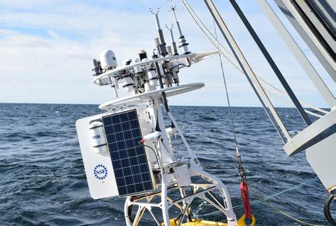
A temporary platform (Fig. 5.4) was built for personnel when working at the height of the surface mooring halo. This provides a stable work platform that can be quickly added to the frame when personnel are completing the build of the mooring and the integration of instrumentation.
CGSN has also utilized a launch and recovery system developed by WHOI for the REMUS AUV that can be containerized and shipped with the vehicle. The Ship of Opportunity Launch and Recovery System (Fig. 5.5) increases handling safety and expands the number of vessels that can be used to deploy and recover the AUV vehicle. This potentially increases the number of opportunities for deployment and also provides common procedures for operation across platforms.
92 OOI Science
OOI
Version 1.1
Plan: Exciting Opportunities using
Data
FIGURE 5.2 Stretch Hose Fairlead. Credit: Don Peters, Woods Hole Oceanographic Instition.
FIGURE 5.3 Halo Bump-Out Design. Credit: Rebecca Travis, Woods Hole Oceanographic Institution.
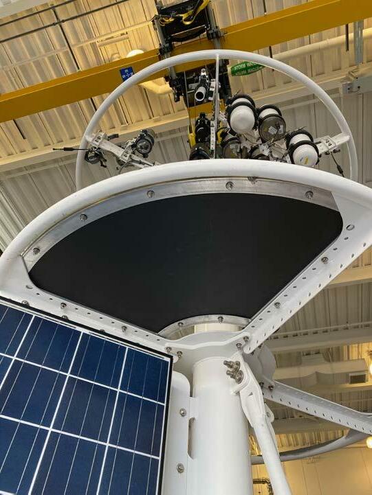
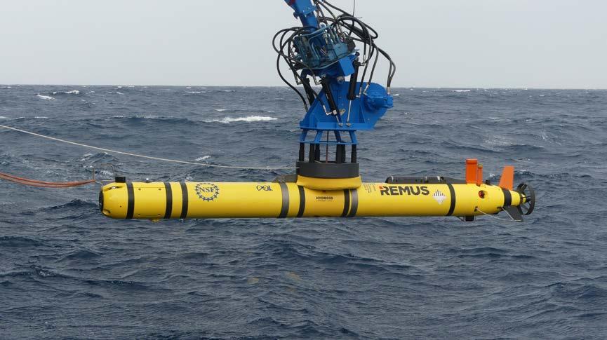
93 OOI Science Plan: Exciting Opportunities using OOI Data Version 1.1
FIGURE 5.4 Tower Temporary Platform. Credit: Kris Newhall, Woods Hole Oceanographic Instition.
FIGURE 5.5 AUV SOO-LARS. Credit: Tina Thomas, Woods Hole Oceanographic Instition.
The Endurance Array team created a lowering release assembly (Fig. 5.6) for deploying MultiFunction Nodes (MFN). It is short to allow for the A-frame to pick up the MFN as far forward on the deck as possible. The light and beacon facilitate completion of deployments at night.
A large custom winch was acquired for the particular needs of each array. For example, the Heavy Lift Winch (Fig. 5.7) is used by both the Endurance Array and RCA to deploy and recover anchors in coastal waters. All of OOI’s large custom winches have been designed to meet UNOLS safety standards.
94 OOI Science Plan: Exciting Opportunities using OOI Data Version 1.1
FIGURE 5.6 Lowering release lifting a mooring’s Multi-Function Node.. Credit: Jonathan Fram, Oregon State University.
FIGURE 5.7 Heavy Lift Winch. Credit: Jonathan Fram, Oregon State University.
SECTION 6. OOI Education: Using Real-World Data from the Ocean Observatories Initiative in Teaching
Janice McDonnell1, Sage Lichtenwalner1, Cheryl Greengrove2, Anna Pfeiffer-Herbert3 and Leslie M. Smith4
1Rutgers University, New Brunswick, NJ, USA
2University of Washington Tacoma, WA, USA
3Stockton University, Galloway, NJ, USA
4Your Ocean Consulting LLC, Knoxville, TN, USA
Engaging students in active learning by modeling the scientific process using real-world data is a high-impact educational practice (O’Reilly et al., 2017; Deslauriers et al., 2019). Working with real data allows students to conduct inquiries that model the actual process of science, facilitating knowledge retention and development of more sophisticated cognitive skills, such as the higher skill levels of Bloom’s taxonomy (Bloom et al., 1956; Krathwohl, 2002). Analyzing data and identifying patterns have become core skills for the 21st century workforce (Oceans of Data Institute, 2015; Partnerships for 21st Century Learning, 2016) and are required for almost all career paths (National Research Council, 2010a; Hubwieser et al. 2015). Expanded access to online data provides educators with a myriad of opportunities to engage learners through the use of real-world data sets, models, and simulations of oceanographic processes.
Since conception of the first OOI Science Plan, the OOI was designed as a research and education platform (ORION Executive Steering Committee, 2005). The same OOI technology, real-time data, and high-speed communication that promised to fundamentally change how ocean science research is conducted can also invigorate science education in the United States. The wealth of freely-accessible data provided by OOI platforms, provides an opportunity to bring these data into classrooms
(Hunter-Thomson et al., 2017; McDonnell et al., 2018) and facilitates the connection between research and education.
These opportunities, however, can be challenging to implement in the classroom. Students often struggle to work with data and visualizations due to their limited experience with different data types, analysis tools, and complex lines of reasoning (Kastens, 2011). Cognitive studies reveal that students often fail to see patterns emerging across scientific experiments and they often ignore anomalous data or distort them to match their personal beliefs (Chinn and Brewer, 1998). By directly manipulating and analyzing data, students are challenged to develop a deeper understanding of a topic or phenomenon. Working with real data helps students develop practical science skills (Hays et al., 2000; Adams and Matsumoto, 2009) as well as an interest in, motivation for, and identity with respect to science (National Research Council, 2015).
In addition, there are technical challenges associated with integrating OOI data into educational applications, due to the large volume of raw data and the inherent complexities of working with real-world data from dynamic environments (McDonnell et al., 2015). For example, the initial effort required to retrieve and manipulate data
95 OOI Science Plan: Exciting Opportunities using OOI Data Version 1.1
is often an entry barrier for many educators. A number of recent initiatives and activities focused on undergraduate education seek to eliminate these barriers and make OOI data more readily accessible to educators and their students through the use of curated datasets and activities that can be directly integrated into lessons.
A. OOI Undergraduate Educational Resources
A summary of OOI resources for undergraduate educators was presented in the March issue of Oceanography (Greengrove et al., 2020). The main purpose of this paper was twofold: 1) to provide educators with the background and materials to begin incorporating OOI data into their own classrooms, and 2) to create a guide of entry points for educators to get involved in the OOI educational community. The paper highlighted examples of OOI data-based lesson plans (https:// datalab.marine.rutgers.edu/tos-lesson-plans/) and activities that were designed and integrated into introductory undergraduate oceanography courses in a range of educational settings at different types of institutions with varied class sizes. Many of these lessons used existing interactive online data exploration widgets (https://datalab.marine. rutgers.edu/explorations/), focused on curated OOI data, covering primary productivity, salinity/ stratification, and underwater volcanism. These activities illustrate key oceanographic processes aligned with course learning objectives, as well as introduce students to the skills of authentic

data analysis. Applications of OOI-based research projects undertaken by advanced undergraduate students were also discussed in the paper. Existing teaching activities were then mapped by undergraduate course levels and Bloom’s taxonomy of cognitive skills to provide an overview of available OOI educational resources and identify gaps for future development (Fig. 6.1).
Since the release of this paper in March 2020, a number of new resources for educators have been developed by the Data Lab team and community collaborators. These include additions to the Data Explorations (https://datalab.marine.rutgers.edu/ data-explorations/), the release of the new OOI Data Nuggets repository (https://datalab.marine. rutgers.edu/data-nuggets/), and a Data Lab Manual ( https://datalab.marine.rutgers.edu/ooi-labexercises/) that will be beta tested in undergraduate oceanography classrooms in Fall 2020.
OOI Data Nuggets are exemplary datasets curated from data collected by the OOI that have been processed, quality controlled, and packaged for use in educational activities. Data Nuggets are designed to explore various concepts common in introductory oceanography courses, with materials cross-referenced to a common undergraduate textbook, as well as upper-level high school Next Generation Science Standards (NGSS). The Data Lab Manual provides detailed instructor guides and assessments built around OOI data explorations that span typical introductory oceanography courses. For more details on current
96 OOI Science Plan:
OOI Data Version 1.1
Exciting Opportunities using
FIGURE 6.1 Matrix of OOI data-driven teaching activities mapped onto undergraduate course level (columns) and level of Bloom’s taxonomy (rows). Figure reproduced from Figure 3 (Greengrove et al., 2020).
OOI educational activities, see the McDonnell and Lichtenwalner sidebar.
These new resources add to the collection of materials available for educators and address a diverse range of oceanographic topics and applications. Topics added include upwelling, hypoxia/anoxia, thermohaline circulation, warm core rings, regional seasonal cycles of primary productivity, diel migration, air-sea CO2 fluxes, airsea interaction, seasonal mixing, turbulent mixing, waves, storms, and tidal induced changes in seafloor geothermal activity. These additional resources also expand applications across the curriculum. For instance, the Data Lab Manual may be most useful for introductory oceanography courses that focus on understanding oceanographic concepts and developing basic data skills (the lower levels of Bloom’s cognitive development), while the Data Nuggets could be adapted for use in upper-level undergraduate classes that address more complex, integrated applications, which incorporate the highest level of cognitive development that involves the processes of evaluation and creation (Fig. 6.1).
While the community of undergraduate educators engaging with the OOI have made excellent progress in developing resources for teaching introductory oceanography concepts and data skills, significant curricular gaps remain in the areas of (1) real-time data access, (2) resources for integrative upper-level oceanography courses, and (3) accessible data science applications. Instructors at all educational levels have interest in bringing in real-time data, as the most up-to-date look into ocean conditions. Though this is not readily accessible in the current OOI system, the new data portal under development improves access and visualizations of a variety of datasets that will allow for better integration. This new data portal will provide the opportunity to augment curated datasets and develop educational user guides that direct students to the real-time data. Upperlevel oceanography courses require the synthesis of multiple datasets to answer oceanographic questions or explore complex phenomena and, therefore, need more advanced tools and supporting educational materials beyond existing
curated datasets and guided activities. For example, Python tutorials that demonstrate how to integrate multiple types of datasets using Jupyter Notebooks and cloud computing (e.g., Google Colabs) could facilitate these explorations. Activities that involve data management and statistical analysis could also be applied more broadly in curricula to support data science curriculum.
B. OOI Education Community of Practice
Keeping existing resources relevant requires sustained effort in growing and supporting a Community of Practice (CoP) of educators where newcomers are supported to join and become more integrated into the community through collaboration and learning with experts and with each other (Lave and Wenger, 1991). For example, the 2020 Ocean Sciences Meeting featured a suite of OOI educational events, including a Data Lab workshop, a “Teaching with Data…” session wherein half of the presentations focused on using OOI data, and the OOIFB town hall that included a presentation of educational applications. Events such as these generate increased interest and help to broaden the OOI educational community. For more details on current activities within the CoP, see the McDonnell and Lichtenwalner sidebar.
C. Recommendations and Future Directions
Since coming online, the real-time data and high-speed communication capabilities of the OOI have provided an incredible opportunity to open new avenues for diverse students and public audiences to interact with and understand the ocean. Though integrating data into classrooms has its inherent challenges and the OOI data add their own layer of complexities, there have been successful initiatives to break down these barriers of entry (Greengrove et al., 2020).
The pursuit toward more fully integrating OOI data and resources into education is critical to the NSF’s overall mission of developing a diverse, globally competitive 21st century STEM workforce, as well as maintaining the vision and promise of OOI’s innovation through the creation of a future user base positioned to
97 OOI Science Plan: Exciting Opportunities
OOI Data Version 1.1
using
ensure high returns on this research investment. Specifically, supporting educators and their students at all levels in building data skills is important to fulfill NSF’s Broader Impacts targets including: full participation of women, persons with disabilities and underrepresented minorities in STEM; development of a diverse, globally competitive STEM workforce; increased economic competitiveness of the United States; and increased public STEM literacy and public engagement with STEM (National Science Foundation, 2018).
To realize this continuing vision, we recommend the following strategic objectives to support the OOI Education Community of Practice:
1. Support an OOI Education and Coordination Office. The primary purpose of the OOI Education and Coordination Office would be to ensure that the OOI education efforts are sufficiently coordinated, coherent, and sustained so the OOI education goals can be achieved. Educators in the Data Labs CoP have very intense teaching schedules and limited institutional support for professional development and need a coordinating office and dedicated team of technical professionals to help them achieve their goals.
2. Support OOI data accessibility and content translation. A team of dedicated professionals, including educators as well as science visualization, technical, and OOI data experts are needed in order to create content and explore new methods for bringing observatory data to students and educators. We suggest facilitating the creation of web- and cloud-based learning resources, including online training modules, interactive visualizations, Python notebooks, etc., in order to fill the curricular gaps such as those identified above. Though educational resources can be generated through grassroots efforts from the educational community, it
will take a team of dedicated professionals led by the OOI Education Coordination Office to regularly provide and maintain resources, as well as support the community in the development and sharing of new resources.
3. Establish an OOI community of peer educator leaders. There is a strong correlation between educator preparedness and student participation in and support of science (NRC, 2010b). Investing in professional development programs is critical for expanding the future scientific workforce and a science-supportive society. Future educators, at all levels, including undergraduate, graduate, K-12, and informal, must be provided with the tools to construct meaningful and coherent curriculum from the vast array of online learning resources that will be available from the OOI. This must be done thoughtfully and systematically, as each of these education communities have different wants and needs. It is imperative that OOI continue to build and expand this community to support the goals and vision established in 2005 (ORION Executive Steering Committee, 2005).
Much remains to be done to fully realize the potential of utilizing OOI data in educational settings. We reiterate the invitation to “join the community to develop, implement, and assess data-based OOI educational resources” and “dive in, build partnerships, and help plumb the depths of the OOI data set to find new and relevant ways to engage students with the data that can be shared as new activities to benefit educators and students at all institutions” (Greengrove et al., 2020).
Note: The recommendations presented above represent the opinion of the Section 6 authors.
98 OOI Science Plan:
OOI Data Version 1.1
Exciting Opportunities using
siDEbar: The Data Labs Project: Building a Community of Practice Using OOI Data
 Janice McDonnell and Sage Lichtenwalner Department of Marine and Coastal Sciences, Rutgers University, New Brunswick, NJ, USA
The overall goal of the Data Labs project is to expand the community of professors effectively utilizing OOI data in their classrooms. Through the continued development of content, in-person and online courses, and tutorials, the project aims to develop leaders who are excited about engaging students with OOI data. The project works with professors and practitioners to refine our model for teaching with data, build a critical mass of resources, and share effective practices within the community.
The Data Labs project focuses on providing experiences and building expertise with three distinct audiences
1) OOI education leaders trained to help facilitate a community of practice;
2) professors who teach undergraduate level oceanography courses; and
3) undergraduate students. Specifically, the project develops and implements professional development programs that promote access to existing tools and support the development of additional resources. The overall goal of these sustained professional development opportunities are to facilitate communication and
the sharing of ideas and teaching practice, while building an OOI focused Community of Practice (CoP) (Lave and Wenger, 1991).
The project, which began in 2018, has several interwoven components (see Figure 6.2) that are ultimately designed to engage, train and develop undergraduate professors who teach undergraduates in OOI. Here we further describe these components:
Build a Comprehensive Database: The Data Labs project started with the assembly of a comprehensive database of undergraduate professors at primary undergraduate institutions (PUI), Historically Black Colleges and Universities (HBCU), Community Colleges (CC), and universities who teach introductory oceanography classes. Our goal was to identify a strong estimate of the total number of professors who could participate in our Data Labs project. We used a baseline list from the Consortium for Ocean Leadership that included a list of institutions engaged in oceanography. We supplemented this with lists from Carleton
99 OOI Science Plan: Exciting Opportunities using OOI Data Version 1.1
FIGURE 6.2 A timeline of the Data Labs project as it supports use of OOI data in teaching. A timeline of the Data Labs project as it supports use of OOI data in teaching.
College, the Community College Undergraduate Research Initiative (CCURI), the COSEE Pacific Partnerships (COSEE-PP), and the NSF funded Faculty as Change Agents project. We believe we have a reasonable estimate of the total number of potential (n = 493) community college, PUI, and HBCU professors across the country teaching Oceanography 101. Our first newsletter was initially sent to the entire mailing list, and we then asked those interested in joining the community to sign up to newsletter list. As of the summer of 2020, we have over 250 members.
Development Workshops: In 2019, we offered four workshops focused on the process of designing new Data Labs. Over the 4.5 day workshop, participants developed new Data Lab activities using OOI data. In total 58 professors from 53 institutions attended these four workshops offered around the country. They designed and implemented a sequence of learning experiences to support undergraduate student comprehension of oceanography content and concepts and later supported students in understanding OOI data through classroom implementations.
Implementation Workshops and Webinars: We offered professional development workshops (1-2 day program) to help professors learn how to use previously developed Data Labs. Workshops included the Earth Science Rendezvous (July 2019) presented by the Data Lab team and members of the Development Workshop (March 2019) cohort. A second implementation workshop was offered at the February 2020 Ocean Sciences Meeting (OSM) in San Diego, CA. This workshop was presented by the Data Lab team and members of the Development Workshop cohort (March, June, and July 2019). Thirty-two participants from across the US, as well as several other countries (including Mexico, Norway, Brazil, France, Italy and Australia), attended the OSM 2020 workshop. We discussed the origins and scientific potential of the OOI, and participants had a chance to explore the OOI Data Explorations collection. Six Data Labs “alumni” were also on hand to share their experiences creating and using Data Lab resources in their classrooms.
In addition, we offered a webinar series to introduce new Data Labs to the larger community. To date, eleven alumni from the Development Workshops have shared their experiences developing and using Data labs in their classroom to their peers through virtual ZOOM meetings.
Fellowship Program: We designed and implemented a Fellowship program. We issued a Request for Applications and selected 11 of 22 applicants for the program (See https://datalab. marine.rutgers.edu/community-map/ for a complete map of the community). We conducted a webinar training for the 11 fellows and set up a project management system (Basecamp) to encourage cross collaboration during spring 2020. Seven of the fellows are focused on implementing a Data Lab(s) in their classrooms and providing student evaluation results. Four of the fellows are working on developing Python notebooks with OOI datasets for the benefit of the community. This part of the project was impacted by COVID-19, as all of the fellows had to pause their data collection due to the health crisis and shutdown.
Data Lab Manual Program: One of our participants from the June 2019 cohort suggested we develop an online laboratory manual that sequences the Data Labs for professors who are less familiar with them, into an online open sources laboratory manual. In January 2020, we conducted a development workshop with a group of 11 professors and alumni from previous programs. With Data Lab Alumni Drs. Anna Pfeiffer-Herbert and Denise Bristol, we are conducting a field trial of the Manual in Fall 2020. We have found that with the pandemic, there is more interest than ever in our online Manual product.
Virtual REU program: In summer 2020, we supported a cohort of ten undergraduate students in a virtual Research Experiences for Undergraduates (REU) program. Because of the pandemic, undergraduate students were displaced from their scheduled REU programs. We offered a two-week professional development, in partnership with the Rutgers RIOS program, followed by six weeks of independent study with
100 OOI Science
Version 1.1
Plan: Exciting Opportunities using OOI Data
a research mentor. We concluded with a two-day research symposium- see https://datalab.marine. rutgers.edu/2020-virtual-reu/ for a list of posters and session materials.
Development of a Community of Practice
The Data Lab project has been successful in building a true Community of Practice (CoP). Results from Reach Study evaluation interviews conducted approximately six months after the development workshops show:
• Respondents see value in using Data Lab activities in Summer 2020 and beyond, especially given the possibility that some or all of their teaching may be online.
• Many respondents will need additional supports to use Data Lab activities in their classrooms.
• Many respondents indicated that their involvement with the Data Labs project has changed the way in which they teach.
We have begun to build a strong community of professors who are actively involved in developing new Data Lab classroom activities that focus on data. Here are a few examples of outcomes related to the Data Labs project:
• One participant successfully applied and received an Improving Undergraduate STEM Education (IUSE) NSF award to conduct educational research on using Data Labs in undergraduate classrooms.
• Two participants have taken the lead (as editors) of the Data Lab Manual and are starting to become peer leaders in the Data Lab program.
• Two 2018 early career workshop participants are submitting an NSF Research Coordiantion Network (RCN) proposal to help expand research applications of OOI data.
101 OOI Science Plan: Exciting Opportunities using OOI Data Version 1.1

102 OOI Science Plan: Exciting Opportunities using OOI Data Version 1.1
FIGURE 6.3 A sable fish rests atop a digital still camera about to be recovered from the Oregon Shelf site (80 m water depth). As you can see, these waters are highly productive, hence the cabled cameras that stream images to shore live, are turned each year. Credit: UW/NSF-OOI/WHOI.V20.
SECTION 7. Community Engagement
The OOI was conceived as a community resource, as a means to provide scientists, educators, students, and others interested in the ocean with a steady stream of reliable ocean data without having to go to sea. Since its inception, the OOI has successfully built the infrastructure to collect and deliver a plethora of data via the Internet, while developing a robust effort to engage the community and encourage use of OOI data in science and in the classroom. The OOI team continually strives to optimize the OOI, build a robust, active, and inclusive community, and cultivate new users.
Many avenues are used to engage with OOI data users and potential data users. Such community engagement begins with a digital presence. All relevant updates and information for the OOI community are posted on its website and shared on many social media channels. Tools are provided on the website, including a brand new data discovery tool, that helps users find, download, and integrate OOI data to help answer science questions. And, if and when users get stumped, the OOI has a HelpDesk, with a committed staff who will work to resolve any and all problems using OOI data.
The OOI also engages with community members by being an active part of the oceanographic community. Team members from each of the implementing organizations (Woods Hole Oceanographic Institution, University of Washington, Oregon State University, and Rutgers, The State University of New Jersey) share progress about the OOI and what is being learned from OOI data at conferences and workshops attended by many in the broader oceanographic community, as well as in their localities. By presenting seminars, webinars, and posters, the OOI team seeks to encourage discussion and collaboration with those
who might benefit from OOI data. The OOI team also makes a concerted effort to be an integral and important resource for organizations such as the University-National Oceanographic Laboratory System (UNOLS), U.S. Integrated Ocean Observing System (IOOS), Global Ocean Observing System (GOOS), Ocean Networks Canada (ONC), Scientific Committee on Oceanic Research (SCOR), and the Integrated Ocean Discovery Program, as well as others in the data science community.
To build a robust and thriving community requires participation by early career scientists who will support the OOI moving forward. The OOI actively supports a cohort of early career scientists who are working to develop a community of practice via a Slack channel community. The OOI team also strives to showcase the work of early career scientists by inviting them to present their work at Town Halls coordinated by the Ocean Observatories Initiative Facilities Board (OOIFB) and digitally sharing their findings with the OOI community. Many early career scientists have taken advantage of opportunities to be aboard OOI operation and maintenance cruises to conduct sampling that will directly advance their research, potentially supporting their career advancement. Over 160 undergraduate students have participated on OOI RCA expeditions as part of the UW VISIONS experiential at-sea learning program. In addition to first-hand learning of seagoing activities focused on the installation and recovery of OOI infrastructure, students also develop engagement and science projects focused on the OOI: some of which result in Senior Thesis projects. OOI data are ripe for inclusion in PhD theses and Research Experience for Undergraduate projects. OOI at-sea experience also is available to graduate students
103 OOI Science Plan: Exciting Opportunities using OOI Data Version 1.1
OOI Science Plan: Exciting Opportunities using OOI Data Version
through the UNOLS Cruise Opportunity Program. If berths are available during an OOI’s deployment/ recovery cruise, the OOI operator will list the cruise on the UNOLS webpage inviting student participation. Through this program, students have been able to gain first-hand experience with the complex at-sea operations required to maintain OOI’s systems.
The OOI works in partnership with the NSFfunded Ocean Data Labs (see Section 6), which is developing, testing, refining, and disseminating easy-to-use, interactive Data Explorations and Data Lab Notebooks. These tools allow undergraduates to use authentic data in accessible ways, while being easy for professors to integrate into their teaching. OOI helps disseminate and promote the use of these materials as a means to effectively integrate OOI data into classrooms. In addition, the RCA team collaborates with people in UW Computer Sciences in the development and implementation of the UW Cloud-hosted interactiveoceans educational website and data portal. This site provides significant add-on value to the oceanobservatories.org site through detailed site and instrumentation descriptions, over 3000 images of at-sea work, OOI infrastructure, and the deep sea. The highly interactive Cloud-based data portal, using M2M capabilities on OOINET, harvests data from 153 instruments and 653 streams from cabled and uncabled OOI instruments on the RCA and Endurance Arrays and allows exploration and advanced visualization
capabilities, as well as Ocean Sciences Notebooks utilizing Python that allows users to work through data exploration and visualizations with full access to the underlying code.
The OOI team has also supported several community hackweeks led by the eScience Institute at the University of Washington. These include a hackathon focused on the RCA, and two NSF-supported Oceanhackweeks. During these intense, 5-day collaborative learning workshops, through a series of tutorials and hands-on learning, participants learn to create data exploration and software tools implemented for collaborative projects focused on myriad ocean science questions. A key example of a

104
1.1
FIGURE 7.1 OOI experts share information at the OOI Exhibit booth at the 2020 Ocean Science Meeting. Credit: Darlene Trew Crist, Woods Hole Oceanographic Institution.
community-generated tool from these hackweeks is an open source Python program that allows users to interact with bioacoustic sonar data, without the previous need to acquire expensive industry provided software tools.
To effectively continue to build a robust OOI data user community requires the efforts of many parties—NSF OOI program managers, members of the OOIFB, and members of OOI’s primary management team and implementing organizations.
Each of these entities is committed to ensuring that OOI data is a staple part of oceanographic research and education moving forward, serving as the key to ocean insights and understanding of ocean processes.
siDEbar: OOI: Access to the Oceans from ‘World’s’ Away
Rachel Scott, School of Oceanography, University of Washington, Seattle, WA, USA
This is a story of how a small-town farm child came to find herself in the middle of the ocean (literally) and a program that altered her course in life.
Nature, especially the water, was both a solace and an escape for me as a child, especially when my alcoholic parents made life difficult. As a child growing up in the remote corner of Eastern Washington, I spent a significant amount of my childhood in our acres of woods, wandering about our farm collecting rocks, or investigating the creek and pond on our property; I adored being outside. When I was not in nature, I was ‘that’ dorky little kid who was insatiably enthralled with anything concerning the natural world. I was always glued to the television during Discovery Channel‘s Shark Week or NOVA. I always wanted to build a life around the sea, in every regard, and by early adolescence I discovered that studying the ocean through some form of higher education was the way I wanted to go, even though college seemed like an impossibility throughout my younger years.
Although drive and direction were there, studying the ocean and attending college proved to be more difficult for me than most would presume. The first big change occurred when my mother passed away and my father surrendered his rights
to myself and my four siblings in 2009, legally orphaning me and leaving me to enter foster care just shy of 13 years old. Nearly 5 years after the loss of my parents and still craving the promises a higher education could bring, I set my sights on attending the University of Washington (UW), a public university with a renowned oceanography program. At this time, I began to understand that all I had been through thus far in life was building to something greater than anything in my childhood dreams.
More changes flooded my life in 2014 after my acceptance to UW and as I began my journey into oceanography. In the fall of 2014, the School of Oceanography at UW changed my life as it quickly became my new home: a consistent, loving, accepting, encouraging environment to grow in – the stuff homes are made of that I had never known. Almost every day since I started college in 2014 (going on 7 years now), I returned to the same buildings, saw the same folks, and felt the same sense that I had found my heaven on Earth, a place I wanted to be and belonged.
My life was dramatically changed the summer of 2018 when I sailed as part of the UW’s VISIONS’18 at-sea experiential learning program as part of NSF’s OOI Regional Cabled Array (RCA)
105 OOI Science Plan: Exciting Opportunities using OOI Data Version 1.1
maintenance cruise. Sailing with the team was my first at-sea experience and I intended to learn all I could, in case it was my only time to be at sea. The mentality of hard work and determination proved worth it as my now boss, then mentor, Deb Kelley, invited me to work with and sail with the team in the following year, and to also do my senior thesis work under her guise utilizing RCA data to explore science questions in the NE Pacific. My thesis research was my exploration of real-time data that the submarine internet-connected observatory had been collecting since 2014, data I would later help to manage. For my thesis, I had the opportunity to investigate data from some of our most unique sensor platforms: Instrumented Shallow Water and Deep Water Profilers (Fig. 7.2 and Fig. 7.3).
Throughout the process, I learned more about myself, the team, and what it takes to operate this facility than I could have ever imagined.
Just over a year later and the changes Deb brought to my door (literally providing me my first office of my own) are still having profound effects: I am now a full-time member of the OOI RCA Team, with a future I am tremendously excited to grow into. Through end-to-end experiences spanning ship to onshore and expansion of data evaluation skills (e.g. python and other programming languages, data visualizing techniques, etc.), I have gleaned more knowledge on more topics than I can count (instrument preparation and deployment procedures, data QA/QC, working with a team, etc.). In one fell swoop, Deb provided me with the foundation needed to build a life on, a foundation to construct the future I desired, an opportunity to build with the team, and to develop as both a human and a scientist; because of the RCA I found a home within a home.
My unimaginable childhood dream culminated in the summer 2019 after I graduated, when I joined
the RCA maintenance expedition (VISIONS’19) and a follow-on NSF-funded science cruise “Pythias Oasis” (a methane seep site like no other found in the worlds’ oceans), this time not as a student, but as a critical member of the RCA team, my team. This summer I am excited to continue to help as shore support for the VISIONS ’20 cruise. Without the support of, and experiences provided by the school of Oceanography, NSF’s Ocean Observatories Initiative, and the RCA, I have no idea where I would be. Growing up landlocked and disenfranchised does not set one up for a life of success, nor a life in academia; without the help and support of these institutions, my prospects of building a life around the ocean would have been very bleak. Importantly, these experiences have brought home the important recognition that the OOI facility helps bring the ocean directly to folks like me who may never have the chance to see these environments, to explore the waves, and what goes on below.
Becoming an oceanographer was my way of leaving my past behind, staring straight into my future, and beginning anew; I have tried to take all of my experiences and use them as fuel to propel me into my future and become someone I am proud of. Being involved in OOI and working with the RCA team has allowed me to excel in ways I never even dreamed – as a kid, a sad truth I lived with is I didn’t know how long I would last; it has been over a decade since my mother passed and I entered foster care and I can now firmly say that I have a long bright future ahead of myself. I look forward to seeing what OOI brings to my future and to sharing it with kids who are only now dreaming of the ocean from a world away.
106 OOI Science Plan: Exciting Opportunities using OOI Data Version 1.1

107 OOI Science Plan: Exciting Opportunities using OOI Data Version 1.1
FIGURE 7.2 Visualization of temperature across depth and time from Shallow Water (top) and Deep Water (Bottom) instrumented profilers at Axial Base. Although Shallow Water and Deep Water profiling platforms collect data at different rates, they can be used to visualize the same ocean parameters. The combination of both profiling platforms at Axial, provide the only place in the oceans where a nearly continuous record of ocean parameters spanning 2600 m of water is achieved.

108 OOI Science Plan: Exciting Opportunities using OOI Data Version 1.1
FIGURE 7.3 Visualization of temperature across the same time range for different depth ranges. Shallow Water Profilers profile from ~5 m to 200 m below the sea surface; Deep Water Profilers profile from ~150 m to 2900 m below the sea surface. These two sensor platforms can be used to investigate parameters throughout the full water column depth.
SECTION 8. National and International Partnerships and Collaborations
A. National Partnerships and Collaborations
There are important partnerships within NSF programs and other oceanographic institutions. EarthScope is an Earth science program using geological and geophysical techniques to explore the structure and evolution of the North American continent and underlying mantle. This program compliments observations from the OOI’s RCA spanning the Juan de Fuca tectonic plate and overlying water column. Key sites focus on the Cascadia Margin where the downgoing Juan de Fuca Plate causes deformation and earthquake rupture along the Cascadia Subduction Zone. Both programs contribute data to the Incorporated Research Institutions for Seismology (IRIS) database that partners with the Pacific Northwest Seismic Network (PNSN). The National Ecological Observatory Network (NEON) uses distributed sensors to provide highquality information on interactions between land, freshwater, life, and climate across a continent that can tie into OOI’s observations. Proposals are now pending with the International Ocean Discovery Program (IODP) to establish several new cabled, corked, and instrumented observatories on Axial Seamount and across the Cascadia Margin and subduction zone. The proposed continuous, downhole measurements would provide new insights into the hydrogeology of the ocean crust, the subseafloor biosphere, and deformation across the subduction zone off Oregon. In addition, the Monterey Accelerated Research System (MARS)
cabled test bed was constructed by the Monterey Bay Aquarium Research Institute (MBARI). MARS serves as a test bed for instruments and operational procedures for the OOI and the ocean science community in general.
The mission agencies, National Oceanographic and Atmospheric Administration (NOAA) and the National Aeronautics and Space Administration (NASA), have partnerships with the OOI in a number of ways. NOAA is the lead agency for the U.S. Integrated Ocean Observing System (IOOS), which was designed to provide coordinated ocean data products for decision makers from federal, regional, state, local, and private groups in support of societal and national goals. The research-driven OOI is NSF’s contribution to IOOS, and supports IOOS through the development of novel platforms and instruments, Best Practices, data assimilation and data management techniques, as well as by advancing understanding of ocean phenomena, which are critical to accurate predictions and forecasts that are important to society. OOI collaborates with the IOOS’ Regional Associations where arrays are co-located [e.g., Northwest Association of Networked Ocean Observing Systems (NANOOS); Northeastern Regional Association of Coastal Ocean Observing Systems (NERACOOS)]. The OOI also contributes glider data to NOAA’s IOOS glider Data Assembly Center (DAC) and surface meteorological data to the National Data Buoy Center (NDBC). There are plans to contribute pH, pCO2 and related data to the Global Ocean Acidification
109 OOI Science Plan: Exciting Opportunities using OOI Data Version 1.1
Observing Network (GOA-ON) Data Portal. The OOI partners with NOAA’s Pacific Marine Environmental Laboratory (PMEL), who deploy and maintain the surface mooring at Ocean Station Papa, while CGSN deploys and maintains the hybrid profiling mooring, two flanking moorings, and the gliders at the Papa site. In addition, the NOAA Tsunami Research Center is implementing a test program to incorporate real-time pressure data from the RCA to provide offshore information about tsunami events. Also NOAA, through the PMEL, funds annual ROVcruises to Axial Seamount. The results from these cruises complement OOI data and environmental characterization of this submarine volcano, which is poised to erupt again.
NASA is committed to studying climate change on Earth and life on other planets. NASA’s satellite programs are an important complement to all ocean observing systems, including the OOI Network. Observations from satellites are primarily limited to measuring a suite of properties at the air-sea interface and in the nearsurface ocean. The OOI Network will provide a larger suite of subsurface time-series data. OOI data could be a source of in-situ data for NASA ocean color calibration, validation, and bio-optical algorithm development activities. Conversely, remote sensing data products may be used to validate OOI data. NASA’s EXPORT program in the north Pacific made use of the Global Array at Station Papa. In addition, NASA funded Principal Investigators (PIs) have built a state-of-the-art Raman and stereo imaging platform (InVADER) for installation on the RCA in 2021, in anticipation of future exobiology space missions (see Section 8.D).
Long term U.S. Navy funding of the oceanographic community has contributed to the development of technologies and methodologies being integrated into the OOI. Examples include the development of mobile platforms (AUVs and gliders), energy extraction systems, research ships, and command/control of remote systems. The OOI, in turn, will provide data and knowledge essential to operations in the world ocean. The
Navy’s historical responsibility for ensuring freedom of the seas will depend increasingly upon access to oceanographic data, information, and global predictions.
B. International Partnerships and Collaborations
Ocean Networks Canada (ONC, https:// www.oceannetworks.ca) has cabled and uncabled observatories in coastal waters and offshore of Vancouver Island, British Columbia on the northern Juan de Fuca plate and in the Arctic. The OOI’s RCA was designed to complement the ONC cable geometry by providing coverage of the southern Juan de Fuca plate. Committee memberships for both observatories share personnel to ensure close coordination. The Fisheries and Oceans Canada (DFO) Institute of Ocean Sciences (IOS) in British Columbia has made observations in the Gulf of Alaska at the Station Papa site for decades and will continue to provide additional field sampling to verify OOI sensor measurements at that site.
IOOS (and the OOI) is the US’ contribution to the international Global Ocean Observing System (GOOS) (https://www.goosocean.org), and GOOS contributes to the international Global Earth Observation System of Systems (GEOSS) (https://www.earthobservations.org/ geoss.php). GEOSS was created to integrate observing systems and share data by connecting existing infrastructures using common standards. The OOI has contributed to GOOS’ Deep Ocean Observing Strategy (DOOS), which includes a global network of deep ocean observing sites.
As part of these activities, the OOI’s Global Array sites have been included in OceanSITES (http://www.oceansites.org) planning. OceanSITES is a worldwide system of long-term, openocean reference stations and are a part of GOOS. The OOI Global Array in the Irminger Sea also collaborates with the international Overturning in the Subpolar North Atlantic Program (OSNAP). The Irminger Sea Flanking moorings are in line with OSNAP moorings on the eastern side of Greenland, with common instrumentation, and
110 OOI Science
OOI Data Version 1.1
Plan: Exciting Opportunities using
operations and maintenance cruises are shared to service OOI and OSNAP moorings. OSNAP is a partner in the North Atlantic Virtual Institute (NAVIS), which connects science teams around the world studying climate variability and change in the North Atlantic. Data from the Southern Ocean Global Array have been integrated into the World Meteorological Organization’s (WMO) Global Telecommunication System (GTS) via NOAA’s National Data Buoy Center, making these data more easily accessible for weather forecasters and modelers. These data contributed to an international effort to improve environmental prediction for polar regions and beyond known as the Year of Polar Prediction (2017 to 2019), which was organized by the WMO. During this time period, the OOI Southern Ocean Array was a partnership between the OOI and the UK’s National Environmental Research Council. A UK PI also tested a novel sensor to measure silicate and nitrate using “lab-on-a-chip” technology on the Southern Ocean Surface Mooring, as part of the Carbon Uptake and Seasonal Traits in Antarctic Remineralisation Depth (CUSTARD) program. The OOI Network’s advanced capabilities play a critical role in supplying data, information technology, and knowledge for all of these global efforts.
C. Partnerships with Industry
The University of Washington RCA partnership with L3 MariPro was highly successful, playing a large part in the on time and under budget complete installation of the cabled observatory in 2014. In 2009, L3 MariPro was awarded the $76 M contract to design, build, and install the Primary Infrastructure for the submarine array (then known as the Regional Scale Nodes). This included ~ 900 km of high power and bandwidth backbone cable, the seven Primary Nodes, installation of the subsea conduit to the Shore Station in Pacific City, and build out of the shore station, with high power feed equipment and development of the sophisticated management and alert- alarm system for the array. Other examples of partnerships with industry include the development of profiling moorings
(see Section 4.2.2) and on-going endeavors to improve instrumentation and platforms (see Section 5).
D. Externally-Funded Instrumentation
A key mark of success for OOI has been the growth in community-provided instrumentation and associated field programs through funding outside of OOI. This capability was encouraged by NSF after commissioning of the “system of systems.” The RCA has had significant success in attracting new instrumentation and platforms. As of 2020, over $28 M of external funding has been awarded (not including myriad related field programs) to Principal Investigators to add cabled infrastructure onto the RCA and to conduct associated science and education. Over 50 awards (PI and Co-PI subawards) have been made to over 60 PIs and Co-PIs, representing over 28 institutions, and two to industry through NSF, the Office of Naval Research, NASA and the German Federal Ministry of Education and Research. Programs focus on creating/testing/ installing state-of-the-art geodetic instruments on Axial Seamount, with implications for adaptation to measure deformation along the Cascadia Subduction Zone-Margin, extraction of energy from hydrothermal vents, and a several year program (MARUM, University of Bremen) at Southern Hydrate Ridge (see Marcon sidebar). The Hydrate Ridge program includes the addition of an overview multibeam sonar that scans the entire summit of SHR for rising bubble plumes every two hours and a very high resolution sonar, which for the first time will quantify flux of methane from the seafloor, a 4K camera, and a CTD. Efforts also include a multi-year effort funded through the NASA Planetary Science and Technology from Analog Research (PSTAR) award (InVADERhttps://invader-mission.org/) to the SETI institute, the Jet Propulsion Laboratory, the UW/APL, and others to install three raman spectrometers and extremely high resolution stereo cameras on a large platform adjacent to an active hydrothermal vent at the summit of Axial Seamount. Mission testing and response-adaptation capabilities will be explored using the high power and real-time
111 OOI Science Plan: Exciting Opportunities using OOI Data Version 1.1
data flow capacity of the RCA. In concert, these data will be utilized to bridge Earth studies and mission concepts to explore for life on other water bodies in the solar system (e.g. Europa and Encelidus). High end visualization and modeling to create a “virtual world” of the vent is also a component of this award.
In 2016, a research team from the UK National Oceanography Centre (NOC) was funded by Natural Environment Research Council (NERC) to add instrumentation to the CGSN Global Southern Ocean Array Surface Buoy as a part of the CUSTARD (Carbon Uptake and Seasonal Traits in Antarctic Remineralisation Depth) project. The primary instrumentation to be added were Nitrate and Silicate sensors. In December 2018, a joint NSF and NERC cruise, using the RRS DISCOVERY, deployed the CGSN Surface Mooring with the integrated NOC sensors and an additional PCO2 sensor. Data from all sensor packages were received and monitored by the CGSN team in near real-time for the full operational period of the mooring. Following a successful deployment of ~12 months, the CGSN Surface Mooring was recovered in January 2020.
In 2018, CGSN collaborated with a PIs from the Biological Carbon Pump (BCP) program. The BCP proposal, funded by the NSF, was to observationally constrain the annual magnitude and seasonal timing of the biological carbon pump (determined as annual net community production; ANCP) and its influence on air-sea
carbon dioxide flux by using biogeochemical sensor measurements from the CGSN Irminger Sea Array. However, the existing CGSN oxygen sensor calibration suffers from both pre- and postdeployment drift, currently precluding the ability to calculate ANCP by oxygen mass balance. The PIs proposed to improve the accuracy and utility of CGSN Irminger Sea oxygen measurements by deploying two gliders configured for air calibration of their oxygen sensors when surfacing between profiles. These air-calibrated gliders would be used to inter-calibrate all 12 existing oxygen sensors on the Irminger Sea Array and produce a calibrated oxygen product incorporating data from all sensors, which would ensure sufficient accuracy to calculate ANCP. Starting in June 2018, a dedicated BCP glider and a CGSN glider were adapted to include top mounted oxygen sensors and deployed at the Irminger Array. For a second deployment in July 2019, the oxygen sensor mounting location was updated to provide better clearance and measurements when at the surface. In 2020, following successful completion of the BCP deployments, a design update was approved by the NSF to enable deployment of air-side oxygen sensors on the whole OOI glider fleet.
112 OOI Science Plan: Exciting Opportunities using OOI Data Version 1.1
SECTION 9. Interested in adding instruments or platforms to the OOI?
The National Science Foundation, Division of Ocean Sciences funds proposals through its core programs and encourages scientists, educators, and students to investigate science questions using OOI data, propose ancillary process cruises that will also make use of OOI data, or propose to use OOI data in the classroom to help inform and educate students and address scientific questions. For OOI program-specific proposal questions, scientists should email NSF OOI representatives at ooi-science@nsf.gov. To address specific research questions, PIs may propose to modify sampling approaches of core instruments and infrastructure, but ideas should be discussed in advance with the OOI Program by contacting the OOI Help Desk. Researchers interested in adding new instrumentation to the OOI network must work with OOI operators during the proposal process to conduct a technical feasibility assessment. Information on this process can be found at https:// oceanobservatories.org/adding-instruments-or-
platforms/. It is essential to ensure new platforms and instruments operate properly when interfaced with OOI infrastructure and do not cause any adverse effects to the existing infrastructure. PI-supplied platforms and instruments must be delivered to the operators several months prior to deployment to ensure sufficient time for integration and testing. Researchers interested in adding additional ocean observing equipment in the vicinity of OOI sites are strongly encouraged to contact the OOI in advance to mitigate technical conflicts or permitting issues. Lastly, there are opportunities for researchers, educators, or students to participate on OOI cruises to obtain research data or for an at sea learning experience. To learn more about shipboard opportunities see the OOI website (https://oceanobservatories.org/ cruise-participation/) and/or contact the OOI Help Desk.
113 OOI Science Plan: Exciting Opportunities using OOI Data Version 1.1

114 OOI Science Plan: Exciting Opportunities using OOI Data Version 1.1
FIGURE 9.1 Glider deployment. Credit: Station Papa Science Team.
SECTION 10. Concluding Remarks
Ocean observing systems are essential for advancing the frontiers of knowledge on oceans and Earth sciences. The Science Questions provided in this document are only a starting point, as there are an almost unlimited number of science questions that could be addressed using OOI data. The sidebars provide some examples of exciting science currently being pursued and we hope that they will, in turn, inspire new ideas and approaches for research and education. Although the OOI network has only been in operation for about four years, it has already demonstrated success, based on the number publications using OOI data and federal funding for OOI-related science. OOI technology, real-time data, and high-speed communication are invigorating
both ocean research and science education. The novel technologies are enhancing our ability to capture and understand transient and long-term phenomena. Partnerships and collaborations with other science programs, industry, among federal agencies, and with international groups are also critical to the success of the OOI. The OOI will continue to encourage transformations in our scientific interactions, in the complexity of our investigations, and help inform society on how to respond to important environmental issues. In the coming decades, the OOI program will continue to energize the public’s ability to share in discoveries, insights, and excitement about understanding the ocean.

115 OOI Science Plan: Exciting Opportunities using OOI Data Version 1.1
FIGURE 10.1 The RCA cabled digital still camera, redeployed in 2015 by the Canadian ROV ROPOS, lights up the active hydrothermal vent called El Gordo in the interantion District Hydrothermal Field, located at the summit of Axial Seamount nearly a mile beneath the ocean surface. Credit: UW/NSF-OOI/CSSF.
References
Adams, K. A., J. A. Barth, and F. Chan. 2013. Temporal variability of near-bottom dissolved oxygen during upwelling off central Oregon. J. Geophys. Res. Oceans 118, 4839–4854. https://doi.org/10.1002/jgrc.20361
Adams, L.G., and G. Matsumoto. 2009. Commentary: Enhancing ocean literacy using real-time data. Oceanography 22(2): 12–13. http://dx.doi.org/10.5670/oceanog.2009.55.
Amaya, D.J., Miller, A.J., Xie, S. et al. 2020. Physical drivers of the summer 2019 North Pacific marine heatwave. Nat Commun 11, 1903.
Andres, M. 2016. On the recent destabilization of the Gulf Stream Path downstream of Cape Hatteras. Geophys. Res. Lett., 43, 9836–9842. https://doi. org/10.1002/2016GL069966
Arnulf, A. F., A. J. Harding, G. M. Kent, S. M. Carbotte, J. P. Canales, and M. R. Nedimović. 2014a, Anatomy of an active submarine volcano. Geology, v. 42, 655-658.
Arnulf, A. F., A. J. Harding, G. M. Kent, and W. S. D. Wilcock. 2018, Structure, Seismicity, and Accretionary Processes at the Hot Spot-Influenced Axial Seamount on the Juan de Fuca Ridge. J. Geophys. Res. v. 123, 4618-4646.
Arnulf, A. F., Harding, A. J., Saustrup, S., Kell, A. M., Kent, G. M., Carbotte, S. M., Canales, J-P, Nedimovic, M. R., Bellucci, M., Brandt, S., Cap, A., Eischen, T. E., Goulain, M., Griffiths, M., Lee, M., Lucas, V., Mitchell, S. J. and Oller, B. 2019. Imaging the internal workings of Axial Seamount on the Juan de Fuca Ridge. In AGU Fall Meeting Abstract OS51B-1483, San Francisco, CA.
Barth, J.A., J.P. Fram, E.P. Dever, C.M. Risien, C.E. Wingard, R.W. Collier, and T.D. Kearney. 2018. Warm blobs, low-oxygen events, and an eclipse: The Ocean Observatories Initiative Endurance Array captures them all. Oceanography 31(1):90–97. https://doi.org/10.5670/ oceanog.2018.114.
Bernatis, J. L., S. L. Gerstenberger, and I. J. McGaw. 2007. Behavioural responses of the Dungeness crab, Cancer magister, during feeding and digestion in hypoxic conditions. Mar Biol 150, 941–951. https://doi.org/10.1007/ s00227-006-0392-3
Bloom, B.S., M.D. Engelhart, E.J. First, W.H. Hill, and D.R. Krathwohl. 1956. Taxonomy of Educational Objectives: The Classification of Educational Goals: Handbook I. Cognitive Domain. David McKay Company, NY, 216 pp.
Bohrmann, G. 2019. Long-Term Monitoring of Gas Emissions at Southern Hydrate Ridge. Abstract OS51A-04 presented at 2019 FallAGU Meeting, San Francisco, CA, 9-13 Dec.
Bond, N. A., M. F. Cronin, H. Freeland, and N. Mantua. 2015. Causes and impacts of the 2014 warm anomaly in the NE Pacific. Geophys. Res. Lett. 42, 3414–3420.
Boyd, P. W., H. Claustre, M. Levy, D. A. Siegel, and T. Weber. 2019. Multi-faceted particle pumps drive carbon sequestration in the ocean. Nature 568(7752), 327–335. https://doi.org/10.1038/s41586-019-1098-2
Brierley AS. 2014. Diel vertical migration. Current Biology 24(22): R1074-R1076.
Briggs, N., M. J. Perry, I. Cetinić, C. Lee, E. D’Asaro, A. M. Gray, and E. Rehm. 2011. High-resolution observations of aggregate flux during a sub-polar North Atlantic spring bloom. Deep-Sea Research Part I: Oceanographic Research Papers 58(10), 1031–1039. https://doi. org/10.1016/j.dsr.2011.07.007
Carbotte, S.M., A. Arnulf, M. Spiegelman, M. Lee, A., Harding, G. Kent, J. P. Canales, M. R. Nedimović. 2020. Stacked sills forming a deep melt-mush feeder conduit beneath Axial Seamount. Geology, 48, https://doi. org/10.1130/G47223.1
Carter, G. S., M. A. Merrifield, J. M. Becker, K. Katsumata, M. C. Gregg, D. S. Luther, M. D. Levine, T. J. Boyd, and Y. L. Firing. 2008. Energetics of M barotropic-to-baroclinic tidal conversion at the Hawaiian Islands. Journal of Physical Oceanography, 38(10), 2205–2223.
Cavole, L. M., A. M. Demko, R. E. Diner, A. Giddings, I. Koester, C. M. Pagniello, et al. 2016. Biological impacts of the 2013–2015 warm-water anomaly in the Northeast Pacific: winners, losers, and the future. Oceanography 29, 273–285.
C. E. Wingard, E. P. Dever, J. P. Fram and C. M. Risien. 2020. Protocol for the Assessment and Correction of Moored Surface Water and Air pCO2 Measurements from the Ocean Observatories Initiative Endurance Array. Abstract AI44C-2440 presented at Ocean Sciences Meeting 2020, San Diego, CA, 16-21 Feb.
Chan, F., J.A. Barth, J. Lubchenco, A. Kirincich, H. Weeks, W.T. Peterson, and B. A. Menge. 2008. Emergence of Anoxia in the California Current Large Marine Ecosystem. Science 319 (5865), 920, https://doi.org/10.1126/ science.1149016
Chavanne, C., P. Flament, D. Luther, and K.-W. Gurgel. 2010. The Surface Expression of Semidiurnal Internal Tides near a Strong Source at Hawaii. Part II: Interactions with Mesoscale Currents. Journal of Physical Oceanography 40(6), 1180–1200.
Chinn, C.A., and W. Brewer. 1998. An Empirical test of a Taxonomy of Responses to Anomalous Data in Science.
116 OOI Science Plan: Exciting Opportunities using OOI Data Version 1.1
Journal of Research in Science Teaching. Vol. 35(6): 623654.
Claustre, H., K. S. Johnson, and Y. Takeshita. 2020. Observing the Global Ocean with Biogeochemical-Argo. Annual Review of Marine Science 12, 23–48. https://doi. org/10.1146/annurev-marine-010419-010956.
Connolly, T. P., B. M. Hickey, S. L. Geier, and W. P. Cochlan. 2010. Processes influencing seasonal hypoxia in the northern California Current System. J. Geophys. Res. 115, C03021, https://doi.org/10.1029/2009JC005283
Daly, K., R. Jahnke, M. Moline, R. Detrick, D. Luther, G. Matsumoto, L. Mayer, and K. Raybould. 2006. Report of the Design and Implementation Workshop. Joint Oceanographic Institutions, Inc., Washington, DC.
Daly, K., D. Au, S. Gallager, and D. Luther. 2007. Report on the Profiling Mooring Workshop for the Ocean Observatories Initiative. Joint Oceanographic Institutions, Inc., Denver, Colorado, July 10-12, 2007. http://oceanleadership.org/files/Report.pdf.
Deslauriers, L., L.S. McCarty, K. Miller, K. Callaghan, and G. Kestin. 2019. Measuring actual learning versus feeling of learning in response to being actively engaged in the classroom. Proceedings of the National Academy of Sciences of the United States of America 16(39):19,251–19,257. https://doi.org/10.1073/pnas.1821936116
Doran, A. K., and W. C. Crawford. 2020. Continuous evolution of oceanic crustal structure following an eruption at Axial Seamount, Juan de Fuca Ridge. Geology, 48(5), 452-456.
Dussin, R. et al. 2019. Biogeochemical drivers of changing hypoxia in the California Current Ecosystem. Deep Sea Research Part II: Topical Studies in Oceanography 169–170, p. 104590. https://doi.org/10.1016/j.dsr2.2019.05.013
Egbert, G. D. 1997 Tidal data inversion: Interpolation and inference. Progress in Oceanography 40, 53–80.
Egbert, G. D. and S. Y. Erofeeva. 2002. Efficient inverse modeling of barotropic ocean tides. Journal of Atmospheric and Oceanic Technology 19(2), 183–204.
Evans, W., B. Hales, and P. G. Strutton. 2011. Seasonal cycle of surface ocean pCO2 on the Oregon shelf. J. Geophys. Res. 116, C05012, https://doi.org/10.1029/ 2010JC006625
Ferrari, R. and C. Wunsch. 2009. Ocean circulation kinetic energy: Reservoirs, sources, and sinks. Annual Review of Fluid Mechanics 41, 253–282.
Fortunato, C. S., B. Larson, D. A. Butterfield, and J. A. Huber. 2018. Spatially distinct, temporally stable microbial populations mediate biogeochemical cycling at and below the seafloor in hydrothermal vent fluids. Environ. Microbiol. 20:769-784.
Froehlich, H. E., T. E. Essington, and P. S, McDonald. 2016.
When does hypoxia affect management performance of a fishery? A management strategy evaluation of Dungeness crab (Metacarcinus magister) fisheries in Hood Canal, Washington, USA. Canadian Journal of Fisheries and Aquatic Sciences 74(6): 922-932. https://doi.org/10.1139/ cjfas-2016-0269.
Gangopadhyay, A., G. Gawarkiewicz, E. N. Silva, M. Monim, and J. Clark. 2019: An observed regime shift in the formation of warm core rings from the Gulf Stream. Sci. Rep. 9, 12319, https://doi.org/10.1038/s41598-019-48661-9
Garrett, C. and E. Kunze. 2007. Internal tide generation in the deep ocean. Annual Review of Fluid Mechanics 39, 57–87.
Gawarkiewicz, G. G. and A. J. Plueddemann. 2018. Scientific rationale and conceptual design in a process-oriented shelfbreak observatory: the OOI Pioneer Array. Journal of Operational Oceanography 13, 19-36, https://doi.org/ 10.1080/1755876X.2019.1679609
Gawarkiewicz, G. and A. Plueddemann. 2020. Scientific rationale and conceptual design of a process-oriented shelf break observatory: the OOI Pioneer Array. Journal of Operational Oceanography. Vol 13, 2020 - Issue 1. https:// doi.org/10.1080/1755876X.2019.1679609
Grantham, B.A., F. Chan, K.J. Nielsen, D.S. Fox, J.A. Barth, A. Huyer, J. Lubchenco, and B.A. Menge. 2004. Upwelling-driven nershore hypoxia signals ecosystem and oceanographic changes in the northeast Pacific. Nature 429, 749–754, https://doi.org/10.1038/nature02605.
Gray, A. R., K. S. Johnson, S. M. Bushinsky, S. C. Riser, J. L. Russell, L. D. Talley, ... and J. L. Sarmiento. 2018. Autonomous biogeochemical floats detect significant carbon dioxide outgassing in the high-latitude Southern Ocean. Geophysical Research Letters 45(17), 9049-9057.
Greinert, J. 2008. Monitoring temporal variability of bubble release at seeps: The hydroacoustic swath system GasQuant. J. Geophys. Res. Oceans 113. https://doi. org/10.1029/2007JC004704.
Greengrove, C., C.S. Lichtenwalner, H.I. Palevsky, A. Pfeiffer-Herbert, S. Severmann, D. Soule, S. Murphy, L.M. Smith, and K. Yarincik. 2020. Using authentic data from NSF’s Ocean Observatories Initiative in undergraduate teaching: An invitation. Oceanography 33(1), https:// doi.org/10.5670/oceanog.2020.103
Hales, B., L. Karp-Boss, A. Perlin, and P. Wheeler. 2006. Oxygen production and carbon sequestration in an upwelling coastal margin, Global Biogeochemical Cycles 20, GB3001, https://doi.org/10.1029/2005GB002517
Hays, J. D., S. Pfirman, M. Blumenthal, K. Kastens, and W, Menke. 2000. Earth science instruction with digital data. Computers and the Geosciences 26, 657-668.
Hefner, W. L., S. L. Nooner, W. W. Chadwick Jr, and D. R.
117 OOI Science Plan:
OOI
Version 1.1
Exciting Opportunities using
Data
Bohnenstiehl. 2020. Revised Magmatic Source Models for the 2015 Eruption at Axial Seamount Including Estimates of Fault-Induced Deformation. J. Geophys. Res. 125(4), https://doi.org/10.1029/2020JB019356.
Heeschen, K.U., R. W. Collier, M. A. de Angelis, E. Suess, G. Rehder, P. Linke, G. P. Klinkhammer. 2005. Methane sources, distributions, and fluxes from cold vent sites at Hydrate Ridge, Cascadia Margin. Glob. Biogeochem. Cycles 19. https://doi.org/10.1029/2004GB002266
Hobday, A. et al. 2016. A hierarchical approach to defining marine heatwaves. Prog. Oceanogr. 141, 227–238.
Holbrook, N.J., H. A. Scannell, A. Sen Gupta, et al. 2019. A global assessment of marine heatwaves and their drivers. Nat Commun 10, 2624.
Huber, J. A., T. J. Crone, and D. S. Kelley. 2017. Drilling into young oceanic crust for subseafloor observations at Axial Seamount. USSSP Workshop Report.
Hubwieser, P., M. Armoni, and M. Giannakos. 2015. How to Implement Rigorous Computer Science Education in K-12 Schools? Some Answers and Many Questions. ACM Transactions on Computing Education 15(2), p. 1-12.
Hunter-Thomson, K., S. Lichtenwalner, and J. McDonnell. 2017. Incorporating observatory data into oceanography courses. Eos 98, https://doi.org/10.1029/2017EO087369
Jacox, M. G., M. A. Alexander, N. J. Mantua, J. D. Scott, G. Hervieux, R. S. Webb, and F. E. Werner. 2017. Forcing of multiyear extreme ocean temperatures that impacted California Current living marine resources in 2016 [in “Explaining extreme events of 2016 from a climate perspective”]. Bulletin of theAmerican Meteorological Society 98, S27-S33, doi: 10.1175/BAMS-D-17-0119.1. [pdf] [Supplemental Information] [Press Release]
Jacox, M. G., M. A. Alexander, S. Siedlecki, K. Chen, Y. -O. Kwon, S. Brodie, … R. Rykaczewski, R. 2020. Seasonal-to-interannual prediction of North American coastal marine ecosystems: Forecast methods, mechanisms of predictability, and priority developments. Progress in Oceanography 183, 102307. https://doi.org/https://doi. org/10.1016/j.pocean.2020.102307
Johansen, C., L. Macelloni, M. Natter, M. Silva, M. Woosley, A. Woolsey, A. R. Diercks, J. Hill, R. Viso, E. Marty, V. V. Lobodin, W. Shedd, S. B. Joye, I. R. MacDonald. 2020. Hydrocarbon migration pathway and methane budget for a Gulf of Mexico natural seep site: Green Canyon 600. Earth Planet. Sci. Lett. 545, 116411. https://doi. org/10.1016/j.epsl.2020.116411.
Joint Oceanographic Institutions, Inc. 2006. Draft Coastal Conceptual Network Design for ORION’s Ocean Observatories Initiative. Washington, DC. [Online] Available: http://oceanleadership.org/wp-content/uploads/2009/07/ ooi_cnd_coastal1.pdf
Joint Oceanographic Institutions, Inc. 2006. Draft Global Conceptual Network Design for ORION’s Ocean Observatories Initiative. Washington, DC. [Online] Available: http://oceanleadership.org/wp-content/uploads/2009/07/ ooi_cnd_global1.pdf
Joint Oceanographic Institutions, Inc. 2006. Draft Overview: Conceptual Network Design for ORION’s Ocean Observatories Initiative. Washington, DC. [Online] Available: http://oceanleadership.org/wp-content/uploads/2009/07/ ooi_cnd_overview1.pdf
Joint Oceanographic Institutions, Inc. 2006. Draft Regional Cabled Conceptual Network Design for ORION’s Ocean Observatories Initiative. Washington, DC. [Online] Available: http://oceanleadership.org/wp-content/ uploads/2009/07/ooi_cnd_regional1.pdf.
Joint Oceanographic Institutions, Inc. Request for Assistance - Concptual Science Experiments. [Online] Available: https://oceanobservatories.org/wp-content/uploads/2020/11/ORION.pdf
Josey, S. A., M. F. de Jong, M. Oltmanns, G. K. Moore and R. A. Weller. 2019. Extreme Variability in Irminger Sea Winter Heat Loss Revealed by Ocean Observatories Initiative Mooring and the ERA5 Reanalysis. Geophys. Res. Lett. https://doi.org/10.1029/2018GL080956.
Joyce, T. M., J. K. B. Bishop, and O. B. Brown. 1992. Observations of offshore shelf-water transport induced by a warm-core ring. Deep Sea Research 39, S97-S113.
Judd, A.G., M. Hovland. 2007. Seabed fluid flow: the impact of geology, biology and the marine environment. Cambridge University Press, Cambridge.
Kannberg, P.K., A. M. Tréhu, S. D. Pierce, C. K. Paull, D. W. Caress. 2013. Temporal variation of methane flares in the ocean above Hydrate Ridge, Oregon. Earth Planet. Sci. Lett. 368, 33–42. https://doi.org/10.1016/j. epsl.2013.02.030.
Kaplan, I, G. Williams, N. Bond, A. Hermann, and S. A. Siedlecki. 2016. Cloudy with a chance of sardines: forecasting sardine distributions using regional climate models. Fisheries Oceanography 25:1, 15-27. https://doi. org/10.1111/fog.12131.
Kastens, K. 2011. Learning to learn from data retrieved at http://serc.carleton.edu/earthandmind/posts/datalearningpro.html.
Kelley, D. S., J. R. Delaney, and S. K. Juniper. 2014. Establishing a new era of submarine volcanic observatories: Cabling Axial Seamount and the Endeavour Segment of the Juan de Fuca Ridge. Mar. Geol. 352:426-450.
Krathwohl, D.R. 2002. A revision of Bloom’s taxonomy: An overview. Theory Into Practice 41(4):212–218, https:// doi.org/10.1207/s15430421tip4104_2
Kupferman, S. L. and N. Garfield. 1977: Transport of low-sa-
118 OOI
OOI
Version 1.1
Science Plan: Exciting Opportunities using
Data
linity water at the slope water-Gulf Stream boundary. J. Geophys. Res. 82, 3481-3486.
Lacour, L., N. Briggs, H. Claustre, M. Ardyna, and G. Dall’Olmo. 2019. The Intraseasonal Dynamics of the Mixed Layer Pump in the Subpolar North Atlantic Ocean: A Biogeochemical-Argo Float Approach. Global Biogeochemical Cycles 33(3), 266–281. https://doi. org/10.1029/2018GB005997
Landschützer, P., N. Gruber, F. A. Haumann, C. Rödenbeck, D. C. Bakker, S. Van Heuven, ... and B. Tilbrook. 2015. The reinvigoration of the Southern Ocean carbon sink. Science, 349(6253), 1221-1224.
Langland, R. and N. Baker. 2004. Estimation of observation impact using the NRL atmospheric variational data assimilation adjoint system. Tellus 56A, 109–201.
Lave, J. and E. Wenger. 1991. Situated Learning: Legitimate Peripheral Participation. Cambridge: Cambridge University Press. ISBN 0-521-42374-0.; first published in 1990 as Institute for Research on Learning report 90-0013.
Le Moigne, F. A. C. 2019. Pathways of Organic Carbon Downward Transport by the Oceanic Biological Carbon Pump. Frontiers in Marine Science 6 (October), 1–8. https://doi.org/10.3389/fmars.2019.00634
Lee WJ, K. Nguyen, V. Staneva. 2020. Echopype: Enabling interoperability and scalability in ocean sonar data analysis (v0.4.0) https://zenodo.org/record/3907000, https:// doi.org/10.5281/ZENODO.3907000
Lee W. J. and V. Staneva. 2007. Compact representation of temporal processes in echosounder time series via matrix decomposition. arXiv:2007.02906.
Levin, J., H. Arango, B. Laughlin, E. Hunter, J. Wilkin and A. Moore. 2020a. Observation Impacts on the Mid-Atlantic Bight Front and Cross-Shelf Transport in 4D-Var Ocean State Estimates, Part I – Multiplatform Analysis. Ocean Modelling, in review.
Levin, J., H. Arango, B. Laughlin, E. Hunter, J. Wilkin and A. Moore. 2020b. Observation Impacts on the Mid-Atlantic Bight Front and Cross-Shelf Transport in 4D-Var Ocean State Estimates, Part II – The Pioneer Array. Ocean Modelling, in review.
Levin, L. A., W. Ekau, A. J. Gooday, F. Jorissen, J. J. Middelburg, W. Naqvi, C. Neira, N. N. Rabalais, and J. Zhang. 2009. Effects of natural and human-induced hypoxia on coastal benthos. Biogeosciences 6(2): 2063-2098, https:// doi.org/10.5194/bg-6-2063-2009.
Linder, C. A., and G. G. Gawarkiewicz. 1998. A climatology of the shelfbreak front in the Middle Atlantic Bight. J. Geophys. Res. 103, 18,405-418,423.
Liu, J., X. Tingyin, and L. Chen. 2011. Intercomparisons of air–sea heat fluxes over the Southern Ocean. J. Clim. 24, 1198–1211. https://doi.org/10.1175/2010jcli3699.1
Llort, J., C. Langlais, R. Matear, S. Moreau, A. Lenton, and P. G. Strutton. 2018. Evaluating Southern Ocean Carbon Eddy-Pump From Biogeochemical-Argo Floats. Journal of Geophysical Research: Oceans 123(2), 971–984. https://doi.org/10.1002/2017JC012861
Malick, M. J., et al. 2020. Environmentally Driven Seasonal Forecasts of Pacific Hake Distribution. Frontiers in Marine Science p. 844. Available at: https://www.frontiersin. org/article/10.3389/fmars.2020.578490
Marcon, Y., E. Kopiske, T. Leymann, U. Spiesecke, V. Vittori, T. von Wahl, P. Wintersteller, C. Waldmann, G. Bohrmann. 2019. A Rotary Sonar for Long-Term Acoustic Monitoring of Deep-Sea Gas Emissions, in: Proceedings of the IEEE/MTS OCEANS 2019 Conference. Presented at the OCEANS 2019 - Marseille, pp. 1–8. https://doi. org/10.1109/OCEANSE.2019.8867218
McCabe, R.M., B. Hickey, R. Kudela, K. Lefebvre, N.G. Adams, B.D. Bill, F.M.D. Gulland, R.E. Thomson, W.P. Cochlan, and V.L. Trainer. 2016. An unprecedented coastwide toxic algal bloom linked to anomalous ocean conditions
McDonnell, J., A. deCharon, C. S. Lichtenwalner, K. Hunter-Thomson, C. Halversen, O. Schofield, S. Glenn, C. Ferraro, C. Lauter, and J. Hewlett. 2018. Education and public engagement in OOI: Lessons learned from the field. Oceanography 31(1):138–146, https://doi.org/10.5670/ oceanog.2018.122
McDonnell, J., S. Lichtenwalner, S. Glenn, C. Ferraro, K. Hunter-Thomson, and J. Hewlett. 2015. The challenges and opportunities of using data in teaching from the perspective of undergraduate oceanography professors. Marine Technology Society Journal 49(4):76–85, https://doi. org/10.4031/MTSJ.49.4.9.
McKibben, S.M., W. Peterson, A. M. Wood, V. L. Trainer, M. Hunter, and A. E. White. 2017. Climatic regulation of the neurotoxin domoic acid. Proceedings of the National Academy of Sciences 114(2):239–244.
McRae, E. 2016. Continuous real time scanning of the upper ocean water column. OCEANS 2016 MTS/IEEE Monterey, Monterey, CA. 2016. pp. 1-6. https://doi.org/10.1109/ OCEANS.2016.7761359
Meijers, A. J. S., I. Cerovečki, B. A. King, and V. Tamsitt. 2019. A see-saw in Pacific subantarctic mode water formation driven by atmospheric modes. Geophysical Research Letters 46(22), 13152-13160.
Melet, A., S. Legg, and R. W. Hallberg. 2016. Climatic impacts of parameterized local and remote tidal mixing. Journal of Climate 29(10), 3473–3500.
Moore, A., H. Arango, G. Broquet, B. Powell, J. Zavala-Garay, A. Weaver. 2011. The Regional Ocean Modeling System (ROMS) 4-dimensional variational data assimilation systems. Part I: system overview and formulation. Prog.
119
Version 1.1
OOI Science Plan: Exciting Opportunities using OOI Data
Oceanogr. 91, 34–49.
Morozov, E. G. 2018. Oceanic Internal Tides: Observations, analysis and modeling. Springer, pp 304.
National Research Council. 2000. Illuminating the Hidden Planet: The Future of Seafloor Observatory Science. National Academy Press, Washington, DC.
National Research Council. 2003. Enabling Ocean Research in the 21st Century: Implementation of a Network of Ocean Observatories. National Academy Press, Washington, DC.
National Research Council. 2010a. Report of a Workshop on The Scope and Nature of Computational Thinking. The National Academies Press. Washington, D.C.
National Research Council. 2010b. PreparingTeachers:Building Evidence for Sound Policy. Washington, DC: The National Academies Press. https://doi.org/10.17226/12882
National Research Council. 2015. Identifying and Supporting Productive STEM Programs in Out-of-School Settings. Washington, DC: The National Academies Press. Retrieved from: https://doi.org/10.17226/21740
National Science Foundation. 2006. Review Report of the NSF Conceptual Design Review Panel for the Ocean Observatories Initiative. Arlington, VA. [Online] Available: http://oceanleadership.org/wp-content/uploads/2009/07/ ooi_cdr_final_report.pdf.
National Science Foundation. 2018. Building the Future Investing in Innovation and Discovery: NSF Strategic Plan 2018-2022. https://www.nsf.gov/publications/pub_ summ.jsp?ods_key=nsf18045
Nicholson, D. P., and M. L. Feen. 2017. Air calibration of an oxygen optode on an underwater glider. Limnology and Oceanography: Methods 15(5), 495–502. https://doi. org/10.1002/lom3.10177.
Nooner, S. L. and W. W. Chadwick. 2016. Inflation-predictable behavior and co-eruption deformation at Axial Seamount. Science v. 354, 1399-1403.
Norton, E., S. A. Siedlecki, I. C. Kaplan, A. J. Hermann, J. Fisher, C. Morgan, S. Officer, C. Saenger, S. A. Alin, J. Newton, N. Bednarsek, and R. A. Feely. 2020. The Importance of Environmental Exposure History in Forecasting Dungeness Crab Megalopae, Occurrence Using J-SCOPE, a High-Resolution Model for the US Pacific Northwest. Frontiers in Marine Science 7, 102. https:// doi.org/10.3389/fmars.2020.00102
NSTC Joint Subcommittee on Ocean Science and Technology. 2007. Charting the Course for Ocean Science in the United States for the Next Decade: An Ocean Research Priorities Plan and Implementation Strategy. Washington, DC. [Online] Available: https://agris.fao.org/agris-search/ search.do?recordID=AV20120122590
Oceans of Data Institute. 2014. Profile of a big-data-enabled
specialist. Waltham, MA: Education Development Center, Inc.
Ogle, S. E., V. Tamsitt, S. A. Josey, S. T. Gille, I. Cerovečki, L. D. Talley, and R. A. Weller. 2018. Episodic Southern Ocean heat loss and its mixed layer impacts revealed by the farthest south multiyear surface flux mooring. Geophysical Research Letters 45(10), 5002-5010.
Oka, A. and Y. Niwa. 2018. Pacific deep circulation and ventilation controlled by tidal mixing away from the sea bottom. Nature Communications 4, 2419.
OOI Bio-acoustic Sonar. https://oceanobservatories.org/instrument-class/zpls/
OOI Raw Data Archive. (n.d.). Retreived from https://oceanobservatories.org/data/raw-data-archive/
O’Reilly, C. M., R. D. Gougis, J. L. Klug, C. C. Carey, D. C. Richardson, N. E. Bader, D. C. Soule, D. Castendyk, T. Meixner, J. Stomberg, and K. C. Weathers. 2017. Using large data sets for open-ended inquiry in undergraduate science classrooms. BioScience 67(12):1,052–1,061, https://doi.org/10.1093/biosci/bix118.
ORION Executive Steering Committee and K. Daly. 2005. Ocean Observatories Initiative Science Plan: Revealing the Secrets of Our Ocean Planet. Marine Science Faculty Publications 816. http://oceanleadership.org/files/ OOI_Science_Plan.pdf
Pacific States Marine Fisheries Commission. 2019. http:// www.psmfc.org/program/tri-state-dungeness-crab-tsdc.
Partnerships for 21st Century Learning. 2016. Communication and Collaboration. Retrieved from: http://www.p21. org/about-us/p21-framework/261
Palanza, M. and J. Lund. Use of Profiler Moorings in the Ocean Observatories Initiative. Oceanogr Fish Open Access J. 2019; 10(3): 555788. https://doi.org/10.19080/ OFOAJ.2019.10.555788
Palevsky, H. I., and S. C. Doney. 2018. How Choice of Depth Horizon Influences the Estimated Spatial Patterns and Global Magnitude of Ocean Carbon Export Flux. Geophysical Research Letters 45(9), 4171–4179. https://doi. org/10.1029/2017GL076498
Palevsky, H. I., and D. P. Nicholson. 2018. The North Atlantic biological pump: Insights from the Ocean Observatories Initiative Irminger Sea Array. Oceanography 31(1), 42–49. https://doi.org/10.5670/oceanog.2018.108
Paul, W. 2004. Hose elements for buoy moorings: Design, fabrication and mechanical properties. Woods Hole Oceanographic Institution Technical Report WHOI 200406, Woods Hole Oceanographic Institution, Woods Hole, MA, 21 pp.
Peterson, J. O., C. A. Morgan, W. T. Peterson, and E. Di Lorenzo. 2013. Seasonal and interannual variation in the extent of hypoxia in the northern California Current from
120 OOI Science
OOI
Version 1.1
Plan: Exciting Opportunities using
Data
1998–2012. Limnol. Oceanogr. 58(6), 2013, 2279–2292, https://doi.org/10.4319/lo.2013.58.6.2279
Philip, B. T., A. R. Denny, E. A. Solomon, D. S. Kelley. 2016. Time-series measurements of bubble plume variability and water column methane distribution above Southern Hydrate Ridge, Oregon. Geochem. Geophys. Geosystems 17, 1182–1196. https://doi.org/10.1002/2016GC006250
Ray, S., S. A. Siedlecki, M. A. Alexander, N. A. Bond, and A. J. Hermann. 2020. Drivers of subsurface temperature variability in the Northern California Current. Journal of Geophysical Research: Oceans 125, e2020JC016227. https://doi.org/10.1029/2020JC016227
Römer, M., M. Riedel, M. Scherwath, M. Heesemann, and G. D. Spence. 2016. Tidally controlled gas bubble emissions: A comprehensive study using long-term monitoring data from the NEPTUNE cabled observatory offshore Vancouver Island. Geochem. Geophys. Geosystems 17, 3797–3814. https://doi.org/10.1002/2016GC006528
Scheer, G. W. (1999). Comparison of Fiber-Optic Star and Ring Topologies for Electric Power Substation Communications. Presented at the 5th Annual Substation Automation Conference at Texas A&M, March 1999. https://cdn. selinc.com/assets/Literature/Publications/Technical%20 Papers/6087_ComparisonFiber_Web.pdf.
Schofield, O., and M.K. Tivey. 2004. Meeting report—Building a window to the sea: Ocean Research Interactive Observatory Networks (ORION). Oceanography 17(2):113–120, https://doi.org/10.5670/oceanog.2004.59.
Sherman, K., N. A. Jaworski, and T. J. Smayda. 1996. The Northeast Shelf Ecosystem: Assessment, Sustainability and Management. Blackwell Science.
Siedlecki, S. A., D. Pilcher, E. M. Howard, C. Deutsch, P. MacCready, E. L. Norton, H. Frenzel, J. Newton, R. A. Feely, S. R. Alin, and T. Klinger. (in review) Coastal processes modify projections of some climate-driven stressors in the California Current System. Biogeosciences
Siedlecki, S. A., I. C. Kaplan, A. Hermann, T. Nguyen, N. Bond, G. Williams, J. Newton, W. T. Peterson, S. Alin, and R.A. Feely. 2016. Experiments with Seasonal Forecasts of ocean conditions for the Northern region of the California Current upwelling system. Nature: Scientific Reports 6, https://doi.org/10.1038/srep27203
Siedlecki, S. A., N. Banas, K. A. Davis, S. Giddings, B. M. Hickey, P. MacCready, T. Connolly, and S. Geier. 2015. Seasonal and interannual oxygen variability on the Washington and Oregon continental shelves. J. Geophys. Res. Oceans 120, https://doi.org/10.1002/2014JC010254
Siegel, D. A., K. O. Buesseler, M. J. Behrenfeld, C. R. Benitez-Nelson, E. Boss, M. A. Brzezinski, et al. 2016. Prediction of the Export and Fate of Global Ocean Net Primary Production: The EXPORTS Science Plan. Frontiers in Marine Science 3(22). https://doi.org/10.3389/
fmars.2016.00022
Smith, L.M., T.J. Cowles, R.D. Vaillancourt, and S. Yelisetti. 2018. Introduction to the Special Issue on the Ocean Observatories Initiative. Oceanography 31(1): 12-15, https:// doi.org/10.5670/oceanog.2018.104.
Smith, L. M., K. Yarincik, L. Vaccari, M. B. Kaplan, J. A. Barth, G. S. Cram, J. P. Fram, M. Harrington, O. E. Kawka, D. S. Kelley, P. Matthias, K. Newhall, M. Palanza, A. J. Plueddemann, M. F. Vardaro, S. N. White, and R. A. Weller. 2019. Lessons Learned From the United States Ocean Observatories Initiative. Frontiers in Marine Science. Volume 5, Article 494. https://doi.org/10.3389/ fmars.2018.00494.
Swart, S., Gille, S. T., Delille, B., Josey, S., Mazloff, M., Newman, L., ... & Kent, E. C. (2019). Constraining Southern Ocean air-sea-ice fluxes through enhanced observations. Frontiers in Marine Science, 6, 421.
Takahashi, T., Sutherland, S. C., and Kozyr, A. (2019). Global Ocean Surface Water Partial Pressure of CO2 Database: Measurements Performed During 1957-2018 (LDEO Database Version 2018) (NCEIAccession 0160492). Version 7.7. NOAA National Centers for Environmental Information. Dataset. https://doi.org/10.3334/CDIAC/OTG.NDP088(V2015).
Tamsitt, V., I. Cerovečki, S. A. Josey, S. T. Gille, and E. Schulz. 2020. Mooring Observations of Air–Sea Heat Fluxes in Two Subantarctic Mode Water Formation Regions. Journal of Climate 33(7), 2757-2777.
The Pew Oceans Commission. 2003. America’s Living Oceans: Charting a Course for Sea Change.
Thomson, J. and J. Girton. 2017. Sustained measurements of Southern Ocean air-sea coupling from a Wave Glider autonomous surface vehicle. Oceanography 30, 104–109. https://doi.org/10.5670/oceanog.2017.228
UCAR Community Programs. 2018. THREDDS Data Server 4.6. Retrieved from https://www.unidata.ucar.edu/software/tds/current
U.S. Commission on Ocean Policy. 2004. An Ocean Blueprint for the 21st Century, Final Report. Washington, DC.
Vågle K., R. S. Pickart, G. W. K. Moore, and M. H. Ribergaard. 2008. Winter mixed layer development in the central Irminger Sea: the effect of strong, intermittent wind events. J. Phys. Oceanogr. 38, 541–565.
Vaillancourt, R. D., J. Marra, L. Prieto, R. W. Houghton, B. Hales, and D. Hebert. 2005. Light absorption and scattering by particles and CDOM at the New England shelfbreak front. Geochem., Geophys., Geosyst. 6, Q11003, https://doi.org/10.1029/2005GC000999
Veloso-Alarcón, M.E., P. Jansson, M. D. Batist, T. A. Minshull, G. K. Westbrook, H. Pälike, S. Bünz, I. Wright, J. Greinert. 2019. Variability of Acoustically Evidenced
121 OOI Science Plan:
OOI Data Version 1.1
Exciting Opportunities using
Methane Bubble Emissions Offshore Western Svalbard. Geophys. Res. Lett. 46, 9072–9081. https://doi. org/10.1029/2019GL082750.
Vic, C., A. C. Naveira Garabato, J. A. M. Green, A. F. Waterhouse, Z. Zhao, A. Melet, C. de Lavergne, M. C. Buijsman, and G. R. Stephenson. 2019. Deep-ocean mixing driven by small-scale internal tides. Nature Communications 10, 2099.
Volk, T. and M. I. Hoffert. 1985. Ocean Carbon Pumps: Analysis of relative strengths and efficiencies in ocean-driven atmospheric CO2 changes. In E. T. Sundquist & W. S. Broecker (Eds.), The Carbon Cycle and Atmospheric CO2 Natural Variations Archean to Present (Vol. 32, pp. 99–110). American Geophysical Union, Wahington, DC.
Wanzer, L. 2019. The influence of deep convection on biologically driven carbon sequestration in the Irminger Sea. (Thesis, Wellesley College, Wellesley, MA, USA). Retrieved from https://repository.wellesley.edu/object/ir883
Waterhouse, A. F., J. A. MacKinnon, J. D. Nash, M. H. Alford, E. Kunze, H. L. Simmons, K. L. Polzin, L. C. St. Laurent, O. M. Sun, R. Pinkel, L. D. Talley, C. B. Whalen, T. N. Huussen, G. S. Carter, I. Fer, S. Waterman, A. C. Naveira Garabato, T. B. Sanford, and C. M. Lee. 2014. Global patterns of diapycnal mixing from measurements of the turbulent dissipation rate. Journal of Physical Oceanography 44(7), 1854–1872.
Wei, Y., S. T. Gille, M. R. Mazloff, V. Tamsitt, S. Swart, D. Chen, L. Newman. 2020. Optimizing mooring placement to constrain Southern Ocean air-sea fluxes. Journal of Atmospheric and Oceanic Technology, in press
Wikipedia. 2020. Representational state transfer. Retrieved from https://en.wikipedia.org/wiki/Representational_ state_transfer
Wilcock, W. S. D., et al. 2018. The recent volcanic history of Axial Seamount: Geophysical insights into past eruption dynamics with an eye toward enhanced observations of future eruptions. Oceanography. 31:114-123.
Wilcock, W.S., M. Tolstoy, F. Waldhauser, C. Garcia, Y. J. Tan, D. R. Bohnenstiehl, J. Caplan-Auerbach, R. P. Dziak, A. F. Arnulf, and M. E. Mann. 2016. Seismic constraints on caldera dynamics from the 2015 Axial Seamount eruption. Science v. 354, 1395-1399.
Wilkin, J., J. Levin, A. Lopez, E. Hunter, J. Zavala-Garay, H. Arango. 2018. A Coastal Ocean Forecast System for U.S. Mid-Atlantic Bight and Gulf of Maine. In: Chassignet, E.P., Pascual, A., Tintore´, J., Verron, J. (Eds.), New Frontiers in Operational Oceanography, pp. 593–624, https:// doi.org/10.17125/gov2018.ch21.
Wingard, C. E., E.P. Dever, J. P. Fram, and C. M. Risien. 2020. Protocol for the Assessment and Correction of Moored Surface Water and Air pCO2 Measurements from the Ocean Observatories Initiative Endurance Array. Abstract
AI44C-2440 presented at Ocean Sciences Meeting 2020 San Diego, CA. 16-21 Feb. 2020.
Wunsch, C. and R. Ferrari. 2004. Vertical mixing, energy, and the general circulation of the oceans. Annual Review of Fluid Mechanics 36, 281–314.
Zhang, W. and G. Gawarkiewicz. 2015. Dynamics of the direct intrusion of Gulf Stream ring water onto the Mid-Atlantic Bight shelf. Geophys. Res. Lett. 42, https://doi. org/10.1002/2015GL065530
Zhang, W. G. and J. Partida. 2018. Frontal subduction of the Mid-Atlantic Bight shelf water at the onshore edge of a warm-core ring. Journal of Geophysical Research – Oceans 123, 779507818, https://doi.org/10.1029/ 2018JC013794
122 OOI Science Plan: Exciting Opportunities using OOI Data Version 1.1
APPENDIX A. Acronym List
4D-Var
4-Dimensional Variational
ADCP Acoustic Doppler Current Profiler
AIS Automatic Identification System
AKS Azure Kubernets Services
ANCP Annual Net Community Production
API Application Program Interface
ASHES Axial Seamount Hydrothermal Emissions Study
AUV Autonomous Underwater Vehicle
BATS Bermuda Atlantic Time-series Study
BCP Biological Carbon Pump
BEP Benthic Experiment Platform
CC Community Colleges
CCURI Community College Undergraduate Research Initiative
CDOM Colored Dissolved Organic Matter
CGSN Coastal and Global Scale Nodes
CI Cyberinfrastructure
CLIVAR Climate and Ocean: Variability, Predictability and Change
CND Conceptual Network Design
COL Consortium for Ocean Leadership
CoOP Coast Ocean Processes
CoP Community of Practice
CORE Consortium for Oceanographic Research and Education
COSEE Consortium for Ocean Science Exploration and Engagement
COSEE-PP COSEE Pacific Partnerships
CSIRO Commonwealth Scientific and Industrial Research Organization
CSPP Coastal Surface-Piercing Profilers
CSV Comma Separated Values
CTD Conductivity Temperature and Depth
CUSTARD Carbon Uptake and Seasonal Traits in Antarctic Remineralisation Depth
DA Data Assimilation
DAC Data Assembly Center
DDCI Data Delivery and Cyberinfrastructure
DEOS Dynamics of Earth and Oceans Systems
123 OOI Science Plan: Exciting Opportunities using OOI Data Version 1.1
DFO IOS Fisheries and Oceans Canada - Institute of Ocean Sciences
DMC Data Management Center
DO Dissolved Oxygen
DOOS Deep Ocean Observing Strategy
DPA Data Product Algorithms
DSL Digital Subscriber Line
DVM Diel Vertical Migration
EAP East Atlantic Pattern
EDEX Fullscreen, cross-platform terminal emulator and system monitor
ENSO El Nino and Southern Oscillation
ERDDAP Environmental Research Division’s Data Access Program
EXPORTS EXport Processes in the Ocean from Remote Sensing
FDCHP Direct Covariant Flux sensor
FLOBN Benthic Fluid Flow Instrument
FOSS Free and Open-Source Software
GbE Gigabit Ethernet
GEOSS Global Earth Observation System of Systems
GLOBEC GLOBal Ocean Ecosystems Dynamics
GOA-ON Global Ocean Acidification Observing Network
GOOS Global Ocean Observing System
GPS Global Positioning System
GTS Global Telecommunication System
GUI Graphical User Interface
HBCU Historically Black Colleges and Universities
HD High Definition
HNLC High Nutrient Low Chlorophyll
HOTS Hawai’i Ocean Time-Series
HPIES Horizontal Electrometer Pressure-Inverted Echosounder
HTTPS Hypertext Transfer Protocol Secure
HYDDB Broadband Acoustic Receiver (Hydrophone)
ICOADS International Comprehensive Ocean-Atmosphere Data Set
IO Implementing Organizations
IODE International Oceanographic Data and Information Exchange
IODP International Ocean Discovery Program
IOOS Integrated Ocean Observing System
IRIS Incorporated Research Institutions for Seismology
IRONEX Iron Fertilization Experiment
ISS International Space Station
ITs internal tides
IUSE Improving Undergraduate STEM Education
124 OOI
OOI Data Version 1.1
Science Plan: Exciting Opportunities using
J-SCOPE JISAO Seasonal Coastal Ocean Prediction of the Ecosystem
JGOFS Joint Global Ocean Flux Study
JISAO Joint Institute for the Study of Atmosphere and the Ocean
JOI Joint Oceanographic Institutions
JSON JavaScript Object Notation
JSOST Joint Committee on Ocean Science and Technology
LDEO Lamont-Doherty Earth Observatory
LEO-15 Long term cabled Ecosystem Observatory at 15 meters
M2M Machine to Machine
MAB Mid-Atlantic Bight
MARACOOS Mid-Atlantic Regional Association Coastal Ocean Observing System
MARS Monterey Accelerated Research System
MARUM Marine Umweltwissenschaften (Marine Environmental Sciences)
Matlab Matrix Laboratory
MBARI Monterey Bay Aquarium Research Institute
MCS Millennium Cohort Study
MIO Marine Implementing Organization
MMP McLane Mooring Profiler
MMR Main Magma Reservoir
MREFC Major Research Equipment and Facilities Construction
MVCO Martha’s Vineyard Coastal Observatory
NANOOS Northwest Association of Networked Ocean Observing Ssytems
NASA National Aeronautics and Space Administration
NAVIS North Atlantic Virtual Institute
NDBC National Data Buoy Center
NeMO New Millennium Observatory
NEON National Ecological Observatory Network
NEP Northeast Pacific
NEPTUNE Northeast Pacific Time-Series Undersea Networked Experiments
NERACOOS Northeastern Regional Association of Coastal Ocean Observing Systems
NERC Natural Environment Research Council (UK)
NetCDF Network Common Data Form
NGSS Next Generation Science Standards
NOAA National Oceanic and Atmospheric Administration
NOC National Oceanography Centre (UK)
NOPP National Ocean Partnership Program
NoSQL Not Only SQL, a non-relational database
NRC National Research Council
NSF National Science Foundation
NSTC National Science and Technology Council
NSW New South Wales
OA Ocean Acidification
125 OOI Science Plan: Exciting Opportunities using OOI Data Version 1.1
ODP Ocean Drilling Program
OISST Optimum Interpolation Sea Surface Temperature
ONC Ocean Networks Canada
ONR Office of Naval Research
OOI Ocean Observatories Initiative
OOI-SP3 Ocean Observatories Initiative Science Plan 3
OOIFB Ocean Observatories Initiative Facility Board
OOINET Ocean Observatories Interactive Data Portal
ORION Ocean Research Interactive Observatory Networks
OSM Ocean Sciences Meeting
OSMOI Osmosis-Based Water Sampler
OSNAP Overturning in the Subpolar North Atlantic Program
OSU Oregon State University
PCO2 Partial Pressure of Carbon Dioxide sensor
PI Principal Investigator
PMEL Pacific Marine environmental Laboratory
PMO Program Management Office
PN Primary Node
PNSN Pacific Northwest Seismic Network
PostgreSQL Free and open-source data management system
PPSDN Particulate DNA Sampler
PSD Power Spectral Density
PSTAR Planetary Science and Technology from Analog Research
PUI Primary Undergraduate Institutions
QA/QC Quality Assurance/Quality Control
QARTOD Quality Assurance of Real Time Ocean Data
QC Quality Control
RASFL Remote Fluid Access Sampler
RCA Regional Cabled Array
RCN Research Coordination Network
RDS Raw Data Server
REU Research Experiences for Undergraduates
RFA Request for Assistance
RIDGE Ridge InterDisciplinary Global Experiments
RIOS Research Internships in Ocean Sciences
ROMS Regional Ocean Modeling System
ROV Remotely Operated Vehicle
RRS Royal Research Ship
SBD Short Burst Data
SCOR Scientific Committee on Oceanic Research
SET Science Engineering Technology
SETI Search for Extraterrestrial Intelligence
126
Version 1.1
OOI Science Plan: Exciting Opportunities using OOI Data
SHR Southern Hydrate Ridge
SIA Science Interface Assembly
SMR Secondary Magma Reservoir
SOFS Southern Ocean Flux Site
SOO-LARS Ship of Opportunity Launch and Recovery System
SPIROPA Shelfbreak Productivity Interdisciplinary Research Operation at the Pioneer Array
SST Sea Surface Temperature
STAC Science Technical Advisory Committee
STEM Science, Technology, Engineering and Mathematics
SUNA Submersible Ultraviolet Nitrate Analyzer
TAS Tasmania
THREDDS Thematic Real-Time Environmental Distributed Data Services
TOGATAO Tropical Oceans Global Atmosphere Tropical Atmosphere-Ocean
TR Terabyte
TW Terawatt
UCSD University of California San Diego
UI User Interface
UK United Kingdom
UN United Nations
UNOLS University National Oceanographic Laboratory System
UW University of Washington
UW/APL UW/Applied Physics Laboratory
VENUS Victoria Experimental Network Under the Sea
WHOI Woods Hole Oceanographic Institution
WMO World Meteorological Organization
WOCE World Ocean Circulation Experiment
ZPLS Acoustic Zooplankton Fish Profiler
127
Data Version 1.1
OOI Science Plan: Exciting Opportunities using OOI
APPENDIX B. Document Version Control
Document Publish Date: Version 1.0 - January 22, 2021
Version 1.1 - June 30, 2021: Added DOI to the citation and updated/corrected URLs in Table of Contents and pages 71, 76, 103, 113, and 117 - 122.
128 OOI Science Plan: Exciting Opportunities using OOI Data Version 1.1