Marine Nature Parks:
Iconic Marine Protected Areas
Iconic Marine Protected Areas
In June 2025, France will host world leaders in Nice for the third United Nations Ocean Conference. The conference provides an opportunity for governments to deliver on their commitment to protect at least 30% of the ocean by 2030.
The ocean covers more than 70% of the planet, yet only about 8% of it is currently designated as protected. And even less is “effectively” protected. As world leaders rush to meet the 30x30 deadline, Oceana is calling on governments to ensure that destructive activities like bottom trawling — a devastating fishing method that scrapes massive, weighted nets across the seafloor, destroying everything in their path — are not allowed in marine protected areas (MPAs).
For example, while France claims to have already protected 30% of its waters, Oceana documented apparent bottom trawling in 42% of the country’s MPAs in European waters,1 including in its most cherished Marine Nature Parks (MNPs).
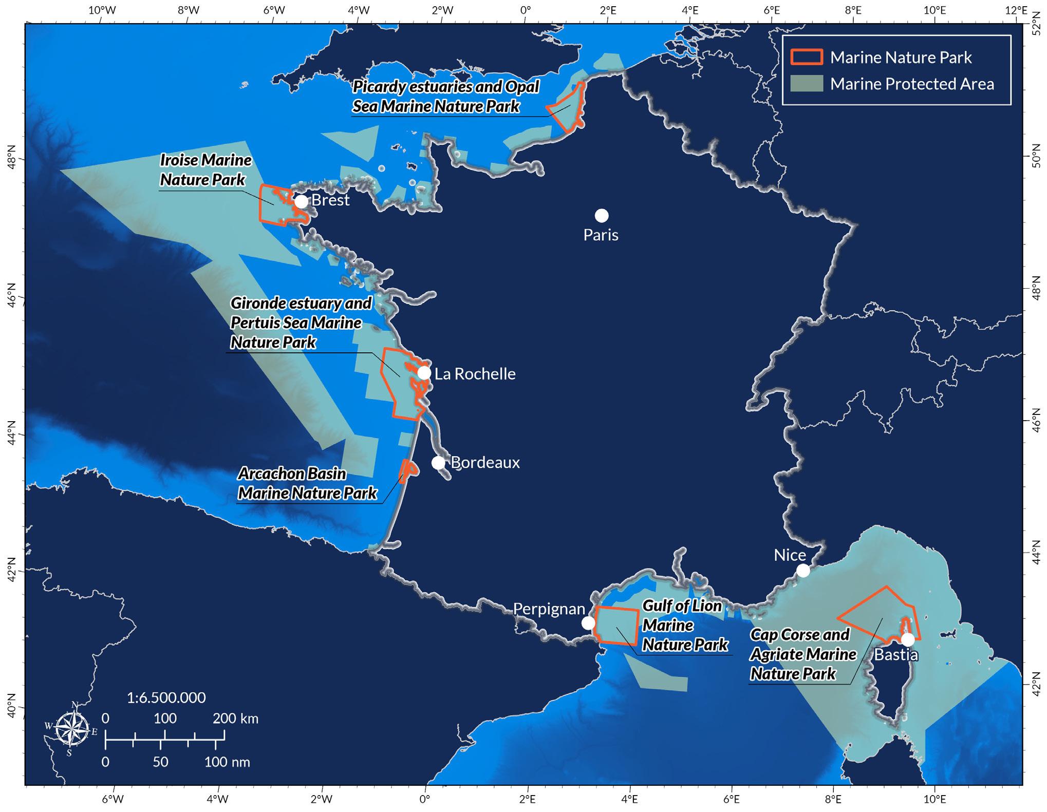
Oceana analysed fishing activity in France’s six MNPs in European waters, special and iconic MPAs that were established because of their unique biodiversity. In 2024 alone, Oceana found that more than 100 bottom trawling vessels appeared to spend over 17,000 hours fishing in these important areas. That is equivalent to one vessel fishing nonstop, 24/7, for nearly two years straight.
Seventy percent of the trawlers identified in this analysis were French vessels, while the other 30% were from countries including Belgium, Spain, the Netherlands, Germany, Ireland, and Italy. Some of these non-French vessels use particularly heavy trawls known as “beam trawls,” which are especially damaging to the seafloor and marine life.
Among the six MNPs analysed, the Picardy estuaries and Opal Sea MNP and the Gironde estuary and Pertuis Sea MNP were the most heavily trawled, representing 40% and 20% of the hours spent bottom trawling, respectively.
In this analysis, Oceana provides three case studies of bottom trawling in French MNPs, showcasing that they are protected only on paper and remain under threat from destructive fishing practices.
Oceana is calling on President Macron and France to lead by example and ban bottom trawling in all French MPAs, including MNPs, to deliver meaningful ocean protection and align with international standards.
We know that when the ocean is protected, and those protections are properly enforced, it thrives. This is essential because healthy coastal ecosystems are important for capturing and storing carbon dioxide, protecting communities from rising sea levels, and providing food and livelihoods to those who live around and depend on these areas.
While low-impact, sustainable fishing practices often thrive inside MPAs, bottom trawling and other destructive activities put these important areas, marine life, and those who rely on them in danger.
We have seen around the world that well-protected MPAs can have positive impacts on jobs and the economy, including for local fishers, coastal communities, and other sectors that depend on a healthy ocean such as tourism and recreation.2 One example in France is the Flamanville fisheries reserve, where long-term monitoring from 1985 to 2017 showed significant ecological benefits. Lobster abundance within the reserve was estimated to increase by 600% and the size of lobsters within the reserve was also higher. A spillover effect also appeared evident with lobster catches higher near the reserve than farther away.3
That is why Oceana and our allies support the global goal of protecting at least 30% of the ocean by 2030. But in order for these protections to be effective, bottom trawling and other destructive activities must be banned in all MPAs.
Imagine a government claiming to protect a forest teeming with wildlife but then allowing bulldozers to plow through and clear-cut the trees. With no home or shelter, the animals left behind could hardly be considered protected. As far-fetched as it sounds, this scenario is effectively in practice inside most of the so-called marine “protected” areas across Europe, where bottom trawling is still permitted.
Bottom trawling is a fishing method that involves towing enormous, weighted nets across the ocean floor to catch fish and other marine life living on or close to it. These nets are highly unselective and essentially clear-cut everything in their path. Just one pass of a trawl can cause serious or irreversible damage to vital habitats including reefs, maërl beds, and sponge grounds, which can take decades to centuries to recover, if they recover at all.
Europe’s waters are the most heavily bottom trawled in the world,4 including in most of its MPAs. Bottom trawling not only devastates the seafloor habitats bulldozed by the heavy gear, but the practice also has negative impacts on the surrounding environment, affects the ocean’s resilience to climate change, and is extremely wasteful, with high levels of unintended catch.
MPAs are created to provide a haven for important marine species and habitats, safeguarding them and allowing them to recover. According to international standards on MPA management by the International Union for the Conservation of Nature (IUCN),5 industrial fishing like bottom trawling is not compatible with this aim and should be excluded from such areas if they are to be considered as MPAs.
France has the second largest Exclusive Economic Zone (EEZ) in the world and claims to be an ocean champion that protects more than 30% of its waters. But most of these protections are on paper only. In France’s waters, bottom trawling is widespread and most of French European MPAs are identified as “not regulated” or “unprotected.” Ninetyeight percent of France’s MPAs allow destructive activities and only 0.03% are strictly protected (i.e., without any extractive activities).6
Destructive fishing like bottom trawling is even taking place in France’s MNPs, a category of MPA that is intended to protect ocean and coastal areas that are especially important for biodiversity.
As of today, France has established six MNPs in European waters:
1. Iroise (established in 2007) – 3,550 km²
2. Gulf of Lion (established in 2011) – 4,019 km²
3. Picardy estuaries and Opal Sea (established in 2012) –2,300 km²
4. Arcachon Basin (established in 2014) – 435 km²
5. Gironde estuary and Pertuis Sea (established in 2015) –6,500 km²
6. Cap Corse and Agriate (established in 2016) – 6,830 km²
These MNPs are key to France’s marine conservation efforts, covering over 23,000 km2 (roughly twice the total area of the Île-de-France region) and making up 14% of the total area of France’s MPAs in European waters.
The Global Fishing Watch7 (GFW) mapping platform is a public tool that uses data from Automatic Identification Systems (AIS) on vessels to track apparent fishing8 effort. Oceana used data from GFW to assess apparent bottom trawling activity inside the six French MNPs in European waters in 2024. Findings were cross-checked using the European Fleet Register to confirm the fishing gear used by each vessel at the time of the apparent fishing event.9 In this context, bottom trawling can refer to any mobile bottom contacting fishing gears.10
This analysis is intentionally conservative, and Oceana excluded certain fishing vessels based on their characteristics, such as suspected use of certain other gears,11 to maintain a robust methodology. The actual amount of bottom trawling taking place is likely to be higher than the estimates in this analysis. AIS coverage is limited, as many fishing vessels below 15 metres in length are not required to use it, and some vessels may turn it off.
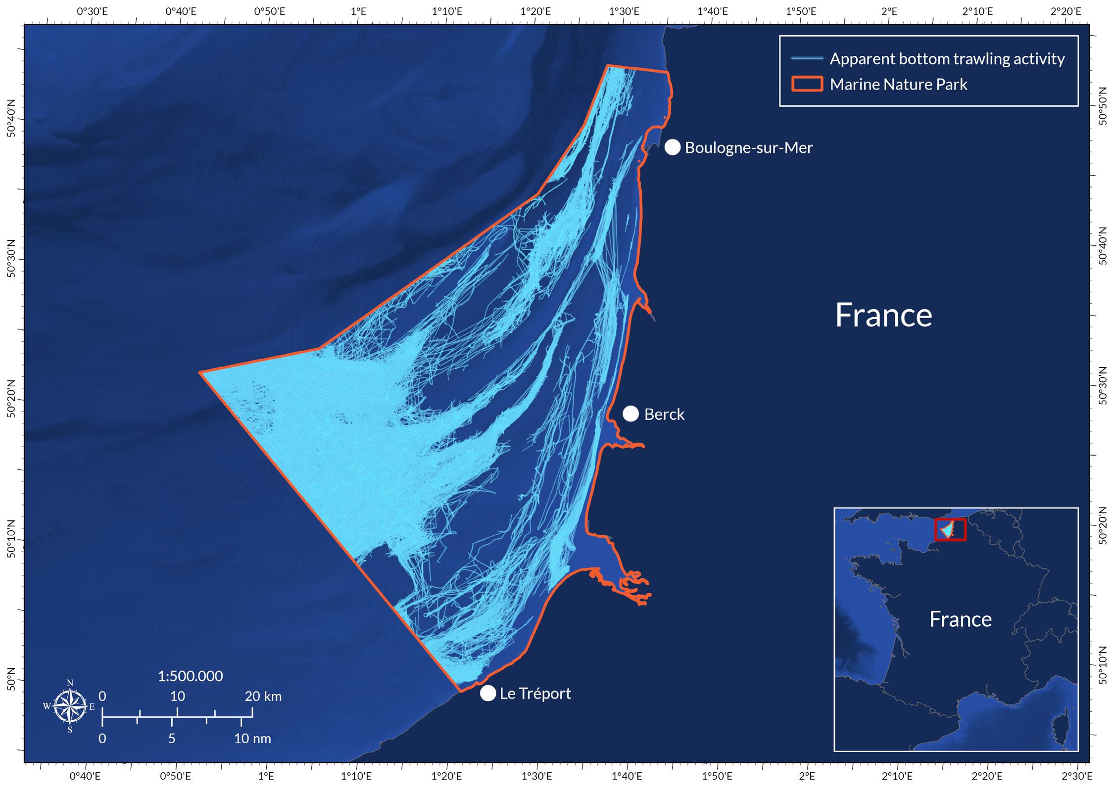
Created in 2012 in northern France, the Picardy estuaries and Opal Sea MNP runs along 118 km of the coast from Ambleteuse to Le Tréport, encompassing seven important estuaries and coastal habitats. Estuaries play a unique and vital role in marine ecology as nutrient-rich transition zones between land and sea. These richly biodiverse areas serve as nursery and spawning areas for fish and feeding grounds for migratory birds. They also act as natural filters, improving water quality, and help protect the coast from erosion and storm surges. Offshore, submarine dunes created by Atlantic currents extend into the depths of the sea. Numerous species inhabit the open sea, including fish species like sole, as well as seals, harbour porpoises, and white-beaked dolphins.
Boulogne-sur-Mer, the most important French fishing harbour, is located within the MPA, as well as the Baie de Somme — an important scallop reserve and fishing ground for brown shrimp. The rich waters of the MNP are particularly important for seafloor-dwelling species,
including commercially exploited fishes such as sole, plaice, turbot, red mullet, and spotted ray. While the MNP was created to protect these and other species, the extent of bottom trawling activity, which covers almost the entire area, is incompatible with their protection. The widespread use of bottom trawls also precludes the use of less impactful, static fishing gears to target these bottomdwelling animals.
Oceana found approximately 60 bottom trawling vessels inside the MNP in 2024, appearing to fish for a total of nearly 7,500 hours, making this the most heavily trawled MNP in this analysis. Most of these vessels were registered to France, from Boulogne-sur-Mer, Dieppe, Caen, or Fécamp, including 10 small vessels (below 12 metres in length) targeting shrimps and scallops.
Twenty-one large trawlers, above 18 metres in length, appeared to fish in the MNP, including 12 vessels from Belgium, Ireland, Germany, and the Netherlands. The largest of these foreign vessels (about 40 metres in length) were industrial bottom trawlers equipped with heavy beam trawls likely targeting flatfishes (e.g., sole and plaice).
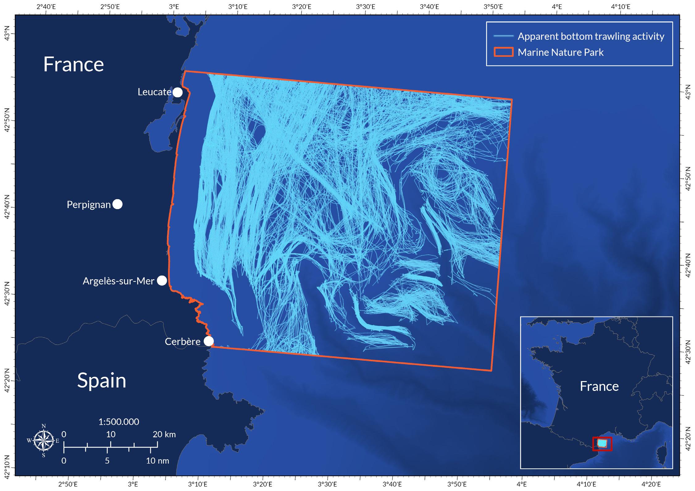
The Gulf of Lion MNP covers 100 km of coastline between Leucate (Aude) and Cerbère (Pyrénées-Orientales). It is home to over 1,200 animal species and around 500 plant species and features a convergence of all the remarkable habitats found in the Mediterranean Sea.
The Ligurian-Provençal current, loaded with mineral and organic particles, makes the waters of the park particularly rich, contributing to its diverse habitats and wildlife. Key highlights include Posidonia seagrass, coralligenous beds and coral reefs, deep underwater canyons, sandy bottoms, numerous seabird species, bottlenose dolphins, and marine turtles.
Ninety percent of the fisheries inside the MNP are smallscale coastal operations based out of many nearby French and Spanish ports. The larger trawlers operating inside the area could threaten some of these artisanal fishers, not only because they damage important fish habitats, but also because they catch the same species (European hake) in much larger quantities.
Fishing Analysis:
Oceana found that in 2024, 17 bottom trawling vessels appeared to fish in the MNP for a total of 4,000 hours. This fleet is composed of vessels 20-27 metres in length, likely targeting European hake — a severely overfished species managed under a European Union Multiannual Management Plan. Fifteen of these trawlers were Spanish, from Catalunya.
According to international standards, industrial fishing like bottom trawling is not compatible with protecting marine habitats and species.
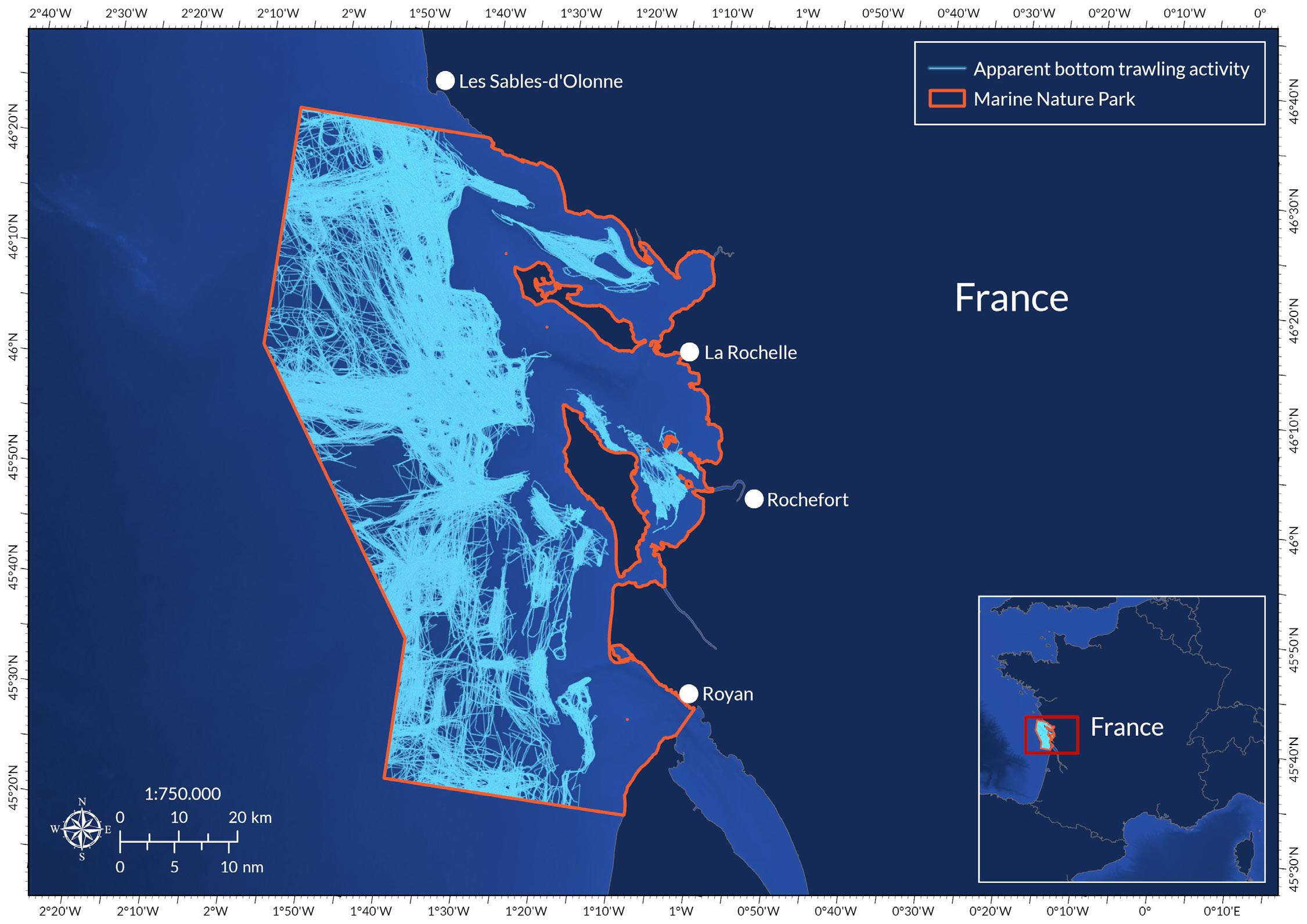
Situated in the heart of the Bay of Biscay, the Gironde estuary and Pertuis Sea MNP extends along more than 1,000 km of coastline, covers three “pertuis” (internal seas protected by islands), and encompasses six estuaries — including the largest one in Western Europe (the Gironde River).
Freshwater inflows from rivers and marshes into the MNP produce an abundance of plankton, a key contributor to biodiversity. The sandy shores, rocky foreshores, and vast mudflats that characterise the MNP are essential feeding, breeding, and nursery grounds for numerous species.
The MNP also harbours part of the last remaining natural population of critically endangered European sturgeon, a species whose recovery is primarily threatened by bycatch in commercial fishing gear, including bottom trawls. The estuary is also an important migration corridor for fish such as the critically endangered European eel and is known internationally as an important area for birds.
The MNP hosts numerous professional and recreational activities that depend on healthy ocean ecosystems.
Marennes-Oléron, the largest oyster farming area in Europe, operates in the park alongside diverse commercial fisheries supporting roughly 400 fishing boats, boating, and other recreation.
Fishing Analysis:
Oceana found that in 2024, 16 vessels carrying bottom trawling gear appeared to fish in the MNP for a total of 3,400 hours. The trawlers were likely targeting seafloor species such as sole, cephalopods, and shrimps. Almost all the fleet is registered locally (La Cotinière, Marennes, or Les Sables-d’Olonne) and includes ten small trawlers (10 to 12 metres in length). The fleet also includes a few very large (about 40 metres in length) industrial trawlers from Spain, Belgium, and the Netherlands (some equipped to fish with heavy beam trawls).
Oceana and our allies are calling on France and other European countries to ban bottom trawling in all marine protected areas.
1. Calculations of the number of MPAs were based on the methodology developed here: https://doi.org/10.1016/j. oneear.2024.07.010
2. https://europe.oceana.org/reports/briefing-the-eu-ocean-pact-and-marine-protected-areas/
3. https://academic.oup.com/icesjms/article/81/9/1827/7761312
4. https://www.pnas.org/doi/10.1073/pnas.1802379115
5. https://portals.iucn.org/library/sites/library/files/documents/PAG-019-2nd%20ed.-En.pdf
6. https://www.sciencedirect.com/science/article/abs/pii/S0308597X20310307
7. Global Fishing Watch, a provider of open data for use in this analysis, is an international nonprofit organisation dedicated to advancing ocean governance through increased transparency of human activity at sea. The views and opinions expressed in this analysis are those of the authors, which are not connected with or sponsored, endorsed, or granted official status by Global Fishing Watch. By creating and publicly sharing map visualisations, data and analysis tools, Global Fishing Watch aims to enable scientific research and transform the way our ocean is managed. Global Fishing Watch’s public data was used in the production of this publication.
8. Any and all references to “fishing” should be understood in the context of Global Fishing Watch’s fishing detection algorithm, which is a best effort to determine “apparent fishing effort” based on vessel speed and direction data from the Automatic Identification System (AIS) collected via satellites and terrestrial receivers. As AIS data varies in completeness, accuracy and quality, and the fishing detection algorithm is a statistical estimate of apparent fishing activity, therefore it is possible that some fishing effort is not identified and conversely, that some fishing effort identified is not fishing. For these reasons, GFW qualifies all designations of vessel fishing effort, including synonyms of the term “fishing effort,” such as “fishing” or “fishing activity,” as “apparent,” rather than certain. Any/all GFW information about “apparent fishing effort” should be considered an estimate and must be relied upon solely at your own risk. GFW is taking steps to make sure fishing effort designations are as accurate as possible.
9. For more details on methodology visit https://oceana.org/wp-content/uploads/sites/18/2025/05/Methodology-ofUNOC-Analysis-1-1.pdf
10. Fishing gears considered for the purpose of this analysis: Beam trawls, Bottom pair trawls, Bottom trawls (nei), Otter trawls (nei), Single boat bottom otter trawls, Twin bottom otter trawls, Mechanised dredges including suction dredges, Towed dredges.
11. Vessels were excluded if mid-water (or “pelagic”) trawls were among their fishing gears registered in the European Fleet Register, because GFW does not distinguish between mid-water and bottom trawling.
Oceana is the largest international advocacy organization dedicated solely to ocean conservation. Oceana is rebuilding abundant and biodiverse oceans by winning science-based policies in countries that control one-quarter of the world’s wild fish catch. With more than 325 victories that stop overfishing, habitat destruction, oil and plastic pollution, and the killing of threatened species like turtles, whales, and sharks, Oceana’s campaigns are delivering results. A restored ocean means that 1 billion people can enjoy a healthy seafood meal every day, forever. Together, we can save the oceans and help feed the world. Visit Oceana.org to learn more.