PORTFOLIO

AKHILESH NIMMI
URBAN PLANNER
MANIT

Skills

 Akhilesh Nimmi
Contact

+91 7042421506

nimmiakhilesh@gmail.com
GIS Analyst
ICSSR, MANIT, Bhopal
• Executed 25 maps showcasing tribal livelihood vulnerability indicators of Madhya Pradesh state.
• Cleaned and organized over 10,000 data points in Excel.


Education
College
Bachelors of Planning
Maulana Azad National Institute of Technology, Bhopal
Senior Secondary School
New Era Public School, Ghaziabad
Higher Secondary School
Soft Skills Language
Analytical Decision Making
Communication
Adaptability
Teamwork
Management Hindi English


Delhi Development Authority, Rohini, Delhi
• Conducted costing for multiple traffic surveys for Influence Zone Plan based on 2 Delhi Metro TOD nodes.
• Assisted in researching Transit Oriented Development, fostering strategies for reducing carbon emissions in urban areas.
• Improve understanding of traffic and transportation within the TOD areas of the Delhi Metro by 80 percent using spatial maps.
AMRUT Mission, Karansagar Lake, Datia
• Conducted over 10 in-depth maps for thorough analysis of laket or evitalize it within Datia city.
• Formulated Water Rejuvenation Plan and Budget under government initiative of AMRUT mission
Achievements
•City Planning Competition on Disaster Prone City in IITBombay 2nd Positon
•Solar Decathlon Competition for Net-Zero Building Design Top 10
Positions of Responsibility
•Lead Photographer Aaroha’s Lead Photographer guiding a team of 5 with expertise.
•Designer Innovative designer at Aaroha,crafting captivating visuals.
Intern Intern Experience


M n p Bo n a P n n B u d y Road NH 5 O h a B pa M o Ro d M o o d Ra Ra wa a k Wa e Body e W e od e Res den al Re e A a Co o y Comme c a Re a Ho o ge R s a a Fun o H / M a e G d n Re r s ndus r a d M xed Re e nd Comm c a Educa ona S h o Hea h Ser v ce C n c D pe a y G v H p Gov P oper y O c Pub c and Sem Pub c P a O Ba k n A M Po e o CC V Co R om C mm n y H Dh ram a Pu C mmu o e S W C O d A e H me Re g ou T mp e C h Rec ea iona G d n P r Pub c Ut i E c u -S n Her age M n m n F r lum Sq a e Va ant Land G v nme A e P a Va a T aspor a on Ra wa o B T af c Re a ed P r g Green Area F re A a G e B T e C d Are Agr cu ure C p n P n n Wa eland Ba n Othe Da Fa m C n u 1m 1 4m - 5 m 1 4m - 6 m 2m - 7 m 4m - 8 m 5m - 1 m W d LEGEND 01 Bachelors Thesis 02 City Development Plan 03 Urban Design 04 AMRUT Mission 05 Other Work
Bachelor’s Thesis
Enhancing Tribal Livelihoods Through Cluster-Focused Initiatives
My bachelor’s thesis focuses on the indigenous tribes of the Betul district in Madhya Pradesh, India. These tribes have been largely overlooked by mainstream society leading to their vulnerability and risk of cultural extinction. Despite this, they possess a wealth of valuable knowledge about their natural environment accumulated over centuries as the original inhabitants of the region.
The objective of my thesis is to explore and document the livelihood strategies and forest-dependence of these tribes. This includes examining their traditional practices, agricultural methods and resource management techniques that have allowed them to live in harmony with their environment.
One key aspect of my research is to highlight how these tribal communities manage their natural resources without causing long-term environmental degradation. Their practices, such as crop rotation, forest conservation, and sustainable harvesting, reflect a deep connection and respect for nature. These methods stand in stark contrast to some modern practices that often lead to resource depletion and environmental damage. By learning from the tribes’ sustainable methods, urban planners and policymakers can develop strategies that incorporate these principles, leading to more sustainable urban environments.


1
District Population 15,75,362 7,76,126 7,99,236 42% 58% Total Population 15,75,362 ST OTHER Village Typology Road Condition Land Utilization
Bachelor’s Thesis
Enhancing Tribal Livelihoods Through Cluster-Focused Initiatives

CLUSTER FORMATION
Cluster is going to formed in the block “Bhainsdehi” in the betul district, as this cluster helps forest dwellers for smooth functioning of their livelihood from production to marketing. This cluster provide a dedicated space for forest dweller including the part of reserved forest for utilizing the forest produce for their livelihood, Bamboo and Mahua is been selected as forest produce production and having a entrepreneurship out of it.
This cluster is been identified on the basis of 3 parameter tribes residence, forest cover, market places after overlapping all these parameter cluster is formed.


CORRIDORS
Tribal livelihood and their assets is been heavily dependent on the markets and road. so, for marketing of tribal products corridors is been proposed connecting all major markets as well as towns of the district for smooth functioning of tribal livelihood. corridor also provides strategic location for future development for tribal as well as for other communities of the socitey.

2
Academic Project
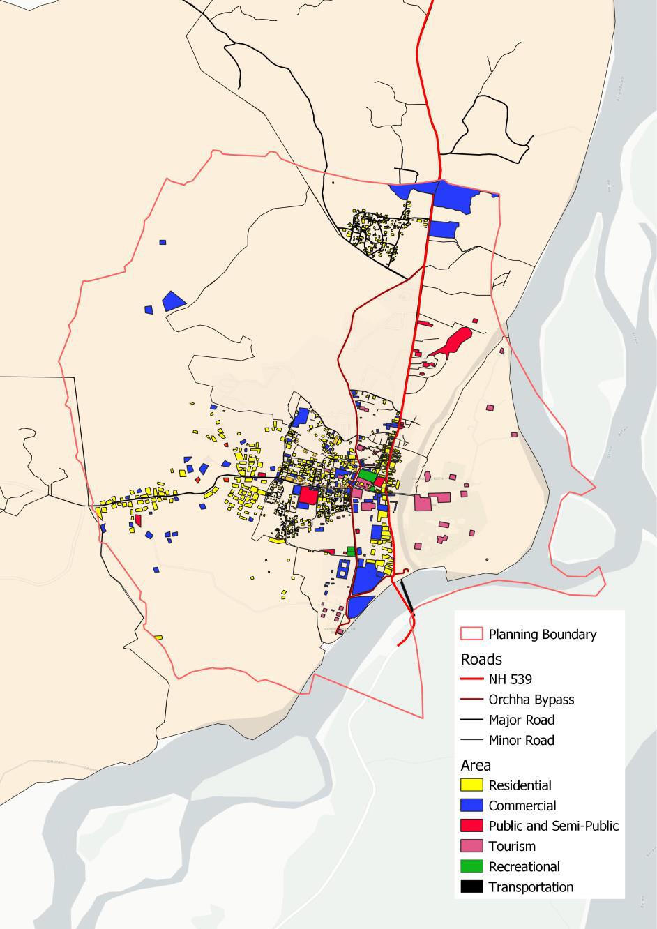
Orchha Development Plan
Orchha is one of the beautiful city of state Madhya Pradesh having a rich history of kings . The city lies in the Bundelkhand region which is part of Uttar Pradesh and Madhya Pradesh nowadays. city lies in Tikamgarh district a part of Madhya Pradesh also home to a number of historical and cultural landmarks, including the Jahangir Mahal, Raj Mahal, Chaturbhuj Temple and Ram Raja Temple.These monuments are a testament to the town’s rich cultural heritage value. The settlements in Orchha are characterized by their unique architectural features, which include elevated pavilions, fortifications, courtyard’s, etc. These architectural features have stood the test of time and continue to attract visitors from all over the world who are fascinated by the town’s unique cultural and architectural heritage. Presence of orchha wildlife sanctuary and Betwa river is the cause of orchha city as ecological sensitive area. Abundance of such features make suitable for the study of city as a urban planner gathering all important insights of the city.
The project cover the relevant parameters of the city having its unique identity which is Ecology, Heritage, Culture and Monuments, using these parameters team developed a orcha city development plan covering all the physical and social infrastructure of city giving its unique identity.


3
d 5435 6076 City Population 11511 2020 201 7 202 2 Legend Green Cover Map Landuse Map
Legen
Academic Project
Orchha Development Plan


PROPOSAL
Orchha an eco-sensitive tourist place having a historical importance through out the history. As per the academic research and study of the city, orchha has beautiful landscape including heritage and ecology, this combination makes orchha city as a tourist city at the national and international level. Floating population can affect the urban fabric of the city for maintaining is magnificent landscape, proposal had been given for the city in various aspects of the city.


4
35% 45% 20% ECO-SENSITIVE ZONE HERITAGE ZONE NEW DEVELOPMENT ZONE
Flood Risk Map Land Suitability Map Proposal
Academic Project
Urban Design : Taj-Ul-Masjid
Taj-Ul-Masjid a Mughal monument in the Bhopal City, The monument has its own historical significance at the time of Mughal Empire in the city. Bhopal city is the capital of the state M.P, as capital of state it has numerous of significant places providing a unique identity to the city. Bhopal has great relationship between landscape and buildings prodiving beautiful essence since kingly empire, one of the building is TajUl-Masjid.
Taj-Ul-Masjid is located at the city core having is own landscape including talaab, parks and garden and buildings, buildings which has magnificent blend of indian and mughal architecture covering all aspects functionality of royals. The site is not only about religious building masjid but a whole area for its functionality and an essence of history.
Project is about to study the site of masjid and its all elements understanding its functionality at historical as well as current times. Examining the effects of urbanization to the historical places and buildings and how can modern techniques and methods can be use for utilization of these places and building as concept of urban design giving place a beautiful public place essence.


5
02. Taj mahal palace 04. T aj-ul masjid 01. G ol Mahal 03. Benazir palace LAKE LANDSCAPE COMMUNITY MOBILITY LOCATIONAL MAP ROAD HIERARCHY TRAFFIC DENSITY MAJOR MOVEMENT
Mobility Study
AMRUT Water Rejuvenation Project: Karan Sagar Lake
Mission Amrit Sarovar - Jal Dharohar Sanrakshan is a government initiative that aims to protect and revive 75 water bodies in each district of India as part of the Azadi Ka Amrit Mahotsav celebrations. The mission focuses on traditional water bodies such as ponds, lakes, and stepwells that are critical for water security and community development. This project talks about the rejuvenation and redevelopment of Karan Sagar Lake in Datia, Madhya Pradesh with special focus on improved water quality, enhanced recreational opportunities or ecological restoration.


Karansagar lake is been a important landscape element through out the history fulfilling is duty towards residents of the area. As the history passes the lake essence is been declining due to its usuage by the locals.


As seen in above maps Karansagar lake has interconnection with its neighboring lakes maintaing water level of the area. In the history these all lakes works as one water family having individual functionality at different spots of the area, few of them work as religious and rest work as fulfilling the demand of the water by the residents of the area.
Now a days, Lakes is been dying as they were using as dustbin and not even maintained by the locals even a plant “hyacinth” is also a major part for the dying of the lake as it covers surface and inlet and outlet of the lake causing it to spoil and contaminated.

6 Govt. Intern
AMRUT Water Rejuvenation Project: Karan Sagar Lake


7 Govt. Intern
S I T E A N A L Y S I S


8
GIS Graphic Design Photography Urban Planning Data Analysis Video Editing Click for Work Presentation
Other Work