Preface
The portfolio encompasses the learning and exertion towards preparing and proposing a Local Area Plan for Yeshwanthpur, Bangalore. Based on the existing situation analysis, DP zoning, existing land use and trends, an initial concept of LAP with required interventions was conceived. The concepts were further strengthened and detailed upon iterative process.
I am thankful for the support and guidance I have received through the course of the studio. Firstly, our studio instructor Mr. Hersh Vardhan Bhasin and teaching associate Mrs. Shyamtika Sarkar for guiding in every plot through the course of the studio. Secondly, the officials at Mysore sandal soap factory and the developers of Yeshwanthpur for giving us their valuable time to arrive at our plan for Yeshwanthpur. Lastly, my teammates Arjun Gowda, Arun Kumar and Deepa Managooli who was constantly spilling out positive vibes and their immense knowledge to complete the studio as a team.
Overview
Urban Expansion and Regeneration Planning Studio of the Faculty Of Planning at CEPT is outlined to devel op and demonstrate the process of planning and preparation of Town Planning Schemes and Local Area Plans. The study process involves surveying, mapping, statutory frame work, accessing the existing city conditions and gauging for the future requirements. Thereby, Preparing a flexible and compact Local Area Plan and TP Schemes for the city.
The studio began with studying and decoding various development models and schemes of various cities around world. With the basic understanding of the practices across the globe and within the country a base was formed to explore the various methodologies and mechanisms to implement development models. The study further narrowed down on planning Local Area Plan for Yeshwanthpur, Bangalore. The site is home for the 2nd largest railway station in Bangalore city, and consist of two metro station Yeshwanthpur and Sandal soap factory. The site also consist of WTC, malls and gated community, has a strong potential for redevelop ment.
#1 UERP Studio Master in Urban planning, CEPT University #1 UERP Studio Master in Urban planning, CEPT University Table Of Contents P R E F A C E
Part A Part B Part C 01 03 02 04 05 06 07 08 Introduction Concept and Vision Existing situation Analysis Master and Proposals Implementation mechnism Exercise 1 Exercise 2 Learnings 1 8 5 10 17 19 20 21


LAP proposals made in group of 4 members Lead
Major concept and work done on the topic by author Individual
Exercises completely done by the author Questions answered at the end 1. Is there any stuatory framework for the Local Area Plan in Karnataka? 2. Is the Local Area Plan profitable in Bangalore? 3. What is the additional length of roads added? 4. How much surplus amount is generated or needed? 1 4
Group work
Author
work
1537 City is Born
The city was founded by Kempegowda.


1881 Yeswanthpur Railway Station Started.

1916 Mysore Sandal soap factory was es tablished.


pur APMC yard Larg est wholesale market for agricultural product in South India

1997 Largest Iskcon temple in the world. It is one of the most famous religious tourist spot


2012 Yeswantpur Traffic Transit Manage ment Centre(TTMC) Established to decongest traffic in the area
1961 Karnataka Town and Country Planning Act (KTCP) was enacted. 2014 Yeshwanthpur Metro Station and san dal soap metro station started

I N T R D U C T I O N #1 UERP Studio Master in Urban planning, CEPT University UERP Studio Master in Urban planning, CEPT University #2 1.2 History
evolution 1.1 Regional
and
Context
Old city cantonment City Railway Yeswanthpur Railway Sandal Soap HAL Yeshwanthpur APMC Yard Electronic City Iskcon Temple Doddaballapur Road Airport Road Kanakapura Road Mysore Road Tumkur Road Magadi Road Hosur Road Old Madras Road Malur Road International Airport Purple Metro Line Yeswanthpur TTMC Green Metro Line Bannerghatta Road Majestic 7th Largest state in India 4th Largest fast moving consum er goods market 3rd Most Populous city in India 8th Largest state population 1.5 Million employ ees in IT Indus tries 2nd Rank for IT In dustries across the world Karnataka Bangalore 4 4


I N T R D U C T I O N UERP Studio Master in Urban planning, CEPT University #4 #3 UERP Studio Master in Urban planning, CEPT University 1.4 Boundary Dileneation 1.3 Metro Connectivity Tumkur Road Yeshwanthpur Metro Station Sandal Soap Metro Station Mysore Road Swami Vivekananda Road Kanakapura Road Banashankari Metro Station Kemepegowda Metro Station MMI 1 Metro Station MMI 5 Metro Station + Railway Station + Inter City Bus Terminal (KSRTC) + Intra City Terminal (Majestic) ) Multimodal Integration(MMI) Public transport proximity to metro station Two metro stations along Green metro line a. Yeshwanthpur metro station b. Sandal soap factory station Walkability Site dilineation based on plots Plots are included based on intersection of 800m aerial circle distance from metro stations 1 2 3 400m 800m Total Delineated area 3.6sqkm Yeshwanthpur metro station Sandal soap metro station 4 4


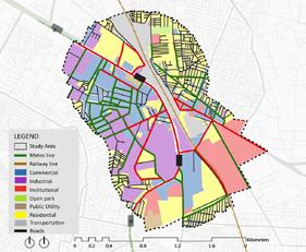
UERP Studio Master in Urban planning, CEPT University UERP Studio Master in Urban planning, CEPT University #6 #5 2.2 Existing Situation Analysis E X I S T I N G S A N A L Y S I S 2.1 ESA - Road Network Arterial Roads 4.9 km Sub-arterial Roads 9.1 km Collector Roads 20.4 km Local Roads 19.7 km Dead Ends - 68 2 Intersections - 442 3 Intersections - 43 4 Intersections - 04 Node Ratio - 0.89 The Roads are not organised for their users, even though the ROW are high from 45m to 9m. Lacks in east and west connectivity with NMT and vehicular services. Parking Encroachment Parking along Road edges - 16.6 Kmt Footpath length Less than 1.5m width - 13.5 Km More than 1.5m width - 8.8 Km <1.5 >1.5 Open Land-12% Private Open - 64% Built -24% • Several unutilised government plots have higher potential for redevelopment • Private - 67% • Government - 33% • 33% of Land under public are not utilised to their potential • Para transit choices • The precinct is well connected with the secondary mode of the transport Average Block Size145m x 145m (21025 sqm) Block Perimeter - 580 m 4 4


1.1 History and evolution UERP Studio Master in Urban planning, CEPT University UERP Studio Master in Urban planning, CEPT University C O N T & V I S I O N E X I S T I N G S A N A L Y S I S #8 #7 2.3 Issues and Potential Issues • Lack of seamless connectivity to between Metro Station, Bus Depot and Railway Station • Unutilized government land • Unorganized spaces for street vendors & hawkers • Huge block sizes & lack of pedestrian network • Less usage of NMT Large block size Industrial & Commercial Plots Unutilised land potential More vacant area within the plots Strategic location and connectivity TTMC, Metro station and railway station in the vicinity Mixed use of land The area acts as self sustainable showing mixed character Unutilised FAR Majority of buildings are low rise Potentials Un-organised road Edges Informal settlements along the railway line More design of public space is required 3.1 Conceptual Map Multimodal Integration Retaining/Encouraging the existing green cover Connectivity Enhancing the existing economy Walkable Neighbourhood Compact Development Zoning Approach 4 4


#1 UERP Studio Master in Urban planning, CEPT University I N T R D U C T 1.1 History and evolution #1 UERP Studio Master in Urban planning, CEPT University P R O P O S A L #10 “ To enhance the existing transit nodes that provide regional connectivity, which would help decongest the city core as well as provide people alternative transit choice and to strengthen the existing economic activities with a compact development that has a safe walkable street network.” 3.2 Vision and Objective Compact Development Multimodal Integration Maximize Land Utilization along the metro line Promote Mixed Development. Enhance Public Space. Rephrase DCR to implement TOD - Provide transit choices that improve mobility & people’s lives. Generate greater prosperity for both the investors and the community. Street Network Retaining/Encourage Green Space Completing the road network and maintaining street hierarchy. Encourage NMT with facilities for pedestrians on major streets Reduce block size. - Ensuring proper maintenance of existing green cover. - Providing green along footpaths to help create pedestrian friendly network. 4.1 Detailed Master Plan West of Chord Road 1. Road Network East west connectivity Rorganising streets Parking management plan 4.Redevelopment of Public Plots Development based on Land Potential Allocating Social Housing on public plots Open spaces as neighbourhood Open parks 2. Zoning High Intensity Zone Standard Intensity Zone 5. Organising Informal economic activities Redevelopment of APMC market Formalising Dedicated Vend ing spaces. 3. Station Area Plan Multimodal Integration Connection between towers 6. Public Realm Organising Street vending Relocation of Local market City level development parks P R O P O S A L S 4 4
4.2 Proposed Road Network
Rationale for Road network


• Improve East and west connectivity
• Reorganize on road parking along prime roads
• Planning walkable streets and NMT around sta tion area

• Formalizing unorganised street vending
• Improve connectivity to major landmarks
• Reduce block perimeter to facilitate walking and NMT
Roads classification and Function

Arterial Roads (ROW:50m)

Arterials are resigned to facilitate the local needs, with NMT and pedestrian tracks without disturb ing the carriage way.
Sub-Arterial Roads (ROW:24m)
Facilitates and connects the user to major land marks and are connected to Arterial roads at short interval to deviate the traffic.
Collector Roads (ROW:15m)
Collector Roads are Moved away from the Arterials to reduce the direct influx of traffic from Ar terial.
Local Roads (ROW:10m)
Local roads are kept away from Sub-arterials to reduce the parking and traffic inflow.
4.3 Station Area Plan
Land Ownership
Railway: Central Government
Total Area: 3,40,696 sqm
• Linking the transit nodes with a skywalk along with amenities like travelator and retail kiosk to reduce the distance to 500m.
• Encouraging the use of parking available at the TTMC.
• To create a single complex of metro, railway and bus terminus.
Built to line with Provision of Arcades
Proposed Flyover over railway track
Proposed Foot over Bridge Proposed Green Open Park
Integration of transit stations with Arcades along Commercial frontages
Yeswanthpura Metro Station
Yeswanthpura Railway Station
Mixed Development
Proposed Underpass
UERP Studio
Master in Urban planning, CEPT University
P R O P O S A L S #12 #11
UERP Studio Master in Urban planning, CEPT University
of
West
Chord Road
West of Chord Road
4 4
• Reduced block size to improve walk ability.
• There is a lot of natural vegetation consisting of mostly of sandalwood trees to the north of the site which we plan to make it as a public park.


• Commercial based tourism develop ment envisioned
• Improve Connectivity by reducing plot size
• Mixed use development with commercial spaces with retail as well as office spaces along with residential spaces with provision for EWS,LIG, and MIG.
4.5 APMC Street proposal


• On street loading\un loading are proposed on Collector without disturbing the private movement on Sub-arterial roads.

• HMV entry and exit are proposed sub-arteri als connecting arterial roads.
 UERP Studio
Master in Urban planning, CEPT University
UERP Studio
UERP Studio
Master in Urban planning, CEPT University
UERP Studio
P R O P O S A L S #14 #13
Master in Urban planning, CEPT University
4.4 Redevelopment of Public plots
Sandal soap factory plot Redevelopment
Mysore lamp factory plot Redevelopment
4 4
4.6 Public Realm

Existing total area under parks: 58,260 sqm (5.82 ha)
Percentage of area under parks: 2% Consists mostly of Housing Cluster Parks and Neighbourhood level parks
No Community, District & City level parks
Nearest District level Parks: JP Park: North of Precinct (35 ha), 1.6km - Railway Station
Sankey tank south-west of precinct(24 ha), 3km- Sandal soap metro
Proposed Community level Parks
Next to yeshwantpur railway station: 2 ha
Sandal Soap Factory: 4.3 ha
Mysore Lamp Factory: 5 ha

Total Public green space: 17.1 ha (5.4%)

P R O P O S A L S
#15
UERP Studio Master in Urban planning, CEPT University
West of Chord Road
4 4
Envisioned Urban Form
Revenue from on-street parking
Considering paid parking on arteri al roads at 50 rs per day Revenue Estimated = 315 cr
5.1 Revenue Generation
Sale of FAR

Considering 50% of plots owners purchase the premium based on de velopment
50% of overall buildable area = 11,63,541 sqm Revenue Estimated = 921 cr
Development Charges
A value of ₹2/ sqm should be charged for sanctioning & permit ted the construction Revenue Estimated = 1.3 cr
5.2 Implementation and Phasing
Rent/lease value of government land
Considering Occupancy of 60% residential and 40% Commercial Revenue Estimated=1,569 cr
Revenue from Advertisement hoardings
Considering 10% of the Arterial and sub-arterial to have public hoarding boards

Revenue Estimated = 142.2 cr

Value capturing finance
A value of ₹ 20 per sqm should be charged every year for local au thority Revenue Estimated= 209 cr
Planning authority to work closely with all relevant departments, agencies and stakeholders involved in securing the delivery of the formulation, adoption and implementation.
Securing funding for the provision of infrastructure and services, and the phasing of development
Identifying all public and private investment re sources
Monitoring regime which will periodically report on the performance and successful implementation of the local area plan
Planning authorities must do civic infrastructure audit in order to maximise the social and financial return generated by financial investment by state agencies.
UERP Studio
Master in Urban planning, CEPT University
I M P L E M E N T A T I O N #18 #17
UERP Studio Master in Urban planning, CEPT University
+427 Cr +432 Cr Phase 1 5 Years Phase 2 5 Years Expenditure Revenue Surplus 1058Cr 1069Cr 1485Cr 1541Cr
Area development model
Exercise 2 - Market Feasibility
STATUTORY/LEGISLATIVE FRAMEWORK
Amendments to the text of this Land Use Code may be approved pursuant to Chapter 23.76, Procedures for Master Use Permits and Council Land Use Deci sions.
INSTITUTIONAL FRAMEWORK
The schemes are prepared by the City council and ad vised Seattle planning commission.


The land use code is developed by the DCI (Develop ment councilors international) planners. Schemes are implemented by the SDC (Seattle design commission)
City council and city clerk office will maintain the area after development
COST & REVENUES:
Development cost - The costs associated with a Mas ter Use Permit vary with the type of approval and the complexity of the project. Fees and fee collection policies for all services associated with SDCI permit application reviews
Sources of revenues - The City shall have the power to assess taxes and to levy and collect rents, addition al FAR charges. There are various source of charges starting from 1000$ to 19000$, based on the type of work and how large is the project the fees will be assigned.
In the downtown area there are many public parking places where the revenue is collected. The downtown parking is too expensive and also from the housing sectors they collect the revenue.
Scenario 1 - Hospital (Beneficial)

Since Bagalkot is a district, there are many villagers who travel for Bagalkot for the treatment and there are numerous hospitals in the area, it is more or less called Hospital zone and hence the profit rate for the devel oper is higher
Scenario 2 – Restaurant and lodge
The city population 0.8 lakh, restaurant and lodge on a long run is not feasible and less marginable. Since it is in the hospital zone, the outsiders are not willing to stay in that area. The profit estimate while selling is comparatively less.
Scenario 3 – Commercial complex
If the plot is converted into commercial complex, it will witness the high footfall both outsiders and insiders of the city. Hence the people would like to invest more with the risk. Hence the developer can earn more profit by doing it as a commercial complex.
P A R T B #20 #19
UERP Studio
MUP, CEPT University
UERP Studio
Profit Estimate for 3 Scenarios Development Scenario Revenue Estimate - Cost Estimate q (p j) Scenario A(Hospital) 7,82,33,082 Scenario B(Restaurant and Lodge) 3,07,88,222 Scenario C(Commercial complex) 6,34,24,328
MUP, CEPT University
1.5m Footpath Site
Site situated in Core city area Street view
satellite imagery Downtown plan
Washington state Seattle city Precinct
PART C - Learning
Conclusion
The studio has helped develop the skills and understandings to identify and analyze the potential of an area in a different way to implement the plan. When we first began, it sounded like a conceptual level and developing an implementation model is merely impossible.
With the initial conceptual local area plan for Seattle downtown, a seed of possibility in understanding was sown. Initially, upon analyzing the existing land use and previous development plans of the city of Bengaluru, every individual had their own approach for various levels of intervention. The upgradation of the existing character by Zoning and DCR’s, incorporating the idea of multimodal integration and enhancing the green network was the initial approach.
But in the further iterations, we were able to analyze critical problems with com plexity and later breaking the problems and addressing solutions was initiated. The old Mysore sandal soap factory which is for decades in the precinct is an attachment to the localities. Thought for the rehabilitating the factory without disturbing the sentiments of the citizens while catering to the demand.
Every iteration feedback prepared us for improvised and betterment in planning, adding the stronger scaffolding to each of the layer/proposals. Starting with conceptually filling in tracing sheets to detail each layer several times to validate our reasoning for growth and development has shaped our view about the new approach.
The studio has always encouraged to bring our own approach for the Yeshwanthpur Local area plan with constant suggestions and comments. Hence, we were able to propose and formulate an LAP for Yeshwanthpur Bangalore.
1. Is there any stuatory framework for the Local Area Plan in Karnataka?
No, There is a Local planning area of 26sqkm jurisdiction which looked after by BBMP(Muncipal corperation). This Local planning area is used for infrastructure classificationa and for distribution network.
2. Is the Local Area Plan profitable in Bangalore?
Considering the Circle rate and average guidance value the Yeshwanthpur local area plan is profitable. However, the civic infrastructure audit should be carried to gurantee the financial returns.
3. What is the additional length of roads added?
The length of roads before and after our proposals remains same as 54km. The heirarchy of the roads has considerable difference. The sub-arterial road before 9km and after our proposals it is increased to 19km.
4. How much surplus amount is generated or needed?
Currently for Yeshwanthpur local area plan 860Cr surplus amount is generated. The major advantage of the precinct is the government lands which will be converted and hence rented.
UERP Studio
P A
Master in Urban planning, CEPT University
R T C #21