Nicole la Hausse de Lalouvière PORTFOLIO
As much as possible, the content of this portfolio is the direct product of work by the author, although work by other members of the team and external collaborators is included (with attribution) to provide full understanding of the projects.
All text by author.
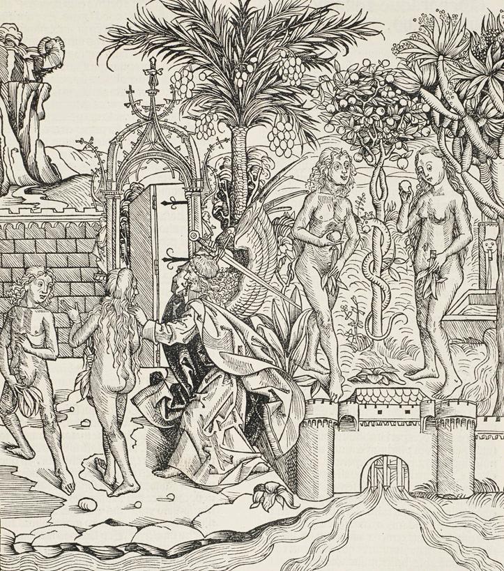 Harmann Schedel, Woodcut of the Garden of Eden, 1493
KEY IDEAS: giardino
segreto, garden of Eden, abundance, wall/gate/threshold
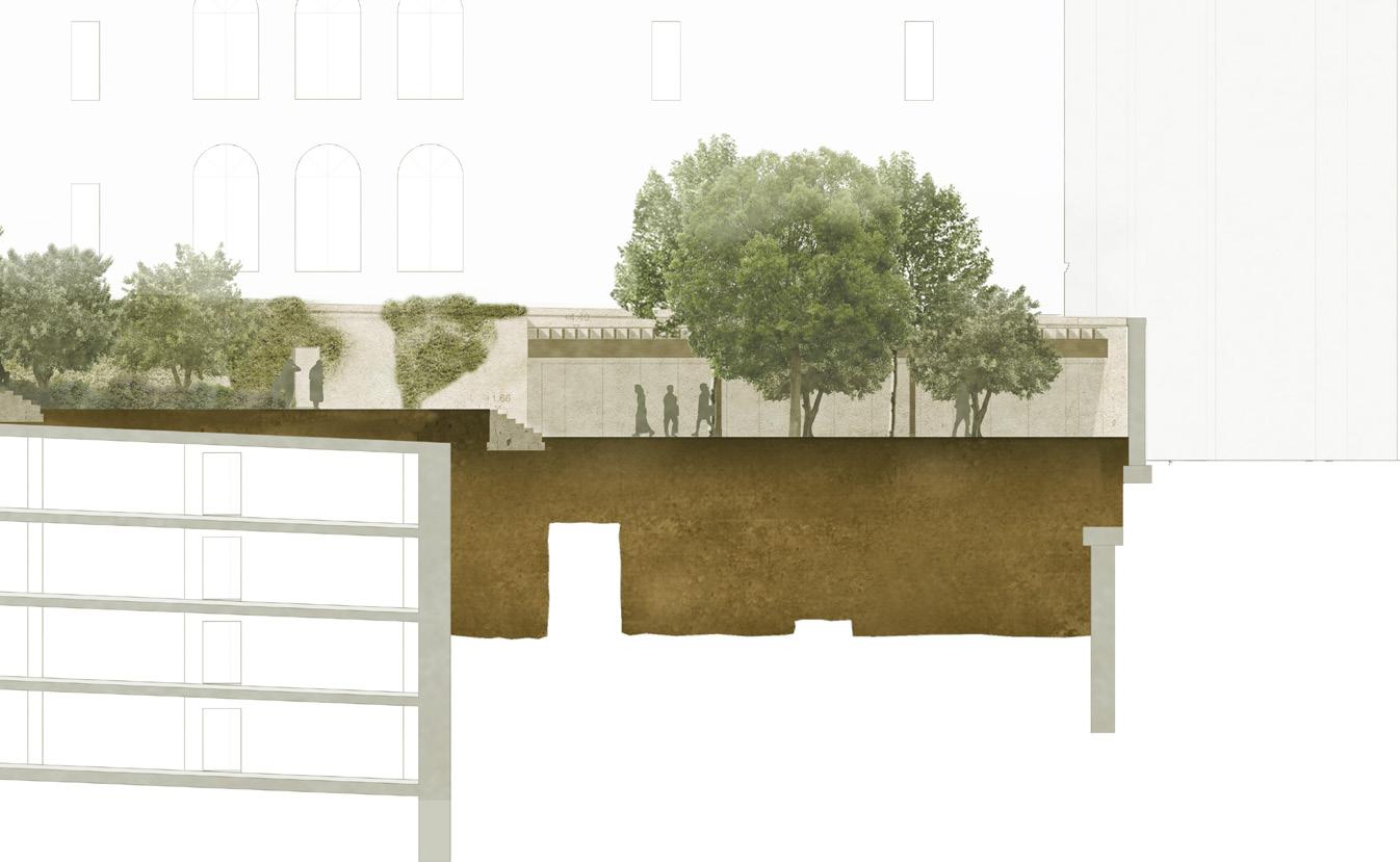
VIA GIULIA
LOCATION: ROME
TYPOLOGY: PUBLIC PARK
TIMELINE: 2010 COMPETITION 1ST PRIZE; 2015-2017 DESIGN STATUS: PENDING CONSTRUCTION PERMIT SIZE: 4,400 M 2 COLLABORATORS: DIENER & DIENER (ARCHITECTS), BASEL CLIENT: CAMEDILIZIA - CAM. S.R.L. ; CITY OF ROME
The new walled garden on Via Giula has both an internal and exter nal story. Inside the perimeter lies a world of quiet and calm, lush vegetation, and a glistening water basin. Visitors come here to sit alone or in pairs, sometimes to meeting wiht neighbours in the eve ning. It has the casualness of a garden that has been here for a long time, forgotten and partly neglected. The canopies of the trees reach over the wall, climbers and ramblers seem to be escaping the garden. It presents itself as an old garden rediscovered but still a well-kept se cret, and thus part of a long history of roman gardens. Those who enter will be reminded of the quieter areas of the Orti farnesiani or of remote spots in the park of Villa Borghese.
The garden is organized in three parts: atrio giardino, frutteto, and giardino segreto. The atrio giardinao offers street access from the prestigious Via Giulia. People may choose to have a drink under the café’s pergola, or sit on one of the chairs surrounding the water basin. From here, steps lead up to the orchard, where rows of fruit trees (critrus, olive, etc) stand on stepped terraces. The true “giardino seg reto” can be reached on the highest part of the garden, where a wild mix of trees, climbers, and bushes surround ancient ruins. A winding path leads the visitor through the rolling topography.
PERSONAL DUTIES:
- led Concept, Schematic Design, Design Development, Building Permit Application for public park sitting atop ancient ruins and new parking garage - managed up to 4 designers - coordinated with public and corporate clients; worked closely with Diener & Diener Architects, Basel - developed design through historical and precedent research, phys ical models, CAD drawings, Rhino digital model
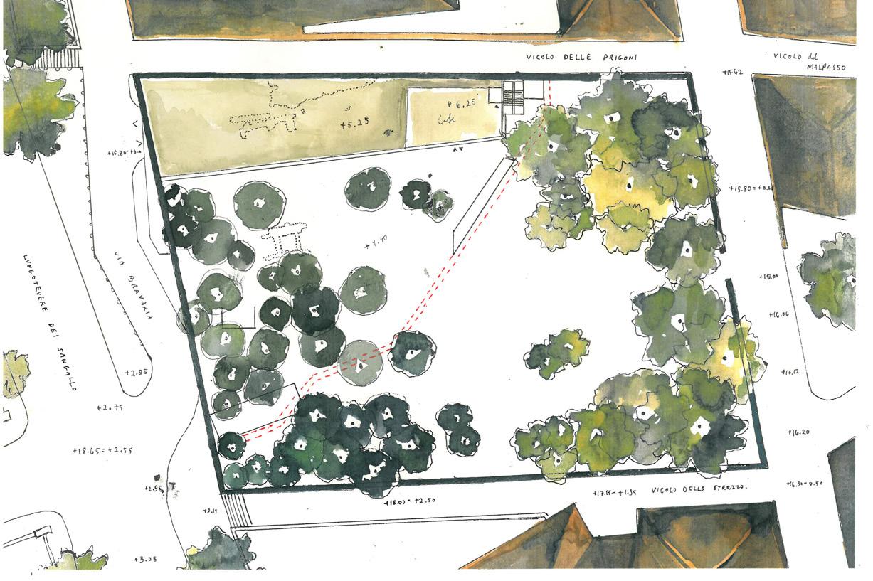
+5.25 +6.25 +4.40 roof of cafe terrace level Option 1 : E / W Belvedere Vogt Stampfenbachstrasse 57 CH-8006 Zürich 0000 Vogt Landschaftsarchitekten Vorlage Zürich 19.08.2015 Vogt Vorlage A2 .5m .5m 3.5m .0m 6.6m 00.6m .6m 0.6m 61.1m.0m.0m.7m 1.7m A +0.20 +16.00 slm +0.25 +16.05 slm +0.32 = +16.12 slm +0.40 = +16.20 slm +0.50 = +16.30 slm ±0.00 = +15.80 slm -0.10 = +15.70 slm -0.08 = +15.72 slm -0.18 = +15.62 slm -0.30 = +15.50 -0slm .62 = +15.18 -0slm .70 = +15.10 slm +2.65 = +18.45 slm +2.85 = +18.65 slm +2.85 = +18.65 slm +2.95 = +18.75 slm +2.75 = +18.55 slm +2.85 +18.65 slm +2.95 = +18.75 slm +3.05 = +18.95 slm +2.42 = +18.22 slm +2.20 = +18.00 slm +1.35 = +17.15 slm Vicolo delle Prigioni Vicolo dello Struzzo Via Bravaria B B magazzino manutenzione 12m² +2.46 +16.30 handicap access route +18+17.80+19.40 .30 +18.85 +18.40 +16.80 +20.30 +15.18 = -0.62 +18.22 = +2.42 +18.45 = +2.65 +18.65 = +2.85 +15.50 = -0.30 +18.00 = +2.20 +17.15 = +1.35 +16.30 = +0.50 +16.20 = +0.40 +18.65 +2.85 +18.65 = +2.85 +18.75 = +2.95 +18.75 = +2.95 +18.55 = +2.75 +15.10 = -0.70 +15.80 = +0.00 +15.62 = -0.18 +15.72 = -0.08 +16.05 = +0.25 +16.12 = +0.32 +15.80 = ±0.00 Tall Trees 20 pieces +18.40 +16.80 Medium Trees 25 pieces Bushes 625 m2 Orchard Trees 40 pieces Climbers 255 linear m Gravel 1250 m2 Lawn 1280 m2 Ground Cover 760 m2


KEY IDEAS:
landform shaped by glacial processes, smooth topography, kettle-and-hill
Geomorphology of Denmark

NEW NORTH ZEALAND HOSPITAL
LOCATION: HILLEROD, DENMARK TYPOLOGY: PUBLIC HOSPITAL, WOODLAND AND HEATHLAND TIMELINE: 2013 COMPETITION 1ST PRIZE – 2020 CONSTRUC TION ENDS
STATUS: BUILDING PERMIT APPLICATION, ONGOING SIZE: 27 HECTARES SITE; 24,000 M 2 INTERIOR LANDSCAPE COLLABORATORS: HERZOG & DE MEURON ARCHITECTS; VILHELM LAURITZEN ARKITEKTER; HENRIK JØRGENSEN LANDSKAB, RAMBOLL (STRUCTURE), MOE (CIVIL)
CLIENT: REGIONAL COUNCIL OF THE CAPITAL REGION OF DENMARK
Landscape and architecture are considered as a whole for this new public hospital, which has for main aim to respect and fade into its surroundings. The horizontality of the building reflects its pastoral location within the wide-open Danish landscape. Here, the sky be comes the most important landscape feature.
The landscape design finds its origin in the glacial processes that shaped the site’s geology, topography, and vegetation. Woodland, heathland, and wetland areas are connected through a system of paths and views, ans sit within a terrain that has been remodelled to main tain the area’s gentle topography. Two open space typologies frame the building: an open heathland punctuated by single-species tree groves on the inside, and a woodland park forming a denser site edge.
Inside the building, over 50 separate courtyards and one large green roof define the character and atmosphere of the hospital. Planting strategies take on the limitations in terms of sunlight and space (ivy, ferns, beech plantings), while also making the most of the opportunity that the large roof garden provides. Here, hedges frame intimate gar dens, each with a different function and feel.
PERSONAL DUTIES:
- led Schematic Design, Design Development, Building Permit Ap plication for 27 hectares site including 24,000 m2 green roofs (>50 courtyards); managed 20M. EUR landscape budget, oversaw team of up to 5 designers.
- coordinated with public client and large international team of ar chitects, engineers, quantity surveyors, local landscape architects; worked closely with Herzog & De Meuron Architects
- developed design through CAD drawings; physical & BIM models


 Site aerial (Herzog & de Meuron collaboration)


KEY IDEAS:
wilderness of great American landscape, foreground/middleground/background, aspenc clones, sound of leaves
 Aspen, New Mexico - Ansel Adams
MET BREUER COURTYARD
LOCATION: NEW YORK CITY
TYPOLOGY: MUSEUM COURTYARD
TIMELINE: 2014 COMMISSION -2016 CONSTRUCTION
STATUS: OPENED SPRING 2016
SIZE: 170 M 2
COLLABORATORS: FUTURE GREEN STUDIO, NYC CLIENT: THE METROPOLITAN MUSEUM OF ART
The iconic Breuer Building underwent a renovation that included its sunken courtyard, 4.5m below the bridge connecting Madison Av enue to the museum’s main entrance. This courtyard is re-imagined as a publicly-accessible space that is part of the bustling city life above.
Since the space needs to accommodate large events, most of the area is left open and flexible, while the long back wall is transformed from a flat, monotonous surface into a thickened and changing expe rience. Full-size quaking aspen are planted along the wall, bringing a piece of American wilderness to Manhattan. The aspen’s leaves shim mer and clatter in the wind, producing a soothing sound in the con tained space below noisy Manhattan streets. The top of the tree cano py is visible from street level, creating a new horizon, and drawing the visitor in.
From the inside of the museum, a large pane of glass separates the exhibition space from the courtyard. It becomes the front plane of a larger-than-life diorama. In the foreground: people mingling and so cialising amidst the new Breuer outdoor furniture. In the mid dleground: the densely-planted quaking aspens. In the background: Madison Avenue and all frenzied activity of Manhattan. The spectacle of aspens and human use of the courtyard changing through the day and the seasons, can be viewed from the museum, the bridge, and the street. In this sense, the courtyard fits into the spatial culture Manhat tan, where transparency, projection, and reflection are intrinsic to the experience of the city.
PERSONAL DUTIES:
- design for Concept, Schematic Design, Design Development phases, oversaw construction and shop drawings from Future Green Studio (local consultants) - coordinated with MET curators, local consultants - developed design through physical models, 1:1 mock-ups, CAD drawings


 Photos by Shimpei Shirafuji

KEY IDEAS: material-sound
relationship, 3D stone cutting, colour in paving
Craft of bell-making, method and metal alloy mix is kept secret by specialised foundries
KURT HACKENBURG PLATZ
LOCATION: COLOGNE
TYPOLOGY: PUBLIC SQUARE
TIMELINE: 2014-2017
STATUS: IN CONSTRUCTION
SIZE: 3600 M 2
CLIENT: STADT KÖLN
This square is located in close proximity to Cologne’s main cultural institution: its cathedral. The sound of its bells creates rings through the square and marks the passage of time throughout the day. We wanted to create a relationship to the Cologne Cathedral and de signed a drinking fountain to do so. The fountain has two compo nents: the drinking piece, the hearing piece and the resonance chamber underground. As one bends over to take a drink, the sound of water droplets hitting the drums below, travels back up the hearing piece. The act of drinking and tasting is thereby connecting to hearing, and also to touching (holding onto the the copper foun tain for balance). Like the bells of the cathedral, the fountain is made of a copper alloy, developed for its acoustic qualities.
In addition to the fountain, we designed two 22m-long benches, which lie on either side of the planted gravel area. They are made of Grauwacke, a local stone, which is cut into smooth forms to create a new horizon line on the square. Although the benches are very solid and form a solid border to the space, they keep a certain informality, offering unconventional seating areas. One may choose to sit on the shaded, quieter side or to face outwards to the bustling vehicular and foot traffic.
New paving unifies the space, all the way up to the various buildings surrounding the square. Grauwacke is used here too, but different shades are chosen to compose a seemingly-random pattern of changing dimensions and colours.
PERSONAL DUTIES:
- led Schematic Design, Design Development, Construction Docu ments (project transferred to VOGT Berlin office for Construction Administration)
- developed design of bespoke benches and drinking fountain through Rhino model, rapid prototyping, 3D-prints, 1:1 mock-ups


Construction
Documents in collaboration with VOGT Berlin Office


 Construction Administration in collaboration with VOGT Berlin Office
KEY IDEAS:
viewing/reflecting/projecting, foreground - middleground - background, miniature & panorama
 Jade diggers along Xinjiang’s White Jade River
HYUNDAI MOTORSTUDIO
LOCATION: BEIJING
TYPOLOGY: PUBLIC SQUARE, RENOVATION
TIMELINE: 2015-2017 COMMISSION
STATUS: IN CONSTRUCTION
SIZE: 1000 M 2 EXTERIOR LANDSCAPE COLLABORATORS: 2X4.ORG, NYC
CLIENT: HYUNDAI GROUP
Landsberg-am-Lech is intrinsically tied to the river that flows through it - it’s even in the town’s name. The river Lech flows down from the Alps, grinding down pebbles and depositing sediments in the floodplain. The river is Landsberg’s direct connection to the greater landscape and millennia of geomorphological activity.
The area of Papierbach is a now-defunct industrial zone that is be ing redeveloped as a mixed-use neighbourhood, with two main axes. One of these encompasses the public square; the other connects the old town (via a bridge over the river) to the other side of town. A tun nel under the existing railway line stands as the main challenge to cre ating an open and welcoming public space. The proposed design fo cuses on materiality, choosing “Nagelfluh” (a local conglomerate stone) for walls, and cobblestones for paving. The walls are a recurring element that separate the public spaces from private gardens half a meter above. Walls also run along the sides of the tunnel below the railway. These are thought of in more sculptural terms: gently curving stone walls guide people through the tunnel. The whole neighbour hood is paved in the same unifying surface of cobblestones. But rather than using a standard pattern, the old-fashioned “passé” laying tech nique is chosen for its lack of orientation. This allows the different spaces to relate as needed to building entrances, direction of move ment, connection to the street, etc. This paving pattern also allows the ground surface to smoothly rise into planters, where trees sit atop the slab of the parking garage below.
PERSONAL DUTIES:
- led design from Concept Design to Construction Administration - coordinated with 2x4.org, local consultants - developed design through physical models, 1:1 mock-ups, local construction methods research


NOTFORCONSTRUCTION


NOTFORCONSTRUCTION


1 West Elevation 1:100 Hyundai Motorstudio Beijing 798 Arts District Beijing China Drawing: Stampfenbachstrasse 57 Xiaoyun Road No.38 Hyundai Motor Tower F 20 Chaoyang Dist Beijing +86 10 8453 9777 Hyundai Motor Group (China) LTDLandschaftsarchitektClient Zürich 20.03.2017 Stampfenbachstrasse 57 8006 Zürich Telefon +41 44 360 54 54 Fax +41 44 360 54 55 mail@vogt-la.ch Vogt Landschaftsarchitekten AG Design Architect: 180 Varick Street 15th Floor New York NY 10014 +1 212 647 1170 Executive Architect: Approach No.4 SanJianFang Nanli Chaoyang Beijing +86 10 84004841 Sustainability Transsolar Klima Engineering +1 212 219 2255 Structural Engineer: LaufsED PLLC Laufs Engineering Design Long City,NY 1 212 529-3905 NOTFORCONSTRUCTION Project Number: P2125 L301 Exterior Elevations: East & West Version 1: 29.08.2016 Version 3: 07.09.2016 Version 5: 10.02.2017 Version 6: 03.03.2017 2 East Elevation 1:100 existing trees to remain when possible exact location to be defined solar chimney Sophora japonica multi-stem existing Sophora japonica ground cover and ivy climbers concrete floor at entrances existing lamp post to remain 2% slope entrance stone furniture brick visiblepaving steel edge 37.0m2.1m .8m 8.2m stone water basin diorama case new poured-in-place concrete paving Slope existing cedrus to remain radius 3.2-4.0 m; height 17 m 10 single-stem Sophora japonica compacted gravel brick paving 10.0m 10.8m 6.6m 1 West Elevation 1:100 Hyundai Motorstudio Beijing 798 Arts District Beijing China Drawing: Stampfenbachstrasse Xiaoyun Road No.38 Hyundai Motor Tower F 20 Chaoyang Dist Beijing T +86 10 8453 9777 Hyundai Motor Group (China) LTDLandschaftsarchitektClient Zürich 20.03.2017 Stampfenbachstrasse 57 8006 Zürich Telefon +41 44 360 54 54 Fax +41 44 360 54 55 mail@vogt-la.ch Vogt Landschaftsarchitekten AG Design Architect: 180 Varick Street 15th Floor New York NY 10014 Executive Architect: Approach No.4 SanJianFang Nanli Chaoyang Beijing T +86 10 84004841 Sustainability Consultant: Transsolar Klima Engineering T +1 212 219 2255 Structural Engineer: LaufsED PLLC Laufs Engineering Design Long City,NY T 212 529-3905
Project Number: P2125 L301 Exterior Elevations: East & West Version 1: 29.08.2016 Version 3: 07.09.2016 Version 5: 10.02.2017 Version 6: 03.03.2017 East Elevation 1:100 existing trees to remain when possible exact location to be defined solar chimney Sophora japonica multi-stem existing Sophora japonica ground cover and ivy climbers concrete floor at entrances existing lamp post to remain 2% slope entrance stone furniture brick visiblepaving steel edge 37.0m2.1m .8m 8.2m stone water basin diorama case new poured-in-place concrete paving Slope existing cedrus to remain radius 3.2-4.0 m; height 17 m 10 single-stem Sophora japonica compacted gravel brick paving 10.0m 10.8m 6.6m 1 North Elevation 1:100 Hyundai Motorstudio Beijing 798 Arts District Beijing China Xiaoyun Road No.38 Hyundai Motor Tower F 20 Chaoyang Dist Beijing T +86 10 8453 9777 Hyundai Motor Group (China) LTDLandschaftsarchitektClient Zürich 20.03.2017 Stampfenbachstrasse 57 8006 Zürich Telefon +41 44 360 54 54 Fax +41 44 360 54 55 mail@vogt-la.ch Vogt Landschaftsarchitekten AG Design Architect: 180 Varick Street 15th Floor New York NY 10014 +1 212 647 1170 Executive Architect: Approach No.4 SanJianFang Nanli Chaoyang Beijing +86 10 84004841 Sustainability Transsolar Klima Engineering +1 212 219 2255 Structural Engineer: LaufsED PLLC Laufs Engineering Design Long City,NY 1 212 529-3905
existing lamp post to remain solar chimney exposed steel edge existing cedrus to remain radius 3.2-4.0 m; height 17 10 single-stem Sophora japonica Sophora japonica ground and climbers existing banner to remain existing lamp post to remain existing lamp post to remain stone furniture Tree positions to be defined by survey retractable bollards see L401 Hyundai Motorstudio Beijing 798 Arts District Beijing China Xiaoyun Road No.38 Hyundai Motor Tower F 20 Chaoyang Dist Beijing T +86 10 8453 9777 Hyundai Motor Group (China) LTDLandschaftsarchitektClient Zürich 08.02.2016 Stampfenbachstrasse 57 8006 Zürich Telefon +41 44 360 54 54 Fax +41 44 360 54 55 mail@vogt-la.ch Vogt Landschaftsarchitekten AG Design Architect: 2x4 lnc 180 Varick Street 15th Floor New York NY 10014 T +1 212 647 1170 Executive Architect: Approach Architecture Studio No.4 SanJianFang Nanli Chaoyang Dist Beijing 100024 T +86 10 84004841 Sustainability Consultant: Transsolar Klima Engineering 220 E 23rd St Suite 403 1 New York NY 1001 O T +1 212 219 2255 Structural Engineer: LaufsED PLLC Laufs Engineering Design 46-01 5th Street Long Island City,NY 11101 T + 1 212 529-3905 NOTFORCONSTRUCTION drip irrigation to digital control system L401 .3m 798 Rd 2% Quixing W St B=12.04mR=6.45 B=9.62mR=4.70m R=B=7.11m .70m R=B=6.44m .70m .6m Sj Sj Sj Sj Sj Sj Sj Sj Sj Sj Sj 11.2m .2m .0m 2 .1m.6m 2% 5% 5% 5% 2% 2% 2% 2% 2% 2% 2% gravel drainage existing manholes façade compacted gravel permeable surface -00.0m .1m -0.1m planter permeable soils irrigation digital system -0 .1m
Parthenocissus


subtropical


winters
Parts
the origin of the plants


temperature: 10
C temperature:


winter (lower temperatures) humidity provided by spray system or evaporation of higher than in winter Development of fungi is high in winter

photosynthesise a process crucial to their survival live, approx 2 ACH (air changes per hour)


air Temperature of the
pre-heated
and moisture
Planting on ground: Acrostichum aureum Anisodontea capensis Abutilon darwinii Bauhinia acuminata Darlingtonia californica Dicksonia antarctica Michelia champaca Psidium guajava Strelizia reginae var juncaceae
Ground cover: Pellaea rotundifolia Nertera granadensis
pieces/m 2
pieces/m
Nutri-LED light see specs air humidity and temperature sensor
top row of water spray nozzles fixed in top holes of column , may be moved depending on plant health
custom-made metal column with double
climbing and hanging plants in planters on columns
groundcover and perennials planted in ground
bottom row of water spray nozzles fixed in holes of column
overflow drainage substrate humidity and temperature sensor waterproofing and drainage mat concrete planter
sensor connection to digital control system filter fleece
planting substrate with high percentage of mineral soil
rocaillle planter screen, hand-modelled similar to rocaille on columns planting substrate drip irrigation L405 concrete planter hidden by screen bark texture hand-modelled in shotcrete finish concrete column 70 50 3.00 climbing plants 90 beam 3.10 90 NOTE: needed conditions less facades) custom-made planter irrigated main Hyundai Motorstudio Beijing 798 Arts District, Beijing China Xiaoyun Road No.38 Hyundai Motor Tower F 20 Chaoyang Dist Beijing T +86 10 8453 9777 Hyundai Motor Group (China) LTDLandschaftsarchitektClient Zürich 10.02.2017 Stampfenbachstrasse 57 8006 Zürich Telefon +41 44 360 54 54 Fax +41 44 360 54 55 mail@vogt-la.ch Vogt Landschaftsarchitekten AG Design Architect: 2x4 lnc 180 Varick Street 15th Floor New York NY 10014 T +1 212 647 1170 Executive Architect: Approach Architecture Studio No.4 SanJianFang Nanli Chaoyang Dist Beijing 100024 T +86 10 84004841 Sustainability Consultant: Transsolar Klima Engineering 220 E 23rd St Suite 403 1 New York NY 1001 O T +1 212 219 2255 Structural Engineer: LaufsED PLLC Laufs Engineering Design 46-01 5th Street Long Island City,NY 11101 T + 1 212 529-3905 NOTFORCONSTRUCTION 2 Green Column 'A' Section 1:20 7 Small Planter Section 5 Green Column Plan 1:20 1 Green Column 'A' Elevation 1:20 60 70 3.00 90 3 Green Column 2.10 50 'rocaille' screen min 10cm thick, hand-modelled concrete column custom-made concrete planter 5cm thick glass facade zinc-coated metal stopper dowel nail and anchoring max 500 mm apart 50 rocaillle screen hand-modelled to planting drip concrete hidden bark hand-modelled shotcrete concrete 70 50 3.00 climbing 90 70 90 Interior Planting: Version 1: 29.08 Version 2: 31.08 Version 3: 07.09 Version 4: 16.09 Version 5: 10.02 NOTE: more planters needed with poorer conditions for plants (eg less light further from the facades) on Column 'B' custom-made concrete planter in 'rocaille' structure irrigated by same system as main planter studio ct, Beijing China Plan size A1 841x594mm Drawing: Plan number: Xiaoyun Road No.38 Hyundai Motor Tower F 20 Chaoyang Dist Beijing T +86 10 8453 9777 Hyundai Motor Group (China) LTDClient Stampfenbachstrasse 57 8006 Zürich Telefon +41 44 360 54 54 Fax +41 44 360 54 55 mail@vogt-la.ch Vogt Landschaftsarchitekten AG Design Architect: 2x4 lnc 180 Varick Street 15th Floor New York NY 10014 T +1 212 647 1170 Executive Architect: Approach Architecture Studio No.4 SanJianFang Nanli Chaoyang Dist Beijing 100024 T +86 10 84004841 Sustainability Consultant: Transsolar Klima Engineering 220 E 23rd St Suite 403 1 New York NY 1001 O T +1 212 219 2255 Structural Engineer: LaufsED PLLC Laufs Engineering Design 46-01 5th Street Long Island City,NY 11101 T + 1 212 529-3905 NOTFORCONSTRUCTION Project Number: Dimensions in cm 2 Green Column 'A' Section 1:20 8 Detail 7Section Small Planter Section 1:10 5 Green Column 'A', Planter on Floor, Plan 1:20 Column 'A' Elevation 1:20 60 3 Green Column 'B' Plan 1:20 90 2.10 'rocaille' screen 10cm thick hand-modelled concrete column 2 custom-made concrete planters 5cm thick zinc-coated stopper, dowel and anchoring 500 mm apart 50 'rocaille' hand-modelled concrete custom-made concrete glass zinc-coated stopper and anchoring 500 concrete 6 Green Plan 1:20 50 'rocaille' screen min 10cm thick hand-modelled concrete column custom-made concrete planter 5cm thick glass facade zinc-coated metal stopper dowel nail and anchoring max 500 mm apart 50 80 rocaillle planter screen hand-modelled similar to rocaille on columns planting substrate, drip irrigation L405 concrete planter hidden by screen bark texture hand-modelled in shotcrete finish concrete column 70 50 3.00 climbing plants 90 sitting on beam 70 3.10 90 concrete pillar/concrete planter fibre-reinforced shotcrete 20kg/t 0-4 mm aggregate min thickness 20 mm hand modelled zinc-coated metal stopper dowel nail and anchoring, max 500 mm apart plastering galvanized welded wire mesh double layer 0.8 mm wire 10x10mm openings, 10-12kg/m2 UV-resistant mineral silicate paint applied to the surfaces in min two layers Paint should be environmentally friendly and harmless to people and animals Ficus pumila Jasminum sambac Epipremnum pinnatum Hoya carnosa Cissus rhombifolia Philodendron melanochrysum Philodendron scandens Senecio mikanioides Interior Planting: Green Columns L401 Version 1: 29.08.2016 Version 2: 31.08.2016 Version 3: 07.09.2016 Version 4: 16.09.2016 Version 5: 10.02.2017 less light further from the facades) on Column 'B' custom-made concrete planter in 'rocaille' structure irrigated by same system as main planter Plan size A1 841x594mm Drawing: Plan number: Vogt Landschaftsarchitekten AG Stampfenbachstrasse 57 No.38 Hyundai Motor Tower F 20 Beijing 9777 Group (China) LTD Design Architect: 2x4 lnc 180 Varick Street 15th Floor New York NY 10014 T +1 212 647 1170 Executive Architect: Approach Architecture Studio No.4 SanJianFang Nanli Chaoyang Dist Beijing 100024 T +86 10 84004841 Sustainability Consultant: Transsolar Klima Engineering 220 E 23rd St Suite 403 1 New York NY 1001 O T +1 212 219 2255 Structural Engineer: LaufsED PLLC Laufs Engineering Design 46-01 5th Street Long Island City,NY 11101 T + 1 212 529-3905 NOTFORCONSTRUCTION Project Number: P2125 Dimensions in cm and mm 2 1 2 1 1 1 1 1 8 4 8 4 4 4 4 4 Climbing Plants A B Column A: number of plants for smaller green column at glass facade Column B: number of plants for larger green column in centre of building 2 Green Column 'A' Section 1:20 8 Detail Section 'Rocaille' 71:5 Small Planter Section 1:10 5 Green Column Plan 1:20 4 Green Column Planting PLANT LIST 3 Green Column 90 'rocaille' screen min 10cm thick hand-modelled concrete planters, 5cm thick zinc-coated metal stopper dowel nail and anchoring max 500 mm apart min thick hand-modelled column custom-made 5cm thick facade metal nail max apart 50 beam staircase 80 Column 'A', Planter on Beam , 50 'rocaille' screen min 10cm thick hand-modelled concrete column custom-made concrete planter 5cm thick glass facade zinc-coated metal stopper dowel nail and anchoring max 500 mm planterapart hand-modelled similar to rocaille on columns planting substrate drip irrigation L405 concrete planter by screen texture hand-modelled in shotcrete finish concrete column 70 50 3.00 climbing plants 90 planter sitting 70 90 concrete pillar/concrete planter fibre-reinforced shotcrete 20kg/t 0-4 mm aggregate min thickness 20 mm hand modelled zinc-coated metal stopper, dowel nail and anchoring max 500 mm apart plastering galvanized welded wire mesh double layer 0.8 mm wire 10x10mm openings 10-12kg/m2 UV-resistant mineral silicate paint applied to the surfaces in min two layers Paint should be environmentally friendly and harmless to people and animals Green Columns L401 Version 1: 29.08.2016 Version 2: 31.08.2016 Version 3: 07.09.2016 Version 4: 16.09.2016 Version 5: 10.02.2017 Plan size A1 841x594mm Plan number: Vogt Stampfenbachstrasse 57 CH-8006 Zürich No.38 Hyundai Motor Tower F 20, Beijing 9777 Group (China) LTD Design Architect: 2x4 lnc 180 Varick Street 15th Floor New York NY 10014 T +1 212 647 1170 Executive Architect: Approach Architecture Studio No.4 SanJianFang Nanli Chaoyang Dist Beijing 100024 T +86 10 84004841 Sustainability Consultant: Transsolar Klima Engineering 220 E 23rd St Suite 403 1 New York NY 1001 O T +1 212 219 2255 Structural Engineer: LaufsED PLLC Laufs Engineering Design 46-01 5th Street Long Island City,NY 11101 T + 1 212 529-3905 NOTFORCONSTRUCTION Project Number: P2125 Dimensions in cm and mm 8 4 8 4 4 4 4 4 B smaller building 2 Green Column 'A' Section 1:20 'Rocaille' 71:5 Small Planter 5 Green Column Plan 1:20 4 Green Column 1:20Planting concrete column 2 custom-made planters metal 50 min thick hand-modelled concrete column custom-made concrete planter 5cm thick glass facade zinc-coated metal stopper dowel nail and anchoring max apart 50 beam staircase 80 Column 'A', Planter on Beam , Xiaoyun Road No.38 Hyundai Motor Tower F 20 Chaoyang Dist Beijing T +86 10 8453 9777 Hyundai Motor Group (China) LTDAGClient Design Architect: 2x4 lnc 180 Varick Street 15th Floor I New York NY 10014 T +1 212 647 1170 Executive Architect: Approach Architecture Studio No.4 SanJianFang Nanli Chaoyang Dist Beijing 100024 T +86 10 84004841 Sustainability Consultant: Transsolar Klima Engineering 220 E 23rd St Suite 403 1 New York NY 1001 O T +1 212 219 2255 Structural Engineer: LaufsED PLLC Laufs Engineering Design 46-01 5th Street Long Island City,NY 11101 T + 1 212 529-3905 NOTFORCONSTRUCTION Planting List Final planting list to be decided in consultation with local partner and local nursery Planting in suspended planters and on ground: Adiantum raddianum Asparagus setaceus Asphargus asparghoides Asplenium nidus Cyrtomium falcatum/fortunei Justicia brandegeana Piper nigrum Pteris cretica
henryana Passiflora edulis Pellaea atropurpurea Platycerium bifurcatum Phaedranthus buccinatorius Senecio mikadoides Stephanotis floribunda Thunbergia alata Tillandsia spp Pellaea rotundifolia NOTE Dense and diverse planting in ground and in suspended planters Planters placed unevenly on column structure Position adjusted manually if needed based on plant growth density lighting needs etc Planters should not be visible through dense vegetation 4. Diorama Case Section 1:20 2 Diorama Case Elevation 1:50
cooler
America ,
of Asia with tolerance for high temperature variance
(NutriLED) Temperature
°
35 ° C
very sensitive to cold
case should be monitored , and
if monitored against temperature
which outside air Excess humidity in the case may cause condensation in the winter, in which case ventilation may reduce the issue
16
for smaller species 5
2 for taller species 17m
set of holes every 15 cm (system for adaptable placement of planters and water spray nozzles) mesh planter: 2-4 planters per column, fixed on different heights filled with substrate invisible in dense planting drainage layer: 20cm gravel/expanded clay 90 90 70 20 irrigation tube connected to building water outlet and control room 1.90 17.00 3. Diorama Case Conditions and Species Interior Planting: Diorama Case L402 Version 1: 29.08.2016 Version 2: 31.08.2016 Version 3: 16.09.2016 Version 4: 22.09.2016 Version 5: 13.10.2016 Version 6: 10.02.2017 Version 7: 03.03.2017 Plan size A1 841x594mm Drawing: Plan number: Vogt Landschaftsarchitekten AG Stampfenbachstrasse CH-8006 Design Architect: 2x4 lnc 180 Varick Street 15th Floor New York NY 10014 T +1 212 647 1170 Executive Architect: Approach Architecture Studio No.4 SanJianFang Nanli Chaoyang Dist Beijing 100024 T +86 10 84004841 Sustainability Consultant: Transsolar Klima Engineering 220 E 23rd St Suite 403 1 New York NY 1001 O T +1 212 219 2255 Structural Engineer: LaufsED PLLC Laufs Engineering Design 46-01 5th Street Long Island City,NY 11101 T + 1 212 529-3905 NOTFORCONSTRUCTION Project Number: P2125 Dimensions in cm and mm NOTE Dense and diverse planting in ground and in suspended planters Planters placed unevenly on column structure Position adjusted manually if needed based on plant growth density lighting needs etc Planters should not be visible through dense vegetation 6 Mesh Planter 1:5 4 Diorama Case Section 1:20 variance Temperature evaporation of fungi is survival hour) of the pre-heated if moisture which may cause issue 5 Maintenance Manhole 1:20 35 35 climbing and hanging plants in planters on columns top row of water spray nozzles fixed in top holes of column may be moved depending on plant health groundcover and perennials planted in ground planting substrate with high percentage of mineral soil overflow drainage substrate humidity and temperature sensor waterproofing and drainage mat concrete planter sensor connection to digital control system filter fleece Nutri-LED light see specs air humidity and temperature sensor bottom row of water spray nozzles fixed in holes of column custom-made metal column with double set of holes every 15 cm (system for adaptable placement of planters and water spray nozzles) mesh planter: 2-4 planters per column fixed on different heights filled with substrate invisible in dense planting drainage layer: 20cm gravel/expanded clay 90 90 70 20 irrigation tube connected to building water outlet and control room 17.00 wire mesh on stainless steel rigid structure 350 x 350 x 150 mm, match colour of columns fleece lining similar in colour to organic material (brown) organic material: mulch substrate custom-made planters fixed to posts with standard shelf supports manhole for drainage and maintenance drainage hole: maximum level of standing water in normal conditions water outlet open only for complete flushing (maintenance) 2% 90 70 20 20 water outlet opening mechanism
FRONT VIEW 150cm natural stone surface on unmachined parts surfaces edges straight cut edge mesh and openening/closing mechanism; water outlet at lowest point of basin opened for cleaning/maintenance and emtying in winter season brass spout for drinking water outlet connected to water system water flow regulated by control system ca 70cm PLAN VIEW SECTION ELEVATION water inlet (drinking water waterquality) outlet Max 30cm water overflow into loose gravel Max200cm 250cm natural stone surface on unmachined parts polished surfaces on cut edges loose gravel for drainage compacted gravel L401 rounded edge 25cm radius NOTE: Boulders are cut at 1m height for standing tables: too high to sit at but comfortable as bar-style tables Boulder is carved out and polished for the water basin Stone is specially selected based on form quality and aesthetics to serve as water basin Moulded seating forms are hand carved by local stone mason (stone masons to be appointed in conjunction with local partners) Plan size A1 841x594mm Drawing: Plan number: Vogt Landschaftsarchitekten AG Stampfenbachstrasse 57 CH-8006 Zürich Road No.38 Hyundai Motor Tower F 20 Dist Beijing 8453 9777 Motor Group (China) LTD Design Architect: 2x4 lnc 180 Varick Street 15th Floor New York NY 10014 T +1 212 647 1170 Executive Architect: Approach Architecture Studio No.4 SanJianFang Nanli Chaoyang Dist Beijing 100024 T +86 10 84004841 Sustainability Consultant: Transsolar Klima Engineering 220 E 23rd St Suite 403 1 New York NY 1001 O T +1 212 219 2255 Structural Engineer: LaufsED PLLC Laufs Engineering Design 46-01 5th Street Long Island City,NY 11101 T + 1 212 529-3905 NOTFORCONSTRUCTION Project Number: P2125 Dimensions in cm and mm L502 Version 1: 29.08.2016 Version 2: 31.08.2016 Version 3: 21.09.2016 Version 4: 23.09.2016 Version 5: 10.02.2017 Site Furniture: Stone Table and Water Basin 2 Boulder Water Basin 1:20 45 cm75cm 1,5 - 2.5m 30-45cm Max 1.8m SIDE VIEW FRONT VIEW PLAN VIEW 10 50 5010 10 Var 60 20.0° 2% slope natural stone surface on unmachined parts polished surfaces on cut edges ca 45cm Hyundai Motorstudio Beijing 798 Arts District, Beijing China Xiaoyun Road No.38 Hyundai Motor Tower F 20 Chaoyang Dist Beijing T +86 10 8453 9777 Hyundai Motor Group (China) LTDLandschaftsarchitektClient Zürich 20.03.2017 Stampfenbachstrasse 57 8006 Zürich Telefon +41 44 360 54 54 Fax +41 44 360 54 55 mail@vogt-la.ch Vogt Landschaftsarchitekten AG Design Architect: 2x4 lnc 180 Varick Street 15th Floor New York NY 10014 T +1 212 647 1170 Executive Architect: Approach Architecture Studio No.4 SanJianFang Nanli Chaoyang Dist Beijing 100024 T +86 10 84004841 Sustainability Consultant: Transsolar Klima Engineering 220 E 23rd St Suite 403 1 New York NY 1001 O T +1 212 219 2255 Structural Engineer: LaufsED PLLC Laufs Engineering Design 46-01 5th Street Long Island City,NY 11101 T + 1 212 529-3905 1 High Boulder Bench 1:20 2 Low Boulder
KEY IDEAS:

Geologic
map and sections of Manhattan Island, State of New York (1898)
urban geology, Manhattan’s glacial erratics, seasonal changes
PARK LANE
LOCATION: NEW YORK CITY
TYPOLOGY: URBAN GARDEN
TIMELINE: 2015 COMPETITION 1ST PRIZE; 2015-2017 DESIGN STATUS: DESIGN DEVELOPMENT COMPLETED SIZE: 2,500 M2 COLLABORATORS: HERZOG & DE MEURON ARCHITECTS, BASEL CLIENT: WITKOFF, NEW YORK
A new skyscraper in Manhattan stands just south of Central Park. On West 59th Street, horse-drawn carriages take tourists from Colum bus Circle to Madison Avenue. The swaying branches of park trees move past on their left, while massive Gilded Age facades border the street to their right. Within long imposing street edge, they might no tice a small garden. Groups of trees planted close to the street hang over the railings, creating areas of shade on the sidewalk. Here, pass ers-by slow down to peer into an urban oasis through the stately wrought-iron gates.
Once inside, a new horizon appears, defined by a 4-m high box hedge standing against the brick party walls. Ivy evokes both the wil derness of American forests and the urban condition of New York City, where it covers stately brownstone buildings. Visitors will recog nize trees typical of the American Northeast: the Sugar Maple, the American Elm, and the Sassafras Tree. Not usually planted as garden trees, they bridge the gap in scale between this urban site and the wide open spaces of the American landscapes.
New York City is built atop some of the oldest rocks of the North American tectonic plate. In Central Park and throughout the island of Manhattan, massive glacial erratics sit in between deep skyscraper foundations and complex layers of infrastructure. These large boul ders stand as evidence of the magnitude and timescales of geological forces. Just as boulders emerge out of the ground in parts of the city, a large rock grows out of this garden on Park Lane. The artificial geo logical formation rises from a sunken courtyard two levels below. It reminds the visitor that there is a world right under our feet that we often forget about.
PERSONAL DUTIES:
- led design of project for Concept Design, Schematic Design - coordinated with Herzog & De Meuron Architects, NYC real es tate developer - developed design through urban research, physical models


IDEAS:
 Photographic series of site photos: plazas, cul-de-sacs, passages, interiors
KEY
-industrial
zones, shipyard, public space in Turkey
HALIÇ SHIPYARDS
LOCATION: ISTANBUL
TYPOLOGY: URBAN REGENERATION
TIMELINE: 2015 MASTERPLAN - CONCEPT DESIGN
STATUS: STUDY COMPLETED
SIZE: 27 HECTARES
COLLABORATORS: TABANLIOGLU ARCHITECTS,ISTANBUL; TEGET ARCHITECTS, ISTANBUL
CLIENT: HALIÇ MARINA
The Haliç Shipyards have been in operation since the area was es tablished under Fatih Sultan Mehmet in 1455. They were some of the longest operating docks in the world. The site is situated on the Gold en Horn, directly across from the Old City (Constantinople). Sur rounded today by a park, a cemetery, and popular neighbourhoods, it has the potential to provide a large and rich area of public space for the local population and a destination for many others. Just as the wa terfront provided the raison d’etre for the site as a shipyard, it should remain the main organizing principle for this development. As the site’s main asset, it should not be privatized, but instead act as its con tinuous, pedestrian, and public spine. We propose that the promenade maintain multiple connections, both physical and programmatic to the water. The esplanade offers points of direct access to the sensory experience of water.
A careful site analysis, based both on tangible and intangible ele ments, led us to five main goals for the urban regeneration scheme:
- Critical Conservation: integrate and translate the historical context of the site at multiple scales.
- Landscape Matrix: recognize landscape as the matrix within which the buildings are sited.
- Scale of Urban Fabric: new site elements (building, landscape, and infrastructure) should sit between the scale of the existing historic shipyard buildings and the small residential buildings of the surround ing urban fabric.
PERSONAL DUTIES:
- part of design team, prepared presentation materials for submis sions and internal reviews, produced research materials - coordinated with Tabanlioglu Architects, TEGET Architects - developed design through physical modeling, extensive cultural research, typological studies,


Landscape Zones


square Marina Building Park Ici Yolu Extension Cultural square Marina Building Park Ici Yolu Extension Cultural square Haliç HaliçPontoon Park Ici Yolu Extension (5m) CH-8006 Zürich


KEY IDEAS:
maritime city, legacy planning, public space and change of use
 Xylography based on drawing by Adolf Eltzner, 1882.
MASTERPLAN OLYMPIC CITY 2024
LOCATION: KLEINER GRASBROOK, HAMBURG TYPOLOGY: NEW NEIGHBORHOOD AND GROUNDS FOR THE 2024 OLYMPIC GAMES
TIMELINE: COMPETITION 1ST PRIZE, MASTERPLAN SUBMITTED TO PUBLIC 2015, “NO” VOTE TO HOSTING OLYMPICS SIZE: 900 HECTARES BUDGET:COLLABORATORS: KCAP (URBAN DESIGN), ARUP (ENGI NEERS), GMP INTERNATIONAL, WES , DREES & SOMMER, KUNST+HERBERT
CLIENT: HAFENCITY, HAMBURG
The Olympic City is located in Kleine Grasbrook, a link between the islands of the River Elbe the rest of Hamburg, including HafenCity, the location of intense urban regeneration.
The new masterplans understands Olympic and Paralympic Games as initiators of sustainable urban renewal and engines of development. Building on the precedents of Barcelona, Vancouver, and London, the proposal anticipates the post-Olympic use of all new structures and infrastructure.
The core is formed by the Olympic Village, where athletes live during the events, and immediately available for inhabitation after the games. The stadium is envisioned as a lasteing symbol of the Olympic City, supplemented by new uses post-games. The Olympic Hall would be converted into a cruise terminal and the Olympia Swimming Pool would continue to be a sports and leisure complex.
The main structuring elements of the urban development are the ports, quays, and shores of Kleiner Grasbrook. The road network and planting typologies are respond to the banks of the River Elbe, Moldauhafen,and Hansahafen. A linear park runs east to west, con necting the main square to the new subway station across the stadium. A new east-west axis forms the Grasbrooker-allee – a central shopping street for the district.
PERSONAL DUTIES:
- part of design team, prepared material for internal reviews, respon sible for submission - coordinated with KCAP (urban design) , Zurich - developed design through urban research, typology studies


OLYMPIA GARTENSCHUTTE III Schnitt DD O'Swaldkai NHN-6.00m NHN 0.00m Hafensohle Fahrrinnenbegrenzung Schnitt AA Holthusenkai Olympisch NHN .00m Hafensohle Fahrrinnenbegrenzung Schnitt BB Holthusenkai Olympisch Höhe NHN .00m Hafensohle Fahrrinnenbegrenzung Schnitt FF Melniker Ufer MTnw NHN-1.54m Bestand Höhe Schnitt DD O'Swaldkai Schnitt CC Amsinckufer NHN .00m Olympisch NHN+8Fahrrinnenbegrenzung .50 Schnitt BB Holthusenkai Olympisch Bestand Schnitt EE Amerikakai NHN .80m NHN .20m VLA BANKS SECTIONS DRAFT 150907 1-500 NHN-6.00m Fahrrinnenbegrenzung Schnitt FF Melniker Ufer Bestand Höhe Olympisch Höhe NHN .00m NHN .50m Schnitt DD O'Swaldkai NHN+9.20 Schnitt CC Amsinckufer Olympisch Höhe NHN-10.00m Fahrrinnenbegrenzung Schnitt AA Holthusenkai NHN+8 Olympisch NHN-10.00m Fahrrinnenbegrenzung NHN+5.50m Bestand Höhe Schnitt BB - Holthusenkai NHN 8.20m Schnitt EE Amerikakai VLA BANKS SECTIONS DRAFT .54m NHN-10.00m Fahrrinnenbegrenzung Schnitt FF Melniker Ufer Olympisch
KEY IDEAS:
-industrial zone, urban regeneration, green/blue connections, urban square, transit
Existing industrial zone in Klybeck (north Basel), large portions inaccessible to the public

KLYBECK PLUS
LOCATION: BASEL
TYPOLOGY: URBAN REGENERATION
TIMELINE: 2016-2017 TESTPLANUNG COMPETITION STATUS: ONGOING SIZE: 20 HECTARES
COLLABORATORS: DIENER & DIENER (ARCHITECTS), BASEL CLIENT: KANTON BASEL-STADT, BASF, NOVARTIS
Klybeck is an industrial neighbourhood in Basel, northeast of the Altstadt (old town). Its large industrial campuses were closed to the public for many decades. It is now opening up, through a process of regeneration and transformation whereby Novartis, BASF and the canton of City Basel join forces to create a new identity of the neigh bourhood.
The aim of the masterplan is to retain the industrial character of this part of town while integrating new uses to the existing and new buildings, including living, international offices, cultural and educa tional education, and research. The phased approach relies on a sensi tive understanding of the current urban composition of the area, and a new urban heart: Klybeck Platz. This square sits at the intersection of traffic lines running north-south and east-west. It sits along Mauer strasse, the historic axis through the industrial zone, now a connection line between the Rhein and the Wiese canal.
PERSONAL DUTIES:
- led design through 3 main testplanung (study competition) phases, including public workshops, client presentations and - coordinated with Diener & Diener Architects - developed design through urban research, typological studies
kleinhüningen haltestelle
Wiesenplatz


kLybEckpLatz

Dreirosenanlage
Erasmusplatz
claraplatz
Wettsteinplatz

pLatzkEttE IM kLEINbasEL mit Rheinquerungen stRUktURELLE aNaLysE Radiale ausstrahlung um den kLyb
103 kLy t pl g k yb kp b sel ch R d g 1:2 000 Kvadranten und Lücken 5 PLaNUNGstEaM DIENER & DIENER VOGt La GRUNER aGtEstPLaNUNG KLYbECKPLUs | WORKsHOP 1 | 31.01 2017 URbaNE MORPHOLOGIEN basEL staDt 1:6 000 Platz/Verkehrskno en Platz P k Verkehrskno en KLYbECKPLatz HORbURGPaRK ERLENMattPaRK MattHÄUsKIRCHE MEssEPLatz LaNDHOF CLaRaPLatz WEttstEINPLatz sOLItUDEPaRK st. aLbaN tOR MÜNstERPLatz baRFÜssERPLatz HOLbEINPLatz sCHÜtzENMattPaRK bUNDEsPLatz bURGFELDERPLatz KaNNENFELDPLatz KaNNENFELDPaRK st JOHaNNsPaRK VOLtaMattE VOLtaPLatz VOGEsENPLatz VOLtaKREIsEL HEUWaaGE NaCHtIGaLLENWÄLDEL MaRKtPLatz sP taLGaRtEN PEtERsPLatz sPaLENtOR KasERNENHOF basLER HaFEN zENtREN -staDt 1:25’000 Diagrams by Diener & Diener


44 EtappIERUNG 3D-DaRstELLUNG Links: heutiges areal in gelb Rechts: Entwicklung ab 202049 Industrie und Wohnen am Rhein Neue sekundarschule klybeckplatz bauphase III Wiesequartier bauphase II klybeckpark am Rhein Verwebung kleinhüningen mit klybeckplatz Diagrams by Diener & Diener


Sculptural Columns stand around the site, all reaching the same height and creating a new shared horizon. 230,000 fatalities cut short, immense tribute to the memory it also mourns shared experi universal community. At symbolism, the memori to human life. Djurgården, affording reflection and solemn leisure – integrating projected onto the table. 543 names victims. They radiate outwards with the smoothness of the New names or symbols when possible. Note: names Minnessten / 210500 6 mm protective glass 10 mm printed glass 5 mm shadow gap granite table Above: Memorial Table with concentric layout of victims’ names; Below: 1:10 sculptural stone posts KEY IDEAS: memory and time, human-scale/geological timescale
2004 S-E ASIA TSUNAMI MEMORIAL
LOCATION: STOCKHOLM
TYPOLOGY: PUBLIC MEMORIAL
TIMELINE: 2016 COMPETITION
STATUS: 3RD PRIZE
SIZE: 11,50 M 2
COLLABORATORS: STUDIO JULIAN CHARRIÈRE
CLIENT: NATIONAL PROPERTY BOARD OF SWEDEN, STATENS KONSTRÅD
The memorial has for mission to commemorate the 543 Swedes and over 230,000 dead caused by the 26 December 2004 Tsunami. Through its range of natural materials and elemental symbolism, the memorial invokes the immense forces and timescales of nature as a counterpart to human life. Aspects of the monument are distributed throughout the site in Djurgården, affording various modes of visitor engagement: establishing a public space for reflection and solemn re membrance while further serving as a site for communication and lei sure – integrating lives past and the living present.
One enters the site through a newly planted Birch Grove, which shields the memorial from the parking and completes the forest edge. Amidst the birches, the visitor first encounters the Offering Table, where flowers and candles may be laid. The visitor then reaches a clearing - the meadow where the Reflection Table stands beneath the old orchard trees and new rambling roses. Toward the forest edge, Communication Tables offer the visitors a place to come together and share a meal. From the clearing, sculptural stone columns are visible. They reach into the forest, accessible via the new Belt Path.
As visitors stroll through the park, they undertake a journey through deep geological time. They encounter stones from various places and epochs, including existing dales and manufactured sculptural stone posts. The extreme contrast in age and lifecycle between the stones, the park’s centenary oaks, and the vistors themselves, invokes the im mense forces and timescales of nature as a counterpart to human life.
PERSONAL DUTIES:
- led design of public park and collaborated with artist on design of memorial
- coordinated with Studio Julian Charrière, stone and glass manufac turers
- developed design through physical models,prototypes, 1:1 mock-ups
The entrance to the site is through a newly planted Birch Grove, which shields the memo rial from the parking and completes the forest edge. Amidst the birches, the visitor first en counters the Offering Table, where flowers and candles may be laid. The visitor then reach es a clearing - the meadow where the Reflection Table stands beneath the old orchard trees and new rambling roses. Toward the forest edge, Communication Tables offer the visitors a place to come together and share a meal. From the clearing, sculptural stone columns are visible. They reach into the forest, which visitors can stroll through by taking the new Belt Path
As visitors walk through the park amidst the stone columns they are encountering objects created by tectonic forces over thousands of millennia – undertaking a journey through deep geological time. Within the selection of stones they encounter samples from various physical epochs, some millions of years apart.
The extreme contrast in age and lifecycle between these stones, the trees of the park, and the vistors themselves, invokes the immense forces and timescales of nature as a counter part to human life.

Site Plan 1:400
Minnessten / 210500
The Reflection Table is placed among the existing fruit trees, in the Forest Clearing. From this loca tion, visitors have views to the different areas of the site, and can take the old path or the new Belt Path through the Ancient Forest.


 Main Path through Birch Grove to the Reflection Table under the fruit trees and rambling roses
The parking lot comes visitors to
The Birch Grove
Existing picnic
Main Path through Birch Grove to the Reflection Table under the fruit trees and rambling roses
The parking lot comes visitors to
The Birch Grove
Existing picnic
 The parking lot is separated from the memorial by a new Birch Grove. The Offering Table wel comes visitors to the site with an engraving annoucing the memorial.
The Birch Grove shields the memorial from the parking, creating an enclosed Forest Clearing.
Taking the Belt Path through the forest leads visitors to the existing dales (rock outcrops), and al lows them to experience the Sculptural Columns within the forest.
Existing picnic tables are replaced by granite Communication Tables, where visitors may sit at the forest edge.
Minnessten / 210500
The parking lot is separated from the memorial by a new Birch Grove. The Offering Table wel comes visitors to the site with an engraving annoucing the memorial.
The Birch Grove shields the memorial from the parking, creating an enclosed Forest Clearing.
Taking the Belt Path through the forest leads visitors to the existing dales (rock outcrops), and al lows them to experience the Sculptural Columns within the forest.
Existing picnic tables are replaced by granite Communication Tables, where visitors may sit at the forest edge.
Minnessten / 210500


Winter View: Section BB’ 1:200 Winter View: Section AA’ 1:200
Leaves
blow in windApples fall on meadow ground in
Forest Clearing
Birch Grove covered in snow
Frost and reflections on Offering Table
Shadows of names on granite Reflection Table
Rambling roses climb up fruit trees in Forest Clearing Looking up in Ancient Oak Forest
Leaves and bark provide contrast in Birch Grove
When considered together the columns terminate at the same height – regardless of variations in the park’s topology. This means that column heights compensate for lower or higher elevations so that each corresponds with one-another on a new horizon line. Formally, this device draws them all together. Furthermore, in terms classical sculptural logic a column is a supporting device. In the unified space above the columns there is no particular individual being supported. Instead, raised on common ground from all parts of the world, there is a space offered as monument to universal community.


 Frost and reflections on Offering Table
Tree shadows on Reflection Table (same view as below)
Shadows of names on granite Reflection Table Names on granite Reflection Table (same view as above)Birch Grove
Minnessten /
Frost and reflections on Offering Table
Tree shadows on Reflection Table (same view as below)
Shadows of names on granite Reflection Table Names on granite Reflection Table (same view as above)Birch Grove
Minnessten /
210500
Geological map of Sweden showing sources of granite
In the clearing, visitors encounter a group of circular stone tables made from smooth Swedish granite. They are cylindrical in form and set within the soil, as if projecting up from the ground itself. Each is accompanied by granite stools.


The Reflection Table stools are set away from the table to allow groups and wheelchair access to the table. Seating is for reflection rather than direct contact with the table. The distance between table and stools registers the profound disruption of everyday life, domes tic, and familial relations, caused by the loss of life.

Winter View: Section Reflection and Communication Tables 1:20 Reflection Table 1:20 Reflection Table
clearing, visitors encounter a group of circular stone tables from smooth Swedish granite. They are cylindrical in form and within the soil, as if projecting up from the ground itself. Each is accompanied by granite stools.

Reflection Table stools are set away from the table to allow and wheelchair access to the table. Seating is for reflection than direct contact with the table. The distance between table stools registers the profound disruption of everyday life, domes and familial relations, caused by the loss of life.
Communication Table 1:20 Communication Table Minnessten / 210500
Sculptural stone columns (25 cm diameter) are located in the clearing and in between trees, fully inhabiting the park, integrated into its flora and topography. Like core-samples from a geological survey, they appear to have risen from the ground itself. Rather than Swedish granite, these col umns are made of stone from all five inhabited continents – and, specifically, regions most affected by the tsunami.
Each is a physical signifier of place, an avatar of strength, and an individual invitation for reflection. Next to every column, a shallow hole has been drilled into the earth. Each of these figures a void - both registering the physical break left by the geological event which caused the tsunami and the lost victims.


 Winter View: Section Sculptural Columns and Offering Table 1:20
Core drilling is a standard technique in mining and consctruction.
Geological forces of compression lead to the creation of new material at the surface of the Earth.
Winter View: Section Sculptural Columns and Offering Table 1:20
Core drilling is a standard technique in mining and consctruction.
Geological forces of compression lead to the creation of new material at the surface of the Earth.


Minnessten / 210500 Minnesten Minnesvård efter Tsunamin Sydostasien Minnesten Minnesvård efter Tsunamin i Sydostasien 26. december 2004 220 000-300 000 dödsoffer 543 svenskar miste livet 1:1 mockup of columns technique in mining and consctruction. compression lead to the creation of new material at the surface of the Earth. Offering Table 1:20 Engraving in side of Offering Table, facing site entrance not to scale
 History of water engineering in Bremen
KEY
IDEAS:
movements
of water, musical movements, flood-protection
ALTE NEUSTADT PROMENADE
LOCATION: BREMEN
TYPOLOGY: RIVER PROMENADE
TIMELINE: 2016 COMPETITION
STATUS: COMPLETED
SIZE: 4 HECTARES
BUDGET:CLIENT: FREIE HASESTADT BREMEN
Thanks to its strategic location on the river Weser, Bremen became one of Germany’s Hanseatic cities. Its waterfront is thus of great his torical and cultural importance.This open competition called for a new concept for the southern promenade, on the “Alte Neustadt” side. We proposed a “changing melody” as one moves along the river: from the industrial zone, to the dense residential centre, and eventual ly to the more natural marshland and park. These changing atmo spheres find form in the flood-protection wall, which becomes the primary expressive element of the design. The rhythm of the curving brick wall connects upper and lower promenades. It moves like a wave, opening to offer more space along the water, or the street above; of fering places to stop and sit or accelerate; providing new activities and even a children’s play area. The river goes through different move ments as it travels along the promenade: it accelerates under the bridges, and slows down between the dam and the marshes. The flow of the water finds itself translated into the wall construction. The curving wall is also a reference to the movements in music and Bre men’s long musical history.
PERSONAL DUTIES:
- led design of open competition, managed team of 4 designers - developed design through urban research, typological studies ,physical modeling, 1:1 mock-ups


Tilia cordata
Beleuchtung
an bedeutenden Referenzpunkten Beleuchtung an Hauptaktivitätspunkten gruppiert und in freierer Stellung. Abschnitt 1 Abschnitt 2a Abschnitt 2b Abschnitt 3 Kontext Historische Altstadt Industrie Wohnungsraum Wohnungsraum Grünflächen Grüne flächen Stephanibrücke Bürgermeister-Smidt-Brücke Wilhelm-Kaiser-Brücke Wasser Wasser Das Materialitätskonzept basiert auf Erdfarben. Materialität
Mauer Gelbe Klinker


Hafenstrecke 012227 Visualisierung - Hafenstrecke AA 1/100 N Beck‘sSegelbot SitzenamWasser Beck‘sBrauerei CaféAzul GartenamWasser Bürgermeister-Smidt-Brücke Weserburg Langemarckstrasse Rampe AmDeich Anlieferung Am Deich Weser A A THINK Rendering


1/200 Vertiefung 2 KleineWeser-zurLandschaft 012227 1/500 Visualizierung - Dammplatz Wilhelm-Kaiser-Brücke Friedrich-Ebert-Strasse Piepe Rampe TanzenamWasser Sankt-Pauli-Deich Sankt-Pauli-Deich Rotes-Kreuz Krankenhaus Bremen Theater am Leibnitzplatz KleineWeser Kleine Weser C C THINK Rendering


Visualisierung - Landschaft an der Kleinen Weser 1/200 Vertiefung 3 Piepe Tanzen am Wasser Sitzen an der Wand


 Charcoal sketches: open square with active edges
KEY IDEAS: density and openness, sedimentation and accretion
T’ZAND SQUARE
LOCATION: BRUGES
TYPOLOGY: PUBLIC SQUARE AND PAVILION
TIMELINE: 2015 COMPETITION
STATUS: COMPLETED
SIZE: 10,000 M 2
COLLABORATORS: NOA ARCHITECTS, BRUGES
CLIENT: STAD BRUGGE
T’Zand is a public square that connects Brugge’s historic old town to its main traffic axes and green spaces. It has been used for centuries as a marketplace, and as such, needs to remain an unobstructed open space to host dozens of stalls every weekend. The design proposal takes for inspiration the name: “sand”; location: close to the coast; and geology: sedimentary. Most of the square is resurfaced with beigetoned asphalt, giving it a unified and fluid materiality. It rises on one side to form the roof of a new pavilion, and descends on the other to create a water feature at the base of a series of steps. These provide seating facing the square to one side, and a shaded planted area on the other. The new space has well defined edges, marking the boundary between the square and the busy adjacent roads. It remains open on the old town side, where busy cafes spill out onto it, while offering sheltered spaces under the trees where it borders busy street intersec tions. It retains its ability to function as a market place when needed, while also offering amenities (water, various seating types, shaded ar eas, kiosk, bike parking) that make it an attractive urban space yearround.
PERSONAL DUTIES:
- designed square and public spaces of greater site, prepared review and submission materials
- coordinated with NoA Architects, Bruges - design developed through urban research, physical models, hand sketching


Apud Harenas* VOGT Landschapsarchitectuur VIERINARCHITECTEN + noAarchitecten Witteveen+Bos Engineering and Consulting 29 mei 2015 Apud Harenas * Het Zand. Iedereen kent het, weinig mensen komen er zomaar. Men parkeert er zijn wagen onder, verlaat de parking en verdwijnt in de binnenstad. Het is een praktische plaats die op vandaag zijn functionele karakter nauwelijks overstijgt. Tijd voor verandering! Het Zand heeft de potentie om een stadsfoyer te worden, een ontvangstruimte en ontmoetingsplaats voor de Stad Brugge. Het Zand is uniek, door zijn schaal en door zijn ligging, tegelijk centraal en buiten de stadskern. Een nieuwe aanleg van het plein zal een nieuw, bijkomend elan geven aan de stad Brugge. Historische openheid nog steeds. Het is een uitgestrekte open plek die gevoelsmatig de stadsrand A good place? het plein. Schaal interactie ten goede komen. Beslotenheid Randen een goed centrum. spelende mensen. Activiteiten Eén Plein Vier Pleinen Park(plein) Centraal Plein ruimte met een zeer duurzame verharding. We stellen een zandkleurige Het nieuwe Zand identiteit die samen een sterk geheel vormen. En steeds maakt de keuze doorgaan Apud Harenas* VOGT Landschapsarchitectuur VIERINARCHITECTEN + noAarchitecten Witteveen+Bos Engineering and Consulting 29 mei 2015

Dakenplan 1/200 0 1 10 Apud Harenas* VOGT Landschapsarchitectuur VIERINARCHITECTEN + noAarchitecten Witteveen+Bos Engineering and Consulting 29 mei 2015 Competition Entry (extract)
KEY IDEAS:
stairs as an architectonic and topographic element, bricklaying
 View of the Roman Capitol, 1757 engraving by Piranesi
BALCONY ON THE ELBE
LOCATION: HAMBURG
TYPOLOGY: NEW URBAN QUARTER
TIMELINE: 2016 COMPETITION
STATUS: COMPLETED
SIZE: 13.2 HA
CLIENT: HAFENCITY HAMBURG
Elbbrucke is part of Hafencity, an area of Hamburg undergoing regeneration. The site includes a new urban square which sits at the end of a dock. It benefits from proximity to a new train station, and promenades along the river. However, it also faces the challenge of noisy traffic on the neighbouring streets, and directly adjacent residen tial areas. The staircase is seen as an architectonic solution that can be adjusted based on different site demands. It also becomes an element of placemaking, with each stair bringing a different character to the adjoining spaces. The main square is organised into a lower zone reaching the water, and two balconies connecting it to the street level. Separate spaces are thus created for circulation, seating, playing, and events. Two grand staircases lead down from the balconies to the wa ter, each offering different spatial qualities. Along the river promenade, smaller stairs also lead to squares, gardens, and courtyards on the up per levels. The standard Hamburg brick becomes an expressive ele ment of the scheme, found not just in the building facades, but also now in the stairs. It is exploited for its tonal, textural and even graphic qualities: the name of the dock is spelled out in the brick walls.
PERSONAL DUTIES: - led team of 3 designers, responsible for submission - developed design through urban research, typological studies, 1:1 mock-ups, physcial models
Balkone und Plätze auf unterschiedlichen Niveaus
Die neue Gestaltung des Amerigo Vespucci-Platzes nim mt starken Bezug auf die Diagonale zum Bahnhof und nimmt die Orientierung mit seinen Blickbezügen und die Choreografie vom Bahnhof zum Hafenbecken und dann weiter zu den Promenaden hin auf.


Der Hauptplatz mit durchgängigem geringem Gefälle führt vom Niveau der Baakwerderstrasse hinunter zu den
beiden Promenade längsseitig zum Hafenbecken. Diese großzügige, kontinuierliche Geste des Verbindens der unterschiedlichen Niveaus unterteilt den Platz gleichsam in unterschiedliche Bereiche. Mittig entsteht ein harter, urbanen Stadtplatz und seitlich flankierende Balkone, die ebenerdig den Zugang zu den Gebäuden ermöglichen.
Der Hauptplatz wird durch die Formgebung der Mau ern bzw. Treppenanlagen in zwei Situationen mit unter schiedlichen Atmosphären geteilt. Die Verengung in der
Mitte dient gleichsam als Tor zum Wasser Der durchge hende Belag aus Kopfsteinpflaster fasst dabei die zwei Räume dennoch zu einem Ganzen und verbindet den ge neigten Hauptplatz mit den Promenaden am Wasser.
Die Balkone bieten mit dichten Baumgruppen aus Schn urbaum und Rundbänken Ausblicke auf den Hauptplatz, sowie auf das Hafenbecken. Als Belag werden hochwer tige grossformatige Betonplatten mit einer Oberflächen behandlung verwendet, die einen Kontrast zum Kopf

steinpflaster Massstab iehen.
Der Pavillon alb


Competition Entry (panel) Laut Leise Mittagssonne Abendsonne Hof Pflasterstein Klinkerstein Strasse Autoverkehr Radweg Fussweg Behindertengere chter Zugang Asphalt Platz grossformatige und oberflächenbehandelte Betonplatten Terrasse wassergebundene Decke Promenade Sophora japonica Tilia cordata Gleditsia triacanthos Quercus palustris Robinia pseudoacacia Corylus colurna Cercidiphyllum japonicum extensive Dachbegrünung Übersichtsplan 1:2000 Elbbalkone Bewegung Sonneneinstrahlung Vegetation Die Auswahl der Baumarten orientiert sich am bestehenden Masterplan. Auf dem Amerigo Vespucci-Platz sind drei raumbildende Schnurbaum gruppen vorgesehen. Sie stehen zudem in den Blickachsen. Zwischen den Gebäuden sieht man auf der gegenüber liegenden Balkon in die dichte Baumgruppe. Für die ökologische Aufwertung des Quartieres ist auf den Flachdächern eine extensive Begrünungen vorgesehen, die vielen Pflan zen und Tierarten ein Lebensraum bieten. In einer interessanten Choreographie führt ein Weg vom Bahnhof zum Platz. Die Formgebung der Mauern und der sonnigen Treppenanlage im Nord-os ten eröffnet immer wieder neue Blickbezüge. Das leichte Gefälle über den gesamten Platz ermöglicht allen Nutzern einen schnellen, direkten Weg zum Wasser. Die sekundäre Zirkulation basiert auf dem Masterplan und sei nem Konzept der Torsituationen und wird durch die Vegetation, Topografie und Wände zusätzlich unterstützt Die Freiraumtypologien des Masterplans für Höfe, Plätze, Promenaden und Strassen würde für den gesamten Bearbeitungsperimeters adaptiert. Den noch erhält jede Freiraumtypologie ihre individuelle Gestaltung und Atmos phäre. Der Amerigo Vespucci-Platz leitet vom Bahnhof zum Wasser über einen geneigten Platz und über die Balkone. Der Platz ist in einem sehr aktiven Stadtteil, doch die Balkone und die Höhendifferenz schaffen zum Wasser hin eine immer ruhigere Atmos phäre Die Ausrichtung der Sitztreppen zum Hafenbecken wendet sich vom Strassenraum und Bahnhof ab. Die Baumgruppe und der Pavillon können ebenfalls einen Lärmschutz bilden. Der Lauf der Sonne wurde bei der Formgebung und Ausrichtung der Mau ern und vor allem der Treppenanlage stark berücksichtigt. Die Ausrichtung der Sitzstufen reagiert auf Mittags- und Abendsonne. Der Balkon im Süden wird von KiTa und den Arkaden aktiviert und bietet eine schöne Aussicht über das Hafenbecken. Die Bodenbeläge stärken die unterschiedlichen Identitäten der verschiede nen Teilräume. Die verwendete Materialpalette schafft dabei grosszügige, durchgängige und einheitliche Flächen von Mauer zu Mauer und bis zu den Fassaden der Gebäude. Bodenbelag Lärm Typologien
der in der mt den zugänglich Unterschiedliche Treppenformen sind typisch für das Quartier. Die Aufund Abgänge zum Wasser können unterschiedlich gestaltet werden. Ver schieden aussehende Treppenabgänge bilden eine Adresse und Identifika tion zu den Gebäuden und somit eine Verortung entlang der Promenade. Der Amerigo Vespucci-Platz soll als ur baner Stadtplatz und der erste Ort des Verweilens vom Bahnhof kommend er Passanten und festes Zentrum des neuen Quartiers werden. Seine Mate rialisierung und die selbstverständliche Gestalt bindet ihn dabei funktional wie optisch in das Quartier ein. Schnitt AA’ 1:200 Terrasse Treppe Varianten A’ A B B’
Promenade längsseitig zum Hafenbecken. Diese großzügige, kontinuierliche Geste des Verbindens der unterschiedlichen Niveaus unterteilt den Platz gleichsam unterschiedliche Bereiche. Mittig entsteht ein harter, urbanen Stadtplatz und seitlich flankierende Balkone, die ebenerdig den Zugang zu den Gebäuden ermöglichen.
Hauptplatz wird durch die Formgebung der Mau bzw. Treppenanlagen in zwei Situationen mit unter schiedlichen Atmosphären geteilt. Die Verengung in der
Mitte dient gleichsam als Tor zum Wasser. Der durchge hende Belag aus Kopfsteinpflaster fasst dabei die zwei Räume dennoch zu einem Ganzen und verbindet den ge neigten Hauptplatz mit den Promenaden am Wasser.
Die Balkone bieten mit dichten Baumgruppen aus Schn urbaum und Rundbänken Ausblicke auf den Hauptplatz, sowie auf das Hafenbecken. Als Belag werden hochwer tige grossformatige Betonplatten mit einer Oberflächen behandlung verwendet, die einen Kontrast zum Kopf

steinpflaster auf dem Hauptplatz bilden und sich auf den Massstab und die ehemalige Nutzung des Quartiers bez iehen.
Der Pavillon kann auf dem nördlichen Balkon innerh alb der Treppenanlage positioniert werden, der bereits in der Sichtachse vom Bahnhof liegt. Der Pavillon nim mt den Höhenversatz auf und ist somit auf zwei Höhen zugänglich – vom Balkon als auf vom Hauptplatz aus.
SITZEN PROMENIEREN
VERANSTALTUNGKUNST & KULTUR
Grössenvergleich
Amerigo-Vespucci-Platz Rathausmarkt
Paul-Nevermann-Platz Gerhart-Hauptmann-Platz
SPIELEN AUSSICHT
Strasse(Bahnhof) HAMBURG WASSER Platz Terrasse Promenade Nutzung Typologische Sequenz Der Amerigo Vespucci Platz bietet durch den spezifischen Umgang mit Topo grafie vielfältige Nutzungsangebote an. Die Belebung durch Veranstaltungen, Kunst und Kultur, auch über den möglichen Pavillon der im ‘Scharnier’ des Platzes alle Teile ähnlich bestpielen kann ist dabei ebenso zweckweisend wie die Erdgeschosse der umgebenden Bauten und Cafes in der Werftwand der Uferpromenaden.
Unterschiedliche Treppenformen sind typisch für das Quartier. Die Aufund Abgänge zum Wasser können unterschiedlich gestaltet werden. Ver schieden aussehende Treppenabgänge bilden eine Adresse und Identifika tion zu den Gebäuden und somit eine Verortung entlang der Promenade. A’ A B B’
Der Amerigo Vespucci-Platz wird in seiner Dimension ähnlich anderer bekannter hamburger Stadtplätze sein. Der Vergleich zeigt dabei die künftige Bedeutung des neuen Platzes für das Quartier Elbbrücken.
Promenade von Hafenbecken zum Bahnhof
Kopfsteinpflaster
Sitztreppen
Schnurbaum
Schnurbaum
Ziegelmauer
169005


Competition Entry (panel) Geländer Inschrift Terasse: Modellstudie zur Ausgestaltung der WandZiegelstein-Farben Farbverlauf Schnittansichten Hafen, Zugang von der Baakenwerderstrasse Mauern, Die Hafenbecken erhalten zifische Konzeptplan 1:500 Schnitt BB’ 1:200 3 2 1 1 Schnurbaum HafenbeckenArkade
Südseite
der Nordseite
Treppenanlage
Speicherstadt
beziehen sich einerseits
anderseits
2 1
Speziell gebrannte Klinker sorgen für einen kon tinuierlichen Farbverlauf dunkel bis hell von unt en bis oben und bieten über den Tages- und Jahresverlauf ein interessantes Farbspiel. Für die Adressbildung und Identifikation des Ortes wird mit helleren Ziegelsteinen und Typografie als un verwechselbares Ornament der Name Vespucci’s in die Mauern eingelassen. Dies wiederspiegelt die alte Tradition großer Schriftzüge zur Orientierung in Hafenbereichen.
Die Elemente Treppenanlagen, Sitzstufen oder Mauern sind sehr funktional verortet und beziehen sich auf Sonnenstand, Aufenthaltsorten, Ausblick situationen und optimale Wegeverbindungen. Diese Individualisierung der beiden Balkone führt zu ei nem sehr differenzierten Hauptplatz in der Mitte, der sich beim durchgehen stark wandelt. Der Weg vom Bahnhof bis zu den Promenaden ist durch die geneigte Fläche für Rollstuhlfahrer und Fahrrad fahrer möglich ohne eine Treppenanlage queren zu müssen.


Geländer +1m Inschrift Terasse: 8.9 MüM Modellstudie zur Ausgestaltung der WandZiegelstein-Farben Farbverlauf Schnittansichten der Mauer beginnend beim Hafen, verortet im Plan per Nummer Mauer mittig im Platz
Mauerabschluss
Zugang von der Baakenwerderstrasse
Sitzstufen
zum Hafenbecken Mauern, Treppen und Höhenversprünge Die Mauern auf dem Platz entwickeln sich vom Hafenbecken aus den Mauern der Promenaden und erhalten auf dem Amerigo-Vespucci-Platz eine spe zifische Form und Aussehen. Die Mauern auf der
und die
auf
bestehen aus Klinker und
auf die Tradition der
und
auf die umliegende Architektur aus Klinkerbauten.
Kopfsteinpflaster
3
Kopfsteinpflaster
Rundbank
Schnurbaum
Schnurbaum
Schnurbaum
Sitztreppe
Hafenbecken
Hafenbecken
Arkade Arkade 169005
 Passé paving pattern
KEY
IDEAS:
English
traditional paving laying pattern, non-directional paving
QUARTIER PAPIERBACH
LOCATION: LANDSBERG AM LECH
TYPOLOGY: NEW URBAN QUARTER
TIMELINE: 2017 COMPETITION
STATUS: COMPLETED
SIZE: 8 HA
CLIENT: EHRET+KLEIN REAL ESTATE
Landsberg-am-Lech is intrinsically tied to the river that flows through it - it’s even in the town’s name. The river Lech flows down from the Alps, grinding down pebbles and depositing sediments in the floodplain. The river is Landsberg’s direct connection to the greater landscape and millennia of geomorphological activity.
The area of Papierbach is a now-defunct industrial zone that is be ing redeveloped as a mixed-use neighbourhood, with two main axes. One of these encompasses the public square; the other connects the old town (via a bridge over the river) to the other side of town. A tun nel under the existing railway line stands as the main challenge to cre ating an open and welcoming public space. The proposed design fo cuses on materiality, choosing “Nagelfluh” (a local conglomerate stone) for walls, and cobblestones for paving. The walls are a recurring element that separate the public spaces from private gardens half a meter above. Walls also run along the sides of the tunnel below the railway. These are thought of in more sculptural terms: gently curving stone walls guide people through the tunnel. The whole neighbour hood is paved in the same unifying surface of cobblestones. But rather than using a standard pattern, the old-fashioned “passé” laying tech nique is chosen for its lack of orientation. This allows the different spaces to relate as needed to building entrances, direction of move ment, connection to the street, etc. This paving pattern also allows the ground surface to smoothly rise into planters, where trees sit atop the slab of the parking garage below.
PERSONAL DUTIES:
- led team of 2 designers, responsible for submission - developed design through urban research, hand-sketching, physcial models


3 BB’ Zwischen Papierbach und Lech Urbanes Leben am Papierbach Materialität Mutterturm Schmalzturm Sandauer Tor Zentrum Altsdadt Zentrum Papierbach Freiraumkonzept 263589 Geologische Geschichte Das Umgebungskonzept nimmt starken Bezug auf den landschaftlichen Kontext mit der sichtbar raumbildenden Topografie und auf seine Geologie. Die geologische Geschichte lag dieser Bereich in einem flachen Meer. Durch Kalk- & Sedimentablagerungen hob sich dieser Bereich langsam. Vor ca. 50-60 Mio. Jahren stieg dann dieser geologische Bereich wieder an und die Alpen begannen sich aufzufalten, ebenso der Bereich des gesamten Voralpenlandes. Mit Beginn der Eiszeiten erstarb jegliches Leben und gewaltige Gletscher schoben Geröll und Fels vor sich her. Ebenso trug das Schmelzwasser gewaltiger Ströme Sand und Gestein weit nach dem Norden hin. Es entstanden weitreichende Trassen- & Moränenlandschaften und Nagelfluh-Gestein Der Lech ist erdgeschichtlich gesehen ein relativ junger Fluss, ebenso die Wertach. Beide strebten nach Norden und bewegten gewaltige Massen, die sich mit der Zeit mehr und mehr verlandeten. Der Lechrain umfasst Teile des hügeligen Alpenvorlandes, den Ammersee, die Schotterebene der Landsberger Platte und das sanft wellige Land um Friedberg. Der Lech selbst blieb der Hauptfluss dieser Landschaft. Das Freiraumkonzept nimmt Bezug auf das regionale und lokale Umfeld und erreicht dadurch eine starke Verankerung in der Landschaft ohne an Urbanität zu verlieren. In den hochbaulichen Strukturen entsteht ein System aus Freiräumen unterschiedlicher Typologien, welches sowohl den Anforderungen der künftigen Bewohner und Nutzer gerecht wird, als auch die gesamte Erschliessung gewährleistet. Es werden robuste, urbane Freiräumen gestaltet, die sich auf die Massstäblichkeit, die Geschichte des Projektgebiets und die Geologie beziehen. Die von industrieller Nutzung gekennzeichnete Vergangenheit, aber auch der Wandel hin zu einem neuem lebendigen Stadtquartier mit Schwerpunkt Wohnen und Gewerbe sind die Grundlage gestalterischer Aussagen hinsichtlich des Freiraums. Die Ausbildung und Vernetzung der differenzierten Freiraumstrukturen mit starkem Bezug zur Altstadt und zur Lech soll eine hohe ästhetische Qualität in Bezug auf ihre Nutzbarkeit und Erholungsfunktion für den Menschen aufweisen. Die Freiraumtypologien werden je nach Verortung und Nutzung unterschiedlich ausformuliert, die einzelnen Grundelemente und -prinzipien bleiben jedoch die gleichen. Die Freiräume dienen dem Aufenthalt, der Erholung, der Aneignung durch verschiedene Nutzergruppen, der Erschliessung, der Identifikation mit dem Gebiet, aber auch der städtebaulichen Strukturierung. Nagelfluh Konglomerate findet man am gesamten Alpenrand sowie an den Flüssen des Alpenvorlandes so auch an der Lech. Die im nördlichen Alpenvorland vorkommenden, geologisch jungen Konglomerate werden als Nagelfluh bezeichnet. Diese Konglomerate entstehen aus Ablagerungen von Flüssen hoher Transportleistung. Nach der diagenetischen Verfestigung dieser Gerölle entstehen Konglomerate. Einzelkörner sind in einem feineren, ausgehärteten Bindemittel von Kalziumkarbonat eingebettet. Die Verwendung des Konglomerats Nagelfluh für die Sockelmauern der Gebäude und die südliche Mauer der Unterführung nimmt Bezug zum Fluss Lech und die vorhandene Geologie und prägt den Freiraum in dem neuen Stadtquartier. Die südliche Mauer am Lechbogens entlang der Unterführung der ist geschwungen und bildet einen starken Kontrast zur geraden Hecke auf der nördlichen Seite der Unterführung. Lageplan 1.500 Passé verband Im gesamten Gebiet wird eine einheitliche Natursteinpflästerung gleichsam eines Teppichs vorgesehen, die bis an die Fassaden heran geführt wird. Es wurde bewusst auf eine Richtung des Verlegemusters verzichtet und deshalb ein Passé –Verband ausgewählt. Bei dieser Verlegeart ändert sich die Fugenrichtung und es ist weder ein Wild- noch Bogenpflaster. Ein gewisses System ist vorgegeben. Der Reiz liegt in der sich wiederholenden Unregelmässigkeit. Gepflastert aus Kleinund Mosaikstein entsteht ein lebhaften Muster, die sich für grosse Flächen eignet, alle Nutzungen zulässt und bei Bedarf leicht zu Revisionieren ist. Die Verwendung der Pflästerung für das neue Quartier bezieht sich auf die Altstadt, wird aber mit dem Passé – Verband neu interpretiert. Die Pflästerung zieht sich bis zum Park mit dem Mutterturm über die Von-Kühlmann-Strasse. Die deutliche andersartige Gestaltung des Belags, signalisiert das Betreten und Befahren eines neuen Bereichs mit geänderten Verkehrsregeln und –hierarchien und bindet das Quartier an den Lech an. Im Lechbogen stehen die Baumgruppen aus Sophora in Chaussierung. In unterbauten Bereichen werden übergrosse Pflanzgefässe von einem Meter Höhe eingeführt der ebenfalls gepflastert ist und konisch zu laufen.
Vegetation


Karl Schrem Bau Bestand Wände Austattung 263589 Beleuchtung Eine an Drahtseilverspannungen unregelmässig aufgehängte Beleuchtung gleich einem Sternenhimmel, soll zukünftig das Quartier überspannen und die Freiräume bewusst von Masten frei halten. Die Unterführung erhält eine integrierte Beleuchtung an der Nagelfluh-Wand von oben. Entlang der Hecke ist die Beleuchtung Carpinus betulus, Hohe Hecke an nördlicher Wand entlang Unterführung Vegetation Im gesamten Gebiet werden Sophoren- Gruppen gepflanzt. Auch die Pflanzgefässe werden dicht mit Sophoren bepflanzt. Das Thema der einzelnen Solitärbäume findet man ebenfalls in der Altstadt, doch wird die punktuellen Bepflanzung Papierbach –Quartier in einen neuen Kontext gestellt. Die Pflanztröge und Baumgruppen stehen in den Blickachsen und sind bereits aus Gassen und Wegen und Es werden bewusst private Vorzonen zu den Gebäuden geschaffen, die von Hecken aus Carpinus betulus umgeben und mit kleinen Gehölzen überstanden sind. Innerhalb der einzelnen Baukörper erhalten die Höfe jeweils eine Hauptart wie Pyrus, Amelanchier, Magnolia und Catalpa. Diese werden mit typischen Gartengehölzen, wie Cercidiphyllum, Ahorn und Flieder ergänzt, so dass jeder Hof seine eigene Adresse und Identifikation erhält. Die drei Entrées im Norden des Quartiers sind ebenfalls gefasst durch die VorgartenHecken auf beiden Seiten. Das Thema der Hecke findet sich wieder auf der nördlichen Seite der Unterführung. Die Hainbuchenhecke folgt dem Gefälle zur Unterführung und bildet gleichzeitig die Begrenzung für den Vorgarten. Unterschiedliche Dichten von Gehölzen, ein abgestimmtes Spiel von Blüten-, Blatt- und Herbstfärbungen, Blatttexturen und Aststrukturen, der Wirkung von Licht und Schatten ruft wechselnde Stimmungen im Verlauf der Jahreszeiten hervor und stärkt den Charakter der einzelnen, unterschiedlich gestalteten Freiräume. Der wertvolle Baumbestand wird am
Beleuchtung
Gepflasterte Pflanzgefässe auf dem Platz am Schrembau Catalpa triacanthos Amelanchier in Sorten Magnolia in Sorten Pyrus in Sorten Sophora japonica Biotop Ulmus Glabra Geschwungene Wand aus Nagelfluh Pflanzgefässe Sockel Wände Spielwand Brunnen Hecken


A’ 263589 A A A’ 263589 Lageplan 1.200 VertiefungsbereichIII:AngeramPapierbachmitKinderspielplatz VertiefungsbereichI:LechbogenmitFußgängerunterführungu.PlatzvorBaufeldB1Kultur


263589 A’ 3 1 2CC’ BB’ 263589 Vertiefungsbereich VI: Zugangsbereich Süd Vertiefungsbereich II: Platz am Karl-Schrem- Bau
KEY IDEAS:
 English Landscape Park in Switzerland, serpentine paths, framed views, follies, surprise, awe, contemplation.
View from the Station Eismeer on the Jungfraubahn.
English Landscape Park in Switzerland, serpentine paths, framed views, follies, surprise, awe, contemplation.
View from the Station Eismeer on the Jungfraubahn.
MITTELHOLZER PARK
LOCATION: KLOTEN
TYPOLOGY: PUBLIC PARK
TIMELINE: 2017 COMPETITION
STATUS: COMPLETED SIZE: 8,2 HA
CLIENT: FLUGHAFEN ZÜRICH COLLABORATORS: PROF. CHRISTIAN SCHMIDT (SOCIOLO GIST, ETH)
Adjacent to Zurich Airport sits a small hill named “Butzenbuhl”, a remnant of the glacial processes that shaped the geomorphology of the region. With the extension of the airport into a global centre for research, medicine, and shopping, the Butzenbuhl hill is poised to become a new point of focus. The competition brief required a clearer definition of its program and character. We worked with a sociologist from ETH University to better understand the potential users: travelers in transit or on a short stop-over, airport staff, and the local inhabitants of the town of Kloten nearby. All of these visitors operate on different timescales and speeds. They require that the new public park be used for a taste of the Swiss landscape, a lunchtime break, or a weekend walk.
A new choreography is drawn through the park to bring visitors to different areas of interest: the grove, the orchard, the holloway, the meadow, etc. Landscape elements are thought of as “follies”, reveal ing themselves from different points on the path. A new, typical ly-Swiss, mountain railway invites the visitors to take the ride up from the main square to the top of the hill. Here, a primordial mound acts as a sun dial, registering astronomical time as a complement to fastpaced airline schedules.
PERSONAL DUTIES:
- led team of 3 designers, responsible for submission - collaborated with academic sociologist, manufacturers - developed design through urban research, typological studies, physcial models


Schräglift Tritt man aus dem Circle heraus, fällt sofort der Einstieg in den Schräglift ins Auge: durch einen leichten Einschnitt der Topographie fährt die verglaste Liftkabine erst durch einen engen Felsspalt, bevor diese durch die eng stehenden Birken hindurch die obere Station am Rundweg erreicht. Während der untere Zugang wie eine moos überwachsende Grotte ein geschütztes War ten ermöglicht, findet sich am oberen Halte punkt keine weitere bauliche Ausstattung. Der unbediente Schräglift steht wie eine Me tapher für die vielen Bergbahnen der Schweiz und folgt zugleich der städtischen Tradition (z.B. in Zürich, Bern, Lugano, Neuenburg oder La Chaux de Fonds) zur Überwindung grosser Höhensprünge. 1 1 1 1. Grotte & Blick nach... 2. Schräglift 4. Observatorium 5. Tanzlinde 6. Circle-Garden 7. Neue Brücke nach Flughafen Fracht 3. Wolkenspiegel Mittelholzer Denkmal 2 3 C B A Route Observatorium Route Naturgeschichte Signaletik Grotte & Blick nach nach: Afrika Asien Südamerika Nordamerika Schräglift Wolkenspiegel Mittelholzer Denkmal Hohlweg Rutsche Stadt der Kinder Gebäude The Circle G. Gletscherwald A. Stadt der Kinder B. Hohlweg D. Gletschertische, Toteislöcher E. Sitzstufen Ausblick F. Steg durch Gletscherwald C. Rutsche Die eiszeitliche Naturgeschichte des Mittelholzer Parks ist durch die teils noch immer ablesbare Morphologie der Endmorände, und die heterogene Zusammenset zung des Untergrundes erkennbar. Durch das Herausschälen werden besondere Relikte wieder ablesbar gemacht und in verschiedenen Phä nomenen des Hügels gezeigt. Dies hilft, die Gestaltung des Ortes naturgeschichtlich zu verankern und damit ein Stück Schweizer Landschaft zu präsentieren, statt die Landschaft zu dekorieren. Diese Route durch den Mittelholzer-Park widmet sich dem Entdecken von Neuem und der Observation der Landschaft. Dabei geht es um Blickbezüge und Ver änderungen der Wahrnehmung wie sie einst Mittel holzer auf seinen Flügen durch die Fotografie erlebbar gemacht hat. Auch wird die lange Tradition des land schaftsbasierten Tourismus der Schweiz aufgegriffen. Von der geschlossenen Grotte führt der Schräglift zur Weitsicht der Plattform. Im hochgelegenen Observatori um wiederum erleben Besucher die Zeitmessung ba siert auf Sonnenstand und Erddrehung und richten, von der Umwelt akustisch und visuell abgeschlossen, den Blick auf den Himmel. Der Pfad verbindet auch die Orte der Versammlung und Kommunikation. der Naturgeschichte, die Relikte aus der Eiszeit, die einzigartige Vegetation des Ortes und die Neupflanzun gen lassen sich auf vorbereiteten Routen finden. Die Wissensvermittlung erfolgt dabei über eine Signaletik mit Pfosten und unauffälligen Tafeln. Weiterführende In formation wird mittels per Smartphone scannbaren QR Codes digital und vielsprachig zur Verfügung gestellt. Vegetation Der Mittelholzer Park besitzt mit dem bestehenden Wald und Wiesenstrukturen bereits heute einen gros sen Wert. Das Ziel ist daher, die vorhandenen Struk turen weitgehend zu erhalten und noch zu stärken. Durch veredelung der Waldränder und der Ergänzung einzelner Baumgruppen in den Wiesenflächen erfolgt gestalterische Aufwertung; die Zonierung der baum losen Zwischenebene und das Schaffen eines Mittel grundes zur grösseren räumlichen Tiefe. Um den Nutzungsdruck von den schützenswerten Flächen zu nehmen, wird in einem Teil der heutige Fromentalwiese als Spiel- und Liegeweise unterhal ten. So werden ökologisch hochwertige Strukturen geschont und zugleich ein über das ganze Jahr wirk sames Farbenspiel aus Blüten und Herbstfärbungen erzielt. Auf unterhaltsintensive Staudenflächen wird bewusst verzichtet. A C B D E G Blick nach Südamerika HohlwegBlick nach NordamerikaStadt der Kinder Rutsche Wolkenspiegel WolkenspiegelBlick nach Afrika 1 4 5 6 7 A 1 B C 3 3 Mittelholzer Park Observatorium der Landschaft Erholungsraum „Butzenbüel“ am Flughafen Zürich Der Bau des Circles bietet eine grosse Chance die ses vergessene und schwer zugängliche Stück Land schaft zu aktivieren. Ein vielschichtiges Konzept, das am Bestand anknüpft und die Qualitäten des Ortes erweitert und zielgerichtet stärkt bietet Attrktivität und viel Nutzungspotential. Das vorgegebene Programm für den künftigen Mit telholzer Park ist umfangreich. So soll dieser künftig als Park für den Flughafen und den Circle deren Aus strahlung auch im Freiraum abbilden und deren Nut zungsangebot als Erholungsraum erweitern. Ebenso soll der Mittelholzer Park ein Park Kloten und eine Bindeglied zwischen Kloten und Flughafen bilden. Gleichzeitig sind die forstbetriebliche Nutzung auf rechtzuerhalten, der festgestellte Wald zu schützen und die teils wertvollen Wiesenstrukturen weitgehend
Topographie
Zugang und Blickachsen Vegetation Die Schweizer Landschaft Observieren und Entdecken Die Tradition des Landschaftserlebnis ist ein bedeutender Bestandteil der Schweizer Kultur. Englischer Landschaftspark Stowe Die Landschaft als Park: Wegesys tem (Beautyline), Blickbezüge, Ge hölzgruppen und Follies als Gestal tungsmittel. Amusement Park Coney Island Ein vielschichtiges Nutzungsange bot spricht eine grosse Bevölke rungsbreite an. Follies Desert de Retz Funktionale und gestalterische Ele mente der Landschaft aktivieren den Park. Choreographie Hauptweg Liegewiese Schräglift Waldkulisse Waldkulisse Waldkulisse Brücke Nebenweg Typologie Erschliessung Das Hauptelement des Erschliessungssystems ist der einem Beltwalk im Englischen Landschaftspark vergleichbare Rundweg, an welchen die diversen Anschlusswege wie ein Netzt angehängt sind. Der Rundweg verbindet den Grossteil der Follies zu ei nem abwechslungsreichen Spaziergang. Der Rund weg wird asphaltiert, ebenso die Hauptzugänge vom Circle über die neue Brücke und von der Unterfüh rung Kloten her. Der Rundweg weist keine Neigungen höher als 6% auf und ist über den Schräglift hindernisfrei erreich Haupt-Veranstaltungsplätze Sekundäre Veranstaltungsplätze WC (Neu) Entsorgungsstation WC (The Circle) Kleine Gruppen, Gastronomie WC (The Circle) WC (Neu) Steg, Findlinge Aussicht, Ruhezone, Rückzug Nutzung und Aktivität Beleuchtung Plan und Schnitt 1:500


Invertierte Landmark - Butzenbüel 74 1230-1233 Butzenbüel Observatorium der Schweiz November 2016 www.vogt-la.com Konzept Model Neuprogrammierung Gletscherlandschaft Die heute eher zufällig wirkenden Gewässer werden in das The ma der Gletscherlandschaft mit Toteislöchern zusammenge bunden. Neben den vorhandenen Wasserflächen werden wei tere, nur temporär gefüllte Senken mit besonderer Vegetation geschaffen. Diese optisch ansprechende Massnahme ist auch ökologisch höchst interessant. Als relikt werden hier auch Glet schertische, ein anderes Eiszeitphänomen gezeigt. Equinox Sonnenuhr Kalender 4 5 6 7 GE F D Observatorium Tanzlinde Circle Garden Neue Brücke zur Station Fracht GletscherwaldSteg im GletscherwaldSitzstufen Ausblick Gletschertische, Toteisseen Wolkenspiegel, Schwebende Steine Lindenskulpturen Am Zugang über die Brücke von Kloten her mar kiert eine grosse Tanzlinde den Kreuzungspunkt. Mit Linden wurden seit jeher besondere Orte des Gemeindelebens markiert, sei es zur Rechtspre chung oder für besondere Feste. Die Tanzlinde ist ein formierter Baum, in welchen Holzböden in bis zu 2 Etagen eingelegt werden können. So wird der Eventbereich des Circle-Gar dens um ein besonderes Angebot für kleine An lässe erweitert. In diesem Kontext wird die Friedenslinde zu einem Lindenhain erweitert. Leicht modellierte Rasenstufen in diesem Bereich bieten erhöhte Sitzmöglichkeiten über der künfti gen Spielwiese. Circle Garden, Linden Ein Ring aus hochstämmigen Linden rahmt den grossen Eventbereich des Mittelholzer Parks und schafft einen eigenen Charakter innerhalb des Parks. Von Aussen als Teil der Baumkulissen wahrnehm bar, finden sich in dessen Innern alle erforder lichen Infrastrukturelemente (Fahrbereiche und chaussierte Nutzflächen, Bodenhülsen für tem poräre Bauten wie Zelte, Sonnensegel, etc., Sam melstelle, temporäre Beleuchtung, WC). Observatorium der Landschaft Erhöht über dem Rundweg mit seinen Follies fin det sich das Observatorium der Landschaft. Von aussen nur durch seine regelmässige Form und zwei Zugänge als künstliches Element wahr nehmbar, findet sich in seinem Innern eine Rund bank mit einem grossen zentralen Tisch. Wie in einer Senke werden die umgebenden Geräusche ausgeblendet und die Wahrnehmung auf den Himmel fokussiert. Der Schatten eines am Rand aufgestellten Stabes zeigt auf den Gravuren der Tischplatte wie ein frühzeitlicher Kalender den Tag und den Monat an. Das Observatorium ist zum einen als geräuschar mer Rückzugsort, zum anderen auch als Treff punkt gedacht. Als Teil der Landschaft ist dieser Hochpunkt nicht durch einen Weg erschlossen, Besucher errei chen das Observatorium über die Wiese. ToteisseeGletschertische Steg im Wald Findlinge Steinflur im Wald Gletscherwald Der technische Charakter der kiesgefüllten Gabionen des Autobahnbaus wird in ein naturgeschichtliches Thema transformiert. Mit Geröll und Kies unterschiedlicher Körnungen belegt wandelt sich das Bild des Forstes. Grosse Findlinge und Steinblöcke liegen wie Spuren der vergangenen Eiszeit in der Waldfläche. Ein eindrucksvolles Bild, welches zugleich auch dem Kinderspiel dient. Ein hölzerner Steg führt über diese besondere Landschaft in Richtung des Hochpunktes. Er führt dabei hoch in die Kronen der Bäume und sorgt für neue Betrachtungswinkel des Waldes. 5 D D F
Desert de Retz: open air theatre, grotto, “colonne brisée”.
RESEARCH & WRITING
WUNDERLUST


/ WANDERKAMMER Case Studio VOGT co-produced by the LUMA Foundation on the occasion of Theater Objects 3A Gallery, Canal Street, New York City, drawn by Mieko Meguro Installation Mock-up 1:10 Top: Plan of 3 Box Build-out out at 3A Gallery, NYC Bottom: Relative sizes of 3 Boxes WUNDERLUST / WANDERKAMMER Case Studio VOGT co-produced by the LUMA Foundation on the occasion of Theater Objects 3A Gallery, Canal Street, New York City, drawn by Mieko Meguro Installation Mock-up 1:10 Top: Plan of 3 Box Build-out out at 3A Gallery, NYC Bottom: Relative sizes of 3 Boxes KEY IDEAS: -curation, work methodology, systems of organisation, spatial translation of book contents Above: concept for exhibition design; Below: final book contents and sleeve
WANDERKAMMER /WUNDERLUST
BOOK AND EXHIBITION SERIES BOOK SLEEVE CONTAINS: LOOSE LEAFLETS (“COLLECTING”), BOOKLET (“RECORDING”), LEPORELLOS (“TRANSLATING”)
AUTHORS: GÜNTHER VOGT; MARA KATHERINE SMABY; NICO LA EIFFLER; NICOLE LA HAUSSE DE LALOUVIÈRE; GIJS RIJN BEEK; 3A GALLERY ZÜRICH : ZÜRICH LARS MÜLLER PUBLISHERS, 2016
“A Wunderkammer is a classification device that emphatically resists classifica tion. It occupies a liminal netherworld between furniture and room, between the natural and the artificial, between the intimate and the universal.
This collection, like the Wunderkammer it considers, is neither monograph, nor catalog, nor book. In three volumes — Collecting, Recording, and Translating — this hybrid collection considers the content and ethos of a Wunderkammer de signed by Case Studio VOGT.”
“Not intended as an artifact, and certainly not as a work of art, the Wunder kammer is instead a design tool, helping us to discursively hone our position as landscape architects. How do we train ourselves as designers to be awake in the world ? How might we transcribe a site with greater intimacy and less remoteness? What are we to do when inevitably, saturated with the radical complexity of the phenom enal world, we must sit back down at our desks and get to work ?”
“Translating is the process by which knowledge and insight acquired through field research is instrumentalized in a productive way. It builds on the work of collecting and recording, capitalizing on the particular insights and perspectives acquired through these processes and bringing them to bear on new problematics. Field trips are centered about a very specific setting, and yet extracting what we learn from this context can be an extremely productive act. The revelation that comes when shedding new light on an idea can trigger some of the most original insights.
In our landscape architecture office, we are con stantly faced with utilitarian requests and prag- matic demands. Through the process of translating, we are able to bring seemingly unrelated ideas”
PERSONAL DUTIES:
- wrote and edited text - graphics and layout design of exhibition catalogues - acquired image copyright - coordinated with editors, graphic designers, publishers
.42m 0.83m 0.45m .45m 0.83m 0.83m 0.83m .42m Wunderkammer 1:20 0 .80m 1 .62m 0 .02m .90m .07m .63m .52m .01m .37m .70m .70m 0.42m 0.45m 0.03m 0.78m 0.03m 0 .02m 2108 710 910 150 1168 1143 4013 550 2130 500 300 308 308 710 308 583 R01 R02 R03 R04 R05 R06 R07 R08 C01 C02 C03 C04 C05 C06 C07 C08 C09 C10 C11 C12 C13 C14 C15 C16 C17 C18 C19 C20 C21 C22 C23 C24 C25 C26 C28 C27 C29 C30 C031 C32 C33 R09 R10 R17 R11 R12 R13 R18


R19 R14 R15 R16 R20 R21 R22 R23 R27 R24 R25 R26 R28 R29 R30 R31 R32 R33 R36 R38 R39 R34 R37 R40 R35 T01 T02 T03 T04 T05


 Ice Hole photo series - Olafur Eliasson
KEY IDEAS: collaboration, shared sensitivity between artist and landscape architect
Ice Hole photo series - Olafur Eliasson
KEY IDEAS: collaboration, shared sensitivity between artist and landscape architect
YOUR GLACIAL EXPECTATIONS
ESSAY: “SEARCH AND RESEARCH: THE MOLS LANDSCAPE IN DENMARK”
AUTHORS: GÜNTHER VOGT, NICOLE LA HAUSSE DE LALOU VIÈRE
PUBLISHED IN BOOK BY ÓLAFUR ELÍASSON, JOSEFINE KLOU
GART, VOGT LANDSCAPE ARCHITECTS, KVADRAT
LONDON : THAMES & HUDSON, 2017 COLLABORATORS: STUDIO ÓLAFUR ELÍASSON, GRAPHIC THOUGHT FACILITY
On the Kvadrat site the sheep roam free: it is the trees that are enclosed by wo ven fencing. This reversal brings our attention to the woodland tree groves, which are both garden and wilderness. Plucked from the neighbouring woodland and placed within the grassland, they are miniature Gardens of Eden: impenetrable, idealised landscapes.
The groves present to the viewer a single species in multiple habitus, ages, and heights: a representative collection for each species. Each chosen species has its own preferred habitat, soil conditions and success rate over the ages. As the climate evolved since the last Ice Age, different trees have come and gone as the dominant species in this area of Djursland.
First came the pioneer softwood species such as birch, aspen and pine, which lead through vegetative succession to species such as oak, a hardwood and shade tree. In addition to these, there are groves of maple, mountain ash and honey lo cust, which were added for their light foliage and seasonal colour change. Today, all of these species are present in Djursland and are representative of the different migration stories and changing roles of trees in a woodland.
“The grassland is a particularly beautiful feature of the site, and was left most ly untouched by the design.[... ] It is enhanced by a simple maintenance approach. The grass is cut only every two years in order to maintain the plant variety, and to allow the perennials to flourish and grasses to seed. The grassland is mown to create a meandering path through the site. This mown area shifts slightly every year, since the exact path location is left undefined. Thus the movement through the site’s gen tle topography changes, and new types of grasses and flowers flourish with the dif ferent mowing patterns.
PERSONAL DUTIES:
- research in various fields: design, geology, botany - wrote and edited text - graphics and layout - coordinated with editors, graphic designers, publishers
As a landscape architecture project, Your glacial expectations is both understated and complex. Vogt Landscape Archi tects’ design melds wilderness and garden while extending its scope beyond the site boundaries.
Simple yet evocative interventions in the landscape are derived from considerable research into the physical processes that moulded the

peninsula. These interventions place the
within both a dynamic geography and a geological timescale.
The following pages present Vogt Landscape Architects’
and Research’ approach: allowing subjective and sometimes tangential elements of interest to come to the fore. These disparate points of focus create a new base of knowledge, which led in Your glacial expectations to the expression of invisible phenomena in a tangible landscape.
Search and Research: The Mols Landscape in Denmark Vogt Landscape Architects Text by Günther Vogt and Nicole la Hausse de Lalouvière

147

Your Glacial Expectations Olafur Eliasson and Günther Vogt The site-specific artwork Your glacial expectations is the result of an extraordinary collaboration between artist Olafur Eliasson and landscape architect Günther Vogt. Created in 2012 for the headquarters of the Danish textile company Kvadrat, the work consists of an installation by Eliasson seamlessly integrated into a landscape designed by Vogt. Large mirrors laid into rolling meadowland echo circular and oval groves of trees that dot the landscape around the site in Ebeltoft. Like the glassy surfaces of glacial pools, the mirrors reflect the changing sky: they blur the boundaries between above and below, inside and out. Within this book, photographs by Iwan Baan, Casper Sejersen and Annabel Elston document the artwork and landscape through changing seasons, capturing their ephemeral qualities. A literary contribution by Danish novelist Josefine Klougart responds to the work with reflections on inner and outer landscapes, and draws on personal memories of a childhood spent in the nearby Mols Mountains. Designed by Graphic Thought Facility and Peter Saville, the book also features texts by Kvadrat CEO Anders Byriel, geologist Minik Rosing, and insights into the working practices of Olafur Eliasson and Günther Vogt.
Djursland
project
‘Search
Essay title page Book sleeve


Achillea millefolium Malva sylvestris Common mallow Solidago virgaurea Woundwort Chenopodium album Lamb's quarters Campanula sp. Hoary alyssum Blackberry Knautia arvensis Sinapis arvensis Hypochaeris radicata Catsear Artemisia campestris Trifolium pratense Red clover Epilobium sp. Willowherbs Epilobium angustifolium Selected spreads 10km The North East Ice glacier was oriented east to west, producing clusters of moraines in the west of Djurs land. The Young Baltic Ice on the other hand, pushed from the south, forming moraines in the opposite direction. Two ice tongues (glacial lobes) advanced northwards, pushing the landscape trapped between them up to 30m high, forming the Mols Bjerge (meaning ‘Mols Mountains’, though they are more like hills). Seen from above, two horseshoe-shaped formations located to the north of the Mols Mountains are recog nisable as terminal moraines. They consist of a series of hills between 80–120m high formed by the Young Baltic Ice cap as it came to a halt. Moraines A moraine is effectively a mound of boulders, stones and debris deposited by a glacier. The glacial deposits can range in size from very large boulders to gravel or till: a mixture of sediment, clay, sand and gravel. The composition of the moraine reveals information about the regions passed by the glacier as it advances and retreats. The crest of the moraine lies in front of a large de pression (meltwater plain) from which the material of its making has been sourced. In the basin, a dead-ice landscape is left behind, often with kettles, eskers and drumlins. Typically, the meltwater plain tilts away from the crest. with retreating glacier Ground moraine Receding glacier Esker Drumlins Terminal moraine Floodplain Kettles Rock bed Rosenholm lavning Kalø Vig Bjerge Ebeltoft Vig Helgenæs Tirstrup Hedeslette Moraine orientation Dead-ice and meltwater plains Paleocene clay Post-glacial marine surfaces 10m topography lines by the North East Ice glacier by the Young Baltic Ice Kettle and hill landscape Fig. 15 Sheep are kept out of the tree groves Fig. 16 Grove of woodland trees surrounded by fence Grassland Today, the heathland has given way to grassland on the site, and we have reintroduced sheep, selective grazers that prefer nutritious herbs and grasses to heather. Sheep have long been part of the Danish landscape, thanks to their relation to knitting. In this sense, they are culturally important and of particular significance to this site for Kvadrat, a textile manu facturer. Beyond this, the sheep also play a practical role on the site, with grazing being part of the mainte nance strategy. The grassland is a particularly beautiful feature of the site, and was left mostly untouched by the design. The existing mix of species is diverse and healthy. It is enhanced by a simple maintenance approach. The grass is cut only every two years in order to maintain the plant variety, and to allow the perenni als to flourish and grasses to seed. The grassland is mown to create a meandering path through the site. This mown area shifts slightly every year, since the exact path location is left undefined. Thus the move ment through the site’s gentle topography changes, and new types of grasses and flowers flourish with the different mowing patterns. The path weaves around the tree groves and Olafur Eliasson’s mirrors to allow elements of the site to frame views all the way to Ebeltoft Bay. In this way, local features are connected to the regional land scape through a dynamic choreography. Just as the path moves slightly across the site over time, so too does the furniture. People are free to place chairs for social or solitary moments, situated under the tree canopies or in the open grassland. When chairs are moved, the grass preserves the imprint of use for a while, before they are rearranged anew. Land Use Pollen samples and macrofossils show a close relationship between soil quality and vegetation type. The clay-rich regions of Denmark developed woodlands populated by birch, poplar, juniper and pine, while the sandy regions bore open heathlands dominated by dwarf shrubs. Heathlands are defined by the presence of Calluna (heather). It is typical of sandy soils, and less nutrient-rich than grass, but has the advantage of providing feed for grazing animals throughout the winter when grassland is unable to. When agriculture was introduced to Jutland around 4,000 BCE, the landscape was a mosaic of heathland and woodland. Local inhabitants developed ways of managing the land, which affected the landscape in ways that only geological processes had before. People learned to manage the fragile balance between heathland and woodland. One of their core land management methods was vegetational burning, a tool widely used to produce extensive heathlands. Fire destroys woodland, but spurs on the reproduction of heather rather than impeding it. Heather is even known to act as an ignition point for lightning, and as a carrier of surface fires in the boreal forest.