

The purpose of this document is to introduce residents and curious visitors to the richness of our city and its beloved 17 neighborhoods. You will find an introduction to what makes each neighborhood special, along with their unique assets, names, and boundaries. This is a celebration of where we live. We encourage you to get involved, no matter where you call home!

Introduction 1

City of Hamilton Hamilton was founded in 1791 on the banks of the Miami River as Fort Hamilton, named after the Secretary of Treasury, Alexander Hamilton. The fort served as a supply station for the troops of Generals Arthur St. Clair and Anthony Wayne. By 1800, the fort was no longer used for military purposes and Hamilton began transitioning into an active agricultural and regional trading area. The town was mapped, government was seated, and Hamilton was formally incorporated as a city by the Ohio General Assembly in 1810. By the mid-1800s, Hamilton had become a significant manufacturing city, producing machines and equipment used to process the region’s farm Sinceproduce.themid-20th century, industry in Hamilton has transitioned to reflect the changing manufacturing trends in the region. Several anchor industries, such as paper production and machinery manufacturing that defined the community’s industrial landscape have closed their doors in recent years. However, Hamilton is revitalizing the community through an arts-centered downtown renaissance supported by many businesses employing revolutionary and innovative approaches to manufacturing as well as other industries.
Table of Contents 17 Strong Neighborhoods Neighborhood Types 17 Strong Advisory Board Getting Involved 4 Traditional Neighborhoods ProspectNorthLindenwaldJeffersonHighlandEastArmondaleEndParkEndHill 9 Suburban Neighborhoods Enterprise Park TaftNewMillikinLondonPlace/Governor’s Hill Washington 33 Urban Neighborhoods RossvilleDaytonGermanRiverviewDowntownVillageLane 23 2 Document Revised August 2022
The City of Hamilton was declared the City of Sculpture in 2000 by Governor Robert “Bob” Taft and is home to many public art installations, including Pyramid Hill Sculpture Park. Several recent City initiatives focus on enhancing the quality of life for residents through community experiences involving the arts, recreation, music, and a vibrant downtown core. RiversEdge, a waterfront amphitheater, was completed in 2014, and the nationally-recognized Marcum Park was completed in 2017. Residents also receive extremely competitive utility services from the City and enjoy the “World’s Best Water”(as named by the Berkeley Springs International Competition in 2010 and 2015) in their homes.

Hamilton, OH Neighborhoods of
Hamilton’s seventeen neighborhoods can be described in three general categories: suburban, traditional, and Suburbanurban.NeighborhoodsThesuburbanneighborhoodsconsist of largely separated single-use zones. For instance, residential subdivisions may be without public spaces, institutions, and commercial spaces within the area. In these neighborhoods you may find large tracts of land devoted to industrial parks, business parks, and “big box” retail stores.
The urban neighborhoods contain all of the characteristics of Traditional neighborhoods, but are different in that they define Hamilton’s City Center. The City Center consists of a higher concentration of the aforementioned characteristics, and is what some may describe broadly as Downtown Hamilton.
3 Neighborhood Types
Urban Neighborhoods
Traditional neighborhoods are defined as walkable, densely built pedestrian-scaled city units with the following three components weaved within the fabric of the neighborhood: public spaces (parks, squares, playgrounds), institutions (schools, churches, government buildings), or commercial spaces (retail, office, industrial).
4
Traditional Neighborhoods
Prospect WashingtonHill Armondale HighlandPark GermanVillage Taft NewMillikinGov.Place/HillLondon RossvilleRiverviewDowntown Dayton NorthLaneEastEndEndJefferson EnterprisePark Lindenwald N Fairfield toLibertyI-75OxfordRoss Trenton Middletown&
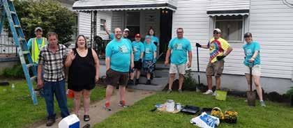
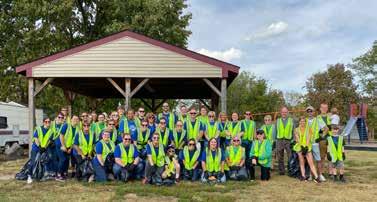
Planning a cleanup just got easier with 17Strong’s “Community Clean-up Chest” (a.k.a “The Cube”). The Cube is Hamilton’s all-inone neighborhood clean-up package, stocked with everything you need to host a successful clean-up event in your neighborhood. The Cube is free and available to all City of Hamilton residents. Reserving The Cube is simple. Fill out the reservation form with the date, location, and time of your event. The Department of Neighborhoods will follow up with your request and transport The Cube to the cleanup location on the day of your event. Community cleanups using The Cube will be added to the Neighborhood Meetings & Events Calendar for residents to view and keep up to date on volunteer opportunities in their area. To reserve the Cube, please visit www.hamilton-oh.gov/cleanups.


Want to Plan Your Own Event?

•
Reserve The Cube
5 6
•
•
Approval from the City of Hamilton is required when ten or more people are gathering in the streets, parks, public facilities or places owned or under the control of the City. of events requiring a permit include: 5K marathon on City streets and/or in a park Festival Concert at Marcum Park Parades on City streets Youth activity program at a park Wedding Block parties being held on a public street Learn more about special events and how to submit a permit request by visiting www.hamilton-oh.gov/specialevents.


•
•
•
•
Examples
For any crime in progress or issues that present an immediate threat to life or property, call 911.
How to Get Involved to Improve Your Neighborhood
Neighborhood Meetings & Events Calendar Keep up to date on what is happening in your neighborhood by visiting 17stronghamilton.org/calendar.
8
You can help keep your city beautiful by volunteering for neighborhood cleanups. To organize your own cleanup, visit www.17stronghamilton.org/cleanups and reserve “The Cube,” Hamilton’s all-in-one neighborhood cleanup package.
For all other inquiries. Non-emergency Dispatch
Sit on Your Front Porch
OTHERSPECIFICPOLICEMOSTREQUESTS
Commit to a 30 minute walk around your neighborhood and try to talk to 5 people and give a friendly, “Hello.” Bonus points for talking with people you have never talked to before.
ONLINEPHONE911
It’s hard to get to know your neighbors if you don’t ever see them. Just by being out in front of your home you can give off a welcoming vibe that encourages interaction.
Trash Pickup
Department of Neighborhoods neighborhoods@hamilton-oh.gov
Neighborhood Meetings Going to your neighborhood meeting is a great way to get involved in your community. During meetings, residents can discover events and volunteer opportunities, create their own solutions to neighborhood problems, and bring up any concerns that you believe might be overlooked.
Talk to Five People
311’ from your phone’s app store and walk the neighborhood. Report issues like tall grass, potholes, street lights that are out, etc.
MyHamilton (311) MyHamilton (311) is the official smartphone application for Hamilton residents and the best way to connect to city services. It allows residents to report a variety of non-emergency issues directly to the city personnel responsible for those tasks. BY
Hamilton Parks Conservancy (513) 785-7055
To reserve park shelters and for other park related questions. Hamilton Utilities (513) 785-7550 Report issues and outages or connect with utility customer service.
If you have an issue, such as parking or noise, you can call 513-785-1300. (513) 785-1300 Vice Hotline For ongoing neighborhood concerns, such as drugs or domestic violence, leave a message at 513-868-5811 x2001. (513) 868-5811 x2001
If you want to take a hands-on role in keeping your neighborhood clean and getting your neighbors involved, think about organizing a neighborhood cleanup, attending a neighborhood meeting, hosting a porch party, or any one of the variety of ideas provided on the 17 Strong website at www.17stronghamilton.gov.TurnOnPorchlightDothiseverynightatduskand keep it on till dawn. Crime tends to decline in neighborhoods that are well lit. Turning on porch lights is a simple way to start this process. It also makes the street feel more “welcome” to neighbors who are out for a walk in the evening. It communicates a higher level of safety and caring. Encourage other neighbors to do the same. A well lit street can make a huge difference! 7
311 DownloadBlitz‘MyHamilton
Connect with Us
The name of the neighborhood is likely derived from the many members of the DeArmond family who were involved in the development of the neighborhood. has been cited in studies of southern migration to the north as a place where and 2nd generation Appalachian residents aspired to live.

1st
ARMONDALE neighborhoodstraditional welcome to MainStreetAvenueMcKinleyAvenueKenworthAvenueLawsonAvenueElmont Western Avenue Azel Avenue Ross GoodmanAvenueAvenueFranklinAvenueHuntAvenue Millville Avenue Highland ParkRossville N 1 5 4 LawnAvenue EdgewoodAvenue 2 3 Places of Interest Millikin Woods Virginia Avenue Park Main St. Business DistrictHighland Elementary School Post Office Armondale is a neighborhood including both the Armondale and Edgewood subdivisions. Edgewood was the name of the stop on the historic Junction Railroad between Hamilton and Indianapolis. The neighborhood is home to one of Hamilton’s two post offices. 894 Households 0.32 Sq. Miles 9 1 2,248 Population What’s in a Name?

Armondale

13 EAST END neighborhoodstraditional

1 N TuleyRoadPiperPlace PanamWayWaco Way ImlayCornellAvenueParrishAvenueAvenue ParkamoAvenue Van Buren Drive PaterAvenueBender Avenue ShulerAvenue MoslerAvenue Grand BoulevardSErieBoulevard HarmonAvenue Hensley Avenue HancockAvenueIrma AvenueSFairAvenue Michael Avenue HampshireDriveLindaLane Vista DriveLindenwaldJefferson 5,024 PopulationBoys& Girls Club Butler RegionalCountyAirport

welcome to East End, also called East Hamilton or Gobbler’s Knob, was created with the building of the Mosler Safe Co. in 1891 and annexed in 1908. It was home to the two largest safe companies in the city that was once known as the “Safe Capital of the World.” Capital Banking on the promise of money, land, and employee housing, Mosler Safe Co. relocated from Cincinnati in 1891. The East End neighborhood began to take shape with the welcoming of Mosler Safe Co. to the area.
of the World
1,904 Households 1.12 Sq. Miles Places of Interest Jefferson Park Crawford CrawfordElementaryWoodsSchoolWoodsPark Safe


100+ Years Highland Park was first developed in 1919. It was quickly populated by some of the most influential business and civic leaders of the day. Here you’ll find homes designed by local architects Fredrick Mueller and George Barkman.
Places of Elementary Avenue Park Wilson Middle School
VirginiaSchool
neighborhoodstraditional welcome to HIGHLAND PARK
659 Households 0.28 Sq. Miles
1 N EatonAve LawrenceHelmaAve Ave Highland Ave ArmoAve LawnAve EmersonAve HaldimanAve Cereal Ave AveHaven AveMarcia AveDickN ParkAve NEdgewoodAve Rhea Ave BealAve Prospect Hill Taft Governor’sPlace/ Hill Armondale MainStreet 1,638 PopulationFortHamiltonHospitalMainSt.BusinessDistrict 14
Interest Highland
Highland Park was annexed in 1919. The neighborhood is composed of the subdivisions Lawn View, Lawn Park, and namesake Highland Park. Its quiet, treelined streets and residential architecture are beloved by residents for their storybook feel.


Places of Interest
welcome to neighborhoodstraditional JEFFERSON
Jefferson, also called 4th Ward, was at one time a highly industrial neighborhood, and enclave for Italian immigrants to the city. It is now home to many small bustling family-owned businesses and is the city’s most ethnically diverse neighborhood.

Debbysville
The Miami-Erie Canal (now Erie Blvd.) helped to transport goods prior to the expansion of railroads in America. In 1826, the canal was outside of Hamilton, and a man named William Murray saw an opportunity to plat a new town at the intersection of Maple Ave. and the canal. Debbysville, named for Murray’s wife, forced Hamiltonians to construct the Hamilton Basin, an inlet parallel to Maple Ave. down to 3rd St., allowing Hamilton to regain its trade advantage.
1,136 Households 0.55 Sq. EastDistrictCentralMilesBusinessAveOrchardServeCity1 N NErieBoulevard S7thStreetLudlowHighStreetMapleAvenueEastAvenueStreetSycamoreStreet Chestnut Street Walnut Street Hanover Street Long GrandHamiltonStreetAvenueEdisonAvenueHensleyAvenueBoulevardSippleAvenueDixieHighway East End Lindenwald North End Riverview 6 4,668 PopulationBoys& Girls Club Jefferson Park 166 Miami University


Officer Bob GentryLindenPark ElementarySchool 10,248 PopulationBenninghofen Park 186
The name Lindenwald is of German origin, meaning “forest of linden trees.” Many streets were named for former Ohio governors (Tiffin, Corwin, Bishop, and Hayes), local landowners (Neilan, Van Hook, and Symmes), or land developers (Benninghofen, Fitton, and Hammond). NeilanBoulevard New London UniversityBoulevard HillRoad GroveAvenue FreemanAvenue ElmoAvenue Belle AvenueNobleAvenue Williams Avenue Woodlawn Avenue PleasantAvenue Symmes Avenue BenninghofenAvenue MadisonAvenue Fairview AvenueLaurel Avenue Hooven Avenue Clinton Avenue Chase Avenue Tiffin Avenue Corwin AvenueGriesmerAvenueRiverRoad Brough Avenue Hayes Avenue Noyes Avenue Allen Avenue St Clair Avenue Bishop Avenue FosterHoadleyAvenueAvenue Allen Avenue Bishop Avenue Carlton Drive Dayspring HammondDriveBoulevardHillSymmesAvenue Road ArlingtonAvenueFreemanAvenueBedford Avenue Kenyon Drive Forest Lake Lane 6


JoeNuxhallWay
DixieHighway Jefferson


LINDENWALD neighborhoodstraditional welcome to Lindenwald is the City’s most populous neighborhood. It is unique for its bounty of park space, resident pride, and diverse, quality residential architecture. Of note are the many east-west streets named for 19th Century Ohio Governors. Places of Interest Joyce MiamiAreaRiversideParkNaturalUniversity 4,214 Households 2.78 Sq. Miles What’s in a aWhat’sname?inName?
1 N
It’s not a stretch to say that Hamilton wouldn’t be Hamilton without the North End. The impact of the hydraulic canal can’t be overstated. It powered early Hamilton industry and positioned this city for success in those transitioning years from frontier outpost to “the greatest manufacturing city of its size in the world.” Some of the most significant manufacturers in Hamilton’s history were here. North End, like the East End, is known for its celebrated industrial past and residents of German and Appalachian heritage. It was home to the Fordson Tractor Plant, a subsidiary of Ford Motor Co., and the boyhood home of baseball great, Joe Nuxhall.
Places of Interest Joe Nuxhall Ballfields Moser CemetaryGreenwoodPark 1,300 Households 1.31 Sq. Miles Cradle Hamiltonof Industry 1 JoeNuxhallBoulevard PoplarStreetLinnStreetVineStreet Greenwood AvenueFairgroveAvenueNFairAvenueGilmore Avenue VanderveerCampbellAvenueAvenueMillRoad N2ndStreetN3rdStreet N6thStreetN7thStreet ShirleyMoreyHelenAvenueAvenueAvenue CarterDouglasLaneTerrace Dayton Lane VillageGerman 6 Prospect Hill NHamilton Middletown Road NErieBoulevard HeatonStreet Butler SchoolFairwoodFairgroundsCountyElementary 3,807 Population Garfield Middle School 20 6


neighborhoodstraditional welcome to NORTH END
Places of Interest Wilson Middle School Fort HospitalHamiltonJimGrimmPark 1,651 Households 0.83 Sq. Miles Champion 1 N Washington Rossville North End Haldimand AvenueCereal Avenue Webster Avenue Gordon AvenueGray Avenue AvenueHunter StreetDNRhea Avenue NBStreetAvenuePrytaniaAvenueRidgelawn AvenueCleveland StreetEN StreetFN AvenueProgress AvenueSherman Elvin Avenue Liberty AvenueWayneAvenueParkAvenue AvenueEaton St. Peter in Chains CombsSchool Park 4,487 Population 22

The Champion Coated Paper Mill is one of the most storied companies that ever called the city home. While Champion’s founder Peter G. Thomson is known for his paper making, he was also a significant developer in the city. He purchased the Thomas Rhea Farm and filed a subdivision plat, naming it Prospect Hill. The Thomson family later donated the land that now contains Twin Run Golf Course.
PROSPECT HILL neighborhoodstraditional welcome to


Peter Thomson, founder of Champion Paper, built the Prospect Hill and Grandview subdivisions behind his world-renowned mill. It is a tree-lined neighborhood noted for a number of unique craftsman homes, Fort Hamilton Hospital, and Wilson Middle School.

Places of Interest 23 Municipal Building 1 6 575 Population
Hamilton was founded in 1791 with the completion of Fort Hamilton on September 30th. Named in honor of Treasury Secretary Alexander Hamilton, the fort was the second in a chain of forts after Fort Washington (Cincinnati) to support the campaign to secure the Northwest Territories. The army chose the location near the present High/Main Bridge because of a shallow crossing of the Great Miami River that existed there.
Fort Hamilton
Downtown is the historic and geographic center of the city. Monument Park is part of the original site of Fort Hamilton, built in 1791, on the east banks of the Great Miami River. Today, Downtown is a growing, vibrant city center full of new businesses and residents.


DOWNTOWN neighborhoodsurban welcome to N MagnoliaStreet SycamoreStreet DaytonStreet MarketStreet CottageStreet ButlerStreet CourtStreet MonumentStreet RiverfrontPlaza SMartinLutherKingJrBoulevardLudlowStreet S2ndStreet N3rdStreet N5thStreet S5thStreet German Village Riverview Dayton Lane Jefferson Rossville 6 195 Households 0.18 Sq. Miles Fitton Center Rotary Park Central Business DistrictMonument Park Marcum Park

Lewis D. Campbell
25 1 1,589 Population
neighborhoodsurban welcome to DAYTON LANE N BuckeyeStreet NErieBoulevard HighStreet HeatonStreetBuckeyeStreet BuckeyeStreet StewartCampbellAvenueStreet CenterStreet N6thStreet N7thStreet N8thStreet N9thStreet N10thStreet N11thStreet DaytonStreet Jefferson DowntownGermanVillage North End 581 Households 0.2 Sq. Miles Places of Interest Hamilton Board ofEducation Campbell Avenue GreenwoodPark CemetaryMoser HistoricDayton-CampbellParkDistrict
Dayton Lane is composed largely of the historic district by the same name. The turnof-the-century neighborhood features the residences of the industrial elite from the late-1800s through the early-1900s. Notable is the unique Campbell Avenue Park.


Campbell Avenue is named after the then US Congressman from Hamilton and ardent opponent of the expansion of slavery to the new western territories. In the summer before the Civil War, future President Andrew Johnson, was the only southern senator to oppose secession. He stayed with Campbell in Hamilton for weeks during the summer/fall of 1861.

1st IndustrialistsGeneration


GERMAN VILLAGE neighborhoodsurban welcome to N RaceStreetDaytonStreetHenselPlaceVillageStreetLindenStreetErwinStreet BuckeyeStreetRiverfrontN2ndStreetPlaza Downtown Prospect Hill North End Dayton Lane 244 Households 0.08 Sq. Miles Places of Interest Marcum Park Hamilton LaneFoundationCommunityPublicLibrarySt.YWCAJulie Church German Village includes landmarks such as the historic Lane Public Library, YWCA, and Marcum Park. It was home to Hamilton’s first courts, school, newspaper, and businesses. German Village, along with Downtown, is the oldest part of the city. 27 1 498 Population

As Hamilton became an industrial powerhouse in the mid-1800s, many of the original industrialists and entrepreneurs called this neighborhood home. Though not known as German Village at the time, many early business leaders living here were of German descent. German or not, many of Hamilton’s early leaders who called this neighborhood home later contributed greatly to the city’s growth and development.


Formerly


a market, Bailey Square is now a commemorative space for the successful men and women from the neighborhood. Named in honor of Jim “Boxcar” Bailey, an outstanding athlete at Hamilton High School and Miami University. 1 2,886 PopulationBaileySymmesSquarePark N StephensStreet SycamoreStreetGrantCircleSMonumentAvenueHurmStreet WilsonStreet CharlesStreetS3rdStreet HenryStreet Pershing Avenue Chestnut Street Walnut Street S4thStreet SMartinLutherKingJrBoulevard Washington Street Hanover Street Beckett Street SFrontStreet MinsterStreet OwenStreetLaneStreetWallaceStreetBaxter AvenueLongStreet ShortStreetCentralAvenue Knightsbridge Drive S2ndStreet Vora Drive UniversityBoulevardNeilanBoulevard Marshall Avenue Jefferson Downtown 30


neighborhoodsurban welcome to RIVERVIEW 1,069 Households 0.67 Sq. Miles Riverview, sometimes referred to as 2nd Ward, is home to such icons as the Booker T. Washington (BTW) Community Center, Bailey Square, Foundation Field, and Symmes Park. A neighborhood with many active churches and a proud history. Places of Interest BTW MiamiSchoolRiverviewCenterCommunityElementaryUniversity Bailey Square

Places of Interest Veterans Park Rossville Historic MainDistrictSt. Business District 830 Households 0.37 Sq. Miles 1 Sutherland Park Central Business District 1,891 Population N New London WoodfordStreet ParkAvenue Prospect HillMillville Avenue NewLondonRoadFranklinStreet RossAvenue MainStreet PuthoffStreet HarveyCourtMillikinStreetBabLaneHomeAvenue CrescentRoad SDStreetSEStreet SFStreetSCStreet SBStreet NBStreet SAStreet ArchStreet
Rossville, named in honor of Pennsylvania Senator James Ross, was a separate city from Hamilton until the mid-1850s when it was annexed by Hamilton. Many street names have changed, such as Morris to Main, Boudinot to Park, North to Wayne, and South to Arch. Ross Avenue (then Ross Street) was originally planned to be the town’s main thoroughfare.
A Separate City
33 ROSSVILLE neighborhoodsurban welcome to

Rossville was a separate city from 18041854, when it was annexed into the City of Hamilton. It is named in honor of Sen. James Ross of Pennsylvania, and is home to the historic district of the same name, including the iconic Main St. Business District.


The Hogan family instructed over 300 pilots for service here during World War II and managed the airport here for over 50 years which grew into the Butler County Regional Airport. Enterprise Park is largely made up of newer business/industrial park uses, but has a number of apartment complexes along Bypass 4, and an adjacent subdivision. It is also the home of the Butler County Regional Airport.
welcome to neighborhoodssuburban ENTERPRISE PARK

Hogan Field
1,011 Households 3.36 Sq. Miles Places of Interest Butler HamiltonRegionalCountyAirportEnterprise Park Butler County RegionalTransit Authority 1 NMcbride Court GatewayAvenue Hamilton Enterprise Park Drive TylersvilleBlistenBoulevardStandenDriveRoad TylersvilleRoad Symmes Road 2,218 PopulationButlerCounty Board of DisabilitiesDevelopmental 34


Formerly Stahlheber Woods, Millikin Woods was renamed in 1950 in honor of Dr. Mark Millikin who, among other things, is responsible for the City’s Charter. The original entrance gates to the park are located at the west end of Ross Ave. The gates and large octagonal shelter houses were built in the 1930s by the Works Progress Administration (WPA). Washington Blvd. was extended through the park in 2003 allowing easier access to the park and its amenities. Millikin is named for the fact that its subdivisions, like Brookwood, Twinbrook, West Park and others surround Millikin Woods Park. It developed largely after World War II and was notable for being where many G.I.s returning from the War built their first homes.
MILLIKIN neighborhoodssuburban welcome to Millikin Woods


Places of Interest Smalley DistrictWestsideElementaryBrookwoodParkSchoolCommercial 2,317 Households 1.88 Sq. Miles 1 Westover PreparatoryMillikinSchool Woods 5,460 Population N Taft Place/Governor’s HillNWWashingtonBoulevard MainStreet Millville Avenue Stahlheber Road Brookwood Avenue BarringtonDrive Springvale Drive NWashingtonBoulevardAvenueCarlisle AvenueWestfield DriveHatherlyDriveArmstead DriveKingston DriveHaverhill DriveQuincy DriveStafford BrookcrestDriveSunsetDrive DriveWestbrookFairhaven Drive DriveCambridge TwinbrookDrive WarrLane SmalleyBoulevardThornhillDrive OlympusDrive RockfordDrive Westview TimbermanAvenueAvenue NWashingtonBoulevard Armondale New London 36

NEW LONDON neighborhoodssuburban welcome to N Downtown DriveGorham Millville Avenue Riverview AlbertaDianaDriveDrive DriveRamsey RoadWasserman DriveTimberhill SusanDrive SWashingtonBoulevardHarrisonAvenueMillikinStreetAmberlyDrive Glenway Drive New London RoadDriveMollie Fairborn Drive DriveFarmington DriveHogan Columbia Road Sharon LaneImpala Place Carriage Hill Lane PyramidHillBoulevardOakmontAvenue Ross Hanover Road Places of Interest ElementaryRidgeway School Miami VeteransWoodsParkBadin High School Potters Park Golf Course Named for its primary thoroughfare, New London is composed of the following subdivisions among others: Oak Park, Forest Hills, Fairway Hills, Britton Ridge, Heathwood, and Southern Hills. It is home to Badin HS, Potter’s Park Golf Course, and Miami Woods. 3,247 Households 3.9 Sq. Miles 37 1 7,919 Population Did you know that the highest elevation in Hamilton is just off of the intersection of New London and Ross-Hanover (916 ft)? This comes as a surprise to many since other hills in the city that have steeper drop-offs, such as Eaton Ave. Hill (872 ft) or behind Garfield (710 ft). ElevationHighest


Interest Twin Run Golf WestoverCourse PreparatoryGreatSchoolMiami Valley YMCA 1,783 Households 1.91 Sq. Miles 1 N HighlandWashingtonParkMillikin CourtCastlepines Beissinger Road EdenParkDrive Taft Place ThomasCarmenAvenueBoulevard NW Washington Boulevard Winston Drive NBrookwoodDrive DriveStephanie DriveLivingston DriveBrookAshley Coleman Drive Conner Drive Hamilton High SandersSchool Park 3,594 Population 40

In the Fall of 1791, the army marched from Fort Hamilton across the river and through dense woodlands for two miles before camping for the night. They set up behind what is now the YMCA on Washington Blvd. They continued their march the next day approximately along the current path of Eaton Ave., and made it an additional two miles before camping at another creek. This continued the following day after a three mile march which inspired the names of, Two, Four, and Seven Mile Creeks. Taft Place/Governor’s Hill is home to Hamilton High School, Fitton Family YMCA, and Twin Run Golf Course. Notable subdivisions are: Taft Place, Governor’s Hill, Gunn Eden Park, Carmen Place, Fairways at Twin Run, Gardner Ridge, and Deerfield Village. of
neighborhoodssuburban welcome to Taft Place/Gov. Hill


Places
First Day’s March
Sanders,
A BeltwayPlanned
43 WASHINGTON neighborhoodssuburban welcome to


Washington is home to the Hamilton Freshman School and world-champion West Side Little League. It’s composed of the following subdivisions among others: Random Hills, Random Oaks, Berkeley Square, Hamilton West Estates, and Gordon Smith.
Places of Interest Hamilton High SandersSchool Park Berkeley Square 2,175 Households 1.76 Sq. Miles 1 N Highland Park EatonGordonSmithBoulevardAvenue Prospect Hill Taft Governor’sPlace/ Hill Justin Place RandomRandomDriveCourt Beeler Boulevard AvenueCleveland Tabor Lane Thall Drive LaneAinsley CourtNichole LaneTatum ShultzTracyDriveLaneHermayDrive LaneLora Bridgeport Drive DriveWinslow CourtSomertonCathedral DriveAlexanderDrive Sanders Drive NWWashingtonBoulevard Mark Avenue SchwartzAnnieLouDriveDriveHermanAvenue BerkeleyDrive FernLaneMossyGrove Hamilton Freshman ElementaryBridgeportSchool School 5,192 Population 42
What became the basis for Washington Boulevard first appears on maps in the city’s 1920 plan as a bypass parkway extending northwest from South B Street all the way around to North B Street. In 1920, most of that proposed right-of-way was outside the city. While successful segments of this plan were executed, many of them were derailed by the Great Depression and World War II.
