Southwestern Commission 2013 Regional Trails Plan


FINAL —September 2013

This page intentionally blank for printing purposes.
2013 Regional Trails Plan Southwestern Commission1 Southwestern Commission 2013 Regional Trails Plan Table of Contents 1. Introduction....................................................................................................................................... 3 2.Trails & Trails Users....................................................................................................................... 6 3. Public & Stakeholder Involvement..............................................................................................11 4. A History of Success Stories........................................................................................................14 5. Region, County Maps & Project Ideas........................................................................................20 6. Mountains-to-Sea State Trail Routing Concepts......................................................................32 7. Health & Economic Impacts of Trails........................................................................................38 8. Maintenance & Operations.............................................................................................................42 9. Implementation..................................................................................................................................46 Appendix: Supplemental Materials...................................................................................................52 Page “Our ultimate aim is more than just a trail–it is a whole system of them, a cobweb planned to cover the mountains... Here is where the planningcomes, for a playground and a living ground–well equipped, well cared for, and well used.” –Benton MacKaye, “Progress Toward the Appalachian Trail”, Appalachia(1922)
Acknowledgments


The Southwestern Commission and State Trails Program thank the individuals and organizations who contributed time, maps, and resources to help us compile the Regional Trails Plan. The counties and towns that are members of the Southwestern Commission continue to provide invaluable support, both monetarily and through commitment of staff and elected officials, to promote efforts such as the Regional Trails Plan. We thank all of you for your contributions!


G.R.E.A.T.

Sarah Graham, Regional Planner
Philip Moore, Environmental Planner


Don Kostelec, Trails Plan Project Manager
Southwestern Commission 2013 Regional Trails Plan 2
Ryan Sherby, Executive Director
Darrell McBane State Trails Program Manager
Southwestern Commission
Chapter 1 Introduction
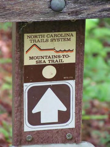
The Southern Appalachian Mountains of Western North Carolina have been a recreational haven since the 1800s. The area contains the Great Smoky Mountains National Park along with premiere hiking trails such as the Appalachian Trail, Benton MacKaye Trail, Bartram Trail and Mountains to Sea Trail. Communities across Western North Carolina are investing in greenways that connect destinations within small towns, mountain bike trails, and blueways (or paddle trails) along the region’s scenic rivers.
This combination of world class trails attracts visitors from across the state, the United States and the world, promoting economic development and healthy living. Until now, the region’s trails have never been fully cataloged into a cohesive set of maps. Further, common considerations for future trail expansion and documentation of what each community envisions for a future trails system was desired by the State.
In 2012 and 2013, the Southwestern Commission— the regional council of governments for the seven county region of Western North Carolina— developed this Regional Trails Plan to be the first ever effort to catalog and plan for a future trail system.
The Plan efforts, funded through the North Carolina
Division of Parks and Recreation’s State Trails Program, includes data collection on regional trails, public workshops to gather ideas for new trails, and documentation of other trail– and greenway related considerations for the region.
The seven counties evaluated for the Plan are:
Cherokee County;
Clay County;
Graham County;
Haywood County;
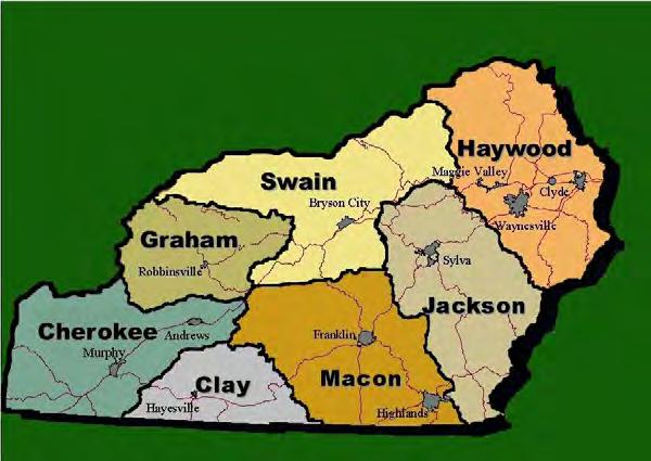
Jackson County;
Macon County; and
Swain County.
The Plan was intended to gather ideas from citizens and community leaders as to where towns, counties, and other community stakeholders should pursue new trails or enhancement of existing trails. This includes hiking trails, mountain bike trails, greenways, paddle trails, equestrian trails and connections between trails.
Trails identified through this Plan will become part of the State Trails Plan and recognition in this Plan will help the region receive state funding through grant programs administered by State Parks as one criteria for ranking of applications is inclusion of a trail in a regional plan.
What does the Plan include?
The primary product of this plan is a regionwide map indicating where existing hiking trails, greenways, mountain bike trails, equestrian trails and some on
2013 Regional Trails Plan Southwestern Commission3
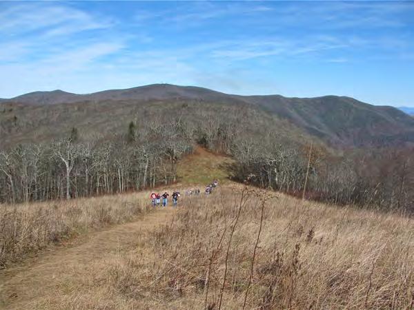
The Southwestern Commission Regional Trails Plan included ideas for new trails and implementation recommendations for the seven western counties in North Carolina.
road bicycle routes are located. It also includes recommendations, based on public input, on where new trails, greenways or routes may be located to connect to other trails or connect towns/ communities to one another.
Other themes addressed in this Plan include:
Regional Success Stories;
Mountains to Sea Trail Options;
Health & Economic Impacts of Trails;
Maintenance & Operations of Trail Facilities; and
Funding & Implementation Recommendations.
Why a Trails Inventory & Concept Plan?
Interest in trails and greenways has always been strong in Western North Carolina. As the region has grown there have been numerous efforts to better identify where existing trails are located and where they are desired. These efforts have never been consolidated into one regional plan to identify partnerships or opportunities among various stakeholders.
The Plan is intended to be a starting point for trail and greenways considerations that the towns and counties within the region can use to conduct more detailed planning, project design and implementation of desired trails and associated facilities.
Benefits of Trails & Greenways
The movement to improve the health and wellness of adults and children across the country has identified trails and greenways as a critical component of healthy living and active lifestyles. In Western North Carolina, they also contribute greatly to the quality of life in the region and will be a vital part of the re-
gion’s attractiveness to visitors, residents and those looking to relocate to the area. Communities often believe they cannot afford to conserve open space and secure land to place greenways and trails. But accumulating evidence indicates that open space conservation and the creation of trails and greenways are investments that produce significant economic benefits to help offset the costs of securing and acquiring land.
There are many benefits of walking and bicycling, including mental health, fostering of independent thought, and physical fitness. Trails and greenways also offer an opportunity to provide natural “playscapes” to encourage children, teenagers, families and older adults to engage in outdoor activities.
How can you stay involved?
This Plan represents input gathered from a variety of sources who contributed to the effort by providing data, mapping information, public input and case study profiles. Organizations that had direct input into the Plan include:
Town and County governments;
Advocacy organizations;
Land conservancies;
Friends groups; and
Individuals.
Southwestern Commission 2013 Regional Trails Plan 4
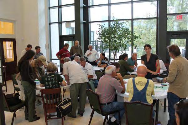
Many of the participants in the Regional Trails Plan workshops are actively involved in various organizations that promote and manage trails in Western North Carolina.
Photo: Don Kostelec
Adoption of this Plan by the Southwestern Commission is only a start. The agency will need passionate citizens and organizations to help carry the Plan forward to implementation. The groups noted on the acknowledgments page of this report are always looking for volunteers to help maintain trails and seek funding for trail enhancements or new trails. We encourage you to get and stay involved!
How much will trails & greenways cost?
The cost to build and maintain a trail or greenway can vary greatly depending on the setting, the type of materials used to pave the greenway or leave a trail in a natural state, and the amenities desired by citizens and communities. The funding source and requirements associated with environmental components of the project, such as wetland buffers, can also impact cost.
Items such as bridges, boardwalks over wetlands, and crosswalks and signals at street intersections also impact cost. Other features such as lighting, signage, benches, information kiosks and historical markers can add to the overall cost to build a trail or greenway.
What’s next?
Work to compile this Plan includes collecting trails, greenways, parks/recreation, pedestrian, bicycle and land use plans from the towns and counties within the study area. Southwestern Commission also gathered several mapping files for current trails, public lands, conservation easements, state bike routes, and others to create the basemaps that are a starting point for the plan and workshops.
Now it’s time to implement the recommendations contained in this Plan. Some the key recommendations outlined in more detail in this report are:
Volunteers are critical in establishing, maintaining and upgrading trails. The climate of Western North Carolina creates many challenges to keep trails open for all types of users.
A simple footpath can be built almost solely through volunteer efforts and oftentimes requires no land acquisition costs if built on public lands or on already obtained conservation easements.
A 10 foot wide asphalt pathway can cost more than $600,000 per mile to pave. The same pathway that is constructed with gravel or mulch surfaces can cost up to $150,000 per mile, but will incur higher maintenance costs.
Establish a Regional Trails Advisory Committee, consisting of prominent agencies and organizations with an interest in trails and greenways;
A coordinated and strategic funding effort to identify methods to secure financial resources to maintain and expand trails and greenways;
Seeking funding for establishment of a Regional Trails Coordinator position to be housed at the Southwestern Commission to oversee the Advisory Committee, coordinate grant pursuits among the Southwestern Commission’s member agencies, and serve as a technical resource for communities and organizations.
2013 Regional Trails Plan Southwestern Commission5
Photo: Back Country Horsemen of Pisgah
Chapter
Trails & Trail Users
A trail can be defined in many ways to reflect both the context of the trail and the users of the trail. Having a shared common knowledge and ideas about trails are important to encourage proper etiquette, ensure appropriate design, and create partnerships. One of the values in creating this regional plan is to ensure that trails within the region are recognized on the State Trails Plan.
A trail might generally be defined as a route or path which has been specifically prepared or designed for one or more recreational functions. Sometimes this is done with thought, planning and effort and sometimes trails just appear on the landscape having been created by individuals who find the path functional or recreational where design and management have not taken place.
Specialty trails and activity trails are two broad categories of trails. Specialty trails relate to a general environment or function while activity trails are designed and built around a function and use.
In North Carolina, there are four official State Trails, designated by law to be units of the North Carolina State Parks System. State scenic trails are defined as extended trails so located as to provide maximum potential for the appreciation of natural areas and for the conservation and enjoyment of the significant scenic, historic, natural, ecological, geological or cultural qualities of the areas through which such trails may pass. State recreation trails are defined as trails planned principally for recreational value and
may include trails for foot travel, horseback, non motorized bicycles, non motorized water vehicles, and two wheel and four wheel drive motorized vehicles.
Specialty Trails
Historic Trails identify and interpret significant historic routes traveled by early explorers or settlers. These trails have been an integral part in shaping American history and allow users to take part and experience some of those historic moments. They are a valuable link in relating a part of history to many people.
Interpretive Trails are trails on which natural and /or cultural environments are interpreted by means of a guide or through various self guiding methods such as illustrative signs. Accessibility to schools, parks and other community gathering spaces are important if outdoor, environmental or conservation education is to take place. These trails help us understand how natural and cultural environments relate to our own and can teach us to appreciate other aspects of life around us.
Recreational Trails interconnect park and recreational areas with communities along routes of scenic, natural, historic, geologic, aquatic or other such elements. A recreational trail should not be designed as an expeditious (utilitarian) route for alternative com-
NOTE: This section is adapted, with permission, from an article produced by the Illinois Trail Riders and written by Denise Maxwell, “Definition of Trails.” It was the most comprehensive publication on defining trails found during research for this Plan.
Southwestern Commission 2013 Regional Trails Plan 6
2
Users of trails may be restricted depending on the setting and ownership of the trails to protect the condition and sanctity of the trail. Photo: Outdoor 76; Franklin, NC
muting to shopping or places of employment or schools, nor be adjacent to major highway and transportation routes except when absolutely necessary.
In the 1991 National Recreational Trails Fund Act a "Recreational Trail " is defined as a "thoroughfare or track across land or snow, used for recreational purposes such as bicycling, cross country skiing, day hiking, equestrian activities, jogging or similar fitness activities, trail biking, overnight or long distance backpacking, snowmobiling, aquatic or water activity and vehicular travel by motorcycle, four wheel drive or all terrain off road vehicles, without regard to whether it is a "National Recreation Trail" designated under section 4 of the National Trails System Act."
sities, or where improvement of the trail surface is necessary by nature of the development within which it occurs and are generally developed in response to one of two emerging trends. One trend is an increase in leisure time and an interest in fitness oriented activities among urban groups. The other trend comes from concerns about the quality of the environment due to explosive urban growth. Congestion of traffic and alternative (non motorized) transportation modes for urban commuters plays a part. These trails provide local and ready recreation, fitness and aesthetic amenities, reclaim otherwise abused or under used land such as utility right of ways or abandoned rail corridors. Greenways, open spaces and the enhancement of natural or man made waterways for use as parks and trails is a popular urban project.
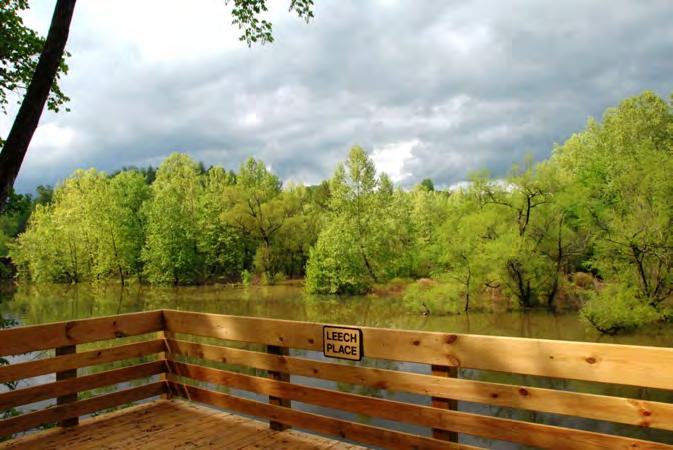
Leech Place along the Murphy River Walk offers users an interpretive experience. Cherokee legend reveals the story of Great Leech, with its red and white striped markings, would cause the water to boil up into a white foam. Then, a great white wave would rise up and sweep people into the deep hole of the river below.
Photo: Paula Bryan
National Trails exist as four types of trails that make up the National Trails System under the authority of the National Trails System Act in 1968. These include National Scenic Trails such as the Appalachian Trail. National Historic Trails include the Trail of Tears.
Urban Trails occur in areas of urban or suburban den-
Supplemental Trails are additional trails required by law in locations within single family housing developments and around developments which would block access from one area to the main trail system. They may take the form of easements or right of way.
Sidewalks are a form of trail that grace some of our neighborhoods and do not exist in other neighborhoods. In better planned neighborhood developments trails exist allowing easements for quick access to elementary schools, shopping, or access to shared common space. In some planned communities back yard gates allow access to alleys or common corridors which become trails.
2013 Regional Trails Plan Southwestern Commission7
"Bushwhacked" Trails are new trails made by individuals with no planning, or thought of environmental impact, legal use privileges or effects it might have on others. Their creation is considered unacceptable by responsible trail users.
Activity Trails
Non Motorized Trails of course restrict motorized
Trail Class Matrix
uses of a trail to all but wheel chairs.
Motorized Recreational Trails are specifically made available to all terrain vehicle riding, 4 wheel driving, dirt bike riding, snowmobiling and so on.
Greenway Trails are typically paved trails in urban or suburban areas that are intended for both recreational and transportation uses. Walking and biking
Tread & Traffic Flow
Tread intermittent and often indistinct
May require route finding
Single lane with no allowances constructed for passing
Predominantly native materials
Tread continuous and discernible, but narrow and rough
Single lane with minor allowances constructed for passing
Typically native materials
Tread continuous and obvious
Single lane, with allowances constructed for passing where required by traffic volumes in areas with no reasonable passing opportunities available
Native or imported materials
Tread wide and relatively smooth with few irregularities
Single lane, with allowances constructed for passing where required by traffic volumes in areas with no reasonable passing opportunities available
Double lane where traffic volumes are high and passing is frequent
Native or imported materials
Tread wide, firm, stable, and generally uniform
Single lane, with frequent turnouts where traffic volumes are low to moderate
Double lane where traffic volumes are moderate to high
Commonly hardened with asphalt or other imported material
Obstacles
Obstacles common, naturally ocurring, often substantial and intended to provide increased challenge
Narrow passages; brush, steep grades, rocks and logs present
Source: US Forest Service Trails Class Matrix (2008)
Obstacles may be common, substantial, and intended to provide increased challenge
Blockages cleared to define route and protect resources
Vegetation may encroach
Obstacles may be common, but not substantial or intended to provide challenge
Vegetation cleared outside of trailway
Obstacles infrequent and insubstantial
Vegetation cleared outside of trailway
Obstacles not present
Grades typically < 8%
Southwestern Commission 2013 Regional Trails Plan 8
Trail Attributes Trail Class 1 Minimally Developed
Trail Class 2 Moderately Developed
Trail Class 3 Developed Trail Class 4 Highly Developed
Trail Class 5 Fully Developed
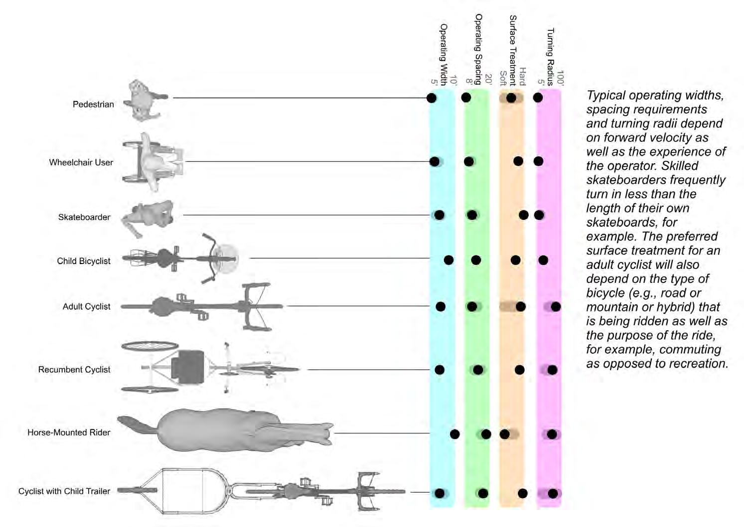
Trail Users: Design Factors
2013 Regional Trails Plan Southwestern Commission9
Graphic developed by J. Scott Lane, JS Lane Co.
are typical activities on greenway trails and are sometimes referred to as multi use trails, although some users, such as equestrians may be prohibited from these trails. Many rails to trails routes are considered greenways trails.
Bike paths are routes separated from vehicular traffic and like most bicycle activity areas has specific standards for size, clearance, grade and surface material (asphalt or concrete preferred). Bike Lanes exist along roadways but are delineated by markings on the pavement or signs and are exclusively for bikes. Shared Roadways serve both motorized and non motorized vehicles and are often marked by signage. Then one must understand that regular bicycles are different from mountain bicycles (fat tires, all terrain).
Mountain bicycles are non motorized and not to be confused with ATV's or ORV's which are motorized. Off road bicycling is popular in some areas and can be referred to as bike hiking.
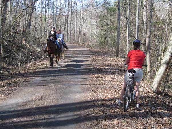
Equestrian Trails are usually non paved, might be close to home or more likely on public land in rural or semi isolated areas. Horse trails can be routed with and parallel to other use trails. Like bicycles, equestrians may share road surfaces with automobile traffic by riding to the right of the road, further over then the bike lanes if possible and on verges of the road when available. If horse trails are located parallel to road then barriers are sometimes placed between the road and the horse trail (Scottsdale, Arizona has exact standards for how this is done on
over highway bridges, in underpasses, and along 4 or 6 lane roads and so on).
When horse trails are located away from the horse population then amenities such as hitching posts, water supply parking lots, and such are necessary. Surfacing should be natural soil, mulch, gravel for short distances and non slick concrete or asphalt for shorter distances.
Jogging Trail/Fitness Trail/Par Courses are alternatives to public sidewalks and school running tracks. They should be smooth packed earth or compacted gravel or wood chips. They might also take the form of cross country track courses, marathon distance routes or as shared surfaces with bicyclists, equestrians or vehicles.
Off Highway Vehicle (OHV) Trails might be designated for two and three and four wheeled motorized bikes or 4 wheel drive trucks and jeeps. Trails should be well marked to reduce damage on various unmaintainable backcountry roads or in places designated specifically for OHV and ATV use.
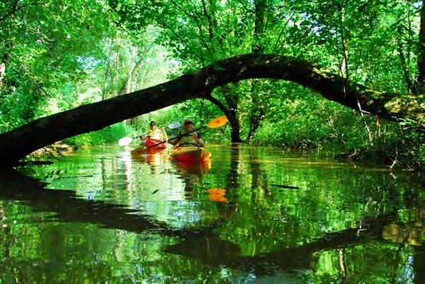
Paddle or Water Trails are for use by non motorized boat travel such as canoe, raft, and tuber. Often these parallel other trails used by hikers, equestrians and cyclists. Put in and Take out areas are important as are picnicking or safe camping spots.
Southwestern Commission 2013 Regional Trails Plan 10
Trails should accommodate diverse users, with each user group understanding the needs of other users.
Photo: Don Kostelec
Public Outreach Meetings for Regional Trails Plan
Ideas Gathering
Blue Ridge Bicycle Plan Regional Open House (Bryson City)

June 12, 2012
Joint Swain Co. & Jackson Co. Workshop (Sylva), September 13, 2012
Macon Co. Workshop (Franklin), September 19, 2012
Graham Co. Workshop (Robbinsville), October 1, 2012
Clay Co. Workshop (Hayesville)
October 23, 2012
Cherokee Co. Workshop (Murphy)
October 25, 2012
Haywood Co. Workshop (Waynesville), November 15, 2012
Draft Plan Review
Andrews Public Open House, February 19, 2013
Sylva Public Open House, February 21, 2013
Chapter 3 Public & Stakeholder Involvement
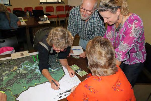
While there are many common features among the towns and rural communities in the seven counties of Western North Carolina, they are not the same. People have different interests, different backgrounds, and a different perspective on trails in their community. To accommodate these diverse opinions and reach stakeholders and citizens in each county, the Southwestern Commission conducted at least one workshop in each of the seven counties.
More than 100 people participated in a series of workshops in Fall 2012 that were set up as ideas gathering sessions. Participants included:
Interested citizens;
County and municipal government staff;
Local retailers, such as bicycle shops and outdoor equipment stores;
US Forest Service staff;
Representatives of local land trusts;
Hiking club members;
Friends groups;
Environmental advocacy group members;
University, college and school system representatives;
Economic development organizations;
Health professionals;
Local greenway and trails committees; and
Representatives of various user groups such as hikers, mountain bikers, and backcountry horsemen.
Gathering Ideas
Participants in these workshops were organized into small groups at tables including maps of the county in which the workshop was taking place. A map of trails within the region was also available. The participants were asked a series of “focus questions” aimed at gathering their input in an organized fashion. The focus questions asked them to:
1. Identify popular destinations with the community. These could include towns, scenic vistas, rivers and streams, lakes, businesses or other places.
2. Identify popular trailheads or starting points for trail users. These could include hiking trails, biking trails, equestrian trails, and greenways.
3. Determine if trails already connected the access points to destinations. If connections did exist, participants were asked to determine if we had mapped them correctly. If they did not exist, participants were asked to identify conceptual routes that could link them.
4. Prioritize their ideas. Participants were asked to label their top 5 priorities, which could include new trails, new trail heads, enhancements to existing facilities, or other adjunct uses.
The results of this exercise were used to generate the regional maps and county specific maps contained in Chapter 5. The priorities developed through this exercise were used to develop the funding and
2013 Regional Trails Plan Southwestern Commission11
implementation strategies contained in Chapter 9.
Identifying Challenges & Opportunities
Once workshop participants documented these ideas on the county by county maps, they were asked to identify, as a group, challenges and opportunities. The responses were a combination of broader, regional ideas for promoting greenways and trails. Some participants identified trail– or town specific challenges and opportunities.
The responses are summarized in the illustration on the following page. The opportunities and challenges labeled as “primary” represent topics that were discussed at multiple workshops or noted by participants to be a priority. The “other” category represents those responses viewed as important but related to more localized needs or requiring the primary issues to be addressed first.
Draft Plan Review
NOTE: This section will be completed after the draft plan is reviewed and open houses are conducted.
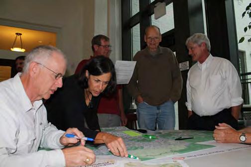
Open Houses. The draft Plan was published in February 2013 for review by stakeholders, workshop participants and other citizens. Two open houses were conducted in mid February to display the regional and county maps and gather feedback from attendees. One open house was held in Sylva and another was in Andrews.
Public Comments. In addition to comments received at the open houses, comments were solicited via an online comment form. The comment form was
linked from the Southwestern Commission’s website, which included PDF files of the maps and Plan document.
Plan Completion
The plan was completed in September 2013 after a seven month public review and comment period that centered around fine tuning language related to the Mountains to Sea Trail routing options (Chapter 6).
After this review period was complete, the Plan was submitted to the State Division of Parks and Recreation’s State Trails Program for endorsement and implementation along with other regional plans that have been adopted across the state.
The maps produced as part of this plan will be made available to counties, towns, cities and stakeholders within the region for further efforts on trail development and trail publicity.
Workshop attendees were organized into small groups and asked to identify popular destinations, trails, trailheads, and priorities for their county or area of interest.
Participants in the survey for the draft Plan prioritized the following implementation actions:
Work with partners and organizations to define a preferred route for the Mountains to Sea Trail;
Produce a set of trail maps and guides for WNC;
Organize a regional effort to designate Trail Towns and promote to visitors; and
Organize a trail friendly business program.
Southwestern Commission 2013 Regional Trails Plan 12
Photo: Don Kostelec
Primary Opportunities
Recognize economic development potential of Trail Towns designation.
Completion of Mountains to Sea Trail
Publish promotional materials & maps.
OPPORTUNITIES CHALLENGES
Build upon local success stories such as Jackrabbit Trails, the Murphy River Walk & Little Tennessee River Greenway.
Create and secure funding for a Regional Trails Coordinator position at Southwestern Commission.
Other Opportunities
Identify new partners and expand funding sources to build and maintain greenways and trails.
Connect major destinations such as downtowns, libraries, schools and parks with new greenway trails.
Recognize public health and fitness benefits.
Pursue paddle or float trail designation for Little Tennessee River, Tuckaseigee River, Hiwassee River, and Cheoah River.
Construct public portages along rivers, greenways and trails.
Evaluate rails with trails or rails to trails between Murphy and Andrews, Bryson City and Sylva.

Continue momentum for the culture of committed volunteers.
Expand existing greenways, such as the Murphy River Walk, Little Tennessee River Greenway, and Waynesville Greenway.
Make region the “Moab of the East” with Tsali, Hanging Dog and Jackrabbit mountain bike trails, along with potential for Tellico.
Continue development of the Santeetlah Trail.
Promote installation of shoulders / bike lanes along major routes through NCDOT highway modernization programs.
Identify solutions to move Bartram Trail linkages in Macon County from along roads to natural areas or linking to the Frankln greenway.
Primary Challenges
Funding for construction & planning.
Maintenance of existing facilities.
Conflicts among users along certain trails.
Lack of central coordination & agency collaboration on trail efforts in the region.
NCDOT’s willingness to accommodate bicyclists, hikers & pedestrians.
Lack of critical mass of users & volunteers to keep trails in usable condition.
Acquiring land for new trails and encouraging new development to dedicate land for planned trails and greenways.
Other Challenges
Maximizing grant and funding opportunities.
Availability of land for new trails and greenways; limited right of way along roads and highways.
Acceptance of multi use designation on US Forest Service trails.
Making small towns walkable outside of downtown areas.
Rumble strip placement along highways.

Upper Tellico Off Road Area is still being re claimed; communities saw loss of economic activity.
Keeping Tatham Gap Road near Andrews open year round.
Reducing encroachment of invasive plants.
Respectful use of trails and education (e.g. leave no trace).
Demand for off highway vehicle trails but few places for them.
Drawing visitors from Georgia to Hayesville from Jackrabbit Trails instead of them returning to Georgia after riding.
Mountain bike trails need more broad based planning to be successful.
Maintaining the sanctity of mountain trails given the pressures
2013 Regional Trails Plan Southwestern Commission13
Chapter
A History of Success Stories
Western North Carolina has a storied history of trail development dating back to the founding of the Appalachian Trail (AT). In addition to this world renown hiking trail, the Bartram Trail, Benton MacKaye Trail (named in memory of the AT’s founder), and the Mountains to Sea Trail serve as long distance linkages throughout the region that showcase the areas diverse terrain and scenic vistas.
The region is also blessed with vast natural areas consisting of the Great Smoky Mountains National Park, several National Forests, the Joyce Kilmer Memorial Forest and scenic rivers. Numerous trails are located within or along these natural areas.
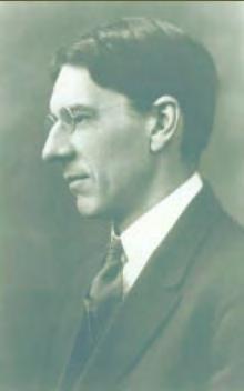
This chapter summarizes the history and function of these primary trails. It also showcases some of the small town success stories in hopes that their stories can serve as inspiration for other communities across the region and throughout North Carolina. Appalachian Trail. As documented by the Appalachian Trail Conservancy, Benton MacKaye—a forester and government analyst and newspaper editor who was employed as a regional planner— proposed a series of work, study, and farming camps along the ridges of the Appalachian Mountains. MacKaye envisioned a trail connecting these destinations to serve as a refuge from urban life in the early 1900s. The trail connecting them, from the highest point in the North (Mt. Washington in New Hampshire) to
the highest in the South (Mt. Mitchell in North Carolina) was envisioned. Hiking was an incidental focus. MacKaye began promoting his idea within his network of friends and colleagues in Washington, New York, and Boston. He found supporters among the area’s hikers whose leaders led to the effort to make the now famous “Maine to Georgia” slogan a goal for the AT.
MacKaye and the Regional Planning Association convened the “Appalachian Trail conference…for the purpose of organizing a body of workers to complete the building of the Appalachian Trail” in 1925. By 1937 the 2,000 mile trail was complete.
Today, the 88 mile stretch of the AT in North Carolina is considered one of the most rugged and memorable stretches of the trail. The Appalachian Trail Conservancy describes the North Carolina section of the trail as: South of the Smokies on the Appalachian Trail are the long climbs of the Stecoah Cheoah Mountain area, then the outstanding Nantahala section, with 4,000 foot gaps and 5,000 foot peaks. Cheoah Bald offers panoramic views of western North Carolina. Like much of the AT in the deep South, users have a feeling of remoteness, and a sensation of being in deep forests. The variety of forest growth and the beauty of the flowering shrubs, along with the many spectacular views, make this entire section of Trail memorable. (The Appalachian Trail Conservancy.)

Southwestern Commission 2013 Regional Trails Plan 14
4
“Achieving this protected status is the result of the enthusiasm and concern of a host of hikers during half a century. Perhaps it is unrivaled by any other single feat in the development of American outdoor recreation.”
- Benton MacKaye, TheAppalachianTrail(1972)
Benton MacKaye
Photo: Appalachian Trail Conservancy
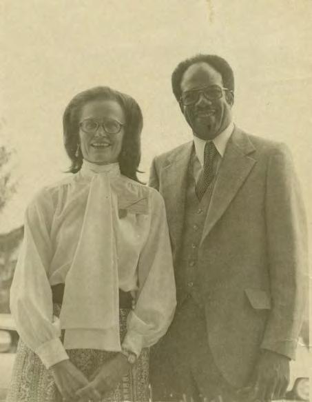
Dr. Doris Hammett, a long time advocate for the Mountains to Sea State Trail, and Howard Lee at the 1977 National Trails Symposium at Lake Junaluska where Lee first issued the challenge of developing a Mountains to Sea Trail across North Carolina.
Mountains to Sea State Trail. North Carolina’s Mountains to Sea State Trail (MST) is a 1,000 mile effort to link Clingmans Dome in the Great Smoky Mountains National Park to Jockey’s Ridge on the Outer Banks.
The MST is one of only four State Trails authorized to date by the North Carolina General Assembly as units of North Carolina’ State Park System.
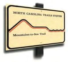
More than just a walk in the woods, the MST route traces the diversity that is North Carolina. Trail users will experience ancient mountains and small Piedmont farms, coastal swamps and colonial towns, changing textile villages and barrier islands. Today, more than 600 miles of the MST have been constructed and are open to the public thanks to partnering land managing agencies, non profit organizations and volunteers.
And noted authors including Allen de Hart, “Hiking North Carolina’s Mountains to Sea Trail;” Scot Ward, “The Thru Hiker’s Manual for the Mountains to Sea Trail of North Carolina;” Danny Bernstein, “The Mountains to Sea Trail Across North Carolina”; and the Friends of the Mountains to Sea Trail organization identifies and promotes hiking NCDOT roads as temporary connectors between open sections of the MST.
Within the study area for the Regional Trails Plan, the Great Smoky Mountains National Park and the Blue Ridge Parkway National Park are great partners in this MST effort, authorizing the construction, blazing and opening of approximately 411 miles of the MST. It is also of vital importance to recognize the volun-
teers of the Carolina Mountain Club, an organization whose members have constructed and continue to maintain the MST in portions of Western North Carolina. Other volunteers will be needed to continue to build and maintain trails in other areas of the region west of Heintooga Ridge Road.
The amount of publicly owned land and these strong partnerships have allowed construction of the MST to proceed more quickly in the mountains than anywhere else in North Carolina, including a 300 mile continuous stretch from Balsam Gap South on the Blue Ridge Parkway to Stone Mountain State Park. The “backbone” of the mountain trail is along the Blue Ridge Parkway with its extraordinary scenery and diverse natural and historic sites. The trail diverges off the Parkway into other areas renowned for their majesty such as the Middle Prong Wilderness Area in the Nantahala National Forest, Mount Mitchell State Park, and Linville Gorge Wilderness Area in the Pisgah National Forest.
The only remaining gap in the MST in the mountains is located where the Parkway approaches the Great Smoky Mountain National Park. In this area, topography, species concerns, narrow right of way/ boundary, and tunnels restrict the ability to construct the trail. Private landowners in that area are unwilling to grant permission to build a trail on their land. Therefore State Parks requested that the Southwestern Commission use this regional planning process as an opportunity to consider new options for how the
2013 Regional Trails Plan Southwestern Commission15
Photo courtesy of Doris Hammett
MST can be routed to connect the Great Smoky Mountain National Park to the Blue Ridge Parkway.
These factors/constraints led the Division of Parks and Recreation and the State Trails Program to explore other MST routing options with all interested agencies and organizations. Great Smoky Mountains National Park and the Parkway have agreed to bridge the gap by connections to National Park Service lands. Currently, this is the only route option supported by both the Park and the Parkway.
The Division of Parks and Recreation contracted with the Southwestern Commission Council of Governments to conduct a trail inventory and plan their 7 county service area, and to consider potential MST routing options to bridge this missing gap in the MST. These routing options are outlined in Chapter 6 of this Plan.
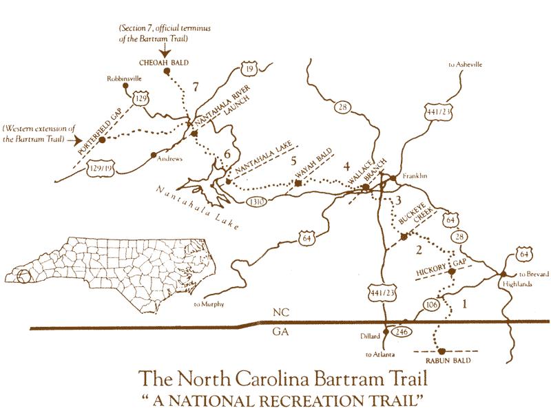
Bartram Trail. The Bartram Trail is designated as a National Recreation Trail by the National Trails System Act of 1968. It is named in honor of naturalist William Bartram, who explored the area in 1773 to 1777 and documented during his travels the plants and animals of the region, and the Native American peoples he encountered. Bartram published an account of his travels in Bartram’s Travels in 1791.
The Bartram Trail stretches nearly 100 miles (62 in North Carolina) from Rabun County, Georgia, to Cheoah Bald in Graham County. In North Carolina, the trail curves in a north to west direction through western North Carolina, joining the Appalachian Trail at two points. On its path from the Georgia
state line to Cheoah Bald it goes to the crest of the Blue Ridge Mountains and crosses the Fishhawk Mountains before descending to the Little Tennessee River Valley. Here the Bartram Trail Society has designated a stretch of the Little Tennessee River to Franklin a canoe trail. Thru hikers must follow a series of country roads through the valley into Franklin. Near and within the city limits of Franklin, the trail intersects the Little Tennessee Greenway, a footpath that winds along the river. The approximately 62 miles of the Bartram Trail in North Carolina are maintained by the NC Bartram Trail Society.
Southwestern Commission 2013 Regional Trails Plan 16
The Benton MacKaye Trail intersects the Appalachian Trail north of Fontana Village and at its northern terminus at Davenport Gap, Tennessee.
Recent planning efforts in Macon County have focused on finding a natural corridor for the trail as portions follow state routes through the County parallel to US 441.
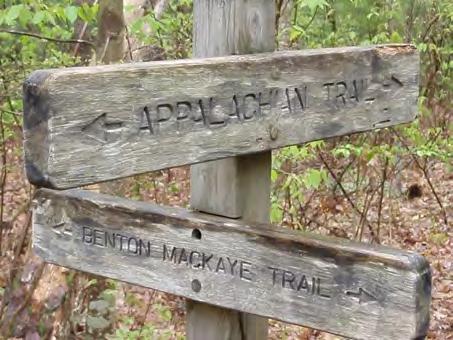
Benton MacKaye Trail. Named in honor of the Appalachian Trail’s founding father, this trail stretches nearly 290 miles from Springer Mountain in North Georgia to Davenport Gap at the north end of the Great Smoky Mountains National Park near the North Carolina Tennessee border. The trail parallels the state line in Graham and Cherokee Counties before entering North Carolina and skirting the north shore Fontana Lake. From there it traverses the southern third of the Park to its northern terminus at Davenport Gap. It intersects the Appalachian Trail north of Fontana Village.
The Benton MacKaye trail is a much narrower, more primitive trail and much less traveled than the Appalachian Trail. The intimate footpath nature of the trail is what attracts hiking enthusiasts. As Benton MacKaye was planning the Appalachian Trail, he also posed the idea of a network of “branch trails,” with two of them located in southern Appalachia. The Benton MacKaye Trail was conceived in 1975 by Georgia’s Department of Natural Resources Director David Sherman. Since then, the Benton MacKaye Trail Association has worked to establish the trail northward from is southern terminus. (Sections of this passage are adapted from Hiking the Benton MacKaye Trail, by Tim Homan, 2004.)
Community Case Studies
The long distance hiking trails throughout Western North Carolina have helped establish a recreational culture throughout the region that attractors visitors and helps sustain local economies. Many of these routes traverse vast open spaces and public lands. In other contexts, there are similar success stories that showcase small town achievements.
Who could have envisioned in the 1980s that Franklin and Murphy would have world class greenways or that mountain bikers of all ages would flock to the shores of Lake Chatuge? Now, Western Carolina University is set to open seven miles of hiking and mountain biking trails adjacent to its campus.
Throughout the development of the 2013 Regional Trails Plan, four notable projects were continuously highlighted by participants and agencies as efforts for counties and towns in Western North Carolina to learn from and use as inspiration for future trail building efforts. They were:
Western Carolina University Trails System;
Murphy River Walk & Canoe Trail;
Little Tennesee River Greenway; and Jackrabbit Mountain Bike & Hiking Trails.
The following pages provide details about these projects, the background of each and the steps that led to implementation. Without countless hours of dedication by volunteers and organizations, these success stories would not be available for all to enjoy.
2013 Regional Trails Plan Southwestern Commission17
Photo: Tom Stone
Western Carolina University Trail System
Length: 7 miles Opened: 2013 Total Cost: $95,000 Volunteer Hrs: 200/yr.
Length: 2 miles Opened: 2003 phase 1 Total Cost: $300,000 Volunteer Hrs: 6,000 (to build) Users: 1,500 to 3,000/mo.
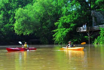
Murphy River Walk & Canoe Trail
The WCU Trail System is a multi use, on campus trail system designed for foot traffic (hiking and trail running) and mountain bikes and consists of 7 miles of single track, primitive surface trail. The trail system is important to the community because it offers easy access to trails from the WCU campus and Cullowhee without having to use a car to access trailheads in other parts of the county. It also doubles the amount of trails available to mountain bikes in Jackson County.
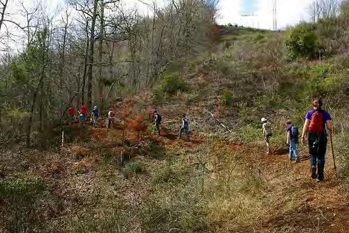
Background. The idea for the project started in 2008 as construction on WCU’s main campus caused fragmentation of the old WCU walking trail. At that point, it was determined there was great support from WCU and the surrounding community for a new trail. The project received a grant in 2009 from the Blue Cross Blue Shield of NC Foundation for planning, which was completed in 2010. The project received two grants in 2011, one from the Recreational Trails Program and one from Specialized Bicycle Company. Construction started in April of 2012 and will be completed in Spring 2013.
Implementation. The first grant in 2009 paid for professional trail building, design and creating a master plan for the project. Construction has been a hybrid project combining volunteer labor with contract labor. Volunteers are in charge of corridor clearing and vegetation removal. The outdoor program of WCU— Base Camp Cullowhee—is in charge of the project and coordinating volunteer labor consisting of student groups, student clubs, church groups, general community members, and community organizations like the Nantahala Area SORBA (Southern Off Road Bicycle Association). Base Camp Cullowhee will also coordinate ongoing maintenance of the system.
Funding was a challenge but came together with the various grants. The project experienced delays in construction due to the acquisition of an Erosion and Sediment Control Permit from NCDENR. This project has served as a catalyst for future projects to obtain such permits more efficiently.
The Murphy River Walk and Canoe Trail follows the Valley River and the Hiwassee River surrounding Murphy’s town center. The 2 mile greenway includes a center loop at the confluence of the two rivers. When the lake and river waters rise during the summer, the canoe trails are extended by a series of inlets. When waters recede, the Confluence Road, which includes part of the old Tennessee Street road surface, can be enjoyed by walkers.
Background. Initiated as a multi phase master plan concept in July of 2002, the River Walk project was formally endorsed by the Mayor & Town Council and by the Cherokee County Board of Commissioners in January 2003. Phase 1 opened in the fall of 2003 at Konehete Park, and a master plan for its future phases was completed by the fall of 2004. Step by step, the River Walk was completed all the way in to the Old L&N Depot on Railroad Street at the Hiwassee Street river bridge in 2010.
Implementation. Enhancement and improvement activities continue on with the trail surfaces, native landscaping and
interpretive markers along the way. The trail carries the potential of far reaching benefits to the community health and recreational enhancements to Konehete Park and the Wellness center facility, economic renewal stimulus for the historic town center, eco and heritage tourism, environmental conservation, cultural and historic preservation, native plant and wildlife education, and more
Confluence Loop Construction: With the basic trail now completed, this extra loop at the convergence of the Valley and Hiwassee rivers forming Lake Hiwassee is destined to be the most beautiful natural area on the trail. A grant was awarded by the Dub and Murray Martin Cherokee and Clay County Trust for the project.
Interpretive Signage Stations : The River Walk will feature both heritage and ecological interpretive stations along the trail. A grant was awarded in 2011 by the OEO Small Growing Opportunities grant program for the project.
Southwestern Commission 2013 Regional Trails Plan 18
Walkers along Murphy’s River Walk wave to canoers on the Hiwassee River. Photo: River Walk
Josh Whitmore, WCU
Paula Bryan & John Strawn
Volunteers hike on a work day to construct the new WCU Trail System. Photo: Pisgah Area SORBA www.wcu.edu/30290.asp www.heritagepartners.org
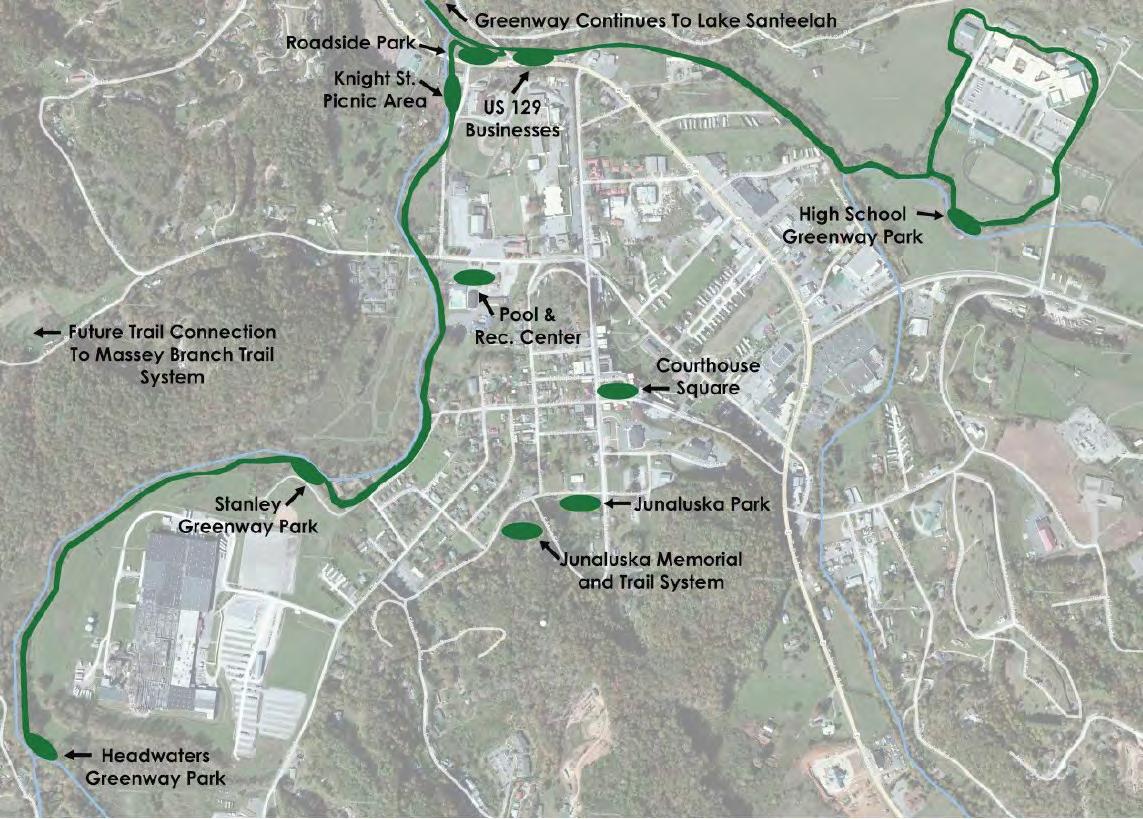
Franklin’s Little Tennessee River Greenway
Jackrabbit Mountain Bike & Hiking Trails

Length: 5 miles Opened: 2013 Total Cost: $95,000 Volunteer Hrs: 200/yr. Users: 20,000/mo. (summer)
Length: 14.5 miles Opened: 2008 Total Cost: $286,000 plus $52,000 in kind Volunteer Hrs: XXXXX Users: XXXXX
www.littletennessee.org www.sabacycling.com
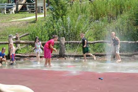
Children play in the splash park located along the Little Tennessee River Greenway in Franklin.
Providing a cornucopia of wildflowers and wildlife, the Little Tennessee River Greenway cuts a meandering path of nearly 5 miles through Franklin. Reflecting the extraordinarily rich diversity of Macon County’s landscape, visitors experience wetlands, stroll through two railroad cuts left behind by the Tallulah Falls Railroad, wander alongside an old pasture, catch sight of the desert agave, and experience the upland woods. The greenway connects to the 2.6 mile Lewis Soles Memorial Mountain Bike Trail.
Background. The greenway began as a dream of many residents, including members of the Nantahala Hiking Club, who saw the uninhabited land alongside the river and pictured it as a place to preserve the landscape while offering expanded recreational opportunities. Others saw it as a way to preserve Macon County’s heritage and bolster economic development. In 1997 Duke Power needed a powerline through Franklin. The unusable land along the river seemed to offer the most logical route. After the land was acquired, and the
Photo: Friends of the Greenway
powerline built, Duke was ready to deed the land. Though not all of the Greenway lies in the transmission line easement, it represents almost 50% of the trail and became the catalyst that was needed to turn the Dream into a vision and ultimately into a reality.
Implementation. Duke and Nantahala Power & Light donated expertise in engineering, grant writing, web design, and getting the job done. They created a steering committee of community leaders to oversee implementation. Barbara McRae, formerly with NP&L, wrote two major grants to bring in the cash to restore the riverbanks, build trails, picnic shelters and bridges across the river. These grants included a NC Clean Water Management Trust Fund grant and a NC Parks and Recreation Trust Fund grant for $250,000. F.P. (“Bodie”) Bodenheimer, II, owner and CEO of Zickgraf Industries came up with the matching funds. The Little Tennessee River Greenway is maintained by volunteers from Friends of the Greenway (FrOGs).
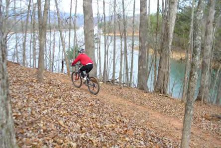
The Jackrabbit Trail is a 14.5 mile stacked loop mountain biking and hiking trail located 7 miles ESE of Hayesville, NC in Clay County near the NC/GA state line. The project is built on USFS land in the Nantahala National Forest, adjacent to TVA Lake Chatuge, and as such most of the trails have lake views. This project attracts mountain bikers and hikers alike for outdoor recreation, and is an element of our tourism economy. It provides local and regional students and residents healthy exercise and organized event opportunities. The trail design accommodates beginner to intermediate, and expert users. Since 2003, Southern Appalachian Bicycle Association (SABA) has been collaborating with the US Forest Service and the Clay Co. Communities Revitalization Association to develop the trail system.
Background. In the summer of 2001, the Clay County School System added mountain biking to its Pathways After School and Summer Program. Members from the local bicycle club volunteered to teach the students about bicycle safety,
skills and etiquette. During this time, the need for an easily accessible trail system for all skill levels was recognized. Collaboration began between SABA, the Tusquittee Ranger District of the USFS, and the Clay County Communities Revitalization Association to construct trails on the peninsula off Lake Chatuge near the NC/Georgia border. The construction of the trails became a community effort with involvement of Clay County Schools, Clay County Health Department, area business, and various community organizations.
Implementation Proceeds from SABA fundraising events help benefit the progression and future maintenance of this project. The Jackrabbit Trail Project involved committed organizations who shared common goals: to promote mountain biking and hiking for recreation and fitness to all ages and skill levels, to promote mountain biking and hiking not only for a single community but for a region, and to promote environmental conservation and tourism.
2013 Regional Trails Plan Southwestern Commission19
A cyclist enjoys the Jackrabbit Trails on the shores of Lake Chatuge. Photo: Joana Atkisson
SABA & Ron Guggisberg
Hank Shuler & Kay Coreill
Chapter
Regional, County Maps & Project Ideas
Participants in the fall 2012 workshops were asked to identify their ideas and top priorities for new trails or trail enhancements. The maps contained in this chapter reflect those ideas and illustrate the existing network of trails in Western North Carolina.
The concepts contained for each county in this Regional Trails Plan are the starting point for pursuing more detailed analysis and funding to implement the Plan’s recommendations. The North Carolina Department of Parks and Recreation’s State Trails Program oversees many of the funding sources available for trail improvements. As the funding source for this Plan the State requested that project ideas be identified based on the ability for communities, stakeholders and organizations to implement them and whether they are likely to be short– or long term projects.
Long Term Projects. These projects are those that are more complex in that they require detailed planning, land acquisition or complex routing to accomplish. They may also require approval from public agencies or a commitment of funding that requires several partners. A reasonable timeframe for implementation of projects considered “long term” is 10 to 20 years. Most new trails, especially those of a length longer than 7 to 10 miles, would be considered long term endeavors.
Short Term Projects. Project falling into this category are less complex than long term projects or already have some level of analysis or funding commitment for implementation. They are ideal candidates for


applications to grant programs such as the Recreation Trails Program (RTP) or the Parks and Recreation Trust Fund (PARTF). Shorter trail connections, trailheads or enhancements to existing trails are likely to be considered “short term” priorities.
Moving Toward Implementation. The figure at right illustrates where projects may fall on this continuum. Long term projects are likely to be at the top stage of the “funnel” while short term projects will fall into the bottom two tiers of the funnel.
Regional Priorities
The following project ideas arose during the course of the Regional Trails Plan process and are considered to be of regional significance based on their visibility, likelihood to promote economic development and have multi county impacts if completed. They are not listed in priority order.
Trail Development Within and Preservation of Municipal Watershed Areas: Several communities have obtained conservation easements for watershed areas. The Pinnacle Park area (Sylva watershed) and Rough Creek area (Canton watershed) are two notable examples. (Short Term)
Paddle Trail along the Hiwassee River: This project would include designation of the River as a paddle trail between Hayesville and Murphy. Workshop participants noted the need for access points as there are long stretches that require crossing private land. (Short Term)
Southwestern Commission 2013 Regional Trails Plan 20
5
Long Term Vision & Priorities Detailed Planning Pursue Grants
New Trails Project Ideas Implementation
From Concept to Implementation: How Ideas Become Projects
Mountains to Sea Trail: Determine best routing options to bypass tunnels along the Blue Ridge Parkway between Heintooga Ridge Road and US 441. This project is addressed in more detail in Chapter 6. (Short Term)
linkages)
An idea of a paddle trail along the Hiwassee River between Hayesville and Murphy was floated as an idea during the Clay and Cherokee County workshops. Participants noted that paddlers currently have to stay on the water for long stretches or risk crossing private property at ingress/egress points.
New trail system connecting Bryson City, Needmore Gamelands, Upper Alarka/Big Laurel Area, and Dillsboro: Listed as potential option for Mountains to Sea Trail routing. Route has long term benefits regardless of designation. Consider linkage to the west of Needmore Gamelands to Appalachian Trail. (Long Term)
Rail to Trail or Rail with Trail between Murphy & Andrews: The idea of a trail linking the two towns has been in discussions for several years. It would require either closure of the railway for a rails to trails conversion or land acquisition for rails with trails joint use in the corridor. (Long term)
Clay County Priorities
Connect Jackrabbit Mountain Bike & Hiking Trails to Campground Trails: This project is already in discussions with public agencies to connect the two trail systems. (Short Term)
Cherokee County Priorities
Construct a trail to link the Murphy River Walk to the Hanging Dog Campground and Mountain Bike Trails: This project was viewed by some as an extension of the River Walk to the popular camping and recreational area. Land along the north side of Hiwassee Lake is managed by TVA. (Short term)
Panther Top Area Trails: Designate existing Forest Service roads and Panther Top Road on the south shore of Hiwassee Lake as bicycle / mountain bike route. (Short term)
Andrews Greenway: Complete the planned greenway system in the town of Andrews, as envisioned through the Valley Trails efforts of the Andrews Valley Initiative (AVI). (Short term to continue existing trails; Long term for full scale
Designation of Scenic Bikeway on popular bicycle route around Lake Chatuge: This is a popular route for recreational cyclists. The route would follow state and US highways in NC and Georgia. Construct shoulders along routes and develop special signage for Scenic Bikeway. (Short–term for designation and signage; Long term for shoulders and other enhancements)
Complete Street / Multi use Trail Linking Hayesville to Chatuge Dam and the Golf Course along Myers Chapel Road: Complete street improvements could include a combination of sidewalk and bikes lanes or construction of a multi use trail or sidepath along the road and nearby lakeshore. (Long Term)
Graham County Priorities
Robbinsville Greenway: Construct new greenway along Long Creek and Tulula Creek, connecting Stanley Furniture plant area to the High School.
2013 Regional Trails Plan Southwestern Commission21
Photo: Murphy River Walk
The Greenway was envisioned through Reimagining Robbinsville (2012) and is being evaluated in more detail for the Robbinsville Pedestrian Connectivity Plan (2013). The map below shows a conceptual route. (Short term)
Trail connecting Cheoah Fitness to Robbinsville: Construct a combination of sidewalks and nature trail from downtown Robbinsville to the Cheoah Fitness Trail on the south shore of Santeetlah Lake. (Long term)
Haywood County Priorities
Rough Creek Watershed Trails Trailhead: Construct new trailhead at location more conducive to use by hikers and mountain bikers. Current trailhead requires a steep ascent to reach trail system. Town of Canton has applied for funding. (Short term)
Mountain Bike Trails at Camp Daniel Boone: Workshop participants noted the Boy Scouts were interested in developing mountain bike trails at the historic camp. (Short term)
Richland Creek Greenway: Construct greenway trail along Richland Creek from Balsam Community, through Waynesville, to connect to Lake Junaluska. Project identified in Waynesville Pedestrian Plan (2010). (Long term)
Pigeon River Greenway: Connect Clyde to Canton and Canton to Bethel with a greenway corridor. Walking trail exists in Canton Recreation Park (pedestrian only). (Long term)
Preserve Allens Creek and Campbell Creek Watersheds: Pursue conservation easements for land
holdings in Allens Creek (Waynesville) and Campbell Creek (Maggie Valley) watersheds. (Timeline based on efforts between property owners, land trusts and municipalities)
Jackson County Priorities
Tuckaseigee River Greenway: Portions of the greenway are being developed between Highway 107 and Cullowhee. The Jackson County Green-
A conceptual greenway network master plan was developed for Robbinsville in 2012 as part of the Reimaging Robbinsville project. The greenway would connect the High School fitness trail to Stanley Furniture, who has land holdings surrounding the plant that are planned for a recreation park.
Southwestern Commission 2013 Regional Trails Plan 22
ways Project Comprehensive Master Plan (2009) envisioned a greenway along the river from Cullowhee, through Webster, to Dillsboro and potentially linking to Swain County. (Short term for linkages under development; Long term for expansion opportunities).
Pinnacle Park Trails Enhancement: Sylva developed a master plan to enhance the trail system within the conservation easement obtained for its watershed. The vision for trails include hiking and mountain bike trails. (Short term)
may be greenway or combination of sidewalk and bicycle route. (Short term)
Designate Little Tennessee River south of Franklin as Paddle Trail: Designate river as blueway from Riverside Road put in to Lake Emory. (Short term)
Construct greenway or hiking trail loop around Franklin: Branch from Little Tennessee River greenway to link other areas of Franklin with a multi use trail or walking loop. May include trail link to Wallace Branch. (Long term)
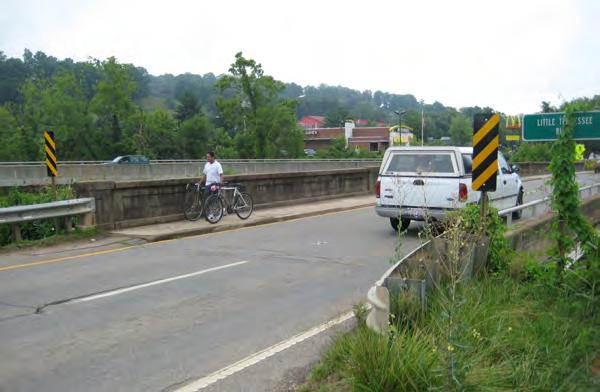
The US 441 Business bridge east of downtown Franklin is a gap in the Little Tennessee River Greenway that requires users to cross a narrow sidewalk and US 441 Business to continue on the trail.
Tuckaseigee River Blueway Designation: Pursue designation as envisioned in the Greenway Project Master Plan. (Short term)
Cashiers/Glenville Pathway System: A system of trails was identified in the Master Plan to link Cashiers to the Glenville area and Blue Ridge School. (Long term)
Macon County Priorities
Bartram Trail Linkages: Pursue Complete Streets upgrades in the Clarks Chapel area to fill gaps in the Bartram trail and connect to Franklin along the Little Tennessee River. (Short term)
Connect Little Tennessee River to Southwestern Community College and Macon County Library on Siler Road: Construct connection from Little Tennessee River to area along Siler Road. Project
Evaluate potential for Mountain Bike Trails in northeast Macon County: Participants identified an opportunity for mountain bike trails near the Jackson County line on public land between Goshen Road and Huckleberry Creek Road. (Long term)
Swain County & Qualla Boundary Priorities
Bryson City Greenway: Construct greenway along Tuckaseigee River in Bryson City as envisioned in town’s Pedestrian Plan. (Short term)
Cherokee Greenway & Pedestrian System: Complete greenway trail along the Oconoluftee River and connect area sidewalks to popular destinations within Cherokee. (Short term)
Trail Linking Bryson City to Nantahala Outdoor Center: Construct greenway or footpath along Nantahala River, parallel to either the river or US 19/74. (Long term)
2013 Regional Trails Plan Southwestern Commission23
Photo: Don Kostelec
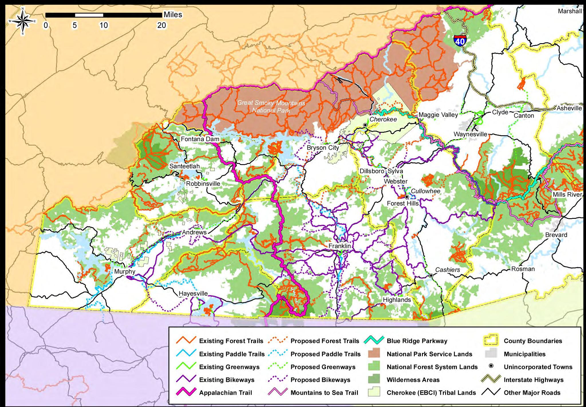
Southwestern Commission 2013 Regional Trails Plan 24 Regional Map: Existing & Planned Trails
Map
2013 Regional Trails Plan Southwestern Commission25 Cherokee County Trails
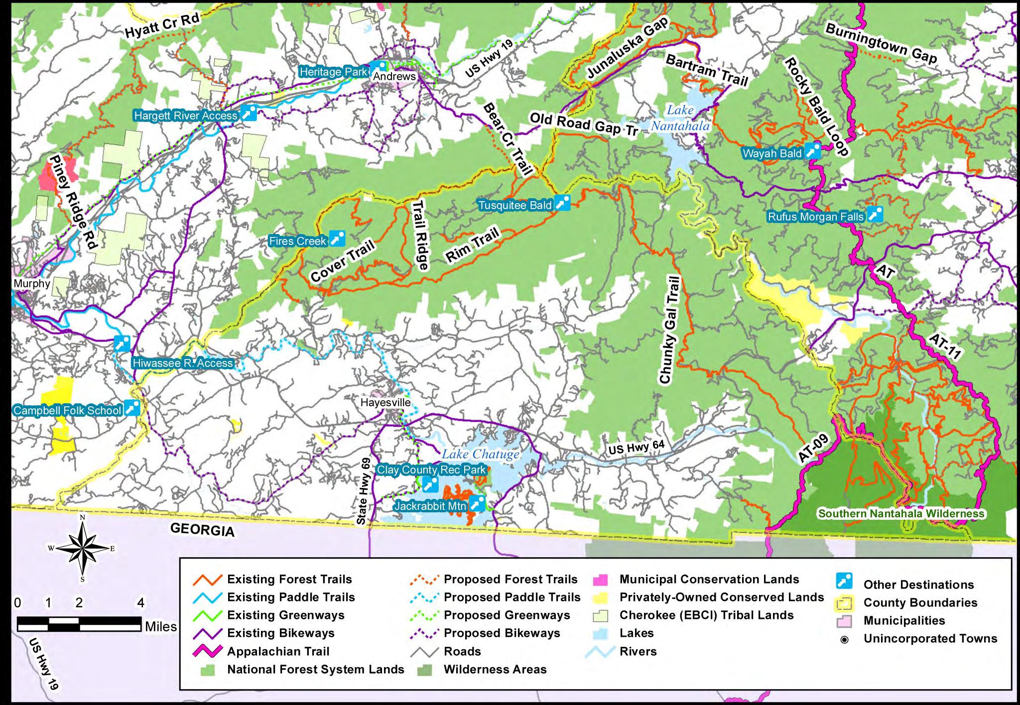
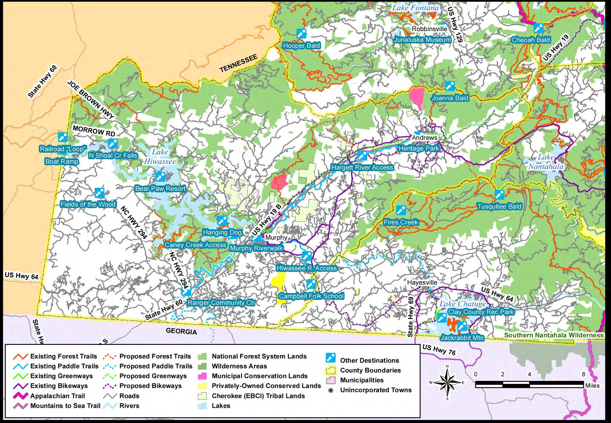
Southwestern Commission 2013 Regional Trails Plan 26 Clay County Trails Map
2013 Regional Trails Plan Southwestern Commission27
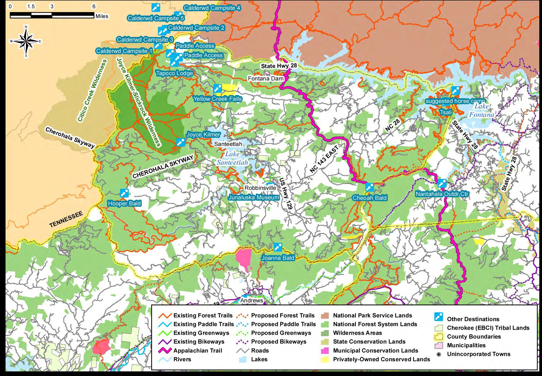
Graham
County Trails Map
Haywood
Trails Map
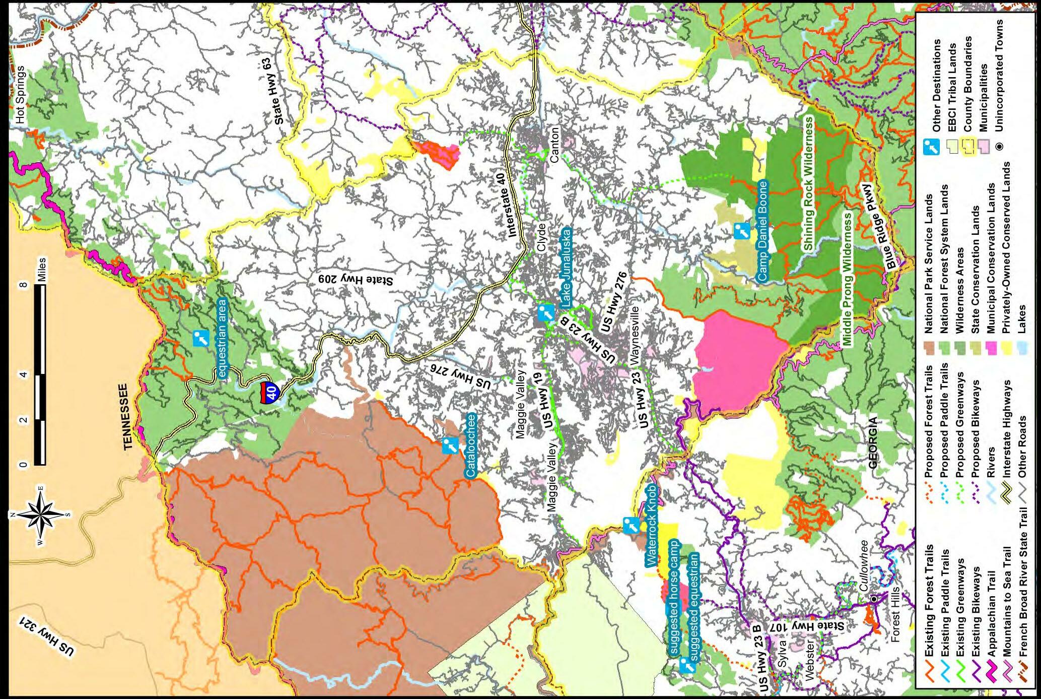
Southwestern Commission 2013 Regional Trails Plan 28
County
Map
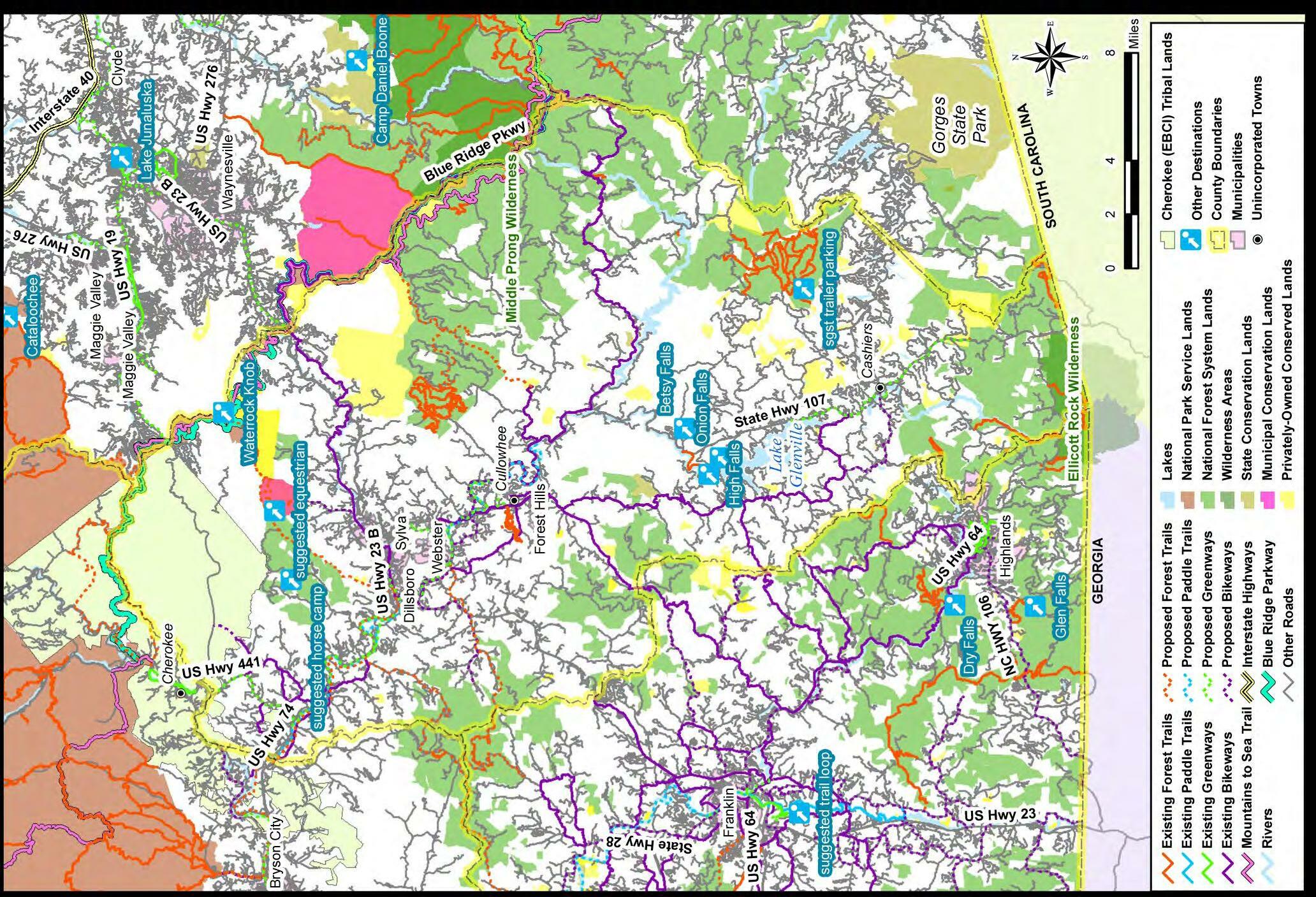
2013 Regional Trails Plan Southwestern Commission29 Jackson County Trails
County Trails Map
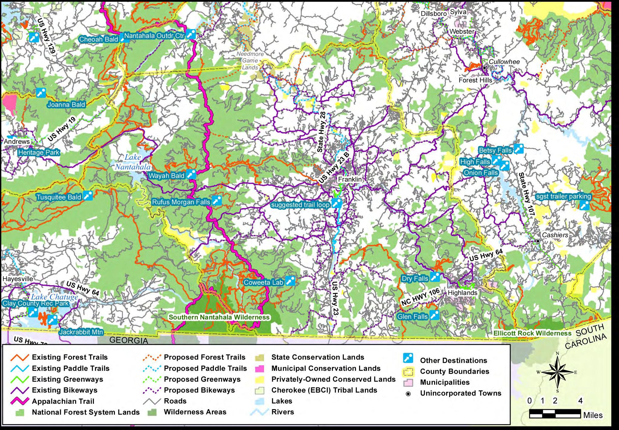
Southwestern Commission 2013 Regional Trails Plan 30 Macon
Trails Map
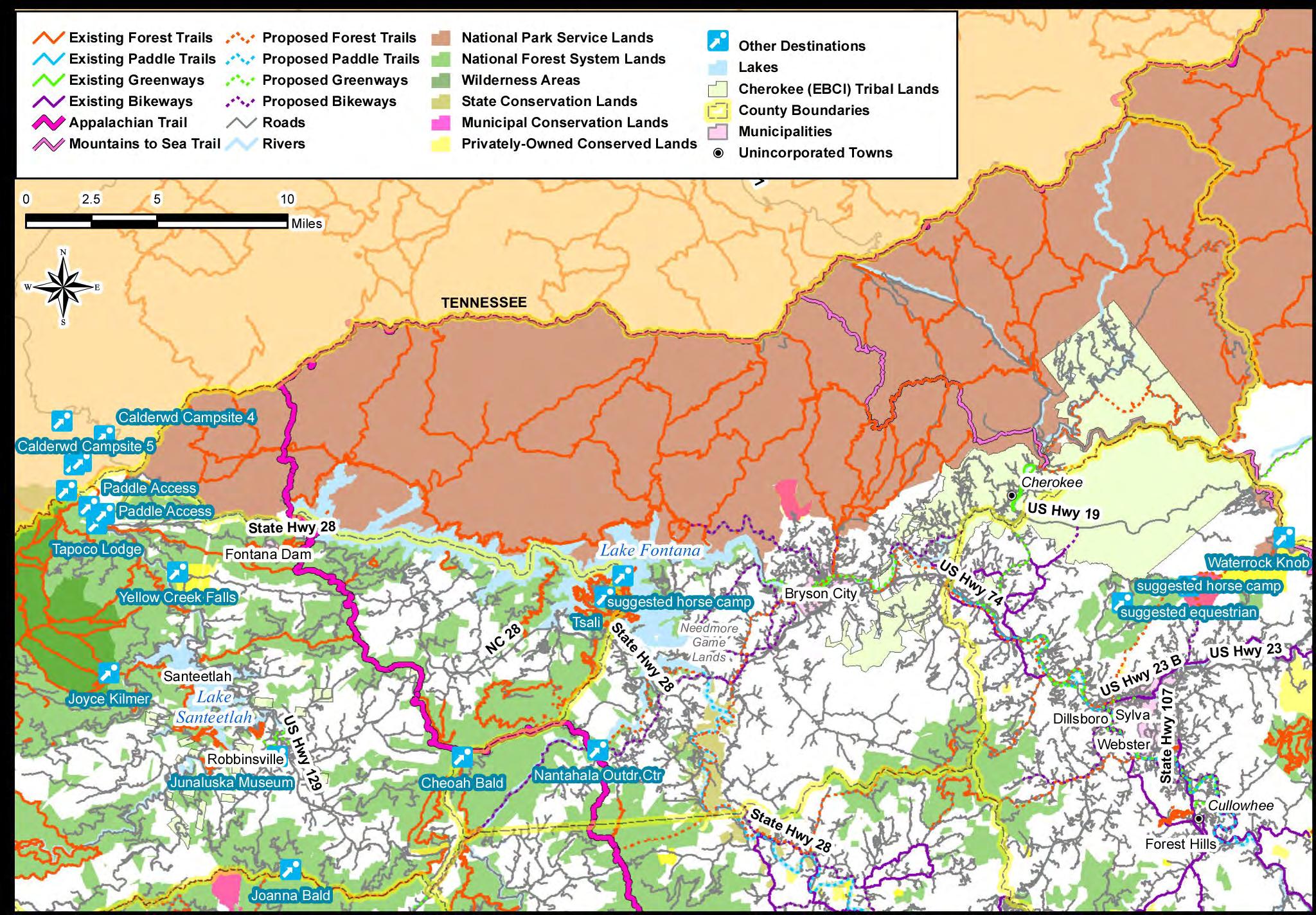
2013 Regional Trails Plan Southwestern Commission31 Swain County
Chapter
Mountains-to-Sea State Trail Routing Concepts
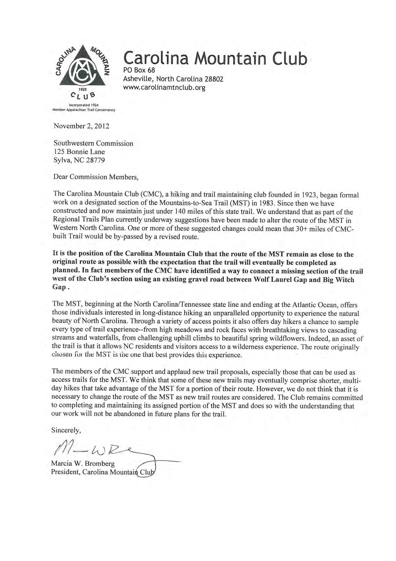
Since its conception in 1977, those tasked with implementation and maintenance of the Mountains to Sea State Trail (MST) have made great progress to fulfill the vision for the trail. While trails such as the Appalachian Trail were planned before development encroached on wilderness areas, newer trails such as the MST must route through growing metropolitan areas and in natural areas where a multitude of stakeholders and landowners have their own de sires for use of nearby land. The Blue Ridge Parkway has been a backbone of the trail throughout the region and a major reason for its success.
The section of the MST needed to connect the Great Smoky Mountains National Park to the Blue Ridge Parkway at Heintooga Ridge Road (originally envisioned as a distance of approximately 12 miles) remains the only missing gap in the MST in Western North Carolina. The Blue Ridge Parkway right of way is too narrow to allow for construction of a trail in this area to route hikers around tunnels to complete the hike from the Park to the existing MST already designated on the Parkway.
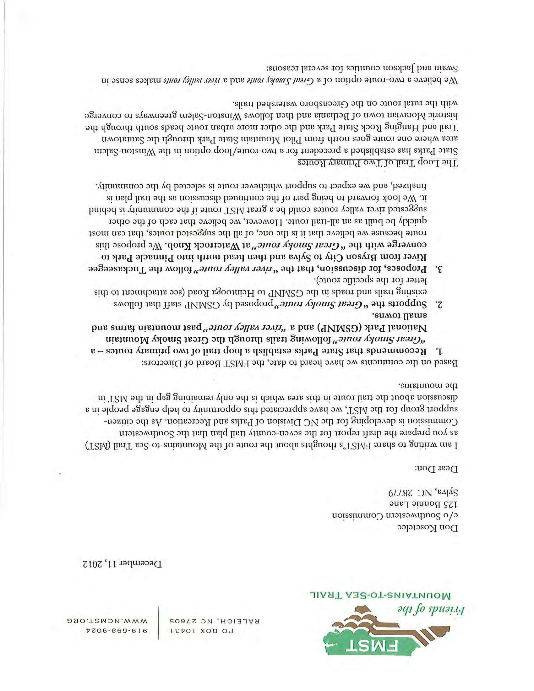
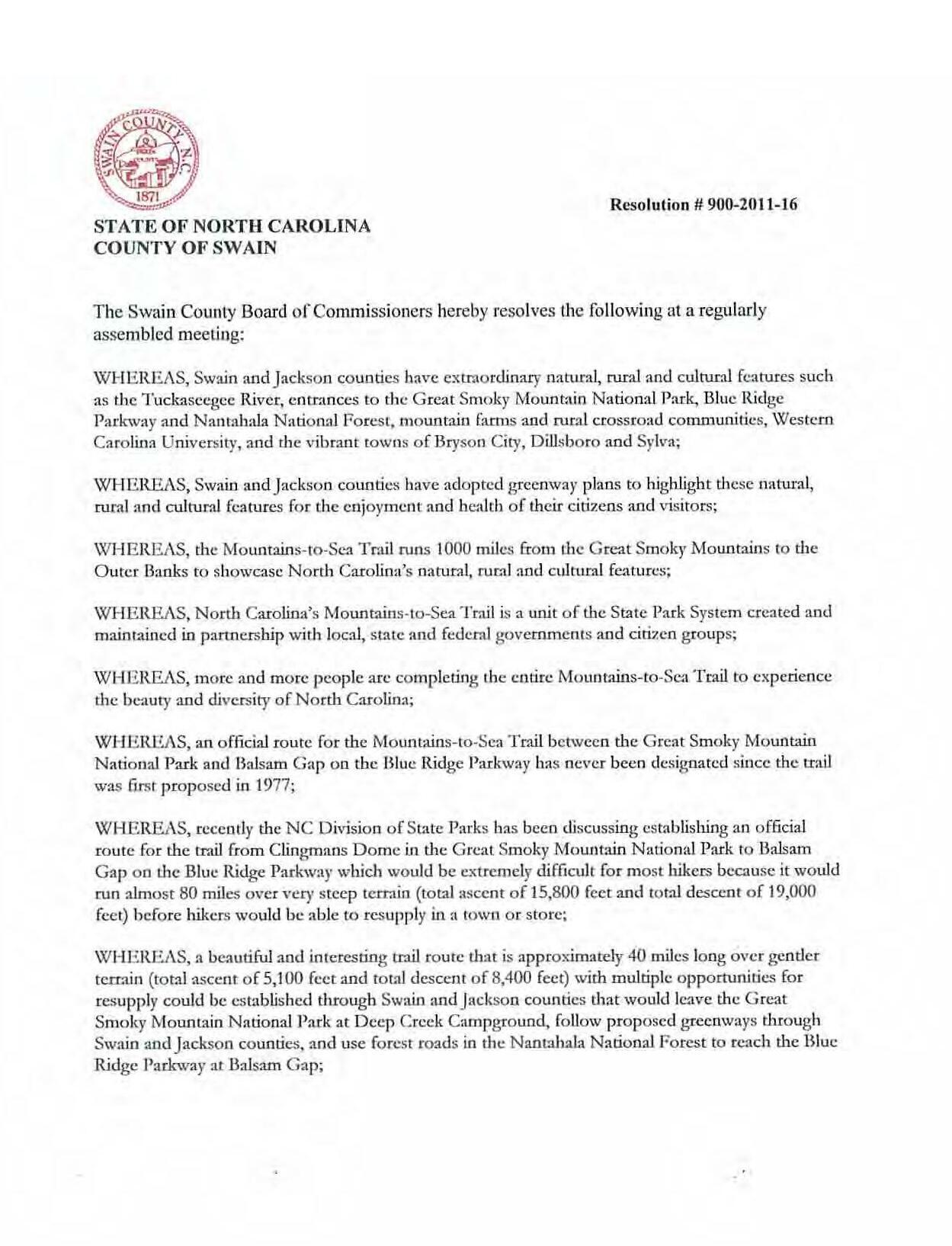
The Great Smoky Mountains National Park has offered to bridge this missing gap by designating existing GSMNP trails (with support facilities) as a section of the MST. The pros and cons of this option are discussed on page 34. The Boards of County Commissioners of Swain and Jackson Counties have also voted to express their interest in establishing a trail route through their counties. During the Regional Trails Plan effort, the South-
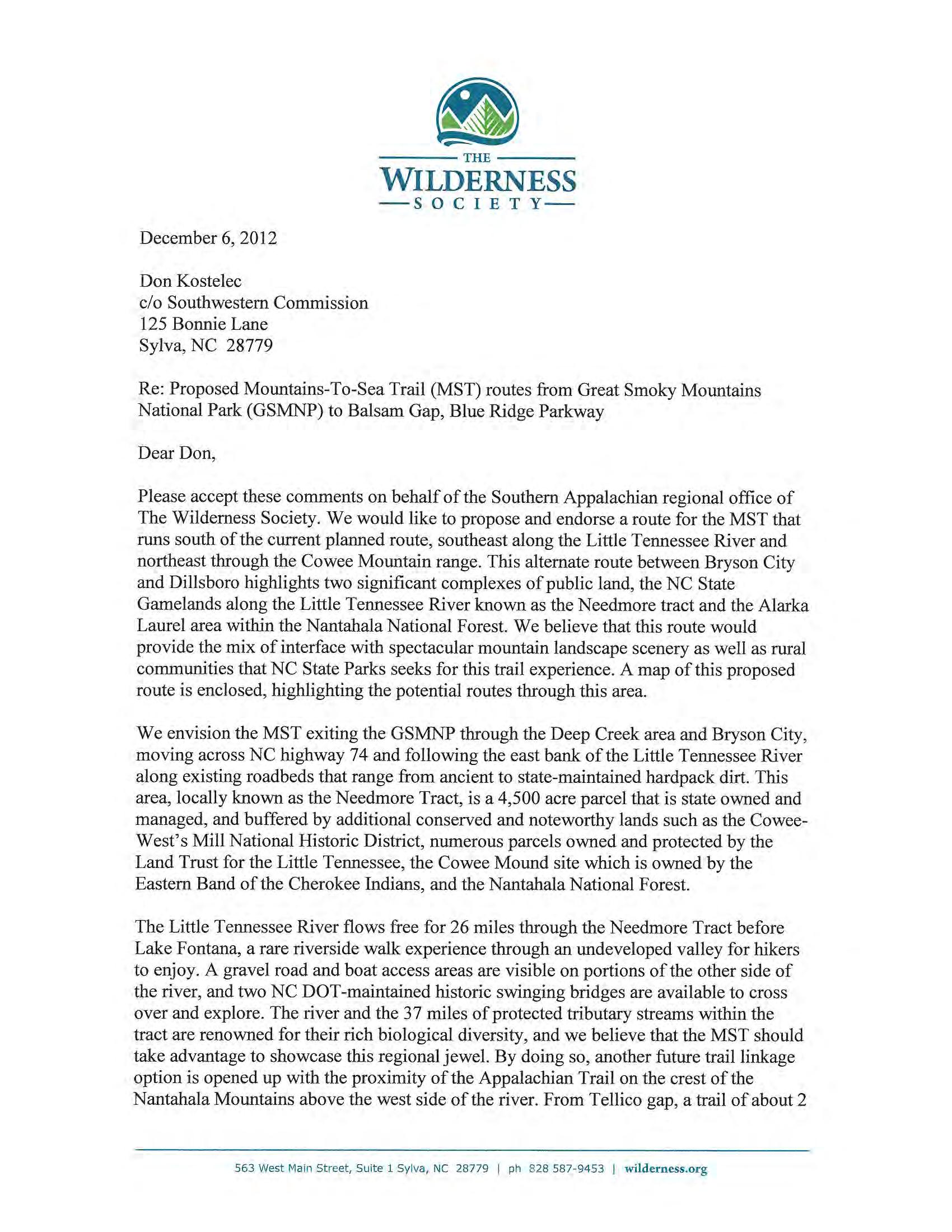
western Commission engaged stakeholders to identify routing options to bridge this missing gap and to discuss other possible alternate alignments for the MST. Groups such as the Carolina Mountain Club (CMC)and Friends of the Mountain to Sea Trail (FMST), the Wilderness Society and Bartram Trail Society have contributed to the discussion. Several ideas have emerged in recent years to solve the challenge of finding an accomplishable, sustainable routing to bridge this missing section of the MST.
This chapter contains a preliminary evaluation of options to help the State of North Carolina, CMC, FMST and other stakeholders define accomplishable and sustainable route or routes the MST in this area of the state.
Some of the main ideas that emerged through this and other efforts include many distinct viewpoints:
A desire for the MST to continue to provide a wilderness experience through public lands and remote areas along its existing route west of Waterrock Knob;
A desire for the MST to give trails users the experience of a mountain river valley, an experience that is not available elsewhere along the MST.
Opportunities for economic development and linking of trail towns along a route connecting Cherokee to Bryson City and Sylva along the Tuckaseigee River;
Emerging ideas to link the Need more Gamelands and Alarka High lands area in the Cowee Mountain Range with a new trail;
The routing of the Mountains to Sea Trail around constrained areas through Western North Carolina has been the subject of many discussions since the trail was conceived in the 1970s.
Southwestern Commission 2013 Regional Trails Plan 32
6
Photo: FMST
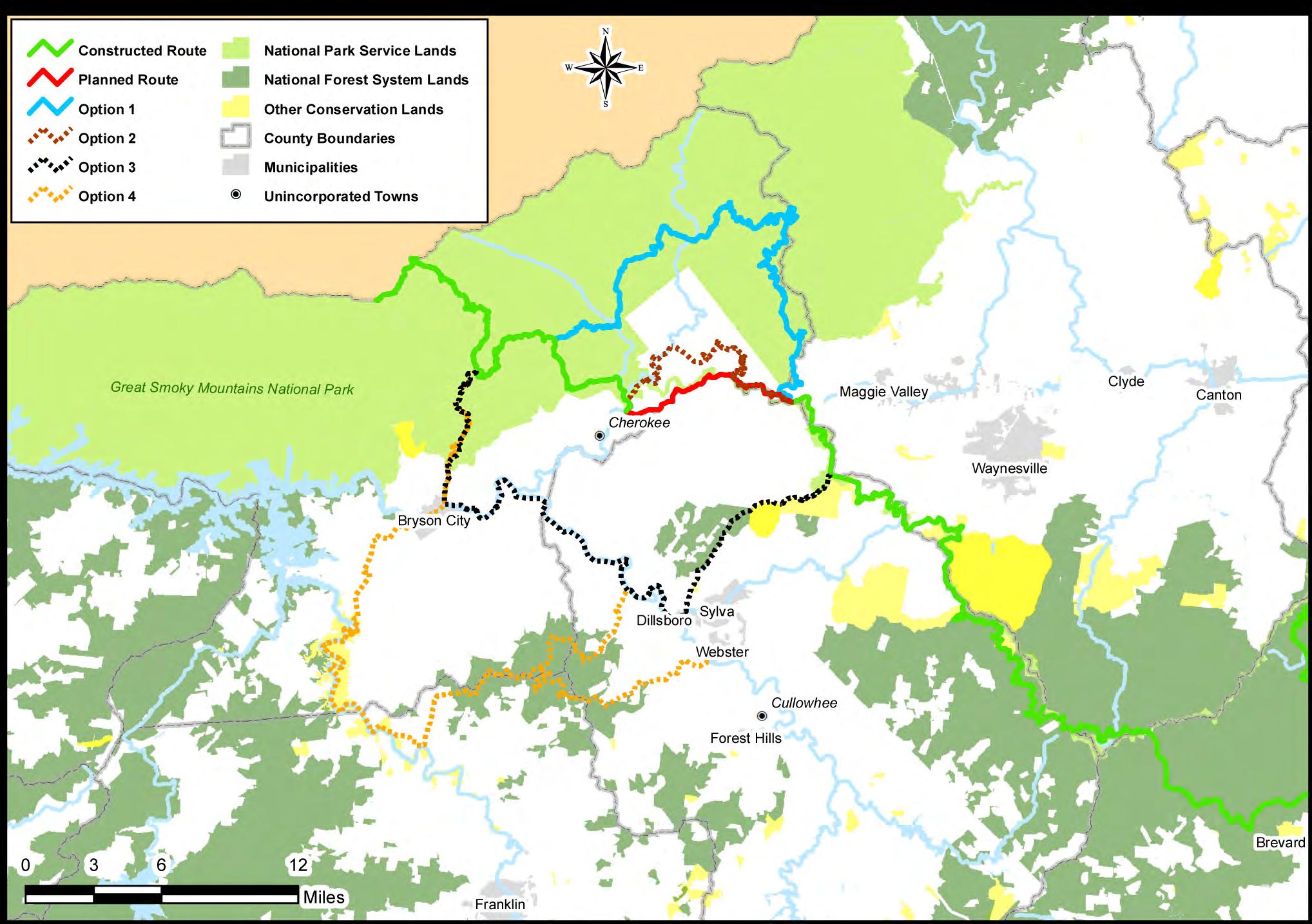
Mountains-to-Sea State Trail: Alternate Proposals for Trail Routing
2013 Regional Trails Plan Southwestern Commission33
Interest among elected officials in Macon County, Jackson County and Swain County to link their communities and towns; and,
Dual or alternate alignments options for the MST.
Perhaps the only consistent theme that emerged through the Regional Trails Plan in relation to the routing of the MST is that few of the routes are short term solutions (other than the route offered by the Great Smoky Mountains National Park). Private land ownership, Tribal Lands and constraints brought about by railroads, highway and rivers will continue to impact development of future MST routes in WNC. Some routes will make great regional trails with or without designation as the MST or as connectors.
Below is a summary of the many pros and cons that emerged through the Regional Trails Plan in relation to potential MST routes in WNC.
route would use existing park trails and support facilities. There is a strong likelihood that Option 1 is the only alternative that could be accomplished within the next 10 years on existing trails and public lands.
Pros:
Is located along existing marked trails with backcountry campgrounds.
Is supported by the Park and Parkway.
Can be routed along existing trails on public lands to meet purpose of MST to connect to Clingmans Dome.
Maintains “wilderness” feel of the trail common to most of the MST in Western North Carolina and supported by the CMC.
Takes advantage of past trail building efforts to reach Heintooga Ridge Road.
Cons:
NOTE: The number of pros and cons for each route should not be construed as a weighting of options for routing of the MST. Some pros may outweigh cons based on timing, cost and feasibility. These pros/cons simply reflect the ideas of Plan stakeholders and the professionals who developed the Plan.
Option 1: Along Existing Trails in the Great Smoky Mountains National Park
This route is shown in BLUE on the map contained in this chapter and is the route offered by the Great Smoky Mountains National Park and the Blue Ridge Parkway to bridge the missing gap in the MST. This route could be recognized by the State as a segment of the Mountains to Sea State Trail quickly, as this
Concerns expressed about promoting the trail in this section for through hikers because it’s a challenging, long hike.
If this route is not designated as the MST, then section of currently constructed trails within the Parkway boundary between Heintooga Ridge Road and where other alternate routes intersect the Parkway boundary could be compromised.
Option 2: Original Planned Route Along or Near Blue Ridge Parkway using Gravel Roads
This route is shown in BROWN on the map and generally follows the originally intended route along the Parkway, except that it follows or parallels Bureau of Indian Affairs (BIA) roadways within the Qualla
Southwestern Commission 2013 Regional Trails Plan 34
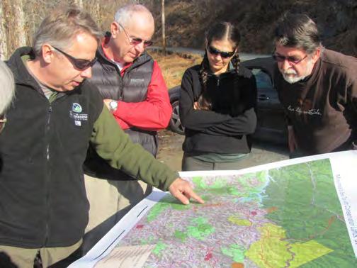
Participants at the Swain County and Jackson County joint workshop discuss routing options for the Mountains to Sea Trail.
Photo: Don Kostelec
Boundary. This option is supported by the Carolina Mountain Club but does not currently have support from the Eastern Band of Cherokee Indians. It is viewed as an inactive option unless support emerges from the Cherokee or other options emerge in the vicinity of the Blue Ridge Parkway.
Pros:
Meets the original intent of the trail with less re routing.
Can be routed along existing roadways (unpaved) through the Qualla Boundary.
Takes advantage of ongoing efforts to reach Heintooga Ridge Rd.
Cons:
Currently lacks support from the Eastern Band of Cherokee Indians.
Some sections require evaluation of existing sewer and utility easements.
nomic development.
Pros:
Connects towns in Western North Carolina and could contribute to increased economic development along the route.
Provides an experience of a mountain river valley not encountered elsewhere in the mountain sections of the MST.
Supported by FMST and Counties.
Could attract more diverse users.
Cons:
Constraints due to railroad, highways and other features along the route due to right of way width, traffic volumes and safety.
Will likely require more costly investments due to land acquisition needs and potential for multi use function in or near towns.
Volunteers from The Wilderness Society, Friends of the Mountains to Sea Trail and nearby communities scout potential trail options in the Needmore Gamelands area.
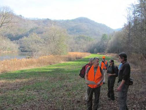
Photo: The Franklin Press
Concerns over land management of designated road routing options along unpaved roads.
Option 3: New Route along Tuckasegee River from Bryson City to Sylva
This route would begin near Deep Creek Campground near Bryson City and follow the Tuckaseigee River to Dillsboro and through Sylva. Planned greenways in Jackson County and trails within Pinnacle Park would connect the trail at Waterrock Knob. The route is generally shown in BLACK on the map. If MST designation does not occur along this route, it is still worth of evaluation as a future trail due to its potential value for connecting communities and eco-
Not supported as a single route option by CMC and other stakeholders who prefer a more natural experience (supported if a dual route option is pursued.
Unless part of an alternate or dual route, then section of currently constructed trails within the Parkway boundary between Heintooga Ridge Road and where other alternate routes intersect the Parkway boundary could be compromised.
Options 4: Connect through Needmore Gamelands and Upper Alarka
The route that connects public lands in the Needmore and Alarka areas, shown in ORANGE on the
2013 Regional Trails Plan Southwestern Commission35
map, is a trail system that warrants evaluation regardless of whether or not it is designated as part of the MST. Options for this route are part of the MST include a re routing through this area or a dual routing option (describe in next section) along the Little Tennessee River and through the Cowee Mountain Range. The route was recommended by The Wilderness Society and the Land Trust for the Little Tennessee. Trails within these public lands are seen as desirable with or without MST designation and could be designated locally as connector trails.
Pros:
Connects existing public lands along forest service roads.
Maintains “wilderness” feel similar to route option through the Park.
Potential linkage to Bartram Trail.
Traverses Macon, Jackson and Swain Counties.
Cons:
Long term implementation steps likely to establish new trails.
Adds considerable mileage to the MST and may inhibit through hikers.
Will require land acquisition or Complete Streets upgrades to connect beyond public lands.
Unless part of an alternate or dual route, then section of currently constructed trails within the Parkway boundary between Heintooga Ridge Road and where other alternate routes intersect the Parkway boundary could be compromised.
Dual or “Loop” Options
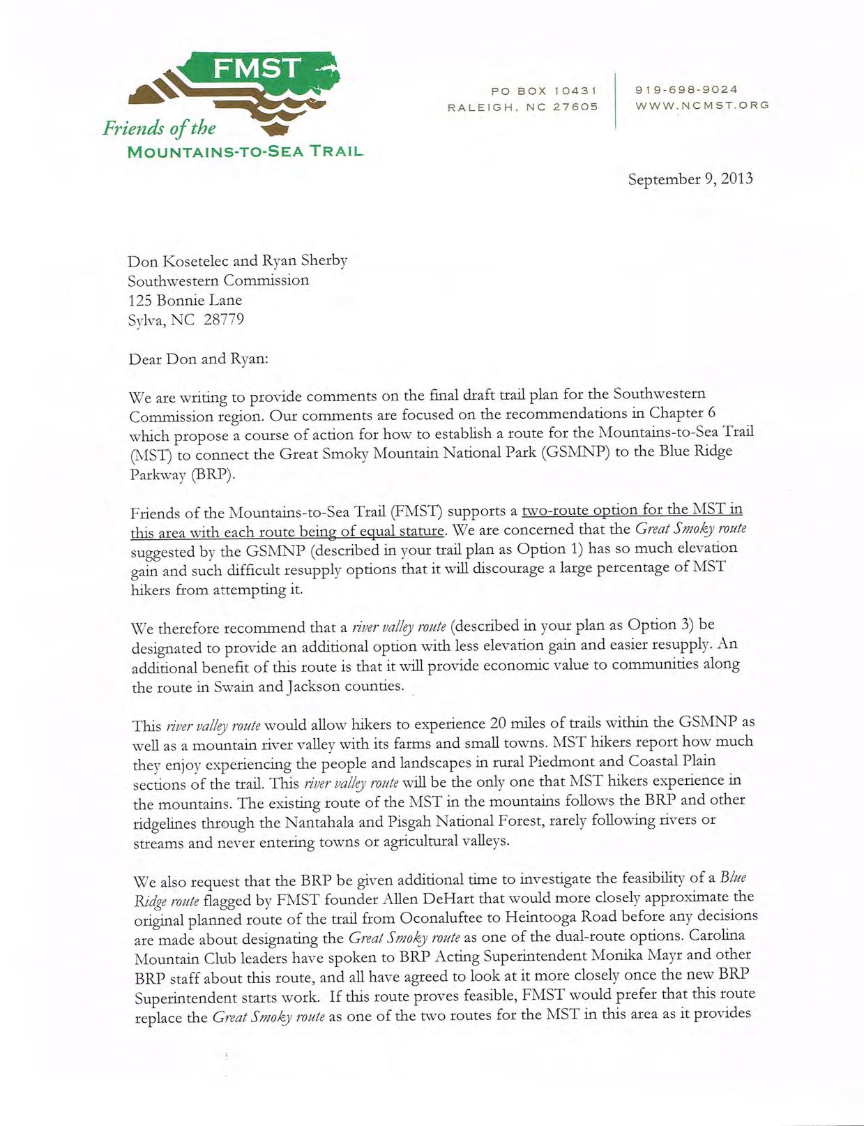
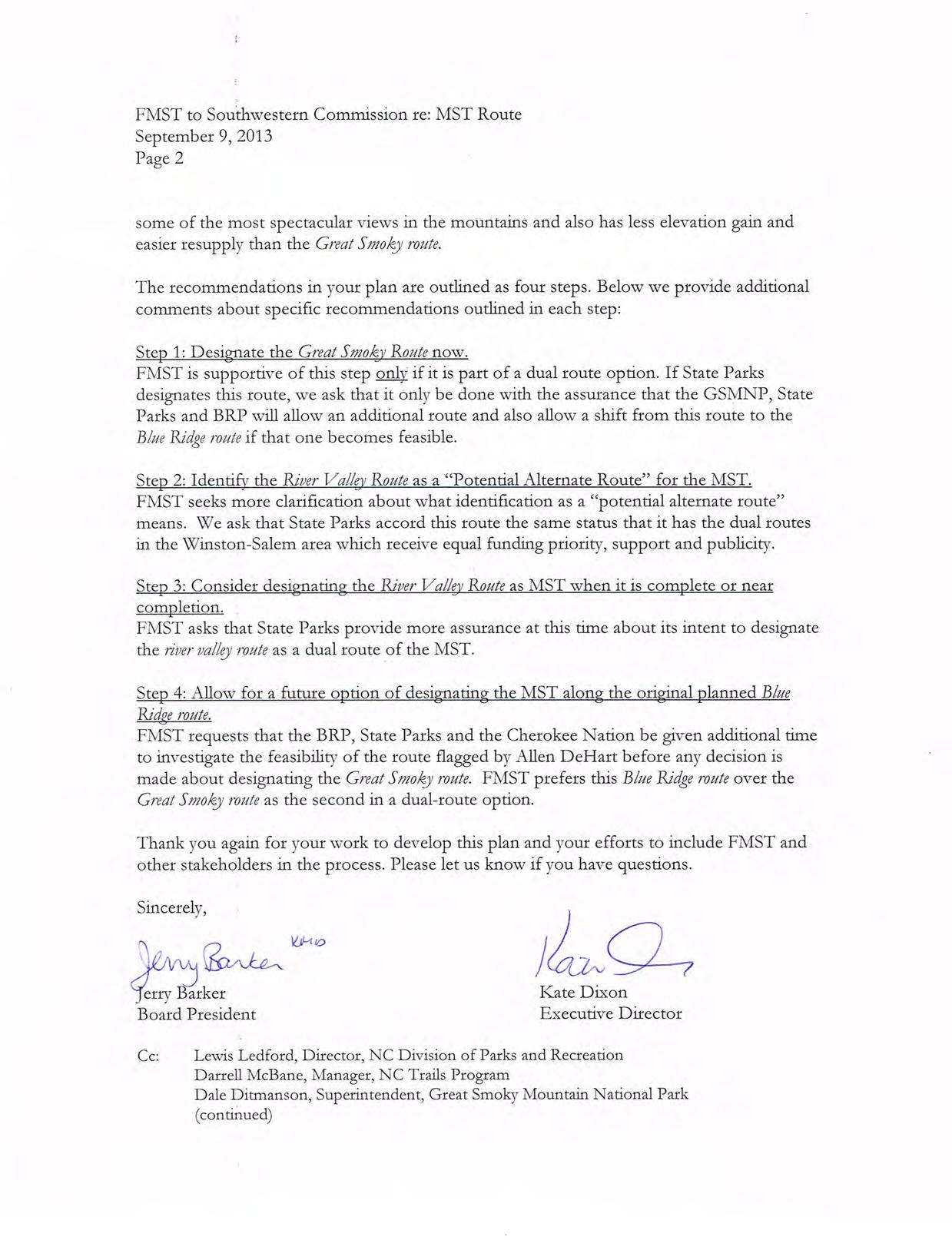
The concept of dual route designations or a loop trail (e.g. Route A through towns; Route B through wilderness areas) also emerged during Trails Plan discussions and is supported by FMST. FMST envisions this as a “Great Smoky route” and a “River Valley route”. The merits of such an idea are worth exploring but should be considered carefully in terms of how it impacts potential users. Currently, Great Smoky Mountains National Park and the Blue Ridge Parkway do not support more than one route designation.
Pros:
A town based vs. wilderness based route would cater to a variety of hikers (long distance hikers and day hikers) and potentially other users such as bicyclists along a multi use trail.
A dual route option can generate interest in communities and towns to create a broader network of volunteers and champions.
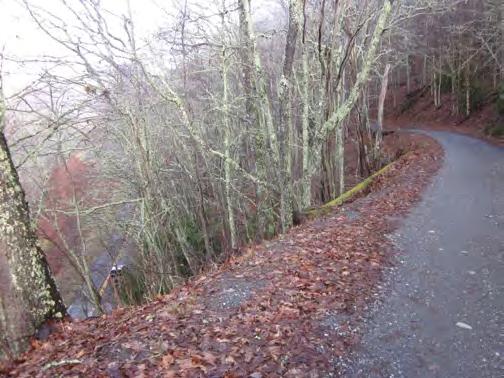
The Blue Ridge Parkway can be seen adjacent to Bureau of Indian Affairs highways near the planned route of the Mountains to Sea Trail. Using a network of these BIA roads to route hikers around tunnels has been posed as one routing option for the Trail.
Dual routes would continue to support and promote efforts by the Carolina Mountain Club and others who have been working on the route near the Park.
Cons:
Confusion could arise as to the routing of the trail in terms of wayfinding and intended purpose of the trail;
The precedent of establishing dual or alternate routes could impact the State and its relationships with other communities in North Carolina
Southwestern Commission 2013 Regional Trails Plan 36
Photo: Don Kostelec
who might desire similar designation for the MST. The State has allowed for dual route designation in the Piedmont region near Winston Salem; and
Potential conflict in independent funding pursuits among counties, towns, non profits, land conservancies, and other stakeholders as they seek implementation of dual routes. Careful coordination would need to occur among many stakeholders to avoid such competition.
Recommendations
More detailed evaluations of routing options for the Mountains to Sea Trail area are required in order for the state and stakeholders to proceed with work on a preferred alternative.
The following steps are recommendations for the North Carolina State Parks to pursue designation of a current route to complete the Mountains to Sea Trail in Western North Carolina while encouraging groups such as the Friends of the Mountains to Sea Trail, Carolina Mountain Club, the Counties and other stakeholders to pursue other complementary routing options identified in this Plan.
Step 1: Designate the Mountains to Sea Trail along existing trails offered by the Great Smoky Mountains National Park (Option 1) as the “Great Smoky Mountains Section of the Mountains to Sea Trail”, while acknowledging that there is community support for a complementary/dual routing option that includes the “Original Planned Route along or near the Blue Ridge Parkway,” and the “river valley route” along or near the Tuckasegee River.
Step 2: Identify the “river valley route” (Option 3) as a
“Potential Alternate Routes for the MST” route for the MST. The river valley route is supported by the Friends of the Mountains to Sea Trail and the Board of County Commissioners in Jackson and Swain Counties, as well as the Carolina Mountain Club if designated as a dual route with the “Great Smokies route.” A dual routing option is not currently supported by the Great Smoky Mountains National Park and the Blue Ridge Parkway.
Step 3: Once the “river valley route” is completed or nearing completion, North Carolina State Parks should consider designating it as a complementary, dual or alternate section of the MST and label the routes accordingly. This will require continuing dialog with the National Parks.
Step 4: Allow for a future option of designating the Mountains to Sea Trail along “Original Planned route along or near the Blue Ridge Parkway”, as Option 1 through the Park adds considerable length to the originally intended route. There is no timetable for Step 4 as any action on it is strictly predicated by actions of the Eastern Band of Cherokee Indians and/or the Blue Ridge Parkway. If this routing is approved and constructed, the State should consider designating this section as the “Primary Route” of the MST.
2013 Regional Trails Plan Southwestern Commission37
Photo: The Franklin Press
Chapter 7 Health & Economic Impacts of Trails
The network of trails and greenways throughout Western North Carolina (WNC) has the potential to provide recreational opportunities that contribute to the overall health and well being of citizens and visitors, as well as local and regional economies. This chapter summarizes key themes emerging in the fields of health and economics indicating the return on investment in trails and greenways can be substantial.
Public Health
The health influences of trails cannot be ignored. Small towns and rural areas generally lack the resources to construct parks, greenways and recreation facilities—and maintain them—to the same degree as larger cities. But WNC has always taken advantage of its close proximity to natural areas where many trails and other recreational opportunities exist.
Methods to evaluate and measure health outcomes consist of a variety of measures and data points. We know that constructing trails and greenways throughout Western North Carolina will largely bring about positive impacts in numerous areas of health. The potential for such investments to impact the health of individuals through increased physical activity is well documented and generally accepted by health professionals, elected officials and citizens. There also exist opportunities to improve not only physical health, but mental health as well as social and environmental factors. Trails and greenways are seen as facilities that provide for greater social interaction, family bonding and a connection to nature that has proven to be beneficial in stress reduction
and well being. The illustration at right depicts the imbalance in causal factors of what makes us healthy versus where our public funding goes toward addressing health. It indicates that greater investments in healthy behavior—of which trails, greenways and bikeways are part—has greater opportunity to contribute to preventive actions before expenditures on medical services are required.
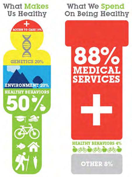
In recent years, counties throughout Western North Carolina have been engaged in conducting Community Health Assessments (CHA). The region is now engaged through the Community Transformation Project in identifying ways to provide greater health living opportunities to residents through access to healthy foods, improvements in the built environment to consider public health, and tobacco prevention programs. By considering health outcomes of investments in trails, the region stands to gain both a deeper understanding of health impacts stemming from trails as well as opportunities to engage new partners in funding of new trails and greenways.
The Jackrabbit Mountain Bike and Hiking Trails in Clay County (profiled in Chapter 4) are a great example of how community members, health organizations, the school system and government agencies coordinated—with an eye toward improving overall public health—to build new trails and develop programs to teach schoolchildren proper riding techniques.
This is just one example of many throughout the region. The Murphy River Walk has a trailhead at a local wellness center. BicycleHaywoodNC received a grant
Southwestern Commission 2013 Regional Trails Plan 38
Source: Lots to Lose: How America’s Health and Obesity Crisis Threatens our Economic Future (2012)
from Healthy Haywood to purchase new bicycles for Haywood County Schools. Blue Cross Blue Shield of North Carolina contributed to the planning for the Western Carolina University Trails System.
Through the Community Transformation Project, which is a five year program aimed at improving overall public health, the following implementation strategies have been identified that have a direct or indirect relationship to trails and greenways in Western North Carolina:
Increase the number of communities that implement comprehensive plans for land use and transportation;
Increase the number of community organizations that promote joint use/community use of facilities (such as schools);
Increase the number of communities that support farmer’s markets, mobile markets and farm stands; and
Increase the number of ways in which a community provides support for individuals with high blood pressure/cholesterol, heart disease, diabetes and other related ailments, including Eat Smart / Move More and Weigh Less programs. The illustration to the left illustrates what is called the “Energy Balance” that individuals must achieve to maintain a healthy weight. Trail investments have the potential to directly impact increased energy expenditures and relate to the features outlined in dotted blue lines in this chart. Trail investments should be considered in combination with plans and policies
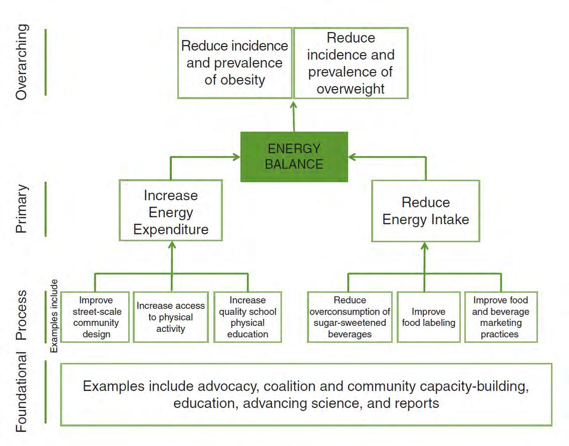
2013 Regional Trails Plan Southwestern Commission39
Framework for developing indicators of progress in accelerating obesity prevention
Source: Accelerating Progress in Obesity Prevention: Solving the Weight of the Nation (2012)
that also promote access to healthy foods and healthy eating habits to help individuals achieve the desired energy balance to maintain a health weight.
Economic Impacts of Trails

While new trails require significant investment from several agencies, organizations and funding sources, communities that have seriously undertaken investment programs for trails and greenways have seen far reaching positive economic impacts. The impacts range from creating a healthier lifestyle for residents to attracting businesses to the area and improving the transportation system by increasing options for users making short or moderate trips in small towns.
Participants in the Southwestern Commission Regional Trails Plan workshops indicated a strong desire to promote the region as a recreation destination, increase opportunities for mountain biking, designate communities as Trail Towns, and link greenways and trails to schools and parks.
A 2011 article in the Macon County News & Shopping Guide about Franklin’s designation as an Appalachian Trail Community cited a survey of trail users reporting an annual income of more than $40,000 and estimated each hiker spent $153 during their time in Franklin. Nearly 70% indicated staying one night in the area with 26% staying two to four nights.
The Virginia Creeper Trail between Abingdon and Damascus, Virginia is one of the most studied trail corridors and was estimated to provide a positive impact to communities along the route. Trail users were estimated to spend $2.5 million per year during
their visits, including $1.2 million by non local users. This led to the creation of 30 jobs in the area. The diagram on the next page illustrates the many ways in which direct and indirect trail related expenditures impact area economies, including sales tax, income tax and income for non profit and trail related organizations. These are but a few of the impacts and show just how complex the economic formulas to identify actual economic benefits must be to gain a comprehensive understanding of them.
Indirect Benefits. Indirect effects were a component of the 2004 report conducted by the North Carolina Department of Transportation on the economic effects of cycling in the Outer Banks region of North Carolina, which remains a benchmark study for the state on this topic. The range of economic impact from bicycling was estimated to be between $15 million and $149 million per year.
The consideration of indirect benefits encompasses health effects of increased trail use/walking, improved mental benefits of exercising, reductions in mobile source emissions for trips that replace an automobile with a non motorized mode of travel, new or expanded business opportunities that key on trail users and their needs, and the impacts to adjacent property values.
The impacts to property values – and hence public tax revenues assessed on property – through externalities also create a conversation about economic benefits of greenways.
Southwestern Commission 2013 Regional Trails Plan 40
Trails in Teton County, Wyoming create an annual economic impact of $18,000,000.
Nadia Kaliszewski (2011)
"JacksonHoleTrailsProject EconomicImpactStudy."
Trail Economics: How Greenways,Trails & Bike Routes Impact Local Economies
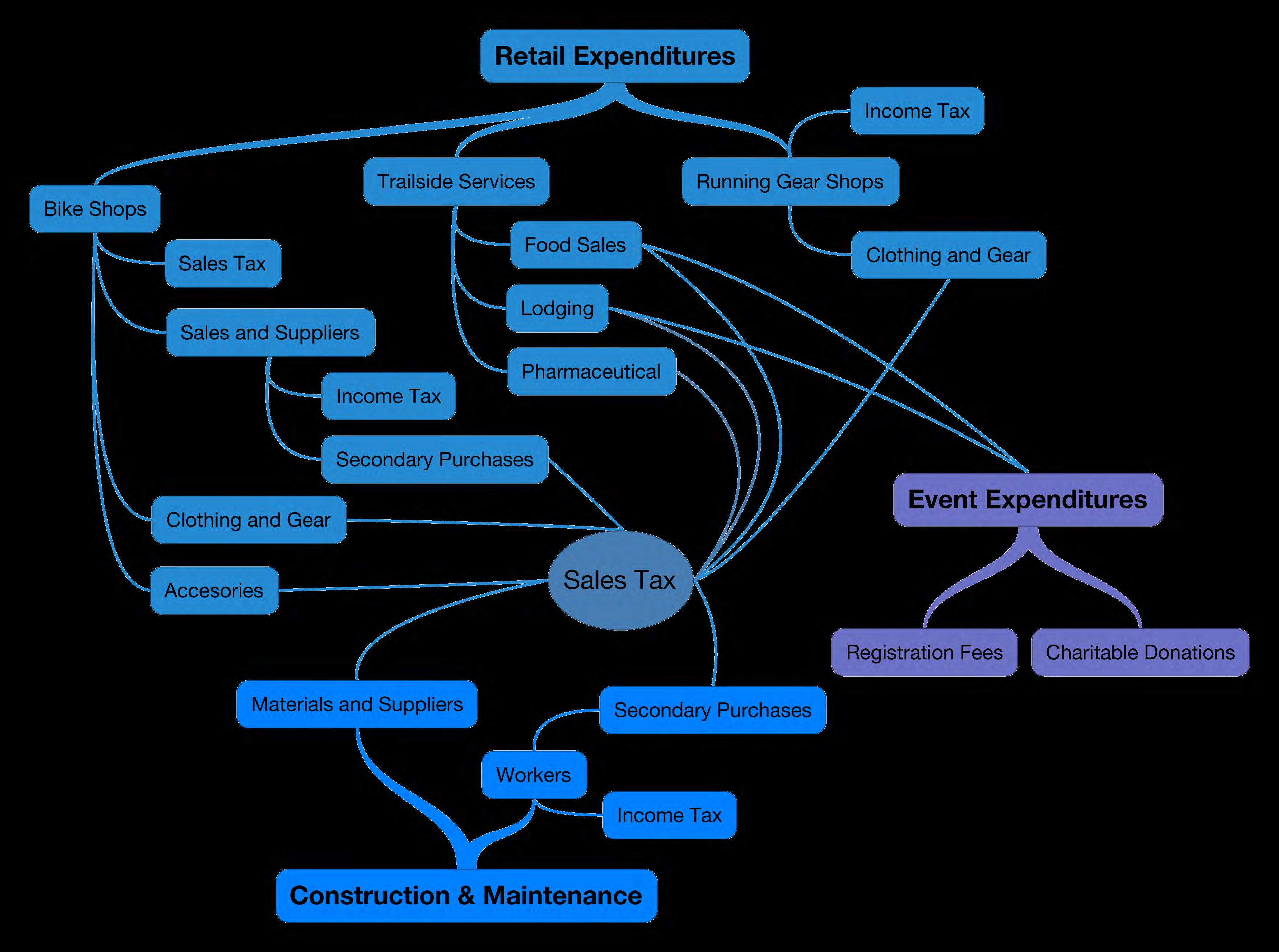
2013 Regional Trails Plan Southwestern Commission41
Chapter
Maintenance & Operations
It is critical for agencies and organizations who pursue new trails and greenways to have an understanding of what is required to operate and maintain a new facility. This Plan showcases the many opportunities for new or enhanced trails in Western North Carolina. Besides funding, major influences of what a future trails network could look like are the degree to which volunteers are able to maintain the trails and attracting a critical mass of users on the trails to prevent encroaching foliage due to underutilization.
Ownership
The ability to perform maintenance and who is able to perform maintenance on trails can vary by who owns the land on which a trail sits.
In natural areas and on public lands, volunteer organizations such as hiking clubs, mountain biking clubs and back country horsemen are the backbone of trail maintenance efforts. The passion of these users and respect for the land on which they recreate drives them to take on maintenance responsibilities that decrease the financial burden on federal, state and local agencies.
Volunteers cut new trails, conduct regular maintenance sweeps, and remove obstructions after the winter season or major storms. On Federal lands, volunteers are required to undergo training on proper procedures to maintain trails on public lands. Skills such as saw cutting and erosion control are part of the curriculum.
On greenways closer to small towns or rural communities, volunteers are still a critical element in any maintenance endeavor but their utilization is dependent on the degree of maintenance that is required. Volunteers cannot operate heavy equipment required to re pave asphalt trails but may be used in support roles as town and county governments conduct such maintenance activities.
The partnership between public agencies and volunteers who maintain trails is a win win relationship. Agencies reduce their fiscal burdens by securing free labor to maintain a public resource and volunteers showcase their passions by helping protect the places in which they recreate.
Non profit groups try to avoid owning land due to liability concerns. Public agencies, which are shielded from litigation related to land ownership, take ownership in exchange for low cost maintenance. Public ownership also contributes to the ability of land to receive federal disaster aid if major storms disturb trail alignments or cause trails to erode.
Maintenance
The two tables contained in this chapter illustrate the many ways in which volunteers can be sought to maintain trails and how frequently maintenance activities should take place.
Groups such as SORBA, Back Country Horsemen of Pisgah and Western North Carolina, the Friends of the Greenway (FrOGs) in Franklin, the Carolina Mountain Club, the Benton MacKaye Trail and Associ-
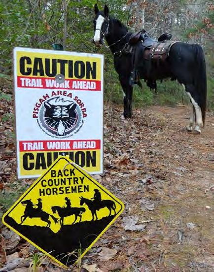
Groups such as Pisgah Area SORBA and the Back County Horsemen of Pisgah regularly coordinate on trail maintenance activities. In natural areas, most trail maintenance is conducted by volunteers who have been through training courses required by the Federal government to maintain trails on public lands.
Photo: Back Country Horsemen of Pisgah
Southwestern Commission 2013 Regional Trails Plan 42
8
Water
Trail
Scheduling
Borrow
Facilities
Asphalt Spot
Debris
Control
Lot Repair
Major Debris Removal
Trash
Planting
Flowers;
Asphalt Crack Sealing
Protection
2013 Regional Trails Plan Southwestern Commission43 Types of Maintenance & Operations Activities Parks & Recreation Departments, Municipal Parks Departments, Contractors Volunteers, Other Non-Profit or Contract Organizations
Maintenance, Municipal Public Works, Transportation Departments, Contractors Spot / Incident: Occurs as necessary or warranted. Citizen Response Low Water Crossing / Warning Signs Major Debris Removal Securing Temporary Signage Identify Detours Information Dissemination Special Events Policies & Permitting Lighting Replacement Citizen Response Spot Improvement & Incident Reporting
New Vegetation Minor Debris Removal Placing Temporary Signage Information Dissemination Special Event Monitoring / Support
Patches Major
Removal Graffiti
Parking
Regular: Programmed or continuous at logical intervals based on features and their needs. Scheduling Major Maintenance Tasks Trail Edge / Path Weed Treatment Major Mowing & Trimming Trash Disposal Plant & Trim Trees Stock, Clean Amenities Rotary/Machine Sweeping Bollards / Bollard Locks Sign Replacement Mapping Volunteer Training Accident & Incident Tracking Pest Management
Inspection & Condition Surveys
Minor Maintenance Tasks Minor Mowing & Trimming Removing noxious weeds Trail Shoulder /
Ditch Clean-up
Collection
Shrubs, Grasses &
Mulch Planting Beds Locking / Securing Trailheads & Access Points Hand Tool Sweeping Volunteer Training Support Accident & Incident Monitoring
/ Seal & Cover Shoulder
& Maintenance Large Scale Vegetation Removal Dust Management On-Street Sidewalk & Connecting Route Maintenance Long-Term: Requires major planning, budgeting and coordination for anticipated investments or major initiatives. Fence & Structure Paint / Maintenance Trail Location Signage / Wayfinding Major Amenities Procurement & Replacement Habitat / Environmental Maintenance & Control Secure Funding Benches & Table Paint / Maintenance Support / Pursue Funding Asphalt Seal & Cover / Overlay Centerline Striping / Crosswalk Markings Street Location Signage & Lighting Bridge inspections & Maintenance Fencing & Railing Drainage / Borrow Ditches, Culverts Trail Maintenance: Partners, Roles & Responsibilities Source: Buncombe County Greenways & Trails Master Plan (2012)
ation and others are active in maintaining trails.
As stated earlier, their ability to maintain trails is limited to the types of duties. The tables in this chapter are intended to help agencies, non profits and volunteers more clearly understand the potential roles they can play in trail maintenance.
Trail Surfaces
The most important interface between trail users and the trail is the surface. It controls the activities that can be undertaken along the trail and impacts the quality of the user’s experience. Trail surfaces can include dirt, gravel, cinders and asphalt and there is no one size fits all surface type.
The characteristics of the trail surface such as width and surface type help communicate to the user what type of activity is appropriate. For example, narrow, natural surface trails indicate users should be expected to traverse more natural terrain and should expect to move slowly and with caution to avoid conflict with other users. Use may be restricted to certain users based on other design characteristics.
Wide, paved or gravel surfaces indicate use by several user types of more varying speeds. Design features such as horizontal and vertical curvature of the trail is an important indicator of how users are expected to travel along the trail.
In any condition, the trail is expected to have a firm and stable surface. It should be a goal of trail construction and maintenance that the trail is accessible to the broadest cross section of user types, based on
setting.
Many laws dictate how to design for universal accessibility. Greenways and urban trail connections should consider how persons with mobility impairments experience the route while trails in natural settings have less stringent regulations pertaining to the Americans with Disabilities Act (although there are still considerations to understand and adhere to).
Paved vs. Un-Paved Trails
There is no universal standard that dictates whether or not a trail should be paved or un paved. It is oftentimes a community preference or can be a requirement of a funding source. Trails in natural settings are almost always unpaved, but may be paved for short segments to prevent erosion. Greenways are oftentimes paved due to the high level of use, but high use trails such as the Virginia Creeper are un paved. Un paved greenways can require more maintenance and may be more difficult to ensure accessibility to persons with mobility impairments.
Greenway trails may have volunteer patrols that provide users with a sense of security on the trail. Patrol vehicles, such as golf carts, can be equipped with tools such as blowers and tree pruning equipment for volunteers to also maintain the trail.
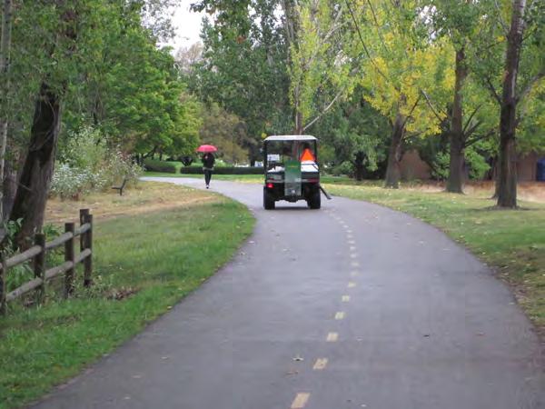
Southwestern Commission 2013 Regional Trails Plan 44
Photo: Don Kostelec
Trail
Maintenance Activity
Un-paved
Paved
Pavement
Resurface
Pothole
Mowing
Patrols
Monthly
Yearly
Needed Notes
Incorporate
After winter season,
After major storm
After storm, flood
Varies
Primarily
After
Greenways:

2013 Regional Trails Plan Southwestern Commission45
Weekly
Seasonal
As
Inspection & conditions survey
with GIS/mapping info.
trail surface repair
major storms
trail surface repair
markings maintenance / replacement
non-asphalt trail
or erosion event
repair and other patches on non-asphalt
or erosion event Remove trash & debris from trailside land
based on setting/context Leaf removal Tree pruning Plant new vegetation
in springtime Weed control & pest management Remove fallen trees from trails
winter season, major storms Empty trash at trailheads & along trails
Weekly; Trails: Monthly Landscaping/gardening at trailheads Repair / maintenance of signs
on greenway trails May be daily or on weekends. Maintenance of lighting Bridge & other heavy infrastructure maintenance
Maintenance: Frequency of Common Tasks Adapted from Rails to Trails Conservancy Maintenance & Operations Guide (2005)
Implementation
This Plan is intended to be the starting point for more robust efforts to coordinate trail planning and implementation efforts in Western North Carolina. The efficacy of any plan is only as good as the ability for agencies, stakeholders and citizens to oversee implementation of the recommendations contained within the Plan.
The preceding chapters of the Regional Trails Plan contain many ideas related to implementation. This chapter outlines further efforts aimed at regional coordination and continuation of the long standing momentum to make Western North Carolina a destination for recreationists and a place that attracts residents and businesses who want access to many recreational opportunities offered throughout the area.
Adopting the Plan. The State of North Carolina, which funded this Plan, requests the Southwestern Commission’s Board to adopt the Regional Trails Plan. This action establishes the Plan as the guiding vision for future trail planning and implementation efforts. It is desired that each Board of County Commissioners within the region also consider endorsing the Plan or building upon it.
Implementing the Plan. Adoption of this Plan does not constitute a mandate for any public agency within the region to fund actions recommended herein. But implementation of the Plan will require dedication of both financial and human resources. Many of the future trail alignments recommended in this Plan require more detailed evaluation. Counties
may undertake countywide greenway and trail planning efforts, such as those conducted in Jackson County. Towns may conduct more detailed Greenways and Pedestrian plans such as those adopted by Bryson City, Cherokee, Sylva, and Waynesville. Other plans, such as the Haywood County Comprehensive Bicycle Plan and the Blue Ridge Bicycle Plan (covering Haywood, Jackson and Swain Counties), may be beneficial for specific user groups.
Some trails will require detailed corridor studies and almost all will require some level of design and land acquisition before construction can begin.
Coordination & Funding Pursuits
The idea emerged through the Regional Trails Plan effort that a Regional Trails Coordinator position be considered to help align the many interests for expanding and enhancing the region’s trail system. Funding for such a position does not exist today.
The logical agency to take on the role of regional trails coordination is the Southwestern Commission. While hiring a part time or full time trails coordinator may be a long term implementation action, the agency can serve in a coordinating role in other ways:
Organize a Regional Trails Committee to meet on a regular or as needed basis to help oversee implementation of this plan;
Conduct an annual or semi annual Trails Symposium in the region to highlight recent accomplishments and promote information exchange
“Just stick with it. It is a multiyear project but it can be accomplished if you keep the pressure on. It takes a consistent leader willing to work around road blocks to make it happen.”
- Josh Whitmore, WesternCarolinaUniversity, about the implementation efforts for the WCU Trails.
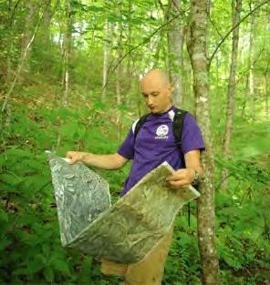
Southwestern Commission 2013 Regional Trails Plan 46 Chapter 9
Photo: WCU
User friendly maps, such as the one contained in the brochure for the Murphy River Walk and Canoe Trail, are critical for encouraging use and helping visitors orient themselves to the community. It is recommended that the region pursue development of a common set of maps of trails for day use that can be distributed to visitor centers, trailheads, area lodging, and restaurants.
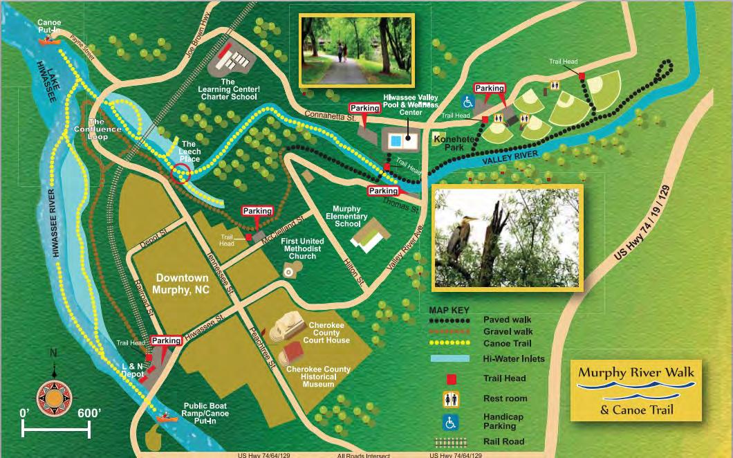
Credit: Murphy River Walk and Canoe Trail Brochure
among organizations and agencies;
Produce an annual report of trail related accomplishments;
Oversee funding pursuits within the region to help ensure that towns, counties and other organizations within Western North Carolina are not unnecessarily competing against one another for limited resources; and
Identify strategies and funding sources to hire a part time or full time regional trails coordinator.
User-Friendly Resources
A trail is only as good as the ability of the user to understand where it can take them. User friendly materials and user friendly amenities are critical to attracting visitors. New places, especially those with dense forests and mountain locations, can be intimidating to novice or out of town hikers, bicyclists, and equestrians. Communities should make every attempt to develop promotional materials that make for a more user friendly experience.
Most counties now have Travel and Tourism Agencies/Authorities who are tasked with using taxes generated from area lodging to help entice more visitors to the area. These authorities have a track record of helping other public agencies and organizations produce signage and materials for visitors.
Trail Maps & Guides. Every town, every trail, every greenway wants to establish its own identity that best illustrates the community and its values. This identity should be recognized and protected; howev-
2013 Regional Trails Plan Southwestern Commission47
er, the region should also work to identify a common theme or identity to collaboratively promote and enhance its trails. Maps should have common features and should indicate where linkages to other trails exist, even if those linkages are not neatly arranged within existing political boundaries.
Every trail or greenway should have its own brochure, map and online presence. Users should know where to access food, water and supplies. Day hikers can easily be intimidated by maps produced for hiking trails that include technical information such as detailed topographical information.
The region can tap the resources of stakeholders such as Western Carolina University or community colleges—their professors and students—to organize an effort to establish common parameters for these materials to make them user friendly.

Trail Towns. A model for designating trail towns is the Appalachian Trail Conservancy’s Appalachian Trail Community™ program. It is designed to recognize communities that promote and protect the Appalachian Trail. According to the Conservancy, the program assists communities with sustainable economic development through tourism and outdoor recreation, while preserving and protecting the AT Designation as an Appalachian Trail Community™. Franklin is the only community in Western North Carolina that has this designation.
The Conservancy notes that participation in the program is aimed to:
Engage community citizens, visitors and stewards;
Recognize and thank communities for their service to the Trail and hikers;
Act as a catalyst for enhancing sustainable economic development;
Aid local municipalities and regional areas with conservation planning; and
Help local community members see the Trail as a resource and asset.
(www.appalachiantrail.org)
The goals and purpose of the designation is replicable for many of the communities in Western North Carolina whether or not they receive designation.
When communities acknowledge they are a trail town, they articulate to community members, businesses, organizations and visitors that trail activities are encouraged and promoted.
The region should organize an official effort for communities to become more trail friendly through the same goals established by the Appalachian Trail Conservancy.
Trail Friendly Businesses. Another movement for trail communities is designation of trail friendly businesses that provide special services to trail users. The region can organize its own local network of trail friendly businesses to help promote the area’s resources and ensure visitors consistent access to information, supplies and amenities. Some common trail friendly business characteristics include:
Franklin, through its Appalachian Trail Community designation efforts, produced a Hiker Services brochure that includes a map of places in and near town for hikers to stay, eat and replenish supplies.
Southwestern Commission 2013 Regional Trails Plan 48
A rural Complete Streets example is located along US 74 near the Nantahala Gorge where NCDOT has installed a wide shoulder and labeled it as a bike lane between a mountain bike trailhead and a nearby parking area and lodging.
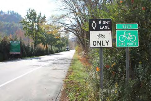
Photo: Don Kostelec
Accommodations for trail users at lodging locations, including storage of equipment;
Stocking of common trail user supplies, such as maps, water, non perishable and healthy food items, overnight or daily parking for trail users, and bicycle repair supplies such as tubes;
Consistent information available at each business, such as brochures or access to Wi Fi;
Staff knowledgeable of trail user needs and area destinations.
A local example of this idea in action is an effort by BicycleHaywoodNC to secure commitments from grocery and convenience stores along popular bicycling routes to stock supplies and information for bicyclists in exchange for promoting the businesses on route cue sheets and brochures.
Complete Streets
Complete Streets are defined as roads that are safe for all users of all abilities at all times. NCDOT adopted its Complete Streets policy in 2009, which is aimed at incorporating the needs of users such as pedestrians and bicyclists when planning, designing, constructing and maintaining public highways.
Complete Streets are not just applicable to urban areas with sidewalks and bike lanes. They are just as important to rural areas, especially on rural roads that provide linkages to area trails. NCDOT should work with small towns and rural communities to identify the appropriate Complete Streets solutions. In some places, a Complete Streets application may
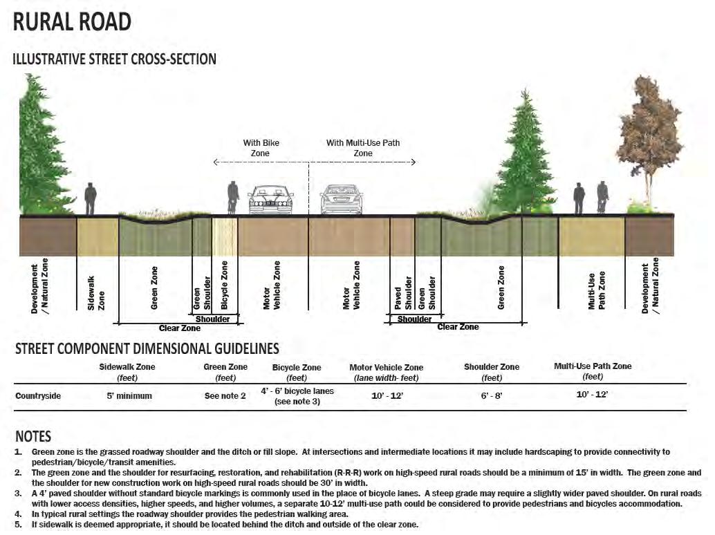
2013 Regional Trails Plan Southwestern Commission49
simply be a wider shoulder along a highway that connects a campground to mountain bike trails (as has been done along US 74 in the Nantahala Gorge). In other places, a greenway may require a sidepath along a highway or a bridge to make a critical linkage.
Southwestern Commission should adopt a Complete Streets policy that aims to integrate the needs of hikers, pedestrians and bicyclists into NCDOT practices and articulate to the agency the unique needs of rural areas in this regard.
Performance Measures
A greater degree of emphasis is placed on the performance of trail related projects, programs and policies. Federal legislation pertaining to funding of trails and greenways now requires many agencies and funding sources to measure the performance of proposed investments. The table at right highlights several categories of evaluation techniques to measure the effectiveness of greenways and trails investment.
As with funding pursuits, the Southwestern Commission is the logical agency to track performance of the region’s trails system. That does not mean, however, that the agency should be tasked with collecting data related to trail usage and other performance measures. Those responsibilities can and should rest with the organizations already serving as stewards of the many trails in the region. The role of the Southwestern Commission can be to:
Define which metrics are useful and attainable;
Compile an annual or semi annual report of performance measures on trails in the region; and Serve as a resource for organizations wishing to use the measures to apply for funding.
Whether or not they are required by a funding source or by law, it is good practice to be tracking measures such as these to help provide documentation for grant pursuits, confidently showcase the benefits of the system to the public, and help evaluate how and where future investments are made.
Potential Trails & Greenways Performance Measures
Facilities
Miles of greenways & trails
New miles of greenways & trails
Residents within 1 mile of access points
Corridor Plans completed
Connectivity of other bike/ped facilities, river access, recreational opportunities, closing gaps
Change in costs over time
Funding / Resources
Number of volunteer hours
Annual allocation / contributions
Staff time contributed
Number of funding partners
Grants pursued / awarded
Usage / Participation
User counts, by mode, user type
Program participants
Members of trail related organizations
People engaged through public outreach
Economic impacts
Presentations to groups, businesses, schools, etc.
Participants in education, encouragement & training activities
Adopt a Trail partners
Safe Routes to Schools
Others
Acreage preserved for future use, environmental & agricultural conservation
New jobs located near trails/greenways
Change in health factors (long term)
Southwestern Commission 2013 Regional Trails Plan 50
Forest Service Plans
The U.S. Forest Service began revising the Nantahala and Pisgah National Forests Land and Resource Management Plan in November 2012. The process is expected to take three to four years to complete. When revision is completed, the Plan will guide management of the Nantahala and Pisgah National Forests for approximately 15 years. The Forest Service published the original Plan in 1987. A significant amended was published in 1994, and smaller amendments occurred in subsequent years.
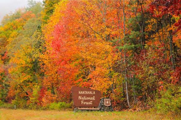
While this plan will impact Western North Carolina, its bearing on the Regional Trails Plan is limited as the Regional Trails Plan did not evaluate specific policy and routes within the National Forests to the degree that will occur with the USFS Plan.
Southwestern Commission should participate in the USFS Plans and work to incorporate any findings of these Plans into regional mapping and future planning efforts.
Each national forest and grassland is governed by a management plan in accordance with the National Forest Management Act. These plans set management, protection and use goals and guidelines.
Revision of the USFS Plan will occur in three phases:
1. Assessment: During this phase, the Forest Service will collect and compile data and other information on the current state of the Nantahala and Pisgah National Forests. The assessment phase will focus on what changes are needed to the management plan for the two national forests. Numerous public meetings will take place to receive input from stakeholders during this period.
2. Planning Period: During this phase, the Forest Service will analyze the data collected; determine the management practices needed to accomplish the desired goals and the effects those management practices may have on the land; draft the revised Plan; receive and respond to public comment; and release the final Plan.
3. Monitoring: The monitoring phase begins after the final Plan is released and continues throughout the Plan period. During this phase, the Forest Service monitors the progress of Plan implementation to make sure goals are being achieved.
Timeline for USFS Plan Revision:
Assessment (Phase 1) – November 2012 Fall 2013
On the heels of the Regional Trails Plan, the US Forest Service will be updating its master plans for land management and trails within the National Forests in Western North Carolina. These planning efforts should be tracked by Southwestern Commission for potential impacts on other trail efforts.
Planning Period (Phase 2) – Fall 2013 2015/Early 2016
Monitoring Phase (Phase 3) – Early 2016 and Beyond
2013 Regional Trails Plan Southwestern Commission51
Photo: Outdoor 76
Appendix: Supplemental Materials
The Appendix contains the following documents:
Results of the Survey Monkey tool developed for review of the draft Plan (February September 2013);
Letter regarding the Mountains to Sea Trail routing options, as received from stakeholders on the organizations’ official letterhead. These include:
Bartram Trail Society
Carolina Mountain Club
Friends of the Mountains to Sea Trail
Great Smoky Mountains National Park
Swain County Resolution on MST routing
Wilderness Society
Southwestern Commission 2013 Regional Trails Plan 52
Survey Responses to Draft Regional Trails Plan (February through September 2013)
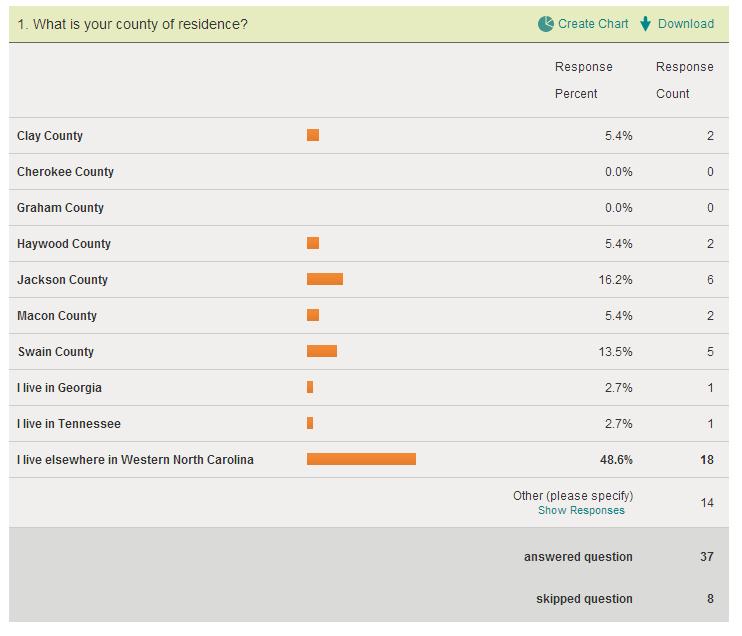
Southwestern Commission Regional Trails Plan: Appendix – Survey Responses 1 | Page

Southwestern Commission Regional Trails Plan: Appendix – Survey Responses 2 | Page
3. Are there any existing trails or other features that we have not included on the regional or countyspecific maps? Is so, please provide a comment related to those features and indicate the appropriate map
9/3/2013 10:00 PM
The waterfalls in the Alarka area of Swain County could be included in the Plan. Existing and future Greenways could include Play Pocket features - elements of Natural Playscapes - to help children, teens, and families engage with outdoor activities. Natural Playscape features have been around since the 1940s in Europe and are booming in popularity in the USA. These features inspire robust outdoor play for children, even those who have been estranged from Nature Play per having an Indoor Childhood. Birding Trails could be included in the development of the Plan.
8/30/2013 10:28 PM no
8/15/2013 8:46 AM Excellent coverage
8/12/2013 9:56 AM
You should have included my book "The Mountains-to-Sea Trail Across North Carolina" by Danny Bernstein (The History Press, 2013) as one of the promoters of walking roads (pg. 15). My book has popularized the MST in the whole state and nationally. See the review at http://www.nationalparkstraveler.com/review/2013/mountains-sea-trailacross-north-carolina-walking-thousand-miles-through-wildness-culture-and-histor23723 The book is the newest book on the MST and the most up-to-date.
8/10/2013 1:22 PM Looks very complete.
8/8/2013 9:39 AM
Communities with lodging, campground business, re-supply businesses.
8/7/2013 12:16 AM
Don't know of any.
8/6/2013 9:37 PM No
8/6/2013 3:38 PM No.
3/19/2013 8:17 AM
Honestly, for Jackson Co, there is just too much on this one map. It's not possible to have a good map that covers this much area with the detail needed to use it to find what you want. However, if you want to show it as a 'big picture', then refer to smaller maps that cover the desired area, you will be able to see the detail needed. Perhaps if I were able to view a large version of it, rather than on my computer screen, I could look at it easier. Here goes: 1. I think it's a mistake to call Rt 19 from 276 to Maggie Valley a Greenway. Is there a Greenway there? 2. Pinnacle Park trails are already in existence, though they are not sustainable going up the West and East Fork routes from the parking area at the end of Fisher Creek Rd. There is wonderful potential for much more enjoyable hiking and biking if sustainable trails were built. 3. Sorry, this just isn't feasible for me to provide much more.
3/3/2013 8:21 PM
Mentioned in the "Other Opportunities" section....I would love to see the possible "more natural" routes for connecting the Bartram Trail in Macon County through Franklin. What are the possibilities/advantages of it joining up with the maybe joining up with the Little Tennessee Greenway for a stretch? Keeping the future route more "natural", yet entering downtown for a small portion of the trail could be great for local promotion. Reminds me of Hot Springs, NC...
Southwestern Commission Regional Trails Plan: Appendix – Survey Responses 3 | Page
3/2/2013 12:54 AM
Ideally, there would be further breakup of OHV trails. In Michigan, the trail system is extensive - over 3,000 miles of trail system for OHV use. However, it is sub-divided into less than 50" width single track for motorcyclists, and over 50" for 4-wheelers and Jeeps. I would prefer to see a similar strategy employed as single track for off-road motorcyclists requires less space and maintenance, offers technical challenges for the experienced motorcyclist, and diminishes the possibility of contact between two different machines.
2/22/2013 9:29 AM
Equestrian activities in these counties amount to significant economic impact. I saw no indication of involvement with this user group. We were not notified in regards to this initiative until very recently. Don was able to come speak to our group.
2/18/2013 12:30 AM
The Haywood County map shows an existing forest trail from the Blue Ridge Parkway down into the Waynesville watershed. This WS-1 watershed is posted, closed to the public and does not have facilities required to be opened for public access. This trail has not been used or maintained in decades and no longer exists. Please remove it from the mapping. Fred Baker Director of Public Works Town of Waynesville
Southwestern Commission Regional Trails Plan: Appendix – Survey Responses 4 | Page
4. After reading the Plan document, are there any topic areas that need clarification? Did we miss something? Should we add anything to the Plan document that would help your understanding of the intent of the Plan?
9/6/2013 10:25 AM
No, I believe you covered all items thoroughly, though I had expected some ballpark cost estimates for financial comparison.
9/3/2013 10:00 PM
Since the enjoyment of outdoor activities is the focus of the Plan and an avenue towards advancing Eco-tourism in WNC, the Plan could benefit by including wording to: 1) Show a world-context of Blue Green Exercise (water/woods) formalized in other countries' health care and educational structure - Japan, United Kingdom, Sweden, Norway, and Germany; engaging the natural world is part of their culture - WNC could serve to inspire that culture within the State and beyond; 2) Highlight the work currently being conducted throughout the State to promote Nature Play - NC State's Natural Learning Initiative which promotes Natural Playscape features and which serves as a national leader in the field as well as NC Children and Nature Coalition which strives to support a multi-discipline network of individuals and organizations to promote Nature Play in the State as well as throughout the USA through National Wildlife Federation's Be Out There campaign, Children & Nature Network's programs, and the First Lady's Let's Move Outside program; and, 3) Be included in the marketing media from the closest WNC urban hub, Asheville, which will debut a new "one umbrella" website soon which notes ALL sorts of trails - food trails, farm trails & tours, wine tails, paddle trails, etc.
8/30/2013 10:28 PM
I am a past president of Carolina Mountain Club. Our club has participated in the development of the Plan. The picture on Pg. 34 includes our current and immediate past presidents. Let me add my voice to the comments you have already received from our Club. I strongly support Option 1 for the route of the Mountains-to-Sea Trail (MST). As pointed out in the discussion of this option: "There is a strong likelihood that Option 1 is the only alternative that could be accomplished within the next 10 years on existing trails and public lands." The cons to this alternative stress its difficulty and remoteness. However, having hiked the Option 1 route and much of the rest of the MST in the mountains, it is less difficult and no more remote than the existing section of the MST in the Lindville Gorge area. The MST is supposed to demonstrate North Carolina's diversity. One aspect of that diversity is the variety of hiking experiences available on mountains. There are many easy to hike sections of the MST in the mountains. Offerings some more difficult sections adds to the MST's diversity. The pros for this alternative state that it "Takes advantage of past trail-building efforts to reach Heintooga Ridge Road." Let me amplify on that statement. The Carolina Mountain Club, with the full encouragement of the NC Dept. of State Parks, has devoted thousands of hours to building trail to Heintooga Ridge Road. That effort is on-going, as volunteers complete the difficult task of building a trail around Waterrock Knob. Any option that did not include the trail these volunteers have built would be an insult to their efforts and a serious barrier to future volunteer efforts. At various times representative of Great Smoky Mountains National Park (GRSM) have stated that they would be willing to designate existing trail in the park between Newton Bald (currently on the MST) and the park boundary at Heintooga Ridge Road as MST provided that there were facilities for backpackers outside GRSM. The Blue Ridge Parkway has discussed providing such facilities, but has yet to take action. I believe the simplest, quickest, and cheapest way to complete the MST in the mountains is to meet GRSM's requirement and allow willing volunteers from Carolina Mountain Club to build any trail required outside the park. Strong support for Option 1 from the Southwest Commission could make this a reality.
8/22/2013 1:39 PM no
8/15/2013 8:46 AM
NO. Please when showing pictures of equestrian trail users, use only riders with protective headgear. The most frequent cause of death of horseback riders is head injury. The Competitive and Endurance riders require/recommend protective headgear. The recreational riders have the most injuries and deaths in the horse related activities. You have a responsibility to encourage head gear when riding the trails.
8/12/2013 9:56 AM
Define and clarify your process for transparency and specifically on how you establish consensus building among the various stakeholders. How are all the interest served, not just those with the consistent and/or loudest voice.
Southwestern Commission Regional Trails Plan: Appendix – Survey Responses 5 | Page
8/11/2013 12:51 AM
You have overdramatized the difficulty of the route through Great Smoky Mountains National Park. The trails are national park quality well marked, well graded with official backcountry campgrounds. It is much easier to negotiate that any other options. When I walked the MST, I used that route instead of walking the Blue Ridge Parkway. The Smokies route is available now, while all the other options are in the future.
8/10/2013 1:22 PM
I don't think enough consideration has been given to the effort that has been made in building the MST on it's current route. This effort involved tens-of-thousands of hours of work by (mostly) CMC trail crews. All of the folks involved with these crews are volunteers. There has been almost no cost to the public for this tremendous amount of work stretching over more than 20 years. If the MST route is changed, or an alternate route developed that draws hikers off the current trail, much of the trail they built will see little if any use, especially in the more remote sections. To cause that to happen would be breaking the "contract" with these dedicated volunteers that "if you build it, we will hike on it".
8/10/2013 12:35 AM
At this point, the Plan document seems thorough enough. I plan to share it with Sylva business owners.
8/8/2013 9:39 AM
Private/public land boundaries, campground/primative camping opportunities, descriptions of areas with reliable springs & water sources. The current issues (terrian/tunnel safety) of building the trail along the Parkway between Cherokee and Soco Gap. If proposing a greenway system for an area, propose a crushed gravel trail bed (similiar to the Virginia Creeper). These type trails can be used be hikers, bicyclists, and horseriders.
8/7/2013 12:16 AM No.
8/6/2013 9:37 PM
Yes
8/6/2013 3:38 PM No.
3/19/2013 8:17 AM
The plan document has been downloading for 15 minutes and still is not done ... Frontier is awfully useless at times.
3/3/2013 8:21 PM
The Plan is a fantastic document and many, many thanks and applause go to those involved in it's creation. I literally could not stop reading once I opened it. I am so thankful for the vision and passion evident in the Plan. Thank you for your tireless efforts in creating such a beautiful document. I would like to take a moment to speak on the MST options here. I am overwhelmingly in favor of "Option 4" for the routing of the WNC portion of the trail for many reasons: 1. If our Plan is to create "more than a trail...a cobweb planned to cover the mountains...well cared for, and well used", then I see no route better than Option 4. This option shows so much potential for covering a portion of the mountains that would be missed otherwise. With Franklin's designation recently as an Appalchian Trail Community, there is much excitement and obvious local support for such an initiative. County and town leaders are ready to take it on. The community is on fire for the outdoors. The future looks bright...it will be well cared for. With potential for linking with other trail systems in the county...it will be well used. 2. This option would bring MST hikers into a pristine Needmore area that would play a perfect host to such an initiative. This would also allow the trail to traverse two of the main river valleys of WNC. Traversing the LT and the Tuck adds to the diversity of the MST by offering something to the trail that no other route can offer. 3. One of the major concerns to this option is the distance that it addes to the overall route. However, adding this small distance to the MST would not deter thru-hikers from completing the trail. Even 2,200 miles of terrain doesn't stop hundreds of people from traversing the AT annually. If a short distance is the main objective here, then let's forget the portion of the trail in Eastern North Carolina that walks up nearly the entire OBX and let's head straight down Highway 64 once we get east of Raleigh...but you see, those are such quality miles and everyone deserves to experience them. This routing option is no different. Why should we make such a hasty exit from the mountains of WNC and Region A...the most beautiful part of the MST system? 4. This route offers the potential to form a trifecta with 2 other MAJOR trail systems. Bringing together the AT, Bartram, and MST would create a synergistic relationship between the trails and all those involved in their creation, upkeep,
Southwestern Commission Regional Trails Plan: Appendix – Survey Responses 6 | Page
promotion, and enjoyment. Creation of a trail system there alone (without connection to MST) would be great, but its potential skyrockets when all are brought together. 5. Lastly, the beautiful counties of Southwestern North Carolina deserve not to be overlooked, especially Macon, when it comes the the creation of routes that traverse our area. A few examples...the Blue Ridge Parkway goes through Buncombe, Haywood, Jackson, and Swain. The Great Smokies Railroad travels through Jackson, Swain and Cherokee. The Great Smoky Mountains Expressway travels through Haywood, Jackson, and Swain. I know, historically, that counties like Macon, Clay, and Cherokee had established trade routes with North Georgia due to the ease of traversing goods in that direction in those days. Those days are over and the counties of Southwestern NC offer so much to the public that is ready to be utilized. Macon is a proud and "unreasonably undiscovered constiuent" of WNC and would play a great and deserving host to the MST!!
3/2/2013 12:54 AM
Not that I can see. I am thrilled with the initiative and find that the team has done an outstanding job. Thank you.
2/22/2013 9:29 AM
Should note where roads are being shown as trails so not to confuse the General Public and/or further personal agendas concerning projects or trail locations. Several of the USFS roads are shown as Trails when they are being funded by Congress as USFS system roads. This is very misleading.
2/20/2013 11:09 AM
As a great amount of the land in these counties is going to fall under the new forest plan, how is this plan going to coordinate efforts?
2/18/2013 12:30 AM
You covered and explained well. Re: MTS I think that the option of convening a stakeholders meeting or work group (last page of MTS chapter) is a necessary and potentially useful approach.
Southwestern Commission Regional Trails Plan: Appendix – Survey Responses 7 | Page

Southwestern Commission Regional Trails Plan: Appendix – Survey Responses 8 | Page
19, 2012 Don Kostelec
c/o Southwestern Commission 125 Bonnie Lane Sylva, NC 28779
Re: Proposed Mountains-to-Sea Trail (MST) Routes from Great Smoky Mountains National Park to Balsam Gap
Dear Don:
This letter is written on behalf of the North Carolina Bartram Trail Society, of which I am President. We have received a copy of Brent Martin’s letter on behalf of The Wilderness Society, and we wish to endorse the alternate route of the proposed MST trail described in his letter to you. As you may be aware, we are an all-volunteer hiking organization with some 200 members, and we maintain and operate a 70-mile trail that generally follows the path taken by the naturalist William Bartram when he made his celebrated visit to Western North Carolina in 1775. Our trail connects in two places with the Appalachian Trail.
In addition to all the benefits of the alternate route proposed by The Wilderness Society, we think a significant advantage would be the ability to connect with both the Appalachian Trail and the Bartram Trail and thus enhance the hiking potential in this area. It would be relatively easy to connect the proposed trail route to the Appalachian and Bartram Trails, as Brent points out in his letter. Moreover, we think the existence of these expanded hiking opportunities would also expand the network of trail maintenance volunteers who work on the trail systems in our area.
I hope this letter is not too late to be given consideration. I have been without internet service for the past two weeks and had no earlier opportunity to express the position of the NCBTS.
Sincerely yours, Walter H. Wingfield President, North Carolina Bartram Trail Society
December
September 11, 2012
Kate Dixon Friends of the Mountain-to-Sea Trail
Dear Kate,
This letter is in response to the recent notification that the FMST is advocating a change of route for the MST in the western part of the state. The notice of a public meeting September 13th to discuss a new plan is the first formal notification the Carolina Mountain Club has received concerning a change although there have been conversations to this effect in the past year with various CMC members. On behalf of the CMC’s governing Council I must express the Club’s unhappiness with both the proposed change in trail route and the process that the FMST have followed in coming up with the proposal.
As you know, the Carolina Mountain Club is responsible for building and maintaining approximately 140 miles of the MST almost 15% of the entire MST or almost 1/3 of the completed portion of the Trail. Put differently, although we are an Appalachian Trail Conservancy maintaining club, we actually maintain more miles of the MST than we do of the AT! Over the past 25 years that the CMC has worked on the trail our members have volunteered tens of thousands of hours to ensure the MST is built and maintained.
Twenty years ago the CMC, FMST and NC State Trails Program agreed on the general location of the MST following the route of the Blue Ridge Parkway and the CMC has been working towards that goal since that agreement was made. We are currently only a few miles short of completing our section of this trail route. So you can imagine our consternation to discover that much of our work may have been in vain.
You note that one of the reasons for the recommended change is that the current route requires people using the BRP to hike the existing trail sections to walk through 5 tunnels. I hope you are aware that this is a temporary problem and will not be the case once the trail is completed. Also, it appears that the proposed new route will require on-road walking well into the future—an undesirable option given to existence of completed trail through the beautiful mountains.
As I noted above, the CMC Council is not only unhappy about the proposed change in route but is extremely upset about the process that led to the FMST’s recommended route change. As an important and dedicated partner in planning, building and maintaining the MST the CMC should
have been formally contacted as soon as the FMST began seriously discussing a change in route. A conversation early on would have allowed a full and open discussion of the pros and cons of both routes. More importantly, we could have asked those Club members who continue to work so hard to complete the Trail as originally planned to hold back till a route is finalized. Instead the CMC has still received no formal notification from the FMST of a planned route change, only a copy of a notice for a public meeting. As a result of this action many of our most dedicated trail builders and maintainers are hurt and angry as you witnessed in the letter you received form Skip Sheldon.
The Carolina Mountain Club remains committed to a successful completion of the Mountain-to Sea Trail. While we appreciate the importance of public meetings and plan to have CMC representative at the 9/13 meeting, we request a separate meeting of representatives from the CMC, FMST and NC State Trails Program to discuss route options and plans.
Thank you for your prompt response to this letter.
Marcia Bromberg President, Carolina Mountain Club
CC: Darrell McBane, NC State Trails Program Manager
November 2, 2012
Southwestern Commission
125 Bonnie Lane Sylva, NC 28779
Dear Commission Members,
The Carolina Mountain Club (CMC), a hiking and trail maintaining club founded in 1923, began formal work on a designated section of the Mountains-to-Sea Trail (MST) in 1983. Since then we have constructed and now maintain just under 140 miles of this state trail. We understand that as part of the Regional Trails Plan currently underway suggestions have been made to alter the route of the MST in Western North Carolina. One or more of these suggested changes could mean that 30+ miles of CMCbuilt Trail would be by-passed by a revised route.
It is the position of the Carolina Mountain Club that the route of the MST remain as close to the original route as possible with the expectation that the trail will eventually be completed as planned. In fact members of the CMC have identified a way to connect a missing section of the trail west of the Club’s section using an existing gravel road between Wolf Laurel Gap and Big Witch Gap .
The MST, beginning at the North Carolina/Tennessee state line and ending at the Atlantic Ocean, offers those individuals interested in long-distance hiking an unparalleled opportunity to experience the natural beauty of North Carolina. Through a variety of access points it also offers day hikers a chance to sample every type of trail experience from high meadows and rock faces with breathtaking views to cascading streams and waterfalls, from challenging uphill climbs to beautiful spring wildflowers. Indeed, an asset of the trail is that it allows NC residents and visitors access to a wilderness experience. The route originally chosen for the MST is the one that best provides this experience.
The members of the CMC support and applaud new trail proposals, especially those that can be used as access trails for the MST. We think that some of these new trails may eventually comprise shorter, multiday hikes that take advantage of the MST for a portion of their route. However, we do not think that it is necessary to change the route of the MST as new trail routes are considered. The Club remains committed to completing and maintaining its assigned portion of the MST and does so with the understanding that our work will not be abandoned in future plans for the trail.
Sincerely, Marcia W. Bromberg President, Carolina Mountain Club