REGIONAL TRAILS PLAN


Technical Report
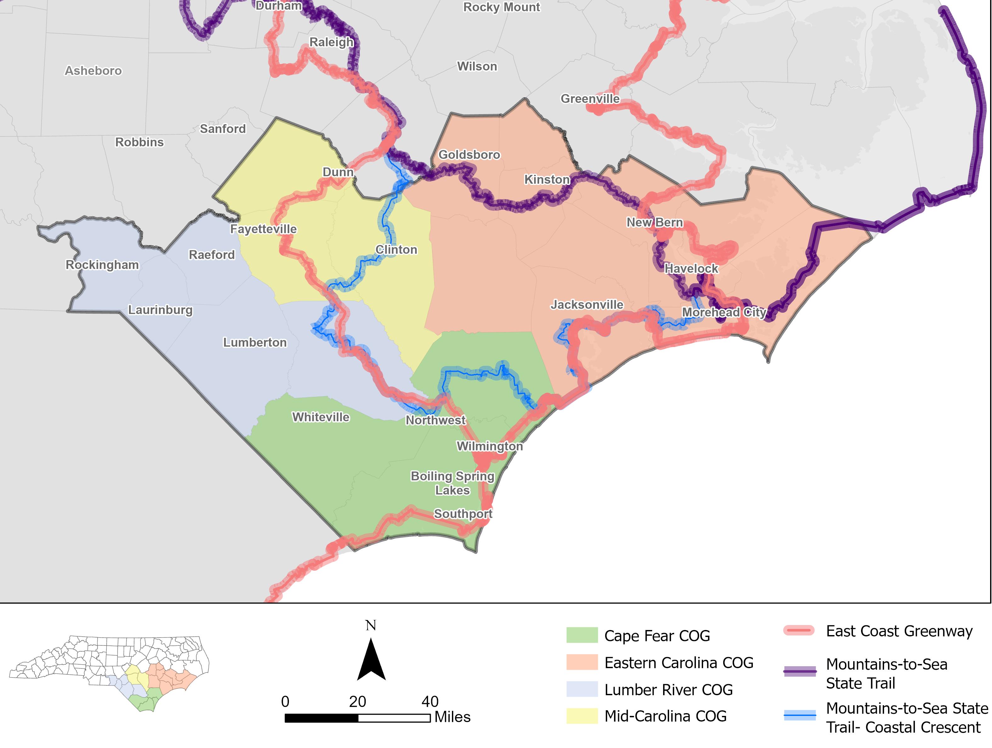
©VHB SOUTHEASTERN NORTH CAROLINACOUNCILS OF GOVERNMENT Lumber River Mid-Carolina Eastern Carolina Cape Fear

Plan
Planning Area
Key Stakeholders 4 Methodology....................................................................................
Bottom-up, Top-Down Process............................................. 6
Existing State and Regional Trails and Plans
8 Mountains-to-Sea State Trail 10
East Coast Greenway..............................................................10 Great Trails State Plan
Stakeholder Engagement
Initial Workshops
Summary of Findings 11 Follow-Up Workshops
13 Stakeholder Interviews
Public Survey
14
14 Results 14
Lumber River COG – Regional Trail Plan
17
18
Mid-Carolina COG – Regional Trail Plan
21
19 Eastern Carolina COG – Regional Trail Plan 20 Cape Fear COG – Regional Trail Plan
The Southeast North Carolina Regional Trails Plan is a vision for trail development in the state’s Coastal Plain. The North Carolina Trails Program (Trails Program), managed by the Division of Parks and Recreation (Division), facilitated the planning process in partnership with regional Councils of Government (COGs), starting in late 2019 and ending with final plan release in 2021. The Trails Program supports regional trail planning across the state, with previous efforts largely focused on the Mountains and Piedmont regions. The Coastal Plain region lacked the conceptual framework for trails connecting to major destinations in the area. This plan aims to fill that gap and is structured around the four COGs that make up southeastern North Carolina- Lumber River, Eastern Carolina, Mid-Carolina, and Cape Fear.
The majority of trail planning and implementation in North Carolina is done by local agencies. State trails in North Carolina are unique units of the state parks system. While a state park is operated and managed by the Division of Parks and Recreation, a state trail is composed of multiple, connected sections sponsored and maintained by a combination of federal, state or local government agencies, nonprofit organizations or private landowners. Trail sponsors are responsible for building, maintaining, and managing their sections of trail.
State trails must be authorized by the General Assembly, and there are currently nine state trails in North Carolina. The Mountains-to-Sea State Trail is the only state trail in the study area. State Parks led this planning study and may occasionally help acquire right of way for portions of state trails in the area, but trail sponsors will lead any future trail development and construction in the region. Trail owners and sponsors will reference this plan to identify strategies for ultimately developing and constructing trails. This plan is not meant to direct funding or supplant any previous or future local trail planning, but to complement these efforts.
Trails and greenways provide important mobility, recreational, economic, and health opportunities for the regions, communities, and people that access them. This plan provides communities throughout southeast North Carolina with a vision for how trails and greenways could connect their region in the future- both to other communities in the region and to national and state trails that run through the study area, like the Mountains-to-Sea State Trail and East Coast Greenway.
The project team worked with community, institutional, and agency stakeholders to: identify existing and proposed trails and greenways in each COG and the region; make recommendations for corridors to complete these trails based on opportunities and constraints; develop a list of trail segments; and identify preferred trail alignments for each COG and the region as a whole.
Understand the vision of each community for greenways and trails in their region
Collect and analyze data on existing trails and trails proposed in local and regional plans
Develop prioritization criteria to identify potential future trail segments
Create an implementation plan that matches trail segments with implementation partners
The study area covers four COGs: Cape Fear, Mid-Carolina, Lumber River, and Eastern Carolina, consisting of 21 counties. The area also includes several Metropolitan Planning Organizations (MPO), Rural Planning Organizations (RPO), cities, and towns.
Cape Fear Council of Governments
» Brunswick County
Columbus County
» New Hanover County
» Pender County
Lumber River Council of Governments
» Bladen County
» Hoke County
Richmond County
Robeson County
Scotland County
Mid-Carolina Council of Governments
» Cumberland County
» Harnett County
Sampson County
Eastern Carolina Council of Governments
Carteret County
Craven County
Duplin County
Greene County
Jones County
Lenoir County
Onslow County
Pamlico County
Wayne County
Due to the large size of the study area, there were many stakeholders involved in the planning process. Regional stakeholders included representatives of the four study COGs; North Carolina State Parks and the Department of Transportation; Metropolitan and Rural Planning Organizations (MPO and RPOs). Additional stakeholders included counties, cities, towns, and tribes; the Friends of the Mountains-to-Sea Trail and East Coast Greenway Alliance; conservancies and land trusts; military bases; and tourism organizations. Several stakeholders were interviewed to gain further insight into opportunities and challenges facing trails in the region. These interviews are summarized in the Route Planning and Analysis section.
The trail development infographic, below, illustrates how an idea or conceptual plan for a trail comes to fruition and becomes a built trail that residents and visitors of a community can enjoy. The process starts at the regional level and then works its way down to construction and maintenance. At the end of the process, trails are completed and have become an integral part of the community and how it stays healthy, attracts tourism and business, protects its resources, and connects with nature.
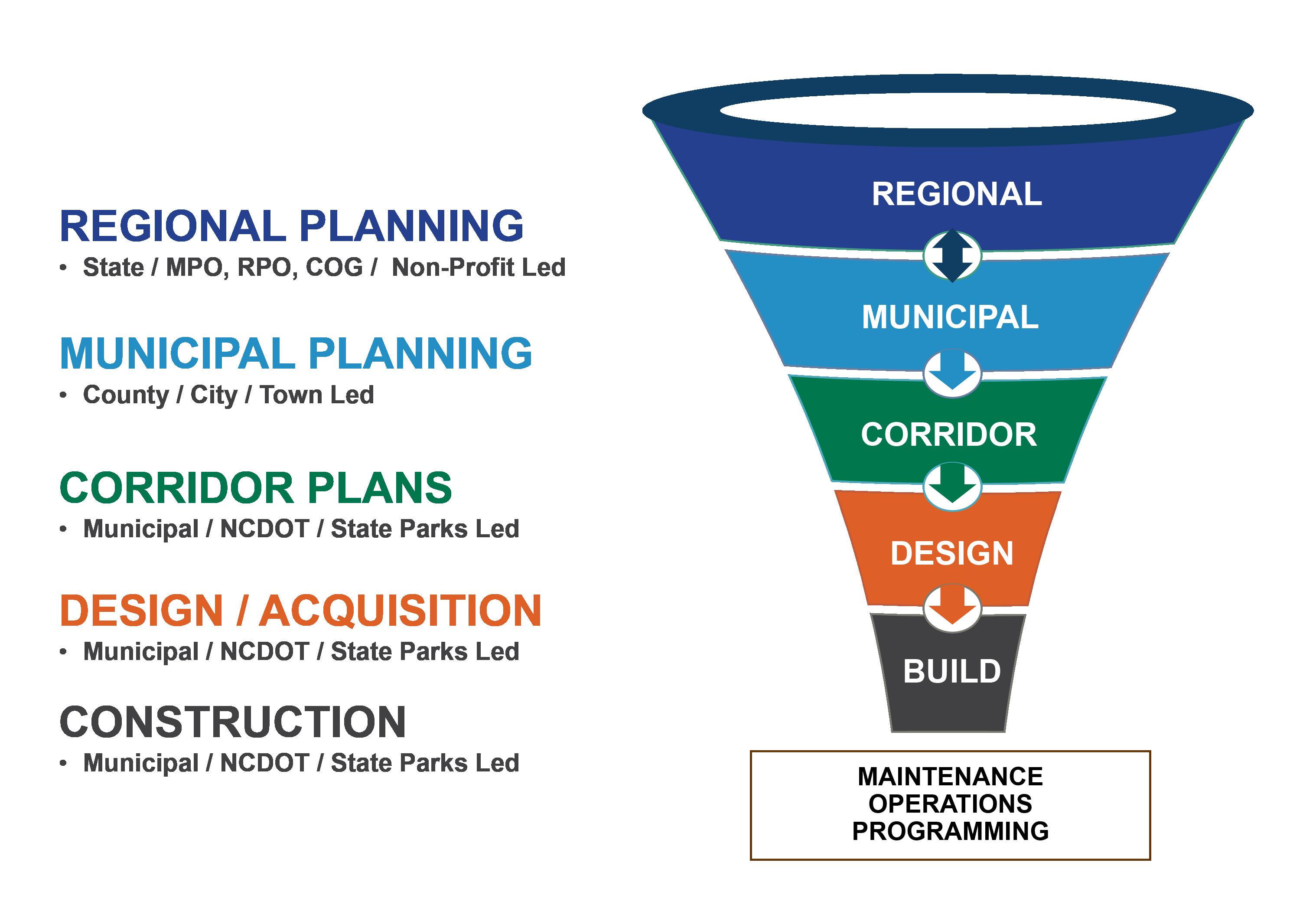
At the regional level, the goal is to create a network of trails that provide connectivity across jurisdictional boundaries at a grand scale. The Carolina Thread Trail in the Charlotte metro area is an example of a well-functioning regional trail network and organization. The network connects 15 counties across North and South Carolina with over 300 miles of trails and 170 miles of blueways (i.e., paddle trails). Much like a road system is designed for cars, longer regional trails are like interstates, providing connectivity across large areas and serving as the spine of the trail network. Good examples of extensive regional trails in the Coastal Plain of North Carolina are the Mountains-to-Sea State Trail and the East Coast Greenway, both of which are referenced in the proposed trail alignments in this plan.
The next step in the trail planning process is at the municipal level. Municipal planning efforts are typically led by public entities (e.g., county, city, or town) that aim to develop comprehensive plans and recommendations for their jurisdictional boundaries. These efforts require a great deal of cooperation and information sharing in order to effectively tie into existing plans at the local and regional level.
The arrow between regional and municipal planning in the infographic is pointing in both directions to indicate the iterative and often overlapping nature of the process. Once overall routes and priority segments are identified at the municipal level, more detailed corridor studies can be done to determine the feasibility of a specific section of trail.
Corridor studies, or feasibility studies, investigate the viability of specific routes, address challenges such as river, road, and railroad crossings, and identify willing property owners and cooperation across jurisdictional boundaries. At this stage, decisions are made about specific routes and trail type. Design recommendations are made regarding topography, river and road crossings, easements, and construction materials to enable the completion of an accurate cost estimate. With a conceptual alignment and cost estimate
developed, communities can seek funding and easements with confidence and advance the project.
Trail design matures the project further. During design, each detail of the project is decided and included in a set of instructions for a trail building contractor to use to construct the project. In this phase, the exact property needs are also established, negotiated, and closed. Finally, the project is constructed, but the new trail will still require maintenance, programming, and promotion to reach its full potential.
The team used a bottom-up, top-down process that combined data analysis with community and stakeholder input to determine alignments for the future regional trail network. Top-down planning leveraged local plan information and stakeholder input to identify community preferences and answer questions such as “Where does the community most want to see trails developed? What function will these trails serve?” Bottom-up planning combines data that describes physical conditions and barriers to trail development.
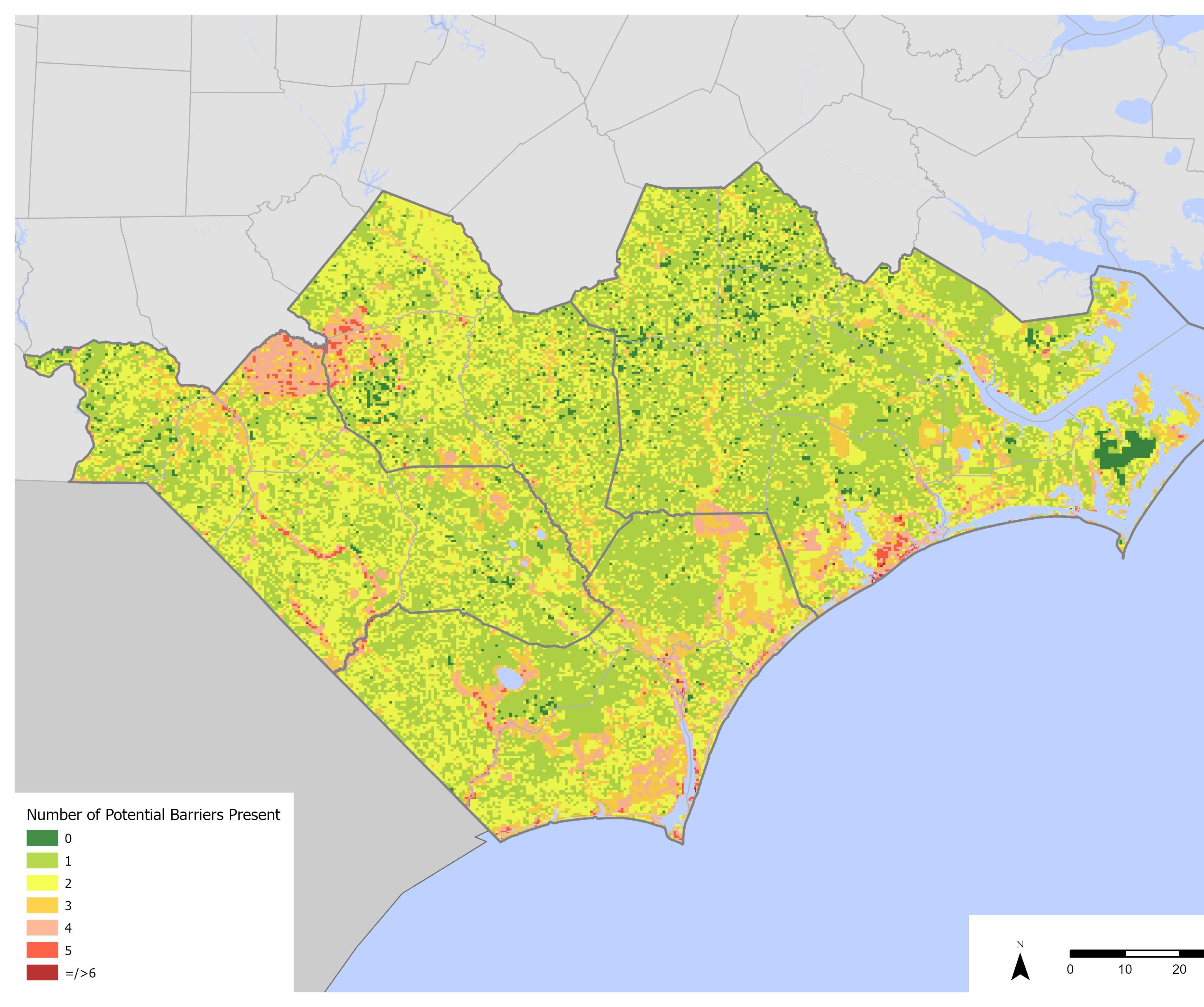
To conduct the data analysis, the project team collected a wide array of data for the region. A sample list of the data used is in the data screening layers list. The team then used geographic information software (GIS), to create a screening analysis to indicate areas where land is potentially most conducive to trail development. The screening analysis created an indexed score based on both potential physical or environmental barriers and opportunities and linkages. The screening analysis map shows the result of the process.
Property Hydrology Destinations Transportation Natural Resources
Parks & Recreation Parks Historic sites Tourist destinations Transportation Rail
High crash rate areas
‘High Traffic Volume’ STIP- State Transportation Improvement Program Parcels (100+ acres)
Wetlands & Flood Plains Impaired Streams
Conservation & Agriculture
Natural heritage element occurrences and natural areas
Swine lagoons
Other Game lands Military bases Hazardous areas Parcels (100+ acres)
To complement the data analysis, the project reviewed multiple rounds of input from an online survey and stakeholder and public comments. The input received from stakeholders and the public helped create a vision for trails in each region and built on the previous data analysis to shape the proposed trail alignments. Community engagement focused on understanding the major destinations in each region, planning how each community wanted to use and benefit from trails, and opportunities and challenges for trails in each COG.


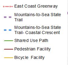
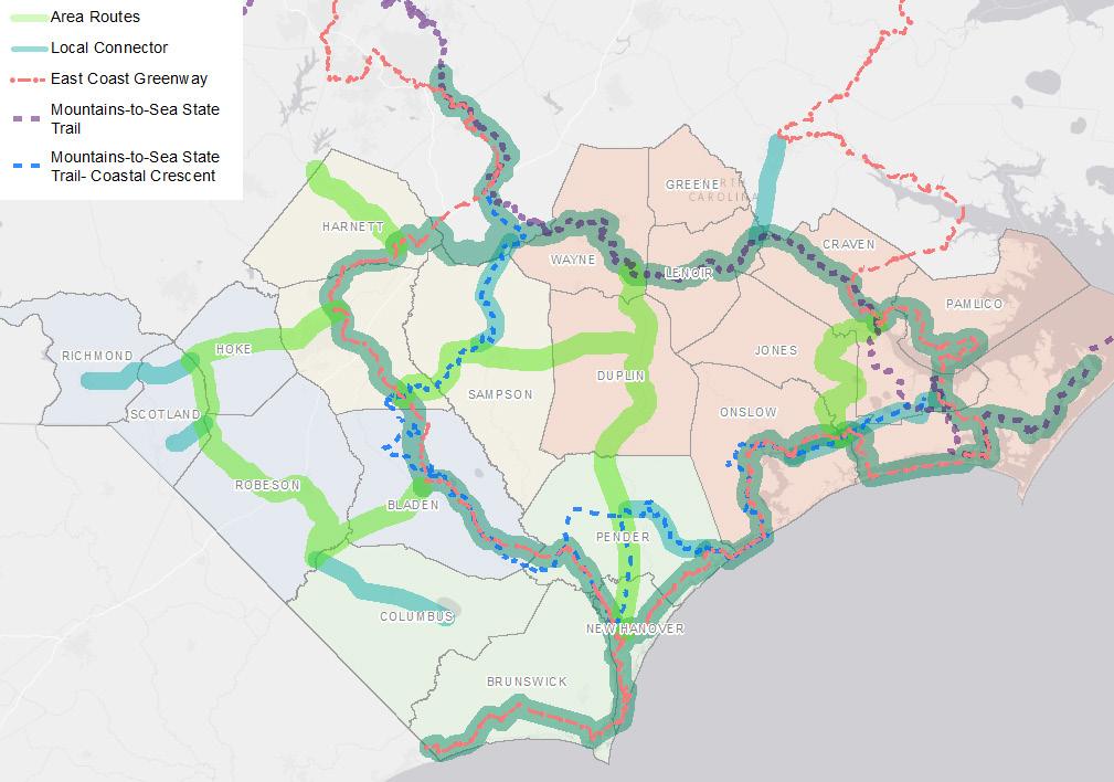
The project team also considered the location of existing state, regional, and local trails when proposing trail alignments. The team reviewed planning area community plans from the past 10 years (2009-2019) to ensure any relevant trail information was reflected in the existing and planned facilities map. The map shows the location of existing and planned pedestrian, bicycle, and shared-use path facilities. The team gave special consideration to regional trails like the Mountains-to-Sea Trail, including the Coastal Crescent portion, and East Coast Greenway, along with the ongoing Great Trails State Plan.
and Planned Facilities
Walk Wilmington 2009 Lumberton Comprehensive Recreation Plan 2016 Pembroke Pedestrian Plan 2010 Leland Pedestrian Plan 2016 Wilmington Parks and Recreation Master Plan 2010 WMPO STIP Projects 2016
Topsail Area CTP 2011 WMPO CTP 2016 Harnett County CTP 2011 Pender County CTP 2016 Gary Shell Cross City Trail Master Plan 2012 Robeson County CTP 2016 Goldsboro Parks and Recreation Master Plan 2012 Scotland County CTP 2016
Clinton Comprehensive Pedestrian Plan 2012 City of Lumberton CTP 2016
Elizabethtown Pedestrian Plan 2013 Fayetteville Area MPO CTP 2016 Wilmington Comprehensive Greenway Plan 2013 Sampson County CTP 2016
Brunswick County CTP 2013 Cape Fear Regional Bicycle Plan 2017
Croatan Regional Bicycle + Trails Plan 2014 Vander Area Land Use Plan 2017
Mountains-to-Sea Trail Master Plan 2014 Bladen County CTP 2017 Goldsboro MPO MTP 2014 Richmond County CTP 2017 Southport Pedestrian Plan 2014 Goldsboro MPO CTP 2017 Whiteville Pedestrian Plan 2014 Harnett County CTP 2017
Surf City Bike/Pedestrian Plan 2014 Hoke County CTP 2017
FAMPO Bike/Pedestrian Element 2040 2014 Fayetteville Comprehensive Pedestrian Plan 2018
Town of Pembroke CTP 2014 Carolina Beach Pedestrian Plan 2018 Cape Fear COG FOCUS Plan 2015 Columbus County CTP 2018 Wilmington Urban Area MPO MTP 2040 2015 Coastal Crescent Strategic plan 2018 Goldsboro Bike/Pedestrian/Greenway Plan 2015 Sandhills Regional Bike Plan 2019 Burgaw Bike/Pedestrian Plan 2015 Goldsboro MPO STIP projects Varies Harnett County Parks and Recreation Plan 2015 WMPO Bike/Ped Projects Varies Tabor City CTP 2015
The Mountains-to-Sea State Trail (MST), including the Coastal Crescent route, is the only state trail in the study area. The MST, spanning from Clingman’s Dome to Jockey’s Ridge, first became a state trail in 2000. In 2017, the General Assembly authorized the addition of the Coastal Crescent route, which loops through the study area, to the Mountains-to-Sea Trail. When completely constructed, the MST will be about 1,400 miles of continuous, off-road trail. Constructed trail within the planned corridor is not part of the State Trail until it is designated by the Secretary of the Department of Natural and Cultural Resources.
The Friends of the Mountains-to-Sea Trail (FMST) organization sponsors most of the task forces that build and maintain sections of the MST. FMST has also been the primary planner and developer of the Coastal Crescent route, making them a key stakeholder for this plan.
The East Coast Greenway is a walking and biking route that spans 15 states along the east coast of the United States, from Maine to Florida. The East Coast Greenway Alliance leads the development of the trail network by partnering with local, state, regional and national agencies, partner organizations, and volunteers. The East Coast Greenway Alliance’s goal is to move more of the route onto protected paths, making the alignment through the region a key consideration in the development of this plan. East Coast Greenway Alliance staff were key stakeholders in this planning process and provided the project team additional background and insight in an indepth interview.
The Great Trails State Plan is an ongoing planning effort from the North Carolina Department of Transportation (NCDOT) and State Parks to connect every county in North Carolina with a network of shared-use paths and trails. The plan draws from both existing plans and new recommendations and
focuses on connections between population centers and North Carolina State Parks. While the plan is still being developed, Great Trails State plan leaders were included in stakeholder meetings for this plan and draft recommendations for the Great Trails State plan were considered where available.
The project team originally met with stakeholders from across the region for a kick-off meeting on November 13th, 2019. The meeting was held in person in the centrally located Clinton, NC and included staff from each COG, regional and local agencies, NCDOT, and advocacy organizations. The focus of the meeting was to communicate the goals of the study and project schedule, provide an overview on trail planning, and get feedback on the location of existing and planned trails. The team also introduced the project website, which hosted a public survey, interactive map, and project documents.
Following the initial regional meeting, the project team held workshops in each COG region in early Spring 2020 to present project details and gather information about trail alignment priorities and community values. Meetings for Lumber River COG and MidCarolina COG occurred in person. Due to social distancing and other measures related to the COVID-19 pandemic, the Eastern Carolina COG and Cape Fear COG meetings occurred online on virtual meeting platforms. Although COVID-19 conditions may have impacted attendance for these COG meetings, the project team made materials available digitally to allow as many stakeholders as possible to participate.
Meetings occurred on the following days:
» Lumber River COG - February 27th, 2020
» Mid-Carolina COG - March 11th, 2020
» Eastern Carolina COG - March 16th, 2020
» Cape Fear COG - March 19th, 2020
The project team sent notice for each meeting
to a project contact list that included COG staff members, local government staff members, advocacy group staff members, and representatives of other stakeholder groups. Meetings were advertised to the project team’s email list and were sent out to each COG’s email list. Invitations were focused on staff members with the ability to implement or act on the recommendations of this plan. All presentation materials and maps were available afterward on the project website for stakeholders who could not attend the live meeting or wanted to provide additional comment.
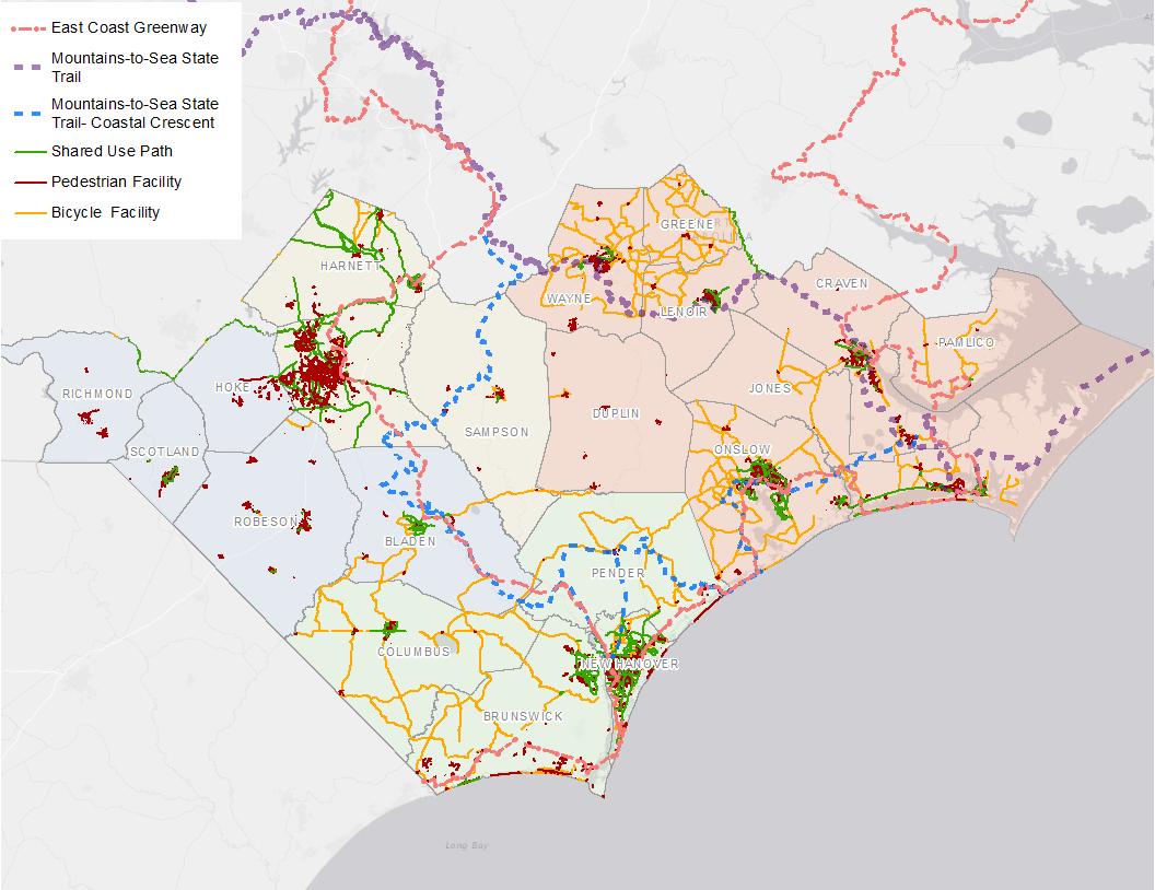
During the first round of stakeholder meetings, the project team collected responses for two questions to help direct recommendations for the proposed trail alignments. The first question asked, “How much of a priority is each of the following items to consider when aligning the trail? The list includes items that could weigh positively (such as attractive destinations) or negatively (such as areas to be avoided). Items are ranked in the Question 1 Responses chart from the greatest to least number of high
priority responses. An item receiving a high priority could indicate that the item is a high priority to access or avoid.
Results indicate that accessing open space, safety, and feasibility of implementation are all high priority considerations for this project. Parks and game lands both rank highly as a high priority consideration. The high ranking for high crash rate areas indicates that participants are eager to see trails intended for bicycle and pedestrian use avoid areas that already demonstrate high rates of pedestrian and vehicle collision. Transportation improvement program (TIP) projects offer opportunities to integrate pedestrian and bicycle improvements into planned upgrades of road and transportation infrastructure. Ensuring that the trail corridors this plan recommends align with planned TIP improvements will be a crucial strategy for implementing the trail network.
Question 1 Responses: How much of a priority is each of the following items to consider when aligning the trail?
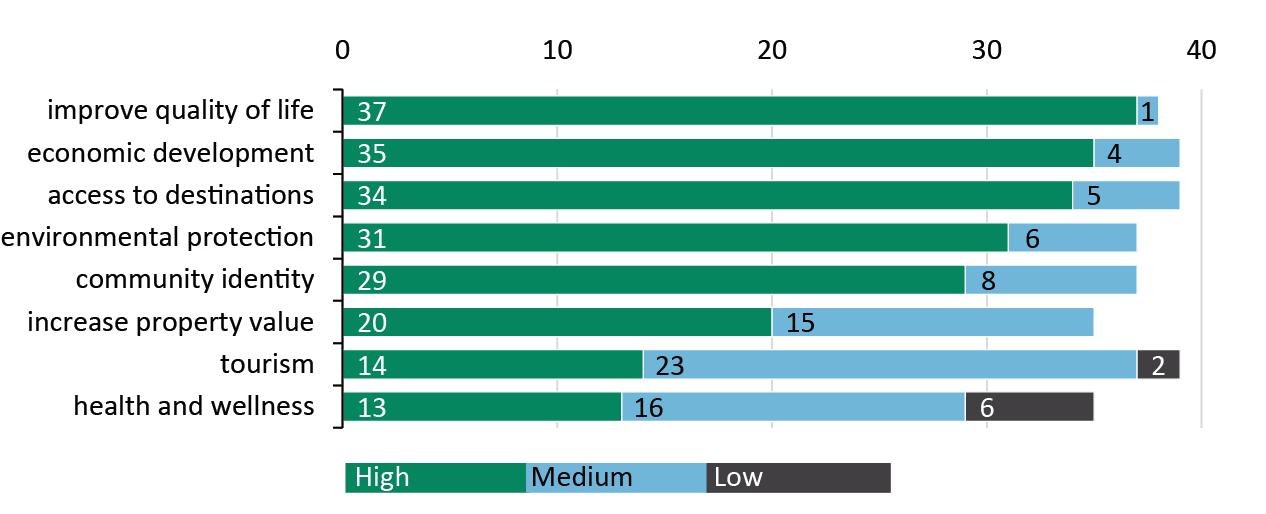
The Question 2 Responses chart summarizes participant responses to “How high of a priority are each of the following values for the team to consider when planning the trail?” While the first question asks about trails in terms of specific locations on the ground, this question tries to determine stakeholder’s broader vision for trails in their community. Items are ranked from the greatest to least number of high priority responses. The top ranked responses include improve quality of life, economic development, and access to destinations.
Responses regarding community values indicate that participants believe ensuring that trails are aligned and designed to improve quality of life is the highest priority. Economic development is the second highest priority, indicating that demonstrating how trails can promote and bolster economic growth will be an important part of this plan and future education and outreach for trails. Access to destinations is the third highest priority, indicating that trails should provide an element of local connectivity, as well as the regional-scale connectivity. Ensuring this plan connects into local planning efforts will support the connectivity of future trails to local trail systems.
Question 2 Responses: How high of a priority are each of the following values for the team to consider when planning the trail?
 Summary
A second virtual stakeholder workshop was held on September 1st, 2020. During the workshop, stakeholders received a presentation on the planning process and proposed alignments. Stakeholders then had the opportunity to provide comments on the trail alignments during a breakout session facilitated by the project team. The presentation materials and maps were available afterward on the project website and Concept board, a collaboration platform, for stakeholders who could not attend the live meeting or wanted to provide additional comment.
Two additional virtual workshops for stakeholders and the public were held on Wednesday, October 14, 2020. The meetings focused on presenting the updated proposed trail network, priority segments, and implementation strategies and giving participants a chance to comment on maps and take a short survey. The survey asked participants whether the proposed routes served their community well, asked about which segments should be prioritized, and what the most critical next steps for their community would be. After the live meeting on the 14th,
the project website hosted the presentation recording, maps, and meeting survey on the “Virtual Workshop” section of the project website for stakeholders who could not attend the live meeting or wanted to provide additional comment.
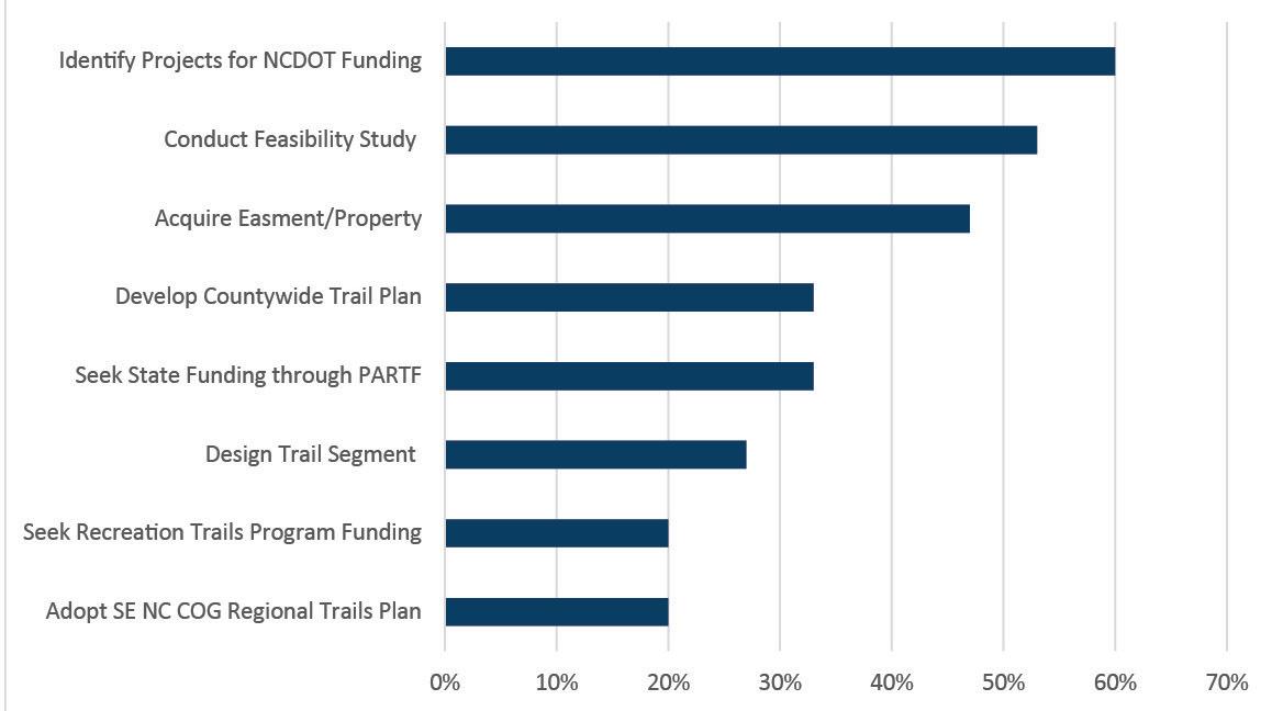
Participation in the survey included participants from all four COGs. The top three segments identified as the most impactful for the region were Goldsboro to Kinston, Kinston to New Bern, and Wilmington to the Cliffs of the Neuse State Park, all of which fall mainly within the Eastern Carolina COG. The next steps identified as most critical for successful implementation of the plan were, in order, identifying projects for NCDOT funding, conducting feasibility studies, and acquiring easements or properties.
Below is a summary of the main findings from interviews conducted with major stakeholders in the region. The project team interviewed the following agencies and organizations: Camp Lejeune, East Coast Greenway Alliance, Fort Bragg, Friends of the Mountains-to-Sea Trail, NCDOT Rail Division, Three Rivers Land Trust, and the Nature Conservancy. Interviews took place via video or phone call during April and May of 2020.
Most organizations identified existing trails, and existing partnerships, communication, and support as the biggest opportunities for successful implementation of the plan. Leveraging resources and previous work done by these stakeholders is also an opportunity, such as the identification of potential trail areas and technical assistance.
Public interest around the trails was focused on destinations and other land uses. Stakeholders mentioned that connecting cultural destinations (museums and nature preserves) is important. Trail connections to hunting and game lands are challenging, but also of interest to the surrounding communities.
The biggest challenges mentioned by the stakeholders include trail construction limitations and access restrictions due to wet areas, hunting, and game lands, and firing ranges and training areas near the military bases. Improving the understanding of trails and trail benefits by the public and local agencies, bureaucratic issues, and rail corridor ownership were other challenges mentioned.
As mentioned by the East Coast Greenway Alliance and Friends of the Mountains-to-Sea Trail, partnership and local communication is a key to trail implementation success. The East
Coast Greenway Alliance mentioned connecting with RPOs and rural leaders (both government and the community) as an opportunity for advancing trails in the region, based on their work on the NC 211 feasibility study.
An online public survey captured community feedback on the plan between November 2019 to June 2020. The survey aimed to gather information about the community’s preferred trail alignment benefits, important destinations, and community values.
The project team collected 150 responses for seven trail-related and three demographic questions. Specific results for each question are summarized in the appendix.
The Trail Benefits Ranking, below, summarizes survey responses to the question, “Which benefits of a regional network trail and greenway are most important to you?” Participants were asked to select five prewritten options from a list of eight and rank them from 1 to 5. A brief description of each benefit was included. The top ranked benefits are health and wellness, improve quality of life, environmental protection, and access to destinations. Participants had the opportunity to suggest additional benefits and submissions of note included safety and equestrian amenities.
and Wellness
Quality of Life
survey questions addressed destinations within the planning area that participants would like to access via a trail network. The first destination question allowed users to add pin drops to an online map. Respondents were asked to mark the start and end of routes they would like to take using a trail and the purpose of that trip. As shown in the Trail Trip Purposes table, the most common route purpose is recreation or fitness followed by all of the above.
how individuals want to use trails is another helpful dimension in trail planning. This question also complements data collected about
destinations. The Preferred Trail Activities
summarizes survey responses to the question, “If trails and greenways were available to you now, which of the following activities would you use them for?” Participants could select as many options as desired. The highest-ranked activities include walking, hiking, and biking.
The Trail Challenges chart summarizes perceived challenges identified by survey participants. Respondents were asked, “In your opinion, what are the biggest challenges for implementing a regional trail network in the southeastern region of North Carolina?” Participants could select all options that applied. The top cited challenges include lack of funding, lack of political will, land acquisition, and lack of understanding trail benefits. There is less concern regarding public support and length of project completion.
19%
Lack of political will Land acquisition challenges
Lack of understanding trail benefits
Lack of funding
Lack of public support
How long trail projects take to complete
Other
The Proposed Trail Alignments map shows the recommended trail alignments for the region overall. The proposed trails for each of the four COGs are further described according to the mileage of proposed trails, destinations that may be reached, and segments located in each region. Maps also show other trail systems of statewide or regional significance – such as the Mountains-to-Sea State Trail, including the Coastal Crescent portion, and the East Coast Greenway – to demonstrate how the trail alignments proposed in this plan align with a larger vision for connecting people, places, and natural resources.
The highest order routes in the proposed trail network are regional routes, which form the spine of the proposed trail network and the main trail loop. Regional routes connect major regional destinations, including cities like Wilmington, Jacksonville, and Fayetteville, many large towns and coastal communities, and natural resources like the Croatan National Forest and several state parks. These regional routes will attract visitors from across the state and U.S.
The proposed trail network also includes routes scaled to the “area” and help create smaller loops connecting to destinations across COG boundaries. These area routes are critical to forming a regional trail system and connecting visitors to local historic or natural destinations. The proposed network also includes local connectors to destinations beyond the loop system which are of most importance to daily trail users.
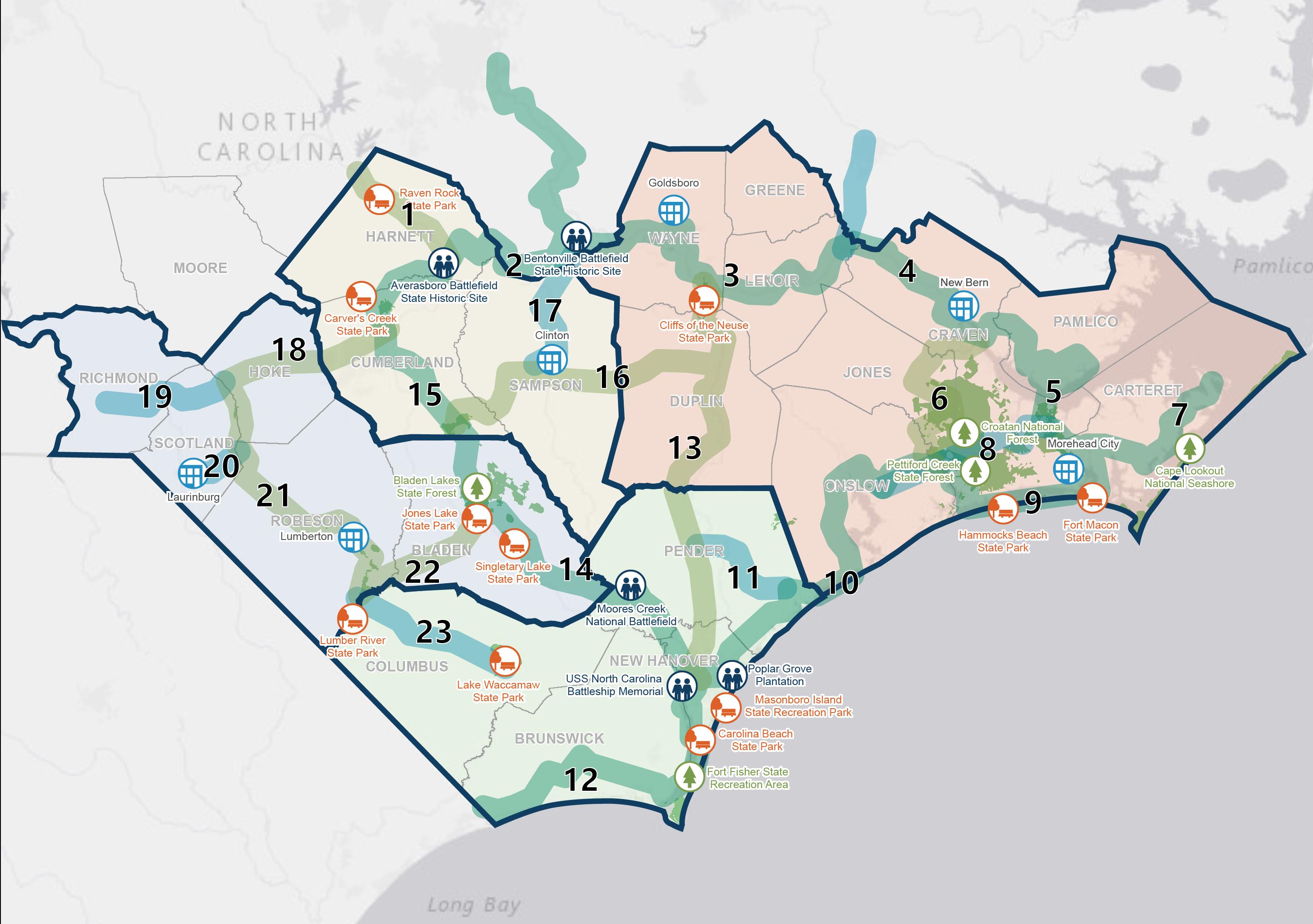
The Lumber River Council of Governments (LRCOG) is a regional planning and service agency representing 36 local governments. The Lumber River region encompasses Scotland, Robeson, Bladen, Hoke, and Richmond counties and Main Street Communities Laurinburg and Lumberton, among other cities and towns. The region also boasts a variety of destinations, including Lumber River State Park, Bladen Lakes State Forest, Singletary Lake State Park, and Jones Lake State Park. The COG’s area routes connect into a loop system that will link Fayetteville and natural areas along the Cape Fear and Lumber Rivers.
Total number of miles of proposed trails: 210
Total number of proposed loop miles: 402 Population per proposed mile of trail: 1,433
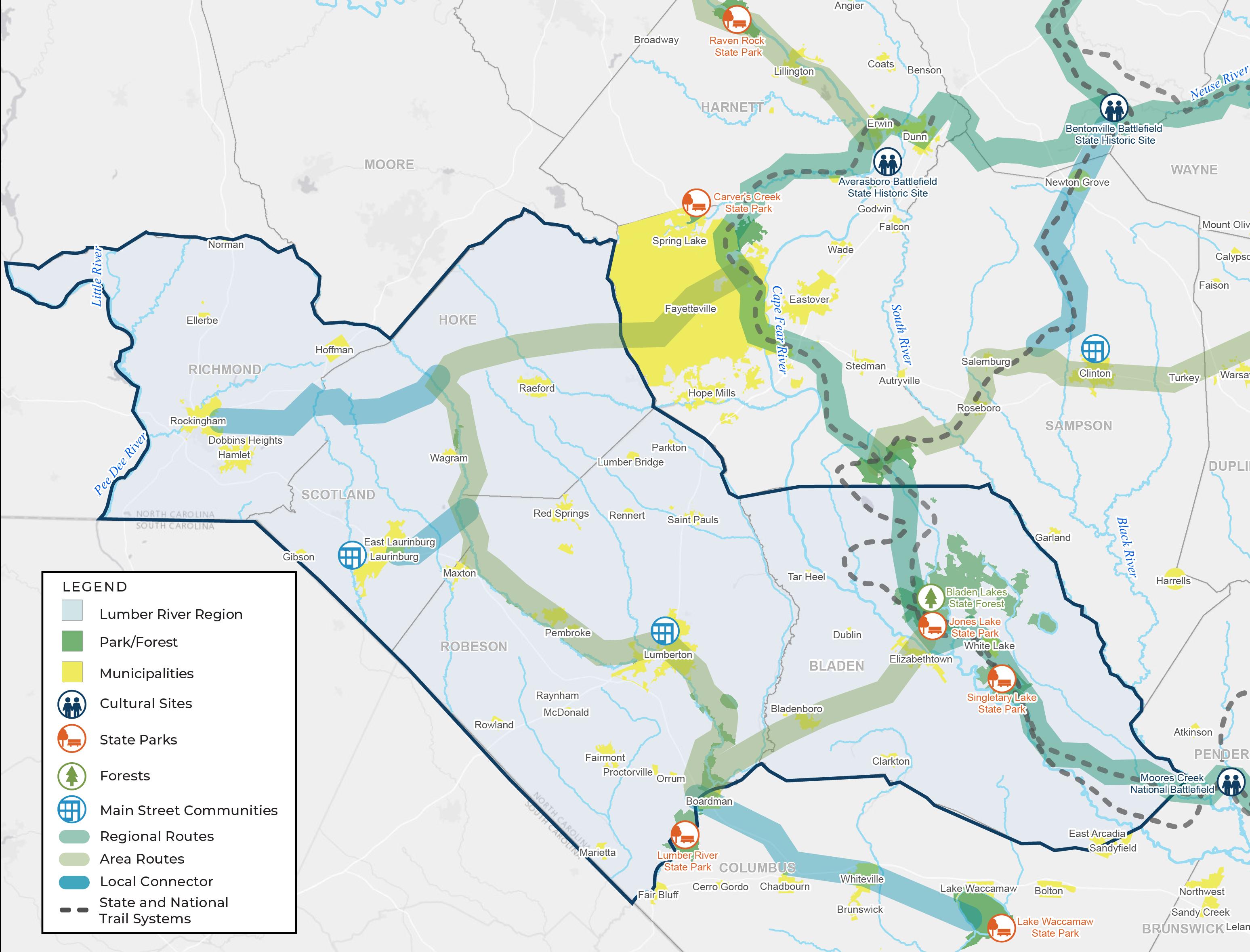
» Lumber River State Park
» Singletary Lake State Park
» Jones Lake State Park
» Bladen Lakes State Forest
» Main Street Communities: Lumberton and Laurinburg
Mid-Carolina Trail Map
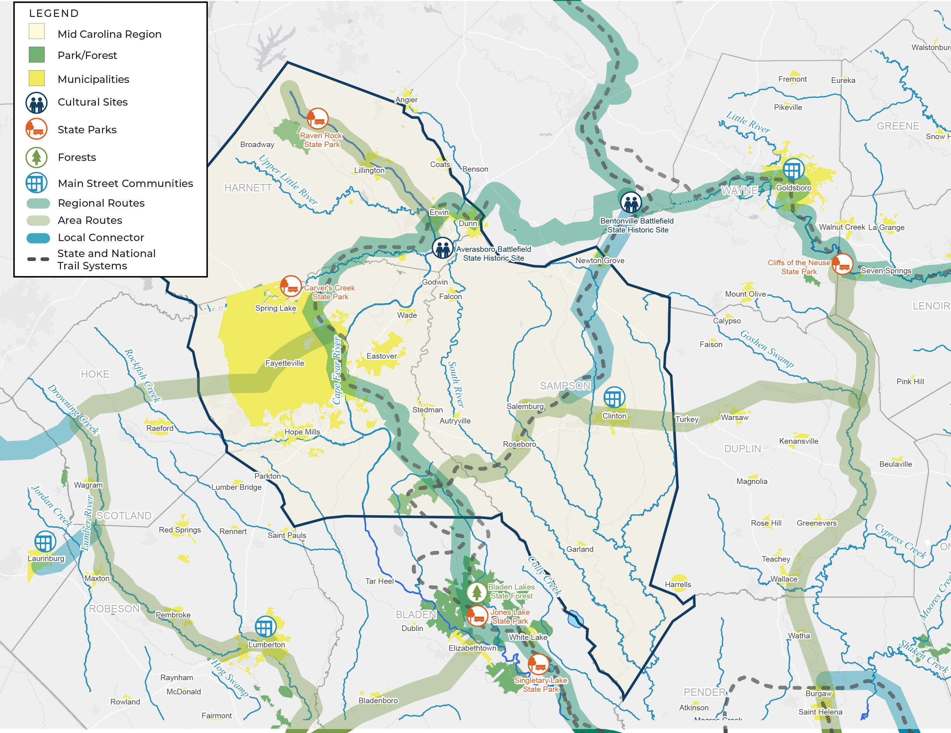
The Mid-Carolina Council of Governments (MCCOG) is a multi-county planning, development, and human services organization representing 23 local governments. The MidCarolina region encompasses Cumberland, Harnett, and Sampson counties; Fayetteville; and several small cities and towns. The region also boasts a variety of historic sites and state parks, including Averasboro Battlefield, Raven Rock State Park and Carvers Creek State Park. The COG’s area routes connect into a loop system that will link Fayetteville, Bentonville Battlefield, and Cliffs of the Neuse State Park.
See Mid-Carolina COG Map for more information
Total number of miles of proposed trails: 221
Total number of proposed loop miles: 610 Population per proposed mile of trail: 2,404
» Raven Rock State Park
» Carver’s Creek State Park
» Averasboro Battlefield State Historic Site
» Bentonville National Battlefield
» Fayetteville
» Main Street Communities: Clinton
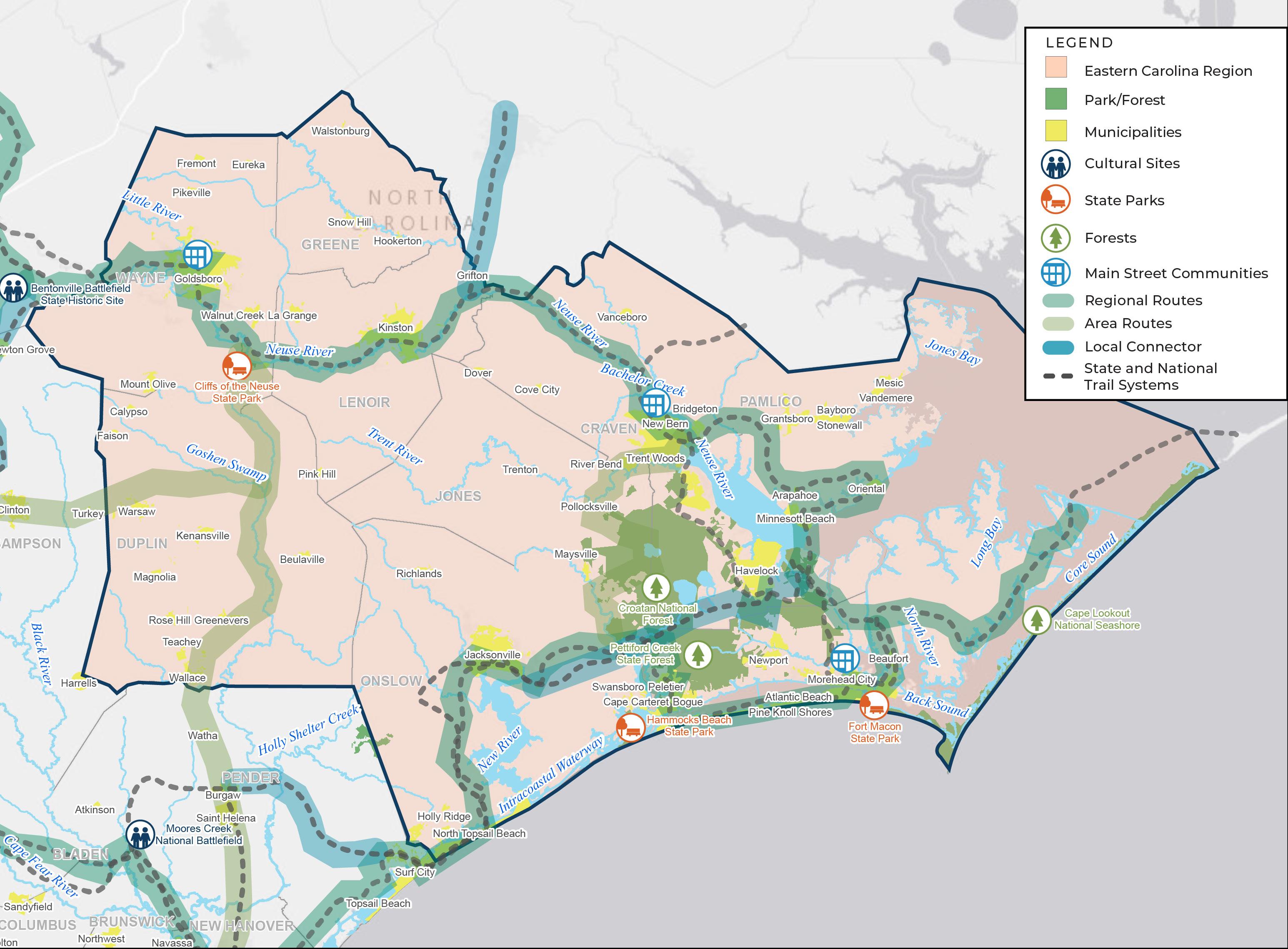
The Eastern Carolina Council of Governments (ECCOG) is a multi-county planning and development organization representing 56 local governments. The Eastern Carolina COG is the largest in the study area, covering 9 counties: Carteret, Craven, Duplin, Greene, Jones, Lenoir, Onslow, Pamlico, and Wayne. There are three Main Street communities (Morehead City, New Bern, and Goldsboro) among other cities and towns. The Eastern Carolina Regional Trails Plan includes routes that will connect to destinations such as the Croatan National Forest, Hammocks Beach State Park, Fort Macon State Park, and Cliffs of the Neuse State Park. The COG’s regional area routes connect into a loop system that will link Wilmington and natural areas along the Cape Fear and Lumber Rivers.
Total number of miles of proposed trails: 529
Total number of proposed loop miles: 799 Population per proposed mile of trail: 1,263
» Hammocks Beach State Park
» Fort Macon State Park
» Croatan National Forest
» Pettiford Creek State Forest
» Cliffs of the Neuse State Park
» Main Street Communities: Morehead City, New Bern, and Goldsboro
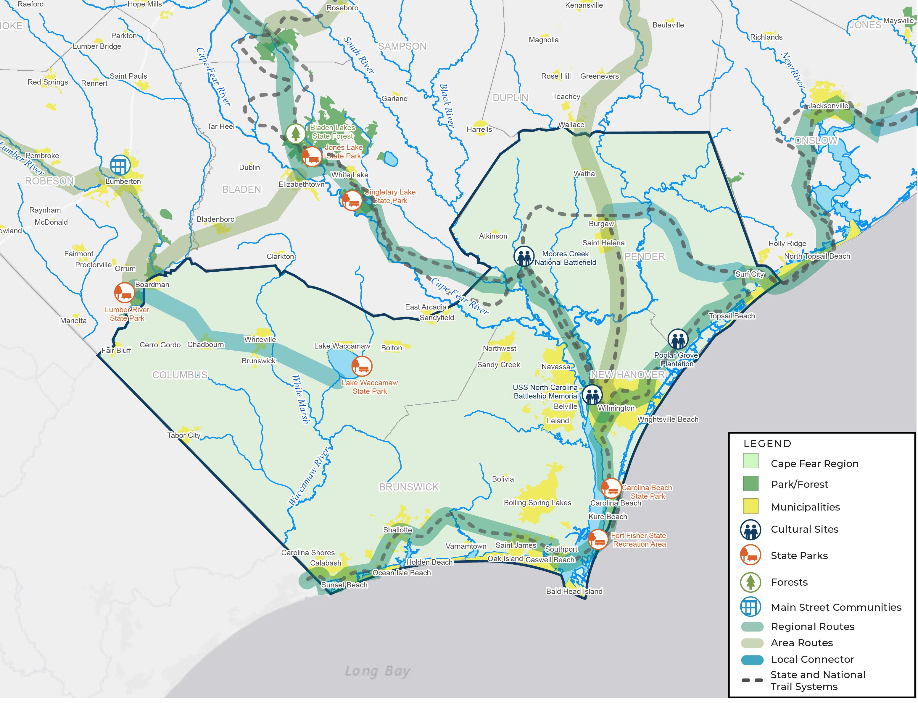
The Cape Fear Council of Governments (CFCOG) is a multi-county planning and economic development organization representing 44 municipal and county governments. The Cape Fear region encompasses Columbus, Brunswick, and Pender counties; Wilmington; and several small cities and towns. The Cape Fear Regional Trails Plan includes routes that will connect to destinations such as Lake Waccamaw State Park, and Carolina Beach State Park. The COG’s regional area routes connect into a loop system that will link the Fayetteville and Wilmington areas.
Total number of miles of proposed trails: 232
Total number of proposed loop miles: 514
Population per proposed mile of trail: 2,136
» Lake Waccamaw State Park
» Wilmington
» Fort Fisher State Recreation Area
» Carolina Beach State Park
» Poplar Grove Plantation
» USS North Carolina Battleship Memorial
» Moore’s Creek National Battlefield
This plan calls for an expansive and far reaching network of trails to connect people to natural, cultural and community destinations. Communities will build the network over time – leveraging opportunities such as new transportation projects, further developed trail plans, and volunteer support. In many communities there has been little prior trail planning, so the first steps toward putting trail on the ground will be the creation of a local trails plan and identification of potential implementation partners.
Every community and project is different, but the general process is the same. It is vital that communities have a trail network planned out and trail advocates at the ready before taking the next steps with identifying trail projects or completing a feasibility study. During and after completing a plan, the local agency should work on gaining community support, by officially adopting the plan, developing a brand for local trails, coordinating with trail advocacy organizations, etc. Strategies for implementation, trail types, partners, and funding opportunities are described in more detail below.
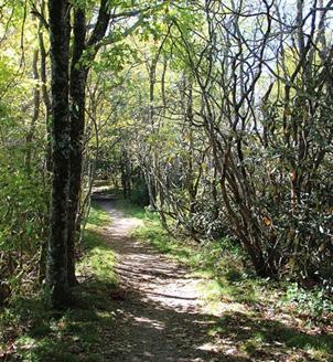
There are several trail types to choose from when developing a regional trail network. It is important to determine the intended purpose (e.g., recreation, commuting, etc.) of the trail and the most likely type of trail activity (e.g., hiking, running, horseback riding, biking, etc.). There are also several environmental (e.g., wetlands, topography, soil type, flora, fauna, etc.) and developmental (e.g., roads, bridges, utilities, neighborhoods, etc.) factors that influence which trail type is most appropriate. The other critical factors when determining trail type are funding (for construction and maintenance costs) and property ownership. The following is a description of the most common trail types with a brief description of pros and cons for application in different contexts. For a trail network, a combination of all trail types could be appropriate.
Specs: 2 ½ - 3’ wide, typically constructed of dirt.
Construction Cost: $15,000 - $40,000 (per mile)
Location: Away from roads, in a natural environment and/ or close to body of water.
Pros: Less expensive (to build and maintain); attractive natural setting; least impact on the environment.
Cons: Degrades quickly with high impact activities (e.g. horseback riding and mountain bikes); can get muddy; does not support high volumes of users well.
Note: Gravel can be used as a lower cost way to improve trails that are in low-lying areas. The trail can then be maintained with gravel or paved when funding allows.
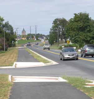
Specs: 10 – 12’ wide, typically constructed of asphalt.
Construction Cost: $400,000-$500,000 (per mile).
Location: Adjacent to roadways.
Pros: Direct
connections to transit and destinations; opportunities for NCDOT Smart Streets Policy; ADA compliant.
Cons: More street crossings and intersections; more property owner negotiations; less scenic.
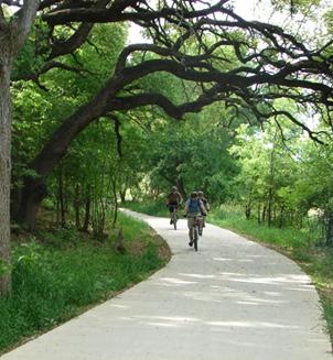
Specs: 12 – 16’ wide, typically constructed of concrete or asphalt (boardwalks in wet areas).
Construction Cost: $1-2M (per mile).
Location: Away from roadways, along abandoned rail corridors, in natural settings, and/or within utility and/or stream easements.
Pros: Supports higher volumes of users and multiple activities; usually in attractive natural settings; more separation from vehicular traffic; and ADA compliant.
Cons: More expensive to build; greater need for trail etiquette information and trail features (e.g. water, benches, etc.) due to high usage; more enforcement issues with scooters, mopeds, etc.
Specs: Width of the paddle trail is dependent upon waterbody of where it is located.
Construction Cost: Access areas are the primary cost, which varies.
Location: On waterbody (e.g. river, creek, estuary, etc.)
Pros: Gives another user group an opportunity to get into nature; can garner interest in stewardship activities.
Cons: Need accesses within good paddle distances, emergency management can be difficult, ADA compliance can be difficult or expensive to implement.
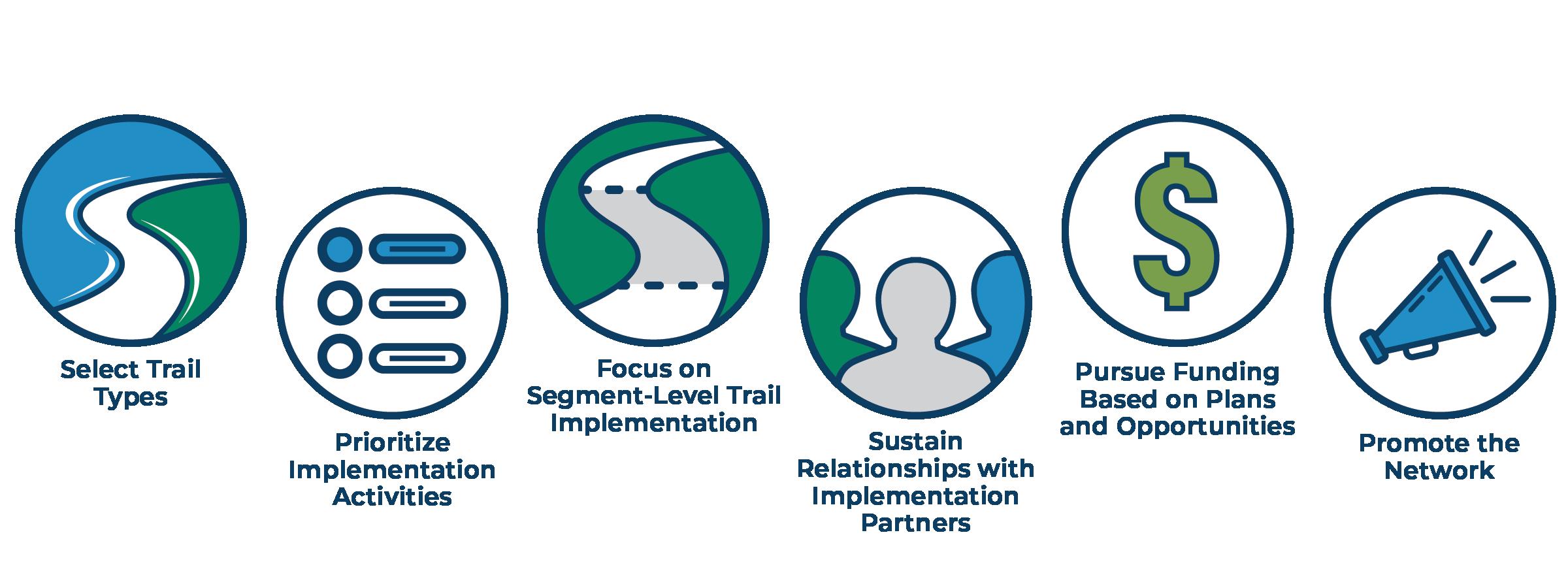
As communities begin taking steps to implement the proposed trail alignments, they will need to tackle each of the many dimensions of the implementation process in turn. The foundation of successful trail implementation is cultivating relationships and coordinating with local champions. Next, adoption and refinement of this and other local plans will allow the local agency to better define priorities and projects. With a team of trail champions and clearly identified trail projects in place, local trail sponsors are prepared to apply for funding, secure right-of-way, and construct trails.
The implementation of trail alignments proposed in this plan will be a long-term, multi-year process. Each trail segment will require a different sequence of actions, based on previous trail planning efforts in the area and the noted constraints and opportunities. Creating or supporting organizations, staff positions, or coordinating councils devoted to trail implementation will be a key to success. Recommended lead agencies will also likely vary across communities depending on the unique challenges and diversity of influential organizations and individuals. The following are the typical activities required to implement regional trail networks.
Form Local/Regional Trail Advocacy Group:
» Create a local or regional trail advocacy group to advance trail planning, acquisition, design, construction and programming
» Recommended lead agency: local planning entity (COG); partner with local foundations.
Develop Trail Branding per COG Region:
» Create visual branding and marketing materials as the network is established.
» Recommended lead agency: County Visitor Bureaus; partner with Department of Natural and Cultural Resources, Visit NC.
Adopt SE NC COG Regional Trails Plan:
» County/municipal elected bodies formally adopt Regional Trails Plan.
» Recommended lead agency: local Town council or County Board of Commissioners.
Develop County-wide/Municipal Trail Plan:
» Complete a county-wide or municipal trail plan to connect and complement the Regional Trail Plan.
» Recommended lead agency: local planning entity (e.g., County, Town).
Update MPO, County or City Comprehensive Transportation Plan (CPT) to Include Recommended Network from this Plan:
» Coordinate with regional planning organizations to ensure compliance with NCDOT Complete Streets policy.
» Recommended lead agency: local planning entity (e.g., MPO/RPO, County, Town).
» Further classify regional segments into scalable project segments based on cost, feasibility, etc.
» Recommended lead agency: local planning entity (e.g., County, Town).
» To identify parcel by parcel the route of a planned trail.
» Recommended lead agency: MPO/RPO; partner with NCDOT.
The Carolina Thread Trail is an example of a successful regional trail coalition with 88 local government members. Since the Thread Trail was launched in 2007: 15 counties have adopted Thread Trail master plans 300+ miles of trail have been built and 1,300 miles planned $4.9 million in private grants have been awarded to communities
Identify Projects for NCDOT
– Bicycle Pedestrian Project Funding:
» Identify FHWA-eligible projects (independent of NCDOT highway projects. These projects must have a transportation component and not a purely recreational purpose to be eligible e.g., locally maintained greenway trails or side paths.)
» Recommended lead agency: MPO/RPO.
Seek Recreation Trails Program Funding:
» Identify publicly accessible trail segments eligible for volunteer-led trail installation.
» Recommended lead agency: local planning entity.
Seek State Funding through PARTF/CWMTF:
» Identify trail segments aligned with public park expansions or improvements.
» Recommended lead agency: local planning entity.
Seek private funding:
» Several private organizations provide funding for greenways and trails (e.g. Rails-to-Trails Conservancy, The Conservation Alliance, etc.)
» Recommended lead agency: local planning entity.
Acquire Easement/Property:
» Legally acquire property in fee simple or through easement needed for a trail segment.
» The local planning entity is strongly encouraged to work with willing landowners to the fullest extent possible when acquiring land for trails.
» Recommended lead agency: local planning entity.
Identify Potential for Trail Improvements on FEMA Properties:
» Assess FEMA buy-out and other flood mitigation properties for trail constructions.
» Recommended lead agency: local planning entity.
Coordinate Improvement with Resurfacing and/or STIP Project:
» Identify segments adjoining or within proximity of NCDOT highway projects for potential Complete Street Policy improvements. This may include sections of sidewalk or bike lanes that will serve as trail connectors in urban or developed areas.
» Recommended lead agency: local planning entity; partner with NCDOT.
» Develop conceptual alternatives for natural surface trails, adjacent to roadways, separated by railings.
» Recommended lead agency: NCDOT/ State Parks.
» When selecting a trail type, there are several factors to consider: intended trail user, desired experience, expected volume of users, natural environment (topography, floodplain, vegetation, etc.), land use regulations (i.e., federal land), long term maintenance, etc.
» Natural surface trails are often preferred for hiking, trail running, mountain biking, and equestrian use. They are well suited for wooded areas with varying topography (e.g., Carvers Creek State Park) and can become maintenance challenges in low-lying areas and floodplains.
» Natural surface trails are typically only 3 ft wide, which can pose a challenge in supporting multiple user types (hiking, mountain biking, and equestrian) and/or large volumes of users.
» Recommended lead agency: local planning entity.
» Consider wayfinding, amenities, and trip planning information.
» Recommended lead agency: State Parks; partner with waterway resource agencies.
» Identify segments that are eligible (i.e., public ROW) for paved greenway trail or side path construction.
» Recommended lead agency: local planning entity.
» Coordinate GIS inventory with NCDOT to identify locations for safety improvements.
» Safety improvements will vary based on roadway characteristics (e.g., traffic volume, vehicle speeds, number of lanes, etc.) and whether the crossing is at an intersection or mid-block. Potential safety improvements include signs, marked crosswalks, pedestrian refuge islands, pedestrian beacons, etc.
» Recommended lead agency: local planning entity; partner with NCDOT, State Parks.
» Identify established natural surface trail segments to be upgraded to paved surface.
» Natural surface trails are often the least costly trail type as they require fewer construction materials and can be built utilizing a skilled volunteer crew. When built incorrectly or in low-lying and/or flood prone areas, natural surface trails can become challenging and costly to maintain. In these situations, it could be appropriate to convert natural surface trails into either boardwalks or paved trails.
» Recommended lead agency: local planning entity.
» Gravel can also be used as a lower cost way to improve trails that are in low-lying areas. On trails that are heavily used, the maintenance costs and difficultly accommodating users with disabilities often make it preferable to pave the trail. In these cases the trail can be graded and hardened with gravel as an interim step and paved when funding allows.
The proposed trail alignments have been broken into segments, as shown in the Proposed Trail Alignment Segments map, to allow local agencies to better plan for implementation of corridors in their jurisdiction. The project team identified actions needed for the implementation of each segment from each of the implementation categories: planning, coordination/advocacy, funding, right of way, and trail development. The team based the need for each implementation action on the current extent of trail planning and organizing in the communities and region adjacent to that segment of trail.
The top row of the matrix lists each of the implementation actions and the first column lists each segment by name. If an implementation action is recommended for a particular segment, its corresponding cell is marked with an “x”. Many of the trail segments have similar recommended implementation actions because the trail planning process is generally the same and many parts of the region have few prior trail planning efforts.
The team also identified stakeholders for each segment of trail based on the communities and agency jurisdictions the segment runs through, previous or ongoing trail planning, and the trail advocacy organization activity in the area. Stakeholders are listed in the right-most column in the matrix.
Bern
Fayetteville MPO, Goldsboro MPO, Cumberland County, Harnett County, Johnston County, Wayne County, Fayetteville, Dunn, Goldsboro, Nature Conservancy, ECG Alliance, Tourism Authorities, NCDOT
Wayne County, Lenoir County, Goldsboro MPO, East Carolina COG, Golds boro, Kinston, Friends of the MST, NC State Parks
Lenoir County, Craven County, Kinston, New Bern, Friends of the MST, NC State Parks, USACE/NCWRC
Craven County, Pamlico County, Carteret County, New Bern, Morehead City, Oriental, Minnesott Beach, Beaufort, ECG Alliance, Nature Conservancy, Croatan National Forest, NCDOT, State Parks, FMST
Craven County, Jones County, Onslow County, New Bern, Jacksonville, Croatan National Forest, Nature Conservancy, USACE/NCWRC
Carteret County, Beaufort, Friends of the MST, NC State Parks, ECG Alliance, Cape Lookout National Seashore, NCDOT
Craven County, Carteret County, Onslow County, Havelock, Croatan National Forest, US Army Railroad
Carteret County, Onslow County, Morehead City, Atlantic Beach, Emerald Isle, Jacksonville, NCDOT, NC State Parks, ECG Alliance, Croatan National Forest, US Marine Corps
Onslow County, Pender County, New Hanover County, Jacksonville, Wilmington, UNC Wilmington, Surf City, ECG Alliance, US Marine Corps, Nature Conservancy, NCDOT
Holly
Wilmington
Southport
Wilmington
Cliffs
Wilmington
Bushy
Bushy Lake
Clinton
Roseboro
Fayetteville
Pender County, Pender, Friends of the MST, NC State Parks, Nature Conservancy
New Hanover County, Brunswick County, Wilmington, Southport, ECG Alliance, NC State Parks
New Hanover County, Pender County, Duplin County, Wayne County, Pender, Burgaw, NCDOT, NC Railroad, USACE/ NCWRC, State Parks, FMST
New Hanover County, Pender County, Bladen County, Cumberland County, ECG Alliance, National Park Service, NC State Parks
Cumberland County, Fayetteville, NC State Parks, ECG Alliance, Nature Conservancy
Cumberland County, Sampson County, Duplin County, Roseboro, Clinton, Friends of the MST, NC State Parks
Sampson County , Johnston County, Roseboro, Friends of the MST, NC State Parks
Cumberland County, Hoke County, Fayetteville, US Army, Nature Conservancy
Scotland County, Richmond County, Rockingham, Nature Conservancy, NC Railroad, NCDOT
Scotland County, Laurinburg, Laurinburg Maxton Airport, NCDOT
Scotland County, Robeson County, Columbus County, Wagram, Pembroke, Lumberton, Lumbee Tribe, NC State Parks, USACE/NCWRC
Columbus County, Robeson County, Bladen County, Lumberton, Lumbee Tribe, State Parks, FMST
Columbus County, NC State Parks, Waccamaw Siouan Tribe
To successfully implement a trail network, especially one at a regional scale as large as this, it is critical that communities develop partnerships and work together. National, state, regional, and local agencies will coordinate with transportation organizations, land trusts, and trail advocacy groups.
The recommended priority segments will have to be built in phases and will require the coordination of several agencies. To ensure that the various segments are being successfully implemented while also aligning with the goals of the overall network, it is recommended that a regional trail advocacy group is created.
The Carolina Thread Trail serves as a great example of a regional coalition that has been extremely successful in branding, assisting with fundraising, and promoting trail development and the Charlotte metro region as a destination for trail-based tourism.
This regional plan will ultimately be stitched together by the various partners that will prioritize and work diligently on the specific segments they are responsible for. For example, county parks and recreation departments will primarily focus on trails in their county; COGs, RPO’s and MPO’s will primarily focus on segments that provide broader regional connectivity; and Friends of the MST and ECG will prioritize segments that follow the networks they have planned. Through the strategic leadership of a regional trails advocacy group, these efforts will be effective in developing more localized segments while also contributing to the regional network at large.
The North Carolina Parks and Recreation Trust Fund (PARTF) awards matching grants to local governments for greenways and trails, parks
and playgrounds, public beach access, and improvements in state parks. North Carolina counties and incorporated municipalities are eligible for PARTF grants and the funds are allocated by the Parks and Recreation Authority, a citizen board of nine appointed members.
The largest portion of PARTF funds, 65%, is allocated for North Carolina state parks capital projects, repairs, and renovations of facilities, and land acquisition. Five percent of funds are for the Coastal and Estuarine Water Beach Access Program. The final 30 percent of funds are for local government grants. Local governments must provide a one-for-one match for the grant (i.e. 50% or more of the total project cost).
The North Carolina Trails Program administers the U.S. Department of Transportation’s Federal Highway Administration Recreational Trails Program in North Carolina. The Recreational Trails Program is a federal grant program designed to help states provide and maintain recreational trails. The program typically allocates nearly $1.5 million in funds to North Carolina, with individual project grants typically ranging from $10,000 to $100,000.
Projects eligible for funding through the Recreational Trails Program include construction of a new trail, maintenance and repair of existing trails, construction and maintenance of paddle trail accesses, land acquisitions, purchase of trail tools and up to 10% of the grant funds can be used for planning, design, engineering, legal, environmental and permitting costs. State, federal or local government agencies or qualified nonprofit organizations are eligible to receive program funding. The local agency must provide a 25% match of the allocated grant funds. The North Carolina Trails Committee reviews and rates all applications and provides a recommended slate of projects to the Secretary of the Department of Natural and Cultural Resources, who makes the final determination.
NCDOT will be an important partner in the implementation of this plan. After the adoption of this plan, counties, COGs, towns and MPOs should coordinate with NCDOT to identify funding for feasibility studies or construction funding. NCDOT funds trail or greenway design or construction projects through multiple programs, including Strategic Prioritization Office of Transportation (SPOT) bicycle and pedestrian projects and SPOT highway project complete streets improvements.
Local agencies can submit bicycle and pedestrian improvements that are independent of roadway improvements for motor vehicles as Division Needs projects through the NCDOT SPOT (Strategic Prioritization Office of Transportation) program. These types of bicycle and pedestrian projects must serve a clear transportation purpose and typically include sidewalks, shared-use paths, and infrastructure separated from the vehicle travel way. NCDOT SPOT program funding is federal, and NCDOT requires local agencies to submit a nonfederal match per the Strategic Transportation Investment (STI) law governing the SPOT process (typically 20% of the total project costs and sourced from local budget allocation).
Local agencies should work closely with the MPO/RPO and NCDOT Division to identify the best trail projects and refine the scope of proposed projects prior to submitting through SPOT. It is a best practice for the local agency to pursue larger-scale and larger-budget projects through SPOT to maximize the effort put into administering federally funded bicycle and pedestrian projects. Partners should consider conducting feasibility studies for substantial projects such as larger-scale greenways to refine cost estimates for design and construction.
Similar to the process described above for independent bicycle and pedestrian projects,
NCDOT uses the SPOT program to prioritize and program highway projects designed to improve mobility, access or safety for motor vehicle travel. These types of projects can include roadway widening, intersection or interchange improvements, or roadways on new alignment such as bypass routes. The NCDOT Complete Streets Policy (revised 2019) requires NCDOT to consider multimodal facilities for all projects.
This plan will become a key reference to NCDOT for future highway projects. Local agencies should coordinate with their MPO/RPO to integrate the plan recommendations into the county Comprehensive Transportation Plan (CTP). The local agency should work with their Division to identify programmed and proposed highway projects that may align with the plan. NCDOT will ask the local agency to agree to maintain separated bicycle or pedestrian facilities constructed as part of highway projects, and NCDOT may require the local agency to support the acquisition of additional right-of-way or negotiating easements.
Conveying the benefits of trails to local agencies and communities is critical throughout the trail planning process to galvanize support for trails and strengthen the chance of plan implementation. Throughout the U.S., researchers have evaluated the benefits of regional trail systems much like the network planned for southeastern North Carolina. The most important benefits from these case studies indicate that trails can provide options for traveling to regional destinations on foot or by bicycle, increase tourism, improve public health, and mitigate flood risk.
Trail Tourism: A study in the Hampton Roads region of Virginia noted that, in addition to Virginia residents visiting local trails, 1/3 of trail visitors were from out-of-state. People making these extended trips to the region often include overnight hotel stays and spending on food and services. Similarly, along the Katy Trail in Missouri, trail users travel an average of 83 miles to begin their trip, resulting in daily expenditures between $45 and $60 per person.
Economic Impact: The North Carolina Department of Transportation studied four trail systems in different regions of the state, including a path along NC 12 in Duck. The trails support jobs such as those employed by bicycle and outdoor equipment stores. And the study found that for every $1.00 spent on trail construction - $1.72 is generated annually from local business revenue, sales tax revenue, and other benefits related to health and transportation savings. The Institute of Transportation Research and Education’s (ITRE) Bridging the Gap paper studied on the impacts of constructing a bridge to link two legs of the American Tobacco Trail in Durham, NC. They found the bridge and trail connectivity resulted in $4.9 million in total business gross revenues and an additional $3.7 million for trip-related goods and services. Along the Great Allegheny Passage (between Pennsylvania and Maryland) trail, businesses capture over 40% of their sales from multi-day trail users.
Access to Recreation, Nature, and History: Several established trail systems in Southeastern North Carolina connect people to important places. The Cape Fear River Trail in Fayetteville connects a major sports complex, to colleges, a nature center, and historic Downtown Fayetteville. The Kinston Riverwalk connects people to nationally renowned restaurants, breweries, city parks and farmer’s markets.
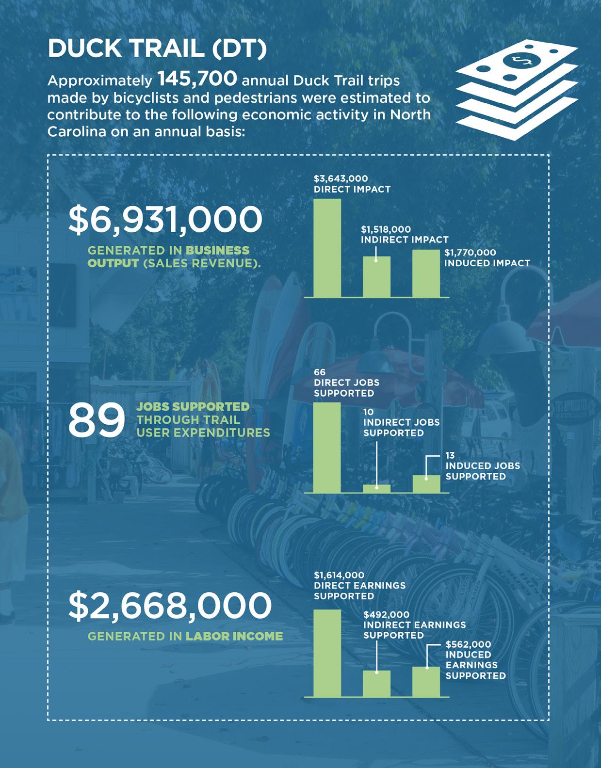
Estimated annual users: 508,100
Economic impact: $8 million
Total impact/mile: $353,982
Avg. trail use: 162 min/wk
Avg. trip distance: 9.3 mi
Source: Bridging the Gap, ITRE (2014)
Health Outcomes: The Pender County Community Health Assessment cited the lack of facilities such as trails and parks as the 4th most important issue facing the quality of life for people in the county, following drug abuse, poverty, and child abuse. Various organizations such as Blue Cross Blue Shield of NC and the American Heart Association cite research that says that for $1 invested in building trails, nearly $3 in medical cost savings may be achieved.
Flooding and Environmental Improvements: Trails can be designed to have minimal impact on flood-prone areas, while preserving natural space in a way that protects natural buffers, native plants, and drainage areas. The Federal Emergency Management Agency (FEMA) estimates that $1.1 billion in annual flood damages are saved when a floodplain is restored, including trail corridors along waterways. These benefits make trails a great value-add to protecting properties vulnerable to frequent flooding.
Safety: Trails and greenways separate pedestrians, bicyclists, and other users from motor vehicle traffic, reducing the risk trail users will encounter conflicts with motor vehicles that might lead to an injury or fatality. Proven countermeasures for improving safety at trail-roadway crossings can be implemented at a relatively low-cost. Refuge islands and Rectangular Rapid-Flashing Beacons (RRFBs), for instance, can reduce crashes at roadway crossings by 31% and 47% respectively.
More specific benefits will be revealed for Southeastern North Carolina as the regional trails network is developed. These benefits should be studied and evaluated, and agencies such as Chambers of Commerce and tourism authorities will use this analysis to promote the region’s trail system. These benefits and local assets, such as unique natural landscapes and historic sites, will become part of the brand each of the regional trail networks.