Piedmont Triad Regional Trail Plan and Inventory


This project was made possible with funding from the Federal Recreational Trails Program, a grant program managed by the Department of Environment and Natural Resources, the Division of Parks and Recreation and its State Trails Program and the Piedmont Triad Council of Governments. The report, mapping and public involvement was completed by the Piedmont Triad Council of Governments with assistance from local governments and the State Parks Trails Program. A special thanks to all the people who participated in the planning process, adding value to this report and tirelessly working to develop more opportunities to get out and enjoy the outdoors for fitness, recreation and transportation.
Wilmington Building, Suite 201 2216 W. Meadowview Road Greensboro, NC 27407 3480 (336) 294 4950 www.ptcog.org
1615 Mail Service Center Raleigh, NC 27699 1615 (919) 715 8699 www.ncparks.gov
OVERVIEW
STUDY
TRAIL
Plan
Public
REGIONAL MAPS
Existing Trails and Current
and Land Trail Proposed Connections
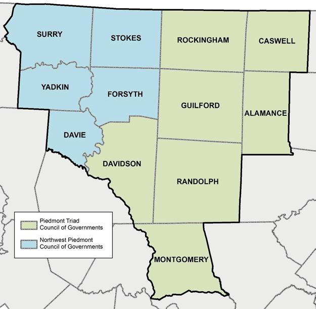
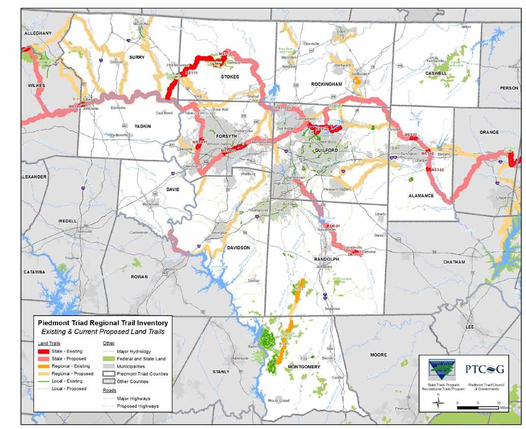
Map 1 Existing Land Trails
Table 1 ID, Name and Length of Existing State
Map 2 Existing and Current Proposed Trails
Map 3 Blueway Trail & River Access Plan
Map 4 Proposed Regional Connections
Regional Trails
Table 2 ID, Name and Length of Proposed Regional Connections.........................................................
Map 5 Priority Proposed Regional Connections
Table 2 ID, Name and Length of Priority Proposed Regional Connections
IMPLEMENTATION
LESSONS
APPENDIX
APPENDIX
BLUEWAY
APPENDIX
The Piedmont Regional Trail plan includes an inventory of existing & current proposed trails, and identification of new proposed regional connections throughout the Piedmont Triad. Building on existing local trail planning efforts, recent Mountains to Sea Trail and Open Space planning efforts, priority regional connections have been identified for the Piedmont Triad. A series of public workshops were held for stakeholders to identify priority trail connections that best preserve and enhance recreation, open space, water quality and wildlife habitat opportunities in the region.
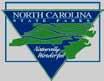
The study area is composed of the following twelve counties, encompassing the Northwest Council of Governments and the Piedmont Triad Council of Governments regions:
The North Carolina Division of Parks and Recreation and its State Trails Program provide funding for trail planning and construction projects through the Federal Recreational Trails Program and the State Adopt A Trail Grant programs as well as other sources. Construction and implementation grants in the public and private sector rely more and more on established trail plans that support multi jurisdictional, regional and state trail systems. Funding requests and needs continually outpace the amount of available funds, making regional trail planning an important component in prioritizing funding.
The Piedmont Triad Trail Inventory and Planning process consisted of a comprehensive search of existing trail and trail related assets from local, regional and state partners and stakeholders. Data was collected from and verified by numerous sources including 61 municipalities, 12 counties, 4 metropolitan planning organizations, 2 rural planning organizations, non profit trail organizations, the State Department of Transportation and State Parks Trails Program. Existing trail and trail related data was compiled into a geographic information system (GIS) database and symbolized in a uniform base map for public workshop review.
The planning project used the website: www.myplaninput.com to post meeting notes, base maps, draft plan maps, meeting dates and other information for public review. Visitors to this site could also post comments regarding the plan documents, proposed trails or to clarify existing trail information. There were 600+ visitors to the project website during the planning process.
Project Website at myplaninput.com

Eight public meetings were held to discuss the Regional Trail Plan and Inventory between September 2009 and June 2010. Total attendance at the eight meetings exceeded 125 people. The e mail contact list for meeting notices and plan results exceeds 350 people.
Six preliminary public workshops were held to provide stakeholders an opportunity to (1) review and revise existing trail information, (2) identify proposed trail connections and (3) garner support for trail development. Preliminary meeting dates and locations:
· Stokes and Surry County; Location: Pilot Mountain, Armfield Center, Sept. 21, 2009;
· Davie and Davidson County; Location: Lexington, Government Center, October 8, 2009;
· Forsyth and Yadkin County; Location: Lewisville, Public Library, October 27, 2009;
· Guilford and Alamance County; Location: Elon, Elon University McMichael Building Room 115, October 29, 2009;
· Randolph and Montgomery County; Location: Seagrove Library November 10, 2009; and
· Rockingham and Caswell County; Location: Reidsville Library, November 19, 2009.
The outcomes of each meeting included a list of proposed trails connecting existing trails, parks, rivers, population centers, points of interest and other assets. Individuals and small groups proposed new trail connections, and then each idea was discussed with the entire group to come to a consensus of what trails were the priority proposed trails.
The results of the fall 2009 meetings were compiled into a proposed trail map, which was reviewed by a region wide group of approximately 50 attendees on April 21, 2010. The results were also discussed with the four Metropolitan Planning Organizations in the region on June 11, 2010. It is the intent of this planning process to reinforce prioritization efforts at the local planning level, while creating new priority proposed local and regional trail connections
See Appendix A for all meeting notes
Existing trail information was collected from various local, regional and state sources beginning in June 2009. Trail data has been continually revised and refined throughout the planning process in consultation with stakeholders to create the 4 regional maps for this planning process.
Compilation of trail and trail related asset data is shown in Map 1 and 2:
Map 1 Existing Land Trails
Map 2 Existing and Current Proposed Trails
There are three basic classifications for land based trails used in the plan maps below:
· Local A Municipal or County trail that serves a local or neighborhood destination and is found in a local plan (municipality or MPO).
· Regional A Municipal or County trail that serves a regional destination or may bridge across County boundaries when fully implemented. The regional destination may be defined as a large regional park, a natural feature that attracts visitors from across the region or some other attraction of regional significance. Some Regional trail systems are a part of State trails systems. For example, the Piedmont Greenway in Guilford and Forsyth County is a part of the Mountains to Sea Trail, a Statewide trail in development.
· State Municipal, County or State trail that is part of a larger statewide trail system. Three official state trails exist in the Piedmont Triad: Mountains to Sea Trail (land trail), Yadkin River Trail (blueway only) and the Deep River Trail (blueway and land trail).
The planning process yielded new ideas for regional trail connections that will enhance trail and recreational opportunities, by extended and enhancing existing trail assets in the Piedmont Triad. There are three maps below showing new proposed regional connections overlaid on top of existing trails and current proposed trails
Map 3 Blueway Trail & River Access Plan
Map 4 Proposed Regional Connections
Map 5 Priority Proposed Regional Connections (Results of regional workshop voting)
The map pages below provide more detail on map contents and proposed facilities.
The land trails may consist of hiking, equestrian, bicycling and multi use trails. The highest known classification (e.g. State) will be displayed for each trail segment: Even if the trail is shown as a State trail, the maintenance of the trail may be the responsibility of a local municipality or non profit.
· Local (Line Color: Green)
· Regional (Line Color: Orange)
· State (Line Color: Red)
ID Trail Name Est. Length (mi)
DR 01 Deep River Trail 0.2*
DR 31 Deep River Trail 0.6*
MST 01 Overmountain Victory Trail (MST) 1.3*
MST 11 Sauratown Trail (MST) 23.5
MST 12 Hanging Rock Trails (MST) 8.9
MST 22 Greensboro Lake Trails 20.7
MST 32 Haw River Trail (MST) 2.1*
MST 42 Haw River Trail (MST) 0.5*
MST 52 Haw River Trail (MST) 1.0*
MST B11 Muddy Creek Greenway (MST) 2.6*
MST B21 Salem Lake Greenway (MST) 7.2*
R 01 Overmountain Victory Trail 1.0
R 02 Reidsville Trails 1.5
R 03 Birkhead Wilderness Trails 7.0
R 04 Uwharrie Trail 13.6
*These sections of the trail are pending State designation and may need to resolve certain design features, ownership agreements or other issues.
Existing and current proposed trail plan GIS datasets are shown here. Current proposed trails shown here are already identified in a local, County, MPO, RPO or Regional Planning (MST) document. This data was used to establish base maps for the trail planning public involvement meetings.
· Existing Trails (Line Color: Same as in Map 1; darker shade than proposed trails))
· Local Proposed (Line Color: Light Green)
· Regional Proposed (Line Color: Light Orange)
· State Proposed (Line Color: Light Red)
The proposed trails create a network of future trail connections in urban and rural areas of the Piedmont Triad. The Mountains to Sea State Trail, a trail that will connect Clingman's Dome in the Great Smoky Mountains National Park to Jockeys Ridge State Park, serves as the "backbone" of a growing system of trails across North Carolina. There are a number of Regional Trail connections represented on this map that connect to the MST, while others connect population centers to public points of interest or other trail systems.
Existing and proposed blueways and river accesses are shown here. The Yadkin and Deep River are designated as State trails. The Yadkin River including High Rock Lake, Tuckertown Reservoir and Lake Tillery has been an established blueway route for decades, with a connected series of river access points from Wilkes County to Montgomery County in this region.
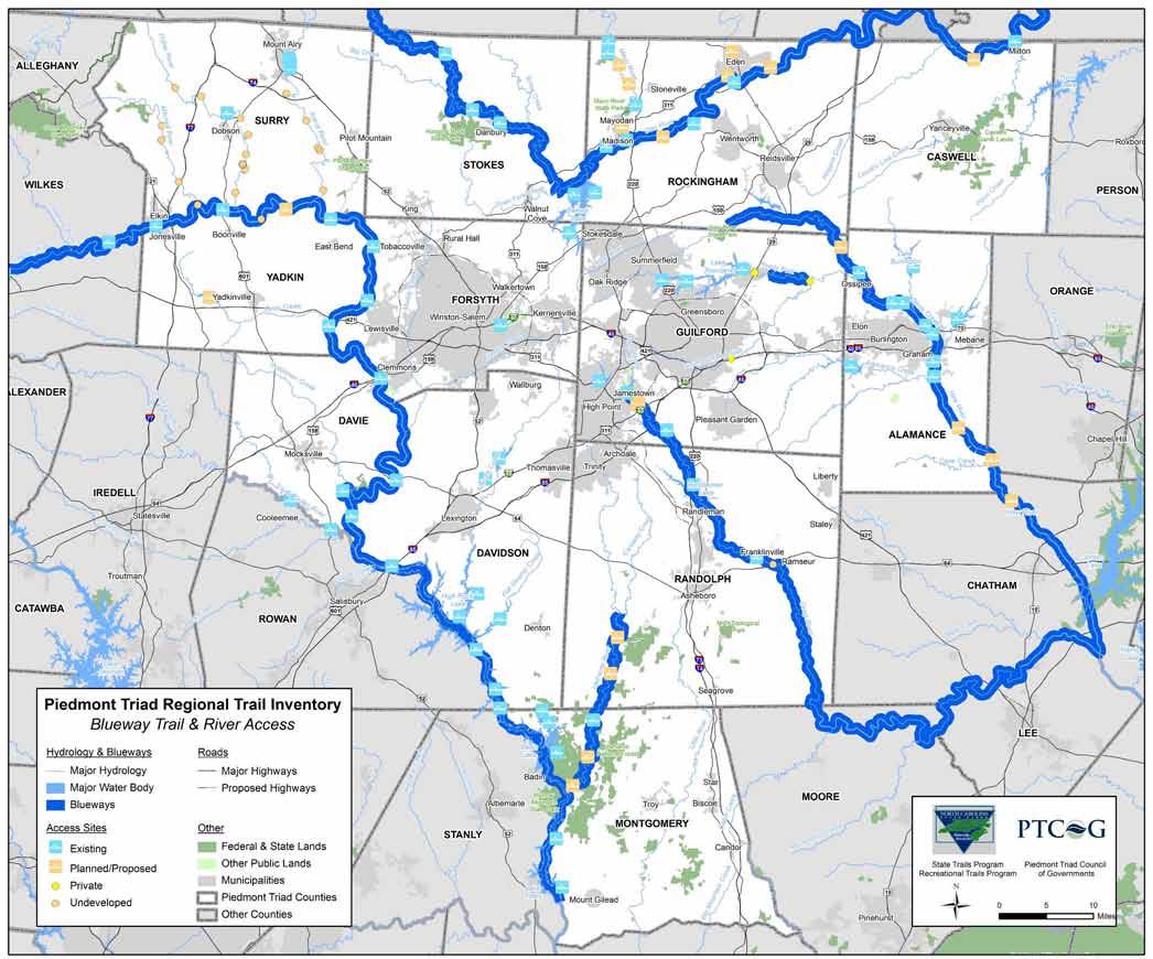
The Deep River State Trail was designated in 2007 and access points are being developed by local communities all along the Deep River. Paddling the upper reaches of the Deep River in Guilford & Randolph County is viable for short distances, however a series of small to medium sized dams exist every few miles along the Deep River from Jamestown (Guilford County) to High Falls (Randolph County) making paddling labor intensive due to the number of portages required. Some of the dam locations do not have public access portage routes
· Existing blueway routes (Line Color: Dark Blue).
· Existing and proposed access points are shown with a canoe symbol (Point Color: blue and orange )
· Undeveloped and private access points (Point Color: orange and yellow)
The State Trails Program promotes the planning, development and management of blueways for public recreation, and provide guidance to agencies and organizations interested in planning a legal, safe and pleasurable paddle trail. Information about NC Blueways can be found at http://www.ncsu.edu/ncblueways/
Using input from public workshops, new proposed regional connections were developed. The new proposed connections (shown in purple) build from existing trail planning efforts, with an emphasis on creating regional connections between local trail networks.
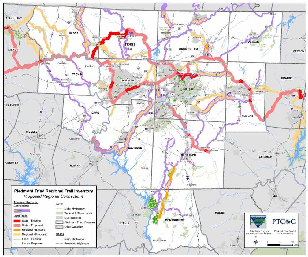
· The state, regional and local color coding is the same as in Map 1 and 2
· Proposed Regional Connections (Line Color: purple) Local or Regional trails that were identified in the Regional Trail Plan public involvement process as a priority. Where priority proposed trail existed on previous local plans, the purple will outline the planned trails, solid purple shows newly proposed trail segments.
ID* Trail Name Est. Length (Miles)
C 01 Ararat River Greenway 33.4
C 02 Jonesville Connector 10.3
C 03 Yadkin Reservoir Trail 7.9
C 04 Deep Creek Trail 29.1
C 05 Forbush Creek, and Fall Creek Greenway 16.9
C 06 Dutchman Creek Greenway 26.0
C 07 Mocksville and Rowan Rail Trail 5.1
C 08 South Yadkin Rail Trail 2.3
C 09 Yadkin River Greenway 9.2
C 10 Abbotts Ck Greenway 34.5
C 11 Linwood Connector 12.5
C 12 Danbury Connector 3.5
C 13 Dan River Trail 123.9
C 14 Hanging Rock Connector 16.6
C 15 Neatman Ck Greenway 16.3
C 16 Neatman Creek Greenway Spur 0.8
C 17 Old Rail Trail 11.8
C 18 Mayodan Stoneville Trail 4.3
C 19 Mayo River Trail 12.7
C 20 Smith River Trail 15.6
C 21 Reidsville Lake Trail 7.8
C 22 Club Trail 1.7
C 23 Cty Line Cr Greenway 24.2
C 24 Country Line Creek Trail 15.1
C 25 Quaker Creek Trail 9.0
ID* Trail Name Est. Length (Miles)
C 26 Reedy Fork Greenway 19.1
C 27 Bicentenial Greenway (4 parts) 6.4
C 28 Triad Park and Bicentennial Connector 4.4
C 29 Triad Park and Bicentennial Connector 5.2
C 30 High Point Connection 8.2
C 31 33 Great Alamance Creek Greenway 35.9
C 34 Cane Trail 11.5
C 35 Liberty Connector N 5.9
C 36 Liberty Connector S 11.1
C 37 Atlantic Yadkin Ramseur Branch Rail Trail 20.1
C 38 Old Liberty Road Sidepath 2.8
C 39 Uwharrie/Deep River Connection 11.0
C 40 Uwharrie Trail Connection 5.0
C 41 Camp Loop 19.3
C 42 Teachey School to Zoo Greenway 5.7
C 43 Uwharrie River Blueway 33.4
C 44 Uwharrie Trail 6.5
C 45 Badin and Tillery Lake Loop Trail 18.1
C 46 Gap Trail 10.5
C 47 Gap Trail 4.6
* ID Number value does not indicate priority
A large regional workshop was held to discuss how to prioritize proposed regional connections. Although not all local and regional planning agencies were able to attend the meeting, 50 people did attend representing citizen groups and local government. The State Trails Program is interested in using the results of the “straw poll” vote on what are the priority proposed regional connections for recreation to help prioritize trail funding for the region. The following 9 regional connections received more than 7 votes each at the regional workshop*.
· The state, regional and
coding is the
· Priority Proposed Regional Connections (Line
Regional
Map
in the Regional Trail Plan
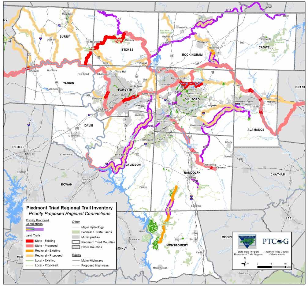
involvement process as a
received top votes at the April 21, 2010 meeting.
ID
C
C
C
C
C
C
C
C
C
*See
Successful implementation of the Regional Trail plan depends on local action. Local governments and citizen volunteers within the 12 County region are encouraged to:
· Review and refine the draft Regional Trail Plan Maps and participate in more detailed local planning as needed. Share the plan maps with local advisory boards & elected bodies for their consideration;
· Request State Trails Program support as needed; and
· Encourage local government advisory boards and elected bodies to formalize some or all of the draft map by taking the following actions:
1. Pass a Resolution of Support endorsing the draft map request a draft resolution from the State Trails Program if needed.
2. Adopt the draft map or a modified version of the map as a component of their local trails and greenways system plan.
3. Determine which segments identified in the Regional Trail plan draft map are most important to their jurisdiction.
4. Resolve to plan, acquire land, design, build and manage specific top priority segments within their jurisdiction.
As local government entities accomplish these recommended actions, a strong foundation will be laid for linking local and regional trail plans to the proposed statewide Mountains To Sea Trail, Deep River State Trail, Carolina Thread Trail and Yadkin River State Trail. The Division of Parks and Recreation will forward local and regional plans and resolutions of support to the Secretary of the Department of Environment and Natural Resources for approval as key components of the State’s regional trails system plan.
Trails included in this regional plan may provide priority points for Adopt A Trail and Recreational Trails Program grants and other State funding sources. The Division is using this regional trail planning approach in other regions of the state to become the basis for a Statewide Trails System Plan for North Carolina.
Appendix B provides a list of potential funding sources for trails. Depending on whether proposed trails follow existing public rights of way or not will influence project development times and what sources of funding to pursue. Each funding source listed in Appendix B describes appropriate projects that meet the funding source goals and objectives.
The following observations reflect on what was learned during the trail planning process. These ideas were shared with trail planning groups, local governments and advocacy organizations following the regional trail planning process:
· Data collection is a major task for a 12 county region with 73 units of local government
o Myriad sources of data with different fields and data management systems;
· Jurisdictional boundaries are an opportunity and hurdle
o Regional associations and planning organizations stratify the region;
· Trails serve a recreational and transportation purpose and different agencies prioritize transportation and recreational investments;
· Great value for areas that have not previously done trail planning
o Counties without a trail plan are able to use this product as a starting point;
· Need to be conscious of local expectations and adjust as needed;
· Communities need regional vision; and
· Partner agencies are needed to educate, market and gather support
September 21st, 2009 6pm
Armfield Center, Pilot Mountain, NC
15 attendees, not including staff
Following an introduction to trail planning efforts along the Mountains to Sea Trail and a summary of the scope of the current Regional Trail Plan process, the group proceeded to a mapping workshop showing where their preferred routes would be located. There were 4 groups working on location of horse, hiking, multi use and water trails. The following priorities were determined by the 4 groups:
Group 1
1. Connect Ararat River to the Yadkin River Trail
2. Develop Mitchell River Trail
3. Connect small gaps
4. Create more access along the Dan River and replace or revitalize closed access points
5. Bicycle route plan for Stokes County
6. Expand horse trails in Stokes County
Group 2
1. Preserve Sauratown Trail and connect with the Town of Danbury
2. Improve river accesses along the Dan River
3. Look at feasibility of river access north of Stokes County, currently not paddleable because of bridge design
Group 3
1. Preserve Sauratown Trail, explore interest in permanent easements
2. Connect Hanging Rock to Belews Lake
3. Re open blueway access in southeast part of Surry County
4. Develop trail along Yadkin railroad route from Elkin to Yadkin Park
Group 4
1. Develop Rockford access on Yadkin River
2. Develop Shiloh access on Yadkin River
3. Construct access at US 421
4. Include interim MST route on future planning maps.
· Pilot Mountain is working on a Management Plan currently
· Piedmont Land Conservancy should be involved in trail planning and development, especially along the Sauratown Trail
October 8, 2009 6pm
Government Center, Lexington, NC
Guy Cornman, Davidson County Planning Director opened the meeting and discussed some of the local efforts for trail planning and building in Davidson County. Darrell McBane, State Trails Program Director and Jesse Day, PTCOG Regional Planner summarized the Mountains to Sea Trail efforts and other similar regional trail plan efforts across the State. Travis Morehead from the Carolina Thread Trail gave a brief overview of their trail planning efforts.
The small group of trail advocates were supportive of the conceptual regional trail plan and were primarily concerned with expanding access to horse and multi use trails. There were two groups working on trail priorities:
· Construct Abbotts Creek trail from Lake Thom A Lex to Finch Park
· Create trail access along the Yadkin River from Wilcox Bridge to Boone’s Cave
· Connect Old County Landfill trails to Abbott’s Creek corridor
· Develop trail and access improvements around Wilcox Bridge
· Create connections from Mocksville and Cooleemee towards Rowan County and the Carolina Thread Trail
· Sign bicycle routes along new Scenic Byways in Denton area.
October 27, 2009 6pm
Forsyth County Public Library, Lewisville
There were 17 attendees. Following introductions, Darrell McBane and Jesse Day gave an overview of the regional and statewide trail planning efforts. Amy Crum and Matthew Burzcyk gave an overview of recent planning efforts in Forsyth County.
The mapping workshop results were as follows:
Group 1 Priorities Multi Use
1. Build trail along Muddy Creek from Bethania to Salem Creek
2. Construct Mill Haven Greenway: Salem Creek connector to Brushy Fork and Winston Salem State, North to Mill Creek and loop back to Muddy Creek Trail. May be able to use existing rail lines for trails
3. Connect new reservoir in Yadkin County to Lewisville and Muddy Creek
4. Provide branch trails and connection on sidewalks to major trail corridors
5. Follow utility lines for new trail development
Group 2 Priorities Hiking
1. Close gaps along the MST Route, especially from Muddy Creek to Pilot Mountain
2. Expand Pilot Mountain Lands on Yadkin River South and East
3. Connect new Yadkin Reservoir to Lewisville
Group 3 Priorities Blueway
1. Build Accesses on new reservoir and incorporate into a Recreation Master Plan for the new reservoir
2. Improve US 601 and Shallowford existing accesses
3. Provide access at Limerock between Rockford Shoals and Donegha
October 29, 2009 6pm
Elon University, Elon
There were 11 attendees, not including staff. After a brief overview of trail planning efforts at the regional statewide level, the attendees began the trail mapping workshop. The results of the workshop are as follows:
1. Build trail along Great Alamance Creek from Hagan Stone Park to Lake Mackintosh
2. Build Rail Trail from Hagan Stone Park to Franklinville along active and inactive rail lines
3. Close gaps along Bicentennial Greenway from North Greensboro to High Point
4. Ensure trail connections to Davidson County and Abbotts Creek
5. Connect MST Trail along Reedy Fork Creek to Ossipee
6. Construct trail from the Bicentennial Greenway to Triad Park
7. Develop the Atlantic and Yadkin Trail as a Multi Use trail to include Horses from Summerfield north
1. Connect MST Trail along Reedy Fork Creek to Ossipee
2. Build trail along Great Alamance Creek from Hagan Stone Park to Lake Mackintosh and connect with Cedar Rock Park Trail system
3. Build Quaker Creek Trail from Graham Mebane Lake to Duke Forest (connect to Burlington along Back Creek)
4. Build Horse Trails from Swepsonville to Orange County Along MST Route
Randolph County Public Library, Seagrove
After a brief project overview and introduction to previous planning efforts in the region and statewide, the group of 14 attendees including citizens, NC Zoo staff, Central Park NC, NC Horse Council, trails committee members and local government began a mapping workshop in Randolph and Montgomery County to identify existing conditions and future priorities for trail development.
The following priorities were identified by each of the three small groups. The priorities with an asterisk * and in bold were identified by the whole group as low hanging fruit or projects that should be implemented as top priority projects.
· Acquire Harvey’s Mountain trail access by the NC Zoo and US Forest Service Land
· Develop Uwharrie River Blueway Trail *
· Connect southern leg of the Uwharrie Trail to the Birkhead Wilderness section*
· Develop Little River Blueway Trail
· Complete Trails Master Plan for the Camps Area (Camp Caraway, Boy and Girl Scout’s Camp, etc.)
· Connect to Davidson County Priorities
· Close Uwharrie Trail Gaps (same as Group 1) *
· Complete Badin and Tillery Lake Loop Trail using existing public and private lands*
· Develop Uwharrie River Blueway Trail (same as Group 1) *
· Develop Deep River Heritage Trail
· Construct Zoo and Teachey School Greenway*
· Improve Cycling Routes to the Uwharrie Region
· Construct Camp Loop trails, some existing trails on each camp site could be connected
· Old Liberty Road Connection to Deep River Trail*
· Expand Deep River Trail in Franklinville, including rail trail connection to Climax
· Improve recreational access to Randleman Lake
Following the workshop, next steps were discussed. It was emphasized that public involvement on this large planning area will continue through the winter. Another round of public meetings will be held in February or March to discuss draft priorities.
Rockingham County Public Library, Reidsville
After a brief project overview and introduction to previous planning efforts in the region and statewide, the group of 12 attendees including members of the Dan River Basin Association, Caswell County Parks and Recreation Commission Trails Committee and County planning departments split up into three work groups to identify trail priorities for Rockingham and Caswell County.
The three small groups came up with the following priority projects. At the end of the small group workshop, participants reported their results. Projects with an * asterisk and in bold were identified as top priority projects.
· Construct the Mountains to the Sea Trail (MST) Rockingham County Section & Connect with Reidsville *
· Develop Dan River Blueway and Land Trail*
· Connect the MST to the Beaches to the Bluegrass Trail in Virginia
· Plan a downtown Wentworth Loop Trail *
· Improve Mayo River water access
· Connect with new Equestrian Center and develop trails
· Explore trails on gasline north from Wentworth
· Construct trails on Mayo River from Mayodan to Stoneville
· Develop Dan River Blueway and Land Trail *
· Develop Rockhouse Creek Trail through Reidsville to the Haw River (MST)
· Explore south Rockingham to central Caswell County trail
· Construct Mayo River connector
· Build Smith River Connector Trail*
· Develop Rattlesnake Creek Connector Trail*
· Develop Stephentown Stagecoach
Greensboro Coliseum Special Events Center April 21, 2010
The meeting consisted of a review of trail priorities from the fall public workshops and feedback received through the project website at www.myplaninput.com. Attendees received an agenda packet that included detailed county level maps and a table of proposed trails each with corresponding IDs. In addition, large format maps and a table of proposed trails were posted on the wall. Existing and proposed trail alignments were reviewed and refined and input on further connections were identified and placed onto the large format maps.
Following discussion of the proposed trail alignments, a “straw poll” prioritization of proposed trails was conducted with the meeting attendees. Each meeting participant was given 5 votes and could not put more than 3 votes on one trail priority. The results of the prioritization were as follows, each ID in the table corresponds to the maps on the following pages. The following list discussed at the April 2010 meeting were revised and improved based on follow up discussions with area Metropolitan Planning Organization staff members. The updated final maps (Map 3, 4 and 5) include different IDs corresponding to each trail. This is a result of combining “focus” trails (ID: F #) and “connector” trails (ID: C #) into one category called “proposed”.
ID SYSTEMNAME TRAILNAME FROM TO LGTH MI VOTES APR 21, 2010
COUNTY
F 10 Dan River Trail Dan River Trail Virginia Line in Stokes County Milton 122.2 21 Stokes, Rockingham, Caswell
F 23 Franklinville Pleasant Garden Rail Trail Rail Trail Ramseur Hagan Stone Park 20.1 21 Randolph, Guilford
F 22 Great Alamance Creek Greenway Great Alamance Creek Greenway Pleasant Garden Cedar Rock Park 32.6 20 Guilford, Alamance
F 19 Bicentennial Greenway Bicentenial Greenway Atlantic & Yadkin Gwy High Point missing sections 19.0 12 Guilford
F 16 Reidsville Greenways Reidsville Lake Trail Lake Reidsville Haw River 7.8 10 Rockingham
F 21 Abbotts Creek Greenway Abbotts Creek Greenway York Hill Boat Access Kernersville 46.7 10 Davidson
F 28 Uwharrie National Forest Trails Uwharrie Trail Existing Trail Existing Trail 6.5 10 Montgomery and Randolph
F 32 High Point Trails Hight Point Connection Abbotts Creek Greenway High Point Greenway 8.2 10 Davidson, Guilford
F 26 Zoo Greenway Teachey School to Zoo Greenway Teachey School NC Zoo 5.7 8 Randolph
C 08 Randolph County Trails Liberty Connector Liberty Cane Creek Trail 5.9 7 Randolph Alamance
F 01 Ararat River Greenway Ararat River Greenway Virginia Line Yadkin River 33.4 7 Surry
F 09 Sauratown Trails Danbury Connector Hanging Rock State Park Danbury 3.5 7 Stokes
F 18 Reedy Fork Greenway Reedy Fork Greenway Lake Townsend Ossipee 19.1 7 Guilford, Alamance
F 20 Deep River Headwaters Trail Triad Park and Bicentennial Ctr Bicentennial Greenway Triad Park 9.7 7 Guilford
F 24 Asheboro Trails Old Liberty Road Sidepath N. Fayetteville St Deep River 2.8 5 Randolph
F 27 Uwharrie River Trail Uwharrie River Blueway Caraway Creek Yadkin River 33.4 5 Montgomery, Randolph
F 04 Yadkin County Trail Deep Creek Trail New Yadkin Reservoir Yadkin River 29.1 4 Yadkin
F 07 Yadkin River Greenway Yadkin River Greenway Boones Cave Park Wilcox Bridge 9.2 4 Davidson
F 13 Smith River Trail Smith River Trail Existing Trail in Eden Existing Trail in Martinsville 15.6 4 Rockingham, Henry
F 17 Quaker Creek Trail Quaker Creek Trail Graham Mebane Lake Duke Forest 9.0 4 Alamance
C 02 Yadkin County Trails Forbush Creek, Little Forbush Creek, and Fall Creek Greenway
Junction of Forbush Creek with Yadkin River
Rockford Access 16.9 3 Yadkin
F 08 Sauratown Trail Sauratown Trail Pilot Mountain State Park Hanging Rock 17.4 3 Stokes
F 25 Randolph County Trails Camp Loop Uwharrie Blueway Randolph Camps 19.3 3 Randolph
F 30 Asheboro Trails Uwharrie/Deep River Connection Uwharrie Trail Deep River 11.0 3 Randolph
C 06 Rockingham County Trails Jacob's Creek Greenway MST Dan River 16.1 2 Rockingham
F 12 Mayo River Mayo River Trail Stoneville Virginia 12.7 2 Rockingham
F 14 Caswell County Trails Country Line Creek Trail C 07 Virginia 15.1 2 Caswell
C 07 Caswell County Trails County Line Creek Greenway Haw River Yanceyville 24.2 1 Caswell, Rockingham
C 09 Randolph County Trails Gap Trail Randolph County Greenway
Old Rail Line 2.2 1 Randolph
C 10 Montgomery County Trails Gap Trail Uwharrie Trail Denson's Creek Trail 10.5 1 Montgomery
F 02 Yadkin County Trails Jonesville Connector Jonesville New Reservoir 10.3 1 Yadkin
F 03 Yadkin County Trails Yadkin Reservoir Trail West Side of New Reservoir East Side of New Reservoir 7.9 1 Yadkin
F 06 South Yadkin Rail Trail South Yadkin Rail Trail South Yadkin River Boat Launch
Cooleemee (NC 801) 2.3 1 Davie
F 11 Mayo River Trails Mayodan Stoneville Trail Mayodan Stoneville 4.3 1 Rockingham
F 29 Uwharrie Loop Trail Badin and Tillery Lake Loop Trail Uwharrie Trail Uwharrie River 18.1 1 Montgomery
C 01 Hunting, Bear and Dutchman's Creek Dutchman Creek Greenway Mocksville Deep Creek (Yadkin County) 26.0 0 Davie, Yadkin
C 03 Stokes County Trails Hanging Rock Connector Neatman Creek and Town Fork Creek
Hanging Rock State Park 16.6 0 Stokes
C 04 Stokes County Trails Neatman Creek Greenway Town Fork Creek Hanging Rock State Park 16.3 0 Stokes
C 05 Stokes County Trails Neatman Creek Greenway Spur South Stokes High School Town Fork Creek 0.8 0 Stokes
C 11 Montgomery County Trails Gap Trail Denson's Creek Trail Biscoe 4.6 0 Montgomery
F 05 Mocksville and Rowan Rail Trail Mocksville and Rowan Rail Trail Mocksville South Yadkin River Boat Launch 5.1 0 Davie
F 15 Reidsville Greenway Club Trail Existing Greenway Existing Greenway 1.7 0 Rockingham
F 31 Uwharrie Trail Uwharrie Trail Connection Uwharrie Trail Uwharrie Blueway 5.0 0 Montgomery, Randolph
F 33 Randolph County Trails Proposed Greenway Deep River Liberty 11.1 0 Randolph
F 34 Alamance County Trails Cane Trail C 08 Connector Cedar Rock Park 11.5 0 Alamance
F 35 Alamance County Trails GAC Trail F 22 Haw River Trail 5.3 0 Alamance
Attendees: Margaret Bessette Winston Salem MPO, Matthew Burcyk Winston Salem MPO, Jesse Day Piedmont Triad COG, Helen Galanti, City of High Point Planning, Peggy Holland Greensboro Urban Area MPO, David Hyder High Point MPO, Gregg Morris City of High Point Planning, Allen Oliver City of High Point Parks and Recreation, Mike Simpson City of Greensboro Parks and Recreation, Phil Trew Burlington Graham Alamance MPO
The results of public input and trail priorities were discussed. The Metropolitan Planning Organizations are the lead transportation planning organizations for Forsyth, Guilford, Alamance and parts of Randolph and Davidson counties. The goal of the meeting was to discuss priority trail alignments and ensure that priorities in MPO areas may be discussed and refined through each MPO planning process.
Discussion highlights from the meeting:
1. Create simpler color scheme/symbology of focus trails and connector trails with a change of terminology to “proposed connections” trails;
2. Remove any “planned” trails and change to “proposed”, unless they have been engineered or have been given some other indication they will be built in the next few years. This change includes trails that have been adopted into a local or county greenway plan. NOTE: please indicate any trails that are planned to be built in the next 5 years or so;
3. Where regional priorities enter an MPO urban area and have not been adopted as a local priority, clearly indicate this with a buffer and an indication in the legend that the priority has not been incorporated in the MPO long range transportation plan;
4. Explain the difference between State, Regional, County and Local trails in the report and differentiate between blueway and land based trails; and
5. There is so much information, it may be clearer to read if some layers are removed and split up between maps.
Local, state, federal, and private funding is available to support the planning, construction, right of way acquisition and maintenance of bicycle and pedestrian facilities. Available funding sources are related to a variety of purposes including transportation, water quality, hazard mitigation, recreation, air quality, wildlife protection, community health, and economic development. This appendix identifies a list of some of the bicycle and pedestrian facility funding opportunities available through federal, state, nonprofit and corporate sources. An important key to obtaining funding is for local governments to have adopted plans for greenway, bicycle, pedestrian or multi use path systems in place prior to making an application for funding.
Funding Opportunities Through NCDENR:
The North Carolina Conservation Tax Credit (managed by NCDENR)
This program, managed by the North Carolina Department of Environment and Natural Resources, provides an incentive (in the form of an income tax credit) for landowners that donate interests in real property for conservation purposes. Property donations can be fee simple or in the form of conservation easements or bargain sale. The goal of this program is to manage stormwater, protect water supply watersheds, retain working farms and forests, and set aside greenways for ecological communities, public trails, and wildlife corridors. For more information, visit: www.enr.state.nc.us/conservationtaxcredit/
The Land and Water Conservation Fund (LWCF) program is a reimbursable, 50/50 matching grants program to states for conservation and recreation purposes, and through the states to local governments to address "close to home" outdoor recreation needs. LWCF grants can be used by communities to build a trail within one park site, if the local government has fee simple title to the park site. Grants for a maximum of $250,000 in LWCF assistance are awarded yearly to county governments, incorporated municipalities, public authorities and federally recognized Indian tribes. The local match may be provided with in kind services or cash. The program’s funding comes primarily from offshore oil and gas drilling receipts, with an authorized expenditure of $900 million each year. However, Congress generally appropriates only a small
fraction of this amount. The allotted money for the year 2007 is $632,846.
The Land and Water Conservation Fund (LWCF) has historically been a primary funding source of the US Department of the Interior for outdoor recreation development and land acquisition by local governments and state agencies. In North Carolina, the program is administered by the Department of Environment and Natural Resources. Since 1965, the LWCF program has built a permanent park legacy for present and future generations. In North Carolina alone, the LWCF program has provided more than $63 million in matching grants to protect land and support more than 800 state and local park projects. More than 37,000 acres have been acquired with LWCF assistance to establish a park legacy in our state. For more information, visit: http://ils.unc.edu/parkproject/lwcf/home1.html
This program, operated by the Trails Section of the NC Division of State Parks, offers annual grants to local governments to build, renovate, maintain, sign and map and create brochures for pedestrian trails. Grants are generally capped at about $5,000 per project and do not require a match. A total of $108,000 in Adopt A Trail money is awarded annually to government agencies. Applications are due during the month of February. For more information, visit : http://ils.unc.edu/parkproject/trails/grant.html.
The Recreational Trails Program (RTP) is a grant program funded by Congress with money from the federal gas taxes paid on fuel used by off highway vehicles. This program's intent is to meet the trail and trail related recreational needs identified by the Statewide Comprehensive Outdoor Recreation Plan. Grant applicants must be able contribute 20% of the project cost with cash or in kind contributions. The program is managed by the State Trails Program, which is a section of the N.C. Division of Parks and Recreation.
The grant application is available and instruction handbook is available through the State Trails Program website at http://ils.unc.edu/parkproject/trails/home.html Applications are due during the month of February. For more information, call (919) 715 8699.
The fund was established in 1994 by the North Carolina General Assembly and is administered by the Parks and Recreation Authority. Through this program, several million dollars each year are available to local governments to fund the acquisition, development and renovation of recreational areas. Applicable projects require a 50/50 match from the local government. Grants for a maximum of $500,000 are awarded yearly to county governments or incorporated municipalities. The fund is fueled by money from the state's portion of the real estate deed transfer tax for property sold in North Carolina.
The trust fund is allocated three ways:
65 percent to the state parks through the N.C. Division of Parks and Recreation.
30 percent as dollar for dollar matching grants to local governments for park and recreation purposes.
5 percent for the Coastal and Estuarine Water Access Program. For information on how to apply, visit:: www.partf.net/learn.html
In North Carolina, the Department of Transportation, Division of Bicycle and Pedestrian Transportation (DBPT) manages the Transportation Improvement Program (TIP) selection process for bicycle and pedestrian projects.
Projects programmed into the TIP are independent projects those which are not related to a scheduled highway project. Incidental projects those related to a scheduled highway project are handled through other funding sources described in this section.
The division has an annual budget of $6 million. Eighty percent of these funds are from STP Enhancement funds 1
while the State Highway Trust provides the remaining 20 percent of the funding.
Each year, the DBPT regularly sets aside a total of $200,000 of TIP funding for the department to fund projects such as training workshops, pedestrian safety and research projects, and other pedestrian needs statewide. Those interested in learning about training workshops, research and other opportunities should contact the DBPT for information.
A total of $5.3 million dollars of TIP funding is available for funding various bicycle and pedestrian independent projects, including the construction of multi use paths, the striping of bicycle lanes, and the construction of paved shoulders, among other facilities. Prospective applicants are encouraged to contact the DBPT regarding funding assistance for bicycle and pedestrian projects. For a detailed description of the TIP project selection process, visit: http://www.ncdot.org/transit/bicycle/funding/funding_T IP.html. Another $500,000 of the division’s funding is available for miscellaneous projects.
Incidental Projects Bicycle and pedestrian accommodations such as bike lanes, widened paved shoulders, sidewalks and bicycle safe bridge design are frequently included as incidental features of highway projects. In addition, bicycle safe drainage grates are a standard feature of all highway construction. Most bicycle and pedestrian safety accommodations built by NCDOT are included as part of scheduled highway improvement projects funded with a combination of National Highway System funds and State Highway Trust Funds.
,
1 After various administrative adjustments for programs within the Surface Transportation Program, or "STP", there is a 10% set aside for Transportation Enhancements. The 10% set aside is allocated within NCDOT to internal programs such as the Bicycle/Pedestrian Division, the Rail Division, the Roadside Environmental Unit, and others. The Enhancement Unit administers a portion of the set aside through the Call for Projects process.
Sidewalk Program Each year, a total of $1.4 million in STP Enhancement funding is set aside for sidewalk construction, maintenance and repair. Each of the 14 highway divisions across the state allocates $100,000 annually from each division’s budget for this purpose. Funding decisions are made by the district engineer. Prospective applicants are encouraged to contact their district engineer for information on how to apply for funding.
Funding Available Through North Carolina Metropolitan Planning Organizations (MPOs) MPOs in North Carolina which are located in air quality nonattainment or maintenance areas have the authority to program Congestion Mitigation Air Quality (CMAQ) funds. CMAQ funding is intended for projects that reduce
transportation related emissions. Some NC MPOs have chosen to use the CMAQ funding for bicycle and pedestrian projects. Local governments in air quality nonattainment or maintenance area should contact their MPO for information on CMAQ funding opportunities for bicycle and pedestrian facilities.
Transportation Enhancement Call for Projects, EU, NCDOT
The Enhancement Unit administers a portion of the enhancement funding set aside through the Call for Projects process. In North Carolina the Enhancement Program is a federally funded cost reimbursement program with a focus upon improving the transportation experience in and through local North Carolina communities either culturally, aesthetically, or environmentally. The program seeks to encourage diverse modes of travel, increase benefits to communities and to encourage citizen involvement. This is accomplished through the following twelve qualifying activities:
1. Bicycle and Pedestrian Facilities
2. Bicycle and Pedestrian Safety
3. Acquisition of Scenic Easements, Scenic or Historic Sites
4. Scenic or Historic Highway Programs (including tourist or welcome centers)
5. Landscaping and other Scenic Beautification
6. Historic Preservation
7. Rehabilitation of Historic Transportation Facilities
8. Preservation of Abandoned Rail Corridors
9. Control of Outdoor Advertising
10. Archaeological Planning and Research
11. Environmental Mitigation
12. Transportation Museums
Funds are allocated based on an equity formula approved by the Board of Transportation. The formula is applied at the county level and aggregated to the regional level. Available fund amount varies. In previous Calls, the funds available ranged from $10 million to $22 million.
The Call process takes place on even numbered years or as specified by the Secretary of Transportation. The Next Call is anticipated to take place in 2009. For more information, visit: www.ncdot.org/financial/fiscal/Enhancement/
Bicycle and Pedestrian Planning Grant Initiative, managed by NCDOT, DBPT
To encourage the development of comprehensive local bicycle plans and pedestrian plans, the NCDOT Division of Bicycle and Pedestrian Transportation (DBPT) and the Transportation Planning Branch (TPB) have created a matching grant program to fund plan development. This program was initiated through a special allocation of
funding approved by the North Carolina General Assembly in 2003 along with federal funds earmarked specifically for bicycle and pedestrian planning by the TPB. The planning grant program was launched in January 2004, and it is currently administered through NCDOT DBPT and the Institute for Transportation Research and Education (ITRE) at NC State University. Over the past three grant cycles, 48 municipal plans have been selected and funded from 123 applicants. A total of $ 1,175,718 has been allocated. Funding is secured for 2008 at $400,000. Additional annual allocations will be sought for subsequent years. For more information, visit www.itre.ncsu.edu/ptg/bikeped/ncdot/index.html
The NCDOT Safe Routes to School Program is a federally funded program that was initiated by the passing of the Safe, Accountable, Flexible, Efficient Transportation Equity Act: A Legacy for Users (SAFETEA LU) in 2005, which establishes a national SRTS program to distribute funding and institutional support to implement SRTS programs in states and communities across the country. SRTS programs facilitate the planning, development, and implementation of projects and activities that will improve safety and reduce traffic, fuel consumption, and air pollution in the vicinity of schools. The Division of Bicycle and Pedestrian Transportation at NCDOT is charged with disseminating SRTS funding.
The state of North Carolina has been allocated $15 million in Safe Routes to School funding for fiscal years 2005 through 2009 for infrastructure or non infrastructure projects. All proposed projects must relate to increasing walking or biking to and from an elementary or middle school. An example of a non infrastructure project is an education or encouragement program to improve rates of walking and biking to school. An example of an infrastructure project is construction of sidewalks around a school. Infrastructure improvements under this program must be made within 2 miles of an elementary or middle school. The state requires the completion of a competitive application to apply for funding. For more information, visit www.ncdot.org/programs/safeRoutes/ or contact Leza Mundt at DBPT/NCDOT, (919) 807 0774.
Small Urban Funds are available for small improvement projects in urban areas. Each NCDOT Highway Division has $2 million of small urban funds available annually. Although not commonly used for bicycle facilities, local requests for small bicycle projects can be directed to the NCDOT Highway Division office for funding through this source. A written request should be submitted to the Division Engineer providing technical information such as
location, improvements being requested, timing, etc. for thorough review.
Annually, State street aid (Powell Bill) allocations are made to incorporated municipalities which establish their eligibility and qualify as provided by statute. This program is a state grant to municipalities for the purposes of maintaining, repairing, constructing, reconstructing or widening of local streets that are the responsibility of the municipalities or for planning, construction, and maintenance of bikeways or sidewalks along public streets and highways. Funding for this program is collected from fuel taxes. Amount of funds are based on population and mileage of City maintained streets. For more information, visit www.ncdot.org/financial/fiscal/ExtAuditBranch/Powell_B ill/powellbill.html.
This fund was established in 1996 and has become one of the largest sources of money in North Carolina for land and water protection. At the end of each fiscal year, 6.5 percent of the unreserved credit balance in North Carolina’s General Fund, or a minimum of $30 million, is placed in the CWMTF. The revenue of this fund is allocated as grants to local governments, state agencies and conservation non profits to help finance projects that specifically address water pollution problems. CWMTF funds may be used to establish a network of riparian buffers and greenways for environmental, educational, and recreational benefits. The fund has provided funding for land acquisition of numerous greenway projects featuring trails, both paved and unpaved. For a history of awarded grants in North Carolina and more information about this fund and applications, visit www.cwmtf.net/
This trust fund, managed by the NC Natural Heritage Program, has contributed millions of dollars to support the conservation of North Carolina’s most significant natural areas and cultural heritage sites. The NHTF is used to acquire and protect land that has significant habitat value. Some large wetland areas may also qualify, depending on their biological integrity and characteristics. Only certain state agencies are eligible to apply for this fund, including the Department of Environment and Natural Resources, the Wildlife Resources Commission, the Department of Cultural Resources and the Department of Agriculture and Consumer Services. As such, municipalities must work with State level partners to access this fund. Additional information is available from the NC Natural Heritage Program. For more information and grant application information, visit www.ncnhtf.org/
North Carolina has a unique incentive program to assist land owners to protect the environment and the quality of life. A credit is allowed against individual and corporate income taxes when real property is donated for conservation purposes. Interests in property that promote specific public benefits may be donated to a qualified recipient. Such conservation donations qualify for a substantial tax credit. For more information, visit: www.enr.state.nc.us/conservationtaxcredit/ .
This program offers small grants that can be used to plant urban trees, establish a community arboretum, or other programs that promote tree canopy in urban areas. The program operates as a cooperative partnership between the NC Division of Forest Resources and the USDA Forest Service, Southern Region. To qualify for this program, a community must pledge to develop a street tree inventory, a municipal tree ordinance, a tree commission, and an urban forestry management plan. All of these can be funded through the program. For more information, contact the NC Division of Forest Resources. For more information and a grant application, contact the NC Division of Forest Resources and/or visit http://www.dfr.state.nc.us/urban/urban_grantprogram.ht m
Developed in 2003 as a new mechanism to facilitate improved mitigation projects for NC highways, this program offers funding for restoration projects and for protection projects that serve to enhance water quality and wildlife habitat in NC. Information on the program is available by contacting the Natural Heritage Program in the NC Department of Environment and Natural Resources (NCDENR). For more information, visit www.nceep.net/pages/partners.html or call 919 715 0476.
This program is a joint effort of the North Carolina Division of Soil and Water Conservation, the NC Clean Water Management Trust Fund, the Ecosystem Enhancement Program (EEP), and the Farm Service Agency United States Department of Agriculture (USDA) to address water quality problems of the Neuse, Tar Pamlico and Chowan river basins as well as the Jordan Lake watershed area.
CREP is a voluntary program that seeks to protect land along watercourses that is currently in agricultural production. The objectives of the program include: installing 100,000 acres of forested riparian buffers, grassed filter strips and wetlands; reducing the impacts of sediment and nutrients within the targeted area; and providing substantial ecological benefits for many wildlife
species that are declining in part as a result of habitat loss. Program funding will combine the Federal Conservation Reserve Program (CRP) funding with State funding from the Clean Water Management Trust Fund, Agriculture Cost Share Program, and North Carolina Wetlands Restoration Program.
The program is managed by the NC Division of Soil and Water Conservation. For more information, visit www.enr.state.nc.us/dswc/pages/crep.html
Established in 1984, this program assists farmers with the cost of installing best management practices (BMPs) that benefit water quality. The program covers as much as 75 percent of the costs to implement BMPs. The NC Division of Soil and Water Conservation within the NC Department of Environment and Natural Resources administers this program through local Soil and Water Conservation Districts (SWCD). For more information, visit www.enr.state.nc.us/DSWC/pages/agcostshareprogram.ht ml or call 919 733 2302.
The NC Division of Water Resources offers cost sharing grants to local governments on projects related to water resources. Of the seven project application categories available, the category which relates to the establishment of greenways is “Land Acquisition and Facility Development for Water Based Recreation Projects.” Applicants may apply for funding for a greenway as long as the greenway is in close proximity to a water body. For more information, see: www.ncwater.org/Financial_Assistance or call 919 733 4064.
State level funds are allocated through the NC Department of Commerce, Division of Community Assistance to be used to promote economic development and to serve low income and moderate income neighborhoods. Greenways that are part of a community’s economic development plans may qualify for assistance under this program. Recreational areas that serve to improve the quality of life in lower income areas may also qualify. Approximately $50 million is available statewide to fund a variety of projects. For more information, visit www.hud.gov/offices/cpd/communitydevelopment/progr ams/stateadmin/ or call 919 733 2853.
The NC Health and Wellness Trust Fund was created by the General Assembly as one of 3 entities to invest North Carolina’s portion of the Tobacco Master Settlement Agreement. HWTF receives one fourth of the state’s
tobacco settlement funds, which are paid in annual installments over a 25 year period.
Fit Together, a partnership of the NC Health and Wellness Trust Fund (HWTF) and Blue Cross and Blue Shield of North Carolina (BCBSNC) announces the establishment of Fit Community, a designation and grant program that recognizes and rewards North Carolina communities’ efforts to support physical activity and healthy eating initiatives, as well as tobacco free school environments. Fit Community is one component of the jointly sponsored Fit Together initiative, a statewide prevention campaign designed to raise awareness about obesity and to equip individuals, families and communities with the tools they need to address this important issue.
All North Carolina municipalities and counties are eligible to apply for a Fit Community designation, which will be awarded to those that have excelled in supporting the following:
• physical activity in the community, schools, and workplaces
• healthy eating in the community, schools, and workplaces
• tobacco use prevention efforts in schools Designations will be valid for two years, and designated communities may have the opportunity to reapply for subsequent two year extensions. The benefits of being a Fit Community include:
• heightened statewide attention that can help bolster local community development and/or economic investment initiatives (highway signage and a plaque for the Mayor’s or County Commission Chair’s office will be provided)
• reinvigoration of a community’s sense of civic pride (each Fit Community will serve as a model for other communities that are trying to achieve similar goals)
• use of the Fit Community designation logo for promotional and communication purposes. The application for Fit Community designation is available on the Fit Together Web site: www.FitTogetherNC.org/FitCommunity.aspx.
Fit Community grants are designed to support innovative strategies that help a community meet its goal to becoming a Fit Community. Eight to nine, two year grants of up to $30,000 annually will be awarded to applicants that have a demonstrated need, proven capacity, and opportunity for positive change in addressing physical activity and/or healthy eating.For more information, visit: www.healthwellnc.com
The North Carolina Division of Forest Resources Urban and Community Forestry Grant can provide funding for a variety of projects that will help toward planning and establishing street trees as well as trees for urban open space. See: http://www.dfr.state.nc.us/urban/urban_ideas.htm
This federal funding source is a voluntary program offering technical and financial assistance to landowners who want to restore and protect wetland areas for water quality and wildlife habitat. The US Department of Agriculture’s Natural Resource Conservation Service (USDA NRCS) administers the program and provides direct payments to private landowners who agree to place sensitive wetlands under permanent easements. This program can be used to fund the protection of open space and greenways within riparian corridors. For more information, visit http://www.nrcs.usda.gov/PROGRAMS/wrp/
The Community Development Block G rant (HUDCDBG)
The U.S. Department of Housing and Urban Development (HUD) offers financial grants to communities for neighborhood revitalization, economic development, and improvements to community facilities and services, especially in low and moderate income areas. Several communities have used HUD funds to develop greenways, including the Boulding Branch Greenway in High Point, North Carolina. Grants from this program range from $50,000 to $200,000 and are either made to municipalities or non profits. There is no formal application process. For more information, visit: www.hud.gov/offices/cpd/communitydevelopment/progr ams/ .
Public and private nonprofit groups in communities with populations under 50,000 are eligible to apply for grant assistance to help their local small business environment. $1 million is available for North Carolina on an annual basis and may be used for sidewalk and other community facilities. For more information from the local USDA Service Center, visit: http://www.rurdev.usda.gov/rbs/busp/rbeg.htm
Rivers Trails and Conservation Assistance Program (RTCA)
The Rivers, Trails, and Conservation Assistance Program, also known as the Rivers & Trails Program or RTCA, is the community assistance arm of the National Park Service. RTCA staff provide technical assistance to community groups and local, State, and federal government agencies so they can conserve rivers, preserve open space, and
develop trails and greenways. The RTCA program implements the natural resource conservation and outdoor recreation mission of the National Park Service in communities across America
Although the program does not provide funding for projects, it does provide valuable on the ground technical assistance, from strategic consultation and partnership development to serving as liaison with other government agencies. Communities must apply for assistance. For more information, visit: www.nps.gov/ncrc/programs/rtca/ or call Chris Abbett, Program Leader, at 404 562 3175 ext. 522.
The Federal Highway Administration administers discretionary funding for projects that will reduce congestion and improve air quality. The FHWA issues a call for projects to disseminate this funding. The FHWA estimates that the PLHD funding for the 2007 call will be $85 million. In the past, Congress has earmarked a portion of the total available funding for projects. For information on how to apply, visit: http://www.fhwa.dot.gov/discretionary/
Municipalities often plan for the funding of pedestrian facilities or improvements through development of Capital Improvement Programs (CIP). In Raleigh, for example, the greenways system has been developed over many years through a dedicated source of annual funding that has ranged from $100,000 to $500,000, administered through the Recreation and Parks Department. CIPs should include all types of capital improvements (water, sewer, buildings, streets, etc.) versus programs for single purposes. This allows municipal decision makers to balance all capital needs. Typical capital funding mechanisms include the following: capital reserve fund, capital protection ordinances, municipal service district, tax increment financing, taxes, fees, and bonds. Each of these categories are described below.
Municipalities have statutory authority to create capital reserve funds for any capital purpose, including pedestrian facilities. The reserve fund must be created through ordinance or resolution that states the purpose of the fund, the duration of the fund, the approximate amount of the fund, and the source of revenue for the fund. Sources of revenue can include general fund allocations, fund balance allocations, grants and donations for the specified use.
Municipalities can pass Capital Project Ordinances that are project specific. The ordinance identifies and makes appropriations for the project.
Municipalities have statutory authority to establish municipal service districts, to levy a property tax in the district additional to the citywide property tax, and to use the proceeds to provide services in the district. Downtown revitalization projects are one of the eligible uses of service districts.
Tax increment financing is a tool to use future gains in taxes to finance the current improvements that will create those gains. When a public project, such as the construction of a greenway, is carried out, there is an increase in the value of surrounding real estate.
Oftentimes, new investment in the area follows such a project. This increase sit value and investment creates more taxable property, which increases tax revenues. These increased revenues can be referred to as the “tax increment.” Tax Increment Financing dedicates that increased revenue to finance debt issued to pay for the project. TIF is designed to channel funding toward improvements in distressed or underdeveloped areas where development would not otherwise occur. TIF creates funding for public projects that may otherwise be unaffordable to localities. The large majority of states have enabling legislation for tax increment financing.
As an alternative to debt financing of capital improvements, communities can execute installment/ lease purchase contracts for improvements. This type of financing is typically used for relatively small projects that the seller or a financial institution is willing to finance or when up front funds are unavailable. In a lease purchase contract the community leases the property or improvement from the seller or financial institution. The lease is paid in installments that include principal, interest, and associated costs. Upon completion of the lease period, the community owns the property or improvement. While lease purchase contracts are similar to a bond, this arrangement allows the community to acquire the property or improvement without issuing debt. These instruments, however, are more costly than issuing debt.
Many communities have raised money through self imposed increases in taxes and bonds. For example, Pinellas County residents in Florida voted to adopt a one cent sales tax increase, which provided an additional $5 million for the development of the overwhelmingly popular Pinellas Trail. Sales taxes have also been used in Allegheny County, Pennsylvania, and in Boulder, Colorado to fund open space projects. A gas tax is another method used by some municipalities to fund public improvements. A number of taxes provide direct or indirect funding for the operations of local governments. Some of them are:
In North Carolina, the state has authorized a sales tax at the state and county levels. Local governments that choose to exercise the local option sales tax (all counties currently do), use the tax revenues to provide funding for a wide variety of projects and activities. Any increase in the sales tax, even if applying to a single county, must gain approval of the state legislature. In 1998, Mecklenburg County was granted authority to institute a one half cent sales tax increase for mass transit.
Property taxes generally support a significant portion of a municipality’s activities. However, the revenues from property taxes can also be used to pay debt service on general obligation bonds issued to finance greenway system acquisitions. Because of limits imposed on tax rates, use of property taxes to fund greenways could limit the municipality’s ability to raise funds for other activities. Property taxes can provide a steady stream of financing while broadly distributing the tax burden. In other parts of the country, this mechanism has been popular with voters as long as the increase is restricted to parks and open space. Note, other public agencies compete vigorously for these funds, and taxpayers are generally concerned about high property tax rates.
Excise taxes are taxes on specific goods and services. These taxes require special legislation and the use of the funds generated through the tax are limited to specific uses. Examples include lodging, food, and beverage taxes that generate funds for promotion of tourism, and the gas tax that generates revenues for transportation related activities.
The NC General Assembly may grant towns the authority to levy occupancy tax on hotel and motel rooms. The act granting the taxing authority limits the use of the proceeds, usually for tourism promotion purposes.
Three fee options that have been used by local governments to assist in funding pedestrian and bicycle facilities are listed here:
Greenway sections may be purchased with stormwater fees, if the property in question is used to mitigate floodwater or filter pollutants.
Stormwater charges are typically based on an estimate of the amount of impervious surface on a user’s property.
Impervious surfaces (such as rooftops and paved areas) increase both the amount and rate of stormwater runoff compared to natural conditions. Such surfaces cause runoff that directly or indirectly discharge into public storm drainage facilities and creates a need for stormwater management services. Thus, users with more impervious surface are charged more for stormwater service than users with less impervious surface. The rates, fees, and charges collected for stormwater management services may not exceed the costs incurred to provide these services. The costs that may be recovered through the stormwater rates, fees, and charges includes any costs necessary to assure that all aspects of stormwater quality and quantity are managed in accordance with federal and state laws, regulations, and rules.
Streetscape Utility Fees could help support streetscape maintenance of the area between the curb and the property line through a flat monthly fee per residential dwelling unit. Discounts would be available for senior and disabled citizens. Non residential customers would be charged a per foot fee based on the length of frontage on streetscape improvements. This amount could be capped for non residential customers with extremely large amounts of street frontage. The revenues raised from Streetscape Utility fees would be limited by ordinance to maintenance (or construction and maintenance) activities in support of the streetscape.
Developers can be required to provide greenway impact fees through local enabling legislation. Impact fees, which are also known as capital contributions, facilities fees, or system development charges, are typically collected from developers or property owners at the time of building permit issuance to pay for capital improvements that provide capacity to serve new growth. The intent of these fees is to avoid burdening existing customers with the costs of providing capacity to serve new growth (“growth pays its own way”). Greenway impact fees are designed to reflect the costs incurred to provide sufficient capacity in the system to meet the additional needs of a growing community. These charges are set in a fee schedule applied uniformly to all new development. Communities that institute impact fees must develop a sound financial model that enables policy makers to justify fee levels for different user groups, and to ensure that revenues generated meet (but do not exceed) the needs of development. Factors used to determine an appropriate impact fee amount can include: lot size, number of occupants, and types of subdivision improvements. If Holly Springs is interested in pursuing open space impact fees, it will require enabling legislation to authorize the collection of the fees.
Exactions are similar to impact fees in that they both provide facilities to growing communities. The difference is that through exactions it can be established that it is the responsibility of the developer to build the greenway or pedestrian facility that crosses through the property, or adjacent to the property being developed.
As an alternative to requiring developers to dedicate on site greenway sections that would serve their development, some communities provide a choice of paying a front end charge for off site protection of pieces of the larger system. Payment is generally a condition of development approval and recovers the cost of the off site land acquisition or the development’s proportionate share of the cost of a regional facility serving a larger area. Some communities prefer in lieu of fees. This alternative allows community staff to purchase land worthy of protection rather than accept marginal land that meets the quantitative requirements of a developer dedication but falls a bit short of qualitative interests.
Bonds have been a very popular way for communities across the country to finance their pedestrian and greenway projects. A number of bond options are listed below. Contracting with a private consultant to assist with this program may be advisable. Since bonds rely on the support of the voting population, an education and awareness program should be implemented prior to any vote. Billings, Montana used the issuance of a bond in the amount of $599,000 to provide the matching funds for several of their TEA 21 enhancement dollars. Austin, Texas has also used bond issues to fund a portion of their bicycle and trail system.
Revenue bonds are bonds that are secured by a pledge of the revenues from a certain local government activity. The entity issuing bonds, pledges to generate sufficient revenue annually to cover the program’s operating costs, plus meet the annual debt service requirements (principal and interest payment). Revenue bonds are not constrained by the debt ceilings of general obligation bonds, but they are generally more expensive than general obligation bonds.
Cities, counties, and service districts generally are able to issue general obligation (G.O.) bonds that are secured by the full faith and credit of the entity. In this case, the local government issuing the bonds pledges to raise its property taxes, or use any other sources of revenue, to generate sufficient revenues to make the debt service payments on
the bonds. A general obligation pledge is stronger than a revenue pledge, and thus may carry a lower interest rate than a revenue bond. Frequently, when local governments issue G.O. bonds for public enterprise improvements, the public enterprise will make the debt service payments on the G.O. bonds with revenues generated through the public entity’s rates and charges. However, if those rate revenues are insufficient to make the debt payment, the local government is obligated to raise taxes or use other sources of revenue to make the payments. G.O. bonds distribute the costs of land acquisition and greenway development and make funds available for immediate purchases and projects. Voter approval is required.
Special assessment bonds are secured by a lien on the property that benefits by the improvements funded with the special assessment bond proceeds. Debt service payments on these bonds are funded through annual assessments to the property owners in the assessment area.
Initially funded with federal and state money, and continued by funds generated by repayment of earlier loans, State Revolving Funds (SRFs) provide low interest loans for local governments to fund water pollution control and water supply related projects including many watershed management activities. These loans typically require a revenue pledge, like a revenue bond, but carry a below market interest rate and limited term for debt repayment (20 years).
Facility Maintenance Districts
Facility Maintenance Districts (FMDs) can be created to pay for the costs of on going maintenance of public facilities and landscaping within the areas of the Town where improvements have been concentrated and where their benefits most directly benefit business and institutional property owners. An FMD is needed in order to assure a sustainable maintenance program. Fees may be based upon the length of lot frontage along streets where improvements have been installed, or upon other factors such as the size of the parcel. The program supported by the FMD should include regular maintenance of streetscape of off road trail improvements. The municipality can initiate public outreach efforts to merchants, the Chamber of Commerce, and property owners. In these meetings, Town staff will discuss the proposed apportionment and allocation methodology and will explore implementation strategies.
The municipality can manage maintenance responsibilities either through its own staff or through private contractors.
Another method of funding pedestrian systems and greenways is to partner with public agencies and private companies and organizations. Partnerships engender a spirit of cooperation, civic pride and community participation. The key to the involvement of private partners is to make a compelling argument for their participation. Major employers and developers should be identified and provided with a “Benefits of Walking” type handout for themselves and their employees. Very specific routes that make critical connections to place of business would be targeted for private partners’ monetary support following a successful master planning effort. Potential partners include major employers which are located along or accessible to pedestrian facilities such as shared use paths or greenways. Name recognition for corporate partnerships would be accomplished through signage trail heads or interpretive signage along greenway systems. Utilities often make good partners and many trails now share corridors with them. Money raised from providing an easement to utilities can help defray the costs of maintenance. It is important to have a lawyer review the legal agreement and verify ownership of the subsurface, surface or air rights in order to enter into an agreement.
A sponsorship program for trail amenities allows smaller donations to be received from both individuals and businesses. Cash donations could be placed into a trust fund to be accessed for certain construction or acquisition projects associated with the greenways and open space system. Some recognition of the donors is appropriate and can be accomplished through the placement of a plaque, the naming of a trail segment, and/or special recognition at an opening ceremony. Types of gifts other than cash could include donations of services, equipment, labor, or reduced costs for supplies.
It is expected that many citizens will be excited about the development of a greenway corridor. Individual volunteers from the community can be brought together with groups of volunteers form church groups, civic groups, scout troops and environmental groups to work on greenway development on special community work days. Volunteers can also be used for fund raising, maintenance, and programming needs.
Many communities have solicited greenway funding assistance from private foundations and other conservation minded benefactors. Below are a few examples of private funding opportunities available in North Carolina.
Conservation Trust for North Carolina (Land Trusts)
The Conservation Trust for North Carolina helps North Carolina’s local land trusts by obtaining grants, emergency loans and other funding for their projects; lobbying in Raleigh and Washington for laws and funding that encourage conservation; helping to manage coalition efforts; and coordinating public awareness efforts www.ctnc.org . There are two land trusts that cover the Piedmont Triad: Piedmont Land Conservancy www.piedmontland.org and the LandTrust for Central North Carolina www.landtrustcnc.org . These two organizations are key partners in acquiring conservation easements and acquisitions for potential trail development or open space
International Mountain Bicycling Association
Assists local mountain bike organizations with trailwork, trainings, fundraising support, events, group rides and festivals.
The Team IMBA program allows clubs and individuals to raise funds by training together and developing personalized campaign web pages earn great perks like team issue jerseys, prizes and giveaways. Many Team IMBA drives also qualify for matching donations from the bike industry. Team IMBA allows individuals or clubs to take donations on line for qualified trail projects. http://www.imba.com/resources/grants/
Land for Tomorrow is a diverse partnership of businesses, conservationists, farmers, environmental groups, health professionals and community groups committed to securing support from the public and General Assembly for protecting land, water and historic places. The campaign is asking the North Carolina General Assembly to support issuance of a bond for $200 million a year for five years to preserve and protect its special land and water resources. Land for Tomorrow will enable North Carolina to reach a goal of ensuring that working farms and forests; sanctuaries for wildlife; land bordering streams, parks and greenways; land that helps strengthen communities and promotes job growth; historic downtowns and neighborhoods; and more, will be there to enhance the quality of life for generations to come. For more information, visit http://www.landfortomorrow.org/
The Trust for Public Land
Land conservation is central to the mission of the Trust for Public Land (TPL). Founded in 1972, the Trust for Public Land is the only national nonprofit working exclusively to protect land for human enjoyment and well being. TPL helps conserve land for recreation and spiritual nourishment and to improve the health and quality of life of American communities. TPL’s legal and real estate specialists work with landowners, government agencies, and community groups to:
• Create urban parks, gardens, greenways, and riverways
• Build livable communities by setting aside open space in the path of growth
• Conserve land for watershed protection, scenic beauty, and close to home recreation safeguard the character of communities by preserving historic landmarks and landscapes.
The following are TPL's Conservation Services:
• Conservation Vision: TPL helps agencies and communities define conservation priorities, identify lands to be protected, and plan networks of conserved land that meet public need.
• Conservation Finance: TPL helps agencies and communities identify and raise funds for conservation from federal, state, local, and philanthropic sources.
• Conservation Transactions: TPL helps structure, negotiate, and complete land transactions that create parks, playgrounds, and protected natural areas.
• Research & Education: TPL acquires and shares knowledge of conservation issues and techniques to improve the practice of conservation and promote its public benefits.
Since 1972, TPL has worked with willing landowners, community groups, and national, state, and local agencies to complete more than 3,000 land conservation projects in 46 states, protecting more than 2 million acres. Since 1994, TPL has helped states and communities craft and pass over 330 ballot measures, generating almost $25 billion in new conservation related funding. For more information, visit http://www.tpl.org/ .
This Winston Salem based Foundation has been assisting the environmental projects of local governments and non profits in North Carolina for many years. The foundation has two grant cycles per year and generally does not fund land acquisition. However, the foundation may be able to support municipalities in other areas of greenways development. More information is available at www.zsr.org .
The North Carolina Community Foundation, established in 1988, is a statewide foundation seeking gifts from individuals, corporations, and other foundations to build endowments and ensure financial security for nonprofit organizations and institutions throughout the state. Based in Raleigh, North Carolina, the foundation also manages a number of community affiliates throughout North Carolina that make grants in the areas of human services, education, health, arts, religion, civic affairs, and the conservation and preservation of historical, cultural, and environmental resources. In addition, the foundation manages various scholarship programs statewide. Web site: http://nccommunityfoundation.org/ .
In 1998, the American Hiking Society created the National Trails Fund, the only privately supported national grants program providing funding to grassroots organizations working toward establishing, protecting and maintaining foot trails in America. Each year, 73 million people enjoy foot trails, yet many of our favorite trails need major repairs due to a $200 million in badly needed maintenance. National Trails Fund grants give local organizations the resources they need to secure access, volunteers, tools and materials to protect America’s cherished public trails. For 2005, American Hiking distributed over $40,000 in grants thanks to the generous support of Cascade Designs and L.L.Bean, the program’s Charter Sponsors. To date, American Hiking has granted more than $240,000 to 56 different trail projects across the U.S. for land acquisition, constituency building campaigns, and traditional trail work projects. Awards range from $500 to $10,000 per project.
What types of projects will American Hiking Society consider? Securing trail lands, including acquisition of trails and trail corridors, and the costs associated with acquiring conservation easements. Building and maintaining trails which will result in visible and substantial ease of access, improved hiker safety, and/ or avoidance of environmental damage. Constituency building surrounding specific trail projects including volunteer recruitment and support. Web site: www.americanhiking.org/alliance/fund.html
The Bikes Belong Grants Program strives to put more people on bicycles more often by funding important and influential projects that leverage federal funding and build momentum for bicycling in communities across the U.S. These projects include bike paths, lanes, and routes, as well as bike parks, mountain bike trails, BMX facilities, and large scale bicycle advocacy initiatives.
Since 1999, Bikes Belong has awarded 166 grants to municipalities and grassroots groups in 44 states and the District of Columbia, investing nearly $1.3 million in community bicycling projects and leveraging more than $476 million in federal, state, and private funding.
American Rivers http://www.americanrivers.org/
Dan River Basin Association http://www.drba.org
How to Build Paddle Trails in Your Community http://www.ncsu.edu/ncblueways/ncblueways_2006_presentations.html
Logistical Lasting Launches http://www.nps.gov/ncrc/programs/rtca/helpfultools/ht_launch_guide.html
NC Blueways http://www.ncsu.edu/ncblueways/
NC Paddle Trails Association http://www.ncpaddletrails.info/
NC Parks Trail Grant Programs http://www.ncparks.gov/About/grants/trails_main.php
National Parks Service Rivers, Trail and Conservation Assistance Program http://www.nps.gov/ncrc/programs/rtca/
USGS North Carolina Water Science Center http://nc.water.usgs.gov/
Yadkin Pee Dee River Trail Association http://www.yadkinrivertrail.org
Yadkin River Trail Safety Code http://www.ncsu.edu/ncblueways/ncblueways_yadkin_safety_code.html
Yadkin Riverkeeper http://www.yadkinriverkeeper.org/