North Carolina Trails Program ANNUAL REPORT
 North Carolina Trails Program Annual Report
2021-2022 1 trails.nc.gov
DIVISION OF PARKS AND RECREATION Dwayne Patterson, Director
NORTH CAROLINA DEPARTMENT OF NATURAL AND CULTURAL RESOURCES
Roy Cooper, Governor | D. Reid Wilson, Secretary
2021-2022
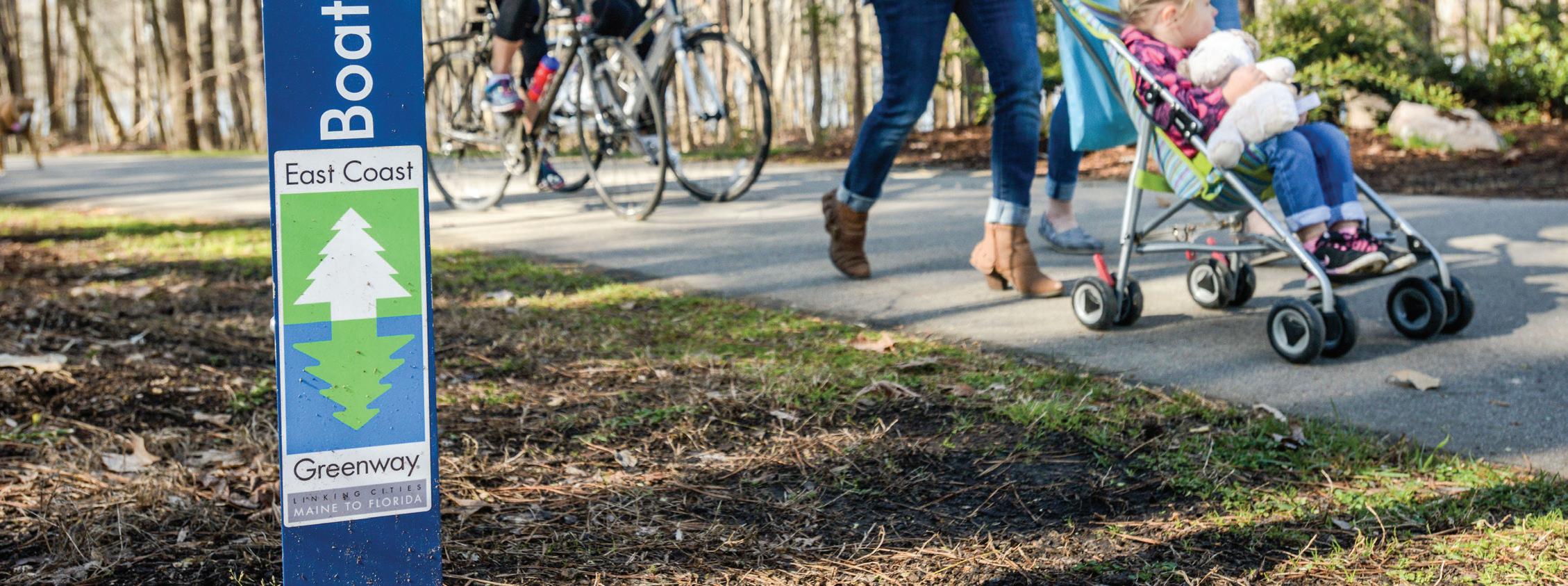
Photo courtesy of Laura Meeks East Coast Greenway near Clayton, NC
trails.nc.gov Table of Contents 1.0 Introduction 1 2.0 The Incredible Value of Trails 2 3.0 Trails and the COVID-19 Pandemic 3 4.0 State Trails and Complete the Trails Program 4 5.0 Actions for Great Trails in North Carolina 31 6.0 State Parks Partnership with Conservation Corps of NC (CCNC) 33 7.0 Recreational Trails Program (RTP) 34 T-1 Table: RTP Grant Awards 2022 .......................................................................................................................... 34 Appendices: State Trail 5-Year plans ........................................................................................................................................... 35
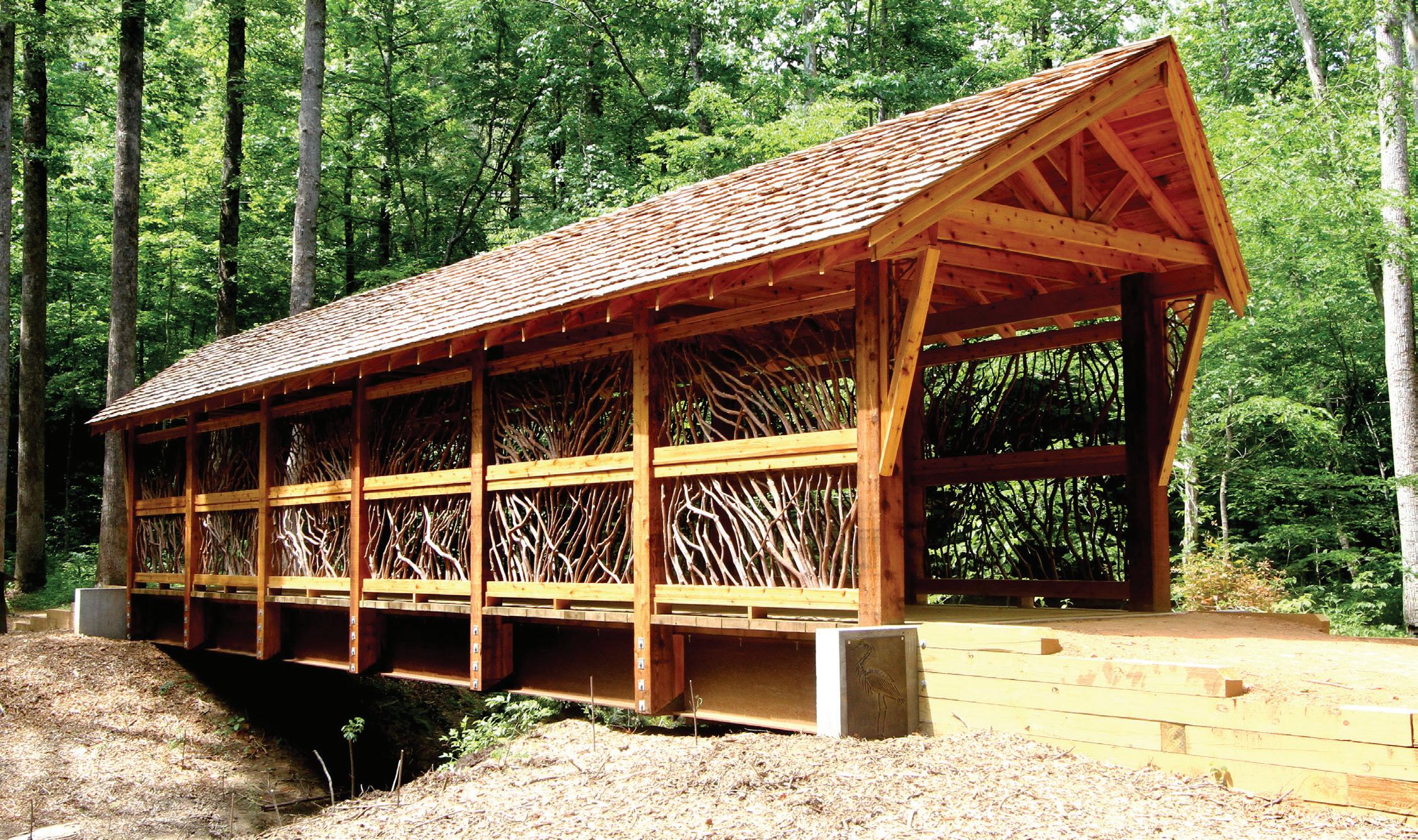
Bridge on the Fonta Flora State Trail
Each year, a trails report is submitted to outline trail needs, describe additions to the State Trails System and summarize the growing importance of trails across the state. This report is composed by the N.C. Trails Program for the Secretary of the Department of Natural and Cultural Resources (DNCR) in accordance with General Statute 143B-135.102.
The North Carolina Trails Program (Trails Program) originated in 1973 with the North Carolina Trails System Act and is dedicated to helping citizens, organizations and agencies plan, develop and manage all types of trails ranging from greenways and trails for hiking, biking and horseback riding to paddle trails and off-road vehicle trails.
The staff of the Trails Program works to enable volunteers, nonprofit organizations, and government agencies to develop trail plans, preserve land corridors for trails, and manage trails for all trail users. Trails Program staff provide technical assistance, administers federal Recreational Trails Program (RTP) grants, and develops successful partnerships with local conservation and recreation advocates, including town, city and county governments.
1 trails.nc.gov
North Carolina Trails Program Annual Report 2021-2022
Introduction 1.0
Cypress trees along the Roanoke River State Trail near Jamesville, NC
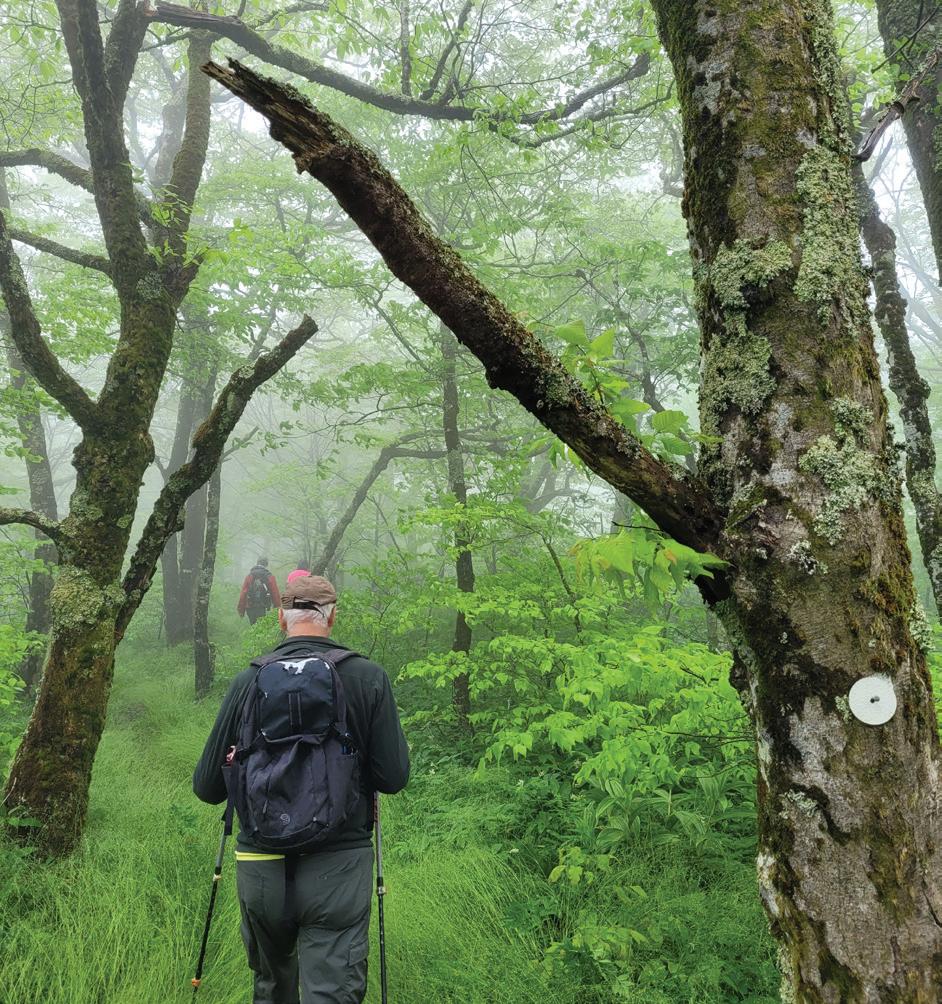
Glassmine Falls Overlook on the MST near Black Mountain, NC
The Incredible Value of Trails
� Trails Boost Local Economies
In North Carolina, regional and state trails directly contribute millions of dollars to local businesses including retail shops, hotels and restaurants as well as provide jobs for local residents. Recent research from the Institute for Transportation Research and Education (ITRE, 2018) has shown that the American Tobacco Trail (a 22-mile trail in the Triangle area) contributes $5.7M to the local economy annually, supports 78 jobs, and generates $2.2M annually in labor income.
The conservation- and recreation-based tourism industry preserves natural resources and increases the quality of life in a community. As its local textile industry floundered, Elkin, N.C. reinvented itself as a trail town — hosting both the Mountains-to-Sea and Yadkin River state trails. New trails-related businesses have rejuvenated the economy in and around the town. Elkin now hosts N.C. Trail Days, which in turn provides a boost to tourism and the local economy.
Regional trails have been shown to increase property values for homes located near the trail (ITRE, 2018). According to the National Association of Home Builders, trails are the most desired community amenity that homeowners seek when buying a home.
� Trails Preserve North Carolina’s Rural Landscape
In 1990, the population of North Carolina was 6.6 million; the U.S. Census from April, 2020 shows the population has reached approximately 10.5 million. Every new person that enters our state needs land for their home, school and workplace. We continue to lose open space to development as we accommodate our increasing population. At the same time, more and more people live and work in our cities and rarely experience the natural beauty of our state. Urban trails serve to preserve open space and are available to people from all walks of life.
� Trails Protect the Environment
Surface runoff from our roads and lawns is one of the leading causes of pollution in our drinking water. The rapid development of land exacerbates this problem by increasing impervious surfaces that are unable to trap and filter pollutants. Protected natural corridors for regional trails and greenways can filter pollutants from runoff. Protecting land, especially near our rivers and streams, is a voluntary, cost-effective way to make our drinking water sources cleaner and reduce the cost of water treatment.
Protected corridors also serve as “highways” of habitat for many wildlife species. This is increasingly essential as our landscape is fragmented through development. Those trails that are planned to function as alternative transportation corridors also serve to reduce vehicle emissions and decrease traffic congestion.
� Trails Promote Healthy Living
Hiking, biking, and walking are available to people from all economic levels and have been shown to combat diabetes, heart disease, hypertension and obesity. Hiking and walking are consistently ranked as a top recreational activity nationally. Where trails are available, people use them. One study has shown that for every dollar spent in trail development, $3 are saved in health care costs (American Heart Association, 2011). Another important benefit is the increase in quality of life for people who continue to seek more time in a natural environment.
North Carolina Trails Program Annual Report 2021-2022 2 trails.nc.gov
2.0
East Coast Greenway State Trail in Bond Park, Cary, NC
Trails and the COVID-19 Pandemic
New times, New Opportunities – Parks Improve Data Collection
Unprecedented. Strange times. Shifting norms. Phrases like these seemed to headline every article and conversation starter the past two years. This was certainly the case for our public lands and those who serve them. While public land use has been on a steady rise, our parks and trails became a source of refuge during the pandemic for those seeking safe recreation. Like in many sectors, the pandemic brought to light many opportunities despite challenging times. Observations on the increase and changing behaviors in trail use and park visitation were important, but our current data collection protocol was in need of modernization to shed light on current trends. Prior to the pandemic, parks used a combination of traffic and trail counters to monitor visitation figures. While they provided a good snapshot of estimated visitation, they lacked the ability to provide data in real-time and to show finer-tuned data trends. For example, the traffic counters were not able to distinguish the number of occupants in a vehicle — so one person visiting would be counted the same as a 15-passenger van. Additionally, data from these counters had to be retrieved manually, and in some of our busiest parks (and especially during the pandemic) staff had difficulties consistently accessing the data. This meant that data had to be generalized over the reporting period, and sometimes led to human error.
As part of the Parks and Trails for Health (PATH) Initiative, new trail counters were deployed across our State Parks to gain objective data on use trends and improve the current system. The new trail counters are solar powered and relay data via cell networks. This automation substantially improves accuracy and alleviates constraints of staff to manage the collection. The new counters collect data on individual use and refine use data down to the hour. Having the ability to visualize data trends on a finer scale will better inform management decisions, from staffing needs to optimal programming times. It could even serve to inform visitors of slower times, which could improve dispersal of visitation. There are some limitations to the new system, which like many pandemic-borne solutions are an experiment in progress. Some of our most remote parks have limited cellular connectivity, and we are seeking solutions with new providers to automate these counters as well. These parks still have to manually retrieve data, but the counters are still able to parse data down to hourly trends.
Parks have seen a small decrease in visitation in the waning months of the pandemic, likely as other options for recreation, exercise and social gathering have increased. However, the overall trend in visitation is likely to continue to rise. Embracing modern technology to predict and manage visitation will make for a more efficient park system and a better experience for our park users.
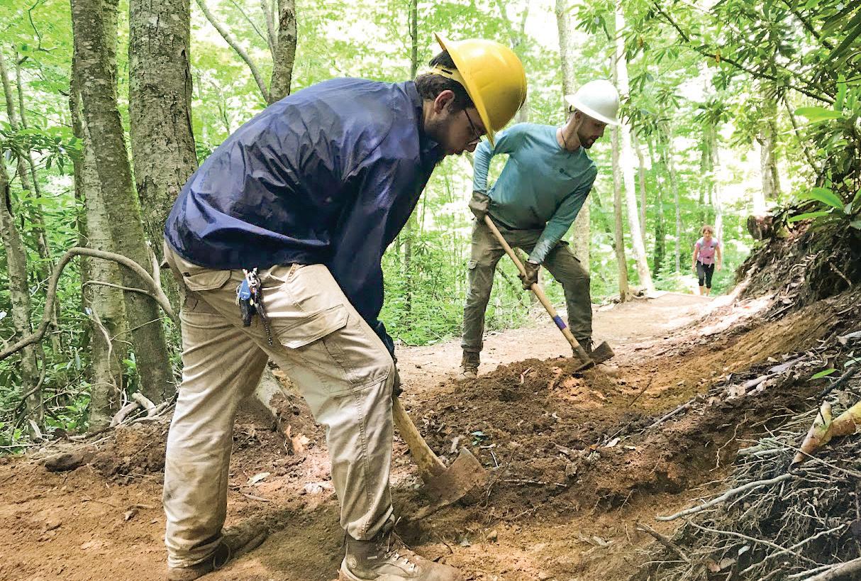
Increased use highlighted the need to maintain and improve the existing trail system while identifying options to expand a system that is near capacity. In addition to routine maintenance practiced by park staff, the Division partnered with the Conservation Corps of North Carolina (CCNC) to tackle some extensive trail maintenance needs on the Profile Trail (pictured above).
The N.C. Trails Program is actively pursuing a long-term strategy to redesign each state park trail system into a sustainable trail system that is more resilient and cost-effective to manage to handle ever-increasing demand on these recreational resources. The N.C. Trails staff completed design for a new sustainable trail system for Morrow Mountain State Park and began construction this year. These trails will be designed to better handle normal wear and tear due to weather while withstanding the impacts that come with the heavier visitation we are certain to continue to see in the coming years.
North Carolina Trails Program Annual Report 2021-2022 3 trails.nc.gov
3.0
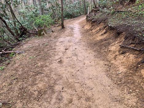
Widened and compacted trail tread on Profile Trail, Grandfather Mountain State Park
Reworking the trail tread on Profile Trail at Grandfather Mountain State Park
State Trails and the Complete the Trail Program
State Trails for the Annual Report
North Carolina’s twelve state trails are essential components to her identity as the Great Trails State. Authorized by the General Assembly, each state trail is a unit of the North Carolina State Parks system. However, unlike the more traditional state parks, the state trails are not owned, managed, or maintained by the N.C. Division of Parks and Recreation (Division), unless the trail segment is located within a state park. Instead, the state trails are accomplished through dedicated partnerships.
Complete the Trail Program
The Complete the Trail Program (CTP) that was introduced and funded in the 2021 North Carolina budget has greatly strengthened these partnerships. The result is transformational for our state trails, both because of the funding and for the focus on partnership. The legislation directed that the funding provided for state trails be administered by the Department of Natural and Cultural Resources (DNCR) for the planning, construction, promotion, and maintenance of the twelve existing state trails. The funds will be distributed, where practicable, through identified state trail partners. These Partners will be granted capacity building funds through the CTP which will allow them to truly focus on developing their state trail.
These Partners, all nonprofits, have signed a Memorandum of Understanding (MOU) with DNCR. This MOU formalizes the collaboration and cooperation between the Division and the partner organizations. One of the requirements of the MOU is that each Partner develop a 5 Year Plan for their state trail. Each Partner has developed and submitted this plan. The plans outline how the Partner plans to spend the funds allocated for their trail; how the capacity building funds will be used; anticipated partnerships; and planned events for the upcoming Year of the Trail. The plans outline needed projects in each section of the state trail and further delineates which of those projects are priorities. It is acknowledged that priorities can and will shift depending on when new opportunities arise. The expectation is that most of the priority projects will be started within 5 years. How each Partner plans to use their capacity building funds; their top priority CTP projects; and planned events for the Year of the Trail are summarized below in the section on each state trail. Each of the 5 Year Plans is included as an appendix to this report.
Each Partner meets individually each month with the State Trails Planner to share updates and brainstorm solutions to evolving issues. Additionally, the Division hosted all the Partners for a two-day workshop at Haw River State Park in March. The workshop addressed requirements and opportunities presented by the Complete the Trail Program. A follow-up workshop for the Partners is planned for October 2022 at Pilot Mountain State Park.
Dan River State Trail (DNST) Dan River Basin Association 2021 90 0 $507,375
Deep River State Trail (DRST) Piedmont Land Conservancy 2007 Land: 125 Paddle: 125 Land: 5 Paddle: 0 Land: $860,828 Paddle: $0
East Coast Greenway State Trail (EGST) East Coast Greenway Alliance 2021 795 102 $4,971,282
Fonta Flora State Trail (FFST) Friends of Fonta Flora State Trail 2015 100 30 $502,150
French Broad State Trail (FBST) MountainTrue 1978 117 0 $210,375
Hickory Nut Gorge State Trail (HGST) Conserving Carolina 2017 50 0 $358,678
Mountains-to-Sea State Trail (MST) Friends of the Mountains-to-Sea Trail 2000 1,400 691 $5,086,059
Northern Peaks State Trail (NPST) Blue Ridge Conservancy 2019 40 0 $286,943
Overmountain Victory State Trail (OVST) OVNCST-Friends 2019 225 0 $1,614,053
Roanoke River State Trail (RRST) Roanoke River Partners 2021 132 0 $507,375
Wilderness Gateway State Trail (WGST) Foothills Conservancy of N.C. 2019 170 0 $1,219,506
Yadkin River State Trail (YRST) Yadkin Riverkeeper 1985 162 0 $210,375
4 trails.nc.gov
North Carolina Trails Program Annual Report 2021-2022
4.0
Year Authorized Planned Miles Designated Miles (10/01/2022)
State Trail Partner
Allocated CTP Funds
4.0 State Trails
The summary of the status of each state trail includes what each Partner has done this year for their state trail. It is important to note that these contributions all came before the capacity building funds were distributed. Most of the Partners have chosen to invest their capacity building funds into additional staffing. This will significantly increase the planning and development of the state trails. However, the capacity funds will only extend through 2023. Recurring capacity funding would do much to enable Partners to continue their focus on their state trail. To receive the initial capacity building funds of $49,500, each Partner had to have an accepted 5 Year Plan; signed MOU; submitted required documentation to qualify to contract with North Carolina; and an executed contract. Capacity building funds were distributed in September 2022.
State Trail Authorizations
The Roanoke River State Trail was authorized by the General Assembly in November 2021. Extending from Roanoke Rapids to the Albemarle Sound, this paddle trail offers a unique wilderness experience to all who venture along its length. While there are some opportunities for day trips on each end of the river, most paddlers need to be prepared for a multiday journey on this state trail. Bear, beaver, river otter, white-tailed deer, bobcat, and over 200 bird species can be observed along the river. Overhead are ancient bald cypress and tupelo trees. Riverside camping platforms make spending the night along the river a true adventure. The Roanoke River Partners are the Partner for this state trail. This authorization follows the authorization of both the East Coast Greenway State Trail and the Dan River State Trail in June 2021, which were noted in last year’s annual report.
Trail Designations
As trail segments are constructed on land-based trails and paddle accesses are developed on blueways (paddle trails), they are not part of the state trail until they are officially designated by the Secretary of the Department of Natural and Cultural Resources (DNCR). This process includes submitting an application by the land manager to the state trails planner, evaluation by Division staff, a site visit, and a formal recommendation by the North Carolina Trails Committee. In 2021, 124.59 miles of trail were designated as part of a state trail. The East Coast Greenway State Trail, newly authorized in 2021, designated 102.24 miles of existing greenway that is already part of the national East Coast Greenway. The Fonta Flora State Trail designated an additional 11.7 miles of trail around Lake James. The Mountains-to-Sea State Trail added 10.65 miles of trail, primarily in Surry County. Increasing designations in the coming years is another expectation because of the strengthened partnerships resulting from the CTP.
The Division created a designation application for access sites on the state trails which are blueways or paddle trails. While the river serves as the trail for the trail users, they must access the river through safe, public access sites. These applications will be reviewed by the North Carolina Trails Committee and final approval granted by the Secretary of DNCR, just as with the land-based trail designation applications. At the time of this report, no paddle accesses have been designated. Once paddle accesses are designated, the mileage between the designated accesses will be recognized as the designated mileage on the paddle trail, presuming that it is a reasonable paddle between adjacent, designated sites.
Partnership with NCDOT
State trails were instrumental in the Great Trails State Plan released by N.C. Department of Transportation (NCDOT) this year. The Division worked closely with NCDOT in their planning effort. The Division continues to partner with NCDOT to provide pedestrian access on bridge replacement projects along state trail routes. The Division is beginning a conversation with NCDOT to provide signage on bridges over rivers that serve as paddle trails. This signage will be essential to increase safety and information along paddle trail routes.
Branding and Promotion
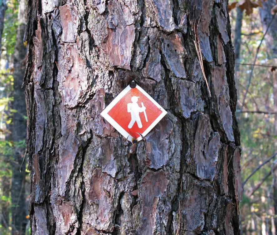
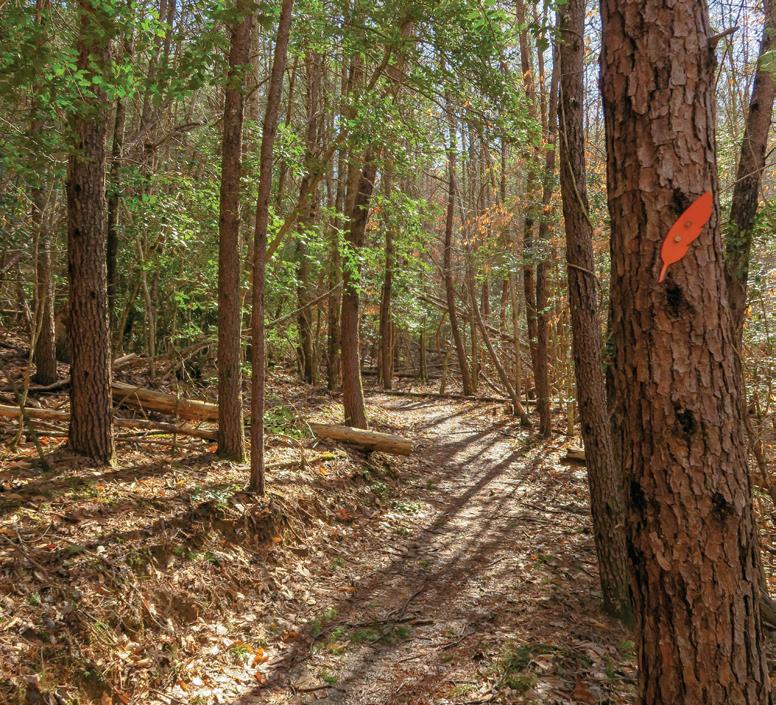
The Division has worked hard to develop consistent branding and promotion for all the state trails. These efforts resulted in an original design for a blaze for each state trail. While blazes are primarily used to mark a trail’s path through the woods, these designs will also be incorporated into trailhead signage, mapping, and safety signage for paddle trails. Each of the designs incorporated input from the Partner organization. They are included in the following section that outlines the status of each state trail. Additionally, the trails website that is hosted by the Division bolstered the content relating to state trails throughout the year. The Division is currently developing a licensing agreement to enable Partners to use the blaze designs on merchandise and other promotional materials.
North Carolina Trails Program Annual Report 2021-2022
5
trails.nc.gov
4.0 State Trails
DanRiver State Trail
Dan River State Trail (DNST)
The Dan River crosses the North Carolina and Virginia border eight times on its 214-mile journey from the Blue Ridge Mountains to Kerr Lake. Ninety miles of the river that are in North Carolina were authorized as a state trail in 2021. The Dan River Basin Association (DRBA) is the Partner for the DNST. This trail will be a blueway or paddle trail, requiring public accesses every 5 to10 miles.
trails nc.gov
EXCERPTS FROM DRBA’S 5 YEAR PLAN
Capacity
Building Fund Projects:
Staff support
Hire part-time DNST assistant
Purchase ESRI (geographic information system) materials
Purchase fieldwork tools and supplies
Update website
Conduct river safety information sessions
Develop promotional information, volunteer recognition and events
Priority CTP Projects:
Master Plan for DNST
Renovate and designate current public accesses
Create signage plan for Stokes County
Land acquisition
Settles Bridge Access permanent easement and/or purchase
Priority accesses identified on Master Plan completed
Estimated cost for all priority projects = $430,000
Estimated cost for all projects = $665,000 CTP allocation = $507,375
Planned
Year of the Trail Celebrations:
Every First Saturday Outing Hike will have a Year of the Trail focus
Creation of the Dan River Master Plan/Beyond Pathways Rivers and Trails Master Plan
Paddle the Dan Challenge
Kayak giveaway
Life jacket giveaways
2022 Accomplishments:
DRBA designed and constructed improvements to Settle Bridge Access: New metal steps and additional improvements to trail to the access
DRBA designed and installed new river access signage in Rockingham County: Includes further safety information and new river accesses
Eden Game Lands Access in Rockingham County: A new canoe/kayak launch was constructed by N.C. Wildlife Resources Commission
New Pitzer Road River Access in Stokes County was constructed by N.C. Wildlife and will be managed by Stokes County
Preliminary engineering drawings for an emergency boat ramp access at Draper Landing were developed by N.C. Wildlife Resources Commission
DRBA designed and installed new dam safety signage at river accesses and portages: Duke Power dam, Leaksville Wildlife Access, and on all new river access signs
DRBA designed Eden safety signage explaining top river safety tips and strainers at Klyce Street Access, Leaksville Landing, Island Ford Landing, and Leaksville Wildlife Access
Jacobs Creek Batteau Landing: DRBA constructed new river access and accessible parking
Rockingham County Blueway Guide: provided consultation and fieldwork
DRBA Summer Safety Summit: held to discuss additional improvements and new safety protocols for rescue teams
DRBA designed new cautionary dam signage on bridges approaching dams on the Dan and other tributaries
North Carolina Trails Program Annual Report 2021-2022
6
trails.nc.gov
�
�
�
�
�
�
�
�
�
�
�
�
�
�
�
�
�
�
�
�
�
�
�
�
�
�
�
�
�
State Trails – Dan River State Trail
Working on Rockingham County Rivers & Trails Outdoor Recreation Master Plan – Year 2 � Dan River Corridor Study: Working in partnership with PTRC, DRBA is studying land use, water quality and assess riparian buffer. Funding provided by N.C. Land and Water. � Madison River Park, Phase 2 discussion for improvements to park � River Clean up events: Rockingham � DRBA partnering with Soil and Water for removal of debris/strainers from Dan River and tributaries � DRBA hired a consultant to help make DRBA river programs more accessible to people with disabilities � Advisory Boards and Stakeholder Groups DRBA works with in the Dan River Basin:
› Dan River Conservation Design
› Mayo River State Park Advisory Council
› Eden Rivers and Trails Advisory Council
› Rockingham County Parks & Recreation Advisory Board
› Outdoor Recreation Advisory Council
Chatham
Collinsville Martinsville
PITTSYLVANIA COUNTY
PATRICK COUNTY
HENRY COUNTY
Mayo River State Park
STOKES COUNTY
Hanging Rock State Park ROCKINGHAM COUNTY
DAN RIVER
DANRIVER STATE TRAIL
Wentworth
Danville
CASWELL COUNTY
Kibler Stuart Milton Roxboro Reidsville Madison Mayodan Stoneville
HALIFAX COUNTY
VIRGINIA
NORTH CAROLINA
Yanceyville
Halifax South Boston Montreat Danbury
PERSON COUNTY
FORSYTH COUNTY GUILFORD COUNTY ORANGE COUNTY
ALAMANCE COUNTY
7 trails.nc.gov
DanRiver State Trail trails
gov
North Carolina Trails Program Annual Report 2021-2022
4.0
nc
�
Planned Trail State Park County Line City State Line Water LEGEND
DanRiver State Trail www danriver org
4.0 State Trails
DeepRiver State Trail
trails nc.gov
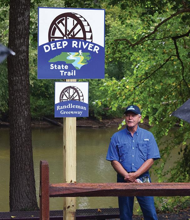
Deep River State Trail (DRST)
The Deep River State Trail was originally authorized in 2007 as the only land and water state trail. The hiking/biking and paddle trails will each be approximately 125 miles long. The trail starts near Jamestown in Guilford County, continues through Randolph and Moore Counties,forms the border between Lee and Chatham Counties and ends at the confluence with the Haw River at Mermaid Point — where the rivers form the Cape Fear River. Piedmont Land Conservancy (PLC) is the Partner for the DRST. Randolph County has led development efforts with significant progress with development, branding and promotion through the local Tourism Development Authority (TDA). This year, for the first time, there was coordination among all the jurisdictions along the entire trail to complete of the 5 Year Plan and the Master Plan.
EXCERPTS FROM PLC’S 5 YEAR PLAN
Capacity Building Fund Projects:
Trail Coordinator position
Mapping
Project Coordination
Priority CTP Projects:
Complete the trail from Franklinville to Sapona
Complete the trail from Sapona to N.C. Textile Museum including water access for the blueway
Estimated cost for all priority projects = $1,000,000+
Estimated cost for all projects = $1,000,000+ CTP allocation = $860,828
Planned Year of the Trail Celebrations:
Ribbon cutting:
› Franklinville to Sapona
› Ramseur trail extension, trailhead, and portage
› Worthville to Central Falls paddle trail
› Randleman Phase III -Worthville to Randleman
› River access at US 421
› River access at US 15/501
Trail Events:
› Lead a paddle using four existing river accesses in Lee/Chatham Counties
› Hike along the new 1.2 mile High Point Greenway segment at Hickswood and Penny Roads
2022 Accomplishments:
Piedmont Land Conservancy (PLC) signed an MOU with DNCR to serve as the Partner for the DRST. PLC completed the 5 Year Plan and contributed significantly to the master plan. � Established DRST Steering Committee which includes representatives from Randolph, Moore, Chatham and Lee Counties, Piedmont Triad Regional Water Authority, and High Point � Randolph County Board of County Commissioners allocated $1 million for the DRST in Randolph County. � Projects were funded to construct a major bridge over Sandy Creek that will connect segments of trail in Ramseur and Franklinville; river accesses in Asheboro and Randleman; and trailhead and trail construction in Randleman. � Land and permanent easements were acquired in Randolph County to extend the land trail and provide land for a portage on the paddle trail. � River accesses at both US-421 and US-15/501 bridges in Lee and Chatham Counties have received funding from the N.C. Wildlife Resources Commission and N.C. Division of Parks and Recreation. The one at US-15/501 is set for construction in September 2022. � $1,956,000 in funds from grants, volunteer contributions and budget allocations have been leveraged to advance the DRST — before accessing any CTP funds.
North Carolina Trails Program Annual Report 2021-2022
8
trails.nc.gov
�
�
�
�
�
�
�
�
North Carolina Trails Program Annual Report 2021-2022 9 trails.nc.gov 4.0 State Trails - Deep River State
DeepRiver State Trail trails nc gov
64 64 421 85 40 421 64 CHATHAM
ALAMANCE
ORANGE
DURHAM
WAKE
LEE
GUILFORD
Greensboro
LEGEND
STATE
DeepRiver
trails nc gov
Trail
DRST dedication with Randleman mayor, Bucky Jernigan in Randleman, NC
COUNTY
COUNTY
COUNTY
COUNTY
COUNTY HARNETT COUNTY
COUNTY RANDOLPH COUNTY MOORE COUNTY MONTGOMERY COUNTY
COUNTY Pittsboro Goldston Sanford Broadway Seagrove Robbins Swepsonville Durham Alamance Pleasant Garden
Archdale High Point Jamestown Trinity Randleman Franklinville Ramseur Staley Liberty Jordan Lake State Recreation Area Planned Trail County Line City State Park Water
DEEPRIVER
TR A I L
State Trail
4.0 State Trails
Greenway
East Coast
StateTrail
East Coast Greenway State Trail (EGST)
The East Coast Greenway State Trail is the North Carolina portion of a 3,000-mile greenway planned from Maine to Florida. In North Carolina, the EGST will be 795 miles long and shaped like a large “V”, with one arm passing through Raleigh, Durham, and Fayetteville and the coastal section connecting Greenville and Jacksonville. The segments will meet in Wilmington. The East Coast Greenway Alliance (ECGA) is the Partner for the EGST.
trails nc.gov
EXCERPTS FROM ECGA’S 5 YEAR PLAN
Capacity Building Fund Projects:
Staff time
Travel and meetings
Priority CTP Projects:
Planning and feasibility studies
Neuse River Trail, Phase 2
Kure Beach Island Greenway
Pine Knoll Shores/Bogue Banks Path
Dismal Swamp Canal Trail extension
Estimated cost for all priority projects = $5,000,000
Estimated cost for all projects = $933,000,000 CTP allocation = $4,971,282
Planned Year of the Trail Celebrations:
ECGA will co-host five events with local communities along the North Carolina East Coast Greenway State Trail in 2023, N.C.’s Year of the Trail.
ECGA will develop press releases along with professional video and photo content to highlight the progress of the Complete the Trails Program.
ECGA will plan celebration events in partnership with State Parks to keep momentum and support going forward.
Coordinate with the relevant legislators in the districts where the projects are happening so keep them informed and involved
ECGA will keep a record of all media coverage and communications details will be shared and coordinated with State Parks.
2022 Accomplishments:
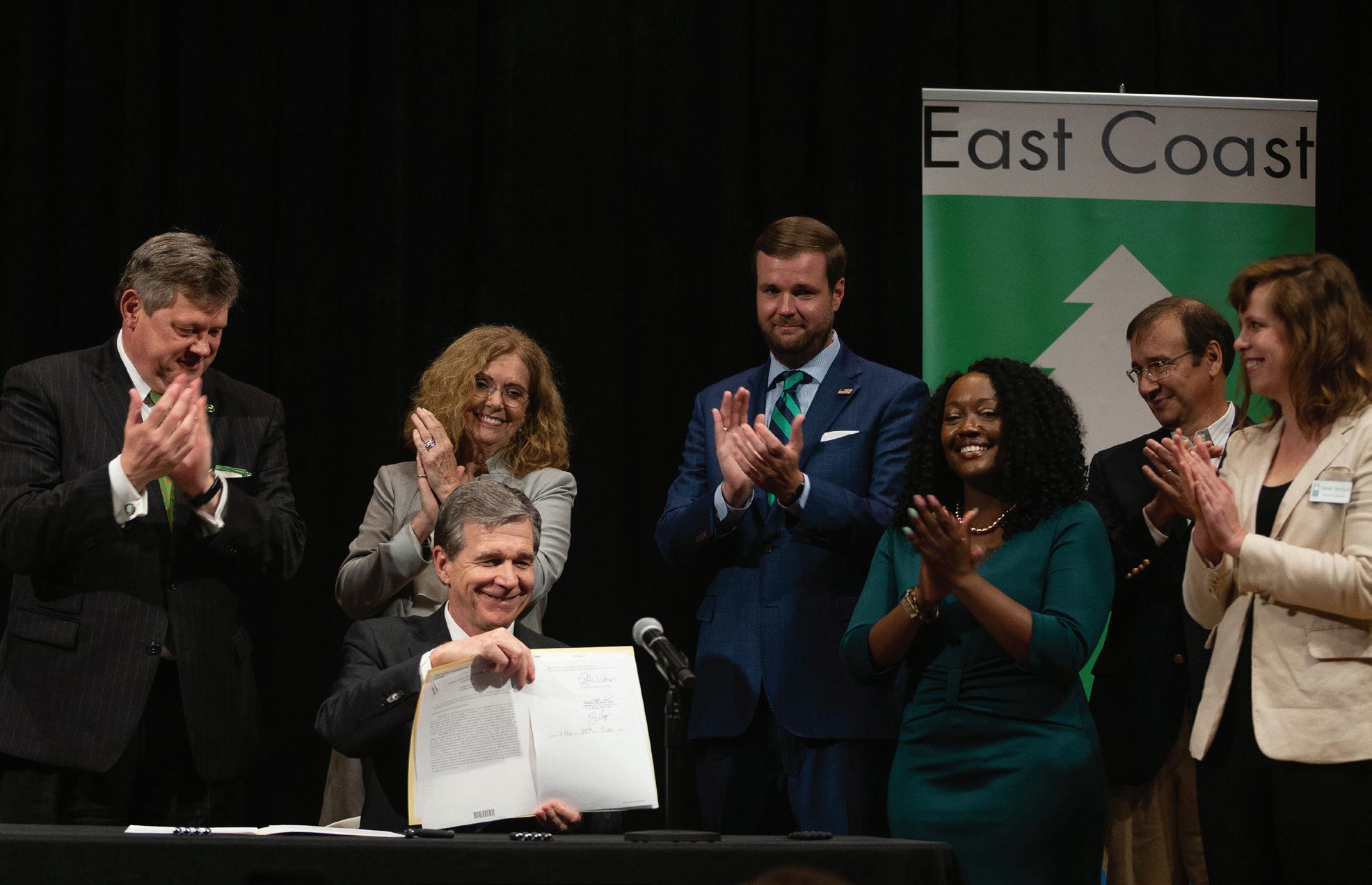
Designated as a State Trail: Passage of House Bill 130 (Session Law 2021-54) adds the East Coast Greenway to the State Parks System
Special bill signing event with Governor Cooper held at the N.C. Museum of Art
102 miles of the East Coast Greenway State Trail designated by N.C. Division of Parks and Recreation
Hundreds of miles of East Coast Greenway wayfinding signage installed along the current travel route making the route almost entirely signed
Completion of new East Coast Greenway State Trail segments: › The Gorman Street Connector in Raleigh › Sam’s Branch Greenway extension in Clayton › The Lejeune Rails-to-Trail Greenway in Jacksonville › Cape Fear River Trail extension in Fayetteville
The City of Durham was awarded a $9 million RAISE grant for the construction of the Durham Belt Line Trail, part of which will be part of the EGST
Participation in feasibility studies to collaboratively develop the foundational understanding of East Coast Greenway State Trail corridors including:
› Neuse River Trail extension segment from Clayton to Smithfield in Johnston County › Segment from Butner to Oxford in Granville County › NC-210 segment from Hampstead to Topsail Island/Surf City in Pender County
North Carolina East Coast Greenway State Trail 5-Year Plan draft was accepted by N.C. Division of Parks and Recreation
ECGA supported the submission of two federal RAISE grant applications:
› For planning and design of a complete streets corridor in Elizabeth City, Pasquotank County, onto which the ECG would re-route which was awarded
North Carolina Trails Program Annual Report 2021-2022
10
trails.nc.gov
�
�
�
�
�
�
�
�
�
�
�
�
�
�
�
�
�
�
�
�
�
4.0 State Trails - East Coast Greenway State Trail
› For planning and design of the segment from Oxford, Granville County to the VA state line in Kerr-Tar RPO territory, which was not awarded � ECGA submitted a Letter of Support for a SP&R grant application submitted by the Greenville MPO and Mideast RPO for a feasibility study between Greenville and Washington along the ECG Coastal route in Pitt and Beaufort Counties, which was awarded and will commence in Fall 2022 � Greenville East Coast Greenway dedication ceremony took place April 9, 2021 (attended by local staff, local elected officials, State legislators, representatives from Congressional Senators’ offices, and strong media attendance) � Municipalities have officially adopted plans that include the East Coast Greenway State Trail, including:
› Kure Beach Town Council adopts Kure Beach Bicycle and Pedestrian Plan, which includes the Island Greenway extension, along which the East Coast Greenway State Trail would route when developed
› The Town of Southport adopted the NC-211 feasibility study, as presented by the Cape Fear RPO � ECGA served on host committee for 2021 BikeWalkNC conference held in Durham � ECGA will continue to work collaboratively with municipalities, planning organizations, and partners across the state to advance the development of the East Coast Greenway State Trail
North Carolina Trails Program Annual Report 2021-2022 11 trails.nc.gov
East Coast Greenway StateTrail trails nc gov
Authorization of East Coast Greenway as a State Trail
North Carolina Trails Program Annual Report 2021-2022 12 trails.nc.gov 4.0 State Trails - East Coast Greenway State Trail East Coast Greenway StateTrail trails nc gov Fayetteville Durham Raleigh New Bern Jacksonville Greenville Elizabeth City Wilmington Planned Trail Existing Trail County Line City State Line Water LEGEND NORTH CAROLINA VIRGINIA EAST COAST GREENWAY STATE TRAIL SNORTHCAROLINA OUTHCAROLINA East Coast Greenway StateTrail trails nc.gov EAST COAST GREENWAY STATE TRAIL
4.0 State Trails
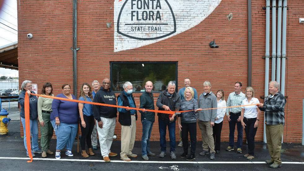
Fonta Flora State Trail
trails nc.gov
Fonta Flora State Trail (FFST)
Authorized in 2015, the Fonta Flora State Trail will connect Morganton to Asheville with a hiking and biking trail. Included in the trail is a loop around Lake James. The trail will traverse Lake James State Park, part of Pisgah National Forest and Fonta Flora County Park in Burke County. It will also connect to the Overmountain Victory National Historic Trail and the Mountains-to-Sea State Trail.
It is named after the local settlement of African American sharecroppers, whose homes were flooded when the Catawba River was dammed to create Lake James. The feather icon of this state trail was inspired by our national bird, the bald eagle. Artwork incorporating the feather has been used along the trail and at the trailheads, particularly in Burke County. When it is complete, the Fonta Flora State Trail will be approximately 100 miles long. The Friends of Fonta Flora State Trail (F3ST) is the Partner for the FFST.
EXCERPTS FROM F3ST’S 5 YEAR PLAN
Capacity Building Fund Projects:
� F3ST will use their capacity-building funds to pay approximately 40% of the salary of a full-time Executive Director over FY 22–23 and FY 23–24. It is only through the support of their members and local municipalities that they can complete this full-time position funding.
Priority CTP Projects:
Canal Bridge Project: 0.2 miles (Partnership with OVNCST-Friends) � Commerce Street to Copper Ridge Trailhead: 1.27 miles (Partner with FCNC for Easements and Acquisition) (Dogwood Health Trust Feasibility Study) �
Copper Ridge to Point Lookout: 0.65 mile (Partnership with USFS) (Dogwood Health Trust Feasibility Study) �
River Ridge Complex Project: 1.29 miles (Partnership with Asheville Unpaved and City of Asheville) � 1780/Enclave: 2.2 miles (Partnership with OVNCST-Friends)
Estimated cost for all priority projects = $700,000
Estimated cost for all projects = $2,700,000
CTP allocation = $502,150
Planned Year of the Trail Celebrations:
Canal Bridge Grand Opening – September 2023
River Ridge Complex (All Phases) – Spring 2023
Year of the Trail “Long Haul” Membership Campaign – Membership campaign to help maximize trail on the ground funds in 2023Year of the Trail Photo Contest 100 Mile Challenge (F3ST Version) – a continuation of our challenge from the past two years. History of Fonta Flora Hike-and-Learn
2022 Accomplishments:
Dogwood Health Trust Feasibility Study Grant – $90,000
PARTF Grant for Old Fort Trailhead – $660,000
F3ST received ARC Ready Nonprofits Cohort program for Fall 2022
F3ST received WNC Bridge Foundation NOW Grant for website redesign and map inclusion
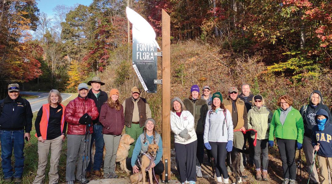
Copper Ridge Trail Segment – Funded, built, and designated 3-mile-long natural surface trail in Old Fort
F3ST created and implemented Style Guide and Brand Plan for F3ST, including new logo and print materials
F3ST raised over $70K in membership dues and support from local governments for F3ST
F3ST created the Complete the Trail 5-Year Plan and associated paperwork
F3ST created and hosted a Regional Trails Group for the Burke, McDowell, and Buncombe counties
F3ST created an Equity Committee for the Board of Directors and initiated strategic plan
F3ST planned for Point Lookout maintenance and new wayside interpretation with USFS and McDowell Trails Association
F3ST created FFST GIS Route Map (Beta Version) with help from the City of Marion’s Heather Cotton.
Engineering and co-location for Canal Bridge planning with Burke County, Overmountain Victory Trail and Lake James State Park
Mi Camina Familia event in partnership with Centro Unido Latino Americanos (CULA) – over 50 community members participated.
North Carolina Trails Program Annual Report 2021-2022
13
trails.nc.gov
�
�
�
�
�
�
�
�
�
�
�
�
�
�
�
�
�
�
F3ST hosted three Hike and Learns: › Asheville – Wilma Dykeman › Old Fort – Copper Ridge › Old Fort – Vida Activa - CULA
F3ST participated in: › Trains and Trails Festival, Old Fort › DivirsiTrails – bilingual interpretation on parts of the trail › Old Fort Hosiery Mural honoring FFST › McDowell County Trail Plan
F3ST maintained relationships with Burke, McDowell, and Black Mountain Chambers of Commerce
North Carolina Trails Program Annual Report 2021-2022 14 trails.nc.gov 4.0
Fonta Flora State Trail trails nc gov �
State Trails - Fonta Flora State Trail
�
�
Ribbon cutting for Copper Ridge Trail segment of FFST in Old Fort Hike on the FFST in Old Fort 74 40 40 40 M c DOWELL
BURKE
RUTHERFORD
YANCEY
MITCHELL
MADISON
BUNCOMBE
Lake
Old
Glen
Montreat Black
Asheville Weaverville 0 5 10 Mile s Existing Trail Planned Trail County Line City State Park Water LEGEND
State
ncparks gov
COUNTY
COUNTY
COUNTY
COUNTY
COUNTY
COUNTY
COUNTY
James State Park
Fort Marion
Alpine Morganton
Mountain
FONTA FLORA STATETRAIL Fonta Flora
Trail
State Trails
FrenchBroad
River
StateTrail
French Broad River State Trail (FBST)
The French Broad River State Trail was established in 1978 on the third oldest river in the world. The 117-mile blueway flows north from Rosman, N.C. to the Tennessee border, through Buncombe (including Asheville), Henderson, Madison and Transylvania counties. MountainTrue is the Partner for the FBST.
trails nc.gov
EXCERPTS FROM MOUNTAINTRUE’S 5 YEAR PLAN
Capacity Building Fund Projects:
Hire paddle trail recreation manager to oversee the implementation of the state funds, as well as organize and coordinate all aspects of managing the paddle trail. This will include coordinating with partners, business and marketing planning, reservation system coordination, upkeep on access points and campsites, paddle trail guidebook management, and website upgrades.
Priority CTP Projects:
Implement river access signage
Complete improvements to five campsites
Implement Transylvania County new river access (leverage funds from Transylvania County tourism development authority, Conserving Carolina, and NC Wildlife Resources)
Clear Mud Creek of debris jams and work on signage and new river access points
Complete improvements to Stackhouse access
Estimated cost for all priority projects = $177,000
Estimated cost for all projects = $342,000
CTP allocation = $210,375
Planned Year of the Trail Celebrations:
Host a public paddle to highlight paddle trail improvements in Transylvania County
Host an overnight guided trip to highlight and discuss history and evolution of the paddle trail
Host a forum and paddle in Madison County with river managers and water quality experts to discuss next current management, future challenges, and next steps
Submit press release and social media highlighting the paddle trail improvements
2022 Accomplishments:
MountainTrue spent the spring prepping all our campsites for the season. Mowed, repaired compost toilets, repaired picnic tables, cleaned and repaired access steps.
MountainTrue began work on updating our paddle trail waterproof map
MountainTrue cleared several debris jams
MountainTrue partnered with a paddle trail landowner to expand the number of campsites available
MountainTrue hired a paddle trail intern
MountainTrue built and installed new compost toilets at three campsites
MountainTrue wrote and posted job description for new paddle trail position and began interviewing applicants
North Carolina
15 trails.nc.gov 4.0
Trails Program Annual Report 2021-2022
�
�
�
�
�
�
�
�
�
�
�
�
�
�
�
�
�
Gorges State Park
North Carolina Trails Program Annual Report 2021-2022 16 trails.nc.gov 4.0 State Trails - French Broad River State Trail FrenchBroad River StateTrail trails nc gov 40 40 40 26 26
Lake
HENDERSON
LEGEND 0 5 10 15 20 Mi le s FRENCHBROAD R I V E R ETATS T RA I L
FrenchBroad
Black Mountain
Lure Hendersonville Brevard Rosman Waynesville Asheville Weaverville Marshall Mars Hill Hot Springs HAYWOOD COUNTY MADISON COUNTY YANCEY COUNTY BUNCOMBE COUNTY
COUNTY TRANSYLVANIA COUNTY JACKSON COUNTY Trail County Line City State Park Water
River StateTrail ncparks.gov
State Trails
Gorge
HickoryNut
StateTrail
Hickory Nut Gorge State Trail (HGST)
The Hickory Nut Gorge State Trail will connect with the Wilderness Gateway Trail near Buffalo Creek Park, and will meander through Rutherford, Henderson, and Buncombe Counties and connect to Chimney Rock State Park, Conserving Carolina’s Upper Hickory Nut Gorge trails, and Town of Lake Lure’s Buffalo Creek Park. Conserving Carolina is the Partner for the HGST.
trails nc.gov
EXCERPTS FROM CONSERVING CAROLINA’S 5 YEAR PLAN
Capacity Building Fund Projects:
Paid staff time to support Hickory Nut Gorge State Trail development during 2022 and 2023.
Deliverables include trail and trailhead maintenance and management, state trail designation application development, grant management and landowner outreach.
Priority CTP Projects:
Purchase Youngs Mountain trailhead parcels and trail easements
Construct 1.5-mile trail on Youngs Mountain, including signage and blazing
Construct new Youngs Mountain trailhead
Acquire additional tracts for Youngs Mountain Trail
Construct 2-mile trail on Youngs Mountain Phase 3 to connect to Buffalo Creek Park/Weed Patch Mountain Trailhead
Estimated cost for all priority projects = $1,000,000
Estimated cost for all projects = $1,600,000
CTP allocation = $358,678
Planned Year of the Trail Celebrations:
Youngs Mountain Phase 2 Ribbon Cutting and Opening
Complete designations for all existing HGST trail miles to include promotion in media and online announcement/ celebration
2022 Accomplishments:
Conserving Carolina signed MOU with State Parks
Completed Five Year Plan
95% completion of 3.0-mile of Strawberry Gap Trail segment of HGST
Maintenance of 25 miles of HGST State Trail
Received grants for trail development from Henderson County Tourism Development Authority, Community Foundation of Henderson County, McClure Family Foundation, and Pave the Way Fernandez Foundation
Professional reconstruction of 30 step rock staircase on immensely popular Bearwallow Mountain Trail
2,100+ volunteer hours from Conserving Carolina’s Rock Crushers Trail Crew
North Carolina Trails Program Annual Report 2021-2022
17 trails.nc.gov
4.0
�
�
�
�
�
�
�
�
�
�
�
�
�
�
�
�
State Trails - Hickory Nut Gorge State Trail
HICKORY
NUT GORGE STATE TR LIA
North Carolina Trails Program Annual Report 2021-2022 18 trails.nc.gov 4.0
HickoryNut Gorge StateTrail trails nc gov 64 74
0 2 4 Mile s
Chimney Rock Village Lake Lure RUTHERFORD COUNTY POLK COUNTY HENDERSON COUNTY BUNCOMBE COUNTY M C DOWELL COUNTY Fletcher
Chimney Rock State Park County Line City State Park Water LEGEND Planned Trail
trails nc gov
HickoryNut
Gorge StateTrail
State Trails
Sea
Mountains-to
StateTrail
trails nc.gov
Mountains-to-Sea State Trail (MST)
The Mountains-to-Sea State Trail, or the MST, is North Carolina’s flagship state trail. The notion of a trail extending across the width of North Carolina was proposed in 1977 by Howard Lee, who was then the Secretary of the North Carolina Department of Natural Resources and Community Development. In 2000, the MST became a state trail and a unit of the state parks system. In 2017, the General Assembly authorized a major addition to the MST: the Coastal Crescent route that loops through southeastern North Carolina. The Friends of the Mountains-to-Sea Trail (FMST) is the Partner for the MST.
EXCERPTS FROM FMST’S 5 YEAR PLAN
Capacity Building Fund Projects:
FMST plans to use capacity building funds to add a new staff person to help increase organizational visibility, help manage and expand our volunteer efforts, sustain, and grow our membership, build relationships with stakeholders in key areas and organize celebratory events when new sections of trail open.
Finally, this new staff person will help them plan and organize ribbon cutting events and community celebrations when new trail sections open and create a statewide event schedule for 2023 to help celebrate the Year of the Trail from the mountains to the sea.
Priority CTP Projects:
Bushy Lake State Natural Area: land acquisition and new trail construction could add close to 18 miles of new trail �
Dan River: trail development from Danbury to Oak Ridge �
North River Wetlands: land acquisition and trail construction
Holly Shelter Game Land: land acquisition and trail construction � Hanging Rock to Danbury Trail: new trail to connect State Park to downtown Danbury
Estimated cost for all priority projects = $3,100,000
Estimated cost for all projects = $7,800,000
CTP allocation = $5,086,059
Planned Year of the Trail Celebrations:
FMST plans to unveil new sections of trail in as many areas of the state as possible in 2023, but they’re particularly excited about those opportunities in eastern N.C. where there are currently limited or no hiking opportunities. Their goal is lift up these trail openings through ribbon cutting events and community celebrations, which they hope will help highlight the enthusiasm and passion for trails across the state.
In addition, they plan to host a series of events and hikes in 2023 that highlight all sections of the trail, from Clingmans Dome in the Great Smoky Mountains National Park to Jockey’s Ridge State Park along the Outer Banks.
2022 Accomplishments:
FMST built the first two new MST kiosks
FMST constructed first off-road trail in Sampson County (Roseboro brick walkway) – 0.1 mile
New section of greenway/trail in Clayton (Sam’s Branch greenway extension) – 0.6 mile
New trail in Oak Ridge – 0.5 mile
A new approach to Mebane Community Park that includes 0.5 mile along the pathways inside the park
FMST hosted annual event that celebrated the MST’s 45th anniversary with 275 people
Thousands of volunteers giving tens of thousands of hours to help build and maintain the trail
Worked with partners and stakeholders across the state to plan for future sections of the MST
FMST began adding ADA and transit accessibility information to trail guides and the interactive map
FMST created official Justice, Equity, Diversity, and Inclusion committee on the board
FMST entered an official partnership with State Parks through a signed MOU
Created Five Year Plan for the MST and the Complete the Trails program
Executed contract for the Capacity Building Funds
Record number of completers in 2021
FMST transitioned to new Executive Director
North Carolina Trails Program Annual Report 2021-2022
19 trails.nc.gov
4.0
�
�
�
�
�
�
�
�
�
�
�
�
�
�
�
�
�
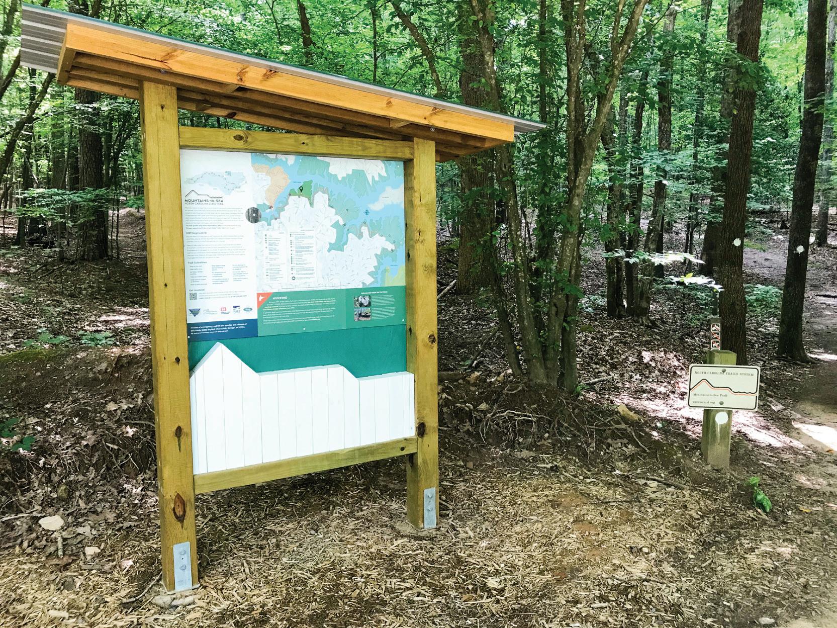
North Carolina Trails Program Annual Report 2021-2022 20 trails.nc.gov 4.0 State Trails - Mountains-to-Sea State Trail Mountains to Sea StateTrail trails nc gov New MST kiosk designed and installed by Friends of Mountains-to-Sea Trail at Falls Lake in Raleigh 74 40 40 85 77 77 26 74 85 85 95 95 40 74 17 17 Lake Norman State Park Morrow Mountain State Park Mayo River State Park Occoneechee Mountain State Park Eno River State Park Falls Lake State Recreation Area Jordan Lake State Recreation Area William B. Umstead State Park Haw River State Park Pilot Mountain State Park Hanging Rock State Park Raven Rock State Park Kerr Lake State Recreation Area Pettigrew State Park Jockey’s Ridge State Park Goose Creek State Park Fort Macon State Park Hammocks Beach State Park Singletary Lake State Park Jones Lake State Park Carvers Creek State Park Cliffs of the Neuse State Park Lumber River State Park Lake Waccamaw State Park Carolina Beach State Park Fort Fisher State Recreation Area Merchants Millpond State Park Dismal Swamp State Park Gorges State Park Chimney Rock State Park Crowders Mountain State Park Lake James State Park South Mountains State Park Mount Mitchell State Park Grandfather Mountain State Park Elk Knob State Park Mount Jefferson State Natural Area New River State Park Stone Mountain State Park Weymouth Woods Sandhills Nature Preserve Winston-Salem Charlotte Greensboro Raleigh Jacksonville Greenville Rocky Mount New Bern Wilmington Fayetteville Nags Head Asheville Boone 0 5 10 15 20 25 30 35 40 45 Miles County Line City LEGEND Existing Trail Planned Trail Mountains to Sea StateTrail mountainstoseatrailorg
State Trails
Peaks
Northern
StateTrail
Northern Peaks State Trail (NPST)
Northern Peaks State Trail will connect Boone, Elk Knob State Park, and Mount Jefferson State Natural Area. The planning corridor is approximately 40 miles long, beginning in the Boone area and ending at Mount Jefferson in Ashe County. Blue Ridge Conservancy (BRC) is the Partner for NPST.
trails.nc.gov
EXCERPTS FROM BRC’S 5 YEAR PLAN
Capacity Building Fund Projects:
BRC will increase staff capacity to plan, design, construct and maintain the Northern Peaks State Trail (NPST). A new trails staff position will be created by leveraging additional funds with the capacity building grant. This staff position will be the main contact for the NPST and will partner with N.C. State Parks, N.C. Wildlife Resources Commission, N.C. Plant Conservation Program, Ashe County, Watauga County, West Jefferson, Jefferson, Boone, and private landowners to create the NPST. The trails coordinator will assist with the biological study, general trail alignment and managing trail construction projects.
Priority CTP Projects:
�
Construct 4 miles of new trail and rehabilitate 2 miles existing trail at Elk Knob State Park and construct one new parking area. CTP funds must be leveraged to help with trail construction and parking facilities. �
Construct 8 miles of new trail at Three Top Mountain Game Land, upgrade two existing parking areas and construct one new parking area. CTP funds must be leveraged to help with trail construction and parking facilities.
Land acquisition along the proposed trail corridor from Snake Mountain to Mount Jefferson. CTP funds will be leveraged to help with land acquisitions.
Estimated cost for all priority projects = $6,200,000
Estimated cost for all projects = $6,200,000+ CTP allocation = $286,943
Planned Year of the Trail Celebrations:
Celebrate the start of trail construction at Elk Knob State Park or Three Top Mountain Game Land.
2022 Accomplishments:
Completed 5 Year Plan and signed a MOU with State Parks for the Capacity Building funds
BRC received $50,000 for the biological study of the proposed trail corridor
BRC contracted with the NC Natural Heritage Program to start the biological study of the proposed trail corridor. The study will continue until the summer of 2023
BRC purchased 152 acres on Paddy Mountain which will become the NPST trailhead in West Jefferson
BRC strengthened support for the NPST with local, county, state and legislative officials in Ashe and Watauga County
BRC raised an additional $28,000 to match the Capacity Building funds to hire a NPST Coordinator
BRC hired the NPST Coordinator
North Carolina Trails Program Annual Report 2021-2022
21
4.0
trails.nc.gov
�
�
�
�
�
�
�
�
�
Planned Trail State Park County Line City
North
22 trails.nc.gov 4.0 State
Northern
Northern Peaks StateTrail trails nc gov
Carolina Trails Program Annual Report 2021-2022
Trails -
Peaks State Trail
ASHE COUNTY WILKES COUNTY WATAUGA COUNTY
TENNESSEE Elk Knob State Park
Mount Jefferson State Natural Area
New River State Park West Je erson
Je erson Boone
N trails nc gov
O R THERN PEAKS STATE TRAIL
LEGEND
Northern Peaks StateTrail
State Trails
Overmountain Victory StateTrai
l
trails nc.gov
Overmountain Victory State Trail (OVST)
The Overmountain Victory National Historic Trail stretches roughly 330 miles from its southern terminus in South Carolina through North Carolina and into Tennessee and Virginia and follows the paths that the patriot militia took as they mustered to fight the Battle of Kings Mountain in 1780. This battle proved to be pivotal in the Revolutionary War. The Overmountain Victory State Trail will follow the 225 miles of the planned route of the National Historic Trail that passes through our state. The Partner for the OVST is the OVNCST-Friends.
EXCERPTS FROM OVNCST-FRIENDS’ 5 YEAR PLAN
Capacity Building Fund Projects:
OVNCST-Friends will use their capacity building funds to hire a part-time Executive Director to complete administrative duties and cover administrative costs for FY 22/23 and FY 23/24. Funding will also be used to develop a website to increase awareness of the organization and trail and fund a contractor for project development and oversight services as needed.
Priority CTP Projects:
Section Master Plans for N.C. State Line to Spruce Pine and W. Kerr Scott Reservoir to Lenoir
Norris Recreation Complex – Phase I – 0.25 miles
Cub Creek Connector – 0.75 miles
Smoot Park Trailhead Gateway
Black Bear Project – 3.5 miles (Partnership with F3ST and Burke County)
Estimated cost for all priority projects = $550,000
Estimated cost for all projects = $3,000,000
CTP allocation = $1,614,053
Planned Year of the Trail Celebrations:
OVNCST will assist partners to have all existing NPS certified sections of trail designated as State Trail.
Canal Bridge Grand Opening – September 1, 2023
2022 Accomplishments:
Established OVNCST-Friends
Signed MOU with N.C. Division Of Parks and Recreation
Developed 5 Year Plan
North Carolina Trails Program Annual Report 2021-2022
23 trails.nc.gov 4.0
�
�
�
�
�
�
�
�
�
�
TENNESSEE
Grandfather Mountain State Park
AVERY COUNTY
ASHE COUNTY
Stone Mountain State Park Elk Knob State Park
WILKES COUNTY WATAUGA COUNTY
Boone
CALDWELL COUNTY
Linville
40
BURKE COUNTY
Lake James State Park
RUTHERFORD COUNTY
Rutherfordton
74
South Mountains State Park
CLEVELAND COUNTY
North Carolina Trails Program Annual Report 2021-2022
OVERMOUNTAIN VICTORYSTATE TRAIL
Lenoir
Wilkesboro
ALEXANDER COUNTY
40
Catawba
CATAWBA COUNTY
LINCOLN COUNTY
Crowders Mountain State Park
GASTON COUNTY
IREDELL COUNTY
Lake Norman State Park
77 77
Overmountain Victory StateTrai l trails.nc.gov
LEGEND
Trail County Line City State Park Water
24
4.0
Overmountain Victory StateTrai l trails nc gov
trails.nc.gov
State Trails - Overmountain Victory State Trail
State Trails
River
Roanoke
StateTrail
trails nc.gov
Roanoke River State Trail (RRST)
Authorized in 2021, the Roanoke River State Trail is a paddle trail extending from Weldon, NC to the Albemarle Sound. Meandering through the coastal plain for 132 miles, this paddle trail offers a unique wilderness experience to all who venture along its length. While there are some opportunities for day trips on either end of the river, most paddlers need to be prepared for a multiday journey on this state trail.
Riverside camping platforms make spending the night along the river a true adventure.
The tent in the RRST blaze is reminiscent of the camping platforms that are available (reservations are required) along the wilder stretches of the Roanoke. Roanoke River Partners is the Partner for this trail.
EXCERPTS FROM RRST’S 5 YEAR PLAN
Capacity Building Fund Projects:
Capacity building funds will be used to support a regional and a paddle trail coordinator. Duties of this coordinator will include:
Program development and administration
Maintain records and documents related to Complete the Trail Fund projects on the RRST
Volunteer recruitment and training
Marketing and communications
Seeking additional grant funding
Paddle trail promotion
Priority CTP Projects:
Camping platform repair/renovation
Campsite(s) construction at RRP Mile Markers 35, 44, 50 and 85
Town of Hamilton boat ramp – floating dock and kayak rack at RRP Mile Marker 72
Rosenwald Visitor Center renovations at RRP Mile Marker 72
Estimated cost for all priority projects = $1,030,000
Estimated cost for all projects = $1,000,000+
CTP allocation = $507,375
Planned Year of the Trail Celebrations:
Upper River Paddle Day event in the Halifax/Weldon area
Lower River Paddle Day event in the Williamston and Plymouth areas
2022 Accomplishments:
November 2021 – Roanoke River became the newest and 12th state trail
Roanoke River Partners, Inc. (RRP), the 20+ year old nonprofit that created and manages a platform camping trail on the Roanoke River will serve as the Partner for the RRST
MOU was created and signed between N.C. Division of Parks and Recreation and Roanoke River Partners, Inc.
Revamped RRP website with new and improved reservation system
5 Year Plan prepared and approved by N.C. Division of Parks and Recreation
RRP collecting data relating to building and creating new sites to connect the river trail for distances that are too far to travel in one day.
Engaged community input from our five-county region along the Roanoke River for river projects to include in our 5 Year Plan
North Carolina Trails Program Annual Report 2021-2022
25 trails.nc.gov
4.0
�
�
�
�
�
�
�
�
�
�
�
�
�
�
�
�
�
�
�
Dismal Swamp State Park
85
NORTHAMPTON COUNTY
WARREN COUNTY
FRANKLIN COUNTY
WAYNE COUNTY
LEGEND
NASH COUNTY
95 95
Medoc Mountain State Park Halifax
WILSON COUNTY
HALIFAX COUNTY
ROANOKERIVERSTA ET TRAIL
HERTFORD COUNTY
CURRITUCK COUNTY
Roanoke Rapids Jamesville
Merchants Millpond State Park
GATES COUNTY PERQUIMANS COUNTY
CAMDEN COUNTY
PASQUOTANK COUNTY
CHOWAN COUNTY
BERTIE COUNTY
Hertford
Edenton Windsor
MARTIN COUNTY EDGECOMBE COUNTY
Elizabeth City Williamston
Plymouth
WASHINGTON COUNTY
Rocky Mount Pettigrew State Park
TYRELL COUNTY
PITT COUNTY GREENE COUNTY
CRAVEN COUNTY
HYDE COUNTY BEAUFORT COUNTY
Planned Trail State Park County Line City
Water Highway
Roanoke River StateTrail www.roanokeriverpartners org
26 trails.nc.gov 4.0
Roanoke River StateTrail trails nc gov
North Carolina Trails Program Annual Report 2021-2022
State Trails - Roanoke River State Trail
State Trails
Gateway
Wilderness
trails nc.gov
StateTrail
Wilderness Gateway State Trail (WGST)
The Wilderness Gateway State Trail will wind through Catawba and Burke counties and along the border of Rutherford and McDowell counties for 170 miles. Part of this trail will include a paddle trail in Catawba County. The planned trail will connect Hickory Nut Gorge State Trail and South Mountains State Park with the towns of Valdese and Hickory. Part of the trail will follow the same route as the Overmountain Victory State Trail. Foothills Conservancy of North Carolina (FCNC) is the Partner for the WGST.
EXCERPTS FROM WGST’S 5 YEAR PLAN
Capacity Building Fund Projects: � Hire full-time WGST trail program manager by 4th quarter 2022 to oversee trail planning, alignment, and construction projects
› Develop and maintain relationships and partnerships with stakeholder and volunteers / volunteer groups � Grow FCNC Volunteer Program
› Recruit 1 volunteer per mile of trail built › Host monthly volunteer workdays to maintain the trail starting in 2023 › Train lead volunteers
Priority CTP Projects: �
Segment 2: Land acquisition – Pinnacle Mountains West
Other funds: N.C. Land and Water Fund; donated land value � Segment 6: Land acquisition – Prospect Ridge property
Other funds: donated land value; (possibly NC LWF) � Segment 6: Trail Planning and alignment – FCNC Henry Fork River Preserve
Segment 6: Trail construction – 8+/- miles of trail on FCNC Smiths Cliffs/Henry Fork River Preserve. Other funds: RTP; private funds �
Segment 2: Trail planning and alignment Pinnacles East and West
Other Funds: Rutherford County Trails Collaborative
Estimated cost for all priority projects = $1,400,000
Estimated cost for all projects = $10,200,000
CTP allocation = $1,219,506
Planned Year of the Trail Celebrations:
Groundbreaking and Ribbon Cutting on Segment 6
Groundbreaking on Segment 2
Promote WGST through FCNC media outlets (and partner media) including website and interactive, print such as annual magazine (Taproot), monthly e-news, social media, and local news sources, press releases
Host Volunteer Workdays on Segment 2, 3, and 6
Host guided outings on Segments 3 and 6
2022 Accomplishments:
40 +/- miles of trail layout on Bobs Creek Wilderness and Bobs Creek SNA – Segment 3
FCNC completed 2,250-acre acquisition in Segment 3 to add to Bobs Creek SNA
FCNC partnering with USFWS on Section 106 Archeological evaluation – Segment 3
FCNC acquired 960 acres in Segment 2 area for permanent conservation and trail layout
FCNC applied to Rutherford County trails grant program ($60,000 request) for layout on Segment 2
FCNC hired Trails Program Director to administer WGST projects (start date is October 3)
FCNC applied for NC LWF funding for 460-acre acquisition in Segment 6
FCNC partnered with ALTA planning for conceptual plan on a section of Segment 8/9/10
FCNC initiated partnership with Carolina Thread Trail for Segment 8/9/10
FCNC helped facilitate transfer (donation) of land from City of Hickory to NC State Parks along Henry Fork River in Segment 8/9/10 – land transfer still pending
Signed MOU with NC State Parks for capacity grant
North Carolina Trails Program Annual Report 2021-2022
27 trails.nc.gov 4.0
�
�
�
�
�
�
�
�
�
�
�
�
�
�
�
�
�
� Completed WGST 5 Year Plan �
FCNC initiated GIS parcel priority analysis on Segment 6 to connect FCNC Henry Fork River preserve lands to Mineral Springs Mountain and Valdese �
FCNC executed purchase agreement on parcel of land in Segment 6 to connect Valdese to Lakeside Park
Lake James State Park Marion
40
MCDOWELL COUNTY
WILDERNESSGATEWAY STATETRAIL
RUTHERFORD COUNTY
Chimney Rock State Park
Boone
Morganton
BURKE COUNTY
South Mountains State Park Belwood
CLEVELAND COUNTY
40
Planned Trail State Park County Line City
North Carolina Trails Program Annual Report 2021-2022
LINCOLN COUNTY
CATAWBA COUNTY
Sawmills Newton
Conover Maiden
GASTON COUNTY
28
trails.nc.gov
4.0
Wilderness Gateway StateTrail trails nc gov
State Trails - Wilderness Gateway State Trail
LEGEND Wilderness Gateway StateTrail trails nc.gov
4.0 State Trails
Yadkin
River State
Trail
trails nc.gov
Yadkin River State Trail (YRST)
The Yadkin River State Trail was established in 1985. The blueway extends for 162 miles through Wilkes, Surry, Yadkin, Forsyth, Davie, Davidson, Rowan, Stanly, and Montgomery counties. The Yadkin River is one of the longest rivers in North Carolina, originating near the Blue Ridge Parkway and flowing east and south until it joins with the Uwharrie River to form the Pee Dee River.
The state trail starts in the tailrace of the W. Kerr Scott Dam and extends all the way to Morrow Mountain State Park. The Yadkin Riverkeeper (YRK) is the Partner for the YRST.
EXCERPTS FROM YRST’S 5 YEAR PLAN
Capacity Building Fund Projects:
Yadkin Riverkeeper will use the capacity building funds to work with public and nonprofit partners to:
Develop and implement a plan to allocate a portion of the Complete the Trail Program (CTP) funds to access area improvements,
Develop grant proposals for access area land acquisition/improvement projects,
Facilitate the placement of mile markers and access area signage, and
Promote the YRST through YRK’s website, social media and Historic Paddle Series.
Priority CTP
Projects:
� Access area improvements
Access road improvements and site development on the Ararat River near its confluence with the YRST on Pilot Mountain State Park land
Rockford access (N.C. Land and Water Fund application submitted by Piedmont Land Conservancy on behalf of Surry County). CTP funds would potentially be used for access infrastructure (i.e., put in ramp or steps)
Purchase YRST mile marker signs
Update and maintain online map, website and develop trail brochures
Estimated cost for all priority projects = $205,000
Estimated cost for all projects = $205,000 CTP allocation = $210,375
Planned Year of the Trail Celebrations:
Ribbon-cutting at Shallowford historic site marking transfer to public ownership.
Year of the Trail promotion as part of YRK’s Historic Paddle Series, highlighting CTF projects.
T-shirt commemorating the Year of the Trail w/ YRST focus.
Information on YRK website and monthly social media postings during 2023 highlighting sections of the YRST supported by CTP
2022 Accomplishments:
Finalized 5 Year Plan and needs assessment for Yadkin River State Trail.
Signed MOU and contract with NC State Parks for YRST capacity building funding.
YRK finalized online YRST map and printed map for review by stakeholders and State Parks.
Developed YRST trail blaze with support from NC State Trails and used the trail blaze as the basis for mile marker signs.
YRK purchased gravel and worked with Yadkin County Parks and Recreation Department to regrade access road and parking area and remove overgrown vegetation to improve Bob Pate/Huntsville Access Area.
YRK organized the 2022 YRK Historical Paddle Series to make the public more aware of the YRST.
North Carolina Trails Program Annual Report 2021-2022
29
trails.nc.gov
�
�
�
�
�
�
�
�
�
�
�
�
�
�
�
�
�
�
CALDWELL COUNTY
WILKES COUNTY
YADKIN RIVER
STATE TRAIL
YADKIN COUNTY
FORSYTH COUNTY
Boone GUILFORD COUNTY
ALEXANDER COUNTY
IREDELL COUNTY
BURKE COUNTY CLEVELAND COUNTY
CATAWBA COUNTY LINCOLN COUNTY GASTON COUNTY
MECKLENBURG COUNTY
Trail County Line City State Park Water
DAVIE COUNTY CABARRUS COUNTY
DAVIDSON COUNTY
RANDOLPH COUNTY ROWAN COUNTY
Morrow Mountain State Park
STANLY COUNTY
MONTGOMERY COUNTY
North
30 trails.nc.gov 4.0 State
Yadkin River StateTrail trails nc gov 77
77
73 73 840 85
40 40 85 85 40 40
Carolina Trails Program Annual Report 2021-2022
Trails - Yadkin River State Trail
485
77 77 485
85
Yadkinville Elkin Mocksville Wilkesboro Statesville Salisbury Charlotte Albemarle Hickory Asheboro High Point Greensboro Winston-Salem
0 5 10 15 20 25 Mile s
LEGEND
ncparks gov
Yadkin River StateTrail
Actions for Great Trails in NC
Support Trail Development
� State Transportation Funding: G.S. 136-189.11(d)(3)c prohibits the use of state funds for independent bicycle and pedestrian projects, even as a match for federal funds. This provision significantly hinders the development of greenways, particularly in rural and underserved areas. This prohibition should be evaluated to determine if it continues to be in the best interests of the citizens of North Carolina.
� Additional State Funding for a Trail Grant Program: The N.C. Trails Program continues to receive more than twice as many applications for trail and greenway funding as the federal Recreational Trails Program grants is able to fund. Additional funding to supplement federal funding would facilitate and expedite completion of trails and greenways.
� The Adopt-a-Trail Program (G.S. 143B-135.112) was previously funded to provide small trail grants to communities and non-profits, but funding was discontinued in 2014. Additional funding would foster opportunities to fund trail projects beyond the federal Recreational Trails Program. This funding could be administered through the N.C. Trails Program and utilize the structure of the Adopt-a-Trail program or create a new trails grant program for the state. Although significant new funding was provided through the Complete the Trail Program, this funding cannot be used on trail projects that are not affiliated with State Trails.
Trails Program Recommendations
� Existing State Trails: The capacity building funding for the state trail partner organizations would benefit from being recurring so that the organizations can continue to focus on developing the state trails.
� New State Trails: Any new state trail that is authorized should have a budget allocation to allow for initial development and should be planned to be at least 100 miles long. Trail concepts considered for state trail authorization should be in areas of the state not currently served by a state trail.
� Paddle Trails: NCDNCR and NCDOT need to develop a MOU to provide safety signage on bridges that span paddle trails throughout North Carolina. At a minimum, the signage should identify the roadway, the paddle trail, and any portages that are nearby downstream.
� Great Trails State Coalition: The Great Trails State Coalition is a group of land conservancies, trails and environmental organizations, and industry partners formed to promote trails in North Carolina. The Division should continue to advise and coordinate with the Coalition, especially related to planning for the Year of the Trail.
� Strategic Planning: The N.C. Trails Program should continue to partner with NCDOT’s Integrated Mobility Division (IMB) to identify priority corridors for state and regional trails in a strategic plan for a statewide network of bicycle and pedestrian accommodations that will link county seats, state parks, state trails, community colleges, and state/national forests. This plan should address criteria for including pedestrian and bicycle accommodations on all non-interstate highway bridge replacements.
North Carolina Trails Program Annual Report 2021-2022 31 trails.nc.gov
5.0
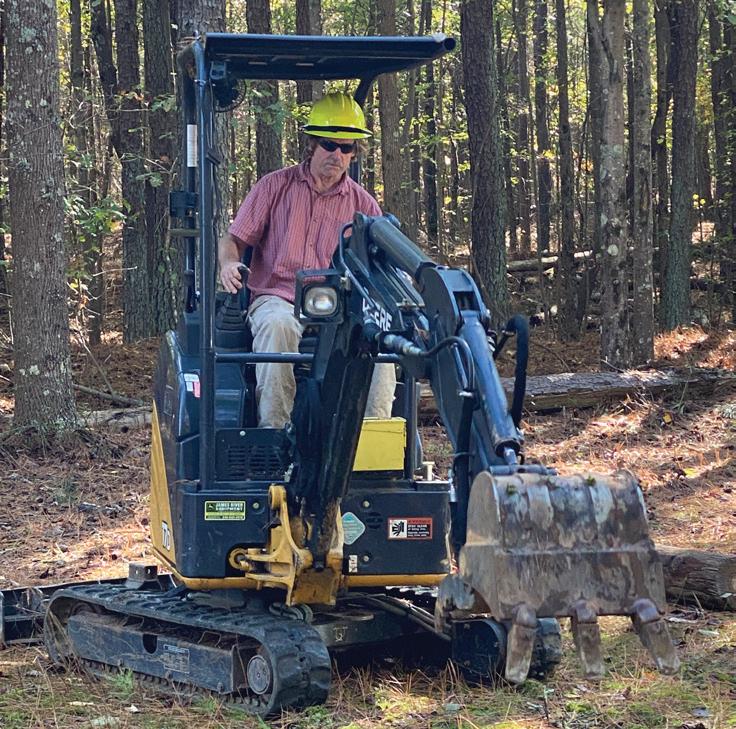
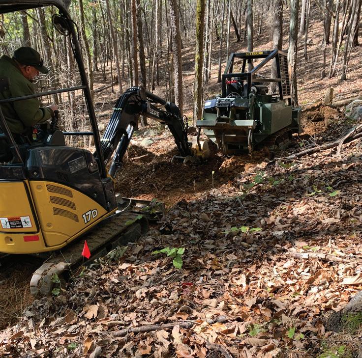
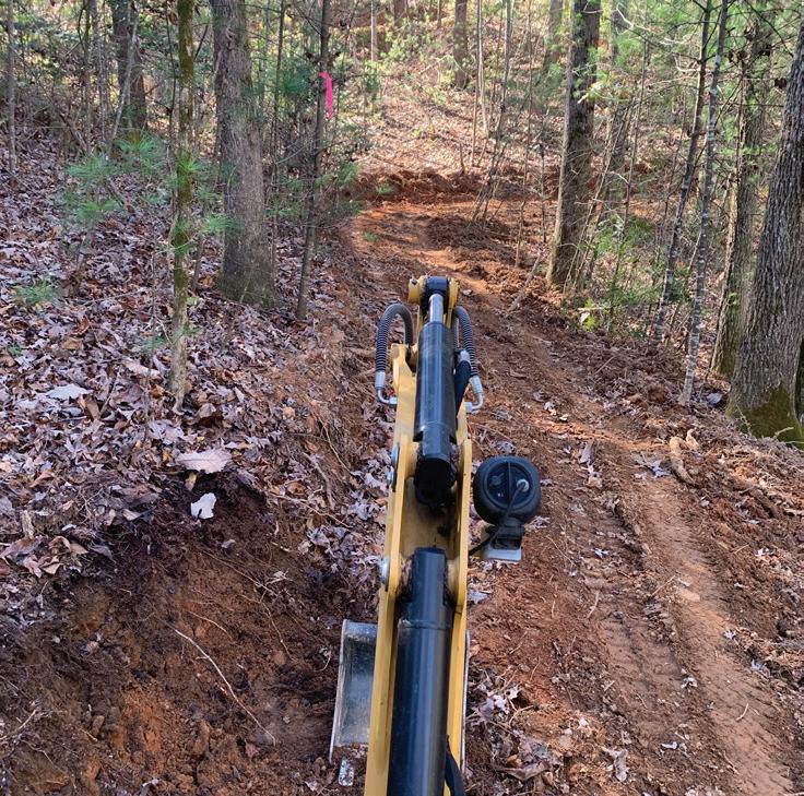
Workshop using mini-excavator and Trail Dozer at Crowders Moutnain State Park
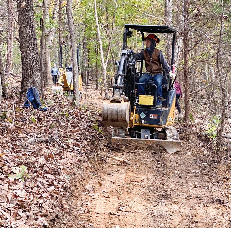
Putting training to use with mini-excavator at Lake James State Park with CCNC crews
Coastal Region Trail Specialist, Bob Taber, receiving miniexcavator training at the mechanized trail building workshop at Crowders Mountain State Park
Actions for Great Trails in NC
The Great Trails State network is planned as a system of multiuse trails. A multiuse path surface is inappropriate for specific state trails, such as the Northern Peaks State Trail. In those cases, the spine network will connect to trailheads. Adoption of DOT’s Great Trails State plan will facilitate many aspects of planning and construction of state trails in the future.
� Partnerships: The Division should continue to strengthen and formalize partnerships with the various organizations which support state trails. Additionally, the Division should coordinate with these organizations to recognize and support the volunteers who labor to construct and maintain our State Trails.
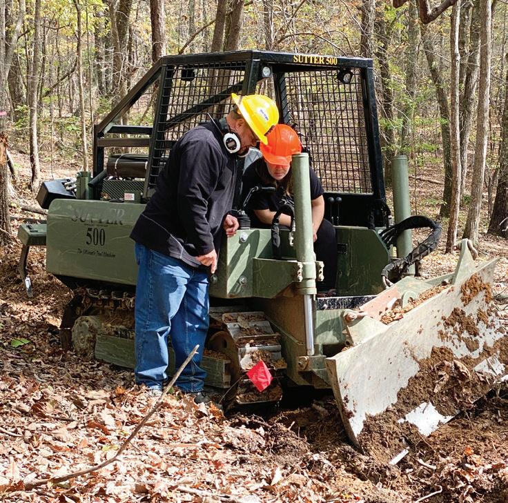
� Technical Assistance and Education: The pandemic has impacted training opportunities available nationwide, but prior to the pandemic the N.C. Trails Program received trail building training using heavy, specialized equipment. These skills will be passed on to other partners and Division staff to assist with efficiently tackling trail building projects in the future. The N.C. Trails Program will continue to provide technical assistance for trail design, maintenance, and sustainability to local communities and state parks. During the Year of the Trail, the N.C. Trails Program will be conducting at least three regional sustainable trails workshops across the state in addition to a variety of activities planned with Division interpretive staff and the State Trail partner organizations.
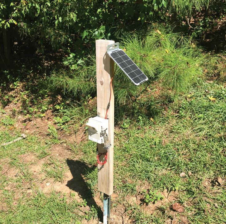
New Trail Counters: Monitor Trail Usage and Collect Data
N.C. State Parks has begun installing digital trail counters in parks across the state. These state-of-the art counters are provided by See Insights LLC, a Raleighbased company that developed the prototype at William B. Umstead State Park over several years. Running on solar power, these counters automatically upload count data to a cloud-based portal where parks staff can access and analyze the information, as well as download it to share across the division.
The counters collect precise numbers on trail usage, including times and dates when collected. This information will help the division analyze trail utilization patterns such as heavy usage periods and seasonal changes and will assist in anticipating various management needs of trails in each park. The data can also be used to illustrate the important role trails play regionally in supporting healthy lifestyles and providing recreational opportunities.
As our parks and trails continue to grow in popularity, having better data can help us to make better decisions to continue to serve the public and manage these much-loved resources.
North Carolina Trails Program Annual Report 2021-2022 32 trails.nc.gov
Provide trails-related education and technical assistance throughout North Carolina during the Year of the Trail
5.0
Piedmont Region Trail Specialist using mini-excavator to finish grading trail cut by trail dozer at Crowders Mountain State Park
Mountain Region Trail Specialist, Amanda Smithson, learning trail dozer operations at Crowders Mountain State Park
A trail counter at the Pump Station access at Eno River State Park
State Parks Partnership with Conservation Corps of NC (CCNC)
In fiscal year of 2021–2022, the Division used recurring funds appropriated by the 2021 legislature for a partnership with Conservation Corps North Carolina (CCNC) to support trail work. A program of Conservation Legacy, CCNC is a corps program that engages North Carolina young people in conservation service projects that benefit North Carolina communities. The partnership is also supported by an AmeriCorps grant from the North Carolina Commission on Volunteerism and Community Service.
The partnership with The State Trails Program vastly improved trail sustainability in state parks while providing diverse young adults a paid job, valuable on-the-job training, and an AmeriCorps education award. This is the third year of the partnership with N.C. Division of Parks and Recreation, and it continues to yield valuable results. Crews of five to eight AmeriCorps members tackled various trail projects under training and direction from our program’s Trail Specialists. From July 2021 to June of 2022, trail projects were completed at New River, Lake James, Crowders Mountain, Mayo River, Cliffs of the Neuse and Jones Lake state parks. The scope of work accomplished included rock work, trail maintenance, new trail construction, deconstruction of dilapidated structures, and decommissioning unsustainable trail segments.
In spring of 2022, recruitment began for two interns to assist the State Trails Program. Interns in six-month (Piedmont region) position and a 11-month (Mountain region) position will help to assess the condition of trails throughout our state parks, conduct on-site data collection, learn in depth the processes of trail layout and design, and assist with updating the program’s Trail Standards. These CCNC interns will benefit from learning a broader range of skills that will prepare them for a variety of natural resources jobs and careers. With over 700 miles of trails throughout our state parks and only three regional trail staff, these positions will temporarily provide much needed assistance. Ultimately, the program would benefit from more permanent positions that could, among other things, operate trail equipment to assist in future projects with CCNC.
CCNC 2021-2022 State Park Projects:
� Crowders Mountain:
› Crews repaired approximately 300 steps on the Backside Trail. Timber steps were repaired and replaced as needed and gravel replenished.
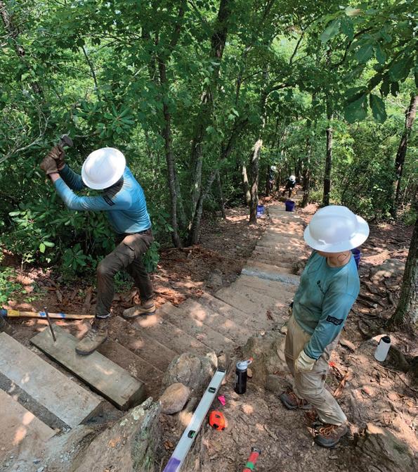
› Decommissioned approximately a mile of two different sections of the Pinnacle Trail that were rerouted in previous trail projects to improve sustainability and relocate the trail from sensitive habitats.
� New River: Heavy trail maintenance on trails at the U.S. 221 Access and decommissioned legacy trails at Elk Shoals access
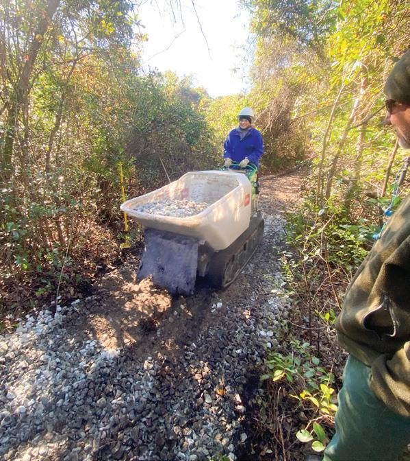
� Lake James: Crews completed the South Wimba Trail, which will connect the new Visitor Center to the existing mountain bike trails and cleared the corridor for the future loop trail originating at the new facility.
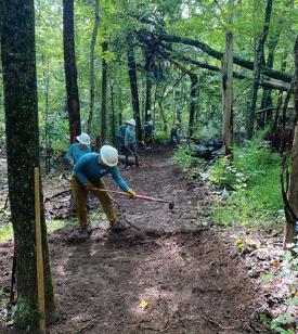
� Mayo River: Completed 2,800 feet of new trail construction at the Mayo Mountain Access.
� Cliffs of the Neuse:
› Completed approximately 1,650 feet of reroute on new Galax Trail
› Removal of a 75-foot bridge and eliminated 50 steps on front side of Spanish Moss trail plus restored the area to a natural state
› Decommissioned 2,000 feet of unsustainable Galax Trail
› Re-naturalized 400 feet of social (unofficial, visitor-worn) trails
� Jones Lake:
› Removed 196 feet of dilapidated boardwalk
› Distributed 14 loads of gravel (275 tons) along low, wet areas of Lake Trail
North Carolina Trails Program Annual Report 2021-2022 33 trails.nc.gov
6.0
CCNC crews used motorized buggies to deliver gravel to trails at Jones Lake State Park
CCNC repairing steps on the Backside Trail at Crowders Mountain State Park
CCNC working on the new natural surface Fox Trail at Mayo River State Park
Recreational Trails Program (RTP) Grants
The Division of Parks and Recreation manages the Federal Recreational Trails Program (RTP) for the N.C. Department of Natural and Cultural Resources. The intent of the RTP is to leverage local funds to develop trails and trail‐related recreational amenities in an effort to provide low-cost infrastructure and economic development opportunities through natural resource tourism.
From 1999 to 2022, our state has received approximately $76,879,804 in requests for RTP funding. Of those requests, the state has awarded $40,734,583 to sustainable RTP trail projects statewide. These RTP funds, in combination with in‐kind services and matching funds totaling $68,643,835, have been applied to trail and greenway projects for the citizens of North Carolina. RTP in North Carolina is enabled by the legislation “Moving Ahead for Progress in the 21st Century Act” (MAP‐21), which reauthorized the RTP Program for the 2021–2022 fiscal year. RTP funding comes from the Federal Highways Administration (FHWA) through the N.C. Department of Transportation and is administered by the State Trails Program within the N.C. Division of Parks and Recreation. Since 1993, RTP funding in North Carolina has been used to provide recreational opportunities for hikers, equestrians, bicyclists, paddlers, and off‐highway vehicle (OHV) users. Funding through RTP has been able to move forward through continuing resolutions.
Through the N.C.Trails Program, the N.C. Division of Parks and Recreation received 27 RTP final application requests totaling $2,423,724 for the 2022 grant year. In North Carolina, we request applicants submit an application several months prior to review by the North Carolina Trails Committee (NCTC) so that applicants receive comments and suggestions from the Trails Program staff. This process has resulted in higher quality, more shovel-ready projects presented to the NCTC. Grant applications are reviewed and recommended for funding by the NCTC, a citizen board established in G.S. 113A-88. The NCTC recommended awards for 18 RTP construction projects totaling $1,632,903 to leverage $872,815 of grantee matching funds. These awards will benefit the following counties: Buncombe, Burke, Cleveland, Davidson, Guilford, Haywood, Iredell, McDowell, Montgomery, Pitt, Polk, Randolph, Rowan, Wilkes and Yadkin.
Table 1: Awarded RTP Projects for spring 2022
Project Title
County Region User Group Award Amount
Wildwood Park Trail Connection Pitt Coastal
Multi-Use/Greenway $55,000.00
Little White Oak Mountain – Phase 2 Polk Mountains Mountain Biking $99,999.76
Valdese Lakeside Greenway Connector Project Burke Mountains Multi-Use/Greenway $100,000.00
Highway 67 Trail Head at Jonesville Greenway Trail Yadkin Mountains
Multi-Use/Greenway $100,000.00
Cub Creek Park Mountain Bike Trails Wilkes Mountains Mountain Biking $99,999.90
Mazeppa Park Phase II Iredell Mountains Mountain Biking $60,000.00
Upper Catawba Falls Access (Phase 1C – Part 1) McDowell Mountains Hiking $100,000.00
Upper Catawba Falls Trail Phase 1C – Part 2 McDowell Mountains Hiking $100,000.00
Town of Canton Chestnut Mountain Recreation Trails Haywood Mountains Hiking $97,903.00
Masters Park Trail Parking Lot and Trailhead Information Kiosk Buncombe Mountains Hiking $20,000.00
Lawndale Park First Broad River Access Cleveland Mountains Canoe/Kayak $100,000.00
Yadkin River Trailhead Rowan Piedmont Multi-Use/Greenway $100,000.00
DRST Sandy Creek Bridge Randolph Piedmont Hiking $100,000.00
Project A: Badin Lake OHV Trail Complex Maintenance Montgomery Piedmont Motorized (OHV/ATV) $100,000.00
Project B: Badin Lake OHV Trail Complex Maintenance Montgomery Piedmont Motorized (OHV/ATV) $100,000.00
The Ridge Cycle Hub – City Lake Park Greenway Connector Davidson Piedmont Multi-Use/Greenway $100,000.00
Project C: Uwharrie NF Access Roads and OHV Trailheads Maintenance Montgomery Piedmont Motorized (OHV/ATV) $100,000.00
Bandera Farms Equestrian Trails Phase 1 Guilford Piedmont Equestrian $100,000.00
34 trails.nc.gov
North Carolina Trails Program Annual Report 2021-2022
7.0
State Trail’s Five Year Plans APPENDICES
DanRiver State Trail trails.nc.gov
DeepRiver State Trail trails.nc.gov
East Coast Greenway StateTrail trails.nc.gov
FrenchBroad River StateTrail trails.nc.gov
Fonta Flora State Trail trails.nc.gov
HickoryNut Gorge StateTrail trails.nc.gov
Mountains-to-Sea StateTrail trails.nc.gov
Northern Peaks StateTrail trails.nc.gov
Overmountain Victory StateTrai l trails.nc.gov
Roanoke River
StateTrail
Wilderness Gateway
StateTrail
trails.nc.gov
trails.nc.gov
Yadkin River State Trail trails.nc.gov
35
North Carolina Trails Program Annual Report 2021-2022
trails.nc.gov
DanRiver State Trail
trails.nc.gov
Dan River State Trail Plan: 2022-2027
Dan
River Basin Association
� Planned Length: 90 miles
Miles Designated: 0
Complete the Trails Funds: $507,375
Capacity Funds: $49,500
Capacity Building Funds: 1. Financial support for current NC Program Coordinator (20% of time, $10,000)
Additional meetings with municipalities to apply for State Designation
Assist with current partnerships
New municipalities and partnerships
Collaboration with paddle trail at MRSP 2. Hire part-time DNST Assistant ($12,000)
15 hrs/week, $15/hr
Field work-ID new accesses and enhancement points
Coordinate public input sessions
Coordinate informational sessions (rotary, garden clubs, Kiwanis, churches, etc.) 3. Other Staff Support (5% each, $9,500)
Executive Director
Finance Manager 4. Purchase ESRI materials- 3 year minimum ($500/3-years) 5. Purchase field work tools and supplies ($2,000)
River access construction tools
Volunteer equipment 6. Website updates ($7,500)
Add the DNST designated symbols to our interactive map
Create a webpage specifically for this project that NC State Parks will link to for information 7. River safety information sessions, safety classes for river experiences on the Dan River ($3,500) 8. Promotional information created for social media and reporters, volunteer recognition and events ($4,500)
Total Funds Requested: $49,500.00
Trail Development: Total Funds: $665,000.00
Segment 1: Stokes County (50 miles) 1. Master Plan for Dan River State Trail ($75K) 2. Create signage for Stokes County ($35,000/5,000 per sign) 3. Create 2 new public accesses (est. $75,000 each)
Snow Creek
Pine Hall 4. Designate current 5 current accesses: (for enhancements, $50,000 total)
Jessups Mill
Harts
Hanging rock
Moratock
Hemlock Golf Course Segment 2: Rockingham County (39 miles)
Master Plan for Dan River State Trail
New access ($125,000)
Berry Hill 3. Designate 7 current accesses ($70,000 for enhancements)
Madison River Park
704 Access
North Carolina Trails Program Annual Report 2021-2022
trails.nc.gov
36
�
�
�
�
�
�
�
�
�
�
�
�
�
�
�
�
�
�
�
�
�
�
�
�
Appendix
1.
2.
�
�
�
� Jacobs Creek Batteau � Klyce Street � Leaksville Landing � Leaksville Wildlife (Boat Landing) � Draper Landing
4. Create permanent easement for Settles Bridge ($150,000 for purchase)
Segment 3: Caswell County (10 miles)
1. Master Plan for Dan River State Trail
2. Designated trail accesses at current public accesses: ($10,000 for enhancements) � Milton Wildlife Access
Complete the Trail (CTF) Projects:
1. Master Plan for DNST ($75,000)
2. Designate current public accesses (enhancement funds $130,000)
3. Create signage plan for Stokes County ($35,000)
4. Pine Hall access 5. Settles bridge access
6. Priority accesses identified on Master Plan completed- Berry Hill ($125,000 for access development)
2023 Year of the Trail Celebrations Planned/Anticipated:
1. Every First Saturday Outing Hike will have a Year of the Trail focus during hikes in NC
2. Creation of the Dan River Master Plan/Beyond Pathways Rivers and Trails Master Plan
3. Paddle the Dan – record the paddle (visual, dollar a mile sponsor, trophy) get a sticker
4. Possible kayak giveaway (April, may, June, July, August, September)
5. Lifejacket giveaways
37 trails.nc.gov
North Carolina Trails Program Annual Report 2021-2022
Appendix
Dan River State Trail Plan 2022-2027
DeepRiver State Trail
trails nc.gov
Deep River State Trail Plan: 2022-2027 Piedmont Land Conservancy
� Planned Length: 125 miles each (land and water)
� Miles Designated: 5
Capacity Building Funds:
Tasks: � Trail Coordinator position – $20,000/ year
Mapping – $2500/year
Project Coordination – $2000/ year
Deliverables: � Deep River State Trail Steering Committee established and functioning
Trail Volunteer program established and functioning
Priority trail projects completed
Trail Development
� Complete the Trails Funds: $860,828
� Capacity Funds: $49,500
Segment 1: Guilford County to Randleman (20 miles) � Planning: Blueway from Deep River Road and Penny Road to City Lake Marina. Have technical assistance grant to plan. Construction: Complete extension of existing Bicentennial Greenway at Piedmont Environmental Center on Penny Road to City Lake Park via a pedestrian bridge across City Lake. (Summer 2022) (Mile 124) � Construction: Blueway from Deep River Rd and Penny Road to City Lake marina.
Designation: Designate 1.2-mile section of the High Point Greenway between Deep River Road and Penny Road; 2.6-mile section of Bicentennial Greenway from Penny Road to Sunnyvale Road and 2.3-mile Deep River Trail along City Lake. (Miles 124-125) � Designation: Designate the 3.9 miles of trails along City Lake at the Piedmont Environmental Center. (Mile 124)
Designation: PTRWA Boat Ramp (Mile 110)
Designation: Southwest Park – river access (Mile 119)
Partners: › Guilford County › City of High Point › Piedmont Triad Regional Water Authority › Randleman › Randolph County › Deep River State Trail Steering Committee › Piedmont Land Conservancy › Randolph County Trails Advisory Council
Segment 2: Randleman to Moore County Line (34 miles)
Planning:
› Randolph County Landfill Central Falls to Cedar Falls (3 miles). Involves conceptual plan with trail alignment.
› Preliminary engineering for five bridges – Bush, Harlan, Cox, Gabriel’s and Hasketts Creeks.
› Extend Randleman trail upstream to Randleman Dam. Involves locating the trail alignment and identifying property for acquisition of easements. �
Acquisition: acquisition of easement of several critical connections. � Trail construction:
› Sandy Creek bridge to connect Franklinville Rail section (1.75 mi) to Ramseur Rail section (0.75 mi). RTP funded
› Ramseur Rail Trail extension, acquisition, trailhead and portage – PARTF and NCL & WF. Involves 0.5-mile trail extension to downtown, trailhead at Old Depot/Columbia Mill and portage river right at Leonard Park.
› Randleman Phase III (1.5 miles) – RTP funded. Involves trailhead at Worthville in conjunction with River Access, 1.25 mile of new trail and 0.25 mile of renovated trail to connect to the existing trail at the rock outcrop.
› Worthville River Access – RTP (2021) and NC WRC funded
› Central Falls River Access – RTP funded (2022)
North Carolina Trails Program
Report
38 trails.nc.gov
Annual
2021-2022
�
�
�
�
�
�
�
�
�
Appendix
Deep River State Trail Plan 2022-2027
› Franklinville to Cedar Falls (Sapona Mill) (2 miles). Involves two trailheads, bridge over Bush Creek and 2 miles of trail on abandoned railroad bed.
› Sapona to N.C. Textile Museum (Cedar Falls) (0.75 mile). Involves trailhead at N.C. Textile Museum, connection from Sapona Mill to abandoned railroad bed, 0.75 mile of trail, and river access site at N.C. Textile Museum.
› Cedar Falls to Central Falls (County Landfill). Involves first section of 3-mile trail based on Conceptual Plan.
› River access below the Randleman Dam. Involve creating trailhead near dam on river right and takeout access in Randleman. �
Partners:
› Randolph County
› Randleman
› Franklinville
› Ramseur
› PTRWA
› Piedmont Land Conservancy
› Randolph County Trails Advisory Council
› Deep River State Trail Steering Committee
Segment 3: Moore County (30 miles)
�
Planning:
› River access at Glendon-Carthage Road Bridge (Mile 55) – plan to rebuild the river access. Bridge was replaced and the river access lost. May involve acquisition.
› River access at S. Carbonton Bridge (Mile 49) near House in the Horseshoe owned by DNCR. Will involve acquisition. The takeout would be existing Carbonton Bridge Ramp Access in Lee County
› River access at N. Howard Mill Road Bridge (Mile 71). Will involve acquisition and perhaps Brownfield cleanup funds. � Acquisition:
› River access near House in the Horseshoe.
› River access at Carthage Road Bridge. � Trail Construction:
› River access at S. Carbonton Bridge (Mile 49) near House in the Horseshoe
› River access at Glendon-Carthage Road Bridge (Mile 55) �
Partners:
› Moore County
› Three Rivers Land Trust
› Triangle J COG
› Deep River State Trail Steering Committee � Volunteer Recruitment – Needed when accesses are constructed.
Segment 4: Chatham and Lee Counties (29 miles)
Planning:
› Conceptual Plan for Deep River Blueway Corridor for Chatham and Lee Counties. Involves coordinating the four existing and three funded river accesses with Chatham and Lee Counties, Deep River Park Association, Triangle Land Conservancy and State Parks.
› Endor Iron Furnace Park (Mile 28). Involves a plan to restore iron furnace and create trails and river access/camping along Deep River.
› Extend the river trail from Endor Iron Furnace (Mile 28) to Deep River Park/Camel Back Park. Involves working with Pilgrim’s Pride that owns 400+ acres along Deep River.
› Conceptual Plan for land trail from Carbonton (Mile 43) to Moncure/US-1 (Mile 18) � Trail Construction:
› River access at US-421– NCWRC funded (Mile 33)
› River access at US-15/501– NCWRC funded (Mile 25)
› River access Jordan Lake (Justice) tract/US-1– State Parks plans to build (Mile 18)
› Pave the river access ramp at Carbonton (Mile 43) �
Partners:
› Lee County
› Chatham County
› Triangle Land Conservancy
39 trails.nc.gov Appendix
North Carolina Trails Program Annual Report 2021-2022
�
Deep River State Trail Plan 2022-2027
› N.C. State Parks, N.C. Historic Sites › Deep River State Trail Steering Committee � Volunteer Coordination Lee and Chatham Counties, Deep River Park Association and Triangle Land Conservancy
Complete the Trail (CTF) Projects: 1. Franklinville to Sapona ($700,000); 2. Sapona to N.C. Textile Museum including water access ($300,000)
2023 Year of the Trail Celebrations Planned/Anticipated:
Ribbon cutting: � Franklinville to Sapona; � Ramseur trail extension, trailhead and portage; � Worthville to Central Falls blueway � Randleman Phase III – Worthville to Randleman. � River access at US-421 � River access at US-15/501
Trail Events: � Paddle using four existing river accesses in Lee/Chatham Counties � Hike along new 1.2 mile High Point Greenway segment at Hickswood/Penny Roads
Needed technical/other assistance needed from State Parks: � Design for standard foot bridge
North Carolina Trails Program Annual Report 2021-2022
40
Appendix
trails.nc.gov
East Coast Greenway
StateTrail
East Coast Greenway State Trail Plan:
East Coast Greenway Alliance
trails.nc.gov
2022-2027
� Planned Length: 795 miles � Miles Designated: 102 miles � Complete the Trails Funds: $4,971,282 � Capacity Funds: $49,500
Capacity Building Funds:
Staff time – 90% ($44,550) � Travel and meetings – 10% ($4,950)
Deliverables:
Comprehensive grant administration and management for East Coast Greenway segments receiving funding � We will set up a new bank account and follow prudent accounting procedures and policies when distributing the funds to local municipalities � We will assume responsibility for audits of the funding � We will ensure communities are aware of and able to receive and execute on funding that is awarded �
A project administration fee not to exceed 10% will be applied
Marketing and communications
ECGA will provide communications to transparently show what is being funded � We will develop press releases along with professional video and photo content to highlight the progress of the Complete the Trails Fund program �
Celebration events will be planned in partnership with State Parks to keep momentum and support going forward
› We will coordinate with the relevant legislators in the districts where the projects are happening so keep them informed and involved � A record of all media coverage and communications details will be shared and coordinated with State Parks
Technical subject matter expertise
ECGA paid staff and volunteer Board members with professional planning and engineering backgrounds will be available to support communities through the process � Our full-time North Carolina Greenway Coordinator will serving as a main point of contact for the Complete the Trails Fund program on behalf of the ECGA. The Coordinator works on planning, greenway implementation, and public engagement, among other responsibilities. � The Coordinator is expected to:
› Complete and monitor ECG signage throughout the region and update the ECGA online Trip Planner (map.greenway.org).
› Work to move a maximum amount of the on-road portions off-road (including designating trail as official ECG) and make remaining on-road sections as safe and bicycle/pedestrian friendly as feasible.
› Keep the GIS data-reporting system up-to-date and create reports as requested (at least quarterly).
› Assist our volunteer State Committees and other volunteers within the region.
› Build/maintain a strong network of strategic alliances with public agencies, elected officials, and organizations in each state to continue strong Greenway progress.
› Communicate regional information in coordination with other staff for ECGA website, print and e-newsletters, and engage regional media.
› Assist as needed with fundraising efforts led by the Development team
Trail Development
Region 1 – Triangle North: Durham Chapel Hill Carrboro MPO, Kerr-Tar RPO
1a | Granville Rail-Trail / S-Line Corridor
Mileage Estimate: 17 or 36 miles
Region: Triangle North
Municipalities: Oxford, Stovall, Henderson, Middleburg, Norlina
Counties: Granville, Vance, and Warren
Planning Organizations: Kerr-Tar RPO
Other Relevant Agencies/Partners: NCDOT (for S-Line Corridor) � Status: Proposed, seeking funding for a Feasibility Study and preliminary design. The S-Line Greenway has had a preliminary study done by NCDOT which can be accessed here.
41
North Carolina Trails Program Annual Report 2021-2022
trails.nc.gov
�
�
�
�
�
�
Appendix
�
�
�
East Coast
Plan 2022-2027 � Project Description: The Kerr-Tar RPO has been leading the effort to bridge the gap between the Virginia State Line to Durham County with ECG trail. There are two possible routes under consideration between the VA State Line and Oxford, NC in Granville County. With support from ECGA, the KTRPO is in the process of identifying grant funding, including a submitted USDOT RAISE application, for a feasibility study and planning work for this section. The primary route options include: an inactive rail line corridor through Granville County; the proposed “S-Line” (Southeast Rail) rail-with-trail corridor from Henderson (Vance County) through Norlina (Warren County) then north towards Petersburg, VA (Oxford and Henderson would be connected by an identified trail corridor); and a third option is routing along other potential non-rail corridors that would be identified through the feasibility study. Once funding is secured, KTRPO will move forward with a feasibility study.
Greenway State Trail
Right-of-Way/Land Acquisition needs: No ROW secured, would need to acquire land/easement for the corridor.
Remaining Project Development Cost Estimates: $82,875,000 – $175,500,000
1b | Butner to Oxford
Mileage Estimate: 15
Region: Triangle North
Municipalities: Butner, Oxford
Counties: Granville
Planning Organizations: Kerr-Tar RPO
Other Relevant Agencies/Partners: NCDOT, Exult Engineering and Kittleson
Status: Feasibility Study in process
Project Description: This segment is within the Kerr-Tar RPO’s planning region. There is currently a feasibility study being conducted by Exult Engineering with support from Kittelson and Associates. ECGA is participating on the study committee. Several routes are being considered, mainly along existing road ROW. After this study is complete, the selected viable route will be ready to move into the engineering and design phase.
Right-of-Way/Land Acquisition needs: No ROW secured, would need to acquire land/easement for corridor.
Remaining Project Development Cost Estimates: $73,125,000
1c | Three Rivers Trail
Mileage Estimate: 8
Region: Triangle North
Municipalities: Durham
Counties: Durham
Planning Organizations: DCHC MPO
Other Relevant Agencies/Partners: The Conservation Fund
Status: Envisioned
Project Description: There are several proposed routes to connect Ellerbe Creek Trail in North Durham to the Durham/ Granville County line, which have been pushed by local advocates and considered by local officials for many years. One route is being explored in the early stages.
Links to Planning Documents: CTP Bike-Ped-Multiuse Map
Right-of-Way/Land Acquisition needs: No ROW secured, would need to acquire land/easement for corridor.
Remaining Project Development Cost Estimates: $39,000,000 – $48,750,000
1d
| Durham Rail Trail
Mileage Estimate: 0.6 miles (1.75 total project length, a segment on which the ECG will route)
Region: Triangle North
Municipalities: Durham
Counties: Durham
Planning Organizations: Durham Chapel Hill Carrboro MPO
Other Relevant Agencies/Partners: McAdams as project planning firm
Status: Master Plan adopted, funds and land secured. Design and Engineering phase, project completion date set for Spring 2024 or later.
Project Description: With support from ECGA, the City of Durham was awarded a 2021 RAISE grant for $9M to construct the Durham Rail Trail (formally the Durham Belt Line) along an abandoned rail corridor, already acquired by the City. Once built, the ECG will route along a segment of this trail, linking the Ellerbee Creek Trail to the American Tobacco Trail. A connector between the start of the Durham Rail Trail with the start of the American Tobacco Trail will be required.
Right-of-Way/Land Acquisition needs: None
North Carolina Trails Program Annual Report 2021-2022
42
Appendix
trails.nc.gov
�
�
�
�
�
�
�
�
�
�
�
�
�
�
�
�
�
�
�
�
�
�
�
�
�
�
�
�
�
�
�
�
East Coast Greenway State Trail Plan 2022-2027
Remaining Project Development Cost Estimates:
Total Cost (already secured): $30,372,500
› Planning: $264,300 › Design: $1,670,000 › Right-of-way: $12,096,400 › Construction: $16,341,800
Region 2 – Triangle South: CAMPO, Upper Coastal Plain
2a
| Black Creek Greenway Missing Link
Mileage Estimate: 0.3
Region: Triangle North
Municipalities: Cary
Counties: Wake
Planning Organizations: CAMPO
Other Relevant Agencies/Partners: N/A
Status: Construction ready
RPO
Project Description: There is a short (0.3 miles) on-road connection along W. Dynasty Drive that requires going over a significant hill and crossing traffic. The Town of Cary has construction scheduled for the connecting segment, rerouting the northern section of Black Creek Greenway to meet the entrance of the southern section.
Right-of-Way/Land Acquisition needs: None
Remaining Project Development Cost Estimates: N/A
2b | Downtown Raleigh Connector
Mileage Estimate: 1.7
Region: Triangle North
Municipalities: Raleigh
Counties: Wake
Planning Organizations: CAMPO
Other Relevant Agencies/Partners: Oaks and Spokes, WakeUP Wake County
Status: Planned
Project Description: Downtown Raleigh is the most significant break in trail along the approximately 74 miles of nearly continuous ECG through the Triangle region. The most viable trail route option is a cycle track along Boylan Avenue and Martin Street, connecting the Rocky Branch Trail to Chavis Way/Little Rock Trail, which is in the planning phase with the City of Raleigh. The connection envisioned between Boylan Avenue and Martin Street for the ECG varies by a few blocks from the planned bicycle facilities in the Raleigh plan. Another route option is the proposed Strollway connecting Dix Park to Chavis Park, however this would not be preferable as it routes just south of downtown Raleigh, and the East Coast Greenway routes so as to connect people to the hearts of cities.
Right-of-Way/Land Acquisition needs: would need to acquire land/easement for corridor
Remaining Project Development Cost Estimates: $5,737,500
2c | Neuse River Trail, Clayton to Smithfield
Mileage Estimate: 15
Region: Triangle North
Municipalities: Clayton, Smithfield, Selma, Wilsons Mills
Counties: Johnston
Planning Organizations: Upper Coastal Plain RPO, CAMPO
Other Relevant Agencies/Partners: McAdams (as the Feasibility Study consultant), Friends of Johnston County Parks
Status: Feasibility Study in process
Project Description: Currently, Johnston County and the Upper Coastal Plain RPO is conducting a feasibility study of the corridor between Clayton and Smithfield, with the consulting firm McAdams. ECGA is participating as a member of the Working Group. Several route options to connect the towns along the corridor have been considered, with a recommended route, along with spurs and alternative routes. The recommended route is split into four phases, the northern three of which are largely along roadways. The southern most phase begins where the proposed alignment crosses the Neuse River (a bicycle/pedestrian bridge will be required) by US-70 and the railroad, just outside of Selma, and then weaves towards Smithfield Community Park to connect with the Buffalo Creek Greenway/Smithfield Neuse Riverwalk. This phase, which
43 trails.nc.gov Appendix
North Carolina Trails Program Annual Report 2021-2022
�
�
�
�
�
�
�
�
�
�
�
�
�
�
�
�
�
�
�
�
�
�
�
�
�
�
�
�
�
�
East Coast Greenway State Trail Plan 2022-2027
will be a priority area for the EGST use of CTF, will likely require land easement acquisition, boardwalk, and some complex infrastructural designs to accommodate the topography, streams, wetlands and floodplains.
Right-of-Way/Land Acquisition needs: would need to acquire land/easement for corridor
Remaining Project Development Cost Estimates: $73,125,000 – $91,406,250
2d
| The Smithfield Neuse Riverwalk Extension
Mileage Estimate: 3.8
Region: Triangle North
Municipalities: Smithfield
Counties: Johnston
Planning Organizations: Upper Coastal Plain RPO
Other Relevant Agencies/Partners: N/A
Status: Initial planning completed several years ago.
Project Description: The Smithfield Neuse Riverwalk currently ends near downtown Smithfield. There is a planned extension continuing along the Neuse until the US-301/Brightleaf Boulevard river crossing. The NCDOT has planned designs for an updated US-301 bridge over the Neuse River with a 10-foot protected bike/pedestrian facility.
Remaining Project Development Cost Estimates: $18,525,000
Region 3 – Fayetteville Mid-Carolina: Fayetteville Area MPO, Mid-Carolina RPO
3a | Erwin Connection
Mileage Estimate: 0.7
Region: Fayetteville Mid-Carolina
Municipalities: Erwin
Counties: Harnett
Planning Organizations: Mid-Carolina RPO
Other Relevant Agencies/Partners: N/A
Status: Initial planning completed several years ago.
Project Description: A short connection between the end of the Dunn-Erwin Trail and the Erwin Cape Fear River Park Trail through downtown Erwin is planned.
Remaining Project Development Cost Estimates: $2,100,000
3b |
Cape Fear River-Arnette Park Trail Extension
Mileage Estimate: 4
Region: Fayetteville Mid-Carolina
Municipalities: Fayetteville
Counties: Cumberland
Planning Organizations: FAMPO
Other Relevant Agencies/Partners: N/A
Status: Planned
Project Description: Stage 3 of the Cape Fear River Trail from the end of Stage 2 at N Eastern Boulevard until Arnette Park, along the west bank of the river. This is a desired segment by local officials and advocates, and would need land acquisition, planning and design to move forward.
Remaining Project Development Cost Estimates: $19,500,000
3c | Elizabethtown to White Lake
Mileage Estimate: 5
Region: Fayetteville Mid-Carolina
Pipeway Path
Municipalities: Elizabethtown, White Lake
Counties: Bladen
Planning Organizations: Mid-Carolina RPO
Other Relevant Agencies/Partners: Friends of Mountains-to-Sea Trail
Status: Under consideration
Project Description: Elizabethtown is extending a wastewater utility right-of-way along US-701. There is an interest by local officials to include a trail along the right-of-way. ECG is in communication with town staff about this possibility.
Right-of-Way/Land Acquisition needs: would need to acquire land/easement for corridor
Remaining Project Development Cost Estimates: $14,375,000
North Carolina Trails Program Annual Report 2021-2022
44
Appendix
trails.nc.gov
�
�
�
�
�
�
�
�
�
�
�
�
�
�
�
�
�
�
�
�
�
�
�
�
�
�
�
�
�
�
�
�
�
�
�
�
�
�
�
3d | White Lake MUP Extension
Mileage Estimate: 1.8
Region: Fayetteville Mid-Carolina
Municipalities: White Lake
Counties: Bladen
Planning Organizations: Mid-Carolina RPO
Other Relevant Agencies/Partners: Friends of Mountains-to-Sea Trail
Status: Planned
Project Description: White Lake plans to extend the White Lake Multi-Use Path around the entire lake, including the southwest segment routed along the ECG.
Right-of-Way/Land Acquisition needs: would need to acquire land/easement for corridor
Remaining Project Development Cost Estimates: $6,525,000
Region 4 – Cape Fear: Wilmington Urban Area MPO, Cape Fear RPO, Grand Strand TSA
4a | Atlantic Seaboard Coastline Trail
Mileage Estimate: 10.5
Region: Cape Fear
Municipalities:
Counties: Pender (possibly New Hanover as well)
Planning Organizations: Wilmington Urban Area MPO, Cape Fear RPO
Other Relevant Agencies/Partners: Friends of the Mountains-to-Sea Trail, The Nature Conservancy, State Parks, Cape Fear Cyclists, Terry Benjey Foundation
Status: Under consideration
Project Description: From Currie in Pender County towards Wilmington, along the US-421 corridor, there is a corridor that would be well suited for a trail segment. This is an area the ECG is somewhat co-routed with the Mountains-to-Sea Trail and could collaborate to pursue this opportunity. There are concurrent conservation interests with local development interests that would need to be approached with sensitivity. Feasibility Study area could extend further into Wilmington.
Right-of-Way/Land Acquisition needs: Would need to acquire land/easement for corridor.
Remaining Project Development Cost Estimates: $51,187,500 – $63,984,375
4b | Market
Street MUP
Mileage Estimate: 3.2 on ECG route (5.75 total project)
Region: Cape Fear
Municipalities: Wilmington
Counties: New Hanover
Planning Organizations: WMPO
Other Relevant Agencies/Partners: Cape Fear Cyclists, Terry Benjey Foundation
Status: Planned for construction
Project Description: A new multi-use path will be completed along most of Market Street (Hwy 17) from Porters Neck to Eastwood Road, which will extend the ECG coastal route from Wilmington north in the direction towards the Surf City connection. Local advocates and officials are enthusiastic about further developing the ECG through Wilmington, closing the existing gaps and expanding out in all three directions. Several segments are in various phases of development, including the 17th Street Multi-Use Path, Independence Boulevard, and the aforementioned Market Street Multi-Use Path.
Right-of-Way/Land Acquisition needs: would need to acquire land/easement for corridor
Remaining Project Development Cost Estimates: NA
4c | NC-210 Holly Shelter –
Surf City MUP
Mileage Estimate: 16.2 corridor (most, but not all, will be ECG route)
Region: Cape Fear
Municipalities: Surf City
Counties: Pender
Planning Organizations: WMPO, Cape Fear RPO
Other Relevant Agencies/Partners: McAdams as Feasibility Study consultant, possibly Cape Fear Cyclists, Terry Benjey Foundation, Friends of the Mountains-to-Sea Trail
Status: Feasibility Study
45 trails.nc.gov Appendix
North Carolina Trails Program Annual Report 2021-2022
East Coast Greenway State Trail Plan 2022-2027
�
�
�
�
�
�
�
�
�
�
�
�
�
�
�
�
�
�
�
�
�
�
�
�
�
�
�
�
�
�
�
�
�
�
�
�
�
Greenway State Trail Plan 2022-2027
Project Description: The WMPO and Cape Fear RPO are conducting a feasibility study of a shared/multi-use path along the ECG route, with McAdams as the consultant. The proposed NC-210 corridor is a 16.2-mile corridor in Pender County potentially connecting existing park trails in the Holly Shelter Game Land to Topsail Island. The proposed corridor parallels NC-210 and US-17 from Country Club Drive (SR 1565) and Sloop Point Loop Road/Sloop Point Rd (SR-1561), north east of Hampstead community, to US-17, to NC-210 to Surf City, across the intercoastal waterway and north along the island to Nelva R. Albury Recreation Area. The NC-210 corridor is a critical missing link in the regional greenway network and is the proposed corridor for gap segments of the Mountains-to-Sea Trail and the East Coast Greenway.
Right-of-Way/Land Acquisition needs: would need to acquire land/easement for corridor
Remaining Project Development Cost Estimates: $58,725,000
4d | Kure Beach Island Greenway
Mileage Estimate: 3.8
Region: Cape Fear
Municipalities: Kure Beach
Counties: New Hanover
Planning Organizations: WMPO
Other Relevant Agencies/Partners: Kure Beach BPAC, Cape Fear Cyclists, Terry Benjey Foundation
Status: Plan is adopted by the town council
Project Description: Local advocates and officials are enthusiastic about developing the ECG through the town, connecting the Carolina Beach Island Greenway to the Aquarium Path and the Fort Fisher – Southport Ferry. The Town just received funds to make a major intersection improvement along the ECG, and they’re reviewing the bike and pedestrian master plan, produced by Alta.
Right-of-Way/Land Acquisition needs: would need to acquire land/easement for corridor
Remaining Project Development Cost Estimates: $18,525,000
4e | NC-211 Corridor
Mileage Estimate: 17
Region: Cape Fear
Municipalities: Southport
Counties: Brunswick
Planning Organizations: Cape Fear RPO
Other Relevant Agencies/Partners: Cape Fear Cyclists, Terry Benjey Foundation, Gullah Geechee Cultural Heritage Corridor Commission �
Status: Planned, NCDOT has moved ahead with road renovations for one segment without including the path. The other two segments have the path in the designs.
Project Description: In August of 2021, the Cape Fear Council of Governments and Cape Fear RPO released a feasibility study of the NC-211 corridor, from Southport to the intersection with Stone Chimney Road, conducted by McAdams. This approximately 19-mile section of road, which currently serves as our interim route, has narrow shoulders and motor vehicles traveling at high speeds. For the safety of people on foot and on bike, developing a protected trail is a priority for this segment. The feasibility study serves as a foundation for future planning and trail development work. The Cape Fear RPO planner has recently met with the Southport Board of Alderman to adopt the feasibility study and gain support. The NCDOT is currently working on road improvements between Southport and Midway without a sidepath. The rest of 211 will eventually be widened with a sidepath, but are likely going to be removed from the next STIP, and therefore, it’s not clear when 211 will next be programed into the STIP. �
Right-of-Way/Land Acquisition needs: would need to acquire land/easement for corridor � Remaining Project Development Cost Estimates: $61,625,000 (This would ideally be programed into the STIP)
Region 5 - Jacksonville Down East: Jacksonville Urban MPO, Down East RPO, New Bern MPO
5a | Lejeune Rails-to-Trails Greenway Extension/DoD Rail Corridor � Mileage Estimate: 6.6 (Lejeune extension) or 13.6 (DoD Rail Corridor) � Region: Jacksonville Down East
Municipalities: Jacksonville, Stella, Hubert
Counties: Onslow, Carteret
Planning Organizations: Jacksonville Urban MPO, Down East RPO
Other Relevant Agencies/Partners: Department of Defense, Friends of Mountains-to-Sea Trail
Status: Planned and Exploratory, respectively
46
North Carolina Trails Program Annual Report 2021-2022
trails.nc.gov �
�
�
�
�
�
�
�
�
�
�
�
�
�
�
�
�
�
�
�
Appendix East
�
�
�
�
�
Coast
Project Description: The Lejeune Rails-to-Trails Greenway is planned to be extended along Lejeune Boulevard/Freedom Way towards Swansboro. An alternative to the Lejeune Rails-to-Trails Greenway is along an active DoD Railroad between Camp Lejeune in Jacksonville, through Stella, and extending to Cherry Point in Havelock. The railway corridor has an expanded corridor right-of-way (from 80-320’, usually around 250’), with ample room for a shared-use path. There are local military officials who are interested in linking the two bases with a greenway. The ECG could route along the rail-withtrail through Stella until the intersection with NC-58, at which point it would route south towards Emerald Isle. This is an opportunity to collaborate with Friends of Mountains-to-Sea Trail.
Right-of-Way/Land Acquisition needs: would need to acquire land/easement for corridor
Remaining Project Development Cost Estimates: $32,175,000 - $39,100,000
5b | Pine Knoll Shores/Bogue Banks Path
Mileage Estimate: 4.6
Region: Jacksonville Down East
Municipalities: Pine Knoll Shores
Counties: Carteret
Planning Organizations: Down East RPO
Other Relevant Agencies/Partners: Coastal Bike Impact, State Parks
Status: Under consideration
Project Description: The NC-58 corridor through Bogue Banks connects four municipalities (as well as the unincorporated Salter Path). Currently, Emerald Isle has the Emerald Path as part of the ECG Coastal Route, but the rest of the ECG Coastal Route across the island is routed on-road in the interim. Local advocates, including our partners at Coastal Bike Impact, as well as town elected officials are interested in the potential of developing a shared-use path in the NC-58 corridor right-ofway. This is being encouraged to be incorporated as a part of Pine Knoll Shores’ sidewalk plan. A portion of this trail would be within Theodore Roosevelt Natural Area, which is under State Parks management.
Right-of-Way/Land Acquisition needs: would need to acquire land/easement for corridor
Remaining Project Development Cost Estimates: $22,425,000
Region 6 - Greenville Mid-East: Greenville Urban Area MPO, Mid-East RPO
6a | Washington-Greenville
Mileage Estimate: 15.5
Region: Greenville Mid-East
Greenway
Municipalities: Greenville, Washington, Simpson, Grimesland, Chocowinity Counties: Pitt, Beaufort
Planning Organizations: Greenville Urban Area MPO, Mid-East RPO
Other Relevant Agencies/Partners:
Status: Envisioned
Project Description: The Mid-East RPO has received a State Planning and Research (SP&R) Funds grant to study the feasibility of a greenway between Washington and Greenville in FY 2023. The Washington-Greenville Greenway would be part of the planned East Coast Greenway Coastal Route. There are routes being considered on both sides of the river.
Right-of-Way/Land Acquisition needs: would need to acquire land/easement for corridor
Remaining Project Development Cost Estimates: $75,562,500
6b | South Tar River Greenway Phase 3
Mileage Estimate: 1.6 (planned section) /4.8 (total)
Region: Greenville Mid-East
Municipalities: Greenville, Simpson
Counties: Pitt
Planning Organizations: Greenville Urban Area MPO
Status: Planned
Project Description: Greenville has been enthusiastic about expanding its greenway network, including the segments along the ECG. The South Tar River Greenway Phase 3 is in the engineering and design phase, and the Tar River Greenway Extension towards Simpson is being planned.
Right-of-Way/Land Acquisition needs: would need to acquire land/easement for corridor
Remaining Project Development Cost Estimates: $23,400,000
North Carolina Trails Program Annual Report 2021-2022
47
trails.nc.gov �
�
�
�
�
�
�
�
�
�
�
�
�
�
�
�
�
�
�
�
�
�
�
�
�
�
�
�
�
�
�
Appendix East Coast Greenway State Trail Plan 2022-2027
East Coast Greenway State Trail Plan 2022-2027
Region 7 – Albemarle: Peanut Belt RPO, Albemarle RPO
7a | Weeksville Road corridor
Mileage Estimate: 3.6
Region: Albemarle
Municipalities: Elizabeth City
Counties: Pasquotank
Planning Organizations: Albemarle RPO
Status: Seeking funding for planning
Project Description: ECGA has been supporting Elizabeth City to apply for a RAISE grant with the USDOT for a complete streets feasibility study along the busy Weeksville Road corridor. The plan would include bike and pedestrian facilities that the ECG would route along.
Right-of-Way/Land Acquisition needs: would need to acquire land/easement for corridor
Remaining Project Development Cost Estimates: $17,550,000
7b | Dismal Swamp Canal Trail extension
Mileage Estimate: 3.5 (Dismal Swamp State Park to VA line), 1.5 (to South Mills), 5 (total)
Region: Albemarle
Municipalities: South Mills
Counties: Camden
Planning Organizations: Albemarle RPO
Other Relevant Agencies/Partners: State Parks, Dismal Swamp Canal Welcome Center
Status: Exploratory and planned
Project Description: The Dismal Swamp Canal Welcome Center, a tourism agency, along with their partners in Camden County, are excited and supportive of extending the Dismal Swamp Canal Trail to the VA State Line. A feasibility study was conducted in 2011 with assistance from Albemarle Commission, which will provide guidance but is likely outdated at this time. Our ECGA VA Coordinator and partners in Virginia are also actively working in Virginia to extend the Dismal Swamp Canal Trail to the NC State Line.
Right-of-Way/Land Acquisition needs: would need to acquire land/easement for corridor
Remaining Project Development Cost Estimates: $17,375,000 ($10,062,500 and $7,312,500 respectively for segment to state line and segment to South Mills)
Other considerations: �
New Bern: The New Bern Area MPO is working on a bicycle and pedestrian plan for the city, with the consultant Alta. The MPO and city are interested in funding opportunities for the East Coast Greenway segment that runs through the city’s boundaries. �
The Gullah Geechee Cultural Heritage Corridor: The Gullah Geechee Cultural Heritage Corridor is a National Heritage Area that extends along the coastal region from a bit south of Jacksonville, Florida, through Georgia and South Carolina, to Jacksonville, North Carolina. The ECGA has developed a longstanding organizational relationship with the Gullah Geechee Cultural Heritage Corridor Commission along shared values and goals, including the promotion of cultural heritage, environmental preservation, and active tourism. This partnership will be critical in developing this segment of the ECG.
� Hertford to Edenton Rail Corridor: a possible rail corridor to route the ECG coastal route in Perquimans and Chowan counties.
�
�
DERPO study: The Down East RPO is interested in conducting a series of studies to map out the ECG route through the RPO area, including Carteret, Craven, and Pamlico counties.
GSATS plan: The Grand Strand Area Transportation Study is developing an East Coast Greenway Plan that will cover the greater Myrtle Beach area, including the area in Brunswick County, NC.
Complete the Trail Program (CTP) Projects
ECGA is in the process of working with our State Committee and local leaders to identify priority projects among our project development pipeline.
(Disclaimer: the cost estimates are very rudimentary for planning purposes, based on estimation multipliers derived in consultation with State Parks. More accurate estimates will be developed as projects move into planning phases. Bridges and other structures will require further funds not represented in these calculations.)
Project Guiding Criteria: Complete the Trails Funds must be used strategically to:
� Develop the East Coast Greenway towards completion in North Carolina.
� Maximize feasibility and planning funding in order to create a foundation upon which to develop the ECG in NC.
48 trails.nc.gov Appendix
North Carolina Trails Program Annual Report 2021-2022
�
�
�
�
�
�
�
�
�
�
�
�
�
�
�
�
�
�
�
East Coast
2022-2027 � Complete exciting and inspiring projects that demonstrate the potential of utilizing CTF. � Target specific districts to build support and allyship in state and local leadership. � Fund in areas where there’s local capacity to effectively deliver projects within grant timeline. �
Greenway State Trail Plan
Prioritize projects that have already undergone feasibility studies and planning/design � Focus on areas that are more challenging to raise funding or have less staff capacity, such as rural areas, where ECGA involvement would be a value-add. �
Prioritize trails that serve communities underserved by active transportation infrastructure. � Use funds to leverage access to other funding sources, such as a match for a federal grant. � Use natural surface trail only in places where it’s appropriate, not in areas that are preferred as paved surface.
Planning/Feasibility Studies ($745,692): We plan to maximize the planning and design funds (15%) towards feasibility studies, a necessary and foundational component to develop any of the ECG segments. This may include:
4a | Atlantic Seaboard Coastline Trail $150,000
6b | South Tar River Greenway Phase 3 $60,000
5aii | DoD Rail Corridor $60,000
3c | Elizabethtown to White Lake Pipeway Path $80,000
1c | Three Rivers Feasibility Study $175,000 �
3b | Cape Fear River-Arnette Park Trail Extension $80,000
2d | The Smithfield Neuse Riverwalk Extension $75,000
Trail Development ($4,225,590): The rest of the funds will be used towards trail development, including land/easement acquisition, trail construction, trail amenities and maintenance. This may include: �
2c | Neuse River Trail, Phase 2 $2,000,000
4d | Kure Beach Island Greenway $800,000 �
5b | Pine Knoll Shores/Bogue Banks Path $750,000 � 7b | Dismal Swamp Canal Trail extension $700,000
All other projects ($928,037,500): The rest of the 5-Year Plan projects listed, in geographic order (not ordered by priority). Again, these are rough preliminary estimates:
1ai | Granville Trail $82,875,000
1aii | Oxford-Henderson Trail $58,500,000
1aiii | S-Line $117,000,000
1b | Butner-Oxford $73,125,000
1c | Timberlake/Roxboro/Three Rivers $39,000,000
1d | Durham Beltline $0 (Project costs already secured)
2a | Black Creek Connector $0 (Project costs already secured)
2b | Downtown Raleigh Connector $5,737,500
2c | Neuse River Trail, Clayton to Smithfield $73,125,000
2d | The Smithfield Neuse Riverwalk Extension $18,525,000
3a | Erwin Connection $2,100,000
3b | Cape Fear River – Arnette Park Trail Extension $19,500,000
3c | Elizabethtown to White Lake Pipeway Path $14,375,000
3d | White Lake MUP Extension $6,525,000
4a | Atlantic Seaboard Coastline Trail $51,187,500
4b | Market Street MUP $0 (Project costs already secured)
4c | NC-210 Holly Shelter-Surf City MUP $58,725,000
4d | Kure Beach Island Greenway $18,525,000
4e | NC-211 Corridor $61,625,000
5ai | Lejeune Rails-to-Trails Greenway Extension $32,175,000
5aii | DoD Rail Corridor $39,100,000
5b | Pine Knoll Shores/Bogue Banks Path $22,425,000
6a | Washington-Greenville Greenway $75,562,500
6b | South Tar River Greenway Phase 3 $23,400,000
7a | Weeksville Road corridor $17,550,000
7bi | Dismal Swamp Canal Trail extension $10,062,500
7bii | Dismal Swamp Canal Trail extension $7,312,500
North Carolina Trails Program Annual Report 2021-2022
49 trails.nc.gov Appendix
�
�
�
�
�
�
�
�
�
�
�
�
�
�
�
�
�
�
�
�
�
�
�
�
�
�
�
�
�
�
�
�
�
�
2023
of the Trail Celebrations Planned/Anticipated:
Year
East Coast Greenway State Trail Plan 2022-2027
� We aim to co-host 5 events with local communities along the North Carolina East Coast Greenway State Trail in 2023 Year of the Trail.
� We will develop press releases along with professional video and photo content to highlight the progress of the Complete the Trails Fund program
� Celebration events will be planned in partnership with State Parks to keep momentum and support going forward › We will coordinate with the relevant legislators in the districts where the projects are happening so keep them informed and involved
� A record of all media coverage and communications details will be shared and coordinated with State Parks
Needed technical/other assistance needed from State Parks:
� Land acquisition technical assistance – ECGA has typically relied on potential trail corridors already in public control or right-of-way. The CTP opens opportunities for corridors in which public control or right-of-way are inadequate or nonexistent through funding land easement acquisition. Given State Parks experience with identifying and negotiating land acquisitions, ECGA would benefit from their technical assistance in this realm.
North Carolina Trails Program Annual Report 2021-2022
50
Appendix
trails.nc.gov
Fonta Flora State Trail trails.nc.gov
Fonta Flora State Trail Plan: 2022-2027
Friends of Fonta Flora State Trail
� Planned Length: 100 miles
� Miles Designated: 18.7
Capacity Building Funds:
� Complete the Trails Funds: $502,150
� Capacity Funds: $49,500
F3ST will use our capacity-building funds to pay approximately 40% of the salary of our full-time Executive Director over FY 22–23 and FY 23–24. It is only through the support of our members and local municipalities that we are able to complete this full-time position funding.
The ED position will:
� Work with regional partners to identify, prioritize, and plan for FFST trail projects.
� Distribute Complete the Trails funds to regional partners for project completion.
� Act as a resource for regional partners who have received grant funds and maintain records, a timeline, and completion date for each project.
� Grow a Volunteer program for FFST and work with existing trail volunteers in local municipalities and other outdoor recreation groups.
� Build F3ST Membership to support our operational mission.
� Create and implement a yearly event calendar to fundraise for FFST projects, including providing matching grant funds.
� Apply for applicable grants for feasibility studies, trail design, construction, maintenance, signposting, and community needs.
� All other applicable organizational needs, including Board and administrative duties, as needed.
Trail Development
Segment 1: Morganton to Lake James (20 miles)
1. FCNC Oak Hill Park: ($94,750) 3.79 miles; This proposed trail construction will connect FCNC’s Oak Hill Park to an existing portion of FFST at the Morganton Greenway near Freedom High School.
2. City of Morganton: ($25,000)1 mile; This proposed trail construction will connect NC 126 from Stephens Rd to Independence Blvd.
3. Burke County: ($20,000) 0.75 mile; This proposed trail construction will connect Oak Hill Park to Stephens Rd.
Segment 2: Lake James (30 miles)
1. Canal Bridge Project: ($355,000) 0.2 miles (Partnership with OVT); This proposed bridge project will connect the completed/ existing portion of trail from Lake James State Park – Paddy’s Creek to Lake James State Park – Catawba River. FFST will run across the bridge with a DOT-approved plan of a concrete sidewalk. Canal Bridge is a crucial connector for ensuring FFST users can safely navigate traffic and it will connect the two sections of Lake James State Park with FFST trail.
2. Priority: 1780/Enclave ($213,696) 2.2 miles (Partnership with OVT); This proposed trail construction will connect existing FFST trail ending at Campbell’s Trace to the McDowell County Line.
3. Paddy’s Creek Project: ($250,008) 2.5 miles (Partnership with OVT); This proposed trail construction will connect the future Benfields section of the FFST (described below) from roughly Corpening Chapel Road to Bridgewater Boat Launch.
4. Benfields Project: ($337,910) 2.5 mile (Partnership with OVT); This proposed trail construction will connect the incomplete FFST trail at Lake James State Park – Catawba River and extend to Corpening Chapel Road.
5. North Bend: ($225,522) 2.4 miles (Partnership with OVT); This proposed trail construction will connect completed/ existing FFST terminating at Harris Whisnant Road to the then eventual Powerhouse section of the trail, described below.
6. Powerhouse: ($830,774) 2.1 miles (Partnership with OVT); This proposed trail construction will connect Powerhouse Road to the then completed North Bend section of the trail.
Segment 3: Lake James to Marion (20 miles)
1. Black Bear Project: ($98,750)3.5 miles; This proposed trail construction will join Duke Energy’s FFST trail to the McDowell County Line.
Segment 4: Marion to Old Fort Depot
1. Old Fort Trailhead/Park and Old Greenlee Connector: (TBD – Dogwood Health Trust Feasibility Study) (Partnership with Town of Old Fort, McDowell County, and PARTF); This proposed trail construction will connect the Old Fort Park and FFST trailhead to Old Greenlee Road.
North Carolina Trails Program Annual Report 2021-2022 51 trails.nc.gov
Appendix
Fonta Flora State Trail Plan 2022-2027
Segment 5: Old Fort Depot to Black Mountain Depot
1. Commerce Street to Copper Ridge Trailhead: ($31,750) 1.27 miles (Partner with FCNC for Easements and Acquisition); This proposed trail construction will join Commerce St. in downtown Old Fort to the existing Copper Ridge Trailhead.
2. Copper Ridge to Point Lookout: ($16,250) 0.65 mile (Partnership with USFS); This proposed trail construction will join the existing Copper Ridge FFST trail to Point Lookout.
3. Ridgecrest Project: ($45,000)1.8 miles; This proposed trail construction will connect the town of Black Mountain with the community of Ridgecrest from the corner of Charlotte Street and State Street and Ridgecrest Conference Center.
Segment 6: Black Mountain Depot to Warren Wilson College
Segment 7: Warren Wilson College to Asheville
1. River Ridge Complex Project: ($80,000) 1.29 miles (Partnership with Asheville Unpaved and City of Asheville); This proposed trail construction will join the be the inaugural FFST trail in the City of Asheville, connecting FFST to the Asheville Unpaved series of hubs and neighborhood connectors, a mixed-use unpaved trail system.
2. River Ridge Complex – Phase Two: ($4,000); This proposed bridge project will provide a footbridge for the River Ridge Complex Trail.
3. River Ridge Complex – Phase Three: ($35,000); This proposed bridge project will provide a multi-use bridge for the River Ridge Complex Trail.
Complete
the Trail (CTF) Projects:
1. Canal Bridge Project: ($355,000) 0.2 miles (Partnership with OVT)
2. Commerce Street to Copper Ridge Trailhead: ($31,750)1.27 miles (Partner with FCNC for Easements and Acquisition) (Dogwood Health Trust Feasibility Study $90,000)
3. Copper Ridge to Point Lookout: ($16,250) 0.65 mile (Partnership with USFS) (Dogwood Health Trust Feasibility Study $90,000)
4. River Ridge Complex Project: ($80,000) 1.29 miles (Partnership with Asheville Unpaved and City of Asheville)
5. 1780/Enclave: ($213,696) 2.2 miles (Partnership with OVT)
2023 Year of the Trail Celebrations Planned/Anticipated:
� Canal Bridge Grand Opening: September 1, 2023 River Ridge Complex (All Phases) – Spring 2023
�
Year of the Trail “Long Haul” Membership Campaign: Membership campaign to help maximize trail on the ground funds in 2023. Incentives will include limited-edition F3ST swag for anyone who makes 12 recurring payments during 2023 (minimum of $5/month).
�
Year of the Trail Photo Contest: Anyone can take a picture of themselves on FFST and submit their entry on social media by tagging #FFST2023 and be entered to win a monthly prize chosen by F3ST BoD local and regional trail partners. Prizes will feature goods from local businesses to celebrate this wonderful region.
� 100 Mile Challenge (F3ST Version): A continuation of our challenge from the past two years. Anyone can dedicate themselves to hiking 100 miles in 2023 on FFST or other trails, sign up for the challenge, keep a log, get F3ST swag, and be featured at our annual membership event in April 2024. Business and Corporations can also sponsor a team of up to five people to collectively log 100 miles.
� History of Fonta Flora Hike-and-Learn: A hike and learn by a professional historian around sections of FFST at Lake James to learn the history of the Fonta Flora community in the past and present.
North Carolina Trails Program Annual Report 2021-2022
52
Appendix
trails.nc.gov
FrenchBroad River StateTrail
trails.nc.gov
French Broad River State Trail Plan: 2022-2027 MountainTrue � Planned Length: 115 miles � Miles Designated: 115* *All accesses still need to be designated
� Complete the Trails Funds: $210,375
Capacity Funds: $49,500
Capacity Building Funds:
Hire paddle trail recreation manager to oversee the implementation of the state funds, as well as organize and coordinate all aspects of managing the paddle trail. This will include coordinating with partners, business and marketing planning, reservation system coordination, upkeep on access points and campsites, paddle trail guidebook management, and website upgrades
Trail Development
MountainTrue will work closely with our partners to improve and expand the paddle trail in several areas. The first will be developing a business and marketing plan for the next five years. Next will include improving the existing infrastructure that already exists along the paddle trail. This includes several of the existing campsites and access points. Finally, we will work to expand access and paddle trail amenities, including a new access in Transylvania County, permanent public access in Hot Springs and the proposed Woodfin Wave.
Segment 1: Transylvania County (36 miles) �
Implement mileage signage for the entire river trail in coordination with state paddle trail designs and with local governments. � Coordinate with NCDOT and partners to implement signage on bridges where permitted, able and applicable. � Upgrade paddle trail website � Riverbend campsite – add additional campsites, new steps, viewing platform, boat slide, and drinking water �
Little River campsite – new steps, boat slide, and drinking water � Transylvania County River access improvements – work to implement a portion of the Transylvania County River access improvements identified in a recent study for the county.
› Fundraise for this effort from the Transylvania County Tourism Development Authority.
Work on construction of new Transylvania County access
Segment 2: Henderson County (19 miles)
Implement mileage signage for the entire river trail in coordination with state paddle trail designs and with local governments
Upgrade paddle trail website
Coordinate with NCDOT and partners to implement signage on bridges where permitted, able and applicable
Mud Creek campsite – water, boat slide, upgrade compost toilet, and upgraded river access, and potential river access on mud creek
Open up Mud Creek from debris jams and install access points and signage
Segment 3: Buncombe County (31 miles)
Implement mileage signage for the entire river trail in coordination with state paddle trail designs and with local governments
Coordinate with NCDOT and partners to implement signage on bridges where permitted, able and applicable
Upgrade paddle trail website
Firefighter Island campsite – new river access
Woodfin Wave – work with a diverse coalition of partners to help fundraise and push along the Woodfin Wave project
Segment 4: Madison County (29 miles)
Implement mileage signage for the entire river trail in coordination with state paddle trail designs and with local governments
Coordinate with NCDOT and partners to implement signage on bridges where permitted, able and applicable
Upgrade paddle trail website
Evan’s Island campsite – rebuild compost toilet and new river access
Stackhouse river access improvements to allow for additional private boater parking and improved access
Work with NOC and other partners for permanent public access is Hot Springs
North Carolina Trails Program Annual Report 2021-2022 53 trails.nc.gov
�
�
�
�
�
�
�
�
�
�
�
�
�
�
�
�
Appendix
�
�
French Broad State Trail Plan
Complete the Trail (CTF) Projects:
2022-2027
1. Hire French Broad Paddle Trail manager – $50,000 2. Complete business and marketing planning and implementation – $10,000 3. Upgrade paddle trail website – $15,000 4. Implement river access signage – $15,000 5. Complete improvements to Riverbend campsite – $15,000 6. Complete improvements to Little River campsite – $12,000 7. Complete improvements to Mud Creek campsite – $20,000 8. Complete improvements to Firefighter Island campsite – $10,000 9. Complete improvements to Evan’s Island campsite – $10,000 10. Implement Transylvania County new river access – $25,000 (funds leverage from Transylvania County tourism development authority, Conserving Carolina and NC Wildlife Resources) 11. Open up Mud Creek from debris jams and work on signage and new river access points - $35,000 12. Complete improvements to Stackhouse river access – $35,000 13. Work to implement Woodfin Wave project – $50,000 14. Work for permanent public access in Hot Springs – $75,000
2023 Year of the Trail Celebrations Planned/Anticipated: �
Host a public paddle to highlight paddle trail improvements in Transylvania County � Host an overnight guided trip to highlight and discuss history and evolution of the paddle trail
Host a forum and paddle in Madison County with river managers and water quality experts to discuss next current management, future challenges, and next steps � Submit press release and social media highlighting the paddle trail improvements
Needed technical/other assistance needed from State Parks: � Possible help coordinating with NC DOT on bridge signage for paddle trail
North Carolina Trails Program Annual Report 2021-2022
54 trails.nc.gov Appendix
�
Gorge
HickoryNut
StateTrail
trails.nc.gov
Hickory Nut Gorge State Trail Plan:
2022-2027 Conserving
Carolina
� Planned Length: 50+ miles � Miles Designated: 0
Capacity Building Funds:
� Complete the Trails Funds: $358,678 � Capacity Funds: $49,500
Paid staff time to support Hickory Nut Gorge State Trail development during 2022 and 2023.
Deliverables include:
Maintenance and management of 15 miles of HNGST under direct responsibility of Conserving Carolina
Maintenance and management of 4 public trailheads
Work with regional partners to identify, prioritize, and plan for trail projects
Apply for applicable grants for trail construction, enhancement, stewardship, and maintenance
Application for official state trail designation of 15 miles of existing HNG State Trail segments under Conserving Carolina responsibility
Support to the Town of Lake Lure of 8 miles of Weed Patch Mountain Trail, as needed/requested
Outreach to private landowners within the proposed trail corridor
Meet monthly with NC State Parks State Trails program planner and staff to plan and facilitate trail development
Implementation of HNG State Trail blazes and signage on 15 miles of Conserving Carolina existing trail segments
Trail Development
Segment 1: Upper Hickory Nut Gorge Loop (15 miles)
Open Strawberry Gap Trail (2022)
Apply for designation of existing and newly constructed accesses
Develop hiker shuttle system and satellite parking in partnership with local businesses to alleviate terrain-caused parking capacity limitations due to increasing popularity of Segment 1
Trail easement acquisition to complete Upper HNG Loop (remaining unfinished linkage in Segment 1)
Segment 2: Bearwallow Mountain to Chimney Rock (5 miles)
Acquire trail easements to connect Florence Nature Preserve to Rocky Broad River
Design and flag future sustainable trail route through Conserving Carolina Teaching and Research Reserve to link Rocky Broad River crossing to Chimney Rock State Park
Explore location and construction feasibility/option of bridged crossing of Rocky Broad River (west of Highway 9)
Segment 3: Lake Lure Loop (30 miles)
Acquire/obtain easement for trailhead and trail corridor
Construct 1.5 miles trail on Youngs Mountain Phase 2
Construct new fully-public accessible Youngs Mountain trailhead and parking area (25+ vehicles)
Implement Youngs Mountain Phase 2 signage and blazing
Construct 2 miles trail on Youngs Mountain Phase 3 to connect to Buffalo Creek Park/Weed Patch Mountain Trailhead
Construct 5 miles of trail connecting Chimney Rock Village to Eagle Rock
Facilitate/partner with State Parks for new trail extensions from Eagle Rock to Shumont Mountain/Rumbling Bald and Exclamation Point to Worlds Edge in Chimney Rock SP
Explore connectivity between Chimney Rock State Park Worlds Edge/Cane Creek Mountain to Ditmer-Watts Nature Park
Coordinate/facilitate with Town of Lake Lure for inclusion of former Donald Ross golf path to be incorporated as potential State Trail route as part of potential property conversion to public greenspace
Complete
the Trail (CTF) Projects:
1. Purchase Youngs Mountain trailhead parcels (Segment 3) – $100,000 2. Purchase Youngs Mountain Trail Phase 2 trail easements (Segment 3) – $25,000 3. Construct 1.5-mile trail on Youngs Mountain Phase 2 (Segment 3) – $125,000 4. Construct new Youngs Mountain trailhead (Segment 3) – $100,000 5. Youngs Mountain Phase 2 Signage and Blazing (Segment 3) – $5,000
North Carolina
55 trails.nc.gov
Trails Program Annual Report 2021-2022
�
�
�
�
�
�
�
�
�
�
�
�
�
�
�
�
�
�
�
�
�
�
�
�
�
Appendix
Hickory Nut Gorge State Trail Plan 2022-2027
6. Acquire connecting tract near Buffalo Creek Park for Youngs Mountain Trail (Segment 3) – $225,000
7. Acquire three connecting tracts for Youngs Mountain Trail Phase 3 (Segment 3) – $300,000
8. Construct 2-mile trail on Youngs Mountain Phase 3 to connect to Buffalo Creek Park/Weed Patch Mountain Trailhead (Segment 3) – $150,000
9. Construct 5 miles of trail connecting Chimney Rock Village to Eagle Rock – $300,000
10. Acquire trail easements in middle HNG to connect Segment 1 to Chimney Rock State Park lands (Segment 2) – $300,000
2023 Year of the Trail Celebrations Planned/Anticipated:
�
Youngs Mountain Phase 2 ribbon cutting and opening �
Complete designations for all existing HNG trail miles to include promotion in media and online announcement/ celebration
North Carolina Trails Program Annual Report 2021-2022
56
Appendix
trails.nc.gov
to Sea
Mountains
StateTrail
trails.nc.gov
Mountains-to-Sea State Trail Plan: 2022-2027
Friends of the Mountains-to-Sea Trail
� Planned Length: 1,400 miles
� Miles Designated: 691
Capacity Building Funds:
� Complete the Trails Funds: $5,086,059 � Capacity Funds: $49,500
We plan to use capacity building funds to add a new staff person to help increase our organizational visibility, help manage and expand our volunteer efforts, sustain and grow our membership, build relationships with stakeholders in key areas and organize celebratory events when new sections of trail open.
In areas where we plan to build, open and designate new trail, we want to increase our organizational visibility and footprint through outreach — educating communities about the trail to gain new volunteers and members. This base will ensure that we have the people power and community support necessary to maintain the trail for users and help us continue to build enthusiasm in areas where the MST has not traditionally been much of a presence. We also want to sustain and continue building our outreach efforts in areas where we have existing trail.
We also want to increase our promotion and outreach to more communities of color and marginalized communities as we aim to grow and diversify the universe of people who hike, promote and volunteer along the MST.
Finally, this new staff person will help us plan and organize ribbon cutting events and community celebrations when new trail sections open and create a statewide event schedule for 2023 to help us celebrate the Year of the Trail from the mountains to the sea.
We will be able to measure success in these areas by increase in membership numbers, especially in areas where new sections of MST will be opening or where there are not currently many MST miles off-road, volunteer task forces building and maintaining the trail, community leaders engaged, and corporate and local government support in key areas.
Trail Development
Mountains: Clingman’s Dome to Pilot Mountain State Park Blue Ridge Parkway – Environmental Assessment
� Investigate the feasibility of moving all areas of the MST along the Blue Ridge Parkway that currently use the road shoulder for hiking away from the shoulder as much as possible. We would also like to determine the feasibility of adding back-country camping areas along the MST route to provide locations for hikers to be able to camp for the night while hiking the trail.
MST Segment 1 � Clingmans Dome: MST Western Terminus Monument
MST Segment 4 � Trail Development Plan: Connecting the Fonta Flora, Overmountain Victory and Mountains-to-Sea Trails (North Fork of the Catawba River)
› Small area with great opportunity for collaboration
MST Segment 5 � Trail Repair: Rough Ridge on the Tanawha Trail
MST Segment 6
�
Trail Development Plan: Elkin to Pilot Mountain State Park (opportunity to collaborate with Yadkin River Trail)
› Planning work already underway with Surry County. We hope to collaborate with Yadkin River State Trail too.
› Trail construction opportunities along identified routes that result from the MST Planning Study
Elkin Area � Bridge of Dreams in Elkin, planning for bridge already underway � Trail Repair: Devils Garden Overlook to Stone Mountain
North Carolina Trails Program Annual Report 2021-2022 57 trails.nc.gov
Appendix
Mountains-to-Sea State Trail Plan 2022-2027
MST Segments 1–6 (All Mountain Segments)
� Promotion: continue to promote the MST online and offline through our website, trail guides and signage; find opportunities to improve signage and kiosks where possible; plan series of events to spotlight Year of the Trail and MST
� Trail Maintenance: work with our task forces and Task Force Leaders along all segments of the MST to ensure regular maintenance and repair of the trail so all users are able to safely enjoy it
� Volunteers: continue to support our task forces with volunteer workdays that help maintain, build, repair and reroute trail as needed; recruit new volunteers to assist in ongoing trail work efforts; create a structure for volunteers that want to be involved but don’t want to do actual trail work in the field
Piedmont: Pilot Mountain State Park to Smithfield
�
Strategic Trail Development Plan: Piedmont Region – We anticipate this master planning process for the Piedmont Region to identify a need for more focused trail development plans, similar to what we’ve already done in the Coastal Crescent, in the following areas:
› Focus Area Trail Development Plan - Danbury to Oak Ridge (opportunity to collaborate with Dan River Trail)
› Focus Area Trail Development Plan - Haw River Corridor from Oak Ridge to Saxapahaw
› Focus Area Trail Development Plan - Saxapahaw to Hillsborough
MST Segment 7
Sauratown Trails
� Work with local stakeholders to protect access to MST between Pilot Mountain State Park and Hanging Rock State Park � Trail Repair: RM Collins Trail — rerouting degraded sections and multiple bridges in need of repair and/or replacement
MST Segment 8
Hanging Rock to Danbury � Trail construction to connect the MST through Hanging Rock State Park into Danbury on land recently acquired by State Parks. Building new trail here would add around 4-5 miles of new MST off-road and provide a great connection between the Town of Danbury and the State Park
Dan River �
Focus Area Trail Development Plan: Danbury to Oak Ridge (opportunity to collaborate with Dan River Trail) � Potential land acquisition opportunities that could add new mileage to the MST near or along the Dan River (opportunity to collaborate with the Conservation Fund of N.C. who is already active in this area)
Belews Lake �
Finish ongoing survey work to identify potential trail corridors and land for conservation on Duke Energy property around Belews Lake. � Once planning work is complete, we are hopeful that we will be able to design and build new trail that has the potential to add 5-13 miles of new MST �
Numerous opportunities for collaboration include Duke Energy, Piedmont Land Conservancy, Dan River Basin Association, Rockingham County, Guilford County, Stokes County, Forsyth County, and more.
MST Segment 9
Focus Area Trail Development Plan: Haw River Corridor from Oak Ridge to Saxapahaw (partially in Segment 8 too) �
Focus Area Trail Development Plan: Saxapahaw to Hillsborough
Alamance County: �
Shallow Ford Natural Area expansion through possible land acquisition opportunities and new trail construction (opportunity to collaborate with the Haw River Trail and Alamance County)
Orange County �
To finish routing the MST through Orange County, we will need to secure access to land through easements. We will work closely with the county to help identify and secure those needed easements �
We hope to begin trail construction in southwest Orange County in the near term, which could add up to four miles of MST off road �
Trail construction to connect Occoneechee Mountain State Natural Area to Hillsborough and to Seven Mile Creek Natural Area in the near term. Land or easement acquisition may be necessary to finish the connecting trails �
Establish connection between Hillsborough and Eno River State Park. State Parks already owns land that can be used to connect much of the MST here. Completing this connection will get hikers off the temporary route along Hwy70 between Hillsborough and Pleasant Green access at Eno River State Park.
North Carolina Trails Program Annual Report 2021-2022
trails.nc.gov
58
Appendix
�
Mountains-to-Sea State Trail Plan 2022-2027
MST Segment 10 � Trail Repair: Falls Lake — boardwalk replacement and extension and several bridge repairs and/or replacements
MST Segment 11
Johnston County � There is currently an ongoing Neuse River Trail Feasibility Study spearheaded by Johnston County, which will yield plans for a trail connection from Clayton to Smithfield, much of which can be integrated into the MST � We are working with a private company to explore an opportunity for the MST to connect through some private walking trails they have built on their property near Clayton. � Working with the Triangle Land Conservancy to support their ongoing efforts to conserve land along the Neuse River in Johnston County
MST Segments 7-11 (All Piedmont Segments) � Promotion: continue to promote the MST online and offline through our website, trail guides and signage; find opportunities to improve signage and kiosks where possible; plan series of events to spotlight Year of the Trail and MST. Collaboration with Friends of Johnston County Parks on their annual events. � Trail Maintenance: work with our task forces and Task Force Leaders along all segments of the MST to ensure regular maintenance and repair of the trail so all users are able to safely enjoy it � Volunteers: continue to support our task forces with volunteer workdays that help maintain, build, repair and reroute trail as needed; recruit new volunteers to assist in ongoing trail work efforts; create a structure for volunteers that want to be involved but don’t want to do actual trail work in the field
Coast: Neuse River Route – Smithfield to Jockey’s Ridge State Park �
Strategic Trail Development Plan: Neuse River Corridor
Goldsboro
Opportunity to collaborate with Center for Environmental Farming Systems, Seymour Johnson Air Force Base, the N.C. Conservation Fund, the Environmental Defense Fund, NC State, and Goldsboro Dept. of Parks and Recreation on a trail and open space plan
MST Segment 17
North River Wetlands Preserve � Land acquisition opportunities for MST � Trail construction opportunities
MST Segment 18
Jockey’s Ridge re-route and MST Eastern Terminus Monument � A minor re-route of the MST at Jockey’s Ridge State Park following completion of Visitor Center renovations � Construction of an eastern terminus monument at the State Park
MST Segments 16-18 (Croatan National Forest to Outer Banks) �
Promotion: continue to promote the MST online and offline through our website, trail guides and signage; find opportunities to improve signage and kiosks where possible; plan series of events to spotlight Year of the Trail and MST � Trail Maintenance: work with our task forces and Task Force Leaders along all segments of the MST to ensure regular maintenance and repair of the trail so all users are able to safely enjoy it �
Volunteers: continue to support our task forces with volunteer workdays that help maintain, build, repair and reroute trail as needed; recruit new volunteers to assist in ongoing trail work efforts; create a structure for volunteers that want to be involved but don’t want to do actual trail work in the field
Coast: Coastal Crescent Route: Smithfield to Croatan National Forest
Planning Projects along Coastal Crescent Route � Sampson County Trail Development Plan � Rail with Trail Development Plan: Camp Lejeune Railroad (opportunity to collaborate with East Coast Greenway Alliance)
Trail Development Plan: Wilmington Area – Moore’s Creek to Wilmington to Burgaw (opportunity to collaborate with East Coast Greenway Alliance)
North Carolina Trails Program Annual Report 2021-2022
trails.nc.gov
59
Appendix
�
�
Mountains-to-Sea State Trail Plan 2022-2027
MST Segment 12
Bentonville Battlefield/Johnston County �
Goals are to get hikers safely from Smithfield to the southernmost part of Johnston County, to connect the MST through Howell Woods and expand the MST at Bentonville Battlefield �
Trail construction projects could begin in the near future at the “Let Lones” (Brogden Bottomlands and Howell Woods) to traverse challenging wet areas and at Bentonville Battlefield
Sampson County Trail Development Plan
Roseboro/Pondberry Bay Preserve
Our plan is to build a brick-paved walking trail through downtown Roseboro as part of the MST and the first phase of that will begin in Spring 2022. The goal is to connect this trail with the Pondberry Bay Preserve � To access the Pondberry Bay Preserve and open up more than five miles of total trail inside the preserve, including around 3.5 miles of MST, there is a need to construct a small parking lot on land adjacent to the preserve �
Land acquisition opportunities to connect the trails
Bushy Lake State Natural Area
Land acquisition opportunities to move the MST off-road and connect with existing trail � The planning phase (trail routing, stakeholder engagement, and budgeting) is complete �
If land is acquired and all land managing partners agree on a route, trail construction can begin to add an additional 17.5 miles of new trail to the MST here. That would create a total of 19 miles in this immediate area, which currently has only four miles of “forest road” to hike now
MST Segment 13
Kelly (Bladen County) � Opportunities along the 14.5-mile White Oak Dike, an earthen levee that historically protected a portion of the Cape Fear River’s Northern Floodplain prior to breaching during hurricane Florence in 2018. � Bladen County is working to find a way to get the structure repaired and has expressed interest in the MST as a mechanism for keeping the structure monitored and well maintained
Three Lakes (Jones Lake State Park/Bladen Lakes State Forest/Turnbull Creek Educational State Forest) � The goal is to connect Jones Lake State Park, Bladen Lakes State Forest and Turnbull Creek Educational State Forest along the MST � Extensive planning and design work is already complete � With the construction of two bridges, one at Jones Lake Drain and the other over Turnbull Creek, the MST can add seven miles of new trail to the existing five miles in the area from Salters Lake to White Lake � Upon completion, this would become the second longest off-road hiking trail in the NC Coastal Plain and would connect two campgrounds (Jones Lake State Park campground and Camp Chamblee)
No land acquisition necessary
White Lake
Land acquisition opportunities
Create a multi-use path around White Lake in collaboration with Town of White Lake and East Coast Greenway Alliance
MST Segment 15
Holly Shelter Game Land
Land acquisition opportunities �
Trail construction opportunities exist here that would create the MST’s first trail at Holly Shelter off forest roads and allow for campsite creation and a hiker-oriented trailhead
Trail Repair: Stones Creek Game Land – repairing areas damaged by forest management activities and replacement of bridge over Stones Creek
Rail with Trail Development Plan: Camp Lejeune Railroad (opportunity to collaborate with East Coast Greenway Alliance)
MST Segments 12–15 (Coastal Crescent Route)
Promotion: continue to promote the MST online and offline through our website, trail guides and signage; find opportunities to improve signage and kiosks where possible; plan series of events to spotlight Year of the Trail and MST
Trail Maintenance: work with our task forces and Task Force Leaders along all segments of the MST to ensure regular maintenance and repair of the trail so all users are able to safely enjoy it
60
Appendix
North Carolina Trails Program Annual Report 2021-2022
trails.nc.gov
�
�
�
�
�
�
�
�
�
�
Mountains-to-Sea State Trail Plan 2022-2027
� Volunteers: continue to support our task forces with volunteer workdays that help maintain, build, repair and reroute trail as needed; recruit new volunteers to assist in ongoing trail work efforts; create a structure for volunteers that want to be involved but don’t want to do actual trail work in the field
Complete the Trail (CTF) Projects:
1. Bushy Lake State Natural Area: land dependent, planning complete, new trail construction could add close to 18 miles of new trail. Estimated cost: $1,130,000 (land and construction).
2. Dan River: trail development plan from Danbury to Oak Ridge, potential land acquisition opportunities to add new MST miles near or along Dan River. Estimated cost: $327,500 (planning, land and construction). Plan to leverage other funds
3. North River Wetlands: land dependent, new trail construction to connect to existing protected land and move MST off roads. Estimated cost: $1,185,000 (land and construction). Plan to leverage other funds
4. Holly Shelter Game Land: land opportunities, trail construction for MST’s first trail at Holly Shelter off forest roads and campsite and trailhead creation. Estimated cost: $290,000 (land and construction).
5. Hanging Rock to Danbury Trail: new trail to connect State Park to downtown Danbury. Estimated cost: $145,000 (trail construction).
6. Three Lakes: connect Jones Lake State Park, Bladen Lakes State Forest and Turnbull Creek Educational State Forest along the MST, extensive planning and design work already complete, construction of two bridges can add seven miles of new trail to existing five miles. Estimated cost: $70,000 (trail construction). Plan to leverage other funds
7. Elkin-Bridge of Dreams: bridge planning underway, land has been acquired. Estimated cost: $100,000 (help with bridge construction). Plan to leverage other funds
8. Orange County: land dependent, trail construction to fill key gaps in the MST, some planning work. Estimated cost: $116,000 (planning, land and construction). Plan to leverage other funds
9. Belews Lake: finish ongoing survey work to identify potential trail corridors and land for conservation, trail construction could add 5-13 miles of new MST. Estimated cost: $195,000 (trail construction). Plan to leverage other funds
10. Bentonville: expand MST at Bentonville Battlefield State Historic Site by 1–2 miles. Estimated cost: $59,500 (trail construction). Plan to leverage other funds
11. Blue Ridge Parkway Environmental Assessment: study moving MST away from the Parkway shoulder where feasible, determine feasibility of adding back-country camping areas along MST. Estimated cost: $150,000 (planning)
12. Jockey's Ridge and Monument: minor re-route of MST, construction of eastern terminus monument. Estimated cost: $25,000 (trail construction). Plan to leverage other funds
13. Roseboro/Pondberry Bay Preserve: build brick walking trail through downtown Roseboro, open trails in Pondberry Bay Preserve, land dependent to connect the two. Estimated cost: $410,000 (land and construction). Plan to leverage other funds
14. Haw River Corridor: trail development plan from Oak Ridge to Saxapahaw. Estimated cost: $65,000 (planning).
15. Sauratown Trails: protect access to MST between Pilot Mountain State Park and Hanging Rock State Park. Estimated cost: $40,000 (land).
16. Yadkin River Corridor: trail development plan. Estimated cost: $50,000 (planning).
17. Sampson County: trail development plan. Estimated cost: $50,000 (planning).
18. Eno River State Park – West: establish connection between Hillsborough and Eno River State Park. Estimated cost: $24,000 (trail construction).
19. Clingmans Dome Monument: construction of MST western terminus monument. Estimated cost: $20,000 (construction).
20. Let Lones: trail and bridge construction near Brogden Bottomlands and Howell Woods. Estimated cost: $1,055,000 (trail construction). Plan to leverage other funds
21. DOD Rail w/ Trail (Jacksonville to Havelock): planning around Camp Lejeune Railroad. Estimated cost: $100,000 (planning).
22. Kelly to Black River (Bladen/Pender): trail development plan. Estimated cost: $40,000 (planning).
23. North Fork of Catawba River: trail development plan. Estimated cost: $5,000 (planning).
24. New Kiosks: creation and placement of new trailhead kiosks across the state. Estimated cost: $25,000 (construction). Plan to leverage other funds
25. Neuse River Corridor: strategic trail development plan. Estimated cost: $60,000 (planning). Plan to leverage other funds
26. Trail repair: trail maintenance on sections of MST identified by volunteer leaders as in need of repair. Estimated cost: $187,000 (trail construction).
27. Shallow Ford Natural Area: possible land acquisition and new trail construction. Estimated cost: $530,000 (land and construction). Plan to leverage other funds
28. White Oak Dike: potential opportunity for MST along dike. Estimated cost: $595,000 (planning, land and construction).
North Carolina Trails Program Annual Report 2021-2022
trails.nc.gov
61
Appendix
Mountains-to-Sea State Trail Plan
2022-2027
29. Goldsboro: develop trail and open space plan. Estimated cost: $270,000–$235,000 (trail construction); $35,000 (planning). Plan to leverage other funds
30. Neuse River Trail (Johnston County): support land conservation efforts along the Neuse River in Johnston County. Estimated cost: $35,000 (land). Plan to leverage other funds
31. White Lake Path: support efforts to create path around White Lake to help close gap in MST. Estimated cost: $375,000 (land and construction). Plan to leverage other funds
32. Wilmington Area Planning: trail development plan from Moore’s Creek to Wilmington to Burgaw. Estimated cost: $75,000 (planning).
2023 Year of the Trail Celebrations Planned/Anticipated:
We plan to unveil new sections of trail in as many areas of the state as possible in 2023, but we’re particularly excited about those opportunities in eastern NC where there are currently limited or no hiking opportunities. Our goal is lift up these trail openings through ribbon cutting events and community celebrations, which we hope will help highlight the enthusiasm and passion for trails across the state.
In addition, we plan to host a series of events and hikes in 2023 that highlight all sections of the trail, from Clingmans Dome in the Great Smoky Mountains National Park to Jockey’s Ridge State Park along the Outer Banks.
Needed technical/other assistance needed from State Parks:
Interacting with State Construction Office, permitting and other help when trail construction is done on State Parks property, assisting with state trail designations, providing support letters for projects if needed, potential to help coordinate with other agencies, land managers or partners
North Carolina Trails Program Annual Report 2021-2022
62
Appendix
trails.nc.gov
Northern Peaks StateTrail
trails.nc.gov
Northern Peaks State Trail Plan: 2022-2027 Blue Ridge Conservancy
� Planned Length: 40 miles
� Miles Designated: 0
Capacity Building Funds:
� Complete the Trails Funds: $286,943
� Capacity Funds: $49,500
Blue Ridge Conservancy (BRC) will increase staff capacity to plan, design, construct and maintain the Northern Peaks State Trail (NPST). A new staff position will be created by leveraging additional funds with the capacity building grant. This staff position will be the main contact for the NPST and will partner with N.C. State Parks, NC Wildlife Resources Commission, N.C. Plant Conservation Program, Ashe County, Watauga County, West Jefferson, Jefferson, Boone and private landowners to create the NPST. The biological study, general trail alignment and one new section of trail will be completed with the funds.
Project Coordinator Deliverables:
� Meet with land management agencies to discuss trail alignment, parking, and timeframes: N.C. State Parks, N.C. Wildlife Resources Commission, and N.C. Plant Conservation Program � Meet with local government to garner support for trail construction and management: Ashe County, West Jefferson, Watauga County, and Boone � Outreach to private landowners within the proposed trail corridor � Assist with the completion of the biological survey conducted by N.C. Natural Heritage Program � Work with Mountain Region Trails Specialist on trail layout as land becomes available � Construct a section of trail in Elk Knob State Park
Trail Development
Complete the biological survey of NPST planning corridor. BRC will contract with the N.C. Natural Heritage Program to inventory rare species and natural areas within the NPST planning corridor. The study will guide the final trail location to minimize the impact on the natural heritage qualities of the corridor. � Locate the trail after completion of the biological survey. BRC will work with partner agencies to locate the trail route within the corridor surveyed by the Natural Heritage Program. This trail route will be used to secure cost estimates from trail builders. � Construct trail segments at Elk Knob State Park, Three Top Mountain Game Land and Paddy Mountain. Contract with private trail builders to construct NPST at locations agreed upon by land managing entities. Construction includes the trail, parking areas, restrooms and other facilities needed for the trail. � Recruit trail volunteers for each segment of the trail that has been constructed. Once the trail is constructed there will be a need for continuous management and maintenance. BRC will organize a ‘Friends’ group to help land managers with this task. � Acquire additional land along the trail corridor. BRC and its partners will acquire land from willing sellers to construct the trail and protect the trail’s conservation values.
Elk Knob and Snake Mountain (14 miles) �
Biological Study: Complete the biological study along the proposed trail corridor on lands owned by Elk Knob State Park and willing public and private landowners. �
Land Acquisitions: Complete acquisitions from willing sellers to connect and expand public land for inclusion in Elk Knob State Park. � Construct the trail along the most appropriate route as determined by the biological study and State Parks. � Create a Friends group and recruit trail volunteers to help maintain sections of trail at Elk Knob State Park.
Three Top Mountain Game Land and The Peak (14 miles)
� Biological Study: Complete the biological study along the proposed trail corridor on lands owned by Elk Knob State Park and NC Wildlife Resources Commission. �
Land Acquisitions: Complete acquisitions from willing sellers to connect and expand public land at Elk Knob State Park and Three Top Mountain Game Land. � Construct the trail along the most appropriate route as determined by the biological study and land managers. � Create a Friends group and recruit trail volunteers to help maintain sections of trail on Three Top Mountain.
North Carolina Trails Program Annual Report
63 trails.nc.gov
2021-2022
�
Appendix
Northern Peaks State Trail Plan 2022-2027
West Jefferson and Mount Jefferson State Natural Area (12 miles)
� Biological Study: Complete the biological study along the proposed trail corridor on lands owned by Mount Jefferson State Natural Area and willing private landowners.
� Determine trail corridor through the downtown of West Jefferson to link BRC land on Paddy Mountain to Mount Jefferson State Natural Area.
� Land Acquisitions: Complete acquisitions from willing sellers to create a corridor between Paddy Mountain and Mount Jefferson State Natural Area.
� Construct the trail along the most appropriate route.
� Create a Friends group and recruit trail volunteers to help maintain sections of trail in this section.
Complete
the Trail (CTF) Projects:
� Construct 4 miles of new trail and rehabilitate 2 miles existing trail at Elk Knob State Park and construct one new parking area. Estimated total cost $1.1 million CTF funds will be leveraged to help with trail construction and parking facilities.
� Construct 8 miles of new trail at Three Top Mountain Game Land, upgrade two existing parking areas and construct one new parking area. Estimated total cost $1.4 million CTF funds will be leveraged to help with trail construction and parking facilities.
� Land acquisition along the proposed trail corridor from Snake Mountain to Mount Jefferson. Estimated cost $3.7 million CTF funds will be leveraged to help with land acquisitions.
2023 Year of the Trail Celebrations Planned/Anticipated:
� Celebrate the start of trail construction at Elk Knob State Park or Three Top Mountain Game Land.
Needed technical/other assistance needed from State Parks:
� Assistance with the planning and layout of the trail corridor along the proposed route from willing land managers.
� Assistance with parking area design standards to create a common theme throughout the NPST.
North Carolina Trails Program Annual Report 2021-2022
64 trails.nc.gov Appendix
Overmountain Victory StateTrai l
trails.nc.gov
Overmountain Victory State Trail Plan: 2022-2027
OVNCST-Friends
� Planned Length: 225 miles
� Miles Designated: 0
Capacity Building Funds:
� Complete the Trails Funds: $1,614,053
� Capacity Funds: $49,500
OVNCST-Friends will use our capacity building funds to hire a part-time Executive Director to complete administrative duties and cover administrative costs for FY 22–23 and FY 23–24. Funding will also be used to develop a website to increase awareness of the organization and trail and fund a contractor for project development and oversight services as needed.
Deliverables:
Deliverable Cost
Part-time Executive Director (15 hours/month @ $30/hour) $10,800 Administrative Costs (PO Box, 3-5 year plan development, etc.) $11,500
Website Development and Hosting (contract) $15,000 Project Development Services (contract) $12,200
TOTAL $49,500
Trail Development
Elizabethton to Spruce Pine (18 miles – NC portions only)
1. Section Master Plan: Avery/Mitchell Counties ($100,000) 18 miles; A section master plan needs to be completed for the OVT from the NC state line to Spruce Pine.
Spruce Pine to Lake James (56 miles)
1. Blair Property Project: Mitchell County ($97,152) 2 miles; The proposed trail construction project will cross Tom Blair’s property beginning at Halltown Road and ending at Cathis (Cathy’s) Creek.
2. Grassy Creek Boardwalk: Mitchell County ($34,500) 200 linear feet; The proposed boardwalk project will be constructed along a portion of the existing Grassy Creek Trail segment.
3. Lynn Gap Trailhead: Mitchell/McDowell Counties ($57,500); The proposed construction project will develop and formalize an existing trailhead at Lynn Gap.
4. Big Lynn Lodge Project: McDowell County ($15,144) 0.25 miles; The proposed trail construction project will be constructed from the existing Lynn Gap trailhead to the Big Lynn Lodge property line and interpretive sign.
5. Minerals Museum Trailhead: Mitchell County ($57,500); The proposed construction project will develop and formalize an existing trailhead at the BRP Minerals Museum.
6. North Cove Land/Easement Acquisition Project: McDowell County ($50,000); This proposed land acquisition project will connect FCNC property and existing OVT trailhead to USFS property leading up to Linville Mountain.
7. North Cove Elementary School Project: McDowell County ($99,581) 2.05 miles; The proposed trail construction project will connect North Cove Elementary School along American Thread Road to Good Road and the existing North Fork of the Catawba River Mountains-to-Sea State Trail bridge crossing.
8. North Fork of the Catawba River Project: McDowell County ($194,304) 4 miles; The proposed trail construction project will connect the existing North Fork of the Catawba River Mountains-to-Sea State Trail bridge crossing to the existing designated OVT segment on NCWRC game lands north of Black Bear Access Area.
9. Black Bear Project: McDowell County ($170,016) 3.5 miles (Partnership with F3ST); This proposed trail construction will join Duke Energy’s FFST trail to a gravel USFS road to the east.
10. Old 105 Trailhead: Burke County ($34,500) (Partnership with FMST); This proposed trail construction project will develop and formalize an existing trailhead for the MST/OVT along old Hwy 105.
11. Paddy’s Creek Extension Project: Burke County ($48,576) 1 mile; This proposed trail construction project will connect Lake James State Park with FCNC property upstream on Paddy’s Creek.
12. Paddy’s Creek Land/Easement Acquisition Project: Burke County ($1,000,000); This proposed land acquisition project will connect FCNC property upstream on Paddy’s Creek to USFS property bounded by old Hwy 105.
13. 1780/Enclave: Burke County ($213,696) 2.2 miles (Partnership with F3ST and Burke County); This proposed trail construction will connect the existing OVT/FFST trail ending at Campbell’s Trace to South Mountain Institute Road at the McDowell County Line.
North Carolina
65 trails.nc.gov
Trails Program Annual Report 2021-2022
Appendix
Overmountain Victory State Trail Plan 2022-2027
Lake James to Morganton (20 miles)
1. Canal Bridge Project: Burke County ($355,000) 0.2 miles (Partnership with F3ST and Burke County); This proposed bridge project will connect the completed/existing portion of trail from Lake James State Park – Paddy’s Creek to Lake James State Park – Catawba River. The OVT/FFST will run across the bridge with a DOT-approved plan of a concrete sidewalk. Canal Bridge is a crucial connector for ensuring OVT/FFST users can safely navigate traffic and it will connect the two sections of Lake James State Park with the OVT/FFST trail.
2. Paddy’s Creek East Project: Burke County ($250,008) 2.5 miles (Partnership with F3ST and Burke County); This proposed trail construction will connect the future Benfields section of the OVT/FFST (described below) from roughly Corpening Chapel Road to Bridgewater Boat Launch.
3. Benfields Project: Burke County ($337,910) 2.5 mile (Partnership with F3ST and Burke County); This proposed trail construction will connect the incomplete OVT/FFST trail at Lake James State Park – Catawba River and extend to Corpening Chapel Road.
4. North Bend: Burke County ($225,522) 2.4 miles (Partnership with F3ST and Burke County); This proposed trail construction will connect completed/existing OVT/FFST terminating at Harris Whisnant Road to the then eventual Powerhouse section of the trail, described below.
5. Powerhouse: Burke County ($830,774) 2.1 miles (Partnership with F3ST and Burke County); This proposed trail construction will connect Powerhouse Road to the then completed North Bend section of the trail.
Elkin to W Scott Kerr Reservoir (28 miles)
1. Smoot Park Trailhead Gateway: Wilkes County ($57,500) (Partnership with Town of North Wilkesboro); This proposed trailhead project will enhance the existing trailhead to increase awareness of the OVT.
2. Cub Creek Connector: Wilkes County ($89,700) 0.75 miles (Partnership with Town of Wilkesboro); This proposed trail construction project will connect the planned Yadkin River Greenway with Cub Creek Park in Wilkesboro at the confluence of the Yadkin River and Cub Creek.
3. Little Cub Creek Connector: Wilkes County ($82,800) 0.6 miles (Partnership with Town of Wilkesboro); This proposed trail construction project will connect the Cub Creek Connector above south to the Cub Creek Park boundary.
4. Cub Creek Bridge: Wilkes County ($143,750) 125 linear feet (Partnership with Town of Wilkesboro); This proposed bridge project will connect planned greenway on each side of Cub Creek along the Yadkin River corridor.
5. Smoot Park Bridge: Wilkes County ($460,000) (Partnership with Yadkin River Greenway Council); This proposed 150’ bridge project will connect Smoot Park across the Yadkin River to existing Yadkin River Greenway.
W Kerr Scott Reservoir to Lenoir (25 miles)
1. Section Master Plan: Wilkes/Caldwell Counties ($100,000) 25 miles; A section master plan needs to be completed for the OVT from the W. Kerr Scott Reservoir to Lenoir.
Lenoir to Morganton (20 miles)
1. John’s River Game Lands Project: Burke County ($388,608) 8 miles; This proposed trail construction project will cross NCWRC property beginning at Putnam Road and ending at Johns River Access Area.
2. Significant Infrastructure for Wetlands Area: Burke County (for above segment) ($1,150,000); This proposed wetland infrastructure project will provide sections of boardwalk trail across wetland areas on the Johns River Game Lands trail segment.
Morganton to Rutherfordton (29 miles)
1. South Mountains State Park Project: Burke County ($97,152) 2 miles (Partnership with FCNC–WGST); This proposed trail construction project will cross SOMO property from the proposed Roper Hollow Road trailhead north to the property boundary (may offer a short loop option).
2. Roper Hollow Road Trailhead: Burke County ($345,000) (Partnership with FCNC–WGST); This proposed construction project will develop a trailhead for hikers and equestrians at SOMO at the intersection of US-64 and Roper Hollow Road.
3. South Mountains Game Lands: North – Burke/McDowell Counties ($291,456) 6 miles (Partnership with FCNC–WGST); This proposed trail construction project will connect the Roper Hollow Road Trailhead with the existing NCWRC US-64 Trailhead.
4. South Mountains Game Lands – South: McDowell County ($170,016) 3.5 miles (Partnership with FCNC–WGST); This proposed trail construction project will connect the existing NCWRC US-64 Trailhead to the US-64 WGST Trailhead.
5. US-64 WGST/OVT Trailhead: McDowell County ($172,500) (Partnership with FCNC–WGST); This proposed construction project will develop a trailhead for hikers on FCNC property adjacent to US 64 and serve both the WGST and OVT.
North Carolina Trails Program Annual Report 2021-2022
66
Appendix
trails.nc.gov
Overmountain Victory State Trail Plan 2022-2027
6. US-64 Land/Easement Acquisition Project: McDowell County ($1,000,000) (Partnership with FCNC–WGST); This proposed land acquisition project will connect gaps along US-64 for the WGST and OVT including Cane Creek Battlefield if needed.
7. Camp Bud Schiele Connector: Rutherford County ($97,152) 2 miles; This proposed trail construction project will connect BSA Camp Bud Schiele to Brittain Presbyterian Church.
Rutherfordton to Chesnee (30 miles – NC portions only)
1. Norris Recreation Complex: Phase I – Rutherford County ($30,360) 0.25 miles (Partnership with Town of Rutherfordton); This proposed construction project will cross the Norris Recreation Complex property.
Complete the Trail (CTF) Projects:
1. Section Master Plan: NC State Line to Spruce Pine ($100,000) 18 miles
2. Section Master Plan: W. Kerr Scott Reservoir to Lenoir ($100,000) 25 miles
3. Norris Recreation Complex: Phase I ($30,360) 0.25 miles; The Town of Rutherfordton has secured funding from local partners and submitted a 2022 PARTF application to help fund park development on this town-owned property.
4. Cub Creek Connector: ($89,700) 0.75 miles; Questions about funding eligibility for this project due to existing certified trail. The Town of Wilkesboro has secured funding for a portion of this project.
5. Smoot Park Trailhead Gateway: ($57,500); The Town of North Wilkesboro may be completing additional improvements at Smoot Park in the near future.
6. Black Bear Project: ($170,016) 3.5 miles (Partnership with F3ST and Burke County)
7. Old 105 Trailhead: ($33,000) (Partnership with FMST)
8. Cathis (Cathy’s) Creek Project: ($97,152) 2 miles
9. Grassy Creek Boardwalk: ($34,500) 200 feet
10. Lynn Gap Trailhead: ($57,500); Possibly leverage with MCTDA funds.
11. Big Lynn Lodge Project: ($15,144) 0.25 miles; Possibly leverage with MCTDA funds.
12. US 64 WGST/OVT Trailhead: ($172,500) (Partnership with FCNC–WGST)
13. South Mountains Game Lands South: ($170,016) 5 miles (Partnership with FCNC– WGST)
14. Paddy’s Creek East Project: ($250,008) 2.5 miles (Partnership with F3ST and Burke County)
15. Benfields Project: ($337,910) 2.5 mile (Partnership with F3ST and Burke County)
16. North Bend: ($225,522) 2.4 miles (Partnership with F3ST and Burke County)
17. Powerhouse: ($830,774) 2.1 miles (Partnership with F3ST and Burke County)
18. Canal Bridge Project: ($355,000) 0.2 miles (Partnership with F3ST and Burke County)
* Estimated costs are for the entire project. Partnerships with other agencies and organizations will reduce OVNCST-Friends costs if costs are shared.
2023
Year of the Trail Celebrations Planned/Anticipated:
� OVNCST will assist partners to have all existing NPS certified sections of trail designated as State Trail. � Canal Bridge Grand Opening – September 1, 2023
Needed technical/other assistance needed from State Parks: � Facilitation of discussions with co-aligned State Trails to address maintenance needs.
North Carolina Trails Program Annual Report 2021-2022
67 trails.nc.gov Appendix
Roanoke River StateTrail
trails.nc.gov
Roanoke River State Trail Plan: 2022-2027 Roanoke River Partners � Planned Length: 132 miles � Miles Designated: 0
� Complete the Trails Funds: $507,375
Capacity Funds: $49,500
Capacity Building Funds:
Our capacity building funds will be used to support a regional and a paddle trail coordinator. Duties of this coordinator will include:
Program development and administration
Maintain records and documents related to Complete the Trail Fund projects on the RRST
Volunteer recruitment and training
Marketing and communications
Seek additional grant funding
Paddle trail promotion
Trail Development
Segment 1: Roanoke Rapids to Halifax (15 miles)
Camping platform repair and renovation (1 platform)
Town of Weldon Riverfront Project
Segment 2: Halifax to Tillery (14 miles)
Camping platform repair and renovation (1 platform)
Segment 3: Tillery to Palmyra (27 miles)
Campsite(s) needed at RRP Mile Marker 27 – need further information from Northampton County on their treehouse proposal at Odom for above site)
Campsite(s) needed at RRP Mile Marker 35 – $30,000
Campsite(s) needed at RRP Mile Marker 44 – $30,000
Campsite(s) needed at RRP Mile Marker 50 – $30,000
Proposed access Bertie County
Segment 4: Palmyra to Williamston (17 miles)
Camping platform repair and renovation (2 platforms)
Town of Hamilton boat ramp - floating dock and kayak rack at RRP Mile Marker 72 – $10,000
Rosenwald Visitor Center – Headquarters for RRP – renovations at RRP Mile Marker 72 – $800,000
Campsite(s) needed RRP Mile Marker 85 – $30,000
Segment 5: Williamston to Jamesville (17 miles)
Camping platform repair and renovation (4 platforms)
Ramp/Launch: Morotoc Park – Williamston
Possible campsites: (2)
Segment 6: Jamesville to Plymouth (12 miles)
Camping platform repair and renovation (4 platforms)
Segment 7: Plymouth to Albemarle Sound (7 miles)
Camping platform repair and renovation (1 platform)
Campsite(s) needed Cashie 25
Proposed Canoe/Kayak Launch
Segment 8: Cashie River
Camping platform repair and renovation (1 platform)
Campsite(s) needed: 1 or 2
68 trails.nc.gov
North Carolina Trails Program Annual Report 2021-2022
�
�
�
�
�
�
�
�
�
�
�
�
�
�
�
�
�
�
�
�
�
�
�
�
�
�
Appendix
�
�
Roanoke River State Trail Plan 2022-2027
Segment 9: Chowan County John’s Island and Holladay Island �
Camping platform repair and renovation at Holladay Island (5 platforms) � Camping platform repair and renovation at John’s Island (5 clusters)
Segment 10: Columbia, NC – Palmetto/Peartree Preserve �
Renovations to existing site on Wildlife Resources Land – unknown cost
Complete the Trail (CTF) Projects:
The current costs have not been determined for the camping sites. We are working with Wildlife Resources now to determine locations. Once locations have been determined the type of need will be identified which will determine cost. We are working with the contractor for the Rosenwald School to obtain a new quote for renovations.
1. Camping platform repair/renovation: Cost estimate: $100,000
2. Campsite(s) needed at RRP Mile Marker 35 – $30,000
3. Campsite(s) needed at RRP Mile Marker 44 – $30,000
4. Campsite(s) needed at RRP Mile Marker 50 – $30,000
5. Town of Hamilton boat ramp – floating dock and kayak rack at RRP Mile Marker 72 – $10,000
6. Rosenwald Visitor Center renovations at RRP Mile Marker 72 – $800,000
7. Campsite(s) needed RRP Mile Marker 85 – $30,000
2023 Year of the Trail Celebrations Planned/Anticipated: �
Upper River Paddle Day event in the Halifax/Weldon area �
Lower River Paddle Day event in the Williamston and Plymouth areas.
Additional Goals: � Trail signs – additional � Rack cards
North Carolina Trails Program Annual Report 2021-2022
69 trails.nc.gov Appendix
Gateway
StateTrail
trails.nc.gov
Wilderness Gateway State Trail Plan: 2022-2027
North Carolina � Planned Length: 170 miles � Miles Designated: 0
Foothills Conservancy of
� Complete the Trails Funds: $1,219,506 � Capacity Funds: $49,500
Capacity Building Funds:
Foothills Conservancy of North Carolina will utilize capacity building funds to meet operational and programmatic needs for WGST projects including trail planning, alignment and construction project management, land acquisition, volunteer coordination, marketing and advertising, and trail stewardship and maintenance.
Deliverables:
Hire full-time WGST trail program manager by 4th quarter 2022 to oversee trail planning, alignment and construction projects
FCNC Volunteer Program Growth › Recruit 1 volunteer per mile of trail built › Host monthly volunteer workdays to maintain the trail starting in 2023 › Train lead volunteers
FCNC Conservation/Stewardship Program Staff Growth › Hired new staff in May 2022 who will assist with parcel prioritization, trail alignment mapping, GIS data management
Develop and maintain relationships and partnerships with stakeholder and volunteers/volunteer groups
Assist with communications strategy to amplify public knowledge of WGST
Support land acquisition and transfers
Construct 70 miles of trail by 2027
Trail Development:
Segment 1: HGST to McDowell County Line (6 miles)
Land Acquisition: Evaluate land purchases to connect Hickorynut Mountain to Weed Patch Mountain.
Planning: Evaluate areas of land and trail connections between WGST and Hickory Nut Gorge State Trail
Partners: Conserving Carolina, Rutherford County Trails Collaborative, private landowners; Rutherford Outdoor Coalition
Trail Construction: Potential for trail construction project between HNGST and Hickorynut Mountain via WGST dependent on land corridor/connectivity being established within 5 years
Trail Maintenance: Future need, FCNC, Conserving Carolina, and Partner Volunteers
Segment 2: Rutherford County Line to US 221 (40 +/- miles)
Land Acquisition:
› Pinnacle Mountains East (960 acres) – completed April 2022, owned by FCNC. Potential transfer to N.C. State Parks within 5 years
› Pinnacle Mountains West (1,560 acres) – pending FCNC acquisition date Q1 2023. Potential transfer to N.C. State Parks within 5 years
Planning:
› Completion of trail planning and alignment on Pinnacle Mountains East and West
› Pursue and complete trail planning and alignment on Hickorynut Mountain if landowner permission is granted; initiate trail construction within 5 years if landowner permission is granted
› Public trailhead access areas along US 221 and other public roadways � Partners: Rutherford County Trails Collaborative, private landowner; Rutherford Outdoor Coalition; McDowell Tech; McDowell County/EMS; G5; People on the Move; Eagle Market Street � Trail Construction: Completion of WGST loop and linear trails on Pinnacle Mountains East and West � Promotion: FCNC WGST Website and Interactive Map; N.C. Foothills Experience website (through WPCOG); press releases; FCNC print and social media � Volunteer Recruitment: FCNC, G5, McDowell Tech (Trails Program); Rutherford Outdoor Coalition � Trail Maintenance: Future need, FCNC and Partner Volunteers
70 trails.nc.gov
North Carolina Trails Program Annual Report 2021-2022
�
�
�
�
�
�
�
�
�
�
�
�
�
�
Appendix
Wilderness
Wilderness Gateway State Trail Plan 2022-2027
Segment 3: US-221 to US-64 (40 +/- miles) �
Land Acquisition:
› Bobs Creek State Natural Area Phase 3 completed February 2022
› Potential small parcel acquisition to connect Pinnacle Mountains East east and across US 221 to Bobs Creek SNA and Box Creek Wilderness � Planning:
› 40 miles of WGST trail alignment complete on Box Creek Wilderness (and a portion of Bobs Creek SNA)
› Additional trail planning and alignment on Bobs Creek SNA with NC State Parks approval
› Section 106 archeology evaluation on Box Creek Wilderness (USFWS conservation easement)
› Public trailhead access along Vein Mountain Road, Brackett Town Road, Rhom Town Road, US 64 � Partners: N.C. State Parks, U.S. Fish & Wildlife Service, private landowner; McDowell Tech; McDowell County/EMS; G5; People on the Move; Eagle Market Street � Trail Construction:
› 14-mile Wolfpen Loop on Bobs Creek SNA and Box Creek
› 15 +/- linear trail segment through Box Creek to US 64
› Additional trail construction on Bobs Creek SNA with NC State Parks approval and partnership �
Promotion: FCNC WGST Website and Interactive Map; NC Foothills Experience website (through WPCOG); press releases; FCNC print and social media; partner social media � Volunteer Recruitment: FCNC, G5, McDowell Tech (Trails Program); Rutherford Outdoor Coalition
Trail Maintenance: Future need, FCNC and Partner Volunteers
Segment 4: US-64 to South Mountains State Park (4 miles in WGST plan; possibly 8 mile on the ground) �
Land Acquisition: Acquisition opportunities in Cane Creek Battlefield Area – co-located with OVNHT
Planning:
› Trail alignment on NC WRC and FCNC property along Cane Creek
› Trail access along US-64 �
Partners: NC WRC; OVTA; National Park Service; Burke County; G5; People on the Move; Eagle Market Street
Trail Construction:
› Trail access area along US-64
› Trail segment on NC WRC
Promotion: FCNC WGST Website and Interactive Map; NC Foothills Experience website (through WPCOG); press releases; FCNC print and social media; partner social media
Trail Maintenance: Future need, FCNC, OVTA, and Partner Volunteers
Segment 5: South Mountains State Park (12 miles)
Land Acquisition: None (complete)
Planning: Trail alignment utilizing existing SOMO State Park trails and newly planned trail segments
Partners: N.C. State Parks
Trail Construction: TBD by N.C. State Parks
Promotion: FCNC WGST Website and Interactive Map; N.C. Foothills Experience website (through WPCOG); N.C. State Parks website?; press releases; FCNC print and social media
Trail Maintenance: Future need, FCNC, State Parks Friends Group, and Partner Volunteers
Segment 6: South Mountains State Park to Cambarus Loop, North (21 miles)
Land Acquisition:
› 6-acre parcel in Valdese adjoining Children’s Park
› Parcel acquisition to connect FCNC’s Smiths Cliffs/Henry Fork River Preserve to FCNC South Mountains Headwaters Preserve (which adjoins SOMO State Park)
› Property acquisition to connect FCNC preserve lands and link Old NC-18 to NC-18
› Parcel acquisition to connect FCNC Smiths Cliffs/Henry Fork River Preserve (NC-18) to FCNC Mineral Springs Mountain
› Parcel acquisition along Mineral Springs Mountain to
› Mineral Springs Mountain to U.S. I-40 � Planning:
› Parcel prioritization to connect FCNC lands along NC-18 to FCNC lands along Mineral Springs Mountain
› Parcel prioritization to connect FCNC lands on Mineral Springs Mountain northerly toward Children’s Park in Valdese
› Trail easement parcel prioritization from I-40 to Children’s Park in Valdese
› Trail easement parcel prioritization from Children’s Park to Valdese Lakeside Park
North Carolina Trails Program Annual Report 2021-2022
71 trails.nc.gov Appendix
�
�
�
�
�
�
�
�
�
�
�
�
Wilderness Gateway State Trail Plan 2022-2027
› Trail alignment on FCNC Smiths Cliffs/Henry Fork River Preserve lands
› Trail alignment on FCNC South Mountains Headwaters Preserve to connect with SOMO State Park �
Partners: Town of Valdese; NC State Parks; private landowners � Trail Construction:
› Loop and linear trails on FCNC Smiths Cliffs/Henry Fork River Preserve (Old NC-18 to NC-18)
› Trail segment on FCNC South Mountains Headwaters Preserve
› Trail segment on Mineral Springs Mountain
› Valdese Lakeside Park �
Promotion: FCNC WGST Website and Interactive Map; N.C. Foothills Experience website (through WPCOG); Town of Valdese; press releases; FCNC print and social media
Trail Maintenance: Future need, FCNC and Partner Volunteers; Friends of Valdese Rec.
Segment 7: South Mountains State Park to Cambarus Loop, South (22 miles)
Land Acquisition: as opportunities arise �
Planning: Engage in trail corridor study with City of Hickory, Catawba County, Western Piedmont Council of Governments, Carolina Thread Trail �
Partners: City of Hickory, Catawba County, Western Piedmont Council of Governments, Carolina Thread Trail � Trail Construction: as opportunities arise � Promotion: FCNC WGST Website and Interactive Map; N.C. Foothills Experience website (through WPCOG); press releases; FCNC print and social media
Volunteer Recruitment: as opportunity arises
Trail Maintenance: Future Need
Segment 8: Cambarus Loop Blueway (34 miles) �
Land Acquisition:
› Henry Fork River blueway put-in / take-out parcels
› Jacob Fork River blueway put-in / take out parcel
› Transfer FCNC Jacob Fork River parcels to NC State Parks
› Help facilitate land donation from City of Hickory to N.C. State Parks adjoining N.C. State Parks’ Henry Fork River parkland
Planning:
› N.C. State Parks blueway access areas along Jacob Fork and Henry Fork River lands that are currently (or pending) owned by N.C. State Parks
› WGST trail loop on N.C. State Parks’ Henry Fork River parklands �
Partners: N.C. State Parks; City of Hickory; private landowners; Catawba County, Western Piedmont Council of Governments � Trail Construction:
› Blueway Put-Ins/Take-Outs on Henry Fork River and Jacob Fork River
› WGST trail loop on N.C. State Parks’ Henry Fork River parklands �
Promotion: FCNC WGST Website and Interactive Map; N.C. Foothills Experience website (through WPCOG); N.C. State Parks website; press releases; FCNC print and social media
Segment 9: Cambarus Loop (21 miles) �
Land Acquisition:
› Help facilitate land donation from City of Hickory to N.C. State Parks adjoining N.C. State Parks’ Henry Fork River parkland
› Acquisition and trail easement opportunities for the following connections:
● Jacob Fork River State Park lands to Bakers Mountain Park
● Bakers Mountain Park to Henry River Park
● Henry Fork River Park to City of Hickory
● Additional lands around Henry Fork River State Park lands � Planning:
› Parcel prioritization plan:
● Jacob Fork River State Park lands to Bakers Mountain Park
● Bakers Mountain Park to Henry River Park
● Henry Fork River State Park to City of Hickory
North Carolina Trails Program Annual Report 2021-2022
72 trails.nc.gov Appendix
�
�
�
�
�
Wilderness Gateway State Trail Plan 2022-2027
�
Partners: N.C. State Parks; City of Hickory; Carolina Thread Trail; private landowners; Catawba County, Western Piedmont Council of Governments � Trail Construction:
› WGST trail loop on N.C. State Parks’ Henry Fork River parklands
› Other opportunities in partnership with Carolina Thread Trail � Promotion: FCNC WGST Website and Interactive Map; N.C. Foothills Experience website (through WPCOG); N.C. State Parks website; press releases; FCNC print and social media; CTT website
Segment 10: Catawba County Loop (29 miles) � Land Acquisition: as opportunities arise �
Planning: Engage in trail corridor study with City of Hickory, Catawba County, Western Piedmont Council of Governments, Carolina Thread Trail � Partners: City of Hickory, Catawba County, Western Piedmont Council of Governments, Carolina Thread Trail � Trail Construction: as opportunities arise �
Promotion: FCNC WGST Website and Interactive Map; N.C. Foothills Experience website (through WPCOG); City of Hickory; press releases; FCNC print and social media; CTT website? �
Volunteer Recruitment: Future Need � Trail Maintenance: Future Need
Complete the Trail (CTF) Projects:
1. Segment 2: Land acquisition – Pinnacle Mountains West = $300,0000; Other funds: NC Land and Water Fund; donated land value
2. Segment 6: Land acquisition – Prospect Ridge property = $775,0000; Other funds: donated land value; (possibly NC LWF)
3. Segment 6: Trail planning and alignment – FCNC Henry Fork River Preserve = $20,000
4. Segment 6: Trail construction – 8+/- miles of trail on FCNC Smiths Cliffs / Henry Fork River Preserve = $300,000; Other funds: RTP; private funds
5. Segment 2: Trail planning and alignment Pinnacles East and West = $40,000; Other Funds: Rutherford County Trails Collaborative
6. Segment 2: Trail construction Pinnacles East and West – 20 +/- miles = $1,000,000; Other funds: Recreational Trails Program Grant; large foundation grant (e.g. Dogwood Health)
7. Segment 3: Trail construction, Bobs Creek SNA and Box Creek Wilderness – 25 +/- miles = $1.2M; Other funds: Recreational Trails Program = $243,700 (secured)
8. Segment 6: Land prioritization from FCNC Henry Fork to Mineral Springs Mountain, and Mineral Springs Mountain toward Valdese Lakeside Park = $25,000
9. Segment 3: Planning – additional trail alignment on Bobs Creek SNA = $30,000; Other funds: large foundation grant (e.g. Dogwood Health)
10. Segment 3: Land acquisition to connect Pinnacle Mountains to Bobs Creek and Box Creek = $500,000; Other funds: Private Funds; N.C. State Parks; NC LWF; foundation grants
11. Segment 6: Land Acquisition – FCNC Henry Fork Preserve to FCNC South Mountains Preserve = $1,000,000; Other funds: Private Funds; NC LWF
12. Segment 8: Land acquisition – Blueway Accesses and State Park expansions on Jacob Fork and Henry Fork in Catawba County = $1,500,0000; Other funds: Private funds; NC LWF; State Parks / PARTF / Federal LWCF
13. Segment 5 and 6: Trail planning/alignment and construction – FCNC South Mountains Headwaters Preserve– 12 +/miles = $750,0000; Other funds: NC RTP
14. Segment 2: Trail planning and alignment Hickorynut Mountain = $50,000; Other Funds: Rutherford County Trails Collaborative
15. Segment 2: Trail construction Hickorynut Mountain – 25 +/- miles = $1,500,000; Other funds: Recreational Trails Program Grant; large foundation grant (e.g. Dogwood Health); private funds
16. Segments 9 and 10: Parcel prioritization and trail corridor planning = $100,000; Other funds: Carolina Thread Trail match / grant; City of Hickory; Catawba Co; planning grants
17. Segment 1: Trail corridor planning and alignment (HGST connection; HGST to Hickorynut Mountain) = $50,000; Other funds: Rutherford County Trails Collaborative; Conserving Carolina match
18. Segment 4: Trail lanning and alignment on N.C. WRC Game Land, co-located with OVST = $25,000
19. Segment 4: Land acquisition along US-64 / Cane Creek Battlefield (if needed) = $1,000,000; Other funds: American
North Carolina Trails Program Annual Report 2021-2022
73
Appendix
trails.nc.gov
Wilderness Gateway State Trail Plan 2022-2027
Battlefield Protection Program
2023 Year of the Trail Celebrations Planned/Anticipated: � Groundbreaking on Segment 3 �
Groundbreaking and ribbon cutting on Segment 6 � Groundbreaking on Segment 2 � Promote WGST through FCNC media outlets (and partner media) including: website and interactive, print such as annual magazine (Taproot), monthly e-news, social media, and local news sources, press releases �
Host Volunteer Workdays on Segment 2, 3, and 6 �
Host guided outings on Segments 3 and 6
Technical/other assistance needed from State Parks: � Planning: Trail alignment for Segments 1, 2, 4, 5, 6, 7, 8, 9, 10 � Trail Construction: Segment 6 (South Mountains State Park) �
Blueway Trail infrastructure and trail planning/design and construction on State Park Lands in Catawba County –Segments 8, 9
North Carolina Trails Program Annual Report 2021-2022
74 trails.nc.gov Appendix
Yadkin River State Trail trails.nc.gov
Yadkin River State Trail Plan: 2022-2027 Yadkin Riverkeeper, Inc.
� Planned Length: 162 miles
� Miles Designated: 130*
*All accesses still need to be designated
Capacity Building Funds:
� Complete the Trails Funds: $210,375
� Capacity Funds: $49,500
Yadkin Riverkeeper will use the capacity building funds to work with public and nonprofit partners to: � develop and implement a plan to allocate a portion of the Complete the Trail Funds (CTF) to access area improvements, � develop grant proposals for access area land acquisition/improvement projects, � facilitate the placement of mile markers and access area signage, and � promote the YRST through YRK’s website, social media and Historic Paddle Series.
Direct costs will include program staff costs for implementing the listed tasks, staff travel and marketing, as well as a contract with the Piedmont Triad Regional Council of Governments to update the online YRST map periodically.
Specific deliverables during FY 23 will include:
1. Access area designation applications submitted and approved for at least eight of current access areas on the upper YRST. Placement of access areas signs at officially designated access areas.
2. Identification of 8–10 new access area locations on the River to achieve the goal of having a public access at least every 4-6 miles. Includes an assessment of the current owner and their willingness to sell.
3. Finalized plans/contracts with local government and nonprofit partners to utilizing CTFs for priority projects.
4. Develop additional marketing materials (brochure/website) to promote the YRST through YRK’s Historical Paddle Series.
5. Periodic updates to the on-line YRST map.
6. Assessment of adding new segment of trail from Ferguson or Patterson to the Kerr Scott Reservoir.
7. Placement of 10 mile marker signs on the River.
Trail Development:
1. Top priority is to provide CTF funds to ensure all current 17 access areas are designated as part of the state trail. Complete the Trail Funds will assist in making this happen and will leverage resources from local governments and nonprofit partners. Most access areas need ramp, road and parking improvements and restroom facilities.
2. Second priority is development of the Ararat River access on Pilot Mountain State Park land in Surry County to close a current gap of nearly 17 miles between the Yadkin Shore Access and the Shoals Access.
3. YRK will work with NC State Trails to procure and place access areas signs, once those sites are designated.
4. Development of new Rockford access in Surry County (NC Land and Water Fund application submitted by Piedmont Land Conservancy. CTFs would potentially be used for access infrastructure (i.e. put in ramp/steps)
5. Development of Shallow Ford State Historic Site on the River in Forsyth County with riverside camping, picnic areas, hiking trails, parking, kayak demos ($425 K in the FY ’22 budget)
6. Working with private landowners and local emergency response agencies, YRK will continue its efforts to place mile markers along the YRST, starting on the Yadkin County side of the River, for which we have separate funding.
7. Work with local government agencies and nonprofit partners such as the Elkin Valley Trail Association, The Conservation Fund, Blue Ridge Conservancy, Piedmont Land Conservancy, and the Three Rivers Land Trust to identify, acquire and develop at least three new access areas where needed to reduce the distance between access areas to 4-6 miles.
Segment 1: Kerr Scott Dam to Elkin (30 miles)
1. Improve ramp at Smoot Park North Wilkesboro.
2. Expand parking and improve emergency response access at Ronda access area.
3. New ramp at Roaring River access area.
4. Safety hazard removal between Roaring River and Ronda accesses (Mile 143).
Segment 2: Elkin to Clemmons (56 miles)
1. Access road improvement and site development on the Ararat River, near its confluence with the YRST on Pilot Mountain State Park land.
2. Site/ramp improvements to the Huntsville access in Yadkin County.
3. Dam portage safety improvements at Winston-Salem’s water intake dam between Donnaha and Old 421 Access. (Winston-Salem/Forsyth County Utilities is currently doing dam maintenance and will be improving the portage around the dam, along with signage within the next year. No CTFs required).
North Carolina Trails Program Annual Report 2021-2022 75 trails.nc.gov
Appendix
4. Parking, river access, riverside camp sites on Shallow Ford tract soon to become a state historic site. $425,000 in FY ’22 state budget for infrastructure improvements at the site. Property in process of being transferred to State Historical Sites.
Segment 3: Clemmons to Spencer (39 miles)
1. Dam portage safety improvements at Idol’s Dam near Mile 72. (Winston-Salem/Forsyth County Utilities is currently doing dam maintenance and will be improving the portage around the dam, along with signage within the next two years. No CTF required.)
2. Ramp improvements and additional gravel at Highway 64 access area.
3. Access area improvements at Tanglewood Park, Forsyth County.
Segment 4: Spencer to Morrow Mountain State Park (37 miles)
1. Cube Hydro Yadkin Generation has constructed three riverside campsites at the York Hill Access Area/Yadkin River Park and three lakeside campsites at the High Rock Dam along the portage trail. They will be constructing new nonmotorized boat campsites throughout the Yadkin Lakes, which can be used by paddlers taking the trip across the lakes. No state funding is anticipated to be needed for the development of these campsites.
2. The City of Lexington is developing a blueway trail along Abbotts Creek and may be interested in applying for a Connecting Trails Grant for access areas improvements on along Abbotts Creek, which connects with the YRST through the Abbotts Creek arm of High Rock Lake.
Complete the Trail (CTF) Projects:
1. Access area improvements ($125 K): Will request/document matching funds/in-kind donation from local partners. Access area must apply for designation to be eligible for CTFs.
� Ramp improvements at Smoot Park in North Wilkesboro.
� New ramp construction at Roaring River access in Wilkes County.
� Expanded parking and improved emergency response access at the Ronda access in Wilkes County.
� Gravel and road grading for Yadkin Shore access in Yadkin County.
� Ramp improvements at Bob Pate/Huntsville access in Yadkin County.
� Access improvements at Tanglewood access in Forsyth County.
� Ramp improvements/gravel at US-64 access in Davidson County.
2. Access road improvements and site development on the Ararat River near its confluence w/ the YRST on Pilot Mountain State Park land with possible match in State Park funds. ($40,000)
3. Rockford access (NC Land and Water Fund application submitted by Piedmont Land Conservancy on behalf of Surry County.) CTFs would potentially be used for access infrastructure (i.e., put in ramp or steps). ($25,000) 4. Purchase YRST mile marker signs. ($10,000) 5. Contract with Piedmont Triad Regional Council to update and maintain YRST on-line map. ($5,000) 6. Website/brochure development, design, and printing. ($5,000)
Future CFT Fund needs:
1. Funding for compostable or vault toilets at 8 existing access areas ($240,000) 2. Land/infrastructure for at least 10 new access areas ($1,000,000–$100,000/per access area). Leverage funds from the NC Land and Water Fund, Recreational Trails Program, CTF land acquisition funds and Connecting Trail Funds.
2023 Year of the Trail Celebrations Planned/Anticipated:
1. Ribbon-cutting at Shallowford historic site marking transfer to public ownership. 2. Year of the Trail promotion as part of YRK’s Historic Paddle Series, highlighting CTF projects. 3. T-shirt commemorating the Year of the Trail with YRST focus. 4. Information on YRK website and monthly social media postings during 2023 highlighting sections of the YRST supported by CTF.
Needed technical/other assistance needed from State Parks:
1. Final access area sign design/production.
2. Two (one at entrance road, one on the river) customized access area signs for each designated access area.
3. Obtain guidance/approval from NCDOT on placing road names on river bridge crossings and roadside directional signs. 4. Facilitate discussions with State Historic Sites to develop and implement a Master Plan for the Shallow Ford Tract. 5. Facilitate discussion about establishing new access area on State Park land on the Arara
North Carolina Trails Program Annual Report 2021-2022
76
trails.nc.gov
Appendix
Yadkin River State Trail Plan 2022-2027
