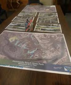
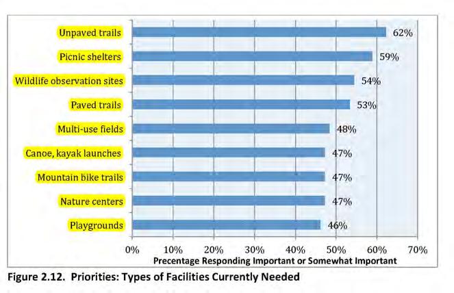
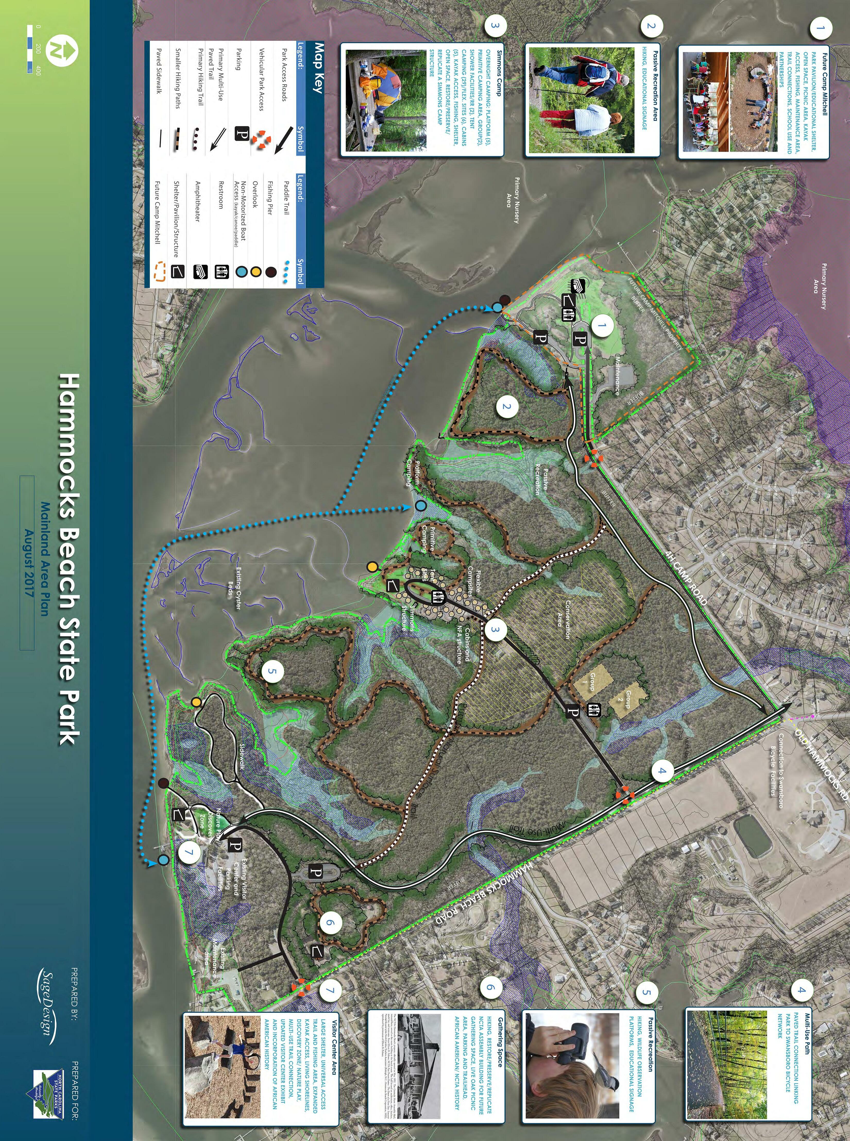
Hammocks Beach State Park


MAINLAND AREA PLAN AUGUST 2017

Contributing Partners:
North CaroliNa State ParkS:

Mike Murphy, Director
Carol Tingley, Deputy Director
John Fullwood, East District
Brian Strong, Chief of Planning and Natural Resources
Dave Head, Program Planning Manager
Christy Rosas, Park Planner
Scott Crocker, State Trails Program Manager
Erin Lawrence, Engineering Supervisor
Justin Williamson, Environmental Review Coordinator
Pete Colwell, Land Protection Specialist
John Amoroso, Planning and GIS
Bob Taber, Coastal Regional Trail Specialist
Michelle Lanier, Director, N.C. African American Heritage Commission
LuAnn Bryan, Recreation Resource Services
hammoCkS BeaCh State Park Staff:
Sarah Kendrick, Park Superintendent
Mary Carr
Renee Evans
Thomas Jones
Ray Parker
David Parker
Pam Pearson
Brian Swanson
Jake Vitak
Brian Vick
ProjeCt PartNerS:
Adjacent Neighborhood Associations
Alta Greenways
Barrier Island Kayak
Coastal Federation
Community Members
Department of Natural and Cultural Resources (DNCR)
Environmental Agency Representatives
Friends of Hammocks and Bear Island (FHBI)
Hoke County Schools (Agriculture)
Hurst/Turner Family
Jacksonville Daily News
Local Area Businesses, Groups and Organizations
Local Fishing Charter Companies Local News Organizations & Publications
National Marine Fisheries Service (NMFS) NC AgricultureTeachers Association Representatives
NC Department of Environmental Quality Division of Coastal Management(NCDEQ DEM)
NC Division of Energy, Mineral and Land Resources (DEMLR)
NC Division of Water Resources (DWR)
NC FFA Organization (representing NFA) NC General Assembly NC Teachers Association
NC Wildlife Resources Commission (NCWRC) NCDOT
Onslow Bay Coastal Conservation Association
Onslow County Government
Onslow County Homeschool Group
Onslow County Parks & Recreation
Onslow County Planning Department
Onslow County Schools
Paddle NC
Public Meeting Attendees
Second Wind Eco Tours & Yoga
Survey Participants
Swansboro Area Chamber of Commerce
Swansboro Parks & Recreation
Swansboro Public Library
Tideland News
Town of Swansboro
Town of Swansboro Fire Department
Town of Swansboro Planning Department
U.S. Army Corp of Engineers (USACE)
U.S. Fish & Wildlife Service (USFWS) White Oak River Keeper Wildlife Resource Commission
4-H
CoNSultaNt team:
SageDesign, Lead Consultant
CIII Associates

Division of Parks and Recreation
NC Department of Natural and Cultural Resources
August, 2017
Friends and Supporters of Hammocks Beach State Park:
Hammocks Beach State Park historically consisted largely of coastal islands, but recently acquired land allows the park to expand on the main land. This land is steeped in rich history, and should be used in ways that respect and highlight that history – honoring the intentions of those who worked to protect the land for recreation, education, and equal opportunity, and ensuring the land is used for those purposes for generations to come. The Mainland Area Master Plan builds upon the unique history of the region and property while combining natural resource protection with public enjoyment.
This master plan is a blueprint for long-term development of facilities and protection of important natural resources, including a long leaf pine forest and marshes. Such a plan is an organic document which evolves as the park grows and knowledge is gained about available resources and public use. With the plan’s completion, Hammocks Beach State Park enters a new era with a bold vision. Sage Design, of Wilmington, NC, developed this master plan in full consultation with State Parks staff and the community through a planning process that included extensive public outreach. The result is a guide that balances cultural history, outdoor recreation and natural resource stewardship.
At all state parks, we are committed to our mission to conserving and protecting natural resources, educating our visitors about unique resources, and providing quality outdoor recreation. The Hammocks Beach Mainland Area Master Plan offers us an outstanding opportunity to fulfill those objectives. That commitment, the continued support of our partners and thoughtful planning will combine for a lasting legacy.
Sincerely,

Michael A. Murphy, Director Division of Parks and Recreation
Michael A. Murphy, Director NC Division of Parks and Recreation 1615 MSC - Raleigh, NC 27699-1615 919.707.9300 / ncparks.gov

This
is
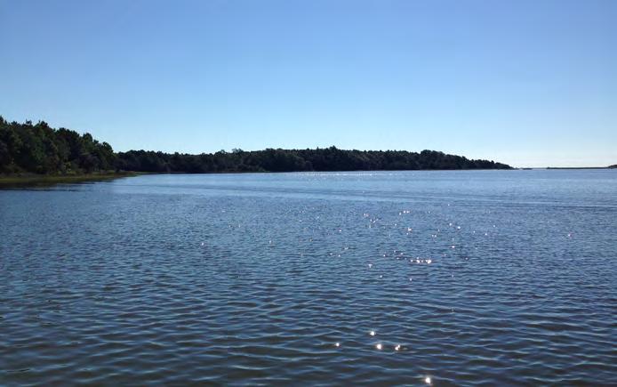
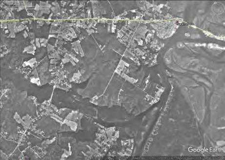
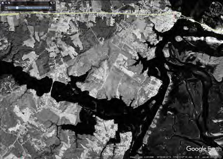
Hammocks Beach State Park is located in Swansboro, North Carolina, the very eastern part of Onslow County The area is commonly referred to the Crystal Coast and the park is part of an area in Swansboro referred to as “the Hammocks .” The total state park site covers approximately 1,520 acres and consists of the mainland property and several islands . The primary island, Bear Island, is a four-mile-long, undeveloped barrier island acces sible by the park’s passenger ferry, private ferry, or by paddling a canoe or kayak . The park also owns three smaller islands, Dudley, Huggins, and Jones, located in the nearby mouth of the White Oak River . The park’s mainland currently offers a visitor center, a launch site for ferry service, and canoes and kayaks . Interpretive programs and exhibits teach about park ecology, wildlife, and history .
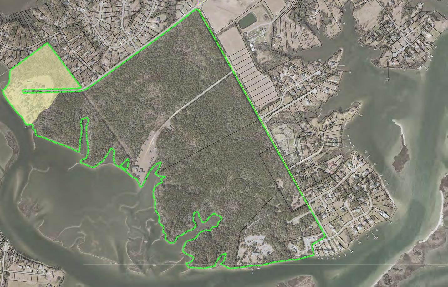
In 2015, the State of North Carolina acquired 290 acres of prop erty adjacent to the visitor center mainland of Hammocks Beach State park This acquisition had been part of the park vision for many years in an effort to expand mainland area access to recreation, education, and conservation for park visitors The 290 acre acquisition area is the focus of this planning effort and study, and will be referred to as the“study area” .
The intent of this study is to further evaluate the mainland area acquisition for the purposes of upholding the North Carolina Division of Parks and Recreation Mission:
• Conservation: To conserve and protect representative examples of North Carolina’s natural beauty, ecolog ical features, recreational and cultural resources within the state parks system;
• Recreation: To provide and promote safe, healthy and enjoyable outdoor recreational opportunities throughout the state; and
• Education: To provide educational opportunities that promote stewardship of the state’s natural and cultural heritage.
• The 1997 Hammocks Beach State Park General Management Plan and Master Plan presents a five year plan for the then owned 35 acre mainland area which included the visitor center and the 892 acre Bear Island .
• 2010 Draft General Management Plan for Hammocks Beach State Park outlines five year recommendations for the 35 Acre mainland area; 892 acre Bear Island; Jones Island, a 23 . 46-acre coastal island located at the mouth of the White Oak River; and, Huggins Island, located just east of Bear Island in the mouth of Bogue Inlet, is a 225-acre island .
• January 2015 PHASE I ENVIRONMENTAL SITE ASSESSMENT REPORT outlines existing environmental and site conditions on the 289 acre acquisition piece . The purpose of the ESA was to: evaluate the probability of impact to the surface water, groundwater and/or soils within the property boundaries through a review of regulatory information and a reconnaissance of the subject site and vicinity; evaluate historical land usage to identify previous conditions that could potentially impact the environmental condition of the site; conduct all appropriate inquiry as defined by ASTM Standard E 1527-13 and 40 CFR Part 312; evaluate the potential for on-site and off-site contamination; and, provide a professional opinion regarding the potential for environment
• DPR Annual Report
• Statewide Comprehensive Outdoor Recreation Plan (SCORP)
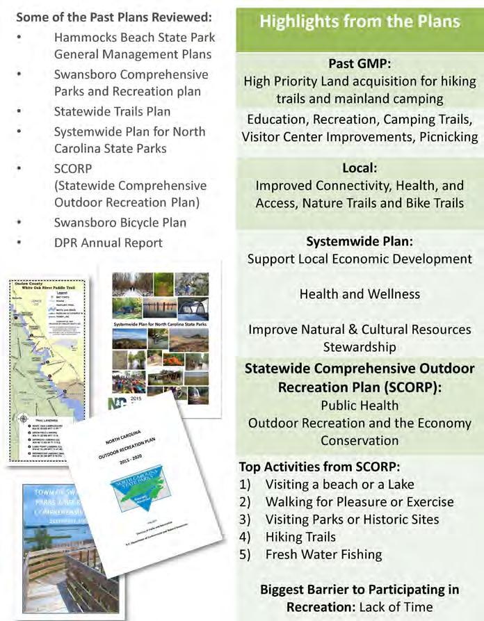
• Systemwide Plan for North Carolina State Parks 2015
• Mountains to Sea Trail: Segment 15B: The Onslow Bight and Jacksonville
• Swansboro Bicycle Plan, 2011
• Swansboro Parks and Recreation Master Plan, 2008
• White Oak Paddle Trail, 2009
• Swansboro Watershed Restoration Plan,2017
Hammocks Beach State Park has a rich history and is summarized on the Park website at: https://www.ncparks.gov/hammocks-beach-state-park/history (The summary for the entire park site ranges from 2000 B.C. up to more recent history)
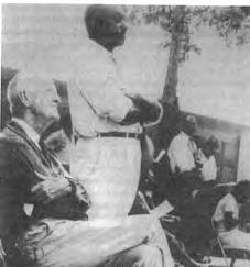
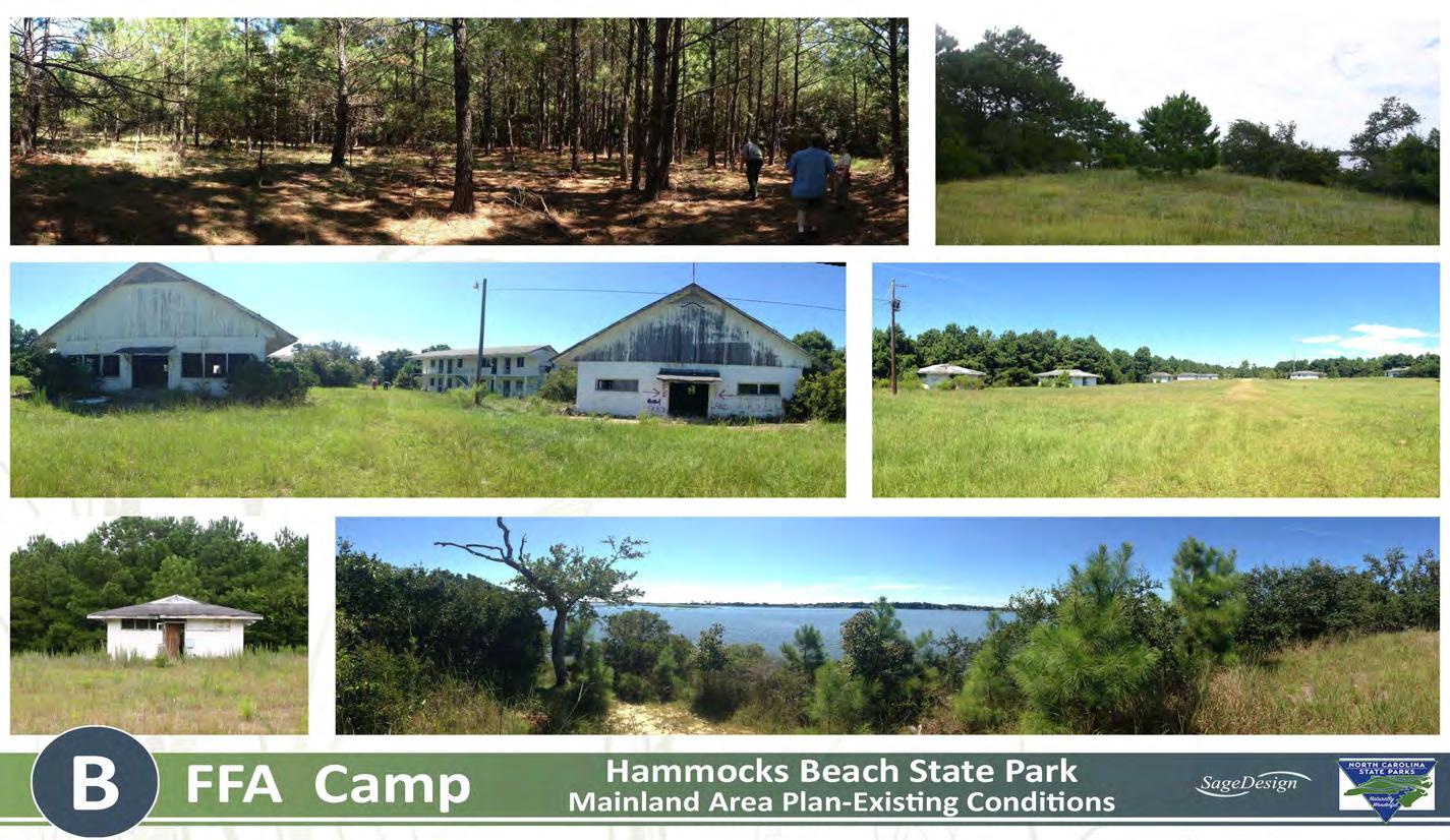
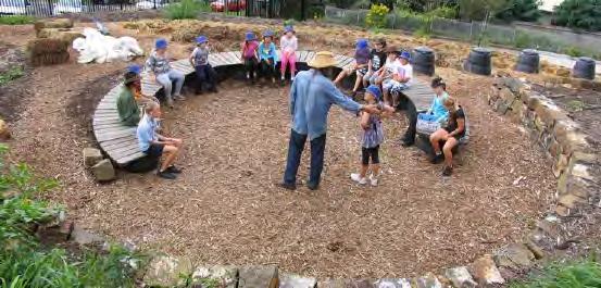
The 289 acre mainland area has a unique 20th century history and can serve as a place to highlight the sites uses during this time period Early in the 20th century, Dr William Sharpe, a neurosurgeon of New York, came to Bear Island to hunt His love of the island prompted him to acquire it and the area referred to as “the Hammocks” for his retirement . Sharpe had intended to will the property to John Hurst, his longtime hunting guide and friend, but Hurst persuaded him to donate it to the North Carolina Teachers Association, an organization of African American teachers . It was from this the Hammock Beach Corporation was created to provide recreational and educational opportunities for African Americans . The corporation formed rela tionships with several organizations including the 4-H, YMCA, YWCA, churches and agricultural groups (New Farmers of America) in order to develop and utilize the property for camps, conventions, field trips and retreats during the early 1950’s .
June of 1956, was named after John W . Mitchell, who served as State Negro Agent in North Carolina . An additional four buildings were eventually added to the camps . Camp Mitchell was racially segre gated until 1965 (https://www.lib.ncsu.edu/specialcollections/greenngrowing/4H_ history.html; Clover All Over)
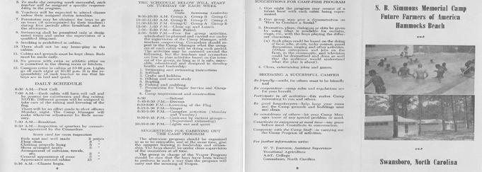
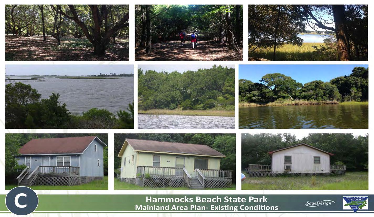
In 1953, the NFA (New Farmers of America), leased 27 acres from the Hammocks Beach Corporation for the future location of a vocational agriculture camp program for young african americans . In June of 1958, the SB Simmons Memorial Camp was completed and opened In 1965, the NFA and the FFA merged, and their lease of the property was in effect until 2016 Participation in the S B . Simmons camp declined in the 1970’s and it was eventu ally closed due to lack of use . (NCffa o rg)
While the mainland devel opment was well underway, accessibility to the beach was still problematic until a canal was dredged to Bear Island and a ferry service was established .
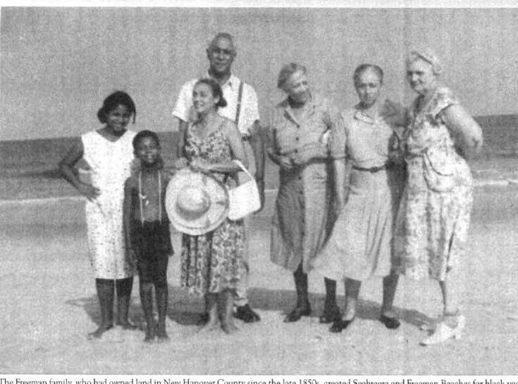
Images from “Blue Water Black Beach: The North Carolina Teachers Association and Hammocks Beach in the age of Jim Crow by Crystal Sanders
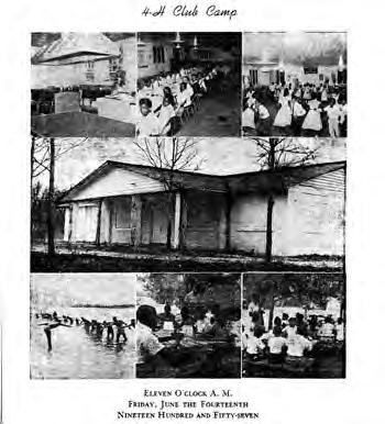

The need for a camp devoted to black youth was apparent to the 4-H in North Carolina . In 1955, their efforts came to fruition . Camp J .W Mitchell, composed of eight buildings, was built in Onslow County on leased land at Hammocks Beach The camp, which opened in
In 1956, the Hammocks Beach Corporation began negotiating with the state of North Carolina to transition Bear Island into a state park . A portion of the mainland property was donated to the state in return for the construction of a ferry channel, which would allow ocean access . In 1961 Hammocks Beach State Park was opened, finally fulfilling the goals the Hammocks Beach Corporation had intended, creating a recre ational and educational facility exclusively for black people to use Initially planned as a park for minorities, Hammocks Beach State Park opened for all people following the Civil Rights Act of 1964 .
Construction continued on Bear island, including a bathhouse, water system, maintenance buildings, restrooms, and ferry facilities, but the mainland property was not progressing in regard to the intended use . In response to desegregation, the NC Association of Educators was formed in 1970 when the NCTA (African American teachers) and the NC Education Association (white teachers) merged .
During the 1980’s, the Hammocks Beach Corporation brought suit against the Hurst and Sharpe heirs, to eliminate their rights of use . In response, in 1986, the Sharpe Family Trust brought a countersuit against the Hammocks Beach Corporation due to the inability to fulfill the intended goal . As a result, a Consent Judgement was reached in 1987 and the Sharpe and Hurst families were each recipients of onethird of the 810 acre property, but in exchange they were required to give up their rights of the remaining property to the Hammocks Beach Corporation, providing the HBC could fulfill the original intent of the trust This remaining land was now “…free and clear of any rights of the heirs of Dr . William Sharpe or of Gertrude Hurst or of the heirs of John and Gertrude Hurst .” The heirs went on to develop their properties, which did not allow the land to be utilized for state park purposes
In 1988, 30 mainland acres were sold to the state based upon the understanding that the Hammocks Beach Corporation was trying to fulfill its goals. This land would later become the visitor center, facili ties, and ferry dock of Hammocks Beach State Park as we know it today . In addition to the mainland areas, Hammocks Beach State Park’s island property was expanding as well Huggins Island, a 225 acre site, was added to the park in 1999 and Jones Island, a 17 acre site, was added in 2007.
In 2006, The Hurst heirs filed a lawsuit against the Hammocks Beach Corporation on the grounds that the Corporation had yet again not been able to fulfill the intended goal. The Hurst family was asking for the remaining land under the Hammocks Beach Corporation be transferred to the family, as per the original 1950 trust agreement The 1987 Consent Judgement however stated that the real property “… vested in the Hammocks Beach Corporation as Trustee shall be clear of any rights of the heirs…” Due to a series of appeals, the case ended up at the NC Supreme court . For the next 8 years, various
court cases and appeals continued, involving the Hammocks Beach Corporation, the State of North Carolina, the North Carolina State Board of Education, the Hammocks Beach Trust, and the Hurst heirs Finally, in June of 2014 a settlement was reached that would allow the heirs to be compensated and the land to be purchased by the state to expand Hammocks Beach State Park .
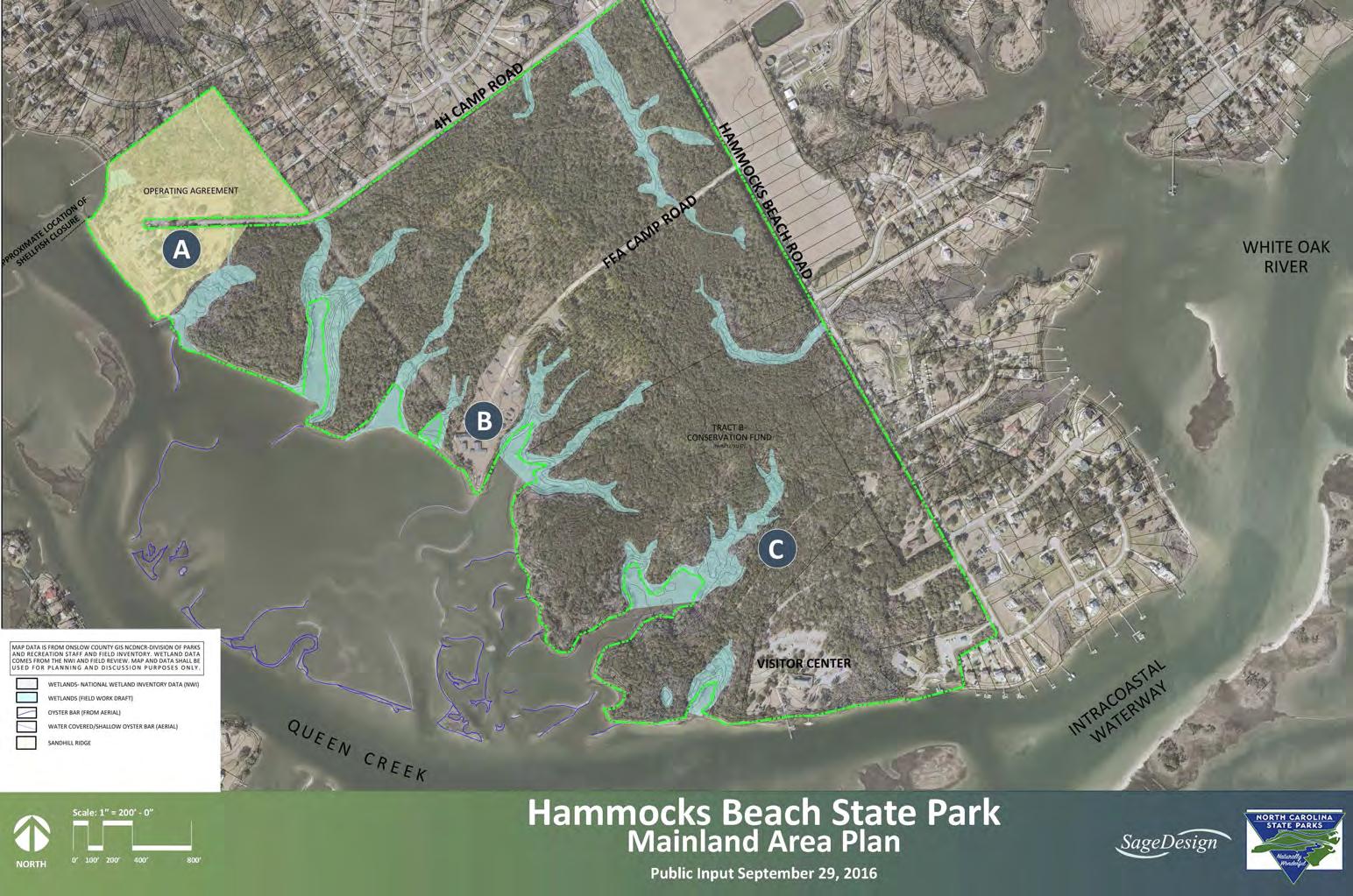
Hammocks Beach State Park mainland area is approximately 289 acres adjacent to the existing 30 acre mainland property that consists of the existing Visitor Center, ferry, and maintenance facilities . Of the 289 acres, approximately 27 acres is under lease for a period of 3
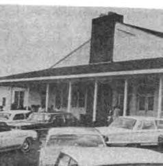
A Brochure from S.B. Simmons Camp (NCFFA.org)
years with the Hurst family to be used and developed as a camp facility The lease began in 2015 . At the end of the lease period if no camp facility development has occurred, the lease will end
The 289 acres can be accessed by car along 4H Camp Road, Hammocks Beach Road, FFA Camp Road, and along the existing access path locations near the Visitor Center .
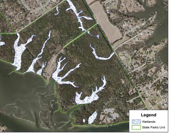
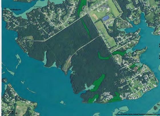
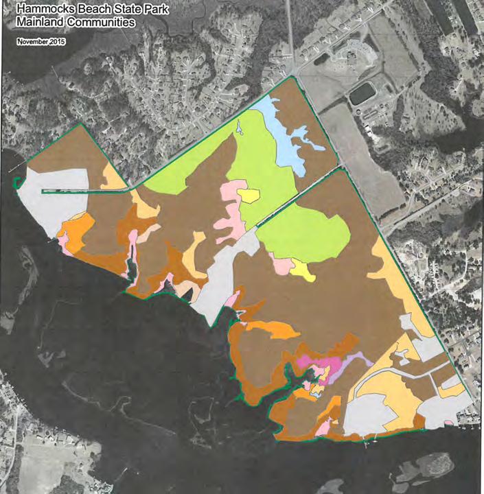
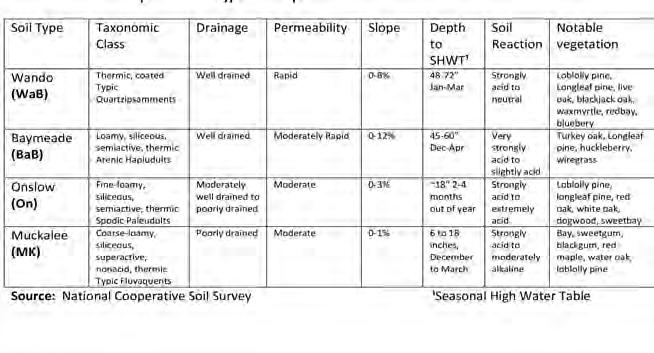
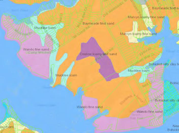
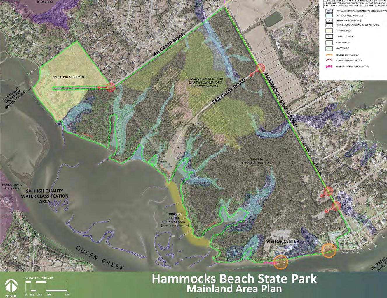
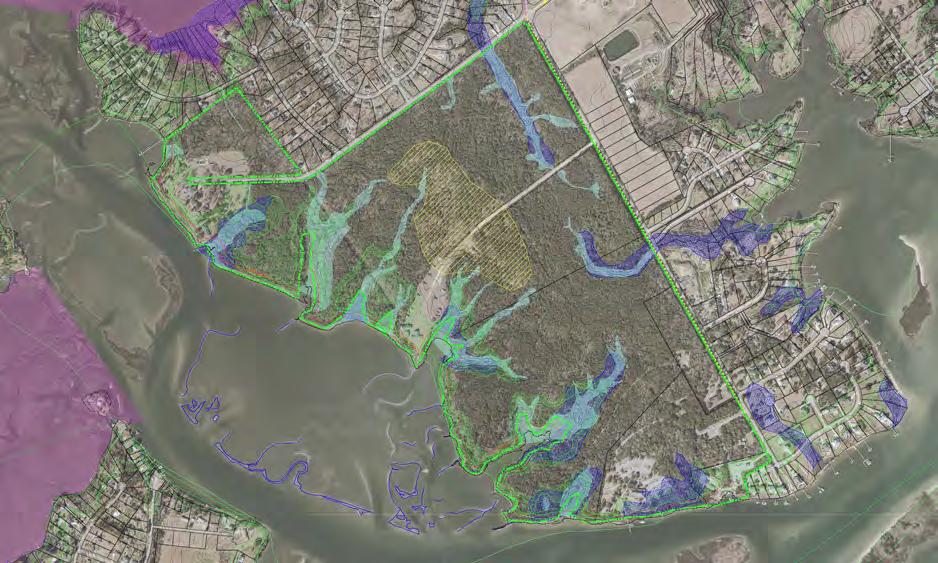
Hammocks Beach State Park contains a variety of natural resources and site features from past use . These natural resources and existing features can serve as potential opportunities, and in some cases constraints for future park use, regardless, each feature contributes to making the site unique . For the purposes of this study, several sources were used to overlay known existing site features and environmental conditions such as: past reports, GIS data, site surveys, and field investigation. Some of the natural resources reviewed include: wetlands, floodplain data, vegetation, soils, topography, Nursery, shellfish , and fisheries informa tion, and Water Quality Classifications and reports.
In addition to the identifying the natural resources, it is important to note, many of these features are protected and/or regulated . Therefore, standards for avoidance and minimization such as addressing required buffers and setbacks will need to be applied when moving forward with future park use and development Each agency involved has it’s own set of regulations and guidelines that will need to be addressed . In addition to potential federal and statewide permit agency involvement, Hammocks Beach State Park, located in Onslow County, is subject to the rules and policies of the Coastal Resources Commission, which adminis ters the Coastal Area Management Act (CAMA) .
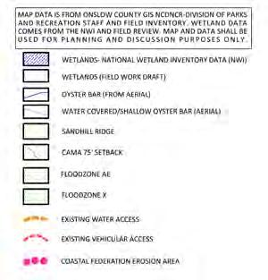
No formal wetland delineation has occurred for the 289 acres . For the purposes of planning, data from the US Fish and Wildlife National Wetland Inventory was downloaded and incorporated into the base map. Additionally, mapped field data conducted in 2016 by state park staff was also placed in the base map for reference and site review Based upon field observation and site visits, the staff mapped field data is more accurate based upon current conditions . Map data is distin guished on the existing conditions map legend and image .
When reviewing the site it is important to understand where flood prone areas exist, not only to minimize impact but to also avoid complications in during the regulatory review process . The following information outlines the floodplain areas indicated on the site. There are many flood zones and guides and many of the maps are currently being updated . For the purposes of this project the following flood information was translated to the project map as areas to avoid:
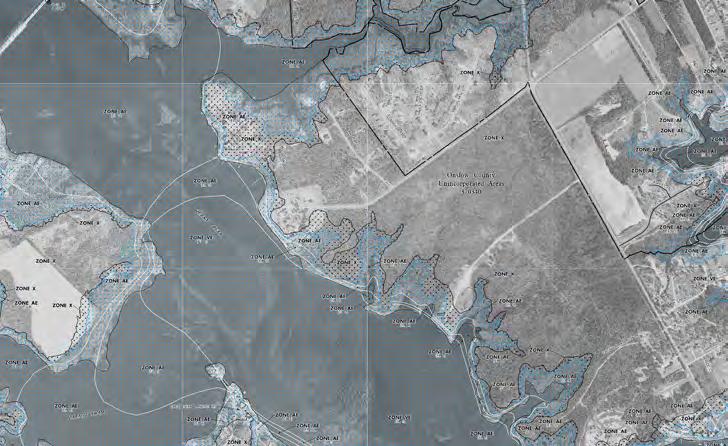
• Zone C, Zone X - Areas determined to be outside 500-year floodplain deter mined to be outside the 1% and 0.2% annual chance floodplains.
• Zone AE - An area inundated by 1% annual chance flooding, for which BFEs have been determined
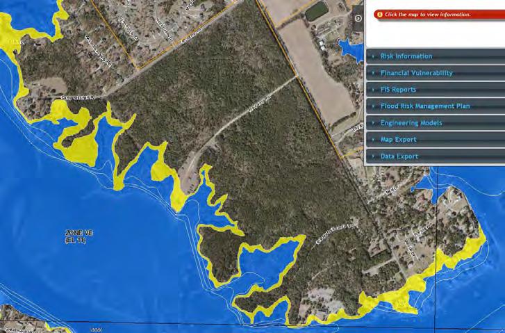
• Zone VE - An area inundated by 1% annual chance flooding with velocity hazard (wave action); BFEs have been determined .
• 100IC - An area where the 1% annual chance flooding is contained within the channel banks and the channel is too narrow to show to scale An arbitrary channel width of 3 meters is shown BFEs are not shown in this area, although they may be reflected on the corresponding profile. (1% Annual Chance Flood Discharge Contained in Channel)
• 500IC - An area where the 0.2% annual chance flooding is contained within the channel banks and the channel is too narrow to show to scale . An arbi trary channel width of 3 meters is shown ( 2% Annual Chance Flood Discharge Contained in channel)
https://deq.nc.gov/about/divisions/water-resources/planning/ classification-standards/classifications
Surface waters in North Carolina are assigned a primary clas sification by the NC Division of Water Resources (DWR). All waters must at least meet the standards for Class C (fishable / swimmable) waters. The other primary classifications provide additional levels of protection for primary water contact recre ation (Class B) & drinking water (Water Supply Classes I - V) .
These classifications are important when looking at potential development within the park and the impacts development may have on adjacent waterways. In addition, these classifica tions are important to understand the water quality levels when evaluating public access to water .
Tidal salt waters that are used for commercial shellfishing or marketing purposes are also protected for all Class SC and Class SB uses . All SA waters are also HQW by supplemental classification.
Supplemental classification intended to protect waters which are rated excellent based on biological and physical/chemical characteristics through Division monitoring or special studies, primary nursery areas designated by the Marine Fisheries Commission, and other functional nursery areas designated by the Marine Fisheries Commission
Maps and additional information can be found at: https://deq.nc.gov/about/ divisions/water-resources/planning/classification-standards/classifications
Primary Nursery Areas, as defined by the Marine Fisheries Commission, are those areas in the estuarine system where initial post-larval development takes place . These areas are usually located in the uppermost sections of a system . The Division of Marine Fisheries is responsible for preserving, protecting and developing Primary Nursery Areas for commercially important finfish and shellfish.
Ensures the safety of consumers of molluscan shellfish by monitoring harvesting waters and ensuring the proper handling of shellfish sold to the public. This classification and monitoring is important to gauge current condition of water quality and habitat, and what impact surrounding development may have on shellfish waters.
According to the 2014 Environmental Assessment Report an Open Records Request was presented to Onslow County to obtain well and/or septic records for the site on October 27, 2014 Onslow County responded on October 28, 2014 and provided ECS with the operations permit, improvements permit, and the installa tion inspection checklist The Onslow County Environmental Health Improvements Permit is dated November 30, 1993 and is for the ground absorption sewage treatment and disposal system located at the Mitchell 4-H Camp/ Mitchell 4-H Educational Center . The permit references the site as listing a water supply well . The permit also shows septic tanks associated with each building with a bath house
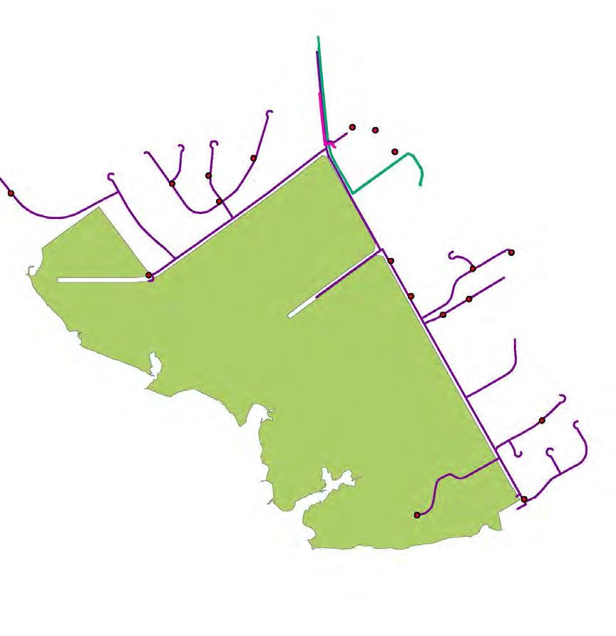
There is access to power along the entire perimeter of the site through Duke Energy and old power poles located at the old 4H Camp Mitchell site and the old Simmons Camp site off of FFA Camp Road . All on site poles would need replacement through purchase or lease with Duke Energy .
There is water access to the site ending at the entrance of the old 4H Camp site, and a water line extension would be needed . Additionally, there is water access into the site on FFA camp road . The condition of this line is unknown . This line may need replacement and an extension may be needed .
There is a nearby pressurized sewer and gravity sewer with both lines ending near the intersec tion of 4H Camp Road and Old Hammocks Beach Road
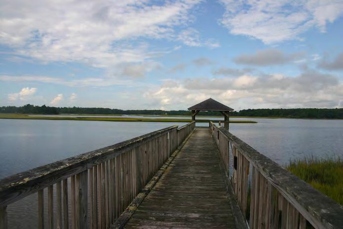
Photos above are from the 4-H camp site and show the condi tion of existing structures, the hiking trails in place, and the existing pier and water access.

Photos above are from the previous Simmons Camp NFA site and show the condition of existing structures, the hiking trails in place, and the view from the site.
Photos above are from the North Carolina Teachers Association Site and show some of the structures in place, the unique grove of live oaks, and the view of the water from this portion the site. Note, the assembly building is not shown above.
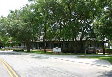
DHammocks Beach State park VIsitor Center
Kayak and Canoe Launch and Vendor area
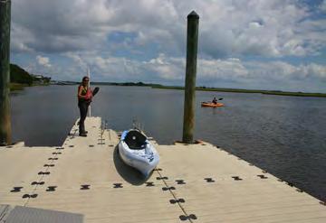
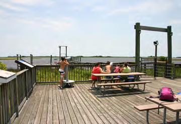
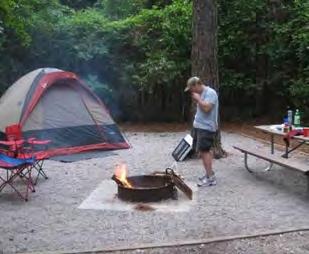
Hammocks Beach State Park has several existing mainland Resources including a ferry dock with service to Bear Island, a full-service visitor center, and canoes and kayaks . Visitors can rent or bring their own kayaks, canoes or paddleboards to explore paddling trails leading to marshes or park islands The park also offers Interpretive programs and exhibits that teach about history, park ecology and wildlife, including endangered sea turtles and nesting shorebirds .
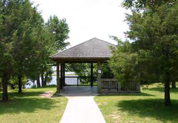
There is an existing park shelter, open space, support parking, ranger residence’s, and a park maintenance area and boat ramp that serves the mainland park and park islands .
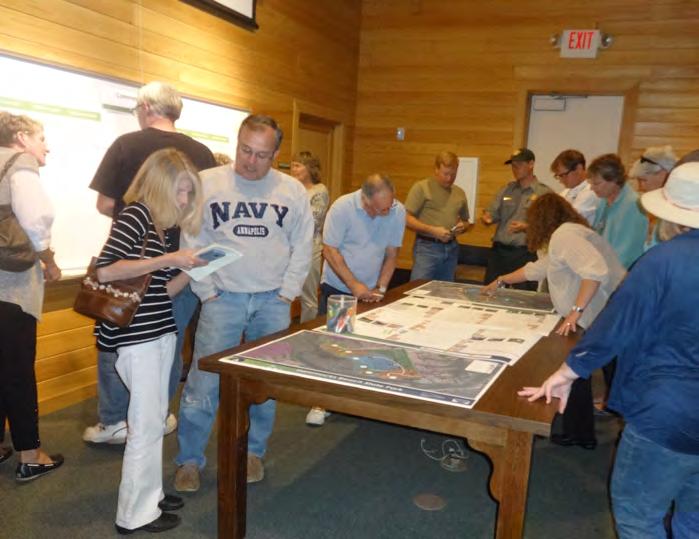
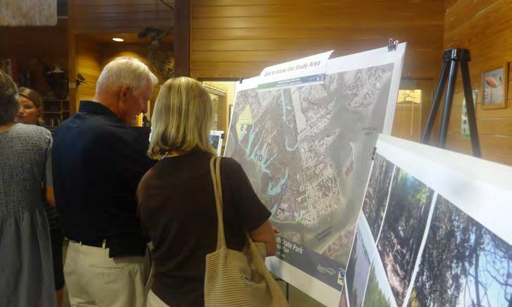
Public involvement is imperative to the success of a park planning process . It is important to not only hear from potential park users and look to statewide input for the Hammocks Beach State Park resource, but also, the community involvement process is an opportunity for outreach and education regarding the mainland area acquisition and future development In order to help identify user needs, several methods of input and evaluation were used throughout the dura tion of this planning process . For this plan, public input was gathered through staff meetings and interviews, steering committee participa tion, online and hard-copy public surveys, phone interviews, Public Open houses, stakeholder meetings and interviews, and reference to recent statewide surveys, the Statewide Comprehensive Outdoor Recreation Plan (SCORP) 2015-2020, the 2015 NC Parks Systemwide Update Public input, Friends of Hammocks and Bear Island Survey, and the staff conducted Public Meeting follow up survey (February 2017) . Each outreach and input method aided in determining the needs for the recently acquired Mainland Area .

(All meeting notes and complete summaries can be found in the appendix of the report)
ProjeCt k i Ck o ff - auguSt 4, 2016
Cultural re SourCe S, 109 e joNe S Street – r aleigh NC – CoNfere NCe room 308, 10:00 am
The project Steering Committee met August 4, 2016 to kick-off the Hammocks Beach State Park Mainland Area Plan . The consultant team (SageDesign) had already reviewed data compiled by the client (State Parks) including past reports, environmental data, and related news articles . Using GIS data gathered to-date, a base map was prepared for the meeting to gather input, identify site concerns, and better understand areas of interest . This meeting included staff from all program areas of the North Carolina Division of Parks and Recreation including: Administration, Operations, Recreation Grants and Outreach, Park Planning, Natural Resources, Land Protection/ Acquisition, North Carolina Trails Program, engineering and construc tion, and Recreation Resources Services coastal resource staff, and Hammocks Beach State Park Staff .
On December 15th, 2016, Sage Design met with five staff members (DPR & HABE) for a design charrette to determine the elements to be included in the park . After reviewing the existing conditions, past plans, public input and comments it was determined that the future design elements would include trails of various types, fishing, camping for groups as well as individuals, and the preservation or replication of important former camp buildings located on the site At this
meeting it was also discussed that a boat ramp should be presented as a possible option . The next step was to meet again with staff in January with plan options, to determine what will be presented to the public in February

The consultant team met with fourteen staff members (NC Parks) to review the existing conditions and constraints, discuss the results of the public input sessions to date and to refine and determine the draft program elements to be presented to the public at the February open house . Sage Design brought three options (A, B, & C) for discussion among the group . Each of these plans included the most desired elements as identified from the public input: trails, camping and fishing. It was also decided that the plans would reflect interpretive elements to recognize the African American history of the site. Each plan reflected different options for circulation, location of elements such as camping, retreat centers, cultural learning, nature preservation, a boat ramp and overall improvements . Upon review and discussion of each plan, it was determined that the plans would be revised to reflect the comments, be internally reviewed by NC Parks prior to the next meeting, and two plans would be presented to the public in February .
The Hammocks Beach State Park Staff were interviewed between October 3rd - October 26th, 2016 as a part of the planning efforts
Nine (9) staff names and emails were given to the consultant team of which seven (7) participated in the interview process . Staff Interviews were conducted over the phone by the consultant team Staff members were told the interview process would take approximately ½ an hour and were given the anticipated discus sion items ahead of the interview process . Each staff person was told questions served as a guide and that anonymity would be provided by answers being summarized by question
#1- SePtemBer 26, 2016 hammoCkS B eaCh State Park vi Sitor CeNter o PeN houSe 4 Pm - 7Pm
Approximately 75 people attended the first public meeting and open house . Information was provided to help participants get to know the site, learn about the planning process, and allow the consultant team an opportunity to hear from the public . Some of the information presented was: Existing Conditions Map, existing site conditions photos, activity preference boards, area history, general project information, and mapping input activity
aCtivity Prefere NCe N umBer of d ot S
Hiking Trails 60
Living Shorelines (to prevent erosion & restore fish and oyster habitat)
43
Kayaking 41
Educational Programs 26
Camping 22
Boat Ramp 18
NCTA/MAAH Museum 15
Campsite Camping 15
Paved Trails 15
Mountain Bike Trails 14
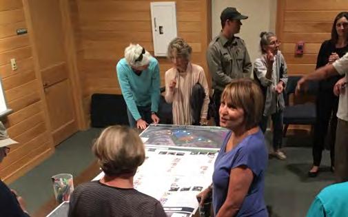
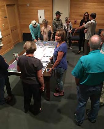
#2- feBruary 23, 2017
o PeN houSe 4 Pm - 7Pm
On February 23rd, 2017 the second public open house was held with approximately 127 people in attendance . The open house was formatted with multiple stations throughout the facility depicting public involvement results to date, recreation trends and past plans, a summary of the public survey, program features based upon anal ysis and input to date, comments previously heard from the public, existing conditions, and an outline of boating resources and history . In addition, two concept diagram options were displayed (Concepts A & B) . Both concepts included uses at both the Simmons and the 4H site, camping, passive recreation, and visitor center area improve ments . Plan B also included the relocation of park operations due to a motorized boat access facility . Attendees reviewed each concept and were encouraged to write any additional comments or thoughts regarding which concept they preferred, why they preferred it, and what may need to be changed
#3- aPril 27, 2017
hammoCkS B eaCh State Park vi Sitor CeNter
o PeN houSe 4 Pm - 6 Pm
The Final Public Meeting was hosted on April 27, 2017 to get Public response to the Mainland Area Plan There were over 50 people in attendance at the Open House . Existing Conditions, the Division Mission Statement, Public Input summary, resulting Program Features, and a Boat Ramp review board were all presented . The Draft Final Plan was presented in the hallway and in the auditorium for review and input . Final thoughts were provided on the plan and comment board for consideration .
As a part of the planning process several local groups were identified by staff as an organization that has interest in Hammocks Beach State Park . These groups were listed and prioritized to either invite to local public meetings, conduct phone interviews, or host a separate stake holder session Stakeholder sessions were hosted at the Hammocks Beach State Park visitor Center with staff representatives from the various organizations . The meeting intent was to hear stakeholder
ideas for the Mainland area, how the park and future elements may support a group or organization, and to identify what plans, projects, or studies may exist that could have influence on the property.
age NCy m eeti Ng (Pre ki Ck off) july 22, 2016
hammoCkS BeaCh State Park
This was an inter-agency site meeting with representatives from various regulatory agencies including: DCM, USACE, USFWS, NMFS, NCWRC, DNCR, and NC Park, to review the Hammocks Beach State Park site prior to project kick-off . The agency representatives reviewed existing conditions and identified areas of concern for the planning and potential development of future park features .
Coa Stal federatioN & white oak river kee Per, NovemBer 16, 2016hammoCkS B eaCh State Park vi Sitor CeNter
The consultant team met with representatives of the Coastal Federation to review the park and learn more about the Living Shorelines project potential at Hammocks Beach State Park . As a part of this planning process the Coastal Federation submitted a letter of concern regarding future park development and features to State Parks for review and consideration .
SwaNSBoro, o NSlow, Carteret SePtemBer 29, 2016
hammoCkS B eaCh State Park vi Sitor CeNter 10:00am
Staff representatives from City and County Planning were present to review the site, discuss local planning efforts that may have influence on the plan, and to express priorities for their communities .
frieNdS of hammoCkS aNd B ear i SlaNd (fh B i) oCtoBer 27, 2016hammoCkS B eaCh State Park vi Sitor CeNter, 6 Pm
The meeting was hosted as a special membership meeting for Friends of Hammocks and Bear Island (FHBI) Participants were asked to check in at the door Members each received: a ballot regarding the boat ramp issue, a name tag, a stakeholder survey, and were asked to sit in front for a presentation .
FHBI President David Pearson introduced himself and discussed the ballot as requested by the board at their 9/10/16 meeting He felt the vote was outside of their scope to support the park He reviewed the Bylaws, asked for cooperation and good behavior, and asked everyone to vote .
Votes were tallied by two Park Staff members and a FHBI representa tive . FHBI members present voted against the boat ramp: 23 against, 7 in favor. Outcome is that FHBI does not support the boat ramp .
David Pearson Introduced the consultant team Sara Burroughs and Nicole Whiteside discussed the planning process, project time line, how decisions would be made, and means of public outreach and input . We asked the group to please speak to their neighbors and friends about the process to get the word out about how the Mainland Plan is working and where we are in the process .
frieNdS of hammoCkS aNd B ear i SlaNd (fh B i) - oCtoBer 27, 2017 Stakeholder Survey Summary:
QueStioN
How many years have you been an FHBI member?
higheSt reSPoNSe
Average 3 years 5
Why did you join Friends of Hammocks and Bear Island? To help support natural resources in the area 10
What do you feel the FHBI role is for Hammocks Beach State Park?
How do you feel FHBI can best support the park on the New Mainland Property?
Volunteer to the park and contribute to community opinion about the role of the park
6
The Friends of Hammocks and Bear Island presented the consultant team with a survey and results they conducted prior to the project getting underway . The consultant team reviewed the data as part of the planning process, however, no data is included due to lack of information regarding distribution, gathering, time frames, and avail ability of the survey to the general public
PuBli C i NPut Survey - the PuBli C Survey wa S CoNduCted from auguSt 26thoCtoBer 28, 2016 aNd remai Ned oPeN for a Period of aPProximately 60 dayS
A participation survey was created with the assistance of Park Planning Staff and placed online and available at the visitor center Questions included user preference, open ended comments, and interests and concerns for the future use of the newly acquired main land area .
Volunteer 6
The public survey results are one tool used in understanding demand and preferred use of the property . This, along with several stake holder meetings and other surveys conducted, helped identify common interests and needs for the mainland area property in the public input process . The public survey was conducted from August 26th- October 28, 2016 and remained open for a period of approxi mately 60 days . The survey instrument was developed using activities typically found within the North Carolina state park system, activities identified in the SCORP, and features identified and reviewed by staff.
What do you think makes the mainland property most unique? That it is a large natural area 12
Please list one (1) activity facility, or program you think would enhance the park Mainland Property the most:
Walking/hiking Trails 12
The survey was placed on the Hammocks Beach State Park Website and a link was distributed to several stakeholder and interest groups including: local businesses, DPR staff, regulatory agencies, environ mental non-profit groups, outdoor recreation providers and vendors, neighborhood groups, the Friends of Hammocks and Bear Island (FHBI), and through local news outlets .
The survey instrument was set up using Survey Monkey and only allowed participants one response per computer . A review of IP addresses was conducted and responses showing the same IP and data for more than one survey response resulted in the responses being discarded from that IP address .
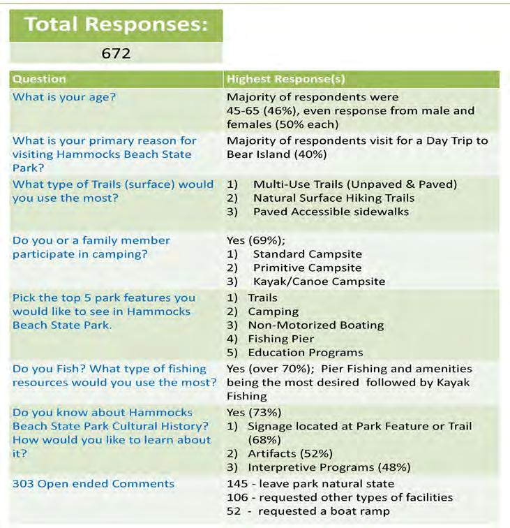
Survey respondents were evenly divided with 50% female and 50% male participants . The majority of participants were Caucasion (91%) with the highest participation in in the age range 45-64 (46%) . The majority of respondents were from the Swansboro, Jacksonville, and the Hubert area . 91% of survey respondents have visited Hammocks Beach State Park before, and the primary reason for their visit (40%) being a Day Trip to Bear Island .
When asked what trail surface would be preferred, natural surface trails ranked the highest followed by paved multi-use trails . The majority (69%) of participants responded that they or a family member participated in camping with the highest preference (52%) for stan dard drive up tent campsites (parking, pad, grill/fire ring, access to shower house) followed by primitive campsites (36%) (hike in & out- no facilities)
When asked what top 5 park features participants would like to see at the Hammocks Beach State Park the following activities ranked within the top 10, in order, with Trails receiving the highest overall support:
Trails
Pier
Non-Motorized Boating
Educational Programs
Swimming
Public Boat Ramp and Parking
Bird Watching
Biking
There were several open ended comments stating further clarifica tion should have been provided for a Public Boat launch for kayaks/ canoes versus motor boating, and an opportunity to specify trail and camping preference in the features portion of the survey .
Question 10, asking if participants owned a boat, shall be discarded since there was not an opportunity presented to select what type of boat a respondent owned: motorized, non-motorized, canoe, kayak, sailboat, etc
The majority of respondents (81%) participate in some type of boating activity with a pretty even distribution expressing interest for boat rental; Yes (48%), No (52%) . When participants were asked their
preferred type of boating activity, kayaking received the highest response (40%), followed by motor boating (26%), then canoeing and kayak fishing (8%).
Respondents stated the majority of them do fish (72%) and that a fishing pier with amenities is the preferred venue (31%), followed by kayak fishing (18%).
Most of the survey participants are aware of the Hammocks Beach State Park Cultural History (73%) with interest in learning about history through signage at the park or trail (68%), followed by seeing artifacts (52%), and through interpretive programming (48%)
At the end of the report there was an opportunity for pariticipants to provide general comments:
There were 303 open ended comments:
• 145 of the 303 open ended comments requested the park be in a more natural state with no boat ramp
99 of the 303 open ended comments requested other items:
horse trails,
camping,
connectivity and greenways,
and ADA accessible facilities
52 of the 303 open ended comments requested a boat ramp
o Nli Ne PuBli C m eeti Ng follow uP (State Park Staff CoNduCted)-
feBruary 27, 2017 - m arCh 21, 2017
The following are highlights from the Public Input Summary:
In addition, NC Parks posted the plans on their website for public browsing and comments and a brief survey after the meeting
All of the comments from this meeting, including the additional NC Park public responses, were then gathered and analyzed to create a final recommendation list to present at the staff meeting in March .
Hammocks Beach State Park is a valuable statewide resource
Because of this, it is not only important to involve staff, stake holders, and project participants, but also to include and evaluate public input from two key statewide planning documents, the 2015 SCORP (Statewide Comprehensive Outdoor Recreation Plan), and the 2015 NC Parks Systemwide Update . This ensures public, staff, and stakeholder input is consistent with these find ings and also offers opportunity to further evaluate discrepancy in findings.
As part of this park planning effort, the team also completed a review of the public input results conducted during the 2015 Statewide Comprehensive Outdoor Recreation Planning efforts (SCORP) . Public response for this project was compared to SCORP input to identify any common finding and to highlight any differ ences that may require further investigation .
SCORP highlights the following needs:
 PuBliC i NPut h ighlightS:
The Systemwide Plan is a 5-year plan that provides a record of recent activities and accomplishments and offers strategic direction for the future of state parks and recreation .
The 2015 Systemwide Plan highlights the SCORP and a 2008 survey conducted by the Division of Parks and Recreation to gain feedback on what types of recreational facilities are desir able in state parks as well as a review and rank of statements regarding the state park system . In addition to press releases, Friends of State Parks groups, outdoor recreation groups, land conservation partners, and various park supporters were encour aged to take the survey online . Some local and statewide park user groups circulated the web link of the online survey to their members . By the time the survey was closed to responses, 3,927 individuals interested in North Carolina state parks completed a survey
The following figure and findings highlight the most and least popular activities from these findings:

All of the study findings and information presented in this report have contributed to the analysis and findings. Existing conditions, Environmental conditions, History, Past Plans, Community Involvement, and Staff involvement and review helped formulate the recommen dations . In order to help identify common factors all environmental information was placed on the existing conditions map, seen on page 20, to help highlight site opportunities and constraints . A data summary was compiled highlighting past plans and findings, and input results were charted to identify common needs throughout the planning process All of the factors contributed to the draft program features
During the inventory process, the consultant team worked with the client to identify related reports and past plans . Each study was read and reviewed to understand common action items and priori ties . Since Hammocks Beach State Park (HBSP) is a state resource, it is important to ensure findings and recommendations are consistent with the system priorities and SCORP. The summary on the following table highlights the analysis methodology and some of the report analysis . This approach was used for each of the reports and studies listed in the inventory
• DPR Annual Report
• 2015 Statewide Comprehensive Outdoor Recreation Plan (SCORP)
• Systemwide Plan for North Carolina State Parks 2015
• HBSP General Management Plan (1997, draft 2010)
• Mountains to Sea Trail: Segment 15B: The Onslow Bight and Jacksonville
• Swansboro Bicycle Plan, 2011
• Swansboro Parks and Recreation Master Plan, 2008
• Onslow County Parks and Recreation information
• White Oak Paddle trail, 2009
• Swansboro Watershed Restoration Plan,2017
• Articles, Newsletters, social media references related to HBSP
• Historic Documents:
• B lue Water Black Beach
• FHBI website
• FFA/NFA information
• 4 -H information
• NCTA Teacher Booklet
• Park Trail maps
• CAMA handbook
• Phase I Environmental Site Assessment Report, January 2015
• Deeds, MOU’s, and real estate data
• Swansboro Watershed Restoration Plan
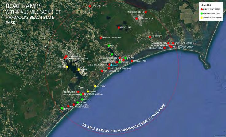
• Area boat data
hammoCkS B eaCh State Park geNeral m aNagemeNt PlaN
aNd m a Ster PlaN
towN of SwaNSBoro ParkS & reCreatioN
ComPrehe NSive PlaN
haBe geNeral m aNagemeNt PlaN (d raft)
SwaNSBoro B i CyCle PlaN
1997 No Public Boat Ramp, additional staffing needs (2 rangers), stay up to date with Ferry operations and equipment, patrol illegal hunting and camping on Bear Island to limit resource damage, education about natural systems The 1997 Master Plan called for amphitheater, picnic areas, mainland camping, and internal vehicular access
2008 Resident input listed Nature Trails and Bike Trails as the 3rd and 4th most important features to add after recreational water features (swimming pools and splash pad)
High Priority Land acquisition for hiking trails and mainland camping
Nature Trails and Bike Trails
2010 Park Expansion and Land Acquisition;
2011 Improve Bicycle and Pedestrian Connectivity from town to Hammocks Beach State Park (HBSP), Improve connectivity from Hotel to HBSP
SyStemwide PlaN for North Caroli Na State ParkS 2015
• Continue Expansion Of The State Parks System
• Provide The Best Possible Visitor Experience
• Increase Efficiency
• Support Local Economic Development
• Support State And Local Health And Wellness Initiatives
• Improve Natural And Cultural Resource Stewardship
• Increase Revenue Generation
SCorP
20152020
• Growing Population - Meet the needs of North Carolina’s rapidly growing popu lation by maintaining and enhancing its outdoor recreation resources
• Public Health- Support improvements in public health and fitness by increasing opportunities for physical activity
• Access and Cooperation - improve the visibility of and public access to public recreation areas and foster cooperation between public recreation resource managers
• Outdoor Recreation and the Economy - Promote the economic advantages of the state’s recreation opportunities for communities across North Carolina
• Conservation - Protect and conserve North Carolina’s high quality natural resources and landscapes
• Public Awareness - Increase public awareness of the state’s natural resources and outdoor recreation opportunities through education and outreach
SCORP Survey Responses: Activities they or household members participate in or have participated in over the past five years:
• visiting a beach or lake, with 69 percent
• participating . Walking for pleasure or exercise,
• visiting parks or historic sites are activities for 61 and 60 percent of respondents respectively
• Over half of all respondents participate in hiking on trails (59 percent)
• Freshwater fishing (58 percent)
Education, Recreation, Camping, Trails, Visitor Center Improvements, Picnicking
Improved Connectivity, health, & Access
Support Local Economic Development
Health and Wellness
Improve Natural and Cultural Resource Stewardship
Public Health
Outdoor Recreation and the Economy Conservation
Lack of Time was listed as the biggest barrier to participation in outdoor recreation with 59% of respondents stating this was the reason for not participating
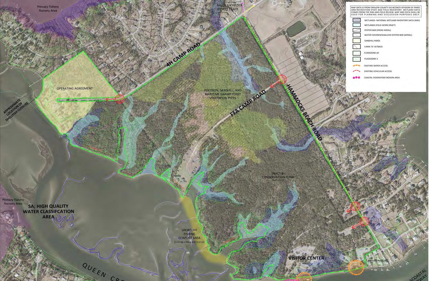
Site existing conditions information was placed into one Existing Conditions Map used for planning, review, and input . The map data contained environmental features, public input comments, and site conditions that may be an opportunity or constraint for future park use and management The following are some of the features included on the Existing Conditions Map during the opportunities and constraints site review:
wetlands
primary nursery areas
water quality classification(s)
floodplain information
soils
4H Camp,
NFA Camp,
Teachers Association
vegetation
topography
shoreline impact
Queen Creek Channel location
oyster beds
regulatory setbacks and/or buffers
vehicular access to the site
pedestrian and bicycle access
water access
adjacent roadways
adjacent zoning and land use
areas already impacted or previous developed
existing impervious surfaces
existing park development and infrastructure
park program needs
overall park acreage, land use, and park user access and circulation
site history
views to and from the site
existing park boundary/ buffers
i NterNal d Pr Staff
SPo NSe
Nviro N
Ntal age
d Pr Staff i NPut Charette
Pu B li C m eeti Ng #1
NC teaCherS a SSoCiatio N re Pre Se Ntative S
PlaNN i Ng aN d P&r Staff i NPut)
hammoCkS B eaCh State Park Staff i NterviewS
frie N dS of hammoCkS aN d B ear i SlaN d
9/29/16
Hiking Trails, picnic shelters, fishing pier, canoe/kayak launch, public restrooms
impact
development
the natural
(overall) Trails, fishing, Camping
would support canoe/kayak access; if a full motorized boat ramp with parking is requested a
analysis
and
not in order or ranked: History, Trails (land and water), rental venues, camping
Hiking Trails, Living Shorelines, kayaking, education programs, camping
History, Museum, Preserve or rebuild a building, discussion of past use
9/29/16 6 Pedestrian connectivity, trails, camping on mainland, offleash or dog park, open space/ open lawn area
Month of October 6
Hiking, Fishing Pier, Camping, Cultural History, Low Impact
natural resource protection
Over Development; Preserving and telling about History
Loss of History and use for underserved community for agricultural and envi ronmental education
be conducted of
with formal submittal
hiking, history, camping
No (overall) Trails, fishing, Camping
No History, Camping, Fishing,
Providing trails and connectivity n/a They did not say one way or the other Trails, Camping
10/27/16 24 (not all attendees signed the sign in sheet)
Walking and Hiking, preserve large natural area
Coa S tal federatio N 11/16/16 6 Living Shorelines, Hiking, Camping, Picnicking, Educational Programming
Petitio N from SwaNS B luff N eigh BorS
11/22/16 103 No activities listed; just concerns against the boat ramp at Queens Creek
Pu B li C Survey Open 90 Days 672 Trails, Camping, Non-Motorized Boating, Fishing Pier, Education Programs
Over Development; Long Term Maintenance and Care of what is already in place
No Hiking, Fishing, Camping History
Over Development No Hiking
No Boat Ramp and use of LID principles in development
No Living Shorelines, Hiking, Camping
No Boat Ramp off Queens Creek Presented a Petition that no boat ramp be placed on Queens Creek n/a
Open Ended Comments: Public Boat Ramp
A Public Boat Ramp ranked 7th highest in the On-Line Public Survey Responses Trails, Camping, Non-Motorized Boating Access, Fishing Pier, Education Programs
Trails (Multi-Use (Paved and unpaved),
Surface, Sidewalks, and Paddle Trail)
Camping (Variety of Types)
Boat Access (non-motorized & 1 option with motorized in existing operations area)
Fishing Pier and Access
Educational Programs & Cultural Interpretation
Wildlife Observation & Overlooks
Large shelter(s) for gatherings or covered outdoor classroom space
Play Area (recommend “Discovery zone” and non-traditional play)
Living Shorelines
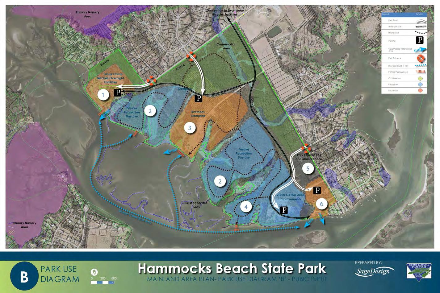
All of the Analysis findings were used to create Park Use Diagrams for staff and Public Input . Park Use Diagrams illustrate the program features identified during the input process . Input received helped to determine preferences for program feature location, connectivity, and identify features that may be desired and were not shown .
CAMP LODGE Provide an overnight facility for groups, schools, and organizations
CAMPER CABINS Provide Individual cabins to be avail able for group rental
BUFFER Provide a buffer between park and adjacent residential area
SHELTER Large shelter for events and rental
WATER ACCESS Re-do the pier and water access to accommodate kayaks, canoes and fishing
TRAILS maintain hiking trails and paths, ensure clearly marked and connect Camp Mitchell to the park via Multi-Use Trail
CAMPER CABINS
WILDLIFE OBSERVATION provide opportunities for wildlife viewing and observation
PICNIC AREA- provide space for picnicking
FOREST WETLAND Maintain Maritime Forest for conservation and education
HIKING TRAILS Provide hiking trails, potential for boardwalks and elevated walk ways for low impact access and observation
Provide Individual cabins for rental
RV short term recreational vehicle camping spaces for park visitors (10-15)
GROUP CAMPING camping area for groups and organizations
PARK PAVILION/ EDUCATIONAL SHELTER
Park Pavilion/shelter for group gatherings and outdoor educational space; seek partnerships for educational programs and use
SALVAGED STRUCTURE Keep one (1) or two (2) structures from Simmons camp for interpretation, education, & re-use; highlight historic uses of property
OPEN SPACE Provide open space for group gatherings and play
PICNIC AREA provide space for picnicking
Primitive and drive to tent spaces
PLATFORM/ KAYAK platform camping spaces for kayaks and canoes TENT AND DRIVE TO SITES
BATHHOUSE & PICNIC AREAS restroom, shower, and picnic facilities
WATER ACCESS
Provide a new water access to accommodate kayaks, canoes, and fishing
EDUCATION AND INTERPRETATION Create opportunities for interpretation & educa tion throughout park to highlight park history; seek educational partnerships with schools and universities
TRAILS natural surface trails with a connection to the primary park Multi-Use Trail
FISHING AND OVERLOOK kayak landing, fishing area, and overlook
TRAILS Natural Surface Trails connecting to Main Multi-Use Trail
CENTER EXHIBIT UPDATES Update the interpretation and exhibits to reflect new park islands and mainland area acquisition, expand concessions and vending
FERRY & KAYAK ACCESS Update Ferry experience for users; separate kayak access area away from Ferry use
OPEN SPACE and NATURE BASED PLAY
Provide open space for group gatherings and discovery zone/Nature Based Play
PICNIC AREA provide space for picnicking and a large shelter near the visitor center
EDUCATION AND INTERPRETATION
TRAILS
Create opportunities for interpretation & education throughout park to highlight natural resources and park history
Add hiking trails, paved trails, Multi-Use Trail connection from Swansboro, paved sidewalks near visitor center, and Paddle trail(s)
Education Conservation Recreation
CAMP LODGE Provide an overnight facility for groups, schools, and organizations
CAMPER CABINS Provide Individual cabins to be avail able for group rental
OPEN SPACE & BUFFER Provide a buffer between park and adjacent residential area
SHELTER Large shelter for events and rental
WILDLIFE
OBSERVATION
provide opportunities for viewing and observation
PICNIC AREA- provide space for picnicking
FOREST WETLAND Maintain forested wetland area
HIKING TRAILS Provide natural surface hiking trails
WATER ACCESS Re-do the pier and water access to accommodate kayaks, canoes and fishing
TRAILS maintain hiking trails and paths, ensure clearly marked and connect Camp Mitchell to the park via Multi-Use Trail
ENVIRONMENTAL EDUCATION/ INTERPRETATION AND SIGNAGE
teach visitors about maritime forest, coastal ecology, and the site history
FAMILY CAMPING Provide a Central Camp Facility for groups, schools, and organizations
CAMPER CABINS Provide Individual cabins to be avail able for group rental
RV short term recreational vehicle camping spaces for park visitors (10-15)
GROUP CAMPING camping area for groups and organizations
PLATFORM/ KAYAK platform camping spaces for kayaks and canoes and organizations
TENT AND DRIVE TO SITES tent spaces for walk to and drive to
BATHHOUSE restroom and shower facilities
WATER ACCESS Re-do the pier and water access to accommodate kayaks, canoes and fishing
TRAILS natural surface trails
CENTER EXHIBIT UPDATES Update the interpretation and exhibits to reflect new park islands and mainland area acquisition, expand concessions and vending
FERRY & KAYAK ACCESS Update Ferry experience for users; separate kayak access area away from Ferry use
OPEN SPACE and NATURE BASED PLAY
Relocated Overall Park Maintenance and Operations Center; Relocated Park Ranger Residences (2); Boat Operations to Remain near Channel
Provide open space for group gath erings and discovery zone/Nature Based Play
PICNIC AREA provide space for picnicking and a large shelter near the visitor center
EDUCATION AND INTERPRETATION
Create opportunities for interpreta tion & education throughout park to highlight natural resources and park history
TRAILS Add hiking trails, paved trails,MultiUse Trail connection from Swansboro, paved sidewalks near visitor center, and Paddle trail(s)
FISHING AND OVERLOOK
Provide a “T” fishing Pier with an accessible route from visitor center and nearby observation area
Provide 2 public ramps and 1 operations ramp and docking
FISHING AND OVERLOOK New kayak access fishing Pier, and overlook
Keep one (1) or two (2) structures from Simmons camp for interpreta tion, education, & re-use; Create opportunities for interpretation & education throughout park; seek educational partnerships with schools and universities
Conservation Recreation
Following existing conditions were
reviewing the feasibility of a
boat ramp
Nursery Areas
the
Acres
need to relocate existing main tenance and Ranger Structures if the existing ramp area were expanded
Completed project with the Coastal Federation reducing Impervious in the ramp area
There is an agreement in place between NC State Parks and the Coastal Federation to keep this project effort in
of Residential Area to boat
following recommendations and associated action items are a result of the compiled information during the planning process Each point of analysis and discovery contributed to plan recommendations
is important to consider each component as the Park transitions from planning to implementation, and during the update of the overall park
Management Plan
recommendations can be found on the Mainland Area Plan graphic and a more detailed outline of findings are listed in the recommendations and action item chart Prioritization is listed in Immediate Term (0-2 years); Near term (3-5 years); and Long Term (6-10 years) . Facilities and Program Actions are broken down by area refer enced on the map graphic, and Policy/Management and Staffing are listed for the Mainland Area
we heard
American
Impact Design (reduced vehicular
Area (recommend “Discovery zone”
non-traditional play)
Shorelines
When developing the trail network for the park careful attention should be paid to the diversity of trail types offered . In order to make the trails accessible to a variety of user groups the park should provide commu nity connectivity, access to park features, opportunity to explore the natural resources, and an understanding of how challenging a route might be, and how long a trail route typically takes to complete
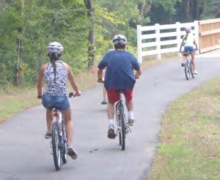
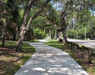
Paved Trail: This primary multi-use paved trail should follow standards and guidelines for trail development outlined in the NCDOT Bicycle and Pedestrian Design Guidelines manual . Recommended Trail Width is a 10’ minimum paved trail with 2’ shoulders on each side of the trail .
Unpaved Trail: This primary natural surface Trail shall connect the western portion of the park to the existing visitor center The primary natural trail shall have a wide enough clear zone to accommodate park maintenance vehicles
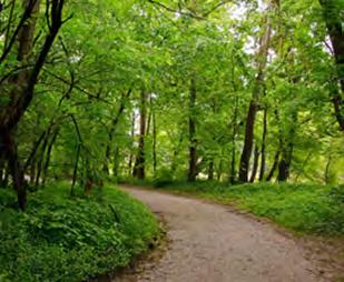
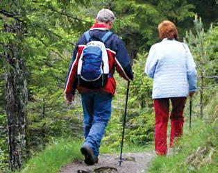
There are trails already identified on the 290 acre site. Natural Surface Trails such as mulch, sand, pine straw, or crushed stone should be provided to allow access to hiking in the natural environment . These trails shall be clearly marked with routes, distance, and key features to help park users navigate the trail system
It is recommended that additional paved sidewalks with shorter distance loops be provided to new park features near the visitor center . This side walk should connect the future fishing pier, natural play area, and the gathering space .
Hammocks Beach State Park already has a wonderful paddle trail system in place . Future access locations should be added to the route map . In addition, it is recommended HBSP work with local vendors to encourage site visits, day trips, and participation in park educational programs . In order to encourage this, HBSP should incorporate support features such as paddle lockers, wipe down areas, restrooms, and vending or access to drinking water .
10’ wide paved Multi-Use Trail 8’-10’ Wide Natural Surface Multi-Use Trail
Natural Surface Hiking Paved Sidewalk
Paddle Trail
In order to provide the greatest access to camping for a variety of user groups HBSP should include multiple camping settings and facility types to accommodate different skill levels and camping needs
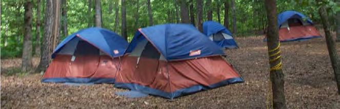
Mainland area primitive camping should follow the “pack in pack out” philosophy These sites typically only provide a cleared area for camping, and no support facilities such as trash or restroom . If the site location remains remote, no fire pit or fire rings shall be included in the primitive camp area Campers shall follow standard primitive camping practices in these locations .
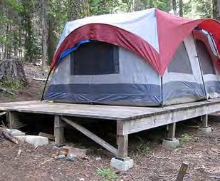
Platform camping minimizes impact to the ground in an area subject to flooding or erosion. These small decks shall be constructed to accom modate a standard 4 person tent, exit area, and kayak or canoe pull up. The platform/kayak canoe area shall provide a fire ring/fire pit, trash receptacles, and a hiking trail to the central camp area .
d rive to CamP SiteS/ multi - uSe SiteS
There are approximately 40 campsites proposed in the Master Plan . During the site planning process it shall be determined what the site can accommodate, and how much capacity staff can manage . These sites are proposed with no hook-ups and the area should provide a wheelchair-accessible site(s) It is recommended that 5-9 of these sites be multi-use at the end of the family camp area with full hookups (water, electric and sewer) . Each site should be equipped with a picnic table and grill/fire ring. There should be a centrally devel oped family camp area with access to drinking water , restrooms, and shower facility nearby .
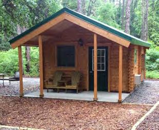
There are proposed camper cabins located near the family camp ground . These camping cabins should be constructed in a way that reflect the architectural style of the Simmons Camp and sleep up to six (6) Each cabin should have access to electrical receptacles and a heating and air-conditioning unit . There should also be outside cabin amenities such as picnic table, charcoal grill, and a fire ring. These should be located near the family camping area so that drinking water, restrooms, and showers are located nearby .
Two camping areas for organized groups are proposed and should be should be developed to accommodate 30- 40 people on each site . These areas should have support features such as picnic tables, grills/fire rings, toilets, access to water, and shower facilities, separate from the primary camping area
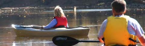
To allow greater access to water for park users additional non-motor ized boat access locations shall be provided . In addition to expanding the access at the existing location behind the visitor center, it is recom mended an access location be provided at the future mainland camp area proposed at the Simmons Camp site, and at the future 4-H Mitchell camp area should that develop in the future .
According to the North Carolina Coastal Federation, the best way to deal with shoreline erosion is to plan for it, to build as far as possible from the water’s edge and to retreat when the time comes .
When that’s not possible, the federation recommends using stabi lization methods that maintain the natural integrity of the marsh and do the least damage to them . Living shorelines are one method of doing that .
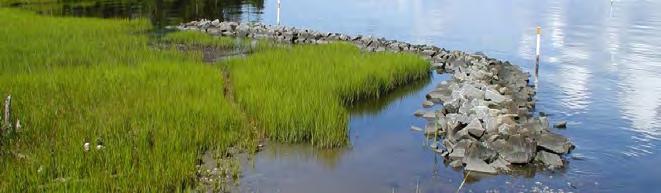
Livings shorelines use as many natural elements as appropriate for the site to protect the shoreline from erosion. Specific mate rials include bags of oyster shells, native marsh grasses, wood, limestone, rip rap, or constructed ‘oyster domes’ They range from construction setbacks and simple plantings of marsh grass to more complex approaches that use the materials listed above or other structures to dampen wave energy .
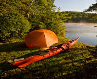
Provide accessible non-motorized boating access
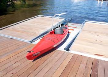
Examine the opportunity for kayak “locker”/storage rental
These shall be constructed in a way that they provide ease of use and access to park visitors, but also minimize impact to the shoreline, nearby oyster beds, and waterways Consideration should not only be given to the park visitor experience arriving from land, but also for those visiting the park from the water These locations should be added to the park paddle trail map .
The park can also serve as a destination by area non-motorized boaters and paddlers using the Intracoastal Water (ICCW), White Oak Creek, or Queen Creek . Support facilities such as paddle board, kayak, and canoe hook ups, rinse down areas, access to drinking water, and rest rooms, and signage and wayfinding to key park features should be considered near the access locations
An outreach and educational program should be provided at access locations through educational signage, programming, and vending rental company to teach users about natural features such as: currents, tides, the presence of oyster beds, and other potential wildlife a user may encounter .
No two shorelines are the same and living shoreline strategies must be selected based upon:
• existing land uses
• the amount of wave energy at the site
• individual local conditions
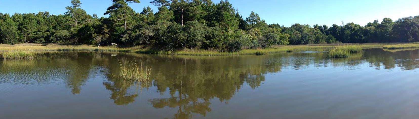
Hammocks Beach State Park is a great location to work in part nership with the Coastal federation for shoreline protection Not only does it have over 8000 linear feet of undeveloped shoreline, but it also can serve as an educational setting to learning more about living shorelines and the impact shoreline loss has on our environment .

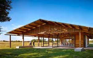
Should there be an opportunity in the future to develop the Camp Mitchell site for park use, consideration should be given to the inclusion of an education pavilion/center that allows groups, classes, and park visitors an opportunity for program participa tion . This structure should include restroom facilities, and at a minimum, covered space for program use or rental
In addition to the education pavilion on this site, there is an opportunity to celebrate the sites past use and incorporate an amphitheater on site that either utilizes portions of a past struc ture or celebrates the character of past structures .
Images from “Blue Water Black Beach”, by Crystal Sanders
Hammocks Beach State Park newly acquired mainland property has an incredibly diverse natural and cultural history . With the acquisi tion of the mainland comes an opportunity to continue to expand the education and interpretive programs for the park . Throughout the planning process, groups representing the African American history at the site expressed the importance of the 290 acres and the need to preserve, protect, and educate park visitors about African American history. They identified three main focus areas related to the site including 4-H Camp Mitchell, the NFA site Camp Simmons, and the North Carolina Teachers Association (NCTA) site While all aspects of the site history and natural resources present an opportunity for education, these were identified in this process as some of the most important to teach As with the other proposed features, the best way to reach park users is to diversify the way the educational messages are delivered .
There are opportunities for expanded special events, programs, updating the visitor center exhibit space, incorporation of artifacts from past land uses, and educational signage throughout the 290 acres Educational messaging can be on preserved structure (to be determined if an NFA Simmons camp building and/or the Gertrude Hurst Assembly building can be repaired or restored) wayside signage, or object identification. There should be continued support and development of the access to history online, and through the narrative being developed by the Friends of Hammocks and Bear Island in partnership with Public Television . The more diverse the offerings provided the better served the park user groups will be
Create an outdoor class room/amphitheater near education pavilion
Dixon Water Foundation Education Pavilion - Decatur, Texas
l arge Shelter(S) for gatheriNgS or Covered outdoor ClaSS room SPaCe
The Mainland area plan proposes three other locations for large shelters and/or pavilion spaces:
• Area 3: Include a large shelter and/or pavilion in the family campground area for group gatherings , outdoor education use, and/or rental .
• Area 6: restore, renovate, or replicate the Gertrude Hurst Assembly building for a gathering space at the former NCTA site .
• Area 7: Provide a large shelter near the visitor center to serve as a multi-use space for outdoor education, large gather ings, or rental
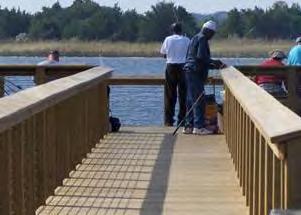
There are two proposed areas for fishing on the mainland property. One is identified near the visitor center, and the other is future develop ment on the 4-H Camp Mitchell site
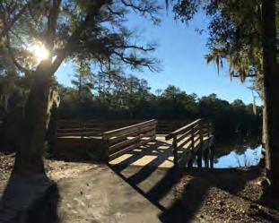
The development of a fishing access near the visitor center shall include a paved accessible route, seating, a section of railing for accessible fishing, and support facilities. This shall be constructed as a “t” pier to minimize impact to the shoreline, but still allow greater access to users . This fishing area shall be located nearer to deeper water and away from oyster beds .
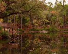
The future development at the 4-H Camp Mitchell site shall include the repair and reconstruction of the pier and shelter . Consideration should be given to minimizing conflict between kayak and canoe users, obser vation and education, and park users fishing.
Example of Wildlife Observation opportunities, Millers Pond Park, Pender County, NC
The views to and from Hammocks Beach State Park mainland area are incredible wildlife viewing opportunities . It is recommended that a minimum of two observation areas be included to allow park visitors the opportunity to see the park natural resources . These area should not be used for fishing, but rather observation and viewing only .
• Area 3: Simmons Camp Overlook and Observation Area can be an incredible asset to parks users at the future camping area . This can also serve as a point of gathering, education, and observation .
Example of a “T” fishing Pier, River Road Park, New Hanover County, NC
• Between Area 5 and 7: This area has incredible wildlife viewing opportunities . It is recommended an accessible walking route be added to a point of observation . This does not need to be out over the water but rather allow visitors an elevated view for observation .
As the additional mainland area opens for public access, whether its trails, camping, or future structures, park staff will need to have a pres ence on the north end of the site for maintenance access and park management . As site plans for these features develop, a location for ranger presence should be identified.
Example of lower railing and flat areas for ADA access and support facilitiesNot every visitor or child is comfortable in nature . Providing a nature based play area and discovery zone introducing the parks natural features in an interactive way not only can educate users on natural resources present, but also provide another means of engagement . It can help transition park users from a more developed area and educational center like the visitor center, to an outdoor interactive space, and ultimately encourage interest and engagement in things like camping, hiking, wildlife observa tion, and plant and animal identification.

Providing ease of access to park users on the mainland is not only done through the features and facilities proposed on site, but also through the messaging and wayfinding provided to make the site more interesting, easy and safe to navigate, and the ability for a park user to clearly identify features and safety needs . HBSP needs to develop a master wayfinding sign family for the park system .
Sign types shall include: Entry signage (all locations-vehicle), Entry signage(trail & greenway), kiosks (pull up car and pedes trian), directionals (vehicle and bike/ped), loop maps, building/ special feature, and educational signage, pavement markings, mile markers, and trail blazes
A color pallete and suite of symbols that are easy to use and improve access should be presented
• Vehicular signage should indicate where to park, where the center or “starting point” can be found, and major attrac tions within the park .
• Pedestrian and bicycle signs should be placed to capture those arriving via greenway/sidewalk, as well as provide information for those approaching from parking areas .
• Pedestrian and bicycle signage should indicate distance, average time for travel, and level of difficulty.
• All trailheads should have kiosks with accurate maps of the trail system, level of difficulty, time investment, and safety information including shade, carrying water, and potential hazards .

• All loop trails should include mile marker for safety and fitness tracking.
• Pedestrian wayfinding should also include: Trail Blazes, mileage markers, navigational tags, and Educational and Interpretive messaging and signage .
 Examples of Nature Based Play and “Discovery Zones”
Nature Based Play and Nature “Discovery Zone”
Examples of Nature Based Play and “Discovery Zones”
Nature Based Play and Nature “Discovery Zone”
Future facilities designed and developed within HBSP shall consider using current low impact design and BMP's (Best Management Practices) during the design process .
Develop a park facility guide that not only shows park offerings by feature and distance, but provide average user time and skill level required to participate in paddle trails and hiking trails . As stated in SCORP, the biggest barrier to participation in outdoor recreation is time; HBSP needs to present recreational and educational offerings for a variety of time uses
X
There is currently water and electrical access in the Camp Mitchell Area and the Simmons Camp Area, however, the sewer access point terminates at the intersection of 4H Camp Road and Hammocks Beach State Park . Determine method for waste water conveyance and treatment If it is determined septic shall be utilized conduct a soil investigation to delineate treatment areas .
This area is currently under a lease agreement Until the lease terms expire in 2018, there shall be no implementation of any new facilities in this partic ular location within the park .
Existing structures should be demolished and disposed of in the proper manner according to state and local regulations . An evaluation shall be done on the existing dock to determine whether or not the structure is salvageable and reusable .
Create and maintain a vegetated buffer between the surrounding neigh borhoods and the Camp Mitchell site to provide privacy for those utilizing the site as well as the local residents .
Preserve and protect any trees that are crucial to maintaining the char acter of the past Camp Mitchell site that are deemed worthy of keeping based upon review by the proper governing division within NCPARKS
Develop and create a maintenance facility for HBSP staff, to utilize to prop erly provide maintenance to the park . This area should include parking, storage and screening from the surrounding areas
Provide a park pavilion/educational center for varying sized groups that can be utilized by educational, social, recreational, and school groups that visit HBSP. This area shall include open space, picnic areas, a fire pit, an outdoor classroom and provide adequate univer sally accessible parking and additional overflow parking areas to accommodate those attending these facilities . The parking area shall include a drop off area for all programs The park pavilion/educa tional center shall also provide all necessary support facilities .
Evaluate existing water access points to improve access and add amenities and support facilities, include parking, easily navigated paths, and wash off stations .
Provide universally accessible fishing experiences that may be enjoyed by park visitors .
Provide paved trails or sidewalks that connect support facilities and parking to the viewing, fishing and kayaking access points as well as to interior trail systems within the park . Establish the boundary and area for Long Leaf Pine Restoration
Identify and locate the entrance/exit to the Future Camp Mitchell and determine what type of access will be needed at this location . A magnetic locking gate accessed via phone is recommended at this location .
Trails ranked high as desired facilities within the park Provide both primary and smaller mulch hiking trails that connect to the Future Mitchell Camp, interior trail systems within the park and the Simmons Camp area . In addition to walking and hiking, bird watching and wildlife observation along trails should be included as a passive recre ation element in this area Many of the trails already exist within this area so providing safe access, signage, and supporting map informa tion could make this area accessible to the public in the near term .
aC tion item i mmediate near term long term area 3- SimmoNS CamP
Most of the existing structures should be demolished . An evaluation shall be done on an existing structure of importance One of the bunk buildings and the assembly structure were identified during the input process as representative examples for interpretive/educational purposes . Structures will need further evaluation to determine if one or two representative structures can be restored/replicated/or reused .
Complete a site plan for the Camp Area for implementation . Camping ranked high as a desired facility . Multiple forms of camping shall be included in a final layout. Future HBSP camping facilities should include platform camping opportunities, an area of primitive, walk up only camping, an area of drive-up tent campsites (+ 29) including: flexible sites(+ 6), cabins(+ 5), group camping sites(+ 2), open space and support facilities such as restrooms, showers, and parking for the areas .
Identify and study previously disturbed areas of the Simmons Camp suitable for reforestation Develop a plan for re-vegetating and refor esting areas between proposed drive to camp sites to improve user experience with existing and future elements in this area .
Preserve and protect any trees that are crucial to maintaining the character of the past Simmons Camp site that are deemed worthy of keeping based upon review by the proper governing division within NCPARKS .
Identify and locate the entrance/exit to the Future Simmons Camp and determine what type of access will be needed at this location .
Provide trails that connect support facilities, camping and parking to the viewing, fishing and kayaking access points as well as to interior trail systems within the park . Trails within this area shall be added with the development of area 1 .
X
X X
X X
X
X X
aC tion item i mmediate near term long term area 4- multi uSe Path
Plan and design the Multi-Use trail connection from the intersection of 4H Camp Road/Hammocks Beach Road to the park Visitor Center
Work with NCDOT and the Town of Swasnboro to provide a safe pedes trian crossing and intersection improvements at 4H Camp Road/ Hammocks Beach Road including signage, crosswalks, and curb cuts and connecting sidewalks .
X
X
Develop and construct a bicycle and pedestrian (multi-use path) connection from the intersection of 4H Camp Road/Hammocks Beach Road to the park Visitor Center . Work with local and state level agen cies to create a connection that improves access to the park as well as the opportunity to connect up to neighborhoods and other local biking/future greenway trails within the Swansboro bicycle network .
X area 5- PaSSive reCreatioN
Provide both a primary hiking trail that can serve as a maintenance access, and secondary hiking trails for hiking only that connects to the Simmons Camp area, the gathering space area, and the visitor center .
In addition to walking and hiking, bird watching and wildlife observa tion platforms along trails should be included as a passive recreation element .
area 6- gatheriNg SPaCe
Evaluate the opportunity for a gathering space and structure This facility may allow for the preservation, restoration or replication of the North Carolina Teachers Association (NCTA) Assembly Building as a place to gather visiting groups This area will also include a picnic area under the live oak grove, parking, African American/NCTA historical elements and support facilities
This area should include a trailhead to park trail system, smaller mulch hiking trails that connect to the passive recreation area and the visitor center, and connections to the parking and the gathering space .
X
X
X
aC tion item
Provide a park shelter for large groups that can be utilized by educa tional, social, and recreational groups that visit Hammocks Beach State Park (HBSP) . This area shall include picnic areas to accommo date those attending these facilities . Necessary support facilities will remain in the current Visitor Center building
Include a "T" fishing pier in the area indicated on plans that has an accessible route, lower rail, and access to deeper water .
Provide an accessible trail/walkway that connects to the Visitor Center, the multi-use path, and the fishing pier. In addition to walking and hiking, scenic overlooks and fishing access should be included along the trail
Expand kayak access at the existing location and provide support facilities such as picnicking, boat wash down, and carts . Consider storage rental for canoes, kayaks, and paddle boards .
Work with Coastal Federation to determine the best location for living shoreline projects
Work with HBSP to determine a suitable nature base play and "discovery zone" near the visitor center and shelter that will meet the needs of those that utilize the park and support current programs . This shall be a non-traditional nature based play space that allows visitors to discover, interact, explore, and climb natural features they may see within the park .
Update the Visitor Center exhibits to include both the islands acquired and the mainland history, including African American history and former uses of the property . Consider how users enter the space and seek opportunities to include exhibits in the high use areas for addi tional educational opportunities .
Expand vending and gift shop space and offerings at the Visitor Center and consider having an access location for vending from the outside .
Create a new Overall Park Map and Key that includes all of the park islands and mainland area open to the public and areas planned for future use
Craft and compile Interpretive messages and potential for program ming prior to undertaking future Master Plans, Management Plans, and Park Site Plans to help guide the planning and design process . This can aid in the inclusions of these stories in the built components .
There is high interest in Natural and Historic Interpretation through classes, events, and signage Work to incorporate these messages throughout the park through classes, special programs, events, and involvement in design development .
Record and gather stories and artifacts from past users and partici pants from the NFA Camp and Camp Mitchell .
X
X X
X
X
X area 1- future CamP m itChell
The adjacent oyster beds to the Mainland area shoreline will require additional oyster education for park users Not only regarding water quality, shell fishing, and information about the oysters, but for also for park user safety and protection of the beds from users .
This area is currently under a lease agreement . Until the lease terms expire in 2018, there shall be no implementation of any new facilities in this particular location within the park .
Approach future development using low impact design and best management practices and consider how those features can be used for educational purposes within the park .
Seek partnerships for education center use with Onslow County Schools and other educational organizations; work with them to determine how they may use the education center to assist in building program development .
Create partnerships with local schools, universities and organizations that allow for research and agricultural and conservation education among groups that visit HBSP.
aC tion item i mmediate near term long term
Establish a plan for access control, days and times, and means of site control Due to multiple entry points, it is recommended a magnetic gate control system be evaluated that allows staff remote access control via cell phone . This site control plan should be a priority to transition the space for public use with NCPARKS and the HBSP staff area 2- PaSSive reCreatioN area
Educational signage should be placed at strategic learning oppor tunities along the trail as deemed and developed by NCPARKS with specific educational/interpretive messages.
Offer points of interpretation highlighting the key natural resources in this area (long leaf pine, transitional marsh area, and oysters) along with the cultural history (pre and post 20th century and African American use of the Simmons Camp)
Use architectural form and style of past NFA features in new architec tural and structural components at the future Simmons Camp site
area 4- multi - uSe Path
HBSP, Swansboro, and Onslow County could all benefit from improved bicycle and pedestrian connectivity between the nearby school, resi dential areas, Town of Swansboro, and the Park Work with local and state level agencies to create a connection that improves access to the park as well as the opportunity to connect up to other biking/ greenway trails (Swansboro, Paddle Trails, Nearby Mountains-to-Sea) .
Educational signage should be placed at strategic learning oppor tunities along the trail as deemed and developed by NCPARKS with specific educational/interpretive messages.
X
X
aC tion item i mmediate near term long term area 6- gatheriNg SPaCe
Provide a day use gathering space for schools and park visitors near the visitor center . Highlight the past use with the Teachers Association and African American History and programs/educational elements
Utilize the newly acquired land to support festivals and events through expanded or relocated festival areas and opportunities for overflow parking .
Work to expand the programming and interpretation within the visitor center to reflect additional islands added to the system and the main land area .
X
Update the Hammocks Beach General Management Plan to eval uate the entire park site and incorporate findings from the Mainland Area Planning Process .
Create a mainland area visitor access plan . Until structure hazards are removed, portions of the park should remain closed
Create a maintenance plan for transitional park use areas and clearly delineate areas that remain closed to park visitors
Establish hours of operation for the overall site, days and times, points of entry, and site control (gates) will need to be developed among NCPARKS and the HBSP staff .
Re-establish the Park Advisory Committee (PAC) so that it is an active and engaged review board that may include a resident, town staff or official, a county staff representative or official, an FHBI member, park staff member, and/or a park volunteer . This will help with commu nity outreach and coordination for park programs, events, and future facility development .
Create policy and fire pit facilities to dictate where and when camp users may have a fire. Work with Emergency services to create an emergency access plan for future development areas .
Examine Rental policy and fee structure for locations and structures within the park
A camping and rental policy and fee structure and evaluation will need to be developed in conjunction with NCPARKS regarding all methods and means of camping at HBSP.
Create an action plan for management and restoration of the long leaf pine area that is compatible with current and proposed uses in the Simmons Camp Area Identify and protect older long leaf pines in this area for protection and educational purposes .
Hammocks Beach State Park’s geography presents a unique approach to park management and operations The park is unique in that the system contains separate islands to manage that are accessible by water only; the mainland, now expanded by 290 acres, Huggins Island, Jones Island, Dudley, and Bear Island . While this plan is only evaluating the mainland area acquisition (290 acres), it is important to consider the other areas within the system regarding staffing. Prior to mainland area acquisition, staff has had to contend with travel between the locations to perform job duties In addition, the ferry operation linking the mainland to Bear Island constitutes a workload not found at other parks . These circumstances should be consid ered for staffing purposes when looking at the mainland area development prioritization .
The current park staff include ten permanent employees . The park has five certified law enforcement officers, three mainte nance personnel, and two administrative office assistant. Since the establishment of the 10 positions, two additional islands (Dudley and Jones) and the mainland area acquisition (290 Acres) has occurred . Without the inclusion of future park facili ties on the mainland, it is recommended maintenance and seasonal staffing levels be evaluated. Once additional facili ties are brought online, staff levels will also need to increase for programming and operations and include the addition of Rangers. It is recommended a thorough staffing evaluation be conducted .
The following outline is a Master Plan level Understanding of Development Costs (25%) Understanding of Cost is presented by area . Understanding of cost should be updated throughout each stage of the Planning Process as material decisions, place ment, and site discoveries are made for each area:
• Design Development (50%)
• Site Plan Development (70%)
• Construction Documents (90%)
In addition to that, contingency and inflation allocation should be made to these prices as time progresses through implementa tion . Recent bid pricing for Public Sector projects has increased at a high rate due to demands for labor . This, along with design fees, permitting, and environmental site analysis costs should be considered in the phasing and implementation for each of the projects .
Summary of CoSt (25% level)
future Ca mP mitChell imProveme Nt Sfor future refereNCe oNly
$3 m illioN
PaS Sive reCreatioN area $140,000
Si mmoN S Ca mPi Ng area $3 m illioN
multi uSe Path
$1.5 m illioN
Primary Natural SurfaCe Path $700,000
gatheri Ng SPaCe $800,000
PaS Sive reCreatioN area 2 $400,000
vi Sitor Ce Nter area
(Note: doeS Not iNClude uPdate to the exhiBit SPaCe)
$1.2 m illioN
Costs presented are preliminary based upon ConCeptual mainland area plan and shall be used for preliminary disCussion purposes only items are based upon ConCeptual level drawings utilizing gis data for preliminary environmental evaluation . Costs and quantities shall be refined as plans develop amounts are based upon reCent bids and/or disCussions with vendors and ContraC tors based upon master plans , not design development drawings please note that geoteChni Cal reports , imaging, water/sewer ConneC tion fees , regulatory permits or drawings , or transportation analysis fees are inCluded in the summary above.
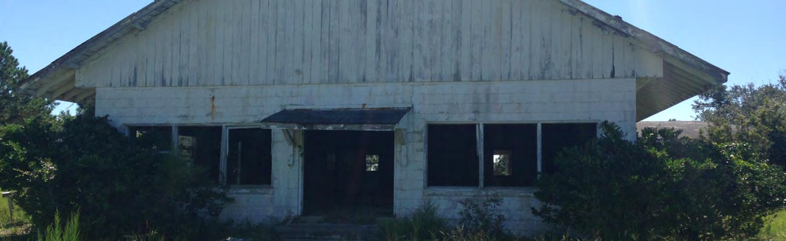
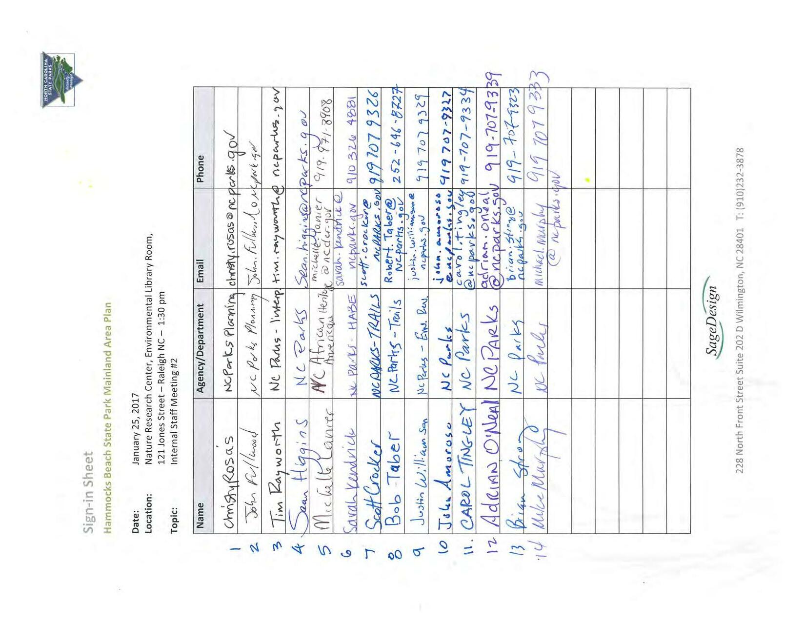
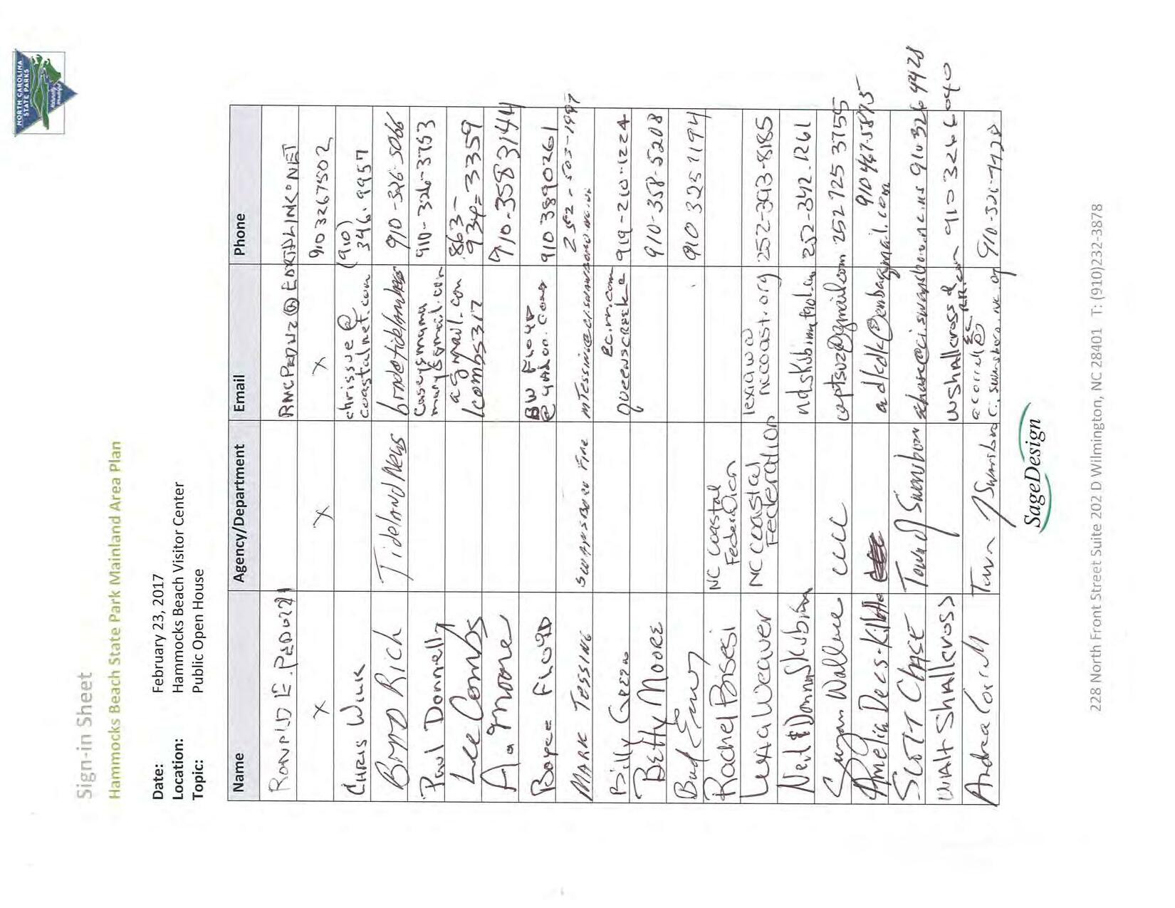
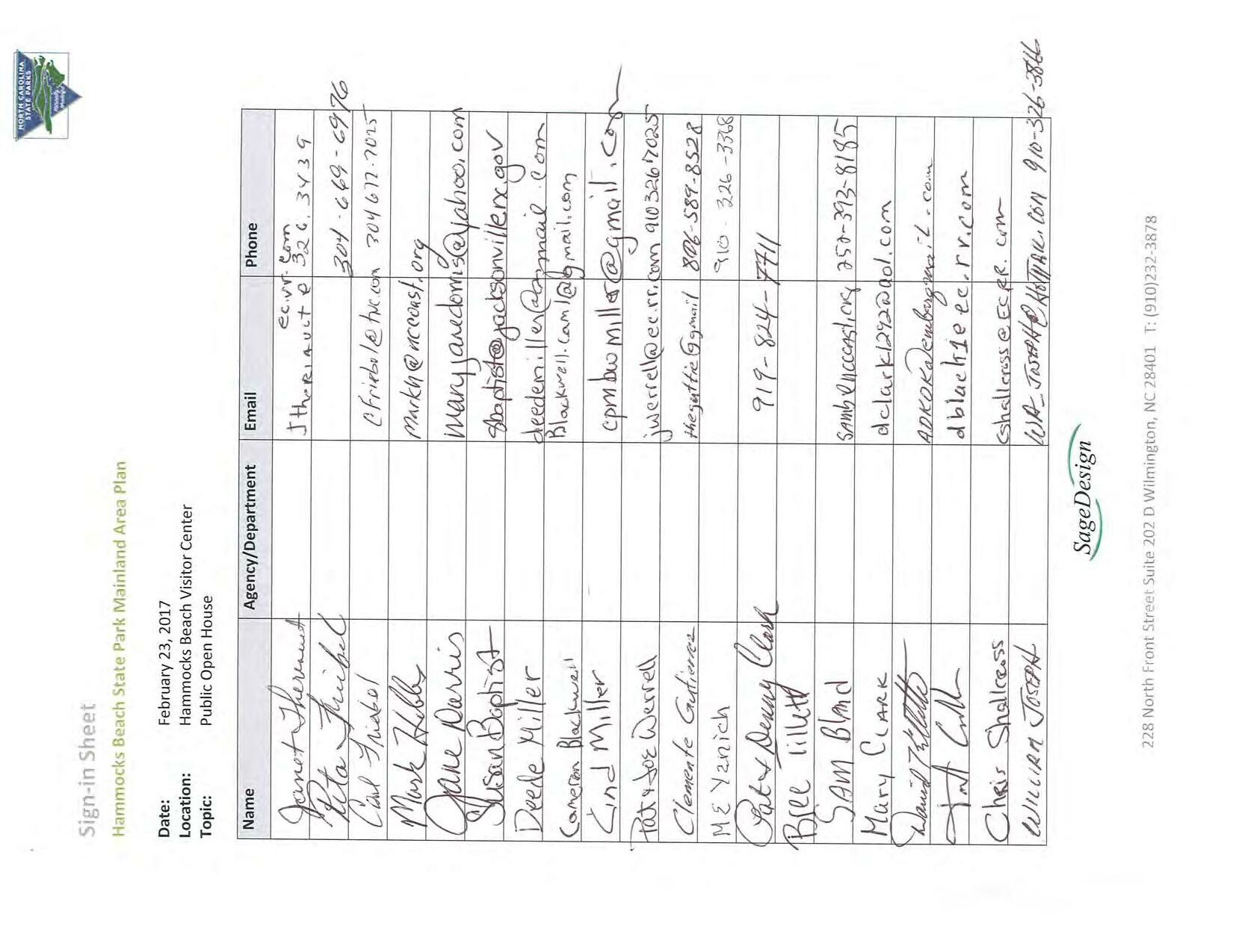
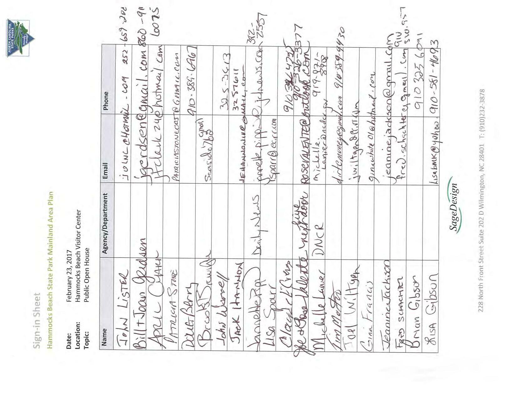
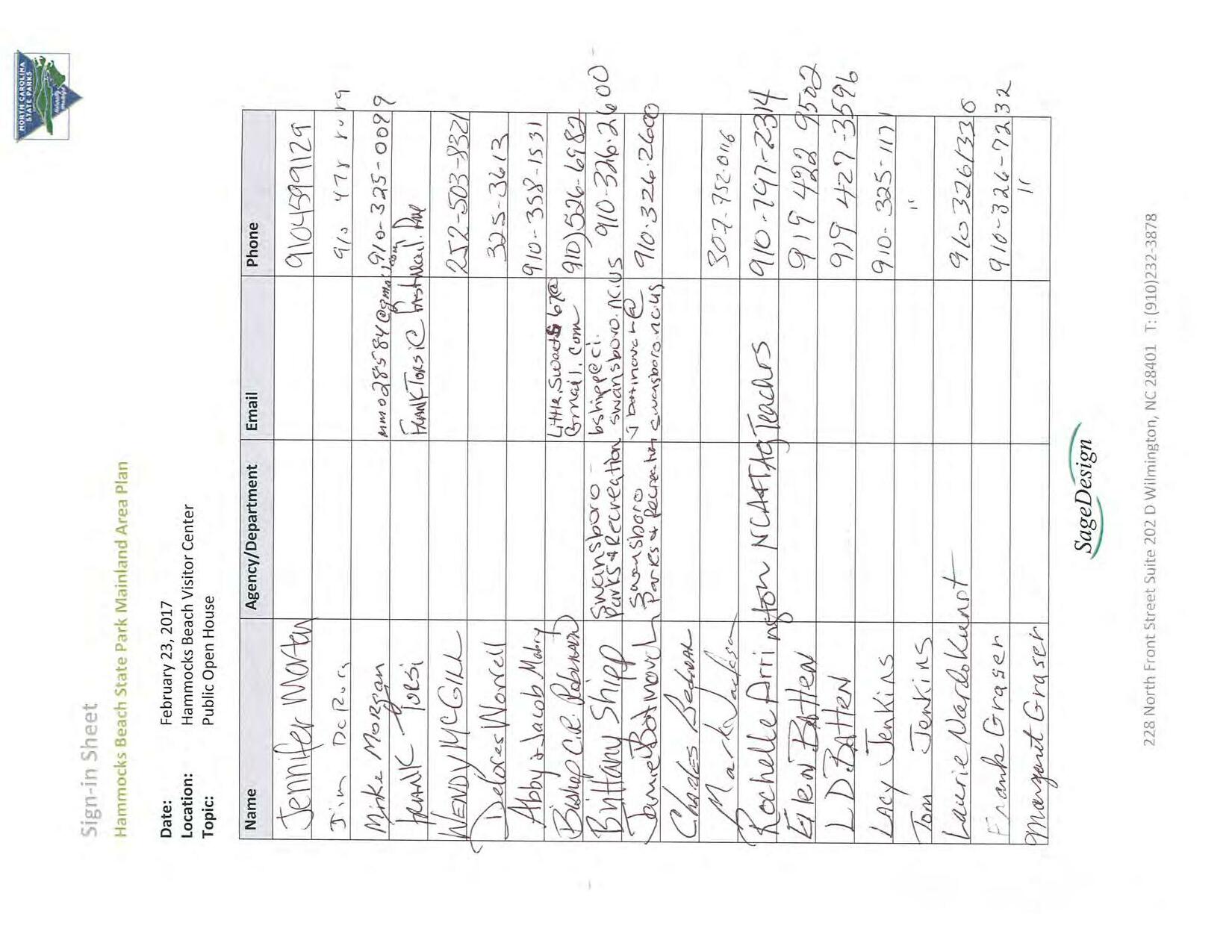
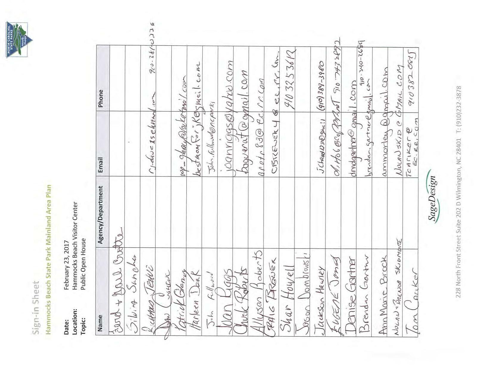
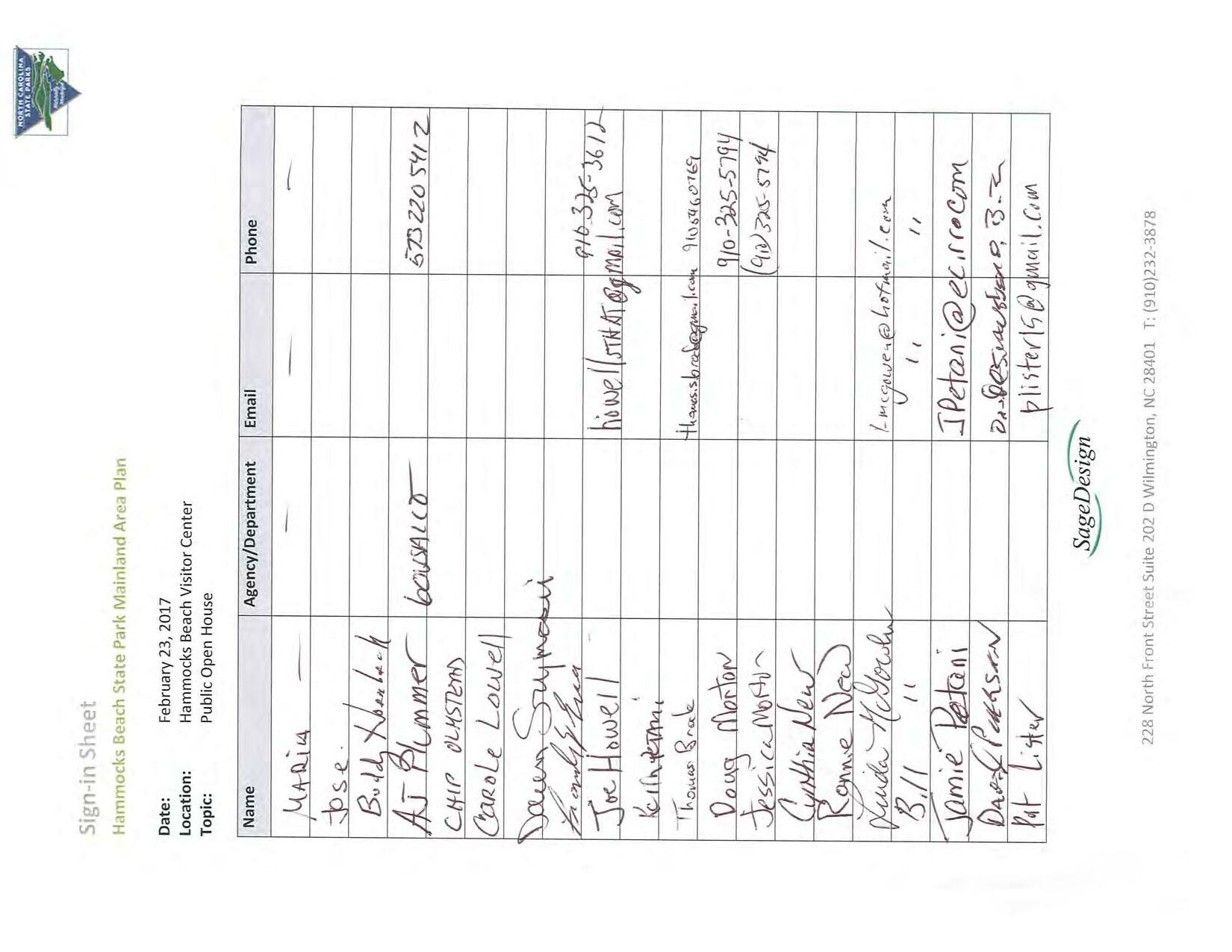
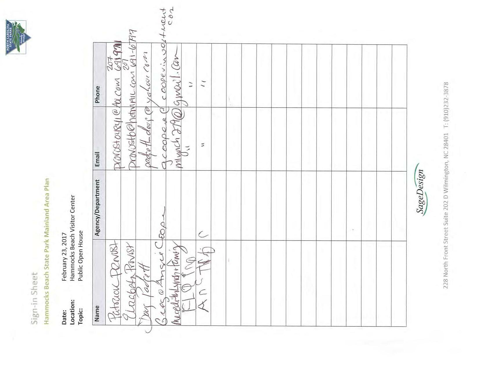
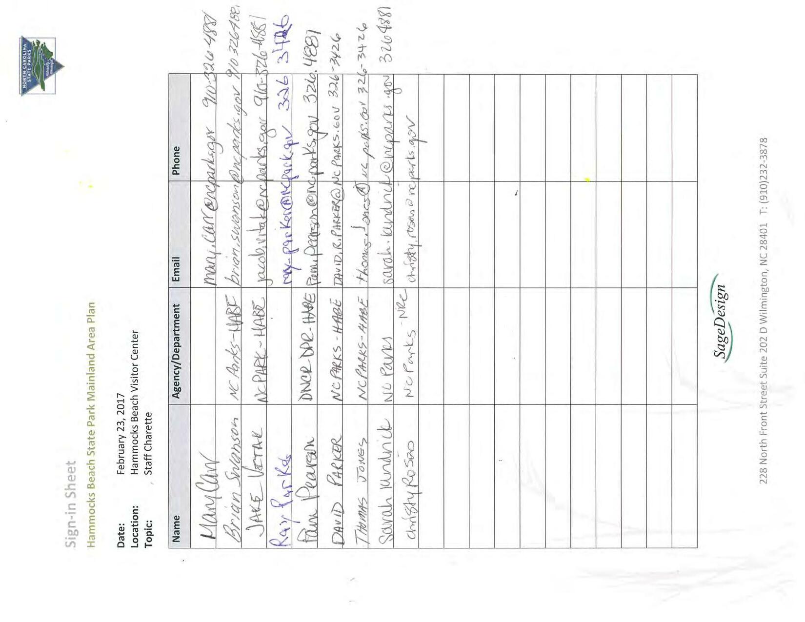
Cameron.Weaver@ncdenr.gov
Chad.Coburn@ncdenr.gov
Linda.Lewis@ncdenr.gov
Rhonda.Hall@ncdenr.gov
Sarah.e.Hair@usace.army.mil
Roy.Brownlow@ncdenr.gov
Kathryn_Matthews@fws.gov
Ken.Riley@noaa.gov
Ryan.Davenport@ncdenr.gov
Courtney.Spears@ncdenr.gov
Maria.Dunn@ncwildlife.org
Shane.Staples@ncdenr.gov
Karen.Creech@ncparks.gov
Justin.Williamson@ncparks.gov
Brian.Strong@ncparks.gov
Jacob.vitak@ncparks.gov
Sarah.Kendrick@ncparks.gov
Sara@sagedesign.us
910-796-7303
910-796-7379
910-796-7343
910-796-7312
910-251-4049
252-808-2808 x
919-856-4520 x 27
252-728-8750
252-808-2808 x
252-808-2808 x
NCDEQ- DEACS
DWR-401
DEMLR-SW
DEMLR-LQ
USACE
252-948-3916
252-948-3950
919-707-9308
919-707-9329
919-707-9323
910-326-4881
910-326-4881
910-232-3878
DCM
USFWS
NMFS
DCM
DCM
NCWRC
DCM
DNCR
Cameron Weaver
Chad Coburn
Linda Lewis
Rhonda Hall
Liz Hair
Roy Brownlow
*Kathy Matthews
X Ken Riley
Ryan Davenport
Courtney Spears
Maria Dunn
Shane Staples
Karen Creech
DNCR
NC Parks
NC Parks
NC Parks
SAGE Design
Justin Williamson
Brian Strong
Jake Vitak
Sarah Kendrick
Sara Burroughs
*Conference line X Not Available


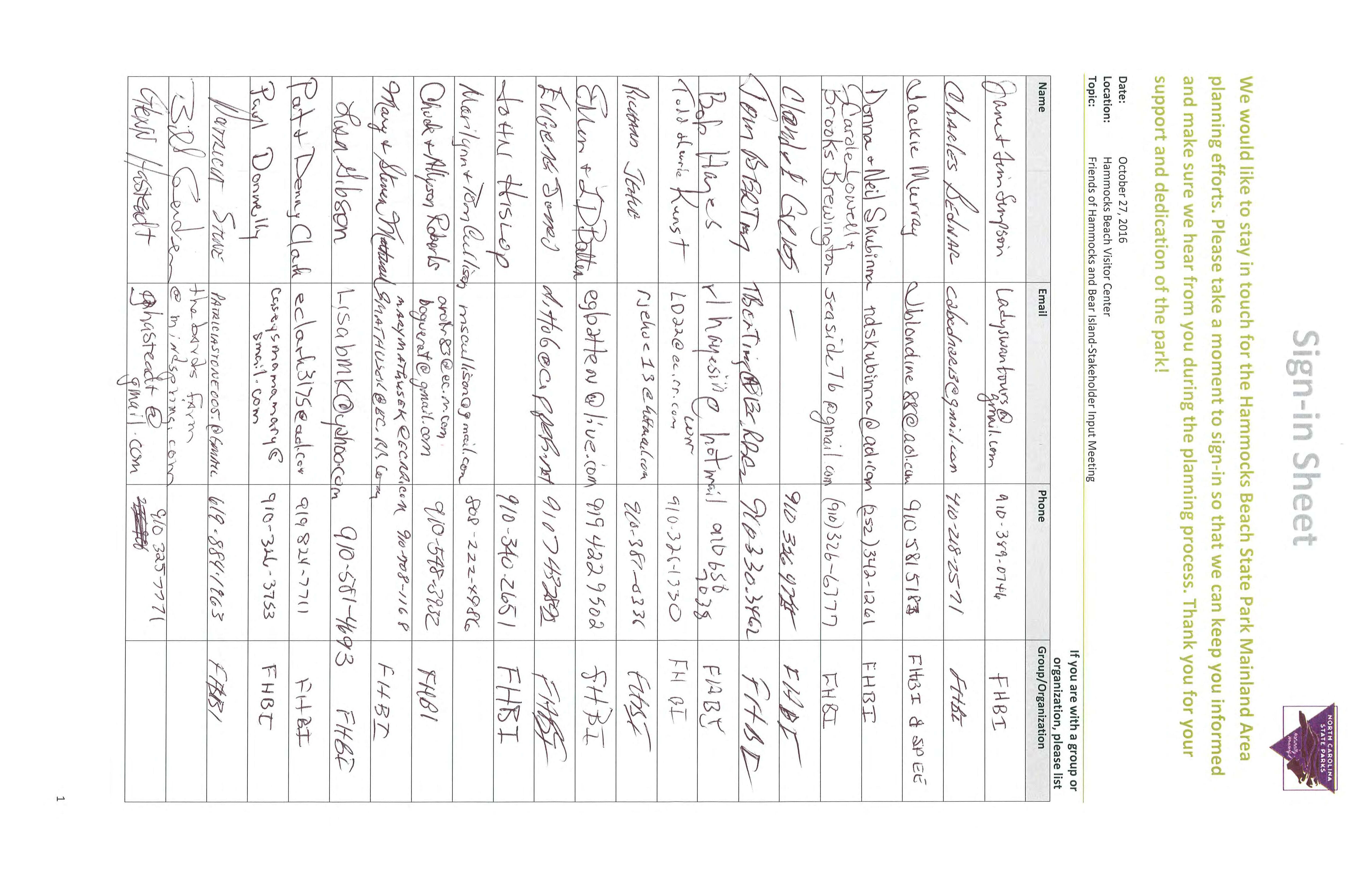


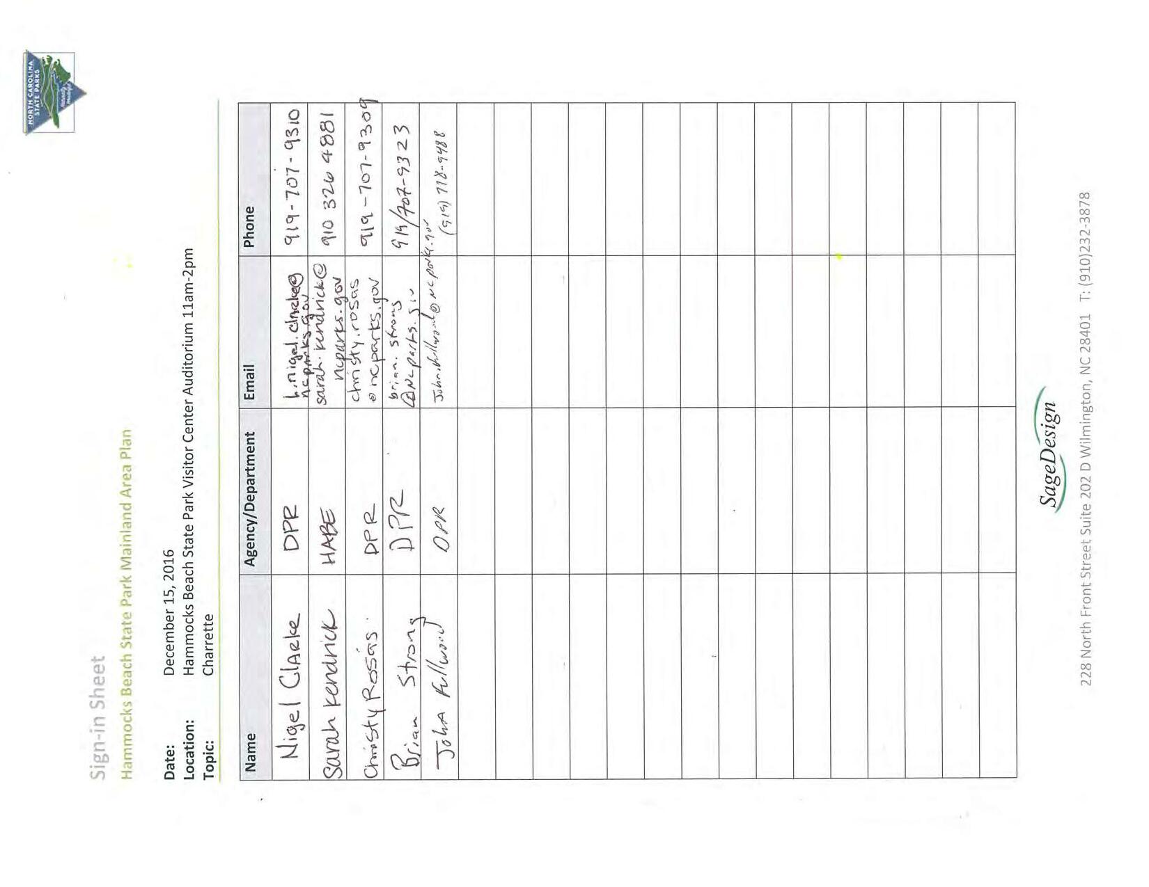
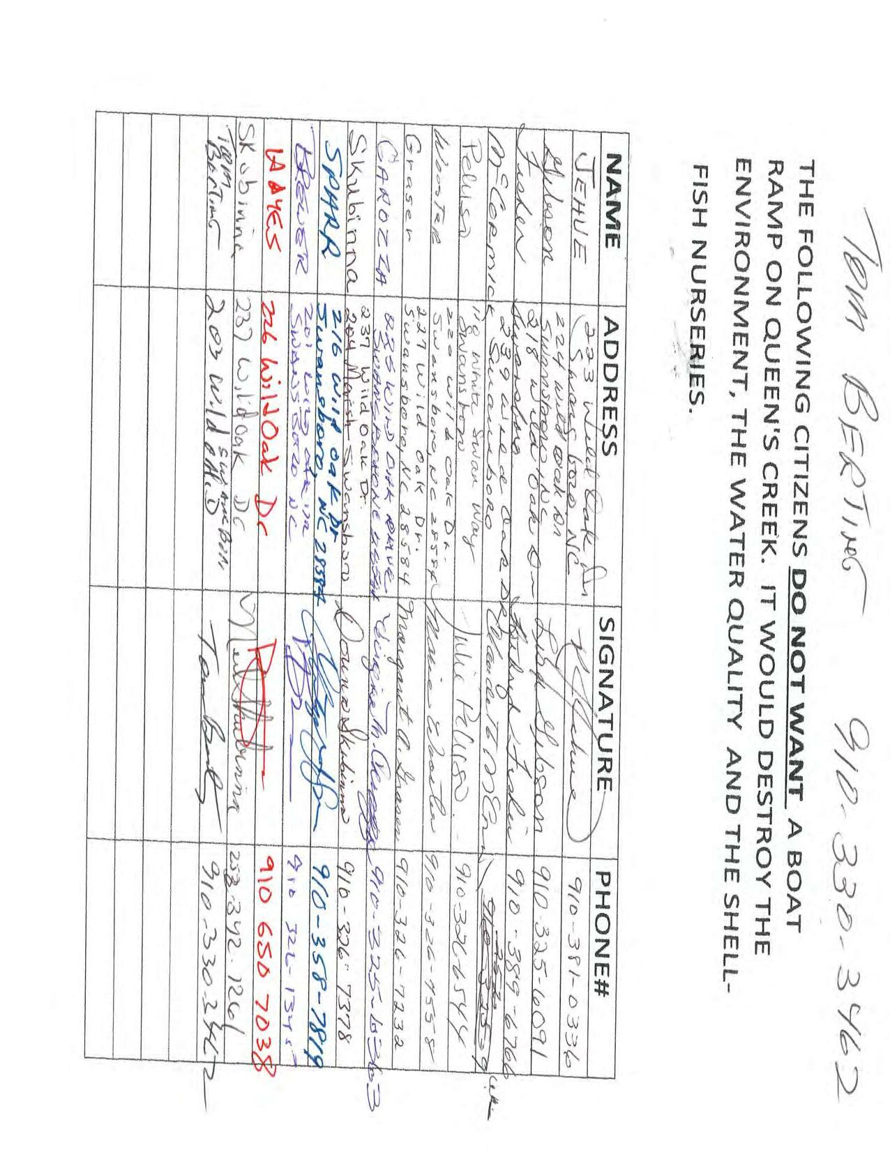
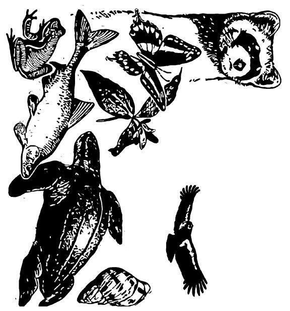
Resources Report . . . . . . . . . . . . . . . . . . . . . . . . . . . . . . . . . . . . . . . . . . . . . . . . . . . . . .
Description . . . . . . . . . . . . . . . . . . . . . . . . . . . . . . . . . . . . . . . . . . . . . . . . . . . . . . . . . . . .
Endangered Species . . . . . . . . . . . . . . . . . . . . . . . . . . . . . . . . . . . . . . . . . . . . . . . . . . . . . . . . . . .
Birds . . . . . . . . . . . . . . . . . . . . . . . . . . . . . . . . . . . . . . . . . . . . . . . . . . . . . . . . . . . . . . . .
& Hatcheries . . . . . . . . . . . . . . . . . . . . . . . . . . . . . . . . . . . . . . . . . . . . . . . . . . . . . . . . . . .
. . . . . . . . . . . . . . . . . . . . . . . . . . . . . . . . . . . . . . . . . . . . . . . . . . . . . . . . . . . . . . . . . . . .


Proposed, candidate, threatened, and endangered species are managed by the of the U.S. Fish & Wildlife Service. Endangered Species Program
This USFWS trust resource report is for informational purposes only and should not be used for planning or analyzing project level impacts. For project evaluations that require USFWS concurrence/review, please return to the IPaC website and request an official species list from the Regulatory Documents section. of the Endangered Species Act
requires Secretary information whether any species which is listed or proposed to be listed may be present in the area of such proposed action" for any project that is conducted, permitted, funded, or licensed by any Federal agency.
Federal agencies to "request of the Section 7
A letter from the local office and a species list which fulfills this requirement can only be obtained by requesting an official species list either from the Regulatory Documents section in IPaC or from the local field office directly.
The list of species below are those that may occur or could potentially be affected by activities in this location:
CRITICAL HABITAT
critical habitat designated for this species. final http://ecos.fws.gov/tess_public/profile/speciesProfile.action?spcode=B079
There is
CRITICAL HABITAT has been designated for this species. No critical habitat http://ecos.fws.gov/tess_public/profile/speciesProfile.action?spcode=B0DM
Red-cockaded Woodpecker Picoides borealis
CRITICAL HABITAT has been designated for this species. No critical habitat http://ecos.fws.gov/tess_public/profile/speciesProfile.action?spcode=B04F
CRITICAL HABITAT has been designated for this species. No critical habitat http://ecos.fws.gov/tess_public/profile/speciesProfile.action?spcode=E0A7
CRITICAL HABITAT has been designated for this species. No critical habitat http://ecos.fws.gov/tess_public/profile/speciesProfile.action?spcode=E00B
CRITICAL HABITAT has been designated for this species. No critical habitat http://ecos.fws.gov/tess_public/profile/speciesProfile.action?spcode=Q231
CRITICAL HABITAT
critical habitat designated for this species. final http://ecos.fws.gov/tess_public/profile/speciesProfile.action?spcode=Q3HD
There is
Pondberry Lindera melissifolia
CRITICAL HABITAT has been designated for this species. No critical habitat http://ecos.fws.gov/tess_public/profile/speciesProfile.action?spcode=Q2CO
Rough-leaved Loosestrife Lysimachia asperulaefolia
CRITICAL HABITAT has been designated for this species. No critical habitat http://ecos.fws.gov/tess_public/profile/speciesProfile.action?spcode=Q2DF
CRITICAL HABITAT has been designated for this species. No critical habitat http://ecos.fws.gov/tess_public/profile/speciesProfile.action?spcode=Q2MZ
West Indian Manatee Trichechus manatus
CRITICAL HABITAT
critical habitat designated for this species. final http://ecos.fws.gov/tess_public/profile/speciesProfile.action?spcode=A007
There is
CRITICAL HABITAT has been designated for this species. No critical habitat http://ecos.fws.gov/tess_public/profile/speciesProfile.action?spcode=C000
Hawksbill Sea Turtle Eretmochelys imbricata
CRITICAL HABITAT
critical habitat designated for this species. final http://ecos.fws.gov/tess_public/profile/speciesProfile.action?spcode=C00E
There is
Kemp's Ridley Sea Turtle Lepidochelys kempii
CRITICAL HABITAT has been designated for this species. No critical habitat http://ecos.fws.gov/tess_public/profile/speciesProfile.action?spcode=C00O
Leatherback Sea Turtle Dermochelys coriacea
CRITICAL HABITAT
critical habitat designated for this species. final http://ecos.fws.gov/tess_public/profile/speciesProfile.action?spcode=C00F
There is
Loggerhead Sea Turtle Caretta caretta
CRITICAL HABITAT
critical habitat designated for this species. final http://ecos.fws.gov/tess_public/profile/speciesProfile.action?spcode=C00U
There is
There are no critical habitats in this location
and the Migratory Bird Treaty Act
Birds are protected by the
Bald and Golden Eagle Protection Act
Any activity that results in the
of migratory birds or eagles is prohibited unless take authorized by the U.S. Fish & Wildlife Service.
There are no provisions for allowing [1] the take of migratory birds that are unintentionally killed or injured.
Any person or organization who plans or conducts activities that may result in the take of migratory birds is responsible for complying with the appropriate regulations and implementing appropriate conservation measures. 1. 50 C.F.R. Sec. 10.12 and 16 U.S.C. Sec. 668(a)
Additional information can be found using the following links:
Birds of Conservation Concern http://www.fws.gov/birds/management/managed-species/ birds-of-conservation-concern.php Conservation measures for birds http://www.fws.gov/birds/management/project-assessment-tools-and-guidance/ conservation-measures.php
Year-round bird occurrence data http://www.birdscanada.org/birdmon/default/datasummaries.jsp
The following species of migratory birds could potentially be affected by activities in this location:
Bird of conservation concern Bird of conservation concern Bird of conservation concern Bird of conservation concern
American Kestrel Falco sparverius paulus
Season:Year-round
American Oystercatcher Haematopus palliatus
Season:Year-round http://ecos.fws.gov/tess_public/profile/speciesProfile.action?spcode=B0G8
American Bittern Botaurus lentiginosus
Season:Wintering http://ecos.fws.gov/tess_public/profile/speciesProfile.action?spcode=B0F3
Bachman's Sparrow Aimophila aestivalis
Season:Year-round http://ecos.fws.gov/tess_public/profile/speciesProfile.action?spcode=B07F
Bird of conservation concern Bird of conservation concern Bird of conservation concern
Bird of conservation concern
Bird of conservation concern Bird of conservation concern Bird of conservation concern
Bird of conservation concern
Bird of conservation concern
Bird of conservation concern Bird of conservation concern Bird of conservation concern Bird of conservation concern Bird of conservation concern
Bald Eagle Haliaeetus leucocephalus
Season:Year-round http://ecos.fws.gov/tess_public/profile/speciesProfile.action?spcode=B008
Black Rail Laterallus jamaicensis
Season:Breeding http://ecos.fws.gov/tess_public/profile/speciesProfile.action?spcode=B09A
Black Skimmer Rynchops niger
Season:Breeding http://ecos.fws.gov/tess_public/profile/speciesProfile.action?spcode=B0EO
Black-throated Green Warbler Dendroica virens
Season:Breeding
Brown-headed Nuthatch Sitta pusilla
Season:Year-round
Chuck-will's-widow Caprimulgus carolinensis
Season:Breeding
Fox Sparrow Passerella iliaca
Season:Wintering
Gull-billed Tern Gelochelidon nilotica
Season:Breeding http://ecos.fws.gov/tess_public/profile/speciesProfile.action?spcode=B0JV
Least Bittern Ixobrychus exilis
Season:Breeding http://ecos.fws.gov/tess_public/profile/speciesProfile.action?spcode=B092
Least Tern Sterna antillarum
Season:Breeding
Lesser Yellowlegs Tringa flavipes
Season:Wintering http://ecos.fws.gov/tess_public/profile/speciesProfile.action?spcode=B0MD
Loggerhead Shrike Lanius ludovicianus
Season:Year-round http://ecos.fws.gov/tess_public/profile/speciesProfile.action?spcode=B0FY
Marbled Godwit Limosa fedoa
Season:Wintering http://ecos.fws.gov/tess_public/profile/speciesProfile.action?spcode=B0JL
Nelson's Sparrow Ammodramus nelsoni
Season:Wintering
Painted Bunting Passerina ciris Season:Breeding
Bird of conservation concern Bird of conservation concern
Bird of conservation concern Bird of conservation concern
Bird of conservation concern
Bird of conservation concern
Bird of conservation concern Bird of conservation concern
Bird of conservation concern Bird of conservation concern
Bird of conservation concern
Bird of conservation concern
Bird of conservation concern
Bird of conservation concern Bird of conservation concern
Bird of conservation concern Bird of conservation concern
Peregrine Falcon Falco peregrinus
Season:Wintering http://ecos.fws.gov/tess_public/profile/speciesProfile.action?spcode=B0FU
Prairie Warbler Dendroica discolor
Season:Breeding
Prothonotary Warbler Protonotaria citrea
Season:Breeding
Purple Sandpiper Calidris maritima
Season:Wintering
Red Knot Calidris canutus rufa
Season:Wintering http://ecos.fws.gov/tess_public/profile/speciesProfile.action?spcode=B0DM
Red-headed Woodpecker Melanerpes erythrocephalus
Season:Year-round Rusty Blackbird Euphagus carolinus
Season:Wintering Saltmarsh Sparrow Ammodramus caudacutus
Season:Wintering
Seaside Sparrow Ammodramus maritimus
Season:Year-round
Sedge Wren Cistothorus platensis
Season:Wintering
Short-billed Dowitcher Limnodromus griseus
Season:Wintering http://ecos.fws.gov/tess_public/profile/speciesProfile.action?spcode=B0JK
Short-eared Owl Asio flammeus
Season:Wintering http://ecos.fws.gov/tess_public/profile/speciesProfile.action?spcode=B0HD
Swainson's Warbler Limnothlypis swainsonii
Season:Breeding
Whimbrel Numenius phaeopus
Season:Wintering http://ecos.fws.gov/tess_public/profile/speciesProfile.action?spcode=B0JN
Wilson's Plover Charadrius wilsonia
Season:Breeding
Wood Thrush Hylocichla mustelina
Season:Breeding
Worm Eating Warbler Helmitheros vermivorum Season:Breeding
and other aquatic habitats may be subject to regulation under NWI wetlands
Impacts to
Section 404 of the Clean Water Act, or other State/Federal statutes.
For more information please contact the Regulatory Program of the local U.S. Army .
Corps of Engineers District
DATA LIMITATIONS
The Service's objective of mapping wetlands and deepwater habitats is to produce reconnaissance level information on the location, type and size of these resources. The maps are prepared from the analysis of high altitude imagery. Wetlands are identified based on vegetation, visible hydrology and geography. A margin of error is inherent in the use of imagery; thus, detailed on-the-ground inspection of any particular site may result in revision of the wetland boundaries or classification established through image analysis.
The accuracy of image interpretation depends on the quality of the imagery, the experience of the image analysts, the amount and quality of the collateral data and the amount of ground truth verification work conducted. Metadata should be consulted to determine the date of the source imagery used and any mapping problems. Wetlands or other mapped features may have changed since the date of the imagery or field work. There may be occasional differences in polygon boundaries or classifications between the information depicted on the map and the actual conditions on site.
Certain wetland habitats are excluded from the National mapping program because of the limitations of aerial imagery as the primary data source used to detect wetlands. These habitats include seagrasses or submerged aquatic vegetation that are found in the intertidal and subtidal zones of estuaries and nearshore coastal waters.
Some deepwater reef communities (coral or tuberficid worm reefs) have also been excluded from the inventory.
These habitats, because of their depth, go undetected by aerial imagery.
Federal, state, and local regulatory agencies with jurisdiction over wetlands may define and describe wetlands in a different manner than that used in this inventory. There is no attempt, in either the design or products of this inventory, to define the limits of proprietary jurisdiction of any Federal, state, or local government or to establish the geographical scope of the regulatory programs of government agencies. Persons intending to engage in activities involving modifications within or adjacent to wetland areas should seek the advice of appropriate federal, state, or local agencies concerning specified agency regulatory programs and proprietary jurisdictions that may affect such activities.
Wetland data is unavailable at this time.


Public participation is a critical and necessary component in creating a planning document. The North Carolina Division of Parks and Recreation conducted a public input survey to evaluate demand for, participation in, and perceptions of outdoor recreation. The survey was conducted online using Survey Monkey and was distributed via multiple channels. In total, the study yielded over 17,000 responses.
Questions from the survey broadly address areas such as outdoor recreation participation, satisfaction with statewide outdoor recreation opportunities, motivation for participation, barriers to participation, and attitudes about the recreation provide r’s priorities .
In order to understand trends and popularity among outdoor recreation activities, respondents were asked to identify the activities they or household members participate in or have participated in over the past five years. The most popular activity was vi siting a beach or lake, with 69 percent participating. Walking for pleasure or exercise, and visiting parks or historic sites are activities for 61 and 60 percent of respondents respectively. Over half of all respondents participate in hiking on trails (59 percent) and freshwater fishing (58 percent ) (Figure 2.1) . Other activities that have at least half of respondents participating are viewing scenery, fishing from a boat, nature viewing and swimming. For the participation rates for all 80 activities inc luded on the public survey, refer to the tables in Appendix C .
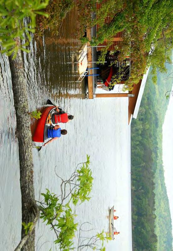
important because over 90 percent of those surveyed responded that local and state parks are extremely important to them. The highest levels of satisfaction are wit h efforts to provide outdoor recreation and environmental education. About 80 percent of respondents were either satisfied or somewhat satisfied with these efforts. In contrast, about 70 percent of respondents are satisfied or somewhat satisfied with eff orts to a cquire and manage public land.

Alongside motivation and satisfaction, it is equally important to understand the barriers to outdoor recreation participation. Not surprisingly, a lack of time was the predo minant barrier (59 percent). Nearly one quarter of respondents indicated that a lack of available facilities (23 percent) and cost (21 percent) are barriers to participation. (Figure 2.5 )
Frequency of Visits
Over one third (35 percent) of respondents reported having visited a local park more than eight times over the past twelve months, with 20 percent having visited at least three times.
Somewhat lower p ercentages of respondents (22 percent and 14 percent respectively) visited state and national parks more than 8 times in the past twelve months. Roughly half of respondents visited local, state and national parks with the same frequency in the past twelve months (47, 50, and 47 percent respectively).
Funding for Park Land and Facilities
Consistent and adequate financial resources are required to address local, state, and federal outdoor recreation needs. Among these needs are acquisition of new parks and open space, development of new facilities at existing recreation sites, operation and maintenance of existing infrastructure and facilities, transforming existing facilities to s erve new purposes, and future planning. Securing appropriate ways of funding outdoor recreation resources, as cost and demand increase, remains a challenge.
As mentioned earlier in this chapter, survey respondents participate in outdoor recreation in stat e parks frequently I t stands to reason that a large majority of respondents ( 8 1 percent) think it is extremely or somewhat important to spend public funds to acquire land and develop outdoor state parks and recreation areas in North Carolina. In addition , a majority of respondents think it is extremely or somewhat important to spend public funds to acquire land and develop outdoor recreation areas on both the local ( 78 percent), and federal ( 7 7 percent) levels.
Survey of Recreation Managers
Recreation providers from across North Carolina completed an online survey designed to better understand the opportunities and challenges faced by recreation managers. Included in the study were recreation providers representing all government sectors; federal, state and local. Q uasi public/ non profit recreation providers were also included as they have similar mandates to serve the public atlarge.
Management Challenge: Obtaining Funding
Public recreation managers were asked to respond to four questions about the relative difficulty they perceive in accomplishing objectives related to providing park and recreation services to the public. The first question dealt with the challenge of obtaining funding for park facilities, land acquisition, programming and maintenance, etc. The providers rated obtaining funding for new facilities (81%), major renovations (78%), facility replacement (74%) and land acquisition (71%) more difficult. The values are the combination of managers responding either difficult or somewhat difficult. ( Figure 2. 8 ).
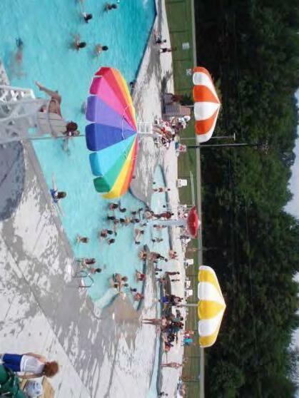
Public recreation providers were asked to identify which types of areas are currently needed in their park system. For each type of are a, the respondents had four choices: important, somewhat important, not important and not applicable. Two types of ar eas received the highest rating; linear parks , such as greenways and parks along rivers or streams, and nature / conservation parks. In each case, 67 percent of respondents chose either “important or “somewhat i mportant” . Other types of area seen as eit her important or somewhat important by at half of the public recreation providers are trail linkages to other jurisdictions (57 percent), cultural / historic parks (57 percent), community parks (55 percent), and specialty parks such as water parks , skate p
Carolina Beach State Park GPS: 34.0471, -77.9071 carolina.beach@ncparks.gov (910) 458-8206
Diverse coastal ecological communities support rare plants, including Venus flytrap.
Carvers Creek State Park GPS: 35.203439, -78.9767398 carvers.creek@ncparks.gov (910) 436-4681
Diverse habitats, 100-acre millpond, picnic areas, historic buildings from the James S. Rockefeller’s Long Valley Farm, bank fishing, and a lovely boardwalk extending 90 feet into the cypress trees of the millpond.
Chimney Rock State Park GPS: 35.432799, -82.250260 chimney.rock@ncparks.gov – (828) 625-1823
Spectacular vistas of Hickory Nut Gorge. Historic tourist destination, 26-story elevator, 404-foot waterfall, over 6,000 acres, rock climbing and bouldering. Admission.
Cliffs of the Neuse State Park GPS: 35.2354, -77.8932 cliffs.neuse@ncparks.gov – (919) 778-6234
Multicolored cliffs up to 98 feet tower over historic river. Part of the Mountains-to-Sea Paddle Trail. Swim lake open during summer
Crowders Mountain State Park GPS: 35.2127, -81.3006 crowders.mountain@ncparks.gov – (704) 853-5375
Two of the highest peaks in Kings Mountain Range, 20mile views, streams and lake environments.
Dismal Swamp State Park GPS: 36.5057, -76.3551 dismal.swamp@ncparks.gov – (252) 771-6593


More than 20 miles of hiking and biking trails on 14,000 acres of the historic Great Dismal Swamp. Wetland habitat and wildlife viewing on half-mile boardwalk. Kayak/canoe/ bike rental. Underground Railroad historic designation. Visitor center and museum.
Elk Knob State Park GPS: 36.332586, -81.69064 elk.knob@ncparks.gov – (828) 297-7261 Scenic vistas from more than 5,500 feet in elevation with rare and unique plant communities. Enjoy a picnic after a rugged hike to the summit. Visit on a snowy day to enjoy cross-country skiing or snowshoeing.
Eno River State Park GPS: 36.0783, -79.0050 eno.river@ncparks.gov – (919) 383-1686
Scenic wilderness corridor encompasses 14 miles of river, multiple cultural history sites, and an extensive trail system. Part of the Mountains-to-Sea State Trail.
Falls Lake State Recreation Area GPS: 36.0117, -78.6888 falls.lake@ncparks.gov – (919) 676-1027
Expansive reservoir and woodlands, habitat for diversity of animals, including American bald eagles. Part of the Mountains-to-Sea State Trail.
Fort Fisher State Recreation Area GPS: 33.9534, -77.929 fort.fisher@ncparks.gov – (910) 458-5798 Barrier island between Cape Fear River and Atlantic Ocean is home to rare and endangered coastal birds and sea turtles.
Fort Macon State Park GPS: 34.696951, -76.677728 fort.macon@ncparks.gov - (252) 726-3775


Restored historic fort that played a key role in Civil War, barrier island beach. Fort tours, Civil War reenactments or enjoy the beautiful beach.
Goose Creek State Park GPS: 35.481853, -76.901414 goose.creek@ncparks.gov - (252) 923-2191
Hardwood swamps and brackish marshes along the Pamlico River, oaks draped in Spanish moss.
Gorges State Park GPS: 35.1133, -82.9563 gorges@ncparks.gov – (828) 966-9099
An 8,000-acre park on the Blue Ridge Escarpment with waterfalls, gorges and dramatic elevation changes provide for a concentration of rare and unique plant and animal species. A LEED-certified visitor center with exhibits, large picnic shelters with fireplaces, hiking trails, observation decks and primitive backcountry camping.
Grandfather Mountain State Park GPS: Hwy 105 S 36.121990, -81.829993 Blue Ridge Parkway 36.120076, -81.781358 grandfather.mountain@ncparks.gov – (828) 963-9522 12 miles of rugged, scenic trails with magnificent views from rock outcrops and forested coves; highest peak at 5,946 feet. Home to over 70 rare/endangered species and 16 distinct natural communities. Adjacent to the private Grandfather Mountain attraction.
Hammocks Beach State Park GPS: 34.67261,-77.13945 hammocks.beach@ncparks.gov – (910) 326-4881
On mainland and islands; park operates a seasonal passenger ferry to ocean beach, maritime forests, salt marshes, tidal creeks. Sea turtle nesting site.
Hanging Rock State Park GPS: 36.411906, -80.254122 hanging.rock@ncparks.gov – (336) 593-8480 Rock outcrops at elevations up to 2,580 feet, five waterfalls, mountain lake, access to scenic river. Part of the Mountains-to-Sea State Trail.
Haw River State Park GPS: 36.250646, -79.756364 haw.river@ncparks.gov – (336) 342-6163
The Summit Environmental Education and Conference Center provides training facilities, environmental education opportunities and overnight accommodations.
Jockey's Ridge State Park GPS: 35.9642, -75.6330 jockeys.ridge@ncparks.gov – (252) 441-7132 Tallest living sand dune along U.S. Atlantic coast, barrier island ecology. Stroll along the sound or hang glide from a dune. Part of the Mountains-to-Sea State Trail.
Jones Lake State Park GPS: 34.682743, -78.595423 jones.lake@ncparks.gov – (910) 588-4550 Carolina bay environment, five-mile hiking trail through diverse habitats with lake overlooks.
Jordan Lake State Recreation Area GPS: 35.7369, -79.0169 jordan.lake@ncparks.gov – (919) 362-0586 13,900-acre reservoir, home to American bald eagles. Several areas for day-use or overnight recreation.
Kerr Lake State Recreation Area GPS: 36.4411, -78.3688 kerr.lake@ncparks.gov – (252) 438-7791 50,000-acre reservoir with 800 miles of shoreline spanning North Carolina/Virginia state line.
Lake James State Park GPS: 35.750378, -81.892075 lake.james@ncparks.gov – (828) 584-7728
Vistas of surrounding Black Mountains overlooking manmade 6,812-acre lake. Take advantage of the many recreation oppotunities this lake has to offer.
Lake Norman State Park GPS: 35.672548, -80.932500 lake.norman@ncparks.gov – (704) 528-6350 State’s largest manmade lake at 32,510 acres. More than 30 miles of biking trails.
Lake Waccamaw State Park GPS: 34.278985, -78.465485 lake.waccamaw@ncparks.gov – (910) 646-4748
One of the largest Carolina bays with unique plants and animals, including alligators.
Lumber River State Park GPS: Princess Ann 34.390023, -79.002225 Chalks Bank 34.8987, -79.3549 lumber.river@ncparks.gov – (910) 628-4564 State Nature & Scenic and National Wild & Scenic 115 miles blackwater river. Enjoy Griffin's Whirl, a unique reverse flow area.
Mayo River State Park GPS: 36.438800, -79.938171 mayo.river@ncparks.gov – (336) 427-2530
A visitor’s center, hiking trails, picnic tables and a picnic shelter are situated near two fishing ponds. Call the park office for updates on new facilities.
Medoc Mountain State Park GPS: 36.2639, -77.8883 medoc.mountain@ncparks.gov – (252) 586-6588
Exposed rock outcrops, bluffs, steep topography, rocks, minerals unusual to piedmont.
Merchants Millpond State Park GPS: 36.437105, -76.701585 merchants.millpond@ncparks.gov – (252) 357-1191
Maze of towering bald cypress trees draped in Spanish moss dominates millpond and adjacent swamp. Rent a canoe/kayak to explore the millpond.
Morrow Mountain State Park GPS: 35.373724, -80.073477 morrow.mountain@ncparks.gov – (704) 982-4402 Mountains up to 936 feet, peaceful lake. These pinnacles are the remains of one of the oldest mountain ranges in the eastern United States.
Mount Jefferson State Natural Area GPS: 36.397660, -81.473466 mount.jefferson@ncparks.gov – (336) 246-9653
Panoramic views from scenic Blue Ridge mountaintop at 4,683-foot elevation. National Natural Landmark.
Mount Mitchell State Park GPS: 35.7528, -82.2737 mount.mitchell@ncparks.gov – (828) 675-4611
Highest peak east of the Mississippi at 6,684 feet, views up to 100 miles, North Carolina’s first state park. Part of the Mountains-to-Sea State Trail.
New River State Park GPS: 36.467680, -81.340350 new.river@ncparks.gov – (336) 982-2587

Nationally designated Wild and Scenic and American Heritage River. It offers canoeing and hiking past scenic rock outcrops, farmlands and woodlands.
Occoneechee Mountain State Natural Area GPS: 36.060835, -79.116900 eno.river@ncparks.gov – (919) 383-1686
Over three miles of trail circle around the highest point in Orange County, providing beautiful views of the mountain and the Eno River.
Pettigrew State Park GPS: 35.4732.03, -76.2434.17 pettigrew@ncparks.gov – (252) 797-4475
Second-largest natural lake in state, old-growth trees, American Indian artifacts including second-oldest dugout canoe in U.S., plantation historic site and grave of Confederate general.
Pilot Mountain State Park GPS: 36.341276, -80.462938 pilot.mountain@ncparks.gov – (336) 325-2355 National Natural Landmark offering scenic vistas of Blue Ridge mountains. Canoe the Yadkin River as it flows for two miles through the park.
Raven Rock State Park GPS: 35.4597, -78.9127 raven.rock@ncparks.gov – (910) 893-4888
Landmark bluff that stretches 150-foot-high and more than a mile along the Cape Fear River.
Singletary Lake State Park GPS: 34.5831, -78.4496 singletary.lake@ncparks.gov – (910) 669-2928 Carolina bay environment, scenic lake vistas, undeveloped shoreline.
South Mountains State Park GPS: 35.5963, -81.6000 south.mountains@ncparks.gov – (828) 433-4772 Mountain peaks to 3,000 feet, 80-foot waterfall. Parts of the park were constructed by the Civilian Conservation Corps (CCC).
Stone Mountain State Park GPS: 36.3873, -81.0273 stone.mountain@ncparks.gov – (336) 957-8185 Rock dome rising 600 feet above the valley floor, waterfalls, mid-19th century homestead, Blue Ridge mountain views. Part of the Mountains-to-Sea State Trail.
Weymouth Woods Sandhills Nature Preserve GPS: 35.1469, -79.3690 weymouth.woods@ncparks.gov – (910) 692-2167 Longleaf pine forest; broad, flat valleys; rare and endangered species include red-cockaded woodpecker, pine barrens tree frog, bog spicebush.
William B. Umstead State Park GPS: 35.8905, -78.7502 william.umstead@ncparks.gov – (919) 571-4170


More than 5,000 acres of hardwood forest in urban
The Mountains-to-Sea State Trail, an effort to link
Dome in the


Smoky Mountains National Park to Jockey’s Ridge State Park on the
the


project of


In 2014, the North Carolina Division of Parks and Recreation conducted a public survey to evaluate demand for, participation in, and perceptions of outdoor recreation. The survey was conducted online using Survey Monkey and was distributed via multiple channels. In total, the study yielded over 17,000 responses.
Questions from the survey broadly address areas such as outdoor recreation participation, satisfaction with statewide outdoor recreation opportunities, motivation for participation, and barriers to participation. In order to understand trends and popularity among outdoor recreation activities, respondents were asked to identify the activities they or household members participate in or have participated in over the past five years. The most popular activity was visiting a beach or lake, with 69 percent participating. Walking for pleasure or exercise, and visiting parks or historic sites are activities for 61 and 60 percent of respondents respectively. Over half of all respondents participate in hiking on trails (59 percent) and freshwater fishing (58 percent) (Figure 4.3). Other activities that have at least half of respondents participating are viewing scenery, fishing from a boat, nature viewing and swimming.
Figure 4.3 Most popular outdoor recreation activities
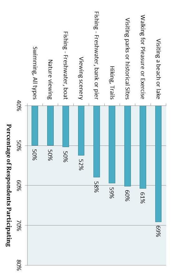
Respondents were asked to describe their motivations for participating in outdoor recreation activities. The most popular answers were, being outdoors (93 %), followed by having fun (87 %) and relaxing (78 %). Respondents also wanted to be closer to nature and spend time with family and friends. (Figure 4.4)
Respondents were also asked how many times they visited local, state, and federal parks. For state parks, most people indicated that they visited between three and five times in the past year (28 percent). The next most popular answers were one to two visits (22 percent) and more than eight visits (22 percent). (Figure 4.5) The reasons that state parks enjoy wide popularity are reflected in the things survey respondents seek in participating in outdoor recreation. State parks provide many if not all of these experiences opportunities to be outdoors, be closer to nature, enjoy time with family and friends. Many state parks also provide opportunities for exercise and fun in a setting that is free or affordable.
In many cases, another factor in the number of times a person visits a state park is proximity. Earlier surveys of state park visitors have shown that many people who choose to visit are within 30 miles. Parks that are closer to home are more affordable to visit in terms of time and effort as well as money.
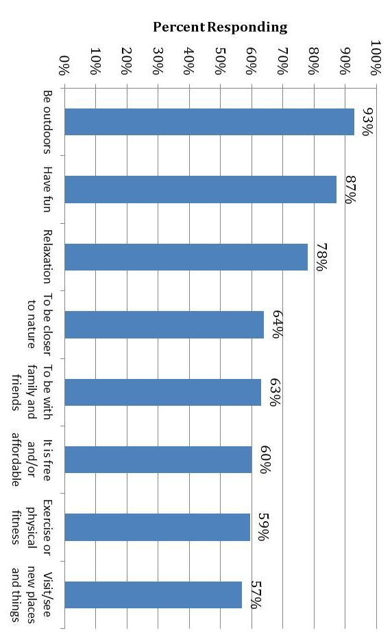
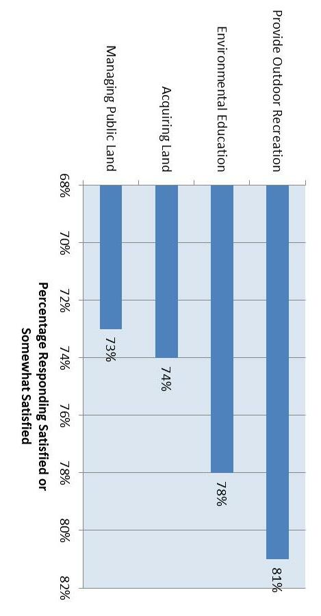
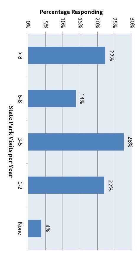
North Carolina residents are generally satisfied with the parks available to them. That’s important because o ver 90 percent of those surveyed responded that local and state parks are extremely important to them. The highest levels of satisfaction are with efforts to provide outdoor recreation and environmental education. About 80 percent of respondents were either satisfied or somewhat satisfied with these efforts. In contrast, about 70 percent of respondents are satisfied or somewhat satisfied with efforts to acquire and manage public land.
4.6)
with Park Management
What are public priorities for parks in North Carolina? Survey respondents were asked to identify their priorities for several management objectives. The most popular top priority was “operate existing parks” (31 percent of respondents), followed closely by “acquire new parks and open space” (24 percent). Other priorities are to develop new trails, the top priority of 13 percent of respondents, and to develop new facilities at existing parks (11 percent). (Figure 4.7)
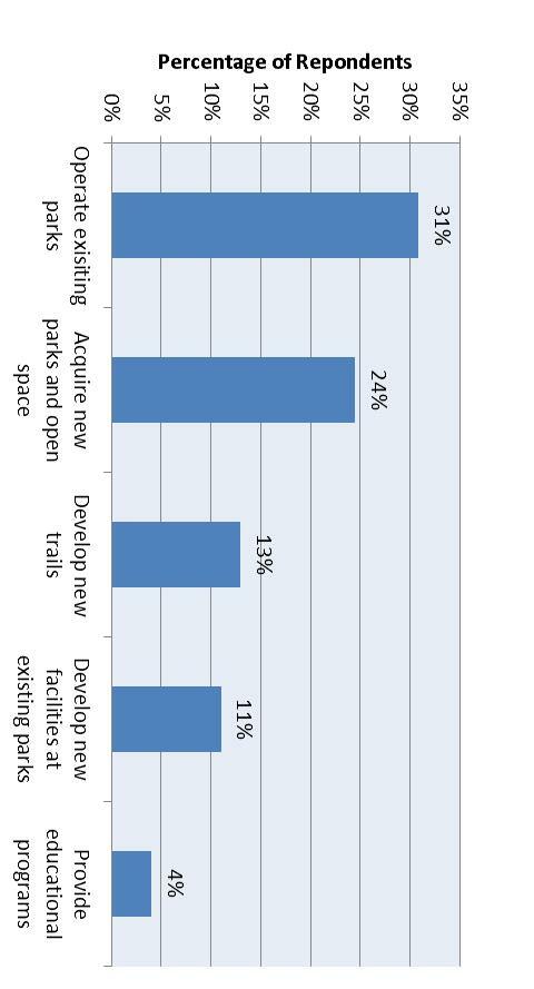
During 2008, the Division of Parks and Recreation conducted a survey to gain feedback on what types of recreational facilities are desirable in state parks as well as a review and rank of statements regarding the state park system. In addition to press releases, Friends of State Parks groups, outdoor recreation groups, land conservation partners, and various park supporters were encouraged to take the survey online. Some local and statewide park user groups circulated the web link of the online survey to their members. By the time the survey was closed to responses, 3,927 individuals interested in North Carolina state parks completed a survey.