
2014 CROATAN REGIONAL BICYCLE + TRAILS PLAN CROATAN REGIONAL BICYCLE + TRAILSPLAN * * Regional Bicycle + Trails Plan Logo

A special thanks to the 150+ people who participated in this planning process through comment forms, public workshops, and meetings.
The Eastern Carolina Council

The Down East Rural Planning Organization
The Jacksonville Metropolitan Planning Organization
Craven County
Pamlico County
Carteret County
Jones County
Onslow County
Local Municipalities, including Atlantic Beach, Emerald Isle, New Bern, Cape Carteret, Havelock, Newport, Cedar Point, Morehead City, and Oriental
The North Carolina Department of Transportation


The North Carolina Department of Environment and Natural Resources
The U.S. Forest Service
The Friends of the Mountains-to-Sea Trail
The East Coast Greenway Alliance
Thank you to representatives of the following organizations for providing input regarding opportunities for cycling and trail development:
U.S. Marine Corps (at Camp Lejune and Cherry Point Air Station)
North Carolina Railroad Company
Weyerhaeuser
North Carolina Coastal Federation
Atomic Cycles in New Bern
The Bicycle Shop in Jacksonville
North Carolina State Parks
Pamlico Community College
Alta Planning + Design 111 E. Chapel Hill Street Suite 100 Durham, NC 27701 (919) 484-8448 www.altaplanning.com

Project Purpose 1-1
Key Project Stakeholders 1-2
Project Background 1-3
Why this Plan is Important to the Croatan Region 1-4
Types of Bicyclists 1-10 Footnotes 1-11
Croatan Regional Transportation Network 2-1
Transportation Planning Agencies 2-2
Existing Plans 2-3
NCDOT Regional Bicycle Plans 2-6
NCDOT Statewide Bicycle Routes 2-7
Existing Trails and Current Trail Planning 2-9
Land Use and Demographic Patterns 2-10
Bicycle Crash Data and Safety Considerations 2-12
Environmental and Cultural Resources 2-14 Tourism 2-15
Overview 3-1
Bicycle Route Identification Process 3-1
Trail Route Identification Process 3-4 Public Involvement 3-6
Bicycle Facility Types 4-1
Bicycle Recommendations 4-4
The Regional Trails Network 4-14
Priority Projects 4-21
Signage Recommendations 4-44
Overview 5-1
Design Needs of Bicyclists 5-2
Types of Bicyclists 5-4
Bicycle Facility Selection Guidelines 5-5
Facility Classification 5-6
Facility Continua 5-7
Shared Roadways 5-8
Separated Bikeways 5-12
Separated Bikeways at Intersections 5-18
Bicyclists at Single-Lane Roundabouts 5-23
Intersection Crossing Markings 5-25
Signage Program 5-25
Retrofitting Existing Streets to add Bikeways 5-30
Multi-Use Paths and Off-Street Facilities 5-35
Typical Trail Cross-sections for Overall Trail Network 5-44
Multi-Use Path Crossings 5-48
Bikeway Support and Maintenance 5-53
Implementation Overview 6-1 Implementation for On-Road Bicycle Recommendations 6-2 Implementation for Trail Recommendations 6-6 Administrative Structure for Bicycle & Trails Plan 6-8
Action Steps Table 6-12
Steering Committee A-1 Online Outreach and Social Media A-1
Resolution of Support A-2
Local Expertise A-2 Public Workshops A-2 Public Comment Form Results A-4
Overview B-1
Federal Funding Sources B-1 State Funding Sources B-8 Local Government Funding Sources B-15
Funds from Private Foundations and Organizations B-19 Funding Source Summary Table B-25
Overview C-1 Partnerships C-1 Government Regulation C-2 Land Management C-3 Acquisition C-4
Opportunities and Constraints Overview D-1
Opportunities and Constraints D-2
Opportunities and Constraints Conclusion D-6
Bike Network Recommendations Maps E-2
Trail Network Recommendations Maps F-2
Introduction G-1
Need for Enhanced Bikeway Signing G-1
Creating an Identity for the Croatan Regional Bicycle Route G-2
Bikeway Wayfinding Signage Design Guidance G-5
Sign Placement Guidelines and Standards G-6
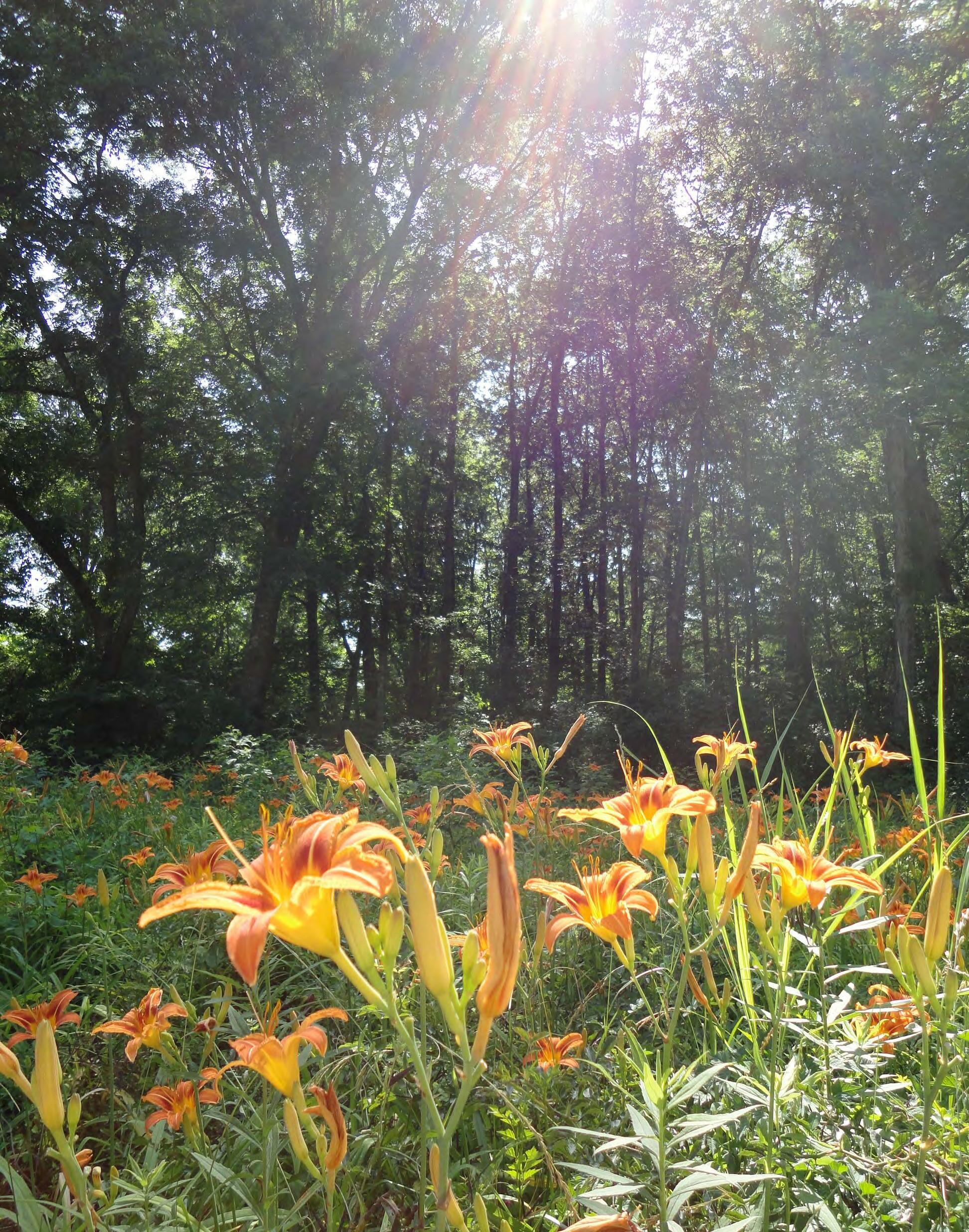 Flowers along Mill Branch Road in the Croatan National Forest
Project Purpose (1-1)
Key Project Stakeholders (1-2)
Project Background (1-3)
Why this Plan is Important to the Croatan Region (1-4)
Types of Bicyclists (1-10)
Endnotes (1-11)
The purpose of the Croatan Regional Bicycle and Trails Plan is to identify multijurisdictional bicycle routes and trail corridors that will connect communities and destinations throughout the region. A network of bicycle routes and trails is sought that can be used by pedestrians and bicyclists of all comfort levels to provide for the needs and enjoyment of locals and visitors alike. Trail corridors through the Croatan National Forest and parts of the surrounding counties, including a preferred route and alignment for two major statewide and multi-state trails that intersect in this region: the North Carolina Mountains-to-Sea Trail and the East Coast Greenway. The broader purpose of this plan is based on the many benefits that a bicycle and trails system could bring to this region, as listed in the vision statement below.
The Croatan Regional Bicycle and Trails Plan will identify and detail the means of creating a regional bicycle and trails network that will connect with neighboring communities, destinations, and local bicycle facilities in order to provide a safer, useful, and attractive transportation and recreation resource for a wide range of users within the surrounding five-county region.

The goals support the vision statement above and the vision of previous plans, giving further definition to what this plan aims to accomplish. The goals of the plan are as follows:
• Provide a safe environment for bicyclists and pedestrians
• Provide a well-designed, connected, and convenient network of on-road bicycle facilities and trails for pedestrian and bicycle transportation
• Boost tourism and economic vitality
Above: Logos for the Regional Trails Plan (top) and logo for the Regional Bicycle Plan (bottom). These logos were used as the basis for the new Regional Bicycle and Trails Plan logo.
• Encourage healthy, active lifestyles for local residents
• Reduce traffic congestion
• Provide alternatives to automobile travel
• Coordinate with NCDOT, the U.S. Forest Service, and the NC Trails Program for the development of these projects


• Improve public awareness and education of traffic laws & safety issues
• Protect natural corridors that serve as a ‘green infrastructure’ for clean, buffered waterways
• Conserve our local heritage by connecting historical and cultural sites along protected landscapes
For more on these topics, see the ‘Plan Importance’ section beginning on page 1-4 of this chapter.
The objectives of this plan are the actions that will support and achieve the goals listed above. The specific objectives of the plan are as follows:
• Identify a Regional Bicycle Route for Tourism – a signage package is included as Appendix G.
• Identify subregional loop bicycle routes for shorter distance options (MS Ride, Cycle NC, Bike clubs, locals or residents)
• Identify target audience for bicycle route and trail segments and appropriate improvements for regional & subregional segments
• Prioritize those improvements (High, medium, low/short, mid, long-term)
• Provide supplemental information for RPO/MPO prioritization (SPOT) and local government grant applications
• Create Regional Bicycle and Trails Plan website (resource for MPO/RPO/local governments/bike clubs, citizens, etc.)
• Create & print copies of Regional Bicycle and Trails Plan brochure
• Local adoption and endorsement of the plan
There are many partners involved in making this vision statement a reality, including, but not limited to, those listed here:
• Eastern Carolina Council (ECC)
• Counties of Craven, Pamlico, Carteret, Jones, and Onslow
• Local municipalities, including Atlantic Beach, Cape Carteret, Cedar Point, Emerald Isle, Havelock, Morehead City, New Bern, Newport, and Oriental
• Down East Rural Planning Organization (RPO)
• Jacksonville Metropolitan Planning Organization (MPO)
• North Carolina Department of Transportation (NCDOT)
• North Carolina Department of Environment and Natural Resources (NCDENR)
• U.S. Forest Service
• Friends of the Mountains-to-Sea Trail (MST)
• East Coast Greenway (ECG) Alliance
• U.S. Marine Corps (at Camp LeJeune and Cherry Point Air Station)
The combined boundaries of the counties listed above make up the overall study area for this plan. The main focus of the trails portion of this plan is on the Croatan National Forest, areas immediately surrounding the forest, and the MST/ECG alignments.

The Croatan Regional Bicycle and Trails Plan was developed out of two separate but complementary efforts to plan for on-road bicycle routes and a trails network in the region. The bicycle portion of this plan, known formerly as the Croatan Regional Bicycle Plan, began as part of the effort of the North Carolina Department of Transportation (NCDOT) Division of Bicycle and Pedestrian Transportation to develop regional, comprehensive bicycle plans in strategic areas through the state, with the goal of promoting bicycling as a form of transportation and recreation. The on-road bicycle planning contained in this document is the result of the second such regional effort, the first of which was completed in the Charlotte area around Lake Norman, called the Lake Norman Regional Bicycle Plan.
The bicycle component of the Croatan Regional Bicycle and Trails Plan focuses on regional on-street bicycle routes and strategic streetscape improvements, but also provides recommendations for secondary, local bicycle route improvements. This component builds upon existing local, regional, and state bicycle routes and creates a continuous route that encompasses the Croatan National Forest and connects neighboring communities, local destinations, and local bike facilities.
Because the area encompassed by the Croatan Regional Bicycle Plan includes the Croatan National Forest, the North Carolina Department of Environment and Natural Resources (NCDENR) became interested in creating a separate but parallel planning
effort to develop a series of trails that would connect the National Forest with the rest of the region. The Croatan Regional Trails Plan, which makes up the trails component of this combined plan, then became a separate but related planning process that focused on recommendations for multi-use trails, both paved and unpaved, in natural settings whenever possible. The regional trails plan not only focused on trails internal to the Croatan National Forest, but also recommends routes for both the East Coast Greenway (ECG), a trail system which links major cities on eastern seaboard from Maine to Florida, and the Mountains-to-Sea Trail (MST), a state wide trail for hiking and backpacking that is under the control of the North Carolina Dvisiion of State Parks. The trail route runs from the great Smokey Mountains to the Outer Banks.
The idea of establishing trails throughout this region of eastern North Carolina goes back decades to the early conception of the statewide MST. Similarly, advocates of the ECG have been narrowing down potential trail alignments in North Carolina for many years, exploring connections through this region in particular. The Croatan National Forest, being located in the center of this region, became a natural partner in planning for trails, as it too examines opportunities to connect trails through the forest and to surrounding communities. Chapter Two contains more information about the related efforts that have been merged into this combined bicycle and trails plan.
This was an open and participatory planning process, which strongly encouraged public involvement. The process involved all of the stakeholders previously listed, plus direction from a bicycle and trails planning and design consultant. Please see Chapter 3: Methodology for a detailed description of the methodologies used during the planning process and Appendix A: Public Involvement for a summary of public involvement methods and input received from the public.
Given the hard work involved in the planning, design, and development of a regional system of trails, it is important for all those involved in this effort to periodically remind themselves, and others, of the meaning behind this work and the tremendous value it brings to the broader community. Improvements that encourage bicycling and walking provide opportunities for people to travel, exercise, and recreate safely on foot or by bike, which in turn boosts tourism and the local economy, promotes active living and healthy lifestyles, reduces motor vehicle congestion and fuel costs, contributes to a cleaner and safer environment, and fosters a better quality of life and sense of community.
A better bicycling and trails network makes an area more accessible to visitors seeking out natural, cultural, and historical attractions, which in turn generates tourism revenue, supports local business, and creates jobs.1,2,3 A 2004 report on bicycling investments made in the Northern Outer Banks region shows how lucrative such investments can be for local tourism. With a one-time investment of $6.7 million in trails and other bicycling improvements, the Northern Outer Banks region has seen a $60 million return in tourism revenue each year.4 Many of the estimated 680,000 annual tourists use a bicycle at some point during their visit, and bicycling improvements have encouraged them to visit the area, make return visits, and stay in the area longer. The study found
At the award-winning Fishhawk Ranch, nearly 30 miles of trails weave throughout the community, connecting the many parks, amenities, villages and neighbors. Soon to be one of the largest community trail systems in the country, each pathway was carefully positioned to minimize the impact on the existing plant life.
Developers are taking advantage of the positive impact of trails on property values by marketing their greenways; left and below are examples of two magazine advertisements from developers that focus their marketing on greenways. These images are from ads in North Carolina and Florida.


that 43 percent of visitors surveyed said that bicycling was a factor in their decision to visit the Northern Outer Banks, and 53 percent reported that the quality of bicycling and trails would be a major factor in their decision to return in the future. Moreover, 12 percent of visitors surveyed decided to stay in the area longer because of local bicycling opportunities, extending their stay by an average of 4 days. Bicycling activity in the Northern Outer Banks helps to support or create over 1,400 jobs in the region each year.4
Other examples from around the country show how trails contribute to the local economy. In San Antonio, Texas, a downtown network of walkways known as the River Walk was built for $425,000, which attracted restaurants and businesses to locate along the previously neglected San Antonio River. Today, the River Walk is San Antonio’s most popular attraction, surpassing the Alamo as the top tourism generator in the city’s $3.5 billion tourism industry. 5 In Pennsylvania, the Great Allegheny Passage trail connects Pittsburgh to Cumberland, Maryland, a distance of 141 miles. The trail generated $40 million in local spending in a single year (2008) and another $7.5 million in wages that support tourism-related jobs in towns and cities along the trail. 6
Other areas with bicycle and trail tourism success stories include the following (cite original croatan):
• Virginia: When visiting the Virginia Creeper Trail, locals and non-locals spend approximately $2.5 million annually related to their recreation visits. Of this amount, non-local visitors spend about $1.2 million directly in the Washington and Grayson County economies.7
• Morgantown, WV: The 45 mile Mon River trail system is credited by the Convention and Visitors Bureau for revitalizing an entire district of the city, with a reported $200 million in private investment as a direct result of the trail. 8
• Tallahassee, FL: The Florida Department of Environmental Protection’s Office of Greenways and Trails estimates an economic benefit of $2.2 million annually from the 16 mile St. Marks Trail.9
• York County, PA: A 2007 report showed an annual economic impact of more than $6 million from the 21 mile Heritage Rail Trail (Heritage Rail Trail County Park User Survey and Economic Impact Analysis, 2007).10
Download the full report on economic benefits of bicycle tourism in the Outer Banks, “Pathways to Prosperity”, from: http://ncdot.org/ transit/bicycle/safety/safety_ economicimpact.html

People who bicycle to a business spend less per visit than those who drive, but they visit more often, resulting in more money spent overall per month. In Portland, Oregon, those who arrived at a shopping area by bike spent 24 percent more per month than those who traveled by car. Studies in Toronto and in three cities in New Zealand have also found that shoppers traveling by bike make more frequent trips and spend more overall than their motorist counterparts.11 Examples such as these show how trails and other bicycling and walking improvements generate business and contribute to the unique character of a region. For a relatively small investment, these facilities generate a high return by attracting residents and visitors who increase local revenue and support jobs and businesses year after year.
For many homebuyers, amenities such as bike lanes, paths, and greenway trails have become a major factor in deciding where to live within a region. A 2002 survey by the National Association of Realtors and the National Association of Homebuilders found that prospective homeowners rank trails as the second-most important community amenity out of 18 choices, above golf courses, parks, security gates, ball fields, and others.12 Two-thirds of homebuyers report that they consider the walkability of an area in their purchase decision, and seventy percent of Americans agree that having trails in their community is important to them.13,14
This strong preference has translated to a national trend of higher property values for homes that are located near trails. In Apex, North Carolina, homes in the Shepard’s Vineyard residential development that were located along the regional greenway were priced at a $5,000 premium over other homes in the subdivision, and yet these homes were still the first to sell.15 Along the Little Miami Scenic Trail in Ohio, a local study found that for every foot closer a home is to the trail, home values are $7.05 higher, with the highest being those along the trail itself.16 In Minneapolis-St. Paul, the median home value is $510 greater for every quarter mile nearer to an off-street bicycle trail.17
And along Indiana’s Monon Trail, homes within a half-mile sell for 11 percent more on average than similar homes farther away.18 Cases such as these are found across the country, from cities and suburbs to small rural towns. They show the tangible economic benefits that bicycling improvements and trails have for homeowners, and the premium that people are willing to pay to live in places where they can enjoy these amenities.
Trails in the Croatan region will contribute to the overall health of residents by offering people attractive, safe, and accessible places to bike, walk, hike, jog, skate, canoe, and kayak. In short, regional trails will create better opportunities for active lifestyles. The design of our communities—including towns, subdivisions, transportation systems, parks, trails and other public recreational facilities—affects people’s ability to reach the recommended 30 minutes each day of moderately intense physical activity (60 minutes for youth). According to the Centers for Disease Control and Prevention (CDC), “Physical inactivity causes numerous physical and mental health problems, is responsible for an estimated 200,000 deaths per year, and contributes to the obesity epidemic”.19
In identifying a solution, the CDC determined that by creating and improving places in our communities to be physically active, there could be a 25 percent increase in the percentage of people who exercise at least three times a week. 20 This is significant
considering that for people who are inactive, even small increases in physical activity can bring measurable health benefits. 21 Walking and bicycling are some of the most basic forms of physical activity, and improving facilities for these activities and linking to parks and playgrounds would help to better connect communities to convenient recreation and exercise options. These connections also make it possible to take short trips without needing to get in the car, thereby incorporating physical activity into daily life. Sixty percent of North Carolinians say they would increase their level of physical activity if they had better access to walking and bicycling facilities, such as sidewalks and trails. 22 Regular physical activity such as walking and bicycling:23
• Reduces the risk and impact of cardiovascular disease and diabetes
• Reduces the risk of some types of cancer
• Controls weight
• Improves mood
• Reduces the risk of premature death
In a 2008 study, adolescents who bicycle were found to be 48 percent less likely to be overweight in young adulthood. 24 Walking and bicycling have been shown to have longevity benefits as well. An adult cyclist typically has a level of fitness equivalent to someone 10 years younger, and a life expectancy two years longer than average. 25,26 Being physically active for even 10 minutes at a time can produce health benefits. 27
The health and well-being benefits of increased physical activity also have a positive impact on individual and societal health costs. Each year North Carolinians spend $24 billion on health care related to lack of physical activity, diabetes, excess weight, and poor nutrition. 28 Walking and bicycling act as preventative measures against these and other conditions, potentially saving individuals and families thousands of dollars on health care. A Portland, Oregon study on the benefits of bicycle projects found that by 2040, Portland’s investment of $138-605 million in bicycling will have saved $388-594 million in health care costs and $7-12 billion in statistical lives. 29 Improving conditions for walking and bicycling in the Croatan Region will provide safe and accessible physical activity opportunities and help to mitigate the health, health care, and well-being costs of lack of exercise.
Investing in bicycle facilities such as wide shoulders, bike lanes, and trails encourages people to make some trips by bike that they would have otherwise made in a car. This change can help to reduce congestion and the pollution, gas costs, wasted time, and stress that comes with it. Every time a person makes a trip by bicycle instead of by car, there is one less car on the road or in the parking lot. A study from the Victoria Transport Policy Institute found that replacing a single car trip with a bike trip saves individuals and society $2.73 per mile in gas costs, congestion reduction, vehicle cost savings, roadway cost savings, parking cost savings, energy conservation, air pollution reduction, and traffic safety improvements. 30 These benefits and the relatively low construction and maintenance costs make walking and bicycling projects some of the most cost-effective transportation investments possible. 31,32 For the cost of one mile of four-lane urban highway ($50 million), an entire network of pedestrian and bicycle facilities for a midsized city could be built, 33 providing feasible travel options that increase the overall efficiency of our transportation system.
Left: ‘Daily Trip Distances’ chart from the Bicycle and Pedestrian Information Center website, www. pedbikeinfo.org
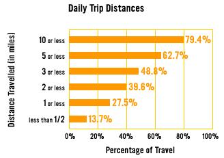
Substituting trips by car with trips by bike or on foot can also generate substantial cost savings for the individual. Walking and bicycling are among the most affordable forms of transportation; according to a 2012 study conducted by the American Automobile Association (AAA), the average cost of owning and operating one car for one year is $8,946, 34 while walking is virtually free and owning and operating a bicycle costs approximately $120 per year. 35 Half of all trips made in the United States are three miles or less, a distance that can be covered on a bicycle within 20 minutes, yet 72 percent of these short trips are currently driven. 36 If even some of these trips were converted to walking or bicycling trips, the change would generate significant cost savings for individuals who make the switch, as well as for society as a whole.
Providing the option of bicycling as an alternative to driving can reduce the volume of car-related emissions, which in turn improves air quality. Trails and greenways reduce air pollution by two significant means: first, they provide enjoyable and safe alternatives to the automobile, which reduces the burning of fossil fuels; second, they protect large areas of plants that create oxygen and filter air pollutants such as ozone, sulfur dioxide, carbon monoxide and airborne particles of heavy metal. Cleaner air reduces the risk and complications of asthma, particularly for children, the elderly, and people with heart conditions or respiratory illnesses. 37 Lower automobile traffic volumes also help to reduce neighborhood noise levels and improve local water quality by reducing automobile-related discharges that are washed into local rivers, streams, and lakes.
Greenways and trails are a key component of any bicycle network and carry environmental benefits as well. Greenways help to preserve wildlife habitats and act as buffers against natural hazards, such as flooding. According to the Federal Emergency Management Agency (FEMA), the implementation of floodplain ordinances is estimated to prevent $1.1 billion in flood damages annually. By restoring developed floodplains to their natural state and protecting them as greenways, many riverside communities are preventing potential flood damages and related costs. 38 Greenways also improve water quality by creating a natural buffer zone that protects streams, rivers and lakes, preventing soil erosion and filtering pollution caused by agricultural and road runoff.
Trails, greenways, and open space can serve as connections to local heritage by preserving
historic places and by providing access to them. They provide a sense of place and an understanding of past events by drawing greater public attention to historic and cultural locations and events. Trails often provide access to historic sites such as battlegrounds, bridges, buildings, and canals that otherwise would be difficult to access or interpret. Each community or region has its own unique history, its own features and destinations, and its own landscapes. By recognizing, honoring, and connecting these features, the combined results serve to enhance cultural awareness and community identity, as well as encourage tourism to the region.
Children in particular can benefit greatly from a safe, well-connected bicycle and trails network in their neighborhoods. In recent years, increased traffic and a lack of pedestrian and bicycle facilities have made it less safe for children to travel to school or to a friend’s house. In 1969, 48 percent of students walked or biked to school, but by 2001, less than 16 percent of students walked or biked to or from school. By reevaluating and improving the regional bicycle and trails network, children in the Croatan region could once again safely bike and walk in their communities. According to the National Center for Safe Routes to School, “walking or biking to school gives children time for physical activity and a sense of responsibility and independence; allows them to enjoy being outside; and provides them with time to socialize with their parents and friends and to get to know their neighborhoods.” 39 Ensuring that children have safe connections to their schools and throughout their neighborhoods can encourage them to spend time outdoors, get the physical activity they need for good health, and offer a higher quality of life.
Bicyclists come in all shapes, sizes, and skill levels. Bicyclist skill level greatly influences expected speeds and behavior, both in separated bikeways and on shared roadways. For the purposes of this plan three different classes of bicyclists were considered when making route recommendations and improvements. The recommendations in this plan are not meant to be a ‘one-size-fits-all’ approach but rather to take into consideration who will be using the route and taking a common sense approach to the different user groups. The design of improvements depends on both the geography and intended purpose of the route (e.g., part of the regional five county ride or a route for visiting the
This interpretive sign tells the story of the Battle of New Bern to trail users. Signs like these help to provide a sense of place and an understanding of local history and community identity.

beach). Chapter 5: Design Guidelines discusses the various types of bicyclists and their unique needs.
1. Garrett-Peltier, H. (2010). Estimating the employment impacts of pedestrian, bicycle, and road infrastructure: Case study: Baltimore. Political Economy Research Institute, University of Massachusetts, Bike League.
2. Grabow, M., Hahn, M., & Whited, M. (2010). Valuing bicycling’s economic and health impacts in Wisconsin. The Nelson Institute for Environmental Studies, Center for Sustainability and the Global Environment, University of Wisconsin-Madison.
3. Venegas, E. (2009). Economic impact of recreational trail use in different regions of Minnesota. University of Minnesota Tourism Center.
4. NCDOT Division of Bicycle and Pedestrian Transportation. (2004). Pathways to Prosperity: The Economic Impact of Investments in Bicycle Facilities.
5. American Planning Association. (2002). How cities use parks for economic development.
6. Campos, Inc. (2009). The Great Allegheny Passage economic impact study. Retrieved from http://www.atatrail.org/docs/GAPeconomicImpactStudy200809.pdf
7. Virginia Department of Conservation. (2004). The Virginia Creeper Trail: An Assessment of User Demographics, Preferences, and Economics.
8. Rails to Trails. (Danzer, 2006). Trails and Tourism.
9. American Planning Association. (2002). How Cities Use Parks for Economic Development.
10. Heritage Rail Trail County Park User Survey and Economic Impact Analysis. (2007).
11. Kelly J. Clifton, Sara Morrissey, and Chloe Ritter, “Business Cycles: Catering to the Bicycling Market,” TR News 280, 2012: 26-32. http://bit.ly/16WKfe3; T Fleming, S Turner, and L Tarjomi, “Reallocation of road space,” NZ Transport Agency research report 530,2013. http://bit. ly/167iGlQ; Clean Air Partnership, “Bike Lanes, On-Street Parking and Business: A Study of Bloor Street in Toronto’s Annex Neighbourhood,” 2009. http://bit.ly/18hToAY
12. National Association of Realtors and National Association of Home Builders. (2002). Consumer’s Survey on Smart Choices for Home Buyers.
13. Bureau of Transportation Statistics. (2010). Transportation Statistics Annual Report. Retrieved from http://www.bts.gov/publications/transportation_statistics_annual_report/2010/
14. National Association of Realtors. (2011). The 2011 Community Preference Survey: What Americans are looking for when deciding where to live. Retrieved from http://www. stablecommunities.org/sites/all/files/library/1608/smartgrowthcommsurveyresults2011.pdf
15. Rails to Trails Conservancy. (2005). Economic benefits of trails and greenways.
16. Karadeniz, D. (2008). The impact of the Little Miami Scenic Trail on single family residential property values. College of Design, Architecture, Art and Planning, University of Cincinnati. Retrieved from http://etd.ohiolink.edu/view.cgi?acc_num=ucin1211479716
17. Kevin J. Krizek, “Two Approaches to Valuing Some of Bicycle Facilities’ Presumed Benefits,” Journal of the American Planning Association 72, 2006: 309-20. http://bit.ly/15ElCCM
18. Lindsey, Greg, Joyce Man, Seth Payton, and Kelly Dickson, “Property Values, Recreation Values, and Urban Greenways,” Journal of Park and Recreation Administration 22, 2004: 69-90. http:// bit.ly/16WHbyI
19. U.S. Department of Health and Human Services. Centers for Disease Control and Prevention. (1996). Physical Activity and Health: A Report of the Surgeon General
20. U.S. Department of Health and Human Services, Centers for Disease Control and Prevention. (2002). Guide to Community Preventive Services.
21. Rails-to-Trails Conservancy. (2006) Health and Wellness Benefits
22. North Carolina State Center for Health Statistics. (2007). Behavioral Risk Factor Surveillance System (BRFSS), Calendar Year 2007 Results, www.schs.state.nc.us/SCHS/brfss/2007/index. html.
23. National Prevention Council. (2011). National Prevention Strategy: America’s plan for better health and wellness. Retrieved from http://www.healthcare.gov/prevention/nphpphc/strategy/ report.pdf
24. Menschik, D., Ahmed, S., Alexander M.H., & Blum, R.W. (2008). Adolescent physical activities as predictors of young adult weight. Archives of Pediatrics & Adolescent Medicine 162: 23-28.
25. Tuxworth, W., Nevill, A.M., White, C., & Jenkins, C. (1986). Health, fitness, physical activity, and morbidity of middle aged male factory workers. British Journal of Industrial Medicine 43: 733-753.
26. Paffenbarger, R.S., Hyde, R., Wing, A.L., Hsieh, C. (1986). Physical activity, all-cause mortality, and longevity of college alumni. New England Journal of Medicine 314(10): 605-613.
27. Centers for Disease Control and Prevention. Physical Activity for Everyone: Guidelines: Adults. http://www.cdc.gov/physicalactivity/everyone/guidelines/adults.html
28. Be Active North Carolina Report: The Economic Cost of Unhealthy Lifestyles in North Carolina. (2005). Retrieved from www.beactivenc.org/mediacenter/Summary percent20Report. pdf
29. Gotschi, Thomas (2011). “Costs and Benefits of Bicycling Investments in Portland, Oregon.” Journal of Physical Activity and Health, 8 (Suppl 1), S49-S58.
30. Litman, T. (2004). Quantifying the benefits of nonmotorized transportation for achieving mobility management objectives. Victoria Transport Policy Institute. Retrieved from http://www. vtpi.org/nmt-tdm.pdf
31. Garrett-Peltier, H. (2010). Estimating the employment impacts of pedestrian, bicycle, and road infrastructure: Case study: Baltimore. Political Economy Research Institute, University of Massachusetts, Bike League. www.bikeleague.org/resources/reports/pdfs/baltimore_Dec20.pdf
32. Campbell, R., & Wittgens, M. (2004). The business case for active transportation: The economic benefits of walking and cycling. B.E.S.T. Better Environmentally Sound Transportation. Retrieved from http://thirdwavecycling.com/pdfs/at_business_case.pdf
33. Gotschi, T. & Mills, K. (2008). Active transportation for America: The case for increased federal investment in bicycling and walking. Rails to Trails Conservancy http://www.railstotrails.org/atfa.
34. American Automobile Association. (2012). Your Driving Costs: 2012 Edition.
35. League of American Bicyclists. http://www.bikeleague.org/
36. U.S. Department of Transportation and Federal Highway Administration. (2009). National Household Travel Survey.
37. Health Effects Institute (2010). Traffic-Related Air Pollution: A Critical Review of the Literature on Emissions, Exposure, and Health Effects. Special Report 17.
38. Federal Emergency Management Agency. (2005) Building Stronger: State and Local Mitigation Planning.
39. National Center for Safe Routes to School. (2006). National Center for Safe Routes to School Talking Points.
Croatan Regional Transportation Network (2-1)
Transportation Planning Agencies (2-2)
Existing Plans (2-3)
NCDOT Regional Bicycle Plans (2-6)
NCDOT Statewide Bicycle Routes (2-7)
Existing Trails and Current Trail Planning (2-9)
Land Use and Demographic Patterns (2-10)
Bicycle Crash Data and Safety Considerations (2-12)
Environmental and Cultural Resources 2-14 Tourism (2-15)
The study area for the Croatan Regional Bicycle and Trails Plan encompasses five counties (Carteret, Craven, Jones, Onslow and Pamlico). The area contains a wide range of transportation facilities from limited access highways to two-lane rural roads, a ferry route and off-road multi-use trails. The area also contains a multitude of environmental challenges because of low lying areas and the many bridges over rivers and creeks that are commonly found in coastal counties.
The Strategic Highway Corridor (SHC) initiative was developed by the NCDOT and partner state agencies to provide a network of high-speed, safe, reliable highways throughout the state. There are three designated Strategic Highway Corridors in the study region: NC 24, US 17, and US 70. It is important to note the SHC’s relationship to bicycle transportation so that bicycle and trail facilities recommended in this plan will be included in the design of future upgrades to each of these corridors, including proposed by-passes and new location projects, This is especially important for US 70 between New Bern and Havelock, where the ultimate regional route is to be located. In cases where these highways are fully controlled access facilities, parallel alternate locations will be necessary. More information and maps of the SHC Initiative can be found at the following web address: www.ncdot.gov/doh/preconstruct/tpb/SHC
There are a number of other major NC roads within the study area that are recommended as part of the regional bicycle route as well as secondary routes that will make up smaller offshoots of the regional route. Major roads which are included in the regional route are NC 58 in Carteret and Jones counties, NC 101 in Craven and Carteret counties, NC 12 in Carteret county, and NC 306 in Pamlico and Craven counties. It is anticipated that these major roads will see an increase in average daily traffic as future development occurs; therefore, the recommendations in this plan are intended to provide a safer road environment for bicyclists.
Portions of the regional bicycle route and many of the secondary routes are located either on local roads maintained by some of the municipalities in the area or are state roadways that have both a State Road number and a common name. These roads commonly have lower traffic volumes than the other major roads in the study area and therefore have a higher level of comfort for on-road bicycling. However, many local roads are conducive to having a bicycle lane or a sidepath if they are located within subdivisions or residential developments.
Transportation planning in the study area is conducted by a number of local, regional, and statewide departments and agencies. Explained below are the roles and responsibilities of the various transportation planning entities in the study area.
Individual municipalities and counties can conduct transportation planning activities within their planning jurisdictions (i.e., corporate limits and, for applicable municipalities, their extraterritorial jurisdictions or “ETJs”). These activities include reviewing site plans, developing local bicycle and pedestrian plans, implementing projects, and writing grant applications. Each of the participating municipalities and counties included in the study area conduct some or all of these activities. Their respective plans were referenced as a part of the plan development process for the bicycle and trails network. The municipalities and counties were asked to endorse the concept of the plan at the beginning of the planning process.


Every county and municipality in North Carolina is represented by either a Rural Planning Organization (RPO) or a Metropolitan Planning Organization (MPO). These two types of transportation planning organizations work with NCDOT to conduct a wide range of transportation planning activities, including the compiling of demographic, environmental, and transportation data; writing grant applications; identifying, ranking, and reviewing projects; and collecting and coordinating general public input.
Communities within the study area are members of either the Down East RPO (DERPO), the Jacksonville Urban MPO (JUMPO) or the newly formed New Bern MPO (NBMPO). MPOs and RPOs have different levels of responsibilities for the various transportation planning activities within their jurisdictions. The MPO maintains and updates a Comprehensive Transportation Plan (CTP) for its entire study area, and develops a Long Range Transportation Plan (LRTP). The LRTP includes those projects the MPO identifies as being “financially-feasible” in the next 25 years.
RPOs do not maintain a CTP for their entire study area. Individual municipalities and counties approve their own CTPs, although RPOs do review them for consistency with adjacent plans. RPOs do not develop LRTPs. They are responsible for developing project priority lists for the biannual Statewide Transportation Improvement Program (STIP) update. These lists are included in the evaluation of candidate projects for funding in the next several years.

NCDOT has a Transportation Planning Branch that provides multi-modal transportation planning services to municipalities, counties, regions, MPOs and RPOs. The Branch includes two Transportation Planning Units. These provide multi-modal Comprehensive Transportation Planning, travel demand modeling, and development assistance to local governments, MPOs, and RPOs. They also perform traffic forecasts for Transportation Improvement Program (TIP) projects and air quality conformity analysis to comply with the Clean Air Act and EPA requirements.
The Division of Bicycle and Pedestrian Transportation (DBPT) of NCDOT is a comprehensive operation, and affects all aspects of bicycling and pedestrian planning in North Carolina. The DBPT is involved in designing facilities, creating safety programs, mapping cross-state bicycle routes, training teachers, sponsoring workshops and conferences, fostering multi-modal planning and integrating bicycling and walking into the ongoing activities of NCDOT. The DBPT also annually awards bicycle and pedestrian planning grants to municipalities and counties throughout the state to increase the planning and implementation of such facilities.
NCDOT is organized into 14 local divisions across the state that are responsible for maintenance, operations, design, and construction activities for all transportation modes within their boundaries. The Divisions and their staff play an integral role in implementing the Route. The Croatan Regional Bicycle Plan Study Area includes portions of two Divisions. Division 2, based in Greenville, includes Carteret, Craven, Jones and Pamlico counties. Division 3, based in Wilmington, includes Onslow County.
Many communities within the study area have existing transportation and land use plans that either specifically deal with bicycle and trail infrastructure or contain an element that makes bicycle and trail recommendations. These plans were collected and reviewed as a part of the planning process to ensure consistency between local plans and the recommendations of this plan.
The Atlantic Beach Comprehensive Bicycle Plan is the newest of the municipal plans in the study area, adopted in 2012. It was funded in part by a grant from the NCDOT Division of Bicycle and Pedestrian Transportation. Atlantic Beach’s vision is to create a safe and convenient bike network throughout Town that accommodates users of varying ages and abilities. In keeping with that vision, the plan contains a number of safety recommendations, design guidelines, policies and program suggestions, and recommended projects (including signage, repaving and resurfacing, and infrastructure improvements). The recommendations of the Atlantic Beach plan were taken into
account during the development of this plan, such as the connection to Fort Macon and muti-use path for a portion of the regional bicycle route.
The Town of Beaufort Comprehensive Bicycle Plan was adopted by the town in 2009. It was funded in part by a grant from the NCDOT Division of Bicycle and Pedestrian Transportation. Beaufort’s vision is similar to that of Atlantic Beach: to develop a bike-friendly environment that accommodates all ages and abilities. In order to fulfill the vision, the following goals are set forth in the plan: education and awareness, enforcement, bicycle-friendly construction, promote connectivity, and adopt bicyclefriendly policies. The Beaufort Plan includes a number of recommended improvement projects that will support the vision of a more bicycle friendly community. A number of these recommendations have been implemented, including sharrows on local streets and an increase in public bike racks. The Beaufort plan recommended signage and multi-use trails in the area where the regional bicycle route will take riders.
The Town of Emerald Isle Bicycle and Pedestrian Transportation Plan was adopted by the town in February 2010. Unlike the previous two plans, the Emerald Isle Plan was not funded by NCDOT and was completed entirely by the town rather than an outside consultant. Emerald Isle currently has an existing multi-use trail on both Highway 58 and Coast Guard Road that have been very well received by residents and visitors. The goal of the plan is to have a mixture of shared roadways, paved shoulders, multiuse trails, and sidewalks to serve all areas of the town. While the town already has a significant bicycle and pedestrian network in place, their plan calls for expanding it by adding amenities such as bike racks, benches, landscaping, and trash cans, which will also benefit riders on the regional bicycle route.
In 2012 the city of Havelock approved a comprehensive transportation and land use plan that contained a number of bicycle improvement recommendations. The bicycle map included in the plan recommends three separate types of bicycle improvements in and around the city: a signed bike route, on-road improvements (e.g. wide shoulders), and off-road improvements (e.g. multi-use trails). The recommendations would create a network of bicycle infrastructure throughout the town on either side of Highway 70 connecting different destinations and communities. While the regional route does not traverse through Havelock, a number of secondary improvements are recommended as a result of suggestions from the Havelock Plan.
The Jacksonville Bicycle and Pedestrian Transportation Plan was completed in June 2008 by the Jacksonville Urban Area Metropolitan Planning Organization (JUMPO). The plan represents a comprehensive evaluation and program of action for addressing the immediate and long-term needs for bicycle and pedestrian facilities. There are several primary goals for the plan: provide connectivity to destinations, improve intersection crossing safety to pedestrians and bicyclists, ensure that bicycle and pedestrian facilities are considered part of the overall transportation system, integrate bicycling and walking
design into neighborhood design, enhance community commitment to programming, and integrate stronger bicycle and pedestrian policies into local ordinances. The plan contains extensive recommendations for bicycle and pedestrian facilities, as well as program and policy recommendations, design guidelines, and implementation strategies. Similar to Havelock, the regional bicycle route does not go through Jacksonville. However, a number of secondary improvements are recommended based on the Jacksonville plan, such as a series of connecting multi-use trails.
The purpose of the Morehead City Comprehensive Bicycle Plan is to increase bicycling trips, improve bicycle access and transportation options, assess current conditions, initiatives, and opportunities in the area, and understand and meet the needs of the public. To do this, the plan looked at bicycling trip characteristics, transportation priorities, safety considerations, barriers to bicycling, and the needs of special populations. The plan identifies long- and short-range project and program priorities by integrating with other planning initiatives, implementing existing local, state, and federal policies and guidelines, identifying high-priority transportation improvement projects, and integrating with other transportation modes. The plan provides standards and guidelines for the development of bicycle facilities and outlines strategies for raising community awareness of bicycle needs and issues. In addition, the comprehensive bicycle plan includes an implementation plan that identifies tasks and involves agencies, elected officials, advocacy groups, and public/private partnerships. It includes implementation strategies, including recommendations for projects, policies, funding, staffing/committees, local ordinances, and program initiatives. Recommendations from the Morehead City Bicycle Plan include improvement of the signage downtown and a multi-use trail on Radio Island.
The City of New Bern Comprehensive Bicycle Plan, similar to the Atlantic Beach and Beaufort plans, was funded in part by a grant from the NCDOT Division of Bicycle and Pedestrian Transportation. It is the goal of the New Bern plan to chart the future of bicycling in New Bern boldly through specific projects and programs, while committing resources wisely. The Comprehensive Bicycle Plan includes establishing connections with Trent Woods, James City, and Bridgeton, updating local ordinances to accommodate bicycles, promoting bicycle awareness, and involving partners such as the NCDOT and the New Bern Police Department to promote education and safety programs in New Bern. The Plan seeks to improve upon the existing bicycle network by proposing a recommended set of routes and facility types and establishing priorities and cost estimates for each. In addition, a barrier analysis was conducted for a set of 16 barriers consisting of bridges, major intersections, railroad crossings, and focus areas. The routes that were recommended in the New Bern plan are reflected in this plan.
Adopted in 2011, the Oriental Bike Plan is a short document that outlines the importance of developing bicycle infrastructure for the town in order to enhance safety, promote tourism, encourage alternative forms of transportation, and enhance public health. The plan focuses on connectivity through town and also longer routes that would create
loops that would begin and end in Oriental. Many of these routes have been included in this plan. The Oriental Bike Plan includes numerous action items to accomplish its goals, and many items could be done in coordination with the implementation of the Croatan Regional Bicycle and Trails Plan.
In 2010, the Pamlico County Comprehensive Transportation Plan (CTP) was adopted by the NCDOT Board of Transportation. As a part of the CTP, the county developed a bicycle element that recommended improvement of various regional and subregional roads to improve bicycle connectivity between different towns in the county. There are currently two state bike routes that pass through Pamlico County; these and other recommendations of the CTP are included in this plan.
In 2010, the Town of Swansboro was awarded a matching grant from the North Carolina Department of Transportation (NCDOT) Bicycle and Pedestrian Planning Grant Initiative. The plan will guide the Town of Swansboro, NCDOT, and other key stakeholders in creating a community network of bicycle trails, connecting the historic district with parks, schools, and residents. This contiguous network of bicycle trails will not only help promote Swansboro as a destination for bicycling and recreation, but will also serve local residents. Kids will have safe routes to school, and bicycling will be a viable alternative to driving for everyday trips around town. Many of the recommendations from the Swansboro plan are included in this plan.
The initial historic coastal route of the East Coast Greenway (ECG) was used as a starting point for the creation of a new route that would include a portion of the Croatan Regional Bicycle Route. There are two proposed routes for the ECG: the spine route and the alternative route. The spine route passes through Durham, Raleigh, Fayetteville, and Wilmington, while the alternative route (also known as the historic coastal route) passes through the Albemarle region, through Greenville to New Bern, down to Jacksonville, and then connects with the spine route in Wilmington.
Since 2009, the NCDOT Division of Bicycle and Pedestrian Transportation has been working to create a series of bicycle plans to connect destinations that exist within various regions throughout the state. The regional bike plans typically encompass multiple counties and municipalities and involve many different stakeholder groups and transportation agencies. The first regional bike plan was created for the Lake Norman region of the state and included four counties and four municipalities which surround Lake Norman north of Charlotte. The Croatan Regional Bike Plan is the second regional planning effort undertaken in the state. Along with the Croatan plan there are multiple other regional plans underway including a plan for the Outer Banks region and a plan for the Asheville area.


Working with local cyclists, the NCDOT DBPT has created a series of touring routes covering different portions of the state. The DBPT has also worked with localities to develop maps of county and regional bicycle route systems. To highlight the unlimited cycling opportunities that North Carolina offers, the DBPT designated a cross-state system of Bicycling Highways. These routes generally parallel the major highways along which cyclists often wish to travel, but offer a more lightly traveled alternative than the busy, major roads that are familiar to most people. Nine different routes covering 3,000 miles of the best North Carolina has to offer comprise the current system. For more information see http://www.ncdot.gov/travel/mappubs/bikemaps/. The following regional and local state designated bike routes are within the Croatan Regional Bicycle and Trails Plan study area.
North Carolina's coast is long and varied, with two major sounds, the Pamlico and the Albemarle Sounds, and a series of barrier islands known as the Outer Banks. The 300-mile route from South Carolina to Virginia takes you to all the major ports of the colonial era: Southport, Wilmington, New Bern, Bath, and Edenton. Take the time to relax on the wide, sandy beaches, explore the charming historic towns, and enjoy the excellent seafood. Other points of interest along this route include Fort Fisher State Historic Site, Carolina Beach State Park, the Croatan National Forest Recreation Areas, Tryon Palace, Goose Creek State Park and Merchants Millpond State Park.
From its western terminus along the Mountains to Sea Route near Wilson, this 170-mile route winds its way through the coastal plain to the Cedar Island Ferry over to Ocracoke. Along the way, points of interest such as Cliffs of the Neuse State Park, the New Bern and Beaufort historic districts, and the Cedar Island Wildlife Refuge provide a glimpse of the natural and cultural diversity of the state.
This route highlights two-to five-day trip options of 150-250 miles through the north and central coastal region, one of the most popular bicycling destinations on the East Coast. The map also shows connections with four of the cross-state Bicycling Highways routes, the Mountains to Sea, Ports of Call, North Line Trace and Ocracoke Option.

This six-mile signed bike route connects the waterfront, historic district, neighborhoods, and schools.


Starting and ending in historic Swansboro, the 25-mile signed route winds through the Croatan National Forest and White Oak River area.
Statewide bicycling routes are onstreet routes (examples above and at right) that take advantage of a combination of bicycle facilities and rural roads with low traffic volumes.

Clockwise from left: The Neusiok Trail, a Croatan National Forest foot path sign, and Cedar Point Tideland Trail.


There are several existing trails in the region, including long segments, such as the Neusiok Trail, and shorter segments, such as those found in municipalities. Other trails are still in the planning stages, and some have portions that are ‘on-road’ as interim routes (i.e., paved shoulders and/or sidewalks). Map 2.1 at the end of this chapter shows these existing and planned trails and includes the East Coast Greenway route as it stood at the outset of this planning process (labeled “Pre-2011 ECG Route”) and the Mountains-to-Sea Trail as approved by the Secretary of the Department of Environment and Natural Resources in the 2006 MST East Plan (labeled as “Approved MST Route”).
The Mountains-to-Sea Trail (MST) is a long-distance trail for hiking and backpacking that extends across North Carolina from the Great Smoky Mountains to the Outer Banks. The trail’s western terminus is at Clingman’s Dome, where it connects to the Appalachian Trail in the Great Smoky Mountains National Park. Its eastern terminus is in Jockey’s Ridge State Park on the tallest sand dune on the east coast. The trail is envisioned as a scenic backbone of an interconnected trail system spanning the state. As such, the trail’s route attempts to connect as many trail systems and natural scenic areas as practicable. A little over half of the trail is complete in multiple, disconnected segments across the state. In the Croatan region, the main existing portion of the MST is the Neusiok Trail.
The Neusiok Trail is located in the easternmost section of the Croatan National Forest. The northern trailhead is located at Pine Cliffs Recreation Area (on the Neuse River) and the southern trailhead is located at Oyster Point Campground (on the Newport River). In its approximately 21-mile course, the Neusiok Trail traverses pine savannahs, blackwater swamps, and the sandy beaches along the Neuse River. This is the longest portion of existing trail in the study area. This plan aims to connect new trails to the Neusiok Trail as a way of building off of existing resources.

The East Coast Greenway is a developing trail system spanning nearly 3,000 miles as it winds its way between Canada and Key West, linking all the major cities of the eastern seaboard. Over 25 percent of the route is already on safe, traffic-free paths.
The Croatan National Forest has a network of roadways that are open to use for bicycling and walking, as well as many existing forest roads and trails that are closed to motor vehicles. Designated trails in the forest are less frequent, including the following:
• Island Creek Forest Walk, 0.5 mile
• Weetock Trail (near Haywood Landing), 11 miles
• Cedar Point Tideland Trail, 1.9 miles
• Patsy Pond Nature Trail, 3.7 miles
• The Neusiok Trail, 21 miles
• Black Swamp Trail, 8 miles for off road vehicles and bicycles
This low-impact 1/2-mile trail is open to the public and is located off Highway 58 in Atlantic Beach next to the Atlantic Station Shopping Center. The trail is on a property permanently protected by the NC Coastal Federation, featuring 31 acres of maritime forest that serve as a refuge for fish, wildlife, and plant communities in diverse coastal habitats.
Land use and transportation patterns influence bicycle facility and trail development in many important ways. Locations of residential and commercial development serve as ‘hubs’ for the regional network, as they generate trips and serve as trip destinations. Agricultural and silvicultural land uses can serve as either opportunities or constraints, depending on the specific site. Transportation systems influence the ability of potential users to connect to the bicycle and trails system using multiple modes, such as walking or bicycling. The following sections review the general nature of these patterns in the Croatan region and how they could impact bicycle and trail planning and design.
Map 2.2 at the end of this chapter features developed areas in shades of red and pink, with the red areas representing higher intensity development and the pink areas as lower intensity development. Not surprisingly, most development in the region is centered around the municipalities, in particular Jacksonville, New Bern, Havelock/Cherry Point, Morehead City, Beaufort, and the towns along NC Highway 24 and the coast. This plan seeks to connect these populated areas and destinations with one another, ideally utilizing existing and planned municipal trail systems as ways to connect with these communities. Map 2.1 at the end of this chapter shows existing and proposed multi-use trails from municipal plans in solid red and solid orange lines, respectively.
Some farm sites are far more compatible with trails than others, depending on how their operations might affect potential trail users. For example, the application of pesticides and herbicides and the movement of trucks and on-site machinery can complicate trail routing. The Open Grounds Farm is one example in the study area which may be less compatible due to large-scale agricultural operations. Still, on large sites where such operations occur, careful and creative trail routing and design can navigate trail users safely.
Other agricultural sites have much greater potential compatibility with trails. For example, conservation farms share the goals of environmental stewardship and education with trail and greenway projects. Also, trails bring additional visitors on-site for education, boosting visibility and awareness of local conservation efforts. Again, careful trail planning and design can ensure that trail users do not disrupt the original use of the site, even if that use and purpose is conservation.
The U.S. Marine Corps has a strong presence in the region, in terms of the local population, employment, and land use. Trails and bicycle facilities in the region should provide connectivity and access for use by local military personnel. One of the greatest potential trail connections for the region is a rail-with-trail project that could connect Camp Lejeune with the Marine Corps Air Station at Cherry Point (Jacksonville to Havelock). This would require approval and cooperation from local Marine Corps leadership, as well as a feasibility study to determine trail routing and alignment through floodplain and wetland areas, and adjacent properties.
The study area of this plan includes parts of five counties, numerous municipalities, and approximately 2,800 square miles (not including water areas). The total population of the five county region in 2010 was 371,037. While the entire region is not included within the study area, using the entire population is appropriate for the purposes of population analysis because the plan is meant to impact areas outside the study area but within the region. From 2000 to 2010, the region has grown at an average rate of 14.3 percent, with the fastest growth in Onslow county and the slowest in Jones county, which lost 2.2 percent population. The table below shows the population change by county and for the entire region.
Carteret
According to the North Carolina Department of Commerce, there were 110,570 jobs in the five county region in 2011. Employment statistics vary across the region, with the majority of jobs located in Carteret, Craven, and Onslow counties. In these counties the largest sector of employment is in retail trade. A large number of people are employed in the accommodation and food services sector as well as health care and social assistance.
Carteret
Craven
Jones
Onslow
Pamlico
Total
The Croatan Regional Bicycle and Trails Plan study area includes rural, suburban, and urban development patterns. These development patterns are served by a variety of road types, from multi-lane, grade-separated interstates and U.S. routes to narrow, winding secondary roads. The plan and recommended routes interface with all of the types of transportation facilities found in the study area. Each of these facility types has its own vehicular and bicyclist characteristics, so understanding the crash statistics and trends for each is useful.
The NCDOT receives a copy of all reported traffic accidents in the state and codes these accidents into a database for crash analysis on intersections and roads. The NCDOT Traffic Safety Unit uses a Traffic Engineering Accident Analysis System (TEAAS) to analyze all types of accidents and roads. The NCDOT Division of Bicycle and Pedestrian Transportation utilize a customized bicycle and pedestrian crash analysis software called the Pedestrian and Bicycle Crash Analysis Tool (PBCAT). The PBCAT is intended to assist state and local pedestrian/bicycle coordinators, planners, and engineers with improving walking and bicycling safety. It uses the development and analysis of a database containing details associated with crashes between motor vehicles and pedestrians or bicyclists. The web-based Crash Data Tool was designed and developed by the University of North Carolina Highway Safety Research Center (HSRC) for the NCDOT DBPT. The tool represents a growing need for information about bicycle- and pedestrian-motor vehicle crashes in North Carolina. The tool can be accessed at: http://www.pedbikeinfo.org/pbcat/ index.cfm. The crash map found at the end of this chapter was created using information extracted from the PBCAT database.
There
10,402
severity of the crash varies,
of the total crashes, 6,952
reported in North Carolina from January 2000
ambulance to the scene. The table below indicates the
of bicyclist injuries per year.
incident (1,389 or
crashes involved excessive speed (73 crashes). The majority
streets (6,290 crashes); however, it is not possible to
crashes occur on local streets primarily because of street design issues,
crashes occur on local streets because that is where the majority of bicyclists
riding.
Between 2000 and 2010 there were 472 bicycle-automobile crashes within the study area (Carteret, Craven, Jones, Onslow, and Pamlico Counties). The majority of these occurred within Onslow County (and the majority of those within the City of Jacksonville). A number of fatalities occurred along the NC 24, NC 53, and US 70 roadway corridors. Other roadway corridors with large number of crashes include NC 101, US 17 and NC 58. The table below shows the breakdown of total bicyclist injuries by county. The map at the end of the chapter shows the approximate location of the crashes. The percentage of hit and run crashes was similar to that of the state statistic: 56 reported cases (12 percent of the total), while excessive speed was only reported in 5 of the cases. The most likely type of crash in the study area was that of a motorist overtaking a bicyclist, which accounted for 95 of the crash types (20 percent). Refer to Map 2-3 Bicycle Crashes Jan. 2000 - Dec. 2010 at the end of this chapter.
Unknown
NCDOT-DBPT
The Natural Heritage Program, managed by the Division of Parks and Recreation within the North Carolina Department of Environment and Natural Resources, was created in order to help protect significant ecological resources throughout the state. The digital database of Significant Natural Heritage Areas generated by the program is the most comprehensive resource available describing the location of endangered animals and plants and exemplary natural communities. This database is intended for use in planning exercises so that disturbance of important ecological features may be prevented. Natural Heritage Areas located within the Croatan region with ‘medium’, ‘high’, or ‘very high’ accuracy are shown on Map 2.4 at the end of this chapter, along with many cultural and historic resources that are clustered in urban areas. These cultural and historic sites should be incorporated into future wayfinding efforts for regional bicycle routes and trails as a way of boosting tourism and providing a unique character to the trail system. Also, Map 2.2 at the end of this chapter shows forested areas, shrubs, and wetlands, all of which support a diverse range of plant and animal species.
Tourism is an important economic resource for North Carolina and for the Croatan Region in particular. Tourists attracted to the region spend money locally on lodging, food, entertainment, shopping, and other goods and services that benefit local economies. The economic impact of such expenditures is large and varied, benefitting businesses, workers, and local governments. Because of this favorable economic impact, competition for tourist dollars is strong. Tourists are drawn to visit an area by specific attractions, such as beaches, but also by a complex mix of activities and destinations that offer a variety of things to see and do. The richer the mix, the stronger the draw. For bicycling to be a significant ingredient in the mix, an area must be considered “bicycle friendly.” This means, among other things, providing special bicycle facilities such as bicycle paths, bicycle lanes or wide paved shoulders, and other amenities that make the overall cycling experience convenient, pleasurable, and safe.
Each county in the study area has either an economic development commission or a tourism board that focuses on developing tourism and bringing tourists to the area. The agencies in the study area include:
• The Crystal Coast Tourism Authority (Carteret County)
• Craven County Tourism Development Authority
• Jones County Economic Development Commission
• Onslow County Tourism
• Pamlico County Chamber of Commerce
These groups have been identified as important local partners for identifying, implementing, and marketing bicycle tourism opportunities in the Croatan Region.
Many area bicyclists have formed or joined both organized and informal bicycle groups to participate in group rides. The study area is home to several bicycle clubs that organize rides throughout the region as well as advocate for safety and awareness. The Croatan Regional Bicycle Working Group and Regional Trails Working Group should coordinate with these important bicycling community assets to ensure that education, outreach, and the implementation of this plan can occur.
Another important resource available within the study area (and some that are outside of the area but promote cycling in the Croatan region) are bicycle sales and repair shops. In addition to being a source for new gear and repair services, these shops are great places to ask questions, find out about local rides, and get valuable information on safe and fun places to cycle.
The final resource for learning about routes are the annual cycling events that are held in various locations within the study area. These events bring hundreds (and sometimes thousands) of cyclists from around the country and showcase the region as the great cycling destination that it is. Not only do these events expose the participants and volunteers to the natural beauty of the area, but they also provide a huge economic boost to the region. See the section titled “Why This Plan is Important to the Croatan Region” in Chapter 1 for more details on how bicycle tourism benefits local economies and the region as a whole.
• Down East Cyclists (Jacksonville)
• New Bern Century Cyclists
• Coastal Carolina Velo Race Club (New Bern)
• East Carolina Velo Club / Fat Tire Society (Greenville)
• Oriental Express Bicycle Club
• Big Wheel Cycling Club (Kinston)
• Crystal Coast Bicycle (Atlantic Beach)
• Bikes-R-In (Cape Carteret)
• Hwy 58 Bicycles at Emerald Isle

• The Bicycle Post (Greenville)
• Bike Depot (Havelock)
• The Bicycle Shop (Jacksonville)
• Eastern United Tire (Kinston)
• Atomic Cycles (New Bern)
• Flythe’s Bike (New Bern)
• MS Bike Ride (New Bern)
• The North Carolina Coastal Federation Ride (Carteret County)
• The North Carolina Land Trust
• The Wounded Warriors Ride (Carteret County)
• Cycle North Carolina (Oriental)


Overview (3-1)
Bicycle Route Identification Process (3-1)
Trail Route Identification Process (3-4) Public Involvement (3-6)
In order to determine which routes in the Croatan Region are most suitable for bicycle facilities and trails, the project team developed a methodology to apply to roads and trail corridors that evaluated each route’s characteristics against other potential routes. The results of this analysis were combined with the extensive public input that was received throughout the planning process in order to develop a series of bicycle and trail recommendations for the region (see Chapter 4). This chapter describes the methodologies employed, including the bicycle route identification process, trail route identification process, and public involvement strategies, to develop and prioritize recommendations for this plan.
Overall, the decision to select one road over another for a bicycle route should be based on the advisability of encouraging bicycle use on that particular road. While the roads chosen for bike routes may not be completely free of problems, they should offer the best balance of safety and convenience of the available alternatives. In general, the most important considerations fall into three main categories: (1) geometrics, (2) traffic conditions, and (3) appropriateness for the intended purpose.
The most important geometric considerations include roadway width, pavement quality, intersections, and curves. To some extent, low motor vehicle traffic volumes can compensate for less desirable roadway conditions.
• Roadway width: On lower speed roadways, widened curb lanes are beneficial for bicyclists. On high speed roads, smoothly paved shoulders are desirable. If a route is generally suitable but includes a short stretch of narrow road, consideration should be given to use of the “Share the Road” warning sign on that segment.

• Pavement quality: Smooth roads are far preferable to roughly paved ones. Perhaps more than any other geometric consideration, pavement quality will determine how popular a bicycle route will be.
• Intersections: Intersections should be relatively simple and should include few complex features, like multiple turn lanes. Points where bicyclists will be expected to turn left should be carefully evaluated for their safety. Traffic lights should be responsive to bicycle traffic. And the presence of high numbers of stop signs on the route will discourage bicycle users.
• Curves: While curved stretches of roadway provide variety, a road with serious sight distance problems and many no-passing zones may not be an appropriate bicycle route.
Traffic conditions that affect the desirability of a potential bicycle route include traffic volume, traffic speed and percentage of truck and RV traffic.
• Traffic volume: In general, the route with the least motor vehicle traffic will be the one many bicyclists will prefer. Experienced bicyclists, who have learned to cope with traffic, will be least concerned with this variable; for new bicyclists, however, it will be the overriding concern.
• Traffic speed: For experienced riders, high speed traffic offers few concerns. However, most bicyclists fear high traffic speeds.
• Percentage of truck and RV traffic: On high speed routes, the percentage of truck and RV traffic is a particular concern due to the buffeting that bicyclists experience when passed by heavy vehicles. When combined with narrow road conditions, a significant percentage of heavy vehicle traffic will make a route undesirable.
Factors used to determine how appropriate a particular road is for a bicycle route include directness, scenery and available services.
• Directness: For utilitarian riders, directness is important, and a route that wanders too much will see little use. For recreational riders, this factor is not as important.
• Scenery: For utilitarian riders, scenery is relatively unimportant. For recreational bicyclists, on the other hand, varied and attractive scenery is one of the most important factors.
• Services: Recreational riders, particularly those riding more than a few miles, will be particularly interested in services (food, water, and restrooms). A route without such services will be less desirable than one with occasional stopping places.
As described in the previous chapter, numerous bicycle-oriented transportation plans already exist in the study area for many of the municipalities and counties. In developing the Croatan Regional Bicycle Route and the secondary routes it was important to follow
the recommendations of these local plans so that there is not a conflict between what a locally adopted plan recommends and the recommendations in this plan. Additionally not all local recommendations were included in this plan because they may have been too specialized to consider at the regional level. The main concern was consistency between plans so that adoption of regional plan did not supersede, but rather support and complement the local plan.
Whenever possible, existing state bike routes were incorporated into the Croatan Regional bike route in order to take advantage of established and approved NCDOT regional and local routes. Using existing bike routes is important for two reasons: they are familiar to riders within the region and have been previously approved and signed by the NCDOT so they are likely to have improvements associated with them that will make bicycling safer.

The study area region has a plethora of interesting and useful destinations for the bicyclist. In creating the regional route various types of destinations were marked on a map and considered based on their importance and regional interest. Some of the destinations considered in developing both the regional route and also the small secondary routes were: places where cyclists could get water, food and information; regionally important attractions such as the State Aquarium at Pine Knoll Shores, Tryon Palace in New Bern, and Fort Macon in Atlantic Beach; and places where lodging is available.
The different routes in this plan were selected based on who the target rider was most likely to be using a particular section of the routes. Unlike other bike routes, it was not possible to designate and design the regional route for all types of bicycle riders (see Types of Bicyclists in Chapter 1 and 5). Because of geographic, environmental, and high
traffic volumes it was not possible to create all bike routes for the intermediate or novice bicyclist, which would most likely consist of off-road multi-use trails. Advanced cyclists prefer to use the roadways because of their speed and tendency to go long distances while the other types of cyclists are more prone to require separated facilities or local roads with low traffic volumes and clear directional signage.

As mentioned in the previous chapter on existing conditions, there are numerous bicycle events that occur within the study area throughout the year. These events have carefully chosen routes that allow the participants to rides safely and provide for multiple distances based on the riders’ level of expertise and condition. These routes were important to consider because one of the goals of the regional route was to promote bicycle tourism and by overlapping with other event routes this plan can be promoted as such.
Another important factor in the designation of the regional and secondary routes within the CRBP was to link them up with existing and proposed routes of the East Coast Greenway (ECG) and the Mountains to Sea Trail (MST). This plan makes recommendations for new adjustments to the original recommended routes for both of these trails.


Project consultants gathered information for this analysis during an on-the-ground tour of the region over a three day period in spring 2011. Based on the information gathered during fieldwork, from previous plans, and from local communities and the public, the consultants conducted a detailed review of key opportunities and constraints for trail development in the Croatan Region. The key findings of the trail route identification process can be found on the following page. Factors listed do not represent an exhaustive list; they are a set of highlights to guide decision making for trail routing. Examples of opportunities include existing trails, potential attractions for trail users, or bridge crossings that could accommodate trail users. Examples of constraints include barriers to trail connectivity, such as waterways, major highways, or railroad corridors.
Above: BIkers in New Bern, NC
Above: Project consultants conducted a three-day field analysis, including roadway measurements for potential key connections and GPS points for mapping key locations.
The main findings of the trail route identification process include:
1. The MST route as approved in the 2006 MST East Plan needs to be re-routed in order to take into account: A) the challenges presented by the future Havelock Bypass; B) the need to connect to the Neusiok Trail; and C) the challenges of routing through Open Grounds Farm.
2. The ECG route needs to connect to communities with interim on-road routes, but it should be out of the roadway corridor in the long term.
3. The ability to connect trail users across existing and future bridges plays an important role in determining trail route feasibility. Examples include bridges across NC Highway 101, US Highway 70, and NC Highway 24.
4. The U.S. Forest Service should be further consulted to determine signage of trail routing on and along Forest Service roads and resolve environmental, right-of-way, and maintenance responsibilities.
5. Due to the fragmented nature of the Croatan Forest boundary (e.g., near Havelock), trail routing would require input and approval from nearby landowners, especially from the silviculture operations by Weyerhaeuser. Respect for current land uses, such as game lands, will need to be taken into account as well.
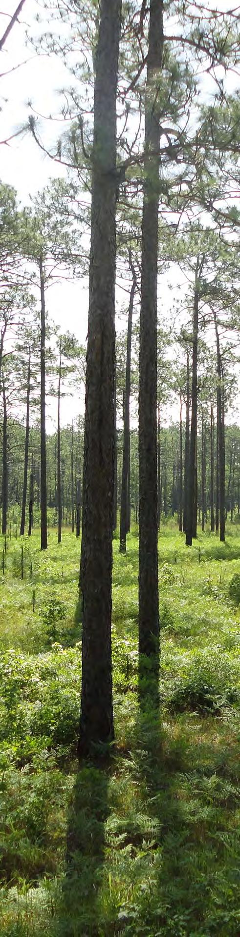
6. The U.S. Marine Corps, the North Carolina Rail Road Company and Weyerhaeuser should be consulted to better determine the feasibility of rails-with-trails along railroad rights-of-way that run from New Bern to Morehead City and from the Marine Corps Air Station at Cherry Point to Camp Lejeune.
7. In the eastern half of the study area, the lack of publicly owned land leaves few options for trail routing other than along roadway corridors. Ferry services to Cape Lookout National Seashore were explored as an option for trail routing, but difficulties were noted in coordinating with multiple private ferry services and guaranteeing that service would be available throughout the year. Other potential routes should be explored wherever possible; partnerships with the North Carolina Coastal Foundation/North River Farms would be key.
A variety of public involvement strategies were pursued during plan development to ensure that residents from all communities had the opportunity to learn about the plan and provide input. Public input methods and materials included the following:

• Formation of a plan steering committee representing the diverse communities and interests of the Croatan Region


• Public workshops
• Public comment forms (online and hard copy)
• Resolution of Support from local leaders
• Social media campaign
• Soliciting local expertise
Together these methods were used to identify regional opportunities and constraints, gather ideas for plan recommendations, and gather feedback on the plan. Please see Appendix A: Public Involvement for a detailed description of the public input process.
Bicycle Facility Types (4-1)
Bicycle Recommendations (4-4)
The Regional Trails Network (4-14)
Priority Projects (4-21) Signage Guidance (4-44)
This chapter presents on-road bicycle facility and off-road trail project recommendations. The methodology for the identification and selection of projects included in this chapter is discussed in Chapter 3 of this plan.
A variety of bicycle facilities are recommended to account for the following conditions:
1. The range of skill and comfort levels involved in bicycling;
2. The range of existing conditions for bicycling in different landscapes and on different roadway environments.
One facility type will not fit all roadways because of variations in roadway configurations and land use. Thus, a toolbox of facility types is used. These recommendations are at a planning level only and will require further analysis before implementation.
The recommended bicycle system is made up of two major types of facilities: on-road and off-road. Within each type are multiple facility options that are recommended for specific segments of the overall system. Methodology for determining recommendations for the bicycle and trails recommendations is described in Chapter 3: Methodology. Descriptions and standards for each type are described in Chapter 5: Design Guidelines. The images and descriptions on the next couple of pages are provided for a quick reference when viewing the on-road bicycle network maps and the trail network maps included in this Chapter.
Paved shoulders, as shown in the picture on the right, are the part of a roadway which is contiguous and on the same level as the regularly traveled portion of the roadway. There is no minimum width for paved shoulders; however a width of at least four feet is preferred. Roadways with speeds greater than 40 mph should have paved shoulders of at least five feet in width.

Ideally, wide paved shoulders should be included in the construction of new roadways or the upgrade of existing roadways, especially where there is a need to safely accommodate bicycles. Recreational bicycling is very common across this region of North Carolina. Most rural roadways in their existing configuration either feature no shoulder or only a 1-2 foot paved shoulder which is not adequate for bicyclists. Roadways in which paved shoulders should be added or widened to a minimum of four or five feet are shown clearly in the recommended network maps included in this chapter.

Shared lane markings, or “sharrows,” as shown in the picture on the right (bottom), are placed in a linear pattern along a corridor, typically every 100-250 feet and after intersections. Shared lane markings can be used in roadways with travel lanes that are all the same width, and they can also be used in raodways with a 14 foot wide outside lane. They function in several important ways:
• They make motorists more aware of the potential presence of cyclists.
• They direct cyclists to ride in the proper direction.
• They remind cyclists to ride further from parked cars to avoid ‘dooring’ collisions.
A bicycle lane, as shown in the top left picture, is a portion of the roadway that has been designated by striping, signing, and pavement markings for the preferential or exclusive use of bicyclists. The minimum width for a bicycle lane is four feet; five- and six-foot bicycle lanes are typical for collector and arterial roads.

A buffered bicycle lane, as shown in the middle left picture, is similar to a regular bicycle lane, but a buffered bicycle lane also includes a marked buffer between the bicycle lane and adjacent travel lanes. The purpose of a buffered bicycle lane is to provide distance between the automobile travel lane and the bicycle lane to increase safety. The buffer is placed between the bicycle lane and automobile travel lane. The buffer is marked with white chevrons to indicate that no vehicles are allowed to travel in the buffered area.


Bicycle boulevards are a special class of shared roadways designed for a broad spectrum of bicyclists. They are low-volume, low-speed local streets modified to enhance bicyclists’ comfort by using treatments such as signage, pavement markings, traffic calming and traffic reduction, and intersection modifications. These treatments allow the through movements of bicyclists while discouraging similar through-trips by non-local motorized traffic.
Refer to Chapter 5 for an in-depth inventory of bicycle design treatments and guidelines for their development.
As a part of the planning process a number of categories of recommendations were created, including improvements to the future regional route, improvements to create the East Coast Greenway route, and improvements on secondary routes. The chapter is organized by county with maps illustrating the types of recommended improvements for the regional route and each of the secondary routes. A description of each of the segments of the regional route and secondary routes are provided for each county. The regional route segments include current conditions and recommended improvements, while the secondary routes include descriptions for the proposed improvements.
The regional route recommendations are meant to be improvements to the mapped route that covers the five-county region and would promote safer travel for various skill levels of bicyclist. Map 4.1 illustrates the recommended improvements described in each table and can be found on page 4-5.
The secondary route recommendations provide alternative, localized improvements to roadways so that bicyclists of various skill levels will be able to navigate and enjoy shorter loop rides and access the various points of interest throughout the region. Map 4.2, on page 406, illustrates the recommended improvements described in each table.
Carteret County is also known as the Crystal Coast because of the barrier island beaches that are located there. Coming into the county from the western county line the regional route follows both rural roads and NC 58 which has a higher volume of traffic. From Onslow County the route continues on Stella Rd. then follows NC 58 to Old Church Rd. and winds around back to Cross NC 58 on West Fire Tower Rd. and loops around to Pelletier Loop Rd. From Pelletier Loop Rd. the route follows along NC 58 the major intersection with NC 24. From this intersection the route crosses the Cameron Langston Bridge into the Town of Emerald Isle. Emerald Isle has an existing multi-use path for the casual bicyclist as well as shoulders for on-road travel. The route follows NC 58 through the beach towns of Salter Path, Indian Beach, Pine Knoll Shores and Atlantic Beach and the rider will pass a multitude of places to eat, access to the beach, shop, and accommodations for a stay overnight or longer. One of the North Carolina State Aquariums is located in Pine Knoll Shores. From Atlantic Beach the route crosses a four-lane bridge into Morehead City and follows quiet residential streets close to the waterfront district which includes shopping and dining. The route then follows US 70 toward the Town of Beaufort, crossing over a high-rise bridge located at the State Port. This bridge is a difficult connection as it is only two lanes and has a high traffic volume. Coming into the Town of Beaufort the route turns off of US 70 and takes the rider to the historic waterfront area of the town where there are multiple options for shopping, dining and accommodation. From downtown Beaufort the next leg of the route goes out to NC 101 and crosses the Intercoastal Waterway (ICW) at the Core Creek Bridge. This bridge is a two lane high-rise with a very narrow shoulder and moderate volume of traffic so cyclists should use caution when crossing. After the ICW the route continues on NC 101 to the Craven County line.

RCart-1 Stella Rd. from BelgradeSwansboro Rd. to NC 58
RCart-2 NC 58 from Stella Rd. to Old Church Rd.
RCart-3 Old Church Rd. crossing NC 58 at West Firetower Rd., intersecting Pelletier Loop Rd. to NC 58
RCart-4 NC 58 from Pelletier Loop Rd. to NC 24.
RCart-5 NC 58, the Cameron Langston Bridge
RCart-6 NC 58 from the base of the Cameron Langston Bridge to 1st Street
Shared Roadway Wide Shoulders 3.77
Shared Roadway with wider outside lane Wide Shoulders 1.43
Shared Roadway Wide Shoulders 7.17
Shared Roadway with wider outside lane Wide Shoulders 2.58
Shared Roadway with wider outside lane Wide Shoulders 1.7
Bicycle Lane/ Wide Shoulders Wide Shoulders 9.05
RCart-7 NC 58 from Coast Guard Rd. to Hurst Rd. Multi-use Path Multi-use Path 3.98
RCart-8 NC 58 from 1st St to Tradewinds
RCart-9 NC 58 from Tradewinds to Hoffman Beach Rd.
RCart-10 NC 58 from Hoffman Beach Rd. to Cedar Lane
RCart-11 NC 58 from Ocean Ridge Dr. to Cedar Lane
RCart-12 NC 58 from Cedar Lane to Atlantic Beach Causeway, Atlantic Beach Causeway to Old Causeway Rd.
RCart-13
RCart-14
Atlantic Beach Causeway from Od Causeway Rd. to Moonlight Dr.
Atlantic Beach -Morehead City Bridge
Bicycle Lane/ Wide Shoulders Wide Shoulders 0.87
Bicycle Lane/ Wide Shoulders Bicycle Lane 0.87
Bicycle Lane/ Wide Shoulders Wide Shoulders 7.73
Bicycle Lane/ Wide Shoulders Muti-use Path 1.04
Shared Roadway with wider outside lane Edgeline Stripes 0.62
Shared Roadway with wider outside lane Wide Shoulders 0.39
Shared Roadway with wider outside lane Wide Shoulders 0.9
RCart-15
RCart-16
S. 23rd St. to S. 22nd St. along Arendell St.
S. 22nd St. to Evans St., along Evans St. to 4th St.
Shared Roadway with wider outside lane Signage 0.16
Shared Roadway Signage 1.6
RCart-17
4th St. to Fisher St., along Fisher St. to 7th St, along 7th St. to Bay St., along Bay St. from 7th to 16th St., along 16th St. to Fisher, along fisher to 24th St.
Shared Roadway Signage 1.92
RCart-18
24th St. from Fisher St. to the Atlantic Beach Causeway ramp
Shared Roadway with wider outside lane Signage 0.18
RCart-19 Newport River High rise Bridge Difficult Connection Bicycle Lane 1.17
RCart-20 Radio Island Causeway Shared Roadway with wider outside lane Multi-use Path 1.2
RCart-21 Cedar St from Moore St. to Turner St. Shared Roadway Bicycle Lane 0.18
RCart-22 Turner St. from Cedar St. to Front St., Along Front Street to Live Oak St., along Live Oak St. from Front St. to Cedar St.
Shared Roadway Signage 1.03
RCart-23 Live Oak St. from Cedar St. to Circle Dr. Shared Roadway with wider outside lane Signage 0.73
RCart-24 NC 101 from Circle Dr. to Copeland Rd. Shared Roadway with wider outside lane Multi-use Path 1.09
RCart-25 NC 101 from Copeland Rd. to Lake Rd. Shared Roadway with wider outside lane Wide Shoulders 0.65
RCart-26 NC 101 from Lake Rd. to Laurel Rd. Shared Roadway with wider outside lane Wide Shoulders 4.34
RCart-27 NC 101 from Laurel Rd. to the Craven County Line Shared Roadway with wider outside lane Wide Shoulders 6.53
The secondary route improvements in Carteret County are meant to serve a dual purpose: to provide access to specific points of interest and to increase safety for local loop routes in conjunction with the regional route improvements. Beginning in the western part of the county, wide shoulders are recommended from NC 58 from the county line to NC 24 in Cape Carteret. NC 58 has a moderate traffic volume (both truck and automobile) and the shoulders are meant to provide extra riding room for cyclists who are comfortable riding with traffic. The same applies to the proposed wide shoulders of NC 24, a five lane undivided highway, which can be used to make a complete loop from Morehead City to the beach communities. A muti-use path is recommended to take the tourist or local from the western end of Emerald Isle to the commercial area of the town and connect with an existing multi-use path. Two roads off of NC 24, Nine Mile and Hibbs Rd. traverse through sections of the Croatan National Forest and provide connections to other parts of the county including the Town of Newport. From the town of Newport traversing the middle part of the county is Mill Creek Rd. and Old Wineberry Rd. which a rural connection through a portion of the Croatan National Forest (including the Oyster Point camp ground) to NC 101. Improvements to NC 58 and Fort Macon Rd. in the Town of Atlantic Beach will make it easier and safer for tourists and local residents to bicycle to Fort Macon State Park, a popular historic and beach destination.
SCart-1 Wetherington Landing from the county lIne to Morristown. Wide Shoulders 1.5
SCart-2 Morristown from NC 58 till the dead end. Wide Shoulders 4.3 SCart-3 Hunters Creek from the County line to NC 58 Wide Shoulders 1.4 SCart-4 NC 58 from the county line to NC 24 Wide Shoulders 9 SCart-5 Coast Guard Rd. from Reed to Point Bogue Multi-use Path 1.8 SCart-6 NC 24 from NC 58 to Mcabe Rd. Wide Shoulders 13.7
SCart-7 NC 24 from Mcabe Rd. to US 70. Multi-use Path 2.6
SCart-8 Nine Mile Rd. from NC 24 to Millis Rd. Wide Shoulders 3.2
SCart-9 Lake Rd. from the northern county line to Millis Rd. Wide Shoulders 5.5
SCart-10 Hibbs Rd. from NC 24 to Roberts Rd. and along Roberts to East Chatham. Wide Shoulders 3.7
SCart-11 Nine Foot Rd. from Nine Mile to Howard. Wide Shoulders 4.2
SCart-12 Orange from Chatham to Mill Creek and then along Mill Creek to Old Wineberry, then along Old Wineberry to NC 101. Wide Shoulders 13.4
SCart-13 NC 58 from the Atlantic Beach Causeway to Fort Macon State Park Edgeline Stripes 2.2
SCart-14 Fort Macon Rd. within the State Park Wide Shoulders 1.6
SCart-15 Laurel Rd. from NC 101 to Merrimon Rd., then along Merrimon Rd. to US 70 Wide Shoulders 4.7
SCart-16 US 70 from NC 101 to the Cedar Island ferry terminal Wide Shoulders 37.2
SCart-17 Harkers Island Road from US 70 to Straits Rd., along Straits Rd. to US 70 Wide Shoulders 5.9
SCart-18 Harkers Island Road from Straits Rd. to the dead end. Wide Shoulders 6.5
The eastern part of Carteret County, traveling down US 70 toward Cedar Island is referred to as the ‘Down East’ area. There are a multitude of small communities Down East including Otway, Straits, Harkers Island, Davis and Atlantic just to name a few. Harkers Island is the location of the Core Sound Waterfowl Museum which showcases the history of the area, and it is also home to the Cape Lookout visitor’s center where you can learn about the historic lighthouse and take a ferry to the National Seashore to enjoy the beaches. Wide shoulders are recommended for the major roads in the Down East area including Harkers Island Rd., Straits Rd., and US 70 from Beaufort all the way to Cedar Island where it becomes NC 12 and dead-ends into the NCDOT ferry terminal to Ocracoke Island, which also has a historic lighthouse, many places to eat and drink, and accommodations for an overnight stay. Additionally, Ocracoke is a very bicycle friendly town as it is very compact and has very little traffic.
The regional route through Craven County is divided into two segments. The first segment takes the rider from the Carteret County line up NC 101 to NC 306 (Ferry Rd.). One of the unique characteristics of this segment of the route is the NCDOT ferry landing at the end of Ferry Rd. where riders will embark on a 30 minute ride across the Pamlico Sound.
The second segment of the regional route that passes through Craven County is on NC 55 starting from the Pamlico County line then passing through the town of Bridgeton. NC 55 then crosses the Neuse River on a relatively long bridge that is a difficult ride because of a lack of wide shoulder and a high volume of traffic. After crossing the bridge the route exits on to Howell Rd. and then follows Madam Moores Lane to Brice’s Creek Rd. and then to the Jones County line. This section of the route is made up of rural roads with low traffic volumes along the Trent River and that pass through small neighborhoods.
RCrav-1 NC 101 from the Craven County Line to Ferry Rd. (NC 306) Shared Roadway with wider outside lane Wide Shoulders 4.43
RCrav-2 NC 306 from NC 101 to the Cherry Branch Ferry Terminal Shared Roadway Wide Shoulders 4.49
RCrav-3 NC 55 From the Pamlico County Line to West US 17 Difficult Connection Wide Shoulders 2.42
RCrav-4 NC 55 across the Neuse River Bridge to US 70 Business Difficult Connection Wide Shoulders 2.75
RCrav-5 Howell Rd. from US 70 Business to Madam Moores Ln., along Madam Moores Lane to Brices Creek Rd., along Brices Creek Rd. to Perrytown Loop Rd.
RCrav-6 Brices Creek Rd. from Perrytown Loop Rd. to the Craven County Line
Shared Roadway Wide Shoulders 4.61
Shared Roadway Wide Shoulders 1.5
The secondary route improvements in Craven County are mostly centered in the cities of New Bern and Havelock with a few recommendations within the unincorporated area. New Bern is known for its historic neighborhoods, Tryon Palace and the North Carolina History Center, as well as a myriad of places to shop, eat and stay close to the waterfront. Improvements in the city of New Bern include directional signage along the Front and Craven Street areas of the historic downtown waterfront area, wide outside lanes on NC 43 and Glenburnie Rd. for connectivity between two sides of the city, and improvements along Trent Rd. as an alternative traveling on US 70 Business which is a major commercial corridor. An additional recommendation is to create a bicycle lane and wide outside lanes connecting New Bern to Trent Woods. Outside the city the recommendations include improving NC 41 from Jones County to Old US 70 all the way into New Bern with wide shoulders and improving US 17 to the county line with wide shoulders into Jones County.
SCrav-1 Hwy 41 from the county line Old US 70, then along Old US 70 to NC 43 Wide Shoulders 15.5 SCrav-2 NC 43 from NC 55 to Glenburnie
Edgeline Stripes 1.6 SCrav-3 NC 43 from Glenburnie to Trent Rd. Wide Outside Lanes 2.5 SCrav-4 US 17 from the county line to Greenleaf Cemetery Rd. Wide Shoulders 4.5 SCrav-5 US 17 from Greenleaf Cemetery to Trent Rd. Multi-use Path 0.6 SCrav-6 Trent Rd. from US 17 to Glenburnie Bicycle Lane 0.6 SCrav-7 Trent Rd. from Glenburnie to Meadows Wide Shoulders 3.2 SCrav-8 Trent Rd. from Meadows to Norwood Bicycle Lane 1.4 SCrav-9 Greenleaf Cemetery Rd. from US 17 to Trent Woods Rd. Wide Shoulders 1.1 SCrav-10 Trent Woods Rd. from Haywood Landing to Chelsea Wide Outside Lanes 1.5 SCrav-11 Country Club Rd. from Chelsea to Walt Belemy Rd. Bicycle Lane 3.6 SCrav-12 Walt Belemy from Country Club Rd. to Front St. and then along Front St. to Craven, then along Craven to North then along North to National. Signage 3 SCrav-13 Glenburnie from NC 43 to Trent Rd.
Wide Outside Lanes 2.5
SCrav-14 Glenburnie from NC 43 to National, then along National to Guon Wide Shoulders 3.3 SCrav-15 George St. from Guon to US 70 Business Wide Outside Lanes 0.8 SCrav-16 Simmons from NC 55 to Trent Rd. Wide Outside Lanes 1.3
SCrav-17 Hickman Hill Loop Sunset, then along Sunset to Greenfield Heights. Signage 7.7
SCrav-18 Greenfield Heights from US 70 to Lake Rd., then along Lake Rd. to Hickman Hills. Wide Outside Lanes 6.5
SCrav-19 Lake Rd. from Hickman Hills to the southern county line Wide Shoulders 1.6 SCrav-20 NC 101 from Outer Banks Rd. to NC 306 Wide Shoulders 3.1
Havelock is the home to Cherry Point Marine Corps Air Station (MCAS), additionally a by-pass is planned by the NCDOT (project R-1015). Proposed improvements include signage in the Hickman Hills neighborhood down to Lake Rd. which will take the rider into Carteret County. Another recommended improvement is wide outside lanes along Greenfield Heights to Lake Rd. creating a parallel route to US 70 and a crossing of the proposed Havelock by-pass at Lake Rd. in order to connect Havelock with the regional route, wide shoulders are recommended along NC 101 from Outer Banks Rd. to NC 306 where the regional route will take the Cherry Point-Minnesott Beach NCDOT ferry.
The regional route enters Jones County on Island Creek Rd. for 8 miles and takes the rider to the town of Pollocksville. Traversing the town of Pollocksville on the Trent River the rider will then follow NC 58 south for a short while (about 3 miles) until reaching Pole Pocosin Rd. Pole Pocosin is a rural route with low traffic volumes with a section passing by the Hoffman Forest and will take the rider to the town of Maysville close to the Jones County border. Both Maysville and Pollocksville have places to stop and eat. Jones County is a rural county with a few major state and US routes (NC 58, 41 and US 17) passing through which have moderate traffic volumes and a number of rural roads with low traffic volumes. Recommendations are for wide shoulders on the various highways, however due to higher traffic volumes (both truck and automobile) the shoulders are meant to provide extra riding room for cyclists who are comfortable riding with traffic. Ten Mile Fork Rd. between the county line and the town of Trenton is a rural road with low traffic volumes.
RJones-1 Island Creek Rd. from the Jones County Line to US 17
Shared Roadway Wide Shoulders 8.22
RJones-2 US 17 from Beaufort Rd. to NC 58 Shared Roadway with wider outside lane Edgeline Stripes 0.38
RJones-3 NC 58 from US 17 to Goshen Ln. Shared Roadway Edgeline Stripes 0.58
RJones-4 NC 58 from Goshen Ln. to Davis Field Rd. Shared Roadway Wide Shoulders 2.2
RJones-5
Davis Field Rd. from NC 58 to Pole Pocosin Rd., along Pole Pocosin Rd. to White Oak River Rd., along White Oak River Rd. to US 17 Shared Roadway Wide Shoulders 7.89
RJones-6 US 17 from 4th St. to Byrd Ln. Shared Roadway with wider outside lane Edgeline Stripes 0.7
SJones-1 NC 58 from the southern county line to US 17 in Maysville
Wide Shoulders 11
SJones-2 US 17 from Fourth St. to NC 58 Wide Shoulders 6.7
SJones-3 US 17 from Beaufort Rd. to the northern county line Wide Shoulders 5
SJones-4 NC 58 from Davis Field Rd. to NC 41 Wide Shoulders 7
SJones-5 NC 41 from NC 58 to the northern county line Wide Shoulders 6.2
SJones-6 Old New Bern Rd. from NC 41 to Ten Mile Fork Rd., then along Ten Mile Fork Rd. to US 17
Wide Shoulders 9.4
The regional route passes through the eastern part of Onslow County on BelgradeSwansboro Rd. from the Jones County line to the Carteret County line in Stella. Belgrade-Swansboro Rd. is a rural road that extends from US 17 parallel to NC 58, which is located in Carteret County. The recommendation for the road is increasing the width of the shoulders along this section which has a low traffic volume.
ROns-1 US 17 from Byrd Ln. to Belgrade Swansboro Rd. Shared Roadway with wider outside lane Wide Shoulders 0.78
ROns-2 Belgrade Swansboro Rd. from US 17 to Stella Rd Shared Roadway Wide Shoulders 8.84
The major secondary route improvement recommended for Onslow County in this plan is a multi-use path along NC 24 to safely connect the downtown Jacksonville area with the historic town of Swansboro. In Swansboro wide shoulders and a multi-use path are recommended to connect to the popular Hammocks Beach State Park where visitors can take a ferry to the undeveloped barrier island in Bogue inlet. Additional recommendations include wide shoulders along Rocky Run Rd., Deppe Rd. and Parkertown Road which are both rural roads with low traffic volumes.
SOns-1 US 17 from the county line to Piney Green Rd. Wide Shoulders 20.2
SOns-2 Deppe Rd from US 17 to Belgrade Swansboro Rd. Wide Shoulders 7.3
SOns-3 US 17 from Piney Green Rd. to Parkwood Rd. Multi-use Path 1.6
SOns-4 Parkwood Rd. from US 17 to Commerce Rd., then along Commerce to Country Club Rd. Along Country Club Rd. to the US 17 bypass, then back to US 17 and along US 17 ending at NC 24.
Multi-use Path 4.7
SOns-5 NC 24 from US 17 to Stratford Rd. Bicycle Lane 1.1 SOns-6 NC 24 from Stratford Rd. to Belgrade Swansboro Rd. Multi-use Path 32.4
SOns-7 Piney Green Rd. from NC 24 to Rocky Run Rd. Multi-use Path 1.5
SOns-8 Rocky Run Rd. from Piney Green to Smith Rd., then along Smith Rd. to Belgrade Swansboro Rd.
Wide Shoulders 17.9
SOns-9 Parkertown Rd. from Hubert Rd. to Belgrade Swansboro Rd. Wide Shoulders 9.2
SOns-10 Stella Rd. from Belgrade Swansboro Rd. to the county line Wide Shoulders 1.8
SOns-11 NC 24 from Belgrade Swansboro Rd. to Webb Edgeline Stripes 2.7
SOns-12 Hammock Beach Rd. from NC 24 to Old Hammock Rd. Wide Shoulders 1.2
SOns-13 Old Hammock Rd. from NC 24 to Hammock Beach Rd., then along Hammock Beach Rd. to Elizabeth Koontz Rd.
Multi-use Path 2.2
The route though Pamlico County is approximately 36 miles along rural roads where the recommendation is to increase the size of the shoulder to accommodate bicyclists. If coming from the south, the rider will cross the Pamlico River on a NCDOT Ferry and disembark on NC 306 at Minnesott Beach. From there the rider will follow the route through sections of agricultural landscapes as well as water views until crossing the highrise bridge into the town of Oriental. Oriental has a wonderful waterfront downtown and multiple places to stay overnight as well as eat and drink. From Oriental the rider will make their way back toward NC 306 via Kershaw Rd, another rural road with light motor vehicle traffic flow. Crossing NC 306 the rider will travel along Neuse Rd., a rural road that gradually winds its way to NC 55. NC 55 was recently upgraded to a fivelane highway and currently has significantly wide shoulder to accommodate bicyclists. However there is a heavy volume of traffic along NC 55 and care must be taken while travelling toward New Bern.
RPam-1
NC 306 from the Minnesott Beach Ferry Terminal to Buckland Rd., along Buckland Rd. to Janeiro Rd., along Janeiro Rd. to Oriental Rd., along Oriental Rd. to the Oriental bridge.
Shared Roadway Wide Shoulders 11.01
RPam-2 NC 55 from New Street to Straight Rd. Shared Roadway Bicycle Lane 1.51
RPam-3 NC 55 from Straight Rd. to Kershaw Rd., along Kershaw to NC 306, Crossing NC 306 to Neuse Rd., along Neuse Rd. to NC 55
Shared Roadway Wide Shoulders 19.27
RPam-4 NC 55 from Neuse Rd. to Deep Run Rd. Shared Roadway with wider outside lane Edgeline Stripes 1.86
RPam-5 NC 55 from Deep Run Rd. to the Pamlico County Line Difficult Connection Wide Shoulders 2.42
The secondary route improvements are meant to create a safe riding experience for both locals and visitors that may not be traveling the entire regional route but would like to enjoy the rural scenery and low traffic volumes in Pamlico County. Combined with section of the regional route, many of the secondary route segments create smaller loop routes that may be easily completed by riders of various skill levels as well as residents using their bicycle as a form of transportation to get to work, run errands etc.
SPam-1 NC 306 from the northern county line to Kershaw Rd
Wide Shoulders 13.3
SPam-2 NC 55 from Neuse Rd. to NC 304 Edgeline Stripes 8
SPam-3 NC 55 from NC 304 to Florence Rd. Wide Shoulders 4.4
SPam-4 Trent Rd. from Florence Rd. to Straight Rd. terminating at NC 55
Wide Shoulders 6.7
SPam-5 Scott Town Rd. from Scotts Store Rd to NC 306 Wide Shoulders 2.6
SPam-6 Janiero Rd. from Kershaw Rd. to Oriental Rd. Wide Shoulders 1.7
Map 4.3 shows the overall recommended trail network. The main trails within the overall network are described below, including the proposed MST routes (Map 4.4), the proposed ECG routes (Map 4.5), and trails within the Croatan National Forest (CNF) (Map 4.6).
1. From New Bern, the proposed MST route heads south along two-lane roadways, portions of which have paved shoulders, room for paved shoulders, or room for sidepaths.
2. The route then connects through the northern tip of the Croatan Forest to Catfish Lake Road, where it diverges from the ‘Approved MST Route’, away from the future Havelock Bypass, and follows forest service roads south, circumnavigating wildlife refuge areas.
3. Boardwalk and a trail bridge will be required to connect trail users to forest roads on either side of Hunter’s Creek.
4. A section of new trail will be required to circumnavigate private property, just outside the southern edge of the Pocosin Wilderness Area.
5. The route continues on a combination of existing forest service roads and trails, heading east along the southern end of the Croatan Forest.
6. From US Highway 70, the trail connects to Fort Benjamin Park and heads north, connecting to Newport and Havelock, temporarily joining the proposed East Coast Greenway Route. This would be a combination of existing and proposed sidewalk, on-street bicycle facilities, and, where possible, multi-use trails along highway and utility corridors.
7. From Havelock, the MST continues east towards the Neusiok Trail, either by navigating along NC Highway 101
(shown as dotted, Alternative A) or inside the potentially wet boundary of the Croatan Forest (shown as dashed, Alternative B). A third option would be to consider purchasing the land or ROW for trail access in between these alternatives.
8. The MST and Neusiok Trail then temporarily overlap before following NC Highway 101 east (potentially along the utility ROW that runs parallel and along the south side of the highway) towards the Intercoastal Waterway.
9. The Intercoastal Waterway bridge is about 30 feet wide, which includes approximately three feet of shoulder space on each side. Bicyclist and pedestrian-activated flashing warning signs could be considered as an option on each side of the bridge to alert motorists when pedestrians or bicyclists are crossing the bridge.
10. From the bridge, the route again diverges from the ‘Approved MST Route’, avoiding the constraints of the Open Grounds Farm, heading east along US Highway 70 instead (dotted, Alternative A). Pending trail easements from local farms, the route could continue off-road towards the Core Sound north of Davis (dashed, Alternatives B and C). These latter alternatives would require extensive boardwalk.
11. The trail continues northeast on US Highway 70 to Cedar Island National Wildlife Refuge and the ferry service to Ocracoke. Paved shoulder space is currently lacking and should be widened as much as possible.
There are
main routes for the
1. The Interim ECG Route (dashed line) is mainly along paved shoulders in highway corridors. The interim route connects various municipalities as it weaves through the study area. From New Bern, the interim route crosses over the Neuse River to Pamlico County, then east to Oriental, and south to the Minnesott Beach-Cherry Branch ferry.
2. From the ferry, it goes back across the Neuse River and follows NC Highway 101 south to Beaufort. The route then continues west on US Highway 70 to Morehead City.
3. From Morehead City, the route goes south to Atlantic Beach following NC Highway 58 to Emerald Isle.
4. From Emerald Isle, the route heads past Cedar Point, west of the White Oak River, then crosses the White Oak River towards Jacksonville.
5. The Proposed ECG Route (solid line from New Bern to Morehead City) is included as a long-term
alternative route
alternative to the interim route. From New Bern, this route meanders south for about six miles through lowvolume, low-speed neighborhood streets just west of US Highway 70. The route would then becomes a rail-withtrail, pending coordination with land owners, heading south and wrapping around the east side of Havelock. The trail continues south, east of the rail corridor to Newport (temporarily joining with the MST), then roughly follows US Highway 70 to Morehead City.
6. Another portion of proposed ECG routing includes the section from Swansboro to Jacksonville along NC Highway 24. However, improvements for bicycling along NC Highway 24 are needed before this becomes a desirable route.
It is important to note that currently pedestrian access is not permitted on the US 17/NC 55 bridge into Pamilco County. Pedestrian access is permitted on the NC 43 bridge, located north of the US 17/NC 55 bridge. Further detailed analysis will be necessary for the Interim ECG route to determine the most appropriate and viable route.
Aside from some short segments requiring new trail and boardwalk, the network of proposed trails within the CNF mainly follow existing Forest Service roadways and trail, requiring mainly wayfinding signage in the short term. The proposed trails in this area include:
1. The portions of the MST that go through the CNF, forming the main ‘spine’ of the trail network. This includes the proposed new sections of trail noted in points 2 and 4 on page 4-7.
2. Section of Forest Service Road 203 (Holston Road) connecting along and across NC Highway 58 to the existing trails and boat ramp at Haywood Landing.
3. Section of Great Lake Road, connecting the proposed MST route to Great Lake and the Great Lake boat ramp.
4. Section of Forest Service Road 166 (White Oak River Road) connecting along and across NC Highway 58 to the existing trails and boat ramp at Cedar Point.
5. Section of Forest Service Road 128 (Millis Road) connecting east-west, just south of the Pocosin Wilderness Area.
6. The Proposed Croatan Connector Trails take into account: A) the potential for a rail-with-trail between the Croatan National Forest and the City of Jacksonville; and B) a connection from Havelock to Catfish Lake Road that completes a trail loop around the CNF (joining with portions of the MST and ECG that would go from Havelock to Newport).
7. New trail segments must have final review and approval by the US Forest Service. These segments may require environmental studies and management plans prior to construction.
This page intentionally left blank for printing
Ten trail and bicycle improvement projects were identified as top priorities for implementation. These priorities are displayed on Map 4.7 and detailed on the following pages.
These priority projects were primarily selected due to their positive impact on the overall connectivity of the Mountains-to-Sea Trail, East Coast Greenway, and the Croatan Regional Bicycle Route. Completion of these projects is critical to making these regional routes safer, more connected, and in many cases, more attractive to existing and potential trail users and bicyclists. While these projects would be ideal to complete first, other improvements to the overall recommended trail and bicycle route networks should still be pursued as opportunities arise through adjacent development and/or roadway reconstruction.
The cut-sheets on the following pages illustrate and describe the priority trail and bicycle projects recommended in this plan. These project cut-sheets provide a planning level of analysis only. Actual development of facilities may differ according to specific site conditions, project funding, and factors unforeseen at the time this plan was developed. These cut-sheets can be used to communicate the individual projects to stakeholders involved in implementation, such as local staff and officials, NCDOT staff, potential funding agencies, and interested citizens.
Each project cut-sheet offers a planning level cost estimate for the priority project. The cost estimates are based on the most recently available per unit cost information obtained from NCDOT District Engineering staff. Project costs vary over time and by geography. Further evaluation during project design will be needed to determine exact project costs.
Trail Project #1: Catfish Lake Road
Roadway: Catfish Lake Road
Project Type: Natural Surface Multi-Use Trail, 6’ wide
Project Length: 6.2 miles
From: Little Road
To: Black Swamp Rd
Catfish Lake Road is a gravel road through the Croatan National Forest. Plans were in place to pave this road over the next few years at the time of writing. A six-foot wide multi-use trail is proposed on the north side of the road as an important connection within the Mountains-to-Sea Trail. This trail will also play a role in the proposed trail network throughout the Croatan National Forest.
• Construct a six-foot wide natural surface trail beginning at the intersection of Brown Road and Little Road, following the east side of Little Road to Catfish Lake Road, and following the north side of Catfish Lake Road to the trailhead at Black Swamp Road.
• Place the trail in the woods so that a planted buffer remains between the trail and roadway for shade and safety. The buffer should be a minimum of five feet, and a larger buffer should be used along Catfish Lake Road where the powerline easement will also separate the trail and roadway.
• Provide wayfinding and emergency signage along the trail and share the trail signage to encourage shared use by cyclists and pedestrians.
• Install yield or stop signs (as appropriate for the condition) along the trail at its intersections with Little Road, Catfish Lake Farm Road, and Black Swamp Road. Ensure clear sight triangles at all intersection approaches.
• Install ‘Yield to Pedestrian’ signage along the forest roadways listed above at approaches to trail crossings.
Trail Project #2: Forest Roads Connection
Project Type: Boardwalk Project Length: 1.3 miles
From: Great Lake Road To: Forest Route #144
This short gap is located along the proposed Mountains-to-Sea Trail through the Croatan Region. A wetland and stream make this a difficult connection that cannot be completed with a natural surface trail. A boardwalk across this gap will both connect the Mountains-to-Sea Trail through the Croatan National Forest and provide a high-quality off-road facility for residents of the Croatan Region.

• Construct a ten-foot wide multi-use boardwalk between Great Lake road and Forest Route #144. The boardwalk may be constructed in timber, as shown in the visualization below, or concrete for greater durability. Concrete boardwalk is more expensive, so cost estimates have been provided for each option.

• Provide wayfinding and emergency signage along the trail, share the trail signage to encourage shared use by cyclists and pedestrians, and stop signs at each end.
• Install ‘Yield to Pedestrian’ signage at trail crossings of Great Lake Road and Forest Route #144.
• Install a foot bridge where the trail crosses the creek.
Timber Boardwalk*: $4,346,000
Concrete Boardwalk*: $5,136,000
*Estimate does not include the cost of a foot bridge. Further analysis is required.
Trail Project #3: Forest Roads Connection
Project Type: Natural Surface Multi-Use Trail, 6’ wide
Project Length: 1.4 miles
From: Forest Route #205
To: Millis Road
The recommended trail fills a gap along the Mountains-to-Sea Trail. Together with priority trail project #3 and the use of existing forest roads, this gap will provide a complete connection through the Croatan Forest for trail users. In the long-term, this route will be built out as a fully off-road connection. The proposed alignment for this gap avoids private property, connecting through federally-owned forest land.
• Construct a six-foot wide natural surface trail between Forest Route #205 and Millis Road.
• Provide wayfinding and emergency signage along the trail and share the trail signage to encourage shared use by cyclists and pedestrians.
$139,000
Trail Project #4: newport
Roadway: Hibbs Road, Joyce Ave, McQueen Ave, and Chatham Street
Project Type: Multi-Use Sidepath Project Length: 4.7 miles
From: Hibbs Road at Arendell Street To: Powerline easement at Whitetail Road

Chatham Street through Newport forms a link along the proposed Mountains-to-Sea Trail and East Coast Greenway. There is no designated on-road bikeway or sidewalk along this stretch currently. Improvements along this roadway will link the proposed Croatan trails network at the southern end to a proposed off-road multi-use trail in a powerline easement heading north. Along with improving regional connectivity, improvements will also serve the residents of Newport.
• Install a ten-foot wide paved multi-use sidepath along the full extent of the proposed route with wayfinding signage.

• Install high visibility crosswalks, tactile warning strips, and ramps at Arendell St., Chatham St., Railroad Blvd., East Railroad Blvd., and Market St. The sidepath should form a 90 degree angle to the extent possible at intersection approaches to slow trail traffic.
• Install crosswalks, tactile warning strips, and ramps at Main St., Mann St., Haskett St., McCain St., Carolina Ave., Watson Ave., New Bern St., Newport Loop Rd., and Pine Grove Rd.
• Install pedestrian signals at Arendell St., Railroad Blvd., and East Railroad Blvd.
Trail Project #5: havelock to neusiok trail
Roadway: NC Highway 101

Project Type: Multi-Use Sidepath Project Length: 4.3 miles
From: Havelock Athletic Complex To: Neusiok Trail
The natural surface Neusiok Trail, located 4 miles east of Havelock, is a popular trail amenity drawing residents from across the Croatan Region. A multi-use trail connecting the Town to the trail will allow all residents of Havelock to access this amenity by foot or bike. This connection also forms a link in the proposed Mountains-to-Sea Trail. The shortest path between these destinations follows Highway 101, making this the preferred routing. An alternative route exists following the edge of the Croatan Forest.
• Install a ten-foot wide paved multi-use sidepath along NC Highway 101 between the Havelock Athletic Complex and the Neusiok Trail. A minimum five-foot wide grass buffer should be provided between the trail and roadway.
• Install ‘Yield to Pedestrian’ signage along Outer Banks Drive and the forest roadways at approaches to trail crossings.
• Provide wayfinding signage along the trail, share the trail signage to encourage shared use by cyclists and pedestrians, and yield or stops signs at intersections (as appropriate for the condition).
• Install a paved multi-use trail along the edge of the Croatan National Forest between the Havelock Athletic Complex and the Neusiok Trail.

$283,000 (estimate does not include drainage)
Bicycle Project #1: Pollocksville to New Bern
Roadway: Island Creek Road & Brices Creek Road
Project Type: Full-depth Paved Shoulders
Project Length: 14.3 miles
From: Highway 70 To: Highway 58
Island Creek Road & Brices Creek Road form the Croatan Regional Bicycle Route between New Bern and Pollocksville. This two-lane rural route with a speed limit of 55 mph provides an alternative connection to Highway 17, which carries higher traffic volumes. The route also links to the Island Creek Trail, a half-mile walking trail maintained by the U.S. Forest Service. Paved shoulders will make this preferred bicycling route safer for all road users by providing space for cyclists.
• Install full-depth paved shoulders of at least four-foot width on both sides of the roadway.
• Repave the first 10 feet of driveways as part of the shoulder widening to reduce gravel in the shoulder at driveway crossing points.
• Remove existing edgeline stripe (experiencing wear), install new stripe, and consider installing raised pavement markers along the stripe in each direction to enhance the separation of bicyclists from motorists. Raised pavement markers can cause steering difficulties for bicyclists and should not be installed at locations where bicyclists will enter or exit the shoulder bikeway. See the 2009 Manual on Uniform Traffic Control Device’s (MUTCD) Chapter 3H for design guidance.
• Install bicycle route signage along the corridor.
Bicycle Project #2: Highway 55 Bridge
Roadway: NC Highway 55/US Highway 17
Project Type : Signage, Striping, and Markings
Project Length: 2.75 miles (including bridge ramps)
From: NC 55, Bridgeton
To: Howell Road, New Bern
The Croatan Regional Bicycle Route crosses the Neuse River at the NC55 bridge between Bridgeton and New Bern. This bridge is difficult for cyclists to ride because of the lack of wide shoulders and high traffic volumes. There are currently three travel lanes in each direction and a narrow shoulder.
• Restripe the bridge to accommodate a wider shoulder (five foot minimum, wider preferred) by narrowing travel lanes. Take back width from the inside shoulder to the extent possible.
• Consider installing raised pavement markers along the stripe in each direction to enhance the separation of bicyclists from motorists. Raised pavement markers can cause steering difficulties for bicyclists and should not be installed at locations where bicyclists will enter or exit the shoulder bikeway. See the 2009 Manual on Uniform Traffic Control Device’s (MUTCD) Chapter 3H for design guidance.
• Install signage at the entrances to the bridge and along the bridge marking it as part of the Croatan Regional Bicycle Route.
• Install 54” bike-safe railing on US 17 loop and bridge.
• Establish designated yielding areas for bicyclists at bridge ramp crossings that facilitates an angled (90 degrees desirable where possible) crossing. Yielding areas should provide sufficient space for several bicyclists to wait simultaneously until an adequate gap in motorist traffic allows for crossing the ramp. Ensure sight lines are maximized so that bicyclists see approaching motorized vehicles. Pavement markings and signage may help indicate the waiting location to bicyclists and instruct bicyclists to yield to vehicular traffic. Yielding areas may require shoulder restriping and ramp lane realignment to create adequate geometry for bicyclists. Note: Further analysis is required to estimate the costs associated with yielding areas at each of the ramps.
*Cost does not include bicycle yielding areas at bridge ramps.
Existing

Proposed Highway 55 Bridge Ramp: Wide Shoulders

Bicycle Project #3: Highway 58 Bridge
Roadway: Cameron Langston Bridge/NC Highway 58
Project Type: Signage, Markings, and Fencing
Project Length: 1.7 miles
From: NC Highway 24
To: NC Highway 58
The Croatan Regional Bicycle Route connects from Cape Carteret to Emerald Isle along the Cameron Langston Bridge, a two-lane bridge with a 3-4’ paved shoulder. This bridge’s railings do not meet NCDOT’s current safety standard for bicyclists, which require a 54” handrail. Additionally, the bridge carries heavy traffic, making it a difficult connection for cyclists.


• Install signage at the entrances to the bridge and along the bridge marking it as part of the Croatan Regional Bicycle Route.
• Restripe the bridge to widen the shoulders to a minimum of five-foot width.
• Consider installing raised pavement markers along the stripe in each direction to enhance the separation of bicyclists from motorists. Raised pavement markers should not be installed at locations where bicyclists will enter or exit the shoulder bikeway. See the 2009 MUTCD Chapter 3H for design guidance.
• Extend the height of the bridge railing to improve safety for bicyclists and meet the current standard for bridge railing height. The feasibility and cost of railing installation requires further analysis.
*This estimate does not include railing. Further analysis is needed to determine the cost of raising the railing.
Bicycle Project #4: NC 101 Bridge
Roadway: Core Creek Bridge, NC Highway 101
Project Type: Signage and Signal
From: Old Bridge Road
Project Length: 0.57 miles
To: Core Creek Road
The Croatan Regional Bicycle Route crosses the Intracoastal Waterway at the Core Creek Bridge along NC Highway 101. This two-lane bridge has a narrow shoulder and annual average daily traffic of 5,900 as of 2012. These conditions, in combination with the 0.57-mile length of the bridge, make it unsafe for bicyclists and pedestrians to cross. The bridge is also a segment along the interim East Coast Greenway route.

• Install crosswalks and signage in advance of the bridge encouraging pedestrians to cross and walk against traffic. The exact locations of these crossings require further analysis.
• Install a pedestrian-activated signal at each end of the bridge. Pedestrians approaching this signal can activate it to alert motorists to their presence on the bridge. The signal should be timed to flash as long as the crossing would take for a typical pedestrian.
• Install a paved shoulder in the approach direction at each end of the bridge.

• Install R4-11 regulatory signs at bridge entrances (BICYCLES MAY USE FULL LANE) and shared lane markings along the bridge.
• Install a bicycle detector loop in the installed shoulder at each end of the bridge. This detector should be embedded in the pavement and trigger the pedestrian signal when a bicyclist passes over it. The signal may be timed to flash for the average time for a bicyclist crossing when triggered by the bicycle detector loop.
Ferries are a critical component to the Croatan Region’s transportation system. Ferries also form links along several of the major routes recommended in this plan, including the Croatan Regional Bicycle Route, the Mountains-to-Sea Trail, and the East Coast Greenway. Currently, bicyclists are not explicitly accommodated at ferries. While bicycles may be brought onto ferries, bicyclists are not treated as vehicles at boarding approach areas and secure parking is not provided on boats.
The ferries of the Croatan Region should make accommodations explicitly for bicyclists to formalize bicycles as vehicles and follow best practices.. The following accommodations are recommended:
• Reservations – Reservations should be allowed for groups of cyclists, so that they might be guaranteed space on the ferry, and keep their schedule if on an organized ride. This would especially apply to the Cedar Island - Ocracoke Ferry that is crowded during the warm months, and wait time between ferries is longer. If reservations are not required, there should be a contact number or address where groups are encouraged to contact ferry personnel to give advanced notice.

• Boarding approach area – Allow a defined space for bicyclists to gather before boarding the ferry. This will allow ferry staff to determine the number of cyclists wishing to board, and bicyclists an opportunity to avoid boarding conflicts with automobiles. This area should include bicycle racks and benches for the cyclists use while waiting. Costs associated with a boarding approach area may be minimal depending on the present configuration.
• Bicycle on board storage – Provide secure bicycle parking facilities for cyclists on the ferries. Focus bicycle storage space in an accessible space on the lower deck where available. There are a variety of compact bicycle racks, mounting brackets or storage hardware available. Many cyclists boarding North Carolina ferries will likely be touring, carrying heavier loads, and a place or locker to store gear may be useful.
• Bicycle information - Provide information to cyclists related to cycling routes and facilities on the ferry website. Also, mapping and tourist materials at the ferry terminals would be very useful. For a best practice example, see: www.wsdot. wa.gov/ferries/bicycles.
Costs for bicycle accommodations at ferries require further analysis. As a starting point for that analysis, the average bicycle rack, that accommodates 4 bicycles cost is $660.
Above photo of Ferry to Ocracoke Island from NCDOT webpage: (https://apps.ncdot. gov/newsreleases/Image. ashx?id=2501&orig=1)
Bikeway signage is a cost-effective treatment to improve the bicycling environment of a community or a region. This type of signage is typically referred to as ‘wayfinding,’ which allows a user to follow an intended route. The planned bicycle routes for this plan were developed over a year-long process considering input from the project stakeholders and knowledgeable local cyclists. Please refer to Appendix G: Bicycle Route Signage Best Practices for guidance on signage standards and placement.
This first section of Appendix G illustrates the best practices in the field of bicycle route wayfinding. This appendix is ultimately intended to provide the Croatan Region with a comprehensive guide to the development and implementation of a wayfinding system that will enhance existing and proposed cycling infrastructure. It provides general guidance on signage design, including dimensions, color, marking design and layout of individual signs. This guidance is consistent with the Manual on Uniform Traffic Control Devices (MUTCD), a publication of sign standards and guidance by the Federal Highway Administration (FHWA) and includes best practices from other regions throughout the U.S., including Chicago, Oakland, California, Milwaukie, and Oregon. Utilizing proven methods that others have successfully used improves the chances of success and saves time and money reinventing what has already been tested and found effective.
Signage can serve both wayfinding and safety purposes such as:

• Helping to familiarize users with the bikeway system
• Helping users identify the best routes to significant destinations
• Helping to address misperceptions about time and distance
• Helping to overcome a “barrier to entry” for people who do not bicycle frequently, but who want to get started
• Alerting motorists to expect bicyclists on the route
Placing signs throughout the region indicating to bicyclists their direction of travel, the location of destinations, and the riding distance to those destinations makes the bicycle system more accessible to all users. Wayfinding signs also provide visual cues to motorists that they are driving along a bicycle route and should use caution. Signs are typically placed at key locations leading to and along bicycle routes, including the intersection of multiple routes. Choosing the right number of signs is important, since too many road signs can clutter the right-of-way physically and visually. Bikeway signs be posted at a height most visible to bicyclists and pedestrians.
The following bicycle route logo was developed specifically for this region. The logo was originally developed as part of the branding for the regional planning process, with earlier versions of it being used in public meetings and announcements. The logo, therefore, is already part of the recognizable identity for bicycling in the region. The final version of the logo is shown below, and should be used in signage as shown in the appendix.


R: 0 G: 117 B: 172
C: 88 M: 49 Y: 11 K: 0
Uniformity, legibility and adherence to existing standards are among the elements to consider when determining the appropriate wayfinding sign design for the Croatan Region. National, state, and local standards (if any), along with local input, should guide the development of signage design.
National guidance on wayfinding signage is found in the MUTCD and the American Association of State Highway and Transportation Officials (AASHTO) Guide for the Development of Bicycle Facilities. State of North Carolina guidelines would come from the North Carolina Department of Transportation (NCDOT), but very little bikeway signage information is available from NCDOT beyond that which is available in the MUTCD. Please see Appendix G: Bicycle Route Signage Best Practices for further guidance.
This page intentionally left blank for printing
Overview (5-1)
Design Needs of Bicyclists (5-2)
Types of Bicyclists (5-4)
Bicycle Facility Selection Guidelines (5-5)
Facility Classification (5-6)
Facility Continua (5-7)
Shared Roadways (5-8)
Separated Bikeways (5-12)
Separated Bikeways at Intersections (5-18)
Bicyclists at Single-Lane Roundabouts (5-23)
Intersection Crossing Markings (5-25)
Signage Program (5-25)
Retrofitting Existing Streets to add Bikeways (5-30)
Multi-Use Paths and OffStreet Facilities (5-35)
Typical Trail Cross-sections for Overall Trail Network (544)
Multi-Use Path Crossings (5-48)
Bikeway Support and Maintenance (5-53)
The sections that follow serve as an inventory of bicycle design treatments and provide guidelines for their development. These treatments and design guidelines are important because they represent the tools for creating a bicycle-friendly, safe, and accessible community. The guidelines are not, however, a substitute for a more thorough evaluation by a landscape architect or engineer upon implementation of facility improvements. Some improvements may also require cooperation with the NCDOT for specific design solutions. The following standards and guidelines are referred to in this guide.
The Federal Highway Administration’s Manual on Uniform Traffic Control Devices (MUTCD) is the primary source for guidance on lane striping requirements, signal warrants, and recommended signage and pavement markings.
American Association of State Highway and Transportation Officials (AASHTO) Guide for the Development of Bicycle Facilities , updated in June 2012 provides guidance on dimensions, use, and layout of specific bicycle facilities.
The National Association of City Transportation Officials’ (NACTO) 2012 Urban Bikeway Design Guide is the newest publication of nationally recognized bikeway design standards, and offers guidance on the current state of the practice designs. All of the NACTO Urban Bikeway Design Guide treatments are in use internationally and in many cities around the US.
Meeting the requirements of the Americans with Disabilities Act (ADA) is an important part of any bicycle facility project. The United States Access Board’s proposed Public Rights-of-Way Accessibility Guidelines (PROWAG) and the 2010 ADA Standards for Accessible Design (2010 Standards) contain standards and guidance for the construction of accessible facilities.
The North Carolina Department of Transportation Complete Streets Planning and Design Guidelines , released in 2012, provide NCDOT and municipality staff with a guide to planning and designing streets that meet the needs of all users, including pedestrians, bicyclists, and motor vehicles. The guidelines include detailed information on the processes, street types, and recommendations for creating complete streets in North Carolina.
Should these standards be revised in the future and result in discrepancies with this chapter, the standards should prevail for all design decisions. A qualified engineer or landscape architect should be consulted for the most up to date and accurate cost estimates.
The purpose of this section is to provide the facility designer with an understanding of how bicyclists operate and how their bicycle influences that operation. Bicyclists, by nature, are much more affected by poor facility design, construction, and maintenance practices than motor vehicle drivers. Bicyclists lack the protection from the elements and roadway hazards provided by an automobile’s structure and safety features. By understanding the unique characteristics and needs of bicyclists, a facility designer can provide quality facilities and minimize user risk.
Similar to motor vehicles, bicyclists and their bicycles exist in a variety of sizes and configurations. These variations occur in the types of vehicle (such as a conventional bicycle, a recumbent bicycle or a tricycle), and behavioral characteristics (such as the comfort level of the bicyclist). The design of a bikeway should consider reasonably expected bicycle types on the facility and utilize the appropriate dimensions.
The figure below illustrates the operating space and physical dimensions of a typical adult bicyclist, which are the basis for typical facility design. Bicyclists require clear space to operate within a facility. This is why the minimum operating width is greater than the physical dimensions of the bicyclist. Bicyclists prefer five feet or more operating width, although four feet may be minimally acceptable.
In addition to the design dimensions of a typical bicycle, there are many other commonly used pedal-driven cycles and accessories to consider when planning and designing bicycle facilities. The most common types include tandem bicycles, recumbent bicycles, and trailer accessories. The figure and table below summarize the typical dimensions for bicycle types.
Upright Adult Bicyclist
Physical width 2 ft 6 in Operating width (Minimum) 4 ft
Operating width (Preferred) 5 ft
Physical length 5 ft 10 in Physical height of handlebars 3 ft 8 in
Source: AASHTO Guide for the Development of Bicycle Facilities, 3rd Edition *AASHTO does not provide typical dimensions for tricycles.
The expected speed that different types of bicyclists can maintain under various conditions also influences the design of facilities such as multi-use paths. The table to the right provides typical bicyclist speeds for a variety of conditions.
Recumbent Bicyclist
Operating height 8 ft 4 in Eye height 5 ft Vertical clearance to obstructions (tunnel height, lighting, etc)
10 ft
Approximate center of gravity 2 ft 9 in - 3 ft 4 in
Physical length 8 ft Eye height 3 ft 10 in Tandem Bicyclist
Physical length 8 ft
Bicyclist with child trailer Physical length 10 ft Physical width 2 ft 8 in
Upright Adult Bicyclist
Paved level surfacing 15 mph
Crossing Intersections 10 mph Downhill 30 mph Uphill 5 -12 mph
Recumbent Bicyclist Paved level surfacing 18 mph
*Tandem bicycles and bicyclists with trailers have typical speeds equal to or less than upright adult bicyclists.
The expected speed that different types of bicyclists can maintain under various conditions also influences the design of facilities such as multi-use paths. The table to the right provides typical bicyclist speeds for a variety of conditions.
It is important to consider bicyclists of all skill levels when creating a non-motorized plan or project. Bicyclist skill level greatly influences expected speeds and behavior, both in separated bikeways and on shared roadways. Bicycle infrastructure should accommodate as many user types as possible, with decisions for separate or parallel facilities based on providing a comfortable experience for the greatest number of people.
The bicycle planning and engineering professions currently use several systems to classify the population, which can assist in understanding the characteristics and infrastructure preferences of different bicyclists. The most conventional framework classifies the “design cyclist” as Advanced, Basic , or Child1. A more detailed understanding of the US population as a whole is illustrated in the figure below. Developed by planners in Portland, OR 2 and supported by data collected nationally since 2005, this classification provides the following alternative categories to address varying attitudes towards bicycling in the US:
Strong and Fearless (approximately 1% of population) – Characterized by bicyclists that will typically ride anywhere regardless of roadway conditions or weather. These bicyclists can ride faster than other user types, prefer direct routes and will typically choose roadway connections -- even if shared with vehicles -- over separate bicycle facilities such as multi-use paths.
Enthused and Confident (5-10% of population) – This user group encompasses bicyclists who are fairly comfortable riding on all types of bikeways but usually choose low traffic streets or multi-use paths when available. These bicyclists may deviate from a more direct route in favor of a preferred facility type. This group includes all kinds of bicyclists such as commuters, recreationalists, racers and utilitarian bicyclists.
Interested but Concerned (approximately 60% of population) – This user type comprises the bulk of the cycling population and represents bicyclists who typically only ride a bicycle on low traffic streets or multi-use trails under favorable weather conditions. These bicyclists perceive significant barriers to their increased use of cycling, specifically traffic and other safety issues. These people may become “Enthused & Confident” with encouragement, education and experience.
No Way, No How (approximately 30% of population) – Persons in this category are not bicyclists, and perceive severe safety issues with riding in traffic. Some people in this group may eventually become more regular cyclists with time and education. A significant portion of these people will never ride a bicycle other than on rare occasions or under special circumstances (e.g., in a park, with a child).
1 Selecting Roadway Design Treatments to Accommodate Bicycles. (1994). Publication No. FHWA-RD-92-073
2 Four Types of Cyclists. (2009). Roger Geller, City of Portland Bureau of Transportation. http://www.portlandonline.com/transportation/index.cfm?&a=237507

This section summarizes the bicycle facility selection typology developed for the Croatan Region. The specific facility type that should be provided depends on the surrounding environment (e.g. auto speed and volume, topography, and adjacent land use) and expected bicyclist needs (e.g. bicyclists commuting on a highway versus students riding to school on residential streets).
There are no ‘hard and fast’ rules for determining the most appropriate type of bicycle facility for a particular location – roadway speeds, volumes, right-of-way width, presence of parking, adjacent land uses, and expected bicycle user types are all critical elements of this decision. Studies find that the most significant factors influencing bicycle use are motor vehicle traffic volumes and speeds. Additionally, most bicyclists prefer facilities separated from motor vehicle traffic or located on local roads with low motor vehicle traffic speeds and volumes. Because off-street pathways are physically separated from the roadway, they are perceived as safe and attractive routes for bicyclists who prefer to avoid motor vehicle traffic. Consistent use of treatments and application of bikeway facilities allow users to anticipate whether they would feel comfortable riding on a particular facility, and plan their trips accordingly. This section provides guidance on various factors that affect the type of facilities that should be provided.
Consistent with bicycle facility classifications throughout the nation, these Bicycle Facility Design Guidelines identify the following classes of facilities by degree of separation from motor vehicle traffic.
Shared Roadways are bikeways where bicyclists and cars operate within the same travel lane, either side by side or in single file depending on roadway configuration. The most basic type of bikeway is a signed shared roadway. This facility provides continuity with other bicycle facilities (usually bike lanes), or designates preferred routes through high-demand corridors.

Shared Roadways may also be designated by pavement markings, signage and other treatments including directional signage, traffic diverters, chicanes, chokers and /or other traffic calming devices to reduce vehicle speeds or volumes. Shared-lane markings are included in this class of treatments.


Separated Bikeways , such as bike lanes, use signage and striping to delineate the right-of-way assigned to bicyclists and motorists. Bike lanes encourage predictable movements by both bicyclists and motorists. Paved Shoulders are also included in this classification.
Cycle Tracks are exclusive bike facilities that combine the user experience of a separated path with the on-street infrastructure of conventional bike lanes.
Multi-use Paths are facilities separated from roadways for use by bicyclists and pedestrians. Greenways and side paths are included in this classification.

The following continua illustrate the range of bicycle facilities applicable to various roadway environments, based on the roadway type and desired degree of separation. Engineering judgment, traffic studies, previous municipal planning efforts, community input, and local context should be used to refine criteria when developing bicycle facility recommendations for a particular street. In some corridors, it may be desirable to construct facilities to a higher level of treatment than those recommended in relevant planning documents in order to enhance user safety and comfort. In other cases, existing and/or future motor vehicle speeds and volumes may not justify the recommended level of separation, and a less intensive treatment may be acceptable.


On shared roadways, bicyclists and motor vehicles use the same roadway space. These facilities are typically used on roads with low speeds and traffic volumes, however they can be used on higher volume roads with wide outside lanes or shoulders. A motor vehicle driver will usually have to cross over into the adjacent travel lane to pass a bicyclist, unless a wide outside lane or shoulder is provided.


Shared roadways employ a large variety of treatments from simple signage and shared lane markings to more complex treatments including directional signage, traffic diverters, chicanes, chokers, and/or other traffic calming devices to reduce vehicle speeds or volumes.
This section includes:
• Signed Shared Roadway
• Marked Shared Roadway
• Bicycle Boulevard
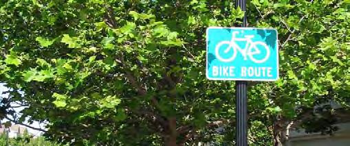
Signed Shared Roadways are facilities shared with motor vehicles. They are typically used on roads with low speeds and traffic volumes, however can be used on higher volume roads with wide outside lanes or shoulders. A motor vehicle driver will usually have to cross over into the adjacent travel lane to pass a bicyclist, unless a wide outside lane or shoulder is provided.
Lane width varies depending on roadway configuration.
Bicycle Route signage (D11-1) should be applied at intervals frequent enough to keep bicyclists informed of changes in route direction and to remind motorists of the presence of bicyclists. Commonly, this includes placement at:
Beginning or end of Bicycle Route.
At major changes in direction or at intersections with other bicycle routes.

At intervals along bicycle routes not to exceed ½ mile.
Signed Shared Roadways serve either to provide continuity with other bicycle facilities (usually bike lanes) or to designate preferred routes through high-demand corridors. This configuration differs from a Bicycle Boulevard due to a lack of traffic calming, wayfinding, pavement markings and other enhancements designed to provide a higher level of comfort for a broad spectrum of users.
AASHTO. (2012). Guide for the Development of Bicycle Facilities. FHWA. (2009). Manual on Uniform Traffic Control Devices.
Maintenance needs for bicycle wayfinding signs are similar to other signs, and will need periodic replacement due to wear.
A marked shared roadway is a general purpose travel lane marked with shared lane markings (SLM) used to encourage bicycle travel and proper positioning within the lane.
In constrained conditions, the SLMs are placed in the middle of the lane to discourage unsafe passing by motor vehicles. On a wide outside lane, the SLMs can be used to promote bicycle travel to the right of motor vehicles.
In all conditions, SLMs should be placed outside of the door zone of parked cars.
In constrained conditions, preferred placement is in the center of the travel lane to minimize wear and promote single file travel.
Minimum placement of SLM marking centerline is 11 feet from edge of curb where on-street parking is present, 4 feet from edge of curb with no parking. If parking lane is wider than 7.5 feet, the SLM should be moved further out accordingly.
Consider modifications to signal timing to induce a bicycle-friendly travel speed for all users.
When placed adjacent to parking, SLMs should be outside of the “Door Zone.”
Minimum placement is 11’ from curb.
MUTCD R4-11 (optional)
MUTCD D11-1 (optional)
Placement in center of travel lane is preferred in constrained conditions.
Bike Lanes should be considered on roadways with outside travel lanes wider than 15 feet, or where other lane narrowing or removal strategies may provide adequate road space. SLMs shall not be used on shoulders, in designated Bike Lanes, or to designate Bicycle Detection at signalized intersections. (MUTCD 9C.07)

This configuration differs from a Bicycle Boulevard due to a lack of traffic calming, wayfinding, and other enhancements designed to provide a higher level of comfort for a broad spectrum of users.
AASHTO. (2012). Guide for the Development of Bicycle Facilities. FHWA. (2009). Manual on Uniform Traffic Control Devices. NACTO. (2012). Urban Bikeway Design Guide. NCDOT. (2000). Traditional Neighborhood Development (TND) Guidelines.
Placing SLMs between vehicle tire tracks will increase the life of the markings and minimize the long-term cost of the treatment.
Bicycle boulevards are a special class of shared roadways designed for a broad spectrum of bicyclists. They are low-volume, low-speed local streets modified to enhance bicyclist comfort by using treatments such as signage, pavement markings, traffic calming and/or traffic reduction, and intersection modifications. These treatments allow through movements of bicyclists while discouraging similar through-trips by non-local motorized traffic.
Signs and pavement markings are the minimum treatments necessary to designate a street as a bicycle boulevard.
Bicycle boulevards should have a maximum posted speed of 25 mph. Use traffic calming to maintain an 85th percentile speed below 22 mph.
Implement volume control treatments based on the context of the bicycle boulevard, using engineering judgment. Target motor vehicle volumes range from 1,000 to 3,000 vehicles per day.
Intersection crossings should be designed to enhance safety and minimize delay for bicyclists.Materials and Maintenance Vegetation should be regularly trimmed to maintain visibility and attractiveness.
Signs and Pavement Markings identify the street as a bicycle priority route.
Enhanced Crossings use signals, beacons, and road geometry to increase safety at major intersections.
Partial Closures and other volume management tools limit the number of cars traveling on the bicycle boulevard.
Speed Humps manage driver speed.
Curb Extensions shorten pedestrian crossing distance.

Mini Traffic Circles slow drivers in advance of intersections.
Bicycle boulevard retrofits to local streets are typically located on streets without existing signalized accommodation at crossings of collector and arterial roadways. Without treatments for bicyclists, these intersections can become major barriers along the bicycle boulevard and compromise safety.
Traffic calming can deter motorists from driving on a street. Anticipate and monitor vehicle volumes on adjacent streets to determine whether traffic calming results in inappropriate volumes. Traffic calming can be implemented on a trial basis.
Alta Planning + Design and IBPI. (2009). Bicycle Boulevard Planning and Design Handbook. BikeSafe. (No Date). Bicycle countermeasure selection system. Ewing, Reid. (1999). Traffic Calming: State of the Practice. Ewing, Reid and Brown, Steven. (2009). U.S. Traffic Calming Manual.
Vegetation should be regularly trimmed to maintain visibility and attractiveness.
Designated exclusively for bicycle travel, separated bikeways are segregated from vehicle travel lanes by striping, and can include pavement stencils and other treatments. Separated bikeways are most appropriate on arterial and collector streets where higher traffic volumes and speeds warrant greater separation.


Separated bikeways can increase safety and promote proper riding by:

• Defining road space for bicyclists and motorists, reducing the possibility that motorists will stray into the bicyclists’ path.
• Discouraging bicyclists from riding on the sidewalk.
• Reducing the incidence of wrong way riding.
• Reminding motorists that bicyclists have a right to the road.
This section includes:
• Shoulder Bikeways
• Bicycle Lanes
• Buffered Bike Lanes

• Uphill Bicycle Climbing Lane
• Cycle Tracks

Typically found in less-dense areas, shoulder bikeways are paved roadways with striped shoulders (4’+) wide enough for bicycle travel. Shoulder bikeways often, but not always, include signage alerting motorists to expect bicycle travel along the roadway. Shoulder bikeways should be considered a temporary treatment, with full bike lanes planned for construction when the roadway is widened or completed with curb and gutter. This type of treatment is not typical in urban areas and should only be used where constraints exist.
4 foot minimum width. Greater widths preferred.
If it is not possible to meet minimum bicycle lane dimensions, a reduced width paved shoulder can still improve conditions for bicyclists on constrained roadways. In these situations, a minimum of 3 feet of operating space should be provided.

A wide outside lane may be sufficient accommodation for bicyclists on streets with insufficient width for bike lanes but which do have space available to provide a wider (14’-16’) outside travel lane. Consider configuring as a marked shared roadway in these locations.
Where feasible, roadway widening should be performed with pavement resurfacing jobs.
AASHTO. (2012). Guide for the Development of Bicycle Facilities. FHWA. (2009). Manual on Uniform Traffic Control Devices.
NCDOT. (1994). Bicycle Facilities Planning and Design Guidelines.
Paint can wear more quickly in high traffic areas or in winter climates. Shoulder bikeways should be cleared of snow through routine snow removal operations.
Bike lanes designate an exclusive space for bicyclists through the use of pavement markings and signage. The bike lane is located adjacent to motor vehicle travel lanes and is used in the same direction as motor vehicle traffic. Bike lanes are typically on the right side of the street, between the adjacent travel lane and curb, road edge or parking lane.

Many bicyclists, particularly less experienced riders, are more comfortable riding on a busy street if it has a striped and signed bikeway than if they are expected to share a lane with vehicles.
4 foot minimum when no curb and gutter is present.
5 foot minimum when adjacent to curb and gutter or 3 feet more than the gutter pan width if the gutter pan is wider than 2 feet.
14.5 foot preferred from curb face to edge of bike lane. (12 foot minimum).
7 foot maximum width for use adjacent to arterials with high travel speeds. Greater widths may encourage motor vehicle use of bike lane.
MUTCD R3-17 (optional)
4’ minimum ridable surface outside of gutter seam.
6” white line.
4” white line or parking “Ts.”
14.5’ preferred.
Wider bicycle lanes are desirable in certain situations such as on higher speed arterials (45 mph+) where use of a wider bicycle lane would increase separation between passing vehicles and bicyclists. Appropriate signing and stenciling is important with wide bicycle lanes to ensure motorists do not mistake the lane for a vehicle lane or parking lane. Consider Buffered Bicycle Lanes when further separation is desired.
AASHTO. (2012). Guide for the Development of Bicycle Facilities. FHWA. (2009). Manual on Uniform Traffic Control Devices. NACTO. (2012). Urban Bikeway Design Guide. NCDOT. (2000). Traditional Neighborhood Development (TND) Guidelines.
NCDOT. (1994). Bicycle Facilities Planning and Design Guidelines.
Paint can wear more quickly in high traffic areas or in winter climates. Bicycle lanes should be cleared of snow through routine snow removal operations.
Buffered bike lanes are conventional bicycle lanes paired with a designated buffer space, separating the bicycle lane from the adjacent motor vehicle travel lane and/or parking lane. Buffered bike lanes are allowed as per MUTCD guidelines for buffered preferential lanes (section 3D-01).

Buffered bike lanes are designed to increase the space between the bike lane and the travel lane or parked cars. This treatment is appropriate for bike lanes on roadways with high motor vehicle traffic volumes and speed, adjacent to parking lanes, or a high volume of truck or oversized vehicle traffic.
Parking side buffer designed to discourage riding in the “door zone.”
Where bicyclist volumes are high or where bicyclist speed differentials are significant, the desired bicycle travel area width is 7 feet.
Buffers should be at least 2 feet wide. If 3 feet or wider, mark with diagonal or chevron hatching. For clarity at driveways or minor street crossings, consider a dotted line or colored pavement for the inside buffer boundary where cars are expected to cross.
MUTCD R3-17 (optional)Color may be used at the beginning of each block to discourage motorists from entering the buffered lane
Frequency of right turns by motor vehicles at major intersections should determine whether continuous or truncated buffer striping should be used approaching the intersection. Commonly configured as a buffer between the bicycle lane and motor vehicle travel lane, a parking side buffer may also be provided to help bicyclists avoid the ‘door zone’ of parked cars.
AASHTO. (2012). Guide for the Development of Bicycle Facilities.
FHWA. (2009). Manual on Uniform Traffic Control Devices. (3D-01)
NACTO. (2012). Urban Bikeway Design Guide.
Paint can wear more quickly in high traffic areas or in winter climates. Bicycle lanes should be cleared of snow through routine snow removal operations.
Uphill bike lanes (also known as “climbing lanes”) enable motorists to safely pass slower-speed bicyclists, thereby improving conditions for both travel modes.
Uphill bike lanes should be 6-7 feet wide (wider lanes are preferred because extra maneuvering room on steep grades can benefit bicyclists).
Can be combined with Shared Lane Markings for downhill bicyclists who can more closely match prevailing traffic speeds.
MUTCD R3-17 (optional)
6-7’ width preferred
May be paired with shared lane markings on downhill side
This treatment is typically found on retrofit projects as newly constructed roads should provide adequate space for bicycle lanes in both directions of travel. Accommodating an uphill bicycle lane often includes delineating on-street parking (if provided), narrowing travel lanes and/or shifting the centerline if necessary.

NACTO. (2012). Urban Bikeway Design Guide. AASHTO. (2012). Guide for the Development of Bicycle Facilities.
FHWA. (2009). Manual on Uniform Traffic Control Devices.
Paint can wear more quickly in high traffic areas or in winter climates. Bicycle lanes should be cleared of snow through routine snow removal operations.
A cycle track is an exclusive bike facility that combines the user experience of a separated path with the on-street infrastructure of a conventional bike lane. A cycle track is physically separated from motor traffic and distinct from the sidewalk. Cycle tracks have different forms but all share common elements—they provide space that is intended to be exclusively or primarily used by bicycles, and are separated from motor vehicle travel lanes, parking lanes, and sidewalks.
Raised cycle tracks may be at the level of the adjacent sidewalk or set at an intermediate level between the roadway and sidewalk to separate the cycle track from the pedestrian area.
Cycle tracks should ideally be placed along streets with long blocks and few driveways or mid-block access points for motor vehicles.
7 foot recommended minimum to allow passing. 5 foot minimum width in constrained locations.

Cycle tracks located on one-way streets have fewer potential conflict areas than those on two-way streets.
12 foot recommended minimum for two-way facility. 8 foot minimum in constrained locations
If possible, separate cycle track and pedestrian zone with a furnishing area.
The cycle track shall be located between the parking lane and the sidewalk.3’ parking buffer.
Cycle track can be raised or at street level.
Special consideration should be given at transit stops to manage bicycle and pedestrian interactions. Driveways and minor street crossings are unique challenges to cycle track design. Parking should be prohibited within 30 feet of the intersection to improve visibility. Color, yield markings and “Yield to Bikes” signage should be used to identify the conflict area and make it clear that the cycle track has priority over entering and exiting traffic. If configured as a raised cycle track, the crossing should be raised so that the sidewalk and cycle track maintain their elevation through the crossing.
NACTO. (2012). Urban Bikeway Design Guide.
In cities with winter climates, barrier separated and raised cycle tracks may require special equipment for snow removal.
Intersections are junctions at which different modes of transportation meet and facilities overlap. An intersection facilitates the interchange between bicyclists, motorists, pedestrians and other modes in order to advance traffic flow in a safe and efficient manner. Designs for intersections with bicycle facilities should reduce conflict between bicyclists (and other vulnerable road users) and vehicles by heightening the level of visibility, denoting clear rightof-way and facilitating eye contact and awareness with other modes. Intersection treatments can improve both queuing and merging maneuvers for bicyclists, and are often coordinated with timed or specialized signals.
The configuration of a safe intersection for bicyclists may include elements such as color, signage, medians, signal detection and pavement markings. Intersection design should take into consideration existing and anticipated bicyclist, pedestrian and motorist movements. In all cases, the degree of mixing or separation between bicyclists and other modes is intended to reduce the risk of crashes and increase bicyclist comfort. The level of treatment required for bicyclists at an intersection will depend on the bicycle facility type used, whether bicycle facilities are intersecting, and the adjacent street function and land use.


This section includes:
• Bike Lanes at Right Turn Only Lanes

• Colored Bike Lanes in Conflict Areas
• Combined Bike Lane/Turn Lane
• Intersection Crossing Markings

• Bicycles at Single Lane Roundabouts

The appropriate treatment at right-turn lanes is to place the bike lane between the right-turn lane and the right-most through lane or, where right-of-way is insufficient, to use a shared bike lane/turn lane.
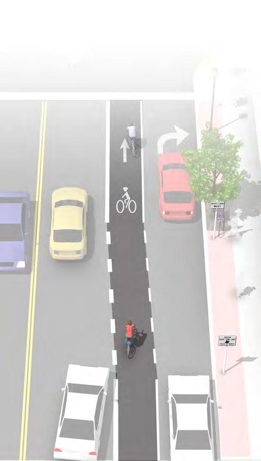
The design (right) illustrates a bike lane pocket, with signage indicating that motorists should yield to bicyclists through the conflict area.
At auxiliary right turn only lanes (add lane):
Continue existing bike lane width; standard width of 5 to 6 feet or 4 feet in constrained locations.
Use signage to indicate that motorists should yield to bicyclists through the conflict area.
Consider using colored conflict areas to promote visibility of the mixing zone.
Where a through lane becomes a right turn only lane:
• Do not define a dotted line merging path for bicyclists.
• Drop the bicycle lane in advance of the merge area.
• Use shared lane markings to indicate shared use of the lane in the merging zone.
Colored pavement may be used in the weaving area to increase visibility and awareness of potential conflict.
MUTCD R4-4 (optional)
Optional dotted lines.
For other potential approaches to providing accommodations for bicyclists at intersections with turn lanes, please see shared bike lane/turn lane, bicycle signals, and colored bike facilities.
AASHTO. (2012). Guide for the Development of Bicycle Facilities.
FHWA. (2009). Manual on Uniform Traffic Control Devices. NACTO. (2012). Urban Bikeway Design Guide.
Because the effectiveness of markings depends entirely on their visibility, maintaining markings should be a high priority.

Colored pavement within a bicycle lane increases the visibility of the facility and reinforces priority of bicyclists in conflict areas.
Green colored pavement was given interim approval by the Federal Highways Administration in March 2011. See interim approval for specific color standards.
The colored surface should be skid resistant and retro-reflective.
A “Yield to Bikes” sign should be used at intersections or driveway crossings to reinforce that bicyclists have the right-of-way in colored bike lane areas.
Normal white dotted edge lines should define colored space.
Variant of R10-15 or R1-5
Evaluations performed in Portland, OR, St. Petersburg, FL and Austin, TX found that significantly more motorists yielded to bicyclists and slowed or stopped before entering the conflict area after the application of the colored pavement when compared with an uncolored treatment.
FHWA. (2011). Interim Approval (IA-14) has been granted. Requests to use green colored pavement need to comply with the provisions of Paragraphs 14 through 22 of Section 1A.10 NACTO. (2012). Urban Bikeway Design Guide.
Because the effectiveness of markings depends entirely on their visibility, maintaining markings should be a high priority.
The combined bicycle/right turn lane places a standard-width bike lane on the left side of a dedicated right turn lane. A dotted line delineates the space for bicyclists and motorists within the shared lane. This treatment includes signage advising motorists and bicyclists of proper positioning within the lane.
This treatment is recommended at intersections lacking sufficient space to accommodate both a standard through bike lane and right turn lane.
Maximum shared turn lane width is 13 feet; narrower is preferable.
Bike Lane pocket should have a minimum width of 4 feet with 5 feet preferred.
A dotted 4 inch line and bicycle lane marking should be used to clarify bicyclist positioning within the combined lane, without excluding cars from the suggested bicycle area.
A “Right Turn Only” sign with an “Except Bicycles” plaque may be needed to make it legal for through bicyclists to use a right turn lane.
Short length turn pockets encourage slower motor vehicle speeds.
Case studies cited by the Pedestrian and Bicycle Information Center indicate that this treatment works best on streets with lower posted speeds (30 MPH or less) and with lower traffic volumes (10,000 ADT or less). May not be appropriate for high-speed arterials or intersections with long right turn lanes. May not be appropriate for intersections with large percentages of right-turning heavy vehicles.
NACTO. (2012). Urban Bikeway Design Guide. This treatment is currently slated for inclusion in the next edition of the AASHTO Guide for the Development of Bicycle Facilities

Locate markings out of tire tread to minimize wear. Because the effectiveness of markings depends on their visibility, maintaining markings should be a high priority.

Bikeways that cross railroad tracks at a diagonal may cause steering difficulties or loss of control for bicyclists due to slippery surfaces, degraded rough materials, and the size of the flangeway gaps.
Angled track crossings also limit sight triangles, impacting the ability to see oncoming trains.
Bicyclist crashes at railroad tracks are often sudden and unexpected. Improvements to track placement, surface quality, flangeway opening width and crossing angle can minimize risks to people riding.
6 ft minimum shoulder/bike lane width.
If the skew angle is less than 45 degrees, special attention should be given to the sidewalk and bicycle alignment to improve the approach angle to at least 60 degrees (90 degrees preferred where possible).
Consider posting W-10 or W-12 signs to alert bicyclists.
Sight triangles of 50 feet by 100 feet will be provided at the railroad and street right of way. (Sight triangles are measured from the centerline of the railroad track.
Allow bicyclists access to the full widened pavement area to allow them to choose the path that suits their needs best.
Improved sight triangle.
Crossing design and implementation is a collaboration between the railroad company and highway agency. The railroad company is responsible for the crossbucks, flashing lights and gate mechanisms, and the highway agency is responsible for advance warning markings and signs. Warning devices should be recommended for each specific situation by a qualified engineer based on various factors including train frequency and speed, path and trail usage and sight distances.
AASHTO. Guide for the Development of Bicycle Facilities. 2012. FHWA. Manual on Uniform Traffic Control Devices. 2009.

TRB. TCRP 17: Integration of Light Rail Transit into City Streets. 1996. FHWA. Railroad-Highway Grade Crossing Handbook. 2007. NCDOT. Complete Street Planning and Design Guidelines. 2012. Rails-to-Trails Conservancy. Rails-with-Trails: A Preliminary Assessment of Safety and Grade Crossings. 2005.
Concrete is the preferred material for use at bikeway railroad crossings. Rubber crossings are ridable when new and dry, but become slippery when wet and degrade over time. (AASHTO 2012)
In single lane roundabouts it is important to indicate to motorists, bicyclists and pedestrians the rightof-way rules and correct way for them to circulate, using appropriately designed signage, pavement markings, and geometric design elements.
25 mph maximum circulating design speed.
Design approaches/exits to the lowest speeds possible.
Encourage bicyclists navigating the roundabout like motor vehicles to “take the lane.”
Maximize yielding rate of motorists to pedestrians and bicyclists at crosswalks.
Provide separated facilities for bicyclists who prefer not to navigate the roundabout on the roadway.
Crossings set back at least one car length from the entrance of the roundabout.
Truck apron can provide adequate clearance for longer vehicles.
Narrow circulating lane to discourage attempted passing by motorists.
Sidewalk should be wider to accommodate bicycle and pedestrian traffic.
Visible, well marked crossings alert motorists to the presence of bicyclists and pedestrians (W11-15 signage).
Bicycle ramps leading to a wide shared facility with pedestrians.
Bicycle exit ramp in line with bicycle lane.
Research indicates that while single-lane roundabouts may benefit bicyclists and pedestrians by slowing traffic, multi-lane roundabouts may present greater challenges and significantly increase safety problems for these users.

AASHTO. (2012). Guide for the Development of Bicycle Facilities.
FHWA. (2000). Roundabouts: An Informational Guide
FHWA. (2010). Roundabouts: An Informational Guide, Second Edition. NCHRP 672
Signage and striping require routine maintenance.


Bicycle pavement markings through intersections indicate the intended path of bicyclists through an intersection or across a driveway or ramp. They guide bicyclists on a safe and direct path through the intersection and provide a clear boundary between the paths of through bicyclists and either through or crossing motor vehicles in the adjacent lane.
See MUTCD Section 3B.08: “dotted line extensions”
Crossing striping shall be at least six inches wide when adjacent to motor vehicle travel lanes. Dotted lines should be two-foot lines spaced two to six feet apart.
Chevrons, shared lane markings, or colored bike lanes in conflict areas may be used to increase visibility within conflict areas or across entire intersections. Elephant’s Feet markings are common in Canada, and in use in Chicago, IL.


Additional markings such as chevrons, shared lane markings, or colored bike lanes in conflict areas are strategies currently in use in the United States and Canada. Cities considering the implementation of markings through intersections should standardize future designs to avoid confusion.
AASHTO. (2012). Guide for the Development of Bicycle Facilities.
FHWA. (2009). Manual on Uniform Traffic Control Devices. (3A.06)
NACTO. (2012). Urban Bikeway Design Guide.
Because the effectiveness of marked crossings depends entirely on their visibility, maintaining marked crossings should be a high priority.
A comprehensive system of signage ensures that information is provided regarding the safe and appropriate use of all facilities, both on-road and on greenways. The bicycle network should be signed seamlessly with other alternative transportation routes, such as bicycle routes from neighboring jurisdictions, trails, historic and/or cultural walking tours, and wherever possible, local transit systems.
Signage includes post- or pole-mounted signs and pavement striping. Signage is further divided into information signs, directional/wayfinding signs, regulatory signs and warning signs. Trail signage should conform to the Manual on Uniform Traffic Control Devices and the American Association of State Highway Transportation Official Guide for the Development of Bicycle Facilities. Bicycle signage should also be coordinated with local colleges and universities. Refer to Appendix G for an in-depth discussion of signage.
Share the Road signs remind motorists that bicyclists have the right to ride on the roadway and are used in areas where cyclists are common.
The “Bikes Allowed Use of Full Lane” sign is currently used on an experimental basis in several cities.
Implementing a well-planned and attractive system of signing can greatly enhance bikeway facilities by signaling their presence and location to both motorists and existing or potential bicycle users. Effective signage can encourage more bicycling by leading people to bikeways, and by creating a safe and efficient transportation option for local residents and visitors.
The signage examples on page 5-26 show a number of different signs and markings, both on poles and on the roadway. Wayfinding signs such as these improve the clarity of travel direction while illustrating that destinations are only a short ride away. The signs shown are provided only as a point of reference for the purposes of these guidelines.
Regulatory and warning bicycle signage like the examples shown on page 5-26 should conform to the Manual on Uniform Traffic Control Devices (MUTCD). The signage on page B-25 are examples of regulatory signs for bicycle (their labels are sign reference numbers for the MUTCD).
The “Share the Road” sign (to the left), is designed to advise motorists that bicyclists are allowed to share and have the right to cycle on narrow roadways with motor vehicles. For more on the “Share the Road Initiative” go to: http://ncdot.org/transit/bicycle/ safety/programs_initiatives/share.html

Innovative signage is often developed to increase bicycle awareness and improve visibility (such as ‘Bikes Allowed Use of Full Lane’, bottom left). Special purpose signs to be installed on public roadways in North Carolina must be approved by NCDOT’s Traffic Control Devices Committee and/or the jurisdictions located within the Croatan Region. New designs can be utilized on an experimental basis with NCDOT approval.

The ability to navigate through a town is informed by landmarks, natural features and other visual cues. Signs throughout the town should indicate to bicyclists:
• Direction of travel
• Location of destinations
• Travel time/distance to those destinations
These signs will increase users’ comfort and accessibility to the bicycle systems.
Signage can serve both wayfinding and safety purposes including:
• Helping to familiarize users with the bicycle network
• Helping users identify the best routes to destinations
• Helping to address misconceptions about time and distance
• Helping overcome a “barrier to entry” for people who are not frequent bicyclists (e.g., “interested but concerned” bicyclists)
A community-wide bicycle wayfinding signage plan would identify:
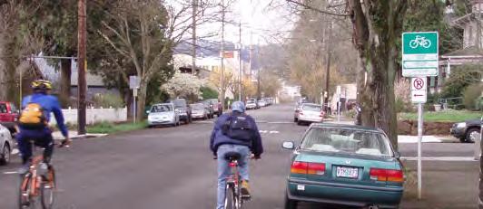
• Sign locations
• Sign type – what information should be included and design features
• Destinations to be highlighted on each sign – key destinations for bicyclists

• Approximate distance and travel time to each destination
Bicycle wayfinding signs also visually cue motorists that they are driving along a bicycle route and should use caution. Signs are typically placed at key locations leading to and along bicycle routes, including the intersection of multiple routes. Too many road signs tend to clutter the right-of-way, and it is recommended that these signs be posted at a level most visible to bicyclists rather than per vehicle signage standards.
This section includes:
A bicycle wayfinding system consists of comprehensive signing and/or pavement markings to guide bicyclists to their destinations along preferred bicycle routes. There are three general types of wayfinding signs:
Indicate to bicyclists that they are on a designated bikeway. Make motorists aware of the bicycle route. This signage can include destinations and distance/time, but does not include arrows.

Indicate where a bikeway turns from one street onto another street. This signage can be used with pavement markings, and does include destinations and arrows.
Mark the junction of two or more bikeways and informs bicyclists of the designated bike route to access key destinations. Destinations and arrows, distances and travel times are optional but recommended.
A customized alternative design may be used to include pedestrian-oriented travel times, local town logos, and sponsorship branding.
There is no standard color for bicycle wayfinding signage. Section 1A.12 of the MUTCD establishes the general meaning for signage colors. Green is the color used for directional guidance and is the most common color of bicycle wayfinding signage in the US, including those in the MUTCD.
AASHTO. (2012). Guide for the Development of Bicycle Facilities.
FHWA. (2009). Manual on Uniform Traffic Control Devices. NACTO. (2012). Urban Bikeway Design Guide.
Maintenance needs for bicycle wayfinding signs are similar to other signs and will need periodic replacement due to wear.
Signs are typically placed at decision points along bicycle routes – typically at the intersection of two or more bikeways and at other key locations leading to and along bicycle routes.
Near-side of intersections in advance of a junction with another bicycle route.
Along a route to indicate a nearby destination.
Every ¼ to ½ mile on off-street facilities and every 2 to 3 blocks along on-street bicycle facilities, unless another type of sign is used (e.g., within 150 ft of a turn or decision sign). Should be placed soon after turns to confirm destination(s). Pavement markings can also act as confirmation that a bicyclist is on a preferred route.
Near-side of intersections where bike routes turn (e.g., where the street ceases to be a bicycle route or does not go through). Pavement markings can also indicate the need to turn to the bicyclist.
It can be useful to classify a list of destinations for inclusion on the signs based on their relative importance to users throughout the area. A particular destination’s ranking in the hierarchy can be used to determine the physical distance from which the locations are signed. For example, primary destinations (such as the downtown area) may be included on signage up to five miles away. Secondary destinations (such as a transit station) may be included on signage up to two miles away. Tertiary destinations (such as a park) may be included on signage up to one mile away.
AASHTO. (2012). Guide for the Development of Bicycle Facilities.
FHWA. (2009). Manual on Uniform Traffic Control Devices. NACTO. (2012). Urban Bikeway Design Guide.
Maintenance needs for bicycle wayfinding signs are similar to other signs and will need periodic replacement due to wear.
Most major streets are characterized by conditions (e.g., high vehicle speeds and/or volumes) for which dedicated bike lanes are the most appropriate facility to accommodate safe and comfortable riding. Although opportunities to add bike lanes through roadway widening may exist in some locations, many major streets have physical and other constraints that would require street retrofit measures within existing curb-to-curb widths. As a result, much of the guidance provided in this section focuses on effectively reallocating existing street width through striping modifications to accommodate dedicated bike lanes.


Although largely intended for major streets, these measures may be appropriate for any roadway where bike lanes would be the best accommodation for bicyclists.


This section includes:
• Roadway Widening
• Lane Narrowing
• Lane Reconfiguration
• Parking Reduction
Bike lanes can be accommodated on streets with excess right-of-way through shoulder widening. Although roadway widening incurs higher expenses compared with re-striping projects, bike lanes can be added to streets currently lacking curbs, gutters and sidewalks without the high costs of major infrastructure reconstruction.
Guidance on bicycle lanes applies to this treatment.
4 foot minimum width when no curb and gutter is present.
6 foot width preferred.
Roadway widening is most appropriate on roads lacking curbs, gutters and sidewalks.


If it is not possible to meet minimum bicycle lane dimensions, a reduced width paved shoulder can still improve conditions for bicyclists on constrained roadways. In these situations, a minimum of 3 feet of operating space should be provided.
AASHTO. (2012). Guide for the Development of Bicycle Facilities.
The extended bicycle area should not contain any rough joints where bicyclists ride. Saw or grind a clean cut at the edge of the travel lane, or feather with a fine mix in a non-ridable area of the roadway.
Lane narrowing utilizes roadway space that exceeds minimum standards to provide the needed space for bike lanes. Many roadways have existing travel lanes that are wider than those prescribed in local and national roadway design standards, or which are not marked. Most standards allow for the use of 11 foot and sometimes 10 foot wide travel lanes to create space for bike lanes.
Vehicle lane width:
Before: 10-15 feet After: 10-11 feet
Bicycle lane width: Guidance on Bicycle Lanes applies to this treatment.
Special consideration should be given to the amount of heavy vehicle traffic and horizontal curvature before the decision is made to narrow travel lanes. Center turn lanes can also be narrowed in some situations to free up pavement space for bike lanes.
AASHTO supports reduced width lanes in A Policy on Geometric Design of Highways and Streets : “On interrupted-flow operation conditions at low speeds (45 mph or less), narrow lane widths are normally adequate and have some advantages.”


AASHTO. (2012). Guide for the Development of Bicycle Facilities.
AASHTO. (2004). A Policy on Geometric Design of Highways and Streets.
Repair rough or uneven pavement surface. Use bicycle compatible drainage grates. Raise or lower existing grates and utility covers so they are flush with the pavement.
The removal of a single travel lane will generally provide sufficient space for bike lanes on both sides of a street. Streets with excess vehicle capacity provide opportunities for bike lane retrofit projects.
Vehicle lane width: Width depends on project. No narrowing may be needed if a lane is removed.


Bicycle lane width: Guidance on Bicycle Lanes applies to this treatment.
BEFORE
11-12’ Travel
11’ Travel
Depending on a street’s existing configuration, traffic operations, user needs and safety concerns, various lane reduction configurations may apply. For instance, a four-lane street (with two travel lanes in each direction) could be modified to provide one travel lane in each direction, a center turn lane, and bike lanes. Prior to implementing this measure, a traffic analysis should identify potential impacts.
AASHTO. (2012). Guide for the Development of Bicycle Facilities. FHWA. (2010). Evaluation of Lane Reduction “Road Diet” Measures on Crashes. Publication Number: FHWA-HRT-10-053
Repair rough or uneven pavement surface. Use bicycle compatible drainage grates. Raise or lower existing grates and utility covers so they are flush with the pavement.
Bike lanes can replace one or more on-street parking lanes on streets where excess parking exists and/or the importance of bike lanes outweighs parking needs. For example, parking may be needed on only one side of a street. Eliminating or reducing on-street parking also improves sight distance for bicyclists in bike lanes and for motorists on approaching side streets and driveways.
Vehicle lane width:
Parking lane width depends on project. No travel lane narrowing may be required depending on the width of the parking lanes.
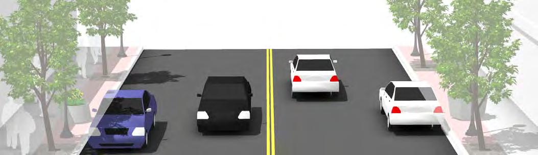

Bicycle lane width:
Guidance on Bicycle Lanes applies to this treatment.
Removing or reducing on-street parking to install bike lanes requires comprehensive outreach to the affected businesses and residents. Prior to reallocating on-street parking for other uses, a parking study should be performed to gauge demand and to evaluate impacts to people with disabilities.
AASHTO. (2012). Guide for the Development of Bicycle Facilities.
AASHTO. (2004). A Policy on Geometric Design of Highways and Streets.
Repair rough or uneven pavement surface. Use bicycle compatible drainage grates. Raise or lower existing grates and utility covers so they are flush with the pavement.
A multi-use path (also known as a greenway) allows for two-way, off-street bicycle use and also may be used by pedestrians, skaters, wheelchair users, joggers and other non-motorized users. These facilities are frequently found in parks, along rivers, beaches, and in greenbelts or utility corridors where there are few conflicts with motorized vehicles. Path facilities can also include amenities such as lighting, signage, and fencing (where appropriate).


Key features of multi-use paths include:
• Frequent access points from the local road network.
• Directional signs to direct users to and from the path.
• A limited number of at-grade crossings with streets or driveways.
• Terminating the path where it is easily accessible to and from the street system.

• Separate treads for pedestrians and bicyclists when heavy use is expected.

•
•
•
•
Shared use paths can provide a desirable facility, particularly for recreation, and users of all skill levels preferring separation from traffic. Bicycle paths should generally provide directional travel opportunities not provided by existing roadways.
• 8 feet is the minimum allowed for a two-way bicycle path and is only recommended for low traffic situations.
• 10 feet is recommended in most situations and will be adequate for moderate to heavy use.
• 12 feet is recommended for heavy use situations with high concentrations of multiple users. A separate track (5’ minimum) can be provided for pedestrian use.
• A 2 foot or greater shoulder on both sides of the path should be provided. An additional foot of lateral clearance (total of 3’) is required by the MUTCD for the installation of signage or other furnishings.
• Clearance to overhead obstructions should be 8 feet minimum, with 10 feet recommended.
• When striping is required, use a 4 inch dashed yellow centerline stripe with 4 inch solid white edge lines.
• Solid centerlines can be provided on tight or blind corners, and on the approaches to roadway crossings.
Terminate the path where it is easily accessible to and from the street system, preferably at a controlled intersection or at the beginning of a dead-end street.
8-12’ depending on usage
The AASHTO Guide for the Development of Bicycle Facilities generally recommends against the development of shared use paths along roadways. Also known as “sidepaths”, these facilities create a situation where a portion of the bicycle traffic rides against the normal flow of motor vehicle traffic and can result in wrong-way riding when either entering or exiting the path.

AASHTO. (2012). Guide for the Development of Bicycle Facilities. FHWA. (2009). Manual on Uniform Traffic Control Devices. Flink, C. (1993). Greenways: A Guide To Planning Design And Development.
Asphalt is the most common surface for bicycle paths. The use of concrete for paths has proven to be more durable over the long term. Saw cut concrete joints rather than troweled improve the experience of path users.
Utility and waterway corridors often offer excellent multi-use path development and bikeway gap closure opportunities. Utility corridors typically include powerline and sewer corridors, while waterway corridors include canals, drainage ditches, rivers, and beaches. These corridors offer excellent transportation and recreation opportunities for bicyclists of all ages and skills.
Multi-use paths in utility corridors should meet or exceed general design practices. If additional width allows, wider paths, and landscaping are desirable.
Any access point to the path should be well-defined with appropriate signage designating the pathway as a bicycle facility and prohibiting motor vehicles.
Public access to the multi-use path may be prohibited during the following events:
• Canal/flood control channel or other utility maintenance activities
• Inclement weather or the prediction of storm conditions
Similar to railroads, public access to flood control channels or canals is undesirable by all parties. Hazardous materials, deep water or swift current, steep, slippery slopes, and debris all constitute risks for public access. Appropriate fencing may be required to keep path users within the designated travel way. Creative design of fencing is encouraged to make the path facility feel welcoming to the user.
AASHTO. (2012). Guide for the Development of Bicycle Facilities. FHWA. (2009). Manual on Uniform Traffic Control Devices.
Flink, C. (1993). Greenways: A Guide To Planning Design And Development.
Asphalt is the most common surface for bicycle paths. The use of concrete for paths has proven to be more durable over the long term. Saw cut concrete joints rather than troweled improve the experience of path users.

Commonly referred to as Rails-to-Trails or Rail-Trails, these projects convert vacated rail corridors into offstreet paths. Rail corridors offer several advantages, including relatively direct routes between major destinations and generally flat terrain.
In some cases, rail owners may rail-bank their corridors as an alternative to a complete abandonment of the line, thus preserving the rail corridor for possible future use.
The railroad may form an agreement with any person, public or private, who would like to use the banked rail line as a trail or linear park until it is again needed for rail use. Municipalities should acquire abandoned rail rightsof-way whenever possible to preserve the opportunity for trail development.
Multi-use paths in abandoned rail corridors should meet or exceed general design practices. If additional width allows, wider paths, and landscaping are desirable.
In full conversions of abandoned rail corridors, the sub-base, superstructure, drainage, bridges, and crossings are already established. Design becomes a matter of working with the existing infrastructure to meet the needs of a rail-trail.
If converting a rail bed adjacent to an active rail line, see Multi-use paths in Existing Active Rail Corridors.
Where possible, leave as much as the ballast in place as possible to disperse the weight of the rail-trail surface and to promote drainage.
Railroad grades are very gradual. This makes rails-totrails attractive to many users, and easier to adapt to ADA guidelines.
It is often impractical and costly to add material to existing railroad bed fill slopes. This results in trails that meet minimum path widths, but often lack preferred shoulder and lateral clearance widths.
Rail-to-trails can involve many challenges including the acquisition of the right of way, cleanup and removal of toxic substances, and rehabilitation of tunnels, trestles and culverts. A structural engineer should evaluate existing railroad bridges for structural integrity to ensure they are capable of carrying the appropriate design loads.
AASHTO. (2012). Guide for the Development of Bicycle Facilities. FHWA. (2009). Manual on Uniform Traffic Control Devices.
Flink, C. (1993). Greenways: A Guide To Planning Design And Development.
Asphalt is the most common surface for bicycle paths. The use of concrete for paths has proven to be more durable over the long term. Saw cut concrete joints rather than troweled improve the experience of path users.

Multi-use paths in Active Rail Corridors
Rails-with-Trails projects typically consist of paths adjacent to active railroads. It should be noted that some constraints could impact the feasibility of rail-with-trail projects. In some cases, space needs to be preserved for future planned freight, transit or commuter rail service. In other cases, limited right-of-way width, inadequate setbacks, concerns about safety/trespassing, and numerous mid-block crossings may affect a project’s feasibility.
Multi-use paths in active rail corridors should meet or exceed general design standards. If additional width allows, wider paths, and landscaping are desirable.

If required, fencing should be a minimum of 5 feet in height with higher fencing than usual next to sensitive areas such as switching yards. Setbacks from the active rail line will vary depending on the speed and frequency of trains, and available right-of-way.
Separation greater than 20’ will result in a more pleasant trail user experience and should be pursued where possible.
Railroads typically require fencing with all rail-with-trail projects. Concerns with trespassing and security can vary with the amount of train traffic on the adjacent rail line and the setting of the multi-use path, i.e. whether the section of track is in an urban or rural setting.
AASHTO. (2012). Guide for the Development of Bicycle Facilities. FHWA. (2009). Manual on Uniform Traffic Control Devices. FHWA. (2002). Rails-with-Trails: Lessons Learned.
Concrete paths may cost more to build than asphalt paths but do not become brittle, cracked and rough with age, or deformed by roots.
Neighborhood greenways are low-volume, low-speed streets modified to enhance bicyclist comfort by using treatments such as signage, pavement markings, traffic calming and/or traffic reduction, and intersection modifications. These treatments allow through movements of bicyclists while discouraging similar through-trips by nonlocal motorized traffic.
Signs and pavement markings are the minimum treatments necessary to designate a street as a neighborhood greenway.
Neighborhood greenways should have a maximum posted speed of 25 mph. Use traffic calming to maintain an 85th percentile speed below 22 mph.
Implement volume control treatments based on the context of the neighborhood greenway, using engineering judgment. Target motor vehicle volumes range from 1,000 to 3,000 vehicles per day.
Intersection crossings should be designed to enhance safety and minimize delay for bicyclists.
Signs and Pavement Markings identify the street as a pedestrian and bicycle priority route.
Enhanced Crossings use signals, beacons, and road geometry to increase safety at major intersections.
Partial Closures and other volume management tools limit the number of cars traveling on the neighborhood greenway.
Speed Humps manage driver speed.
Curb Extensions shorten pedestrian crossing distance.
Mini Traffic Circles slow drivers in advance of intersections.
Neighborhood greenway retrofits to local streets are typically located on streets without existing signalized accommodation at crossings of collector and arterial roadways. Without treatments to assist pedestrian crossing, these intersections can become major barriers along the neighborhood greenway and compromise safety.
Traffic calming can deter motorists from driving on a street. Anticipate and monitor vehicle volumes on adjacent streets to determine whether traffic calming results in inappropriate volumes.
Alta Planning + Design and IBPI. (2009). Bicycle Boulevard Planning and Design Handbook. BikeSafe. (No Date). Bicycle countermeasure selection system. Ewing, Reid. (1999). Traffic Calming: State of the Practice. Ewing, Reid and Brown, Steven. (2009). U.S. Traffic Calming Manual.
Maintenance needs for bicycle signs are similar to other signs. Signs will need periodic replacement due to wear.
Neighborhood accessways provide residential areas with direct bicycle and pedestrian access to parks, trails, greenspaces, and other recreational areas. They most often serve as small trail connections to and from the larger trail network, typically having their own rights-of-way and easements.
Additionally, these smaller trails can be used to provide bicycle and pedestrian connections between dead-end streets, cul-de-sacs, and access to nearby destinations not provided by the street network.

Neighborhood accessways should remain open to the public.
Trail pavement shall be at least 8’ wide to accommodate emergency and maintenance vehicles, meet ADA requirements and be considered suitable for multi-use.
Trail widths should be designed to be less than 8’ wide only when necessary to protect large mature native trees over 18” in caliper, wetlands or other ecologically sensitive areas.
Access trails should slightly meander whenever possible.
Neighborhood accessways should be designed into new subdivisions at every opportunity and should be required by town/county subdivision regulations.
For existing subdivisions, Neighborhood and homeowner association groups are encouraged to identify locations where such connects would be desirable. Nearby residents and adjacent property owners should be invited to provide landscape design input.
AASHTO. (2012). Guide for the Development of Bicycle Facilities. FHWA. (2009). Manual on Uniform Traffic Control Devices.
FHWA. (2006). Federal Highway Administration University Course on Bicycle and Pedestrian Transportation. Lesson 19: Greenways and Shared Use Paths.
Asphalt is the most common surface for bicycle paths. The use of concrete for paths has proven to be more durable over the long term. Saw cut concrete joints rather than troweled improve the experience of path users.
Sometimes referred to as footpaths or hiking trails, the natural surface trail is used along corridors that are environmentally-sensitive but can support bare earth, wood chip, washed stone, gravel, or boardwalk trails. Natural surface trails are a low-impact solution and found in areas with limited development or where a more primitive experience is desired.
Guidance presented in this section does not include considerations for bicycle users. Natural surface trails designed for bicycle users are typically known as single track trails.
Trails can vary in width from 18 inches to 6 feet or greater; vertical clearance should be maintained at ninefeet above grade.

Base preparation varies from machine-worked surfaces to those worn only by usage.
Trail surface can be made of dirt, rock, soil, forest litter, or other native materials. Some trails use crushed stone (a.k.a. “crush and run”) that contains about 4% fines by weight, and compacts with use.
Provide positive drainage for trail tread without extensive removal of existing vegetation; maximum slope is five percent (typical).
Trail erosion control measures include edging along the low side of the trail, steps and terraces to contain surface material, and water bars to direct surface water off the trail; use bedrock surface where possible to reduce erosion.
Flink, C. (1993). Greenways: A Guide To Planning Design And Development.
Consider implications for accessibility when weighing options for surface treatments.
A multi-use path allows for two-way, off-street bicycle use and also may be used by pedestrians, skaters, wheelchair users, joggers and other nonmotorized users. These facilities are frequently found in parks, along rivers, beaches, and in greenbelts or utility corridors where there are few conflicts with motorized vehicles.
Along roadways, these facilities create a situation where a portion of the bicycle traffic rides against the normal flow of motor vehicle traffic and can result in wrong-way riding where bicyclists enter or leave the path.
The AASHTO Guide for the Development of Bicycle Facilities generally recommends against the development of multi-use paths directly adjacent to roadways.
• 8 feet is the minimum allowed for a two-way bicycle path and is only recommended for low traffic situations.
• 10 feet is recommended in most situations and will be adequate for moderate to heavy use.
• 12 feet is recommended for heavy use situations with high concentrations of multiple users such as joggers, bicyclists, rollerbladers and pedestrians. A separate track (5’ minimum) can be provided for pedestrian use.
• Bicycle lanes should be provided as an alternate (more transportation-oriented) facility whenever possible.
Pay special attention to the entrance/exit of the path as bicyclists may continue to travel on the wrong side of the street.
W11-15, W169P in advance of cross street stop sign.
Crossings should be stop or yield controlled.
When designing a bikeway network, the presence of a nearby or parallel path should not be used as a reason to not provide adequate shoulder or bicycle lane width on the roadway, as the on-street bicycle facility will generally be superior to the “side path” for experienced bicyclists and those who are cycling for transportation purposes.
AASHTO. (2012). Guide for the Development of Bicycle Facilities.
NACTO. (2012). Urban Bikeway Design Guide. See entry on Raised Cycle Tracks.

NCDOT. (1994). Bicycle Facilities Planning and Design Guidelines.
Asphalt is the most common surface for bicycle paths. The use of concrete for paths has proven to be more durable over the long term. Saw cut concrete joints rather than troweled improve the experience of path users.
This plan recommends several different trail types to accommodate the variety of landscapes and opportunities that exist for trail development throughout the region. They range from forested footpaths to paved multi-use paths.
This Section Includes:
• Forest Service Gravel Roads
• Forest Service Gravel Road + Natural Surface Trails
• Multi-Use Paths
• Boardwalk
• Natural Surface Trails
• Multi-Use Paths – Roadway Corridor
• Boardwalk – Roadway Corridor
• Paved Shoulders – Roadway Corridor
• Rail-with-Trail – Landscaped Buffer
Potential applications for this plan: Could be used on existing forest service roads within the Croatan National Forest or other unpaved roads that generally have lower traffic volumes and lower speeds. This is recommended for many forest service roads in the near-term due to the relatively low costs of signage, safety education, and enforcement. Note that some forest service roads have similar cross sections, but are closed to motor vehicles, making them exclusive to bicyclists and pedestrians.

Potential applications for this plan: Could be
existing
within the Croatan National Forest or along other roadways in the region that have sufficient right-of-way for a parallel trail. In this situation pedestrians would be separated from vehicles and in more natural environments— ideal for MST routing.


Potential applications for this plan: Could be used along portions of proposed trail that are outside of roadway corridors and wetland areas. This trail type is desirable for multiple users and can be paved or unpaved, depending on the desired function. For example, bicyclists would be better served with a paved surface if the corridor is used for transportation purposes, whereas hikers preferring a more natural
Potential applications for this plan: where there are wetlands or drainage areas that require boardwalk for trail development. This type of trail may be essential for connecting short distances between other trail types or for longer stretches where there is no other trail alternative.


Potential applications for this plan: Could be used for foot travel along natural corridors throughout the study area , especially where a more natural experience and a lower environmental impact is desired — ideal for MST routing.

Potential applications for this plan: Could be used along roadways (or railroad corridors) throughout the study area where available right-of-way exists for the roadway. This type of trail may be essential along roadway corridors that offer no space for bicyclists or pedestrians along the road itself.
Potential applications for this plan: Could be used along roadways (or railroad corridors) throughout the study area where there are wetlands or drainage areas that require boardwalk for trail development. This type of trail may be essential along roadway corridors that offer no space for bicyclists or
Potential applications for this plan: Could be used along roadways throughout the study area where there is sufficient shoulder space to pave extra width beyond the edgeline stripe. Four to five-foot wide shoulders are recommended. However, if the full recommended width is not possible, even one extra foot of paved shoulder will improve conditions for current bicyclists.
When a sidewalk is available, pedestrians must use the sidewalk instead of walking on the roadway; which is defined as that part of the highway that is paved, graveled or otherwise improved for vehicle travel. When sidewalks are not provided, pedestrians walking along or on the highway should, when practicable, walk on the extreme left of the roadway or shoulder, facing traffic and must yield the rightof-way to traffic. [State Statute 20-174(d)]
Potential applications for this plan: Could be used along railroad corridors where there is sufficient right-of-way to include a landscaped buffer. Additional right-of-way should be pursued to allow for a buffer where none exists today.
Potential applications for this plan: Could be used along railroad corridors where there is not sufficient right-of-way to include a landscaped buffer.
Rail-with-Trail Case Studies and Resources: www.altaplanning.com/rails_with_trails_+_lessons+learned_+federal+rwt+study.aspx


At-grade roadway crossings can create potential conflicts between multi-use path users and motorists, however, well-designed crossings can mitigate many operational issues and provide a higher degree of safety and comfort for path users. This is evidenced by the thousands of successful facilities around the United States with at-grade crossings. In most cases, at-grade path crossings can be properly designed to provide a reasonable degree of safety and can meet existing traffic and safety standards. Path facilities that cater to bicyclists can require additional considerations due to the higher travel speed of bicyclists versus pedestrians.
Consideration must be given to adequate warning distance based on vehicle speeds and line of sight, with the visibility of any signs absolutely critical. Directing the active attention of motorists to roadway signs may require additional alerting devices such as a flashing beacon, roadway striping or changes in pavement texture. Signing for path users may include a standard “STOP” or “YIELD” sign and pavement markings, possibly combined with other features such as bollards or a bend in the pathway to slow bicyclists. Care must be taken not to place too many signs at crossings lest they begin to lose their visual impact.
A number of striping patterns have emerged over the years to delineate path crossings. A median stripe on the path approach will help to organize and warn path users. Crosswalk striping is typically a matter of local and State preference, and may be accompanied by pavement treatments to help warn and slow motorists. In areas where motorists do not typically yield to crosswalk users, additional measures may be required to increase compliance.

This section includes:
• Marked/Unsignalized Crossings
• Active Warning Beacons
• Route Users to Existing Signals
An unsignalized marked crossing typically consists of a marked crossing area, signage and other markings to slow or stop traffic. The approach to designing crossings at mid-block locations depends on an evaluation of vehicular traffic, line of sight, pathway traffic, use patterns, vehicle speed, road type, road width, and other safety issues such as proximity to major attractions.
When space is available, using a median refuge island can improve user safety by providing pedestrians and bicyclists space to perform the safe crossing of one side of the street at a time.
Refer to the FHWA report, “Safety Effects of Marked vs. Unmarked Crosswalks at Uncontrolled Locations” for specific volume and speed ranges where a marked crosswalk alone may be sufficient.

Where the speed limit exceeds 40 miles per hour, marked crosswalks alone should not be used at unsignalized locations.
Crosswalks should not be installed at locations that could present an increased risk to pedestrians, such as where there is poor sight distance, complex or confusing designs, a substantial volume of heavy trucks, or other dangers, without first providing adequate design features and/or traffic control devices.
Crosswalk markings legally establish midblock pedestrian crossing.
Curves in paths help slow path users.
W11-15, W16-9P
If used, a curb ramp should be the full width of the path.
R1-2 YIELD or R1-1
STOP for path users
Consider a median refuge island when space is available.
Marked crosswalks alone will not make crossings safer, nor will marked crosswalks necessarily result in more vehicles stopping for pedestrians. Whether or not marked crosswalks are installed, it is important to consider other pedestrian facility enhancements (e.g. raised median, traffic signal, roadway narrowing, enhanced overhead lighting, traffic-calming measures, curb extensions, etc.) as needed to improve the safety of the crossing. These are general recommendations; good engineering judgment should be used in individual cases for deciding which treatment to use.
AASHTO. (2012). Guide for the Development of Bicycle Facilities.
FHWA. (2009). Manual on Uniform Traffic Control Devices. NCDOT. (2012). Complete Streets Planning and Design Guidelines.
Locate markings out of wheel tread when possible to minimize wear and maintenance costs.
Enhanced marked crossings are unsignalized crossings with additional treatments designed to increase motor vehicle yielding compliance on multilane or high volume roadways.

These enhancements include pathway user or sensor actuated warning beacons, Rectangular Rapid Flash Beacons (RRFB) shown below, or in-roadway warning lights.
Rectangular Rapid Flash Beacons (RRFB) dramatically increase compliance over conventional warning beacons.
Guidance for Unsignalized Marked Crossings applies.
Warning beacons shall not be used at crosswalks controlled by YIELD signs, STOP signs, or traffic control signals.
Warning beacons shall initiate operation based on user actuation and shall cease operation at a predetermined time after the user actuation or, with passive detection, after the user clears the crosswalk.
Median refuge islands provide added comfort and should be angled to direct users to face oncoming traffic.
Providing secondary installations of RRFBs on median islands improves driver yielding behavior.
W11-15,
Rectangular rapid flash beacons show the most increased compliance of all the warning beacon enhancement options.
A study of the effectiveness of going from a no-beacon arrangement to a two-beacon RRFB installation increased yielding from 18 percent to 81 percent. A four-beacon arrangement raised compliance to 88%. Additional studies of long term installations show little to no decrease in yielding behavior over time.
NACTO. (2012). Urban Bikeway Design Guide. FHWA. (2009). Manual on Uniform Traffic Control Devices. FHWA. (2008). MUTCD - Interim Approval for Optional Use of Rectangular Rapid Flashing Beacons (IA-11) NCDOT. (2012). Complete Streets Planning and Design Guidelines.
Depending on power supply, maintenance of active warning beacons can be minimal. If solar power is used, signals should run for years without issue.
Path crossings within approximately 400 feet of an existing signalized intersection with pedestrian crosswalks are typically diverted to the signalized intersection to avoid traffic operation problems when located so close to an existing signal. For this restriction to be effective, barriers and signing may be needed to direct path users to the signalized crossing. If no pedestrian crossing exists at the signal, modifications should be made.
Barriers and signing may be needed to direct shared-use path users to the signalized crossings.
Path crossings should not be provided within approximately 400 feet of an existing signalized intersection. If possible, route path directly to the signal.
If possible, route users directly to the signal.
In the US, the minimum distance a marked crossing can be from an existing signalized intersection varies from approximately 250 to 660 feet. Engineering judgement and the context of the location should be taken into account when choosing the appropriate allowable setback. Pedestrians are particularly sensitive to out of direction travel and jaywalking may become prevalent if the distance is too great.

AASHTO. (2012). Guide for the Development of Bicycle Facilities.
AASHTO. (2004). Guide for the Planning, Design, and Operation of Pedestrian Facilities.
Municipalities should maintain comprehensive inventories of the location and age of bicycle wayfinding signs to allow incorporation of bicycle wayfinding signs into any asset management activities.
Bicyclists expect a safe, convenient place to secure their bicycle when they reach their destination. This may be short-term parking of 2 hours or less, or long-term parking for employees, students, residents, and commuters.
Regular bicycle facility maintenance includes sweeping, maintaining a smooth roadway, ensuring that the gutter-to-pavement transition remains relatively flat, and installing bicycle-friendly drainage grates. Pavement overlays are a good opportunity to improve bicycle facilities.
Inspections
Seasonal – at beginning and end of Summer
Pavement sweeping/ blowing As needed, with higher frequency in the early Spring and Fall

Pavement sealing 5 - 15 years
Pothole repair 1 week – 1 month after report
Culvert and drainage grate inspection Before Winter and after major storms
Pavement markings replacement As needed
Signage replacement As needed
Shoulder plant trimming (weeds, trees, brambles)
Tree and shrub plantings, trimming
Major damage response (washouts, fallen trees, flooding)
Twice a year; middle of growing season and early Fall
1 – 3 years
As soon as possible
This Section Includes:
• Bicycle Racks
• Sweeping

Short-term bicycle parking is meant to accommodate visitors, customers, and others expected to depart within two hours. It should have an approved standard rack, appropriate location and placement, and weather protection. Racks should:
• Support the bicycle in at least two places, preventing it from falling over.
• Allow locking of the frame and one or both wheels with a U-lock.
• Is securely anchored to ground.
• Resists cutting, rusting and bending or deformation.
Bicycle shelters include structures with a roof that provides weather protection.
• 2’ minimum from the curb face to avoid ‘dooring.’
• Close to destinations; 50’ maximum distance from main building entrance.
• Minimum clear distance of 6’ should be provided between the bicycle rack and the property line.

• Locate racks in areas that cyclists are most likely to travel.
A loop may be attached to retired parking meter posts.
• Establish a seasonal sweeping schedule that prioritizes roadways with major bicycle routes.
• Sweep walkways and bikeways whenever there is an accumulation of debris on the facility.
• In curbed sections, sweepers should pick up debris; on open shoulders, debris can be swept onto gravel shoulders.
• Pave gravel driveway approaches to minimize loose gravel on paved roadway shoulders.
• Perform additional sweeping in the Spring to remove debris from the Winter.
• Perform additional sweeping in the Fall in areas where leaves accumulate.
Bicyclists often avoid shoulders and bike lanes filled with gravel, broken glass and other debris; they will ride in the roadway to avoid these hazards, potentially causing conflicts with motorists. Debris from the roadway should not be swept onto sidewalks (pedestrians need a clean walking surface), nor should debris be swept from the sidewalk onto the roadway. A regularly scheduled inspection and maintenance program helps ensure that roadway debris is regularly picked up or swept.
Implementation Overview (6-1)
Implementation for On-Road Bicycle Recommendations (6-2)
Implementation for Trail Recommendations (6-6)
Administrative Structure for Bicycle & Trails Plan (6-8)
Action Steps Table (6-12)
This chapter lays the groundwork for defining an appropriate structure for managing the emerging regional bicycle and trails program. Implementing the recommendations within this plan will require leadership and dedication to trail development on the part of local government agencies. Coordination with the RPO, MPOs, and NCDOT will be critical to ensuring that the recommendations of this plan are programmed and implemented. Segments (or groups of segments) may need to be prioritized and submitted to the RPO or MPO in order to be entered into the state prioritization process and included in the State Transportation Improvement Program (STIP). However, many projects may not need to be placed into the STIP as they may be accomplished in a number of other ways. Other potential avenues to completion include local implementation through land development regulations, regular road resurfacing and modernization projects, signage programs, and integration into existing projects already on the STIP.
Equally critical, and perhaps more challenging, will be meeting the need for a recurring source of revenue. Given the present day economic challenges faced by local governments (as well as their state, federal, and private sector partners), it is difficult to know what financial resources will be available for implementing this plan. However, there are still important actions that could take place in advance of major investments, including key organizational steps, and the development of some lower-cost priority trail projects. Even small amounts of local funding could be very useful and beneficial when matched with outside sources. Most importantly, the local governments within the region need not accomplish the recommendations of this plan by acting alone; success will be realized through collaboration with state and federal agencies, the private sector, and non-profit organizations.
Following through on these priorities will allow the key stakeholders to be prepared for regional trail development over time, while taking advantage of strategic opportunities, both now and as opportunities arise. More specific action steps and resources are found in the table at the end of this chapter.
The first step in implementing the Croatan Regional Bicycle and Trails Plan is to have all participating communities, and regional and state agencies, adopt the plan. The adoption procedures vary from community to community depending on existing plans and policies. In each jurisdiction, the planning board (as applicable) should review and recommend the
plan to its governing body, which in turn must consider and officially incorporate the the plan into its official land development and transportation plans. Each community need only adopt the recommendations of the plan that fall within its geographic boundaries. However, communities should resolve to support one another in the implementation of the plan in its entirety.
As part of the adoption process, this plan recommends that local zoning codes, subdivision regulations, or Unified Development Ordinances be amended to ensure that, as developments are planned and reviewed, adequate open space and greenway corridors identified in this plan are protected. This would entail amending development regulations to have developers set aside land for trails whenever a development proposal overlaps with the proposed routes, as adopted.
For NCDOT, NCDENR, the U.S. Forest Service, and regional planning organizations, this plan and the recommended bicycle and trail routes should be officially recognized in the appropriate manner for each agency. For example, NCDOT should refer to this document when assessing impact for future projects and plans. Likewise, the Croatan National Forest should refer to this plan and incorporate its recommendations into upcoming projects, such as the National Forests in North Carolina Non-Motorized Trails Strategy.
The bicycle recommendations in this plan are numerous, and implementing them will continue to be a long-range planning and development process. In order to move the recommendations from a plan to reality, key stakeholders must provide leadership and motivation in an organized setting. A working group will help advocate for the regional and secondary route improvements and seek out opportunities to coordinate with other projects to keep the plan relevant into the future.
It is advised that this plan’s steering committee and stakeholders for the development of the plan be transformed into a ‘Bicycle Plan Working Group’ and new individuals be invited to join who have interest in seeing the plan come to fruition. It is also recommended that there be a designated lead agency to coordinate the working group, most likely a regional entity such as the Council of Governments or the RPO.
An integral part of the working group should be coordination with the Rural Planning Organization (the Down East RPO), the Jacksonville Urban Metropolitan Planning Organization (JUMPO) and the recently formed New Bern Metropolitan Planning Organization. These organizations provide transportation planning expertise and coordination with the NCDOT. Additionally, the RPOs and MPOs may submit transportation projects into the TIP process in order for them to be considered for federal and state monies for development.
One of the most important actors in the continued development of the recommendations in this plan is the NCDOT, both at the local division and state levels. The working groups should continue to coordinate with both the Highways Division and the Bike and Pedestrian Division of the NCDOT on future planning and development of the recommendations set forth in this document. Many times projects may be included in the regular maintenance and safety routines at a minimal cost.
In 2009 the NCDOT Board of Transportation adopted a “Complete Streets” policy which directs the Department to consider and incorporate several modes of transportation when building new projects or making improvements to existing infrastructure. The benefits of this new approach include:
• Making it easier for travelers to get where they need to go;
• Encouraging the use of alternative forms of transportation;
• Building more sustainable communities;
• Increasing connectivity between neighborhoods, streets, and transit systems; and
• Improving safety for pedestrians, cyclists, and motorists.
The Complete Streets policy is very beneficial to the advancement of the recommendations set forth in this plan because it places a focus on other forms of transportation (including cycling) when developing highway and municipal projects. Complete Streets also applies to rural projects on a case by case basis. More information about complete streets can be found at http://www.completestreetsnc.org/.
A recommendation is that NCDOT should evaluate every resurfacing project for the potential of adding paved shoulders or bicycle lanes, and alert the affected county or municipality where the adding of such facilities is feasible and within the scope of the resurfacing project. The county or municipality should be made aware of the resurfacing plans with sufficient time to consider the opportunity to contribute to the cost of the project if possible.
Prioritization in the State Transportation Improvement Program (STIP)
NCDOT uses a transparent, systematic, and data-driven process for prioritizing the major transportation projects in the state and making investment decisions. This process, developed in collaboration with key partners, evaluates based on their merit through an analysis of the existing and future conditions, the benefits the project is expected to provide, the project’s multi-modal characteristics and how the project fits in with local priorities. NCDOT’s first strategic prioritization process (known as Prioritization 1.0 or P1.0) was implemented in 2009 and was subsequently codified into law in 2012.
The strategic prioritization process categorizes similar projects together into “prioritization buckets” where they are compared against each other using a data-driven methodology. While the focus of the prioritization process is on the highway-mobility, highway-modernization, bicycle and pedestrian, and public transportation buckets, projects in other buckets (such as bridges) are evaluated by NCDOT’s subject-matter experts. The process aligns with the Department’s emphasis on improving system performance based on the primary goals of Safety, Mobility, and Infrastructure Health.
Highway mobility and modernization projects are scored based on a combination of quantitative data, local input, and multimodal characteristics. Quantitative data includes an analysis of current congestion, safety, and pavement conditions, while also evaluating the project benefits compared to its cost and the expected economic impact. Local input comes from the priorities of the local MPOs, RPOs, and NCDOT Divisions. Multimodal characteristics address how the project benefits more than one mode of transportation. Similarly, bicycle and pedestrian projects are scored using a combination of quantitative data, such as density of the area in which the project is located, and the priorities of the MPOs and RPOs.
It is this prioritization process that will allow the individual or groups of recommended route segments to be included within the STIP. The working group should develop a qualitative/quantitative set of metrics that can be used to rank route segments so that they may be submitted to the RPO and MPO for recommendation to be placed into the STIP for funding consideration.
After the plan is adopted at the municipal and county levels it is recommended that the local zoning, subdivision, or unified development ordinance is amended to ensure that, as developments are planned and reviewed, adequate accommodations will be made for the recommendations identified within this plan. This may entail amending development regulations to have developers construct improvements when a proposal overlaps with proposed routes, either regional or secondary.
As a part of the development of the planning process the steering committee came up with a number of potential prioritization factors that may be used in the scoring of the recommended improvements in order to rank them in order of importance and/ or priority. Each variable would be given a score based on the following scale: High=2, Medium=1, Low=0 and then multiplied by the weight to reach a final score for each segment. Below is a table that illustrates these potential scoring variables. Under the ‘Scenic’ category each segment is given 1 point for each quality that could be considered connected to the segment (the six different qualities are: Archeological, Cultural, Historic, Natural, Recreational, and Scenic resources) then multiplied by a weight of .5 so that max score is 3.
Each segment (or combinations of segments) would be given a score based on the weighted variables in the table and then priority may be given to segments in a range of order such as low, medium, and high. However, it must be kept in mind that even segments that may score as a low priority may be easier to implement then high priority projects due to cost and other factors. These ‘low hanging fruit’ projects that are easily put into place with minimal funding and construction time are valuable to show progress of the development of the regional and secondary routes. An example of a low-cost project that could be implemented in a short period of time would be signage within a municipality directing riders safely through certain areas of town.
Safety Is the road currently attractive for bicyclists?
High: Road only requires signage & limited improvements. Low: high truck traffic/traffic volumes, frequent curb cuts, lack of shoulders.
2
CostEffectiveness
Will the facility (excluding signage) require ROW acquisition, drainage modification, bridging, utility relocation, curb & gutter modification, or private costs?
High: shoulders graded for paving, adequate ROW, or excess pavement available for restriping. Low: large intersections, lack of shoulders, high % truck traffic, existing curb & gutter, bridge construction or renovation.
2
Regional Route Is the segment a part of the adopted regional route? Yes / No 2
Demand Is the segment already known as a "bicycling" road, or is it reasonable to assume it will be with improvements?
Existing bicycle traffic or nearby bicycling populations currently not using facility 1
Scenic Does the segment contain natural scenic areas? Consensus 0.5
Residence / Destinations Will this segment allow residents to bicycle to identified destinations? Identified destinations 1
Recreation / Tourism Will residents and visitors want to ride on this segment for exercise/tourism?
Alternative Travel Will residents and visitors be able to complete routine trips on this segment?
Connectivity Does this segment connect to existing bicycle facilities?
School Will this segment allow students to safely travel to a nearby school?
Local Plan Is this segment identified in a locally adopted bicycle plan?
Croatan / MST / ECG
Does the segment connect to another planned facility?
Combination of safety, scenic, and leisure oriented destinations 1
Identified residential areas and shopping, employment destinations 1
High: connects to Multi-Use Trail or bike lanes, Medium: connects to state route or regional route 1
Identified residential areas and schools 1
High: high priority in local plan. Medium: medium priority in local plan. Low: low priority or not included in local plan.
2
Direct connection to another regional trail/greenway. 1
Leadership from individuals representing the key stakeholders for this bicycle and trails planning initiative is essential to move the trail system from concept to reality. These individuals will help advocate for the trail, and in their professional and personal capacity will seek out opportunities to utilize synergies with other projects, individuals and organizations to keep the trail system as a priority in the ever-present competition for resources.
It is advised that the steering committee and stakeholders for the planning process be reconstituted as a ‘Regional Trails Working Group’ and new leaders be invited to join, with an eye towards accomplishing the tasks that lie ahead. The Regional Trails Working Group should be a forum for leaders to convene periodically to discuss progress, share resources/tools, and otherwise coordinate trail planning and development activities. The group should brainstorm specific benchmarks to track, and honor their completion with public events and media coverage. These benchmarks should be revisited and revised periodically. A subset of the group should coordinate a public information campaign to assist in celebrating these successes and otherwise raise awareness of the trail system and its benefits.
The following criteria were used to select priority trail corridors, and could be used for identifying future phases of trail development:
1. Available Land/Right-of-Way: This factor is related to trail development costs, and in a weak climate for funding opportunities, this becomes the top factor in determining priorities. Most of the available land/right-of-way currently exists in the Croatan National Forest, and therefore, the large majority of initial priority recommendations fall within the forest boundaries.
2. Near Population: Priority trail corridors should be near populated areas, or should connect directly to them. Trails provide numerous benefits to their users in the form of health and wellness, recreation and transportation. Where possible, such benefits should be directly accessible to where the majority of people live.
3. Functional Segments: As segments of trail are developed, each new segment should have an “anchor” or destination, preferably on each end. Examples include trailheads, scenic rest areas, recreation areas, neighborhoods, downtown areas, schools, shopping areas, military bases and other destinations.
4. Ease of Development: Related to the first factor, future candidate trail segments should be further studied to better understand potential bureaucratic obstacles, such as environmental permitting or competing political interests.
5. Available Funding: An assessment should be made as to how individual segments will be funded. For example, if a project presents a strong case for transportation funding, NCDOT would be the logical choice for a matching grant, whereas recreational trails as part of the MST could be better suited for a partnership with NCDENR.
A continued assessment and evaluation of trail development opportunities will need to occur over time, likely by the Regional Trails Working Group. As priority lists are developed and refined, a flexible and pragmatic approach is needed so that unforeseen opportunities are not missed. Opportunities for trail development will arise after this plan is adopted, and such opportunities should not be overlooked simply because they do not show up on priority lists.
Achieving the vision that is defined within this plan will require, among other things, a stable and recurring source of funding. Communities across the county that have successfully engaged in trail programs have relied on multiple funding sources to achieve their goals. No single source of funding will meet the recommendations identified in this Plan. Instead, stakeholders will need to work cooperatively with all the municipalities, state and federal partners to generate funds sufficient to implement the program.
A stable and recurring source of revenue is needed to generate funding that can then be used to leverage grants dollars from state, federal and private sources. The ability of the local agencies to generate a source of funding for trails depends on a variety of factors, such as taxing capacity, budgetary resources, voter preferences, and political will. It is very important that these local agencies explore the ability to establish a stable and recurring source of revenue for trails and bicycle facilities.
Federal and state grants should be pursued along with local funds to pay for trail ROW acquisition, trail design, construction, and maintenance expenses. “Shovel-ready” designed projects should be prepared in the event that future federal stimulus funding occurs. Recommended funding sources may be found in Appendix C.
Trail right-of-way acquisition can be accomplished through a number of methods, providing benefits to the landowner. Property owners should be approached and informed by the implementing agency (e.g., the municipality, the county, NCDENR, etc.) in advance of the design process. A toolbox of land conservation and acquisition strategies can be found in Appendix B. Refer to Chapter 1 for benefits of trails to property owners.
Once a trail segment is selected and land acquired, trail design typically follows. For this Plan, some trail segments simply need to be signed, not requiring a full design phase. Other segments will require varying degrees of clearing and natural surface grading, but still may be able to be implemented without design and/or construction documents. It will be essential for the Regional Trails Working Group to determine the intended use(s) of a particular segment and design/construct with that in mind. Intended uses of the trail will dictate the ideal trail surface and will have a direct bearing on the construction and maintenance costs.
Trail construction costs will vary, and until a project is put out for competitive bid, there is no way to accurately determine local prices. A competitive bid process should ask for the cost of trail construction using the three most common trail construction surfaces (granite screening, asphalt, and concrete) in order to fully understand the costs and potential savings when making a decision between one building material over another.
Preliminary site plans should be reviewed by multiple stakeholders, including emergency service personnel, so they can offer suggestions, guidance, and have their voices heard from the very beginning. There is sometimes a disconnect between the designer and operating staffs. Designs that are pleasing to the eye are not always conducive to affordable operational maintenance program costs. Therefore, it is imperative that cost saving should be a part of any design with a thorough review of the plans while they are still in a preliminary stage.
Security starts in the design phase as well. There is much that can be done in designing a trail system that greatly reduces the risk of crime. Security experts such as local police chiefs or National Forest rangers should be consulted early on in order to seek their advice and to alert them that the trail will be built and that they need to plan for it as well. Well placed lights, wide-open spaces along the trail, removal of underbrush, and easily accessible trailheads all add to the security matrix. Routine patrols and staff members in uniform will alert people that the trail is being watched. Security tips and procedures can be conveyed on bulletin boards, on brochures and in informal gatherings by park staff along the trail.
The following are suggested roles for the core stakeholders involved in implementation. Actual roles may vary depending on how this plan is implemented over time, and the ongoing level of interest and involvement by specific stakeholders.
As the lead agency in bicycle and trail network development, the ECC will have multiple roles, including the following:
• Facilitate the implementation of this plan among the stakeholders through semiannual meetings (quarterly to start) and ongoing communication. Encourage bicycle facilities and trails as priorities for public infrastructure investment among all stakeholders.
• Develop a coordinated operations and maintenance plan among the various stakeholders. Operations and maintenance tasks need to be supported by adequate funding and staff levels.
• Work with counties and municipalities to ensure that when future development is proposed along adopted trail corridors, developers are required to show those trails on their development plans. Depending on the local agency, provision of trails from adopted plans could be the responsibility of the developer, similar to other required public infrastructure investments.
• Appoint a Regional Bicycle, Pedestrian, and Trails coordinator. This coordinator would be responsible for implementing this plan and would work with local agencies and municipalities to seek funding. This coordinator could also manage and facilitate meetings for the Regional Trails Working Group.
As mentioned previously, this committee would play a major role in championing the implementation of this plan. Specifically this group should:
• Champion for implementing the bicycle and trails program.
• Facilitate cooperation among jurisdictions for bicycle facility and trail development.
• Define and recommend sources of funding for bicycle facility and trail development.
• Meet at least quarterly to start, then semi-annually. The agenda should include:
A) Provide implementation progress updates from each of the Working Group member organizations, B) Confirm specific tasks to be completed by specific members before the next meeting, and C) Discuss new opportunities and constraints as they arise, and identify ways to address them.
• Coordinate volunteer efforts with representatives from the necessary agencies. For example, some trail construction in the Croatan National Forest could be supervised by National Forest staff, and constructed by volunteers (especially for clearing, pruning, and the specific final alignment of some sections).
• Develop bicycle safety education and trail education programs. Coordinate special events.
• Pursue funding and build partnerships with land owners for trail development.
• Keep local leaders informed about bicycle- and trail-related issues and developments through direct dialogue and personal e-mail; promote bicycle facility and trail development among local leaders through creative approaches, such as organized tours of existing facilities.
• Rally public support for key public hearings and coordinate mass e-mail campaigns for special votes.
• Assist counties and municipalities in the exchange of effective bicycle facility and trail development strategies, and other areas of regional trail coordination.
• Continue communication and build positive relationships with organizations such as the U.S. Marine Corps, the North Carolina Railroad Company, Weyerhaeuser, the North Carolina Coastal Federation, and others that can assist with issues related to potential trail ROW and trail development.
Many of the communities in this region have already been active in bicycle and trail planning and development. Communities that are more experienced in implementation and construction should share strategies (such as effective development ordinances and procedures, contractor references, and budget estimates) with their neighboring communities that have less experience. The Regional Trails and Bicycle Plan Working Groups would be the facilitators of such an exchange, and could also offer guidance in several other areas, including the following municipal and county tasks:
• County parks and recreation directors should formulate an annual program of action for the trails program.
• County planners should ensure bicycle and trail connectivity between jurisdiction borders.
• County parks and recreation staff and related citizen boards and committees should participate in bicycle and trail events that cross jurisdiction borders.
• County planners and engineers should aim for uniform standards in bicycle and trail facilities, especially for signage and wayfinding.
Most importantly, prior to the beginning of each fiscal year, the local counties and municipalities should annually adopt a budget for expenditures of funding that supports the bicycle and trails program, even if only for small amounts. Local municipal and county staff should be prepared to provide supporting materials for the budget process, including any related reports, estimates, and benchmarking statistics.
As key partners in the development of this plan, NCDOT and NCDENR should continue to play a role in implementation, including participation in the following tasks:
• The NCDOT DBPT should be prepared to provide guidance and technical support to local NCDOT offices that are implementing bicycle and trail facilities, such as bike lanes, multi-use paths in roadway corridors, trail-roadway crossings, and improvements that increase safety for bicyclists and pedestrians crossing bridges on state roadways.
• NCDOT should also continue to work with local and regional planners on coordination of upcoming and future roadway projects with bicycle and trail recommendations. Examples include providing bicycle and pedestrian access along locally connecting roadways near the Havelock Bypass, and incorporating trail recommendations in the early design phase of future bypasses and railroad projects.
• NCDENR should continue to be a partner in providing guidance on the specific routing of the MST, as well as other important trail-related recommendations such as trail interface with natural resource areas and proper alignment of trails through sensitive and regionally significant environmental features.
The National Forest Service is an indispensable partner in the implementation of this plan’s key recommendations. Specifically, their involvement should include:
• Working with members of the Regional Trails Working Group to officially designate portions of Croatan National Forest roadways as part of the MST.
• Working with volunteers on creating natural surface hiking trails that run parallel to some of the designated roadways.
• Assisting in the permitting and approval process for completing small strategic trail connections (across Hunter’s Creek, for example).
• Identifying locations within the forest where there is likely to be higher potential for conflict between bicyclists or trail users and hunters, then enforcing and protecting in those areas.
Non-profit organizations can serve a variety of purposes and are already serving across the region and eastern North Carolina. For example:
• The Friends of the Mountains-to-Sea Trail actively organizes trail building activities and builds partnerships for trails across the public, private, and nonprofit sectors of North Carolina.
• The East Coast Greenway Alliance provides strategic assistance for states, counties, and municipalities, building local trail sections of the East Coast Greenway, posting signage, and making maps and guides to facilitate use of the trail.
• Local bicycling clubs and advocacy groups, such as Down East Cyclists and Coastal Carolina Velo Club, organize group rides, advocacy meetings and fundraisers, educational programs, and other activities.
• The North Carolina Coastal Federation, in Ocean, N.C. (halfway between Morehead City and Swansboro) protects and restores the coast of North Carolina through education, advocacy and habitat preservation and restoration.
Specific tasks for non-profits related to the implementation of this plan include:
• Participate as members of the Regional Trails and Regional Bicycle Plan Working Groups.
• Advocate, promote, encourage development of bicycle facilities and trails throughout the region.
• Educate citizens as to benefits of bicycling, walking, and trails.
• Assist the ECC and its counties and municipalities in raising funds and securing ROW for implementation.
• Help to organize volunteers to assist with implementation and management.
• Sponsor or co-sponsor bicycle or trail-related events.
2
Present Plan to state agencies and U.S. Forest Service for adoption (or some other form of official approval or recognition).
Eastern Carolina Council Croatan Forest District Ranger
The plan should be presented to locally elected officials in 2014. Focus on the importance of the plan, relevance to economic development, and key bicycle and trail recommendations.
For NCDOT, NCDENR, the U.S. Forest Service, and regional planning organizations, this plan and the recommended trail routes should be officially recognized in the appropriate manner for each agency. For example NCDOT should refer to this document when assessing impact for future projects and plans. Likewise, the Croatan National Forest should refer to this Plan in upcoming projects, such as the National Forests in North Carolina (NFsNC) Non-Motorized Trails Strategy, to be developed starting in summer 2012.
Short Term
3 Form a Regional Trails Working Group
Eastern Carolina Council
The purpose of this group is to establish regional coordination for trail development. While the group would not carry authority for decision making, they would still play a critical coordinating role. The group could include membership from ECC, NCDOT, NCDENR, the U.S. Forest Service, local counties and municipalities and the Jacksonville MPO. Meetings should evaluate implementation progress and set goals to be achieved
Short Term; Quarterly meetings to start, then semi-annual meetings.
4 Ensure planning efforts are integrated regionally.
Regional Trails Working Group
Eastern Carolina Council
Combining resources and efforts with surrounding municipalities, regional entities, and stakeholders is mutually beneficial. Ongoing communication and coordination with neighboring counties and municipalities on regional trail corridors is essential; Partnerships for joint-funding opportunities should also be pursued. After adoption by the local agencies, this document should also be recognized in regional transportation
Ongoing
6 Evaluate land or right-of-way acquisition options
7 Complete priority bicycle and trail projects.
Eastern Carolina Council
Regional Trails Working Group
Trail and bicycle right-or-way acquisition can be accomplished through a number of methods, providing benefits to the landowner. Property owners should be approached and informed by the implementing agency (e.g., the municipality, the county, NCDENR, etc.) in advance of the design process. A toolbox of land conservation and acquisition strategies can be found in Appendix C.
Eastern Carolina Council
Regional Trails Working Group
Immediate attention to the higher priorities will have a large impact on bicycling and walking conditions in region (see trail-specific action steps below). First phase work should include critical trail connections and projects in which acquisition and other obstacles are minimal.
8
Work with NCDOT to ensure that railing heights on bridges throughout the regional network are appropriate for bicyclists.
Regional Trails Working Group
NCDOT Division 2
In particular, examine needed improvements for railing heights along the MST route on bridges along NC 101 and 12, and US 70.
9
Work with NCDOT to ensure that future underpasses and overpasses for the Havelock Bypass accommodate bicycle and pedestrian connectivity.
Regional Trails Working Group
NCDOT Division 2
In addition to accommodating bicycle and pedestrian traffic through underpasses and overpasses, the southernmost interchange for the bypass (just south of Havelock) should allow the proposed regional trail to go around the outside of the bypass, connecting Newport and Havelock.
Ongoing throughout the bypass design and construction process.
11
Develop greenway and bicycle programs for recreation, tourism, active transportation, and health and wellness.
Regional Trails Working Group
Eastern Carolina Council
Education and encouragement programming should be key component of implementation. Programs help spread the word about the bicycle and trails system, encourage use, and provide a revenue source. See summary on the regional need for tourism development and the need to better support both the local military community and the aging population with recreation and opportunities for
Continuous/ Ongoing
12 Maintain bicycle and greenway facilities.
Regional Trails Working Group
Eastern Carolina Council
Local agencies that are responsible for bicycle and trail maintenance should make immediate repairs to facilities that are damaged or have hazardous conditions. For some trails, such as off-road footpaths, maintenance responsibilities can be supplemented with volunteer labor (as with the
Continuous/ Ongoing
13
Use consistent trail and bicycle design standards and guidelines.
Regional Trails Working Group
Eastern Carolina Council
Building upon the typical trail cross sections identified in the Design Guidelines Chapter, implementing agencies should seek to build the highest quality trails possible. Certain trail design standards may be required depending on sources of funding (state, federal, local or private/non-profit). For general trail design and maintenance guidelines, see “Trails for the Twenty-
Continuous/ Ongoing
14
Establish a bicycle and trail wayfinding system as Forest Service Roads and trails become designated and in use by bicyclists and hikers.
Regional Trails Working Group
Eastern Carolina Council
A wayfinding system is recommended after completing several key trail and bicycle facility projects. It should be designed so that it is flexible enough to make updates as new projects are completed.
Medium Term
15
Develop a phase 2 project list and complete phase 2 projects.
16
Develop phase 3 project list and complete phase 3 projects.
Eastern Carolina Council
Regional Trails Working Group
In 2014, reevaluate bicycle and trail priorities listed below based on what has been completed and create a new agenda of “Phase 2” projects. Consider including phase one projects that were not completed and consider new bicycle and trail opportunities that may have
Medium Term
Eastern Carolina Council Municipalities
In 2017, reassess projects and reevaluate priorities and phases. Consider updating the entire plan.
Long Term
1
Develop boardwalk and a foot bridge that connects trail users across Hunter’s Creek, from Great Lake Rd towards Hunter’s Creek Road (Forest Route 144).
Regional Trails Working Group
Croatan National Forest and the Friends of the Mountains-toSea Trail
The crossing location that was groundtruthed and discussed by project stakeholders is approximately (Lat/ Long): 34° 48’ 5” N 77° 6’ 11” W. Without this key connection, trail users would need to cross Hunter’s Creek at Highway 58, a major highway nearly three miles to the west and outside the National Forest.
Short-term: research and coordinate funding and begin permitting (NEPA), surveying and approval process.
2
Develop a natural surface trail that connects Whiteoak River Road (Forest Route 166) to Millis Road (Forest Route 128).
Regional Trails Working Group
Croatan National Forest and the Friends of the Mountains-toSea Trail
This portion of trail would be within the National Forest in the area bound by the Pocosin Wilderness to the east, Whiteoak River Road to the west, Millis Road to the south, and Riceground Rd (Forest Route 3014) to the north.
The purpose of this trail would be to circumnavigate private property along Whiteoak River Road.
Short-term: research and coordinate funding and begin permitting (NEPA), surveying and approval process.
3 Develop natural surface trails that parallel Forest Service roads.
Regional Trails Working Group
Croatan National Forest and the Friends of the Mountains-toSea Trail
Much of the MST routing through the Croatan National Forest is along Forest Service roads with low volume and low speed traffic, and some of the roads are closed to motor vehicles altogether. However, the trail user experience and safety along Catfish Lake Road and Seaborn Road, for example, would be greatly enhanced with the option of a natural surface footpath running generally parallel to the roadway. Catfish Lake Road is a priority for such footpath development.
Short-term coordination between MST volunteers and the Croatan National Forest staff.
4
Consider options for a fee simple purchase of strategic property for MST trail routing east of Havelock.
Regional Trails Working Group
Eastern Carolina Council
This is in reference to the Weyerhaeuser property south of NC 101, east of Havelock Recreation Complex. Next step would be contacting Weyerhaeuser’s Land Adjustment staff that handles sales, purchases, and land-use issues.
Short-term follow-up; ongoing coordination.
5
Follow-up with the North Carolina Coastal Federation about possible trail partnerships.
Regional Trails Working Group
North Carolina Coastal Federation
Constraints for MST trail routing near the NCCF education farm include salt marsh wetlands in the northwest end of the property. This would require an extensive boardwalk system, but could also become a huge tourist draw.
Short-term follow-up; ongoing coordination; likely long-term implementation.
6
Consider marketing the use of local ferry service in the programming of the MST through this region.
Regional Trails Working Group
Friends of the Mountains-toSea Trail
The MST does not connect with ferry ports directly, but spur connections could be promoted. Current communication efforts for the MST (websites & maps) could feature ferry operating schedules, costs, and contact information.
Medium Term (2014-2016)
7
In the longterm, revaluate opportunities for trail routing as land use and ownership changes over time.
Friends of the Mountainsto-Sea Trail
Regional Trails Working Group
An example is future potential for nonroadway corridor routing in Carteret County, such as Open Grounds Farm, which currently is not well-suited for trail routing.
1
Continue discussions about a possible rail-with-trail opportunity between New Bern and Morehead City.
Eastern Carolina Council
Regional Trails Working Group, East Coast Greenway Alliance
The desired rail-with-trail for this corridor would run roughly from New Bern to Morehead City for the ECG. According to stakeholder interviews during the planning process, the North Carolina Rail Road’s main concerns are needing insulation from liability and not setting a precedent for the statewide system. A major factor influencing activity in the rail corridor could be eastern NC’s desire to move more freight along this corridor in the future (from ports at Morehead City). NCRR leases this line to Norfolk Southern and owns a 100’ R/W on both sides of the tracks. The corridor reportedly averages 5 trains per week in both directions at 10-40 MPH.
Short-term follow-up with USMC, ongoing coordination.
2
Make improvements to the on-road portions of the ECG throughout the region.
Eastern Carolina Council
Regional Trails Working Group, East Coast Greenway Alliance, NCDOT
See recommendations from the Croatan Bicycle Plan for on-road ECG route improvements. Ongoing
1
Incorporate this Plan’s recommendations into the 2012 Nonmotorized Trails Strategy planning process, conducted by the National Forests in North Carolina (NFsNC).
Eastern Carolina Council
Croatan National Forest staff and the National Forests in North Carolina (NFsNC)
The NFsNC will be hosting a public workshop at the Croatan National Forest in the summer of 2012.
Short-term
2
Develop a strategy for mitigating potential conflict between trail users in the Croatan and hunting.
Regional Trails Working Group
Croatan National Forest staff
This could include signage and information on websites and other materials that define designated areas for hunting and designated areas for trail users. Enforcement strategies for hunting in designated areas only should also be confirmed among Forest Service staff and put into action.
Mid-term
3
Explore opportunities for development of mountain bike trails within the Croatan National Forest.
Regional Trails Working Group
Croatan National Forest staff
Public workshop participants in 2011 were strongly in support of mountain bike trails. Volunteers could be coordinated to construct the trails with supervision and oversight from Forest Service staff. A list of potential volunteers can be provided by the ECC.
Mid-term
1
Continue discussions about a possible rail-with-trail opportunity between Camp Lejeune and Cherry Point.
Eastern Carolina Council
Regional Trails Working Group
The desired rail-with-trail for this corridor would run roughly from NC 24 in Jacksonville to just inside the western edge of the CNF. Other portions of this corridor were seen as too difficult due to wetland areas and private hunting organizations. However, if connected to Cherry Point, it could also serve as a base-to-base training route for the U.S. Marine Corps, and could be occasionally closed when necessary.
Short-term follow-up with USMC, ongoing coordination.
2 Provide a trail link between Havelock & Catfish Lake Road.
3
Include a parallel trail in the design stage of the potential future bypass and rail road corridor from Havelock to Beaufort.
Regional Trails Working Group
Eastern Carolina Council
NCDOT and the Town of Havelock
Regional Trails Working Group
This could be on-road through the town after the Havelock Bypass is constructed, or it could be along the Bypass in the future.
If a bypass and/or rail road corridor becomes a reality from Havelock to Beaufort, a trail should be designed into the project from the beginning. Track progress of this as a possibility and advocate for the inclusion of the trail.
Mid-term
Ongoing and Long-Term
This page intentionally left blank for printing
Steering Committee (A-1)
Online Outreach and Social Media (A-1)
Resolution of Support (A-2)
Local Expertise (A-2)
Public Workshops (A-2)
Public Comment Form Results (A-4)
The steering committee was an important contributor to plan development throughout the planning process. This group consisted of interested citizens from throughout the region, NCDOT representatives, local government planners, parks and recreation staff, and elected officials. Meeting multiple times during plan development, this diverse group came together to make route recommendations, provide valuable technical expertise regarding the possibility of bicycle and trail facility improvements, and offer insight into the unique walking and bicycling needs of each community. The committee members were also responsible for promoting the plan within their communities and updating local officials on the plan’s progress and the resulting recommendations.

In addition to traditional types of media for advertising public workshops, electronic social media sites (e.g. Facebook, Meetup) were employed to provide information about upcoming events and invite public input. The Facebook page provided a forum for plan updates, discussion, comment, and announcements.

[From Bike Plan] In order to inform the local governments within the study area that the regional bike plan was underway, and to garner support and participation, a presentation was given to each county and municipality in the study area. Each was asked to provide a resolution of support for the project. This resolution served as the starting point for continuing communication with the elected and appointed boards (planning boards). All of the counties and municipalities contacted were supportive of the regional plan.
[From Bike Plan] Staff consulted extensively with area bike shop owners and bike club and event organizers on what routes were popular, scenic and safe and these were considered when developing the final and secondary Croatan Regional Routes.
In June and September 2011, the counties of Carteret, Craven, Jones, Onslow, and Pamlico (and local municipalities) invited area residents to attend rounds of public open house workshops for the Croatan Regional Trails Plan and the Croatan Regional Bicycle Plan.

The first three opportunities to attend were in different locations throughout the region, held on the evenings of June 8th and 9th, 2011. Each of these workshops contained the same basic information about existing conditions and current planning. The locations were the Jacksonville Youth Council Center in Jacksonville, NC; the Havelock Tourist and Event Center, in Havelock, NC; and Broad Creek Middle School, in Newport, NC.
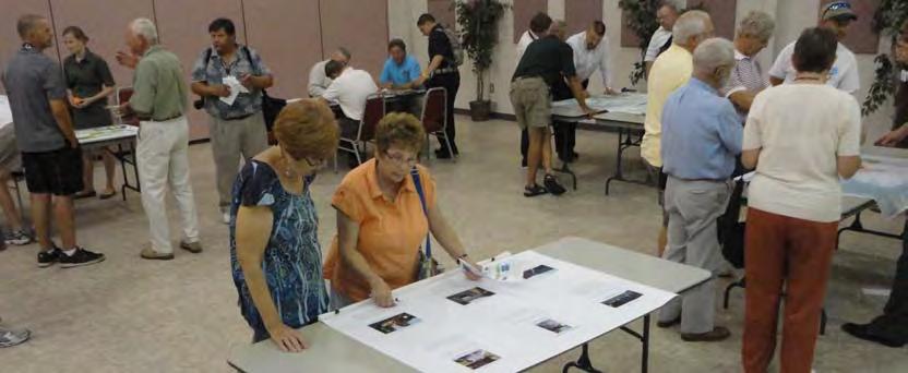
The counties of Carteret, Craven, Jones, Onslow, and Pamlico
for the Croatan Regional
Regional Bicycle Plan. The


throughout
September
September
September
September
A second set of four workshops were also held in different locations, on the evenings of September 13th, 14th and 15th, 2011. Each of these workshops contained the same basic information about draft plan recommendations. The locations were at City Hall in Jacksonville, NC; the Beaufort Train Depot, in Beaufort, NC; the New Bern Convention Center in New Bern, NC; and at Pamlico Community College (Delamar Center) in Grantsboro, NC.


A total of approximately 80 people participated in the first three workshops, with about 75 attending the second set of workshops. Participants received information and provided input for the preparation of these regional plans. Local community staff and project consultants were on-hand at each workshop, introducing the scope of each planning effort and gathering public input for each plan. Participants were encouraged to ask questions, share ideas, fill out comment forms, and write and draw on public input maps. Most comments for each of these sets of workshops were captured through the hardcopy comment forms, which were then merged with the online input summarized on the following pages.

The charts and tables on the following pages show results from the online comment for this plan. Comment forms were distributed at the public workshops and were made available online. The online comment form was advertised in newsletters and newspapers, and links to it were posted on Facebook and distributed via mass e-mail. Although not a statistically valid survey, the results of this comment form still represent the opinions of more than 130 people in the region.
Croatan Regional Trails Plan
1. How important to you is the goal of creating more trails? (Please select one)
1. How important to you is the goal of creating more trails? (Please select one)
Response Percent Response Count very important 77.6% 104 somewhat important 18.7% 25 neutral 0.7% 1 not important 3.0% 4 answered question 134 skipped question 4
Response Percent Response Count very important 77.6% 104 somewhat important 18.7% 25 neutral 0.7% 1 not important 3.0% 4 answered question 134 skipped question 4
2. How often do you use trails now? (Please select one)
2. How often do you use trails now? (Please select one)
Response Percent Response Count
few times per week 30.6% 41 few times per month 27.6% 37 few times per year 25.4% 34 not currently, but I have thought about it 11.9% 16 never 4.5% 6 answered question 134 skipped question 4
3. Would you use trails more often if you could easily bike or walk to one?
Response Percent Response Count few times per week 30.6% 41 few times per month 27.6% 37 few times per year 25.4% 34 not currently, but I have thought about it 11.9% 16 never 4.5% 6 answered question 134 skipped question 4 1 of 8
1 of 8
Response Percent Response Count Yes 94.8% 127 No 5.2% 7 answered question 134 skipped question 4
4. Have you used bicycle or trail facilities in other areas and if so, what did you like about them?
4. Have you used bicycle or trail facilities in other areas and if so, what did you like about them?
This image was created using www.wordle.net to generate a ‘word cloud’ from answers to this open-ended question. Greater prominence is given to words that appeared more frequently.
Response Count 102 answered question 102 skipped question 36
5. For what purposes do you walk or bike most often, or for what purposes would you use trails in the future? (Rank Top 3)
#1 #2 #3 Rating Average Response Count
Exercise 74.6% (94) 19.8% (25) 5.6% (7) 1.31 126
Recreation/social visits 14.7% (16) 53.2% (58) 32.1% (35) 2.17 109
Transportation 17.3% (9) 30.8% (16) 51.9% (27) 2.35 52
Comments are listed as received and have not been edited.
Walking the dog 22.2% (8) 47.2% (17) 30.6% (11) 2.08 36
1. + need easy on / off at common points of interest - near transit hubs / stores + bridge crossings + periodic water and bathroom stations (5 miles) + distance markers
Walking with a baby/stroller 33.3% (2) 50.0% (3) 16.7% (1) 1.83 6
2. Access to City Stops --Yuma, AZ
3. American Tobacco Trail in Durham, Chatham and Wake is a great place to ride. Umstead state park is good but has tough hills for a flat lander!! I enjoy Jacksonville to Camp Lejuene Rail trail.
4. Away from traffic, scenic
5. bike lanes removed from main road,( recreational and commuter friendly) Park-woods trails for MTBing any and all
Other 5.9% (2) 5.9% (2) 88.2% (30) 2.82 34 answered question 134 skipped question 4
6. Bike trails I’ve used in other area have offered great access to the city and surounding communities without having to ride on busy city streets. Even adding bike lines to the sides of the roads make for safer conditions.
2 of 8
7. bike trails would be helpful as I am handicapped and could use my wheelchair
8. California, lots of them
9. City of Greenville, Wilmington, Carolina Beach
10. Clear use rules, excellent signage, proper maintenance by active clubs
11. Clearwater Florida has 3 great Trails! The Clearwater Trail through the city, the Pinellas Trail which connects several towns together (may have been an old railroad path) and the Suncoast Trail which follows a major highway but riders are completely seperated from the car traffic!
12. convenience, feeling of being away from city
13. Cultural and Historic Character
14. D.C. metro area....I liked that I could safely get just about anywhere I needed to go in the D.C./ ALexandria VA area. THese trails were exclusive use for bikers/joggers so there were no traffic worries. The longer I lived there, though, there began to be a safety problem...hearing about women being attacked. SO then I was nervous to use them alone.
15. Designated shoulders for bikes - lined and signed Also “mountain trails” unpaved in park areas.
16. dirt, gravel, non asphalt. occasional places to pull off the trail and adjust equipment, hydrate, let others go by. ease of access, patrolled by law enforcement or park rangers
17. Dismal Swamp
18. Durham, NC area -- well designed
19. Ease of access. Quality and condition. Multiple levels available for different experience levels.
20. Easy access and parking. Good maps of the trail system. Well maintained.
21. Easy access, scenery, water views
22. Easy access. Well maintained. Well marked with signage.
23. Have used-scenery. Light use
24. Hilton Head, SC - connectivity to all restaurants and shopping areas St. Paul, Minn - connectivity between neighborhoods and schools, downtown and waterfront areas, local areas, and urban shopping areas. Both areas have lots of multi-use trails to accommodate bicycle and walking traffic.
25. I bicycled from Washington, D.C. to Pittsburgh, PA on the C & O Canal Towpath and Great Alleghenny Passage in July 2009. Traveling on a dedicated path for bicycles and pedestrians away from motorized transport through woods and near rivers provided a wonderful opportunity to travel at a pace conducive for experiencing and learning about beauty, peace, history and the environment. The trails provided history of George Washington’s vision for transporting raw materials from the interior of the country to the coast and manufactured goods from the coast to the interior of the country. It provided an opportunity to learn about how the extraction of raw materials such as coal has and still has impacts on air, land, and water. It provided an understanding of how the exploitation of a race of people and the war to end that exploitation impacted the canal and the areas around the trail. It provided a perspective on the competing transportation technologies of canals, railroads, roads and bicycle/pedestrian paths and how they either support or undermine the communites and environments they traverse. It created opportunites for a variety of people from different socioeconomic, racial and political backgrounds to mingle with out the typical boundaries separating them in a healthy and healing environment. It provided diverse opportunities for lodging, food and entertainment. It provided opportunities for schools, community groups and businesses to come together to build the infrastructure of trails, healthy communities and healthy environment. It was incredibly heartening to see the wildflower beds, bird and bat nesting boxes, parks, murals, clean rivers, and vibrant communites along the way that were the result of the trails. It provided examples of sustainable development that gave people opportunites to work together using their bodies and minds that actually helped improve the environment and community. This particular trip provided bout history, the enviro of George Washington’s vision for moving raw materials from the interior of the country to the coast and finished goods from the coast to the interior.
26. I cycle several times a week, for transportation and recreation and am disappointed at the limited trailed in Eastern NC. We live in a beautiful part of the country with great weather for cycling, so please work to make cycling safe for residents.
27. I enjoyed using the mountain biking trails in Southern California. Since moving here to the Jacksonville area it has been hard to find bike riding trails. Trails that do exist are often far away, or on base and being leveled due to on-going development.
28. I have gone to small towns that have bike rental programs and supply with map and trail
29. I have not but I’ve seen them and I like how they connect all parts of the area.
30. I have ridden Island Creek Mountain Bike trails in Croatan Forest and I love riding thru those woods. I ride the Jacksonville Rails to Trails bike path almost every day and wish they were more miles added to the bike path so I could ride longer.
31. I have used the trail in Onslow County and the fact that it was paved made it easier to bike.
32. I have used trails in many parks , but most recently use a rails-to-trails bike and walking path in PA . When there, I use it 3-4 times a week because I can walk to it from my house; it is a very walkable
surface; it has stops at road crossings for safety; it joins several small park areas;and is well maintained.
33. I like the consistency of the road. It’s nearly impossible to ride a road bike on a sidewalk without damaging them in some way.
34. I like the idea of options for different skill levels. As a rider with lots of experience I prefer more advanced trails but I believe you can attract more users by having different loops for different skill levels.
35. I like the peace and being able to exercise in a natural environment.
36. I prefer off-road type cycling, i.e. mountain biking. I have used the paved trails in the Jacksonville/Camp Lejeune area for recreational riding.
37. I ride on local roads for pleasure and for errands on a beach cruiser and for fitness on a standard road racing bicycle. There are NO bike lanes so I try to stay on secondary roads w/the beach cruiser and roads w/a shoulder (Hwy58 & Hwy24) on the road bike. I ride mountain bike trails in Greenville, Raleigh, Wilmington, Neusiok and Island Creek on a regular basis. The upper end of the Neusiok is only mildly challenging and Island creek is ridden more for fitness (NOTHING challenging about this trail!) I WANT to ride closer to home (Beaufort), on the more challenging trails located on the military bases of Cherry Point and Camp LeJeune but have a hard time getting on base (even though I am the primary trail maintenance guy for the Piranha Pit on Cherry Point!).
38. I travel to the Raleigh and Asheville areas for well built single track mountain bike trails.
39. I use the Jacksonville Bike Trail 5 days a week, riding 5 miles in one direction and 5 back home. This trail has allowed me to get my cardio shape back in that, the trail is perfect for biking and walking and prior to the trail, I wasn’t able to ride the bike in any one direction
40. Iowa has a very nice “Rails to Trails” program for cycling with convenient locations, well-maintained paths, and easy parking options.
41. Isolated from Traffic
42. Lanes completely seperated from motor traffic. Full access to the all ares of the city.
43. Love Durham’s Tobacco Trail. Flows through neighborhoods...is connected, but safely removed from high traffic...includes city and nature together. Virginia Beach Boardwalk...closeness of walking/biking trails... but keeps each group safely separated.
love them. they have encouraged me to travel to other areas for weekend adventures.
Loved the safety feature as well as the nature aspect
Loved them
47. Maintained by locals or city maintenance. Well marked. No fees.
Many other communities have a better connecting network of bike lanes and MUP’s
Many Trails, MST, AT, Charlotte, NC area trails. Like accessibility, place to park, place to camp.
Metropolitan Washington, DC, with a huge network of trails, used daily for recreation and commuting, one of the greatest assets to living in that area.
New trails would be so refreshing, and to be able to exercise on an alternate trail, due to my age (70) I now personally I ride a bicycle most every day here in Jacksonville, NC., the trail is wonderful but short, about 12 miles, it would be refreshing to be able to ride additional miles in the region.
no
No
not used
Parking and restroom facilities. Prefer nature walks
Paved and under tree by Lake
Priority is safety - being able to be away from traffic is key. However, if the trails run through wooded areas, it’s critical to provide adequate lighting, so that the trail users feel safe.
Rails to Trails
RALEIGH
raliegh, Ohio, MN, There are convenient and safe.
answered question
skipped question
5. For what purposes do you walk or bike most often, or for what purposes would you use trails in the future? (Rank Top 3)
#1 #2 #3 Rating Average Response Count
Exercise 74.6% (94) 19.8% (25) 5.6% (7) 1.31 126 Recreation/social visits 14.7% (16) 53.2% (58) 32.1% (35) 2.17 109
Transportation 17.3% (9) 30.8% (16) 51.9% (27) 2.35 52
Walking the dog 22.2% (8) 47.2% (17) 30.6% (11) 2.08 36
Walking with a baby/stroller 33.3% (2) 50.0% (3) 16.7% (1) 1.83 6
Other 5.9% (2) 5.9% (2) 88.2% (30) 2.82 34 answered question 134 skipped question 4
2 of 8
6. What are the most important benefits and uses of a regional trail system? (Select all that apply)
Response Percent Response Count
Community-building and events 28.6% 38 Connectivity between local areas 41.4% 55 Education and outreach 13.5% 18 Environmental improvements 30.1% 40 Exercise 93.2% 124 Recreation 83.5% 111 Tourism and place making 31.6% 42 Transportation alternative 45.9% 61 answered question 133 skipped question 5
7. What destinations would you most like to travel to by trail and/or bicycle lane? (Rank Top
3) #1 #2 #3 Rating Average Response Count
Libraries 50.0% (6) 8.3% (1) 41.7% (5) 1.92 12 Neighborhoods 20.0% (8) 27.5% (11) 52.5% (21) 2.33 40 Parks 35.8% (29) 37.0% (30) 27.2% (22) 1.91 81 Place of work 59.5% (25) 31.0% (13) 9.5% (4) 1.50 42 Public Transportation 28.6% (2) 28.6% (2) 42.9% (3) 2.14 7 Recreation centers 3.8% (1) 61.5% (16) 34.6% (9) 2.31 26
Regional trails and greenways 52.3% (46) 28.4% (25) 19.3% (17) 1.67 88 Restaurants 11.1% (2) 38.9% (7) 50.0% (9) 2.39 18 School 0.0% (0) 75.0% (3) 25.0% (1) 2.25 4 Shopping 22.7% (5) 36.4% (8) 40.9% (9) 2.18 22
Tourism destinations (ex: Aquarium) 12.5% (5) 25.0% (10) 62.5% (25) 2.50 40 answered question 130 skipped question 8
8. What do you think are the biggest factors that discourage trail, sidewalk, or bicycle facility use? (Rank Top 3)
8. What do you think are the biggest factors that discourage trail, sidewalk, or bicycle facility use? (Rank Top 3)
#1 #2 #3 Rating Average Response Count
#1 #2 #3
Rating Average Response Count
Aggressive motorist behavior 49.4% (39) 15.2% (12) 35.4% (28) 1.86 79
Aggressive motorist behavior 49.4% (39) 15.2% (12) 35.4% (28) 1.86 79 High traffic volume 35.3% (30) 47.1% (40) 17.6% (15) 1.82 85
High traffic volume 35.3% (30) 47.1% (40) 17.6% (15) 1.82 85
Lack of information about local trails 29.0% (18) 33.9% (21) 37.1% (23) 2.08 62
Lack of information about local trails 29.0% (18) 33.9% (21) 37.1% (23) 2.08 62
Lack of interest 14.3% (2) 21.4% (3) 64.3% (9) 2.50 14
Lack of interest 14.3% (2) 21.4% (3) 64.3% (9) 2.50 14
Lack of nearby destinations 32.1% (17) 34.0% (18) 34.0% (18) 2.02 53 Lack of time 16.7% (2) 16.7% (2) 66.7% (8) 2.50 12
Lack of nearby destinations 32.1% (17) 34.0% (18) 34.0% (18) 2.02 53
Lack of time 16.7% (2) 16.7% (2) 66.7% (8) 2.50 12
Personal safety concerns 30.8% (24) 38.5% (30) 30.8% (24) 2.00 78
Personal safety concerns 30.8% (24) 38.5% (30) 30.8% (24) 2.00 78 answered question 133 skipped question 5
answered question 133 skipped question 5
9. What do you think are the biggest infrastructure issues that discourage trail, sidewalk, or bicycle facility use? (Rank Top 3)
9. What do you think are the biggest infrastructure issues that discourage trail, sidewalk, or bicycle facility use? (Rank Top 3)
#1 #2 #3
#1 #2 #3
Rating Average Response Count
Rating Average Response Count
Adequate amenities (benches,water fountains) 31.0% (9) 24.1% (7) 44.8% (13) 2.14 29 Adequate safe lighting 22.2% (6) 29.6% (8) 48.1% (13) 2.26 27
Deficient or lack of bike lanes 64.2% (70) 22.9% (25) 12.8% (14) 1.49 109 Deficient or lack of sidewalks 18.2% (10) 49.1% (27) 32.7% (18) 2.15 55
Deficient or lack of trails 28.9% (28) 42.3% (41) 28.9% (28) 2.00 97
Unsafe street crossings 13.8% (8) 27.6% (16) 58.6% (34) 2.45 58
Adequate amenities (benches,water fountains) 31.0% (9) 24.1% (7) 44.8% (13) 2.14 29 Adequate safe lighting 22.2% (6) 29.6% (8) 48.1% (13) 2.26 27 Deficient or lack of bike lanes 64.2% (70) 22.9% (25) 12.8% (14) 1.49 109 Deficient or lack of sidewalks 18.2% (10) 49.1% (27) 32.7% (18) 2.15 55 Deficient or lack of trails 28.9% (28) 42.3% (41) 28.9% (28) 2.00 97 Unsafe street crossings 13.8% (8) 27.6% (16) 58.6% (34) 2.45 58 answered question 132 skipped question 6
answered question 132 skipped question 6
10. What
surface do
prefer for a trail?
select
Response
Natural surfaces
Paved surfaces
Either
soil
concrete,
stone)
answered
11. Are there specific destinations in Craven, Pamlico, Carteret, Jones and Onslow counties that you would use a trail to travel to? (for example: aquarium, community college, beach access)
This image was created using www.wordle.net to generate a ‘word cloud’ from answers to the open-ended ‘other’ response above. Greater prominence is given to words that appeared more frequently.
Response Count
11. Are there specific destinations in Craven, Pamlico, Carteret, Jones and Onslow counties that you would use a trail to travel to? (for example: aquarium, community college, beach access)
This image was created using www.wordle.net to generate a ‘word cloud’ from answers to this open-ended question. Greater prominence is given to words that appeared more frequently.
of 8
Comments are listed as received and have not been edited.
Response
1. - need way to cross bridge at Emerald Isle - need alternative to HWY 24 between Swansboro and MHCCroatan Forest Trail (semi-paved / hard pack) would be idea - White Oak River Trail - Swansboro /Hubert Loop
2. A trail from Morehead City to Havelock could be a great alternative to driving to and from Cherry Point everyday for work
3. All beach access, downtown areas & waterfronts, community colleges & schools, senior centers, parks
4. Any location that will benefit the most for the people.
5. Any Parks in Havelock, City Hall, Recreation Center on Hwy 101
6. Aquarium - I would like to see the trail made longer
7. aquarium, beach
8. Aquarium, community college, beach access, historical sites, resturant & shopping districts, entertainment venues, etc
9. aquarium, community college, library, beach access
10. Aquarium, Parks, Beach areas, and local shops
11. beach
12. beach
13. beach access
14. Beach access and Historic Sites
15. beach access from mainland to sea; residential areas to restaurants, shops
16. Beach access, downtown, Morehead City, and Downtown Beaufort
17. beach access, shopping
18. beach access, stores, restaurants
19. beach accesses
20. Beach, Cherry Point, Oriental and New Beln water fronts
21. Beaches
22. beaches, tryon palace
23. beaches, work (cherry point), mtb trails, down town areas
24. Catfish Lake, Headwater of New and Whitewater River, Hoffman Forest
25. College in craven, piney green area in onslow,
26. Commercial areas (Onslow)
27. community college, downtown 9farmer’s market etc) and out to flanner’s beach recreation area
28. Community College, shopping, interconnectivity with other neighborhoods with safe street crossings.
29. Community Colleges; Work = CP
30. Connect with East Coast Greenway
31. Connecting other trails
32. creekside park, croatan forest
33. Downeast, beach, National Forest
34. Downtown Jacksonville
35. Downtown New Bern
36. Downtown Swansboro, Beach Access
37. From Bridgeton to New Bern Area
38. From Jacksonville to Neuse River parks. To other towns in the area
39. general access to surrounding areas with better roads and wider bike lanes.
40. Highway 101 from Havelock to Beaufort. It would be great to ride my bike to either town from my home near the Core Creek Bridge! It is so dangerous that we put our bikes in the car and drive them to ride them on Bogue Banks where at least there is a shoulder on the road and a maximum speed limit of 45.
41. I currently drive to either Wilmington (Blue Clay Road Mountain Biking Park” or up to the Raleigh/Chapel Hill area where there is a wide selection of trails, beginner to advanced, available.
42. I ride to work every day for excersise and to cut our family fuel costs. We live just outside the Morehead City limits. There are no bike lanes, trails or side walks until you get into the City limits, and even then they are limited. Most of the roads I ride are busy, and have no shoulder, and there is not alternative route.
43. I use my bike for transport... so all of the above!
44. I use the trail for recreation
45. I would just enjoy having a bike trail to ride on that was in the Jacksonville, N.C. general area.
46. I would like to be able to travel throughout the Five-county region to do work, shop and recreate. Frankly, I believe that bicycle/pedestrian trails should be a national priority to help create a more democratic society that promotes healthy people and sustainable development.
47. I would like to see communities connected with safe bike lanes.
48. I would use the trail for all of the above - aquarium, community college, beach access, shopping, recreation. I would love to be able to ride from Jacksonville to Emerald Isle or Topsail Island without going on the streets on my bike.
49. In Carteret County, it would be great if we could have a trail to travel to the beach, aquarium, community college, the shopping centers (like Belk and Harris Teeter).
50. In Craven, having bike and walking trails along the main roads like Hwy 17 and Hwy 70 would be awesome. In Onslow, we already have a great start on the trails, but I would love to see them on Gum Branch Rd as well. Carteret could benefit from having trails on Hwy 24 and 58, particularly near tourist destinations like Fort Macon and the Aquarium.
51. It’s probably asking too much, but a bike lane on the new Beaufort/Morehead highrise bridge would expand how often I ride to work (live in Beaufort, work in Morehead). We would bike EVERYWHERE on the weekends if there were adequate bike lanes. We would ride mountain bike trails at least 3 days per week if they were accessible.
52. Local Beaches, Parks.
53. Making a connection from all municipalities/places/destinations w/ all counties.
54. MCAS New River, Northwoods Area, Gumbranch/Western Blvd Ext,
Camp Lejeune; Riverwalk Crossing Park; USO
56. More bike lanes in/around Swansboro. Safe Bike Lane to the beach. In jacksonville, the trails are adequate but unsafe. biking clubs are needed for early evening/after work and/or early in the morning.
57. Need striped bicycle lanes between Bayboro and New Bern on Hwy 55. There is plenty of room on this road for all! Striped lanes would help to remind motorists that bicycles belong and are legitimate users of the road.
58. New Bern should look to develop a trail system.
59. New Bern to Jacksonville for oreental to Kinston
60. Off road trails in Croatan Forrest
61. Onslow - Beaches, parks,
62. Parks and Natural Areas
63.Parks, Beaches, recreational areas.
64. restaurants, parks, water views
65. Schools and Rec areas in Havelock
66. Sound side access in North Topsail Beach
67. The bike path from Bridges down to 30th is great, but it should be extended to downtown MHC. I feel many more families would travel there on weekends. I would also like it to be recognized that sidewalks provide a much different use than sidewalks. Sidewalks work when there are places to stop that all nearby, not for long distances. That’s what bike trails are preferred for.
68. The Trails would serve perfectly for traveling within and around public areas, and by providing the trails access to public and not public places, I would find it much easier to travel within the trail to get to public locations and when I’m interested in just riding, I’d use the outside trails. With the current gas prices, I’d use trails to go to stores, etc., if I had the correct type of trails.
69. To historic area of New Bern from South along US 70. No designated bike lanes (shoulders) available. Especially through the interchange in James City.
70. Tourist attractions
71. Ttavel to my work would be great, which lies along the main highway in Beaufort. However, there are no bicycle lanes and no shoulder. Also the Beaufort bridge has no bike lane.
12. Are there specific corridors
would like considered during the evaluation of
to the pier,
from Jacksonville to Swansboro)
This image was created using www.wordle.net to generate a ‘word cloud’ from answers to this open-ended question. Greater prominence is given to words that appeared more frequently.
Response Percent Response Count
question
question
13. What other bicycle or trail-related improvements do you consider priorities?
Comments are listed as received and have not been edited.
1. 20th street in Morehead City
2. 70 should be better utilized for multi-modal (utilize service road/shoulders)
3. a bike loop around Country Club Rd.
AB-EI
5. All of the above and museum in Richland
Along highway east from New Bern to Havelock
7. Along Western Blvd in Jacksonville
8. Atlantic Beach
Response Count
question
question
14. Do you have any other comments or recommendations that you would like considered?
9. Atlantic Beach to Beaufort
10. Beaufort to MHC
11. Beaufort to Morehead City
12. Belgrade-Swansboro roadway (from Stella to Swansboro)
13. Bike lane hwy24 Cape Carteret to Swansboro
14. Bike lane hwy24 Swansboro to Jacksonville
15. Bike lane hwy24 Swansboro to Morehead city
16. Cape Carteret to Camp Lejeune
17. Cape Carteret to Emerald Isle
18. Cape Carteret to Havelock
19. Cape Carteret to Jacksonville
Count
question
question
20. Cape Carteret to MHC
21. Cedar Island to Wilmington via existing electric, sewer, water, railroad and other right of ways.
Cedar Point to Emerald Isle
Connect all of the Jacksonville areas
connect main shopping areas along Western Blvd
25. Connecting cities like Jacksonville, New Bern and Swansboro to the eachother and the beaches.
26. Country Club Rd in Morehead City
27. Country Club Rd in Morehead City
28. Croatan National forest
29. Dedicated, physical barrier bike lanes on Western Blvd, entire length
Down 24 and 17 to get to the military bases
31. down highway 101
Downtown Morehead City to the Beach
33. Downtown Morehead City to the western commercial district via Progress Energy right of way along Bay Street past area middle, primary and high schools.
Downtown New Bern
Downtown to all directions of Jacksonville
Elizabeth City
37. Emerald Isle to Swansboro
38. existing trail to Western Blvd Shopping
Expansion of Flanners Beach into an actual mountain bike trail (suitable as a tourist destination/host of competitions)
40. Extension of Bridges St. Trail in Morehead City, NC
extensive trail network in Croatan Forest
Flanners Beach to Morehead
from community college downtown and out to havelock
from Hammock Beach state park to Swansboro
From Havelock to New Bern
from Jacksonville to Swansboro
From one part of Onslow County to the other side of the county
from Sneads Ferry to N Topsail
From Thenton, Jones County through the Huffman forest to the Croatan Forest
Gum Branch Rd, Jacksonville
gum branch to western
Hammock Beach State Park - would like to see some trails there for use of park all year round.
Harker’s Island farther down east
Harker’s Island to Beaufort
to Jacksonville
Havelock to Morehead
Havelock to Morehead and to Jacksonville
Havelock to Morehead City
Havelock to New Bern
Havelock to New Born up Hwy 101
61. Havelock to New Port
Havelock Tourist Center area to Havelock Walmart
101 from Havelock to Beaufort
Highway 17 from Wilmington to New Bern
Highway 24 from Jax to I-40
Hovelock to Nevsiok Trail
67. Hubert to Sneads Ferry
68. Hwy 101 from Havelock to Beaufort
hwy 24
70. Hwy 24 between Morehead City and Swansboro
71. hwy 24 to downtown Jacksonville
Hwy 24, Hwy 158
73. Hwy 58 from Cape Carteret to Fort Macon, Carteret County
hwy 70
75. Hwy 70 from Morehead City to eastern Beaufort
Hwy 70 from New Bern to Havelock, Craven County
Hwy 70 MHD to to/from NB
78. If there were something like a circle trail around the main public areas, then a “X” trail leading thru to the outer loop would be perfect
79. Intratown By-ways
Jacksonville
Jacksonville through Morehead city (nature not urban)
Jacksonville to Emerald Isle
Jacksonville to Havelock
Jacksonville to Holy Ridge
Jacksonville to Maysville
Jacksonville to Morehead city
Jacksonville to New Bern
jacksonville to new bern
Jacksonville to Richlands
jacksonville to richlands
Jacksonville to Richlands
Jacksonville to Richlands
Jacksonville to Richlands.
Jacksonville to Snead’s Ferry and North Topsail.
Jacksonville to Sneads Ferry
Jacksonville to Swansboro
Jacksonville to Swansboro
Jacksonville to Swansboro
Jacksonville to Swansboro
Jacksonville to Swansboro
Jacksonville to Swansboro
Jacksonville to Swansboro
103. Jacksonville to Swansboro
104. Jacksonville to Swansboro
105. jacksonville to swansboro
106. Jacksonville to Swansboro
107. Jacksonville to Swansboro
108. Jacksonville to Swansboro
109. Jacksonville to Swansboro
110. jacksonville to swansboro or all the way to beaches
111. Jacksonville to Swansboro would be great
112. Jacksonville to Swansboro would be great - a path exists, but it its on busy roads without shoulders.
113. Jacksonville to Swansboro.
114. Jacksonville to the beach.
115. Jacksonville to Topsail Island
116. Jacksonville to west
117. Jacksonville to Wilmington
118. Jacksonville to Wilmington and to WRightsville beach.
119. Jacksvonville to beach
120. Just a longer bike trail in Jacksonville
121. Jville to Swansboro
122. Kinston
123. Main St. to Fontana
124. Maysville to Jacksonville via 17S
125. McCotter to Fontana to Main St.
126. MHC to New Bern
127. MHC to Pine knoll shores
128. Mill Creek to Newport
Morehead city through Harvey Island
130. Morehead City to Havelock
131. Morehead City to New Bern via the North Carolina railroad right of way.
Morehead City to Newport
Morehead to Beaufort
NA
NA
NA
New Bern Area/Hammocks beach
New Bern to Goose Creek State Park
New Bern to Havalok
New Bern to Havelock
New Bern to Havelock
New Bern to Jacksonville
New Bern to Jacksonville for oreental to Kinston
Newbern to Coast
145. Newport to Havelock via Nine Mile or Hibbs road, or trough Croatan
146. Newport to Morehead City
147. nine foot road, newport-to milas rd or fire tower rd
148. Off road biking trails.
149. old airport raod, through James City and east
150. Pollocksville to Hevelock
151. Put a Trail in Richland, NC area
152. rail-trail corridors or safe bike lanes between towns
153. Richlands to Jacksonville
154. Rural and Natural vs. Urban
155. safe bike lanes in town for recreation-touring-commuting
156. Safe bike lanes to the beaches.
157. Safe biking lanes to local ferries.
158. Sneads Ferry to N Topsail
159. Sneads Ferry to NTB
160. Sneads Ferry to Swansboro
161. Sneads Ferry to Wilmington
162. Swansboro
163. Swansboro to Bogue
164. Swansboro to Cape Carteret
165. Swansboro to Cape Carteret
166. Swansboro to Emerald Isle
167. Swansboro to Maysville
168. Swansboro to Morehead City
169. Swansboro to Morehead City
170. Through any forest
171. Tootle Rd in Morehead City
172. Trail in the Richlands area (not the current highway ones) 173. Trail to Jacksonville Commons area
174. Trails that lead from inner city areas to the external loops would be great. Distances between cities would be to long
175. Trent in New Bern
176. US 70
177. Weelauk Trail/Croatan Area.
178. Wilmington
question
13. What other bicycle or trail-related improvements do you consider priorities?
This image was created using www.wordle.net to generate a ‘word cloud’ from answers to this open-ended question. Greater prominence is given to words that appeared more frequently.
Response Count 70 answered question 70 skipped question 68
14. Do you have any other comments or recommendations that you would like considered?
Response Count 34 answered question 34 skipped question 104
Comments are listed as received and have not been edited.
1. Better education for the public about bicycles rights to the road. I have everyone from a newly licensed teenager to a senior citizen make comments about running wanting to run over bikes because they don’t belong on the road!
7 of 8
2. specific bike lanes (3-4 ft wide), more trails accessible by off-road bicycles (MTB).
3. Future road improvements should have bicycling lanes as a starting forethought.
4. A local mountain bike trail that doesn’t necessitate a military ID to use. Or provisions for a permanent or yearly pass to the trails on board Camp Lejeune.
5. Improved roads (decreased potholes) and wider bike lanes.
6. Adding bicycle lanes in our towns and communities in Eastern NC
7. BAYBORO TO NEW BERN
8. Off-Road Trail Systems through out the Croatan Forest. Natural single track trails, NOT paved!
9. having real shoulders on which to ride
10. Marked off road bicycle paths
11. nine foot rd
12. bicycle lanes, increased enforcement of traffic rules on motorists, bicyclists and pedestrians
13. bicycle lanes are needed along beach acces areas and along tourist areas in Sneads Ferry to avoid crossing traffic
14. RR
15. Making connections where opportunities are available, creating opportunities in land use design (bikes races) all new facilities should be considered for multi-modal.
16. Any
17. Greenways, trails, blueways all are good and needed
18. Widen Current roads when re-paving takes place (DOT issue)
19. Local interest from Municipalities
20. Continuous Maintenance
21. A scenic, back country connection of MST to Nevsiok Trail
22. Wider Bern on Roads with High Traffic
23. Development of “natural” trails within Croatan Park. 180,000 acres of area should provide plenty of trails but only 1.2 mi in Flanners Beach Park out 20+ miles of Nusiok exist.
24. Safe, separated lanes to ride in
25. Maintaining current and creating more walking-only trails
26. Trails for bike and hiking away from motor vehicles
27. Signage and well marked all along trails that are not paved and are through the woods, for example
28. Separate, multi-use trails
29. overnight camping facilities
30. Street and Road addition of Bike - Walking paths
31. Surfaces and Safety
32. Multi-use trails, well marked or separate from vehicles.
33. Education (motorist and cyclist)
34. bicycle lanes should be connected and lead to destinations
35. More signage
36. Work with DOT and NC State Parks and Croatan National Forest
37. Complete Streets
38. A pedestrian/bicycle trail system from New Bern to Washington, NC.
39. Trails the have not just recreational purpose but utilitarian too. Like to work centers, to shopping.
40. A longer and more enjoyable trail in Jacksonville to intice more people to use it.
41. Any addition of bike trails or lanes would be an improvement
42. sidewalks!!!!!!
43. Wider shoulders on all eastern NC roads
44. Education of the public that cyclists and runners a members of community and they have rights to use the trails/roads also.
45. Improving large intersections like 70 & 24 in MHC, 24 & 58 in Cedar Point Safe intersectionscrosswalks with signals, refuge islands, curb cuts for pedestrians Improving commercial corridors like Highway 70 in Havelock and Morehead City for bicycle traffic.
46. For a bike trail, side enough so you won’t be getting hit in the face with vegetation the whole time riding.
47. Lighting is important, and 911 phones in case someone gets in trouble. Water fountains.
48. Recognizing that sidewalks do not suffice as bike trails, and that biking is a great transportation.
49. Simply having a bike lane would be great!
50. Bike lanes on the major roads in Jacksonville and public education about the bike lanes and what motorists can do to observe the bike lanes
51. Bike lanes on streets.
52. street crossing areas
53. Developing single track off road biking trails in the Croatan forest.
54. The development of off road multi use trail systems.
55.Trails need to be planned with water points, like on Camp Lejeune
56. adding more bike lanes and trails in Jacksonville, connecting the entire community
1 100.0% 90 2 62.2% 56
57. Lighting; access; safety
58. Anything that gets people out and moving
59. Sidewalks that are large enough for walkers and bikes would be great. Biking on market areas beside traffic is dangerous and the traffic tend to blow rocks, glass and debris onto the bike lane which may cause bike tires to be punctured.
60. Separated Bicycle lanes along the road.
61. More off-road (mountain bike) trails that are linked to paved trails or bike lanes
3 35.6% 32 answered question 90 skipped question 48
62. rest stops and water fountains
63.more trails that break off our current trail to other parts of the city
64. amenities, bike rentals, water fountains, trash containers, flower gardens and natural beauty
13. What other bicycle or trail-related improvements do you consider priorities?
65. Wider, clean, shoulders on existing two lane. Hwy 70 and 101 would be great(er) if there was more than 9” of roadway to use when cars pass.
66. Would really love to see plans for an off-road trail in the Onslow County area. Currently only have use of one trail located on Camp Lejeune and it is slowly being taken over by new construction projects. There are some other multiuse trails in adjacent counties but require 1+ hours of driving.
67. MOUNTAIN BIKE TRAILS!!!
68. Designated Bike Lanes
69. Better lighting, adding more trail mileage
70. There is a critical need for natural surface single track mountain bike trails in the Croatan forest on Hwy 58 south of Maysville. The only mountain bike trail left in the area is at Island Creek near New Bern or is inaccessible because it is on a military base.
Response Count 70 answered question 70 skipped question 68
14. Do you have any other comments or recommendations that you would like considered?
This image was created using www.wordle.net to generate a ‘word cloud’ from answers to this open-ended question. Greater prominence is given to words that appeared more frequently.
7 of 8
Response Count 34 answered question 34 skipped question 104
Comments are listed as received and have not been edited.
1. A 5 year and 10 year plan must be established for maintenance.
2. A foot trail connecting the weetock trail in Western Croatan to Sevsiok Trail in eastern Croatan
3. Be sure not to build any more high rise bridges that do not have a bicycle/ walking lane along one side. The hish rise bridge to N Topsail is narrow with no walking /bicycling lane and yet people try to do both on the bridge to great peril.
4. Bike lane added to hwy 24
5. bike rental programs close to trails
6. Bike Trails and walking trails should be incorporated in all cities and if possible, short distances such as 10 mile or less trails should be designed to allow for the serious exercisers. Biking is the perfect cardio exercise for people above 40, but, often times, there aren’t any bike trails at all or they are to far to access easily.
7. biking group/club to ride the trails in Jax after work.
8. Build some signal track mountain bike trails in the Onslow county area. There are a lot of people who could use a place to ride their mountain bikes other than pavement.
9. Communities should consider supporting those who might commute to their work by alternative means. As fuel prices rise and the need to reduce dependence on foreign energy increases this is becoming more and more important. This means connecting residential areas to business areas with bike lanes and sidewalks.
10. Connections between facilities are Vital
11. Croatan forest, catfish lake, waterfront area in surrounding counties
12. Develope trails and the people will come!
13. Get it done!
14. Great Start!
15. I am an advocate for using electric, water, sewer, gas, railroad and any other existing right of ways for the development of bicycle/pedestrian corridors connecting cities in the region. I recommend using students, community groups, local businesses, military personnel as well as any one else receiving public assistance, unemployment insurance, or needing work to do the work of developing the trail system and creating interpretative centers discribing history ,community and environment along the trail.
16. I helped develop and maintain the trails on board Camp Lejeune and New River Air Station for over 8 years. I would certainly be interested in a position with the county for being involved with any trail building.
17. I would like to have access to the city and shopping in Jacksonville by bicycle. If I did, I would ride to town and use my car less.
18. Leverage existing trails and connect them
19. Mayb more people would ride bikes and walk if the trail went more places in Jacksonville
20. motorists in our area need to be educated about courtesy toward cyclists
21. nine foot rd
22. None
23. Please add bike lanes to all of the military bases too
24. Please add more bike trails!!!! Gas is getting too expensive and it’s pretty easy to ride your bike where you need to go!
25. please add sidewalks. Very difficult for those of us with handicaps to access areas that are safe to walk or use wheelchair
26. Please continue to follow through with this plan
27. Public awareness campaign.
28. Public mountain bike trails in Croatan Forrest
29. Railroad as a trail
30. See 13, Also a 10+ mile trail around Catfish Lake, Great Lake, ect. Or a series of interconnected loop trains of varying lengths in the Croatan
31. The old Atlantic Coastline Railroad from New Beth to Jacksonville and on to Wilmington. Also Midathy R/R from camp leseunc to cherry point
32. Trails need to be away from heavy traffic
33. Yes. I would like to see a consortium among hiking, mountain biking and equestrian groups together with local organizations to build a multi-access trail system in the Croatan forest on hwy 58. This system would include separate trails for each group plus connecting multi-use trails and parking, restroom and other ammenities.
34. You can’t just stick a sign up and call it a bike trail without actually providing real space and a lane. Island Creek Road is a “bike route” but not really and so is 43, but a few signs that say, watch for bikes means nothing.
This page intentionally left blank for printing
Overview (B-1)
Federal Funding Sources (B-1)
State Funding Sources (B-8)
Local Government Funding Sources (B-15)
Funds from Private Foundations and Organizations (B-19)
Funding Source Summary Table (B-25)
Due to the cost of most construction activities, it may be necessary to consider several sources of funding, that when combined, would support full project construction. This appendix outlines likely sources of funding for the identified projects at the federal, state, and local government levels as well as from the private and non-profit sectors. It should be noted that this section reflects the funding available at the time of writing. The funding amounts, fund cycles, and even the programs themselves are susceptible to change without notice.
Federal funding is typically directed through state agencies to local governments either in the form of grants or direct appropriations. Federal funding typically requires a local match of anywhere from five percent to 50 percent, but there are sometimes exceptions, such as the recent American Recovery and Reinvestment Act stimulus funds, which did not require a match.
The following is a list of possible federal funding sources that could be used to support construction of many pedestrian and bicycle improvements. Most of these are competitive, and involve the completion of extensive applications with clear documentation of the project need, costs, and benefits. However, it should be noted that the FHWA encourages the construction of pedestrian and bicycle facilities as an incidental element of larger ongoing projects. Examples include providing paved shoulders on new and reconstructed roads, or building sidewalks, on-street bikeways, trails and marked crosswalks as part of new highways.
Moving Ahead for Progress in the Twenty-First Century (MAP-21)
The largest source of federal funding for pedestrian and bicycle projects is the USDOT’s Federal-Aid Highway Program, which Congress has reauthorized roughly every six years since the passage of the Federal-Aid Road Act of 1916. The latest act, Moving Ahead for Progress in the Twenty-First Century (MAP-21) was enacted in July 2012 as Public Law 112-141. The Act replaces the Safe, Accountable, Flexible, Efficient Transportation Equity Act – a Legacy for Users (SAFETEA-LU), which was valid from August 2005 - June 2012.
MAP-21 authorizes funding for federal surface transportation programs including highways and transit for the 27 month period between July 2012 and September 2014. It is not possible to guarantee the continued availability of any listed MAP-21 programs, or to predict their future funding levels or policy guidance. Nevertheless, many of these programs have been included in some form since the passage of the Intermodal Surface Transportation Efficiency Act (ISTEA) in 1991, and thus may continue to provide capital for active transportation projects and programs.
In North Carolina, federal monies are administered through the North Carolina Department of Transportation (NCDOT) and Metropolitan Planning Organizations (MPOs). Most, but not all, of these programs are oriented toward transportation versus recreation, with an emphasis on reducing auto trips and providing inter-modal connections. Federal funding is intended for capital improvements and safety and education programs, and projects must relate to the surface transportation system.
There are a number of programs identified within MAP-21 that are applicable to pedestrian and bicycle projects. These programs are discussed below.
For more information, visit: http://www.fhwa.dot.gov/map21/summaryinfo.cfm
Transportation Alternatives (TA) is a new funding source under MAP-21 that consolidates three formerly separate programs under SAFETEA-LU: Transportation Enhancements (TE), Safe Routes to School (SR2S), and the Recreational Trails Program (RTP). These funds may be used for a variety of pedestrian, bicycle, and streetscape projects including sidewalks, bikeways, multi-use paths, and rail-trails. TA funds may also be used for selected education and encouragement programming such as Safe Routes to School, despite the fact that TA does not provide a guaranteed set-aside for this activity as SAFETEA-LU did. Unless the Governor of a given state chooses to opt out of Recreational Trails Program funds, dedicated funds for recreational trails continue to be provided as a subset of TA. MAP-21 provides $85 million nationally for the RTP.
Complete eligibilities for TA include:
1. Transportation Alternatives as defined by Section 1103 (a)(29). This category includes the construction, planning, and design of a range of bicycle and pedestrian infrastructure including “on-road and off-road trail facilities for pedestrians, bicyclists, and other non-motorized forms of transportation, including sidewalks, bicycle infrastructure, pedestrian and bicycle signals, traffic calming techniques, lighting and other safety-related infrastructure, and transportation projects to achieve compliance with the Americans with Disabilities Act of 1990.” Infrastructure projects and systems that provide “Safe Routes for Non-Drivers” is a new eligible activity. For the complete list of eligible activities, visit: http://www.fhwa.dot.gov/environment/transportation_enhancements/legislation/map21. cfm
2. Recreational Trails. TA funds may be used to develop and maintain recreational trails and trail-related facilities for both non-motorized and motorized recreational trail uses. Examples of trail uses include hiking, bicycling, in-line skating, equestrian use, and other non-motorized and motorized uses. These funds are available for both paved and unpaved trails, but may not be used to improve roads for general passenger vehicle use or to provide shoulders or sidewalks along roads.
Recreational Trails Program funds may be used for:
• Maintenance and restoration of existing trails
• Purchase and lease of trail construction and maintenance equipment
• Construction of new trails, including unpaved trails
• Acquisition or easements of property for trails
• State administrative costs related to this program (limited to seven percent of a State’s funds)
• Operation of educational programs to promote safety and environmental protection related to trails (limited to five percent of a State’s funds)
NC’s dedicated annual RTP funds for 2012 total $1,506,344. See this link for funding levels in subsequent years: http://www.fhwa.dot.gov/MAP21/funding.cfm .
3. Safe Routes to School. The purpose of the Safe Routes to Schools eligibility is to promote safe, healthy alternatives to riding the bus or being driven to school. All projects must be within two miles of primary or middle schools (K-8).
Eligible projects may include:
• Engineering improvements. These physical improvements are designed to reduce potential bicycle and pedestrian conflicts with motor vehicles. Physical improvements may also reduce motor vehicle traffic volumes around schools, establish safer and more accessible crossings, or construct walkways, trails or bikeways. Eligible improvements include sidewalk improvements, traffic calming/ speed reduction, pedestrian and bicycle crossing improvements, on-street bicycle facilities, off-street bicycle and pedestrian facilities, and secure bicycle parking facilities.
• Education and Encouragement Efforts. These programs are designed to teach children safe bicycling and walking skills while educating them about the health benefits, and environmental impacts. Projects and programs may include creation, distribution and implementation of educational materials; safety based field trips; interactive bicycle/pedestrian safety video games; and promotional events and activities (e.g., assemblies, bicycle rodeos, walking school buses).
• Enforcement Efforts. These programs aim to ensure that traffic laws near schools are obeyed. Law enforcement activities apply to cyclists, pedestrians and motor vehicles alike. Projects may include development of a crossing guard program, enforcement equipment, photo enforcement, and pedestrian sting operations.
4. Planning, designing, or constructing roadways within the right-of-way of former Interstate routes or divided highways. At the time of writing, detailed guidance from the Federal Highway Administration on this new eligible activity was not available.
Average annual funds available through TA over the life of MAP-21 equal $814 million nationally, which is based on a 2% set-aside of total MAP-21 allocations. Current projected obligations for NC are available at this website: http://www.fhwa.dot.gov/ MAP21/funding.cfm .] Note that state DOT’s may elect to transfer up to 50% of TA funds to other highway programs, so the amount listed on the website represents the maximum potential funding.
Remaining TA funds (those monies not re-directed to other highway programs) are disbursed through a separate competitive grant program administered by NCDOT. Local governments, school districts, tribal governments, and public lands agencies are permitted to compete for these funds.
The Surface Transportation Program (STP) provides states with flexible funds which may be used for a variety of highway, road, bridge, and transit projects. A wide variety of pedestrian and bicycle improvements are eligible, including trails, bike lanes, sidewalks, crosswalks, crossing signals, and other ancillary facilities. Modification of sidewalks to comply with the requirements of the Americans with Disabilities Act (ADA) is also an eligible activity. Unlike most highway projects, STP-funded pedestrian and bicycle facilities may be located on local and collector roads which are not part of the Federalaid Highway System. 50 percent of each state’s STP funds are allocated by population to the MPOs; the remaining 50 percent may be spent in any area of the state.
For more information: http://www.fhwa.dot.gov/map21/stp.cfm
MAP-21 doubles the amount of funding available through the Highway Safety Improvement Program (HSIP) relative to SAFETEA-LU. HSIP provides $2.4 billion nationally for projects and programs that help communities achieve significant reductions in traffic fatalities and serious injuries on all public roads, bikeways, and walkways. MAP-21 preserves the Railway-Highway Crossings Program within HSIP but discontinues the High-Risk Rural roads set-aside unless safety statistics demonstrate that fatalities are increasing on these roads. Bicycle and pedestrian safety improvements, enforcement activities, traffic calming projects, and crossing treatments for non-motorized users in school zones are eligible for these funds.
For more information: http://www.fhwa.dot.gov/map21/hsip.cfm
The Congestion Mitigation/Air Quality Improvement Program (CMAQ) provides funding for projects and programs in air quality non-attainment and maintenance areas for ozone, carbon monoxide, and particulate matter which reduce transportation related emissions. States with no non-attainment areas may use their CMAQ funds for any CMAQ or STP eligible project. These federal dollars can be used to build bicycle and pedestrian facilities that reduce travel by automobile. Purely recreational facilities generally are not eligible. Communities located in attainment areas who do not receive CMAQ funding apportionments may apply for CMAQ funding to implement projects that will reduce travel by automobile.
For more Information: http://www.fhwa.dot.gov/map21/cmaq.cfm
MAP-21 establishes a new pilot program to promote planning for Transit-Oriented Development. At the time of writing the details of this program are not fully clear, although the bill text states that the Secretary of Transportation may make grants available for the planning of projects that seek to “facilitate multimodal connectivity and accessibility,” and “increase access to transit hubs for pedestrian and bicycle traffic.”
Federal Transit Administration (FTA) funding is available for projects designed to improve access to transit. Individual grant programs vary on the specific goals, but eligible improvements include crossing improvements, pedestrian signals, sidewalks and trails. Programs of the FTA are described in the following section.
This program provides funding for metropolitan coordinated transportation planning. Federal planning funds are first apportioned to State DOTs. State DOTs then allocate planning funding to MPOs. Eligible activities include pedestrian or bicycle planning to increase safety for non-motorized users, and to enhance the interaction and connectivity of the transportation system across and between modes.
For more information: http://www.fhwa.dot.gov/map21/mp.cfm
This program can be used for capital expenses that support transportation to meet the special needs of older adults and persons with disabilities, including providing access to an eligible public transportation facility when the transportation service provided is unavailable, insufficient, or inappropriate to meeting these needs.
For more information: http://www.fta.dot.gov/documents/MAP-21_Fact_Sheet_-_ Enhanced_Mobility_of_Seniors_and_Individuals_with_Disabilities.pd f
Founded in 2009, the Partnership for Sustainable Communities is a joint project of the Environmental Protection Agency (EPA), the U.S. Department of Housing and Urban Development (HUD), and the U.S. Department of Transportation (USDOT). The partnership aims to “improve access to affordable housing, more transportation options, and lower transportation costs while protecting the environment in communities nationwide.” The Partnership is based on five Livability Principles, one of which explicitly addresses the need for bicycle and pedestrian infrastructure (“Provide more transportation choices: Develop safe, reliable, and economical transportation choices to decrease household transportation costs, reduce our nation’s dependence on foreign oil, improve air quality, reduce greenhouse gas emissions, and promote public health”).
The Partnership is not a formal agency with a regular annual grant program. Nevertheless, it is an important effort that has already led to some new grant opportunities (including both TIGER I and TIGER II grants). North Carolina jurisdictions should track Partnership communications and be prepared to respond proactively to announcements of new grant programs. Initiatives that speak to multiple livability goals are more likely to score well than initiatives that are narrowly limited in scope to bicycle or pedestrian improvement efforts.
For more information: http://www.sustainablecommunities.gov/ http://www.epa.gov/smartgrowth/partnership/
Resource for Rural Communities: http://www.sustainablecommunities.gov/pdf/ Supporting_Sustainable_Rural_Communities_FINAL.PD F
State level Community Development Block Grant Recovery (CDBG-R) funds are allocated through the NC Department of Commerce, Division of Community Assistance to local municipal or county governments for projects that enhance the viability of communities by providing decent housing and suitable living environments and by expanding economic opportunities, principally for persons of low- and moderate-income.
Federal CDBG grantees may “use Community Development Block Grants funds for activities that include (but are not limited to): acquiring real property; reconstructing or rehabilitating housing and other property; building public facilities and improvements, such as streets, sidewalks, community and senior citizen centers and recreational facilities; paying for planning and administrative expenses, such as costs related to developing a consolidated plan and managing Community Development Block Grants funds; provide public services for youths, seniors, or the disabled; and initiatives such as neighborhood watch programs.”
State CDBG funds are provided by the U.S. Department of Housing and Urban Development (HUD) to the state of North Carolina. Some urban counties and cities in North Carolina receive CDBG funding directly from HUD. Each Year, CDBG provides funding to local governments for hundreds of critically-needed community improvement projects throughout the state. Approximately $50 million is available statewide to fund a variety of projects.
More information: http://www.nccommerce.com/en/CommunityServices/ CommunityDevelopmentGrants/CommunityDevelopmentBlockGrants/
The Land and Water Conservation Fund (LWCF) provides grants for planning and acquiring outdoor recreation areas and facilities, including trails. Funds can be used for right-of-way acquisition and construction. The program is administered by the Department of Environment and Natural Resources as a grant program for states and local governments. Maximum annual grant awards for county governments, incorporated municipalities, public authorities, and federally recognized Indian tribes are $250,000. The local match may be provided with in-kind services or cash.
More information: http://www.ncparks.gov/About/grants/lwcf_main.php
The Rivers, Trails, and Conservation Assistance Program (RTCA) is a National Parks Service (NPS) program providing technical assistance via direct NPS staff involvement to establish and restore greenways, rivers, trails, watersheds and open space. The RTCA program provides only for planning assistance—there are no implementation funds available. Projects are prioritized for assistance based on criteria including conserving significant community resources, fostering cooperation between agencies, serving a large number of users, encouraging public involvement in planning and implementation, and focusing on lasting accomplishments. This program may benefit trail development in North Carolina locales indirectly through technical assistance, particularly for community organizations, but is not a capital funding source.
More information: http://www.nps.gov/ncrc/programs/rtca/ or contact the Southeast Region RTCA Program Manager Deirdre “Dee” Hewitt at (404) 507-5691
The National Scenic Byways Discretionary Grants program provides merit-based funding for byway-related projects each year, utilizing one or more of eight specific activities for roads designated as National Scenic Byways, All-American Roads, State scenic byways, or Indian tribe scenic byways. The activities are described in 23 USC 162(c). This is a discretionary program; all projects are selected by the US Secretary of Transportation.
Eligible projects include construction along a scenic byway of a facility for pedestrians and bicyclists and improvements to a scenic byway that will enhance access to an area for the purpose of recreation. Construction includes the development of the environmental documents, design, engineering, purchase of right-of-way, land, or property, as well as supervising, inspecting, and actual construction.
More information: http://www.bywaysonline.org/grants/
The FLTP funds projects that improve access within Federal lands (including national forests, national parks, national wildlife refuges, national recreation areas, and other Federal public lands) on federally owned and maintained transportation facilities. $300 million per fiscal year has been allocated to the program for 2013 and 2014.
More information: http://www.fhwa.dot.gov/map21/fltp.cfm
The Public Lands Highway - Discretionary (PLH-D) Program is intended for the planning, design, construction, reconstruction of improvement of roads and bridges that are within or adjacent to, or provide access to public lands and Indian reservations. PLH-D funding has been used for bike trails, walkways, and transportation planning activities. More information: http://flh.fhwa.dot.gov/programs/plh/discretionary/
The Forest Highways (FH) Program provides funding to resurface, restore, rehabilitate, or reconstruct designated public roads that provide access to or are within a National Forest or Grassland. Eligible activities include provision for pedestrians and bicycles. More information: http://flh.fhwa.dot.gov/programs/plh/fh/
The Department of Energy’s Energy Efficiency and Conservation Block Grants (EECBG) may be used to reduce energy consumptions and fossil fuel emissions and for improvements in energy efficiency. Section 7 of the funding announcement states that these grants provide opportunities for the development and implementation of transportation programs to conserve energy used in transportation including development of infrastructure such as bike lanes and pathways and pedestrian walkways. Although the current grant period has passed, more opportunities may arise in the future.
More information: http://www1.eere.energy.gov/wip/eecbg.html
The funding sources covered in this section were updated in the Winter of 2013 and reviewed for accuracy by NCDOT Division of Bicycle and Pedestrian Transportation staff. However, at the time of development of this plan, the Strategic Transportation Investment initiative was being reviewed by the Joint Legislative Transportation Oversight Committee. Therefore, the status of future funding sources is subject to change. The availability of these funding resources should be confirmed during the implementation of a project.
The NCDOT’s State Transportation Improvement Program is based on the Strategic Transportation Investments bill, signed into law in 2013. The Strategic Transportation Investments (STI) initiative introduces the Strategic Mobility Formula, a new way to fund and prioritize transportation projects to ensure they provide the maximum benefit to our state. It allows NCDOT to use its existing revenues more efficiently to fund more investments that improve North Carolina’s transportation infrastructure, create jobs and help boost the economy.
The new Strategic Transportation Investments initiative is scheduled to be fully implemented by July 1, 2015. Projects funded for construction before then will proceed as scheduled under the current Equity Formula; projects slated for after that time will be ranked and programmed according to the new formula. The new Strategic Mobility Formula assigns projects for all modes into one of three categories: Statewide Mobility, Regional Impact, and Division Needs. All independent bicycle and pedestrian projects are placed in the “Division Needs” category, and are ranked on the following five criteria:
• Safety
• Access
• Demand or density
• Constructability
This ranking largely determines which projects are included in the department’s State Transportation Improvement Program (STIP). The STIP is a federally mandated transportation planning document that details transportation improvements prioritized by stakeholders for inclusion in the Work Program over the next ten years. The STIP is updated every two years.
The STIP contains funding information for various transportation divisions of NCDOT including: highways, aviation, public transportation, rail, bicycle and pedestrian, and the Governor’s Highway Safety Program. Access to many federal funds require that projects be incorporated into the STIP. The STIP is the primary method for allocating state and federal transportation funds. However, beginning July 1, 2015, state funds cannot be used to match federally funded projects. Only Powell Bill or local funds can be used as a match for federally funded bicycle and pedestrian projects.
For more information on STI: www.ncdot.gov/strategictransportationinvestments/
To access the STIP: https://connect.ncdot.gov/projects/planning
For more about the STIP process: http://www.ncdot.org/performance/reform/
Bicycle and pedestrian accommodations such as bike lanes, sidewalks, intersection improvements, widened paved shoulders and bicycle and pedestrian-safe bridge design are frequently included as incidental features of highway projects.
In addition, bicycle-safe drainage grates are a standard feature of all highway construction. Most pedestrian safety accommodations built by NCDOT are included as part of scheduled highway improvement projects funded with a combination of federal and state roadway construction funds or with a local fund match. Incidental projects are often constructed as part of a larger transportation project, when they are justified by local plans that show these improvements as part of a larger, multi-modal system.
More information: http://www.ncdot.gov/bikeped/funding/process/
The Spot Safety Program is a state funded public safety investment and improvement program that provides highly effective low cost safety improvements for intersections, and sections of North Carolina’s 79,000 miles of state maintained roads in all 100 counties of North Carolina. The Spot Safety Program is used to develop smaller improvement projects to address safety, potential safety, and operational issues. The program is funded with state funds and currently receives approximately $9 million per state fiscal year. Other monetary sources (such as Small Construction or Contingency funds) can assist in funding Spot Safety projects, however, the maximum allowable contribution of Spot Safety funds per project is $250,000.
The Spot Safety Program targets hazardous locations for expedited low cost safety improvements such as traffic signals, turn lanes, improved shoulders, intersection upgrades, positive guidance enhancements (rumble strips, improved channelization, raised pavement markers, long life highly visible pavement markings), improved warning and regulatory signing, roadside safety improvements, school safety improvements, and safety appurtenances (like guardrail and crash attenuators).
A Safety Oversight Committee (SOC) reviews and recommends Spot Safety projects to the Board of Transportation (BOT) for approval and funding. Criteria used by the SOC to select projects for recommendation to the BOT include, but are not limited to, the frequency of correctable crashes, severity of crashes, delay, congestion, number of signal warrants met, effect on pedestrians and schools, division and region priorities, and public interest.
For more information: https://connect.ncdot.gov/resources/safety/Pages/NC-HighwaySafety-Program-and-Projects.aspx
Annually, State street-aid (Powell Bill) allocations are made to incorporated municipalities which establish their eligibility and qualify as provided by G.S. 136-41.1 through 13641.4. Powell Bill funds shall be expended only for the purposes of maintaining, repairing, constructing, reconstructing or widening of local streets that are the responsibility of the municipalities or for planning, construction, and maintenance of bikeways or sidewalks along public streets and highways. Beginning July 1, 2015 under the Strategic Transportation Investments initiative, Powell Bill funds may no longer be used to provide a match for federal transportation funds such as Transportation Alternatives.
More information: https://connect.ncdot.gov/municipalities/state-street-aid/Pages/ default.aspx
The Hazard Elimination Program is used to develop larger improvement projects to address safety and potential safety issues. The program is funded with 90% federal funds and 10% state funds. The cost of Hazard Elimination Program projects typically ranges between $400,000 and $1 million. A Safety Oversight Committee (SOC) reviews and recommends Hazard Elimination projects to the Board of Transportation (BOT) for approval and funding. These projects are prioritized for funding according to a safety benefit to cost (B/C) ratio, with the safety benefit being based on crash reduction. Once approved and funded by the BOT, these projects become part of the department’s State Transportation Improvement Program (STIP).
More information: https://connect.ncdot.gov/resources/safety/Pages/NC-HighwaySafety-Program-and-Projects.aspx
The Governor’s Highway Safety Program (GHSP) funds safety improvement projects on state highways throughout North Carolina. All funding is performance-based. Substantial progress in reducing crashes, injuries and fatalities is required as a condition of continued funding. This funding source is considered to be “seed money” to get programs started. The grantee is expected to provide a portion of the project costs and is expected to continue the program after GHSP funding ends. State Highway Applicants must use the web-based grant system to submit applications.
More information: http://www.ncdot.org/programs/ghsp/
The Bicycle and Pedestrian Planning Grant Initiative is a matching grant program administered through NCDOT that encourages municipalities to develop comprehensive bicycle plans and pedestrian plans. The Division of Bicycle and Pedestrian Transportation (DBPT) and the Transportation Planning Branch (TPB) sponsor this grant. All North Carolina municipalities are eligible and are encouraged to apply. Funding allocations are determined on a sliding scale based on population. Municipalities who currently have bicycle plans or pedestrian plans, either through this grant program or otherwise, may also apply to update their plan provided it is at least five years old.
More information: https://connect.ncdot.gov/municipalities/PlanningGrant/Pages/ default.aspx
When space allows the inclusion of a bicycle lane onto a road without requiring significant drainage, Right-of-Way, or grading work, NCDOT can install the improvement during road resurfacing projects. If a project is feasible, the NCDOT can inform the affected community and offer them the opportunity to contribute to the marginal cost associated with these improvements.
The Eat Smart, Move More (ESMM) NC Community Grants program provides funding to local communities to support their efforts to develop community-based interventions that encourage, promote and facilitate physical activity. The current focus of the funds is for projects addressing youth physical activity. Funds have been used to construct trails and conduct educational programs. More information: http://www.eatsmartmovemorenc. com/Funding/CommunityGrants.html
The North Carolina Department of Environment and Natural Resources Division of Coastal Management offers the Public Beach and Coastal Waterfront Access Funds program, awarding $500,000 to $1 million a year in matching grants to local governments for projects to improve pedestrian access to the state’s beaches and waterways. Eligible applicants include the 20 coastal counties and municipalities therein that have public trust waters within their jurisdictions. More information: http://www.nccoastalmanagement. net/Access/about.html
The North Carolina Division of Parks and Recreation and the State Trails Program offer funds to help citizens, organizations and agencies plan, develop and manage all types of trails ranging from greenways and trails for hiking, biking and horseback riding to river trails and off-highway vehicle trails.
More information: http://www.ncparks.gov/About/
The Parks and Recreation Trust Fund (PARTF) provides dollar-for-dollar matching grants to local governments for parks and recreational projects to serve the general public. Counties, incorporated municipalities and public authorities, as defined by G.S. 159-7, are eligible applicants.
A local government can request a maximum of $500,000 with each application. An applicant must match the grant dollar-for-dollar, 50 percent of the total cost of the project, and may contribute more than 50 percent. The appraised value of land to be donated to the applicant can be used as part of the match. The value of in-kind services, such as volunteer work, cannot be used for the match.
For more information: http://www.ncparks.gov/About/grants/partf_main.php
The Recreational Trails Program (RTP) of the federal transportation bill provides funding to states to develop and maintain recreational trails and trail-related facilities for both nonmotorized and motorized recreational trail uses. Examples of trail uses include hiking, bicycling, in-line skating, and equestrian use. These funds are available for both paved and unpaved trails, but may not be used to improve roads for general passenger vehicle use or to provide shoulders or sidewalks along roads. Recreational Trails Program funds may be used for:
• Maintenance and restoration of existing trails
• Purchase and lease of trail construction and maintenance equipment
• Construction of new trails, including unpaved trails
• Acquisition or easements of property for trails
• State administrative costs related to this program (limited to seven percent of a state’s RTP dollars)
• Operation of educational programs to promote safety and environmental protection related to trails (limited to five percent of a state’s RTP dollars)
In North Carolina, the Recreational Trails Program is administered by the North Carolina Division of Parks and Recreation. This grant is specifically designed to pay for recreational trail projects rather than utilitarian transportation-based projects. Grants up to $75,000 per project, and applicants must be able to contribute 20% of the project costs with cash or in-kind contributions. Projects must be consistent with the Statewide Comprehensive Outdoor Recreation Plan (SCORP).
More information: http://www.ncparks.gov/About/trails_grants.php
The Adopt-A-Trail (AAT) Program is a source of small funds for trail construction, maintenance, and land acquisition for trails. The program funds $108,000 annually in North Carolina, and awards grants up to $5,000 per project with no local match required. Applications are due in February. More information is available from Regional Trails Specialists and the Grants Manager. More information: http://www.ncparks.gov/ About/grants/docs/AAT_info.pdf
Annually, State street-aid (Powell Bill) allocations are made to incorporated municipalities which establish their eligibility and qualify as provided by G.S. 136-41.1 through 13641.4. Powell Bill funds shall be expended only for the purposes of maintaining, repairing, constructing, reconstructing or widening of local streets that are the responsibility of the municipalities or for planning, construction, and maintenance of bikeways or sidewalks along public streets and highways. Beginning July 1, 2015 under the Strategic Transportation Investments initiative, Powell Bill funds may no longer be used to provide a match for federal transportation funds such as Transportation Alternatives.
This fund was established in 1996 and has become one of the largest sources of money in North Carolina for land and water protection, eligible for application by a state agency, local government, or non-profit. At the end of each year, a minimum of $30 million is placed in the CWMTF. The revenue of this fund is allocated as grants to local governments, state agencies and conservation non-profits to help finance projects that specifically address water pollution problems. Funds may be used for planning and land acquisition to establish a network of riparian buffers and greenways for environmental, educational, and recreational benefits. For more information: http://www.cwmtf.net/#appmain.htm
State level funds are allocated through the NC Department of Commerce, Division of Community Assistance to be used to promote economic development and to serve lowincome and moderate-income neighborhoods. Greenways and pedestrian improvements that are part of a community’s economic development plans may qualify for assistance under this program. Recreational areas that serve to improve the quality of life in lower income areas may also qualify. Approximately $50 million is available statewide to fund a variety of projects.
More information: www.hud.gov/offices/cpd/communitydevelopment/programs/ stateadmin/ or (919) 733-2853.
The NCDOT Safe Routes to School Program is a federally funded program that was initiated by the passing of the Safe, Accountable, Flexible, Efficient Transportation Equity Act: A Legacy for Users (SAFETEA-LU) in 2005, which establishes a national SRTS program to distribute funding and institutional support to implement SRTS programs in states and communities across the country. SRTS programs facilitate the planning, development, and implementation of projects and activities that will improve safety and reduce traffic, fuel consumption, and air pollution in the vicinity of schools. The Division of Bicycle and Pedestrian Transportation at NCDOT is charged with disseminating SRTS funding.
The state of North Carolina was allocated $15 million in Safe Routes to School funding for fiscal years 2005 through 2009 for infrastructure or non-infrastructure projects. In 2009, more than $3.6 million went to 22 municipalities and local agencies for infrastructure and non-infrastructure projects. All proposed projects must relate to increasing walking or biking to and from an elementary or middle school. An example of a non-infrastructure project is an education or encouragement program to improve rates of walking and biking to school. An example of an infrastructure project is construction of sidewalks around a school. Infrastructure improvements under this program must be made within 2 miles of an elementary or middle school. The state requires the completion of a competitive application to apply for funding.
For more information: https://connect.ncdot.gov/projects/BikePed/Pages/Safe-RoutesTo-School.aspx
http://www.ncdot.gov/download/programs/srts/SRTS.pdf
Or contact DBPT/NCDOT at (919) 807-0774.
The North Carolina Division of Forest Resources Urban and Community Forestry grant can provide funding for a variety of projects that will help toward planning and establishing street trees as well as trees for urban open space. The goal is to improve public understanding of the benefits of preserving existing tree cover in communities and assist local governments with projects which will lead to a more effective and efficient management of urban and community forests. Grant requests should range between $1,000 and $15,000 and must be matched equally with non-federal funds. Grant funds may be awarded to any unit of local or state government, public educational institutions, approved non-profit 501(c)(3) organizations and other tax-exempt organizations. Firsttime municipal applicant and municipalities seeking Tree City USA status are given priority for funding.
For more about Tree City USA status, including application instructions, visit: http:// ncforestservice.gov/Urban/urban_grant_overview.htm
Municipalities often plan for the funding of pedestrian facilities or improvements through development of Capital Improvement Programs (CIP). In Raleigh, for example, the greenways system has been developed over many years through a dedicated source of annual funding that has ranged from $100,000 to $500,000, administered through the Recreation and Parks Department. CIPs should include all types of capital improvements (water, sewer, buildings, streets, etc.) versus programs for single purposes. This allows municipal decision-makers to balance all capital needs. Typical capital funding mechanisms include the following: capital reserve fund, capital protection ordinances, municipal service district, tax increment financing, taxes, fees, and bonds. Each category is described below. A variety of possible funding options available to North Carolina jurisdictions for implementing pedestrian projects are described below. However, many will require specific local action as a means of establishing a program, if not already in place.
Municipalities have statutory authority to create capital reserve funds for any capital purpose, including pedestrian facilities. The reserve fund must be created through ordinance or resolution that states the purpose of the fund, the duration of the fund, the approximate amount of the fund, and the source of revenue for the fund. Sources of revenue can include general fund allocations, fund balance allocations, grants and donations for the specified use.
Municipalities can pass Capital Project Ordinances that are project specific. The ordinance identifies and makes appropriations for the project.
Local Improvement Districts (LIDs) are most often used by cities to construct localized projects such as streets, sidewalks or bikeways. Through the LID process, the costs of
local improvements are generally spread out among a group of property owners within a specified area. The cost can be allocated based on property frontage or other methods such as traffic trip generation.
Municipalities have statutory authority to establish municipal service districts, to levy a property tax in the district additional to the citywide property tax, and to use the proceeds to provide services in the district. Downtown revitalization projects are one of the eligible uses of service districts, and can include projects such as street, sidewalk, or bikeway improvements within the downtown taxing district.
Project Development Financing bonds, also known as Tax Increment Financing (TIF) is a relatively new tool in North Carolina, allowing localities to use future gains in taxes to finance the current improvements that will create those gains. When a public project (e.g., sidewalk improvements) is constructed, surrounding property values generally increase and encourage surrounding development or redevelopment. The increased tax revenues are then dedicated to finance the debt created by the original public improvement project. Streets, streetscapes, and sidewalk improvements are specifically authorized for TIF funding in North Carolina. Tax Increment Financing typically occurs within designated development financing districts that meet certain economic criteria that are approved by a local governing body. TIF funds are generally spent inside the boundaries of the TIF district, but they can also be spent outside the district if necessary to encourage development within it.
As an alternative to debt financing of capital improvements, communities can execute installment or lease purchase contracts for improvements. This type of financing is typically used for relatively small projects that the seller or a financial institution is willing to finance or when up-front funds are unavailable. In a lease purchase contract the community leases the property or improvement from the seller or financial institution. The lease is paid in installments that include principal, interest, and associated costs. Upon completion of the lease period, the community owns the property or improvement. While lease purchase contracts are similar to a bond, this arrangement allows the community to acquire the property or improvement without issuing debt. These instruments, however, are more costly than issuing debt.
Many communities have raised money for general transportation programs or specific project needs through self-imposed increases in taxes and bonds. For example, Pinellas County residents in Florida voted to adopt a one- cent sales tax increase, which provided an additional $5 million for the development of the overwhelmingly popular Pinellas Trail. Sales taxes have also been used in Allegheny County, Pennsylvania, and in Boulder, Colorado to fund open space projects. A gas tax is another method used by some municipalities to fund public improvements. A number of taxes provide direct or indirect funding for the operations of local governments. Some of them are:
In North Carolina, the state has authorized a sales tax at the state and county levels. Local governments that choose to exercise the local option sales tax (all counties currently do), use the tax revenues to provide funding for a wide variety of projects and activities. Any increase in the sales tax, even if applying to a single county, must gain approval of the state legislature. In 1998, Mecklenburg County was granted authority to institute a one-half cent sales tax increase for mass transit.
Property taxes generally support a significant portion of a municipality’s activities. However, the revenues from property taxes can also be used to pay debt service on general obligation bonds issued to finance greenway system acquisitions. Because of limits imposed on tax rates, use of property taxes to fund greenways could limit the municipality’s ability to raise funds for other activities. Property taxes can provide a steady stream of financing while broadly distributing the tax burden. In other parts of the country, this mechanism has been popular with voters as long as the increase is restricted to parks and open space. Note, other public agencies compete vigorously for these funds, and taxpayers are generally concerned about high property tax rates.
Excise taxes are taxes on specific goods and services. These taxes require special legislation and funds generated through the tax are limited to specific uses. Examples include lodging, food, and beverage taxes that generate funds for promotion of tourism, and the gas tax that generates revenues for transportation related activities.
The NC General Assembly may grant towns the authority to levy occupancy tax on hotel and motel rooms. The act granting the taxing authority limits the use of the proceeds, usually for tourism-promotion purposes.
A variety of fee options have been used by local jurisdictions to assist in funding pedestrian and bicycle improvements. Enabling actions may be required for a locality to take advantage of these tools.
Greenway trail property may be purchased with stormwater fees, if the property in question is used to mitigate floodwater or filter pollutants.
Stormwater charges are typically based on an estimate of the amount of impervious surface on a user’s property. Impervious surfaces (such as rooftops and paved areas) increase both the amount and rate of stormwater runoff compared to natural conditions. Such surfaces cause runoff that directly or indirectly discharge into public storm drainage facilities and create a need for stormwater management services. Thus, users with more impervious surface are charged more for stormwater service than users with less impervious surface. The rates, fees, and charges collected for stormwater management services may not exceed the costs incurred to provide these services.
Streetscape Utility Fees could help support streetscape maintenance of the area between the curb and the property line through a flat monthly fee per residential dwelling unit. Discounts would be available for senior and disabled citizens. Non-residential customers would be charged a per-foot fee based on the length of frontage streetscape improvements. This amount could be capped for non-residential customers with extremely large amounts of street frontage. The revenues raised from Streetscape Utility fees would be limited by ordinance to maintenance (or construction and maintenance) activities in support of the streetscape.
Developers can be required to pay impact fees through local enabling legislation. Impact fees, which are also known as capital contributions, facilities fees, or system development charges, are typically collected from developers or property owners at the time of building permit issuance to pay for capital improvements that provide capacity to serve new growth. The intent of these fees is to avoid burdening existing customers with the costs of providing capacity to serve new growth so that “growth pays its own way.”
In North Carolina, impact fees are designed to reflect the costs incurred to provide sufficient capacity in the system to meet the additional needs of a growing community. These charges are set in a fee schedule applied uniformly to all new development. Communities that institute impact fees must develop a sound financial model that enables policy makers to justify fee levels for different user groups, and to ensure that revenues generated meet (but do not exceed) the needs of development. Factors used to determine an appropriate impact fee amount can include: lot size, number of occupants, and types of subdivision improvements. A developer may reduce the impacts (and the resulting impact fee) by paying for on- or offsite pedestrian improvements that will encourage residents/tenants to walk or use transit rather than drive. Establishing a clear nexus or connection between the impact fee and the project’s impacts is critical in avoiding a potential lawsuit.
Exactions are similar to impact fees in that they both provide facilities to growing communities. The difference is that through exactions it can be established that it is the responsibility of the developer to build the greenway or pedestrian facility that crosses through the property, or adjacent to the property being developed.
As an alternative to requiring developers to dedicate on-site greenway or pedestrian facility that would serve their development, some communities provide a choice of paying a front-end charge for off-site protection of pieces of the larger system. Payment is generally a condition of development approval and recovers the cost of the off- site land acquisition or the development’s proportionate share of the cost of a regional facility serving a larger area. Some communities prefer in-lieu-of fees. This alternative allows community staff to purchase land worthy of protection rather than accept marginal land that meets the quantitative requirements of a developer dedication but falls short of qualitative interests.
Bonds have been a very popular way for communities across the country to finance their pedestrian and greenway projects. A number of bond options are listed below. Contracting with a private consultant to assist with this program may be advisable. Since bonds rely on the support of the voting population, an education and awareness program should be implemented prior to any vote. Billings, Montana used the issuance of a bond in the amount of $599,000 to provide the matching funds for several of their TEA-21 enhancement dollars. Austin, Texas has also used bond issues to fund a portion of its bicycle and trail system.
Revenue bonds are bonds that are secured by a pledge of the revenues from a specific local government activity. The entity issuing bonds pledges to generate sufficient revenue annually to cover the program’s operating costs, plus meet the annual debt service requirements (principal and interest payment). Revenue bonds are not constrained by the debt ceilings of general obligation bonds, but they are generally more expensive than general obligation bonds.
Cities, counties, and service districts generally are able to issue general obligation (G.O.) bonds that are secured by the full faith and credit of the entity. A general obligation pledge is stronger than a revenue pledge, and thus may carry a lower interest rate than a revenue bond. The local government issuing the bonds pledges to raise its property taxes, or use any other sources of revenue, to generate sufficient revenues to make the debt service payments on the bonds. Frequently, when local governments issue G.O. bonds for public enterprise improvements, the public enterprise will make the debt service payments on the G.O. bonds with revenues generated through the public entity’s rates and charges. However, if those rate revenues are insufficient to make the debt payment, the local government is obligated to raise taxes or use other sources of revenue to make the payments. Bond measures are typically limited by time, based on the debt load of the local government or the project under focus. Funding from bond measures can be used for right-of-way acquisition, engineering, design, and construction of pedestrian and bicycle facilities. Voter approval is required.
Special assessment bonds are secured by a lien on the property that benefits from the improvements funded with the special assessment bond proceeds. Debt service payments on these bonds are funded through annual assessments to the property owners in the assessment area.
Initially funded with federal and state money, and continued by funds generated by repayment of earlier loans, State Revolving Funds (SRFs) provide low interest loans for local governments to fund water pollution control and water supply related projects including many watershed management activities. These loans typically require a revenue pledge, like a revenue bond, but carry a below market interest rate and limited term for debt repayment (20 years).
Many communities have solicited greenway and pedestrian infrastructure funding assistance from private foundations and other conservation-minded benefactors. Below are several examples of private funding opportunities available in North Carolina.
Land for Tomorrow is a diverse partnership of businesses, conservationists, farmers, environmental groups, health professionals and community groups committed to securing support from the public and General Assembly for protecting land, water and historic places. The campaign was successful in 2013 in asking the North Carolina General Assembly to continue to support conservation efforts in the state. The state budget bill includes about $50 million in funds for key conservation efforts in North Carolina. Land for Tomorrow works to enable North Carolina to reach a goal of ensuring that working farms and forests; sanctuaries for wildlife; land bordering streams, parks and greenways; land that helps strengthen communities and promotes job growth; and historic downtowns and neighborhoods will be there to enhance the quality of life for generations to come.
For more information: http://www.land4tomorrow.org/
The Robert Wood Johnson Foundation was established in 1972 and today it is the largest U.S. foundation devoted to improving the health and health care of all Americans. Grant making is concentrated in four areas:
• To assure that all Americans have access to basic health care at a reasonable cost
• To improve care and support for people with chronic health conditions
• To promote healthy communities and lifestyles
• To reduce the personal, social and economic harm caused by substance abuse: tobacco, alcohol, and illicit drugs
For more information about what types of projects are funded and how to apply, visit http://www.rwjf.org/grants/
The North Carolina Community Foundation, established in 1988, is a statewide foundation seeking gifts from individuals, corporations, and other foundations to build endowments and ensure financial security for nonprofit organizations and institutions throughout the state. Based in Raleigh, North Carolina, the foundation also manages a number of community affiliates throughout North Carolina, that make grants in the areas of human services, education, health, arts, religion, civic affairs, and the conservation and preservation of historical, cultural, and environmental resources. The foundation also manages various scholarship programs statewide.
For more information: http://nccommunityfoundation.org/
The Walmart Foundation financially supports projects that create opportunities for better living. Grants are awarded for projects that support and promote education, workforce development/economic opportunity, health and wellness, and environmental sustainability. Both programmatic and infrastructure projects are eligible for funding. State Giving Program grants start at $25,000, and there is no maximum award amount. The program accepts grant applications on an annual, state by state basis January 2nd through March 2nd.
Online resource: http://foundation.walmart.com/apply-for-grants/state-giving
The Rite Aid Foundation is a foundation that supports projects that promote health and wellness in the communities that Rite Aid serves. Award amounts vary and grants are awarded on a one year basis to communities in which Rite Aid operates. A wide array of activities are eligible for funding, including infrastructural and programmatic projects.
Online resource: https://www.riteaid.com/about-us/rite-aid-foundation
This Winston-Salem-based Foundation has been assisting the environmental projects of local governments and non-profits in North Carolina for many years. They have two grant cycles per year and generally do not fund land acquisition. However, they may be able to offer support in other areas of open space and greenways development.
For more information: www.zsr.org
The Bank of America Charitable Foundation is one of the largest in the nation. The primary grants program is called Neighborhood Excellence, which seeks to identify critical issues in local communities. Another program that applies to greenways is the Community Development Programs, and specifically the Program Related Investments. This program targets low and moderate income communities and serves to encourage entrepreneurial business development.
For more information: www.bankofamerica.com/foundation
Funded by Duke Energy shareholders, this non-profit organization makes charitable grants to selected non-profits or governmental subdivisions. Each annual grant must have:
An internal Duke Energy business “sponsor”
A clear business reason for making the contribution
The grant program has three focus areas: Environment and Energy Efficiency, Economic Development, and Community Vitality. Related to this project, the Foundation would
support programs that support conservation, training and research around environmental and energy efficiency initiatives.
For more information: http://www.duke-energy.com/community/foundation.asp
The Conservation Fund’s American Greenways Program has teamed with the Eastman Kodak Corporation and the National Geographic Society to award small grants ($250 to $2,000) to stimulate the planning, design and development of greenways. These grants can be used for activities such as mapping, conducting ecological assessments, surveying land, holding conferences, developing brochures, producing interpretive displays, incorporating land trusts, and building trails. Grants cannot be used for academic research, institutional support, lobbying or political activities. For more information: www.conservationfund. org
Land conservation is central to the mission of the Trust for Public Land (TPL). Founded in 1972, the Trust for Public Land is the only national nonprofit working exclusively to protect land for human enjoyment and well-being. TPL helps conserve land for recreation and spiritual nourishment and to improve the health and quality of life of American communities.
More information: http://www.tpl.org
American Hiking Society created the National Trails Fund in 1998, the only privately supported national grants program providing funding to grassroots organizations working toward establishing, protecting and maintaining foot trails in America. 73 million people enjoy foot trails annually, yet many of our favorite trails need major repairs due to a $200 million backlog of badly needed maintenance. National Trails Fund grants help give local organizations the resources they need to secure access, volunteers, tools and materials to protect America’s cherished public trails. To date, American Hiking has granted more than $240,000 to 56 different trail projects across the U.S. for land acquisition, constituency building campaigns, and traditional trail work projects. Awards range from $500 to $10,000 per project.
Projects the American Hiking Society will consider include:
Securing trail lands, including acquisition of trails and trail corridors, and the costs associated with acquiring conservation easements.
Building and maintaining trails which will result in visible and substantial ease of access, improved hiker safety, and/or avoidance of environmental damage.
Constituency building surrounding specific trail projects - including volunteer recruitment and support.
For more information: http://www.americanhiking.org/national-trails-fund/
The Conservation Alliance is a non-profit organization of outdoor businesses whose collective annual membership dues support grassroots citizen-action groups and their efforts to protect wild and natural areas. Grants are typically about $35,000 each. Since its inception in 1989, The Conservation Alliance has contributed $4,775,059 to environmental groups across the nation, saving over 34 million acres of wild lands.
The Project should be focused primarily on direct citizen action to protect and enhance our natural resources for recreation.
The Alliance does not look for mainstream education or scientific research projects, but rather for active campaigns.
All projects should be quantifiable, with specific goals, objectives and action plans and should include a measure for evaluating success.
The project should have a good chance for closure or significant measurable results over a fairly short term (one to two years).
Funding emphasis may not be on general operating expenses or staff payroll.
More information: http://www.conservationalliance.com/grants
The National Fish and Wildlife Foundation (NFWF) is a private, nonprofit, tax-exempt organization chartered by Congress in 1984. The National Fish and Wildlife Foundation sustains, restores, and enhances the Nation’s fish, wildlife, plants and habitats. Through leadership conservation investments with public and private partners, the Foundation is dedicated to achieving maximum conservation impact by developing and applying best practices and innovative methods for measurable outcomes.
The Foundation awards matching grants under its Keystone Initiatives to achieve measurable outcomes in the conservation of fish, wildlife, plants and the habitats on which they depend. Awards are made on a competitive basis to eligible grant recipients, including federal, tribal, state, and local governments, educational institutions, and nonprofit conservation organizations. Project proposals are received on a year-round, revolving basis with two decision cycles per year. Grants generally range from $50,000$300,000 and typically require a minimum 2:1 non-federal match.
Funding priorities include bird, fish, marine/coastal, and wildlife and habitat conservation. Other projects that are considered include controlling invasive species, enhancing delivery of ecosystem services in agricultural systems, minimizing the impact on wildlife of emerging energy sources, and developing future conservation leaders and professionals.
For more information: http://www.nfwf.org/pages/grants/home.aspx
Blue Cross Blue Shield of North Carolina Foundation
Blue Cross Blue Shield (BCBS) focuses on programs that use an outcome approach to improve the health and well-being of residents. The Health of Vulnerable Populations grants program focuses on improving health outcomes for at-risk populations. The
Healthy Active Communities grant concentrates on increased physical activity and healthy eating habits. Eligible grant applicants must be located in North Carolina, be able to provide recent tax forms and, depending on the size of the nonprofit, provide an audit.
For more information: http://www.bcbsncfoundation.org/
Bicycle and pedestrian advocacy organizations play the most important role in improving and increasing biking and walking in local communities. Advocacy Advance Grants enable state and local bicycle and pedestrian advocacy organizations to develop, transform, and provide innovative strategies in their communities. With sponsor support, the Alliance for Biking & Walking has awarded more than $500,000 in direct grants, technical assistance, and scholarships to advocacy organizations across North America since the Advocacy Advance Grant program’s inception. In 2009 and 2010, these one-year grants were awarded twice annually to startup organizations and innovative campaigns to dramatically increase biking and walking. The Advocacy Advance Partnership with the League of American Bicyclists also provides necessary technical assistance, coaching, and training to supplement the grants.
For more information, visit www.peoplepoweredmovement.org
The Bikes Belong Grant program funds important and influential projects that leverage federal funding and build momentum for bicycling in communities across the U.S. These projects include greenways and rail trails accessible by pedestrians and bicyclists. Applicants can request a maximum amount of $10,000 for their project, and priorities are given to areas that have not received Bikes Belong funding in the past three years.
A new Bikes Belong opportunity is Community Partnership Grants. These grants are designed to foster and support partnerships between city or county governments, nonprofit organizations, and local businesses to improve the environment for bicycling in the community. Grants will primarily fund the construction or expansion of facilities such as bike lanes, trails, and paths. The lead organization must be a non-profit organization with IRS 501(c)3 designation or a city or county government office.
More information: http://www.peopleforbikes.org/pages/community-grants
A sponsorship program for trail amenities allows smaller donations to be received from both individuals and businesses. Cash donations could be placed into a trust fund to be accessed for certain construction or acquisition projects associated with the greenways and open space system. Some recognition of the donors is appropriate and can be accomplished through the placement of a plaque, the naming of a trail segment, and/or special recognition at an opening ceremony. Valuable in-kind gifts include donations of services, equipment, labor, or reduced costs for supplies.
Corporate donations are often received in the form of liquid investments (i.e. cash, stock, bonds) and in the form of land. Municipalities typically create funds to facilitate and simplify a transaction from a corporation’s donation to the given municipality. Donations are mainly received when a widely supported capital improvement program is implemented.
Private individual donations can come in the form of liquid investments (i.e. cash, stock, bonds) or land. Municipalities typically create funds to facilitate and simplify a transaction from an individual’s donation to the given municipality. Donations are mainly received when a widely supported capital improvement program is implemented.
Organizations and individuals can participate in a fundraiser or a campaign drive. It is essential to market the purpose of a fundraiser to rally support and financial backing. Often times fundraising satisfies the need for public awareness, public education, and financial support.
Residents and other community members are excellent resources for garnering support and enthusiasm for a greenway corridor or pedestrian facility. Furthermore volunteers can substantially reduce implementation and maintenance costs. Individual volunteers from the community can be brought together with groups of volunteers from church groups, civic groups, scout troops and environmental groups to work on greenway development on special community workdays. Volunteers can also be used for fundraising, maintenance, and programming needs.
FEDERAL FUNDING
Transportation Alternatives x x x Surface Transportation Program x Highway Safety Improvement Program x x
Congestion Mitigation/Air Quality x x Pilot Transit-Oriented Development Planning x
FTA Metropolitan Planning Program x
FTA Enhanced Mobility of Seniors and Individuals with Disabilities x x
Partnership for Sustainable Communities x x x
Community Development Block Grant Funds x x x
Land and Water Conservation Fund x x
Rivers, Trails, and Conservation Assistance Program x
National Scenic Byways Discretionary Grant Program x
Federal Lands Transportation Program x x
Energy Efficiency and Conservation Block Grants x x
NCDOT State Transportation Improvement Program x Incidental Projects x Spot Safety Program x Powell Bill Funds x Highway Hazard Elimination Program x
Governor’s Highway Safety Program x
Bicycle and Pedestrian Planning Grant Initiative x x
Eat Smart, Move More North Carolina Community Grants x x Department of Environment and Natural Resources x
The North Carolina Division of Parks and Recreation x
The North Carolina Parks and Recreation Trust Fund (PARTF) x
Recreational Trails Program x x Adopt-a-Trail Program x Powell Bill Funds x
Clean Water Management Trust Fund x x x Community Development Block Grant x x x Safe Routes to School Program x x x Urban and Community Forestry Grant x x
Capital Reserve Fund x Capital Project Ordinance x Local Improvement District x Municipal Service District x
Tax Increment Financing x Bonds and Loans x Revenue Bonds x General Obligation Bonds (cities, counties, and service districts) x Special Assessment Bonds x State Revolving Fund Loans x Sales Tax x x Property Tax x x Excise Tax x
Occupancy Tax x Stormwater Utility Fees x Streetscape Utility Fees x Impact Fees x Exactions x
Installment Purchase Financing x In-Lieu-of Fees x
The Robert Wood Johnson Foundation x x
North Carolina Community Foundation x x
Walmart State Giving Program x x x The Rite Aid Foundation Grant x x Z. Smith Reynolds Foundation x Bank of America Charitable Foundation x x
Duke Energy Foundation x American Greenways Eastman Kodak Awards x x x National Trails Fund x x The Conservation Alliance x x
National Fish and Wildlife Foundation x x x
The Trust for Public Land x x Blue Cross Blue Shield of North Carolina Foundation x x Alliance for Biking and Walking Advocacy Advance Grants x Local Trail Sponsors x Corporate Donations x x x Private Individual Donations x x x Fundraising/Campaign Drives x x x Volunteer Work x x x
This page intentionally left blank for printing
Overview (C-1)
Partnerships (C-1)
Government Regulation (C-2)
Land Management (C-3)
Acquisition (C-4)
There are many different ways to secure trail right-of-way for greenway systems. It will be necessary to work with some landowners to secure trail right-of-way when it does not exist. The following text provides a list of options that should be considered. Funding sources for acquiring right-of-way and trail development are described and provided in Appendix B: Funding Opportunities.
The following sections detail a list of specific strategies including the formation of partnerships and a toolbox of acquisition options.
Local government agencies should pursue partnerships with land trusts and land managers to make more effective use of their land acquisition funds and strategies. The following offers recommendations on how these partnerships could be strengthened
Land trust organizations are valuable partners when it comes to acquiring land and rights-of-way for greenways. These groups can work directly with landowners and conduct their business in private so that sensitive land transactions are handled in an appropriate manner. Once the transaction has occurred, the land trust will usually convey the acquired land or easement to a public agency, such as a town or county for permanent stewardship and ownership.
Another possible partnership that could be strengthened would be with the utility companies that manage land throughout the region. Trails and greenways can be built on rights-of-ways that are either owned or leased by electric and natural gas companies. Electric utility companies have long recognized the value of partnering with local communities, non-profit trail organizations, and private land owners to permit their rights-of-ways to be used for trail development. This has occurred all over the United States and throughout North Carolina.
Local government agencies should actively update and maintain relationships with private utility and land managers to ensure that community wide bicycle, pedestrian and greenway system can be accommodated within these rights-of-way. The respective municipalities will need to demonstrate to these companies that maintenance will be addressed, liability will be reduced and minimized and access to utility needs will be provided.
Regulation is defined as the government’s ability to control the use and development of land through legislative powers. Regulatory methods help shape the use of land without transferring or selling the land. The following types of development ordinances are regulatory tools that can meet the challenges of projected suburban growth and development as well as conserve and protect greenway resources.
Concurrency-based development approaches to growth management simply limit development to areas with adequate public infrastructure. This helps regulate urban sprawl, provides for quality of life in new development, and can help protect open space. In the famous case with the Town of Ramapo (1972), the Town initiated a zoning ordinance making the issue of a development permit contingent on the presence of public facilities such as utilities and parks. This was upheld in Court and initiated a wave of slow-growth management programs nationwide. This type of growth management can take the form of an adequate public facilities ordinance.
Performance zoning is zoning based on standards that establish minimum requirements or maximum limits on the effects or characteristics of a use. This is often used for the mixing of different uses to minimize incompatibility and improve the quality of development. For example, how a commercial use is designed and functions determines whether it could be allowed next to a residential area or connected to a greenway.
This mechanism allows greenways to be dedicated for density transfers on development of a property. The potential for improving or subdividing part or all of a parcel can be expressed in dwelling unit equivalents or other measures of development density or intensity. Known as density transfers, these dwelling unit equivalents may be relocated to other portions of the same parcel or to contiguous land that is part of a common development plan. Dedicated density transfers can also be conveyed to subsequent holders if properly noted as transfer deeds.
This mechanism recognizes the problem of reconciling different, potentially incompatible land uses by preserving natural areas, open spaces, waterways, and/or greenways that function as buffers or transition zones. It can also be called buffer or transition zoning. This type of zoning, for example, can protect waterways by creating buffer zones where no development can take place. Care must be taken to ensure that the use of this mechanism is reasonable and will not destroy the value of a property.
An overlay zone and its regulations are established in addition to the zoning classification and regulations already in place. These are commonly used to protect natural or cultural features such as historic areas, unique terrain features, scenic vistas, agricultural areas, wetlands, stream corridors, and wildlife areas.
This type of mechanism allows municipalities to negotiate with landowners for certain parcels of land that are deemed beneficial to the protection and preservation of specific stream corridors. This type of mechanism can also be exercised through dedication of greenway lands when a parcel is subdivided. Such dedications would be proportionate to the relationship between the impact of the subdivision on community services and the percentage of land required for dedication-as defined by the US Supreme Court in Dolan v Tigard.
This type of mechanism does not involve any transfer of property rights but simply constitutes an obligation to keep property free from development for a stated period of time. Reservations are normally subject to a specified period of time, such as 6 or 12 months. At the end of this period, if an agreement has not already been reached to transfer certain property rights, the reservation expires.
A planned unit development allows a mixture of uses. It also allows for flexibility in density and dimensional requirements, making clustered housing and common open space along with addressing environmental conditions a possibility. It emphasizes more planning and can allow for open space and greenway development and connectivity.
Cluster development refers to a type of development with generally smaller lots and homes close to one another. Clustering can allow for more units on smaller acreages of land, allowing for larger percentages of the property to be used for open space and greenways.
Land Management Management is a method of conserving the resources of a specific greenway parcel by an established set of policies called management plans for publicly owned greenway land or through easements with private property owners. Property owners who grant easements retain all rights to the property except those which have been described in the terms of the easement. The property owner is responsible for all taxes associated with the property, less the value of the easement granted. Easements are generally restricted to certain portions of the property, although in certain cases an easement can be applied to an entire parcel of land. Easements are transferable through title transactions, thus the easement remains in effect perpetually.
The purpose of a management plan is to establish legally binding contracts which define the specific use, treatment, and protection for publicly owned greenway lands. Management plans should identify valuable resources; determine compatible uses for the parcel; determine administrative needs of the parcel, such as maintenance, security, and funding requirements; and recommend short-term and long-term action plans for the treatment and protection of greenway lands.
This type of easement generally establishes permanent limits on the use and development of land to protect the natural resources of that land. When public access to the easement is desired, a clause defining the conditions of public access can be added to the terms of the easement. Dedicated conservation easements can qualify for both federal income tax deductions and state tax credits. Tax deductions are allowed by the Federal government for donations of certain conservation easements. The donation may reduce the donor’s taxable income.
This type of easement is intended to protect the historical integrity of a structure or important elements in the landscape by sound management practices. When public access to the easement is desired, a clause defining the conditions of public access can be added to the terms of the easement. Preservation easements may qualify for the same federal income tax deductions and state tax credits as conservation easements.
This type of easement grants public access to a specific parcel of property when a conservation or preservation easement is not necessary. The conditions of use are defined in the terms of the public access easement.
Acquisition requires land to be donated or purchased by a government body, public agency, greenway manager, or qualified conservation organization.
In this type of acquisition, a government body, public agency, or qualified conservation organization agrees to receive the full title or a conservation easement to a parcel of land at no cost or at a “bargain sale” rate. The donor is then eligible to receive a federal tax deduction of up to 30 to 50 percent of their adjusted gross income. Additionally, North Carolina offers a tax credit of up to 25 percent of the property’s fair market value (up to $5000). Any portion of the fair market value not used for tax credits may be deducted as a charitable contribution. Also, property owners may be able to avoid any inheritance taxes, capital gains taxes, and recurring property taxes.
This is a common method of acquisition where a local government agency or private greenway manager purchases property outright. Fee simple ownership conveys full title to the land and the entire “bundle” of property rights including the right to possess land, to exclude others, to use land, and to alienate or sell land.
This type of acquisition is the fee simple purchase of an easement. Full title to the land is not purchased, only those rights granted in the easement agreement. Therefore the easement purchase price is less that the full title value.
A local government agency or private greenway organization can purchase a piece of land and then lease it back to the seller for a specified period of time. This lease may contain restrictions regarding the development and use of the property.
A property owner can sell property at a price less than the appraised fair market value of the land. Sometimes the seller can derive the same benefits as if the property were donated. Bargain Sale is attractive to sellers when the seller wants cash for the property, the seller paid a low cash price and thus is not liable for high capital gains tax, and/or the seller has a fairly high current income and could benefit from the donation of the property as an income tax deduction.
An installment sale is a sale of property at a gain where at least one payment is to be received after the tax year in which the sale occurs. These are valuable tools to help sellers defer capital gains tax. This provides a potentially attractive option when purchasing land for open space from a possible seller.
A local government agency or private organization establishes an agreement with a public agency or private property owner to provide the right of first refusal on a parcel of land that is scheduled to be sold. This form of agreement can be used in conjunction with other techniques, such as an easement to protect the land in the short-term. An option would provide the agency with sufficient time to obtain capital to purchase the property or successfully negotiate some other means of conserving the greenway resource.
A voluntary purchase of development rights involves purchasing the development rights from a private property owner at a fair market value. The landowner retains all ownership rights under current use, but exchanges the rights to develop the property for cash payment.
Land banking involves land acquisition in advance of expanding urbanization. The price of an open space parcel prior to development pressures is more affordable to a jurisdiction seeking to preserve open space. A municipality or county might use this technique to develop a greenbelt or preserve key open space or agricultural tracts. The jurisdiction should have a definite public purpose for a land banking project.
The practice of condemning private land for use as a greenway is viewed as a last resort policy. Using condemnation to acquire property or property rights can be avoided if private and public support for the greenway program is present. Condemnation is seldom used for the purpose of dealing with an unwilling property owner. In most cases, condemnation has been exercised when there has been an absentee property ownership, when the title of the property is not clear, or when it becomes apparent that obtaining the consent for purchase would be difficult because there are numerous heirs located in other parts of the United States or different countries.
The right of exercising eminent domain should be done so with caution by the community and only if the following conditions exist: 1) the property is valued by the community as an environmentally sensitive parcel of land, significant natural resource, or critical parcel of land, and as such has been defined by the community as irreplaceable property; 2) written scientific justification for the community’s claim about the property’s value has been prepared and offered to the property owner; 3) all efforts to negotiate with the property owner for the management, regulation, and acquisition of the property have been exhausted and that the property owner has been given reasonable and fair offers of compensation and has rejected all offers; and 4) due to the ownership of the property, the timeframe for negotiating the acquisition of the property will be unreasonable, and in the interest of pursuing a cost effective method for acquiring the property, the community has deemed it necessary to exercise eminent domain.
Opportunities + Constraints Overview (D-1)
Opportunities + Constraints (D-2)
Key opportunities and constraints are identified on Map D.1 and are described in the text and photos throughout this chapter. Numbers are used to correspond between the text, the photos, and the map. Green numbers are used for opportunities, orange for constraints, and blue for factors that have aspects of both an opportunity and a constraint. All together, these factors play an important role in developing the recommended trail routing described in Chapter 4.
Opportunity: Existing Riverwalk trail in downtown New Bern provides a scenic gateway to the region and opportunities for adjacent trail connections.


Opportunity/Constraint: Existing bridge has sidewalk but no bicycle facili ties.
Opportunity: Existing trailhead at Brices Creek Road provides parking and access to several miles of spur trail connections.

Opportunity: Existing Island Creek Road trails, north of Island Creek Road, include six miles of natural surface, single track trails.
Constraint: Opportunities for rail-to-trail corridors were examined in the field; however, in Maysville, significant portions of the abandoned corridor have been developed.
Constraint: Hofmann Forest is used primarily for logging and forestry, which includes trucks and other heavy equipment. Public access is not permitted.

Opportunity/Constraint: Rocky Run Road is a low traffic, rural roadway that could provide connections to Jacksonville via bicycle; however, if a trail is desired along this corridor, there are numerous drainage constraints, private property, and other utilities present.

Opportunity: Existing railroad from the Camp Lejeune Marine Corps Base to Cherry Point Marine Corps Air Station could provide a direct trail connec tion from Jacksonville to Havelock through Croatan National Forest.


Opportunity/Constraint: If a rail-with-trail connection is not feasible, the existing roadway bridge could be used as a potential connection.
Opportunity: Existing boardwalk at Haywood Landing in Croatan National Forest could provide a future boardwalk trail connection to the open space at the Clean Water Preserve. Existing Weetock Trail, trailhead, and landing are already in place.


Opportunity/Constraint: There is a Clean Water Preserve property along Belgrade-Swansboro Road. This open space area could provide poten tial connections to Croatan National Forest and Haywood Landing; however, an extensive boardwalk or bridge connection would be required.


Opportunity: The Great Lake trailhead includes toilets, parking, and put-in area for non-motorized watercraft. There are existing hiking trails in the area, providing a network connection.
Opportunity: Gravel roadways in the Croatan National Forest provide opportunities for trail users to access the forest and reach off-road facilities.

Opportunity: Catfish Lake is a scenic opportunity for passive recreation or as a destination along proposed trails.
Constraint Four separate wilderness areas exist within the Croatan Na tional Forest, and no public access is permitted in these areas.

Constraint Extensive wetlands in the study area (due to coastal proximity) are a major constraint. Designing trails in and around these areas will require environmental permitting and potentially cost prohibitive solutions.
Opportunity: Flanners Beach trails are an existing opportunity for a trail network connection.
Constraint Existing hunting lands along the east side of the Croatan Na tional Forest are not accessible by the public.
Opportunity: The proposed US Highway 70 bypass is in the final stages of design development. Bicycle and pedestrian access should be provided along locally connecting roadways that go under or over the future bypass.
Opportunity: The existing rail line from New Bern to Morehead City is a potential opportunity for a rail-with-trail. There are many locations along this corridor that could be connected, including a historic Civil War fort and proposed trails in Havelock.

Opportunity: The existing Neusiok Trail provides an opportunity for future trail spurs and includes recreation facilities, such as camping, scenic hiking, and trailhead areas.

Constraint: Several bridges east of Havelock are narrow with approximately three foot shoulders and low railings. These bridges could be especially prob lematic when vehicles pulling boats are crossing. Bicyclist and pedestrian activated flashing warning signs could be considered as an option on each side of major bridges to alert motorists that pedestrians or bicyclists are crossing the bridge.
Constraint: Nelson Bay Road running through Open Grounds Farm is a long, dusty stretch containing heavy truck traffic. In some sections, the road drops off quickly on each side to allow drainage, and the crops borders closely.
Opportunity: The NC Coastal Federation operates the North River Farms site between US Highway 70 and the Open Grounds Farm. This wetland res toration project could provide an off-road route through the area (with ex tensive boardwalk) as well as an educational opportunity for trail users on re-created wetlands.


Constraint: A stream borders Felton Road where it connects to North River Farms, preventing access without a small trail bridge.
Constraint: US Highway 70 becomes a busy corridor through Morehead City and Beaufort, containing heavy traffic on two lanes in each direction.


Opportunity: While the bridge between Morehead City and Beaufort currently exists without wide shoulders, the new bridge planned at this location will have bike lanes and sidewalks.
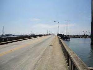

Constraint: US Highway 70 has narrow shoulders throughout and fast-mov ing traffic. Some sections drop off quickly at the roadside for drainage.
Opportunity: The Cape Lookout National Seashore is a significant attraction with camping, cabins, and the Cape Lookout Lighthouse. Ferry services operate from Beaufort, Harker’s Island, and Davis.

This page intentionally left blank for printing
This page intentionally left blank for printing


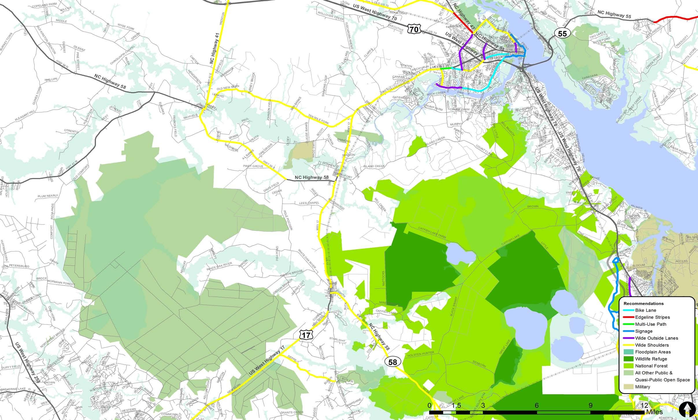


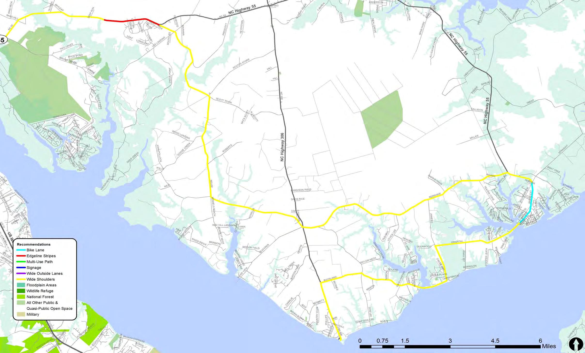

Trail Zoom-In Maps
The trail zoom-in maps on pages F-3 to F-14 are provided for anyone who wishes to better understand the recommended trail routing in this plan. The maps are particularly useful for state and local agencies as they begin developing more detailed design work for these projects. They will also help planning and transportation agencies as they explain these projects to various parties, such as local elected officials, potential funding agencies, and interested citizens. The graphic below shows how the overall trail system is broken out into more legible trail zoom-in maps.
CUT SHEET LOCATOR FOR MAPS ON PAGES 4-11 TO 4-21
Zoom-In Map 1: New Bern
Zoom-In Map 10: Pamlico
Zoom-In Map 6: Upper
Zoom-In Map 7:
Zoom-In Map 2: Havelock
Zoom-In Map 3: Neusiok
Zoom-In Map 4:
Zoom-In Map 5: Cedar
Zoom-In Map 9: Jacksonville-

Zoom-In Map
This page intentionally left blank for printing


This page intentionally left blank for printing
Introduction (G-1)
Need for Enhanced Bikeway Signing (G-1)
Creating an Identity for the Croatan Regional Bicycle Route (G-2)
Bikeway Wayfinding Signage Design Guidance (G-5)
Bikeway signage is a cost-effective treatment to improve the bicycling environment of a community or a region. This type of signage is typically referred to as ‘wayfinding,’ which allows a user to follow an intended route. The planned bicycle routes for this plan were developed over a year-long process, including input from the project stakeholders and knowledgeable local cyclists.
This first section of this appendix illustrates the best practices in the field of bicycle route wayfinding. This appendix is ultimately intended to provide the Croatan Region with a comprehensive guide to the development and implementation of a wayfinding system that will enhance existing and proposed cycling infrastructure. It provides general guidance on signage design – including dimensions, color, marking design and layout of individual signs. This guidance is consistent with the Manual on Uniform Traffic Control Devices (MUTCD), a publication of sign standards and guidance by the Federal Highway Administration (FHWA) and includes best practices from other regions throughout the U.S., including Chicago, Oakland, California, Milwaukie, and Oregon. Utilizing proven methods that others have successfully used improves the chances of success and saves time and money reinventing what has already been tested and found effective.
Signage can serve both wayfinding and safety purposes including:
• Helping to familiarize users with the bikeway system
• Helping users identify the best routes to significant destinations
• Helping to address misperceptions about time and distance
• Helping to overcome a “barrier to entry” for people who do not bicycle frequently, but who want to get started
• Alerting motorists to expect bicyclists on the route
Placing signs throughout the region indicating to bicyclists their direction of travel, the location of destinations, and the riding distance to those destinations makes the bicycle system more accessible to all users. Wayfinding signs also provide visual cues to motorists that they are driving along a bicycle route and should use caution. Signs are typically placed at key locations leading to and along bicycle routes, including the intersection of multiple routes. Choosing the right number of signs is important, since having too many road signs can clutter the right-of-way both physically and visually. It is recommended that bikeway signs be posted at a height most visible to bicyclists and pedestrians.
The following bicycle route logo was developed specifically for this region. The logo was originally developed as part of the branding for the regional planning process, with earlier versions of it being used in public meetings and announcements. The logo, therefore, is already part of the recognizable identity for bicycling in the region. The final version of the logo is shown below, and should be used in signage as shown in this appendix.
Uniformity, legibility and adherence to existing standards are among the elements to consider when determining the appropriate wayfinding sign design for the Croatan Region. National, state, and local standards (if any), along with local input, should guide the development of signage design.
National guidance on wayfinding signage is found in the MUTCD and the American Association of State Highway and Transportation Officials (AASHTO) Guide for the Development of Bicycle Facilities. State of North Carolina guidelines would come from the North Carolina Department of Transportation (NCDOT), but very little bikeway signage information is available from NCDOT beyond that which is available in the MUTCD
The MUTCD is a publication of signage standards and guidance published by the Federal Highway Administration. The National Committee on Uniform Traffic Control Devices reviews the document’s content closely and recommends updates regularly. The standards contained in this Croatan Regional Bicycle Route Signage Plan are based on the 2009 update to the MUTCD. The MUTCD uses highly specific language to classify design guidelines. The following terms are defined by the MUTCD:
• Standard: A statement of required, mandatory, or specifically prohibitive practice regarding a traffic control device.
• Option: A statement of practice that is a permissive condition and carries no requirement or recommendation.
• Guidance: A statement of recommended, but not mandatory practice in typical situations, with deviations allowed if engineering judgment or engineering study indicates the deviation to be appropriate.
For example, the speed limit sign Standard states that a speed limit sign will be placed at points of change from one speed to another while Guidance suggests that warning signs be posted prior to a speed change to alert motorists of the upcoming change. A section on Options covers factors that may be used in addition to engineering studies to determine optimal speed limits.
Bicycle guide signs are defined by the following Standards, Options and Guidance found in MUTCD Section 9B.20 Bicycle Guide Signs.
Option:
Bike Route Guide (D11-1) signs (see Figure G-1 on following page [MUTCD Figure 9B-4]) may be provided along designated bicycle routes to inform bicyclists of bicycle route direction changes and to confirm route direction, distance, and destination. If used, Bike Route Guide signs may be repeated at regular intervals so that bicyclists entering from side streets will have an opportunity to know that they are on a bicycle route. Similar guide signing may be used for shared roadways with intermediate signs placed for bicyclist guidance. Alternative Bike Route Guide (D11-1c) signs may be used to provide information on route direction, destination, and/or route name in place of the “BIKE ROUTE” wording on the D11-1 sign (MUTCD Figures 9B-4 and 9B-6). Destination (D1-1, D1-1a) signs, Street Name (D3) signs, or Bicycle Destination (D1-1b, D1-1c, D1-2b, D1-2c, D1-3b, D1-3c) signs (MUTCD Figure 9B-
Figure G-1: MUTCD Figure 9B-4. Guide Signs and Plaques for Bicycle Facilities


4) may be installed to provide direction, destination, and distance information as needed for bicycle travel. If several destinations are to be shown at a single location, they may be placed on a single panel with an arrow (and the distance, if desired) for each name. If more than one destination lies in the same direction, a single arrow may be used for the destinations.
Adequate separation should be made between any destination or group of destinations in one direction and those in other directions by suitable design of the arrow, spacing of lines of legend, heavy lines entirely across the panel, or separate signs.
An arrow pointing to the right, if used, shall be at the extreme right-hand side of the sign. An arrow pointing left or up, if used, shall be at the extreme left-hand side of the sign. The distance numerals, if used, shall be placed to the right of the destination names. On Bicycle Destination signs, a bicycle symbol shall be placed next to each destination or group of destinations. If an arrow is at the extreme left, the bicycle symbol shall be placed to the right of the respective arrow.
Unless a sloping arrow will convey a clearer indication of the direction to be followed, the directional arrows should be horizontal or vertical. The bicycle symbol should be to the left of the destination legend. If several individual name panels are assembled into a group, all panels in the assembly should have the same horizontal width.
The AASHTO Guide for the Development of Bicycle Facilities (2012) recommends that use of the Alternative Bike Route Guide (D11-1c) sign (which include a destination or route name) is preferred whenever practical, as it provides the rider with more useful information than the D11-1. The sign should be named with either a term that describes the corridor (for example, a route that generally follows a waterway or valley, or a route that follows or parallels a well-known street), or a destination, using a relatively well-known place reference that is at the end of that specific route. Figure G-2 depicts a conceptual Alternative Bike Route Guide sign that could be incorporated into the Croatan Region Bicycle Route.
North Carolina Department of Transportation (NCDOT)
Bike route signage guidelines in the North Carolina Bicycle Facilities Planning and Design Guidelines (1994) reference the MUTCD. More recently, Walk Bike NC: North Carolina Statewide Bicycle and Pedestrian Plan (2012) expands on Walk Bike NC by outlining bike route wayfinding signage levels of compliance with various facility design guidelines:
• MUTCD: Compliant (the treatment may be implemented at this time, if MUTCD compliant signs and pavement markings are used)
• AASHTO (2012): Included (the guidelines/standards discuss this topic and provide at least some guidance for application considerations)
• NACTO Urban Bikeway Design Guide (http://nacto.org/cities-for-cycling/design-guide/): Included
• North Carolina Department Of Transportation Complete Streets Planning And Design Guidelines (2012): Included
There are three basic sign types: Decision, Action (Turn) and Confirmation. Decision signs are placed along the corridors to inform bicyclists of connections with other corridors or significant existing routes. Action (Turn) signs are placed along a corridor where the alignment makes a major change of direction. Confirmation signs are placed at regular intervals along the corridor and to confirm turn or connecting corridor situations.
• Signed: A route with D11-1 signs placed every 0.25 mile.
• Unsigned: A route that is recommended for bicycling, yet no D11-1 signs are present.
D11-1 (Bike Route Guide and Decision Signs}
• D11-1 Signs appear in a variety of configurations, such as our examples shown. For the purposes of this guide, these signs (D11-1) will appear as Decision signs, Turn signs, as well as Confirmation signs.
• Per the MUTCD :
“Route Guide (D11-1) signs may be provided along designated bicycle routes to inform bicyclists of bicycle route direction changes and to confirm route direction, distance and destination.

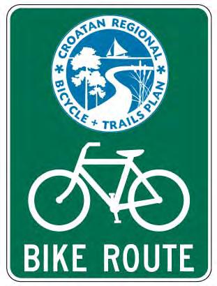

If used, Bike Route Guide signs may be repeated at regular intervals so that bicyclists entering from side streets will have an opportunity to know that they are on a bicycle route.
Alternative Bike Route Guide (D11-1c) signs may be used to provide information on route direction, destination, and/or route name in place of “BIKE ROUTE” wording on D11-1 sign.”
• For the use of D11-1 as a confirmation sign, the signs are typically placed: approximately every 0.25 mile after every turn in a route (unless the next turn is 0.125 mile away or less) after all signalized intersections within 160 feet after an intersection on existing poles (if practical)
Right: D11-1 sign with regional route logo.
D1-1b (Destination signs mounted below Bike Route Guide Signs)


• The D1-1b is only used as part of a Decision sign assembly.
• Non-Channelized
Place 40 feet before the intersection
Ensure sign is at least 20 feet, preferably 30 to 40 feet, from the stop sign or stop light
Ensure sign is not blocking the stop sign or stop light.
• Channelized
Sign is placed based on engineering judgment
Place between taper and bay
Ensure sign cannot be misinterpreted (e.g. turn into alley)
• Specific
- 4 signs max on one pole
- No more than 2 signs in one direction
The following pages illustrate the wayfinding signs described in the previous section as well as their installation along the corridor and at intersection situations. The section begins with an illustration of Decision, Action (Turn) and Confirmation signs along with an example of a custom D11-1 sign developed with the regional route logo. The following section illustrates several examples of Destination signs (D1-1b) referencing their size, font type and colors as well as other D11-1 route signs. Examples illustrate the placement of signage in signed and unsigned route intersection situations. Finally, guidance for vertical and horizontal sign clearances are shown as well as signpost and installation.
Beyond this standardized approach to sign installation and specification, additional information could be provided on the corridor signs in the form of a Quick Response code (QR code). First designed for the automotive industry, QR codes are becoming more common in public places. Users with a camera-equipped smart phone can scan the image to display text, contact information or open a web page. Use of QR codes on wayfinding signage is intended to direct bicyclists in the field to the presence of a regional bicycle plan webpage that might include corridor maps and background information. QR codes could be placed on the rear of D1-1b signs. Below are two illustrations of how this public information strategy could be used. This example is from Des Plaines, Illinois.


