National Aeronautics Space Administration
Goddard Space Flight Center

Large UV/Optical/IR Surveyor

Natural Feature Tracking
Gravity Recovery and Climate Experiment Laser Communications
Relay Demonstration


National Aeronautics Space Administration
Goddard Space Flight Center
Large UV/Optical/IR Surveyor
Natural Feature Tracking
Gravity Recovery and Climate Experiment Laser Communications
Relay Demonstration
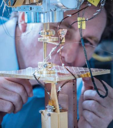
This report’s cover reflects the enduring arc of innovation that defines NASA’s Goddard Space Flight Center’s leadership in science and technology. Echoing Isaac Newton’s timeless acknowledgment, “If I have seen further, it is by standing on the shoulders of giants,” this year’s design honors the contin uum of discovery powered by generations of scientists, engineers, and technologists who dared to explore the unknown.
This year’s report represents more than a snapshot of NASA’s Goddard Space Flight Center’s technology achievements—it reflects a continuum of purpose, innovation, and strategic investment that has propelled the center’s scientific leadership for decades.
leadership, he is exceptionally well positioned to guide the agency’s largest and most diverse science and technology portfolio through its next phase of growth.
At Goddard, our progress is built on a legacy of curiosity, creative inquiry, and purposeful technology investment. Research and De velopment initiatives not only enable break through missions—they spark new questions that require technologies yet to be invent ed. This virtuous cycle of discovery, devel opment, and deployment is what propels NASA forward.
The cover symbolizes our commitment to that future-forward vision: seeding innova tions today so that tomorrow’s explorers can see further still.
autoNGC: from Inception to
Innovation is not a destination; it is a continuum. I am confident that the foundation we have built will continue to strengthen Goddard’s role as a driver of discovery and elevate NASA’s mission for years to come.
It has been my profound honor to serve as Goddard’s Chief Technologist and lead the center’s Independent Research and Development (IRAD) program for the past 20 years, culminating a 40-year NASA career devoted to advancing science, exploration, and mission excellence. Throughout that time, Goddard has remained the agency’s most comprehensive science and technology center; home to groundbreaking work in Earth observation, astrophysics, heliophysics, planetary science, communications and navigation, and suborbital systems.
The technologies featured in this report, beyond being mission enablers, are force multipliers of mission value. From quantum sensing and artificial intelligence to autonomous systems, advanced materials, and next-generation instruments, Goddard’s technology portfolio exemplifies the forward-leaning, high-impact innovation that underpins NASA’s future.
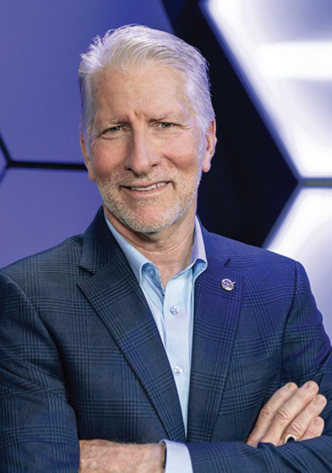

As I conclude my federal service at the end of July 2025, I am pleased to share that Bhanu Sood will serve as Acting Chief Technologist. With deep technical insight and proven

Goddard’s IRAD program nurtures seed technologies across the center’s strategic focus areas. These innovations enable new and future missions while attracting, retaining, and cultivating talented scientists and engineers. Dual investment in workforce and technologies positions Goddard to continue winning new missions and instrument starts in areas important to NASA’s mission priorities.
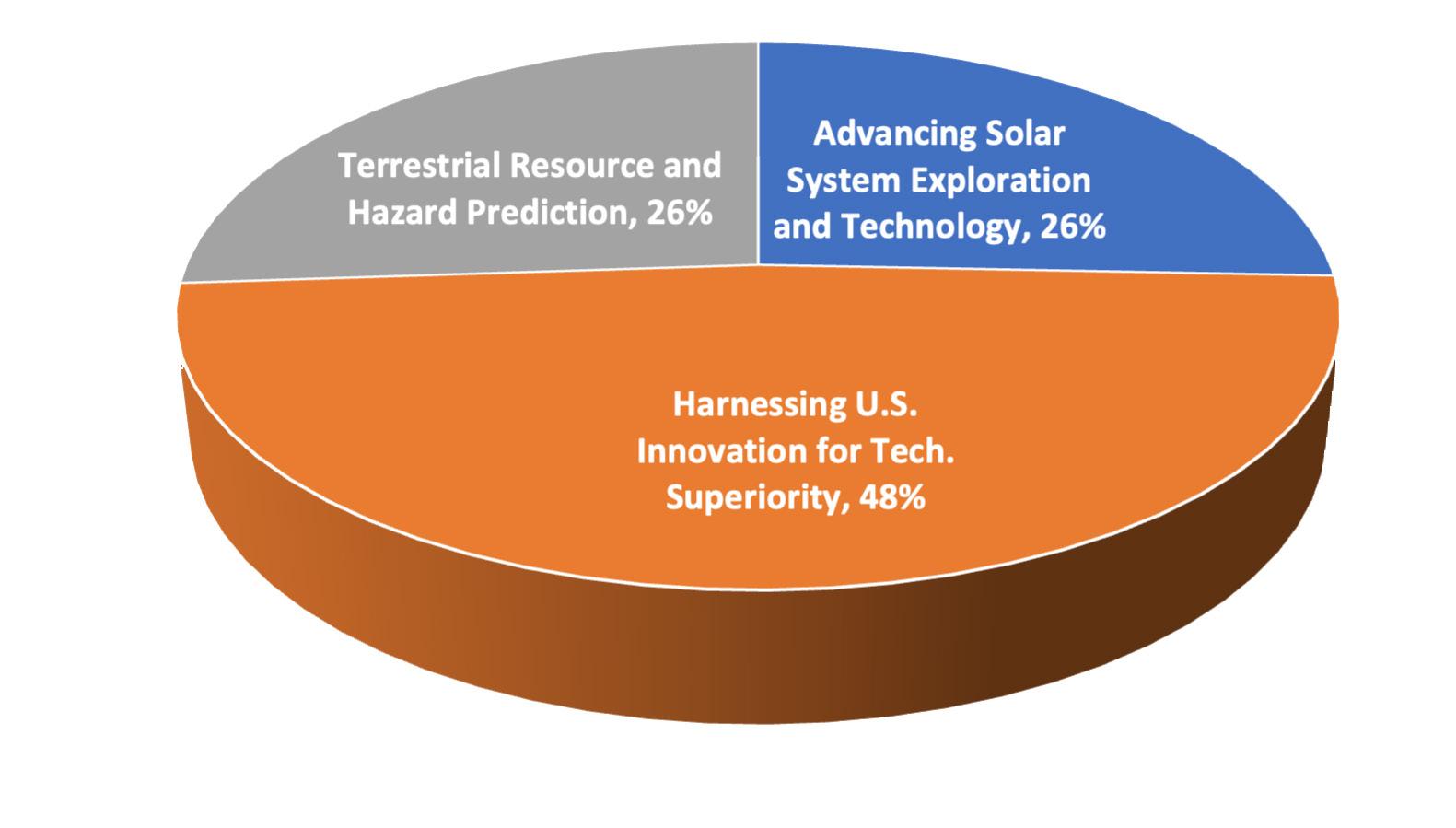
% IRAD Resources

IRAD funds can carry through the years, making state-ofthe-art innovations a reality and allowing novel projects to soar to new heights.
National Aeronautics Space Administration
Goddard Space Flight Center
Autonomous Navigation, Guidance, and Control (autoNGC) began as a vision by Goddard’s Cheryl Gramling, former Associate Chief Technologist, circa 2018 and was awarded IRAD funds in FY19, when the project’s framework construction began. After three additional years of IRAD funding and other investments, a team led by Sun Hur-Diaz continued to develop the autoNGC application suite. The project was executed by engineers from multiple Goddard divisions, and several opportunities for improvements were identified through collaboration with federal and industry partners and funding from IRAD and others.
Enabling a spacecraft to automatically plan maneuvers is necessary for advanced missions, such as distributed systems missions (DSM), with large numbers of spacecraft in coordinated flight where human-in-the-loop operations are prohibitive due to time constraints.
bital mechanics. The team also held discussions with NASA’s Johnson Space Center to determine whether their existing maneuver planning FSW could be integrated into autoNGC.
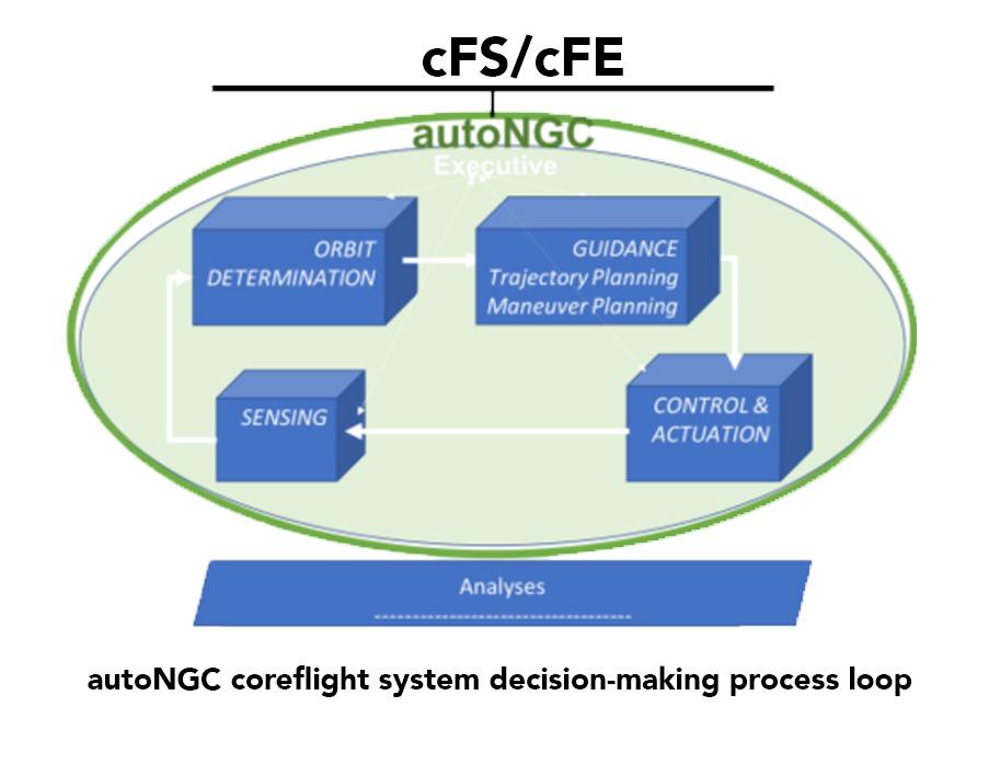
Robert Pritchett and his team used FY24 IRAD funds to develop a flight software (FSW) implementation of a maneuver-planning algorithm to include in Goddard’s software for autoNGC. The maneuver planning application is the first step in equipping autoNGC with the algorithms required for autonomous onboard guidance and control. The team implemented and tested a single-shooting maneuver-planning algorithm within the NASA core Flight System environment upon which autoNGC is built. This type of algorithm calculates the precise maneuvers a spacecraft must execute to move from its current position to a desired destination in space while considering factors like propellant usage, time constraints, and or-
At Goddard, onboard autonomy is not just beneficial, but enabling for multiple mission concepts. One example is the Virtual Telescope for X-ray Observations (VTXO) mission, which requires two spacecraft to fly in a tightly controlled formation. Additionally, potential servicing missions for observatories such as the James Webb or Nancy Grace Roman space telescopes will likely require onboard maneuver planning for rendezvous and proximity operations (RPO). The investment made in this FY24 IRAD can be leveraged to support these concepts or win new work through Science Mission Directorate and Space Technology Mission Directorate funding opportunities.
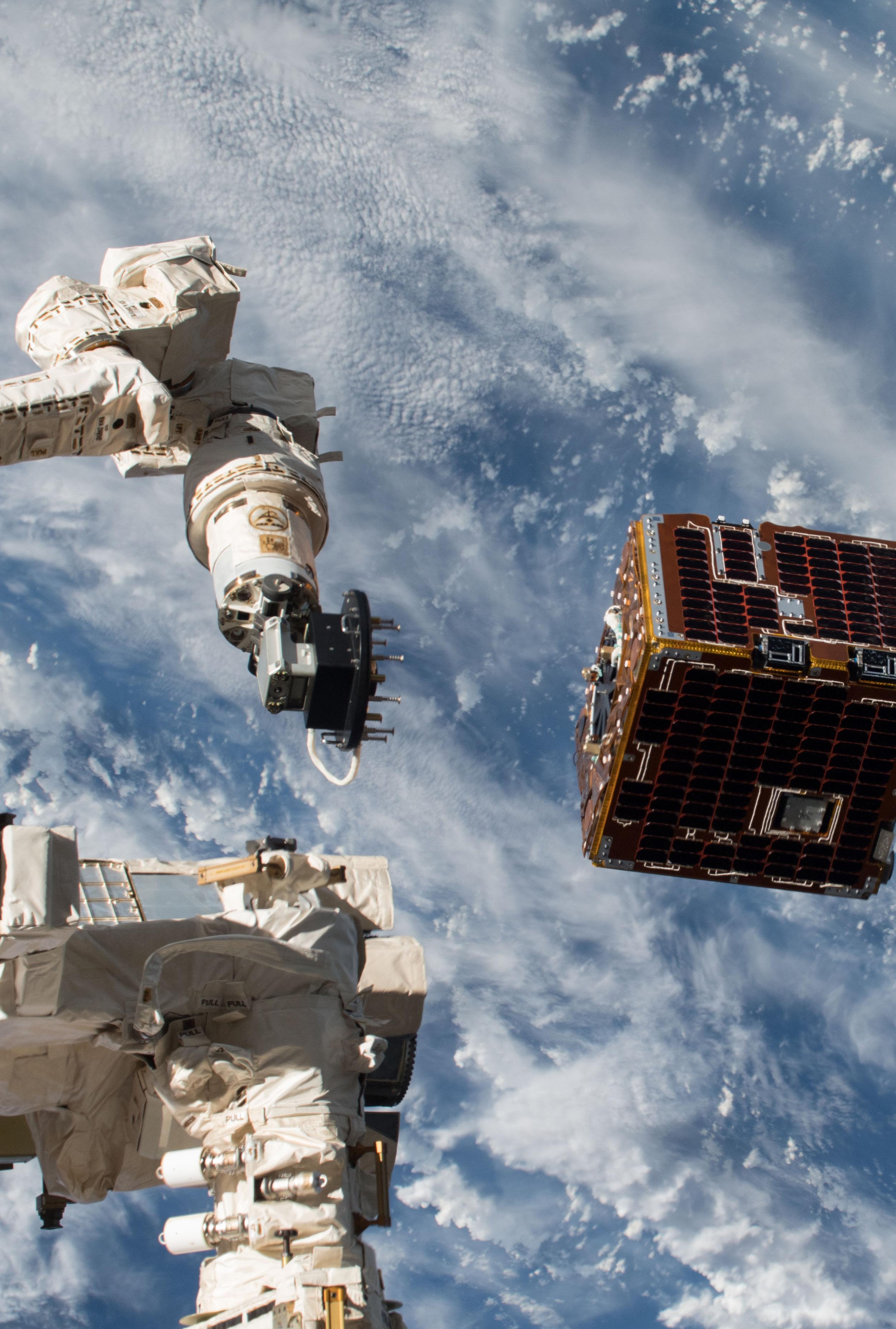
autoNGC’s first flight (since its inception in 2018) occurred during the week of May 19, 2025. Through a partnership with NASA’s Ames Research Center, autoNGC aimed to demonstrate onboard navigation, prediction, and maneuver planning capabilities on the Ames Starling mission. The autoNGC flight software – a suite of core Flight System (cFS) apps and libraries –was uplinked to two of the four spacecraft in the Starling swarm operating in a sun-synchronous, low Earth orbit. Once initialized, autoNGC provided onboard navigation by filtering Global Positioning System (GPS) pseudorange measurements. The main navigation function of autoNGC was provided by the Goddard Enhanced Onboard Navigation System (GEONS) library, another Goddard innovation with more than 25 years of flight heritage.
Using GEONS’ high-fidelity dynamics and measurement models, autoNGC delivered accurate onboard navigation knowledge, even during GPS outages. Post-processing of the navigation telemetry showed excellent agreement with the ground-based orbit determination solutions.
This successful demonstration of onboard navigation will soon be followed by autoNGC’s onboard ephemeris and covariance predictions, supporting Starling’s onboard orbit conjunction assessment and space traffic management experiment goals. Additionally, autoNGC’s onboard maneuver targeting capabilities will be demonstrated for autonomous station keeping and distributed system management.
Orbit determination for interplanetary missions primarily relies on radiometric tracking through the Deep Space Network (DSN), which traces the position and velocity of spacecraft. While these measurements are powerful and accurate, DSN’s use requires scheduling and planning, which can be burdensome to researchers and inconvenient for active missions.
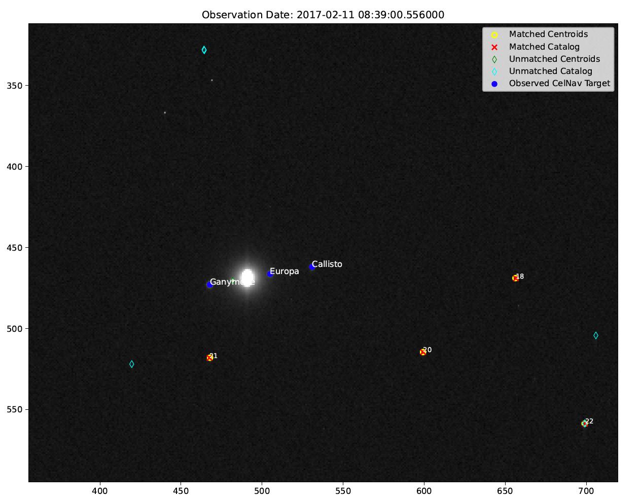
Andrew Liounis and his team are using FY25 IRAD funds to build celestial navigation (CelNav) capabilities into the autoNGC software suite, which exists aboard spacecraft and automates and controls dynamic spacecraft maneuvers.
CelNav uses images of known solar system bodies to locate spacecraft locations in the solar system. The application is usable nearly anywhere and requires minimal hardware (i.e., only a camera and a processor) to produce in-situ measurements capable of enabling autonomous spacecraft operations.CelNav provides an alternative to traditional radiometric tracking for safety-critical missions, those part of the Artemis campaign.
An
Including CelNav in the autoNGC onboard suite will be a supporting and enabling measure, supporting missions by reducing reliance on the oversubscribed DSN – thus freeing up resources for other missions, and enabling future missions where the light-time delay between spacecraft and Earth may hinder time-critical operations. CelNav can also enable smaller missions that would not usually be prioritized for significant DSN time and could therefore benefit from an alternative navigation technique while in deep space.
Matthew Brandt and his team used FY24
Autonomy has become an essential requirement for NASA missions beyond low Earth orbit. The Distributed Systems Mission (DSM) project, especially, needs autonomous systems to support many different constellation scenarios which require handling (e.g., communications delays, emerging science opportunities, and rapid resolution of any detected faults) and quick coordination among many spacecraft in a constellation.
The DSM Event Driven Planning (EDP) module uses an event-driven software architecture, a software design where a program’s operation is determined by external events such as sensor data or changes in the system. Certain components of the program report events to separate components, which then respond to the reports by taking appropriate action.
IRAD funds to implement the EDP software architecture in Python, a high-level, general-purpose programming language. The EDP software was used to demonstrate several constellation-related autonomous scenarios in FY24. The primary scenarios were a series of multi-drone demos in support of the Network for Assessment of Methane Activity in Space and Terrestrial Environments (NAMASTE). These scenarios involved the use of two or three multi-rotor airborne drones whose flight planning and execution was controlled by EDP to perform coordinated mapping of methane levels, both simulated and live in the field. EDP demonstrated actual autonomous drone-path planning, mapping, and control in Alaska in the summer of 2024.
The DSM EDP module has the ability to handle all requirements for autonomous constellation operations via flexibility, asynchronous messaging (where events are sent and received without the sender needing to wait for a response), and modern AI techniques including: machine learning (where algorithms learn from data and make predictions), reinforcement learning (where an AI agent is trained to make decisions to optimize a desired outcome or achieve a goal by interacting with data from the environment and receiving positive, negative or neutral feedback on its decisions), and modern planning algorithms.
The DSM EDP project demonstrated the following features essential to distributed constellation missions: flexibility, autonomous operations, asynchronous event-driven actions, handling of communication delays and faults, and modern planning and scheduling algorithms. These results likely position the module for use in several future constellation missions, including Magnetospheric Constellation, Geospace Dynamics Constellation, Enceladus-oriented missions, and others.
A constellation of spacecraft flying in formation can assist with developing advanced mission concepts, including those related to constellations, starshades, servicing, and synthetic telescopes. These concepts can be realized through small spacecraft (SmallSat) platforms, which have low costs due to standardization and low size, weight, and power requirements. Through coordination, individual spacecraft flying in formation within a constellation can execute advanced mission concepts typically reserved for a single large spacecraft.
regime. Using IRAD FY24 funds, the team continued the toolkit’s development and moved to release its first public version.
While Goddard has extensive expertise in formation flight, a common toolkit to perform the necessary analysis for these types of missions does not exist. Typically, engineers will develop specific toolkits for their respective missions, which is not easily portable to other studies.
Specifically, the toolkit enables the DSM architecture, where multiple spacecraft can be used to achieve common goals. The toolkit facilitates the mission design process and helps identify propellant-efficient formations and control strategies for both translational (i.e., movement of a spacecraft from one place to another without changing its orientation) and attitude dynamics, thereby enabling future formation missions. DeepThought provides users a simple graphical user interface to generate common missions using the DSM architecture, while providing the necessary navigation, guidance, and control algorithms to achieve the complex science objectives demanded.
36 SmallSats in a series of various orbits to allow a three-dimensional mapping of the magnetosphere, giving valuable insight into magnetic field dynamics and interaction with solar weather. Another mission in the DSM architecture that will benefit from this work is the Virtual Telescope X-ray Observatory. This mission plans to utilize SmallSats flying in a one-kilometer formation to image bright X-ray sources to improve our understanding of the universe. DeepThought allows for the design and analysis of these mission concepts in a high-fidelity environment, providing great value to scientists and engineers.
Pavel Galchenko and his team began investigating this trade space in 2021 and started to develop the DeepThough toolkit. The toolkit is built based on “NASA 42: A Comprehensive General-Purpose Simulation of Attitude and Trajectory Dynamics and Control of Multiple Spacecraft Composed of Multiple Rigid or Flexible Bodies’” simulation framework, which is a powerful simulation tool for modeling spacecraft attitude (i.e., orientation), orbit dynamics, and environmental models. DeepThought expands these capabilities to provide methods for orbit visualization, selection, and analysis of SmallSat formation-flying missions in a multi-body
In 2025, with core functionality completed, the team focused on improving the toolkit’s features, functionality, and usability by seeking feedback and working with the open-source community and customer base. The project is available opensource on NASA 42’s GitHub website.
As Goddard advances interest in DSM architectures, the importance of formation flight cannot be overstated. Many scientific concepts require making multi-point observations, which can only be done using constellations of spacecraft in formation flight. Missions such as the Magnetospheric Constellation mission plan to utilize over
Large language models (LLM), a type of neural network foundation model, like ChatGPT for example, have swept through the world and changed the landscape of artificial intelligence. LLMs’ core machine learning (ML) model is the transformer neural network model, which was first proposed by Google in 2017.
Gong used FY24 IRAD funds to understand whether the transformer framework could overcome two common hurdles when applying the AI and ML techniques to NASA data: cross-time and cross-mission knowledge transfer.
Cross-time knowledge transfer allows an AI
National Aeronautics Space Administration
Goddard Space Flight Center
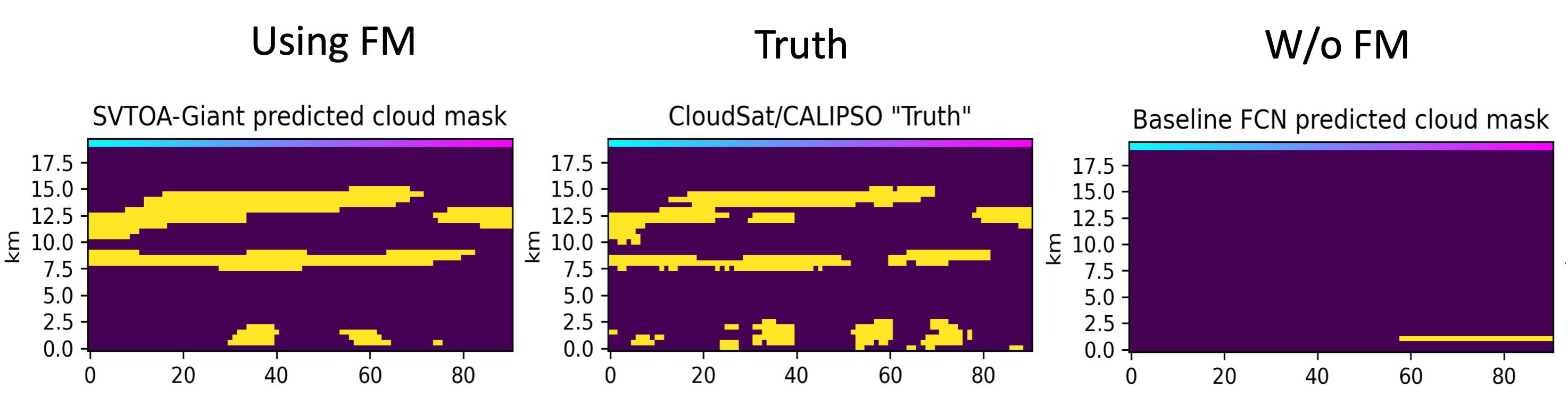
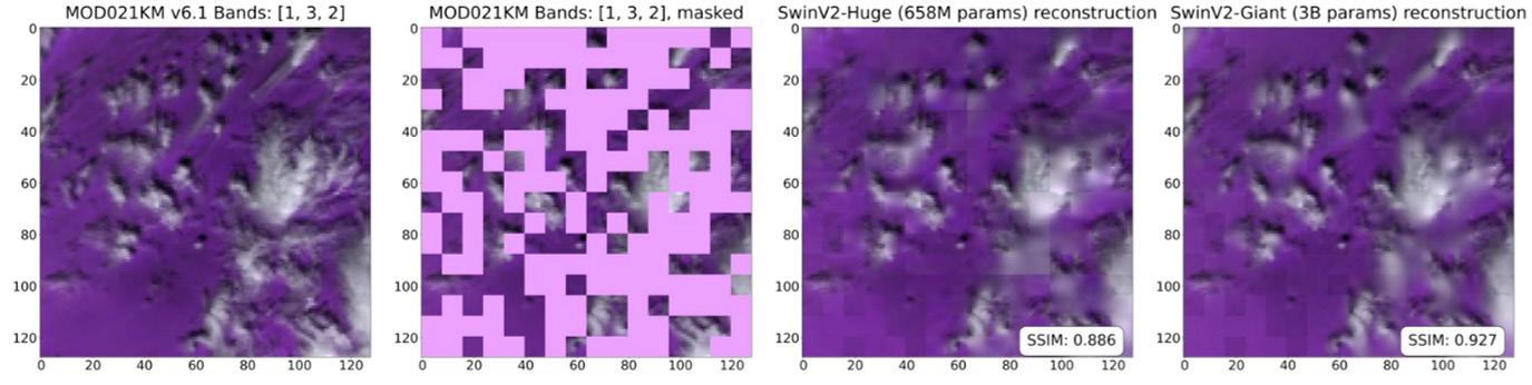
applied to reconstructing images from the Advanced Baseline Imager, which is a MODIS-like instrument onboard the Geostationary Operational Environmental Satellites (GOES)-R-series, but with fewer channels than MODIS. In addition, the team also tested the model’s benefit on a downstream task: three-dimensional (3D)-cloud reconstruction, where they proved that using SatVision-TOA significantly improves the similarity score for 3D-cloud-mask prediction over an off-the-shelf, deep learning model, especially for complicated situations like multi-layer cloudy scenes.
random images taken over a 10-year period, representing different seasons, surface situations and inter-annual variabilities. The team built two MODIS allsky-radiance-based foundation models (MODIS-Top-of-Atmosphere [TOA]-Huge and MODIS-TOA-Giant). The models adopted the Mask-Image-Modeling (MIM) framework to train and learn detailed contextual representation of all-sky images (i.e., including clouds and other atmospheric phenomena) through self-supervised learning without any labels. These conditions make the models suitable for a variety of downstream tasks, including those related to the atmosphere. The two models where trained based on 200 million all-sky MODIS images with 658 million (MODIS-TOA-Huge) and three billion (MODIS-TOA-Giant) parameters; the latter, later re-named “SatVision-TOA”, is the largest foundation model trained solely on satellite images (to the team’s best knowledge).
Unlike other ML models, the transformer neural network uses the multi-head attention mechanism to train an ML model to notice patterns in data, mimicking how neurons work in the human brain. The transformer model overcomes the memory-vanishing-gradient problems that are often barriers for other deep-learning models, allowing the transformer model to prioritize important features and their connections during training, even if they are spatially or temporally distant from one another. This unique advantage makes the transformer framework suitable for building satellite-image-based foundation models.
model to apply what it learned from past data-processing experiences to its future processes, while cross-mission transfer allows an AI model to apply what it learned from one mission to another. Successfully demonstrating AI’s capability in these two domains could allow the power of past NASA satellite observations to be harnessed and improve future satellite products using similar but better (e.g., smaller, cheaper) instruments.
The team found that SatVision-TOA, the model with more parameters, performed better than the model with fewer parameters in reconstruction, especially for cloudy scenes. The team also proved that the model’s transfer learning is functional and that SatVision-TOA performed better at transfer learning when it was
This project is one of the pioneer efforts to introduce the transformer model to NASA-specific remote-sensing applications, and its outcomes will likely provide constructive advice for including the transformer framework into the ever-developing NASA digital-transformation roadmap while revolutionizing the satellite retrieval strategy for next-generation missions. For Goddard, this project serves as a significant steppingstone that will enable the center to take full advantage of frontier ML and AI technologies and to prepare Goddard to capture upcoming funding opportunities.
A team led by Principal Investigator Jie
To test this proposition, the team used randomly cropped images from the Moderate Resolution Imaging Spectroradiometer (MODIS) instrument on the Terra Earth Observing System satellite. The training and testing dataset was composed of
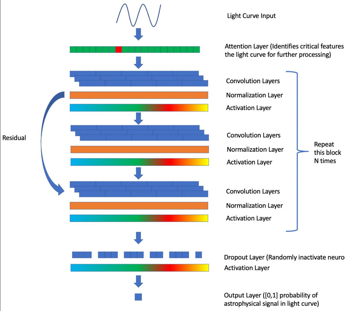
Astronomers analyze light curves – the change in brightness of a celestial object over time – to obtain information about the object’s properties, including the classification of the object and whether it has companions, such as stars, or planets in its orbit.
National Aeronautics Space Administration
Goddard Space Flight Center
However, due to the vast amounts of light curve data available in research databases (ranging from tens to hundreds of millions of datapoints), researchers often have difficulty identifying a light curve containing their astrophysical signal of interest. This obstacle will only grow as improved observatories, such as Roman, improve and build upon current light curve datasets.
Brian Powell and his team are employing AI to automate these highly specific light curve database searches. The team developed a universally applicable machine learning framework to assist researchers in locating any known or predicted astrophysical signal present in Roman Space Telescope light curves. The team built a neural network, an algorithm that processes data similarly to the human brain, and trained it to decompose and reconstruct several million synthetic Roman light curves that represent different types of stellar variability.
The team used the foundation of this neural network model to train a different type of neural network to classify the light curves. Using the pre-trained foundation, the model was able to converge (i.e., reach a stable conclusion) extremely quickly, within only a few rounds of training, to nearly 75% accuracy in classifying variable and unfamiliar light curves. In contrast, the model without the pre-trained foundation was completely unable to converge.
These results demonstrate the model’s potential for fast training on unknown signals. Powell and his team plan to make this model publicly available to scientists searching for signals in Roman light curves, allowing for fast discovery and amplifying the benefit of Roman data.
National Aeronautics Space Administration
Goddard Space Flight Center
Laser altimetry, also known as light detection and ranging (lidar), calculates the distance from a laser’s origin point to a surface by measuring the time a laser pulse takes to travel from a laser emitter to a surface and back to a sensor. Laser altimetry data is invaluable for mapping the surface topography and surface structure of Earth and other planetary bodies and has significantly enhanced our understanding of Earth’s forests and the long-term changes in ice sheets, shedding light on how the planet’s surface responds to climate-driven events.
Station that precisely measures forest canopy height, canopy vertical structure, and surface elevation. By accurately measuring forests in 3D, GEDI data plays an important role in understanding the amounts of biomass and carbon forests store and how much they lose when disturbed.
tation risk and improve cost, risk posture, and the proposal’s chances of selection overall. Further, through IRAD funding, the team demonstrated that this beam scanner technology’s potential beam number capacity and two-axis scanning capability will allow for its application in increasingly capable, next-generation imaging lidar following EDGE.
As lasers have become more efficient, reliable, and higher in power and rep-rate (i.e., the number of laser pulses emitted per second), and as detectors continue to improve, space-based laser altimeters must overcome barriers related to laser scanning in order to move beyond multi-beam implementations to true imaging. For example, to produce geodetic quality images at higher resolutions, laser scanners need sub-arcsecond accuracy, high efficiency, long lifetimes, and microsecond switching times.
The successful demonstration of this prototype solid-state laser scanner has the potential to generate more than an order of magnitude increase in coverage from a single laser. The scanner is an enabling step for future imaging lidar opportunities called for in the National Academies of Sciences, Engineering, and Medicine 2017-2027 Decadal Survey for Earth Science and Applications from Space, including NASA’s Earth System Explorer (ESE) Program and Surface Topography and Vegetation Study.
Using FY24 IRAD funds, Bryan Blair and his team built and demonstrated a threestage, eight-beam digital beam scanner that is solid-state (i.e., has no moving parts), highly efficient, fast, reliable, and accurate. This scanner is a derivative of the Global Ecosystem Dynamics Investigation (GEDI) instrument’s beam dithering unit (which changes the beams’ direction). GEDI is a lidar installed on the International Space
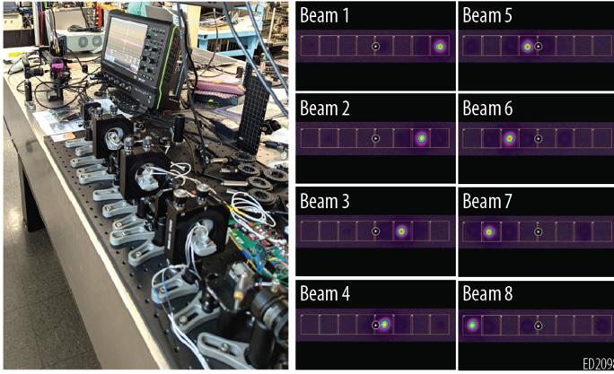
This successful prototype has also improved the competitive position of the Earth Dynamics Geodetic Explorer (EDGE) mission, which has been proposed for inclusion in ESE. EDGE was selected as one of four missions funded for Phase A and is being considered for one of the two available mission opportunities. Specifically, the development process enabled Blair and his team to mature their understanding of component performance sensitivity and assembly alignment sensitivity and verify their performance models. These outcomes reduce EDGE’s implemen-
Laboratory prototype of digital beam scanner in its 8-beam configuration (L: setup, R: far-field test images of the 8 beam paths). This IRAD-funded prototype demonstrated the required crosstalk isolation, throughput efficiency, and pointing accuracy needed for space-based geodetic laser altimetry.
National Aeronautics Space Administration
Goddard Space Flight Center
To support Artemis plans for continued human exploration of the Moon, the Lunar Exploration and Science Orbiter (LExSO) mission concept is being developed to serve critical future lunar exploration and science measurement needs. Continued orbital presence at the Moon remains vital to lunar science. However, the Lunar Reconnaissance Orbiter (LRO), one of the most essential contributors to lunar science, is beyond its design lifetime and may not be operational past the first few human Artemis landing missions. LExSO will equip Artemis with situational awareness, planning, science gap coverage, and enhanced capability by providing improvements to LRO imagery and localized topography.
frequency conversion that functions inside a laser cavity using a neodymium-doped yttrium aluminum garnet (Nd:YAG) laser as the pump. There are two major changes from the LVO design. The first is to let out the 1.064-micron residual pump laser light for topographic mapping. The second is to be able to pulse at a much higher rate when flying over high-valued areas. Gregory Clarke and his team used FY24 IRAD funds to build two optical designs to demonstrate these new laser capabilities and perform a trade study.
team demonstrated that the laser can safely operate in burst mode for at least 10 seconds, which corresponds to a 16-kilometer ground track. The burst-mode testing successfully demonstrated an innovative laser that builds upon a design with a strong heritage of success in space-based applications and allows LExSO to map surface topography at a high pulse rate on-demand.
The tests also reduced the risk of the new design. IRAD funds supported these updates to the current laser design, allowing the laser to meet the new LExSO laser requirements and increasing Goddard’s competitive edge in assisting with the upcoming mission’s instrument construction.
One of the primary payload instruments is the Spectroscopic Infrared Reflectance and Altimetry Lidar (SpIRAL). SpIRAL has a new requirement to provide submeter spatial resolution and gapless topographic mapping of landing sites and other high-valued areas, which will build upon current requirements to map global surface reflectance at the 3-micron and 1.6-micron water bands (i.e., the specific wavelengths that distinguish land from water), as seen in the Lunar Volatiles Orbiter (LVO) mission concept.
The team built broad-board lasers based on the heritage Lunar Orbital Laser Altimeter laser, but replaced one end mirror with a nonlinear crystal to convert it to an IOPO laser. The crystal required a complex optical coating that had not been tested previously. This coating was difficult to produce, and the coating vendor required several attempts and long lead-times. Nevertheless, the team successfully created and implemented the optical coating on the IOPO’s nonlinear crystal.
The new LExSO requirements also called for changes to the optical design of the previously considered laser, which consists of an intra-cavity optical parametric oscillator (IOPO), an optical component utilized for
To test the laser’s performance, the team conducted a burst-mode operation, increasing the laser repetition rate from 100 times per second to 250 times per second for a short period of time, long enough to map a typical landing site but short enough to maintain performance and avoid overheating the laser. After several tries, the
National Aeronautics Space Administration
Goddard Space Flight Center
Transient structures in solar wind, such as coronal mass ejections (CMEs) and stream interaction regions (SIRs), can generate geomagnetic storms capable of disrupting power grids and satellites. The shape, intensity, and orientation of magnetic fields carried by these structures contribute to the severity of these storms, so understanding the emergence of magnetic flux from the solar interior through the photosphere and its global impact on the inner heliosphere is a key scientific goal of the Heliophysics community.
known as Faraday rotation. FETCH will be the first instrument to transmit and receive polarized radio waves in solar wind. By measuring how radio signals are modified by Faraday rotation as they encounter magnetic fields in solar wind, FETCH will provide insights into the magnetic field configuration of the inner-heliospheric structures that will support the MOST mission concept. Due to large spacecraft separation distances, achieving a sufficient signal-to-noise ratio (SNR) in FETCH data to allow for quantitative Faraday rotation measurements is difficult.
The Multiview Observatory for Solar Terrestrial Science (MOST) mission concept will make measurements of solar variability from the solar interior, atmosphere, and the interplanetary medium or solar wind. MOST will be a four-spacecraft mission with one at Lagrange point 4 (MOST1), one at Lagrange point 5 (MOST2), and the other two (MOST3 and MOST4) at variable locations along Earth’s orbit. Each spacecraft will have multiple instruments, and all four will carry a novel radio package known as the Faraday Effect Tracker of Coronal and Heliospheric structures (FETCH), which will systematically probe the magnetic content of transient solar wind structures, including CMEs and SIRs. Faraday rotation measurements will provide the magnetic content of these structures at various heliocentric distances from the outer corona to Earth’s vicinity.
Natchimuthuk Gopalswamy and his team used FY24 IRAD funds to perform a trade study to determine the optimal antenna type that would ensure a sufficient SNR in the FETCH data. In the investigation, the team modeled the SNR expected to be encountered by the FETCH receiver and worked on analyzing and optimizing a wideband, low-frequency (165-225 megahertz [MHz]) antenna for a radio frequency transceiver used in FETCH instrumentation.
An antenna must satisfy size, weight, and power requirements without compromising its electromagnetic performance in order to detect the Faraday rotation of radio waves passing through CME plasma. The team explored the feasibility of using two types of antennas: the Log Periodic Dipole Array (LPDA) and the Yagi antenna, and concluded that the LPDA best meets the gain and bandwidth requirements.
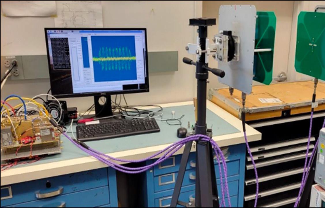
The experimental setup for simulating the Faraday effect in the laboratory, displaying the software defined radio assembly (L), signal generator (bottom R), transmitting and receiving antennas (top R). The transmitting antenna is rotated to simulate Faraday rotation.
As polarized radio waves – low-energy electromagnetic waves that are vibrating in a preferred direction – travel through solar wind and encounter magnetic fields, the magnetic fields rotate the polarization plane of the radio waves in a phenomenon
National Aeronautics Space Administration
Goddard Space Flight Center
The Goddard Earth Observing System (GEOS) is a data assimilation system that uses data from NASA’s Earth science missions for atmospheric and climate modeling and prediction. However, the present version of GEOS only holds atmospheric data to 80 kilometers (km) high. Fabrizio Sassi and his team used FY24 IRAD funding to test the feasibility and benefits of adding data from NASA’s Heliophysics missions to extend GEOS range to the upper regions of Earth’s atmosphere (i.e., beyond 80 km). These regions are directly influenced by space weather from solar activity, such as flares and coronal mass ejections, and associated magnetic storms that can produce auroras and disrupt electrical, communication, and navigation systems, including spacecraft navigation.
The aspirational goal of this project is to produce atmospheric background states up to the lower thermosphere (about 110-120 km) that can be utilized by upcoming spaceflight mission opportunities. Ultimately, this project will enable the inclusion of other Heliophysics data in GEOS through follow-up efforts that will extend its capability to higher altitudes and enable its use in space weather applications.
per-atmosphere observations has similar beneficial effects to those associated with other datasets, and the combination of all datasets (to be completed) can have beneficial effects on upper-atmosphere simulations using GEOS. These results will extend the validity of GEOS to the mesopause and the first step toward including other Heliophysics observations in a vertically extended domain of GEOS.
The team added temperature data from the stratopause (about 50 km) to the mesopause (about 90 km). The stratopause is the region where ozone heating peaks, while the mesopause is the region with the coldest temperatures in Earth’s atmosphere during solstices. They used data from the Sounding of the Atmosphere using Broadband Emission Radiometry (SABER) instrument on the Thermosphere Ionosphere Mesosphere Energetics and Dynamics (TIMED) mission.
The goal of the project was to bridge critical components of space weather observations and Earth-system modeling at Goddard that currently reside separately.
Sassi and his team tested the system by adding SABER temperature data to GEOS Instrument Teams, a modeling project that aids instrument teams by subtracting data from specific sensors for comparison. The test revealed that the integration of up-
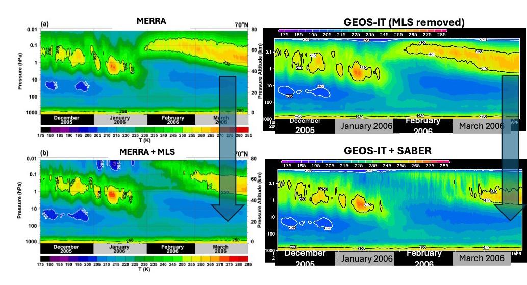
NASA Heliophysics data has been used only sporadically with other Earth observations to build a whole-Earth-system view that can be used to create a climate record from Earth’s surface to the upper atmosphere and products that can be utilized in planned spaceflight missions.
National Aeronautics Space Administration
Goddard Space Flight Center
NASA’s robotic missions rely on instruments that analyze the composition of samples from remote worlds for clues of their past, including their ability to support life. One such instrument is the gas chromatograph, a device that determines the composition of a gaseous sample by separating compounds in the sample through their interactions with material in an analytical column and identifying the compounds using sensitive gas detectors.
However, these instruments are typically too large, heavy, and energy-intensive to be practical for spaceflight. With FY24 IRAD funding, Lu Chou and her team are using fabrication technology to design and build a microchannel gas chromatograph analytical column to introduce gas flow to computer chips, seeking a small and lightweight approach to gas chromatography. This device, Goddard’s first micro gas chromatograph, will pave the way toward incorporating similar instruments into future high priority decadal survey-recommended missions.
miniaturized instrument system can be used to detect and characterize volatiles that hold critical information about planetary habitability and biosignatures. The novel chromatograph technology can be used to support current and future life detection missions, such as Enceladus Orbilander, Mars Life Explorer, New Frontiers, Uranus Orbiter and Probe, and Artemis.
Chou’s team’s miniaturized chromatography system, and similar devices, can be coupled to Goddard’s flightready mass spectrometers, instruments that ionize molecules and identify them by their signature mass-to-charge ratios. The
Typically, sensors for data collection related to the functioning of a spacecraft (known as “spacecraft housekeeping”), such as temperature and power levels, are distributed across various sub-systems. The data is collected using separate components, such as analog-to-digital converters, analog multiplexers, and amplifiers. Such discrete implementations require additional size, weight, and power, and interconnect complexity with an integrated circuit solution.
In the short term, this effort seeks to produce a flight-worthy, radiation-hardened ASIC that will replace several discrete devices in current and future science instruments, power system electronics designs, and instruments and systems housekeeping, thus reducing the instruments’ size, mass, power, cost, and complexity.
Although commercial devices are readily available, they are not suitable for space applications due radiation tolerance and qualification requirements. Spacecraft encounter harsh, ionizing radiation from various sources, such as explosive activity on the Sun from solar flares and coronal mass ejections, and powerful events in deep space, such as exploding stars.
In the long term, the proposed device is a step toward enabling the development of essential radiation-hardened ASICs that support Goddard miniaturized instruments and sub-systems, including particle instruments, laser altimeters, astrophysics X-ray energetic telescopes, power supplies, and housekeeping. The device will also be beneficial to projects proposed in the NASA Explorers Program Announcement of Opportunities list and SmallSat missions.
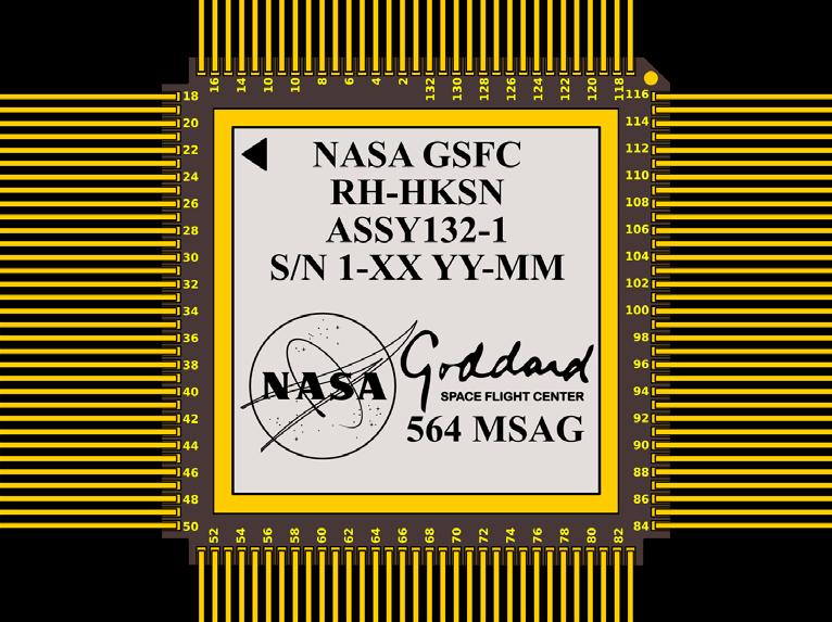
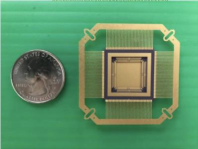
A team led by George Suarez used IRAD FY24 funds to continue developing the Radiation Hardened Power System Electronics Housekeeping (RH-PSEHK/HKSN) Application Specific Integrated Circuit (ASIC), a low-power data acquisition system on a chip that is resistant to space radiation and suitable for miniaturized instruments, CubeSats (i.e., cube satellites; a class of SmallSat), and spacecraft housekeeping data collection. The project’s main objective was to access a new chip manufacturing foundry, migrate the team’s intellectual property core (i.e., the reusable unit of integrated circuit design), and advance the design of the RH-PSEHK/HKSN.
The ability to accurately know a mission’s location on the surface of an airless solar system body is a necessity for science, planning, and safety. However, building a system of navigation satellites at these bodies is expensive and lengthy.
cy and more precision than what can be achieved through LunaNet alone.
National Aeronautics Space Administration
Goddard Space Flight Center
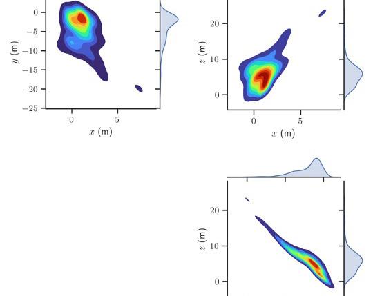
The team has developed and tested an image processing pipeline capable of estimating surface location within tens of meters using only a monocular camera, an inertial measurement unit, and a single-board computer. The pipeline takes image data from a camera and transforms
Future missions to the Moon will require self-sufficient and redundant onboard localization for rover and human surface operations. Liounis’s team held discussions with colleagues at Johnson about their interest in this technology and their desire to include it as a ground tool for Artemis III and IV, and potentially as an onboard tool for Artemis V+, presuming that the tool is proven to be a good solution.
Additionally, the team is partnering with Johnson to continue development of this tool, which began in FY23 and has continued through the present with Goddard contributions funded through IRAD.
For example, the Artemis campaign continues to progress toward permanent lunar surface operations where one of the driving needs for safety and science is precision localization. LunaNet is currently under consideration as a promising concept solution to this problem. LunaNet is a framework that will allow industry, academia, and international partners to build and operate networking nodes alongside NASA, in essence extending the internet and GPS to the Moon. These nodes will offer missions four distinct services: networking, navigation, detection and information, and radio and optical science services.
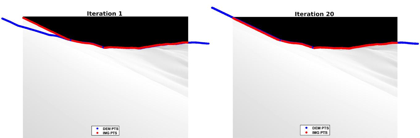
it into information about the user’s position and orientation. In 2024, they focused on demonstrating the pipeline’s capabilities with simulated images and data.
However, a team LED by Andrew Liounis used FY24 IRAD funds to continue development of a complementary and lower-cost approach for geolocation technology (which will be available before LunaNet is established) utilizing in-situ observations of the lunar horizon with only a monocular camera. This technology will be useful during possible signal outages with LunaNet, during emergencies, and for use with information-fusion techniques to refine localization estimates with better accura-
Results from the simulation were excellent. The end-to-end pipeline was successful and met performance expectations when applied to synthetic images rendered from a surface user’s perspective. Additionally, analysis of the algorithms used in the pipelines demonstrated that by making use of star images to provide attitude, localization performance can approach 5-10 meters, which meets the requirements for Artemis surface operations.
ing, and identified the software and hardware needed for the VR demonstration. To date, these ga me-changing data rates have not been achievable using existing sounding rocket technologies. With these high data rate-capable systems, utilizing high-bandwidth data, such as high-definition video or other high-bandwidth data transfers, will be possible.
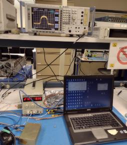
To date, maximum sounding rocket downlink rates (i.e., the linking rate between signals moving from Earth to spacecraft) have been limited to less than 50 megabits per second (Mbps) when using commercially available transmitters and range telemetry receivers. Higher data volumes generated by sounding rocket science instruments require significantly higher downlink rates. Brian Banks and his team used FY24 IRAD funds to develop a high-data-rate telemetry system that operates in the C-band (the 4,400-4,940 megahertz Aeronautical Mobile Telemetry band). This is a higher-frequency band in the electromagnetic spectrum than the S-band, currently used for suborbital rocket telemetry, allowing for a much higher data rate, set to 300 Mbps for the team’s system.
As part of the project, Banks and his team developed a high-rate C-band radio frequency (RF) modulator, a device that encodes data on the transmitted signal. The RF modulator will be used on the main payload of a suborbital rocket flight that will help evaluate the impacts of vehicle dynamics and high roll rates on high-speed telemetry link performance. The sounding rocket will implement a virtual reality (VR) demonstration to provide a real-time, 360-degree view by stitching together data streams from high-definition cameras. Banks and his team built the RF modulator by modifying an existing in-house design, performed test-
several iridium, chromium and iridium-chromium bilayer samples using iridium possessing the required low surface roughness for future X-ray mirror coatings.
X-rays are produced by some of the universe’s most violent events, such as when the intense gravity of a neutron star or black hole tears material away from a nearby star. Achieving very detailed (arcsecond) X-ray imaging in the 0.1-10 kilo-electron-volt (keV) energy band to obtain a better understanding of such events is vital to X-ray astronomy’s future.
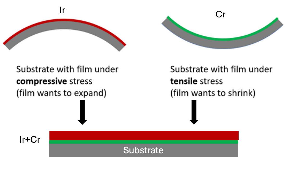
Iridium mirror coatings are the most efficient for reflecting X-ray energies less than 10 keV and are the preferred coatings for telescopes in the soft X-ray range (0.1-5 keV), but iridium coating displays compressive stress under certain conditions, which can cause the film to expand and impact the mirror’s imaging quality. Thus, controlling coating stress is critical to achieving arcsecond imaging performance.
The iridium-chromium combination has been baselined for the High Energy X-ray Probe (HEX-P) proposal’s Low Energy Mirror Assembly (LEMA). This research is also relevant for the Line Emission Mapper (LEM) and Advanced X-ray Imaging Satellite (AXIS) X-ray probes, as well as future NASA explorer calls. The Next Generation X-ray Optics team at Goddard is providing optics for all three concepts, and the efforts of this proposal will advance mirror coatings’ Technology Readiness Levels across many proposals.
A proven method to countering compressive iridium stress involves placing a tensile chromium layer underneath the iridium, which encourages the film to shrink and neutralizes the effects of the compressive stress.
A team led by Kristin Madsen used FY24 IRAD funds to successfully measure the coating properties of iridium and chromium thin-film coatings deposited with direct current (DC) magnetron sputtering, a technique that applies coatings to a substrate in a vacuum chamber using DC to create a plasma from an inert gas. Accelerated ions in the plasma hit the coating material, knocking off atoms which are directed to the substrate. Madsen’s team produced


Text-to-Spaceship: Revolutionizing Mission Development through AI and Evolved Systems
National Aeronautics Space Administration
Goddard Space Flight Center
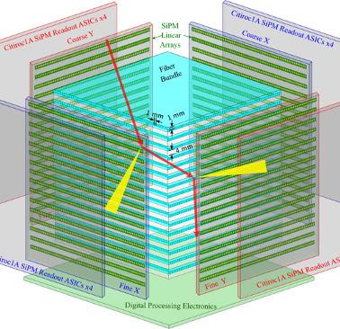
read out by SiPM linear arrays on all sides. Fine readout boards via ribbon
McClelland and his team will collaborate with action event reconstructions and improving Goddard’s current mission development process could be greatly improved by using AI and computational design to accelerate development cycles and actualize essential performance improvements. Ryan McClelland and his team are using FY25 IRAD funds to establish a comprehensive Text-to-Spaceship framework that would integrate AI into all aspects of mission development, facilitating a transition to AI-enabled automation.
particle paths and collisions that obey the laws of physics.
The project’s goals are to improve SONTRAC use cases via enhanced autonomous neutron interaction event reconstruction and advance PIML in Heliophysics. This work could also benefit current work, such as NASA’s Artemis mission, by supporting space weather and solar activity monitoring and increasing safety during hazardous solar particle events.
Evolved Systems is a key component of the Text-toSpaceship framework that will automate complex, multidisciplinary assembly design, building upon a similar paradigm established by Evolved Structures, which uses AI to efficiently create spacecraft instruments and structures. Automating these designs using the Text-to-Spaceship framework will reduce development costs and
Autonomous Science with a Collaborative Multi-Agent System Using AI
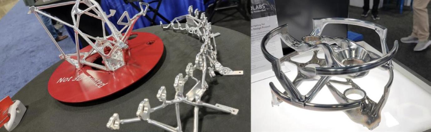
Evolved Structures, featured at a 2025 satellite exhibition showcasing Goddard’s industry collaborations and impact in advancing manufacturing capabilities.
The Solar Neutron Tracking Instrument (SONTRAC) is a neutron spectrometer designed to detect solar flare neutrons by tracking recoil protons (i.e., protons whose directions change following their interactions with neutrons) and the ionization energies they deposit along their paths. To reconstruct SONTRAC data, researchers must identify the energies and determine the protons’ directions, but this process is currently fully manual and laborious.
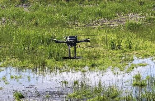
Multifunctional Nanosensor Platform, a highly miniaturized in situ gas sensing platform, integrated with a custom drone is flown over a remote permafrost site in Alaska measuring carbon sources.
Mahmooda Sultana and her team plan to use FY25 IRAD funds to develop and demonstrate a methodology for autonomous science measurement performance using AI in collaboration with Michael Otte at the University of Maryland. This work will leverage new advancements in AI to develop methodologies that maximize scientific output in real time for in situ instruments with minimal sampling and will be potentially important for resource-constrained missions in planetary and Earth sciences. This methodology will be applicable to several in situ instruments, such as mass spectrometers and gas sensors, and will enable a variety of missions related to planetary environment studies, habitability assessment, sample return, human exploration, and others. When the AI methodology is developed, the team plans to demonstrate its capabilities in a field campaign in Alaska (using separate and already-awarded travel funds) on a Multifunctional Nanosensor Platform instrument, displaying its ability to efficiently identify localized sources of carbon that are released from melting permafrost.
Carlos Del Castillo and his team have proposed to use FY25 IRAD funds to create hyperspectral, polarimetric libraries of foreign marine debris (garbage) found in coastal environments. This data, in combination with current measuring
technologies and ML and AI, would be useful in many applications, from detection and characterization of marine debris to national security applications.
National Aeronautics Space Administration
Goddard Space Flight Center
An IRAD derivative of the hyperpolarimetric detector system under construction (from SciGlob Inc.).
Example of complex shore anvironment targeted for detection of marine debris.
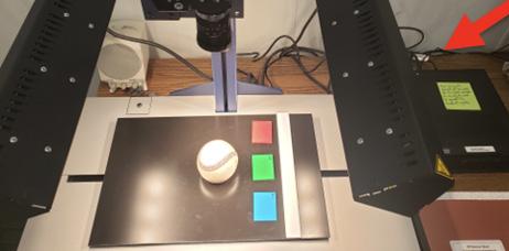
Gravimetry – the measurement of gravitational pull – is one technique used to estimate the direct masses of large (i.e., more than 250 meter in diameter), potentially hazardous asteroids during rapid flybys. However, using this technique to estimate smaller asteroids’ (i.e., less than 150 meters in diameter) direct masses was found to be impractical due to target acquisition times, and thus alternate techniques should be investigated. One potential alternative is using image-based volume estimations, body spectral type determinations, and density measurements to determine a target asteroid’s mass. Other alternative technique options, which include late target acquisition scenarios, may require advancing current spacecraft components.
Joshua Lyzhoft and his team are using FY25 IRAD funds to employ this image-based technique to reduce uncertainties in asteroid mass calculations, which would allow for a better understanding of an asteroid’s trajectory and potential risk to spacecraft in relation to an asteroid during rapid flyby reconnaissance missions. This risk reduction could help support deflection mission designs or civil defense plans, and may help to understand asteroid intercept geometries that would reduce risk even further consumption. To achieve these goals, the team will pursue 3D active sensing in the form of imaging lidar.
National Aeronautics Space Administration
Goddard Space Flight Center
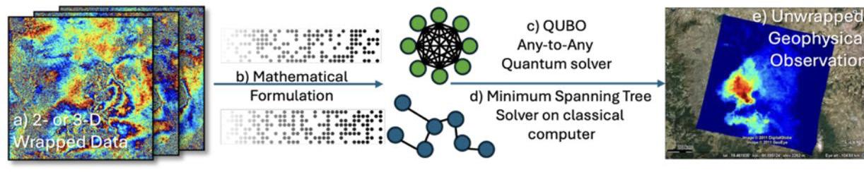
Radar experts consistently reference two major issues as the primary limitations in interferometric (i.e., the interactions of light, radio, or sound waves with their surroundings) time-series analyses: 1) atmospheric phase signal (APS) variations and 2) phase unwrapping (PU) errors. PU is a mathematical operation that converts observed wrapped phase values (i.e., restricted or incomplete light, radio, or soundwave data) to unwrapped (i.e., complete or accurate) geophysical location information. While the researchers can use time-series techniques and multi-static observations to mitigate APS-related problems, no universal solutions to PU errors exist.
high-duty-cycle, and large-area mapping systems such as that used for the NASA-Indian Space Research Organization Synthetic Aperture Radar (NISAR) mission, which will closely examine Earth’s land-and ice-covered surfaces.
As NASA pursues its charge to explore the Moon, Mars, and beyond, in situ navigational autonomy for planetary surface operations will be of paramount importance. Not only is this autonomy essential for the safety and reliability of both robotic and crewed missions, but it can also cut costs and improve scientific return by decreasing ground control requirements and communication bandwidth requirements. Nathaniel Gill and his team will use FY25 IRAD funds in attempt to address known problems on existing, high-TRL rover navigational lidar systems while setting the stage for further increasing spacecraft capability while reducing instrument size, weight, and power consumption. To achieve these goals, the team will pursue 3D active sensing in the form of imaging lidar.consumption. To achieve these goals, the team will pursue 3D active sensing in the form of imaging lidar.
This project would allow missions like NISAR to generate more interferometric SAR data than any other past mission via Dirac-3, speeding up phase unwrapping without poorly effecting solution accuracies. Osmanoglu and his team will seek to demonstrate quantum utility by delivering a phase unwrapping performance beyond what is possible with classical computing.
To seek a solution, Batuhan Osmanoglu and his team will use FY25 funds to pursue a proposal that will leverage Quantum Computing Inc.’s (QCI) Dirac-3 – a quantum optimization system – for efficient PU in preparation for data-intensive,
While spaceborne Wi-Fi does exist on the International Space Station, the current implementation uses commercial, off-the-shelf components that are unsuitable for high-reliability and mission-critical applications. The lunar environment presents even greater challenges than those faced by the space station, presenting difficulty in considerations for implementing a Wi-Fi infrastructure on the Moon.
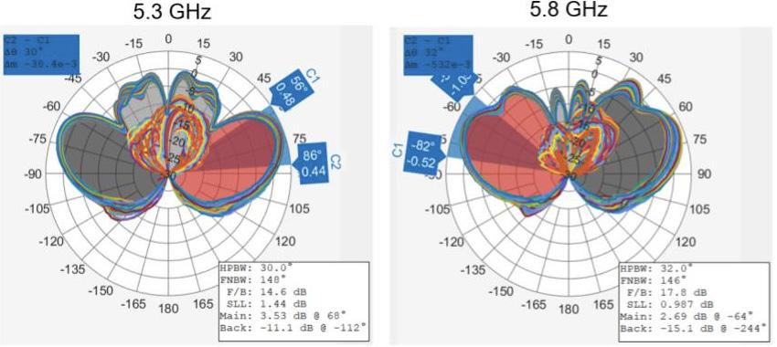
Measured radiation pattern of antenna prototype unit.
The project aims to generate unwrapped physical measurements starting from 2- or 3D wrapped phase observations (a). The project team is developing the mathematical formulation (b) compatible with Dirac-3 (c) and will compare the performance against state-of-the-art algorithms on classical computers (d). Ultimately, the team’s goal is to obtain unwrapped geophysical observations (e).
Victor Marerro-Fontanez and his team are using FY25 IRAD funds to create a low-profile, dipole-like, 5-6GHz antenna, capable of withstanding the extreme temperature swings, lunar dust, and specific astronaut handling requirements on the Moon. The antenna design meets the needs for astronaut-operated instruments on the lunar surface (identified by the Lunar Experiment Survey System and Handling Handheld Instrument Design Lab) and is based on previous technology currently deployed on the space station. The team plans to assemble and test the antenna using FY25 IRAD funds, thus establishing candidacy for environmental and vibrational testing in future project phases.
This project would enable remote science instruments and stations on the lunar surface (within connectivity ranges) to connect to lunar Wi-Fi and would enable other researchers to establish remote stations on the lunar surface.