
1

Jean Birtwistle is an ex-pupil of Skerton Junior School, who returned to teach there in 1971. She developed her interest in local history into a school project based on the Skerton area. The project has been underway for a number of years, continued by successive classes, and this book represents a part of the teacher’s and children’s work.
The original book was published by Countryside Publications Limited, Brinscall, Chorley, Lancashire
Text © J. M. Birtwistle 1983
Printed by Tamley-Reed Limited ISBN 0 86157 105 3
Above and front cover: A view looking north along central Main Street in 1880.
The shop with the canopied window (No. 90) was originally a private house purchased to become Skerton’s schoolroom. In 1733 John Houseman, the school’s first manager, received £100, a donation made by Jane Jepsom. This bequest allocated £60 for building or purchasing a schoolhouse in Skerton, and the yearly produce of the rest for a schoolmaster to teach poor children. It is believed that the schoolroom was situated in the region opposite the Blue Anchor Hotel

Little is known about Skerton. The name it bears is a compound of Danish and Saxon, Skaar town. This has changed over the years to Skerton. Schertune was mentioned in the Doomsday Book as part of the extensive manor of Haltune. In 1361, Skeron was part of the estates of John of Gaunt.
By the early 19th century Skerton was a village inhabited principally by labouring people, with a population, in 1801, of 276 families. It was considered a rough spot, with Main Street’s five hotels catering for travellers on the main nortyh/south route.
After 1838, and the ‘great fire in Skerton’, which destroyed a warehouse and three cottages, improvements were made. By 1888, many houses and shops had been rebuilt. The Ramparts had originally been a mere river side walk, but by 1889 it had developed into a continuous street of houses of various ages, conditions and types.
The population had increased too, and some of the travelling people who used Lamb’s field as a stopping off point, started businesses, bought property, and settled in the area. The next half century saw Skerton consolidate its position with residents moving within the area, but few leaving to live elsewhere. A strong community spirit developed, and many Skerton people were to regret the demolition that followed the 1950s and 60s.
In the 1950s the Health and Housing Committee viewed the property on the Ramparts, Main Street, and Captain’s Row areas, and decided that over 200 dwellings would need to be demolished. The houses in question were said to be completely beyond repair, with qualities of squalor that no public authority could tolerate.
However, many of the residents considered that a large number of the properties were not substandard. They represented years of investment of life savings by the owners and their predecessors. Although blocks of flats may have been necessary, many considered it was wrong that property should be taken from the owners through compulsory purchase orders to make way for planning schemes.
Despite the opposition, Lancaster undertook its most ambitious clearance scheme, and in 1959 the firm of Wimpey started the foundation work.
We are indebted to many people for their contributions to this book. In particular, we would like to thank the staff of Lancaster City Museum for their assistance, and the parents and friends of Skerton Junior School, many of whom have provided photographs and given up a great deal of their time helping with research.
Old Main Street in 1880, looking south. On the near left are white Tudor cottages. Further south in the same block are the ‘Fish Houses’ recognised by the plaque above the door. They were built in 1650 for the River Lune wardens. The houses opposite are on the site of the old Blue Anchor Hotel.

The Fish House in 1927, showing clearly the Lune Salmon above the door. This house once belonged to Beaumont Fishery.
With the dissolution of the monasteries, the Beaumont Fisheries passed from the monks of Furness Abbey to the Manor of Halton, and the fisheries bailiff lived in Main Street.

The left of the photograph shows the boys’ entrance to the present Skerton School. Alongside this, out of the photograph, was the entrance for the girls and infants. It was altered in 1932, when the cottages were knocked down to extend the school yard. The school gate was moved further from the road and the present school caretakers house was built about 1936.

The large building is the Blue Anchor Hotel, Main Street. The three houses next door were built by Richard Howard for his family. By the waggon is the alley-way leading to the co-op bakery and stables. Over the alley was the Skerton reading room and lending library.

Taken in 1920 outside the Blue Anchor: the picture shows two friends, Mr Bill Howard, who was a local horse dealer, and Mr Isaac Miller, a general dealer who lived in Skipton.

A group of patrons from the Blue Anchor Hotel who took part in a shooting competition in the 1920s. Mr Richard Airey, the landlord, is sitting on the third row from the left with his daughter Lucy. His wife, Lucy, is in the centre of the back row.


The Royal Oak Hotel stands near the junction of Main Street and Broadway. The hotel survived the demolition of the 1950s and 60s due to economic reasons.

In 1952 the circus came to town. The stage coach advertising the show, stopped at the Royal Oak, so that the driver could have a pint. Bobby Dedman and Bill Howard came out to pat the horses.

North Main Street in 1926. The house on the left with the foot scraper, and, Lune Grove, the house with the trees in the garden, remain today, although sadly the trees have now gone. Next to Lune Grove, with its side facing the street, was Laburnum Cottage, originally a Tudor farmhouse. Mr. Anthony Rigby lived there in 1909, and had a garden on the site of Laburnum Road. The housewives in this area took a particular pride in their well-scrubbed doorsteps, rubbing them regularly with step stone and polish.

Skerton Corn Mill 1950. Locals remember going to shop at the mill when they were children. They took along an old pram to carry the flour costing 2d a stone. The last time the mill was working was during the Great War. It is possible that the white-washed cottages on the left housed the mill workers. They sometimes flooded at high tide. The mill is situated at the north end of the Ramparts, and Halton Road can be seen to the north of the mill.

This photograph shows the southern entrance at Main Street, near Skerton Bridge. In the words of a local housewife, ‘At the end of Main Street near Skerton Bridge, was a grocery store called, Middletons. It sold food for horses, and had big copper scales chained to the ceiling for weighing. People used to take stone jars to the shop and get 2d worth of syrup, and buy gas mantles at 2½ d each.
Near left is the Skerton Hotel. It was known locally as the ‘Bull’, because of the regular cattle sales held at the rear of the pub. Every day cattle were driven from the field behind Skerton Hotel, past Middleton’s shop to the Ramparts, and then onto the Shards to graze.
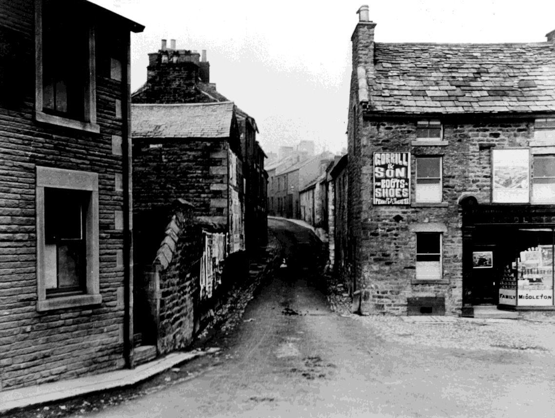
The houses just north of Middleton’s shop are shown here in more detail.
Satterthwaite’s grocers shop is under the gas lamp.


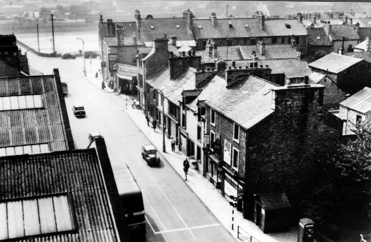
An aerial photograph taken in 1956, showing the Ramparts and Main Street. By 1956 some of the houses had already been pulled down, the rest remaining until the mass demolition of 1959-60. St Lukes Church, Skerton School, school house, and the bus depot are still standing today.

41-53 Main Street, showing the entrance to Church Court. In the early 1900s, Number 53 was a grocer’s shop, and two trade signs advertising Lyon’s tea and Brooke Bond tea are visible.

Number 2 Church Court. One of the five houses situated between Main Street and St Lukes Church.

In May of each year the Main Street Methodist’s Chapel held a procession through the streets of Skerton. This included the present and past queens, with attendants and pageboys. The Salvation Army provided the music, and the congregation followed behind the banner. The procession has just left the chapel and is moving down Pinfold Lane. When the 56-year-old chapel was demolished, all the Skerton Methodists combined at Owen Road, and the procession continued.

Skerton County Junior School, Rose Queen 1945. Each year a 4th year girl was chosen to be queen, and her retinue was made up of children from every class. The ceremony was held on the senior school field, and the festivities included singing, acting and dancing round the Maypole.

Coronation Party, 1953. The photograph shows the children of Main Street assembled outside the Blue Anchor. Their party was held inside the hotel and games were played in the streets.

The adults continued to celebrate into the evening. The party was organised by Mrs. Maryann McCullock, of 74 Main Street. She was helped by Mrs. M. Newsham and Mrs. P. Cruikshank, who lived in the co-op bakery houses, and by Mrs. M. Thompson, who lived at 76 Main Street. Mrs. May Dougan, who lived at 115 Main Street and made wedding cakes for many Skerton couples, set out the food for the big event.

This picture was taken from near the gates of Skerton Junior School, and shows central Main Street, looking north. The houses in the foreground were Nos. 124 to 1312. Next came Rigg Lane. It ran from Main Street down to the Ramparts Following Main Street into the picture, Mr Harrison’s general store can be seen.

Mr Harry Harrison in 1952, near his shop by Broadley’s Yard.

Mr Bill Howard and his niece Sally Stevens. Mr. Howard ran a sweet shop near the school gates.

The children of Skerton Infants School knitted squares to make blankets for the war refugees. They are pictured in the school hall in 1939.

Skerton ‘Dads Army’. A representative group of ‘A’ Company of the Lancaster 94th King’s Own) Battalion of the Home Guard, recruited in May 1940. ‘A’ Company, a body of men aged 17 to 70 years, was responsible for the area from Skerton Bridge to Howgill Ave. Their headquarters was the old St Lukes School, between the church and Main Street. It collapsed in heavy rainstorms at Christmas 1943. They then used the St Lukes Parish hut. The company was disbanded at the end of the war when the photograph was taken as a memento, and presented to their company commander Maj. R.T. Alcock (centre front row).


William Howard, with his daughter Jane, taken in the yard by Skerton Infant School in 1906. Mr. Howard was a horse dealer who had purchased this horse in Ireland to sell at Appleby Fair.

Brough Hill Fair, near Appleby, in 1929. The fairs have always been popular gatherings for many of the people of Skerton. They took their trailers and horses to Appleby in June, and to Brough Hill in October. The horse dealing, the pot stalls, the trotting events, and meeting old friends combined to make them exciting occasions.

Trotting is one of the traditional sports of Skerton. This trotting horse with harness and sulky, was owned by William Howard. He is seen here, with his son Charles, in the yard by the Blue Anchor Hotel.

Drinkwater steps on June 13th 1927. The steps ran from Main Street opposite the Blue Anchor, down to the Ramparts.

South Ramparts, looking north. The building with the wooden shutters was a stable owned by Mr. Smith.

South Ramparts, 1880, taken from Skerton Bridge. It used to be just a riverside walk, but gradually it was built into a continuous street of houses of different styles and ages. On the left is the entrance to Main Street, and Mr. Middleton’s shop. It is possible that the house with the steps used to be Skerton Workhouse. The long building on the extreme right was an early mission. In the early 20th century the bank was stone walled and railed off.

Captains Row, taken from the top of Skerton Methodist Church tower, in the 1950s. The field in the background was known as ‘Acrelands’, and edged onto Lune Street. Our Lady’s High School now occupies this site. The two workshops in the middle of the picture belonged to R. Wilson & Sons, joiners and undertakers, and V.E. Pennington & Sons the plumbers. Both firms moved to new premises in Aldrens Lane before the demolition of the 1960s. The main road at the front of the picture is the Morecambe Road.

Captains Row, 1927. Looking east along Captains Row towards Lune Street.

A common sight on Captains Row. ‘Door step’ conversation was, and still is, a feature of the Skerton area.

Kiln Lane was situated behind Captains Row. Its name has probably survived from Saxon times when kylna, or drying house for corn stood somewhere near. In more recent times there was a malt kiln in the Lane, which belonged to Robert Aldren. In his will dated, June 10th, 1846, he gave it to his son Robert.

Looking towards Skerton Bridge from the junction of Owen Road and Morecambe Road. By the side of the garage is the entrance to Cross Street. Although all the houses have now gone, the bus garage on the left still stands, and Skerton Bridge remains unchanged.
A view from Skerton Bridge, showing the junction of Lune Street and Derby Road in the late 1950s.

This photograph was taken in 1962, only a month before the street was demolished. On the left is the Red Cross Hotel, and the B.P. garage and T.D. Smiths mark the entrance to Cross Street. Moving further towards the park, are two old cottages and Henderson’s fish and chip shop.


This photograph, taken from the same place as the previous one, shows that by March 1960 the demolition was nearly complete, and construction work was well underway.

Two way traffic on Skerton Bridge before the one-way system was introduced in 1972. The bridge, designed by a Mr. Harrison, and built in 1788 at a cost of £14,000 joined Lancaster with the village of Skerton. It was the first flat bridge in the country, and had five arches and an overall length of 549 ft. Some people think that the design features that made it the ‘most handsome bridge in Europe’ were later used in the construction of London Bridge.

Pupils from Skerton Junior School taking a last look at the ‘fish stone’ above Beaumont Fisheries, before the building was demolished in 1959 and the stone placed in the Lancaster Museum.

Pupils from Skerton Junior School, with their headmaster, Mr. Whitehead, and teacher, Miss monks, watching the demolition men at work.

By the beginning of the 1960s the reconstruction of Main Street was well underway, The photograph shoes children making their way to the Kingsway Baths, through the middle of the construction site. The flats have already become a prominent feature.

The beginning of the end for most of old Skerton. It is hoped that enough remains to preserve the age old community spirit in the area.

This book was originally published in 1983 at which time any proceeds from its sale were to go into the school funds of Skerton Junior School.
Unfortunately since that time Skerton Junior School has closed and it is not now possible to honour this request.
Jean Birtwistle has therefore requested that any proceeds that may be realised, or should anyone wish to make a donation regarding her work, such monies should go to British Hedgehog Preservation Society, Hedgehog House, Dhustone, Ludlow, Shropshire. SY8 3PL – email: info@britishhedgehogs.org.uk web: www.britishhedgehogs.org.uk
The original book was published by Countryside Publications Limited, Brinscall, Chorley, Lancashire
Text © J. M. Birtwistle 1983
Printed by Tamley-Reed Limited ISBN 0 86157 105 3