Community Information -Demographics -Traffic Counts
Property Information Assessors Tax Map Vesting Deed
The information contained is provided by WFG’s Customer Service Department to our customers, and while deemed reliable, is not guaranteed.
Property Detail Report
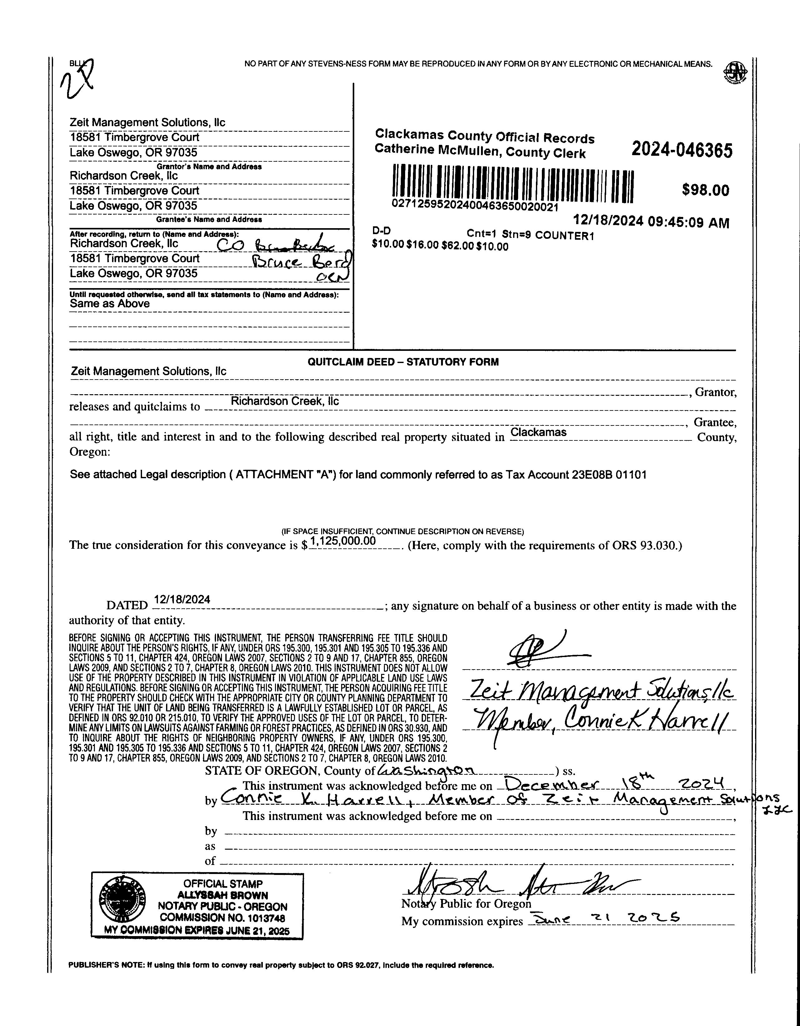
Owner: Richardson Creek LLC
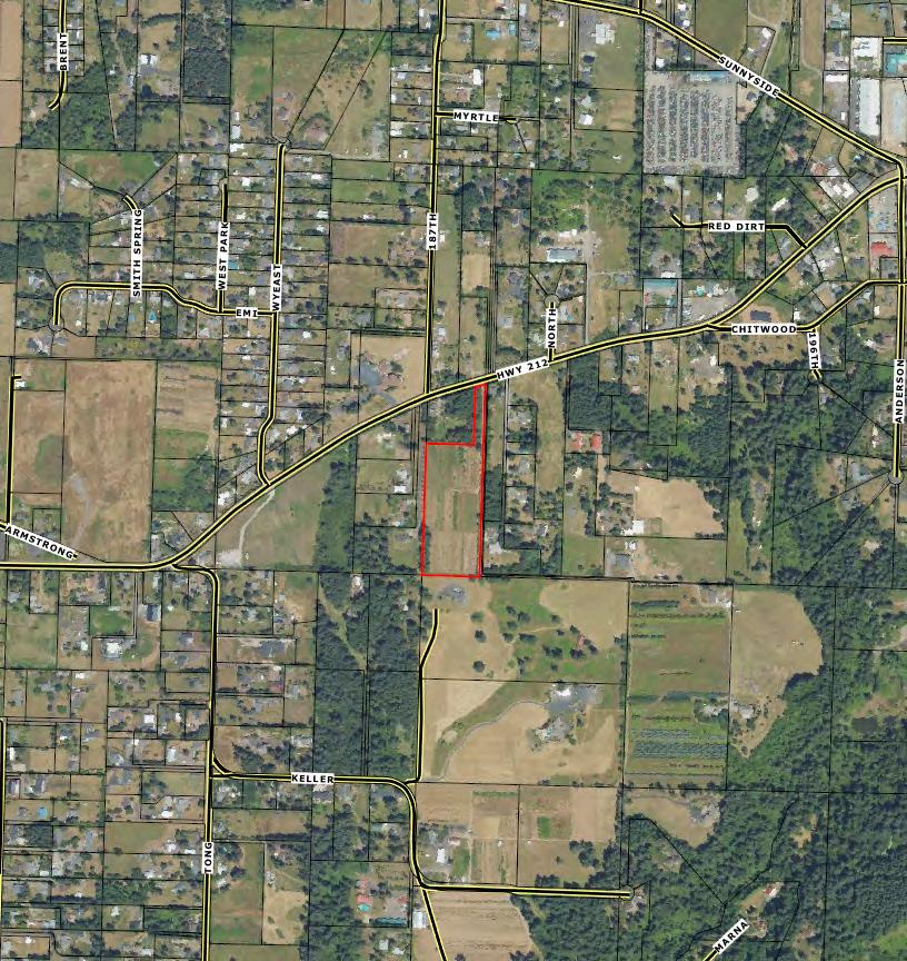
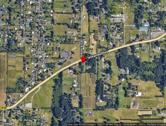
Site: Happy Valley OR 97089
Mail: 18581 SWTimbergrove Ct Lake Oswego OR 97035
Location and Site Information
County: Clackamas
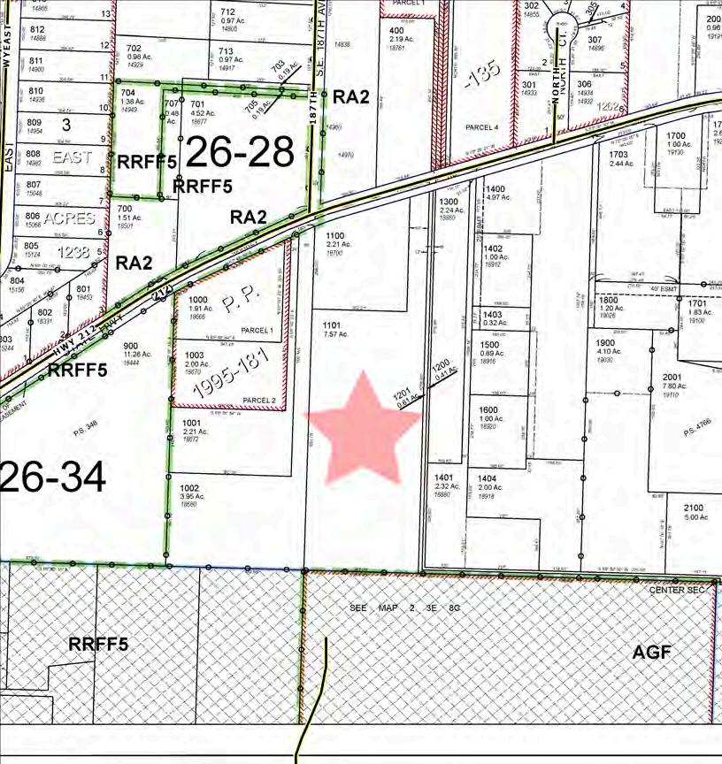
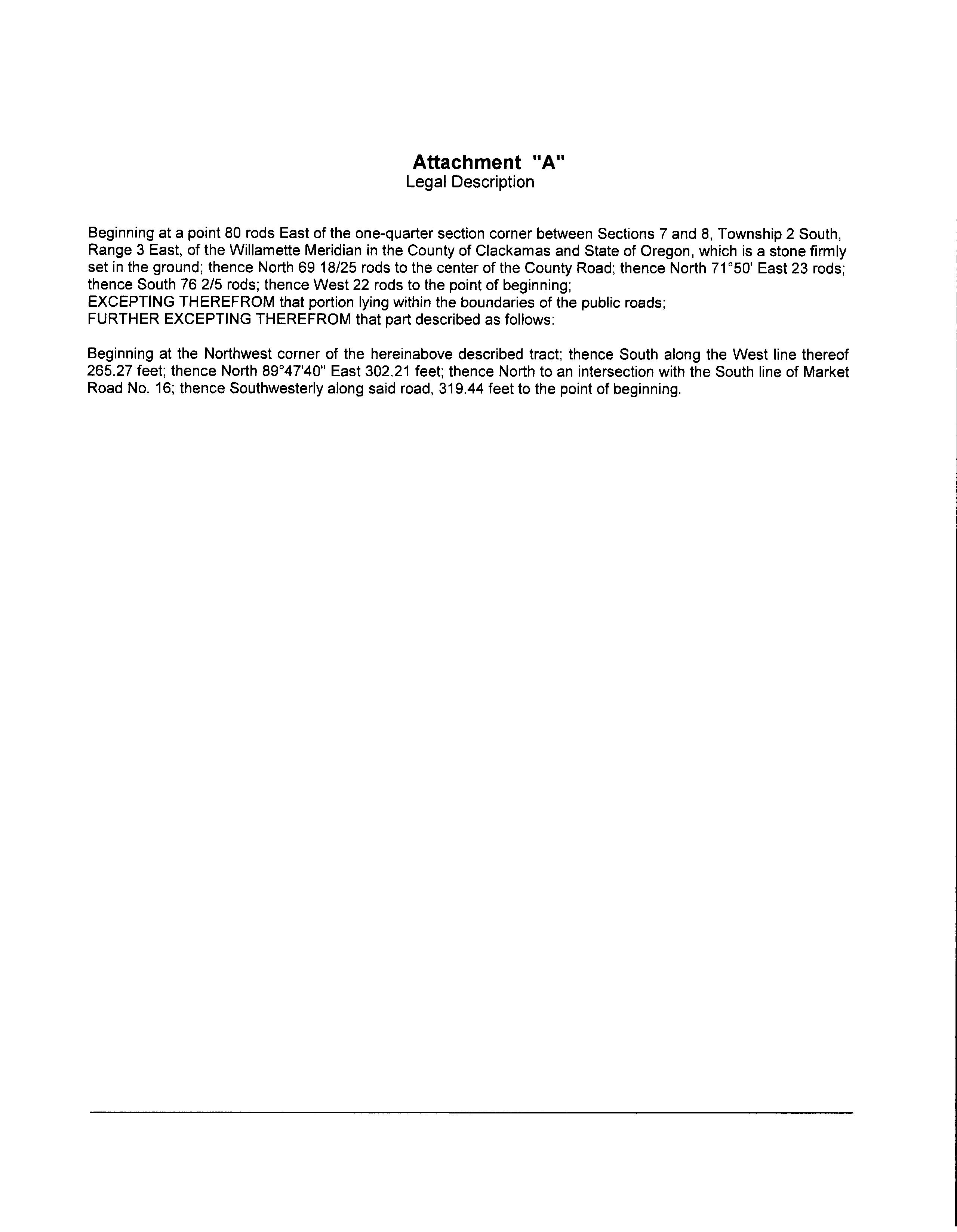
Legal Description: Section 08 Township 2S Range 3E Quarter B TAX LOT 01101
APN: 00617611
Tax Lot: 23E08B 01101
Lot SqFt: 329,749
LotAcres: 7.57
Land Use: 540 - Non EFU farmland vacant
Land Use STD: Rural/Agricultural-Vacant Land Twn-Rng-Sec: 02S / 03E / 08 / NW
Neighborhood: Damascus
County Bldg Use: 8008
# Dwellings: Subdivision: Map Page/Grid: 658-G7
Legal Lot/Block: 1101
CensusTract/Block: 023202 / 2006
Zoning: Happy Valley-R5
Watershed: Lower Clackamas River
Elementary School: Deep Creek - Damascus K-8 School High School: Sam Barlow High School
Middle School: Deep Creek - Damascus K-8 School School District: Oregon Trail
Property Characteristics
Total LivingArea: Bedrooms: Year Built/Eff: First Floor SqFt: BathroomsTotal: Heating: Second Floor SqFt: Bathrooms Full/Half: Cooling: Basement Fin/Unfin: Stories: Fireplace:
Prepared By: WFG NationalTitle Customer Service Department 12909 SW 68th Pkwy, Suite 350, Portland, OR 97223 P: 503 603 1700 | 360 891 5474 E: cs@wfgnationaltitle.com | cccs@wfgtitle.com
Sentry Dynamics, Inc. and its customers make no representation, warranties or conditions, express or implied, as to the accuracy or completeness of information contained in this report.
Parcel ID: 00617611
SiteAddress:
Sentry Dynamics, Inc. and its customers make no representations, warranties or conditions, express or implied, as to the accuracy or completeness of information contained in this report.
Sentry Dynamics, Inc. and its customers make no representations, warranties or conditions, express or implied, as to the accuracy or completeness of information contained in this report.
Parcel ID: 00617611
UTILITY
AS - BUILTS
Water As-Built Maps
Sunrise Water Authority
Sewer As-Built Maps
*Rural-No Sanitary Sewer data available
Map shows nearest Public Sanitary Sewer System
serviced by Water Environmental Services
SEWER LINE MAP
This map is a copy of public record and is provided solely for informational purposes.
ZONING
DETAILS
Detailed Zoning Information
R5 (Single Family Residential 5,000 Sq Ft)
Zoning Map
Community Jurisdiction
The information contained is provided by WFG’s Customer Service Department to our customers, and while deemed reliable, is not guaranteed.
City of Happy Valley, OR Thursday, December 11, 2025
Title 16. Land Development Code
ARTICLE 16.2. LAND USE DISTRICTS
Chapter 16.22. RESIDENTIALLAND USE DISTRICTS
§ 16.22.040. Medium density single-family residential zones.
Purpose.
Residential—Five thousand Square Feet (R-5). This development district will allow singlefamily (attached and detached) as well as duplexes, triplexes within the City. Sanitary sewer and water are the most essential of urban services, but all Level I services and facilities are necessary and required for development at full density. In this district, there is an average lot size of 5,000 square feet.
Mixed Use Residential—Single-Family (MUR-S). Mixed use residential will promote compact form, and residential and commercial or residential and office mixed vertically, in addition to across the district. Minimum densities are provided to comply with the Urban Growth Management Functional Plan, Title 1 requirements. MUR-S has a minimum density of six units per net acre and a minimum lot size of 5,000 square feet.
Permitted Uses Table 16.22.040-1 identifies the land uses that are allowed in the R-5 and MUR-S Districts.
Table 16.22.040-1 Medium Density Single-Family Residential (R-5 and MUR-S) Permitted Uses
P=Permitted; C=Conditional Use; X=Prohibited
One single-family dwelling, townhome, duplex, triplex, quadplex, cottage cluster, or modular dwelling unit per lot
Multiple-family units or manufactured housing, approved as part of a PUD application pursuant to Section 16.63.130. Density calculation as defined in Section 16.12.030 may be used where applicable.
Accessory dwelling units, complying with Section 16.44.050
parks subject to the provisions of Section 16.44.040
Table 16.22.040-1 Medium Density Single-Family Residential (R-5 and MUR-S) Permitted Uses
P=Permitted; C=Conditional Use; X=Prohibited
Land Use
Home occupation as defined in Section 16.12.030, per the provisions of Section 16.69.020
Special event centers for hosting functions such as weddings, anniversary celebrations, corporate parties and similar events
Neighborhood Commercial Uses
Coffee shops, cafes, sandwich shops and delicatessens, restaurants (no drive-through service allowed)
Florists
Grocery, food, specialty foods, and produce stores
Laundromats and dry cleaners
Personal services (e.g., barbershops, hair salons, spas)
Yogurt and ice cream stores
Video rental stores
Retail and service commercial uses similar to those above but not listed elsewhere in this section upon administrative determination through the design review process
Institutional/Utilities
Church, synagogue, temple or other place of worship
Public or private open spaces, parks and playgrounds, tennis courts, and similar outdoor recreational activity areas and recreational buildings, facilities and grounds, which include fully or partially enclosed structures for the primary or secondary use
Large scale recreational facilities such as golf courses, aquatic centers, aquariums, amusement parks and similar uses
Wireless communications facilities not to include antenna support structures, subject to the provisions of Section 16.44.020 of this title
Construction of new streets and roads including the extensions of existing streets and roads, that are included with the adopted transportation system plan
Any accessory structure, which is, customarily incidental to any of the permitted uses, located on the same lot
Uses similar to those upon administrative determination by the Planning Official
NOTES:
Applies to a parent lot. Duplexes, triplexes, quadplexes, and cottage clusters are not permitted on a child lot (i.e., previously subdivided lot from a middle housing land division).
Neighborhood commercial uses subject to the provisions of Section 16.44.080
Neighborhood commercial uses are permitted within the Happy ValleyTown Center PlanArea.
C. Development Standards. The development standards in Table 16.22.040-2 apply to all uses, structures, buildings, and development in the R-5, MUR-S Districts.
Table 16.22.040-2 Development Standards for R-5 and MUR-S
(minimum): Single-family
tached,
Townhomes are exempt from the lot width requirements. Street frontage controls lot width for townhomes.
Interior side yard setbacks for townhomes may be reduced to zero in compliance with applicable sections of the adopted Uniform Building Code.
Standards may be proposed for amendment by Master Plan, PUD or Design Review land use applications.
Cottage cluster housing is exempt from lot coverage requirements.
Pursuant to Section 16.42.030, 20% of the net developable area must be usable open space.
The single-family residential building height maximum is 45 feet at the front elevation; side and rear elevations may not exceed 49 feet.
If a duplex, triplex, fourplex, or cottage cluster has been divided by a middle housing land division, per LDC 16.61, the development standards that are applicable to the lot shall apply to the middle housing parent lot, not to the middle housing child lot.
Maximum lot coverage for townhomes is the greater of the percentage identified in the table or up to 1,000 square feet of buildings, decks, stairways and entry bridges that are more than 30 inches above grade (excluding eaves). Compliance with all other standards is required.
Editor's Note: Ord. 589, which amended this section with regard to Cottage Clusters, was remanded by the courts and all amendments were removed at request of the City.
The material and information on this website are made available for general informational purposes only. Although Metro makes reasonable efforts to ensure the accuracy, completeness, and currency of this information, the data and maps may contain errors or inaccuracies. No representations or warranties of any kind, express or implied, are provided.
Summary data
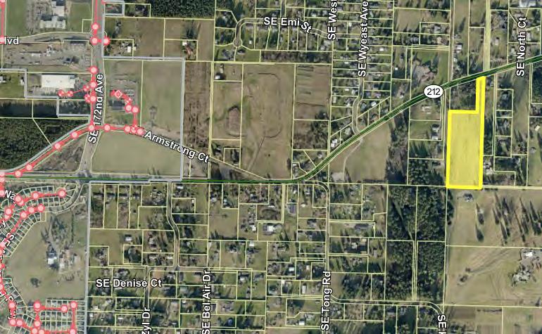
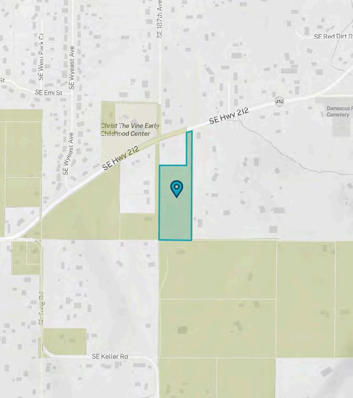
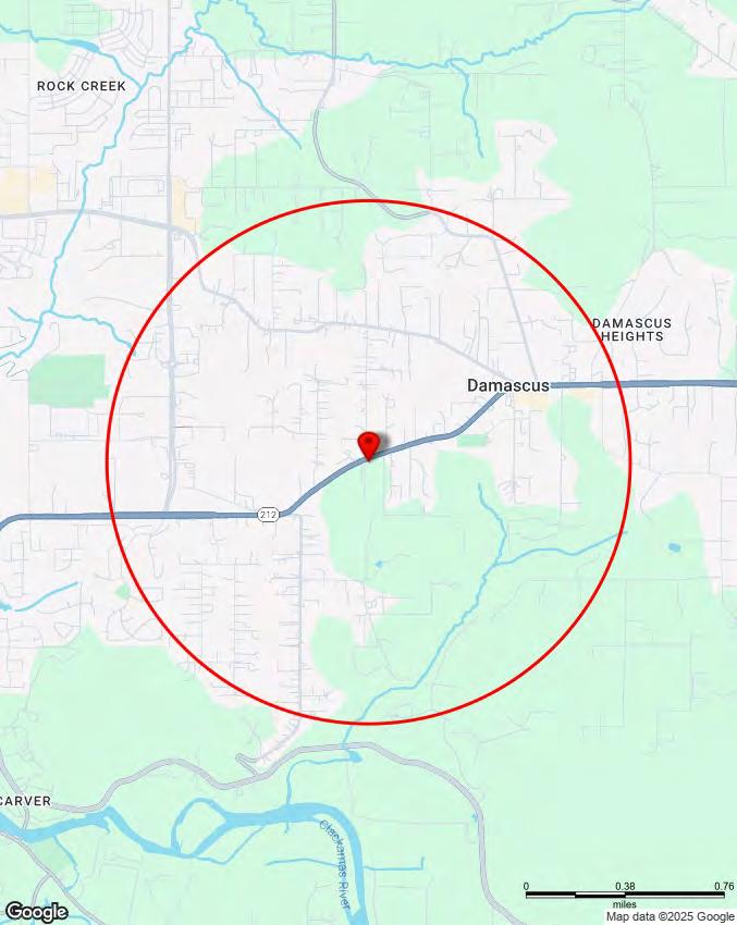
Site Location
Address No data
City
County Clackamas
State No data
Coordinates (45.411668, -122.4695)
Taxlot Information
Taxlot ID 23E08B 01101
Taxlot area 7.56 acres Sale price $1,125,000
Metro
Land Use and Planning
Urban
Sub-watershed
Sub-basin
Residential hauler Hoodview Disposal and Recycling, Inc.
Residential hauler phone (503) 668-8300
Commercial hauler Hoodview Disposal and Recycling, Inc
Commercial hauler phone (503) 668-8300
Dropbox provider Hoodview Disposal and Recycling, Inc
Dropbox provider phone (503) 668-8300
School district GRESHAM-BARLOW
School district number 10J
Fire district Clackamas Fire District #1
Park district No data
Sewer district No data
Water district Sunrise Water Authority
Topography
CUSTOM
MAPS
Water Features
Aerial
Aerial Environmental
Community
Transit
Vacant Land
The information contained is provided by WFG’s Customer Service Department to our customers, and while deemed reliable, is not guaranteed.
Lewis and Clark Montessori Charter School
Verne A. Duncan Elementary
DAMASCUS
HAPPY VALLEY
HAPPY VALLEY
HAPPY VALLEY
Clackamas Bluff
COMMUNITY
Demographics
Traffic Counts INFORMATION
The information contained is provided by WFG’s Customer Service Department to our customers, and while deemed reliable, is not guaranteed.
* This row intentionally left blank. No Total Category.
**1939 will appear when at least half of the Housing Units in this reports area were built in 1939 or earlier.
Tax Lot: 23E08B 01101, Clackamas County, OR 0 - 1 mi
Pop-Facts: Census Demographic Overview (Part 1)
(Part
Pop-Facts: Census Demographic Overview (Part 2)
Lot: 23E08B 01101, Clackamas County, OR Sitewise Online Retail Market Power Opportunity Gap Report By Retail Store Types
Market Power Opportunity Gap Report By Retail Store Types
Total retail trade including food and drink (NAICS 44, 45 and 722)
retail trade (NAICS 44 and 45)
vehicle and parts dealers (NAICS 441)
dealers (NAICS 4411)
car dealers (NAICS 44111)
car dealers (NAICS 44112)
dealers (NAICS 4412)
vehicle dealers (NAICS 44121)
Motorcycle, boat, and other motor vehicle dealers (NAICS 44122)
(NAICS 441222)
(NAICS 441228)
$7,701,835
(NAICS 4441)
centers (NAICS 44411)
(NAICS 44422)
(NAICS 4451)
44511)
Tax Lot: 23E08B 01101, Clackamas County, OR Sitewise Online
Retail Market Power Opportunity Gap Report By Retail Store Types
Retail Market Power Opportunity Gap Report By Retail Store Types Tax Lot: 23E08B 01101, Clackamas County, OR
(NAICS 44521)
(NAICS 44522)
(NAICS 44523)
(NAICS 44529)
(NAICS 445291 + 445292)
(NAICS 446)
(NAICS 44611)
(NAICS 44619)
(NAICS 4482)
stores (NAICS 44831)
(NAICS 4483)
goods, hobby, musical instrument, and book stores (NAICS 451)
goods, hobby, and musical instrument
(NAICS 4511)
goods stores (NAICS 45111)
toy, and game stores (NAICS 45112)
(NAICS 45113)
merchandise stores (NAICS 452)
(NAICS 4522)
Retail Market Power Opportunity Gap Report By Retail Store Types
Retail Market Power Opportunity Gap Report By Retail Store Types
store retailers (NAICS 453)
(NAICS 4531)
supplies, stationery, and gift stores (NAICS 4532)
supplies and stationery stores (NAICS 45321)
novelty, and souvenir stores (NAICS 45322)
merchandise stores (NAICS 4533)
miscellaneous store retailers (NAICS 4539)
and pet supplies stores (NAICS 45391)
dealers (NAICS 45392)
Manufactured (mobile) home dealers (NAICS 45393) $
other miscellaneous store retailers (NAICS 45399)
(NAICS 453991)
other miscellaneous store retailers (except tobacco stores) (NAICS 453998)
retailers (NAICS 454)
4541)
GAFO (General merchandise, Apparel, Furniture and Other) represents sales at stores that sell merchandise normally sold in department stores. This category is not included in Total Retail Sales Including Eating and Drinking Places.
Tax Lot: 23E08B 01101, Clackamas County, OR Sitewise Online
Retail Market Power Opportunity Gap Report By Retail Store Types
Retail Market Power Opportunity Gap Report By Retail Store Types Tax Lot: 23E08B 01101,
Retail Market Power data is derived from two major sources of information. The demand data is derived from the Consumer Expenditure Survey (CE Survey or CEX), which is fielded by the U.S. Bureau of Labor Statistics (BLS). The supply data is derived from the Census of Retail Trade (CRT), which is made available by the U.S. Census. Additional data sources are incorporated to create both supply and demand estimates. The difference between demand and supply represents the opportunity gap or surplus available for each merchandise line in the specified reporting geography. When this difference is positive (demand is greater than the supply), there is an opportunity gap for that merchandise line; when the difference is negative (supply is greater than demand), there is a surplus.