DEVELOPER PACKET

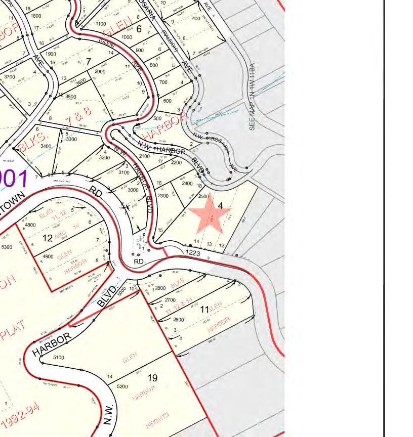
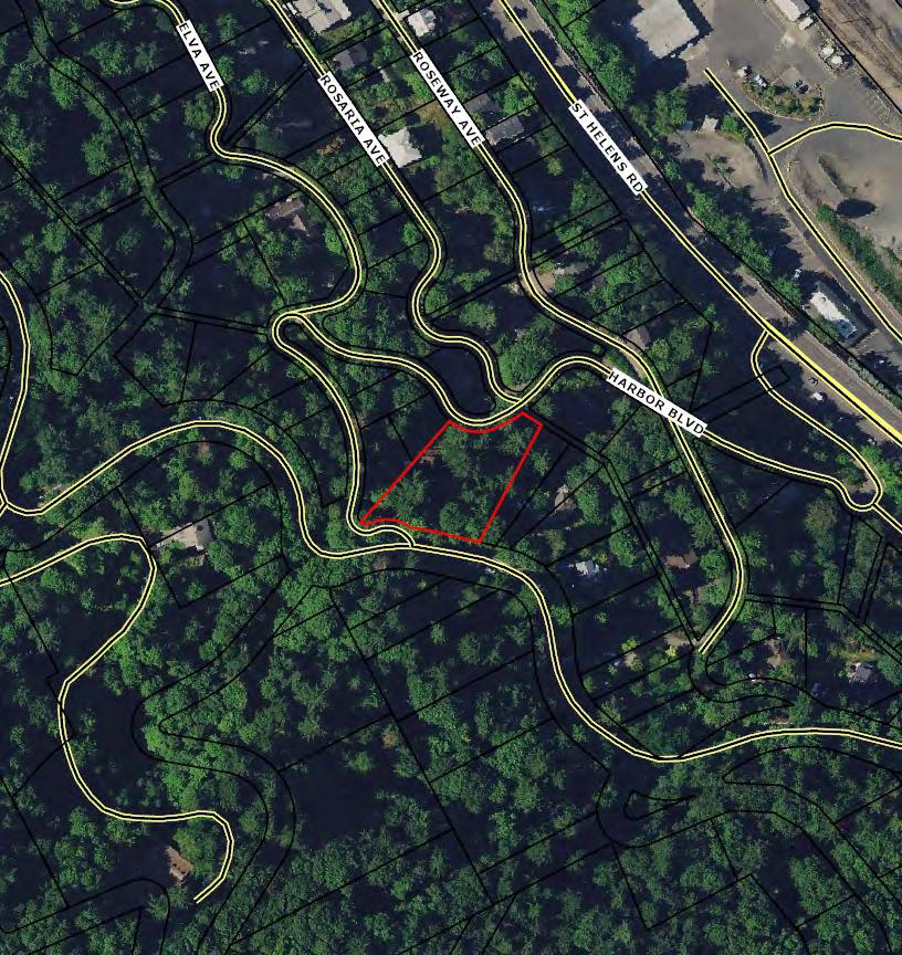
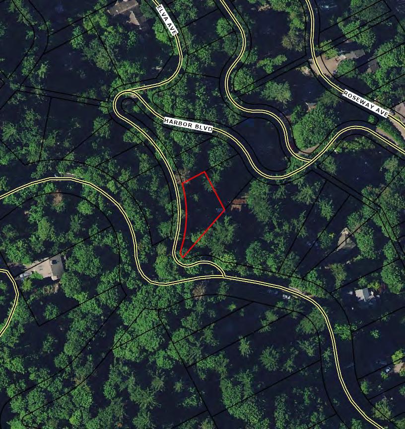
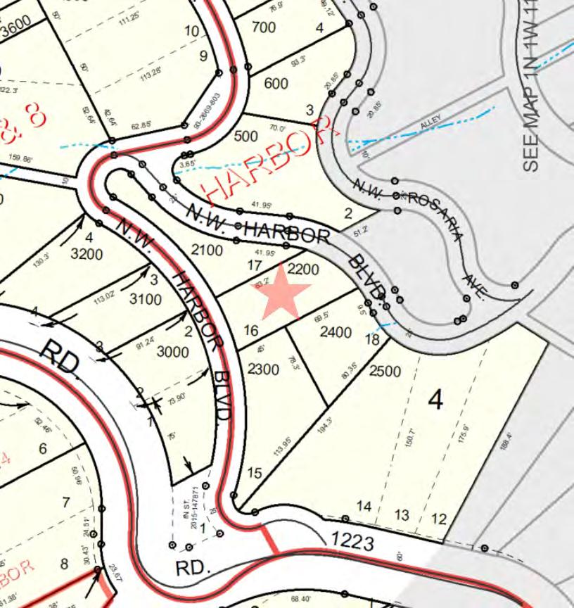
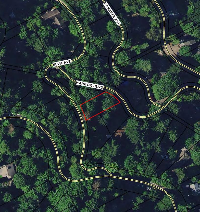
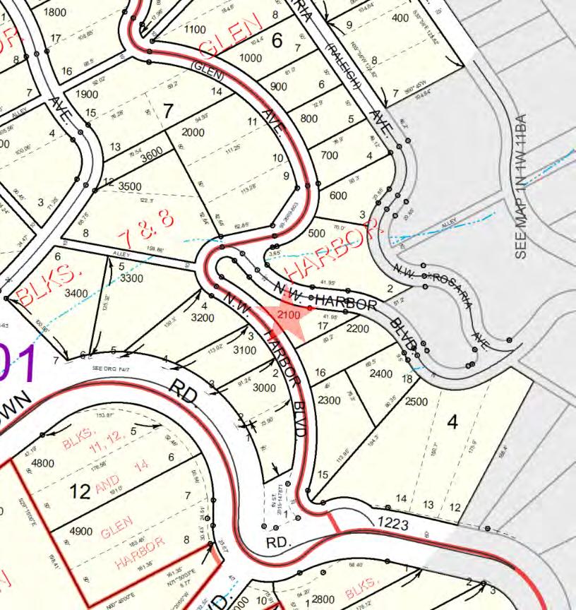
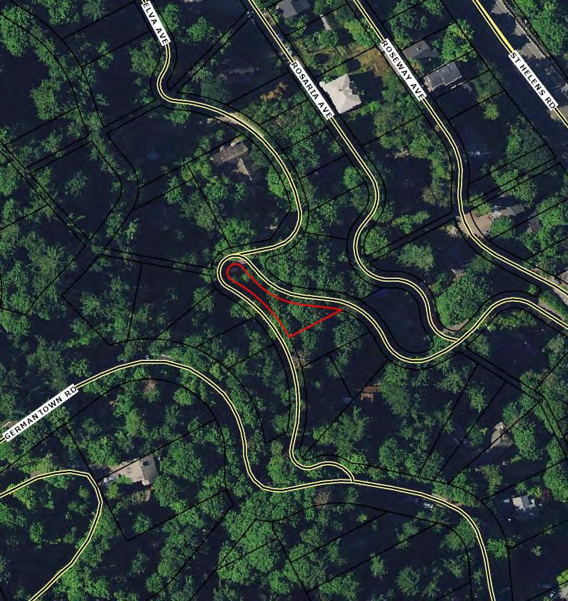
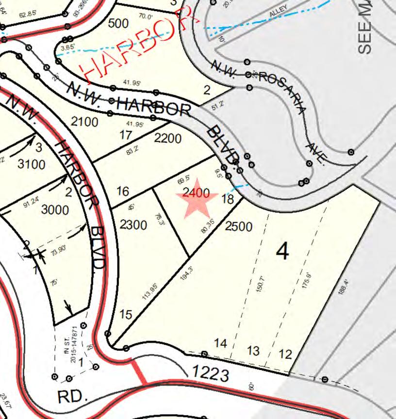
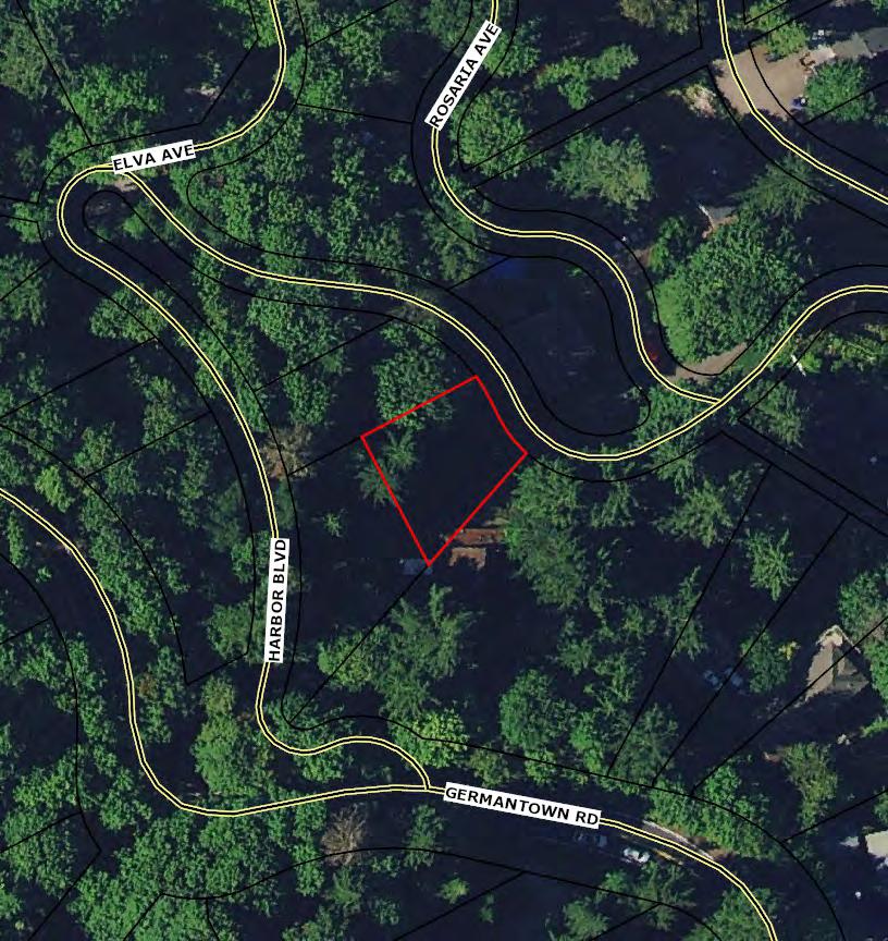
9440 NW HARBOR BLVD
1N1W11BB TL 2100, 2200, 2300, 2400, 2500 PORTLAND, OR 97233
Compliments of WFG National Title Insurance Company Customer Service Department

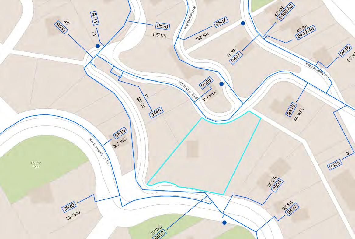
9440 NW HARBOR BLVD
1N1W11BB TL 2100, 2200, 2300, 2400, 2500 PORTLAND, OR 97233
Property Details
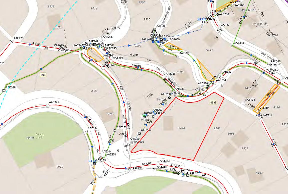
Utility As-Builts (Water & Sewer)
Zoning Information
Custom Maps
Community Information

-Demographics
-Traffic Counts
The information contained is provided by WFG’s Customer Service Department to our customers, and while deemed reliable, is not guaranteed.
Owner:KevinO'Connell
SentryDynamics,Inc.anditscustomersmakenorepresentation,warrantiesorconditions,expressorimplied, astotheaccuracyorcompletenessofinformationcontainedinthisreport.

ParcelID:R169411
SiteAddress:9440NWHarborBlvd
SentryDynamics,Inc.anditscustomersmakenorepresentations, warrantiesorconditions,expressorimplied,astotheaccuracyor completenessofinformationcontainedinthisreport.
SentryDynamics,Inc.anditscustomersmakenorepresentations, warrantiesorconditions,expressorimplied,astotheaccuracyor completenessofinformationcontainedinthisreport.
Owner:KevinO'Connell
Site:9440W/NWHarborBlvdPortlandOR97231
Mail:9440NWHarborBlvdPortlandOR97231 Location
PropertyCharacteristics
PreparedBy:WFGNationalTitleCustomerServiceDepartment 12909SW68thPkwy,Suite350,Portland,OR97223
|3608915474E:cs@wfgnationaltitle.com|cccs@wfgtitle.com
SentryDynamics,Inc.anditscustomersmakenorepresentation,warrantiesorconditions,expressorimplied, astotheaccuracyorcompletenessofinformationcontainedinthisreport.
ParcelID:R169412

SiteAddress:9440W/NWHarborBlvd
SentryDynamics,Inc.anditscustomersmakenorepresentations, warrantiesorconditions,expressorimplied,astotheaccuracyor completenessofinformationcontainedinthisreport.
SentryDynamics,Inc.anditscustomersmakenorepresentations, warrantiesorconditions,expressorimplied,astotheaccuracyor completenessofinformationcontainedinthisreport.
Owner:KevinO'Connell
Site:NWHarborBlvdPortlandOR97231
Mail:9440NWHarborBlvdPortlandOR97231
PropertyCharacteristics Total
PreparedBy:WFGNationalTitleCustomerServiceDepartment 12909SW68thPkwy,Suite350,Portland,OR97223
|3608915474E:cs@wfgnationaltitle.com|cccs@wfgtitle.com
SentryDynamics,Inc.anditscustomersmakenorepresentation,warrantiesorconditions,expressorimplied, astotheaccuracyorcompletenessofinformationcontainedinthisreport.
ParcelID:R169413
SiteAddress:NWHarborBlvd
SentryDynamics,Inc.anditscustomersmakenorepresentations, warrantiesorconditions,expressorimplied,astotheaccuracyor completenessofinformationcontainedinthisreport.
SentryDynamics,Inc.anditscustomersmakenorepresentations, warrantiesorconditions,expressorimplied,astotheaccuracyor completenessofinformationcontainedinthisreport.
Owner:KevinO'Connell
Site:NWHarborBlvdPortlandOR97231
Mail:9440NWHarborBlvdPortlandOR97231 Location
PropertyCharacteristics
PreparedBy:WFGNationalTitleCustomerServiceDepartment 12909SW68thPkwy,Suite350,Portland,OR97223
|3608915474E:cs@wfgnationaltitle.com|cccs@wfgtitle.com
SentryDynamics,Inc.anditscustomersmakenorepresentation,warrantiesorconditions,expressorimplied, astotheaccuracyorcompletenessofinformationcontainedinthisreport.
ParcelID:R169414
SiteAddress:NWHarborBlvd
SentryDynamics,Inc.anditscustomersmakenorepresentations, warrantiesorconditions,expressorimplied,astotheaccuracyor completenessofinformationcontainedinthisreport.
SentryDynamics,Inc.anditscustomersmakenorepresentations, warrantiesorconditions,expressorimplied,astotheaccuracyor completenessofinformationcontainedinthisreport.
Owner:KevinO'Connell
Site:9440N/NWHarborBlvdPortlandOR97231
Mail:9440NWHarborBlvdPortlandOR97231
PropertyCharacteristics
PreparedBy:WFGNationalTitleCustomerServiceDepartment 12909SW68thPkwy,Suite350,Portland,OR97223
|3608915474E:cs@wfgnationaltitle.com|cccs@wfgtitle.com
SentryDynamics,Inc.anditscustomersmakenorepresentation,warrantiesorconditions,expressorimplied, astotheaccuracyorcompletenessofinformationcontainedinthisreport.
ParcelID:R169415
SiteAddress:9440N/NWHarborBlvd
SentryDynamics,Inc.anditscustomersmakenorepresentations, warrantiesorconditions,expressorimplied,astotheaccuracyor completenessofinformationcontainedinthisreport.
SentryDynamics,Inc.anditscustomersmakenorepresentations, warrantiesorconditions,expressorimplied,astotheaccuracyor completenessofinformationcontainedinthisreport.
Water As-Built Maps City of Portland
Sewer As-Built Maps
City of Portland
The information contained is provided by WFG’s Customer Service Department to our customers, and while deemed reliable, is not guaranteed.
Detailed Zoning Information
R10 (Residential 10,000)
Overlay C ( Environmental Conservation)
Overlay S (Scenic Resource)
Overlay Z (Constrained Sites)
Zoning Map
Community Jurisdiction
The information contained is provided by WFG’s Customer Service Department to our customers, and while deemed reliable, is not guaranteed.
The single-dwelling zones are intended to preserve land for housing and to provide housing opportunities for individual households. The zones implement the comprehensive plan policies and designations for single-dwelling housing and provide options for infill housing that is compatible with the scale of the single-dwelling neighborhood.
A. Use regulations. The use regulations are intended to create, maintain and promote singledwelling neighborhoods. They allow for some non-household living uses but not to such an extent as to sacrifice the overall image and character of the single-dwelling neighborhood.
B. Development standards. The development standards preserve the character of neighborhoods by providing six different zones with different densities and development standards. The development standards work together to promote desirable residential areas by addressing aesthetically pleasing environments, safety, privacy, energy conservation, and recreational opportunities. The site development standards allow for flexibility of development while maintaining compatibility within the City's various neighborhoods. In addition, the regulations provide certainty to property owners, developers, and neighbors about the limits of what is allowed. The development standards are generally written for houses on flat, regularly shaped lots. Other situations are addressed through special regulations or exceptions.
The full names, short names, and map symbols of the single-dwelling residential zones are listed below. When this Title refers to the single-dwelling zones, it is referring to the six zones listed here. When this Title refers to the residential zones, or R zones, it is referring to both the single-dwelling zones in this chapter and the multi-dwelling zones in Chapter 33.120. The Residential Farm/Forest zone is intended to generally be an agricultural zone, but has been named Residential Farm/Forest to allow for ease of reference.
The regulations in this chapter state the allowed uses and development standards for the base zones. Sites with overlay zones, plan districts, or designated historical landmarks are subject to additional regulations. The Official Zoning Maps indicate which sites are subject to these additional regulations. Specific uses or development types may also be subject to regulations in the 200s series of chapters.
Neighborhood contact is a set of outreach steps that must be taken before certain developments can be submitted for approval. Neighborhood contact is required as follows:
A. Neighborhood contact I.
1. Neighborhood contact I requirements. When proposed development will add at least 10,000 square feet and not more than 25,000 square feet of net building area to a site, the neighborhood contact steps of 33.705.020.A., Neighborhood contact I are
required. All the steps in 33.705.020.A. must be completed before an application for a building permit can be submitted.
2. Exemption. If the proposed development has already met the neighborhood contact requirements as part of a land use review process, it is exempt from the neighborhood contact requirements.
B. Neighborhood contact II.
1. Neighborhood contact II requirements. When the proposed development will add more than 25,000 square feet of net building area to a site, the neighborhood contact steps of 33.705.020.B., Neighborhood contact II, are required. All of the steps in 33.705.020.B. must be completed before an application for a building permit can be submitted.
2. Exemption. If the proposed development has already met the neighborhood contact requirements as part of a land use review process, it is exempt from the neighborhood contact requirements.
A. Allowed uses. Uses allowed in the single-dwelling zones are listed in Table 110-1 with a "Y". These uses are allowed if they comply with the development standards and other regulations of this Title. Being listed as an allowed use does not mean that a proposed use will be granted an adjustment or other exception to the regulations of this Title. In addition, a use or development listed in the 200s series of chapters is also subject to the regulations of those chapters.
B. Limited uses. Uses allowed that are subject to limitations are listed in Table 110-1 with an "L". These uses are allowed if they comply with the limitations listed below and the development standards and other regulations of this Title. In addition, a use or development listed in the 200s series of chapters is also subject to the regulations of those chapters. The paragraphs listed below contain the limitations and correspond with the footnote numbers from Table 110-1.
1. Group Living. This regulation applies to all parts of Table 110-1 that have note [1]. Up to 3,500 square feet of the total net building area on the site can be in a Group Living Use. More than 3,500 square feet of net building area in Group Living is a conditional use.
2. Retail Sales And Service. This regulation applies to all parts of Table 110-1 that have a [2]. Retail plant nurseries are a conditional use. All other Retail Sales And Service uses are prohibited.
3. Manufacturing And Production. This regulation applies to all parts of Table 110-1 that have a [3]. Utility Scale Energy Production from large wind turbines is a conditional use in the RF zone. All other Manufacturing And Production uses are prohibited.
4. Basic Utilities. This regulation applies to all parts of Table 110-1 that have a [4].
a. Basic Utilities that service a development site are accessory uses to the primary use being served.
b. Small Scale Energy Production that provides energy for on-site or off-site use are considered accessory to the primary use on the site. Installations that sell power they generate—at retail (net, metered) or wholesale—are included. However, they are only considered accessory if they generate energy from biological materials or byproducts from the site itself, or conditions on the site itself; materials from other sites may not be used to generate energy. The requirements of Chapter 33.262, Off Site Impacts must be met.
c. All other Basic Utilities are conditional uses.
5. Community Service Uses. This regulation applies to all parts of Table 110-1 that have a [5]. Most Community Service uses are regulated by Chapter 33.815, Conditional Uses. Short term, mass, and outdoor shelters are regulated by Chapter 33.285, Short Term, Mass, and Outdoor Shelters.
6. Parks And Open Areas. This regulation applies to all parts of Table 110-1 that have a [6]. Parks And Open Areas uses are allowed by right. However, certain accessory uses and facilities that are part of a Parks And Open Areas use require a conditional use review. These accessory uses and facilities are listed below.
a. Swimming pools.
b. Cemeteries, including mausoleums, chapels, and similar accessory structures associated with funerals or burial.
c. Golf courses, including club houses, restaurants and driving ranges.
d. Boat ramps.
e. Parking areas.
f. Recreational fields for organized sports. Recreational fields used for organized sports are subject to the regulations of Chapter 33.279, Recreational Fields for Organized Sports.
7. Daycare. This regulation applies to all parts of Table 110-1 that have a [7]. Daycare uses are allowed by right if locating within a building that contains or contained a College, Medical Center, School, Religious Institution, or a Community Service use.
8. Agriculture in RF and R20 zones. This regulation applies to all parts of Table 110-1 that have an [8]. Agriculture is an allowed use. Where the use and site meet the regulations of Chapter 33.237, Food Production and Distribution, the applicant may choose whether it is allowed as a Market Garden.
9. Agriculture in R10 and R7 zones. This regulation applies to all parts of Table 110-1 that have a [9]. Agriculture is a conditional use. Where the use and site meet the regulations of Chapter 33.237, Food Production and Distribution, the applicant may choose whether it is allowed as a Market Garden, which does not require a conditional use.
10 Agriculture in R5 and R2.5 zones. This regulation applies to all parts of Table 110-1 that have a [10]. If the use and site do not meet the regulations of Chapter 33.237, Food Production and Distribution, Agriculture is prohibited.
11. Radio Frequency Transmission Facilities. This regulation applies to all parts of Table 110-1 that have an [11]. Some Radio Frequency Transmission Facilities are allowed by right. See Chapter 33.274.
C. Conditional uses. Table 110-1. Uses that are allowed if approved through the conditional use review process are listed in Table 110-1 with a "CU". These uses are allowed provided they comply with the conditional use approval criteria for that use, the development standards, and other regulations of this Title. Uses listed with a "CU" that also have a footnote number in the table are subject to the regulations cited in the footnote. In addition, a use or development listed in the 200s series of chapters is also subject to the regulations of those chapters. The conditional use review process and approval criteria are stated in Chapter 33.815, Conditional Uses.
D. Prohibited uses. Uses listed in Table 110-1 with an "N" are prohibited. Existing uses in categories listed as prohibited may be subject to the regulations of Chapter 33.258, Nonconforming Uses And Development.
Accessory uses to a primary use are allowed if they comply with all development standards. Accessory home occupations, accessory dwelling units, and accessory short-term rentals have specific regulations in Chapters 33.203, 33.205, and 33.207 respectively.
Chapter 33.110
Title 33, Planning and Zoning Single-Dwelling Zones 6/30/22
Notes:
• The use categories are described in Chapter 33.920.
• Regulations that correspond to the bracketed numbers [ ] are stated in 33.110.100.B.
• Specific uses and developments may also be subject to regulations in the 200s series of chapters.
A. Purpose. Housing types are limited in the single-dwelling zones to maintain the overall image and character of the City's single-dwelling neighborhoods. However, the regulations allow options to increase housing variety and opportunities, and to promote affordable and energy-efficient housing.
B. Housing types. The kinds of housing types allowed in the single-dwelling zones are stated in Table 110-2.
A. Purpose. The regulations of this section allow for development of primary structures on lots and lots of record that are an adequate size, but do not legitimize plots that were divided after subdivision and partitioning regulations were established. The regulations ensure that development on a site will in most cases be able to comply with all site development standards. The regulations also allow development of primary structures on lots that were large enough in the past, but were reduced by condemnation or required dedications for right-of-way.
B. Adjustments. Adjustments to this section are prohibited.
C. Primary structures allowed. Development of a primary structure is allowed as follows:
1. On a lot created on or after July 26, 1979;
2. On a lot created through the Planned Development or Planned Unit Development process;
3. On a lot, lot of record, lot remnant, or combinations thereof that did not abut a lot, lot of record, or lot remnant under the same ownership on July 26, 1979, and has not abutted a lot, lot of record, or lot remnant under the same ownership since July 26, 1979;
4. On a lot or adjusted lot or combination thereof that either:
a. Meets the minimum lot size requirements stated in Table 110-3; or
b. Does not meet the minimum lot size requirements stated in Table 110-3 but meets all of the following:
(1) No portion of the lot, adjusted lot or combination is in an environmental protection, environmental conservation, or river environmental overlay zone;
(2) No portion of the lot, adjusted lot or combination is in the special flood hazard area; and
(3) The lot, adjusted lot or combination has an average slope of less than 25 percent.
5. On a lot of record or lot remnant or combination thereof that meets the minimum lot size requirements of Table 110-3.
D. Plots. Primary structures are prohibited on plots that are not lots, adjusted lots, lots of record, or lot remnants or tracts.
Table 110-3
Minimum Lot Size Requirements
RF through R5 Zones
Adjusted Lot
Lot 36 feet wide and meets the minimum lot area requirement for all other lots stated in Table 610-2. [1, 2, 3, 4, 5]
R2.5 Zone Lot 1500 sq. ft. [1, 4]
Notes:
[1] A primary structure is allowed on a lot or lot of record that did meet the requirements of Table 110-3 in the past but was reduced below the requirements solely because of condemnation or required dedication by a public agency for right-of-way.
[2] In the R5 zone, the minimum size requirements for adjusted lots and lot remnants approved through a property line adjustment under 33.677.300.A.4. or 33.677.300.C. are 36 ft. wide and 1,600 sq. ft.
[3] In the R20 zone, a primary structure is allowed on a lot, lot of record, adjusted lot, lot remnant, or combination thereof that did meet the requirements of Table 110-3 in the past but no longer meets the requirements solely due to a zone change effective on May 24, 2018
[4] A primary structure is allowed on a lot, lot of record, adjusted lot, lot remnant, or combination thereof that was separated from abutting lots through a lot confirmation that was finalized before September 11, 2020
[5] Lot width for a flag lot is measured at the midpoint of the flag portion of the lot.
A. Purpose. This standard promotes additional housing opportunities in areas of the city where services are available and restricts larger sites from being utilized for a single house.
B. When this standard applies. The minimum dwelling unit density standard applies to new development when at least one dwelling unit is proposed. Sites in the Constrained Sites overlay zone are exempt from this standard.
C. Minimum dwelling unit density.
1. R7. In the R7 zone, a minimum of two dwelling units are required on sites that are 14,000 square feet or larger in total site area.
2. R5. In the R5 zone, a minimum of two dwelling units are required on sites that are 10,000 square feet or larger in total site area.
3. R2.5. In the R2.5 zone, a minimum of two dwelling units are required on sites that are 5,000 square feet or larger in total site area.
33 110.225)
33.110.240)
[1] Including any site with a congregate housing facility.
[2] Including accessory dwelling units.
[3] Additional FAR and height may be allowed. See 33.110.265.F. 33.110.210 Floor Area Ratios
A. Purpose. Floor area ratios (FAR) work with height, setback, and building coverage requirements to control the overall bulk and placement of buildings. The maximum FAR allowances have been calibrated by zone to:
• Define the character of each zone by establishing greater FAR allowances in the higher intensity zones;
• Encourage the provision of additional dwelling units within existing neighborhoods by relating the allowed amount of FAR to the total number of units on a site; and
• Ensure that the bulk of buildings on one lot does not overwhelm development on adjacent lots
B. Maximum FAR. Maximum floor area ratios are stated in Table 110-4. Maximum FAR applies to all buildings on the site, however the maximum allowed is based on the total number of dwelling units on the site and whether a bonus option is chosen In the R10 and R20 zones, the maximum FAR only applies to sites that are less than 10,000 square feet in area. The maximum FAR for a site with a congregate housing facility is the same as shown in Table 110-4 for a site with 1 total dwelling unit. The maximum FAR for institutional uses is stated in 33.110.270. Adjustments to the maximum FAR ratios, including bonus ratios, are prohibited.
C. Exceptions.
1. Maximum FAR does not apply to one alteration or addition of up to 250 square feet when the alteration or addition is to a primary structure that received final inspection at least 5 years ago. This exception is allowed once every 5 years.
2. Stairwells are only counted as floor area on one level.
D. Maximum FAR with bonus.
1. Affordable housing bonus option The maximum FAR for sites that provide at least one dwelling unit that is affordable to those earning no more than 60 percent of the area median family income or an affordability level established by Title 30 is stated in Table 110-4. To qualify for this maximum FAR with bonus:
a. The applicant must provide a letter from the Portland Housing Bureau certifying that the development meets the affordability standard stated above. The letter is required to be submitted before a building permit can be issued but is not required in order to apply for a land use review; and
b. The property owner must execute a covenant with the City that complies with the requirements of 33.700.060. The covenant must ensure that the affordable dwelling unit will remain affordable to households meeting the income restriction and any administrative requirements of the Portland Housing Bureau.
2. Preserving existing dwelling units bonus option. The maximum FAR for sites that contain a primary residential structure that received final inspection at least 5 years ago is stated in Table 110-4. To qualify for this maximum FAR with bonus, no more than 25 percent of the existing street-facing façade of the primary residential structure may be altered to add additional floor area.
A. Purpose. The height standards serve several purposes:
• They foster a reasonable building scale and relationship of one residence to another;
• They promote options for privacy for neighboring properties; and
• They reflect the general building scale and placement of houses in the city's single-dwelling neighborhoods.
B. Maximum height. The maximum height allowed is stated in Table 110-4. The maximum height standards for detached and connected accessory structures are stated in 33.110.245, Detached and Connected Accessory Structures. The maximum height standard for narrow lots is stated in 33.110.260, Additional Development Standards for Narrow Lots. The maximum height standard for small flag lots is stated in 33.110.255, Additional Standards for Flag Lots. The maximum height standard for institutional uses is stated in 33.110.270, Institutional Development Standards.
C. Exceptions to the maximum height.
1. Chimneys, vents, flag poles, satellite receiving dishes and other similar items with a width, depth, or diameter of 3 feet or less may extend above the height limit, as long as they are attached to a building and do not exceed 5 feet above the top of the highest point of the roof. If they are greater than 3 feet in width, depth, or diameter, they are subject to the height limit.
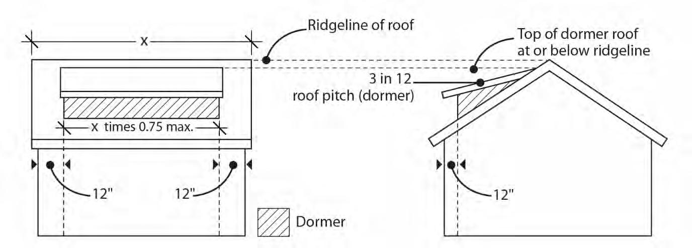
2. Dormers are not included in the height calculation when:
a. The roof of the dormer has a pitch of at least 3 in 12 and no part of the dormer extends above the ridgeline of the roof;
b. The walls of the dormer are set back at least 12 inches from the plane of any exterior wall of the floor below; and
c. The width of the dormer is not more than 75 percent of the width of the roof from which it projects. See Figure 110-1
3. Farm buildings associated with an agricultural use, such as silos and barns are exempt from the height limit as long as they are set back from all lot lines, at least one foot for every foot in height.
4. Antennas, utility power poles, and public safety facilities are exempt from the height limit.
5. Small wind turbines are subject to the standards of Chapter 33.299, Wind Turbines.
6. Roof mounted solar panels are not included in height calculations, and may exceed the maximum height limit as follows:
a. For flat roofs or the horizontal portion of mansard roofs, the roof mounted solar panel may extend up to 5 feet above the top of the highest point of the roof.
b. For pitched, hipped or gambrel roofs, the roof mounted solar panel must be mounted no more than 12 inches from the surface of the roof at any point, and may not extend above the ridgeline of the roof. The 12 inches is measured from the upper side of the solar panel.
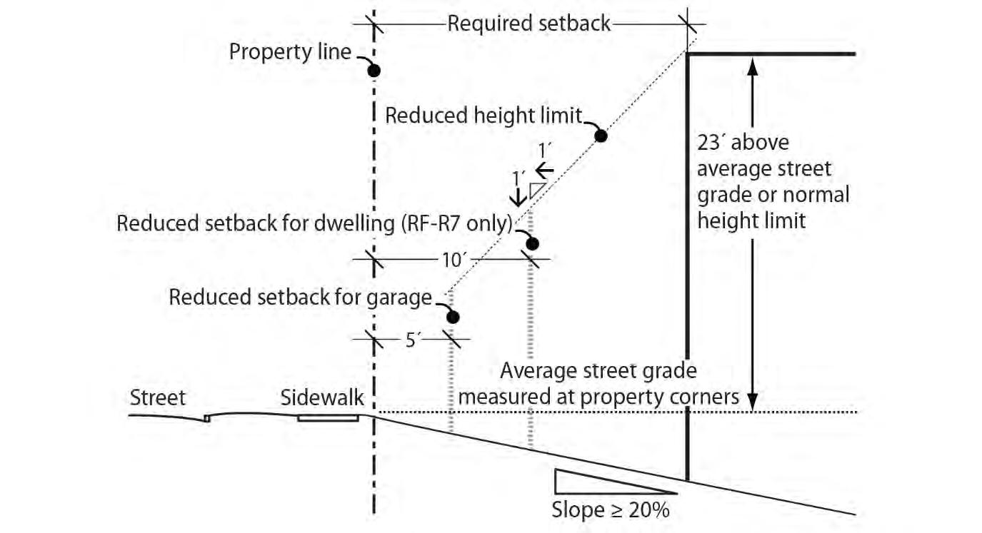
1. Downhill slope from street. On lots that slope downhill from the street with an average slope of 20 percent or greater, the height limit is the higher of either 23 feet above the average of the grade of the street or the normal height limit calculated as stated in Chapter 33.930, Measurements. In addition, the alternative height and setback standards of Subsection 33.110.220.D apply. For the purpose of this paragraph, the average grade of the street is measured at the street lot line property corners.
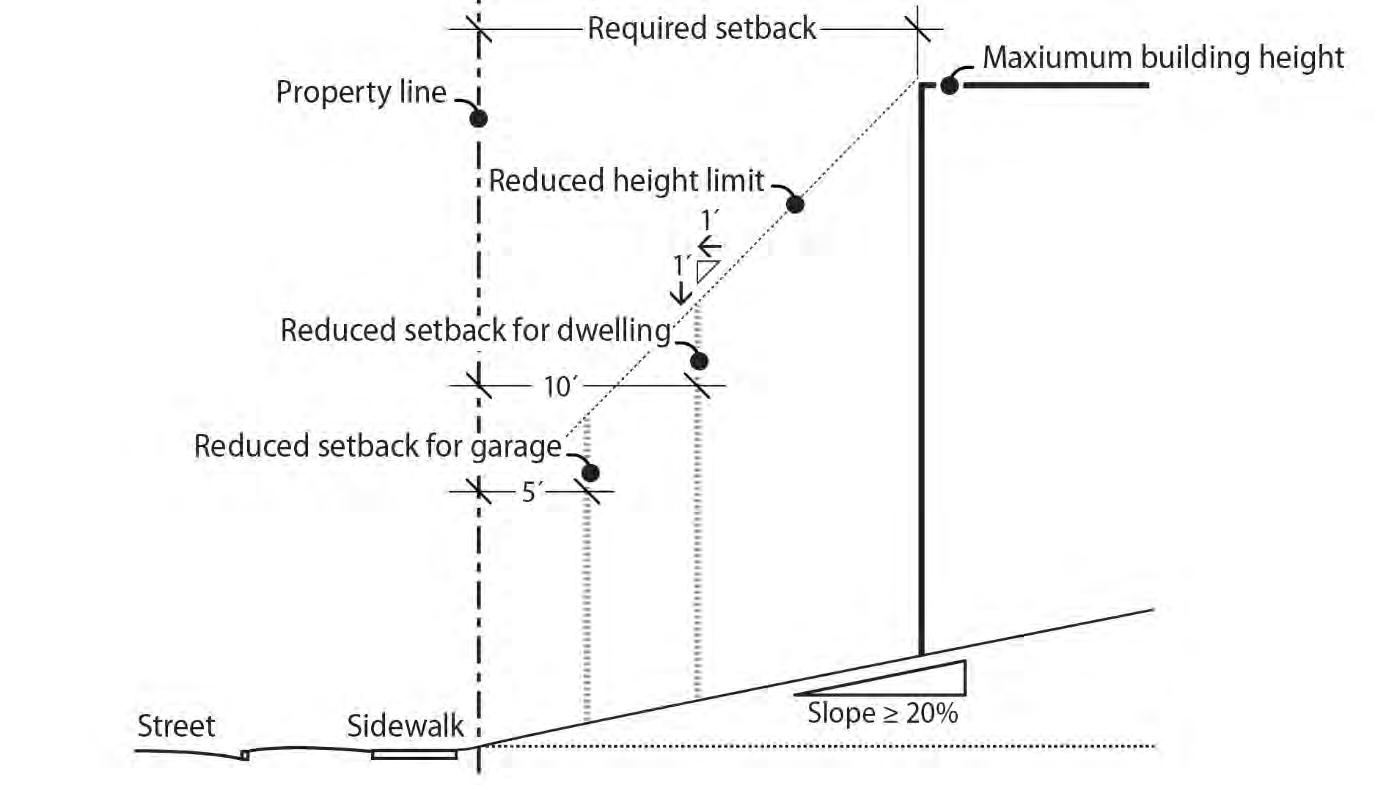
2. Uphill slope from the street. On lots that slope uphill from the street with an average slope of 20 percent or greater the alternative height and setback standards of Subsection 33.110.220.D apply.
3. Downhill and uphill slope from the street. On lots that slope uphill from one street and downhill from another street with an average slope of 20 percent or greater, the applicant may meet the alternative height limit of Paragraph D.1.
A. Purpose. The setback regulations for buildings and garage entrances serve several purposes:
• They maintain light, air, separation for fire protection, and access for fire fighting;
• They reflect the general building scale and placement of residences in the city's singledwelling neighborhoods;
• They foster a reasonable physical relationship between residences;
• They promote options for privacy for neighboring properties;
• They require larger front setbacks than side and rear setbacks to promote open, visually pleasing front yards;
• They provide adequate flexibility to site a building so that it may be compatible with the neighborhood, fit the topography of the site, allow for required outdoor areas, and allow for architectural diversity; and
• They provide room for a car to park in front of a garage door without overhanging the street or sidewalk, and they enhance driver visibility when backing onto the street.
B. Required setbacks. The required setbacks for buildings and garage entrances are stated in Table 110-4. The walls of the garage structure are subject to the front, side, and rear building setbacks stated in Table 110-4. The minimum setbacks for institutional uses are stated in 33.110.270, Institutional Development Standards. Other setbacks may apply to specific types of development or situations.
C. Extensions into required building setbacks.
1. The following features of a building may extend into a required building setback up to 20 percent of the depth of the setback. However, the feature must be at least three feet from a lot line:
a. Chimneys, fireplace inserts and vents, mechanical equipment, and fire escapes;
b. Water collection cisterns and stormwater planters that do not meet the standard of Paragraph C.3;
c. Decks, stairways, wheelchair ramps and uncovered balconies that do not meet the standards of Paragraph C.3; and
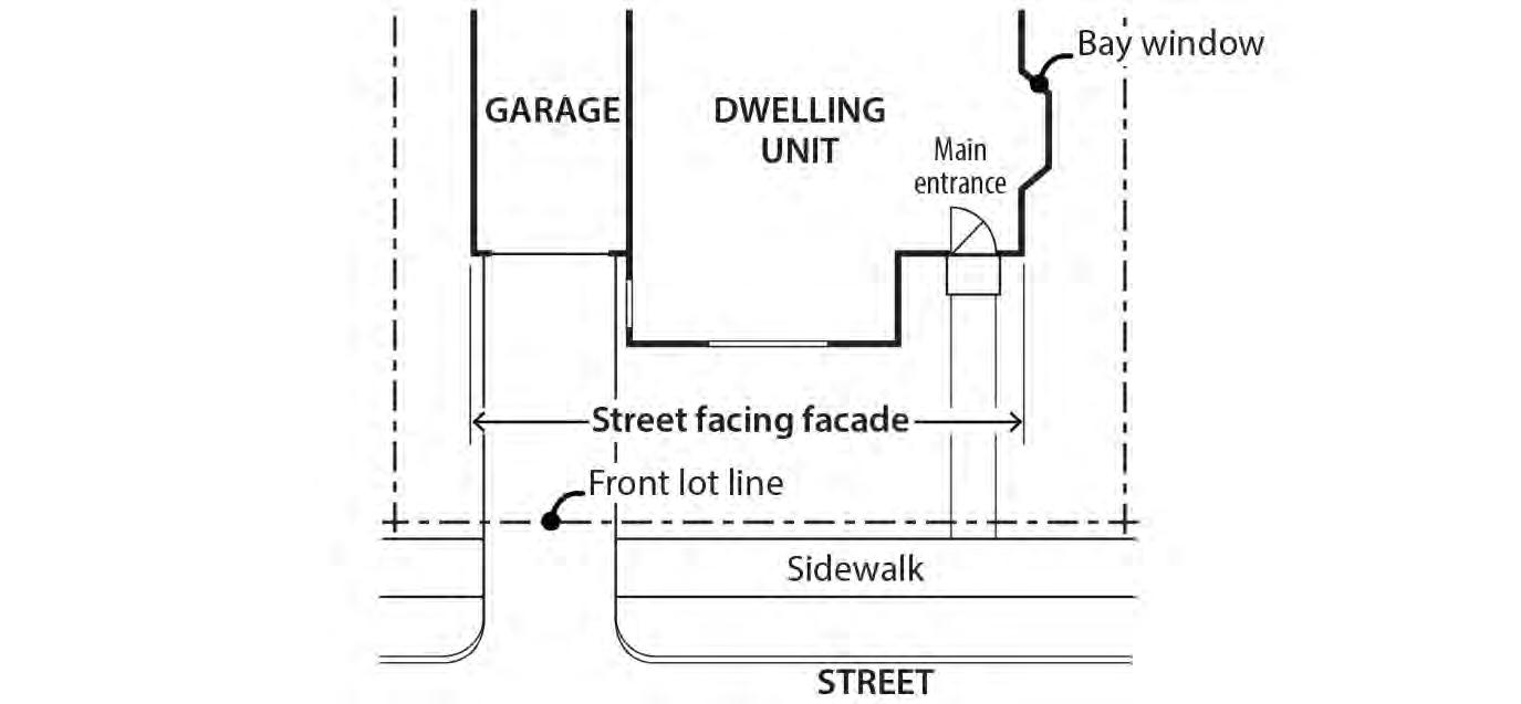
d. Bays and bay windows that meet the following requirements:
(1) Each bay and bay window may be up to 12 feet long, but the total area of all bays and bay windows on a building facade cannot be more than 30 percent of the area of the facade;
(2) At least 30 percent of the area of each bay which faces the property line requiring the setback must be glazing or glass block; and
(3) Bays and bay windows must cantilever beyond the foundation of the building.
2. Building eaves may extend up to 2 feet into a required building setback provided the eave is at least three feet from a lot line.
3. The following minor features of a building may extend into the entire required building setbacks:
a. Utility connections attached to the building that are required to provide services such as water, electricity, and other similar utility services;
b. Gutters and downspouts that drain stormwater off a roof of the structure;
c. Stormwater planters that are no more than 2-1/2 feet above the ground;
d. Water collection cisterns that are 6 feet or less in height;
e. Decks, stairs and ramps that are no more than 2-1/2 feet above the ground. However, stairways and wheelchair ramps that lead to one entrance on the street-facing façade of a building are allowed to extend into the required setback from a street lot line regardless of height above ground; and
f. On lots that slope down from the street, vehicular or pedestrian entry bridges that are no more than 2-1/2 feet above the average sidewalk elevation.
4. Detached accessory structures. The setback standards for detached accessory structures, including detached mechanical equipment, are stated in 33.110.245. Fences are addressed in 33.110.275. Detached accessory dwelling units are addressed in Chapter 33.205.
D. Exceptions to the required setbacks.
1. Setback averaging. The front building setback, and the setback of decks, balconies, and porches may be reduced to the average of the respective setbacks on the abutting lots. See Chapter 33.930, Measurements, for more information.
2. Flag lots. The lot in front of a flag lot may reduce its side building setback along the flag pole lot line to zero. All other setback requirements remain the same.
3. Environmental zone. The front building and garage entrance setback may be reduced to zero where any portion of the site is in an environmental overlay zone. Where a side lot line is also a street lot line the side building and garage entrance setback may be reduced to zero. All other provisions of this Title apply to the building and garage entrance.
4. Steeply sloping lots. This provision applies to lots that slope up or down from the street with an average slope of 20 percent or greater. See Chapter 33.930, Measurements, for more information on how to measure average slope.
a. In the RF, R20, R10, and R7 zones, the front building setback for the dwelling may be reduced to 10 feet. However, the height limitations of subparagraph c. below apply. See Figures 110-2 and 110-3.
b. In all single-dwelling residential zones, the front building setback for the garage wall and/or the garage entrance setback may be reduced to five feet. However, the height limitations of Paragraph D.4.c. apply. See Figures 110-2 and 110-3.
c. Height limitation. The height limit in the area of the reduced setback is lowered one foot for every foot of reduced setback. See Figures 110-2 and 110-3.
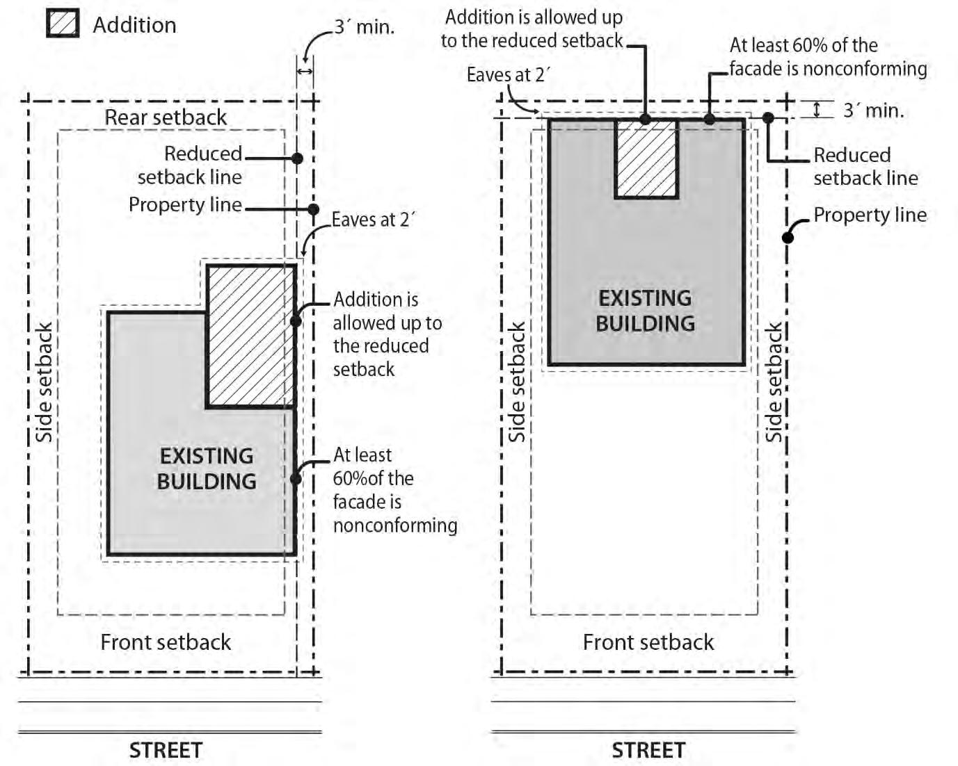
5. Established building lines. The front, side, or rear building setback for the primary structure may be reduced for sites with existing nonconforming development in a required setback. The reduction is allowed if the width of the portion of the existing wall of the primary structure within the required setback is at least 60 percent of the width of the respective facade of the existing primary structure. The building line created by the nonconforming wall serves as the reduced setback line. Eaves associated with the nonconforming wall may extend the same distance into the reduced setback as the existing eave. However, side or rear setbacks may not be reduced to less than 3 feet in depth and eaves may not project closer than 2 feet to
the side or rear property line. See Figure 110-4. This reduced setback applies to alterations that are no higher than the existing nonconforming wall. For example, a second story could not be placed up to the reduced setback line if the existing nonconforming wall is only one story high.
6. Split zoning. No setbacks are required from an internal lot line that is also a zoning line on sites with split zoning.
7. Land divisions and Planned Developments with existing development. The following setback reductions are allowed when proposed as part of a land division or Planned Development:
a. The minimum setback between an existing building and a side lot line along a proposed right-of-way dedication or street tract may be reduced to three feet;
b. When a dedication of public right-of-way along the frontage of an existing street is required as part of a land division or Planned Development, the minimum front or side setback between an existing building and a lot line that abuts the right-ofway may be reduced to zero. Future additions or development must meet required minimum setbacks.
c. Eaves on an existing building may extend one foot into the reduced setback allowed by D.7.a. or b., except they may not extend into the right-of-way.
8. Required dedication. When a dedication of public right-of-way along the frontage of an existing street is required by a public agency, the minimum front or side setback between an existing building and a lot line that abuts the right-of-way may be reduced to zero. Future additions or development must meet required minimum setbacks. Eaves on an existing building may extend one foot into the reduced setback except they may not extend into the right-of-way.
9. Alley. No side, rear, or garage entrance setback is required from a lot line abutting an alley.
A. Purpose. The building coverage standards limit the footprint of buildings and work together with the height, setback, and floor area ratio standards to control the overall bulk of structures. They are intended to ensure that taller buildings will not have such a large footprint that their total bulk will overwhelm adjacent houses. Additionally, the standards help define the character of the different zones by limiting the amount of buildings allowed on a site.
B. Building coverage standards. The maximum combined building coverage allowed on a site for all covered structures is stated in Table 110-5.
Requirements for street trees and for on-site tree preservation, protection, and overall tree density are specified in Title 11, Trees. See Chapter 11.50, Trees in Development Situations.
A. Purpose. These standards:
• Work with the street-facing facade and garage standards to ensure that there is a physical and visual connection between the living area of the residence and the street;
• Enhance public safety for residents and visitors and provide opportunities for community interaction;
• Ensure that the pedestrian entrance is visible or clearly identifiable from the street by its orientation or articulation; and
• Ensure a connection to the public realm for development on lots fronting both private and public streets by making the pedestrian entrance visible or clearly identifiable from the public street.
B. Where these standards apply.
1. The standards of this section apply to all residential structure types in the R10 through R2.5 zones except accessory dwelling units in;
2 Where a proposal is for an alteration or addition to existing development, the standards of this section apply only to the portion being altered or added;
3 On sites with frontage on both a private street and a public street, the standards apply to the site frontage on the public street. On all other sites with more than one street frontage, the applicant may choose on which frontage to meet the standards;
4 Development on flag lots or on lots that slope up or down from the street with an average slope of 20 percent or more is exempt from these standards;
5 Subdivisions and PUDs that received preliminary plan approval between September 9, 1990, and September 9, 1995, are exempt from these standards; and
6. Development on lots where any portion of the lot is in the special flood hazard area is exempt from the standard in Subsection D.
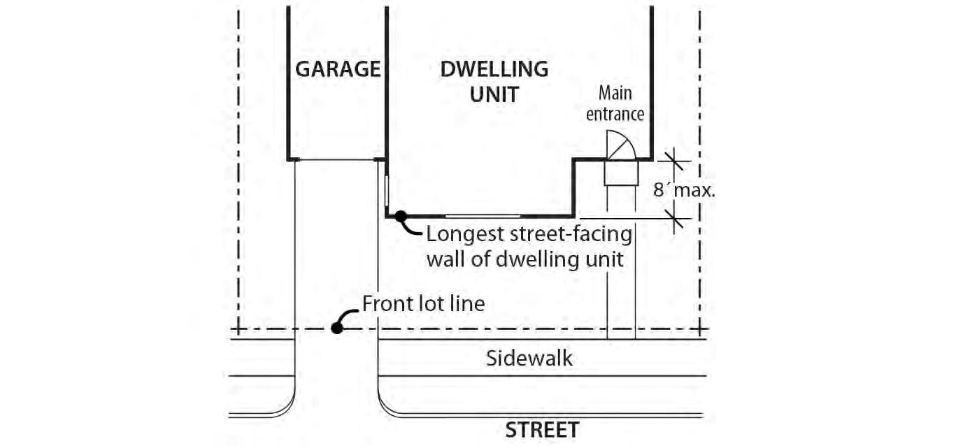
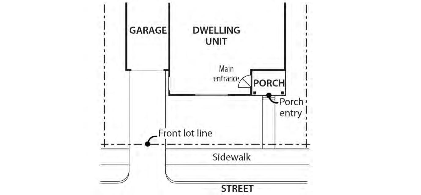
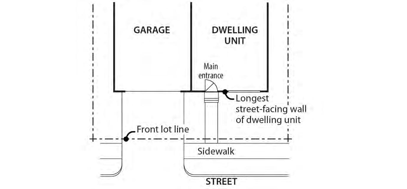
C. Location. At least one main entrance for each structure must:
1. Be within 8 feet of the longest street-facing wall of the dwelling unit; and
2. Either:
a. Face the street. See Figure 110-5;
b. Be at an angle of up to 45 degrees from the street; or
c. Open onto a porch. See Figure 110-6. The porch must:
(1) Be at least 25 square feet in area;
(2) Have at least one entrance facing the street; and
(3) Have a roof that is:
• No more than 12 feet above the floor of the porch; and
• At least 30 percent solid. This standard may be met by having 30 percent of the porch area covered with a solid roof, or by having the entire area covered with a trellis or other open material if no more than 70 percent of the area of the material is open.
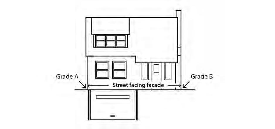
D. Distance from grade. The main entrance that meets Subsection C must be within 4 feet of grade. For the purposes of this Subsection, grade is the average grade measured at the outer most corners of the street facing façade. See Figure 110-7.
• Work with the main entrance and garage standards to ensures that there is a visual connection between the living area of the residence and the street;
• Enhance public safety by allowing people to survey their neighborhood from inside their residences; and
• Provide a pleasant pedestrian environment along the street by preventing large expanses of blank facades and facade-obscuring staircases from interrupting the connection between the residence and the public realm.
B. Where the standards apply.
1. The street-facing façade standards apply to all residential structure types in the R10 through R2.5 zones except accessory dwelling units;
2. Where a proposal is for an alteration or addition to existing development, the applicant may choose to apply the standard either to the portion being altered or added, or to the entire street-facing facade;
3. Development on flag lots or on lots that slope up or down from the street with an average slope of 20 percent or more is exempt from this standard; and
4. Subdivisions and PUDs that received preliminary plan approval between September 9, 1990, and September 9, 1995, are exempt from these standards.
C. Windows. At least 15 percent of the area of each facade that faces a street lot line must be windows or main entrance doors. Windows used to meet this standard must allow views from the building to the street. Glass block does not meet this standard. Windows in garage doors do not count toward meeting this standard, but windows in garage walls do count toward meeting this standard. To count toward meeting this standard, a door must be at the main entrance and facing a street lot line.
D. Exterior stairs. Fire escapes and exterior stairs providing access to an upper level are not allowed on any facade that faces a street lot line.
A. Purpose. The required outdoor areas standards ensure opportunities in the single-dwelling zones for outdoor relaxation or recreation. The standards work with the maximum building coverage standards to ensure that some of the land not covered by buildings is of an adequate size and shape to be usable for outdoor recreation or relaxation. The location requirements provide options for private or semiprivate areas. The requirement of a required outdoor area serves in lieu of a large rear setback requirement and is an important aspect in addressing the livability of a residential structure.
B. Required outdoor area sizes. The minimum sizes of required outdoor area per lot is stated in Table 110-4. The shape of the outdoor area must be such that a square of the stated dimension will fit entirely in the outdoor area
C. Requirements.
1. The required outdoor area must be a contiguous area and may be on the ground or above ground.
2. The area must be surfaced with lawn, pavers, decking, or sport court paving which allows the area to be used for recreational purposes. User amenities, such as tables, benches, trees, planter boxes, garden plots, drinking fountains, spas, or pools may be placed in the outdoor area. It may be covered, such as a covered patio, but it may not be fully enclosed. Required outdoor area may not be used as vehicle area.
3. General landscaped areas that are included as part of the required outdoor area may extend into the required side and rear building setback, but the required outdoor area may not be located in the front building setback.
A. Purpose. This section regulates detached and connected structures that are incidental to primary buildings to prevent them from becoming the predominant element of the site. The standards limit the height and bulk of these structures, promote compatibility of design for larger structures, provide for necessary access around larger structures, help maintain privacy between abutting lots, and maintain open front setbacks.
B. General standards.
1. The regulations of this section apply to detached accessory structures and connected accessory structures. Farm structures associated with an agricultural use such as barns and silos are exempt from these standards as long as they are set back from all lot lines at least one foot for every foot in height. Additional regulations for accessory dwelling units are stated in Chapter 33.205.
2. Detached accessory structures are allowed on a lot only in conjunction with a primary building and may not exist on a lot prior to the construction of the primary structure, except as allowed by Paragraph B.3.
3. A detached accessory structure that becomes the only structure on a lot as the result of a land division, a property line adjustment, a lot confirmation, or a demolition of the primary structure may remain on the lot if the owner has executed a covenant with the City that meets the requirements of Section 33.700.060.
a. For a land division, the covenant must require the owner to remove the accessory structure if, within two years of final plat approval, a primary structure has not been built and received final inspection. The covenant must be executed with the City prior to final plat approval.
b. For a property line adjustment or a lot confirmation, the covenant must require the owner to remove the accessory structure if a primary structure has not been built and received final inspection within two years. The two years begins on the date the letter from BDS approving the property line adjustment or lot confirmation is mailed. The covenant must be executed with the City before the final letter from BDS is issued.
c. For a demolition of a primary structure, the covenant must require the owner to remove the accessory structure if a new primary structure has not been built and received final inspection within two years. The two years begins on the date of the final inspection of the demolition. The covenant must be executed with the City prior to the issuance of the demolition permit.
C. Detached and connected covered accessory structures. The following standards apply to all detached covered accessory structures and connected covered accessory structures. Detached covered accessory structures are items such as garages, carports, greenhouses, artist’s studios, guest houses, accessory dwelling units, storage buildings, wood sheds, water collection cisterns, and covered decks or patios that are not connected to the primary structure. Connected covered accessory structures include accessory structures that are connected to a primary structure via a roofed structure such as a breezeway. The standards of this subsection do not apply to the portion of the structure that connects the
accessory structure to the primary structure Garages are also subject to the standards of 33.110.250.
1. Height. The maximum height allowed for all detached covered accessory structures and connected covered accessory structures is 20 feet.
2. Setbacks. Except as follows, detached covered accessory structures and connected covered accessory structures are subject to required building setbacks. See the additional regulations for garages in 33.110.250.
a. Water collection cisterns that are 6 feet or less in height are allowed in required side and rear setbacks.
b. In the R7, R5 and R2.5 zones, detached covered accessory structures other than water collection cisterns, are allowed in required side and rear building setbacks if all of the following are met:
(1) The structure is at least 40 feet from a front lot line, and if on a corner lot, is at least 20 feet from a side street lot line;
(2) The structure’s footprint has dimensions that do not exceed 24 feet by 24 feet, excluding eaves;
(3) If more than one structure is within the setback, the combined length of all structures in the setback adjacent to each property line is no more than 24 feet;
(4) The structure is no more than 15 feet high, and the walls of the structure are no more than 10 feet high, excluding the portion of the wall within a gable;
(5) The portion of the structure within the setback must be screened from adjoining lots by a fence, unless it is enclosed within the setback by a wall. Screening is not required for enclosed structures. Screening must comply with the F2 standards of Chapter 33.248, Landscaping and Screening;
(6) Walls located within the setback do not have doors or windows facing the adjacent lot line;
(7) The structure does not have a rooftop deck; and
(8) Dormers are set back at least 5 feet from the side and rear lot lines that abut another lot.
3. Building coverage. The following additional building coverage standards apply to detached covered accessory structures and connected covered accessory structures:
a. The combined building coverage of all detached and connected covered accessory structures may not exceed 20 percent of the total area of the site; and
b. The building coverage of each detached covered accessory structure and each connected covered accessory structure may not be greater than the building
coverage of the smallest primary structure, or 900 square feet, whichever is greater.
4. Additional development standards. The following additional standards apply to detached covered accessory structures and connected covered accessory structures that are more than 15 feet high. Additions to existing structures that do not meet a standard are exempt from that standard.
a. Exterior finish materials. The exterior finish materials must meet one of the following:
(1) The exterior finish material must be the same in type, size and placement as the exterior finish material of a primary structure; or
(2) Siding must be made from wood, composite boards, vinyl or aluminum products, and the siding must be composed in a shingle pattern, or in a horizontal clapboard or shiplap pattern. The boards in the pattern must be 6 inches or less in width.
b. Roof Pitch. The pitch of the roof with the highest ridgeline must meet one of the following:
(1) The pitch of the roof with the highest ridgeline must be the same as the pitch of the roof with the highest ridgeline of a primary structure; or
(2) The pitch of the roof with the highest ridgeline must be at least 6/12.
c. Trim. The trim must meet one of the following:
(1) The trim must be the same in type, size, and location as the trim used on a structure; or
(2) The trim around all windows and doors must be at least 3 ½ inches wide.
d. Windows. The windows on all street facing facades must meet one of the following:
(1) The windows must match those on the street facing facade of a primary structure in orientation (horizontal or vertical); or
(2) Each window must be square or vertical – at least as tall as it is wide.
e. Eaves. The eaves must meet one of the following:
(1) The eaves must project from the building walls the same distance as the eaves on a primary structure;
(2) The eaves must project from the building walls at least 1 foot on all elevations; or
(3) If the primary structure has no eaves, no eaves are required.
D. Detached uncovered vertical structures. Detached uncovered vertical structures are items such as flag poles, trellises, arbors and other garden structures, play structures, antennas,
satellite receiving dishes, and lamp posts. The following standards apply to detached uncovered vertical structures. Fences are addressed in 33.110.275:
1. Height. Except as follows, the maximum height allowed for all detached uncovered vertical structures is 20 feet:
a. Antennas, utility power poles, and public safety facilities are exempt from the height limit.
b. Flagpoles are subject to the height limit of the base zone for primary structures.
c. Detached small wind turbines are subject to the standards of 33.299, Wind Turbines.
2. Setbacks. Except as follows, detached uncovered vertical structures are subject to required building setbacks:
a. Detached uncovered vertical structures that are no larger than 3 feet in width, depth, or diameter and no taller than 8 feet are allowed in required building setbacks.
b. A single arbor structure that is up to 6 feet wide, up to 3 feet deep, and up to 8 feet tall is allowed in the front setback. The arbor must allow for pedestrian access under its span.
c. Flagpoles are allowed in required building setbacks.
d. In the R7, R5, and R2.5 zones, detached uncovered vertical structures that exceed the allowances of Subparagraph 2.a are allowed in side and rear setbacks if all of the following are met:
(1) The structure is at least 40 feet from a front lot line, and if on a corner lot, at least 20 feet from a side street lot line;
(2) The structure’s footprint has dimensions that do not exceed 24 feet by 24 feet;
(3) The structure is no more than 10 feet high;
(4) The portion of the structure within the setback must be screened from adjoining lots by a fence or landscaping, unless it is enclosed within the setback by a wall. Screening is not required for enclosed structures. Screening must comply with the L3 or F2 standards of Chapter 33.248, Landscaping and Screening; and
(5) The structure does not have a rooftop deck.
E. Detached uncovered horizontal structures. Uncovered horizontal structures are items such as decks, stairways, swimming pools, hot tubs, tennis courts, and boat docks not covered or enclosed. The following standards apply to detached uncovered horizontal structures.
1. Height. The maximum height allowed for all detached uncovered horizontal structures is 20 feet.
2. Setbacks. Except as follows, detached uncovered horizontal structures are subject to required buildings setbacks:
a. Detached uncovered decks, ramps, and stairways that are more than 2-1/2 feet above the ground may extend into a required building setback up to 20 percent of the depth of the setback. However, the deck or stairway must be at least three feet from a lot line.
b. Structures that are no more than 2-1/2 feet above the ground are allowed in required building setbacks.
F. Detached mechanical equipment. Detached mechanical equipment includes items such as heat pumps, air conditioners, emergency generators, radon mitigation components, and water pumps. Generally, detached mechanical equipment will not be attached to a building but may have components such as ventilation or electrical systems attached to the primary structure. The following standards apply to detached mechanical equipment:
1. Height. The maximum height allowed for all detached mechanical equipment is 20 feet.
2. Setbacks. Except as follows, detached mechanical equipment is subject to required buildings setbacks. Detached mechanical equipment is allowed in side or rear building setbacks if all of the following are met:
a. The equipment is no more than 5 feet high; and
b. The equipment is screened from adjoining lots by walls, fences or vegetation. Screening must comply with the L3 or F2 standards of Chapter 33.248, Landscaping and Screening.
A. Purpose. These standards:
• Together with the window and main entrance standards, ensure that there is a physical and visual connection between the living area of the residence and the street;
• Ensure that the location and amount of the living area of the residence, as seen from the street, is more prominent than the garage;
• Prevent garages from obscuring the main entrance from the street and ensure that the main entrance for pedestrians, rather than automobiles, is the prominent entrance;
• Provide for a more pleasant pedestrian environment by preventing garages and vehicle areas from dominating the views of the neighborhood from the sidewalk; and
• Enhance public safety by preventing garages from blocking views of the street from inside the residence.
B. Existing detached garages.
1. Rebuilding. A detached garage that is nonconforming due to its location in a setback, may be rebuilt on the footprint of the existing foundation, if the garage was originally constructed legally. In this case, the rebuilt garage may be no more than 15 feet high, and the garage walls may be no more than 10 feet high, excluding the portion of the
wall within a gable. Decks are not allowed on the roof of the garage. The rebuilt garage is not required to comply with other standards of this chapter.
2. Additions. An addition may be made to an existing or rebuilt detached garage that is nonconforming due to its location in a setback as follows:
a. The expanded garage complies with all other standards of this chapter; or
b. The combined size of the existing foundation and the addition is no larger than 12 feet wide by 20 feet deep. In this case, the garage may be no more than 15 feet high, and the walls of the addition may be no more than 10 feet high, excluding the portion of the wall within a gable. Decks are not allowed on the roof of the garage. The expanded garage is not required to comply with other standards of this chapter.
1. Where these regulations apply. Unless exempted by Paragraph C.2, the regulations of this subsection apply to garages in the R10 through R2.5 zones.
2. Exemptions.
a. Development on flag lots, and development on lots that slope up or down from the street with an average slope of 20 percent or more are exempt from the standards of this subsection.
b. Subdivisions and PUDs that received Preliminary Plan approval between September 9, 1990, and September 9, 1995, are exempt from the standards of this subsection.
c. On corner lots, only the street-facing garage wall that contains the garage door must meet the standards of this subsection.
3. Standards.
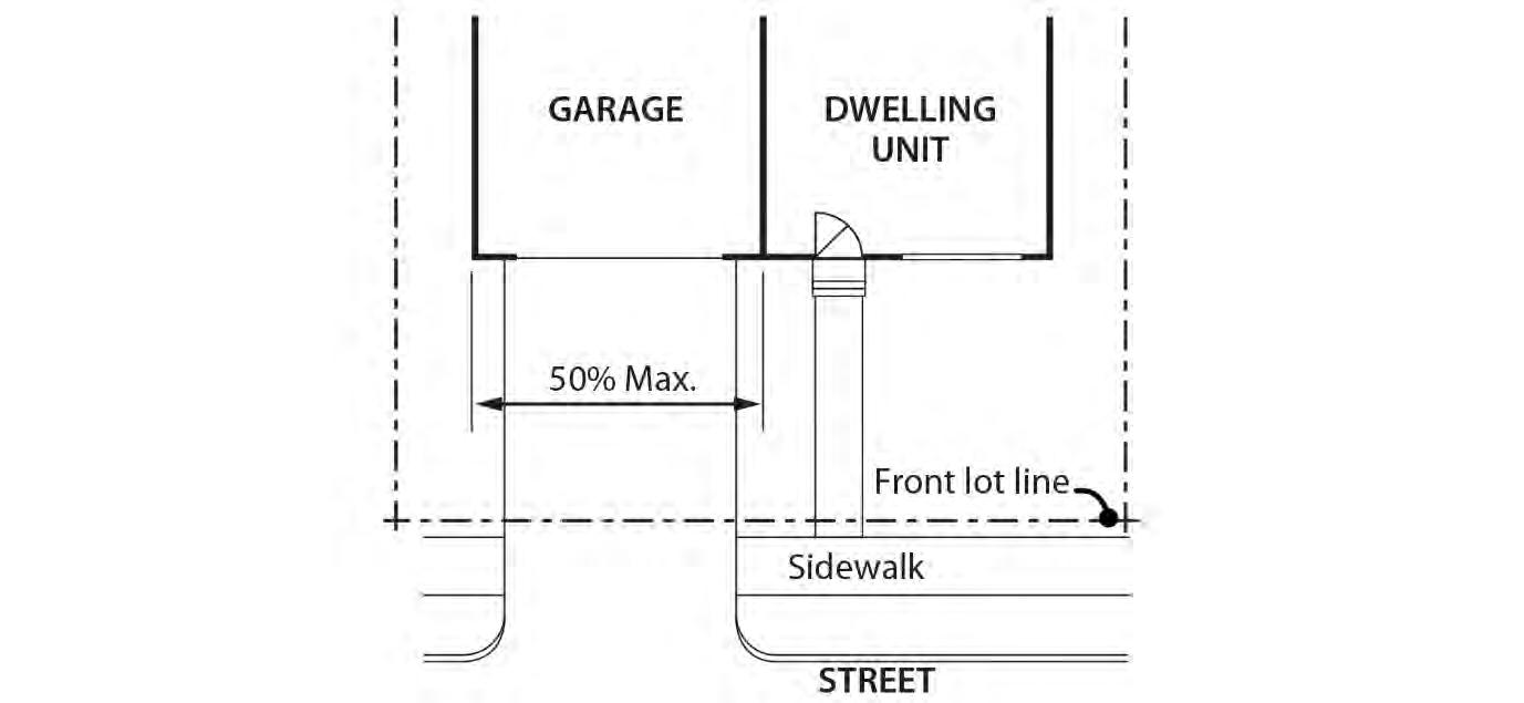
a. Garages that are accessory to houses. For garages that are accessory to houses and manufactured homes, the length of the garage wall facing the street may be up to 50 percent of the length of the street-facing building façade. See Figure 110-8. Where the street-facing facade is less than 22 feet long, an attached garage is not allowed as part of that façade.
b. Garages that are accessory to attached houses. The following standards apply to garages that are accessory to attached houses:
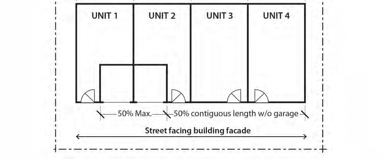
(1) The length of the garage wall facing the street may be up to 50 percent of the length of the street facing building façade. See Figure 110-8. When all the units are 22 feet wide or wider, the standard applies to the street-facing façade of each unit. In all other situations, the standard applies to the total length of the street-facing facades; and
(2) When the attached house structure is made up of more than three attached houses and at least one attached house is less than 22 feet wide, at least 50 percent of the total length of the street-facing facades must be without
garage, and the 50 percent length without garage must be contiguous. See Figure 110-9.
c. Garages that are accessory to duplexes, triplexes, and fourplexes. The following standards apply to garages that are accessory to duplexes, triplexes, and fourplexes:
(1) The length of the garage wall facing the street may be up to 50 percent of the total length of the street-facing building façades. See Figure 110-8. Where the total length of the street-facing facades is less than 22 feet long, an attached garage is not allowed; and
(2) For a fourplex, at least 50 percent of the total length of the street-facing building facades must be without garage, and the 50 percent length without garage must be contiguous. See Figure 110-9.
D. Street lot line setbacks.
1. Where this standard applies. The standard of this paragraph applies to garages in the R10 through R2.5 zones. Where a proposal is for an alteration or addition to existing development, the standard applies only to the portion being altered or added.
2. Exemptions.
a. Development on flag lots or on lots that slope up or down from the street with an average slope of 20 percent or more are exempt from this standard.
b. Subdivisions and PUDs that received preliminary plan approval between September 9, 1990, and September 9, 1995, are exempt from this standard.
c. Where a lot has more than one street lot line, and there is an existing dwelling unit on the lot, this standard must be met only on the street-facing facade on which the main entrance is located.
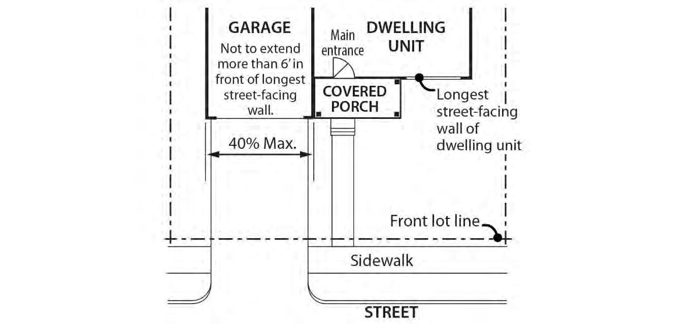
3. Standard. A garage wall that faces a street may be no closer to the street lot line than the longest street-facing wall of the dwelling unit. See Figure 110-10
4. Exception. A street-facing garage wall may be up to 6 feet in front of the longest street-facing wall of the dwelling unit, if:
a. The street-facing garage wall is 40 percent or less of the length of the building facade; and
b. There is a porch at the main entrance. The garage wall may not be closer to the street lot line than the front of the porch. See Figure 110-11. The porch must meet the following:
(1) The porch must be at least 48 square feet in area and have minimum dimensions of 6 feet by 6 feet;
(2) The porch must have a solid roof; and
(3) The roof may not be more than 12 feet above the floor of the porch.
A. Purpose. Flag lots encourage additional housing opportunities in a land efficient manner that allows existing homes to be retained. The standards in this section are intended to:
• Protect privacy between the flag lots and abutting residences; and
• Increase the compatibility of structures on small flag lots.
B. Flag lot standards.
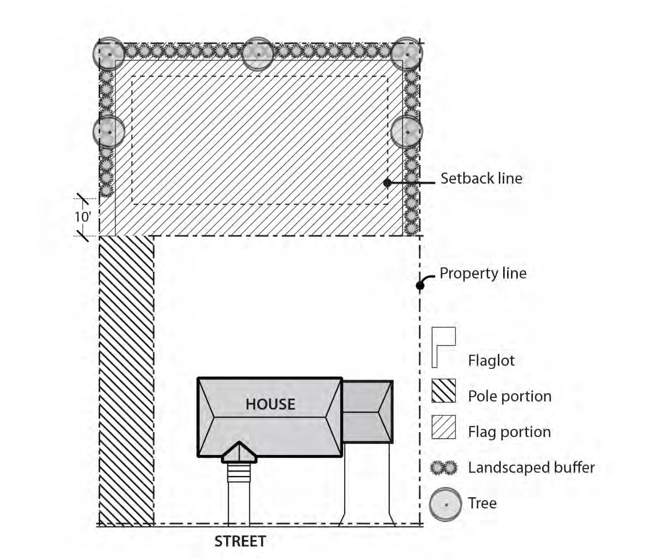
1. Large flag lots. The following standards apply to flag lots that are 3,000 square feet or more in area. Only the area of the flag portion of the flag lot is included when calculating area. The pole portion of the flag lot is not included. See Figure 110-11:
a. Setbacks. Large flag lots have required building setbacks that are the same along all lot lines. The required setbacks are: Zone Setback
RF, R20, R10 15 feet
R7, R5, R2.5 10 feet
b. Landscaped buffer area. A landscaped area is required around the perimeter of a flag lot that is 10,000 square feet or less in area to buffer the flag portion from surrounding lots. The pole portion of the flag lot is not included when calculating area, and the pole and the lot lines that are internal to the original land division site, or are adjacent to an alley, are exempt from the landscaped area requirement. The landscaped area must be at least 5 feet deep and must be landscaped to at least the L3 standard. Landscaping is not required within the first 10 feet from the point at which the pole portion meets the flag portion of the lot. See Figure 110-12;
c. Building coverage. Only the area of the flag portion of the flag lot is included when calculating building coverage. The area of the pole portion of the lot is not included;
d. Required outdoor area. The required outdoor area may not extend into the required landscaped buffer area required by Subparagraph B.1.b.; and
e. Detached and connected accessory structures. Detached and connected accessory structures may project into the flag lot setbacks as allowed by 33.110.245, Detached and Connected Accessory Structures. However, these structures may not extend into the landscaped buffer area required by Subparagraph B.1.b.
2. Small flag lots. The following standards apply to flag lots where the flag portion of the lot is less than 3,000 square feet in area:
a. Setbacks. Small flag lots have a 5 foot required building setback along all lot lines;
b. Building coverage. Only the area of the flag portion of the flag lot is included when calculating building coverage. The area of the pole portion of the lot is not included;
c. Maximum FAR. In the RF through R5 zones, the maximum floor area ratio allowed on a small flag lot is 0.5 to 1.
d. Maximum height. In the RF through R5 zones, the maximum height allowed for all structures is 20 feet.
e. Design standards. In the RF through R5 zones, the following design standards apply to structures that are more than 15 feet high:
(1) The exterior finish material must be the same in type, size and placement as the exterior finish material on the primary structure on the lot in front of the flag lot, or be made from brick, stucco, wood, composite boards, vinyl or aluminum. Wood, composite boards, vinyl or aluminum siding must be arranged in a shingle, horizontal clapboard, or shiplap pattern. The boards in the pattern must be 6 inches or less in width.
(2) The pitch of the roof with the highest ridgeline must be the same as the pitch of the roof with the highest ridgeline of the primary structure on the lot in front of the small flag lot or be at least 6/12.
(3) The trim around all windows and doors must be the same as the window and door trim on the primary structure on the lot in front of the flag lot or be at least 3-1/2 inches wide.
(4) The eaves must project the same as the eaves on the primary structure on the lot in front of the flag lot, or project from the building walls at least 1 foot on all elevations.
A. Purpose. These standards increase the compatibility of residential structures on narrow lots by:
• Ensuring a reasonably proportional relationship between the width and height of structures on narrow lots;
• Promoting wider front facades by requiring two attached houses on very narrow lots;
• Promoting open landscaped front yards
B. Where these regulations apply. The following additional development standards apply to lots, adjusted lots, lot remnants, lots of record, and combinations of lots, adjusted lots, lot remnants, or lots of record that are less than 32 feet wide in the R20 through R2.5 zones. Lots in planned unit developments are exempt from the additional standards.
1. Required housing type. Attached houses are required on lots and lots of record that are less than 26 feet wide. Attached houses are not required on sites that contain a combination of lots or lots of record when the combination is at least 26 feet wide. Attached houses are also not required when there are primary structures on all of the adjacent sites that share a side lot line with the development site. See 33.110.265.C. for development standards that apply to attached houses.
2. Maximum height. The maximum height allowed for all primary structures is 1.5 times the width of the structure, up to the maximum height limit listed in Table 110-4. Attached houses are exempt from this standard but are still subject to the maximum height limit listed in Table 110-4. For the purposes of this Paragraph, width is the length of the street-facing facade of the structure. See Figure 110-13.
a. All street-facing facades must have landscaping along the foundation. There must be at least one three-gallon shrub for every 3 lineal feet of foundation; and
b. Sixty percent of the area between the front lot line and the front building line must be landscaped. At a minimum, the required landscaped area must be planted with ground cover. Up to one-third of the required landscaped area may be for recreational use or for use by pedestrians. Examples include walkways, play areas, and patios.
A. Purpose. The residential infill options allow for a variety of residential housing types in a manner that maintains the overall character of single-dwelling neighborhoods. These options have several public benefits:
• They promote housing types that accommodate households of varying sizes and income levels;
• They promote energy-efficient development;
• They provide for a more efficient use of residential land; and
• They promote better site layout and opportunities for private recreational areas.
B. General requirements for all residential infill options. The residential infill options listed in this section are allowed by right unless specifically stated otherwise. The project must comply with the applicable development standards of this section. The project must also conform with all other development standards of the base zone unless those standards are superseded by the standards in this section.
C. Attached housing. Attached housing allows for more efficient use of land and for energyconserving housing. Attached houses are allowed in the R20 through R2.5 zones as follows:
1. Lot dimensions. Attached houses are allowed on lots that comply with 33.110.202, When Primary Structures are Allowed.
2. Number of attached houses.
a. In the R20 through R5 zones up to four attached houses may have a common wall. Structures made up of five or more attached houses are prohibited unless approved as a Planned Development.
b. In the R2.5 zones, up to eight attached houses may have common walls Structures made up of nine or more attached houses are prohibited.
3. Building setbacks. The required building setback on the side containing the common wall is reduced to zero. The reduced setback applies to all buildings on the lot and extends along the full length of the lot line that contains the common or abutting wall.
4. Alternative building coverage calculation. For attached houses, the maximum building coverage of the base zone may be calculated, combined, and shared among the attached house lots. However, no lot can exceed 5 percent more that the base zone maximum allows for that lot.
5. Floor area. The maximum floor area ratio allowed may be based on the total number of dwelling units in the attached house project. The maximum floor area ratio may be calculated, combined, and shared among the attached house lots. However, no lot can exceed .05 more than the base zone maximum allows for the site.
D. Duplexes.
1. Duplexes consisting of two primary dwelling units in one structure are allowed on lots in the R20 through R2.5 zones.
2. Duplexes consisting of two detached primary dwelling units are allowed on lots in the R20 through R2.5 zones, and must meet the following standards. Adjustments are prohibited:
a. Existing dwelling unit. The lot must contain a primary dwelling unit that received final inspection at least 5 years ago.
b. Maximum height. The maximum height allowed for the dwelling unit that is not the existing primary dwelling unit is 25 feet.
E. Triplexes and fourplexes. Triplexes and fourplexes that meet the following standards are allowed in the R20 through R2.5 zones. Triplexes and fourplexes are prohibited on lots that do not have frontage on a maintained street, except lots that have frontage on a private street that connects to a maintained street, and lots that have frontage on a self-contained pedestrian connection created solely for pedestrians and bicycles that connects to a maintained street. Payment in lieu of street improvements does not satisfy this requirement.
1. Density. Up to a maximum of four dwelling units are allowed.
2. Minimum lot area. Lots for triplexes and fourplexes must meet the minimum lot area requirement shown in Table 110-7. Adjustments are prohibited.
3. Visitability.
a. Purpose. Visitability standards ensure that a baseline of accessible features is provided to accommodate people living in or visiting the residence regardless of age or ability. The standards:
• Promote a diverse supply of more physically accessible housing;
• Allow people of all ages and abilities to easily enter and visit the residence;
• Foster community interaction by reducing barriers that can lead to social isolation; and
• Enhance public safety for all residents and visitors.
b. Visitable unit standard. Unless exempted by Subparagraph E.3.c., at least one dwelling unit on the lot must meet all of the following visitability standards:
(1) Visitable entrance. At least one entrance must be accessible via a route that does not have any stairs between it and the street lot line or an on-site parking space. The slope of the route may not exceed 1:8.
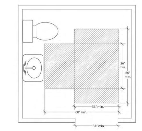
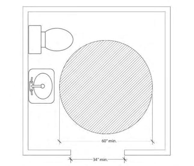
(2) Visitable bathroom. At least one bathroom with a sink and toilet must be designed to accommodate an unobstructed circle that is at least 60-inches in diameter. As an alternative, the bathroom may be designed to accommodate an unobstructed area that is comprised of two rectangles that are at least 36 inches by 60 inches, and oriented at right angles to each other. See Figure 110-14. The visitable bathroom must be on the same floor as the visitable entrance or be accessible from the visitable entrance via a ramp, elevator or lift. Adjustments are prohibited;
(3) Visitable living area. There must be at least 200 square feet of living area on the same floor as the visitable entrance or 200 square feet of living area must be accessible from the visitable entrance via a ramp, elevator or lift. Adjustments are prohibited; and
(4) Visitable doors. All door openings between and including the visitable entrance, visitable living area, and the visitable bathroom must be at least 34 inches wide. Adjustments are prohibited.
c. Exemptions. The following are exempt from the standards of this Paragraph:
(1) Lots with an average slope of 20 percent or greater;
(2) Lots where there is more than a 3-foot rise between the highest elevation along the street lot line and the lowest grade measured at the front setback.
(3) Conversion of an existing residential structure to a triplex or fourplex.
F. Affordable fourplexes and multi-dwelling structures. Fourplexes and multi-dwelling structures with no more than six dwelling units are allowed in the R20 through R2.5 zones when the following standards are met. Fourplexes and multi-dwelling structures are prohibited on lots that do not have frontage on a maintained street, except lots that have frontage on a private street that connects to a maintained street, and lots that have frontage on a self-contained pedestrian connection created solely for pedestrians and bicycles that connects to a maintained street. Payment in lieu of street improvements does not satisfy this requirement.
1. Density. A maximum of six dwelling units are allowed. More than six dwelling units are prohibited.
2. Affordability. 50 percent of the total number of dwelling units on the site must be affordable to those earning no more than 60 percent of the area median family income or an affordability level established by Title 30. The applicant must provide a letter from the Portland Housing Bureau certifying that the development meets the affordability requirement of this option and any administrative requirements of the Portland Housing Bureau. The letter must be submitted before a building permit can be issued for the development but is not required in order to apply for a land use review. Adjustments are prohibited.
3. Minimum lot area. Lots for affordable fourplexes and multi-dwelling structures must meet the minimum lot area requirement shown in Table 110-7. Adjustments are prohibited.
4. Maximum FAR. The maximum FAR is 1.2 to 1. Adjustments are prohibited.
5. Maximum Height. The maximum height is 35 feet. Adjustments are prohibited.
6. Building Coverage.
a. Generally. The maximum building coverage allowed is stated in 33.110.225.
b. Exception. The maximum building coverage allowed per lot is 60 percent. In this case, the maximum height allowed is reduced to 25 feet. Adjustments are prohibited.
7. Required outdoor area.
a. Generally. Outdoor area is required as stated in 33.110.240.
b. Exception. At least 48 square feet of outdoor area must be provided per dwelling unit. Each outdoor area must be designed so that a 4-foot x 6-foot square will fit entirely within it. The outdoor area must be directly accessible to the unit. Areas used for pedestrian circulation to more than one dwelling unit do not count towards meeting this standard. If the area is at ground level, it may extend into the entire required side and rear setback. The requirements of 33.110.240.C continue to apply. Adjustments are prohibited.
8. Visitability.
a. Purpose. The visitability standard ensures that a baseline of accessible features is provided to accommodate people living in or visiting the residence regardless of age or ability. The standards:
• Promote a diverse supply of more physically accessible housing;
• Allow people of all ages and abilities to easily enter and visit the residence;
• Foster community interaction by reducing barriers that can lead to social isolation; and
• Enhance public safety for all residents and visitors.
b. Visitable unit standard. Unless exempted by Subparagraph F.8.c., at least two dwelling units on the lot must meet all of the following visitability standards:
(1) Visitable entrance. At least one entrance must be accessible via a route that does not have any stairs between it and the street lot line or an on-site parking space. The slope of the route may not exceed 1:8.
(2) Visitable bathroom. At least one bathroom with a sink and toilet must be designed to accommodate an unobstructed circle that is at least 60-inches in diameter. As an alternative, the bathroom may be designed to accommodate an unobstructed area that is comprised of two rectangles that are at least 36 inches by 60 inches, and oriented at right angles to each other. See Figure 110-14. The visitable bathroom must be on the same floor as the visitable entrance or be accessible from the visitable entrance via a ramp, elevator or lift. Adjustments are prohibited;
(3) Visitable living area. There must be at least 200 square feet of living area on the same floor as the visitable entrance or 200 square feet of living area must be accessible from the visitable entrance via a ramp, elevator or lift. Adjustments are prohibited; and
(4) Visitable doors. All door openings between and including the visitable entrance, visitable living area, and the visitable bathroom must be at least 34 inches wide. Adjustments are prohibited.
c. Exemptions. The following are exempt from the standards of this Paragraph:
(1) Lots with an average slope of 20 percent or greater;
(2) Lots where there is more than a 3-foot rise between the highest elevation along the street lot line and the lowest grade measured at the front setback.
(3) Conversion of an existing residential structure to a fourplex or multidwelling structure.
G. Cottage cluster. Cottage clusters that meet the following standards are allowed on sites in the R10 through R2.5 zones. Cottage clusters are prohibited on sites that do not have frontage on a maintained street, except sites that have frontage on a private street that connects to a maintained street, and sites that have frontage on a self-contained pedestrian connection created solely for pedestrians and bicycles that connects to a maintained street. Payment in lieu of street improvements does not satisfy this requirement. Adjustments to the following standards are prohibited.
1. Minimum site dimensions.
a. Minimum site area.
(1) R10 and R7. In the R10 and R7 zones, cottage cluster sites must be at least 7,000 square feet in area.
(2) R5 and R2.5. In the R5 and R2.5 zones, cottages clusters sites must be at least 5,000 square feet in area.
b. Minimum site width. Cottage cluster sites must be at least 36 feet wide. Site width for a cottage cluster is measured as lot width is measured. See 33.930.100.
2. Maximum area. Cottage cluster sites must not be greater than one acre.
3. Minimum density. The minimum number of dwelling units required is 3 or the minimum number stated in Table 110-8 whichever is greater.
4. Maximum dwelling units. The maximum number of dwelling units allowed on a cottage cluster site is 16.
5. Floor area. Cottage clusters are exempt from 33.110.210, Floor Area Ratio. However, the maximum average floor area for the cottage cluster site is 1,400 square feet per dwelling unit, including the floor area for attached accessory structures. The applicant may choose to exclude the floor area of any existing dwelling units that received final inspection at least 5 years ago from the average. The maximum floor area allowed for a detached or connected accessory structure is 400 square feet.
6. Maximum height. The maximum height allowed is 25 feet. Existing dwelling units that received final inspection at least 5 years ago that exceed this maximum height are allowed but the height cannot be increased. The maximum height standards for detached and connected accessory structures are stated in 33.110.245, Detached and Connected Accessory Structures.
7. Separation. Dwelling units within the cottage cluster site must be separated by at least 6 feet.
8. Building coverage. Cottage clusters are exempt from 33.110.225. Building Coverage. The following building coverage standards apply:
a. The maximum building coverage allowed for each dwelling unit is 900 square feet and includes attached accessory structures. Existing dwelling units that received final inspection at least 5 years ago that exceed this limit are allowed but the building coverage cannot be increased; and
b. The building coverage of a detached or connected covered accessory structure may not be greater than the building coverage of the smallest primary structure.
9. Common outdoor area. The following common outdoor area standards apply to cottage clusters. Cottage clusters are exempt from 33.110.240:
a. The total amount of common outdoor area required is 150 square feet per dwelling unit if all the dwelling units are separated by at least 10 feet, or 200
square feet per dwelling unit if any of the dwelling units are separated by less than 10 feet.
b. Each common outdoor area:
(1) Must be at least 450 square feet in area. Required pedestrian connections located adjacent to or within a common outdoor area count toward this minimum size;
(2) Must measure at least 15 feet in all directions. Required pedestrian connections located adjacent to or within a common outdoor are included in this minimum width; and
(3) Must be located outside the required front setback.
c. Each required common outdoor area must be surfaced with landscaping, pavers, decking, or sport court paving to allow the area to be used for active or passive recreational use. No more than 50 percent of the total common outdoor area can be in an impervious surface. Common outdoor area may not be used as vehicle area.
d. User amenities. User amenities, such as tables, benches, trees, shrubs, planter boxes, garden plots, drinking fountains, spas, or pools may be placed in the outdoor area. Common, shared outdoor areas may also be developed with amenities such as play areas, plazas, picnic areas, and open recreational facilities.
10. Dwelling unit orientation. Dwelling units located within 25 feet of a street property line must meet the base zone main entrance standards of 33.110.230. All other dwellings units are exempt from 33.110.230 but must meet the following dwelling unit orientation standards:
a. At least 50 percent of the dwelling units that are exempt from 33.110.230 must:
(1) Have at least one main entrance facing a common outdoor area; and
(2) Be located within 10 feet of the common outdoor area, measured from the closest point of the façade with the main entrance to the nearest edge of the common outdoor area.
b. Dwelling units that do not have a main entrance facing the common outdoor area or street must have at least one main entrance facing a pedestrian connection that is connected to the common outdoor area.
11. Windows. Cottage clusters are exempt from 33.110.235.C. However, 15 percent of the area of the façade with the required main entrance must be windows or main entrance doors. Windows used to meet this standard must allow views from the building to the street, pedestrian connection or common outdoor area. Glass block does not meet this standard. Windows in garage doors do not count toward meeting this standard, but windows in garage walls do count toward meeting this standard.
12. Pedestrian connections.
a. A pedestrian connection system is required that connects the main entrances of all of the dwelling units on the site to the street and to common outdoor areas. Sidewalks within the right-of-way can be included as part of the pedestrian connection system.
b. The pedestrian connection system must be hard surfaced and must be at least 3 feet wide for sites with 3 or 4 dwelling units and 4 feet wide for sites with 5 or more dwelling units.
13. Visitability.
a. Purpose. The visitability standard ensures that a baseline of accessible features is provided to accommodate people living in or visiting the residence regardless of age or ability. The standards:
• Promote a diverse supply of more physically accessible housing;
• Allow people of all ages and abilities to easily enter and visit the residence;
• Foster community interaction by reducing barriers that can lead to social isolation; and
• Enhance public safety for all residents and visitors.
b. Visitable unit standard. Unless exempted by Subparagraph G.13.c., at least 33 percent of the dwelling units on the cottage cluster site must meet all of the following visitability standards:
(1) Visitable entrance. At least one entrance must be accessible via a route that does not have any stairs between it and the street lot line or an on-site parking space. The slope of the route may not exceed 1:8.
(2) Visitable bathroom. At least one bathroom with a sink and toilet must be designed to accommodate an unobstructed circle that is at least 60-inches in diameter. As an alternative, the bathroom may be designed to accommodate an unobstructed area that is comprised of two rectangles that are at least 36 inches by 60 inches, and oriented at right angles to each other. See Figure 110-14. The visitable bathroom must be on the same floor as the visitable entrance or be accessible from the visitable entrance via a ramp, elevator or lift;
(3) Visitable living area. There must be at least 200 square feet of living area on the same floor as the visitable entrance or 200 square feet of living area must be accessible from the visitable entrance via a ramp, elevator or lift; and
(4) Visitable doors. All door openings between and including the visitable entrance, visitable living area, and the visitable bathroom must be at least 34 inches wide.
c. Exemption The following are exempt from this Paragraph:
(1) Lots with an average slope of 20 percent or greater are exempt; and
(2) Lots that are less than 7,000 square feet in area when there is more than a 3-foot rise between the highest elevation along the street lot line and the lowest grade measured at the front setback.
H. Planned development. See Chapter 33.270, Planned Developments.
A. Purpose. The general base zone development standards are designed for residential buildings. Different development standards are needed for institutional uses which may be allowed in single-dwelling zones. The intent is to maintain compatibility with and limit the negative impacts on surrounding residential areas.
B. Use categories to which these standards apply. The standards of this section apply to uses in the institutional group of use categories, whether allowed by right, allowed with limitations, or subject to a conditional use review. The standards apply to new development, exterior alterations, and conversions to institutional uses. Recreational fields used for organized sports on a school, school site, or in a park, are subject to Chapter 33.279, Recreational Fields for Organized Sports.
C. The standards.
1. The development standards are stated in Table 110-9. If not addressed in this section, the regular base zone development standards apply.
2. Setbacks on a transit street or in a Pedestrian District.
a. Purpose. The purpose of these regulations is to reduce reliance on the automobile and encourage pedestrians and transit riders by ensuring safe and convenient pedestrian access to buildings.
b. Building setbacks on a transit street or in a Pedestrian District. Buildings on a transit street or in a Pedestrian District must meet the provisions of 33.120.220.C.
c. Conflicts
(1) If the depth of the minimum building setback or buffering standards conflicts with the maximum building setback standard, the depth of the maximum building setback standard supersedes the depth of the minimum building setback and buffering standards.
(2) If the depth of the minimum setback standard for detached accessory structures conflicts with the depth of the minimum buffering standard, the depth of the minimum buffering standard supersedes the depth of the minimum setback standard for detached accessory structures.
d. Exception. Development that is not subject to conditional use review under Section 33.815.040 is exempt from the maximum transit street setback requirement.
3 Exterior storage. Exterior storage of materials or equipment is prohibited.
4. Outdoor activity facilities. Except as specified in paragraph C.5. below, outdoor activity facilities, such as swimming pools, basketball courts, tennis courts, or baseball diamonds must be set back 50 feet from abutting R-zoned properties. Playground facilities must be set back 25 feet from abutting R-zoned properties if not illuminated, and 50 feet if illuminated. Where the outdoor activity facility abuts R-zoned properties in School uses, the required setback is reduced to zero.
5. Recreational fields for organized sports. Recreational fields used for organized sports on a school, school site, or in a park, are subject to Chapter 33.279, Recreational Fields for Organized Sports.
6. Mechanical equipment. Mechanical equipment located on the ground, such as heating or cooling equipment, pumps, or generators must be screened from the street and any abutting residential zones by walls, fences, or vegetation. Screening must comply with at least the L2 or F2 standards of Chapter 33.248, Landscaping and Screening, and be tall enough to screen the equipment. Mechanical equipment placed on roofs must be screened in one of the following ways, if the equipment is within 50 feet of an abutting R zoned lot:
a. A parapet along facades facing the R zone that is as tall as the tallest part of the equipment;
b. A screen around the equipment that is as tall as the tallest part of the equipment; or
c. The equipment is set back from roof edges facing the R zone 3 feet for each foot of height of the equipment.
7. Electrical substations. In addition to the standards in Table 110-9, the entire perimeter of electrical substations, including the street lot line (except for the access point), must be landscaped to the L3 standards stated in Chapter 33.248. This landscaping must be planted on the outside of any security fence. Electrical substations that are in a fully enclosed building are exempt from this requirement.
8. Grassy areas. Grassy play areas, golf courses, cemeteries, and natural areas are not subject to the L3 landscaping standard of Table 110-9 and are exempt from the setback standard of Paragraph 4, above.
9. Garbage and recycling collection areas. All exterior garbage cans. Garbage collection areas, and recycling collection areas must be screened from the street and any adjacent properties. Trash receptacles for pedestrian use are exempt. Screening must comply with at least the L3 or F2 standards of Chapter 33.248, Landscaping and Screening. See Section 17.102.270, Business and Multifamily Complexes Required to Recycle, of the Portland City Code for additional requirements for recycling areas.
10. Pedestrian standards. The on-site pedestrian circulation system must meet the standards of Section 33.120.255, Pedestrian Standards.
Parking and Loading See Chapter 33.266
Signs See Title 32, Signs and Related Regulations
Notes:
[1] The standards of this table are minimums or maximums as indicated. Compliance with the conditional use approval criteria might preclude development to the maximum intensity permitted by these standards.
[2] For campus-type developments, the entire campus is treated as one site. Setbacks are only measured from the perimeter of the site. The setbacks in this table only supersede the setbacks required in Table 110-4
3. The normal regulations for projections into setbacks and for detached accessory structures still apply.
[3] Towers and spires with a footprint of 200 square feet or less may exceed the height limit, but still must meet the setback standard. Elevator mechanical equipment that is set back at least 15 feet from all roof edges on street facing facades may extend up to 16 feet above the height limit. Other mechanical equipment and stairwell enclosures that provide rooftop access when these cumulatively cover no more than 10 percent of the roof area and are set back at least 15 feet from all roof edges on street facing facades may extend up to 10 feet above the height limit.
[4] Any required landscaping, such as for required setbacks or parking lots, applies towards the landscaped area standard.
[5] Vehicle areas are subject to the parking lot setback and landscaping standards stated in Chapter 33.266, Parking, Loading And Transportation And Parking Demand Management.
[6] Setbacks for structures that are accessory to recreational fields for organized sports on a school, school site, or in a park, are stated in Chapter 33.279, Recreational Fields for Organized Sports.
[7] The maximum building setbacks are described in 33.110.270.C.
A. Purpose. The fence standards promote the positive benefits of fences without negatively impacting the community or endangering public or vehicle safety. Fences can create a sense of privacy, protect children and pets, provide separation from busy streets, and enhance the appearance of property by providing attractive landscape materials. The negative effects of fences can include the creation of street walls that inhibit police and community surveillance, decrease the sense of community, hinder emergency access, hinder the safe movement of pedestrians and vehicles, and create an unattractive appearance. These standards are intended to promote the positive aspects of fences and to limit the negative ones.
B. Types of fences. The standards apply to walls, fences, and screens of all types whether open, solid, wood, metal, wire, masonry, or other material.
C. Location and height.
1. Front building setbacks. Fences up to 3-1/2 feet high are allowed in required front building setbacks, or between the front lot line and the front building line of the primary structure, whichever is less
2. Side and rear building setbacks.
a. Fences up to 8 feet high are allowed in required side or rear building setbacks that do not abut a pedestrian connection.
b. Fences abutting a pedestrian connection.
(1) Fences up to 8 feet high are allowed in required side or rear building setbacks that abut a pedestrian connection if the pedestrian connection is part of a right-of-way that is at least 30 feet wide.
(2) Fences up to 3-1/2 feet high are allowed in required side or rear building setbacks that abut a pedestrian connection if the pedestrian connection is part of a right-of-way that is less than 30 feet wide.
3. Exceptions for corner lots. On corner lots, if the main entrance is on the facade facing the side street lot line, the applicant may elect to meet the following instead of C.1 and C.2. See Figure 110-15.
a. Fences up to 3-1/2 feet high are allowed within the first 10 feet of the side street lot line.
b. Fences up to 3-1/2 feet high are allowed in required setbacks that abut a pedestrian connection if the pedestrian connection is part of a right-of-way that is less than 30 feet wide;
c. Fences up to 8 feet high are allowed in the required front building setback, outside of the area subject to 3.a.
d. Fences up to 8 feet high are allowed in all other side or rear building setbacks.
4. Not in building setbacks. The height for fences that are not in required building setbacks is the same as the regular height limits of the zone.
D. Reference to other regulations. Electrified fences are regulated under Title 26, Electrical Regulations. The use of barbed wire is regulated under Title 24, Building Regulations.
A. Purpose. The standards of this section help mitigate the potential negative effects of large retaining walls. Without mitigation, such walls can create a fortress-like appearance and be unattractive. By requiring large walls to step back from the street and provide landscaping, the wall is both articulated and visually softened.
B. Where these regulations apply.
1. Generally. These regulations apply to the portions of street-facing retaining walls that are in required setbacks along street lot lines. Where there is no required setback, or the setback is less than 10 feet, the regulations apply to the first 10 feet from the line.
2. Exceptions. The following are not subject to the regulations of this section:
a. Retaining walls in the areas described in B.1 that are less than four feet high, as measured from the bottom of the footing.
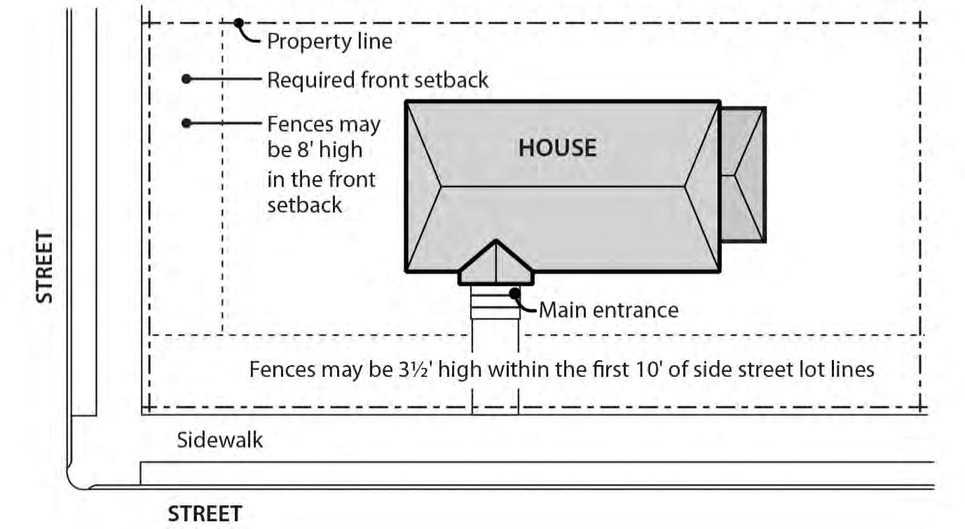
b. Retaining walls on sites where the site slopes downward from a street in the area described in B.1.
c. Retaining walls on sites where the site slopes upward from a street and the existing slope within the area regulated by B.1 is 50 percent or more.
d. Replacing an existing retaining wall, where the replacement will not be taller or wider than the existing wall.
e. Retaining walls on sites where any portion of the site is in an environmental overlay zone.
C. Standards.
1. Retaining walls are limited to 4 feet in height measured from the bottom of the footing, as shown in Figure 110-16.
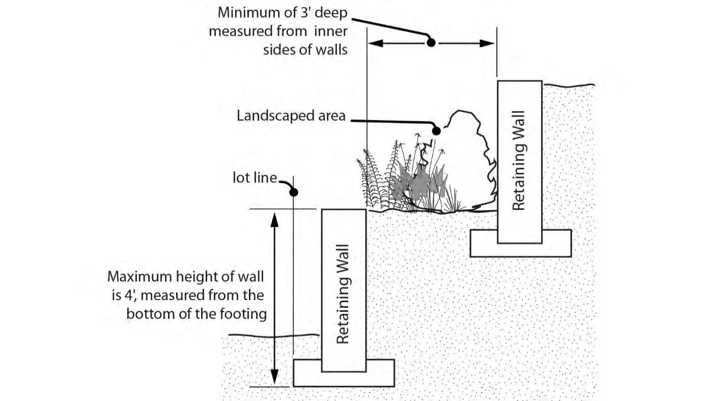
2. Retaining walls must be set back at least 3 feet from other street-facing retaining walls, as shown in Figure 110-16. The 3 foot setback area must be landscaped to at least the L2 standard, except that trees are not required. A wall or berm may not be substituted for the shrubs.
A. Generally. Demolition on a site that requires a demolition permit is subject to the tree preservation and protection requirements of Title 11, Trees. See Chapter 11.50, Trees in Development Situations.
B. Historic resources. Demolition of historic resources is regulated by Chapter 33.445, Historic Resource Overlay Zone.
Existing developments that do not conform to the development standards of this chapter may be subject to the regulations of Chapter 33.258, Nonconforming Situations.
Chapter 33.110
Single-Dwelling Zones
33.110.292 Parking and Loading
Title 33, Planning and Zoning
8/31/22
For parking and loading regulations, see Chapter 33.266, Parking, Loading, and Transportation and Parking Demand Management.
33.110.295 Signs
The sign regulations are stated in Title 32, Signs and Related Regulations.
33.110.296 Recycling Areas
Requirements for recycling areas are regulated by the Bureau of Planning and Sustainability. See Section 17.102.270, Businesses and Multifamily Complexes Required to Recycle, of the Portland City Code.
(Amended by: Ord. No.165376, effective 5/29/92; Ord. No. 165594, effective 7/8/92; Ord. No. 166313, effective 4/9/93; Ord. No. 167186, effective 12/31/93; Ord. No. 167189, effective 1/14/94; Ord. No. 168698, effective 4/17/95; Ord. No. 169324, effective10/12/95; Ord. No. 170704, effective 1/1/97; Ord. No. 171219, effective 7/1/97; Ord. No. 171718, effective 11/29/97; Ord. No. 171879, effective 2/2/98; Ord. No. 173533, effective 8/2/99; Ord. No. 173593, effective 9/3/99; Ord. No. 173729, effective 9/9/99; Ord. No. 174263, effective 4/15/00; Ord. No. 174378, effective 5/26/00; Ord. No. 175204, effective 3/1/01; Ord. No. 175837, effective 9/7/01; Ord. Nos. 175965 and 176333, effective 7/1/02; Ord. No. 176469, effective 7/1/02; Ord. No. 177028, effective 12/14/02; Ord. No. 177422, effective 6/7/03; Ord. No. 177643, effective 7/10/03; Ord. No. 177701, effective 8/30/03; Ord. No. 177975, effective 11/14/03; Ord. No. 178045, effective 12/10/03; Ord. No. 178172, effective 3/5/04; Ord. No. 178509, effective 7/16/04; Ord. No. 178927, effective 12/31/04; Ord. No. 179092, effective 4/1/05; Ord. Nos. 179980 and 179994, effective 4/22/06; Ord. No. 180619, effective 12/22/06; Ord. No. 181357, effective 11/9/07; Ord. No. 182429, effective 1/16/09; Ord. No. 183598, effective 4/24/10; Ord. No. 183750, effective 6/4/10; Ord. No. 184016, effective 08/20/10; Ord. No. 184235, effective 11/26/10; Ord. No. 185412, effective 6/13/12; Ord. No. 185915; effective 5/1/13; Ord. No. 186639, effective 7/11/14; Ord. No. 186736, effective 8/29/14; Ord. No. 186053, effective 1/1/15; Ord. No. 187216, effective 7/24/15. Ord. No. 187471, effective 1/1/16; Ord. No. 188142, effective 1/13/17; Ord. No. 188259, effective 3/31/17; Ord. No. 188177, effective 5/24/18; Ord. No. 188958, effective 5/24/18; Ord. No. 189488, effective 12/2/19; Ord. No. 189807, effective 12/18/19; Ord. No. 190093, effective 9/11/20 and 8/1/2021; Ord. No. 190380, effective 4/30/21 and 8/1/2021; Ord. No. 190851, effective 6/30/22; Ord. No. 190978, effective 8/31/22.)
Natural Resource Management Plans
33.430.310 Purpose
33.430.320 Scope
33.430.330 Procedure
33.430.340 Components
33.430.350 Approval Criteria for Adoption and Amendment
Corrections to Violations of This Chapter
33.430.400 Purpose
33.430.405 Correction Options
33.430.407 Recurring Violations of This Chapter
Notice and Review Procedure
33.430.410 Purpose
33.430.420 When These Regulations Apply
33.430.430 Procedure
Map 430-1 Environmental Overlay Zone Map Correction Project Area
Map 430-2 Columbia Corridor Industrial and Environmental Mapping Project Area
Map 430-3 East Buttes, Terraces and Wetlands Conservation Plan Area
Map 430-4 Johnson Creek Basin Protection Plan Area
Map 430-5 Northwest Hills Natural Areas Protection Plan Area
Map 430-6 East Columbia Neighborhood Natural Resources Management Plan Area
Map 430-7 Peninsula One Natural Resources Management Plan Area
Map 430-8 Forest Park Natural Resources Management Plan Area
Map 430-9 Middle Columbia Corridor/Airport Natural Resources Inventory
Environmental Mapping Project Area
Map 430-10 Bank Reconfiguration and Basking Features Area
General
33.430.010 Purpose
Environmental zones protect resources and functional values that have been identified by the City as providing benefits to the public. The environmental regulations encourage flexibility and innovation in site planning and provide for development that is carefully designed to be sensitive to the site's protected resources. These regulations also help meet other City goals, along with other regional, state, and federal goals and regulations. The environmental regulations also carry out Comprehensive Plan policies and objectives.
33.430.015 Purpose of the Environmental Protection Zone
The Environmental Protection zone provides the highest level of protection to the most important resources and functional values. These resources and functional values are identified and assigned value in the inventory and economic, social, environmental, and energy (ESEE) analysis for each specific study area. Development will be approved in the environmental protection zone only in rare and unusual circumstances.
The Environmental Conservation zone conserves important resources and functional values in areas where the resources and functional values can be protected while allowing environmentally sensitive urban development.
The application of the environmental zones is based on detailed studies that have been carried out within six separate areas of the City. The City’s policy objectives for these study areas are described in reports. Each study identifies the natural resource features and describes the functional values within resource sites. Functional values are the benefits provided by resources. The values for each resource site are described in the inventory section of these reports. The City has adopted the following six environmental study reports:
• Environmental Overlay Zone Map Correction Project
• Columbia Corridor Industrial and Environmental Mapping Project
• East Buttes, Terraces and Wetlands Conservation Plan
• Johnson Creek Basin Protection Plan
• Northwest Hills Natural Areas Protection Plan
• Middle Columbia Corridor/Airport Economic, Social, Environmental and Energy (ESEE) Analysis
Some of the six study areas discussed under Section 33.430.020 impose additional environmental regulations in Plan Districts. These additional regulations either supplement or supersede the regulations of this Chapter. Paragraph 33.700.070.E describes the hierarchy of regulations within the Zoning Code.
Additionally, Natural Resource Management Plans may contain regulations that supersede or supplement the regulations of this chapter. Whenever natural resource management plan provisions conflict with other provisions of this chapter, the natural resource management plan provisions supersede. Non-conflicting provisions supplement the provisions of this chapter. Maps 430-6, 7, and 8 show Natural Resource Management Plan areas.
The following Plan Districts and Natural Resource Management Plans have additional regulations that may supersede or supplement the environmental regulations of Chapter 430:
• The Balch Creek Watershed (see Chapter 33.563, Northwest Hills Plan District)
• Cascade Station / Portland International Center Plan District (see Chapter 33.508, Cascade Station / Portland International Center [CS/PIC])
• The Columbia South Shore within the Columbia Corridor (see Chapter 33.515, Columbia South Shore Plan District)
• Johnson Creek Basin (see Chapter 33.537, Johnson Creek Basin Plan District)
• Northwest Hills Natural Areas (see Chapter 33.563, Northwest Hills Plan District)
• Skyline West Conservation Plan area (see Chapter 33.563, Northwest Hills Plan District)
• East Columbia Neighborhood Natural Resources Management Plan (separate document)
• Forest Park Natural Resources Management Plan (separate document)
• Natural Resources Management Plan for the Peninsula Drainage District No. 1 (separate document)
• Portland International Airport Plan District (see Chapter 33.565, Portland International Airport Plan District)
This chapter contains only the City's environmental regulations. Activities which the City regulates through this chapter may also be regulated by other agencies. In cases of overlapping City, Special District, Regional, State, or Federal regulations, the more stringent regulations will control. City approval does not imply approval by other agencies.
33.430.033 Relationship to Scenic Resources
When an environmental zone has been applied at the location of a designated scenic resource, environmental review must include consideration of the scenic qualities of the resource as identified in the Scenic Resources Protection Plan, Central City Scenic Resources Protection Plan, or River Plan / South Reach Scenic Resources Protection Plan, and any relevant development standards of 33.480
33.430.035 Other City Regulations
Other City regulations such as Title 10, Erosion Control, and Title 11, Trees, may apply to sites in the environmental overlay zones.
33.430.040 Overlay Zones and Map Symbols
There are two environmental overlay zones.
A. The Environmental Protection overlay zone is applied wherever the City determines that highly significant resources and functional values are present. The Environmental Protection overlay zone is shown on the Official Zoning Maps with either the "p" symbol or a dark green color
B. The Environmental Conservation overlay zone is applied wherever the City determines that significant resources and functional values are present. The Environmental Conservation overlay zone is shown on the Official Zoning Maps with either the "c" symbol or a light green color
33.430.050 Subareas of Environmental Zones
Environmental overlay zones contain resource areas and transition areas. Resource areas contain significant resources and functional values. Transition areas surround the resource areas. Resources and functional values within transition areas are not significant, but they provide a buffer for the significant resources and functional values within the resource area. The transition area is measured as the first 25 feet inward from an environmental zone boundary. The remaining area is the resource area. See Figure 430-1. The following are three exceptions:
A. Where part of an environmental zone boundary is also the City Limits or Urban Service Boundary, there is no transition area.
B. Where environmental zone boundaries are contained within other environmental zone boundaries, there is no transition area.
C. Where environmental zone boundaries abut other environmental zone boundaries, transition areas are only measured from the combined outer-most boundaries of the environmental zones.
These regulations apply to all environmental zones, except those in the Columbia South Shore Plan District that are south of NE Marine Drive, those in the Cascade Station/Portland International Center Plan District, City-owned land within the Forest Park Natural Resources Management Plan area, and the Peninsula Drainage District No. 1 Natural Resources Management Plan area. See also Section 33.430.030, Relationship to Other Environmental Regulations
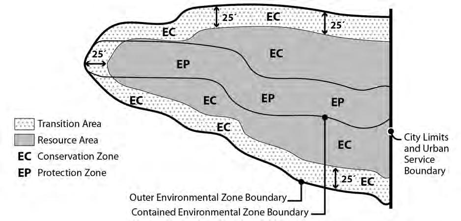
Unless exempted by Section 33.430.080, below, the regulations of this chapter apply to the following:
A. Development;
B. All land divisions and property line adjustments except for middle housing land divisions. The regulations of this chapter do apply to development proposed on a middle housing land division site;
C. Removing, cutting, mowing, clearing, burning, or poisoning native trees and plants listed in the Portland Plant List;
D. Planting or removing trees and plants listed on the Nuisance Plants List, and planting or removing non-native non-nuisance trees and plants;
E. Changing topography, grading, excavating, and filling;
F. Resource enhancement; and
G. Dedication and expansions of rights-of-way.
The following items, unless prohibited by Section 33.430.090, below, are exempt from the regulations of this chapter. Other City regulations such as Title 10, Erosion Control, and Title 11, Trees, must still be met.
A. Change of ownership;
B. Temporary emergency procedures necessary for the protection of life, health, safety, or property;
C. Dedicating right-of-way to widen an existing right-of-way;
D. Existing development, operations, and improvements, including the following activities:
1. Maintenance, repair, and replacement of existing structures, exterior improvements, roads, public trails, public rest points, public viewing areas, public interpretative facilities, and utilities. Replacement is not exempt whenever coverage or utility size is increased;
2. Continued maintenance of existing gardens, pastures, lawns, and other planted areas, including the installation of new irrigation and drainage facilities, new erosion control features, and the installation of plants except those listed on the Nuisance Plants List. Change of crop type or farming technique on land currently in agricultural use. Pruning trees and shrubs within 10 feet of buildings and structures attached to buildings, such as decks, stairs, and carports;
3. Changes to existing disturbance areas to accommodate the following when plantings do not include plants on the Nuisance Plants List and no trees 6 or more inches in diameter are removed;
a. Gardens, including raised beds no greater than 2 feet in height, and play areas surfaced with grass, groundcover plants, bark chips, sand or gravel;
b. Accessory structures with a footprint no larger than 100 square feet that are not on a foundation or concrete pad; and
c. Septic systems.
4. Alterations to buildings that do not change the building footprint and do not require adjustments to site-related development standards;
5. Operation, maintenance, and repair of the following:
a. Irrigation systems;
b. Stormwater management systems;
c. Pumping stations; and
d. Erosion control and soil stabilization features;
6. Operation, maintenance, and repair of drainage facilities, flood control structures, and conveyance channels that are managed by Drainage Districts as defined in ORS 547, and where the activity is conducted or authorized by the Drainage District. This exemption does not apply if dredge spoils are placed onto the top of banks of the
drainageway, or onto portions of the environmental overlay zone above the ordinary high water mark Operation, maintenance, and repair of drainage facilities include:
a. Dredging and channel cleaning below the ordinary high water mark and vegetative maintenance within the minimum floodway cross-section of drainageways;
b. Operation, maintenance, and repair of drainage district pump stations, water control structures, or levees;
c. Reconfiguring the cross-section of drainage channels below the ordinary high water mark, or changing the location of the low flow channel within a wider drainage channel; and
d. Stabilizing banks and restoring levees back to original condition and footprint;
7. Removing or pruning the following trees and plants:
a. Trees. The following trees may be removed or pruned if no development or other activities subject to the regulations of this chapter are proposed and all removal or pruning activities are surrounded or protected to prevent erosion and sediment from leaving the site or negatively impacting resources on the site. Permanent erosion control, such as replanting areas of bare soil must be installed after removal or pruning:
(1) Dead, dying, diseased, or dangerous trees, or portions of trees, when they pose an immediate danger as determined by the City Forester or an arborist. On sites 7,000 square feet or larger in area, all sections of wood more than 12 inches in diameter must remain or be placed in the resource area of the site on which they were cut or within a commonly-owned environmental resource tract. These sections of wood are not required to remain when:
• The site contains only transition area; or
• The City Forester authorizes removal of diseased wood because it will threaten the health of other trees;
(2) Non-native trees and trees listed on the Nuisance Plants List;
(3) Trees or portions of trees that are within 10 feet of an existing building or structure attached to a building, such as deck, stairs, and carport; or
(4) Trees or portions of trees that exceed the height restriction of a view corridor with special height restrictions designated in the Scenic Resources Protection Plan, Central City Scenic Resources Protection Plan or River Plan / South Reach Scenic Resource Protection Plan.
b. Other plants. The following may be removed or pruned if removal or pruning activities are surrounded or protected to prevent erosion and sediment from leaving the site or negatively impacting resources on the site. Permanent erosion control, such as replanting areas of bare soil, must be installed after removal or pruning:
(1) Plants that exceed the height restrictions of a view corridor with special height restrictions designated in the Scenic Resources Protection Plan, Central City Scenic Resources Protection Plan or River Plan / South Reach Scenic Resources Protection Plan; or
(2) Plants that block signage along a public recreational trail, within a resource enhancement area, or required by a state or federal agency; or
(3) Non-native plants and plants listed on the Nuisance Plant List.
8. Pruning trees in accordance with Title 11 permit requirements;
9. Alterations to existing houseboats or replacing houseboats in existing slips;
10. Development over existing paved surfaces that are over 50 feet from any identified wetland or water body; and
11. Land divisions or Property Line Adjustments where all properties are developed, no additional building sites are created and no additional development is proposed.
E. The following new development and improvements:
1. Planting of native vegetation listed on the Portland Plant List when planted with handheld equipment;
2. Public street and sidewalk improvements meeting all of the following:
a. Improvements must be within a public right-of-way used by truck or automobile traffic; and
b. Streets and sidewalks must not exceed the minimum width standards of the Bureau of Transportation Engineering.
3. Groundwater monitoring wells constructed to the standards of the Oregon Water Resources Department and water quality monitoring stations, where access is by foot only;
4. Utilities installed above or below developed portions of public rights-of-way;
5. Utility service using a single utility pole or where no more than 100 square feet of ground surface is disturbed outside of the top of bank of water bodies and where the disturbed area is restored to the pre-construction conditions;
6. Temporary site investigative work including soil tests, land surveys, groundwater and water quality monitoring stations when all of the following are met:
a. The work is conducted using hand-held equipment only;
b. The disturbance is temporary;
c. Disturbance areas are restored to pre-existing conditions; and
d. No native trees are removed.
7. Installation of temporary fencing to protect resource enhancement project planting areas, or to close off or control the use of illegal trails. The fence must be removed within 5 years;
8. Installation of signage as part of public recreational trail, as part of a resource enhancement project, or as required by a state or federal agency;
9. Additional disturbance within an existing cemetery when all of the following are met:
a. The disturbance is for soil removal for a burial plot;
b. No more than 10 cubic yards of soil is removed per burial plot;
c. The disturbance area is set back at least 5 feet from the resource area of the environmental protection zone; and
d. No native trees 6 inches or more in diameter are removed;
10 Additional disturbance for gardens, play areas surfaced with grass, groundcover plants, bark chips, sand or gravel, and septic systems when the added disturbance area meets all of the following:
a. The added disturbance area does not exceed 500 square feet;
b. The total disturbance area on the site does not exceed standards in Table 430-1;
c. No native trees 6 or more inches in diameter are removed; and
d. The disturbance area is located at least 30 feet from the top of bank of a stream or drainage and at least 50 feet from the edge of a wetland.
11. Trails and fire breaks meeting all of the following:
a. The trails or fire break must be confined to a single ownership or be within a public trail easement;
b. Widths must not exceed 36 inches. For trails, stair width must not exceed 50 inches, and trail grade must not exceed 20 percent except for the portion of the trail containing stairs;
c. Plant trimming must not exceed a height of 8 feet and a width of 6 feet as shown in Figure 430-2;
d. No native trees 6 or more inches in diameter and no native shrubs larger than 5 feet tall may be removed;
e. The trails or fire break must not be paved; and
f. The trails or fire break must be at least 15 feet from the top of bank of all water bodies.
12. All land divisions with tentative plans, final plans, and recorded plats showing all of the following for every lot created or adjusted; and Property Line Adjustments with plans showing all of the following for each lot adjusted:
a. Building sites at least five feet from all resource areas. For the purpose of this subsection, “building site” means an area of any shape in which a square 40 feet by 40 feet will fit;
b. Public and private utilities (including water lines, sewer lines or drain fields, and stormwater disposal facilities) where none of these utilities are in a resource area; and
c. Streets, driveways, and parking areas where all pavement is at least ten feet from a resource area.
F. Hand removal of trash, provided that native vegetation is not removed or damaged.
The following items are prohibited in all environmental zones. Prohibitions apply to both transition areas and resource areas:
A. The use, packaging, transportation, or storage of hazardous substances, except as follows:
1. Transportation of hazardous substances through environmental zones by rail or on designated truck routes is allowed; and
2. Use of consumer quantities of hazardous substances within environmental zones is allowed subject to the regulations of this Title. Consumer quantities of hazardous substances are packaged and distributed in a form intended or suitable for sale through retail sales outlets for consumption by individuals for purposes of personal care and household use.
B. The planting or propagation of any plant listed on the Nuisance Plants List;
C. Exterior work activities, unless in conjunction with a river-related or river-dependent use. See Chapter 33.910, Definitions; and
D. Dumping of yard debris or trash.
These development standards are intended to:
A. Encourage sensitive development while minimizing impact on resources;
B. Provide clear limitations on disturbance within resource areas;
C. Ensure that new development and alterations to existing development are compatible with and preserve the resources and functional values protected by the environmental zones;
D. Provide clear planting and erosion control requirements within resource areas;
E. Buffer the resource area from the noise, fumes, lights, and motion of vehicular traffic associated with industrial, commercial, and multi-dwelling residential uses; and
F. Limit the impacts on resources and functional values resulting from construction of certain types of utilities.
A. Generally. Compliance with the development standards of this chapter is required for all development in the environmental zones and is determined as part of the building permit or development permit application process. For proposals that cannot meet all of the standards, Environmental Review is required. Where a proposal can meet all the standards, the applicant may choose to go through the discretionary environmental review process, or to meet the objective standards of this chapter
The development standards are Sections 33.430.140 through .195; Sections 33.430.150 through .195 address specific types or aspects of development, while 33 430.140 applies to
proposals not covered by the more specific sections. A proposal may be subject to several sections. For example, construction of a house may be subject to the General Development Standards of 33.430.140, the standards of 33.430.150, Utilities, and the standards of 33.430.180, Stormwater Outfalls. If the proposal can meet the general standards and standards for utilities, but not those for a stormwater outfall, environmental review is required only for the stormwater outfall. To be eligible to use the development standards for an aspect of a proposal, all of the standards within the relevant section must be met.
B. Adjustments prohibited. Adjustments to these standards are prohibited. Proposals that do not meet all the standards within each relevant section require approval through environmental review described in Sections 33.430.210 through .280.
33.430.130 Permit Application Requirements
A building permit or development permit application that is reviewed for compliance with the standards of this chapter requires more information than a permit not affected by these provisions. The information in Subsections A and B must be submitted with permit application plans. Submission of the information in Subsection C is optional.
A. An existing conditions site plan including:
1. Location of all Environmental Zone lines on the site;
2. Outline of any existing disturbance area, including existing utility locations;
3. Location of any wetlands or water bodies on the site or within 50 feet of the site. Indicate the location of the top of bank, centerline of stream, or wetland boundary as appropriate;
4. Within the disturbance area, all trees that are 6 or more inches in diameter must be indicated by size and species. Trees outside of the disturbance area must be shown as crown cover with an indication of species composition; and
5. Topography shown by contour lines at 2 foot vertical contours in areas of slopes less than 10 percent and at 5 foot vertical contours in areas of slopes 10 percent or greater.
B. Proposed development plan including:
1. Outline of the proposed disturbance area, including all areas of proposed utility work;
2. Location and description of all proposed erosion control devices;
3. A stormwater management plan;
4. A landscape plan indicating the size, species, and location of all vegetation to be planted in the environmental zone;
5. Trees proposed to be preserved and trees proposed to be removed. For trees to be preserved, tree protection, meeting the requirements of Chapter 11.60, Technical Specifications, must be shown. A tree plan may also be required to comply with Chapter 11.50, Trees in Development Situations; and
6. Where applicable, the location and specifications of the site enhancement option with dimensions, a list of plants on the Nuisance Plants List to be removed, and a landscape plan indicating the size, species, and location of all vegetation to be planted.
C. Photographs of the site are not required but are encouraged to supplement the existing conditions site plan.
The standards below apply to all development in the environmental zones except as follows:
• Utilities subject to Section 33.430.150;
• Septic systems subject to Section 33.430.155;
• Land divisions subject to Section 33.430.160;
• Property line adjustment subject to Section 33.430.165;
• Resource enhancement projects subject to Section 33.430.170;
• Rights-of-way improvements subject to Section 33.430.175;
• Stormwater outfalls subject to Section 33.430.180;
• Flood and water control facilities subject to Section 33.430.185;
• Public recreational trails subject to Section 33.430.190; and
• Tree removal in scenic resources zone subject to Section 33.430.195.
Standards A through C and G through S apply to new development in the resource area. Standards D through S except L apply to alterations to existing development in the resource area. Only standards
E, J, K, N, Q, R, and S apply to new development and alterations to existing development in the transition areas. All of the applicable standards must be met.
A. The maximum disturbance area allowed within the resource area on the site is determined by subtracting all portions of the site outside the resource area from the number listed in Table 430-1.
Note:
[1] Subtract the amount of area on the site outside the resource area from the number given in the table.
B. The disturbance area is set back at least 5 feet from the resource area of any environmental protection zone;
C. The disturbance area must be set back at least:
1. Fifty feet from the edge of any identified wetland;
2. Fifty feet from the top of bank of any identified water body within the Columbia Corridor or any identified water body within a protection zone on lots zoned R10, R20, or RF;
3. Thirty feet from the top of bank of any identified water body within a protection zone on all lots except those zoned R10, R20 or RF;
4. Thirty feet from the top of bank of any identified water body within a conservation zone except those within the Columbia Corridor; and
5. When reconfiguration of the bank carried out in accordance with subsection 33.430.170.A results in the top of bank shifting landward, the applicant may choose to measure the setback from the original top of bank. When this occurs, a survey of the original top of bank line and the new top of bank line must be submitted for verification and then recorded with the County recorder. In all cases the disturbance area must be set back at least 5 feet from the new top of bank line.
D. For alterations to existing development, one of the following must be met:
1. The disturbance area does not exceed the limitations of Table 430-1 and the disturbance area is not expanded into or within five feet of the resource area of an environmental protection zone; or
2. If the existing disturbance area now exceeds the limitations of Table 430-1, alterations are allowed within the existing disturbance area if the following are met:
a. The existing disturbance area may not be expanded; and
b. Increases in building coverage and exterior improvement area are allowed if a site enhancement option is completed on the site. Applicants must show that an area equivalent in size to at least 50 percent of the area proposed for development will be enhanced following one or more of the options described in Table 430-2. If the proposed development is less than 100 square feet, the minimum enhanced area will be 50 square feet.
E. The proposed development is set back at least 5 feet from the resource area of any environmental protection zone;
F. The proposed development must be set back at least:
1. Fifty feet from the edge of any identified wetland;
2. Fifty feet from the top of bank of any identified water body within the Columbia Corridor or any identified water body within a protection zone on lots zoned R10, R20, or RF;
3. Thirty feet from the top of bank of any identified water body within a protection zone on lots except lots zoned R10, R20 or RF;
4. Thirty feet from the top of bank of any identified water bodies within a conservation zone except those within the Columbia Corridor; and
5. When reconfiguration of the bank carried out in accordance with subsection 33.430.170.A results in the top of bank shifting landward, the applicant may choose to
measure the setback from the original top of bank. When this occurs, a survey of the original top of bank line and the new top of bank line must be submitted for verification and then recorded with the County recorder. In all cases the disturbance area must be set back at least 5 feet from the new top of bank line.
G. The proposed buildings must be set back at least 5 feet from the edge of the disturbance area;
H. Where the distance between a building and the edge of the disturbance area is less than 10 feet, additional temporary disturbance area is allowed. The edge of the additional temporary disturbance area may extend no more than 10 feet from the building. The temporary disturbance area must be replanted with three different native shrub species at a minimum 1-gallon size or bare root, planted at a density of 3 plants per 10 square feet with the remaining area planted with native groundcover using a minimum of 4-inch pots at a density of 8 plants per 10 square feet;
I. Temporary disturbance areas and portions of the resource area where removal of nonnative vegetation occurs must be replanted so that the area achieves a 90 percent vegetation cover within one year;
J. Tree removal and replacement standards.
1. Removal of native trees is allowed as follows:
a. Trees removed from resource and transition areas must be replaced as shown in Table 430-3. Trees less than 6 inches in diameter do not have to be replaced.
b. In resource and transition areas, the combined total diameter of all trees removed may not exceed 225 inches, counting only native trees that are at least 6 inches in diameter;
c. In resource areas, trees may be removed only if one of the following is met:
(1) Within 10 feet of existing or proposed buildings and structures attached to buildings, such as decks, stairs, and carports;
(2) Within 10 feet of proposed driveways or right-of-way improvements; or
(3) To create up to 500 square feet of permanent disturbance area for uses such as gardens and play area.
2. Non-native non-nuisance trees may be removed if each tree at least 6 inches in diameter is replaced as shown in Table 430-3;
3. Trees listed on the Nuisance Plants List may be removed, if each tree at least 6 inches in diameter is replaced with one native tree; and
4. For replacement of non-native trees, applicants may pay a revegetation fee as described in Table 430-2 in lieu of planting on the site. The fee is based on the number of trees required under Table 430-3, Option A.
Option Action
Option 1
Restoration
Planting
Remove plants listed on the Nuisance Plants List. Plant the area with native plants at the following minimum planting density: 10 plants per 50 square feet at a ratio of one tree, two shrubs, and 7 groundcover plants. Trees must be at least one-half inch in diameter, shrubs must be at least 1 gallon, and groundcover plants a minimum pot size of 4 inches. The remaining area may be seeded with native grass seed.
Option 2
Impervious
Surface Reduction
Option 3
Parking Lot
Retrofit
Remove impervious surface to improve stormwater management, and replant the area with native plants at the following minimum planting density: 10 plants per 50 square feet at a ratio of one tree, two shrubs, and 7 groundcover plants. Trees must be at least one-half inch in diameter, shrubs must be at least 1 gallon, and groundcover plants must be a minimum pot size of 4 inches. The remaining area may be seeded with native grass seed.
Replace existing interior parking lot landscaping with a vegetated infiltration basin using native plants. The minimum planting ratio for this option is one tree and two shrubs for every 50 square feet of planting area, and groundcover plants to cover the remaining area, planted on 12-inch centers. Trees must be at least one-half inch in diameter, shrubs must be at least 1 gallon, and groundcover plants a minimum pot size of 4 inches. Enhancements must be approved by the Bureau of Environmental Services as meeting the Stormwater Management Manual, and must also comply with parking lot landscape requirements of this Title.
Option 4
Revegetation
Fee
Pay a revegetation fee.
1. Fee use and administration. The revegetation fee is collected by BDS and is administered by the Bureau of Environmental Services. The fees collected are used for revegetation projects on public or private property within the same watershed as the site.
2. Calculation of required fee contributions. Applicants must contribute the cost to purchase and plant trees, shrubs, and groundcover plants as set out in 3. below. The cost to purchase and plant trees and plants will be adjusted annually as determined by the Director of BES based on current market prices for materials, labor, and maintenance.
3. Required fee contribution. The applicant must contribute the following revegetation fee before a building permit will be issued:
- The cost to purchase, plant, and maintain one tree, two shrubs, and 7 groundcover plants for every 50 square feet of planting area;
- The fee calculation will be rounded up to the next multiple of $10; and
- The minimum area to be used in this calculation is 50 square feet. Calculations that are not a multiple of 50 will be rounded up to the next multiple of 50.
K. Replacement trees must be at least one-half inch in diameter; shrubs must be in at least a 1-gallon container or the equivalent in ball and burlap. All trees and shrubs must be selected from the Portland Plant List and planted on the site within the environmental zone. Conifers must be replaced with conifers and shrubs must consist of at least two different species;
L. Nuisance plants.
1. Remove plants on the Nuisance Plants List in an area on the site that is equal to 50 percent of the size of the proposed permanent disturbance area, or from the entire site, whichever is less.
2 Plant removal must occur outside of the permanent and temporary disturbance areas.
3. Nuisance plant removal entails actions such as the removal of: roots, the above ground portion of the plant, and the seeds of the plant such that existing nonnuisance or newly installed plants are able to grow and survive. The non-nuisance plants are maintained free of nuisance plants.
4. The cleared area must be replanted as follows:
a. Seed the entire area of removal with a native grass seed.
b. Install seven groundcover plants and two shrubs per 50 square feet. Groundcover plants must be a minimum size of four-inch pots and the shrubs a minimum size of one gallon pots
c Install one native tree that is at least one-half inch in diameter for every nuisance tree over 6 inches in diameter that is removed.
d. Planting native species listed on the Portland Plant List is required.
M. All vegetation planted in a resource area is native and listed on the Portland Plant List Plants listed on the Nuisance Plants List are prohibited;
N. The minimum front and street building setback and garage entrance setback of the base zone may be reduced to any distance between the base zone minimum and zero. Where a side lot line is also a street lot line the side building and garage entrance setback may be reduced to any distance between the base zone minimum and zero. Parking spaces may be allowed within the first 10 feet from a front lot line, and within a minimum side street setback;
O. Maximum front or street setbacks are as follows:
1. The front building or street setback of the base zone is the maximum building setback for primary structures.
2. On a lot with more than one street lot line the maximum setback standard applies to the street lot line that is farthest from the resource area.
3. In zones with no minimum front or street setback, the maximum setback is 10 feet.
P. Fences are allowed only within the disturbance area;
Q. Parking and truck area buffers:
1. Auto and light truck areas. For commercial, industrial, and multi-dwelling residential uses, parking areas for autos and light trucks include a ten foot perimeter buffer from the resource area. The buffer is landscaped with plants listed on the Portland Plant List to at least the L2 standard, as stated in Chapter 33.248, Landscaping and Screening;
2. Medium and heavy truck areas. Where allowed by the base zone, the parking, loading, and maneuvering areas for medium and heavy trucks include a ten foot perimeter buffer from the resource area. The buffer is landscaped with plants listed on the Portland Plant List to at least the L3 standard, as stated in Chapter 33.248, Landscaping and Screening;
R. Exterior lights must be spaced at least 25 feet apart. Incandescent lights exceeding 200 watts (or other light types exceeding the brightness of a 200-watt incandescent light) must be placed so they do not shine directly into resource areas; and
S. Exterior storage and display areas include a ten-foot perimeter buffer from the resource area. The buffer is landscaped to at least the L3 standard, as stated in Chapter 33.248, Landscaping and Screening.
The following standards apply to private connections to existing utility lines and the upgrade of existing public utility lines All of the standards apply in the resource area. Only standard E applies in the transition area.
A. The disturbance area for private connections to existing utility lines is no greater than 10 feet wide;
B. The disturbance area for the upgrade of existing public utility lines is no greater than 15 feet wide;
C. The utility construction does not occur within a stream channel, identified wetland, or water body;
D. Disturbance areas must be planted with native species listed in the Portland Plant List according to the following densities:
1. Three different native shrub species are required at a minimum 1-gallon size or bare root, planted at a density of 3 plants per 10 square feet;
2. The remaining area must be planted with native groundcover using a minimum of four inch pots at a density of 8 plants per ten square feet; and
3. Below the top of bank on slopes greater than 30 percent or in riprap areas, live stakes, 2 to 12 inches in diameter, may be substituted for the requirements of D.1 and D.2
above. Stakes must be installed at a density of 2 to 4 stakes per square yard. Detailed specifications for installing live stakes are found in the Erosion Control Manual.
E. Tree removal and replacement standards are as follows:
1. Native trees more than 12 inches in diameter may not be removed. Each native tree more than 6 but less than 12 inches in diameter that is cut must be replaced as shown in Table 430-3;
2. Non-native non-nuisance trees may be removed, if each tree 6 or more inches in diameter is replaced as shown in Table 430-3;
3. Trees listed on the Nuisance Plants List may be removed if each tree 6 or more inches in diameter is replaced with one tree;
4. Replacement trees and shrubs must meet the planting standards in 33.430.140.K; and
5. Where a utility line is approximately parallel with the stream channel at least half of the replacement trees must be planted between the utility line and the stream channel, except where a utility easement precludes tree planting.
F. Exemption. If a proposed utility line or upgrade to a utility line runs through an area that has already been approved as a disturbance area, or allowed by the standards of this chapter, it is exempt from Subsections A, B and D.
The following standards apply to septic systems. All of the standards must be met
A. The maximum disturbance area allowed within the resource area on the site for the septic system is no greater than 2,000 square feet;
B. No trees greater than 6 inches in diameter may be removed;
C. The proposed disturbance area is located at least 50 feet from the top-of-bank of a stream or edge of any wetland; and
D. The proposed disturbance area is replanted with a minimum of eight ground cover plants per 10 square feet. The ground cover plants must be a minimum size of four inch pots and must be native species listed in the Portland Plant List
The following standards apply to land divisions and Planned Developments in the environmental overlay zones. All of the standards must be met.
A. All development, except for development associated with stormwater outfalls that meet Section 33.430.180, is outside the resource area of the environmental protection zone;
B. The total amount of disturbance area allowed within the resource area of the environmental zone is either the amount listed in Table 430-4 or 1 acre, whichever is less, minus the amount of area outside the resource area. Disturbance area associated with construction or installation of stormwater outfalls that meets Section 33.430.180 are not counted towards maximum disturbance area;
C. Where there is a house on the site that is in the environmental protection zone, it may remain if a new lot is created that meets the following:
1. The existing house will remain; and
2. A new lot is created that is no larger than required to contain the existing house, garage, minimum required setbacks, a 12-foot wide driveway, and an open area of 20 feet by 20 feet.
D. Resource areas of the environmental protection zone that are outside of lots being created under the provisions of Subsection B., above, are located entirely within environmental resource tracts. The tracts must be owned in common by all of the owners of the land division site, by a Homeowners’ Association, by a public agency, or by a non-profit organization;
Table 430-4
Maximum Disturbance Area for a Land Division and PD Allowed Within the Resource Area[1]
OS and RF Zone R20 Zone R10 Zone R7 Zone R5 Zone All Other Zones
Notes:
[1] Disturbance area includes utility construction.
E. Resource areas outside designated disturbance areas must be placed entirely within environmental resource tracts. The tracts must be owned in common by all of the owners of the land division site, by a Homeowners’ Association, by a public agency, or by a nonprofit organization;
F. Tree removal is allowed as follows:
1. Native trees. In residential zones, the combined total diameter of native trees cut may not exceed 225 inches per lot, counting only native trees that are at least 6 inches in diameter. In all other zones, native tree removal is limited to the boundaries of the approved disturbance area. Native trees must be replaced as shown in Table 430-3;
2. Non-native non-nuisance trees. Non-native non-nuisance trees may be removed, but must be replaced as shown in Table 430-3; and
3. Nuisance trees. Trees listed on the Nuisance Plants List may be removed, but must be replaced. Each tree 6 or more inches in diameter must be replaced with one native tree.
G. The standards of Subsections 33.430.140.B, C, and K through R must be met.
H. Streets, alleys, walkways, and stormwater facilities are not created within 50 feet of an identified wetland or water body. The standard does not apply to recreational trails identified by the Comprehensive Plan;
I. New right-of-way and roadway widths do not exceed the maximums listed in Table 430-5; and
J. Utility construction must meet the applicable standards of Section 33.430.150. Private utility lines on a lot where the entire area of the lot is approved to be disturbed and where the private utility line provides connecting service directly to the lot from a public system are exempt from this standard; and
K. The standards of Subsection 33.430.180 must be met. Table
The following standards apply to Property Line Adjustments (PLAs) in the environmental overlay zones that do not meet one of the exemptions in 33.430.080.C.11 or 33.430.080.D.11. For purposes of this section, the site of a Property Line Adjustment is the two properties affected by the relocation of the common property line. All of the standards must be met.
A. A Property Line Adjustment may not result in any property being entirely in the environmental protection zone, unless that property is entirely in the environmental protection zone before the PLA, or the property will be dedicated or limited by deed restriction to the uses allowed in the OS zone.
B. The amount of area on each property that is outside of the resource area of the environmental overlay zone may not be reduced below the square footage in Table 430-6. A property that contains less than the area listed in Table 430-6 outside of the resource area of the environmental overlay zone may not move further out of conformance with Table 430-6.
The following standards apply to resource enhancement projects in the environmental zones. The applicant for projects that will take place within the area shown on Map 430-10 may choose to meet all of the standards of subsection A, all of the standards of subsection B, or all of the standards of subsection C. Applicants for projects that will take place outside the area shown on Map 430-10 must meet all of the standards in subsection C.
A. Bank reconfiguration. The following standards apply to bank reconfiguration projects that take place in the Bank Reconfiguration and Basking Features Area shown on Map 430-10 Slough and drainageway banks, which are the area between the ordinary high water mark and the top of bank, may be regraded when all of the following are met:
1. The activity is conducted or authorized by the Multnomah County Drainage District #1 or Peninsula Drainage District #2;
2. The final slope above ordinary high water after grading is 33 percent or less (33 percent slope represents a rise to run ratio equal to 1:3);
3. Rock armoring may not be used except surrounding outfalls, inlets, culverts and bridge crossings, the rock armoring cannot exceed a distance of 5 feet from those features, and must be planted with live stakes of native plant stock, one half inch in diameter. Stakes must be used at a density of 2 to 3 stakes per 9 square feet. If the armoring is located on a levee, live stakes are not required;
4. The placement of large wood on the bank is allowed to improve bank stabilization if installed above the Base Floodplain Elevation (BFE), as defined on the Federal Emergency Management Agency Flood Insurance Rate Maps;
5. Trees or snags, 6 inches or greater in diameter, that are removed landward of the new top-of-bank must be replaced and meet the following:
a. Each tree or snag, 6 inches or greater in diameter, removed must be replaced as specified in Table 430-3, Tree Replacement;
b. Replacement trees and shrubs must be native and selected from the Portland Plant List;
c. Replacement shrubs must be in at least a 2-gallon container or the equivalent in ball or burlap;
d. Replacement trees must:
(1) Be at least one-half inch in diameter and have a maximum height-atmaturity that will not project above the height limit of the h overlay zone; and
(2) Be planted within a transition area or resource area on a property owned by the applicant; or for which the applicant possesses a legal instrument that is approved by the City (such as an easement or deed restriction) sufficient to carry out and ensure success of the mitigation; or can demonstrate legal authority to acquire the site through eminent domain;
e. If the replacement trees are planted within 100 feet of the Columbia Slough main channels or secondary drainageways, the trees must be planted above the Base Floodplain Elevation (BFE), as defined on the Federal Emergency Management Agency Flood Insurance Rate Maps.
6. The area between the ordinary high water mark and the new top of bank must be revegetated as specified in Figure 430-3 and Table 430-7, Bank Revegetation.
Water
Zone 1
Sloughs and drainageways; except on levees
Zone 2
On levees Zone 1 and 2
A mix of native emergent wetland vegetation planted at a rate of 50 plugs of vegetation per 100 square feet of area, ten native shrubs for every 100 square feet of area and a native grass and forb seed mix at a rate of 30 pounds per acre. No trees may be planted in Zone 1.
A. Outside of the Airport Subdistrict of the Portland International Airport plan district, one native tree, three native shrubs and four other native plants for every 100 square feet of area. Trees may be clustered.
B. Within the Airport Subdistrict of the Portland International Airport plan district, Option A or ten native shrubs for every 100 square feet of area and a native grass and forb seed mix at a rate of 20 pounds per acre.
A native grass and forb seed mix at a rate of 50 pounds per acre or a grass seed mix approved by the US Army Corps of Engineers for use on levees applied at a rate of 50 pounds per acre.
7. Disturbance areas related to structure removal must be replanted with native plants to achieve a 90 percent vegetative cover within one year. Disturbance area that is related to the removal of structures from the water is exempt from this standard;
8. No structures are proposed except for public viewing areas developed as part of the project. The public viewing areas must meet the following:
a. The viewing area contains no more than 500 square feet of permanent disturbance area;
b. The viewing area is at least 30 feet from the top of bank of a stream, drainageway, wetland, or other water body;
c. The viewing area is not in the floodway;
d. Native trees more than 10 inches in diameter are not removed; and
e. Each 6 to 10-inch diameter native tree removed is replaced at a rate of three trees for each one removed. The replacement trees must be a minimum one-half inch diameter or 3 to 5-gallon conifers and be native trees listed on the Portland Plant List All trees must be planted on the site; and
9. Temporary disturbance areas may be seeded with non-native seed that is sterile and is certified as 100 percent weed-free for erosion control purposes until replanting occurs.
B. Basking features. The following standards apply to the placement of large wood or large rocks as basking features for wildlife in the Bank Reconfiguration and Basking Features Area shown on Map 430-10. The placement of large wood or large rocks as basking features for wildlife within the Columbia Slough, Whitaker Slough, Buffalo Slough, Peninsula Canal, or other drainageways or identified wetlands is allowed when all of the following are met:
1. The activity is conducted or authorized by the Multnomah County Drainage District #1, Peninsula Drainage District #2 or the City of Portland Bureau of Environmental Services;
2. No native trees are removed;
3. The basking feature is installed above the Base Floodplain Elevation (BFE), as defined on the Federal Emergency Management Agency Flood Insurance Rate Maps;
4. Disturbance areas related to structure removal must be replanted with native plants to achieve a 90 percent vegetative cover within one year. Disturbance area that is related to the removal of structures from the water is exempt from this standard;
5. No structures are proposed except for public viewing areas developed as part of the project. The public viewing areas must meet the following:
a. The viewing area contains no more than 500 square feet of permanent disturbance area;
b. The viewing area is at least 30 feet from the top of bank;
c. The viewing area is not in the floodway;
d. Native trees more than 10 inches in diameter are not removed; and
e. Each 6 to 10-inch diameter native tree removed is replaced at a rate of three trees for each one removed. The replacement trees must be a minimum one-half inch diameter or 3 to 5-gallon conifers and be native trees listed on the Portland Plant List. All trees must be planted on the site; and
6. Temporary disturbance areas may be seeded with non-native seed that is sterile and is certified as 100 percent weed-free for erosion control purposes until replanting occurs.
C. All other resource enhancement projects. The following standards apply to all other resource enhancement projects not addressed by subsections 170.A or B. All of the following standards must be met:
1. There is no excavation or fill of, or construction activity within any wetland or water body;
2. There is no net fill, or increase in the amount of soil on the site;
3. No native vegetation listed on the Portland Plant List is removed except as allowed by C.5. below Non-native trees and vegetation may be removed;
4. Disturbance areas related to structure removal must be replanted with native plants to achieve a 90 percent vegetative cover within one year Disturbance area that is related to the removal of structures from the water is exempt from this standard;
5. No structures are proposed except for public viewing areas developed as part of the project. The public viewing areas must meet the following:
a. The viewing area contains no more than 500 square feet of permanent disturbance area;
b. The viewing area is at least 30 feet from the top of bank;
c. The viewing area is not in the floodway;
d. Native trees more than 12 inches in diameter are not removed;
e. Each 6 to 12-inch diameter native tree removed is replaced as shown in Table 430-3. Replacement trees and shrubs must comply with the planting standards of Subsection 33.430.140.K; and
6. Temporary disturbance areas may be seeded with non-native see that is sterile and is certified as 100 percent weed-free for erosion control purposes until replanting occurs.
The following standards apply to unimproved and partially improved rights-of-way. All of the standards must be met. New rights-of-way that are part of a proposed land division or planned development must be reviewed under the Standards for Land Divisions and Planned Developments in Section 33.430.160.
A. The proposed paved roadway portion of the right-of-way must not be more than 26 feet wide and 2600 square feet in area;
B. The proposed disturbance area for the right-of-way improvement must;
1. Be at least 50 feet from the edge of any wetland or waterbody;
2. Be at least 5 feet from the resource area of any environmental protection zone; and
3. Be no larger than 3300 square feet in area;
C. Planted areas, including stormwater swales, must be planted with native plants from the Portland Plant List;
D. Trees within the right-of-way may be removed within the improvement area and within 10 feet of the edge of the improvement In no case may the combined total diameter of all trees removed exceed 225 inches, counting only native trees that are at least 6 inches. Trees other than native trees are exempt from this standard and may be removed without being counted as part of the 225 inches; and
E. The right-of-way improvements meet the development requirements of the City Engineer or the Permanent Rule for Private Rights-of-Way.
The following standards apply to the installation of stormwater outfalls. All of the standards apply in the resource area. Only standards B through E and H apply in the transition area.
A. The temporary disturbance area for the stormwater outfall is no greater than 10 feet wide;
B. Native trees 12 or more inches in diameter may not be removed Each native tree at least 6 inches but less than 12 inches in diameter that is removed must be replaced as shown in Table 430-3;
C. Non-native non-nuisance trees may be removed. Each tree at least 6 inches in diameter must be replaced as shown in Table 430-3;
D. Trees listed on the Nuisances Plant List may be removed. Each tree at least 6 inches in diameter must be replaced with one tree.
E. Replacement trees and shrubs must comply with the planting standards of Subsection 33.430.140.K; and
F. Temporary disturbance areas must be planted with native species listed in the Portland Plant List according to the following densities:
1. Three different native shrub species are required at a minimum 1-gallon size or bare root, planted at a density of 3 plants per 10 square feet; and
2. The remaining area must be planted with native groundcover using a minimum of 4inch pots at a density of 8 plants per 10 square feet;
G. When constructed open channels or vegetated swales are proposed, the slope between the stormwater source and the waterbody does not exceed 15 percent at any point;
H. Only one outfall pipe may be used on a site. The outfall pipe size may not exceed 6 inches in diameter; and
I. If an outfall riprap pad is used it must be planted with live stakes of native plant stock, onehalf inch in diameter. Stakes must be installed at a density of 2 to 3 stakes per square yard. Detailed specifications for installing live stakes are found in the Erosion Control Manual
The following standards apply to minor improvements to certain existing flood and water conveyance control facilities. For the purposes of this Section, an existing flood or water conveyance control facility is defined as existing pump stations, wet wells, electrical panels or pads, and trash racks. The minor improvements that these standards apply to are defined as the addition or
modification of handrails, access paths, ADA ramps, safety vaults, fall protection posts or pads, or Sewer Level Remote Telemetry (SLRT). All of the standards must be met.
A. The disturbance area for the minor improvement is not greater than 10 feet wide, not greater than 500 square feet total, and is contiguous to the existing disturbance area for the flood or water conveyance control facility that is being altered;
B. Temporary disturbance areas must be planted with native species listed in the Portland Plant List according to the following densities:
1. Ten native shrubs for every 100 square feet of temporary disturbance area and a native grass and forb seed mix at a rate of 20 pounds per acre; or
2. If on a levee, a native grass and forb seed mix at a rate of 50 pounds per acre or a grass seed mix approved by the US Army Corps of Engineers for use on levees at a rate of 50 pounds per acre.
C. The proposed disturbance area must be located above the ordinary high water mark and outside of wetlands;
D. No trees more than 6-inches in diameter are removed with the exception of nuisance species trees. Nuisance species trees 6 inches in diameter or larger that are removed must be replaced with one tree meeting the standard of 33.430.140.K; and
E. At least one site enhancement option must be completed on the site. Applicants must show that an area equivalent in size to at least 100 percent of the proposed permanent disturbance area will be enhanced following one or more of the options described in Table 430-2. If the proposed permanent disturbance area is less than 100 square feet, the minimum required enhanced area must be 100 square feet. The site enhancement area must be located outside of the proposed permanent and temporary disturbance area.
The following standards apply to public trails and viewing areas developed in conjunction with the public trail. All of the standards must be met.
A. The trail is located on public property or within a public trail easement;
B. The trail is no longer than 5,000 feet and no wider than 4 feet with a maximum vegetation clearance of 8 feet high and 2 feet on either side of the trail (see Figure 430-4);
C. If the trail crosses a waterbody it is constructed above the top of bank;
D. If a public viewing area is proposed, the following must be met:
1. The viewing area may create up to 500 square feet of permanent disturbance area;
2. The viewing area is at least 30 feet from the top of bank of a stream, drainageway, wetland or other water body; and
3. The viewing area is not in the floodway;
E. Tree removal and replacement standards:
1. Native trees up to 12 inches in diameter and non-native trees of any size may be removed with hand-held equipment or equipment with a wheel/surface-to-ground pressure of no more than 7.5 psi;
2. Trees that are more than 6 inches in diameter that are removed must be replaced as shown in Table 430-3; and
3. Replacement trees must meet the planting standards in 33.430.140.K.
The following standards apply to removal of native trees up to 12 inches in diameter and non-native trees of any size that are located within an environmental overlay zone and the Scenic Resource zone:
A. Trees may be removed with hand-held equipment or equipment with a wheel/surface-toground pressure of no more than 7.5 psi;
B. Trees that are more than 6 inches in diameter that are removed must be replaced as shown in Table 430-3, and replacement trees must be planted outside of the Scenic Resource overlay zone;
C. Temporary disturbance areas caused by the tree removal must be replanted to meet one of the following options. Shrubs planted to meet this standard may be counted towards meeting the replacement requirements shown in Table 430-3:
1. Option 1. Three shrubs and four other plants must be planted for every 100 square feet of temporary disturbance area; or
2. Option 2. Three shrubs must be planted for every 100 square feet of temporary disturbance area and the remainder of the temporary disturbance area must be seeded with a grass and forb seed mix at a ratio of 30 pounds per acre; and
D. Replacement plantings must meet the planting standards in 33.430.140.K.
33.430.210 Purpose
Environmental review is intended to:
A. Prevent harm to identified resources and functional values, compensate for unavoidable harm, and ensure the success of mitigation and enhancement activities;
B. Provide a mechanism to modify the development standards of this Chapter if the proposed development can meet the purpose of these regulations;
C. Provide flexibility for unusual situations. The review provides for consideration of alternative designs for development that have the least impact on protected resources in the environmental conservation zone and more exacting control over development in the environmental protection zone;
D. Allow for more accurate maps and more certainty for property owners by allowing for the location of the environmental zone boundary to be modified when permitted changes to a resource occur or when the boundary location is determined more precisely on a specific site through a more detailed environmental study; and
E. Provide for the replacement of resources and functional values that are lost through violations of this Chapter.
Environmental review is required for all development in an environmental zone that does not meet the development standards of Sections 33.430.140 through .190 and for violations of this chapter. Environmental review is also required when an applicant wishes to fine-tune the zone boundary location based on a detailed environmental study. The City Council, Planning and Sustainability Commission, or Director of BDS may initiate an environmental review for environmental zone boundary amendments to reflect permitted changes in the location or quality of resources or functional values. Removal of environmental zone boundaries are processed as a change of an overlay zone, as stated in Chapter 33.855, Zoning Map Amendments. The zone boundary change procedure does not apply to changes caused by violations of this chapter. The procedure for violations of this chapter is described in Section 33.430.400.
Environmental reviews are processed through the following procedures:
A. Property Line Adjustments, resource enhancement activities, public recreational trails, rest points, view points, and interpretative facilities are processed through the Type Ix procedure.
B. The following are processed through the Type II procedure:
1. Roads, driveways, walkways, stormwater disposal, and buried connections to existing utility lines;
2. Public safety facilities;
3. Septic systems;
4. Environmental zone boundary modifications;
5. All other uses and development in resource areas of Environmental Conservation zones; and
6. Development within the Transition Area only.
C. All other uses or development in resource areas of Environmental Protection zones are processed through the Type III procedure.
In addition to the application requirements of Section 33.730.060, the following information is required for an environmental review application:
A. Supplemental site plans required. One copy of each plan must be at a scale of at least one inch to 100 feet. The following supplemental site plans are required:
• Existing conditions;
• Conditions existing prior to a violation (if applicable);
• Proposed development;
• Construction management; and
• Mitigation or remediation.
A mitigation site plan is required whenever the proposed development will result in unavoidable significant detrimental impact on the identified resources and functional values. A remediation site plan is required whenever significant detrimental impacts occur in violation of the Code and no permit was applied for. The Director of BDS may waive items listed in this Subsection if they are not applicable to the specific review; otherwise they must be included. Additional information such as wetland characteristics or soil type may be requested through the review process.
1. The existing conditions site plan must show the following for the entire site:
a. Special flood hazard area and floodway boundaries;
b. Boundaries of the resource area and the transition area. These boundaries may be scaled in relation to property lines from the Official City Zoning Maps;
c. Topography shown by contour lines at two foot vertical contours in areas of slopes less than ten percent and at five foot vertical contours in areas of slopes ten percent or greater;
d. Drainage patterns, using arrows to indicate the direction of major drainage flow; and
e. Existing improvements such as structures, or buildings, utility lines, fences, etc.
2. The proposed development site plan must show the following:
a. In areas of the site that have been or will be part of the permanent disturbance area, distribution outline of shrubs and groundcovers, with a list of most abundant species;
b. In areas of the site that are and will remain undisturbed: Tree crown cover outline, and generalized species composition;
c. A grading plan showing proposed alteration of the ground at two-foot vertical contours in areas of slopes less than ten percent and at five-foot vertical contours in areas of slopes ten percent or greater;
d. Trees six or more inches in diameter, identified by species, with trees proposed to be preserved and removed indicated. In the case of violations, also indicate those that were cut or damaged by stump diameter and species;
e. Proposed development, including proposed buildings, walkways, decks, retaining walls, bridges, garages, utility lines, stormwater management systems; and
f. Proposed planting areas.
3. A construction management site plan must show the following:
a. Areas that will be temporarily or permanently disturbed, including equipment maneuvering areas, and perimeter controls;
b. Areas where existing topography and vegetation will be left undisturbed;
c. Location of site access and egress;
d. Equipment and material staging and stockpile areas;
e. Erosion control measures; and
f. Measures to protect trees and vegetation. Tree protection must meet the requirements of Chapter 11.60, Technical Specifications.
4. A mitigation or remediation site plan must show the following:
a. Dams, weirs, or other in-water structures;
b. Distribution outline, species composition, number, and percent cover of groundcovers to be seeded or planted;
c. Distribution outline, species composition, size, number, and spacing of shrubs to be planted;
d. Location, species, number, and size of each tree to be planted;
e. Stormwater management features, including retention, infiltration, detention, discharges, and outfalls;
f. Water bodies to be created, including depth;
g. Water sources to be used, including volumes; and
h. Information showing compliance with Section 33.248.090, Mitigation and Restoration Plantings.
B. Supplemental narrative. The following is required:
1. Impact evaluation. An impact evaluation is required to determine compliance with the approval criteria and to evaluate development alternatives for a particular site. The alternatives must be evaluated on the basis of their impact on the resources and functional values of the site. In the case of a violation, the impact evaluation is used to determine the nature and scope of the significant detrimental impacts. To the extent that the site resources and functional values are part of a larger natural system such as a watershed, the evaluation must also consider the cumulative impacts on that system. The impact evaluation is based on the resources and functional values identified as significant in the reports listed in section 33.430.020;
a. An impact evaluation includes:
(1) Identification, by characteristics and quantity, of the resources and their functional values found on the site;
(2) Evaluation of alternative locations, design modifications, or alternative methods of development to determine which options reduce the significant detrimental impacts on the identified resources and functional values of the site; and
(3) Determination of the alternative that best meets the applicable approval criteria and identify significant detrimental impacts that are unavoidable.
b. An impact evaluation for a violation includes:
(1) Description, by characteristics and quantity, of the resources and functional values on the site prior to the violation; and
(2) Determination of the impact of the violation on the resources and functional values.
2. Construction management plan. Identify measures that will be taken during construction or remediation to protect the remaining resources and functional values at and near the construction site and a description of how undisturbed areas will be protected. For example, describe how trees will be protected, erosion controlled, construction equipment controlled, and the timing of construction; and
3. Mitigation or remediation plan. The purpose of a mitigation or remediation plan is to compensate for unavoidable significant detrimental impacts that result from the
chosen development alternative or violation as identified in the impact evaluation. A mitigation or remediation plan includes:
a. Resources and functional values to be restored, created, or enhanced on the mitigation or remediation site;
b. Documentation of coordination with appropriate local, regional, special district, state, and federal regulatory agencies;
c. Construction timetables;
d. Operations and maintenance practices;
e. Monitoring and evaluation procedures;
f. Remedial actions for unsuccessful mitigation; and
g. Information showing compliance with Section 33.248.090, Mitigation and Restoration Plantings.
An environmental review application will be approved if the review body finds that the applicant has shown that all of the applicable approval criteria are met. When environmental review is required because a proposal does not meet one or more of the development standards of Section 33.430.140 through .190, then the approval criteria will only be applied to the aspect of the proposal that does not meet the development standard or standards.
A. Public safety facilities, rights-of-way, driveways, walkways, outfalls, utilities, septic systems, land divisions, Property Line Adjustments, Planned Developments, and Planned Unit Developments. Within the resource areas of environmental zones, the applicant's impact evaluation must demonstrate that all of the general criteria in Paragraph A.1 and the applicable specific criteria of Paragraphs A.2, 3, or 4, below, have been met:
1. General criteria for public safety facilities, rights-of-way, driveways, walkways, outfalls, utilities, septic systems, land divisions, Property Line Adjustments, Planned Developments, and Planned Unit Developments;
a. Proposed development locations, designs, and construction methods have the least significant detrimental impact to identified resources and functional values of other practicable and significantly different alternatives including alternatives outside the resource area of the environmental zone;
b. There will be no significant detrimental impact on resources and functional values in areas designated to be left undisturbed;
c. The mitigation plan demonstrates that all significant detrimental impacts on resources and functional values will be compensated for;
d. Mitigation will occur within the same watershed as the proposed use or development and within the Portland city limits except when the purpose of the mitigation could be better provided elsewhere; and
e. The applicant owns the mitigation site; possesses a legal instrument that is approved by the City (such as an easement or deed restriction) sufficient to carry
out and ensure the success of the mitigation program; or can demonstrate legal authority to acquire property through eminent domain.
2. Public safety facilities. The public benefits of the proposal outweigh all significant detrimental impacts;
3. Rights-of-way, driveways, walkways, outfalls, utilities, and septic systems;
a. The location, design, and construction method of any outfall or utility proposed within the resource area of an environmental protection zone has the least significant detrimental impact to the identified resources and functional values of other practicable alternatives including alternatives outside the resource area of the environmental protection zone;
b. There will be no significant detrimental impact on water bodies for the migration, rearing, feeding, or spawning of fish; and
c. Water bodies are crossed only when there are no practicable alternatives with fewer significant detrimental impacts.
4. Land divisions, Property Line Adjustments, Planned Developments, and Planned Unit Developments:
a. Proposed uses and development must be outside the resource area of the Environmental Protection zone except as provided under Paragraph A.3 above. Other resource areas of Environmental Protection zones must be in environmental resource tracts;
b. There are no practicable arrangements for the proposed lots, tracts, roads, or parcels within the same site, that would allow for the provision of significantly more of the building sites, vehicular access, utility service areas, and other development on lands outside resource areas of a conservation zone; and
c. Development, including building sites, vehicular access and utilities, within the resource area of a conservation zone must have the least amount of detrimental impact on identified resources and functional values as is practicable. Significantly different but practicable development alternatives, including alternative housing types or a reduction in the number of proposed or required units or lots, may be required if the alternative will have less impact on the identified resources and functional values than the proposed development.
B. Resource enhancement projects. In resource areas of environmental zones, resource enhancement projects will be approved if the applicant's impact evaluation demonstrates that all of the following are met:
1. There will be no loss of total resource area;
2. There will be no significant detrimental impact on any resources and functional values; and
3. There will be a significant improvement of at least one functional value.
C. Public recreational facilities. In resource areas of environmental zones, public trails, rest points, public viewing areas, and interpretative facilities will be approved if the applicant's impact evaluation demonstrates that all of the following are met:
1. Proposed development locations, designs, and construction methods are less detrimental to identified resources and functional values than other practicable and significantly different alternatives;
2. The public benefits of the proposal outweigh all significant detrimental impacts;
3. Areas disturbed during construction, that do not contain permanent development, will be restored with native vegetation that is similar to the vegetation existing on the site and found on the Portland Plant List; and
4. There will be no significant detrimental impact on resources and functional values in areas designated to be left undisturbed.
D. Modification of zone boundaries. Modifications of environmental zone boundaries that reflect permitted changes in the location or quality of resource areas will be approved upon finding that the applicant's statement demonstrates that either Paragraph D.1 or D.2 below are met. For the minor modification of environmental zone boundaries based on a more detailed site specific environmental study, the applicant's impact evaluation must demonstrate that Paragraph D.3 below is met:
1. Successful mitigation. An approved mitigation plan has been successful and a new, restored, or enhanced resource exists which, depending on its degree of significance, should be included in either the resource area of an Environmental Conservation zone or the resource area of an Environmental Protection zone; or
2. Approved loss of resource area. All of the following must be met:
a. All approved development in a resource area has been completed;
b. All mitigation required of this development has been successful; and
c. The identified resources and functional values at the developed site no longer exist, or have been subject to a significant detrimental impact.
3. The proposed environmental zone line location accurately reflects the location of the significant or highly significant resources and functional values on the site, plus 25 feet of transition area. The significant or highly significant resources are identified in the Resource Site Inventory of the relevant Environmental Study Report, see 33.430.020.
E. Other development in the Environmental Conservation zone or within the Transition Area only. In Environmental Conservation zones or for development within the Transition Area only, the applicant's impact evaluation must demonstrate that all of the following are met:
1. Proposed development minimizes the loss of resources and functional values, consistent with allowing those uses generally permitted or allowed in the base zone without a land use review;
2. Proposed development locations, designs, and construction methods are less detrimental to identified resources and functional values than other practicable and significantly different alternatives;
3. There will be no significant detrimental impact on resources and functional values in areas designated to be left undisturbed;
4. The mitigation plan demonstrates that all significant detrimental impacts on resources and functional values will be compensated for;
5. Mitigation will occur within the same watershed as the proposed use or development and within the Portland city limits except when the purpose of the mitigation could be better provided elsewhere; and
6. The applicant owns the mitigation site; possesses a legal instrument that is approved by the City (such as an easement or deed restriction) sufficient to carry out and ensure the success of the mitigation program; or can demonstrate legal authority to acquire property through eminent domain.
F. Other development in the Environmental Protection zone. In Environmental Protection zones the applicant's impact evaluation must demonstrate that all of the following are met:
1. All sites within the Portland city limits, in which the proposed use or development is possible, are also in the resource areas of Environmental Protection zones;
2. Of these sites, development on the proposed site would have the least significant detrimental environmental impact;
3. There is a public need for the proposed use or development;
4. The public benefits of the proposed use or development outweigh all significant detrimental impacts;
5. There will be no significant detrimental impact on resources and functional values in areas designated to be left undisturbed;
6. The mitigation plan demonstrates that all significant detrimental impacts on resources and functional values will be compensated for;
7. Mitigation will occur within the same watershed as the proposed use or development and within the Portland city limits except when the purpose of the mitigation could be better provided elsewhere; and
8. The applicant owns the mitigation site; possesses a legal instrument that is approved by the City (such as an easement or deed restriction) sufficient to carry out and ensure the success of the mitigation program; or can demonstrate legal authority to acquire property through eminent domain.
G. Corrections to violations. For corrections to violations of this Chapter the application must meet all applicable approval criteria stated in subsections A through F above, and paragraphs 1, 2.b and 2.c, below. If these criteria cannot be met, then the applicant’s remediation plan must demonstrate that all of the following are met:
1. The remediation is done in the same area as the violation; and
2. The remediation plan demonstrates that after its implementation there will be:
a. No permanent loss of any type of resource or functional value;
b. A significant improvement of a least one functional value; and
c. There will be minimal loss of resources and functional values during remediation until the full remediation program is established.
The Director of BDS may require performance guarantees as a condition of approval to ensure mitigation or remediation. See Section 33.700.050, Performance Guarantees.
A professional consultant may be hired to evaluate proposals and make recommendations if the Director of BDS finds that outside expertise is needed due to exceptional circumstances. The professional will have expertise in the specific resource or functional value or in the potential adverse impacts on the resource or functional value. A fee for these services will be charged to the applicant in addition to the application fee.
The review body may consider modifications for lot dimension standards or site-related development standards as part of the environmental review process. The review body may not consider modifications to standards for which adjustments are prohibited. Modifications are done as part of the environmental review process and are not required to go through the adjustment process. Adjustments to use-related development standards (such as floor-area ratios, intensity of use, size of the use, number of units, or concentration of uses) are subject to the adjustment process of Chapter 33.805. In order to approve these modifications, the review body must find that the development will result in greater protection of the resources and functional values identified on the site and will, on balance, be consistent with the purpose of the applicable regulations. For modifications to lot dimension standards, the review body must also find that the development will not significantly detract from the livability or appearance of the area.
33.430.310
Natural resource management plans provide an alternative to case-by-case environmental reviews. These plans provide the means to evaluate the cumulative effects of development and mitigation proposed at different times and in different places within the same large ecosystem. These plans are of particular value in areas of multiple ownership. These plans also provide opportunities for coordination with, or joint adoption by, other local governments; special districts; and regional state, and federal agencies.
33.430.320
Natural resource management plans must cover large ecosystems such as a forests, creeks, sloughs, or watersheds. These plans must address all resources and functional values conserved and
protected by environmental zones within the plan boundaries. The plan must also address all significant detrimental impacts of uses allowed by the plan
33.430.330 Procedure
Adoption and amendment of natural resource management plans is a legislative procedure. Whenever natural resource management plan provisions conflict with other provisions of this chapter, the natural resource management plan provisions supersede. Non-conflicting provisions supplement the provisions of this chapter.
33.430.340 Components
The applicant must submit a natural resource management plan with the following components:
A. Management objectives to maintain or enhance resources and functional values;
B. Lists of allowed and prohibited uses;
C. Maps of areas where these uses are allowed and prohibited;
D. Types of mitigation or enhancement required;
E. Maps of areas reserved for these mitigation or enhancement actions;
F. Timetables for development, mitigation, and enhancement; and
G. Procedures and criteria for approving uses.
33.430.350 Approval Criteria for Adoption and Amendment.
A natural resource management plan, or an amendment to a natural resource management plan, will be approved if it meets the following approval criteria:
A. Compliance with Sections 33.430.310 through 350;
B. Compliance with Statewide Planning Goals and the Portland Comprehensive Plan; and
C. If the natural resource management plan is approved as part of a plan district, the criteria for adoption of plan districts that are in Section 33.500.050 are met.
33.430.400 Purpose
The purpose of Sections 33.430.400 and .405 is to ensure the timely restoration and remediation of natural resources and functional values that have been degraded due to a violation of this chapter. These sections establish a process to determine which review requirements will be applied to remedy a violation that takes place in the environmental overlay zone. The type of review required depends on the circumstances of the violation. Section 33.430.405 details methods for correcting such violations and Title 3 of the City Code details the enforcement penalties.
Applicants must choose one of the following options to correct environmental code violations.
A. When these options may be used.
1. If all of the following are met, the applicant may choose Option One, Option Two, or Option Three:
a. Tree removal:
(1) Only non-native trees have been removed;
(2) No more than 12 diameter inches of native trees have been removed; or
(3) No more than one of the following has been removed:
• A Madrone 4 inches or less;
• A Garry Oak 4 inches or less; or
• A Pacific Yew 2 inches or less;
b. No development, exterior alteration, or exterior improvement has occurred below the top of bank or within a wetland, stream channel, drainageway, or waterbody.
c. The proposal will remove all illegal development; and
d. The proposal will replant illegal clearing.
2. If any of the following apply, the applicant may not use Option One, but may chose either Option Two or Option Three:
a. Tree removal. More than 12 diameter inches of native trees have been removed;
b. More than one of the following has been removed:
(1) A Madrone 4 inches or less;
(2) A Garry Oak 4 inches or less;
(3) A Pacific Yew 2 inches or less;
c. Any of the following has been removed:
(1) A Madrone larger than 4 inches;
(2) A Garry Oak larger than 4 inches; or
(3) A Pacific Yew larger than 2 inches.
3. If the applicant cannot meet Options One or Two, Option Three must be used.
4. If the violation also violates a condition of approval of a land use review and no trees have been removed, the applicant may choose Option One or the process described in Section 33.730.140. The applicant may not choose Options Two or Three.
5. If the violation also violates a condition of approval of a land use review, and trees have been removed, the applicant must use the process described in Section 33.730.140. The applicant may not choose one of the options in this section.
B. Option One, Remove and Repair. This option results in removal of illegal development and replanting and repair of any damage. All of the requirements of this subsection must be met, and the notice and review procedure described in Sections 33.430.410 through 33.430.430 must be followed. Adjustments and modifications to these requirements are prohibited.
1. All items and materials placed in the area of violation are removed and no new disturbance area is created;
2. Any soil compaction resulting from the violation is tilled or otherwise broken up to a depth of 6 inches prior to planting; and
3. Violation remediation planting. The area to be planted is the area disturbed by the violation. All of the following must be met:
a. The area disturbed by the violation activity must be replanted;
b. One tree, 1 shrub, and 5 groundcover plants are required to be planted for every 50 square feet of planting area. Plants must be native and selected from the Portland Plant List;
c. A second area, equal in size to the area disturbed by the violation activity, must also be replanted as remediation, or 7 additional plants as described in B.3.b. must be planted on the site for every 50 square feet disturbed;
d. Any plants on the Nuisance Plants List on the Portland Plant List must be removed from the planting area and within 10 feet of the planting area;
e. Trees must be a minimum one-half inch in diameter unless they are oak, madrone, or conifer, which may be 3 to 5-gallon size. No more than 10 percent of the trees may be oak or madrone. Shrubs must be a minimum of 1-gallon size. All other species must be a minimum of 4-inch pots; and
f. The requirements of Section 33.248.090, Mitigation and Restoration Planting, must be met.
4. For violations involving the removal of trees, three native trees must be planted on the site for each tree removed, in addition to other remediation vegetation planted. If any tree removed was a Garry Oak, Madrone, or Pacific Yew, the replacement trees must be of the same species. Planted trees must be a minimum one-half inch in diameter unless they are oak, madrone, or conifer, which may be 3 to 5-gallon size.
C. Option Two, Retain and Mitigate. This option results in legalizing the illegal development and mitigating for any damage. All of the requirements of this subsection must be met and the notice and review procedure described in Sections 33.430.410 through 33.430.430 must be followed. Adjustments and modifications to these standards are prohibited.
1. The applicable standards of Section 33.430.140 through .190 must be met; and
2. Violation remediation planting. The area to be planted is the area disturbed by the violation. Where development is approved for the area disturbed by the violation, an area of the same size elsewhere on the site must be planted. All of the following must be met:
a. The area disturbed by the violation activity must be replanted;
b. One tree, 1 shrub, and 5 groundcover plants are required to be planted for every 50 square feet of planting area. Plants must be native and selected from the Portland Plant List
c. A second area, equal in size to the area disturbed by the violation activity, must also be replanted as remediation, or 7 additional plants as described in C.2.b must be planted on the site for every 50 square feet disturbed;
d. Any plants on the Nuisance Plants List on the Portland Plant List must be removed from the planting area and within 10 feet of the planting area;
e. Trees must be a minimum one-half inch in diameter unless they are oak, madrone, or conifer, which may be 3 to 5-gallon size. No more than 10 percent of the trees may be oak or madrone. Shrubs must be a minimum of 1-gallon size. All other species must be a minimum of 4-inch pots; and
f. The requirements of Section 33.248.090, Mitigation and Restoration Planting, must be met.
3. For violations involving the removal of trees, three native trees must be planted on the site for each tree removed, in addition to other remediation vegetation planted. If any tree removed was a Garry Oak, Madrone, or Pacific Yew, the replacement trees must be of the same species. Planted trees must be a minimum one-half inch in diameter unless they are oak, madrone, or conifer, which may be 3 to 5-gallon size.
D. Option Three, Environmental Review. This option requires Environmental Review, using the approval criteria and procedures below:
1. Approval criteria. The approval criteria of Subsection 33.430.250.G must be met.
2. Review procedures. Reviews are processed as follows:
a. Type III. The following situations require a Type III review:
(1) The removal of trees that exceeds the quantity of environmental standard 33.430.140.J.
(2) Any development, exterior alteration, or exterior improvement within or below top of bank of a wetland, stream channel, drainageway, or waterbody.
b. Type II. All other environmental reviews to correct environmental code violations are processed through a Type II procedure.
c. All environmental reviews must provide the information required in Section 33.430.240, Supplemental Application Requirements.
A. Recurring violations on a site. Sites where there have been more than one environmental violation while in the same ownership may be subject to fines under Title 3.
B. Recurring violations by an individual or business. Individuals or businesses who have committed more than one environmental violation may be subject to fines under Title 3.
33.430.410 Purpose
The purpose of this notice and review procedure is to notify the public of the permit review process for development proposed in areas having identified significant resources and functional values.
33.430.420 When These Regulations Apply
These regulations apply when a building permit or development permit application is requested within the resource area of the environmental conservation zone and is subject to the Development Standards of Section 33.430.110 through .190, 33.430.405.B, or 33.430.405.C. These regulations do not apply to building permit or development permit applications for development that has been approved through environmental review.
33.430.430 Procedure
Applications for building permits or development permits as specified in Section 33.430.420 will be processed according to the following procedures:
A. Application. The applicant must submit a site plan with an application for a permit The site plan must contain all information required by 33.430.130, Permit Application Requirements, and any additional information required for a building permit or development permit review.
B. Notice of an application.
1. Notice on website Upon receipt of a complete application for a building or development permit, the Director of BDS will post a notice of the application on the BDS website and mail a notice of the request to all recognized organizations within 400 feet of the site. The posted notice of the application will contain at least the following information:
• A statement that a building or development permit has been applied for that is subject to the Development Standards of Section 33.430.110 through .190, 33.430.405.B, or 33.430.405.C.
• The legal description and address of the site;
• A copy of the site plan;
• The place where information on the matter may be examined and a telephone number to call; and
• A statement that copies of information on the matter may be obtained for a fee equal to the City’s cost for providing the copies.
The notice will remain on the website until the permit is issued and administrative decision is made, or until the application is withdrawn.
2. E-mailed notice to recognized neighborhood associations. At the time a notice is posted on the BDS website, the Director of BDS will e-mail information about the internet posting to all recognized neighborhood associations and neighborhood coalition offices within 400 feet of the site. When an e-mail address is not available, the notice will be mailed to the neighborhood association and coalition office.
C. Posting the site and marking development. The applicant must post notice information on the site and identify disturbance areas as specified below.
1. Posting notice on the site. The applicant must place a public notice about the request on the site when the application is deemed complete by the Bureau of Development Services. A posted notice must be placed on each frontage of the site. If a frontage is over 600 feet long, a notice is required for each 600 feet, or fraction thereof. Notices must be posted within 10 feet of a street lot line and must be visible to pedestrians and motorists. Notices may not be posted in a public right-of-way. The posted notice will contain the same information as the notice posted on the internet.
2. Marking proposed development on site. Prior to inspection of the site, the applicant will mark all trees over six inches diameter to be removed on the site and the building and pavement outlines with high visibility tape. The extent of the disturbance area must be marked with orange construction fencing or similar highly visible material. For corrections to violations, the disturbance area and remediation area to be planted must be identified with high visibility tape or similar high visibility material.
D. Site inspection. A BDS inspector will inspect the site prior to issuance of the permit and will provide the Director of BDS with one of the following:
1. An inspection report that confirms the accuracy of the site plan and conformance with the applicable development standards; or
2. A check sheet identifying the deficiencies in the plan. Deficiencies must be corrected before a building permit is approved, or they may be addressed through environmental review as described in Sections 33.430.210 through 33.430.280.
E. Comments. Any interested person may comment on the permit application by writing and specifically identifying errors or non-compliance with development standards.
F. Response to comments. If a comment is received, the Director of BDS will respond in writing or in a manner suitable to the comment. The response will specifically address each comment that concerns compliance with the development standards of Section 33.430.140 through .190. The Director of BDS will recheck permits for compliance with development standards and approve the permit if compliance is reaffirmed or when identified deficiencies are corrected, and when all applicable standards and regulations of the Zoning Code are met.
(Amended by: Ord. No. 167293, effective 1/19/94; Ord. No. 168698, effective 4/17/95; Ord. No. 169375, effective 10/4/95; Ord. No. 171219, effective 7/1/97; Ord. No. 171260, effective 7/12/97; Ord. No. 171740, effective 11/14/97; Ord. No. 173015, effective 2/12/99; Ord. No. 174263, effective 4/15/00; Ord. Nos. 175965 and 176333, effective 7/1/02; Ord. No. 177422, effective 6/7/03; Ord. No. 178509, effective 7/16/04; Ord. No. 178657, effective 9/3/04; Ord. No. 178961, effective 6/13/05; Ord. No. 179540, effective 9/26/05; Ord. No. 180619, effective 12/22/06; Ord. No. 181357, effective 11/9/07; Ord. No. 183598, effective 4/24/10; Ord. No. 183534, effective 7/1/10; Ord. No. 184235, effective 11/26/10; Ord. No. 183534 and Ord. No. 184524, effective 7/1/11; Ord. No. 184944, effective 11/18/11; Ord. No. 185915, effective 5/1/13; Ord. No. 184944, effective 12/31/13; Ord. No. 186639, effective 7/11/14; Ord. No. 186053, effective 1/1/15; Ord. No. 187216, effective 7/24/15; Ord. No. 188177, effective 5/24/18; Ord. No. 188958, effective 5/24/18; Ord. No. 189002, effective 7/9/18; Ord. No. 190023, effective 8/10/20; Ord. No. 190241, effective 3/1/21; Ord. No. 190851, effective 6/30/22; Ord. No. 190834, effective 10/1/22.)
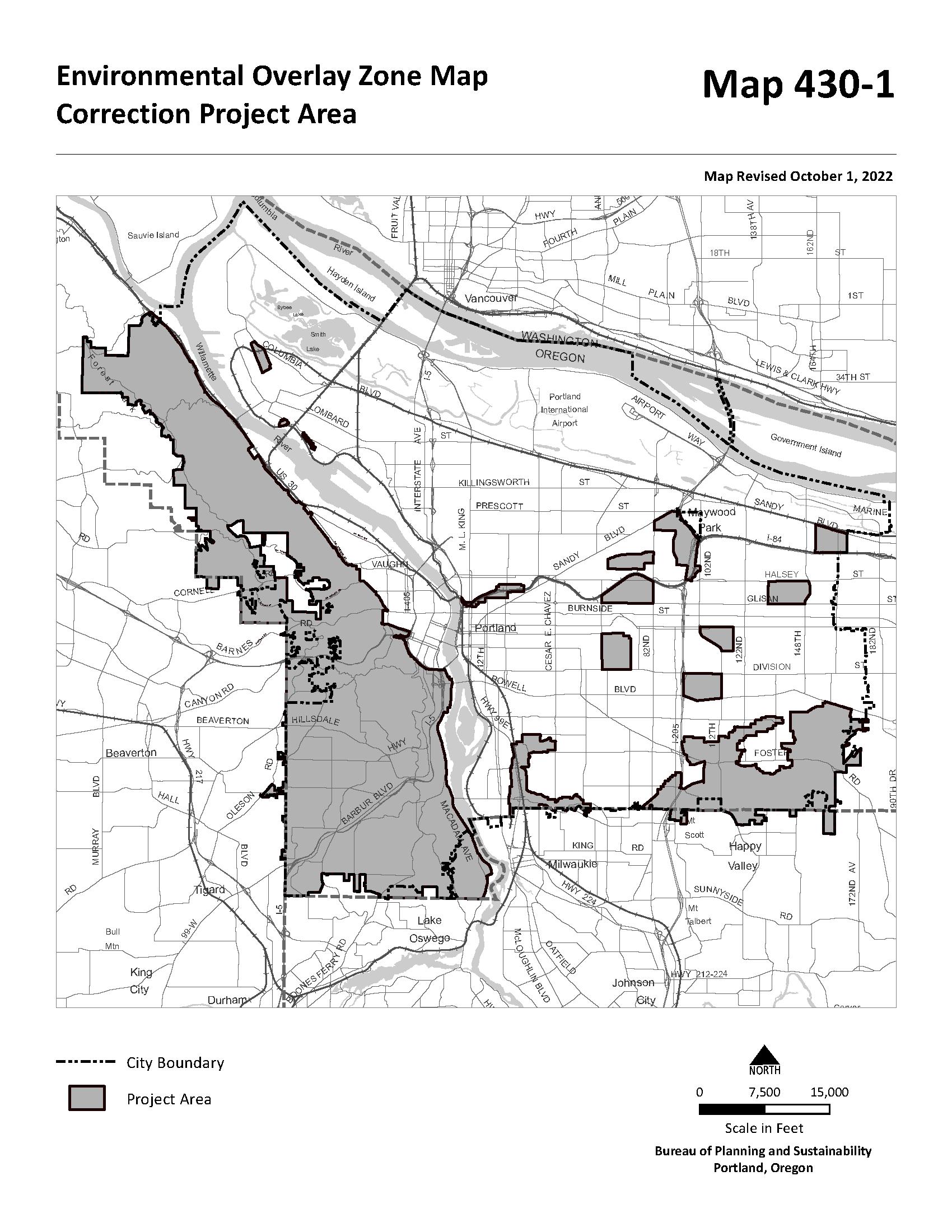
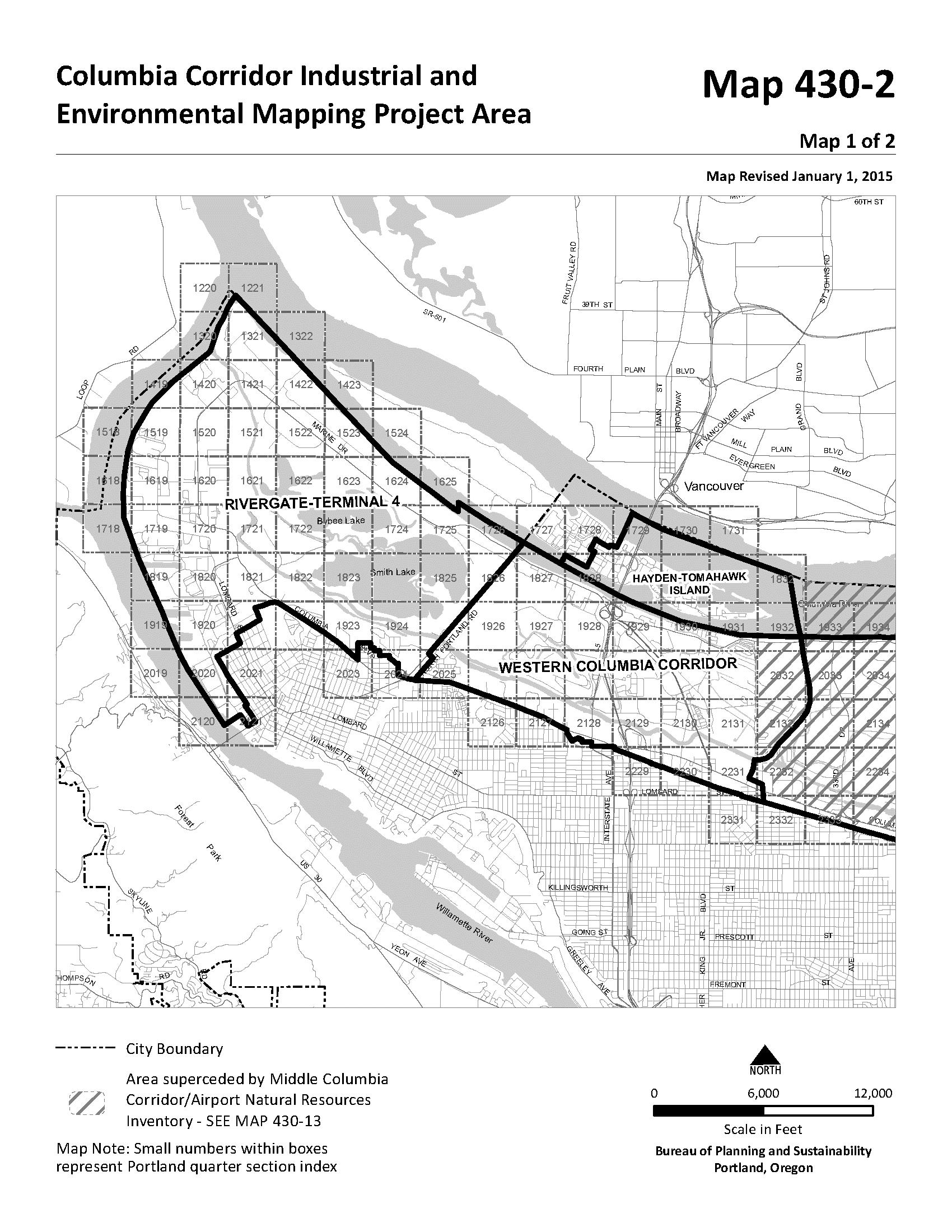
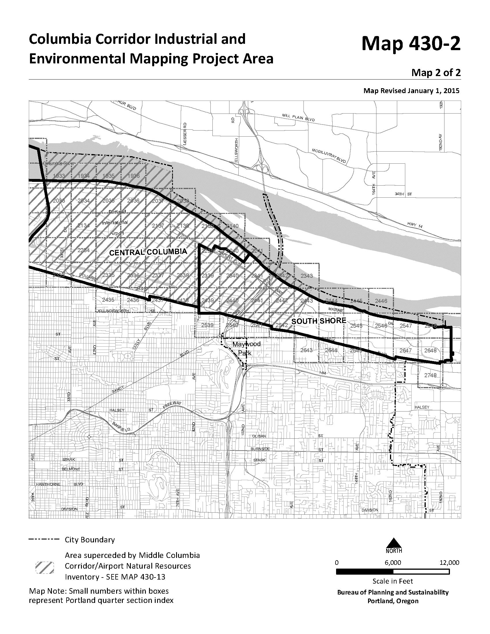
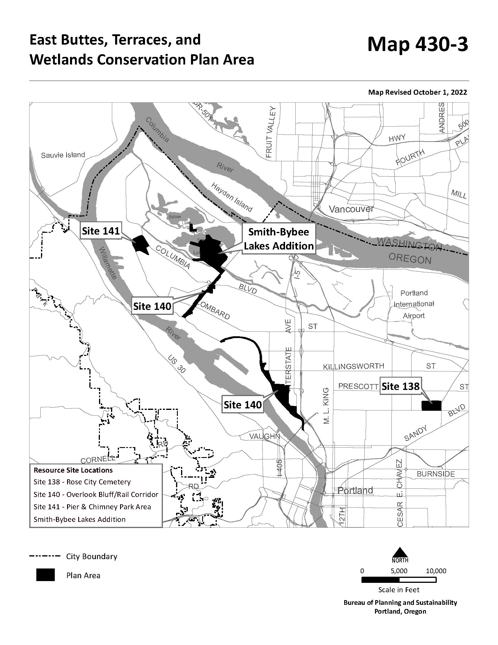
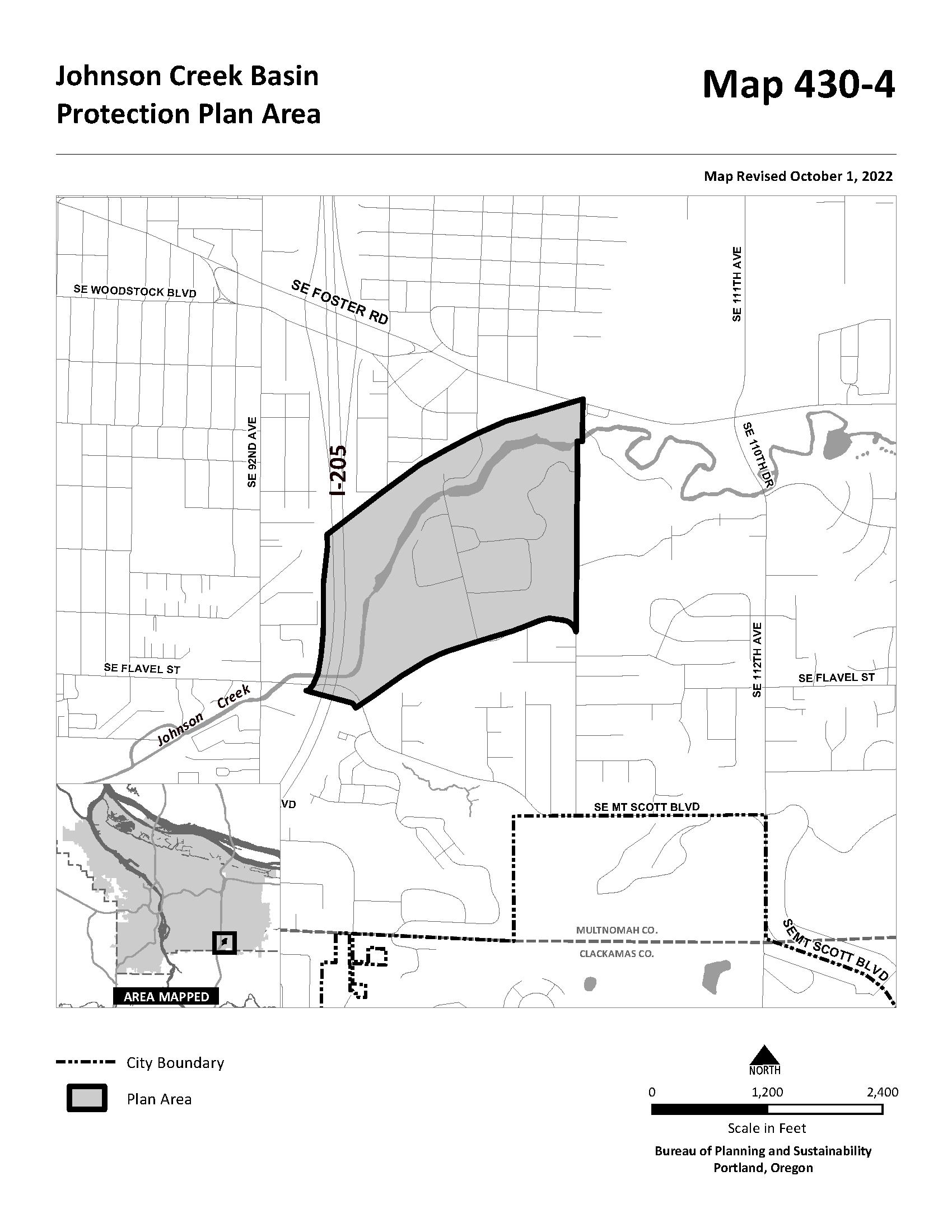
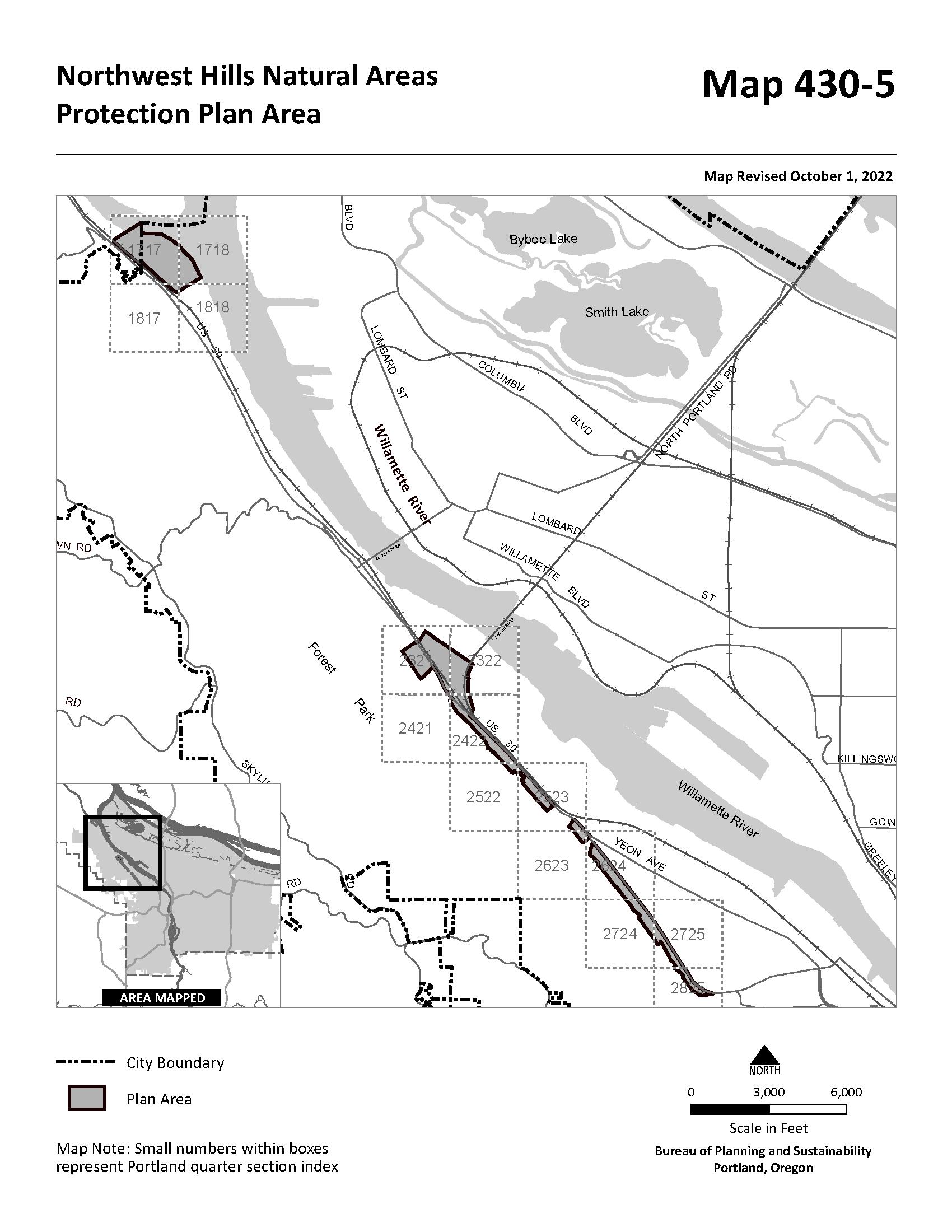
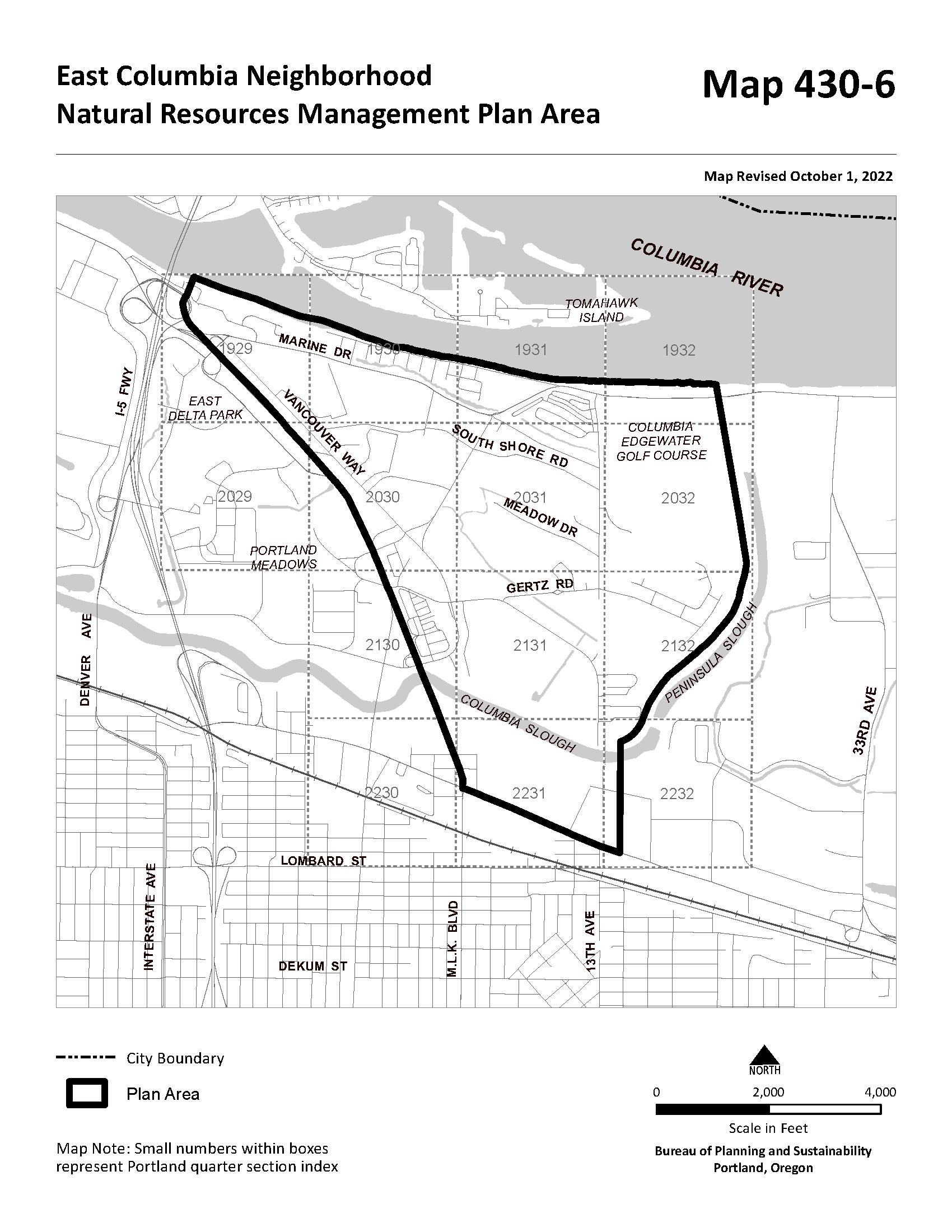
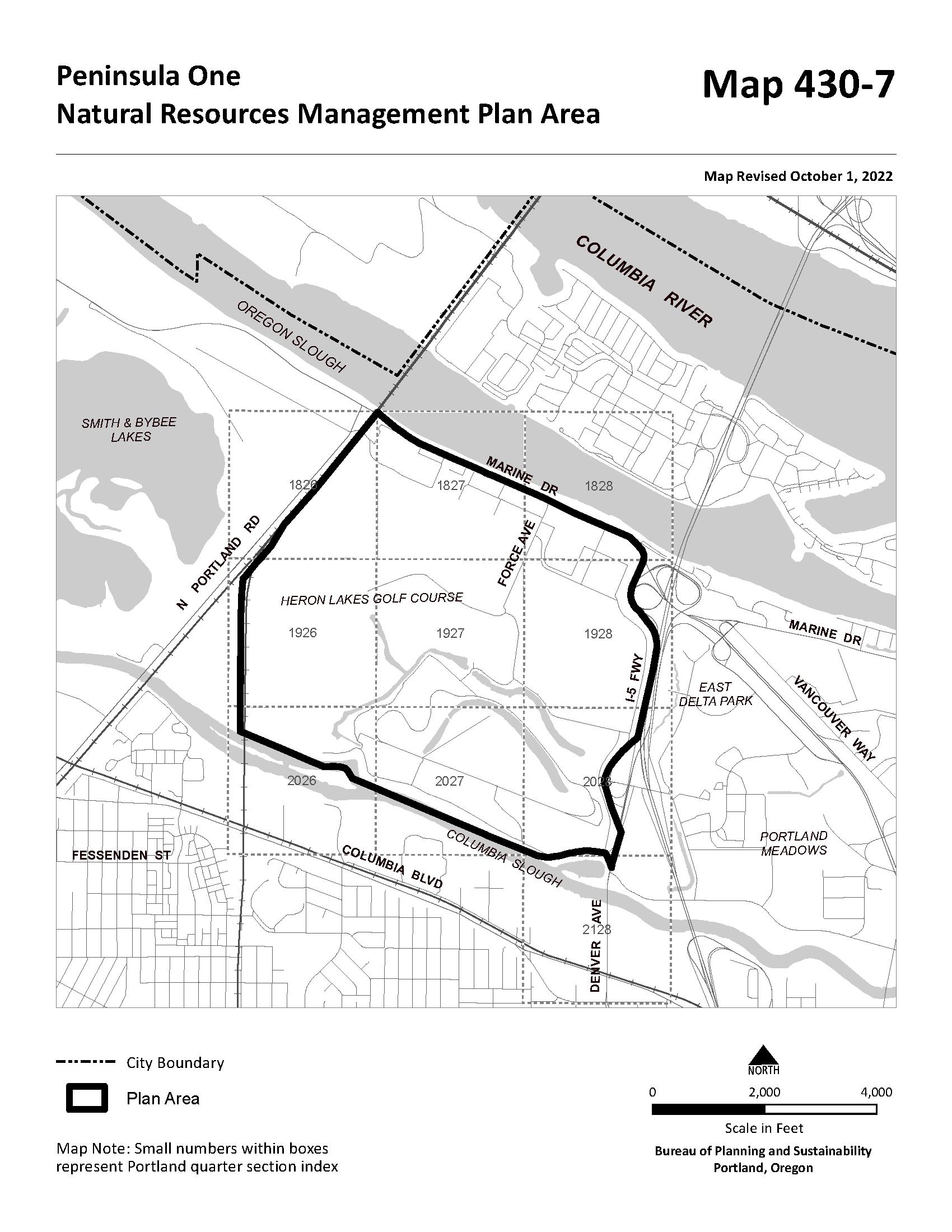
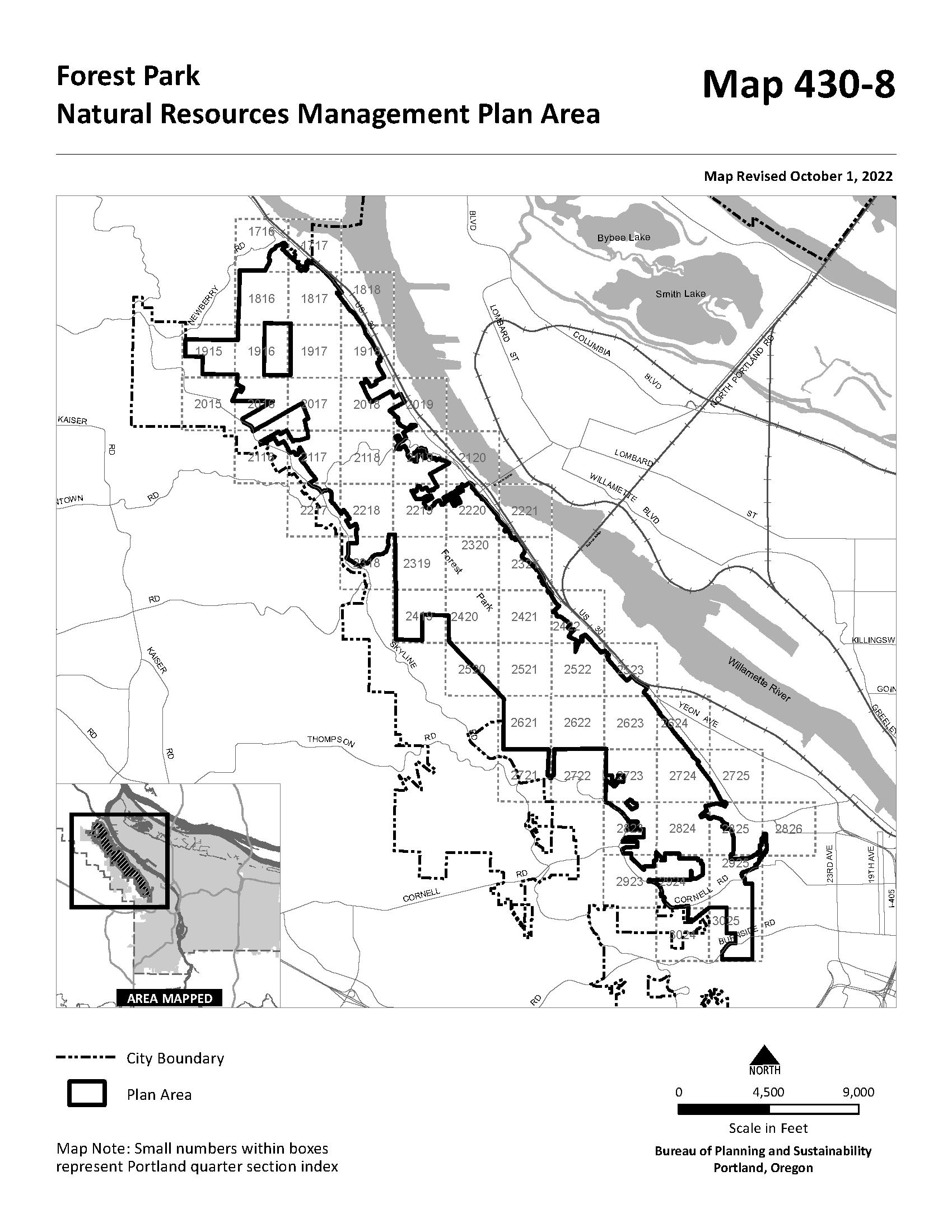
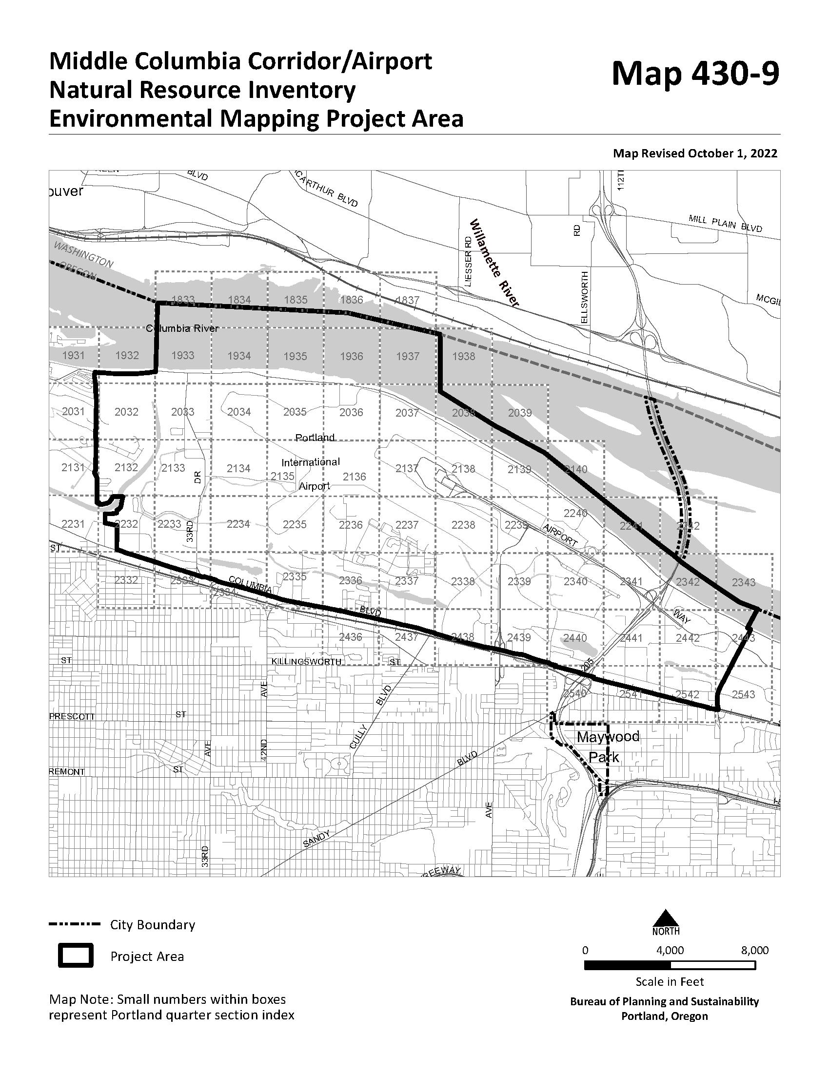
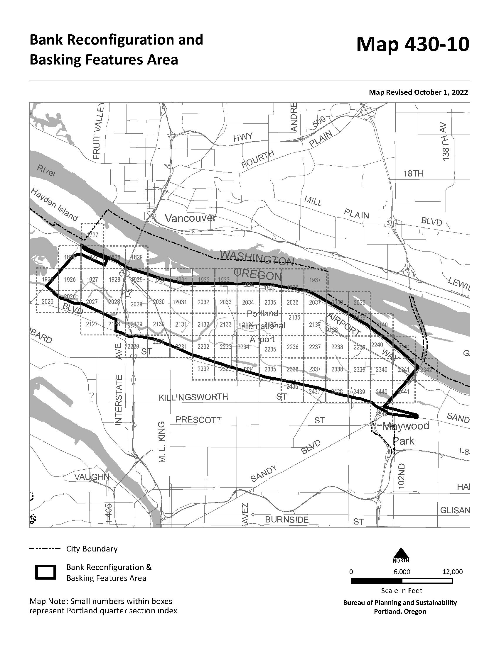
Sections:
33.480.010 Purpose
33.480.020 Map Symbol
33.480.030 Application of the Scenic Resource Zone
33.480.035 Where These Regulations Apply
33.480.040 Development Standards
33.480.050 Tree Removal Review
33.480.010 Purpose
The Scenic Resource zone is intended to:
480
• Protect Portland's significant scenic resources that provide benefits to the public as identified by the City in the Scenic Resources Protection Plan (1991), the Central City Scenic Resources Protection Plan (2017), and the River Plan / South Reach Scenic Resources Protection Plan (2020);
• Enhance the appearance of Portland to make it a better place to live and work;
• Create attractive entrance ways to Portland and its districts;
• Improve Portland's economic vitality by enhancing the City's attractiveness to people who live and work in Portland and people who are visiting; and
• Implement the scenic resource policies, goals, and objectives of Portland's Comprehensive Plan.
The purposes of the Scenic Resource zone are achieved by establishing height limits within view corridors to protect significant views and by establishing additional landscaping and screening standards to preserve and enhance identified scenic resources.
33.480.020 Map Symbol
The Scenic Resource zone is shown on the Official Zoning Maps with a letter "s" map symbol.
33.480.030 Application
The Scenic Resource zone is applied to significant view corridors, viewpoints, and scenic corridors identified in the Scenic Resources Protection Plan, the Central City Scenic Resources Protection Plan, or the River Plan / South Reach Scenic Resources Protection Plan.
33.480.035 Where These Regulations Apply
Any changes to land or development, including rights-of-way, within the Scenic Resource zone are subject to the regulations of this chapter.
33.480.040 Development Standards
The development standards of the Scenic Resource zone apply based on the mapping designations shown in the Scenic Resources Protection Plan, the Central City Scenic Resources Protection Plan, or the River Plan / South Reach Scenic Resources Protection Plan The standards for each subsection below apply only to areas with that designation in the respective plan. The resource is defined as the width of the right-of-way or top of bank to top of bank for scenic corridors. Setbacks are measured
from the outer boundary of the right-of-way unless specified otherwise in the ESEE Analysis and as shown on the Official Zoning Maps. In some cases, more than one development standard applies. For example, within a scenic corridor, a view corridor standard will apply where a specific view has been identified for protection.
A. View Corridors. The following standards apply to development and vegetation within a view corridor.
1. Purpose. The intent of the view corridor designation and standards is to establish maximum heights within view corridors to protect views from designated viewpoints and to provide a location where the public can safely take in a significant view.
2. Standards.
a. Height limit. All development within the designated view corridors are subject to the height limits of the base zone, overlay zone, or plan district, except when a more restrictive height limit is established by the view corridor. In those instances, the view corridor height limit applies to both development and vegetation. Removal of trees or limbs necessary to maintain the view corridor is allowed. When no development is proposed, tree removal is subject to the requirements of Title 11, Trees. Public safety facilities are exempt from this standard.
b. Viewpoint standards. The following standards apply to the viewpoint portion of view corridors shown on a Map 480-1:
(1) Construction of a viewpoint. Construction of a viewpoint that is at least 16 feet in total area is required as follows:
• When there is new development;
• When exterior alterations to existing development are 35 percent or greater of the assessed improvement value of the total improvements on the site.
(2) Viewpoint location.
• If the viewpoint is identified on a site that also has a major public trail designation, the viewpoint must be located adjacent to the major public trail and must comply with the Use of Trail, Hours of Use, Trespass and Trail Maintenance and Liability sections of Chapter 33.272, Major Public Trails.
• A viewpoint shown in a right-of-way must be located within or adjacent to the lanes of pedestrian or bicycle travel.
(3) Viewpoint amenities. The viewpoint must include at least two of the following amenities. The amenities must be located within the required viewpoint area:
• A bench;
• A light;
• A sign with information about the view; or
• A telescope directed at the focal features of the view.
B. Scenic Corridors. The following standards apply to development and vegetation within a scenic corridor.
1. Purpose. The scenic corridor designation is intended to preserve and enhance the scenic character along corridors, and where possible, scenic vistas from corridors. This is accomplished by limiting the length of buildings, preserving existing trees, providing additional landscaping, preventing development in side setbacks, screening mechanical equipment, and restricting signs. Property owners and others are encouraged to make every effort to locate buildings, easements, parking strips, sidewalks, and vehicle areas to preserve the maximum number of trees.
2. Standards.
a. Scenic corridor setback. A scenic corridor setback per Table 480-1 applies along street lot lines that abut the Scenic Corridor identified in the Scenic Resources Protection Plan. Development within an environmental overlay zone is exempt from this setback standard.
All other base zones 20’
[1] Larger minimum setbacks in overlay zone and plan district supersede this setback
b. Side building setbacks. Buildings, garages, and covered accessory structures are not allowed within the side building setbacks within the first 100 feet from the designated resource.
c. Structure length. No more than 80 percent of the length of any site can be occupied by structures, excluding fences, as measured parallel to the scenic corridor. This standard applies to an entire attached housing project rather than to individual units.
d. Limiting blank facades. Long, blank facades create uninteresting elements along a scenic corridor. This standard applies to all portions of buildings within 100 feet of the designated resource. Residential structures are exempt from this standard. Blank facades must be mitigated for in at least one of the following ways:
(1) The maximum length of any building facade is 100 feet.
(2) Two rows of trees, one deciduous and one evergreen, must be planted on 30-foot centers along the length of the building between the structure and the protected resource.
(3) Facades facing the scenic corridor must have a minimum of 40 percent of surface area in glass. Mirrored glass with a reflectance greater than 20 percent is prohibited.
e. Landscaping. The entire required scenic corridor setback must be landscaped to at least the L1 level unless the more stringent standards below or in other chapters of this Title apply. Up to 25 percent of the entire area of the scenic corridor setback may be used for vehicle and pedestrian areas except that each lot is allowed at least a 9-foot wide driveway or parking area and a 6-foot wide pedestrian area. Additionally, areas within the adjacent right of way must be landscaped to standards approved by the City engineer. The required landscaping in the setback and adjacent right of way must be provided at the time of development, except as allowed in B.2.e(1) below.
(1) When alterations are made to a site with an existing nonconforming use, allowed use, limited use, or conditional use, and the alterations are over the threshold stated in 33.258.070.D.2.a, the site must be brought into conformance with the landscape standards above. The value of the alterations is based on the entire project, not individual building permits. The cost of the upgrades required by this chapter may be counted toward the cost of upgrades required by Subsection 33.258.070.D. However, the upgrades required by this chapter must be completed first.
(2) Area of required improvements Except as provided in 33.258.070.D.2.c(2), Exception for Sites With Ground Leases, required improvements must be made to the entire site and adjacent right of way. If the ground lease is adjacent to a right of way within the scenic corridor, the upgrades required by this chapter also apply to the right of way adjacent to the ground lease
(3) Timing and cost of required improvements. The timing and cost of the required improvements is specified in 33.258.070.D.2.d. However, where 33.258.070.D.2.d refers to the standards listed in 33.258.070.D.2.b, the landscape standards above, are also included.
f. Screening. All exterior garbage cans, garbage and recycling collection areas, and mechanical equipment (including heat pumps, air conditioners, emergency generators, and water pumps) must be screened from view or not visible from the designated scenic corridor. Small rooftop mechanical equipment, including vents, need not be screened if the total area of such equipment does not exceed 10 square feet per structure.
g. Fences and hedges. The total maximum height of fences, hedges, and berms within the scenic corridor setback, and when allowed in the adjacent right of way is 3-1/2 feet. This provision does not apply to any required screening and buffering.
h. Preservation of trees. This provision does not apply if the property is regulated by state statutes for forest management practices. All trees 6 or more inches in diameter that are within the scenic corridor setback and right of way must be
retained unless removal conforms to one or more of the following standards:
(1) The tree is located within a view corridor designated in the Scenic Resources Protection Plan (1991) or the Central City Scenic Resources Protection Plan (2017);
(2) The tree is located within the footprint or within 10 feet of existing or proposed buildings and structures attached to buildings, such as decks, stairs, and carports, or within 10 feet of a proposed driveway;
(3) The tree is determined by an arborist to be dead, dying or dangerous;
(4) The tree is on the Nuisance Plants List;
(5) The tree must be removed due to installation, repair, or maintenance of water, sewer, or stormwater services. For new installation of services, tree removal allowed under this provision is limited to a single 10 foot wide utility corridor on each site;
(6) The tree is within a proposed roadway or City-required construction easement, including areas devoted to curbs, parking strips or sidewalks, or vehicle areas;
(7) The tree is within 20 feet of a Radio Frequency Transmission Facility antenna that is a public safety facility. The distance to the antenna is measured vertically and horizontally from the edge of the antenna. See Figure 480-1; or
(8) The tree is at least 6 and up to 12 inches in diameter and does not meet any of the other standards of this subparagraph, but is replaced within the scenic corridor setback or adjacent right of way according to Table 480-2. Replacement plantings must meet Section 33.248.030, Plant Materials.
Applicants may choose either Option A or Option B [1]
Size of tree to be removed (inches in diameter)
Option A (no. of trees to be planted)
Up to 9 1 tree
More than 9 and up to 12 3 trees
Option B (combination of trees and shrubs)
Not applicable
2 trees and 2 shrubs
More than 12 Tree Review Required (see 33.480.050 below)
[1] Trees and Shrubs must be species listed in the Scenic Resources Protection Plan
A. Tree removal without development. When no development is proposed, tree removal allowed by the standards of Subparagraph 33.480.040.B.2.h is subject to the tree permit requirements of Title 11, Trees.
B. Tree removal in development situations. When tree removal is proposed as part of development, the standards of Subparagraph 33.480.040.B.2.h apply in addition to the tree preservation standards of Title 11, Trees.
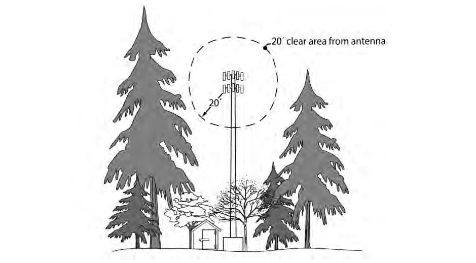
C. Trees that do not qualify for removal under Subparagraph 33.480.040.B.2.h may be removed if approved through tree review as provided in Chapter 33.853, Tree Review. However, where the tree removal would require environmental review, only environmental review is required.
(Amended by: Ord. No. 163957, effective 4/12/91; Ord. No. 166572, effective 6/25/93; Ord. No. 167186, effective 12/31/93; Ord. No. 171718, effective 11/29/97; Ord. No. 173528, effective 7/30/99; Ord. No. 175204, effective 3/1/01; Ord. Nos. 175965 and 176333, effective 7/1/02; Ord. No. 176469, effective 7/1/02; Ord. No. 177368, effective 5/17/03; Ord. No. 178509, effective 7/16/04; Ord. No. 178657, effective 9/3/04; Ord. No. 179092, effective 4/1/05; Ord. No. 181357, effective 11/9/07; Ord. No. 184524, effective 7/1/11; Ord. No. 186053, effective 1/1/15; Ord. No. 187216, effective 7/24/15; Ord. No. 188177, effective 5/24/18; Ord. No. 188958, effective 5/24/18; Ord. No. 189000, effective 7/9/18; Ord. No. 189805, effective 3/1/20; Ord. No. 190023, effective 8/10/20; Ord. No. 190241, effective 3/1/21; Ord. No. 190834, effective 10/1/22.)
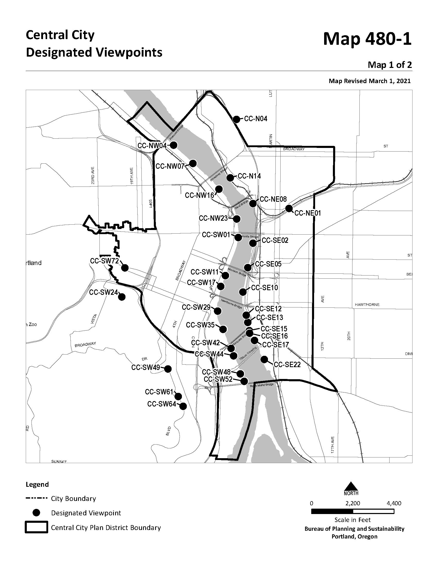
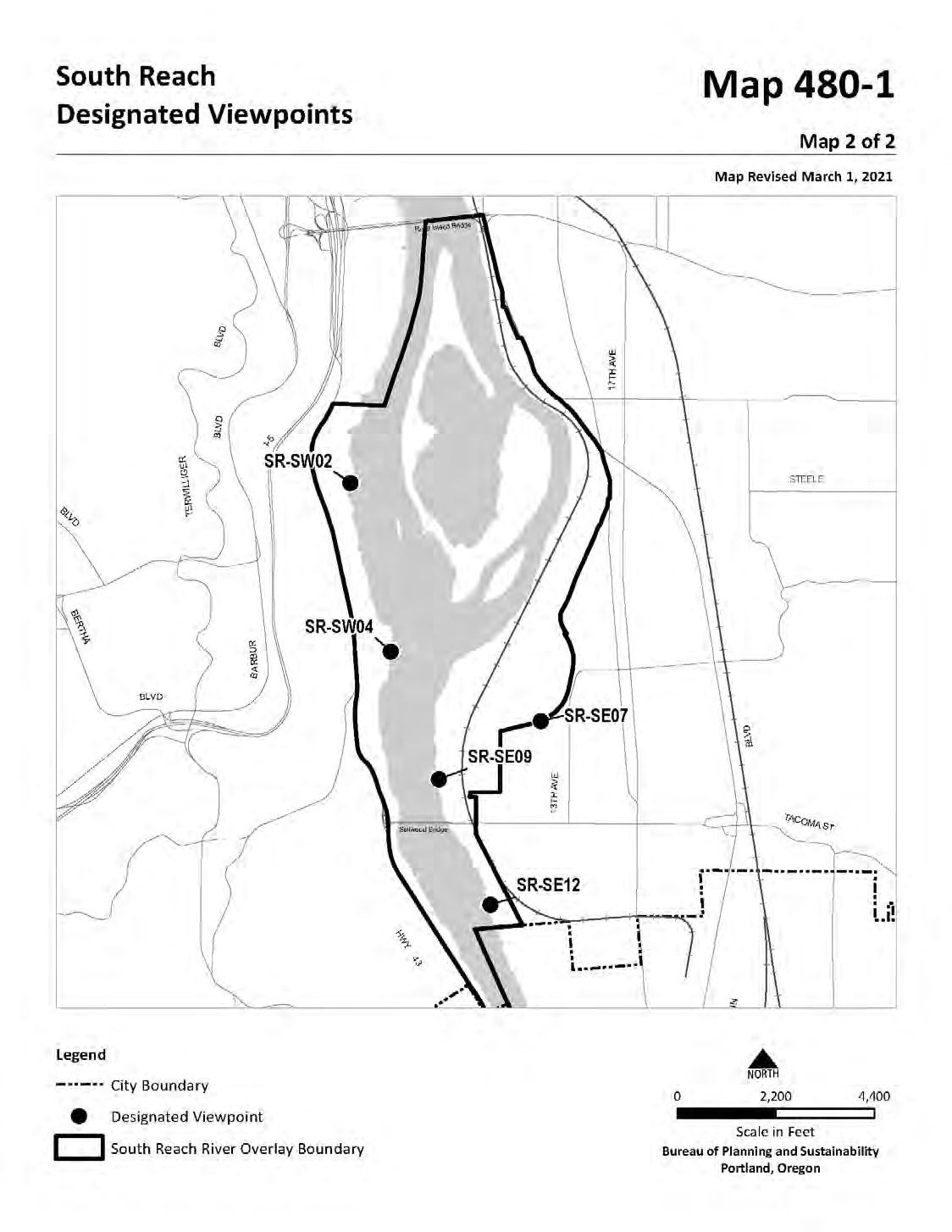
Sections:
33.418.010 Purpose
33.418.020 Map Symbol
33.418.030 Applying the Constrained Sites Overlay Zone
33.418.040 Housing Type Limitations
33.418.010 Purpose
Under some circumstances, more than two dwelling units are allowed on lots in the R20 through R2.5 zones. The Constrained Sites overlay zone reduces development potential to comply with protective measures adopted and acknowledged pursuant to statewide land use planning goals. This overlay zone reduces risk to life or property from certain natural hazards.
33. 418.020 Map Symbol
The Constrained Sites overlay zone is shown on the Official Zoning Maps with the letter “z” map symbol.
33. 418.030 Applying the Constrained Sites Overlay Zone
The Constrained Sites overlay zone is applied to lots in the R20, R10, R7, R5 and R2.5 zones when any portion of the lot has one of the following constraints. When property is rezoned out of an R20, R10, R7, R5, or R2.5 zone, the Constrained Sites overlay zone is automatically removed from the zoning map:
A. Environmental Conservation overlay zone, Environmental Protection overlay zone, or Pleasant Valley Natural Resource overlay;
B. Special flood hazard area;
C. Floodway;
D. 1996 Flood Inundation area;
E. Potential Rapidly Moving Landslide Hazard Zones as shown in the DOGAMI IMS-22 publication;
F. Deep landslide High Susceptibility or Landslide Deposit or Scarp as shown in the DOGAMI IMS-57 publication.
G. Sites in the R10 and R20 zones with a cumulative hazard value of 5 or more as shown on the 1998 City of Portland Wildfire Hazard Zone map;
H. Sites in the R10 and R20 zones with a high or extreme risk rating as shown on the 2001 Multnomah County Community Wildfire Protection Plan map 13B that are not also included in the 1998 City of Portland Wildfire Hazard Zone map;
I. Land within an industrial sanctuary comprehensive plan designation;
J. Land within the Portland International Airport Noise Impact overlay zone with a 68DNL or higher noise contour.
The following residential infill and accessory dwelling unit options do not apply in the Constrained Sites overlay zone:
A. 33.110.265.D.2 which allows duplexes consisting of two detached primary dwelling units in the R20 through R2.5 zones;
B. 33.110.265.E which allows triplexes and fourplexes in the R20 through R2.5 zones;
C. 33.110.265.F which allows fourplexes and multi-dwelling structures with up to six dwelling units in the R20 through R2.5 zones;
D. 33.110.265.G which allows cottage clusters in the R10 through R2.5 zones;
E. 33.205.020.B.1.c which allows an accessory dwelling unit on a site with a duplex in the R20 through R.25 zones; and
F. 33.205.020.B.2 which allows two accessory dwelling units on a site with a house, attached house, or manufactured home in the R20 through R2.5 zones
(Added by: Ord. No. 190093, effective 8/1/21; Amended: Ord. No. 190851, effective 6/30/22.)

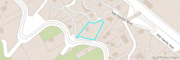
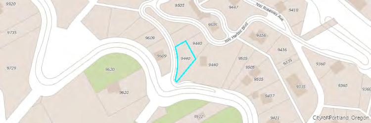
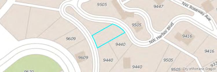
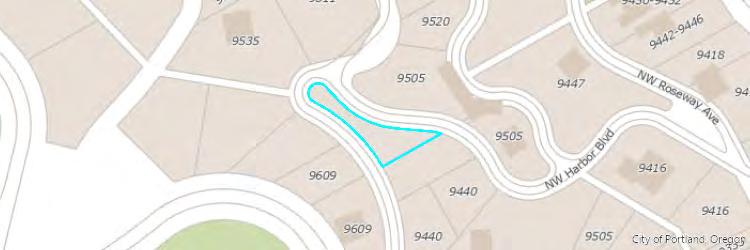
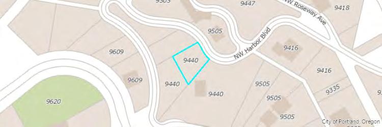


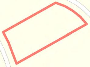
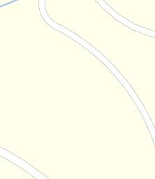


Water Features
Aerial
Aerial Environmental
Community
Transit
Vacant Land
The information contained is provided by WFG’s Customer Service Department to our customers, and while deemed reliable, is not guaranteed.
Traffic Counts
The information contained is provided by WFG’s Customer Service Department to our customers, and while deemed reliable, is not guaranteed.

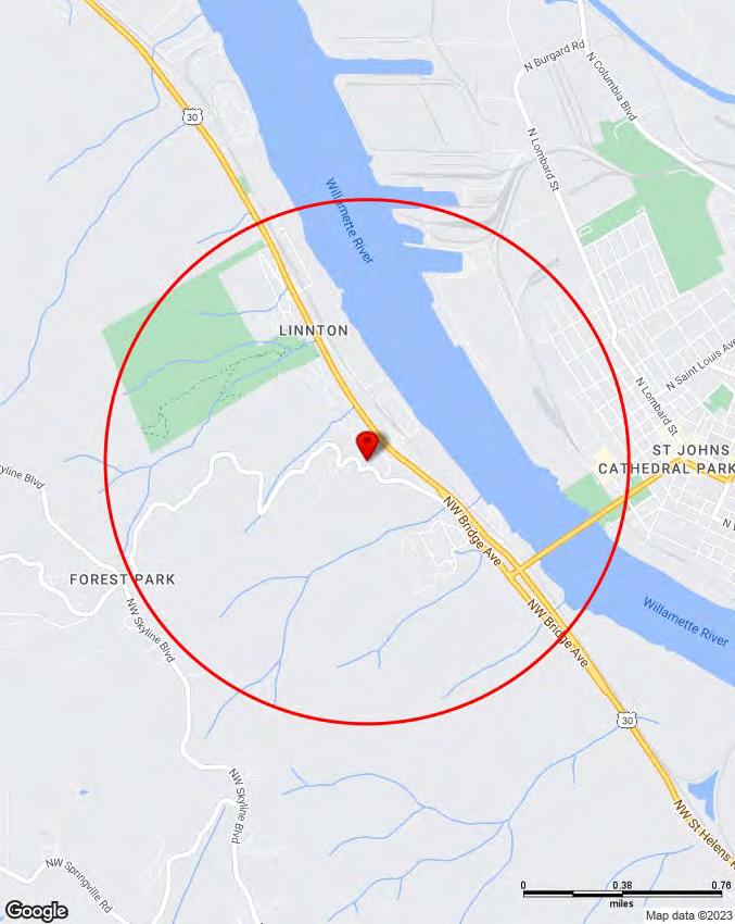
Copyright © Claritas, LLC 2022. All rights reserved.
9440 NW Harbor Blvd, Portland, OR 97231 Sitewise Online
Pop-Facts: Demographic Snapshot (Part 1)
9440 NW Harbor Blvd, Portland, OR 97231 Sitewise Online
Pop-Facts: Demographic Snapshot (Part 2) Pop-Facts:
9440 NW Harbor Blvd, Portland, OR 97231 Sitewise Online
Pop-Facts: Demographic Snapshot (Part 2)
Pop-Facts: Demographic Snapshot (Part 2)
Copyright © Claritas, LLC 2022. All rights reserved.
* This row intentionally left blank. No Total Category.
**1939 will appear when at least half of the Housing Units in this reports area were built in 1939 or earlier.
Copyright © Claritas, LLC 2022. All rights reserved.
* GAFO (General merchandise, Apparel, Furniture and Other) represents sales at stores that sell merchandise normally sold in department stores. This category is not included in Total Retail Sales Including Eating and Drinking Places.
Retail Market Power data is derived from two major sources of information. The demand data is derived from the Consumer Expenditure Survey (CE Survey or CEX), which is fielded by the U.S. Bureau of Labor Statistics (BLS). The supply data is derived from the Census of Retail Trade (CRT), which is made available by the U.S. Census. Additional data sources are incorporated to create both supply and demand estimates. The difference between demand and supply represents the opportunity gap or surplus available for each merchandise line in the specified reporting geography. When this difference is positive (demand is greater than the supply), there is an opportunity gap for that merchandise line; when the difference is negative (supply is greater than demand), there is a surplus.
Copyright © 2022 Environics Analytics. All rights reserved.
9440 NW Harbor Blvd, Portland, OR 97231
February 7, 2023
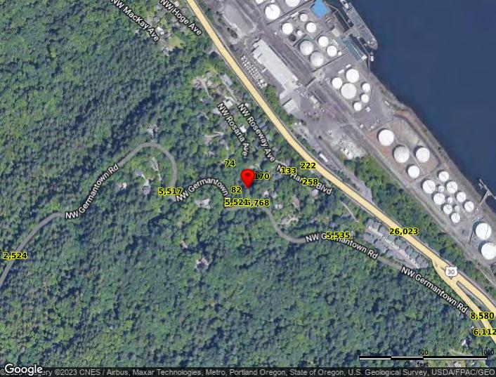 Powered by Sitewise
Data Source: Kalibrate TrafficMetrix
Powered by Sitewise
Data Source: Kalibrate TrafficMetrix