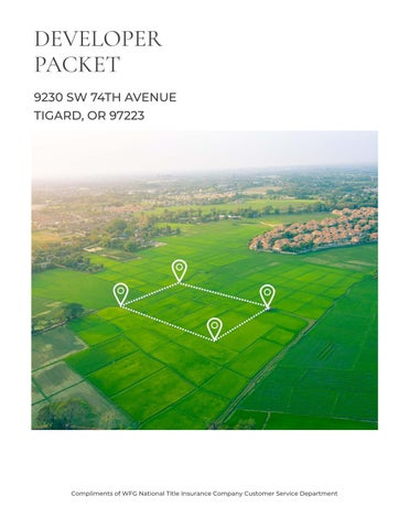
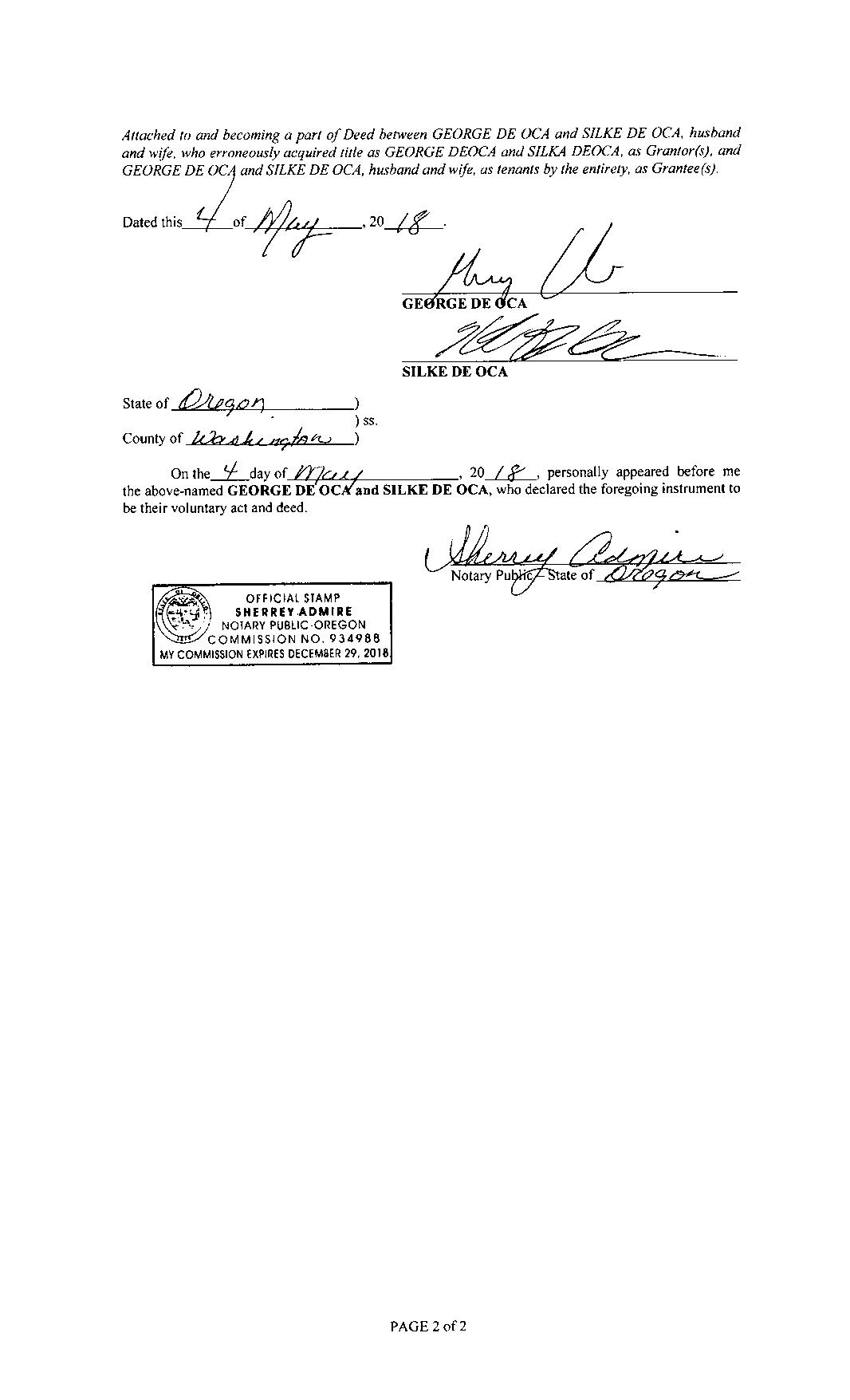
DEVELOPER PACKET

9230 SW 74TH AVENUE
TIGARD, OR 97223
Compliments of WFG National Title Insurance Company Customer Service Department
Property Details
Utility As-Builts (Water & Sewer)
Zoning Information
Custom Maps
Community Information

-Demographics
-Traffic Counts
The information contained is provided by WFG’s Customer Service Department to our customers, and while deemed reliable, is not guaranteed.
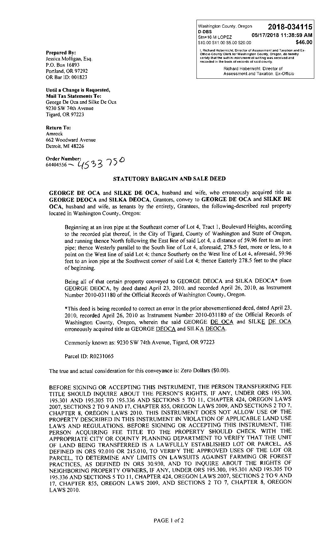
Owner:George&SilkeDeOca
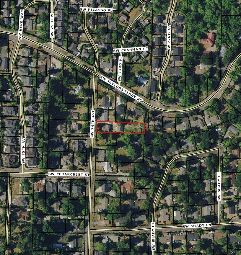
Site:9230SW74thAveTigardOR97223
Mail:9230SW74thAveTigardOR97223 Location
SentryDynamics,Inc.anditscustomersmakenorepresentation,warrantiesorconditions,expressorimplied, astotheaccuracyorcompletenessofinformationcontainedinthisreport.

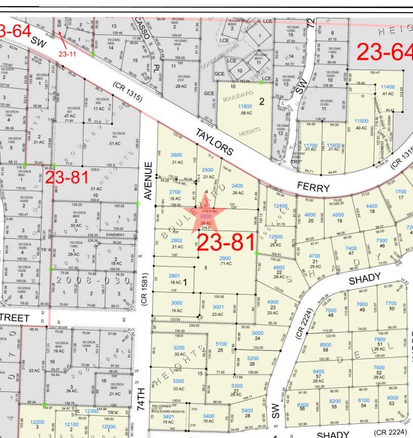
ParcelID:R231065
SiteAddress:9230SW74thAve
SentryDynamics,Inc.anditscustomersmakenorepresentations, warrantiesorconditions,expressorimplied,astotheaccuracyor completenessofinformationcontainedinthisreport.
SentryDynamics,Inc.anditscustomersmakenorepresentations, warrantiesorconditions,expressorimplied,astotheaccuracyor completenessofinformationcontainedinthisreport.
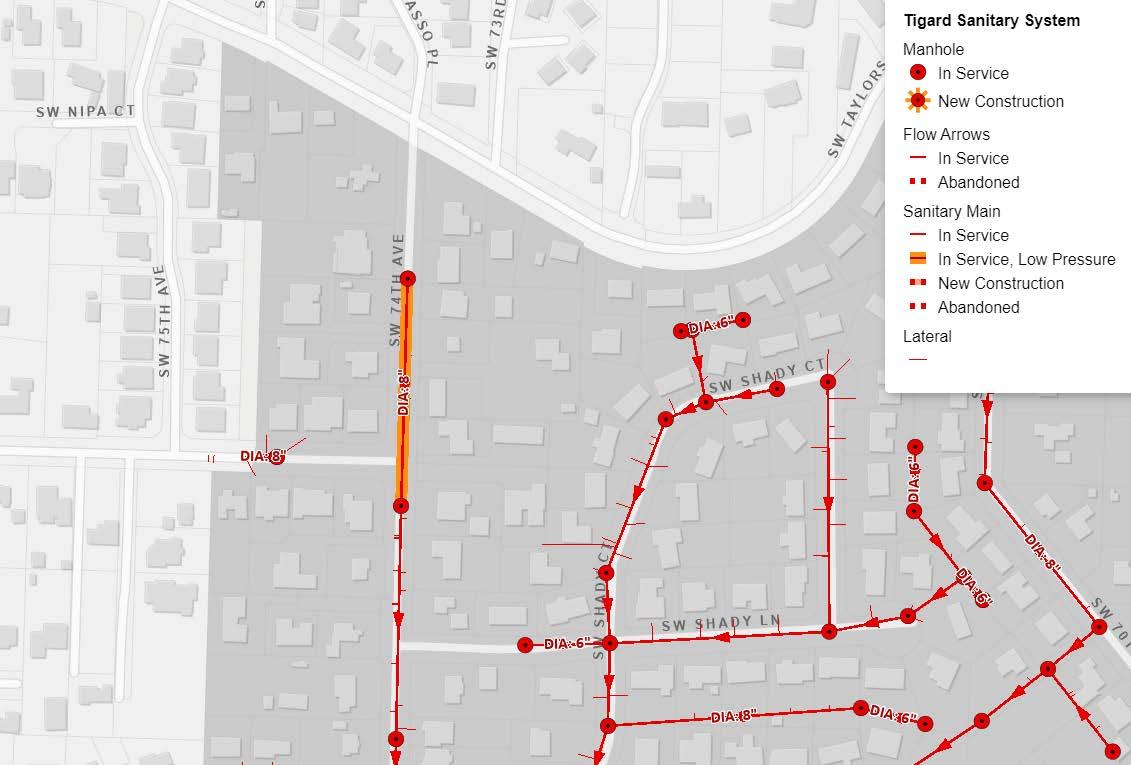
Water As-Built Maps
Tualatin Valley Water District
Sewer As-Built Maps City of Tigard
The information contained is provided by WFG’s Customer Service Department to our customers, and while deemed reliable, is not guaranteed.
TUALATIN VALLEY WATER DISTRICT CANNOT GUARANTEE AND MAKES NO REPRESENTATION OF THE ACCURACY OF THE MEASUREMENTS OR LOCATIONS ON MAPS OR INFORMATION PROVIDED. DESIGN ENGINEER OR CONTRACTOR MUST VERIFY IN FIELD. THIS MAP DOES NOT CONTAIN METERS AND SERVICES THAT MAY EXIST IN FIELD. ASSETS THAT EXIST OUTSIDE OF REQUESTED AREA MAY HAVE BEEN REMOVED FROM MAP.
TLID: 1S125DB02800


Detailed Zoning Information
Tigard RES-B (Residential – B)
Zoning Map
Community Jurisdiction
The information contained is provided by WFG’s Customer Service Department to our customers, and while deemed reliable, is not guaranteed.
A. Base zones.All land within the City ofTigard is divided into zones.The use and development of land is limited by the base zone in which the land is located.The following base zones are established in the city:
Zone Name ZoneAbbreviation
Mixed-Use Residential MUR-1
Mixed-Use Residential MUR-2
Triangle Mixed Use TMU
Industrial Zones
Industrial Park I-P
Light Industrial I-L
Heavy Industrial I-H
1. The base zones applied to the public rights-of-way within the city, as shown on the zoning map, do not directly regulate the uses or developments that are allowed in these rights-of-way. Public rights-of-way are governed by other regulations maintained by the city or other applicable transportation authorities.
2. Land annexed to the city will be assigned a base zone or zones as provided in Chapter 18.720,Annexations.
3. When more than one base zone exists on a property, the development standards for each base zone will apply to the portion of the property in that base zone.
B. Zoning map.The map entitled “Tigard Zoning Map” is the official zoning map and displays the boundaries of each of the base zones provided inTable 18.10.1.The current official zoning map is maintained by the Director.The official zoning map is made a part of this title by reference.
C. Zone boundary.The exact location of a zone boundary will be determined by the Director where there is uncertainty, contradiction, or conflict as to the zone boundary. Zone boundary determinations will consider the following:
1. Boundaries shown as approximately following the center lines of streets, highways, railroad tracks, or alleys are construed to follow such center lines;
2. Boundaries shown as approximately following platted lot lines are construed as following such lot lines;
3. Boundaries shown as approximately following city limits are construed as following city limits; and
4. Boundaries shown as approximately following a river, stream, or drainage channel are construed as following such river, stream, or drainage channel.
D. Zoning map amendments.Amendments to the official zoning map may be made as provided in Chapter 18.790,Text and MapAmendments. (Ord. 22-06 §2; Ord. 18-23 §2; Ord. 17-22 §2)
Contact:
City Recorder: 503-718-2419
Published by Quality Code Publishing, Seattle, WA. By using this site, you agree to the terms of use.
Tigard,OregonMunicipalCode
Title18DEVELOPMENTCODE
18.100BASEZONES
Chapter18.110RESIDENTIALZONES
18.110.010Purpose
18.110.030
18.110.040
Chapter18.120COMMERCIALZONES
18.120.010
18.120.020
18.120.030
18.120.040
18.120.050
Chapter18.130
18.130.010Purpose
18.130.040
Chapter18.140PARKSANDRECREATIONZONE
18.140.010Purpose
18.140.020Applicability
18.140.030OtherZoningRegulations
18.140.040
18.140.050
Chapter18.110RESIDENTIALZONES
18.110.010Purpose
Thepurposeofthischapteristoimplementthepoliciesofthecomprehensiveplanrelatedtohousingby:
A. Creatinganenvironmentinwhichconstructionofafullrangeofowner-occupiedandrentalhousingataffordablepricesisencouraged;
B. Providingresidentialzonesofvaryingdensities,withflexibledesignanddevelopmentstandardstoencourageinnovationandreduce housingcosts;
C. Accommodatingcompatiblenonresidentialdevelopment—including,butnotlimitedto,schools,churches,parks,recreationfacilities, daycarecenters,andneighborhoodcommercialusesandservices—atappropriatelocationsandscales;and
D. Enhancingthelivabilityofneighborhoodsbyencouragingdiversityinhousingstockandpromotingopportunitiesforwalkability.(Ord. 22-06§2;Ord.18-28§1;Ord.18-23§2;Ord.17-22§2)
TheresidentialbasezonesarelistedinTable18.110.1.Whenthistitlereferstotheresidentialzones,itisreferringtothefivebasezones listedhere.
(Ord.22-06§2;Ord.18-28§1;Ord.18-23§2;Ord.17-22§2)
A. Generalprovisions.Alistofallowed,restricted,conditional,andprohibitedusesinresidentialzonesisprovidedinTable18.110.2.Ifa usecategoryisnotlisted,seeSection18.60.030
1. Allowed(A).Usesthatareallowed,subjecttoalloftheapplicableprovisionsofthistitle.
2. Restricted(R).Usesthatareallowedprovidedtheyareincompliancewithspecialrequirements,exceptions,orrestrictions.
3. Conditional(C).UsesthatrequiretheapprovaloftheHearingsOfficerusingdiscretionarycriteria.Theapprovalprocessand criteriaareprovidedinChapter18.740,ConditionalUse.
4. Prohibited(P).Usesthatarenotallowedunderanycircumstance.
Table18.110.1A=Allowed R=Restricted C=ConditionalUse P=Prohibited
[1] Above-groundpublicandprivateutilityfacilitiesproposedwithdevelopmentandundergroundpublicandprivateutilityfacilitiesare allowed.Standaloneabove-groundpublicandprivateutilityfacilitiesnotproposedwithdevelopmentareallowedconditionally.
[2] Familydaycareisallowed.Otherdaycareusesareallowedconditionally.
[3] Schoolbusparkingonpublichighschoolsitesisallowedasanaccessoryuseiflocatedaminimumof200feetfromthenearest propertylineofaresidentialuse.
[4] Allowedconditionallyonpublicschoolsites.
[5] Onlypark-and-rideandothertransit-relatedfacilitiesareallowedconditionally.
[6] Limitedtofirststoryofapartmentdevelopmentsandmaximumsquarefootageof10%ofthebuilding.Developmentsutilizingthis provisionareconsideredresidentialdevelopment,notmixed-usedevelopment,forthepurposesofthistitle.
[7] SeeChapter18.450,WirelessCommunicationFacilities,forrequirements.
B. Developmentstandards.Thestandardsforresidentialdevelopmentinresidentialzonesarelocatedintheapplicablehousingtype chapterin18.200ResidentialDevelopmentStandards.Thestandardsfornonresidentialdevelopmentinresidentialzonesarelocatedin Chapter18.350,ResidentialZoneDevelopmentStandards,andtheapplicableplandistrictchapter,ifany.(Ord.22-09§2;Ord.22-06§2; Ord.20-01§1;Ord.19-09§1;Ord.18-28§1;Ord.18-23§2;Ord.17-22§2)
A. Ahousingtypeisnotausecategory.ItdescribesatypeofdevelopmentthatcancontainaResidentialUse.
B. Alistofallowed,limited,andprohibitedhousingtypesinresidentialzonesisprovidedinTable18.110.3.Termsandabbreviationsused aredefinedasfollows:
1. Yes,allowed(Y).Housingtypesthatareallowed.
2. Limited(L).Housingtypesthatrequireaconditionaluseapprovalorareallowedsubjecttospecificlimitations.
3. No,prohibited(N).Housingtypesthatarenotallowedunderanycircumstance.
C. Housingtypesthatareallowedorallowedonalimitedbasisaresubjecttothestandardsandprovisionsoftheapplicabledevelopment standardschapter,whichisindicatedinparenthesesinthefirstcolumnofTable18.110.3.
D. Allallowedhousingtypesmaybebuiltonsiteorbroughttothesiteasamanufacturedhome.
Table18.110.3
Y=Yes,Allowed L=Limited,seefootnotesN=No,Prohibited
[1] Allowedonlythroughaconditionaluseapplication.
[2] Rowhousesofupto5unitspergroupingallowed.
(Ord.22-06§2;Ord.20-01§1;Ord.18-28§1;Ord.18-23§2)■
Thepurposeofthischapteristoimplementthegoalsandpoliciesofthecomprehensiveplanrelatedtolanduseplanningandeconomic developmentby:
A. Ensuringthatafullrangeofgoodsandservicesareavailablethroughoutthecitysothatresidentscanfulfillallormostoftheirneeds withineasydrivingdistanceand,ideally,withineasywalkingandbikingdistanceoftheirhomes;
B. Ensuringthatafullrangeofeconomicactivitiesandjobopportunitiesareavailablethroughoutthecity;and
C. Minimizingthepotentialadverseimpactsofcommercialusesonresidentialusesbycarefullylocatingandselectingthetypesofuses allowedineachcommercialzone.(Ord.18-28§1;Ord.18-23§2;Ord.17-22§2)
A. C-N:NeighborhoodCommercialzone.TheC-Nzoneisdesignedtoprovideconveniencegoodsandserviceswithinasmallclusterof storesadjacenttoresidentialneighborhoods.Conveniencegoodsandservicesarethosethatarepurchasedfrequently,meaningatleast weekly;forwhichcomparisonbuyingisnotrequired;andthatcanbesustainedinalimitedtradearea.Suchusesincludeconvenience markets,personalservices,andrepairshops.Alimitednumberofotheruses,includingbutnotlimitedtogasstations,medicalcenters, religiousinstitutions,park-and-ridelots,anduseswithdrive-throughservices,areallowedconditionally.
B. C-C:CommunityCommercialzone.TheC-Czoneisdesignedtoprovideconvenienceshoppingfacilitiesthatmeettheregularneeds ofnearbyresidentialneighborhoods.Withaserviceareaofabout1.5miles,suchcommercialcenterstypicallyrangeinsizefrom30,000— 100,000squarefeetonsitesrangingfrom2to8acres.Separatedfromothercommercially-zonedareasbyatleast0.5miles,community commercialcentersareintendedtoserveseveralresidentialneighborhoods,ideallyattheintersectionoftwoormorecollectorstreetsorat theintersectionofanarterialandcollectorstreet.Alimitednumberofotheruses,includingbutnotlimitedtogasstations,medicalcenters, religiousinstitutions,park-and-ridelots,anduseswithdrive-throughservices,areallowedconditionally.
C. C-G:GeneralCommercialzone.TheC-Gzoneisdesignedtoaccommodateafullrangeofretail,office,andcivicuseswithacitywide andevenregionaltradearea.Exceptwherenonconforming,residentialusesarelimitedtomixed-usedevelopments.Awiderangeofuses, includingbutnotlimitedtoadultentertainment,automotiveequipmentrepairandstorage,mini-warehouses,utilities,heliports,medical centers,majorevententertainment,andgasolinestations,areallowedconditionally.
D. C-P:Professional/AdministrativeCommercialzone.TheC-Pzoneisdesignedtoaccommodatecivicandprofessionalservicesand compatiblesupportservices,forexampleconvenienceretail,personalservices,andrestaurants,incloseproximitytoresidentialareasand majortransportationfacilities.Heliports,medicalcenters,religiousinstitutions,andutilitiesareallowedconditionally.DevelopmentsintheCPzoneareintendedtoserveasabufferbetweenresidentialareasandmoreintensivecommercialandindustrialareas.
E. MU-CBD:Mixed-UseCentralBusinessDistrictzone.TheMU-CBDzoneisdesignedtoprovideapedestrian-friendlyurbanvillagein downtownTigard.Awidevarietyofcommercial,civic,employment,mixed-use,apartments,androwhousesareallowed.
F. MUE:Mixed-UseEmploymentzone.TheMUEzoneisdesignedtoaccommodateawiderangeofusesincludingmajorretailgoodsand services,businessandprofessionaloffices,civicuses,andapartments.
G. MUE-1andMUE-2:Mixed-UseEmployment1and2zone.TheMUE-1and2zonesaredesignedtoapplytoareaswhereemployment usessuchasoffice,researchanddevelopment,andlightmanufacturingareconcentrated.Commercialandretailsupportusesareallowed butarelimited,andresidentialusesareallowedthatarecompatiblewiththeemploymentcharacterofthearea.LincolnCenterisan exampleofanareadesignatedMUE-1,ahigh-densitymixed-useemploymentzone.TheNimbusareaisanexampleofanareadesignated MUE-2,requiringmoremoderatedensities.
H. MUC:Mixed-UseCommercialzone.TheMUCzoneincludeslandaroundtheWashingtonSquareMallandlandimmediatelywestof Highway217.Primaryusesallowedincludeofficebuildings,retail,andserviceuses.Alsoallowedaremixed-usedevelopmentsandhousing atdensitiesof50unitsperacre.Largerbuildingsareencouragedinthisareawithparkingunder,behind,ortothesidesofbuildings.
I. MUC-1:Mixed-UseCommercial1zone.TheMUC-1zone,whichisdesignedtoapplytothatportionofBridgeportVillage(formerly knownastheDurhamQuarrysite)withintheCityofTigard,isamixed-usecommercialzoneboundedby72ndAvenue,FindlayStreet,and theTigard,TualatinandDurhamcitylimits.ThissiteisthesubjectofanintergovernmentalagreementbetweenthecitiesofTigardand Tualatin.PursuanttothatagreementtheCityofTualatinwillfurnishallplanning,building,andassociateddevelopmentreviewandpermit servicesforthesite.ThiszoneisintendedtomirrortheCityofTualatin’sMixed-UseCommercialOverlayDistrictinTualatinDevelopment Code,Chapter57.Itpermitsawiderangeofusesincludingcommerciallodging,generalretail,offices,andhousing.Additionaluses, includingbutnotlimitedtomajorevententertainmentandmotorvehicleretailfuelsales,areallowedconditionally.
J. MUR-1andMUR-2:Mixed-UseResidential1and2zone.TheMUR-1andMUR-2zonesaredesignedtoapplytopredominantly residentialareaswheremixed-usesareallowedwhencompatiblewiththeresidentialuse.Ahigh-density(MUR-1)andmoderate-density (MUR-2)designationisavailablewithintheMURzone.
K. TMU:TriangleMixed-Usezone.TheTMUzoneappliestomostlandwithintheTigardTriangle,aregionalTownCenterboundedby PacificHighway,Highway217,andInterstate5.TheTMUzoneisintendedtobeanactive,urban,multimodal,andmixed-usedistrictthat accommodatesavarietyofhousingoptionsanduses,promotespedestrian-orienteddevelopment,andlimitsnewauto-oriented development.(Ord.18-28§1;Ord.18-23§2;Ord.17-22§2) 18.120.030
A. Generalprovisions.Alistofallowed,restricted,conditional,andprohibitedusesincommercialzonesisprovidedinTable18.120.1, exceptforusesintheTMUzone,whichareprovidedinChapter18.660,TigardTrianglePlanDistrict.Ifausecategoryisnotlisted,see Section18.60.030
1. Allowed(A).Usesthatareallowed,subjecttoalloftheapplicableprovisionsofthistitle.
2. Restricted(R).Usesthatareallowedprovidedtheyareincompliancewithspecialrequirements,exceptions,orrestrictions.
3. Conditional(C).UsesthatrequiretheapprovaloftheHearingsOfficerusingdiscretionarycriteria.Theapprovalprocessand criteriaareprovidedinChapter18.740,ConditionalUses.
4. Prohibited(P).Usesthatarenotallowedunderanycircumstance.
B. Userestrictions.Allallowed,restricted,andconditionalusesintheC-NandC-Czonesaresubjecttoadditionallanduserestrictionsin Section18.120.040
C. Developmentstandards.Thestandardsforresidentialdevelopmentincommercialzonesarelocatedintheapplicablehousingtype chapterin18.200ResidentialDevelopmentStandards.Thestandardsfornonresidentialdevelopmentincommercialzones—including mixed-usedevelopmentwithorwithoutaresidentialcomponent—arelocatedinChapter18.320,CommercialZoneDevelopmentStandards, andtheapplicableplandistrictchapter,ifany.
Table18.120.1R=Restricted C=ConditionalUse P=Prohibited
[1] SeeSection18.120.040foradditionallanduserestrictions.
[2] Useswithdrive-throughservicesthatwerelawfullyinexistencepriortotheadoptionoftheMU-CBDzoneareallowed.Allnewuses withdrive-throughservicesareprohibited.
[3] Residentialusesareallowedonorabovethesecondstoryofamixed-usedevelopmentwherethefirststorycontainsanallowed commercialuse.
[4] Smallformresidentialdevelopmentisallowedwhereitislocatedonthesamesitewithanallowedorconditionaluseandisoccupied exclusivelybyacaretakerorsuperintendentoftheallowedorconditionaluse.
[5] Above-groundpublicandprivateutilityfacilitiesproposedwithdevelopmentandundergroundpublicandprivateutilityfacilitiesare allowed.Standaloneabove-groundpublicandprivateutilityfacilitiesnotproposedwithdevelopmentareallowedconditionally.
[6] Familydaycareisallowed.Otherdaycareusesareallowedconditionally.
[7] UsesthatwerelawfullyinexistencepriortotheadoptionoftheMU-CBDzoneareallowed.Allnewusesareprohibited.
[8] Themaximumallowedgrossfloorareais60,000squarefeetperbuildingortenant.
[9] Themaximumallowedgrossfloorareais60,000squarefeetperuseforusesproposedaftertheadoptionoftheMUC,MUE-1,and MUE-2zones.
[10] Themaximumareaallowedforproductionis500squarefeetperbuildingortenant.
[11] Themaximumallowedcombinedareaofsales-orientedretailandeatinganddrinkingestablishmentsis20%ofthegrossfloorareaof theotherusesallowedbyrightonthepremises.
[12] Usesmustbewithinamixed-usedevelopment.Usesmayoccupyamaximumof50%ofthetotalgrossfloorareawithinthemixed-use developmentonlywhenminimumresidentialdensitiesaremet.PropertiesthatwerezonedcommercialpriortoMarch28,2002areexempt fromthisrequirement.Theseproperties,orlotscreatedfromtheseproperties,maydevelopasasingle-usecommercialdevelopment.The taxassessormapnumbersforexemptpropertiesareasfollows:1S135AA-00400,1S135AA-01400,1S135AA-01900,1S135AA-01901, 1S135DA-02000,1S135AA-02500,1S135AA-02600,1S135AA-02700,1S135DA-01900,and1S1DA-02000.
[13] Salesorrentalofheavyvehiclesorfarmequipmentisallowedconditionally.
[14] Usesallowedonlyasaccessoryusestoalloweduseswherecontainedinthesamestructureandlessthanthegrossfloorareaofthe alloweduse,exceptformotorvehiclesales/rentalwhichisallowedasaprimaryuseinspecificlocationsasprovidedinSubsection 18.670.020.C
[15] Alluseactivitiesmustbecontainedinsideastructureexceptforemployeeandcustomerparking.
[16] Onlymotorvehiclecleaningisallowed.
[17] Themaximumallowedgrossfloorareais60,000squarefeetperbuildingortenantinallMU-CBDsubareasexceptthe99W-Hall subareaasshownonMap18.650.A.
[18] Themaximumallowedgrossfloorareais30,000squarefeetperbuildingortenantwherethesiteismorethanthreeacresinsize.One additionalsquarefootoffloorareaisallowedforeachfoursquarefeetoffloorareaoccupiedordesignedforanalloweduseotherthana sales-orientedretailuse.
[19] SeeChapter18.450,WirelessCommunicationFacilities,foradescriptionofallowedandrestrictedfacilities. (Ord.22-09§2;Ord.22-06§2;Ord.20-01§1;Ord.18-28§1;Ord.18-23§2;Ord.17-22§2) 18.120.040
ThefollowingrestrictionsapplytoallusesintheC-NandC-Czones:
A. Usesmustbecontainedinsideastructureexceptforthefollowingaccessoryuses:
1. Parkingandloadingareas;
2. Daycareoutdoorplayareas;
3. DiningordrinkingareaswhereassociatedwithanallowedEatingandDrinkingEstablishmentorSales-OrientedRetailuse;or
4. Sale,display,orstorageofhorticulturalandfoodmerchandisewherelimitedtoamaximumareaof5percentofthegrossfloor areaoftheprimaryuse.
B. Useswithdrive-throughservicesoroperatingbefore6a.m.orafter11p.m.areallowedconditionally.
C. Eachuseisallowedamaximumgrossfloorareaof5,000squarefeetperbuildingortenantexceptforthefollowinguses:
1. Sales-OrientedRetailusesprimarilyinvolvedinthesaleoffoodandbeveragesareallowedamaximumgrossfloorareaof40,000 squarefeetperbuildingortenant;and
2. AllotherSales-OrientedRetailusesareallowedamaximumgrossfloorareaof10,000squarefeetperbuildingortenant.(Ord. 18-28§1)
A. Ahousingtypeisnotausecategory.ItdescribesatypeofdevelopmentthatcancontainaResidentialUse.
B. Alistofallowed,limited,andprohibitedhousingtypesincommercialzonesisprovidedinTable18.120.2.Commercialzonesthatdonot allowanyresidentialusesorallowthemonlyinamixed-usedevelopmentarenotincludedinthetable.Termsandabbreviationsusedare definedasfollows:
1. Yes,allowed(Y).Housingtypesthatareallowed.
2. Limited(L).Housingtypesthatrequireaconditionaluseapprovalorareallowedsubjecttospecificlimitations.
3. No,prohibited(N).Housingtypesthatarenotallowedunderanycircumstance.
C. Housingtypesthatareallowedorallowedonalimitedbasisaresubjecttothestandardsandprovisionsoftheapplicabledevelopment standardschapterorapplicableplandistrictchapter,ifany.Theapplicabledevelopmentstandardschapterforeachhousingtypeisindicated inparenthesesinthefirstcolumnofTable18.120.2.
D. Allallowedhousingtypesmaybebuiltonsiteorbroughttothesiteasamanufacturedhome.
Y=Yes,Allowed L=Limited,SeeFootnotes N=No,Prohibited
[1] Accessorydwellingunitsareonlyallowedonsiteswithpre-existingsmallformresidentialdevelopment.
[2] MobilehomeparksthatwerelawfullyinexistencepriortotheadoptionoftheMU-CBDzoneareallowed.Allnewmobilehomeparks areprohibited.
[3] Mobilehomeparks,smallformresidential,androwhousesthatwerelawfullyinexistencepriortotheadoptionoftheWashington SquareRegionalCenterPlanDistrictareallowed.Conversionofpre-existingmobilehomeparks,smallformresidential,orrowhousesto otherhousingtypesorusesissubjecttotherequirementsofChapter18.670,WashingtonSquareRegionalCenterPlanDistrict.
[4] Smallformresidentialdevelopmentisallowedwhereitislocatedonthesamesitewithanallowedorconditionaluseandisoccupied exclusivelybyacaretakerorsuperintendentoftheallowedorconditionaluse.
[5] Pre-existingsmallformresidentialandrowhousesareallowed.Allnewsmallformresidentialandrowhousesareprohibited. (Ord.22-06§2;Ord.20-01§1;Ord.18-28§1;Ord.18-23§2;Ord.17-22§2)■
Thepurposeofthischapteristoimplementthegoalsandpoliciesofthecomprehensiveplanrelatedtolanduseplanningandeconomic developmentby:
A. Ensuringthatafullrangeofeconomicactivitiesandjobopportunitiesareavailablethroughoutthecity;and
B. Minimizingthepotentialadverseimpactsofindustrialusesonnonindustrialusesbycarefullylocatingandselectingthetypesofuses allowedineachindustrialzone.(Ord.18-28§1;Ord.18-23§2;Ord.17-22§2)
A. I-P:IndustrialParkzone.TheI-Pzoneprovidesappropriatelocationsforcombininglightmanufacturing,office,andsmall-scale commercialuses,suchasrestaurants,personalservices,andfitnesscenters,inacampus-likesettingwithnonuisancecharacteristicssuch asnoise,glare,odor,orvibration.
B. I-L:LightIndustrialzone.TheI-Lzoneprovidesappropriatelocationsforgeneralindustrialusesincluding,butnotlimitedto:industrial services,manufacturingandproduction,researchanddevelopment,warehousingandfreightmovement,andwholesalesalesactivitieswith few,ifany,nuisancecharacteristicssuchasnoise,glare,odor,orvibration.
C. I-H:HeavyIndustrialzone.TheI-Hzoneprovidesappropriatelocationsforintensiveindustrialusesincludingindustrialservice, manufacturingandproduction,researchanddevelopment,warehousingandfreightmovement,railroadyards,waste-relatedbusinesses, andwholesalesalesactivities.ActivitiesintheI-Hzoneincludethosethatinvolvetheuseofrawmaterials,requiresignificantoutdoor storage,orgenerateheavytruckorrailtraffic.(Ord.18-28§1;Ord.18-23§2;Ord.17-22§2)
A. GeneralProvisions.Alistofallowed,restricted,conditional,andprohibitedusesinindustrialzonesisprovidedinTable18.130.1.Ifa usecategoryisnotlisted,seeSection18.60.030
1. Allowed(A).Usesthatareallowed,subjecttoalloftheapplicableprovisionsofthistitle.
Table18.120.22. Restricted(R).Usesthatareallowedprovidedtheyareincompliancewithspecialrequirements,exceptions,orrestrictions.
3. Conditional(C).UsesthatrequiretheapprovaloftheHearingsOfficerusingdiscretionarycriteria.Theapprovalprocessand criteriaareprovidedinChapter18.740,ConditionalUses.
4. Prohibited(P).Usesthatarenotallowedunderanycircumstance.
B. Userestrictions.DaycareandcommerciallodgingusesaresubjecttoadditionallanduserestrictionsinSection18.130.040
C. Developmentstandards.ThestandardsfornonresidentialdevelopmentinindustrialzonesarelocatedinChapter18.330,Industrial ZoneDevelopmentStandards,andtheapplicableplandistrictchapter,ifany.
A=Allowed R=Restricted C=ConditionalUse P=Prohibited
[1] Asingledetachedhouseisallowedwhereitislocatedonthesamesiteasthealloweduseandisoccupiedexclusivelybythecaretaker, orkennelowneroroperator,andfamily.
[2] Above-groundpublicandprivateutilityfacilitiesproposedwithdevelopmentandundergroundpublicandprivateutilityfacilitiesare allowed.Standaloneabove-groundpublicandprivateutilityfacilitiesnotproposedwithdevelopmentareallowedconditionally.
[3] Limitedtooutdoorrecreationon:(1)landclassifiedasspecialfloodhazardarea,whentherecreationalusedoesnototherwise precludefuturecutandfillasneededtosupportindustrialzonedevelopmentoutsidethespecialfloodhazardarea;and(2)landlocated outsidethespecialfloodhazardarea,whentherecreationaluseistemporaryanddoesnototherwiseprecludeallowedorconditionaluses.
[4] Familydaycareisallowed.OtherdaycareusesaresubjecttoadditionallanduserestrictionsinSubsection18.130.040.A
[5] Alluseactivitiesmustbecontainedinsideastructureexceptforemployeeandcustomerparking.
[6] BulkSalesareonlyallowedintheI-PzoneeastofSW72ndAvenue.Themaximumallowedgrossfloorareais60,000squarefeetper building.
[7] SeeSubsection18.130.040.Bforadditionallanduserestrictions.
[8] Themaximumallowedgrossfloorareaoftheseuses,eitherseparatelyorincombination,is20%oftheentiredevelopmentcomplex. Themaximumallowedgrossfloorareaforretailusesis60,000squarefeetperbuildingortenant.
[9] Themaximumallowedgrossfloorareaoftheseuses,eitherseparatelyorincombination,is10,000squarefeetperlot.
[10] Onlyboatsalesorrentalisallowed.
[11] VehicleFuelSalesallowedunlessincombinationwithconveniencesales,inwhichcaseitisallowedconditionally.
[12] SeeChapter18.450,WirelessCommunicationFacilities,foradescriptionofallowedandrestrictedfacilitiesintheI-Pzone.
(Ord.22-09§2;Ord.20-01§1;Ord.18-28§1;Ord.18-23§2;Ord.17-22§2)
A. Daycareuses.Thefollowingstandardsapplytoalldaycarefacilitiesinindustrialzones,exceptfamilydaycare:
1. Theapplicantmustprepareanenvironmentalimpactassessmentthatdocumentsnoise,visibleemissions,vibration,odor,glare, andheatfromuseswithin0.25miles.Aplanandprogramfordaycarefacilitiestoprovidemitigationonsiteforanyoftheaboveoff-site impactsmustbeprovided.Soundattenuationwalls,screening,windowcovering,shades,andothersuchmeansareappropriatemeans ofmitigationandmaybeattachedasconditionsofapproval.
2. TheStateofOregonChildCareDivisionCertificationSectionmustbenotifiedoftheproposedsiteplanspriortosubmittingan applicationtoensurethattheplanssubmittedgenerallyaddressthepermittingrequirements.
3. Priortooccupancyoftheproposeddaycare,evidenceofcertificationthroughtheStateofOregonChildCareDivisionmustbe providedtothecity.
B. Commerciallodginguses.ThefollowingstandardsapplytoallcommerciallodgingusesintheI-Pzone:
1. Thesitemustbeaminimumoftwoacresandamaximumoffiveacres.
2. ThesitemusthaveaccesstoanarterialorcollectorstreetapprovedbytheCityEngineerwithsufficientcapacitytomaintain adequateaccesstolocalbusinesses.
3. UsesthatareallowedintheI-Pzoneareallowedasaccessoryusestoacommerciallodgingdevelopment,providedthey comprisenomorethan20%oftotalgrossfloorareaofthedevelopment.(Ord.18-28§1)n
Thepurposeofthischapteristopreserveandenhancepublicly-ownedopenspaceandnaturalandimprovedparklandwithinthecity.This zoneisintendedtoservemanyfunctionsincluding:
A. Providingopportunitiesforbothactiveandpassiverecreationalfacilitiestomeetneighborhood,community,andregionalneeds;
B. Providingcontrasttothebuiltenvironment;
C. Providingopportunitiestostrengthencommunityidentity,improvepublichealth,andfosterinteractionsbetweencitizens;
D. Providingeconomicdevelopmentbycreatingadesirablepublicimageandrobustqualityoflife;
E. Recognizingthatpublicly-ownedparkshaveaspecialrelationshiptothecommunityandareanimportantresource;
F. Providingflexibilityintheuseanddevelopmentofrecreationalfacilitiesasthecityrespondstochangesindemographics,program needs,andexternalregulatoryrequirements;and
G. Allowingfortheefficientimplementationofplansandimprovementstoparks,recreationalfacilities,andopenareaswithappropriate reviewswherecompatibilityissuesmayarise.(Ord.18-28§1;Ord.17-22§2)
TheParksandRecreation(PR)zoneisapplicabletoallcity-ownedlandsintendedasparks,openspace,andrecreationalfacilitiesandmay beappliedwithinallcomprehensiveplandesignations.City-ownedparks,openspace,andrecreationalfacilitieslocatedinaplandistrict mayretainorreceiveotherthanaPRzonedesignationifitbetterfurthersthegoalsoftheplandistrict.Inaddition,otherpublicagencies mayrequestaPRzonedesignationforareasthatmeetthepurposeofthezone.(Ord.18-28§1;Ord.17-22§2)
Siteswithoverlayzones,plandistricts,inventoriedhazards,orsensitivelandsaresubjecttoadditionalregulations.Specificusesor developmentsmayalsobesubjecttoregulationsasprovidedelsewhereinthistitle.(Ord.18-28§1;Ord.17-22§2)
A. Generalprovisions.Alistofallowed,restricted,conditional,andprohibitedusesinthePRzoneisprovidedinTable18.140.1.Ifause categoryisnotlisted,seeSection18.60.030
1. Allowed(A).Usesthatareallowed,subjecttoalloftheapplicableprovisionsofthistitle.
2. Conditional(C).UsesthatrequiretheapprovaloftheHearingsOfficerusingdiscretionarycriteria.Theapprovalprocessand criteriaareprovidedinChapter18.740,ConditionalUses.
3. Prohibited(P).Usesthatarenotallowedunderanycircumstance.
Table18.140.1
ParksandRecreationZoneUseStandards
[1] Above-groundpublicandprivateutilityfacilitiesproposedwithdevelopmentandundergroundpublicandprivateutilityfacilitiesare allowed.Standaloneabove-groundpublicandprivateutilityfacilitiesnotproposedwithdevelopmentareallowedconditionally.
[2] SeeSubsections18.140.040.BandCforusetypedetermination.
[3] Restrictedtoactivitiesandfacilitiesfocusedonenvironmentaleducation.
[4] AllowedonlywhenaccessorytoaCommunityServiceuse.
[5] Multi-usetrailsareallowed,allotherusesareconditional.
[6] SeeChapter18.450,WirelessCommunicationFacilities,forrequirements.
B. Alloweddevelopment.WhenassociatedwithaCommunityServiceuse,thefollowingtypesofdevelopmentareallowedprovidedit complieswiththedevelopmentstandardsandotherregulationsofthistitle.Sitedevelopmentreviewisnotrequiredforthetypesof developmentlistedbelow.Allotherapplicablelandusereviewsapply.
1. Parkfurnishingssuchasplayequipment,picnictables,benches,bicycleracks,publicart,trashreceptacles,andotherimprovementsof asimilarnature.
2. Fences.
3. Off-street,multi-usetrails.
4. Structuresupto600squarefeetinsize,andnomorethan15feethigh.
5. Picnicareasdesignedtoaccommodategroupsoflessthan25.
6. Outdoorrecreationalfields,courts,arenas,andotherstructureswhennotilluminatedandnotdesignedorintendedfororganizedsports andcompetitions.
7. Communitygardensupto5,000squarefeetinsize.
8. Routinemaintenanceorreplacementofexistingfacilities.
C. Developmentsubjecttoconditionalusereview.Thefollowingtypesofdevelopmentareallowedsubjecttoconditionalusepermitapproval, asprovidedinChapter18.740,ConditionalUses.
1. Poolsandaquaticcenters,bothindoorandoutdoor.
2. Communityandseniorcentersprovidingafocusforrecreational,social,education,andculturalactivities.Thesemayinclude gymnasiums,indoortracksandfitnessareas,meetingrooms,officeandkitchenspace,andotheramenitiesdesignedforcommunity use.
3. Picnicareasdesignedtoaccommodategroupsof25ormore.
4. Boatramps.
5. Off-streetparkingareas.
6. Recreationalfields,courts,arenas,andassociatedstructuresfororganizedsportsandcompetitions.
7. Stagesandamphitheaters.
8. Dogparks.
9. Communitygardensinexcessof5,000squarefeet.
10. Structuresinexcessof600squarefeetinsize,ormorethan15feethigh.
11. Outdooramplifiedsoundsystems.
12. Illuminatedathleticfields,courts,andotheroutdoorrecreationalfacilitiesintendedtobeusedaftersunset.
13. Camping,unlessassociatedwithanapprovedtemporaryorseasonaleventasprovidedinChapter18.440,TemporaryUses.
14. Golfcourses,includingclubhousesanddrivingranges.
15. Developmentwithinahighvoltagetransmissionlineright-of-way.(Ord.22-09§2;Ord.20-01§1;Ord.18-28§1;Ord.18-23§2; Ord.17-22§2)
DevelopmentwithinthePRzonemustcomplywiththefollowingdevelopmentstandards,exceptwheretheapplicanthasobtainedan adjustmentasprovidedinChapter18.715,Adjustments.
A. Minimumlotsize.None.
B. Minimumlotwidth.None.
C. Maximumstructureheight.None,exceptstructureswithin100feetofaresidentialzonearesubjecttothemaximumheightlimitforthe abuttingresidentialzone.
D. Minimumstructuresetbacks.None,exceptwhereabuttingaresidentialzone.Insuchcasesstructuresmustbesetbackaminimum distanceofonefootforeachfootofbuildingheight.
E. Setbacksfromfuturerights-of-way.Forthepurposeofmeasuringsetbacksfromrights-of-way,thesetbacksaremeasuredfromthe ultimateright-of-wayasshownintheTransportationSystemPlan.
F. Outdoorrecreationfacilitysetbacks.Non-illuminatedplaygroundsmustbesetbackaminimumof25feetfromabuttingresidentiallyzonedproperties.Illuminatedplaygroundsandotherconstructedrecreationalfacilitiessuchasswimmingpools,skateparks,basketball courts,soccerfields,andgrouppicnicareasmustbesetback50feetfromabuttingresidentially-zonedproperties.Wheretheoutdoorfacility abutsaschooluse,thesetbackisreducedtozerofeet.Outdoorrecreationfacilitiesnotmeetingminimumsetbacksprovidedinthis subsectionmaybeconsideredthroughconditionalusereviewasprovidedinChapter18.740,ConditionalUses.
G. Projectionsnotforhumanhabitation.Projectionssuchaschimneys,spires,domes,elevatorshafthousings,towersexcludingTVdish receivers,aerials,flagpoles,andothersimilarobjectsnotusedforhumanoccupancy,arenotsubjecttothebuildingheightlimitationsofthis title.
H. Exceptionstominimumsetbacks.Thefollowingmayprojectintorequiredsetbacks:
1. Cornices,eaves,beltcourses,sills,canopies,orsimilararchitecturalfeaturesmayextendorprojectintoarequiredsetbacknot morethanthreefeetprovidedthesetbackisnotreducedtolessthanthreefeet.
2. Fireplacechimneysmayprojectintoarequiredfront,side,orrearsetbacknotmorethanthreefeetprovidedthesetbackisnot reducedtolessthanthreefeet.
3. Unroofedporches,decks,orbalconiesthreefeetorlessinheightmayprojectintoarequiredrearorsidesetbackprovidedthe projectiondoesnotreducethewidthofanysetbacktolessthanthreefeet.Unroofedporchesmayprojectamaximumofthreefeetinto arequiredfrontsetback.
4. Unroofedlandingsandstairsmayprojectintorequiredfrontorrearsetbacksonly.
I. Bathroomsandconcessions.Bathroomsandconcessionstandsmustbesetbackaminimumdistanceof50feetfromabutting residentialzones.WhereabathroomorconcessionstandabutsaSchoolsuseonaresidentially-zonedproperty,thesetbackisreducedto zerofeet.
J. Parking.DevelopmentmustcomplywithChapter18.410,Off-StreetParkingandLoading.
K. Signs.SignsinthePRzonemustcomplywiththeregulationsapplicabletononresidentiallandusesinresidentialzones,asprovidedin Subsection18.435.130.A
L. Lightsandamplifiedsoundsystems.LightsandamplifiedsoundssystemsmustcomplywithTitle6,NuisanceViolations.Inaddition, glaresourcesmustbehooded,shielded,orotherwiselocatedtoavoiddirectorreflectedilluminationinexcessof0.5footcandles,as measuredatthesiteboundaryoratthefurthestboundaryofabuttingindustrially-zonedproperties.(Ord.22-10§2;Ord.18-28§1;Ord.1823§2;Ord.17-22§2)■
CityRecorder:503-718-2419
PublishedbyQualityCodePublishing,Seattle,WA.Byusingthissite,youagreetothetermsofuse

GENERAL
Jurisdiction: Tigard
City Zoning (updated 9/2016): RES-B (confirm with Tigard City Planning department)
Annexation Proposal / Effective Date / Action / File : BC2413 / 09/14/1987 / Completed annexation to a district / http://library.oregonmetro.gov/annexation/BC2413.pdf
Within Urban Growth Boundary: Yes
Plat:
SOUTH WEST PORTLAND BOULEVARD HEIGHTS
Assessor Area: 11 Zipcode: 97223
SERVICES and DISTRICTS
Community Participation Organization CPO4M
Within Enhanced Sheriff's Patrol District [ESPD]
(*Updated July 31st each calendar year): No
Fire District (*Updated July 31st each calendar year): TVFR
Fire Management Zone: 5890
Garbage Hauler: Waste Management of Oregon
Garbage Dropbox: Waste Management of Oregon
Within Metro's district boundary (*Updated July 31st each calendar year): Yes
ODOT District: 2B
Recreation District (*Updated July 31st each calendar year): TTAD
Park System Development Charge: No park SDC to collect
THPRD Special Area : Not in a THPRD Special Area
Sanitation District (*Updated July 31st each calendar year): Clean Water Services
School District (*Updated July 31st each calendar year): TIGARD-TUALATIN
Service District for Lighting Assessment Area/zone: Not in an Assessment Area. Within Urban Road Maintenance District [URMD] (*Updated July 31st each calendar year): No
Water District (*Updated July 31st each calendar year): Tualat Valley Water District
PLANNING
North Bethany Plan Area: Not in North Bethany Sub Area
Community Plan Map: Metzger - Progress
Historic & Cultural Resource Inventory: Not located within Historic and Cultural Resource Overlay District
POD Date Zoned: POD:1-9/9/59
Ground Water Resouce Area: Not located within a Ground Water Resource Area
VOTING and REPRESENTATION
Census Blockgroup:
Census Block: Block 1002
* The data layers used to derive items in the report are assembled from multiple sources. Report items flagged with an asterisk (*) are derived from the taxcode layer maintained by the Washington County Department of Assessment and Taxation. The taxcode layer is updated once a year on July 31st and may not reflect final/proposed annexations or boundary adjustments. All information should be verified with individual service districts.
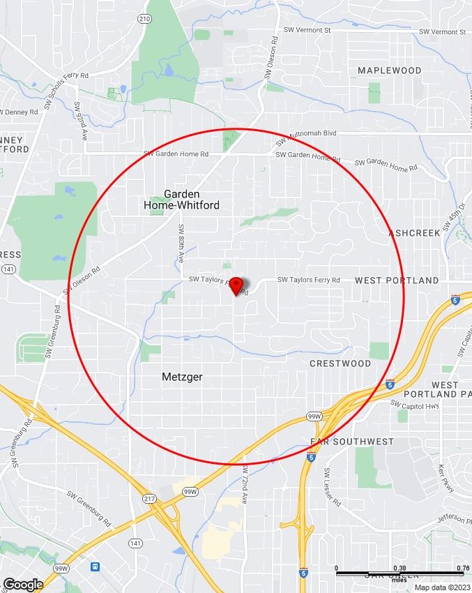
9230 SW 74TH AVE, TIGARD, OR, 97223

Washington County T1S R1W S25
Latitude: 45.453449


Tax Lot ID: R Number: Tax Lot Size:
POLITICAL BOUNDARIES
LAND
600 Northeast Grand Avenue, Portland, OR 97232
503-797-1742
drc@oregonmetro.gov
© Oregon Metro www.oregonmetro.gov/rlis
This Web site is offered as a public service, integrating various government records into a region-wide mapping system. The property assessment records are a multi-county integration of Clackamas, Multnomah and Washington County records. MetroMap blends each county's records into a common database on a quarterly basis. Therefore, to view each county's of�cial records, go to their respective web sites or of�ces. The other MetroMap data are derived from city, county, state, federal and Metro sources. The metadata (data about the data) are included on this site, including the sources to be consulted for veri�cation of the information contained herein. It describes some cases where Metro blends city and county records by generalizing the disparities. Metro assumes no legal responsibility for the compilation of multi-source government information displayed by Metro Map. Users of this information are cautioned to verify all information.
Topography
Water Features
Aerial
Aerial Environmental
Community
Transit
Vacant Land
The information contained is provided by WFG’s Customer Service Department to our customers, and while deemed reliable, is not guaranteed.
INFORMATION
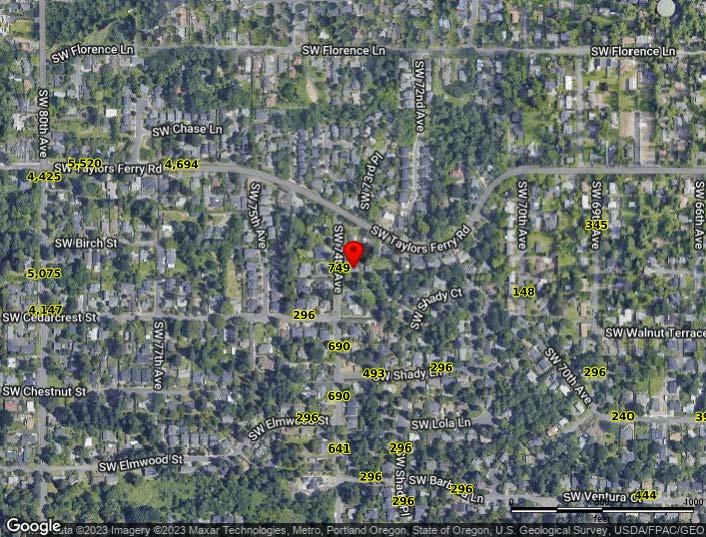
Traffic Counts
The information contained is provided by WFG’s Customer Service Department to our customers, and while deemed reliable, is not guaranteed.

© Claritas, LLC 2022. All rights reserved.
Sitewise Online
Pop-Facts: Demographic Snapshot (Part 1)
Pop-Facts: Demographic Snapshot (Part 2)
Pop-Facts: Demographic Snapshot (Part 2)
9230 SW 74th Ave, Tigard, OR 97223
Sitewise Online
Pop-Facts: Demographic Snapshot (Part 2)
Pop-Facts: Demographic Snapshot (Part 2)
Copyright © Claritas, LLC 2022. All rights reserved.
* This row intentionally left blank. No Total Category.
**1939 will appear when at least half of the Housing Units in this reports area were built in 1939 or earlier.
9230 SW 74th Ave, Tigard, OR 97223 0 - 1 mi
9230 SW 74th Ave, Tigard, OR 97223
Sitewise Online
Pop-Facts: Census Demographic Overview (Part 1)
Pop-Facts: Census Demographic Overview (Part 1)
9230
Copyright © Claritas, LLC 2022. All rights reserved.
9230 SW 74th Ave, Tigard, OR 97223
9230 SW 74th Ave, Tigard, OR 97223
 Powered by Sitewise
Data Source: Kalibrate TrafficMetrix
Powered by Sitewise
Data Source: Kalibrate TrafficMetrix