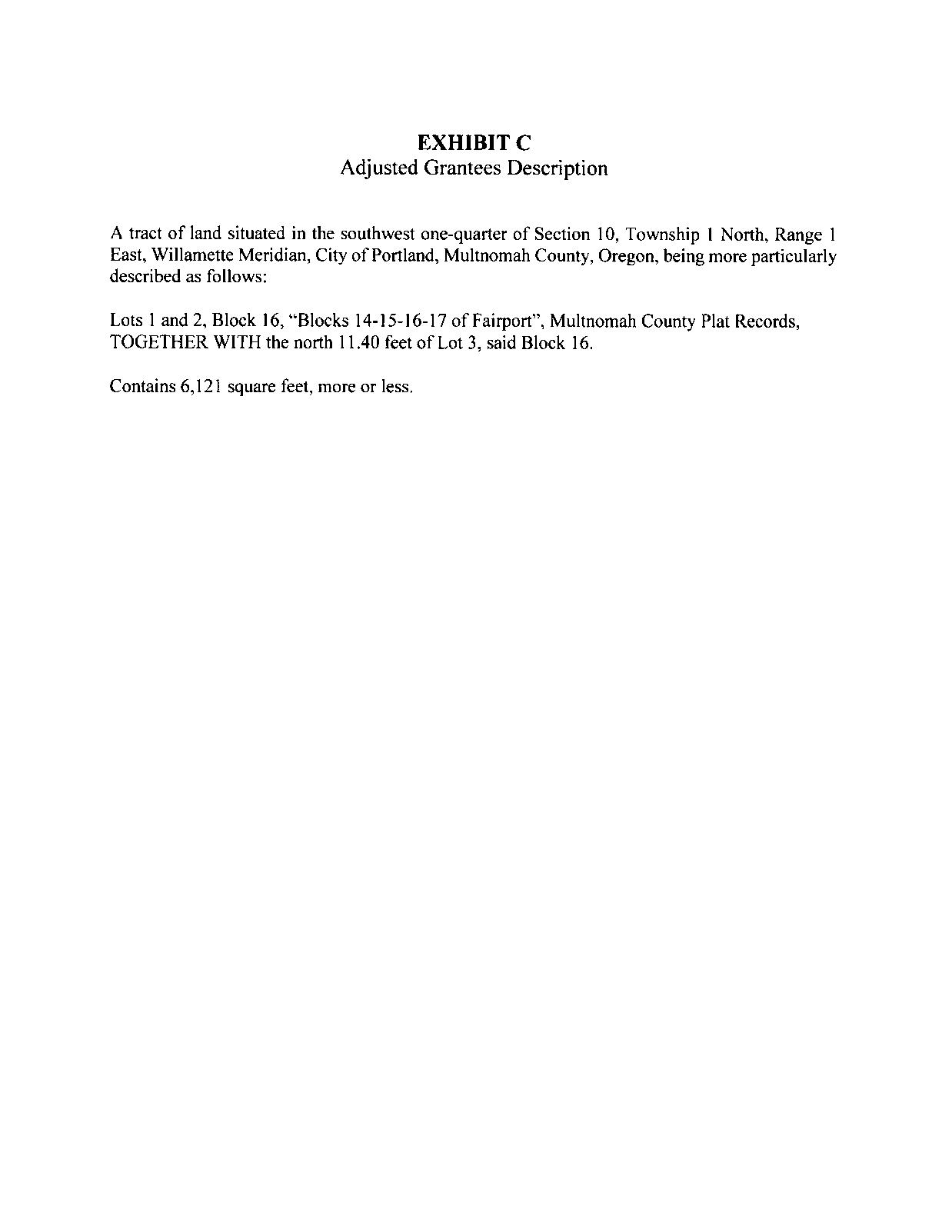
PROPERTY ADDRESS

8106 N Interstate Avenue, Portland, OR 97217
Prepared For: Mike Nuss, Rarebird
8106 N Interstate Avenue, Portland, OR 97217
Prepared For: Mike Nuss, Rarebird
Property Details
Utilities (Water & Sewer)

Zoning
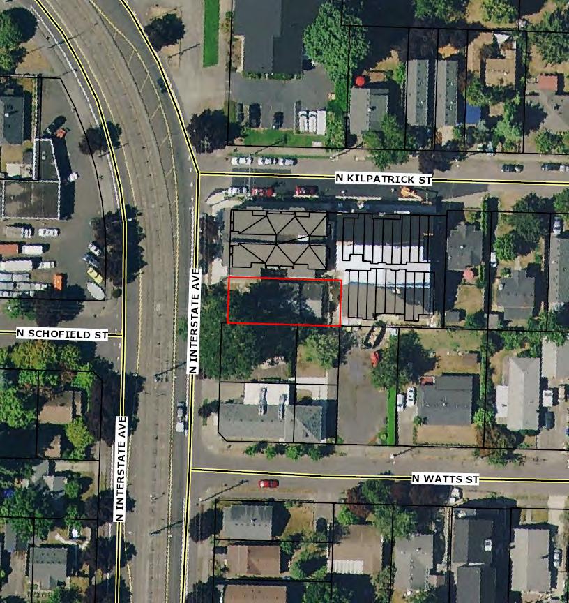
Custom Maps
Miscellaneous Items
-Market Trend Report
-Demographics
-Traffic Counts
Property Tax Information
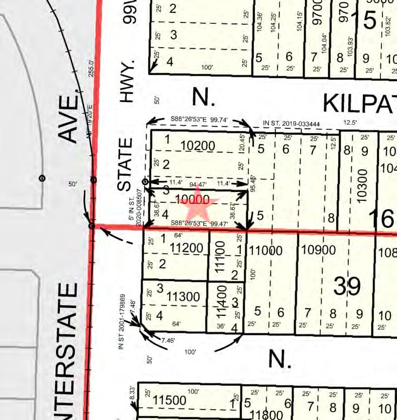
Assessors Tax Map
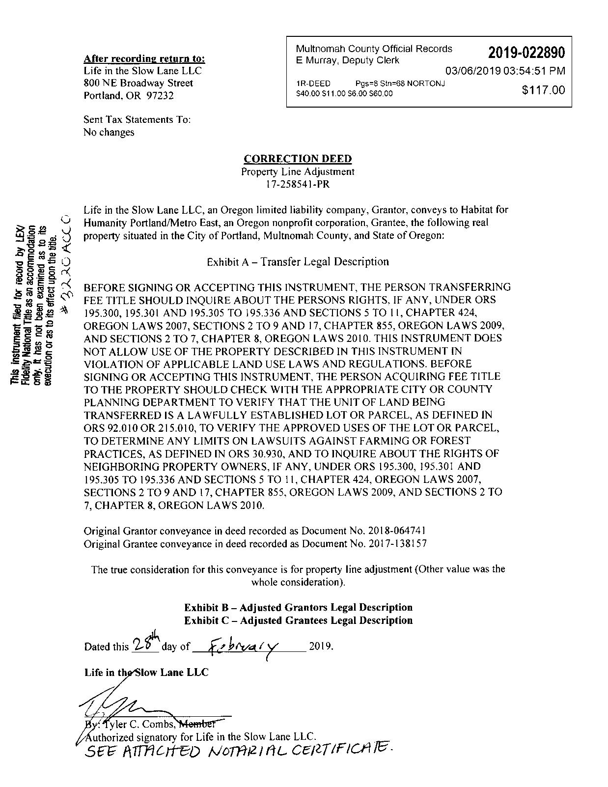
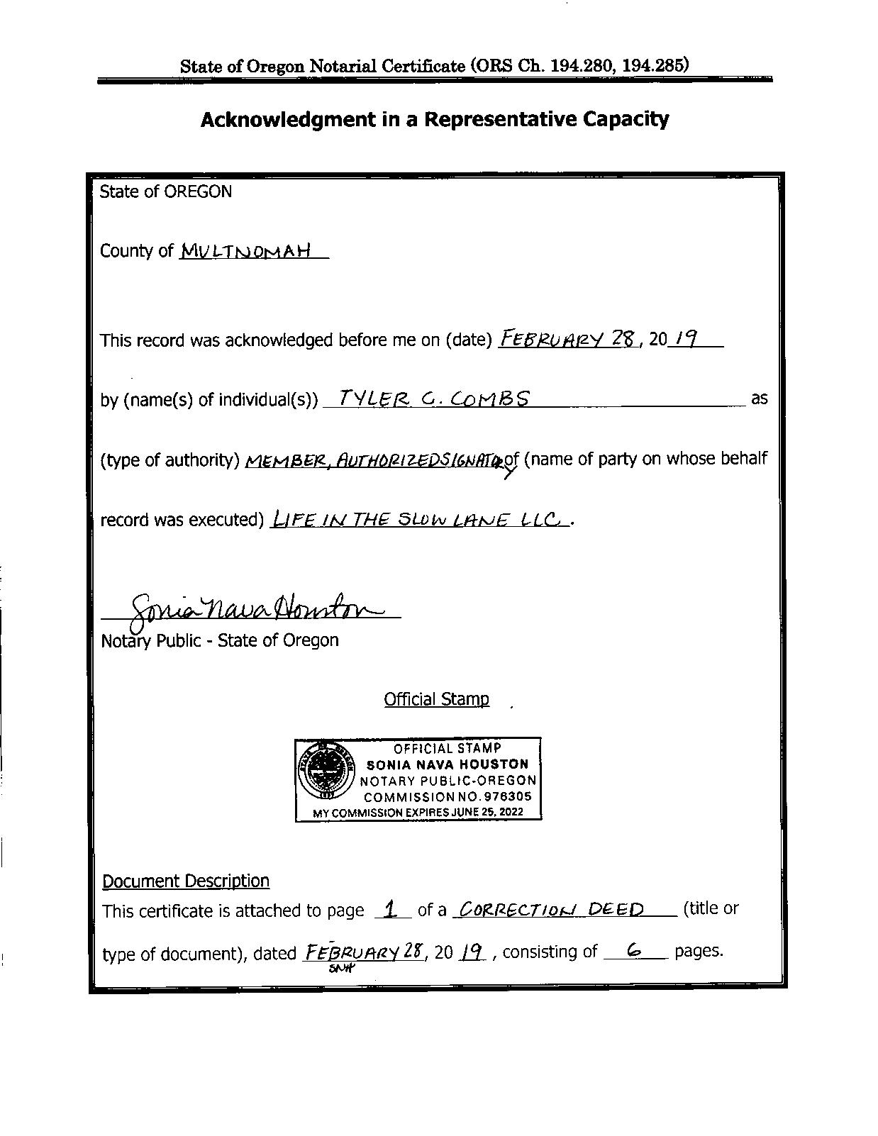
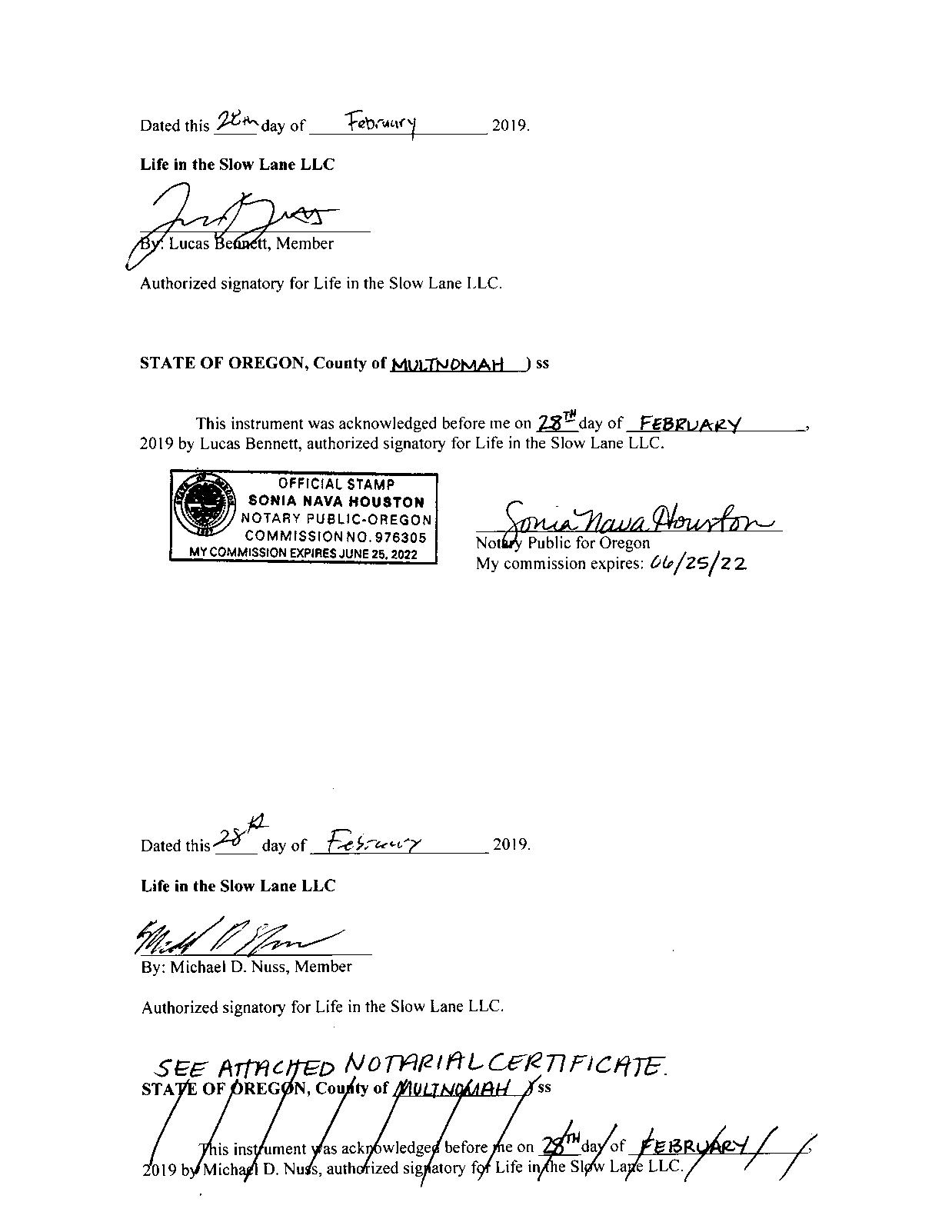
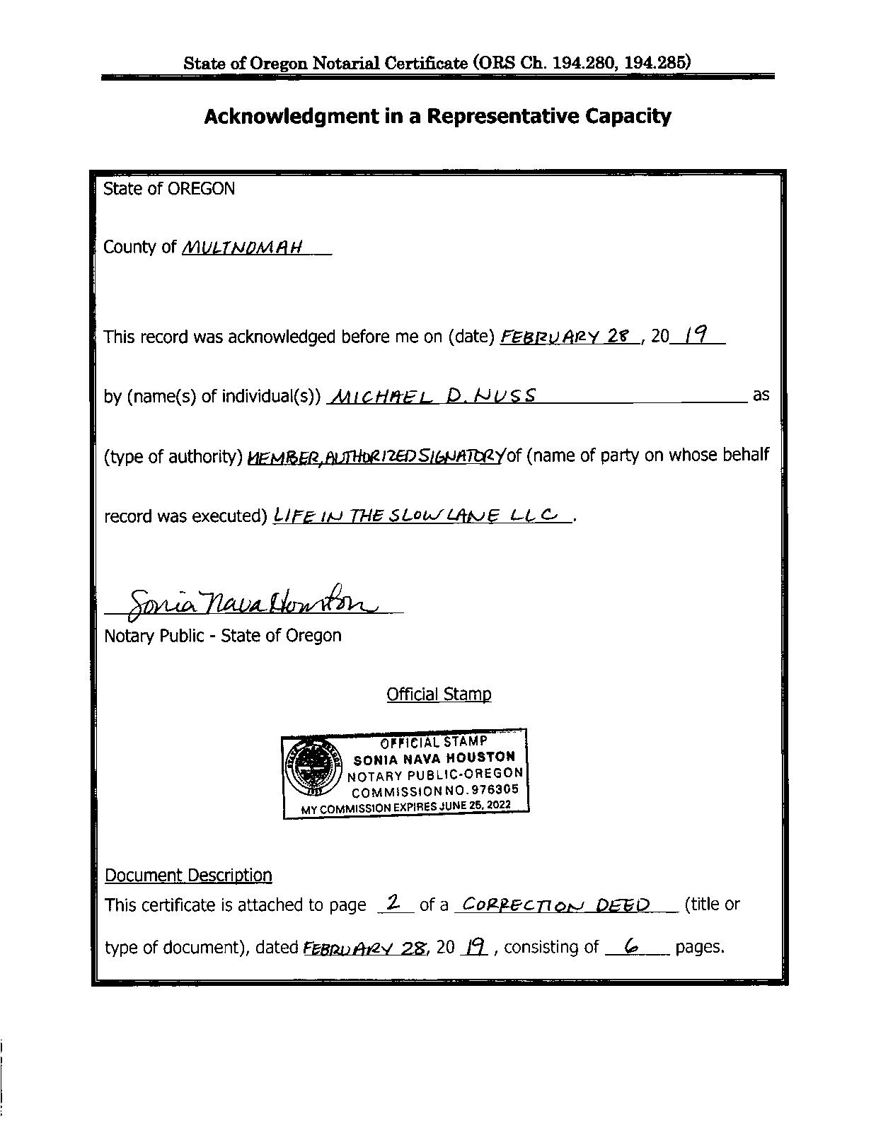
Vesting Deed
Owner:LifeInTheSlowLaneLLC
Site:8106NInterstateAvePortlandOR97217

Mail:800NEBroadwayPortlandOR97232
SentryDynamics,Inc.anditscustomersmakenorepresentation,warrantiesorconditions,expressorimplied, astotheaccuracyorcompletenessofinformationcontainedinthisreport.
ParcelID:R160069
SiteAddress:8106NInterstateAve
SentryDynamics,Inc.anditscustomersmakenorepresentations, warrantiesorconditions,expressorimplied,astotheaccuracyor completenessofinformationcontainedinthisreport.
SentryDynamics,Inc.anditscustomersmakenorepresentations, warrantiesorconditions,expressorimplied,astotheaccuracyor completenessofinformationcontainedinthisreport.


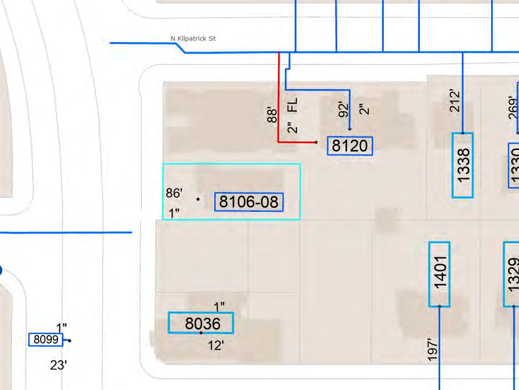
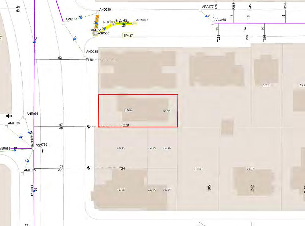
Water As-Built Maps
City of Portland
Sewer As-Built Maps
City of Portland

Detailed Zoning Information
CM3 (Commercial Mixed Use 3)
Overlay d (Design)
Overlay h (Aircraft Landing)
Overlay m (Centers Main Street)
Zoning Map
Community Jurisdiction
Commercial/Mixed Use Zones 3/1/22
Supplemental Information
Map 130-1 Civic Corridors with Required Setbacks
Map 130-2 Pattern Areas
Map 130-3 Civic and Neighborhood Corridors
33.130.010
The commercial/mixed use zones are intended for commercial and mixed use areas of the City as designated on the Comprehensive Plan map. These zones implement the vision, guiding principles, and goals and policies of the Comprehensive Plan, and encourage economic prosperity, human health, environmental health, equity, and resilience. These zones are primarily distinguished by the uses allowed and the intensity of development allowed. The zones allow a mix of commercial activities, housing, and employment uses that reflect the different types of centers and corridors described in the Urban Design chapter of the Comprehensive Plan, and also accommodate smaller, dispersed commercial and mixed use areas to provide opportunities for services in areas between the centers and corridors.
The commercial/mixed use zones are intended to serve local neighborhood areas, larger districts, as well as broader citywide or regional markets. The regulations promote uses and development that support healthy complete neighborhoods—places where people of all ages and abilities have safe and convenient access to the goods and services they need in their daily life, and where people have the opportunity to live active lifestyles. The zones encourage quality and innovative design, and facilitate creation of great places and great streets.
The development standards are designed to allow development flexibility, within parameters, that supports the intended characteristics of the specific zone. In addition, the regulations provide guidance to property owners, developers, and neighbors about the limits of what is allowed.
The full and short names of the commercial/mixed use zones and their map symbols are listed below. When this Title refers to the commercial/mixed use zones, it is referring to the zones listed here.
A. Commercial Residential zone. The Commercial Residential (CR) zone is a low-intensity zone for small and isolated sites in residential neighborhoods. The zone is intended to be applied in limited situations on local streets and neighborhood collectors in areas that are predominately zoned single-dwelling residential. The zone encourages the provision of small scale retail and service uses for surrounding residential areas. Uses are restricted in size to promote a local orientation, and to limit adverse impacts on surrounding residential areas. Where commercial uses are not present, residential density is limited to provide
compatibility with surrounding residential areas. Development is intended to be pedestrian-oriented and building height is intended to be compatible with the scale of surrounding residentially zoned areas.
B. Commercial/Mixed Use 1 zone. The Commercial/Mixed Use 1 (CM1) zone is a small-scale zone intended for sites in dispersed mixed use nodes within lower density residential areas, as well as on neighborhood corridors and at the edges of neighborhood centers, town centers and regional centers. The zone is also appropriate in core commercial areas of centers in locations where older commercial storefront buildings of 1 to 2 stories are predominant. This zone allows a mix of commercial and residential uses. The size of commercial uses is limited to minimize impacts on surrounding residential areas. Buildings in this zone will generally be up to three stories tall. Development is intended to be pedestrian-oriented and compatible with the scale and characteristics of adjacent residentially zoned areas or low-rise commercial areas.
C. Commercial/Mixed Use 2 zone. The Commercial/Mixed Use 2 (CM2) zone is a mediumscale zone intended for sites in a variety of centers, along corridors, and in other mixed use areas that have frequent transit service. The zone allows a wide range and mix of commercial and residential uses, as well as employment uses that have limited off-site impacts. Buildings in this zone will generally be up to four stories tall unless height and floor area bonuses are used, or plan district provisions specify other height limits. Development is intended to be pedestrian-oriented, provide a strong relationship between buildings and sidewalks, and complement the scale of surrounding residentially zoned areas.
D. Commercial/Mixed Use 3 zone. The Commercial/Mixed Use 3 (CM3) zone is a large-scale zone intended for sites in high-capacity transit station areas, in town centers, along streetcar alignments, along civic corridors, and in locations close to the Central City. It is intended to be an intensely urban zone and is not appropriate for sites where adjacent properties have single-dwelling residential zoning. The zone allows a wide range and mix of commercial and residential uses, as well as employment uses that have limited off-site impacts. Buildings in this zone will generally be up to six stories tall unless height and floor area bonuses are used, or plan district provisions specify other height limits. Development is intended to be pedestrian-oriented, with buildings that contribute to an urban environment with a strong street edge of buildings. The scale of development is intended to be larger than what is allowed in lower intensity commercial/mixed use and residential zones. The Design overlay zone is applied to this zone.
E. Commercial Employment zone. The Commercial Employment (CE) zone is a medium-scale zone intended for sites along corridors with a Neighborhood Collector or higher traffic classification, especially along civic corridors that are also Major Truck Streets or Priority Truck Streets. This zone is generally not appropriate in designated centers, except on a site that is currently developed in an auto-oriented manner and where more urban development is not yet economically feasible. The zone allows a mix of commercial uses, including auto-accommodating development and drive-through facilities, as well as some light manufacturing and distribution uses that have few off-site impacts. The emphasis of this zone is on commercial and employment uses, but residential uses are also allowed. Buildings in this zone will generally be up to four stories tall. This zone is intended to allow
for development with auto-accommodating configurations, while also including pedestrianoriented design features that support transit and pedestrian access.
F. Central Commercial zone. The Central Commercial (CX) zone is intended to provide for commercial and mixed use development within Portland's most urban and intense areas, specifically the Central City and the Gateway Regional Center. A broad range of uses are allowed to reflect Portland's role as a commercial, cultural, residential, and governmental center. Development is intended to be very intense with high building coverage, large buildings, and buildings placed close together. Development is intended to be pedestrianoriented with a strong emphasis on a safe and attractive streetscape. The Design overlay zone is applied to this zone.
The regulations in this chapter state the allowed uses and the development standards for the base zones. Sites with overlay zones, plan districts, or designated historical landmarks are subject to additional regulations. The Official Zoning Maps indicate which sites are subject to the additional regulations. Specific uses or development types may also be subject to regulations in the 200s series of chapters.
33.130.050 Neighborhood Contact
Neighborhood contact is a set of outreach steps that must be taken before certain developments can be submitted for approval. Neighborhood contact is required as follows:
A. Neighborhood contact I.
1. Neighborhood contact I requirements. When proposed development will add at least 10,000 square feet and not more than 25,000 square feet of net building area to a site, the neighborhood contact steps of 33.705.020.A., Neighborhood contact I, are required. All the steps in 33.705.020.A. must be completed before an application for a building permit can be submitted.
2. Exemption. If the proposed development has already met the neighborhood contact requirements as part of a land use review process, it is exempt from the neighborhood contact requirements.
1. Neighborhood contact II requirements. When the proposed development will add more than 25,000 square feet of net building area to a site, the neighborhood contact steps of 33.705.020.B., Neighborhood contact II, are required. All of the steps in 33.705.020.B. must be completed before an application for a building permit can be submitted
2. Exemption. If the proposed development has already met the neighborhood contact requirements as part of a land use review process, it is exempt from the neighborhood contact requirements.
A. Allowed uses. Uses allowed in the commercial/mixed use zones are listed in Table 130-1 with a "Y". These uses are allowed if they comply with the development standards and other regulations of this Title. Being listed as an allowed use does not mean that a proposed development will be granted an adjustment or other exception to the regulations of this Title. In addition, a use or development listed in the 200s series of chapters is also subject to the regulations of those chapters.
B. Limited uses. Uses allowed that are subject to limitations are listed in Table 130-1 with an "L". These uses are allowed if they comply with the limitations listed below and the development standards and other regulations of this Title. In addition, a use or development listed in the 200s series of chapters is also subject to the regulations of those chapters. The paragraphs listed below contain the limitations and correspond with the footnote numbers from Table 130-1.
1. Commercial limitations. These regulations apply to all parts of Table 130-1 that have a [1].
a. In the CR and CM1 zones, each individual Retail Sales and Service and Office use is limited to 5,000 square feet of net building area, except that in the CM1 zone on sites that are over 40,000 square feet in size and are located on a Neighborhood Collector or higher classification traffic street, each individual Retail Sales and Service or Office use is limited to 40,000 square feet of net building area; and
b. In the CR zone, in addition to the size limitation specified in Subparagraph B.2.a., the hours when Retail Sales And Service uses can be open to the public are limited to 6:00 AM to 11:00 PM.
c. In the CM1, CM2, and CM3 zones, Quick Vehicle Servicing uses that existed on May 24, 2018 are allowed. New Quick Vehicle Servicing uses are prohibited. If a Quick Vehicle Servicing use that existed on May 24, 2018 is discontinued for 3 continuous years, reestablishment of the use is prohibited. If the Quick Vehicle Servicing use ceases operations, even if the structure or materials related to the use remain, the use as been discontinued. If the Quick Vehicle Servicing use changes to another use without obtaining all building, land use, and development permits that would have been required at the time of the change, the use has been discontinued.
2. Industrial use and size limitations. These regulations apply to all parts of Table 130-1 that have a [2]. Utility Scale Energy Production and Industrial Service are conditional uses. All other industrial uses are allowed, and all industrial uses, including Utility Scale Energy Production and Industrial Service, are limited in size as follows. Amounts in excess of the limits are prohibited:
a. In the CM1 zone, each individual Industrial use is limited to 5,000 square feet of net building area;
b. In the CM2 and CX zones, each individual Industrial use is limited to 15,000 square feet of net building area;
c. In the CM3 zone, the total net building area of all Industrial uses on the site may not exceed the total square footage of the site; and
d. In the CE zone, each individual Industrial use is limited to 40,000 square feet of net building area.
3. Self-Service Storage limitation. This regulation applies to all parts of Table 130-1 that have a [3]. The limitations are stated with the special regulations for these uses in Chapter 33.284, Self-Service Storage.
4. Exterior development limitation. This regulation applies to all parts of Table 130-1 that have a [4]. Exterior display or storage of industrial equipment, such as tools, equipment, vehicles, products, materials, or other objects that are part of or used for the business operation is prohibited.
5. Community Services. This regulation applies to all parts of Table 130-1 that have a [5]. Most Community Service uses are allowed by right. Short term, mass, and outdoor shelters may be allowed by right if they meet certain standards, or may be a conditional use. See Chapter 33.285, Short Term, Mass, and Outdoor Shelters.
6. Radio Frequency Transmission Facilities. This regulation applies to all parts of Table 130-1 that have a [6]. Some Radio Frequency Transmission Facilities are allowed by right. See Chapter 33.274.
7. Basic Utilities. This regulation applies to all parts of Table 130-1 that have an [7].
a. Public safety facilities that include Radio Frequency Transmission Facilities are a conditional use. The approval criteria are in Section 33.815.223.
b. Small Scale Energy Production that provides energy for on-site or off-site use are considered accessory to the primary use on the site. However, it is only considered accessory if they generate energy from biological materials or byproducts from the site itself, or conditions on the site itself; plus not more than 10 tons per week of biological material or byproducts from other sites. Installations that sell power they generate — at retail (net metered) or wholesale — are included.
c. All other Basic Utilities are allowed.
8. Commercial Parking. This regulation applies to all parts of Table 130-1 that have a [8]. Commercial Parking is a conditional use in the CX zone except when superseded by plan district regulations. In the CM2 and CM3 zones, Commercial Parking is allowed as follows:
a. Commercial Parking is allowed by right in structured parking.
b. Commercial Parking is allowed by right on a surface parking lot legally constructed on or before May 24, 2018.
c. Commercial Parking is allowed by right on a surface parking lot legally constructed after May 24, 2018 when all of the following are met:
(1) The surface parking lot was constructed as accessory parking for other primary uses on the site;
(2) The total number of parking spaces on the site does not exceed the maximum number of parking spaces allowed for the other primary uses on the site; and
(3) Only non-required parking spaces are used as Commercial Parking.
9. Agriculture in the CR and CM1 zones. This regulation applies to all parts of Table 130-1 that have a [9]. If the use and site do not meet the regulations of Chapter 33.237, Food Production and Distribution, Agriculture is prohibited.
10. Agriculture in the CM2 and CX zones. This regulation applies to all parts of Table 130-1 that have an [10]. Agriculture is a conditional use. Where the use and site meet the regulations of Chapter 33.237, Food Production and Distribution, the applicant may choose whether it is allowed as a Market Garden, which does not require a conditional use.
11. Agriculture in the CM3 and CE zones. This regulation applies to all parts of Table 130-1 that have a [11]. Agriculture that is outdoors is a conditional use. Agriculture that is entirely indoors is allowed up to the following limits. Indoor Agriculture in excess of the following limits is prohibited. Where the use and site meet the regulations of Chapter 33.237, Food Production and Distribution, the applicant may choose whether it is allowed as a Market Garden, which does not require a conditional use:
a. In the CM3 zone, the total net building area of all indoor Agriculture per site may not exceed the total square footage of the site; and
b. In the CE zone, each indoor Agriculture use is limited to 40,000 square feet of net building area.
C. Conditional uses. Uses that are allowed if approved through the conditional use review process are listed in Table 130-1 with a "CU". These uses are allowed provided they comply with the conditional use approval criteria for that use, the development standards, and other regulations of this Title. Uses listed with a "CU" that also have a footnote number in the table are subject to the regulations cited in the footnote. In addition, a use or development listed in the 200s series of chapters is also subject to the regulations of those chapters. The conditional use review process and approval criteria are stated in Chapter 33.815, Conditional Uses.
D. Prohibited uses. Uses listed in Table 130-1 with an "N" are prohibited. Existing uses in categories listed as prohibited may be subject to the regulations of Chapter 33.258, Nonconforming Uses and Development.
Uses that are accessory to a primary use are allowed if they comply with specific regulations for the accessory uses and all development standards.
Chapter 33.130
Title 33, Planning and Zoning
Commercial/Mixed Use Zones 3/1/22
A. Off-site impacts. All nonresidential uses including their accessory uses must comply with the standards of Chapter 33.262, Off-Site Impacts.
B. Other nuisances. Other nuisances are regulated by Title 29, Property and Maintenance Regulations.
Table 130-1
Y = Yes, Allowed
CU = Conditional Use Review Required
Notes:
• The use categories are described in Chapter 33.920.
L = Allowed, But Special Limitations
N = No, Prohibited
• Regulations that correspond to the bracketed numbers [ ] are stated in 33.130.100.B.
• Specific uses and developments may also be subject to regulations in the 200s series of chapters.
33.130.200 Lot Size
There is no required minimum lot size for development of land in commercial/mixed use zones. Creation of new lots is subject to the regulations of Chapter 33.613, Lots in Commercial/Mixed Use Zones.
A. Purpose. Floor area ratios (FARs) regulate the amount of use (the intensity) allowed on a site. FARs provide a means to match the potential amount of uses with the desired character of the area and the provision of public services. FARs also work with the height, setback, and building coverage standards to control the overall bulk of development. The bonus FAR options allow additional floor area as an incentive for providing affordable housing.
B. FAR standard. The maximum floor area ratios are stated in Table 130-2 and apply to all uses and development. Additional floor area may be allowed through bonus options, as described in Section 33.130.212, or transferred from historic resources per Subsection C. Adjustments to the maximum floor area ratios are prohibited. Except in the CR zone, floor area does not include the following:
1. Floor area for structured parking and required long-term bicycle parking not located in a dwelling unit, up to a maximum FAR of 0.5 to 1; and
2. Floor area for indoor common area used to meet the requirements of Section 33.130.228.
C. Transfer of floor area from historic resources. Floor area ratios may be transferred from a site that contains a historic resource as follows:
1. Sending sites. FAR may be transferred from a site that contains a Historic or Conservation Landmark or a contributing resource in a Historic or Conservation District. Sites that are eligible to send floor area through this transfer are allowed to transfer:
a. Unused FAR up to the maximum FAR allowed by the zone; and
b. An additional amount equivalent to 50 percent of the maximum FAR for the zone. To qualify to transfer this additional amount of FAR, the Bureau of Development of Services must verify that the landmark or contributing resource on the site meets one of the following:
(1) If the building is classified as Risk category I or II, as defined in the Oregon Structural Specialty Code, it has been shown to meet or exceed the American Society of Civil Engineers (ASCE) 41- BPOE improvement standard as defined in City of Portland Title 24.85;
(2) If the building is classified as Risk category III or IV, as defined in the Oregon Structural Specialty Code, it has been shown to meet or exceed the ASCE41BPON improvement standard as defined in City of Portland Title 24.85; or
(3) The owner of the landmark or contributing resource has entered into a phased seismic agreement with the City of Portland as described in Section 24.85.
2. Receiving site. The transfer must be to a site that is zoned CM1, CM2, CM3, CE, CX, RM1, RM2, RM3, RM4, or RX outside of the Central City plan district. Transferring to a site that is zoned CR is prohibited. Transferring to a site where a Historic or Conservation Landmark or a contributing structure in a Historic or Conservation District has been demolished within the past ten years is prohibited unless the landmark or contributing structure was destroyed by fire or other causes beyond the control of the owner, the only structure on the site that was demolished was an accessory structure, or the demolition was approved through demolition review.
3. Maximum increase in FAR in the CM1, CM2, CM3, and CE zones. In the CM1, CM2, CM3, and CE zones, the total FAR on the receiving site may not exceed the maximum FAR with bonuses identified on Table 130-3. This total FAR includes FAR transferred from historic resources, and any additional FAR allowed at the receiving site from bonus options, or from other transfers. In addition, an increase on the receiving site of more than the following due to a historic resource transfer is prohibited:
a. 0.5 to 1 in the CM1 zone;
b. 0.75 to 1 in the CM2 zone;
c. 1 to 1 in the CM3 zone;
d. 0.5 to 1 in the CE zone.
4. Maximum increase in FAR in the CX zone. In the CX zone, an increase in FAR on the receiving site of more than 3 to 1 is prohibited. The total increased FAR includes FAR
transferred from historic resources, and additional FAR allowed at the receiving site from bonus provisions, or from other transfers;
5. Development standards. The building on the receiving site must meet the development standards of the base zone, overlay zone, and plan district except floor area ratio, which is regulated by Paragraphs C.2 and C.3 above;
6. The property owner must execute a covenant with the City that is attached to and recorded with the deed of both the site transferring and the site receiving the density. The covenant must reflect the respective increase and decrease of potential FAR. The covenants for both sites must meet the requirements of Section 33.700.060, Covenants with the City.
A. Purpose. The minimum density standards ensure that the service capacity is not wasted and that the City's housing goals are met.
B. Minimum Density. The minimum density requirements for the CM2 and CM3 zones are stated in Table 130-2. Minimum density applies to new development when at least one dwelling unit is proposed. Group Living uses are exempt from minimum density requirements. Land within an Environmental zone may be subtracted from the calculation of minimum density.
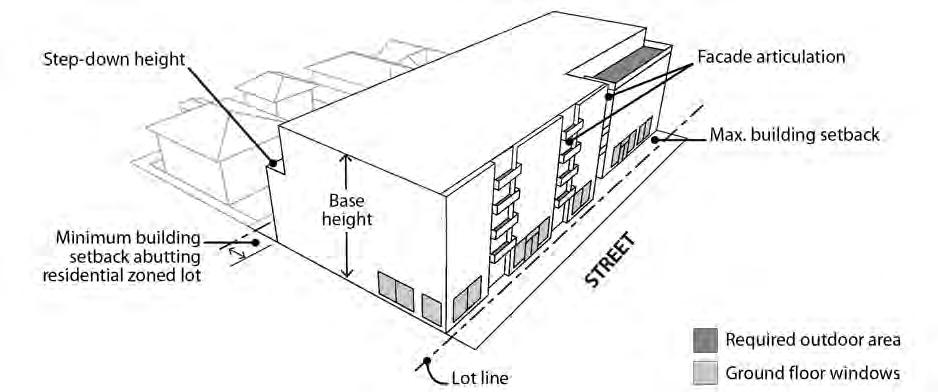
A. Purpose. The height limits are intended to control the overall scale of buildings. The height limits in the CR and CM1 zones allow buildings that are in scale with low rise residential areas. The height limits in the CM2 and CE zones allow for a greater building height at a scale that can accommodate the growth intended for centers and corridors, while relating to the low- to mid-rise scale of neighborhood residential areas. The CM3 zone allows the tallest buildings outside the Central City and Gateway plan districts, consistent with its intended role in accommodating higher-density development in areas well served by transit and other services. The CX zone allows the tallest buildings in the commercial/mixed use zones, consistent with its intended role in accommodating high-density development in the Central City and the Gateway plan districts.
In some situations, step downs in maximum height provide a transition in scale to adjacent lower-scale residential areas, and preserve opportunities for light, air and privacy. Exceptions to height limit standards accommodate minor projections that do not significantly increase the visual scale of buildings; provide flexibility in the height of parapets and railings to facilitate rooftop outdoor spaces and equipment screening; and accommodate ground-floor spaces with high ceilings to encourage ground-floor commercial uses, mechanical parking, and other uses that benefit from high ceilings.
B. Height standard.
1. Base height. The base height standards for all structures, except detached accessory structures, are stated in Table 130-2. The height standards for detached accessory structures are stated in 33.130.265, Detached Accessory Structures.
2. Step-down height. In the following situations, the base height is reduced, or steppeddown. Stepped-down height is not required in the CR zone:
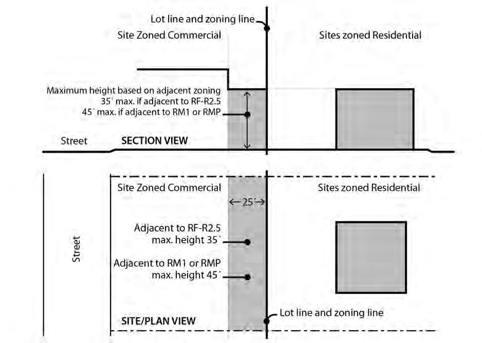
a. Step-down adjacent to residential zones. The following step-down height limits apply within 25 feet of sites zoned residential. Sites with property lines that abut residential zones for less than a 5-foot length are exempt from these standards:
(1) On the portion of the site within 25 feet of a site zoned RF through R2.5, the step-down height limit is 35 feet. See Figure 130-1.
(2) On the portion of the site within 25 feet of a site zoned RM1 or RMP, the step-down height limit is 45 feet. See Figure 130-1.
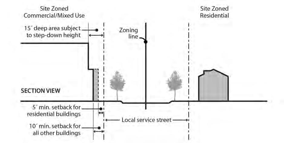
b. Step-down across a local service street or alley from a residential zone. In the CM2, CM3, CX, and CE zones the following step-down height limit applies. The limit does not apply to portions of buildings within 100 feet of a transit street On the portion of the site within 15 feet of a lot line that is across a local service street or alley from a site zoned RF through R2.5 or RM1 or RMP, the step-down height limit is 45 feet. See Figure 130-2.
3. Bonus height. The base height limits can be increased through options described in Section 33.130.212. When a bonus option allowed by 33.130.212 is used to increase the base height, the step-down height limits do not increase.
C. Exceptions. Exceptions to the base height, step-down height, and bonus height limits are stated below:
1. Projections allowed. Chimneys, vents, flag poles, satellite receiving dishes, and other similar items that are attached to a building and have a width, depth, or diameter of 5 feet or less may extend 10 feet above the height limits, or 5 feet above the highest point of the roof, whichever is greater. Items that are greater than 5 feet in width, depth, or diameter are not allowed to project above the base, step-down, or bonus height limits.
2. Parapets and railings. In the CM1, CM2, CM3, CE and CX zones, parapets and rooftop railings may extend 4 feet above the height limits.
3. Walls and fences. In the CM1, CM2, CM3, CE and CX zones, walls or fences located between individual rooftop decks may extend 6 feet above the height limits if the visual screen is set back at least 4 feet from the edges of the roof.
4. Rooftop equipment. In the CM1, CM2, CM3, CE and CX zones, rooftop mechanical equipment and stairwell enclosures that provide rooftop access may extend above the height limits as follows, provided that the equipment and enclosures are set back at least 15 feet from all roof edges on street facing facades:
a. Elevator mechanical equipment and stairwell enclosures may extend up to 16 feet above the height limits; and
b. Other mechanical equipment that cumulatively cover no more than 10 percent of the roof area may extend up to 10 feet above the height limits.
5. Antennas and mounting devices, utility power poles, and public safety facilities are exempt from the height limits.
6. Small wind turbines are subject to the standards of Chapter 33.299.
7. Roof mounted solar panels are not included in height calculations and may exceed the maximum height limits if the following are met:
a. For flat roofs or the horizontal portion of mansard roofs, the solar panel may extend up to 5 feet above the top of the highest point of the roof; and
b. For pitched, shed, hipped, or gambrel roofs, the solar panel must be mounted no more than 12 inches from the surface of the roof at any point, and may not extend above the ridgeline of the roof. The 12 inches is measured from the upper side of the solar panel.
8. High ceilings. In the CM1, CM2, CM3, CE and CX zones outside the Central City plan district, base height, step-down height, and bonus height may be increased by 5 feet when at least 75 percent of the ground floor has at least 15 feet between the floor and the bottom of the structure above. The bottom of the structure above includes supporting beams.
A. Purpose. The bonus options allow additional floor area and an increase in height as an incentive for development that provides a public or community benefit. The bonus can be gained in exchange for providing affordable housing or affordable commercial space in conjunction with new development.
B. General floor area and height bonus option regulations.
1. Unless specified below, the bonus options in this section are allowed only in the CM1, CM2, CM3, and CE zones, and in the CX zone outside the Central City and Gateway plan districts. Sites where a Historic or Conservation Landmark or a contributing structure in a Historic or Conservation District has been demolished within the past ten years are not eligible to use bonus options unless the landmark or contributing structure was destroyed by fire or other causes beyond the control of the owner, the only structure on the site that was demolished was an accessory structure, or the demolition was approved through demolition review.
2. The bonus options refer to an administrative agency or qualified administrator. The administrative and reporting requirements of each bonus must be met to the satisfaction of the named agency or administrator. The named agencies are authorized to publish administrative rules with clear and objective administrative requirements.
3. More than one bonus option may be used up to the overall maximums per site stated in Table 130-3. For development without any residential use, and for mixed use development that proposes fewer than 20 dwelling units and does not voluntarily provide units on the site per the standards of 33.245.040.A, the affordable commercial space bonus option must be used up to the maximum increment allowed for the zone before any other bonus is allowed. Adjustments to the maximum FAR and height obtainable through bonuses are prohibited.
4. The increment of additional floor area ratio allowed per bonus is stated in Table 130-3 and described in Subsections C though E.
5. The increment of additional height allowed per bonus is stated in Table 130-3, except as follows:
a. Additional height is not allowed where the step-down height limits of 33.130.210.B.2 apply.
b. In the CM2 zone, increasing maximum height through a bonus is allowed only on sites that:
(1) Are within the Design Overlay Zone; and
(2) Have a Comprehensive Plan Map designation of Mixed Use – Urban Center or Mixed Use – Civic Corridor.
[1] Bonus height in the CM2 zone is only allowed on sites that are within a Historic District, Conservation District, or the Design Overlay Zone and that have a Comprehensive Plan Map designation of Mixed Use–Urban Center or Mixed Use–Civic Corridor. Bonus height on a site where a Historic or Conservation Landmark or a contributing structure in a Historic or Conservation District has been demolished within the past ten years is prohibited unless the landmark or contributing structure was destroyed by fire or other causes beyond the control of the owner or the only structure on the site that was demolished was an accessory structure.
[2] This larger overall maximum is only allowed through the Planned Development bonus option and required Planned Development Review.
C. Inclusionary housing bonus. Maximum height and FAR may be increased as stated in Table 130-3 if one of the following is met:
1. Mandatory inclusionary housing. Bonus height and FAR is allowed for development that triggers 33.245, Inclusionary Housing. The amount of bonus floor area allowed is an amount equal to the net building area of the building that triggers 33.245, up to the increment of additional FAR allowed as stated in Table 130-3. To qualify for this bonus, the applicant must provide a letter from the Portland Housing Bureau certifying that the regulations of 33.245 have been met; or
2. Voluntary inclusionary housing. Maximum height and FAR may be increased as stated in Table 130-3 when one of the following voluntary bonus options is met:
a. Bonus height and FAR is allowed for projects that voluntarily comply with the standards of 33.245.040 and 33.245.050. The amount of bonus floor area allowed is an amount equal to the net building area of the building that complies with 33.245.040 and .050, up to the increment of additional FAR allowed as stated in Table 130-3. To qualify for this bonus, the applicant must provide a letter from the Portland Housing Bureau certifying that the regulations of 33.245 have been met. The letter is required to be submitted before a building permit can be issued for development, but is not required in order to apply for a land use review; or
b. Bonus height and FAR is allowed in exchange for payment into the Affordable Housing Fund. For each square foot of floor area purchased a fee must be paid to the Portland Housing Bureau (PHB). The Portland Housing Bureau collects and administers the Affordable Housing Fund, and determines the fee. PHB determines the fee per square foot and updates the fee at least every three years. The fee schedule is available from the Bureau of Development Services. To qualify for this bonus, the applicant must provide a letter from PHB documenting the amount that has been contributed. The letter is required to be submitted before a building permit can be issued for development, but is not required in order to apply for a land use review.
D. Affordable commercial space bonus. Proposals that provide on-site affordable commercial space, or pay into the Affordable Commercial Space Fund, may increase maximum height and FAR if all of the following are met. Floor area may be increased by 2 square feet for each square foot of on-site affordable commercial space provided, up to the maximum stated in Table 130-3 Floor area may be increased by 1 square foot for each square foot purchased through the Affordable Commercial Space Fund, up to the maximum stated in Table 130-3:
1. The applicant must submit with the development application a letter from the Portland Development Commission certifying that any program administrative requirements have been met; and
2. The property owner must execute a covenant with the City that complies with the requirements of Section 33.700.060. The covenant must ensure that floor area built as a result of this bonus will meet the administrative requirements of the Portland Development Commission or qualified administrator.
E. Planned Development bonus. Proposals that provide a combination of affordable housing, a publicly accessible plaza or park, and energy efficient buildings may increase maximum height and FAR as stated in Table 130-3 if approved through a Planned Development Review and Design Review (see Chapter 33.270 and Chapter 33.854). The site must be at least two acres in size to be eligible for this bonus. Sites located within Historic or Conservation districts are not eligible to use this bonus.
A. Purpose. The required building setbacks promote streetscapes that are consistent with the desired character of the different commercial/mixed use zones. The setbacks promote buildings close to the sidewalk to reinforce a pedestrian orientation and built-up streetscape. The setback requirements for areas that abut residential zones promote commercial/mixed use development that will maintain light, air, and the potential for privacy for adjacent residential zones.
The front setback requirements for Civic Corridors in Eastern and Western pattern areas provide opportunities for additional pedestrian space and separation from the vehicle traffic along these major streets to create an environment for building users and pedestrians that is less impacted by close proximity to traffic, and provide opportunities for front landscaping reflective of the vegetated characteristics of these neighborhood pattern areas.
The minimum building setbacks along local service streets adjacent to residential zones work together with requirements for step downs in building height (33.130.210.B.2.b.) to ensure that there is a transition in street frontage characteristics to lower scale residential zones. In these situations, the building setback regulations promote street frontages with landscaping and residential uses to provide a transition and a cohesive street environment with similar street frontage characteristics on both sides of the street, and limit exterior display and storage to minimize impacts to nearby residentially-zoned areas.
B. Minimum building setbacks. Minimum required building setbacks are listed below and summarized in Table 130-2. Unless otherwise specified in this section, the minimum required setbacks apply to all buildings and structures on a site. Setbacks for exterior development are stated in 33.130.245, and setbacks for parking areas are stated in Chapter 33.266, Parking, Loading and Transportation and Parking Demand Management.
1. Required setbacks from a street lot line. Unless as specified below, there is no minimum required setback from a street lot line:
a. The minimum setback required from a street lot line adjacent to a Civic Corridor shown on Map 130-1 is 10 feet.
b. The following minimum setbacks are required from a street lot line on the portion of the site that is across a local service street from an RF through RM2 or RMP zone. The setbacks do not apply in the CR or CM1 zones, or on or within 100 feet of a transit street:
(1) Buildings that are entirely in a residential use, and portions of buildings with dwelling units on the ground floor, must be set back 5 feet from a street lot line facing an RF through RM2 or RMP zone. The setback must be landscaped to at least the L1 standard. Vehicle access is not allowed through the setback unless the local service street facing the residential zone is the only frontage for the site. Up to one third of the setback area can be hard surfaced for pedestrian or bicycle access. Exterior display and storage is not allowed within the setback.
(2) All other buildings must be set back 10 feet from a street lot line facing an RF through RM2 or RMP zone. The setback must be landscaped to at least the L1 standard. Vehicle access is not allowed through the setback unless the local service street facing the residential zone is the only frontage for the site. Up to one third of the setback area can be hard surfaced for pedestrian or bicycle access. Exterior display and storage is not allowed within the setback. See Figure 130-2.
c. See 33.130.250.D for the required garage entrance setback for a garage that is accessory to a house, attached house, manufactured home, or duplex.
d. Structured parking that does not allow exiting in a forward motion must be set back 18 feet from the street lot line. See 33.266.130.C.
2. Required setbacks from a lot line that is not a street lot line:
a. There is no minimum setback required from a lot line that abuts an OS, RX, C, E or CI zone. And, no setback is required from an internal lot line that is also a zoning line on sites with split zoning.
b. Except as follows, the required minimum setback from a lot line that abuts an RF through RM4, RMP, or IR zone is 10 feet. The required setback area must be landscaped to the L3 standard. Areas paved for pedestrian or bicycle use can be located in the required building setback area, but may not extend closer than 5 feet to a lot line abutting an RF through RM4 or RMP zone.
(1) In the Inner Pattern Area on sites that abut a Civic or Neighborhood Corridor shown on Map 130-3 no setback is required from a lot line that abuts a
property in the RM2-RM4 zones that also has a lot line on a Civic or Neighborhood Corridor.
(2) Buildings that are 15 feet or less in height are exempt from the required setback.
(3) For both exceptions, any setback provided that is 5 feet or greater in depth must be landscaped to at least the L3 standard for a distance of up to 10 feet from the lot line. This means that if the building is setback 3 feet, no landscaping is required, but if the building is setback 15 feet, then the first 10 feet measured from the lot line must be landscaped.
c. Windows in the walls of dwelling units must be setback a minimum of 5 feet from a lot line that abuts a C, E, I, or CI zoned lot. Windows of dwelling units that also have other windows facing a street lot line or facing a dedicated open space that is at least 10 feet in depth, such as a required setback or required outdoor area, are exempt from this standard. The setback area must be a minimum width of 12 feet or the width of the residential window, whichever is greater.
3. Extensions into required building setbacks and buffering requirements of Table 130-2.
a. The following features of a building may extend into a required building setback up to 20 percent of the depth of the setback. However, except for building eaves and stormwater planters, they may not extend closer than 5 feet to a lot line abutting an RF – RM4 or RMP zoned lot.
(1) Eaves, chimneys, fireplace inserts and vents, mechanical equipment, fire escapes, water collection cisterns and stormwater planters;
(2) Stairways and wheelchair ramps that do not meet the standard of Subparagraph B.3.b below; and
(3) Bays and bay windows may extend into a street setback, but not a required setback abutting an RF – RM4 or RMP zoned lot, and also must meet the following requirements:
• Each bay and bay window may be up to 12 feet long, but the total area of all bays and bay windows on a building facade cannot be more than 30 percent of the area of the facade;
• At least 30 percent of the area of the bay which faces the street lot line requiring the setback must be glazing or glass block;
• Bays and bay windows must cantilever beyond the foundation of the building; and
• The bay may not include any doors.
b. The following minor features of a building are allowed to fully extend into required building setbacks, but may not extend closer than 5 feet to a lot line abutting an RF – RM4 or RMP zoned lot.
(1) Uncovered decks, stairways, and wheelchair ramps with surfaces that are no more than 2-1/2 feet above the ground;
(2) On lots that slope down from the street, vehicular and pedestrian entry bridges with surfaces that are no more than 2-1/2 feet above the average sidewalk elevation; and
(3) Canopies, marquees, awnings, and similar features may fully extend into a street setback.
c. Uncovered decks are allowed to fully extend into required street setbacks.
4. Detached accessory structures. For sites entirely in residential use, detached accessory structures are subject to the multi-dwelling zone standards of Section 33.120.280. The setback standards for detached accessory structures are stated in 33.130.265 below. Fences are addressed in 33.130.270 below.
C. Maximum building setbacks. Except as stated in Subsection E., the maximum building setback standards are stated below.
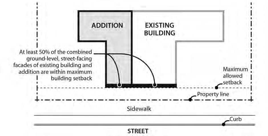
1. Maximum setback standards. Unless otherwise specified, the maximum a building can be set back from a street lot line is 10 feet, except on Civic Corridors shown on Map 130-1, where the maximum set back is 20 feet. At least 50 percent of the length of the ground level street-facing facade of the building must meet the maximum setback standard.
2. Applying the standard.
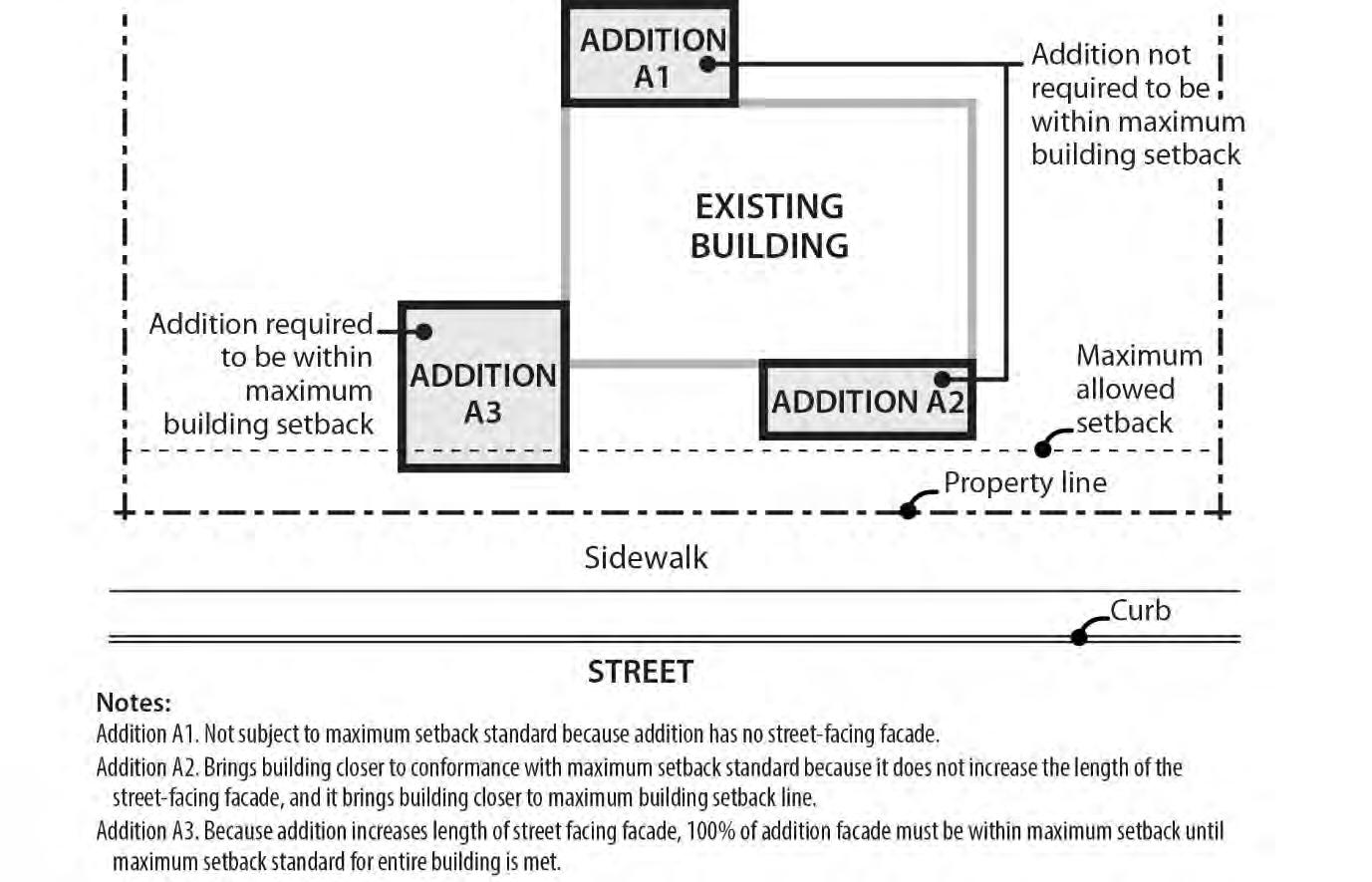
a. Where an existing building is being altered, the standards apply to the ground level, street-facing facade of the entire building. See Figures 130-3 and 130-4.
b. Where there is more than one building on the site, the standards of this paragraph apply to the combined ground level, street-facing facades of all of the buildings. See Figures 130-5 and 130-6.
c. In the CR, CM1, CM2, CM3, and CX zones, and in the CE zone within a Pedestrian District, if the site has street lot lines on three or more streets, the maximum setback standard only applies to two of the streets. When this occurs, the standard must be applied to the streets with the highest transit street classifications. If the site is a through lot, the maximum setback standard only applies to the street with the highest transit street classification. If multiple streets have the same highest transit street classification, the applicant may choose which street or streets to apply the standard.
d. In the CE zone outside of pedestrian districts, the maximum setback standard only applies to transit streets unless the site does not have a street lot line on a transit street. If the site does not have a street lot line on a transit street, then the maximum setback standard applies to one street, and if there is more than one street, the applicant may choose which street to apply the standard. If the site has street lot lines on three or more transit streets, the maximum setback standard applies only to two of the streets. When this occurs, the standard must be applied to the streets with the highest transit classification. If multiple transit
streets have the same highest street classification, the applicant may choose which streets to apply the standard.
e. For buildings where all of the floor area is in residential use, the street-facing facade of an open porch that meets the following standards is included as part of the ground level, street-facing facade of the building:
(1) For houses, attached houses, manufactured homes and duplexes, the porch must be at least 25 square feet in area. For multi-dwelling structures, the porch must be at least 9 feet wide and 7 feet deep;
(2) The porch must have at least one entrance facing the street; and
(3) The porch must have a roof that is no more than 12 feet above the floor of the porch and at least 30 percent solid. This standard may be met by having 30 percent of the porch area covered with a solid roof, or by having the entire area covered with a trellis or other open material if no more than 70 percent of the area of the material is open.
3. Exception. The maximum building setbacks do not apply to primary structures under 500 square feet in floor area, or to detached accessory structures. The street-facing facades of detached accessory structures do not count towards meeting maximum setback standards. See Figure 130-5.
1. General standard. The land between any building and a street lot line must be landscaped to at least the L1 level and/or hard-surfaced for use by pedestrians. This area may be counted towards any minimum landscaped area requirements. Vegetated stormwater management facilities used to meet Bureau of Environmental Services stormwater management requirements, and residential outdoor areas, such as play areas and garden plots, as well as vehicle areas and exterior display, storage, and work activities, if allowed, are exempt from this standard. Bicycle parking may be located in the area between a building and a street lot line when the area is hard surfaced.
2. Improvements within transit street maximum building setbacks. Along transit streets, at least 50 percent of the setback area between the street lot line and the portion of the building that complies with the maximum building setback must be hard surfaced for use by pedestrians. Buildings entirely in a residential use are exempt from this standard.
New
Calculating
E. Alternative maximum building setback for large retailers.
1. Purpose. The intent of the regulations is to allow deeper street setbacks for very large retail stores locating along transit streets or in Pedestrian Districts in exchange for a
pedestrian and transit-friendly main street type of development. These large retail sites can still be transit-supportive and pedestrian-friendly by placing smaller buildings close to the street and by creating an internal circulation system that is similar to streets in order to separate the parking area into blocks. The intent is to encourage development that will, over time, form a pedestrian-friendly main street along the perimeter of the parking blocks and provide connectivity within the site and to adjacent streets and uses.
2. Regulation. Sites that have at least one building with at least 60,000 square feet of floor area in Retail Sales and Service use are exempt from the maximum setback requirement of Table 130-2 and the vehicle area frontage limitations of 33.266.130.C.3 if all of the requirements of this paragraph are met. For sites with frontage on more than one transit street or more than one street in a Pedestrian District, this exemption may be used only along one transit street frontage or frontage along a street in a Pedestrian District.
a. Other buildings on the site have ground level walls within the maximum setback for at least 25 percent of the frontage on a transit street or street in a Pedestrian District. These buildings must be constructed before or at the same time as the large retail store;
b. Internal circulation system. An internal circulation system that meets the following standards must be provided:
(1) Internal accessways that are similar to streets must divide the site into parking areas that are no greater than 55,000 square feet;
(2) These accessways must connect to the transit street, or street in a Pedestrian District, at least every 250 feet;
(3) Each internal accessway must have at least one auto travel lane, curbs, and unobstructed sidewalks on both sides and one of the following must be met:
• The sidewalks must be at least 10 feet wide and planted with trees a maximum of 30 feet on center. Trees must be planted in the center of unpaved tree wells at least 18 square feet, with a minimum dimension of 3 feet. The unpaved area may be covered with a tree grate. Tree wells must be adjacent to the curb, and must be located so there is at least 6 feet of unobstructed sidewalk; or
• The sidewalks must be at least 6 feet wide. There must be a planting strip at least 4 feet wide. The planting strip must be between the curb and the sidewalk, and be landscaped to at least the L1 standard, except that trees cannot be grouped.
(4) Along each internal accessway that intersects a transit street, parking must be provided between both sidewalks and the auto travel lanes except for within 75 feet of the transit street intersection, measured from the street lot line, where parking is not allowed;
(5) Curb extensions that are at least the full depth of the parking must be provided, as shown in Figure 130-7, at the intersections of internal accessways that have parking; and
(6) The internal accessways are excluded from the portion of the parking and loading area used to calculate required interior landscaping.
c. Connections between sites. This standard applies to all commercial, office, or institutional development that is adjacent to sites either developed for Commercial or Institutional use, or zoned C, E, I, CI, or IR. The system must connect the buildings on the site to these adjacent sites.
A. Purpose. The building coverage standards limit the footprint of buildings and work with the FAR, height, and setback standards to control the overall scale of development. The standards promote development consistent with the desired character of the zone. The standards allow a high degree of lot coverage in the Inner Neighborhoods pattern area to reflect the urban development patterns and continuous building frontages of the area. The standards for Eastern and Western pattern areas work in conjunction with landscaping requirements to respond to the less intensely developed characteristics of these areas.
B. Building coverage standards. The maximum building coverage standards are stated in Table 130-2, and the standards apply based on pattern area geography. Map 130-2 identifies the pattern areas. Maximum building coverage applies to all buildings and covered structures.
A. Purpose. These standards, along with the height and setback standards, limit the bulk of buildings close to the street. These standards help ensure that large buildings will be divided into smaller components that relate to the scale and patterns of Portland’s commercial/mixed-use areas and add visual interest and variety to the street environment.
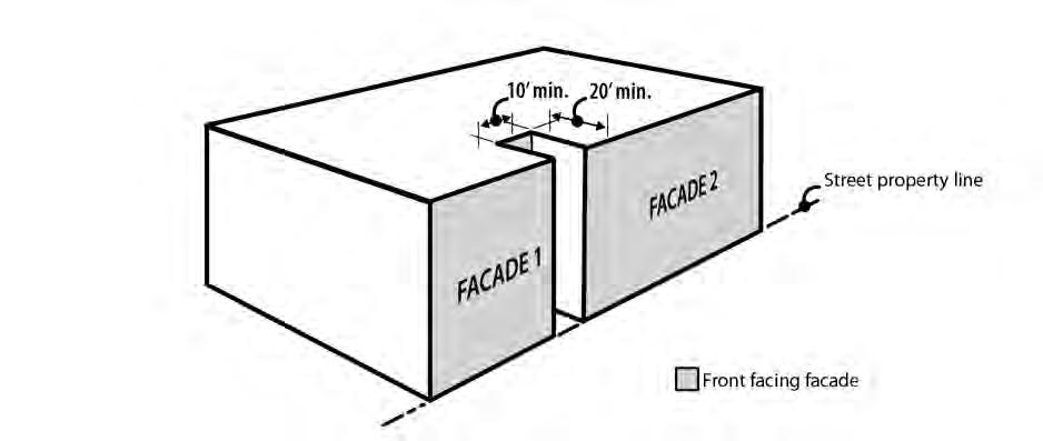
B. Maximum building length. In the CR, CM1, CM2, CM3, and CE zones, the maximum building length for the portion of a building located within 20 feet of a street lot line is 200 feet. The portions of buildings subject to this standard must be separated by a minimum of 20 feet when located on the same site. See Figure 130-8.
C. Facade articulation.
1. Where the standard applies. This standard applies in the CM2, CM3 and CE zones as follows:
a. In the CM2 and CE zones, the standard applies to buildings more than 35 feet high that have facade areas of more than 3,500 square feet within 20 feet of a street property line.
b. In the CM3 zone, the standard applies to buildings more than 45 feet high that have facade areas of more than 4,500 square feet within 20 feet of a street property line.
c. Portions of building facades that are vertically separated by a gap of at least 10 feet in width extending at least 20 feet in depth from the street property line are considered to be separate facades areas for the purposes of the facade area measurements. See Figure 130-9.
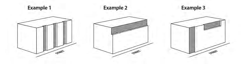
2. The standard. At least 25 percent of the area of a street-facing facade within 20 feet of a street lot line must be divided into facade planes that are off-set by at least 2 feet in depth from the rest of the facade. Facade area used to meet the facade articulation standard may be recessed behind or project out from the primary facade plane, but projections into street right-of-way do not count toward meeting this standard. See Figure 130-10.
A. Purpose. Landscaping is required in some zones because it is attractive and it helps to soften the effects of built and paved areas. Landscaping also helps cool the air temperature, intercept rainfall and reduce stormwater runoff by providing unpaved permeable surface. Landscaping can also provide food for people and habitat for birds and other wildlife As an alternative to conventional landscaping, a range of urban green options are provided in the CM2 and CM3 zones in the Inner Neighborhoods pattern area to reflect this area’s more urban development patterns and historic storefront commercial characteristics. Landscaping is required for all commercial/mixed use-zoned lands abutting R zoned lands and as screening for parking lots (see Chapter 33.266) to provide buffering and promote livability.
B. Minimum landscaped area. The minimum amount of required landscaped area is stated in Table 130-2. Any required landscaping, such as for required setbacks or parking lots, applies towards meeting the minimum amount of required landscaped area. Sites developed with a house, attached house or duplex are exempt from the required minimum landscaped area standard. The required landscape area must meet one of the following:
1. Unless allowed by Paragraph B.2., required landscaped areas must:
a. Be at ground level, except when in raised planters that are used to meet minimum Bureau of Environmental Services stormwater management requirements; and
b. Comply with at least the L1 standard described in Chapter 33.248, Landscaping and Screening, or be a vegetated stormwater management facility that meets minimum Bureau of Environmental Services stormwater management requirements. However, up to one-third of the required landscaped area may be improved for active or passive recreational use, or for use by pedestrians. Examples of active or passive recreational use include walkways, play areas, plazas, picnic areas, garden plots, and unenclosed recreational facilities.
2. Urban green alternative landscaped area. In the CM2 and CM3 zones in the Inner pattern area shown on Map 130-2, one or more of the following may be used to meet the required landscape area:
a. Ecoroof. An ecoroof area may apply toward meeting the required landscaped area standard at a ratio of 4 square feet of ecoroof area for every 1 square foot of required landscaped area. The ecoroof area must be approved by the Bureau
of Environmental Services as being in compliance with the Stormwater Management Manual.
b. Large trees. The minimum required landscaped area may be reduced to 10 percent of site area when the site includes an area with minimum dimensions of 30 feet by 30 feet planted with at least one large-canopy tree. An existing largecanopy tree can be used to meet this requirement, subject to the Tree Protection Specifications of Title 11 (Section 11.60.030). Large canopy trees are defined in Section 33.248.030, Plant Materials. At least 50 percent of the ground area within this space must planted with ground cover plants and the remainder may be hard-surfaced for use by pedestrians.
c. Raised landscaped areas. Landscaped areas raised above ground level may be used to meet the minimum landscaped area standard when landscaped to at least the L1 standard and soil depth is a minimum of 30 inches. Large trees are not allowed in raised landscaped area used to meet this alternative.
d. Pervious pavement. Up to 50 percent of the required landscaped area may be improved for pedestrian use, such as walkways and plazas, if the area is surfaced with pervious pavement approved by the Bureau of Environmental Services as being in compliance with the Stormwater Management Manual. If this provision is used, no impervious surfaces can be counted toward meeting the minimum landscaped area standard.
Requirements for street trees and for on-site tree preservation, protection, and overall tree density are specified in Title 11. See Chapter 11.50, Trees in Development Situations.
A. Purpose. The required outdoor areas standards ensure opportunities for residents to have on-site access to outdoor space for recreation, relaxation, natural area, or growing food. Required outdoor areas are an important aspect for addressing the livability of a property with residential units by providing residents with opportunities for outdoor activities, some options for outdoor privacy, and a healthy environment. The standards ensure that outdoor areas are located so that residents have convenient access. These standards also allow for outdoor area requirements to be met by indoor community facilities because they provide opportunities for recreation or gathering.
B. Requirements.
1. Amount required:
a. On sites that are up to 20,000 square feet in total area, at least 36 square feet of outdoor area is required for each dwelling unit on the site;
b. For sites that are more than 20,000 square feet in total area, at least 48 square feet of outdoor area is required for each dwelling unit on the site;
c. For any site with a congregate housing facility, at least 10 percent total site area must be provided as common area.
2. Size, location and configuration. Required outdoor area may be provided as individual, private outdoor areas, such as patios or balconies, or as common, shared areas, such as outdoor courtyards and play areas, or indoor recreational facilities or community rooms. There also may be a combination of individual and common areas.
a. Individual unit outdoor areas. Where a separate outdoor area is provided for an individual unit, it must be designed so that a 4-foot by 6-foot dimension will fit entirely within it. The outdoor area must be directly accessible to the unit. Balconies that extend over street right-of-way count towards meeting this standard. Areas used for pedestrian circulation to more than one dwelling unit do not count towards meeting the required outdoor area. If the area is at ground level it may extend up to 5 feet into a required front setback, and may extend into required side and rear setbacks as long as the area is not closer than 5 feet to a lot line abutting an RF through RM4 zoned lot.
b. Common areas. There are two types of common area:
(1) Outdoor common area. Where outdoor areas are common, shared areas, each area must be designed so that it is at least 500 square feet in area and must measure at least 20 feet in all directions. The outdoor common area must be located within 20 feet of a building entrance providing access to residential units.
(2) Indoor common area. Where an indoor common area is provided, it must be an indoor recreational facility or an indoor tenant community room. Indoor common areas that are not recreational facilities or community rooms, such as lobbies, hallways, laundry facilities, storage rooms, and vehicle or bicycle facilities, cannot be used to meet this requirement.
c. Combination of individual and common areas. Where a combination of individual unit and common areas is provided, each individual area must meet Subparagraph B.2.a and each common area must meet B.2.b above, and together must provide a total amount of space equivalent to the combined amount of outdoor area required for each dwelling unit.
3. Surfacing materials. Required outdoor areas must be surfaced with lawn, pavers, decking, or sport court paving which allows the area to be used for active or passive recreational use
4. User amenities. User amenities, such as tables, benches, trees, shrubs, planter boxes, garden plots, drinking fountains, spas, or pools, may be placed in the outdoor area. Common, shared outdoor areas may also be developed with amenities such as play areas, plazas, roof-top patios, picnic areas, and open recreational facilities.
33.130.230 Windows
A. Windows in street-facing facades.
1. Purpose. This standard:
• Ensures that there is a visual connection between the living area of the residence and the street;
• Enhances public safety by allowing people to survey their neighborhood from inside their residences; and
• Provides a more pleasant pedestrian environment by preventing large expanses of blank facades along streets.
2. Where this standard applies. This standard applies to street-facing facades of buildings. Where a proposal is for an alteration or addition to existing development, the applicant may choose to apply the standard either to the portion being altered or added, or to the entire street-facing facade.
3. Windows in street-facing facades. At least 15 percent of the area of each facade that faces a street lot line must be windows or main entrance doors. Windows used to meet this standard must allow views from the building to the street. Glass block does not meet this standard. Windows in garage doors do not count toward meeting this standard, but windows in garage walls do count toward meeting this standard. To count toward meeting this standard a door must be at the main entrance and face the street lot line. For structures subject to ground floor window requirements, windows used to meet ground floor window requirements may also be used to meet this standard.
4. Exemption. Development on flag lots or on lots that slope up or down from the street with an average slope of 20 percent or more are exempt from this standard.
1. Purpose. In the commercial/mixed use zones, blank walls on the ground level of buildings are limited in order to:
• Provide a pleasant, rich, and diverse pedestrian experience by connecting activities occurring within a structure to adjacent sidewalk areas, or allowing public art at the ground level;
• Encourage continuity of retail and service uses;
• Encourage surveillance opportunities by restricting fortress-like facades at street level; and
• Avoid a monotonous pedestrian environment.
2. Ground floor window standard for wall area that is not the wall of a dwelling unit. The following standards apply to the portions of a ground floor wall of a street-facing facade that is not the wall of a dwelling unit:
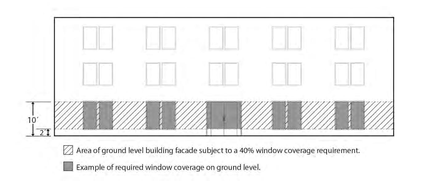
a. General standard.
(1) Windows must cover at least 40 percent of the ground floor wall area of street-facing facades that are 20 feet or closer to a street lot line or a publicly-accessible plaza. For the purposes of this standard, ground floor wall areas include all exterior wall areas from 2 feet to 10 feet above the
finished grade, and include openings in the walls of structured parking. See Figure 130-11.
(2) If the lot has more than one street frontage, then the ground floor window standard in Subparagraph B.2.a(1). applies to the facade that faces the highest transit street classification. All other ground level street-facing facades that are 20 feet or closer to the street lot line must have windows that cover 25 percent of the ground level wall area. The walls of structured parking along these facades may be set back at least 5 feet and landscaped to the L2 standard instead of providing 25 percent windows. If two or more streets have the same highest transit street classification, then the applicant may choose on which of those street to meet the higher standard. Transit street classifications are identified in the Transportation Element of the Comprehensive Plan.
b. Exemptions:
(1) Houses, attached houses, manufactured homes, duplexes, attached duplexes, triplexes, and fourplexes are exempt from this Section;
(2) Ground floor street-facing walls of dwelling units must meet the standards in Paragraph B.4; and
(3) One opening for vehicular access to onsite parking area.
3. Qualifying window features. Required ground floor window areas must be windows that allow views into working areas, lobbies, residential units or residential building common areas; glazing in pedestrian entrances; or display windows that are at least 24 inches deep set into a wall. Windows into storage areas, vehicle parking areas, mechanical and utility areas, garbage and recycling areas, and display cases attached to outside walls do not qualify. Windows into bicycle parking areas are allowed to qualify for up to 25 percent of the ground floor windows coverage requirement. Except for the windows of residential units and clerestory windows located above doors or other windows, the bottom of qualifying windows must be no more than 4 feet above the adjacent exterior grade.
Ground Floor Windows
4. Ground floor window and frontage standards for dwelling units. The ground floor wall area of street-facing facades of dwelling units that are 20 feet or closer to a street lot line must meet at least one of the following standards:
a. Flexible ground floor design. The ground floor window standard of Subparagraph B.2.a(1) must be met, and the ground level of the building must be designed and constructed as follows:
(1) The distance from the finished floor to the bottom of the ceiling structure above must be at least 12 feet. The bottom of the structure above includes supporting beams;
(2) The area meeting this standard must be at least 25 feet deep, measured from the street-facing facade; and
(3) Each unit must include a front entrance that is located at the level of the finished grade and can be accessed without steps.
b. Front setback.
(1) The portions of the building with residential dwelling units on the groundfloor must be set back at least 5 feet from the street lot line. The setback must be landscaped to at least the L1 level and/or hard-surfaced for use by pedestrians; and
(2) Windows must cover at least 25 percent of the ground level wall area of the portion of the building with residential dwelling units on the ground-floor.
c. Raised ground floor.
(1) The portion of the building with residential dwelling units on the groundfloor must have the finished floor of each residential unit at least 2 feet above the grade of the closest adjoining sidewalk.
(2) Window must cover at least 25 percent of the ground level wall area of the portion of the building with residential dwelling units on the ground-floor.
5. Exception for Public Art. Outside the Central City, public art may be used to meet up to one half of the required window coverage of the ground floor window provision. Covenants for the public art will be required, following the regulations of Section 33.700.060, Covenants with the City, to ensure the installation, preservation, maintenance, and replacement of the public art. To qualify for this exception, documentation of approval by the Regional Arts and Culture Council must be provided prior to approval of the building permit
A. Purpose. The screening standards address specific unsightly features which detract from the appearance of commercial/mixed use areas.
B. Garbage and recycling collection areas. All exterior garbage cans, garbage collection areas, and recycling collection areas must be screened from the street and any adjacent properties. Trash receptacles for pedestrian use are exempt. Screening must comply with at least the L3 or F2 standards of Chapter 33.248, Landscaping and Screening.

C. Mechanical equipment. Mechanical equipment located on the ground, such as heating or cooling equipment, pumps, or generators must be screened from the street and any abutting residential zones by walls, fences, or vegetation. Screening must comply with at least the L2 or F2 standards of Chapter 33.248, Landscaping and Screening, and be tall enough to screen the equipment. Mechanical equipment placed on roofs must be screened in one of the following ways, if the equipment is within 50 feet of an R zone:
1. A parapet along facades facing the R zone that is as tall as the tallest part of the equipment;
2. A screen around the equipment that is as tall as the tallest part of the equipment; or
3. The equipment is set back from roof edges facing the R zone 3 feet for each foot of height of the equipment.
D. Other screening requirements. The screening requirements for parking, exterior storage, and exterior display areas are stated with the regulations for those types of development.
A. Purpose. The pedestrian standards encourage a safe, attractive, and usable pedestrian circulation system in all developments. They ensure a direct pedestrian connection between abutting streets and buildings on the site, and between buildings and other activities within the site. In addition, they provide for connections between adjacent sites, where feasible.
B. The standards. The standards of this Section apply to all development except houses, attached houses, and duplexes. An on-site pedestrian circulation system must be provided. The system must meet all standards of this Subsection.
1. Connections. The on-site pedestrian circulation system must provide connections as specified below:
a. Connection between streets and entrances.
(1) Sites with one street frontage.
• Generally. There must be a connection between one main entrance of each building on the site and the adjacent street. The connection may not be more than 20 feet longer or 120 percent of the straight line distance, whichever is less. Buildings separated from the street by other buildings are exempt from this standard.
• Household Living. If a building is located within 40 feet of a street lot line, and all of the floor area in the building is in a Household Living use, then there must be at least one connection between one main entrance and the adjacent street. The connection may not be more than 20 feet longer or 120 percent of the straight line distance, whichever is less.
• Tree preservation. If a tree that is at least 12 inches in diameter is proposed for preservation, and the location of the tree or its root protection zone would prevent the standard of this paragraph from being met, the connection may be up to 200 percent of the straight line distance.
(2) Sites with more than one street frontage. Where the site has more than one street frontage, the following must be met:
• The standard of Subparagraph B.1.a(1) must be met to connect the main entrance of each building on the site to the closest sidewalk or roadway if there are no sidewalks;
• An additional connection, which does not have to be a straight line connection, is required between each of the other streets and a pedestrian entrance. However, if at least 50 percent of a street facing facade is within 10 feet of the street, no connection is required to that street.
b. Internal connections. The system must connect all main entrances on the site and provide connections to other areas of the site used by building occupants, including parking areas, bicycle parking, recreational areas, common outdoor areas, and any pedestrian amenities. Pedestrian connections to public sidewalks may substitute for internal connections for main entrances that are within 10 feet of a public sidewalk.
2. Materials.
a. The circulation system must be hard-surfaced and be at least 6 feet wide. On sites where all of the floor area is in Household Living, segments of the circulation system that provide access to no more than 4 units may be 3 feet wide.
b. Except as allowed in Subparagraph B.2.d., where the system crosses driveways, parking areas, and loading areas, the system must be clearly identifiable, through the use of elevation changes, speed bumps, a different paving material, or other similar method. Striping does not meet this requirement. Elevation changes and speed bumps must be at least 4 inches high.
c. Except as allowed in Subparagraph B.2.d., where the system is parallel and adjacent to an auto travel lane, the system must be a raised path or be separated from the auto travel lane by a raised curb, bollards, landscaping or other physical barrier. If a raised path is used it must be at least 4 inches high and the ends of the raised portions must be equipped with curb ramps. Bollard spacing must be no further apart than 5 feet on center.
d. On sites where all the floor area is in a Household Living use, the pedestrian circulation system may be located within an auto travel lane if the auto travel lane provides access to 16 or fewer parking spaces and the entire auto travel lane is surfaced with paving blocks or bricks.
3. Lighting. The on-site pedestrian circulation system must be lighted to a level where the system can be used at night by the employees, residents, and customers.
A. Purpose. Locating the main entrance to a use on a transit street provides convenient pedestrian access between the use and public sidewalks and transit facilities, and so promotes walking and the use of transit.
1. Generally. All sites with at least one frontage on a transit street, and where any of the floor area on the site is in nonresidential uses, or residential use in a multi-dwelling structure, must meet the following standards. If the site has frontage on more than one transit street, the standards of Subsection C, below, must be met on at least one of the transit streets;
2. Small housing types. Houses, attached houses, manufactured homes, duplexes, attached duplexes, triplexes, and fourplexes must meet the standards of 33.130.250.B, Residential Main Entrance, instead of the requirements of this section.
C. Location. For portions of a building within the maximum building setback, at least one main entrance for each nonresidential tenant space on the ground floor, and one main entrance to a multi-dwelling structure must meet the standards of this section. The ground floor is the lowest floor of the building that is within four feet of the adjacent transit street grade. The main entrance must:
1. Be within 25 feet of the transit street;
2. Allow pedestrians to both enter and exit the building; and
3. Meet one of the following:
a. Face the transit street;
b. Be at an angle of up to 45 degrees from the transit street, measured from the street property line, as shown in Figure 130-13; or
c. If it is an entrance to a multi-dwelling structure:
(1) Face a courtyard at least 15 feet in width that abuts the transit street and that is landscaped to at least the L1 level, or hard-surfaced for use by pedestrians; and
(2) Be within 60 feet of the transit street.
D. Distance between entrances. For portions of a building subject to the maximum building setback, a minimum of one entrance is required for every 200 feet of building length.
E. Unlocked during regular business hours. Each main entrance to nonresidential uses that meets the standards of Subsection C and D must be unlocked during regular business hours.
A. Purpose. The standards of this section are intended to assure that exterior display, storage, and work activities:
• Will be consistent with the desired character of the zone;
• Will not be a detriment to the overall appearance of a commercial/mixed use area;
• Will not have adverse impacts on adjacent properties, especially those zoned residential; and
• Will not have an adverse impact on the environment.
B. Exterior display.
1. CR zone. Exterior display of goods is not allowed.
2. CM1, CM2, CM3, and CX zones. Exterior display of goods is allowed except for the display of motor vehicles, recreational vehicles, motor vehicle parts and supplies, building materials, and the display of goods associated with an industrial use.
3. CE zone. Exterior display of goods is allowed except for the display of goods associated with industrial uses. Exterior display areas for motor vehicles and trailers must be set back at least 5 feet from street lot lines and be landscaped to at least the L1 standard.
4. Exterior display landscape screening abutting R zones. Exterior display areas must be set back at least 5 feet from lot lines abutting R zones and be landscaped to at least the L3 standard.
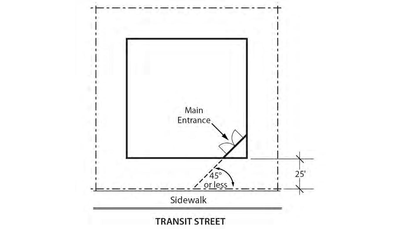
C. Exterior storage.
1. Exterior storage is not allowed in the CR, CM1, CM2, CM3, and CX zones.
2. Exterior storage is allowed in the CE zone if the storage area complies with the standards of this paragraph. Exterior storage is limited to 20 percent of the site area for all uses except lumber yards and other building material stores. All exterior storage areas must be set back 5 feet from nonstreet lot lines and 10 feet from street lot lines, with the setback area landscaped to at least the L3 standard.
D. Exterior work activities. Exterior work activities are prohibited in the commercial/mixed use zones except for the propagation and sale of plants, sales of motor vehicle fuels, and car washes, which are allowed. Exterior work activities related to sales of motor vehicle fuels and car washes are not allowed within 25 feet of a lot line that abuts a residential zone.
E. Other exterior activities. The following exterior activities are allowed in the commercial/mixed use zones: outdoor eating areas, entertainment and recreation activities that are commonly performed outside, and outdoor markets and vendor stalls.
F. Paving. All exterior display and storage areas, except for plant nurseries, must be paved.
A. Generally. Except as specified in this section, all development residential, mixed-use, and nonresidential must meet the other development standards for the zone such as height, setbacks, and building coverage.
B. Residential main entrance.
1. Purpose. These standards:
• Together with the window and garage standards, ensure that there is a physical and visual connection between the living area of the residence and the street;
• Enhance public safety for residents and visitors and provide opportunities for community interaction;
• Ensure that the pedestrian entrance is visible or clearly identifiable from the street by its orientation or articulation; and
• Ensure that pedestrians can easily find the main entrance, and so establish how to enter the residence;
• Ensure a connection to the public realm for development of lots fronting both private and public streets by making the pedestrian entrance visible or clearly identifiable from the public street.
2. Where these standards apply.
a. The standards of this subsection apply to houses, attached houses, manufactured homes, duplexes, attached duplexes, triplexes, and fourplexes in the commercial/mixed use zones.
b. Where a proposal is for an alteration or addition to existing development, the standards of this section apply only to the portion being altered or added.
c. On sites with frontage on both a private street and a public street, the standards apply to the site frontage on the public street. On all other sites with more than one street lot line, the applicant may choose on which frontage to meet the standards.
d. Development on flag lots or on lots which slope up or down from the street with an average slope of 20 percent or more are exempt from these standards.
3. Location. At least one main entrance for each structure must:
a. Be within 8 feet of the longest street-facing wall of the structure; and
b. Either:
(1) Face the street, See Figure 130-14;
(2) Be at an angle of up to 45 degrees from the street; or
(3) Open onto a porch. See Figure 130-15. The porch must:
• Be at least 25 square feet in area;
• Have at least one entrance facing the street; and
• Have a roof that is:
- No more than 12 feet above the floor of the porch; and
- At least 30 percent solid. This standard may be met by having 30 percent of the porch area covered with a solid roof, or by having the entire area covered with lattice or other open material if no more than 70 percent of the area of the material is open.
4. Duplexes on corner lots. Where a duplex is on a corner lot, the requirements of Paragraph C.3, above, must be met for both dwelling units. Both main entrances may face the same street.
C. Garages.
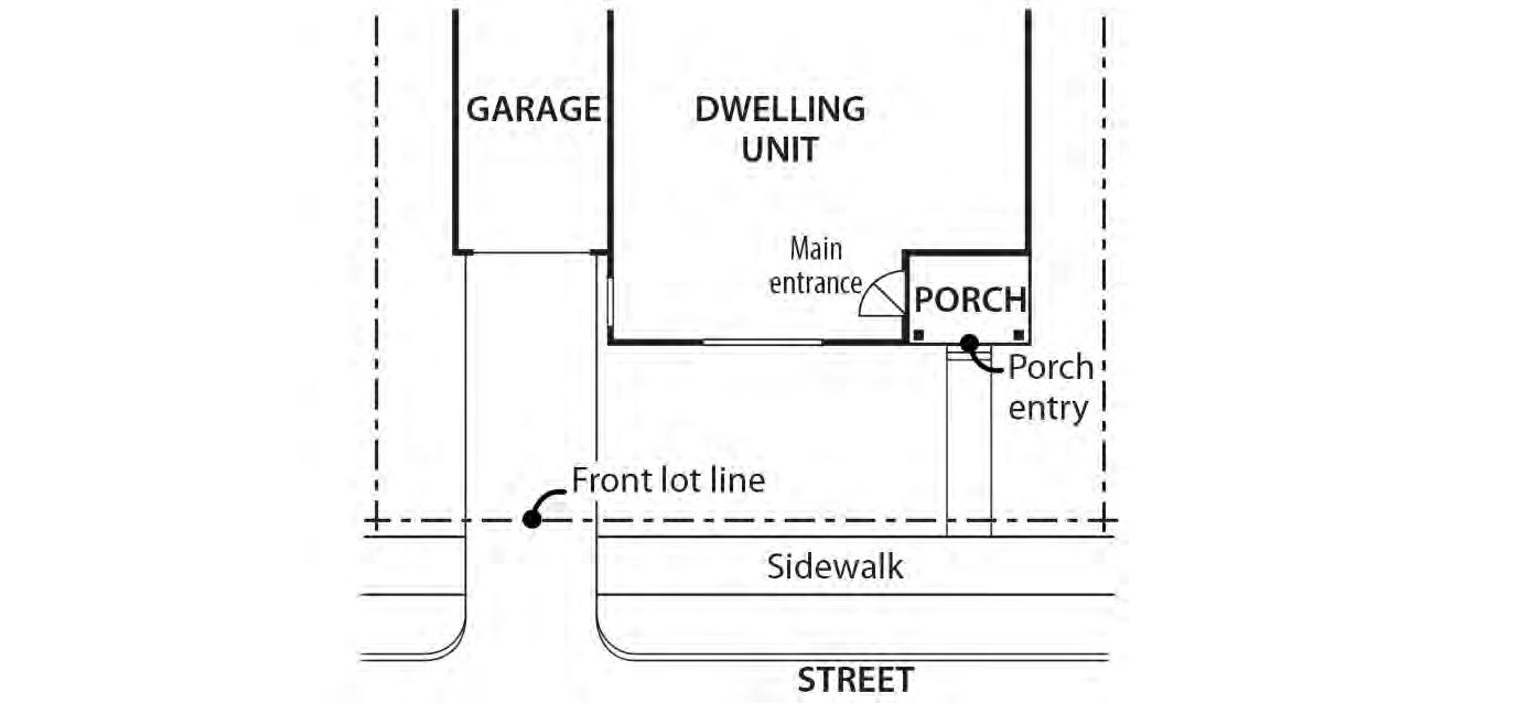
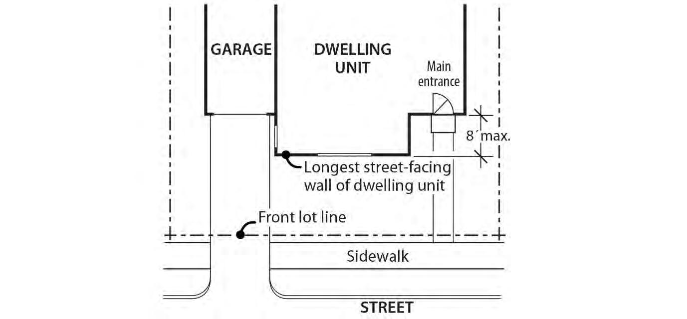
1. Purpose. These standards:
• Together with the window and main entrance standards, ensure that there is a physical and visual connection between the living area of the residence and the street;
• Ensure that the location and amount of the living area of the residence, as seen from the street, is more prominent than the garage;
• Prevent garages from obscuring the main entrance from the street and ensure that the main entrance for pedestrians, rather than automobiles, is the prominent entrance;
• Provide for a more pleasant pedestrian environment by preventing garages and vehicle areas from dominating the views of the neighborhood from the sidewalk;
• Enhance public safety by preventing garages from blocking views of the street from inside the residence;
• Prevent cars from overhanging the street or sidewalk; and
• Provide for adequate visibility for a driver backing out of a garage.
2. Where these standards apply. The requirements of Paragraphs D.3, D.4 and D.5, below, apply to houses, attached houses, manufactured homes, duplexes, attached duplexes, triplexes, and fourplexes. When a proposal is for an alteration or addition to existing development, the standards of this section apply only to the portion being altered or added. Development on flag lots or on lots which slope up or down from the street with an average slope of 20 percent or more are exempt from these standards.
3. Length of street-facing garage wall. The length of the garage wall facing the street may be up to 50 percent of the length of the street-facing building facade. See Figure 13016. For attached houses and attached duplexes, the standard applies to the combined length of the street-facing facades of the attached units.
4. Street lot line setbacks.
a. Generally. A garage wall that faces a street may be no closer to the street lot line than the longest street-facing wall of the dwelling unit. See Figure 130-17.
b. Exception. A street-facing garage wall may be up to 6 feet in front of the longest street-facing wall of the dwelling unit, if:
(1) The street-facing garage wall is 40 percent or less of the length of the building facade; and
(2) There is a porch at the main entrance. The garage wall may not be closer to the street lot line than the front of the porch. See Figure 130-18. The porch must meet the following:
• The porch must be at least 48 square feet in area and have minimum dimensions of 6 feet by 6 feet;
• The porch must have a solid roof; and
• The roof may not be more than 12 feet above the floor of the porch.
c. Exemption. Where a lot has more than one street lot line, and there is an existing dwelling unit on the lot, this standard must be met only on the street-facing facade on which the main entrance is located.
5. Garage entrance setback. The garage entrance must be either 5 feet or closer to the street property line, or 18 feet or farther from the street property line. If the garage entrance is located within 5 feet of the front property line, it may be no closer to the street lot line than the longest street-facing wall of the dwelling unit.
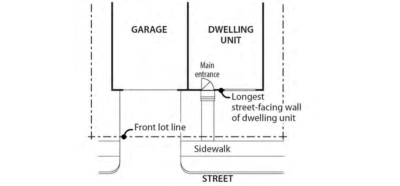
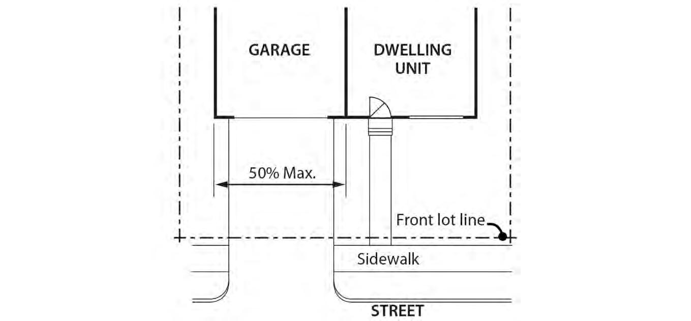
A. Purpose. The parking and storage of trucks and equipment is regulated to ensure that it will be consistent with the desired character of the commercial/mixed use zones and to limit adverse effects on adjacent residential lands.
B. Truck and equipment parking standards. The standards for truck and equipment parking apply to business vehicles that are parked regularly at a site. The regulations do not apply to pick-up and delivery activities, to the use of vehicles during construction, or to services at the site which occur on an intermittent and short term basis. The truck categories are defined in Chapter 33.910.
1. Light trucks. The parking of passenger vehicles, light trucks, and similar equipment is allowed in all commercial/mixed use zone areas that comply with the development standards for parking areas.
2. Medium trucks. The parking of pickup trucks in the medium truck category is allowed in all commercial/mixed use zones. The parking of all other medium trucks and similar equipment is allowed only in the CE and CM3 zone. Truck parking areas must comply with the development standards for auto parking areas.
3. Heavy trucks. The parking of heavy trucks and similar equipment is not allowed in any commercial/mixed use zone.
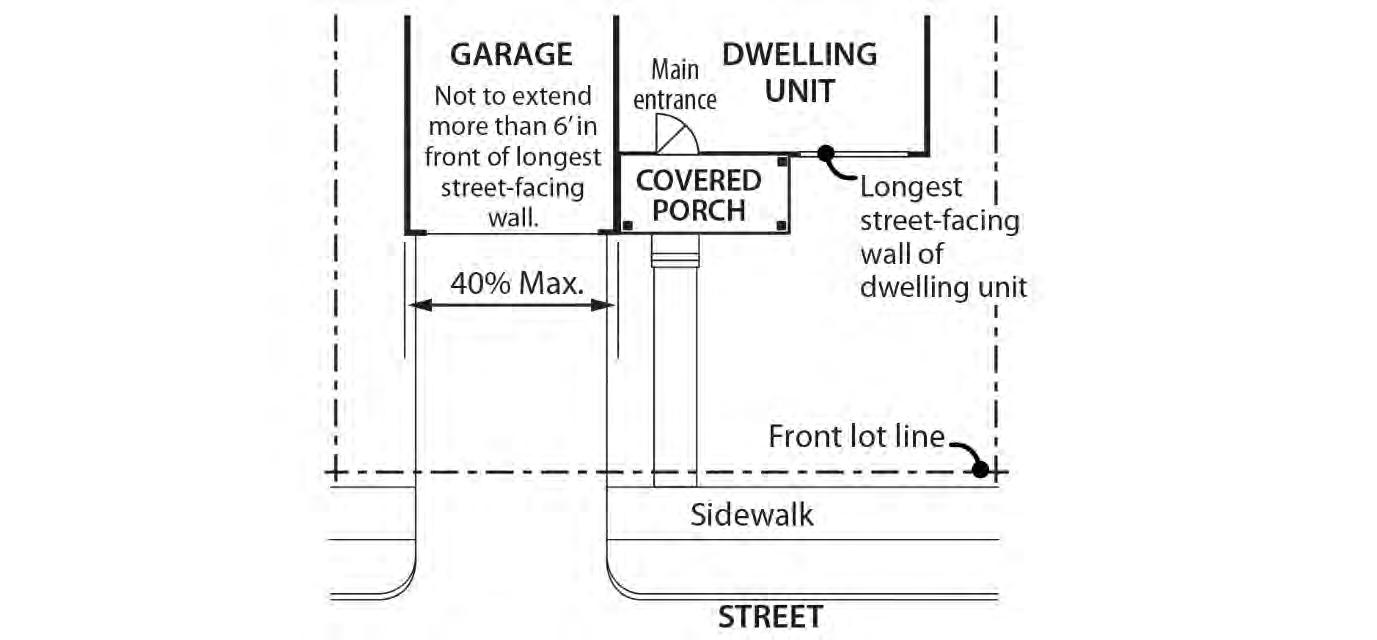
A. Purpose. The drive-through facility regulations support the desired character of the commercial/mixed use zones that are intended to be pedestrian-oriented, while allowing the continuation and improvement of existing drive-through facilities in some of these
zones. In zones intended for auto-accommodating development, these regulations allow for drive-through facilities, while limiting the impacts from drive-through facilities on adjacent residential zones, such as noise and air pollution from idling cars.
B. CR and CX zones. Drive-through facilities are prohibited in the CR and CX zones.
C. CM1, CM2, and CM3 zones. The following regulations apply to drive-through facilities in the CM1, CM2 and CM3 zones:
1 New drive-through facilities are prohibited; and
2. Existing drive-through facilities are allowed. Existing facilities can be rebuilt, expanded, or relocated on the site. The standards for drive-through facilities are stated in Chapter 33.224, Drive-Through Facilities. If the use with the drive-through facility is discontinued for 3 continuous years, reestablishment of the drive-through facility is prohibited. If the use ceases operation, even if the structure or materials related to the use remain, the use has been discontinued. A list of the standard evidence that can be provided to prove that the use has been maintained over time can be found in Subsection 33.258.038.B. If the applicant provides standard evidence from the list, the Director of BDS will determine if the evidence is satisfactory. If the applicant provides evidence other than the standard evidence listed, a Determination of Legal Nonconforming Status is required.
D. CE zone.
1. New drive-through facilities are prohibited except for drive-through facilities associated with Quick Vehicle Servicing uses. Drive-through facilities are not allowed within 25 feet of a lot line that abuts a residential zone. The standards for drivethrough facilities are stated in Chapter 33.224, Drive-Through Facilities.; and
2. Existing drive-through facilities are allowed. Existing facilities can be rebuilt, expanded, or relocated on the site. The standards for drive-through facilities are stated in Chapter 33.224, Drive-Through Facilities. If the use with the drive-through facility is discontinued for 3 continuous years, reestablishment of the drive-through facility is prohibited. If the use ceases operation, even if the structure or materials related to the use remain, the use has been discontinued. A list of the standard evidence that can be provided to prove that the use has been maintained over time can be found in Subsection 33.258.038.B. If the applicant provides standard evidence from the list, the Director of BDS will determine if the evidence is satisfactory. If the applicant provides evidence other than the standard evidence listed, a Determination of Legal Nonconforming Status is required.
A. Purpose. These standards are intended to maintain separation and privacy to abutting residential zoned lots from nonresidential development.
B. General standards.
1. The regulations of this section apply only to detached accessory structures on sites with non-residential uses. For sites where all of the floor area is in residential use, detached accessory structures are subject to the standards of Section 33.120.280
Detached garages are also subject to the standards of 33.130.250, General Requirements for Small Housing Types.
2. The height and building coverage standards of the base zone apply to detached accessory structures.
C. Setbacks.
1. Uncovered accessory structures. Uncovered accessory structures such as flag poles, lamp posts, signs, antennas and dishes, mechanical equipment, uncovered decks, play structures, and tennis courts are allowed in a required setback, but can be no closer than 5 feet to a lot line abutting an RF through RM4 zoned lot.
2. Covered structures.
a. Covered structures such as storage buildings, greenhouses, covered bicycle parking, and work sheds are subject to the setbacks for buildings.
b. Water cisterns that are 6 feet or less in height are allowed in side and rear setbacks, including setbacks for abutting a residential zone.
c. See Section 33.130.250, General Requirements for Small Housing Types, for additional requirements for garages that are accessory to residential development.
A. Purpose. The fence regulations promote the positive benefits of fences without negatively impacting the community or endangering public or vehicle safety. Fences near streets are kept low in order to allow visibility into and out of the site and to ensure visibility for motorists. Fences in any required side or rear setback are limited in height so as to not conflict with the purpose for the setback.
B. Types of fences. The standards apply to walls, fences, and screens of all types whether open, solid, wood, metal, wire, masonry, or other material.
C. Location and heights.
1. Fences abutting street lot lines and pedestrian connections. Within 10 feet of a street lot line or lot line that abuts a pedestrian connection, fences that meet the following standards are allowed:
a. Fences that are more than 50 percent sight-obscuring may be up to 3-1/2 feet high.
b. Fences that are 50 percent or less sight-obscuring may be up to 8 feet high.
2. Fences abutting other lot lines. Fences up to 8 feet high are allowed in required building setbacks along all other lot lines.
3. Fences in all other locations. The height for fences in locations other than described in Paragraphs C.1 and C.2 is the same as the regular height limits of the zone.
D. Reference to other regulations. Electrified fences are regulated under Title 26, Electrical Regulations. The use of barbed wire is regulated under Title 24, Building Regulations.
A. Generally. Demolition on a site that requires a demolition permit is subject to the tree preservation and protection requirements of Title 11, Trees. See Chapter 11.50, Trees in Development Situations.
B. Historic resources. Demolition of historic resources is regulated by Chapter 33.445, Historic Resource Overlay Zone.
C. CX zone landscaping. In the CX zone, sites must be landscaped within 6 months of the demolition of buildings unless there is an approved development for the site. Approved development means a project approved through design review. The landscaping must meet at least the L1 standard of Chapter 33.248, Landscaping and Screening, except that no shrubs or trees are required.
Existing development that does not conform to the development standards of this chapter may be subject to the regulations of Chapter 33.258, Nonconforming Situations.
The standards pertaining to the minimum required and maximum allowed number of auto parking spaces, minimum required number of bicycle parking spaces, parking lot placement, parking lot setbacks and landscaping, and requirements for transportation demand management are stated in Chapter 33.266, Parking, Loading, and Transportation Demand Management.
A. Large site pedestrian connectivity.
1. Purpose. The large site pedestrian connectivity standard implements regional pedestrian and bicycle connectivity standards. The standard enhances direct movement by pedestrians and bicycles between destinations and increases the convenience of travelling by foot or bike. The standard also protects public health and safety by ensuring safe movement and access through a large site. The standard provides flexibility for locating the pedestrian connection in a manner that addresses site constraints such as existing development.
2. When does the standard apply. The large site pedestrian connectivity standard applies to new development and major remodeling on sites that are more than 5 acres in size.
3. Standard. If the site does not have pedestrian connections at least every 330 feet as measured from the centerline of each connection, then dedication of ROW for pedestrian connections is required.
4. Exemptions. Dedication of right-of-way for pedestrian connections is not required in:
a. The Central City plan district; and
Chapter 33.130
Title 33, Planning and Zoning
Commercial/Mixed Use Zones 8/31/22
b. Areas of a site that are in the Environmental Protection overlay zone, the Environmental Conservation overlay zone, or have slopes with an average slope of 20 percent or greater. This means that if the 330 feet interval falls in one of these areas, that pedestrian connection is not required.
5. Pedestrian connection alignment, width and design. The Bureau of Transportation must approve the alignment of the pedestrian connections. The final alignment must ensure that pedestrian connections are located at least 200 feet apart. The Bureau of Transportation must also approve the width of, and configuration of element within, the pedestrian connections.
B. Additional requirements for street and pedestrian/bicycle connections are regulated by the Bureau of Transportation. See Section 17.88.040, Through Streets, of the Portland City Code.
33.130.295 Signs
The sign regulations are stated in Title 32, Signs and Related Regulations.
33.130.305 Superblock Requirements
Development in the CM2, CM3, CE, and CX zones which are on land that includes vacated rights-ofway may be subject to the superblock standards of Chapter 33.293, Superblocks.
33.130.310 Recycling Areas
Requirements for recycling areas are regulated by the Bureau of Planning and Sustainability. See Section 17.102.270, Businesses and Multifamily Complexes Required to Recycle, of the Portland City Code.
(Amended by: Ord. No. 165594, effective 7/8/92; Ord. No. 167186, effective 12/31/93; Ord. No. 167189, effective 1/14/94; Ord. No. 169099, effective 8/18/95; Ord. No. 169535, effective 1/8/96; Ord. No. 169987, effective 7/1/96; Ord. No. 170704, effective 1/1/97; Ord. No. 171219, effective 7/1/97; Ord. No. 171718, effective 11/29/97; Ord. No. 173533, effective 8/2/99; Ord. No. 173593, effective 9/3/99; Ord. No. 173729, effective 9/8/99; Ord. No. 174263, effective 4/15/00; Ord. No. 174980, effective 11/20/00; Ord. No. 175204, effective 3/1/01; Ord. No. 175837, effective 9/7/01; Ord. No. 175966, effective 10/26/01; Ord. Nos. 175965 and 176333, effective 7/1/02; Ord. No. 176469, effective 7/1/02; Ord. No. 177028, effective 12/14/02; Ord. No. 177422, effective 6/7/03; Ord No. 177404, effective 7/1/03; Ord. No. 178172, effective 3/5/04; Ord. No.178509, effective 7/16/04; Ord. No. 179092, effective 4/1/05; Ord. No. 179845, effective 1/20/06; Ord. Nos. 179980 and 179994, effective 4/22/06; Ord. No. 180619, effective 12/22/06; Ord. No. 181357, effective 11/9/07; Ord. No. 182429, effective 1/16/09; Ord. No. 183598, effective 4/24/10; Ord. No 184016, effective 08/20/10; Ord. No. 184524, effective 7/1/11; Ord. No. 185412; effective 6/13/12; Ord. No. 185915, effective 5/1/13; Ord No. 185974, effective 5/10/13; Ord. No. 186639, effective 7/11/14; Ord. No. 186053, effective 1/1/15; Ord. No. 187216, effective 7/24/15; Ord. No. 187471, effective 1/1/16; Ord. No. 188142, effective 1/13/17; Ord. No. 188177, effective 5/24/18; Ord. No. 188958, effective 5/24/18; Ord. No. 189137, effective 08/22/18; Ord. No. 189488, effective 12/2/19; Ord. No. 189807, effective 12/18/19; Ord. No. 189805, effective 3/1/20; Ord. No. 189784, effective 3/1/20; Ord. No. 190380, effective 4/30/21 and 8/1/21; Ord. No. 190687, effective 3/1/22; Ord. No. 190978, effective 8/31/22.)
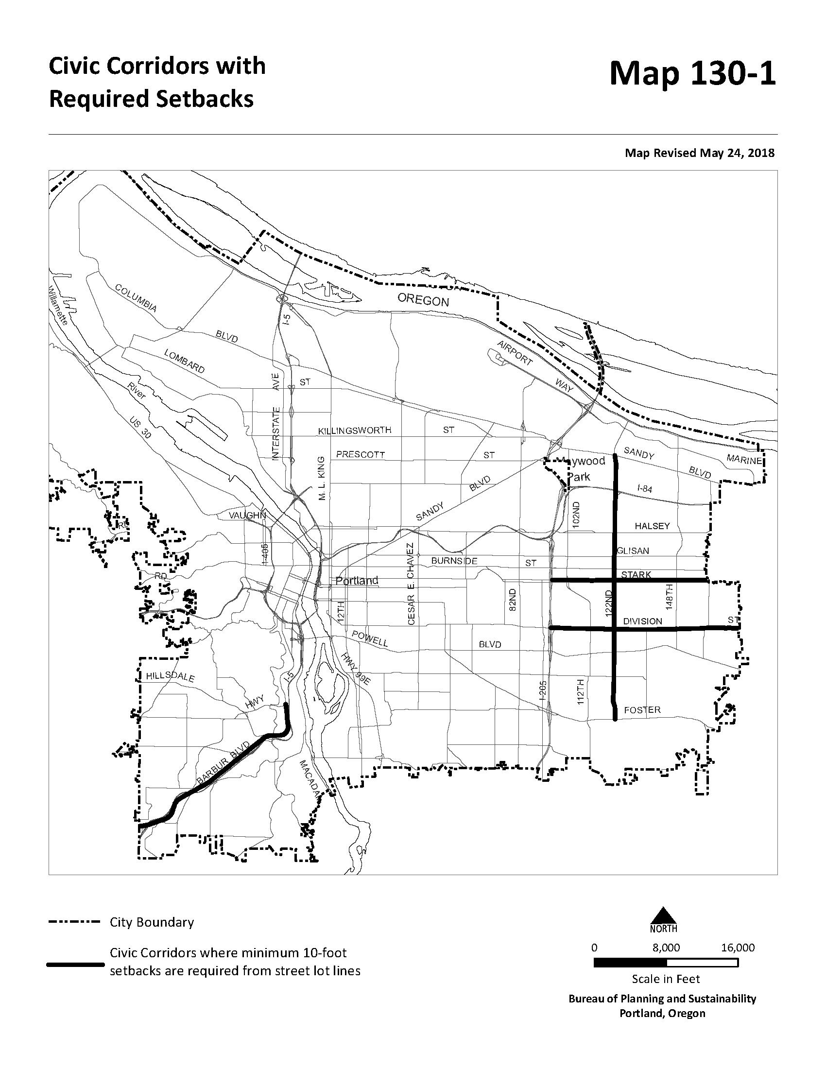
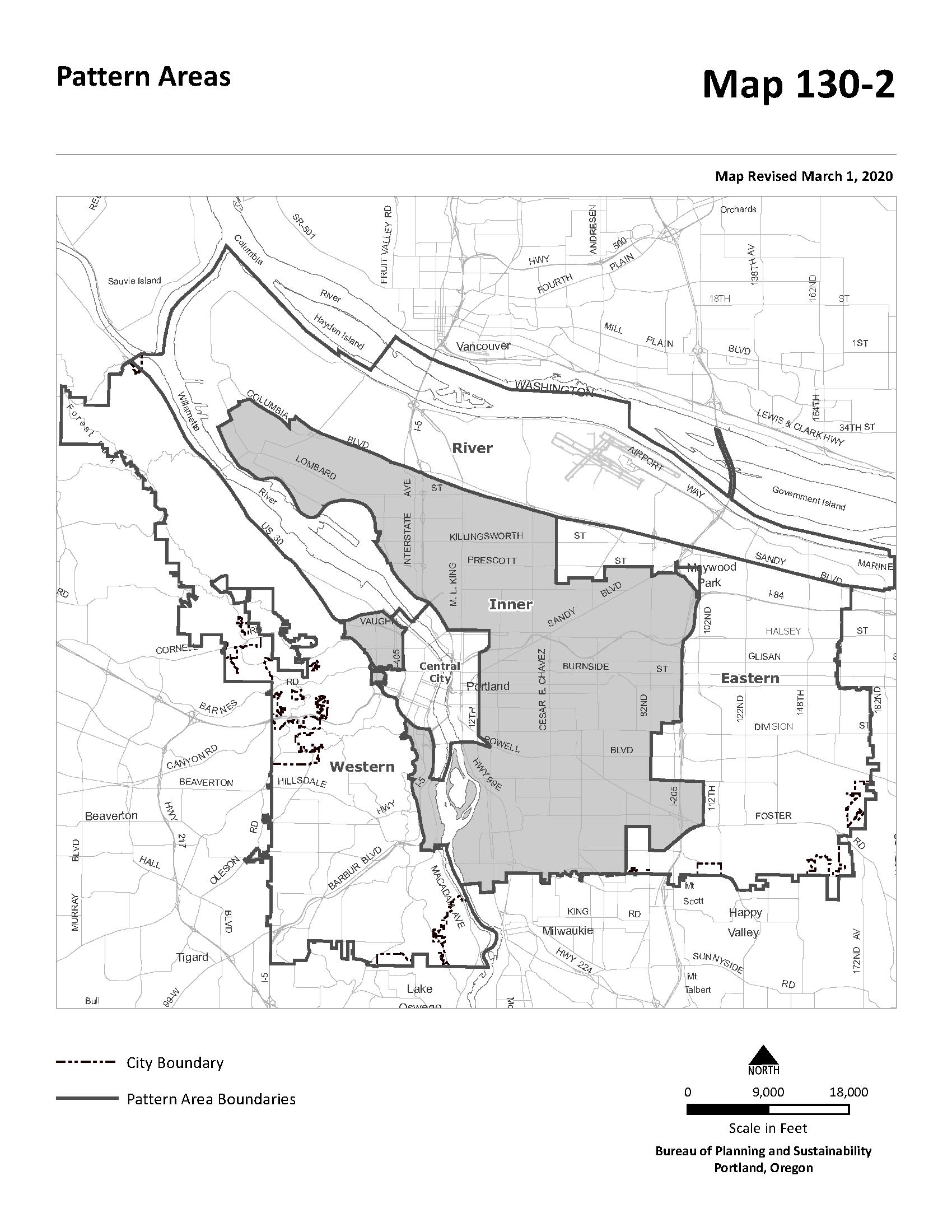
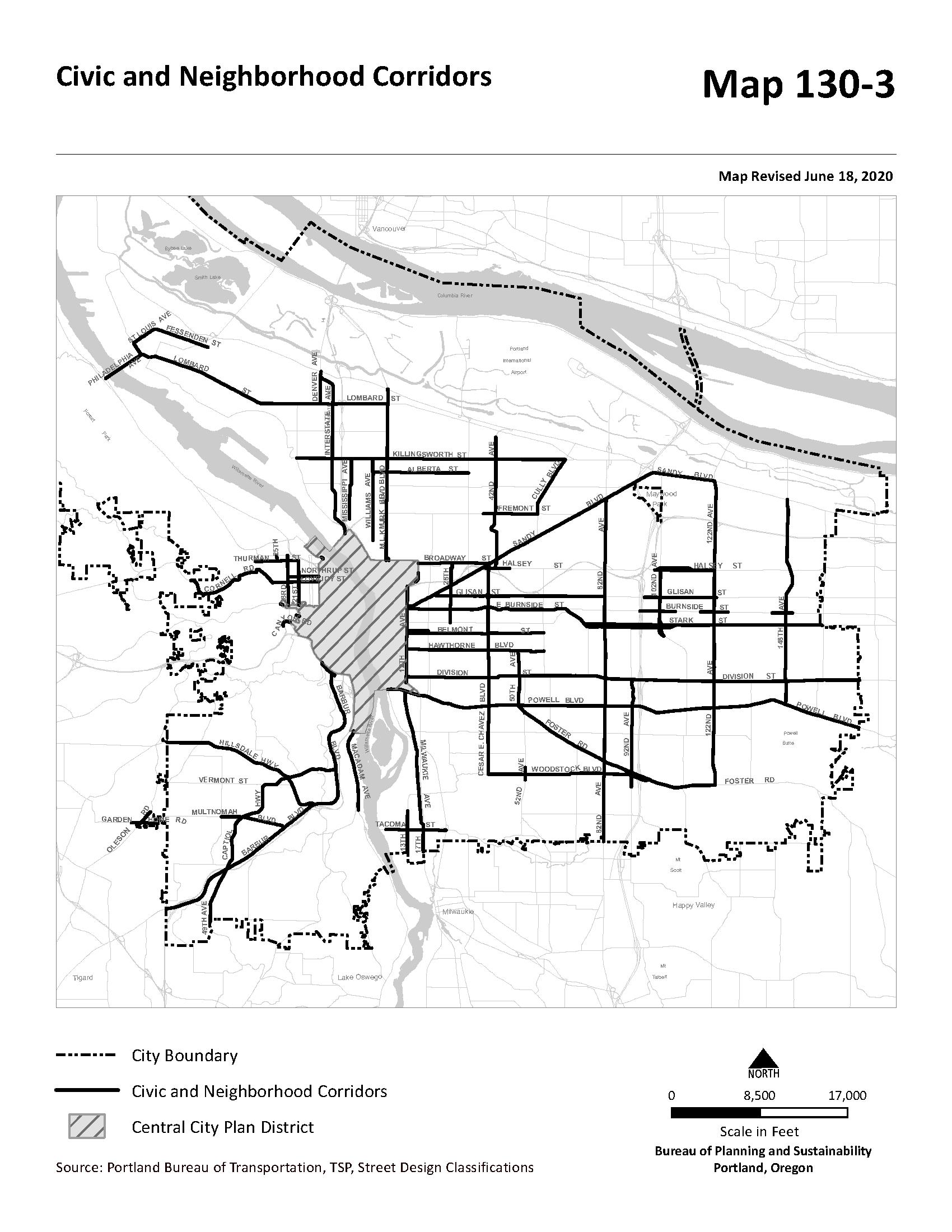
Sections:
33.420.010 Purpose
33.420.020 Map Symbol
33.420.021 Applying the Design overlay zone
33.420.025 Where These Regulations Apply
33.420.030 Neighborhood Contact
33.420.041 When These Regulations Apply
33.420.045 Items Exempt From Design Review and Design Standards
33.420.050 Design Standards
33.420.060 Design Guidelines
Map 420-1 Design Districts and Subdistricts in the Central City and South Auditorium Plan Districts
Map 420-2 Terwilliger Design District
Map 420-3 Marquam Hill Design District
Map 420-4 Gateway Design District
33.420.010 Purpose
The Design overlay zone ensures that Portland is both a city designed for people and a city in harmony with nature. The Design overlay zone supports the city’s evolution within current and emerging centers of civic life. The overlay promotes design excellence in the built environment through the application of additional design standards and design guidelines that:
• Build on context by enhancing the distinctive physical, natural, historic and cultural qualities of the location while accommodating growth and change;
• Contribute to a public realm that encourages social interaction and fosters inclusivity in people’s daily experience; and
• Promotes quality and long-term resilience in the face of changing demographics, climate and economy.
33.420.020 Map Symbol
The Design overlay zone is shown on the Official Zoning Maps with a letter "d" map symbol.
33.420.021 Applying the Design overlay zone
The Design overlay zone is applied to current and emerging urban locations including centers and corridors. The Design overlay zone is also applied to areas outside of centers and corridors that have distinct features with important development context, and to specific zones identified through the Comprehensive Plan. Application of the Design overlay zone must be accompanied by adoption of design guidelines, or by specifying which guidelines will be used.
Some areas of the Design overlay zone are referred to as design districts. A design district may be divided into subdistricts. Subdistricts are created when an area within a design district has unique characteristics that require special consideration and additional design guidelines. The location and name of each design district and subdistrict is shown on maps 420-1 through 420-4 at the end of this chapter.
Chapter
The regulations of this chapter apply to all design overlay zones. Meeting the regulations of this chapter may also be a requirement of a plan district, other overlay zone, or as a condition of approval of a quasi-judicial decision. This chapter does not apply to sites located within the boundary of a Historic Landmark, Conservation Landmark, Historic District, or Conservation District.
Neighborhood contact is a set of outreach steps that must be taken before certain developments can be submitted for approval. Neighborhood contact is required as follows:
A. When the proposed development will add at least 10,000 square feet of net building area to a site, the neighborhood contact step of 33.705.020.C., Neighborhood contact III, are required.
B. If the proposed development has already met the neighborhood contact requirements as part of a land use review process, it is exempt from the neighborhood contact requirements.
Unless exempted by Section 33.420.045, Items Exempt From This Chapter, the following must meet the design standards or be approved through design review:
A. New development;
B. Exterior alterations to existing development;
C. Nonstandard improvements in the public right-of-way such as street lights, street furniture, planters, public art, sidewalk and street paving materials, landscaping, and new bridges Nonstandard improvements in the public right-of-way must receive approval from the City Engineer prior to applying for design review Improvements that meet the City Engineer’s standards are exempt from this chapter;
D. Items identified in the Citywide Policy on Encroachments in the Public Right-of-Way or Title 17, Public Improvements, as requiring design review;
E. Removal of trees 6 or more inches in diameter in the South Auditorium plan district;
F. Where City Council requires design review of a proposal because it is considered to have major design significance to the City. In these instances, the City Council will provide design guidelines by which the proposal will be reviewed, and specify the review procedure; and
G. Floating structures, except individual houseboats
The following items are exempt from the regulations of this chapter:
A. General exemptions:
1. Development that does not require a permit;
2. Development when:
a. The only use on the site will be Household Living;
b. There will be no more than four dwelling units total on the site;
c All new buildings and additions to existing buildings on the site are no more than 35 feet in height; and
d. The site is not zoned RX, EX, or CX;
3. Houseboats in a houseboat moorage;
4. Manufactured dwelling parks;
5. Outdoor shelters;
6. Development associated with a Rail Lines and Utility Corridor use;
7. Development associated with a Parks and Open Areas use when the development does not require a conditional use review;
8. Anemometers, and small wind energy turbines that do not extend into a view corridor designated in the Scenic Resources Protection Plan; and
9. New bridges in the right-of-way, and alterations to existing bridges in the right-of-way. However, a new bridge in the right-of-way with a horizontal span more than 100 feet must complete a design advice request with the Design Commission as specified in 33.730.050.B.
B. Exterior alterations
1. Repair, maintenance, and replacement with comparable materials;
2. Exterior alterations to a structure required to meet the Americans With Disabilities Act’s requirements, or as specified in Section 1113 of the Oregon Structural Specialty Code;
3. Exterior work activities associated with an Agriculture use;
4. Detached accessory structures when the structure has a building coverage no more than 300 square feet in area and is located at least 20 feet from all street lot lines, or located within an existing vehicle area;
5. Exterior alterations for parking lot landscaping, short-term bicycle parking, and pedestrian circulation systems when all relevant development standards of this Title are met;
6. Except in the South Auditorium plan district, signs with a sign face area of 32 square feet or less;
7. The following alterations to the facade of a building:
a. Awnings as follows:
(1) If awnings were approved on the same facade through design review, then a new or replacement awning is exempt if it meets the previous design review conditions of approval; or
(2) If there are no previous conditions of approval for awnings on the same facade, then a new or replacement awning is exempt if the awning projects at least four feet from the wall, and the area of the awning does not exceed 200 square feet measured from the building elevation, except in the Central City, where it does not exceed 100 square feet measured from the building elevation;
b. Alterations to an existing ground floor storefront glazing and mullion system that uses the same materials and profile as the existing system without reducing the percentage of ground floor windows on the facade;
c. Louvers or vents for mechanical systems that meet the following:
(1) The louver or vent opening affects 1 square foot or less of the facade and is the same color as the adjacent facade; or
(2) The louver or vent is placed within an existing window mullion, is the same color as the mullion, and is at least 8 feet above the adjacent grade;
d. Radon systems on non-street facing facades;
e. The removal of fire escapes;
f. Seismic bracing, except on street-facing facades within the Central City plan district; or
g. Any other alteration to a facade when the total area of the alteration is 200 square feet of the facade or less measured from the building elevation and the alteration meets one of the following. This exemption does not apply to signs or within the Central City plan district:
(1) On street-facing facades, the alteration is above the ceiling of the ground floor or is setback at least 20 feet from the street lot line; or
(2) The alteration is on a facade that does not face the street;
8. The following alterations to the roof of a building when the roof has a 1/12 pitch or less:
a. Ecoroofs, landscaping on a roof, solar panels, skylights, and roof hatches;
b. Protective railings that project up to 4 feet above the adjoining roof;
c. Rooftop alterations and equipment that do not increase floor area when:
(1) The proposed alteration or equipment is screened by an existing parapet, screen, or enclosure that is as tall as the tallest part of the equipment or alteration;
(2) The proposed alteration or equipment is set back 4 feet from the edge of the roof for every 1 foot of height above the roof surface or top of parapet;
(3) The proposed alteration or equipment is located entirely within 5 feet of the facade of an existing equipment penthouse, does not extend above the penthouse, and is the same color as the penthouse; or
(4) The proposed alteration or equipment does not exceed 3 feet in width, depth, length, diameter or height.
d. Radio frequency transmission facilities as follows:
(1) New or replacement antennas that are mounted to the side of an existing stairwell enclosure or an existing or extended equipment penthouse when the antennas do not extend above the penthouse and are the same color as the existing penthouse or stairwell enclosure.
(2) New or replacement equipment associated with the antennas when screened by an existing penthouse or located entirely within 5 feet of the facade of an existing penthouse. As an alternative, an existing penthouse may be extended to screen the equipment if:
• The penthouse extension is at least 15 feet from any street facing roof edge;
• The equipment does not extend above the penthouse; and
• The penthouse extension is the same color as the existing penthouse;
(3) Alterations to an existing facility that comply with a previous design review approval for the facility including screening or concealment; or;
(4) Alterations to an existing eligible facility, that qualifies under the terms pursuant to 47 U.S.C. §1455, when approved measures of concealment are maintained.
9. The following alterations and additions to the roof of a building when the roof has a pitch that is greater than 1/12:
a. The addition or alteration is parallel with the roof surface and extends no more than 12 inches above the roof surface; or
b. The addition or alteration extends no more than 18 inches from the surface of the roof and is less than 2 feet in diameter.
10. Public Art as defined in Chapter 5.74, or a Permitted Original Art Mural as defined in Title 4.
Chapter
Design Overlay Zone 3/1/22
C. Geographically specific:
1. In the South Auditorium plan district shown in Map 420-1, signs that meet the following:
a. Except within 50 feet of the Halprin Open Space Sequence historic district, signs with a sign face area of 32 square feet or less; and
b. Within 50 feet of the Halprin Open Space Sequence historic district, signs with a sign face area of 3 square feet or less;
2. In the Marquam Hill Design District shown on Map 420-3:
a. Additions of less than 25,000 square feet of floor area;
b. Exterior alterations that affect less than 50 percent of the area of the facade where the area affected is also less than 3,000 square feet;
c. Exterior improvements that are less than 5,000 square feet in total area, except for exterior improvements affecting areas counting towards the formal open area requirements of Section 33.555.260; and
d. Landscaping not associated with formal open areas required under 33.555.260.
The design standards provide an alternative process to design review for some proposals. Proposals that are eligible to use the design standards are stated in Subsection A. The standards for signs are stated in Title 32, Signs and related Regulations. Proposals that do not meet the design standards stated in Subsection C — or where the applicant prefers more flexibility — must go through the design review process.
A. Unless excluded by Subsection B, proposals that are within the maximum limits of Table 420-1 may use the design standards stated in Subsection C as an alternative to design review.
Table 420-1
Maximum Limits for Use of the design standards [1]
Zones Maximum Limit—New Floor Area
RM2, RM3, RM4, C, E, I, & CI
Zones 40,000 sq. ft. of floor area
IR Zone See institution's Impact Mitigation Plan or Conditional Use Master Plan.
Zones Maximum Limit Exterior Alterations
All except IR
• For street facing facades less than 3,000 square feet, alterations affecting less than 1,500 square feet of the facade.
• For street facing facades 3,000 square feet and larger, alterations affecting less than 50% of the facade area.
IR Zone See institution's Impact Mitigation Plan or Conditional Use Master Plan.
Notes:
[1] There are no maximum limits for proposals where any of the floor area is in residential use.
B. The design standards may not be used as an alternative to design review as follows:
1. In the Central City plan district. See Map 420-1;
2. In the Gateway plan district as follows. See Map 420-4;
a. New development and alterations to existing development when any portion of the new development or alteration exceeds 35 feet in height not counting additional height allowed through a base zone height standard exception; and
b. Development subject to the requirements of 33.526.240, Open Area;
3. New buildings or additions when any portion of the new building or addition exceeds 75 feet in height not counting additional height allowed through a base zone height standard exception;
4. For Institutional uses in residential zones, unless specifically allowed by the base zone, overlay zone, plan district, or an approved Impact Mitigation Plan or Conditional Use Master Plan;
5. Non-standard improvements in the right-of-way or other encroachments identified in City Titles as requiring design review;
6. In the CM3 zone within the St. Johns plan district, structures that exceed 45 feet in height;
7. For motor vehicle fuel sales in the 122nd Avenue subdistrict of the East Corridor plan district; and
8. In the North Interstate plan district proposals taking advantage of the additional height allowed by 33.561.210.B.2.
1. New development.
a. Required design standards. New development must meet all the design standards identified in Table 420-2 as required standards. Only the standards applicable to the development apply; and
b. Optional design standards. New development must meet the optional design standards as follows. Unless otherwise stated, if a standard is required, no optional points are earned:
(1) Buildings up to 55 feet tall. New development with buildings that are 55 feet tall or less must meet enough of the standards identified in Table 420-2 as providing optional points to total 20 points, or one point for every 1,000 square feet of site area, whichever is less. For sites that are required to earn 20 points, at least one point must be earned in each of the context, public realm, and quality and resilience categories;
(2) Building more than 55 feet tall. New development with buildings that are more than 55 feet tall must meet enough of the standards identified in
Table 420-2 as providing optional points to total 20 points, or two points for every 1,000 square feet of site area, whichever is less. For sites that are required to earn 20 points, at least one point must be earned in each of the context, public realm, and quality and resilience categories.
2. Alterations to existing development must meet all the design standards identified in Table 420-2 as required. Only the standards applicable to the alteration apply. In addition, major remodels must meet enough of the standards identified in Table 420-2 as optional to total 5 points, or one point for every 1,000 square feet of site area, whichever is less.
(X) APPLIES TO: THE DESIGN STANDARD
BUILDING MASSING AND CORNERS
X C1 Corner Features on a Building
New development on a site on a corner lot, located within a neighborhood or town center, where the zoning does not require a minimum building setback from a street lot line:
At least one of the following must be met:
• At least one building must be within 5 feet of the intersecting street lot lines and meet the following:
• Each street facing wall meeting this standard must be at least 25 feet long;
• At least 30 percent of the street-facing building wall within 25 feet of the corner must be windows or main entrance doors. Windows and doors used to meet ground floor window requirements may be used to meet this standard; and
• At least one main entrance to a lobby or individual commercial tenant space must be located within 15 feet of the two intersecting street lot lines, and face the street with the highest transit designation.
• At least one building must abut a plaza at the corner of the two intersecting street lot lines. The plaza must meet the following standards:
• The plaza must measure at least 20 feet in all directions;
• The plaza must be hard surfaced for use by pedestrians or be an extension of the sidewalk;
• No more than 25 percent of the plaza may be covered;
• The plaza must include benches or seating that provides at least 10 linear feet of seating surface. The seating surface must be at least 15 inches deep, and between 16 and 24 inches above the grade upon which the seating or bench sits; and
• At least one main entrance to a lobby or commercial tenant space must face the plaza.
Optional points
The standards for context provide an opportunity for development to respond to the surrounding natural and built environment and build on the opportunities provided by the site itself. The context standards are split into the following categories: Building Massing and Corners, Older Buildings/History, Landscaping, and Adjacent Natural Areas. Required
Divide the building elevation on the facade facing a local service street into distinct wall planes measuring 1,500 square feet or less.
To qualify, the facade plane must be offset in depth by at least 2-feet from adjacent facades. Facades may also be separated by balconies or architectural projections that project at least 2 feet from adjacent facades for a minimum distance of 8 feet. Projections into street right-of-way do not count toward meeting this standard.
Meet any of the following standards up to a maximum of 4 points:
• The portion of the street-facing facade that fronts a non-residential use must provide the following:
• A transom window must be provided above each ground floor window and door opening. The transom window must be at least 12 inches in height and separated from main ground floor windows by at least 4 inches. Mullions within a storefront glazing system do not count toward the window separation.
• A base sill or bulkhead must be provided at the ground level. The base must be at least 18 inches above grade, but is not required where access doors are located.
• Street-facing ground floor windows must be split up into sections no more than 25 feet wide, separated by a column made up of a different material than the storefront glazing system and at least 12 inches wide.
• The following must be provided on street-facing facades:
• The ground floor of the building must be visually distinct from upper stories by providing either a cornice, belt course or projecting band between the first and second floor of the building, or a change of material between the first floor and upper floors of the building.
• The top of the building must have a parapet or cap that extends at least 18 inches above the roofline and is distinguished from the rest of the building by a different color or material.
• The street-facing windows on floors above the ground floor must be vertical – taller than it is wide. Street-facing windows on each upper floor must be directly above the one below, excluding the ground floor. Upper floors that step back per the standard below do not need to be vertical or aligned.
• On street-facing facades, floors that are more than 35 feet above the existing or proposed sidewalk adjacent to the site must be set back at least 5 feet from the exterior walls below.
• On corner sites, a main entrance for a ground floor tenant must be located at the corner of the intersecting streets and be at an angle of 30 to 45 degrees from the transit street with the highest classification.
to a building that:
• is at least 50 years old and
• has at least 1,000 square feet of net building area
Meet one of the following standards:
• Retain at least 75 percent of the area of all existing street-facing facades and meet the standards of 33.415.200 Required Ground Floor Active Use.
• Retain at least 75 percent of the area of all existing street-facing facades and at least 75 percent of the existing building’s exterior walls and meet the standards of 33.415.200 Required Ground Floor Active Use.
• Retain at least 90 percent of the area of the existing street-facing facade and at least 75 percent of the existing building’s exterior walls and meet the standards of 33.415.200 Required Ground Floor Active Use. This option is only available if the building is listed on the City’s Historic Resources Inventory.
1
2
1
2
3
5
C5 Vertical Addition to Existing Building. Building addition above the existing wall of a building that is at least 50 years old
The building addition must include one of the following features:
• Set back the walls above the existing facade at least 2 feet from the exterior edge of the existing wall.
• Place windows on the vertical extension directly above the existing windows. The area of the new windows may be up to 20 percent larger or smaller than the area of the existing windows, but the center of the new window must align with the vertical plane of the center of the existing windows.
C6 Historical Plaque.
Site that contains a building that is at least 50 years old
Install a plaque on a street-facing facade of the building that provides information on the previous uses of the building or site. The plaque must be:
• at least 2 square feet in area,
• made of metal with stamped lettering and
• be permanently secured to the building facade.
Optional points
Required (X) APPLIES TO: THE DESIGN STANDARD
New building located on a site that abuts a site containing a Historic Landmark.
If the new building abuts a site containing a historic landmark and the historic landmark contains only residential uses, C9 applies instead of this standard.
Optional points
Meet one of the following standards
Additional features may be provided for optional points up to a maximum of 3 points.
• The ground floor height in the new building must match the ground floor height in the Historic Landmark, or be at least 10 feet tall, whichever is greater. This standard only applies to new buildings not subject to Standards PR1 or PR2.
• Street-facing ground floor windows in the new building must be as tall as the ground floor windows in the Historic Landmark.
• The base of the street-facing ground floor windows must be the same distance above grade as the ground floor windows in the Historic Landmark.
• If the Historic Landmark has transom windows on the ground floor, the new building must include transom windows that match in location, size, and distance above grade as the transom window on the historic building.
• The exterior materials on the new building must match the exterior materials on the Historic Landmark on at least 80 percent of the new building’s street-facing facade
• Floor and cornice bands on the new building must match the width and location of the floor and cornice bands on the Historic Landmark.
• If any portion of the new building is taller than the Historic Landmark, that portion of the new building must be setback at least 10 feet from the property line adjacent to the site that contains the Historic Landmark.
1
1
1
1
1
1
2
C8 Building Near Historic Landmark or Property on Historic Resource Inventory. New building that is either:
• located on a site that is across the street from a site containing a historic landmark, or
• located on a site that abuts or is across the street from a site containing a building on the Historic Resources Inventory (HRI)
Meet any of the following standards, up to a maximum of 2 points:
• The ground floor height in the new building must match the ground floor height in the Historic Landmark or HRI building, or be at least 10 feet tall, whichever is greater. This standard only applies to new buildings not subject to Standards PR1 or PR2.
• Street-facing ground floor windows in the new building must be as tall as the ground floor windows in the Historic Landmark or HRI building.
• The base of the street-facing ground floor windows must be the same distance above grade as the ground floor windows in the Historic Landmark or HRI building.
• If the Historic Landmark or HRI building has transom windows on the ground floor, the new building must include transom windows that match in location, size, and distance above grade as the transom window on the historic building.
• The exterior materials on the new building must match the exterior materials on the Historic Landmark or HRI building on at least 80 percent of the new building’s street-facing facade.
• Floor and cornice bands on the new building must match the width and location of the floor and cornice bands on the Historic Landmark or HRI building.
1
1
1
1
C9 Building Abutting a Residential Historic Landmark. New building located on a site that abuts a site that contains a Historic Landmark that:
• only contains residential uses, and
• is located within 10 feet of the street lot line
If the new building abuts a site containing a historic landmark and the historic landmark contains non- residential uses, C7 applies instead of this standard.
C10 Tree Preservation.
Site with at least one tree 20 inches or greater in diameter
Meet any of the following standards up to a maximum of 2 points.
• The ground floor height in the new building must match the ground floor height in the Historic Landmark, or be at least 10 feet tall, whichever is greater.
• The exterior materials on the new building must match the exterior materials on the Historic Landmark on at least 80 percent of the new building’s street-facing facade
• Floor and cornice bands on the new building must match the width and location of the floor and cornice bands on the Historic Landmark.
• If any portion of the new building is taller than the Historic Landmark, that portion of the new building must be setback at least 10 feet from the property line adjacent to the site that contains the Historic Landmark.
Earn one point for each tree 20 inches or greater in diameter that is protected as specified in Title 11, Trees. No more than 6 points can be earned.
A report from a certified arborist is required documenting the diameter of each tree to be preserved and that the trees are not nuisance trees and are not dead, dying or dangerous.
1
1
1
2
1-6
C11 Grouping of Trees.
Site located within the Eastern Pattern Area shown on Map 1302
Plant a minimum of 5 evergreen trees in an area that is at least 500 square feet in area and measures at least 20 feet in all directions.
Trees planted must be a minimum of 5 feet in height and listed on the Portland Plant List.
2
Required
C12 Native landscaping. Site that is 20,000 square feet or larger and located outside of environmental zones
Optional points
• Plant at least 80 percent of the total landscaped area with native species listed on the Portland Plant List, and
• Plant at least 80 percent of all trees on site with native trees listed on the Portland Plant list.
C13 Trees in Setbacks along a Civic Corridor.
Site with at least 100 feet of street frontage on a civic corridor identified on Map 130-1
Plant trees within the 10-foot required building setback for the civic corridor. The row of trees must meet the following.
• The row must extend along at least 50 percent of the street frontage.
• A minimum of 4 trees must be planted and the trees must meet the L1 standard for tree spacing.
• Trees planted to meet perimeter parking lot landscaping do not count toward meeting this standard.
C14 Setback from Waterbodies. Site that:
• Has at least one wetland, water body, seep or spring, and
• Is located outside of environmental zones
Locate all buildings, structures, and outdoor common areas that are more than 50 percent impervious a minimum of 50 feet from the edge of wetlands, the top of bank of water bodies, and seeps or springs located on the site.
C15 Public View of Natural Feature. Site that:
• Has at least one existing natural feature on site, such as a grove of native trees, rock outcropping, wetland, water body, seep or spring, and
• is located outside of environmental zones
Optional points
Provide a view corridor between the public street and an existing natural feature on site. The area of the natural feature must be at least 500 square feet and measure 20 feet in all directions. The view corridor must:
• be a minimum of 20 feet wide and
• be landscaped with shrubs and ground cover or include a pedestrian connection to a viewing platform accessible from the street.
Trees greater than 6 inches in diameter that are not on the nuisance plant list must be preserved in the view corridor.
X C16 Maximum Building Length Adjacent to Willamette River. In the River overlay zones, a new building located in, or within 25 feet landward of, the river setback.
See 33.475 for a description of the river setback.
The maximum building length of the portion of the building located within 25 feet landward of the river setback is 100 feet.
The portions of a building subject to this standard must be separated by a minimum of 20 feet when located on the same site. See Figure 130-8.
X C17 Building Features Adjacent to Willamette River. In the River overlay zones, a new building that:
• is located within 50 feet landward of the River setback; and
• contains commercial or residential uses.
Meet one of the following standards. Additional standards may be met for optional points up to a maximum of 3 points.
• At least 25 percent of the building facade facing the river must be divided into facade planes that are off-set by at least 2 feet in depth from the rest of the facade. Facade area used to meet the facade articulation standard may be recessed behind or project out from the primary facade plane. See Figure 130-10.
• Provide balconies on at least 75 percent of the dwelling units that have facades that face a lot line abutting the Willamette River and are located above the ground floor.
• Ground floor windows must cover at least 40 percent of the ground floor wall area of facades facing a lot line abutting the Willamette river. Ground floor wall area includes all exterior wall areas from 2 feet to 10 feet above finished grade. Windows must meet the standards for qualifying window features stated in 33.130.230.B.3.
• Windows must cover at least 15 percent of the area of facades facing the property line along the river above the ground level wall areas. This requirement is in addition to any required ground floor windows.
• One main entrance must be located on the facade facing a lot line abutting the Willamette river. The main entrance must provide access to a nonresidential tenant space or to a lobby area of a multi-dwelling structure. The entrance must be unlocked during regular business hours.
X C18 Open Area Adjacent to Willamette River Greenway Trail. New development on a site that is at least 20,000 square feet in site area, located within the River overlay zone that has the major public trail designation.
Provide an outdoor area of at least 500 square feet and a minimum 20 feet dimension in all directions.
The open area must:
• be adjacent to and landward of the greenway trail.
• include a minimum of 15 percent landscaping, with one small canopy tree per 100 square feet of landscaping,
• include benches or seating that provides at least 10 linear feet of seats. The seating surface should be at least 15 inches deep and between 16 and 24 inches above the grade upon which the seating or bench sits.
• include one of the following:
• The open area must connect directly to the Willamette Greenway trail through a pedestrian connection that is hard surfaced and at least 6 feet wide.
• If there is a building located directly adjacent to the open area, the building must have a main entrance to a nonresidential tenant space or to a lobby area of a multi-dwelling structure.
• At least 15 percent of the open area is covered by awnings, building eaves or other covered structures.
• The open area includes a 5-foot setback from the Willamette Greenway trail landscaped to the L2 standard.
The standards for public realm provide an opportunity for development to contribute positively to the adjoining sidewalks, streets and trails. They encourage spaces on the ground floor that support a range of uses and create environments that offer people a welcoming and comfortable experience. The public realm standards are split into the following categories: Ground Floors, Entries/Entry Plazas, Weather Protection, Utilities, Vehicle Areas, and Art and Special Features
Optional points
GROUND FLOORS
X PR1 Ground Floor Height
New building with a ground floor that fronts on a street identified as a civic or neighborhood corridor on Map 130-3
At least 50 percent of the ground floor must meet the following:
• The distance from the finished floor to the bottom of the structure above must be at least 12 feet. The bottom of the structure above includes supporting beams; and
• The area meeting this standard must be at least 25 feet deep measured from the street-facing facade
X PR2 Ground Floor Height for Taller Buildings
New building with a ground floor that fronts on a street identified as a civic or neighborhood corridor on Map 130-3 as follows:
The standard is required for a new building with a height that exceeds 55 feet.
The standard is optional for a building that is 55 feet or less in height.
At least 50 percent of the ground floor must meet the following:
• The distance from the finished floor to the bottom of the structure above must be at least 15 feet. The bottom of the structure above includes supporting beams; and
• The area meeting this standard must be at least 25 feet deep, measured from the street-facing facade.
PR3 Ground Floor Active Floor Area
Site that is at least 10,000 square feet in total site area except for a site located within the Centers Main Street Overlay Zone or where a commercial use in excess of 1,500 square feet is prohibited.
The site must have:
• at least 1,500 square feet of floor area on the ground floor in one of the following active uses: Retail Sales and Service, Office, Manufacturing and Production, Community Service, or Daycare; and
• at least one main entrance to the space that faces the street and is within 5-feet of the street lot line.
X
PR4 Affordable Ground Floor Commercial Space
Site where commercial uses are allowed or limited
Provide at least 1,500 square feet of floor area located on the ground floor for an affordable commercial space that meets the affordable commercial space program administrative requirements of the Portland Development Commission. To qualify the applicant must:
• Submit a letter from the Portland Development Commission certifying that any program administrative requirements have been met; and
• Execute a covenant with the City, complying with the requirements of 33.700.060, that ensures that the floor area will meet the administrative requirements of the Portland Development Commission or qualified administrator.
PR5 Oversized Street-Facing Opening
New building that has at least one ground floor tenant space with a facade that faces the street lot line and is used for Retail Sales And Service uses
At least 50 percent of the ground floor tenant spaces, with a minimum of one, must meet the following:
• Provide a roll-up door or movable storefront that provides an opening to the street; and
• The opening must be at least 8 feet wide and cannot open onto storage areas, mechanical equipment and utility areas, garbage and recycling areas, or vehicle parking areas.
New louver or vent
All new louvers or vents must be the same color as the adjacent facade material.
For new louvers or vents on street-facing facades within 5 feet of the street, one of the following standards must be met. The measurement is made from the adjacent grade:
• The bottom of the louver or vent is at least 7 feet above the adjoining grade; or
• The top of the louver or vent is a maximum of 2 feet above the adjoining grade
Optional points
X PR7 Exterior Lighting
New building with a streetfacing facade within 20 feet of the street
Provide exterior light fixtures on the street facing facade that meet the following:
• The fixtures must be spaced a maximum of 30-feet apart;
• The bottom of each fixture is a maximum of 15 feet above the adjoining grade or sidewalk; and
• Lights may only project light downward.
Ground Floor Bicycle Parking
ENTRIES / ENTRY PLAZAS
X PR9 Main Entrance Location
New building with at least one main entrance for a nonresidential tenant space, or an existing building where the main entrance to a nonresidential tenant space is being moved.
Locate the main entrances at least 25-feet from a lot line that abuts an RF through R2.5 zone.
For alterations that impact the location of an existing main entrance, the applicant must either meet the standard or move the existing entrance further from the single dwelling zone lot line.
PR10 Residential Entrance New building with ground floor dwelling unit main entrances adjacent to a street that is not identified as a civic or neighborhood corridor on Map 130-3
At least 50 percent, or four, whichever is more, of the dwelling units on the street-facing ground floor of the building must have a pedestrian connection between the street and the main entrance of the dwelling unit.
The entrance must be set back at least 6 feet from the street lot line and have at least two of the following within the setback:
• A wall or fence that is 18 to 36 inches high;
• Landscaping that meets the L2 standard;
• A tree within the small tree category identified in 33.248.030;
• Individual private open space of at least 48 square feet designed so that a 4-foot by 6-foot dimension will fit entirely within it. The floor of the open space is between 18 and 36 inches above the grade of the right of way; or
• A change of grade where the door to the dwelling unit is 18 to 36 inches above the grade of the right of way.
In addition, the dwelling units meeting this standard must not have windows into bedrooms located on the ground floor that face the street.
Optional points
PR11 Separation of Dwelling Unit Entry from Vehicle Areas
New building with ground floor dwelling unit entrances adjacent to a parking area
At least four of the ground floor dwelling units must provide pedestrian entrances adjacent to a parking area.
Doors leading to the ground floor dwelling units that face a vehicle area on site must be set back at least 8 feet from the vehicle area and have at least two of the following within the setback:
• A wall or fence that is 18 to 36 inches high;
• Landscaping that meets the L2 standard;
• A tree within the small tree category identified in 33.248.030;
• Individual private open space of at least 48 square feet designed so that a 4-foot by 6-foot dimension will fit entirely within it. The floor of the open space is between 18 and 36 inches above the grade of the vehicle area; or
• A change of grade where the door to the dwelling unit is 18 to 36 inches above the grade of the vehicle area.
PR12 Seating Adjacent to Main Entrance
Main entrance to a lobby or to a non-residential tenant space
Provide at least 10 linear feet of seating or bench within 25 feet of a main entrance. The seating or bench must be accessible to the sidewalk or a completed trail and the access must be open to the public. The seating surface must be at least 15 inches deep and between 16 and 24 inches above the grade upon which the seating or bench sits.
PR13 Pedestrian Access Plaza.
New development
Optional points
Provide an outdoor plaza that abuts a sidewalk on a public right-of-way. The plaza must meet the following requirements:
• The plaza is designed so that it is at least 500 square feet in area and must measure at least 20-feet in all directions.
• A maximum of 25 percent of the plaza may be covered by structures or overhangs.
• A minimum of 15 percent of the plaza must be landscaped with a small canopy tree for each 100 square feet of landscaping.
• The plaza must include benches or seating that provides at least 10 linear feet of seats. The seating surface should be at least 15 inches deep and between 16 and 24 inches above the grade upon which the seating or bench sits.
• A plaza provided to meet C1 does not count toward meeting this standard.
WEATHER PROTECTION
X PR14 Weather Protection at Entrances
New main entrances at a new or existing building
Provide weather protection at new main entrances that face a street lot line. The weather protection may be an awning, a portion of the building, a balcony, or other covered structure. The weather protection must meet the following:
• The weather protection must project out at least 4 feet from the wall above the doorway;
• The weather protection is four feet wider than the doorway, unless there is a building wall that prohibits this width; and
• The height of the weather protection must be between 9 feet and 15 feet above the grade underneath it.
X PR15 Weather Protection Along a Transit Street
New building on a transit street as follows:
The standard is required for a new building with a height that exceeds 55 feet.
The standard is optional for new buildings that are 55 feet or less in height
UTILITIES
X PR16 Location of Utilities
New electric meters, gas meters and radon mitigation equipment located at the ground level of a building
Weather protection must be provided along at least 50 percent of the street-facing facade located within 20 feet of a transit street lot line. The weather protection must meet the following:
• The weather protection must project out at least 4 feet from the adjoining wall.
• The height of the weather protection must be between 9 feet and 15 feet above the grade underneath it.
When this standard is met as an optional standard, the street facing facade within 20 feet of a transit street lot line must have a length of at least 50 feet.
Optional points
Screen new electric meters, gas meters and radon mitigation equipment located at ground level from the street or a completed major recreational trail by meeting one of the following standards:
• The meters or equipment are enclosed by a building;
• The meters or equipment are screened by a fence or wall meeting the F2 standards that is as tall as the tallest part of the meters or equipment, excluding the conduit or pipe;
• The meters or equipment are mounted to a wall that does not face a street or major recreational trail. Electric and gas meters must be set back at least 5-feet from a street lot line or lot line along a major recreational trail; or
• The meters or equipment are set back at least 20feet from all street lot lines or a major recreational trail.
Any site
Provide an art feature or mural on the site that has been approved by the Regional Arts and Culture Commission (RACC).
The feature must be set back a maximum of 15 feet from the street lot line with the highest street classification.
To meet this option, the applicant must provide the following prior to the issuance of the building permit:
• A letter from the RACC indicating the approval of the art.
• A covenant in conformance with 33.700.060, Covenants with the City. The covenant must state the steps to be taken by the property owner and RACC to ensure the installation, preservation, maintenance, and replacement of the public art.
Any site
Provide a water feature, such as a fountain, waterfall, or reflecting pool. The feature must be setback a maximum of 20 feet from the street lot line with the highest street classification. The water feature must have the following:
• A feature area of at least 6 square feet that contains water year-round; and
• A bench or seat with 6 linear feet of seating adjacent to it.
The standards for Quality and Resilience provide an opportunity for development of quality buildings that provide benefits to current users and can adapt to future changes. They also provide an opportunity for successful site designs that enhance the livability of those who live, work and shop at the site. The quality and resilience standards are split into the following categories: Site Planning and Pedestrian Circulation, On-site Common Areas, Windows and Balconies, Building Materials, and Roofs. Required
SITE PLANNING AND PEDESTRIAN CIRCULATION
X QR1 On-site Building Separation
New building containing dwelling units on the ground floor
Optional points
Set back any building on the site that contains dwelling units on the ground floor at least 10 feet from other buildings on the site that contain dwelling units on the ground floor.
X QR2 Vertical Clearance to Pedestrian Circulation System
New building
Projections from a building, such as a balcony, bay window, or skybridges must be at least 9 feet above the grade of any pedestrian circulation system below.
QR3 Pedestrian Connection to a Major Public Trail
New development on a site with the major public trail designation. Provide a pedestrian connection from a completed trail to the site’s pedestrian circulation system. The pedestrian connection must be unlocked during business or daylight hours.
This standard is not available if the major public trail designation is located within a street.
QR4 Windows Facing a Pedestrian Walkway
New buildings that are within 15 feet of, and face the on-site pedestrian circulation system
At least 15 percent of the area of each facade that faces the circulation system must be windows or main entrance doors.
ON-SITE COMMON AREAS
QR5 On-site Outdoor Common Area
New Development
Optional points
Provide a common outdoor area designed so that it is at least 600 square feet in area and measures 20 feet in all directions. On sites in the Western or Eastern pattern area identified on Map 130-2, provide a common outdoor area designed so that it is at least 800 square feet in area and measures 20 feet in all directions. Up to 20 percent of the outdoor area may be landscaped to the L1 standard. The remainder of the outdoor area must meet one of the following:
• The outdoor area is hard-surfaced or meets the surfacing materials requirement in 33.130.228.B.3. The outdoor area includes at least 4 linear feet of seating per 100 square feet of area;
• The entire outdoor area is a community garden with the area divided into individual raised garden beds. The beds are raised at least 12 inches above grade and can each be between 12 and 50 square feet in area. Individual beds are separated by pathways at least 3 feet in width; or
• The entire outdoor area is a children’s play area that includes a play structure at least 100 square feet in area and manufactured to the American Society for Testing and Materials (ASTM) standards for public playground equipment. At least 4 linear feet of seating per 100 square feet of area must be located adjacent to the play structure.
X QR6 Building Walls Adjacent to Outdoor Common Area
New building with facade facing and within 10 feet of an outdoor common area
Meet the following standards:
• At least 15 percent of the facade that faces the outdoor common area must be windows; or doors leading to lobbies, tenant spaces or dwelling units; and
• Pedestrian access must be provided between the outdoor common area and at least one entrance for a lobby, tenant space or dwelling unit.
QR7 Buildings Surrounding Outdoor Common Area
New building with walls located within 10 feet of an outdoor common area meeting QR5
WINDOWS AND BALCONIES
Walls located within 10 feet of an outdoor common area meeting QR5 must not be taller than two-times the shortest width of the outdoor area. As an example, if the outdoor area is 20-feet by 30-feet, the building walls within 10-feet of this open area may be up to 40-feet above the grade of the open area.
X QR8 Street-Facing Window Detail
New street-facing facade
Optional points
QR9 Upper Floor Windows
New building, and an expansion of existing building above the ground floor
Meet the following window standard on the street-facing facade:
• Provide trim that is at least 3 inches wide around 80 percent of the windows; or
• Recess the window glazing at least 3 inches behind the exterior wall or window frame for 80 percent of the windows.
Ground floor storefront or curtain wall glazing systems are exempt from this standard. Alterations must either meet this standard or match the window trim and recess of the existing building for all new windows on street facing facades.
At least 30 percent of the area of the new street-facing facade above the ground floor must be:
• Windows; or
• Doors opening up to balconies.
Required (X) APPLIES TO:
QR10 Street-Facing Balconies
New building
QR11 Sunshades for Windows
New windows above the ground floor on facades that face south or west
Optional points
Provide balconies for at least 50 percent, or six whichever is greater, of the dwelling units with facades that face a street lot line and are located above the ground floor. The balconies must be designed so that a 4-foot by 6-foot dimension will fit entirely within it. If the balcony has glazed railings, they must have a treatment pattern that is applied using techniques from the Portland Bird Safe Windows list
Provide awnings or eaves directly above 50 percent of the window openings on facades that are facing within 45 degrees of south or west. The awning or eave must project out at least 2 feet.
QR12 Bird-Safe Glazing for Windows
Facades that contain more than 30 percent glazing
At least 90 percent of the windows must provide birdsafe glazing. Treatment patterns and application techniques must be from the Portland Bird Safe Windows list.
QR13 Operable Windows on Upper Level Units
Dwelling units or commercial tenant spaces located above the ground floor
X QR14 Ground Floor Windows
New building as follows:
The standard is required for a new building with a height that exceeds 55 feet.
The standard is optional for new buildings that are 55 feet or less in height
Provide at least one operable window in an exterior wall of each dwelling unit or tenant space. Each window meeting this standard must provide an operable opening of at least 6 square feet.
The 60 percent ground floor window standard in 33.415.340 of the Centers Main Street Overlay Zone applies to all street-facing elevations. Other ground floor window standards of the base zone apply.
BUILDING MATERIALS X QR15 Exterior Finish Materials
New building that has a net building area of at least 5,000 square feet
Alterations to buildings with a net building area of at least 5,000 square feet may choose to meet the standard above or use materials which are the same as, or visually match the appearance of, those on the existing building.
Meet the following standards:
• The exterior finish materials on 80 percent of the building must be materials listed on the approved materials list in Table 420-3 excluding windows and doors.
• The exterior finish materials on 90 percent of the street facing facade of the ground floor must be materials listed on the approved materials list in Table 420-3 excluding windows and doors.
• No more than 3 exterior finish material types listed on Table 420-3 may be used per building.
• There may be no more than one unlisted material used per facade.
QR16 Exterior Finish Materials Option
New building
The exterior finish materials on 100 percent of the building must be materials listed on the approved materials list in Table 420-3 excluding windows and doors. No more than 3 exterior finish material types listed in Table 420-3 may be used per building.
Exterior finish materials on the street-facing facade of buildings located 20 feet or closer to a street lot line and on the first 2 feet of the adjoining, but not streetfacing, facades must be the same exterior finish materials.
QR18 Sustainable Wood Building using wood products where allowed as an exterior material in Table 420-3
Provide at least one of the following Forest Stewardship Council (FSC) certified materials on at least 500 square feet of the exterior of a building:
• Salvaged/reclaimed wood having “FSC Recycled” certification.
• Wood from well-managed forests having a “FSC 100%” certification.
Re quired (X) APPLIES TO: THE DESIGN STANDARD
QR19 Low Carbon Concrete
New building using concrete as allowed for an exterior material in Table 420-3
Optional points
Use mixes that have a global warming potential (GWP) that is 15 percent lower than the GWP limits referenced in the City’s Pre-Approved Concrete Mix Design List maintained by the Bureau of Environmental Services’ materials testing lab.
ROOFS
X QR20 Rooftop Equipment
New rooftop equipment
QR21 Ecoroof
New building or alteration
New rooftop equipment must be screened by a parapet that is as tall as the equipment, or the rooftop equipment must be set back 3 feet for every 1 foot of height above the roof or parapet.
Provide an ecoroof that covers at least 40 percent of the total building roof area or 2,000 square feet whichever is greater. The ecoroof must meet the Stormwater Management Manual’s Ecoroof Facility Design Criteria.
QR22 Solar Energy System
New building or alteration Provide a rooftop solar energy system that covers at least 40 percent of the total building roof area or 2,000 square feet whichever is greater.
QR23 Reflective Roof Surface
New building or alteration
Meet the Energy Star requirements for solar reflectance on at least 90 percent of the roof area not covered by rooftop equipment, vents, skylights, stairwells or elevator enclosures.
This standard does not apply if either standard QR21 or QR22 are met.
Brick
All brick and brick veneer Brick and Brick veneer n/a
Stucco
Stucco that is one of the following:
• Portland cement based three coat stucco system; or
• Cement board stucco system
Wood
• The wood must be painted or sealed. If clear-finished or stained wood is used on a facade, the facade that contains this wood product must be protected from the elements. Protection from the elements means the wood is recessed at least two feet back from the exterior walls, or there is an eave or awning that extends out two feet from the edge of the wood wall; and
• On the ground floor, the wood must be at least 6 inches above the foundation grade.
Stucco n/a
Wood: boards
• The boards have a width of 6 inches or less.
• Wood with a larger dimension must contain a reveal or board pattern that has dimension of 6 inches or less.
Wood: shakes/ shingles
The shingles or shakes must contain a reveal of 10 inches or less.
Metal Wall Cladding
The cladding must have a factory applied color or coat finish. Exterior paint applied to the panels does not count to meet this requirement. Metal wall cladding made of zinc or copper does not need a factory applied color or coat finish;
Metal: narrow format panels
Metal: large format panels
If the material has a vertical or horizontal dimension of 12 inches or less, the material must have a minimum thickness of 24-gauge.
If the material has a vertical or horizontal dimension greater than 12 inches, the material must meet one of the following:
• The material has a minimum thickness of 20-gauge. The panels must include a rib or reveal of 4 inches or less. The rib or reveal must have a minimum depth of 7/8 inch.
• The material is bonded to a minimum 1/8” thick solid phenolic resin or plastic core.
Fiber Cement Wall Cladding
In Town Centers and on Civic Corridors, fiber cement wall cladding cannot be used on the ground floor except on the portion of the ground floor containing residential uses;
Fiber Cement: planks
Fiber cement: shake/shingles
If the product has a vertical or horizontal dimension of 6 inches or less, it must have a thickness of at least 5/8 inch.
If the product is composed of shingles or shakes, the installation of the shingles or shakes must contain a reveal of 10 inches or less and have a thickness of at least 5/8 inch.
Fiber cement: panels If the product has a vertical or horizontal dimension greater than 6 inches, the panel must have a density greater than 80 pounds per cubic foot.
Concrete: Poured in Place Poured in place Architectural Concrete meeting ACI 117 Class A Surface and ACI 301 Surface Finish
3.0, used as an exterior material; or Poured in place concrete used as an exterior material for the foundation and ground floor up to the floor level of the second floor;
Concrete Masonry Units (CMU) CMU may be used as a foundation material if the material is not revealed more than 3 feet above the finished grade adjacent to the foundation wall.
For projects subject to design review, guidelines specific to a design district have been adopted for the areas shown on maps 420-1 through 420-4 at the end of this chapter. Projects within the South Auditorium Plan District use the Central City Fundamental Design Guidelines for the Downtown Subdistrict. All other areas within the Design overlay zone use the Portland Citywide Design Guidelines.
(Amended by: Ord. No. 163697, effective 1/1/91; Ord. No. 167054, effective 10/25/93; Ord. No. 169987, effective 7/1/96; Ord. No. 171589, effective 11/1/97; Ord. No. 171849, effective 4/1/98; Ord. No. 174263, effective 4/15/00; Ord. No. 175204, effective 3/1/01; Ord. No. 175837, effective 9/7/01; Ord. No. 176587, effective 7/20/02; Ord. No.176742, effective 7/31/02; Ord. No. 177920, effective 11/8/03; Ord. No. 178172, effective 3/5/04; Ord. Nos. 178423 and 178480, effective 6/18/04; Ord. No 178452, effective 7/10/04; Ord. No. 178509, effective 7/16/04; Ord. No. 178946, effective 010705, Ord. Nos. 179980 and 179994, effective 4/22/06; Ord. No. 180372, effective 9/30/06; Ord. No. 181357, effective 11/9/07; Ord. No. 182072, effective 8/22/08; Ord. No. 182429, effective 1/16/09; Ord. No. 182962, effective 7/31/09; Ord. No. 183518, effective 03/05/10; Ord. No. 183598, effective 4/24/10; Ord. No. 184842, effective 9/2/11; Ord. No. 185915, effective 5/1/13; Ord. No. 186639, effective 7/11/14; Ord. No. 187216, effective 7/24/15; Ord. No. 188259, effective 3/31/17; Ord. No. 188177, effective 5/24/18; Ord. No. 188958, effective 5/24/18; Ord. No. 189000, 7/9/18; Ord. No. 189137, effective 8/22/18; Ord. No. 189488, effective 12/2/19; Ord. No. 189805, effective 3/1/20; Ord. No. 190380, effective 4/30/21; Ord. No. 190093, effective 8/1/21; Ord. No. 190477, effective 8/1/21; Ord. No. 190687, effective 3/1/22.)
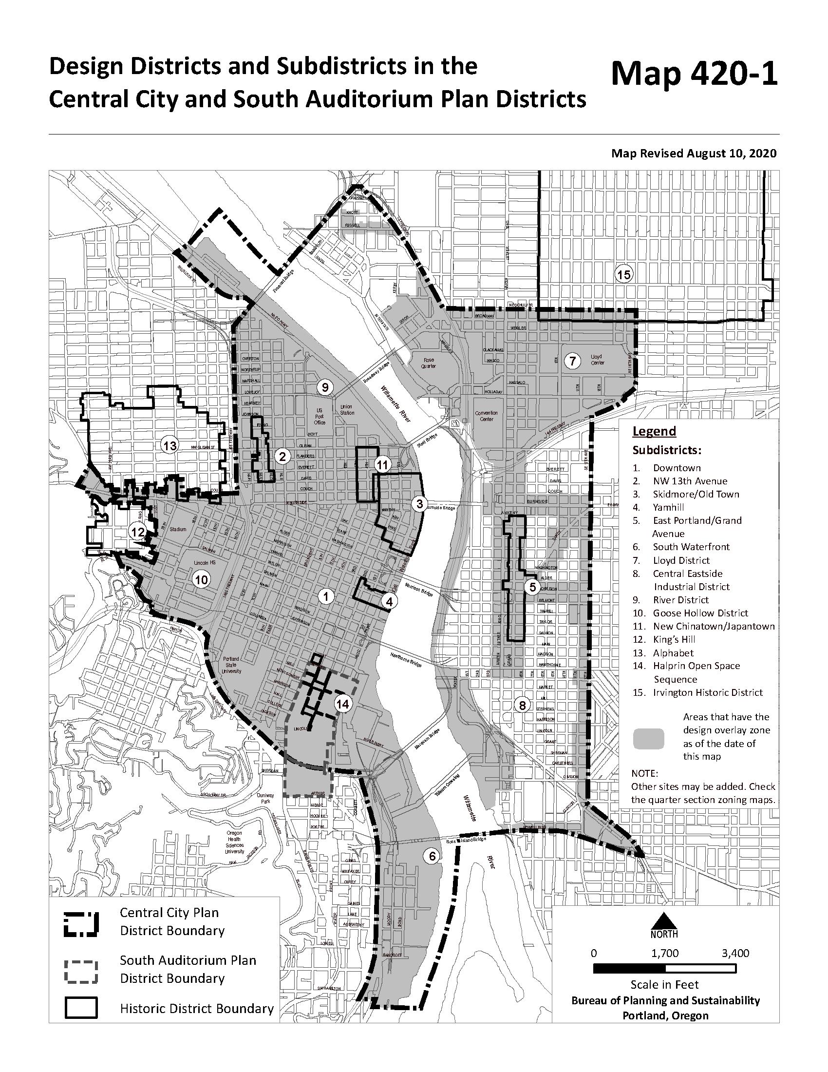
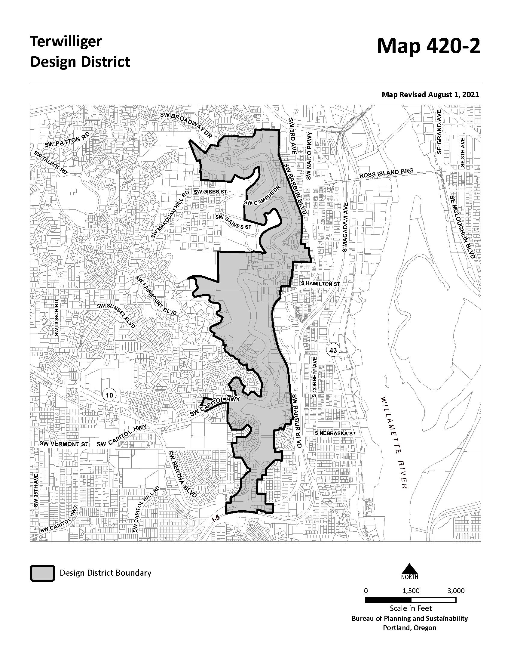
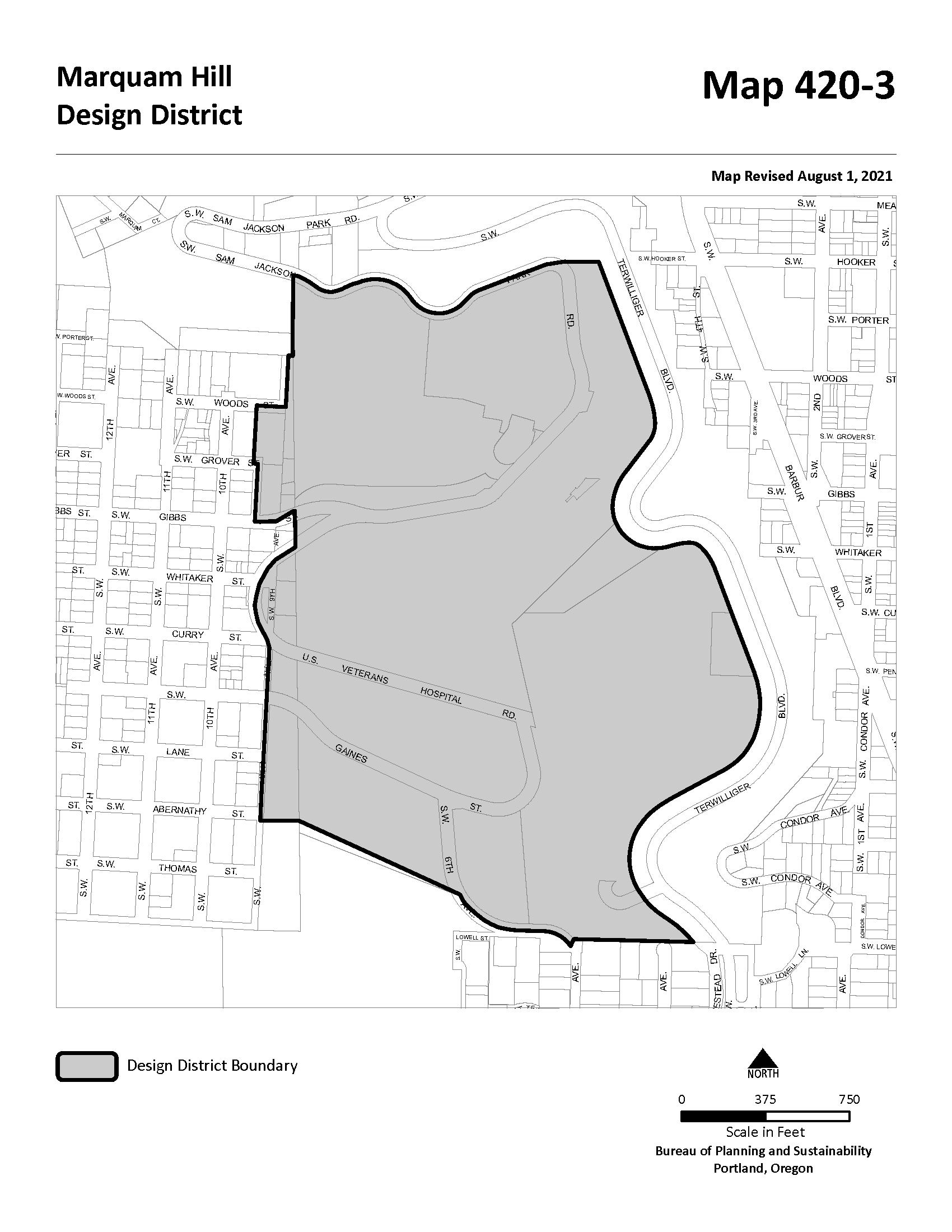
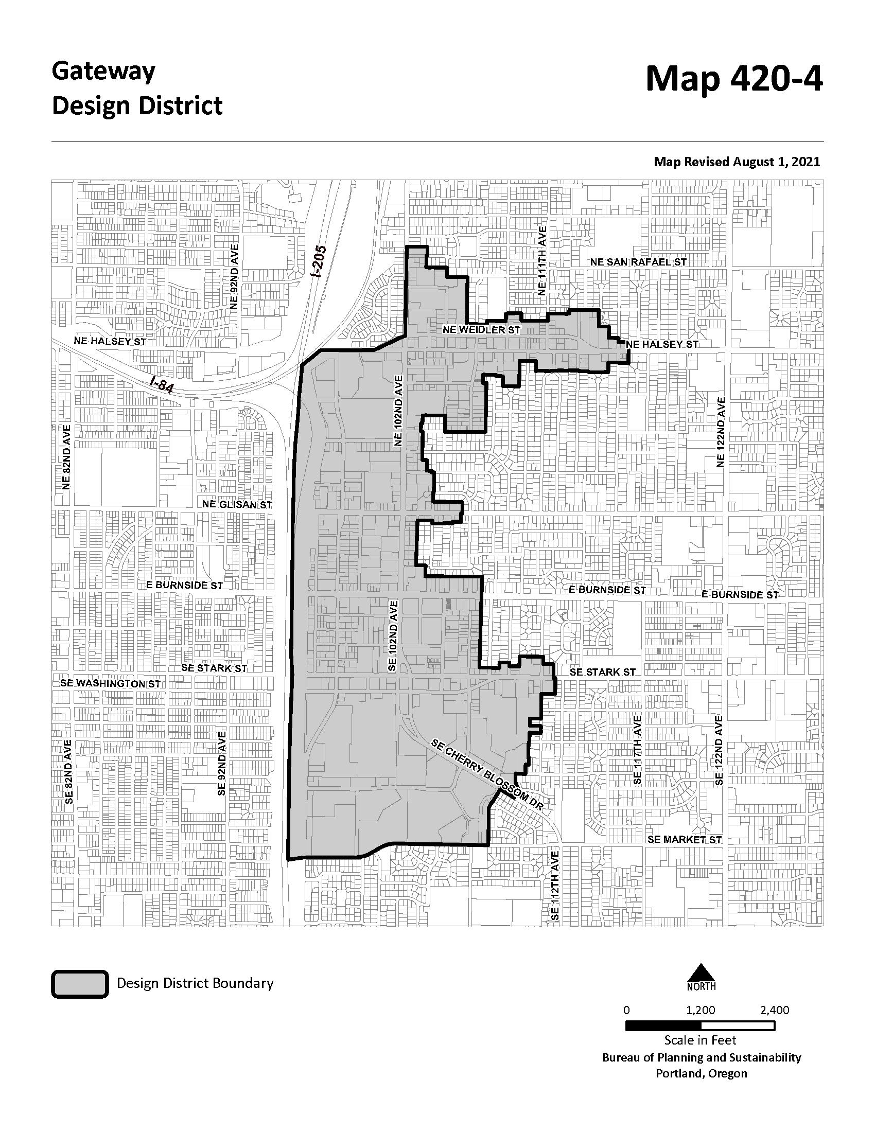
Sections:
33.400.010 Purpose
33.400.020 Map Symbol
33.400.025 Relationship to Federal Regulations
33.400.030 Height Limits
33.400.040 Exceptions to Height Limits
Map 400-1 Aircraft Landing Overlay Zone Boundaries
33.400.010 Purpose
The Aircraft Landing Overlay Zone provides safer operating conditions for aircraft in the vicinity of Portland International Airport by limiting the height of structures, vegetation, and construction equipment.
33.400.020 Map Symbol
The Aircraft Landing zone is shown on the Official Zoning Maps with a letter "h" map symbol (for height).
33.400.025 Relationship
The Aircraft Landing overlay zone supplements, but is subordinate to, federal airspace regulations administered by the Federal Aviation Administration (FAA). Development and structures that meet the requirements of the Aircraft Landing Overlay Zone may still be subject to review by the FAA.
33.400.030 Height Limits
All structures, vegetation, and construction equipment within the Aircraft Landing Overlay Zone are subject to the height limits of this section. Map 400-1 shows the boundaries of the overlay zone. The Aircraft Landing Overlay Zone Map, available in the Development Services Center shows the height limits.
A. E, I, CI2, and OS zones. In the employment, industrial, CI2, and open space zones, the height limits are shown on the Aircraft Landing Overlay Zone Map. When the base zone height is more restrictive than the Aircraft Landing Overlay Zone height, the base zone height applies. The Aircraft Landing Overlay Zone Map is available at the Development Services Center.
B. R, C, IR, and CI1 zones. In the residential and commercial/mixed use, IR, and CI1 zones, structures are regulated by the base zone height limits rather than the height limits of this chapter.
C. All zones. In all zones, structures taller than the limits of Subsection A or B are subject to Section 33.400.040.
Chapter 33.400
Title 33, Planning and Zoning
Aircraft Landing Zone 5/24/18
An application for a building permit or land use review for a structure that will exceed the height limits of Section 33.400.030 must be accompanied by an approval letter from the Federal Aviation Administration. The letter, called "determination of no hazard to air navigation," states that the proposal will not create safety problems. The application for FAA approval is available on the Federal Aviation Administration website or from the Aviation Department of the Port of Portland.
(Amended by: Ord. No. 176469, effective 7/1/02; Ord. No. 184521, effective 5/13/11; Ord. No. 188177, effective 5/24/18; Ord. No. 188958, effective 5/24/18.)
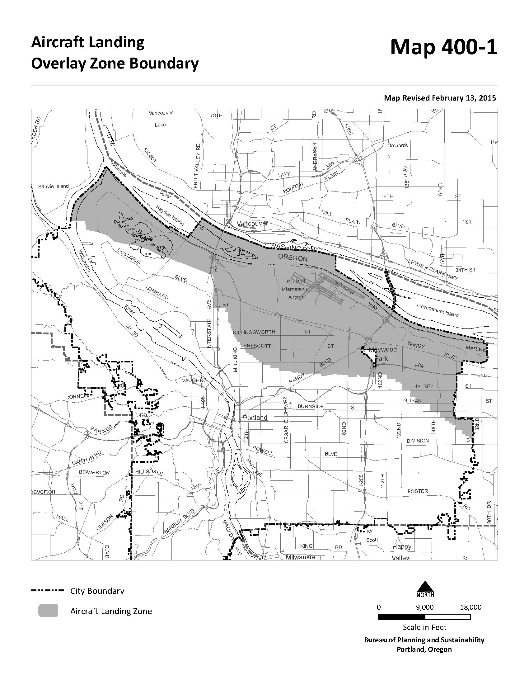
The Centers Main Street overlay zone encourages a mix of commercial, residential and employment uses on the key main streets within town centers and neighborhood centers identified in the Comprehensive Plan. The regulations are intended to encourage a continuous area of shops and services, create a safe and pleasant pedestrian environment, minimize conflicts between vehicles and pedestrians, support hubs of community activity, and foster a dense, urban environment with development intensities that are supportive of transit.
The Centers Main Street overlay zone is shown on the Zoning Map with an "m" map symbol.
The regulations of this chapter apply to sites in the Centers Main Street overlay zone.
The following uses are prohibited within 100 feet of a transit street:
A. Quick Vehicle Servicing; and
B. Self-Service Storage.
Chapter 33.415
Title 33, Planning and Zoning
Centers Main Street Overlay Zone 3/1/20
Within 100 feet of a transit street, at least 25 percent of the ground level floor area must be in one of the following active uses. Only uses allowed in the base zone may be chosen:
A. Retail Sales and Service;
B. Office;
C. Industrial Service;
D. Manufacturing and Production;
E. Community Service;
F. Daycare;
G. Religious Institutions;
H. Schools;
I. Colleges. If a College use is provided to meet this regulation, the floor area must be in one or more of the following functions: lobby; library; food service; theatre; meeting area; or
J. Medical Centers. If a Medical Center use is provided to meet this regulation, the floor area must be in one or more of the following functions: lobby; waiting room; food service; outpatient clinic.
The following development is prohibited within 100 feet of a transit street:
A. Drive-through facilities; and
B. Houses, attached houses, and duplexes.
33.415.310 Minimum Floor Area Ratio
A. In the Inner Pattern Area the minimum floor area ratio (FAR) for all new development is 0.5 to 1. Pattern areas are shown on Map 415-1.
B. In the Eastern and Western Pattern Area the minimum floor area ratio (FAR) for all new development is 0.25 to 1 Pattern areas are shown on Map 415-1.
In the Inner Pattern Area, at least 70 percent of the length of the ground level street-facing facade of the building must meet the maximum building setback standard of the base zone. If the site has three or more block frontages, this standard only applies to two frontages. In the case of sites with three or more block frontages, the two frontages subject to this standard are those with the highest transit street classifications. If multiple streets have the same highest transit street classification, the applicant may choose on which streets to meet the standard. Pattern areas are shown on Map 415-1.
A. Purpose. The vehicle area regulations help minimize conflicts between vehicles and pedestrians on transit streets, and create a pleasant, pedestrian-oriented environment by limiting the areas where parking and vehicular activity may be located on site.
B. Location of vehicle area. The following limitations apply on transit streets. Pattern areas are shown on Map 415-1:
1. In the Inner Pattern area, no more than 30 percent of any transit street frontage may be used for vehicle areas; and
2. In the Eastern and Western Pattern areas, no more than 50 percent of any transit street frontage may be used for vehicle areas.
C. Exemption. Sites that meet all of the requirements of 33.130.215.E, Alternative maximum building setback for large retailers, are exempt from this standard.
The ground floor window standards of the base zones apply to all sites in the Centers Main Street overlay zone, however the percentage of ground floor window required by 33.130.230.B.2.a(1) is increased to 60 percent. See Figure 415-1.
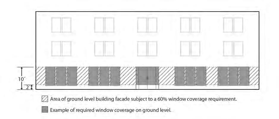
A. Purpose. Building entrances provide convenient pedestrian access between the use and public sidewalks and transit facilities. They help promote an environment that supports retail facilities and pedestrian activity.
B. Entrance frequency. On transit streets, at least one entrance is required for every 100 feet of building length for portions of buildings subject to the maximum street setback.
Chapter 33.415
Title 33, Planning and Zoning
Centers Main Street Overlay Zone 3/1/20
C. Entrance Design. Required entrances must be designed to meet the requirements of 33.130.242 Transit Street Main Entrance.
A. Purpose. Some locations in the Centers Main Street overlay zone are zoned CM1 and contain areas of continuous, older low-rise commercial storefront buildings that typically feature a concentration of retail uses, no landscaping, and are one to three stories in height. These additional regulations work in conjunction with regulations in the base zone, and the other standards of this section to support and protect the low-rise storefront scale and development features of these areas.
B. Where these regulations apply. The regulations in this Section apply to sites zoned CM1.
C. Retail Sales And Service and Office use limitations. Each individual Retail Sales And Service or Office use is limited to 40,000 square feet of net building area.
D. Industrial use. Manufacturing and Production and Wholesale Sales uses are allowed but each individual use is limited to 15,000 square feet of net building area.
E. Maximum floor area ratio. The maximum floor area ratio is 2.5 to 1.
F. Maximum building coverage. The maximum building coverage allowed is 100 percent.
G. Landscaping. No landscaping is required.
(Added by Ord. No. 188177, effective 5/24/18. Amended by: Ord. No. 188958, effective 5/24/18; Ord. No. 189805, effective 3/1/20.)
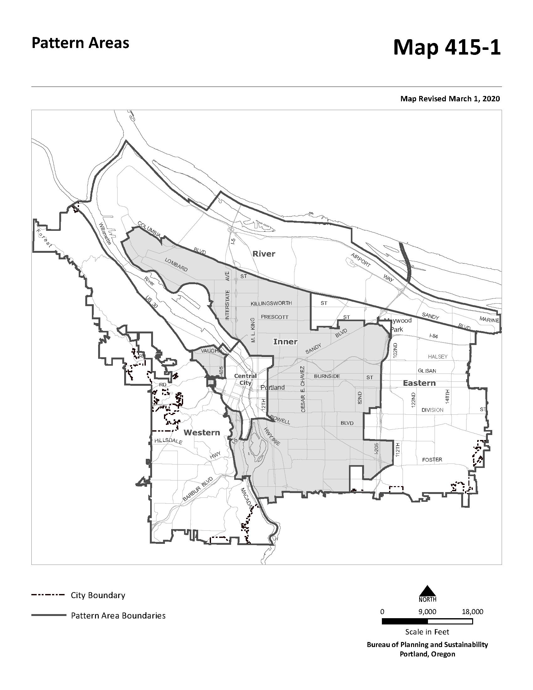

For more information about data updates or discrepancies, please contact Multnomah County Assessment, Recording & Taxation at (503) 988-3326 or dartcs@multco.us

Permits & Zoning Parks
Bureau of Development Services
Phone: 503-823-7300
Zoning Hotline: 503-823-7526
Clinton (DART) Public 6-12
Discovery Gardens - Kenton Private P
Discovery Gardens - Lombard Private P
Trinity Academy Private 6-12
Public Safety
Crime Statistics
To display crime data on the map click the crime category (person, property, or society) within the circle below
Person Crimes
Total: 0
City Average: <1
Assault O�enses (0)
Homicide O�enses (0)
Human Tra�cking O�enses (0)
Kidnapping/Abduction (0)
Sex O�enses (0)
Sex O�enses, Nonforcible (0)
Arson (0)
Bribery (0)
Burglary (0)
Counterfeiting/Forgery (0)
Embezzlement (0)
Property Crimes
Total: 1
City Average: 3
Extortion/Blackmail (0)
Fraud O�enses (0)
Larceny O�enses (1)
Motor Vehicle Theft (0)
Robbery (0)
Stolen Property O�enses (0)
Vandalism (0)
Society Crimes
Total: 0
City Average: <1
Animal Cruelty O�enses (0)
Drug/Narcotic O�enses (0)
Gambling O�enses (0)
Pornography/Obscene Material (0)
Prostitution O�enses (0)
Weapon Law Violations (0)
Data Range: 01/16/2022 - 01/15/2023
Reported crime counts are aggregated across hexagonal 1/8 mile grid sections of the city, and do not represent the number of reported crimes on a speci�c tax lot. Points on the map are generalized to the midblock point and may represent the location of multiple reported crimes. The locations of certain crimes are not shown on the map due to privacy concerns, but are included in counts and averages.
The records depicted give a general picture of crime events in the surrounding area and are not o�cial crime statistics. Some information displayed is currently under review and may change subject to record �nalization. For greater detail about each record, visit Portland Police Bureau's Open Data Portal and download o�ense data directly from the Crime Statistics Dashboard.
Police Jurisdiction
http://www.portlandpolice.com
Transportation
Portland Bureau of Transportation (PBOT)
1120 SW 5th Ave, Portland, OR 97204 www.portlandoregon.gov/transportation/
Tra�c Safety
Vision Zero is a citywide e�ort to make Portland's transportation system the safest possible and to move towards zero tra�c-related fatalities and serious injuries in the next 10 years
View the Vision Zero Tra�c Injuries and Fatalities Map
Report a Tra�c Safety Concern
Call the Transportation Safety and Neighborhood Livability Line (503-823-SAFE) or email safe@portlandoregon.gov
Tra�c Counts
Learn more about tra�c counts
View Portland tra�c counts map
TSP Classi�cations
View the Transportation System Plan (TSP) street classi�cation map
Snow & Ice Priority Routes
Learn about the City's snow and ice response plan
Parking
Learn more about Portland's parking policy and programs
For more information contact 503-823-2777 or email parking@portlandoregon.gov
Please call our 24 hour/7 days a week hotline (503-823-1700) for maintenance and repair issues or email BOMDispatch@portlandoregon.gov
Smart Trips
Learn about active transportation options for yourself, your family or your business
Transit
To plan a trip, use TriMet's Trip Planner
Leaf Day
District
Sweep Date 1
Sweep Date 2
Learn more about Portland's Leaf Day Program
Utilities
Garbage & Recycling
Residential Customers
Portland Disposal & Recycling
(503) 281-8736
http://www.portlanddisposal.com
Collection Day
Westside Terrain Area?
Commercial Customers
Dropbox Services
Thursday No
Unfranchised
Unfranchised
Bureau of Planning & Sustainability
Curbside Hotline: 503-823-7202
Email: wasteinfo@portlandoregon.gov
1900 SW 4th Ave, Suite 7100, Portland, OR 97201
www.portlandoregon.gov/bps/
Sewer & Environmental
Bureau of Environmental Services
Phone: 503-823-7740
1120 SW 5th Ave. #613, Portland, OR 97204
www.portlandoregon.gov/bes/
Water
Portland Water Bureau
Phone: 503-823-7770
1120 SW 5th Ave. #405, Portland, OR 97204
www.portlandoregon.gov/water/
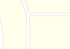


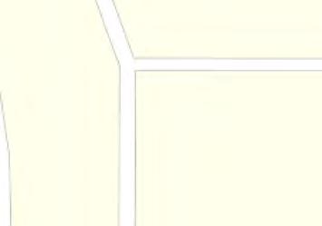


Topography
Water Features
Aerial
Aerial Environmental
Community
Transit
Vacant Land
Market Trend Report (1 Mile Radius)
Traffic Counts
AreaProfiled:8106NInterstateAve,Portland,OR
ReportDate: 02/15/2023
NumberofParcels:203
SalesDates: 01/01/1989-12/07/2022 WaterfrontParcels:0
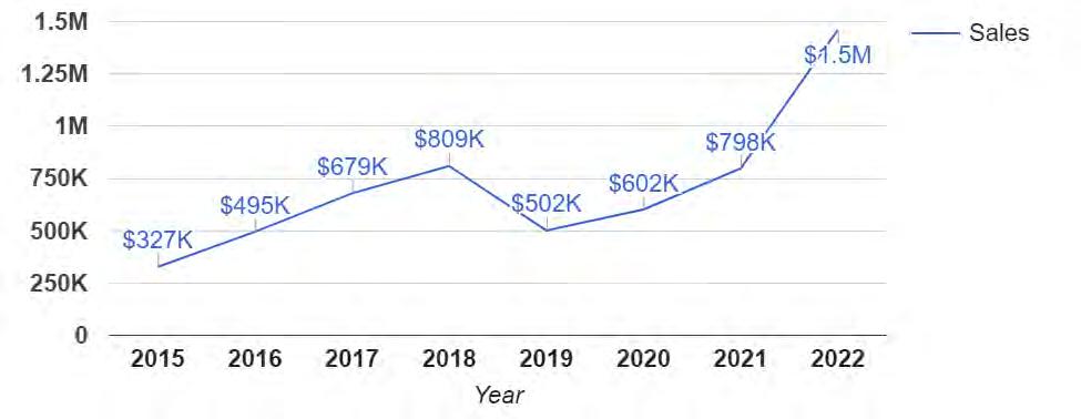
AverageSalePricebyYear:01/01/2015-02/15/2023
ParcelswithViews:0
*120sale(s)areincludedinthegraph
SalesStatisticsbyYear:01/01/2015-02/15/2023

*118sale(s)areincludedinthetable **2sale(s)withnosalepriceorbuildingsqftareexcludedfromthetable
Informationisdeemedreliablebutnotguaranteed.PoweredbygeoAdvantage.

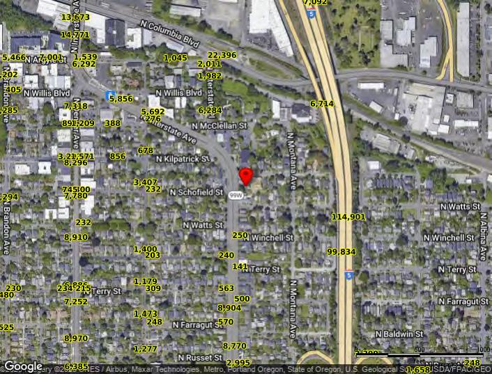 Powered