The information contained is provided by WFG’s Customer Service Department to our customers, and while deemed reliable, is not guaranteed.
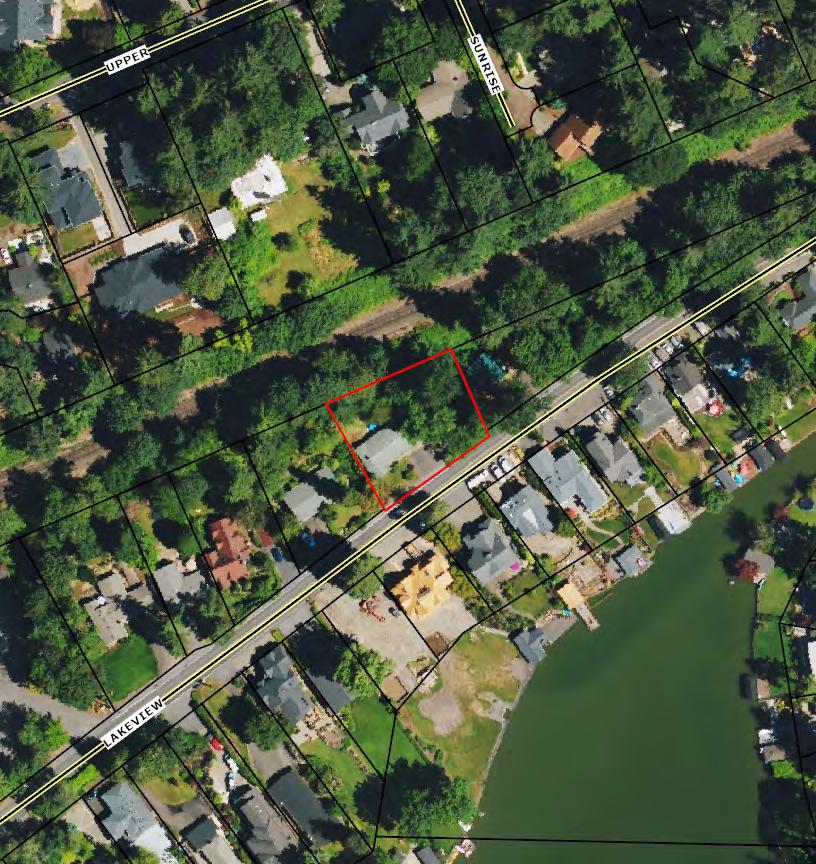
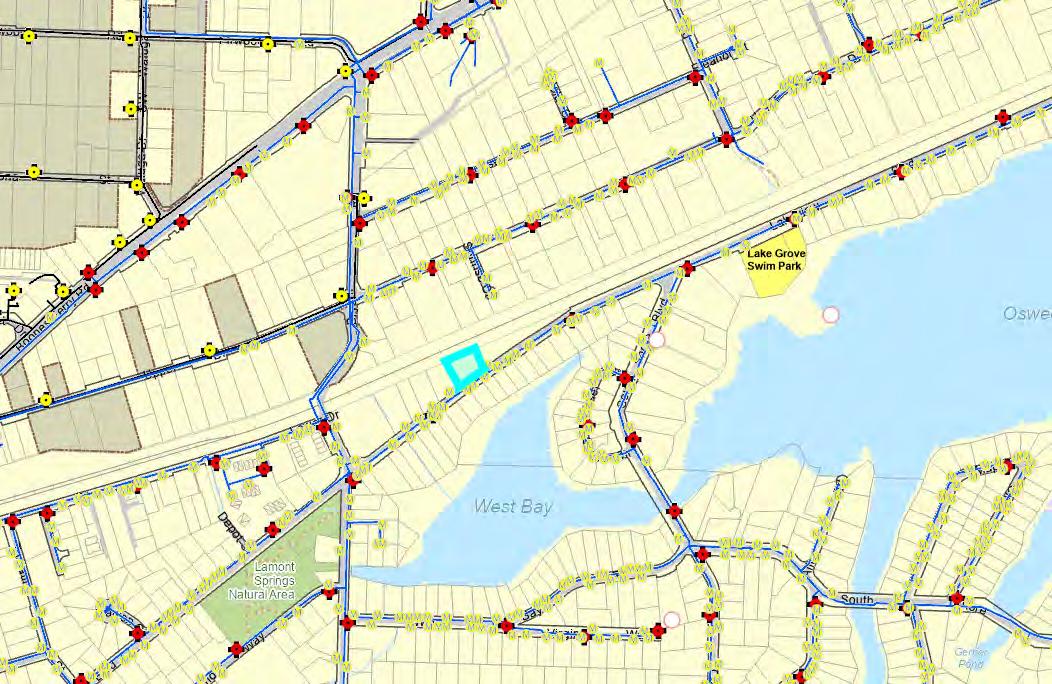
WATER LINE MAP
This map is a copy of public record and is provided solely for informational purposes.
WFG National Title assumes no liability for variations, if any, in dimensions, area or location of the premises or the location of improvements.
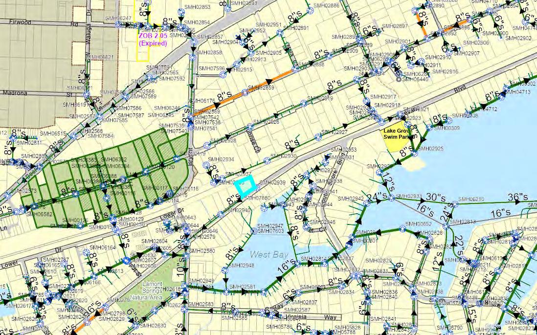
SEWER LINE MAP
This map is a copy of public record and is provided solely for informational purposes.
WFG National Title assumes no liability for variations, if any, in dimensions, area or location of the premises or the location of improvements.
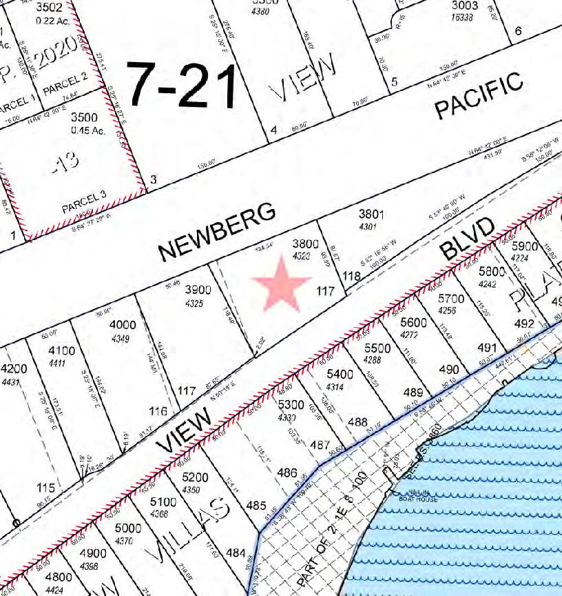
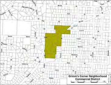
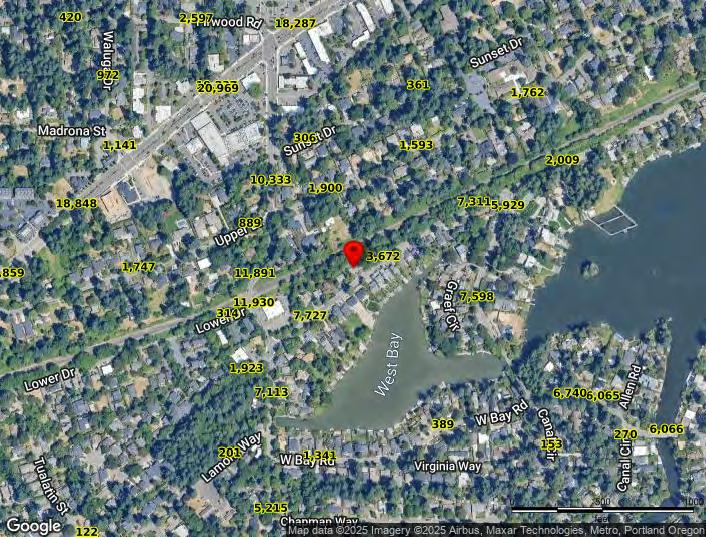
ZONING
DETAILS
Detailed Zoning Information
Lake Oswego R-7.5 (Low Density Residential)
Zoning Map
Community Jurisdiction
The information contained is provided by WFG’s Customer Service Department to our customers, and while deemed reliable, is not guaranteed.
General Provisions
§ 50.01.001. Title and Purpose.
1. Title.
[Ord. No. 2579, Repealed and Replaced, 3-20-2012]
Lake Oswego Code Chapter 50 may be referred to as "the Community Development Code of the City of Lake Oswego" and is referred to herein as "the CDC" and "this Code."
a. Generally Applicable Purposes. This Code has been drafted in accordance with the policies set forth in the Comprehensive Plan for the City of Lake Oswego. It is the general purpose of this Code, therefore, to provide the principal means for the implementation of the Comprehensive Plan. To fulfill this general purpose this Code is intended to:
i. Protect and promote the public health, safety, convenience and general welfare;
ii. Guide future land uses, growth and development in accordance with the Comprehensive Plan;
iii. Provide for review of those uses determined to carry the potential for adverse impact on surrounding uses;
iv. Assure prompt review of development applications for compliance with this Code’s requirements, and the application of clear and specific standards;
v. Provide for public review and comment on development proposals which may have a significant impact on the community;
vi. Guide public and private policy and action to assure provision of adequate water, sewerage, transportation, drainage, parks, open space and other public facilities and services for each development and to implement Comprehensive Plan policies concerning the distribution of costs of public facilities and services required to serve development, and coordinate the timing of development with the provision of adequate public facilities and services;
vii. Provide the opportunity for a mixture of housing types which meet the needs of the City residents;
viii. Establish procedures, standards, and review of uses assuring that the design of site improvements and building improvements are consistent with applicable standards and minimize adverse impacts on surrounding land uses, and yet allow for and encourage flexibility in the design and layout of site improvements and buildings, and innovation in design and construction;
ix. Provide for review and approval of the relationship between land uses and traffic circulation in order to minimize congestion, with particular emphasis on not exceeding the planned capacity of residential streets to carry projected traffic; to provide for safe pedestrian and bicycle circulation; to provide for the proper location of street rights-of-way, easement and building lines; to assure provision of adequate internal vehicle circulation; parking, loading and pedestrian walkways;
x. Minimize pollution and damage to waterways and Oswego Lake; to assure the adequacy of drainage facilities and to protect the natural character and functions of waterways;
xi. Provide standards to regulate the impacts of development upon soils, trees and vegetation, sensitive lands and other natural features;
xii. Assure reasonable safety from fire, flood, landslide, erosion or other natural hazards;
xiii. Provide opportunities for economic development of the City;
xiv. Protect the City’s aesthetic beauty and character; and
xv. Promote the conservation of energy through site and building design and orientation;
b. Historic Preservation Purposes. This Code incorporates the City’s historic preservation regulations that are intended to:
i. Promote the historic, educational, architectural, cultural, economic, and general welfare of the public through the identification, preservation, restoration and protection of those structures, sites, objects, and districts of historic and cultural interest within the City;
ii. Foster community and neighborhood pride and sense of identity based on recognition and use of historic and cultural resources;
iii. Identify and designate as historic resources only those structures, sites and objects which possess historic features and characteristics viewed by this community as having true historical significance;
iv. Strengthen the economy of the City by enhancing the historic and cultural resources for tourists, visitors and residents;
v. Encourage public knowledge, understanding and appreciation of the City’s history and culture;
vi. Promote the enjoyment and use of historic and cultural resources appropriate for the education and recreation of the people of Lake Oswego;
vii. Preserve diverse architectural styles reflecting periods of the City’s historical and architectural development; and encourage complementary design and construction impacting historic resources;
viii. Enhance property values and increase economic and financial benefits to the City and its inhabitants;
ix. Identify and resolve conflicts between the preservation of historic or cultural resources and alternative conflicting uses;
x. Integrate the management of historic and cultural resources into public and private land management and development processes;
xi. Provide the principal means to implement and carry out the provisions of Statewide Planning Goal 5 and the Comprehensive Plan Policies relating to historic resources and support the enforcement of all federal and state laws relating to the protection of National Register resources, archaeological sites and archaeological objects;
xii. Recognize the importance of Oswego Lake to this community and the attendant and long-standing use of the lake and appurtenant assets for recreational, water quality and electrical power generation purposes;
xiii. Provide clear procedures and standards to ensure that the ongoing operation and maintenance of residential, commercial and industrial uses are not affected in a manner that jeopardizes the economic viability of such uses; and
xiv. Protect private property owners against extraordinary cost occasioned by the application of this chapter.
xv. Ensure that land is divided so that structures can be oriented to maximize solar access and to minimize shade on adjoining properties from structures and trees.
[Editor’s Note: From time to time, new state and federal laws, regulations, or court decisions are issued. The reader is advised that federal or state law may be determined to supersede portions of this Community Development Code, either generally or as applied to a specific situation.]
§ 50.01.002. Application of Code.
1. Applicability.
[Ord. No. 2579, Repealed and Replaced, 3-20-2012]
Development of real property within the corporate limits of the City of Lake Oswego shall be governed by this Code. All provisions in other sections of the Lake Oswego Code which conflict with applicable provisions of this Code are hereby superseded.
2. Compliance.
[Ord. No. 2579, Repealed and Replaced, 3-20-2012]
Except as otherwise specifically provided by this Code, no building or other structure shall be constructed, reconstructed, improved, altered, enlarged or moved, nor shall any use or occupancy of premises within the City be commenced or changed, nor shall any condition of or upon real property be caused or maintained after December 16, 1982, except in
conformity with the requirements prescribed for each of the several zones and general regulations established hereunder. It shall be unlawful for any person to erect, construct, reconstruct, establish, occupy, alter, enlarge or use, or cause to be used, any building, structure, improvement or use of premises located in any zone described in this Code contrary to the provisions of this Code. Where this Code imposes greater restrictions than those imposed or required by other rules or regulations or Code provisions, the provisions of this Code shall control.
3. Maintenance of Minimum Ordinance Requirements.
[Ord. No. 2579, Repealed and Replaced, 3-20-2012]
No lot area, yard, or other open space, existing on or after December 16, 1982, shall be reduced in area, dimension, or size below the minimum required by this Code, nor shall any lot area, yard, or other open space which is required by this Code for one use be used as the lot area, yard, or other open space requirement for any other use, except as provided in this Code.
4. Relationship to Other Laws and Private Agreements; Prior Approvals and Conditions of Approval.
It is not an intent of this Code to interfere with, abrogate or annul any easement, covenant or agreement between parties; provided, however, that where this Code imposes a greater restriction upon the use of buildings and premises, upon height of buildings, or requires larger open spaces or similar restrictions than are imposed or required by private agreements, easements and covenants, the provisions of this Code shall govern.
a. Approvals Granted Before December 16, 1982. Planned unit development approvals, conditional use permits, variances and Development Review Commission approvals, and conditions attached to those approvals, and conditions attached to zone change approvals, granted prior to December 16, 1982, shall remain in effect until specifically amended or deleted by action pursuant to this Code. A request to amend approvals or delete or amend conditions of approvals is classified as a request to amend the zoning map and shall be considered as such unless the subject matter of the request is regulated by LOC § 50.07.003.11.a, Modification of Approved Permit, in which case the request will be processed pursuant to that section. Those conditions imposed or approvals granted by ordinance under the prior zoning code may be amended or deleted by order of the hearing body, or, on appeal, by order of the City Council, without the necessity of adopting an amending ordinance.
§ 50.01.003. Authority.
1. Official Action.
[Ord. No. 2579, Repealed and Replaced, 3-20-2012]
a. All officials, departments, employees, and commissions of the City vested with authority to issue permits or grant approvals shall adhere to and require conformance with this Code, and shall issue no permit or grant approval for any development or use
which violates or fails to comply with conditions or standards imposed to carry out this Code.
b. Any permit or approval issued or granted in conflict with the provisions of this Code, whether intentional or otherwise, is void. It is the duty of the person receiving such permit to bring the structure or use subject to the permit into compliance with the terms of this Code immediately upon gaining knowledge that the permit is in conflict with the provisions of this Code.
i. The City Manager shall have the authority to interpret, implement, and enforce the requirements of this Code, subject to review by the hearing body and/or the City Council pursuant to this Code.
ii. The City Manager may request an advisory opinion from the First Addition Neighborhood Association or the Old Town Neighborhood Association regarding interpretation or application of standards and requirements of the R-6 and R-DD zones, respectively.
b. Administrative Rules. The City Manager may adopt administrative rules to aid in implementing this Code.
c. Delegation of Authority. The City Manager may delegate any authority or responsibility identified in this Code to any suitable person.
d. Interpretation of Approvals. The City Manager shall interpret the meaning and scope of approvals granted based on the record of the proceeding.
[Cross-Reference: See LOC § 50.05.010.4.d, Construction Standards – Grading, Clearing or Construction in RP or RC zone.]
e. Concurrent Hearings. When more than one approval is sought for a particular property the City Manager may allow the requests to be processed concurrently. The City Manager may refuse to allow concurrent consideration if it is determined that such a process would be impractical or cumbersome, tend to create confusion before the hearing body or require a potentially unnecessary use of City resources.
f. Historic Resources.
i. The City Manager shall have the authority to make a decision to approve, approve with conditions, or deny applications for:
(1) Minor alterations to a landmark;
(2) Major alterations to a landmark if the application includes other minor development;
(3) Alterations, moving or demolition of a contributing resource.
ii. At the discretion of the City Manager, an application under subsection 2.f.i of this section may be referred to the DRC for hearing and decision.
The hearing body shall be the Planning Commission, the Development Review Commission (DRC) or the Historic Resources Advisory Board (HRAB).
a. Planning Commission. Except as provided by LOC § 50.01.003.3.d, the Planning Commission shall hear:
i. Applications to develop pursuant to a mixed use Overall Development Plan and Schedule (ODPS); and
ii. Applications for a quasi-judicial zone change or quasi-judicial Comprehensive Plan or Code amendment.
b. Historic Resources Advisory Board. Except as provided by subsection 3.d of this section, HRAB shall hear applications and shall have the authority to make a decision to approve, approve with conditions, or deny an application for the following:
i. Designation or removal of a designation of a historic resource;
ii. Establishment, modification or abolishment of a historic district;
iii. Demolition or moving of a landmark;
iv. Demolition (as defined in LOC § 50.06.009.9.b) or relocation of a National Register property.
c. Development Review Commission.
i. Except as provided by subsection 3.d of this section, the Development Review Commission shall hear all other applications for development, including:
(1) Conditional use;
(2) Single use ODPS;
(3) Appeals of decisions of the City Manager on minor development applications; and
(4) Any application referred by the City Manager pursuant to LOC § 50.07.003.14.d.i
d. Consolidated Review. If a person desires to apply for a development which requires hearings before the Planning Commission, DRC, and/or HRAB, the City Manager may either consolidate the proceedings before one hearing body or schedule the hearings in such a manner that a decision on the development can be made within the time period
for final action established by state law. The City Manager has the sole discretion to determine which hearing body shall hear the application. As a nonbinding guideline, the City Manager should refer the consolidated proceeding to the Planning Commission if the City Manager believes that the application raises significant policy issues. The City Manager should refer the consolidated proceeding to the DRC if the City Manager believes the primary issue involves siting or design.
4. Development Permits Restricted for Unlawful Uses.
[Ord. No. 2579, Repealed and Replaced, 3-20-2012]
No development permit shall be issued for a development or use of land in violation of this Code, unless the violation is rectified as part of the development.
5. Development Restricted on Illegal Lot.
[Ord. No. 2579, Repealed and Replaced, 3-20-2012]
a. No development permit shall be issued for the development or use of an illegal lot unless the lot is made legal pursuant to the applicable requirements for creation of a lot in effect at the time of application. The applicant shall demonstrate conformance with applicable legal requirements. This restriction applies regardless of whether the applicant was responsible for creation of the illegal lot.
b. If an illegal lot cannot be made legal pursuant to subsection 5.a of this section because it does not comply with lot area or dimensional requirements in effect at the time of application, an application for the creation of the lot shall be exempted from compliance from such lot area or dimensional requirements if the applicant demonstrates that the lot would have complied with lot area and dimensional requirements applicable at the time of creation.
c. If an illegal lot cannot be made legal pursuant to subsection 5.a or 5.b of this section because it does not comply with applicable lot area or dimensional requirements at the time of application and did not comply with applicable lot area or dimensional requirements at the time of creation, an application for the creation of the lot shall be exempted from compliance with such lot area and dimensional requirements if the applicant demonstrates that development that would be allowed by legal creation of the lot will not have a significant negative impact on the neighborhood in terms of scale, noise, traffic, parking, loss of privacy, obstruction of views, or buffers from existing properties. In determining the degree of impact, the City shall consider the consistency of potential development on a lot with the existing development pattern in the vicinity. The City may impose conditions on development of the lot in order to ensure that legalization of the lot does not have a significant negative impact on the neighborhood. Public notice of an application to legalize a lot pursuant to this subsection shall contain a map of the property illustrating the building envelope. If the lot proposed to be made legal pursuant to this subsection has a lot area or dimension which is less than 65% of the size or length required by the zone at the time of application, the application to create the legal parcel shall be referred to the Development Review Commission for public hearing.
§ 50.01.004. Zoning Designations, Boundaries, Maps, and Annexation.
The City is divided into the following zoning designations:
Table 50.01.004-1: Zoning Designations
Zone District Category Map Designation
Residential
Residential – Low Density
R-15
Residential – Low Density R-10
Residential – Low Density
R-7.5
Residential – Medium Density (FAN) R-6
Residential – Medium Density
Residential – Design District (Old Town)
Residential – High Density
Residential – High Density
R-5
R-DD
R-3
R-2
Residential – High Density R-0
Residential – Waterfront Cabanas R-W
Commercial
Neighborhood Commercial NC
General Commercial GC
Highway Commercial HC
Office Campus OC
East End General Commercial EC
Campus Research and Development CR&D
Mixed Use
Foothills Mixed Use FMU
Mixed Commerce MC
West Lake Grove Districts
WLG Townhome Residential
WLG R-2.5
WLG Residential Mixed Use WLG RMU
Table 50.01.004-1: Zoning Designations
Zone District Category Map Designation
WLG Office Commercial WLG OC
Industrial
Industrial I
Industrial Park IP
Special Purpose Districts
Campus Institutional CI
Public Functions PF
Park and Natural Areas PNA
Overlay Districts – Area Specific
Glenmorrie R-15 Overlay District GO
Evergreen R-7.5 Overlay District EO
Lake Grove R-7.5/R-10 Overlay District LGO
Downtown Redevelopment Design District DRD
West Lake Grove Design District WLG
Old Town Neighborhood Design OTN
Lake Grove Village Center Overlay District LGVCO
Southwest Overlay District SWO
Overlay Districts – Resource Specific
Greenway Management Overlay District GM
Sensitive Lands Overlay
Resource Conservation (Tree Groves) RC
Resource Protection (Streams and Wetlands) RP
Habitat Benefit Area (Tree Groves) HBA
Flood Management Area FMA
2. Zoning Districts Map.
[Ord. No. 2579, Repealed and Replaced, 3-20-2012]
a. The boundaries of the zoning districts established in this Code are indicated on the City zoning map.
b. Amendments to the City zoning map may be made pursuant to LOC § 50.07.003.16, Legislative Decisions. Copies of all map amendments shall be dated with the effective
date of the document adopting the map amendment and shall be maintained without change, together with the adopting document, on file in the office of the City Recorder.
c. The City Manager shall maintain an up-to-date copy of the City zoning map to be revised from time to time so that it accurately portrays changes of zone boundaries. A separate map shall also be maintained and show the location of conditional use permits, planned developments and variances. The City Manager shall index on the appropriate map adjacent to such zone change, conditional use, planned developments, or variance, the file number of the document authorizing the same.
3. Interpretation of Zone District Boundaries.
[Ord. No. 2579, Repealed and Replaced, 3-20-2012]
a. Guidelines for Interpretation. Where due to the scale, lack of detail or illegibility of the City zoning map or due to any other reason, there is uncertainty, contradiction or conflict as to the intended location of any zone district boundary, the exact location of district boundary lines shall be determined by the City Manager in accordance with the following guidelines:
i. Street Lines. Where district boundaries are indicated as approximately following the centerline or right-of-way line of streets, such lines shall be construed to be such district boundaries.
ii. Street Vacations. Whenever any street is lawfully vacated, and the lands within the boundaries thereof attach to and become a part of lands adjoining such street, the lands formerly within the vacated street shall automatically be subject to the same zoning district designation that is applicable to lands to which same attaches.
iii. Lot Lines. Where district boundaries are indicated as approximately following lot lines, such lot lines shall be construed to be said boundaries. If a district boundary divides a lot into two or more districts, the entire lot shall be placed in the district that accounts for the greater area of the lot by the adjustment of the district boundary; provided, that the boundary adjustment is for a distance of less than 20 ft. If an adjustment of more than 20 ft. is required, the change in the district boundary shall be treated as a change of zone.
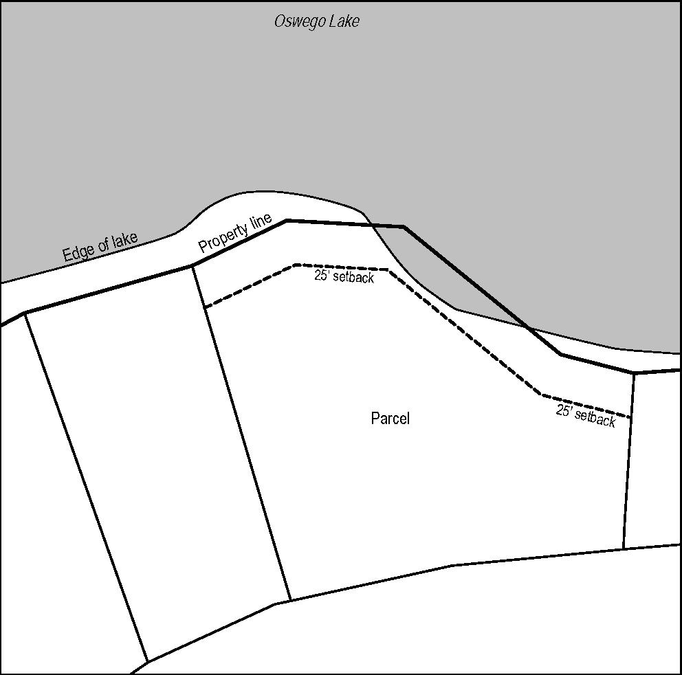
iv. Water Courses. District boundary lines are intended to follow the centerlines of water courses and the shore line of Oswego Lake unless such boundary lines are otherwise fixed on the City zoning map.
4. Zoning of Annexed Areas.
[Ord. No. 2579, Repealed and Replaced, 3-20-2012]
a. Zoning designations on newly annexed territories shall be imposed as provided in LOC § 50.01.004.5.
b. The City may consider the zoning for any area proposed for annexation at the same time the question of annexation for the area is considered. The notice and hearing procedures
shall be the same as if the area in question were located within the City limits. The zoning decision shall not be a final decision for the purposes of judicial review until the date that the approval of the annexation of the area has become effective, or the date of the zoning order if that date is later in time.
5. Comprehensive Plan Map Designations Automatically Applied Upon Annexations; Exceptions.
a. The Lake Oswego Comprehensive Plan Map provides for the future City zoning of all property within the City’s Urban Service Boundary. In cases where the Comprehensive Plan Map requires a specific zoning map designation to be placed on territory annexed to the City of Lake Oswego, such a zoning designation shall automatically be imposed on territory as of the effective date of the ordinance annexing such territory to the City. The City Manager shall modify the zoning map accordingly. In cases where the Comprehensive Plan Map does not require a specific zoning map designation to be placed on territory annexed to the City, the City Manager shall prepare an application and recommend a specific zoning map designation to the Planning Commission with all due speed following the effective date of an ordinance annexing such territory to the City of Lake Oswego. The Planning Commission shall hear the application pursuant to LOC § 50.07.003.16, Legislative Decisions.
b. Where the Comprehensive Plan Map indicates an RP, RC, or HBA District designation on territory proposed for annexation, the City shall notify the owners of the annexing territory that they have 20 days prior to the initial public hearing on the annexation to contest the designation pursuant to LOC § 50.07.004.8.b, Sensitive Lands Overlay Districts. No fee shall be charged for such review. If, following review, the decisionmaker determines the property was improperly designated, the RP, RC, or HBA designation shall be removed.
c. When evidence indicates that a resource that potentially qualifies for an RP or RC District or HBA overlay designation pursuant to LOC § 50.07.004.8 exists on territory to be annexed, the City may conduct an Economic, Social, Environmental, and Energy (ESEE) Analysis and determine whether such a zone should be imposed pursuant to LOC § 50.07.004.8, Sensitive Lands Overlay Districts. City staff may request a delay in the effective date of annexation to complete review.
6. Effect of Conditions of Approval or Development or Design Regulations Imposed Prior to Annexation.
a. Purpose. The purpose of this section is to require owners of nonconforming uses, structures, or parcels annexed into the City of Lake Oswego to continue to comply with the use, design or development standards imposed by the prior jurisdiction until such time as the use, structure, or parcel is modified or developed under City development standards.
b. Definition of Prior Jurisdiction. For purposes of this section, "prior jurisdiction" shall mean the county or city that had zoning jurisdiction upon the parcel prior to its annexation to the City of Lake Oswego.
c. Compliance with Prior Jurisdiction Requirements. Following annexation of a parcel into the boundaries of the City of Lake Oswego, the owner of a parcel shall comply with the use limitations, development or design regulations, or conditions of approval applicable to the use, structure or parcel imposed by the prior jurisdiction prior to annexation of the parcel into the boundaries of the City.
d. Interpretation of Prior Jurisdiction Requirements. In the event it is necessary to interpret the design or development standards, or use limitations of a prior jurisdiction, or any condition of approval granted by a prior jurisdiction, the interpretation shall be made in the manner provided by LOC § 50.01.005, Authority to Interpret CDC, Zoning Map and Comprehensive Plan.
e. Modification of Conditions of Approval. The owner’s obligation to comply with the conditions of approval of a development permit issued by a prior jurisdiction may be modified following annexation of the parcel into the City boundaries the same as if the conditions were imposed by the City, in the same manner as provided in LOC § 50.07.003.11, Modification of Development Permits. Except to the extent a condition of approval is modified pursuant to this subsection, the prior jurisdiction’s use limitations, and development or design regulations, shall continue to apply to the use, structure or parcel.
f. Modification of Use, Structure or Parcel to Comply with Applicable City Use, Design, or Development Regulations. A property owner may seek modification of the requirements of a development permit, including use, design or development regulations, issued or imposed by the prior jurisdiction for the purpose of complying with comparable City use, design or development regulations. Such modification shall be in accordance with LOC § 50.07.003.11, Modification of Development Permits. Except to the extent the use, structure or parcel complies with City requirements following modification of development permit as provided under this subsection, the owner shall comply with the prior jurisdiction’s use limitations, and development or design regulations.
g. Effect of Compliance with Prior Jurisdiction Requirement or Modification Upon Nonconforming Status. This section shall not be construed as remedying the nonconformance of any use, structure or parcel with the use limitations, design and development requirements of this Code. Notwithstanding the compliance of the owner with this section, the structure or use shall nevertheless be deemed nonconforming and shall be subject to the provisions of LOC §§ 50.01.006.1.b, 50.01.006.3.a.i, 50.01.006.3.a.iv and LOC § 50.01.006.4, Nonconforming Uses, Structures, Lots and Site Features.
[Cross-Reference: LOC § 50.01.006.1 – Nonconforming Defined; Rights Granted.]
§ 50.01.005. Authority to Interpret CDC, Zoning Map and Comprehensive Plan.
1. City Manager Interpretations.
[Ord. No. 2579, Repealed and Replaced, 3-20-2012]
A person may request an interpretation of the City Comprehensive Plan or land use regulations from the City Manager. Such an interpretation may be formal or informal, as follows:
a. Formal Interpretation. An applicant may request a formal interpretation as it relates to the proposed development of a specific property owned by the applicant or by a person for whom the applicant is the agent. The application shall be in writing and shall set forth the issues the applicant desires interpreted. A fee set by resolution of the City Council may be charged for an application for a formal interpretation. Notice of a request for a formal interpretation shall be sent in the manner provided for a minor development pursuant to LOC §§ 50.07.003.3.a and 50.07.003.14.c, and notice of the interpretation shall be sent in the same manner as notice of a decision on a minor development pursuant to LOC § 50.07.003.14.d.iii(3), Notice of Final Decision. A formal interpretation may be appealed in the same manner as a minor development. Once a formal interpretation becomes final, it shall be binding on the City as it applies to a future application for development of the subject property unless the provision that is the subject of the interpretation is amended, repealed or construed differently by LUBA or a court of competent jurisdiction prior to the filing of the application for development. Such an interpretation shall not be binding as it relates to development of other properties.
b. Informal Interpretation. Any person may request the planning staff or the City Attorney for an informal interpretation. Such a request may either be oral or in writing, and is not subject to notice, appeal or a fee. Such an interpretation is not a final land use decision, however, and is not binding on City staff or City appellate authorities as it applies to future land use applications on the subject property or in general.
§ 50.01.006. Nonconforming Uses, Structures, Lots and Site Features.
i. A use, structure, lot, or site feature (e.g., landscaping, parking, etc.; see Sign Code, LOC Chapter 47 for nonconforming signs) is nonconforming if the use, structure, lot, or site feature was initially lawfully established, but does not comply with or would not be permitted to exist under this Code due to a subsequent enactment or amendment to this Code, or due to annexation.
ii. An illegal use, structure, lot or site feature is one that was not lawfully established because it does not comply with or would not be permitted under this Code or any prior versions of this Code. A use, structure, lot or site feature that was lawfully established under a prior jurisdiction but did not comply with this Code at the time of annexation is not illegal. An illegal use, structure, or site feature is a violation of
this Code and may be subject to abatement or penalties pursuant to LOC Article 50.09. An illegal lot may obtain legal status only if it meets the requirements set forth in LOC § 50.01.003.5, Development Restricted on Illegal Lot.
b. Approved Variance. A use, structure, lot, or site feature for which a variance was granted is not considered nonconforming solely because the characteristic of the use, structure, lot, or site feature for which the variance was granted fails to comply with the requirements of this Code. However, the existence of an approved variance does not prevent the use, structure, lot, or site feature from being classified as nonconforming as to another characteristic that fails to comply with the requirements of this Code.
c. Applicability to Approvals and Incomplete Construction. If a use, structure, or site feature that received final development approval becomes nonconforming within a year after approval, but before construction is completed, no change in plans, construction or use for which a final development approval was received is required. All rights granted by this section are extinguished if the development permit or building permit is revoked or becomes void. The structure, use, or site feature shall thereafter conform to all applicable provisions of this Code.
[Cross-Reference: LOC § 50.07.005.1 – Uses Under Conditional Use Provisions Not Nonconforming Uses.]
2. Continuation and Maintenance of Nonconformities.
a. Continuation of Nonconformity. Subject to the provisions of this section, and except as otherwise provided by this Code, a nonconforming use, structure, lot, or site feature may be continued in use so long as it remains otherwise lawful.
b. Demolition or Alteration of a Nonconforming Dwelling. In a residential zone, an existing nonconforming residential dwelling shall be removed or brought into conformance with this Code upon:
i. Demolition of the dwelling under LOC § 45.12.100.1.d, except where demolition results from the Building Official ordering the reconstruction of a wall under subsection 2.c of this section because it is unsafe; or
ii. An increase in floor area of the dwelling by 50% or more where the total floor area of the dwelling after the addition exceeds 90% of maximum allowed floor area, except as provided in subsection 3 of this section.
EXCEPTION: In calculating whether the increase in floor area of the dwelling is 50% or more, new floor area resulting from conversion of existing unfinished and enclosed space within the structure is excluded, provided the conversion does not expand the building or increase roof height (including dormers).
c. Maintenance. On any nonconforming structure or site feature, maintenance may be performed in a manner not in conflict with the other provisions of the City Code. Nothing in this Code shall be deemed to prevent the strengthening or restoring to a safe condition of any structure, or portion thereof, or site feature declared to be unsafe by any official charged with protecting the public safety, upon the order of that official.
a. Nonconforming Structures. A nonconforming structure may only be expanded or changed in accordance with the provisions of this subsection.
i. Nonconforming structures may only be expanded if:
(1) The expansion does not increase the degree of any existing nonconformity; and
(2) The expansion does not create any new nonconformity.
ii. Portions of a nonconforming structure that are not being altered as part of the expansion are not required to be brought into conformance with this Code.
iii. Extensions of nonconforming walls may be approved through the Minor Variance process set forth in LOC § 50.08.002.2.k.
iv. For residential structures, a change in roof pitch on a nonconforming portion of the structure may be permitted if the roof height is not increased by more than six ft. above the existing wall top plate and does not exceed the base zone height.
v. A nonconforming dwelling in a residential zone may maintain its nonconformity notwithstanding the requirement in subsection 2.b of this section to either demolish or conform to the Code, where:
(1) The dwelling is located on publicly owned property; or
(2) The development maintains a native tree 30 in. DBH or greater, or a native tree greater than 15 in. DBH if the lot contains no other native tree 30 in. or greater, within the building envelope of the lot. In both cases, the native tree must not be dead, invasive, or hazardous, as defined in LOC § 55.02.020. The owner shall record a notice of development restriction requiring preservation of the native tree prior to issuance of a building permit.
vi. Use of Expansion Area.
(1) If the building being expanded contains a permitted use, that use may also
occupy the building expansion area.
(2) If the building being expanded contains a conditional use, that use may only be enlarged to also occupy the building expansion area with a modification of the conditional use permit.
(3) If the building being expanded contains a nonconforming use, that nonconforming use may be enlarged to also occupy the expanded area with a conditional use permit, but the conditional use criterion in LOC § 50.07.005.3.a.i, Authorization to Permit or Deny Conditional Uses, as it relates to uses in the zone shall not apply.
b. Nonconforming Uses.
i. A nonconforming use may only be expanded with a conditional use permit, but the conditional use criterion in LOC § 50.07.005.3.a.i, Authorization to Permit or Deny Conditional Uses, as it relates to uses in the zone shall not apply.
ii. A nonconforming use with outdoor operations may only expand its outdoor operations to new areas of the property with a conditional use permit.
iii. A nonconforming use may only be changed to:
(1) A permitted use; or
(2) A conditional use, with a conditional use permit.
c. Nonconforming Site Features.
i. If a property is nonconforming with respect to landscaping or open space and the expansion of a structure on the property is proposed, the applicant shall install new landscaping and/or open space in an amount equal to the lesser of:
(1) The footprint of the new building addition multiplied by the percentage of landscaping and/or open space prescribed by this Code; or
(2) The amount of landscaping and/or open space needed to bring the property into compliance with the minimum amounts of landscaping and/or open space required by this Code.
4. Damage and Reconstruction of Nonconforming Structures.
a. Single-Family and Middle Housing Dwellings, Accessory Structures, and Historic Landmarks. This subsection is applicable to nonconforming single-family dwellings, middle housing dwellings, historic landmarks designated or listed upon the Landmark Designation List, and accessory structures to a single-family dwelling, middle housing dwelling, or historic landmark.
i. Nonconforming Structures not Located in the Flood Management Area.
Subject to the time limitation in subsection 4.c of this section, when all or any portion of a nonconforming structure listed above is damaged by any cause other than an intentional act of the owner, and no part of the structure is located in the flood management area, the reconstruction of the nonconforming structure shall be exempt from the provisions of this Code to the extent that the damaged portions of the structure failed to conform.
ii. Nonconforming Structures Located in the Flood Management Area. Subject to the time limitation in subsection 4.c of this section, when all or any portion of a nonconforming structure is damaged by any cause other than an intentional act of the owner, and part of the structure is located in the flood management area, the reconstruction of the nonconforming structure shall be exempt from the provisions of this Code to the extent that the damaged portions of the structure failed to conform, except that no part of the structure shall be reconstructed within the flood management area.
iii. Nonconforming Single-Family or Duplex Dwelling or Landscaping Located in an RP or RC District or Construction Setback.
(1) Nonconforming Structures. See LOC § 50.05.010.4.a, Rebuilding Nonconforming Single-Family or Duplex Dwelling Located in RP or RC District or Construction Setback, and LOC § 50.05.010.2.b and c, General and Specific Exceptions.
(2) Nonconforming Landscaping. See LOC § 50.05.010.5.c.iii(8)(e), Landscaping in an RC district, and LOC § 50.05.010.6.c.ii(1)(a)(v), Landscaping in an RP district.
iv. Damage to a Nonconforming Structure by an Intentional Act of an Owner. When all or any portion of a nonconforming structure is damaged by an intentional act of the owner, all reconstruction of the structure shall conform to this Code.
b. Structures Other Than Single-Family or Middle Housing Dwellings, Accessory Structures, and Historic Landmarks.
i. Applicability. This subsection is applicable to structures other than those listed in subsection 4.a of this section.
ii. Ability to Construct or Reconstruct Nonconforming Structure.
(1) Damage to Nonconforming Structures of Less than 50% of the Structure Replacement Cost. If a nonconforming structure is damaged from any cause to the extent that the cost of rebuilding the damaged portions is less than 50% of the current replacement cost of the entire building, the rebuilding may be reconstructed to the extent that it was nonconforming, except that no portion of the structure shall be reconstructed in the flood management area.
(2) Damage to Nonconforming Structures of More than 50% of the Structure Replacement Cost. If a nonconforming structure is damaged
from any cause to the extent that the cost of rebuilding the damaged portions is 50% or more of the current replacement cost of the entire building, the rebuilding shall conform to City codes and standards.
c. Time Limitation.
i. In order to use any rights to reconstruct a damaged nonconforming structure without full compliance with this Code, above, the building permit for the new construction or reconstruction must be issued within one year from the date of damage. If the building permit is not issued within the one-year period, or if the building permit is issued but later expires, the ability to reconstruct a nonconforming structure not in compliance with this Code shall cease.
ii. On demonstration that a good faith effort has been made by the owner to be able to apply for the building permit to reconstruct the damaged structure (including obtaining funding and completion of architectural work) and a written request for extension is submitted prior to expiration, the City Manager may extend the construction rights for an additional year. Construction shall be completed within two years of the issuance of the building permit or extension granted by the City Manager.
iii. The time limitations in subsections 4.c.i and 4.c.ii of this section, may be extended by the City Manager if the owner can demonstrate that the reconstruction of a damaged nonconforming structure is pending review under an insurance claim or litigation. Construction shall be completed within two years of the settlement date or decision of the insurance claim or litigation.
a. Development Permitted. A nonconforming lot that does not meet the minimum size or dimensional requirements of the zone in which it is located may be developed as permitted in that zone; provided, that (i) the structure complies with all applicable Code standards or (ii) the applicant obtains a variance pursuant to LOC Article 50.08, Variances.
Exception: No middle housing except a duplex and accessory structures to a duplex shall be developed on a nonconforming lot that does not meet the minimum size or dimensional requirements of the zone.
b. Lot Line Adjustment. Lot lines may be adjusted; provided, that the degree of any existing nonconformity is not increased and no new nonconformity is created on any of the lots involved as a result of the adjustment.
a. One-Year Time Limit. If a nonconforming use is discontinued for a period of at least
one year, the nonconforming use may not be restarted and future use shall comply with the requirements of this Code. For the purpose of this standard, "discontinued" means the use has vacated or ceased operation on the site.
b. One-Year Extension. Up to two one-year extensions may be granted by the City Manager if the owner demonstrates that they are actively marketing the property for continuation of the nonconforming use but have been unable to find a buyer or tenant for that use. The owner shall file each request for a one-year extension separately. After three years, the nonconforming use may not be restarted, and any future use of the structure shall comply with the requirements of this Code.
a. Districts. The residential-low density zone districts are R-15, R-10, and R-7.5.
b. Purpose. To provide lands for single-family residential development with densities ranging from two to five dwelling units per gross acre, and to provide lands for middle housing development.
a. Districts. The residential-medium density zone districts are R-6, R-5, and R-DD.
b. Purpose.
i. R-5. To provide lands for single- and multi-family residential development with densities ranging from seven to eight dwelling units per gross acre, and to provide lands for middle housing development.
ii. R-DD Zone.
(1) The purpose of the R-DD zone is to assure that both single-family homes and middle housing are protected from noise, light, glare and reduction in privacy to the maximum extent possible during the area’s transition to higher density residential use, to facilitate good architectural design and site planning which maintains residential choices of unit size, cost and other amenities and supports the economic feasibility of new construction and development, and to assure protection and compatibility of all land uses, including commercial, residential, park, open space and historic sites.
(2) The R-DD zone is intended for use in low density residential districts which are undergoing transition to increased densities, and which have scenic, historic, natural or residential features which should be preserved and integrated with new development.
iii. R-6 Zone. The FAN R-6 zone is intended to implement the land use policies of the First Addition Neighborhood Plan. The purpose of this zone is to ensure the design quality of proposed development in the neighborhood by:
(1) Ensuring that proposed building designs are visually compatible with the character of existing structures, maintain adequate light and air between structures, and complement the neighborhood’s architectural character.
(2) Minimizing the visual impact of garages from the street, and to continue established alley uses and functions such as access to garages, off-street parking and trash removal.
(3) Encouraging compatible and sensitive remodeling and renovation of existing residences.
(4) Preserving the small-town character of the existing streetscape by allowing single-family and middle housing development that is human scale and pedestrian oriented.
(5) Enhancing the natural environment of the neighborhood as one of the dominant characteristics.
(6) Preserving FAN’s historical and architectural character by encouraging infill development that is compatible in design character to landmark structures on abutting lots.
a. Districts. The residential-high density zone districts are R-3, R-2, R-0, and R-W.
b. Purpose. To provide lands for single- and multi-family residential development with densities of at least 12 dwelling units per gross acre, and to provide lands for middle housing development.
LOC 50.03
Use Regulations and Conditions
§ 50.03.001. Introduction to the Use Table.
1. Introduction to the Use Table.
[Ord. No. 2579, Repealed and Replaced, 3-20-2012]
Tables 50.03.002-1, Residential Districts Use Table, and 50.03.002-2, Commercial, Mixed Use, Industrial, and Special Purpose Districts Use Table, list land uses and indicate whether they are allowed by right or with a conditional use permit, or prohibited in each base zone district. The use table also includes references to any additional regulations applicable to that use.
a. Permitted Uses. A "P" in a cell of a use table indicates that the land use is allowed by right in that base or overlay zone, subject to compliance with the use-specific standards referenced in the final column of the use table. Permitted uses are subject to all other applicable requirements of this Code, including those set forth in LOC § 50.06, Development Standards. Uses accessory to a permitted use are allowed regardless of whether they are listed separately in the use table.
b. Conditional Uses. A "C" in a cell of a use table indicates that the land use is allowed in that base or overlay zone only upon approval of a conditional use permit as described in LOC § 50.07.005, Conditional Use Permits, including the specific conditions listed in LOC § 50.07.005.3, and compliance with any usespecific standards referenced in the use table. Uses subject to a conditional use permit are subject to all other applicable requirements of this Code, including those set forth in LOC § 50.06, Development Standards. Uses accessory to a conditional use are allowed regardless of whether they are listed separately in the use table.
c. Accessory Uses. An "A" in a cell of a use table indicates that the land use is expressly allowed in that base or overlay zone as an accessory use to a permitted use or an approved conditional use. In addition to those expressly listed, all uses that are secondary and subordinate to a permitted or approved conditional use, and are frequently found in connection with that permitted or approved conditional use, are allowed as accessory uses. A use is "accessory," when the use is (i) generally accepted as accessory to a primary use based on state of the industry, (ii) the accessory use is secondary to the primary use, (iii) the impacts of the accessory use do not significantly alter the impacts of the primary use (e.g., traffic volume), and (iv) the accessory use is not the same size or scale as would be found for a primary use elsewhere.
d. Prohibited Uses. A blank cell in a use table indicates that the land use is prohibited in that base or overlay zone district.
e. Overlay Districts Provisions Govern. When a property is located within the boundaries of an overlay district, the use table provisions for that overlay district prevail over those in the base zone district. For example, if a use is prohibited in the base zone district where the property is located, but is a permitted use in an overlay district applicable to the same property, then the use is allowed on that property. On the other hand, if a use is listed as a permitted use in the base zone district but is listed as a conditional use in an overlay zone district applicable to the same property, then the use is a conditional use for that property. Where a property is located in more than one overlay district, then the most restrictive use provision in those overlay zone districts shall apply to the property.
f. Use-Specific Standards and Table Notes. There may be additional standards that apply to specific permitted or conditional uses. Those additional standards are either identified in a note at the end of the table or cross-referenced under the “use specific standards” column in the use table. The cross-referenced standards appear in LOC § 50.03.003, Use-Specific Standards, immediately following the use table.
g. Authorization for Similar Uses. The City Manager may authorize that a use not specifically named in the permitted, conditional or prohibited uses of a district be included among the allowed uses, if the use 1) is similar to and of the same general type as the uses specifically allowed; 2) is consistent with the Comprehensive Plan; and 3) has similar intensity, density, off-site impacts and impacts on community facilities as uses permitted in the zone. However, the City Manager may not authorize a use already specifically permitted in any other zoning district. A person disagreeing with the City Manager’s decision may appeal that decision to the Planning Commission pursuant to LOC § 50.07.003.7.b, Appeal of Minor Development Decision.
2-7-2023, Amended 12-5-2023 by Ord. No. 2928] TABLE 50.03.002-2: COMMERCIAL, MIXED USE, INDUSTRIAL AND
TABLE 50.03.002-2: COMMERCIAL, MIXED USE, INDUSTRIAL AND SPECIAL PURPOSE DISTRICTS USE TABLE
P = Permitted Use | Blank = Not Permitted | C = Conditional Use | A = Accessory Use [x] Table notes located at the end of the table
TABLE 50.03.002-2: COMMERCIAL, MIXED USE, INDUSTRIAL AND SPECIAL PURPOSE DISTRICTS USE TABLE
P = Permitted Use | Blank = Not Permitted | C = Conditional Use | A = Accessory Use [x] Table notes located at the end of the table
TABLE 50.03.002-2: COMMERCIAL, MIXED USE, INDUSTRIAL AND SPECIAL PURPOSE DISTRICTS USE TABLE P = Permitted Use | Blank = Not Permitted | C = Conditional Use | A = Accessory Use [x] Table notes located at the end of the table
TABLE 50.03.002-2: COMMERCIAL, MIXED USE, INDUSTRIAL AND SPECIAL PURPOSE DISTRICTS USE TABLE P = Permitted Use | Blank = Not Permitted | C = Conditional Use | A = Accessory Use [x] Table notes located at the end of the table
Notes:
[1] At a net site density of 2,500 sq. ft./lot area per unit area allowed in conjunction with office uses in the same building.
[2] Attached townhomes only.
[3] Wholly conducted within an enclosed structure.
[4] No drive-through businesses are allowed in the West Lake Grove Design District or FMU zone.
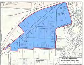
[5] In the portion of the IP zone depicted on Figure 50.03.003-B, additional permitted uses are: institutional use, personal services, commercial recreational facility < 5,000 sq. ft. gross floor area, and retail ≤ 35,000 sq. ft. gross floor area subject to use-specific limitations in LOC § 50.03.003.6. Additional conditional uses are: pet day care partially conducted outside during daytime hours.
[6] Outright permitted use if the gross floor area and exterior display area are 5,000 sq. ft. or less; conditional use if the gross floor area and exterior display are more than 5,000 sq. ft.
[7] FMU uses allowed only if the primary building on site was constructed after January 17, 2013.
[8] If lot has multiple zones, e.g., R-0/EC, see LOC § 50.02.002.2.e
[9] Site-specific use limitations, see LOC § 50.02.002.2.c
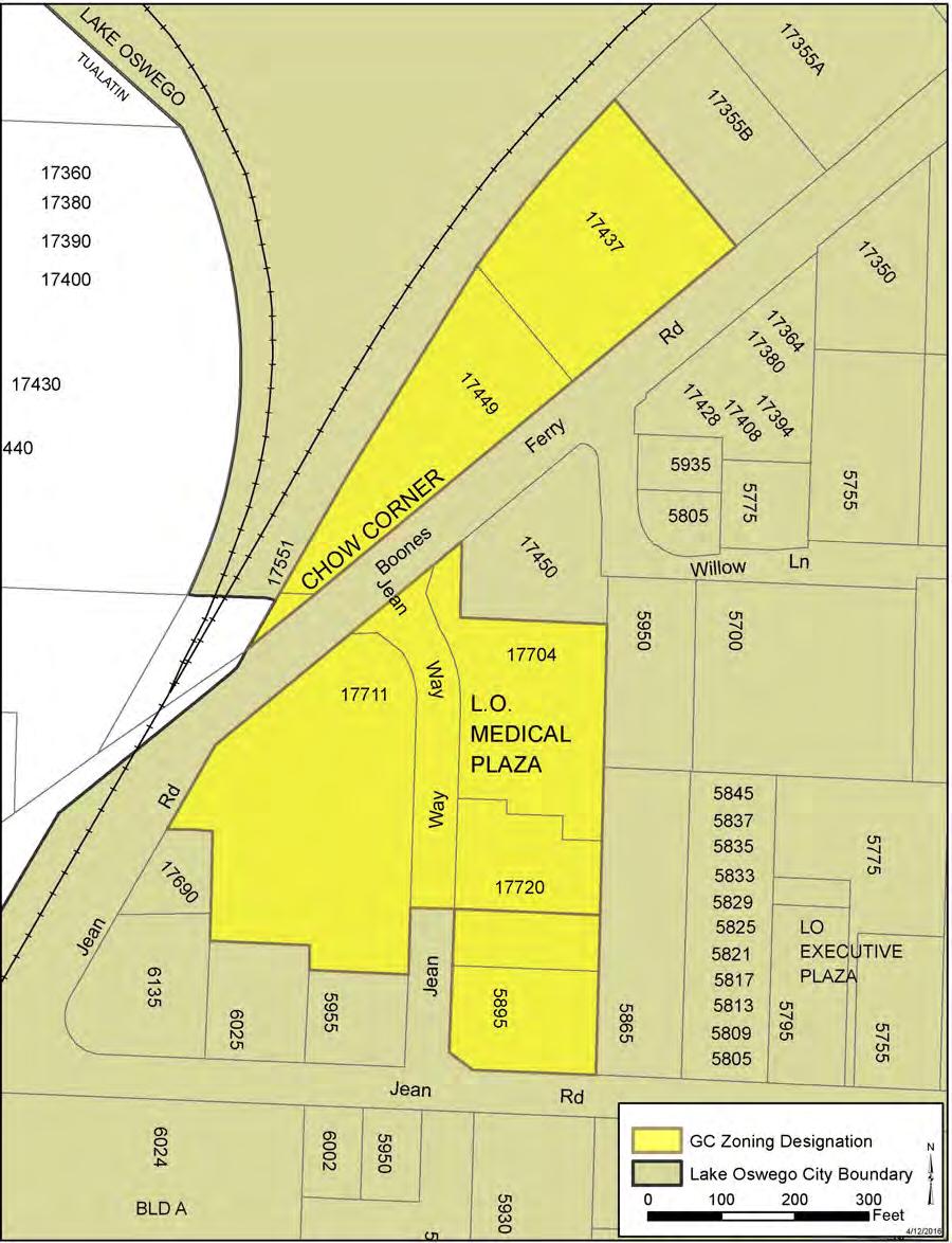
[10] In the GC-zoned area in the vicinity of Jean Way and Boones Ferry Road, as depicted on Figure 50.03.003-C, the following uses are not permitted: residential, congregate housing, community institution, residential care housing, community garden, hospitals, mortuaries, bars, drive-through restaurants, hotels, commercial recreational facilities, theaters, auto and light vehicle rental and sales, auto service station, car wash, and parking facilities (primary use).
Editor’s note: Italicized text is added for reader’s convenience. It will be proposed for adoption in a future code update.
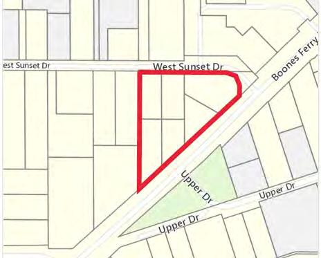
[11] Limited to multifamily residences in the vicinity of Boones Ferry Road and West Sunset Drive, as depicted on Figure 50.03.003-A.1.
a. Attached, Residential Townhome Uses in West Lake Grove.
i. Subject to the following conditions, in addition to the other provisions of this Code:
(1) The minimum net density area for attached townhome housing is 2,500 sq. ft./lot area per unit.
(2) The minimum required lot width shall be 17 ft. The maximum lot coverage shall be 60%, excluding parking.
(3) Each unit of attached townhome housing shall be constructed on a separate lot.
ii. Within the WLG RMU zone:
(1) Attached townhomes are allowed solely or in conjunction with office uses in the same building.
(2) When a combination of office-commercial and attached townhome residential uses are proposed together on the same site and in separate buildings, the commercial structure(s) shall front on Boones Ferry Road. Residential buildings shall occupy the rear portion of the parcel which is most proximate to the surrounding residential zoning districts.
iii. Within the WLG R-2.5 zone:
(1) The use is "Attached for-sale residential townhomes."
(2) When subdivisions are proposed in the WLG R-2.5 zone, a minimum density of 80% of the maximum allowed by the zone is required. For purposes of this subsection, the number of lots required shall be determined by dividing the net developable area by the minimum lot size per unit required in the underlying zone, and multiplying this number by 0.8. The result shall be rounded up for any product with a fraction of 0.5 or greater and rounded down for any product with a fraction of less than 0.5. The requirements of this subsection are subject to the exceptions contained in LOC § 50.04.003.10, Exceptions to the Minimum Density Requirement for All Zones.
b. Manufactured Homes.
i. General Provisions.
(1) Manufactured Homes Permitted on Individual Lots and Parcels. Manufactured homes are permitted on individual lots or parcels in all residential zones as permitted in Table 50.03.002-1: Residential Districts Use Table, in accordance with the placement standards below and all other provisions of this Code which apply to conventionally built dwellings.
(2) Deed Covenants or Restrictions. Nothing in these provisions shall be interpreted as superseding deed covenants or restrictions.
(3) Manufactured Housing Construction and Safety Standards (HUD Code). Title VI of the 1974 Housing and Community Development Act (42 USC 5401 et seq.) as amended and rules and regulations adopted thereunder; and including information supplied by the manufacturer which has been stamped and approved pursuant to HUD Rules by a "Design Approval Primary Inspection Authority"; and regulations and interpretations of the Act by the Oregon Department of Commerce; all of which became effective for mobile/manufactured home construction on June 15, 1976, shall be utilized as the minimum construction standard of the City of Lake Oswego to which all manufactured home placements shall comply except as provided otherwise by this section.
(4) State Standards. Where standards for manufactured home construction and placement are established by state law or Department of Commerce Administrative Rules, such requirements shall apply in addition to those of this section.
(5) Terms and Definitions. For purposes of this section only, the definitions of terms used herein and not defined in this Code shall be as defined in ORS Chapter 446 or OAR Chapter 918, Div. 500 as amended.
ii. Manufactured Home Placement Standards (Individual Lots).
(1) The manufactured home shall be multi-sectional and enclose a space of not less than 1,000 sq. ft.
(2) Bear an insignia of compliance with the Manufactured Housing Construction and Safety Standards Code and be:
(a) A new or not previously occupied unit; or
(b) Be found upon inspection to be in excellent condition and free of structural, electrical, mechanical, and plumbing defects, any of which must be corrected prior to placement.
(3) Transportation mechanisms including wheels, axles and hitch must be removed. The manufactured home shall be placed on an excavated and backfilled foundation and enclosed at the perimeter such that the finished floor elevation of the manufactured home is located not more than 12 in. above grade. The perimeter enclosure shall be a nonreflective material and give the outward appearance of a concrete, stone or masonry foundation. This material
shall be of weather resistant, noncombustible or self extinguishing materials. The materials below grade and for a distance of six in. above finish grade shall be resistant to decay or oxidation.
All load bearing foundations, supports, and enclosures shall be installed in conformance with the Oregon Department of Commerce regulations (OAR, Chapter 814, Division 23) and with the manufacturer’s installation specifications.
(4) Have utilities connected in accordance with City of Lake Oswego and Oregon Department of Commerce requirements and manufacturer’s specifications.
(5) The manufactured home shall have a pitched roof at a minimum of three ft. in height for each 12 ft. in width. Eaves must extend at least one ft. from the intersection of the roof and the exterior walls.
(6) The manufactured home shall have exterior siding and roofing which is similar to the exterior siding and roofing material commonly used in the community or which is comparable to the predominant materials used on surrounding dwellings (greater than 50%) within 300 ft. of the subject property.
(7) The manufactured home shall have either an attached or detached garage constructed at the same time the manufactured home is placed on the site or prior to occupancy. The garage shall be constructed of like materials as the manufactured home. An attached carport shall be allowed if more than 50% of homes within 300 ft. of the subject do not have garages.
Garages and carports shall be constructed to the Oregon State Structural Specialty Code.
(8) If new or previously unoccupied, the manufactured home shall be certified by the manufacturer to have an exterior thermal envelope meeting performance standards which reduce heat loss levels equivalent to the performance of single-family dwellings constructed under the State Building Code as defined by ORS 455.010.
iii. Placement Permit.
(1) Requirements. Prior to the location, relocation, or establishment of any manufactured home, the homeowner or authorized representative shall secure from the Building Official a placement permit which states that the building and its location conform with these and other relevant standards of this Code. Each application for a placement permit shall be accompanied by:
(a) A plot plan as required for all dwelling units and elevations or photographs of all sides of the home; drawings showing exterior dimensions; information illustrating the type of roofing and siding materials, foundation support system; and foundation enclosure method and materials.
(b) A copy of the manufacturer’s approved instructions to be used for installation purposes.
(c) An agreement signed by the homeowner or authorized representative pledging compliance with the terms set by the Building Official in the placement permit and other information as may be required for enforcement of these standards.
(2) Issuance of Permit. Following receipt of the required information, the placement permit shall be issued by the Building Official within ten days if all requirements have been met.
(3) Denial and Revocation of Placement Permit. The Building Official shall deny a placement permit which does not provide the proper information or which proposes to site a manufactured home not in conformance with the requirements of this Code.
The Building Official shall revoke a placement permit when such permit was issued on the basis of incorrect or misleading information. In this case the applicant shall cease work on the placement and/or occupancy of the unit and reapply for a placement permit and pay the required fees within five days of written notification of revocation by the Building Official. If the Building Official determines that it is not possible for placement of the manufactured home or the unit itself to meet the requirements of this Code, then it shall be removed from the site within 15 working days of written notice.
iv. Occupancy Certificate. Occupancy Requirement: Prior to the occupancy of any manufactured home, the homeowner or authorized representative shall request from the Building Official a Certificate of Completion stating that all requirements of this Code have been complied with. The Building Official shall inspect the property and if all requirements have been complied with, an occupancy certificate shall be issued.
If the applicant has not met the required conditions and standards, the Building Official may issue a temporary occupancy certificate along with a written statement of requirements to be met. The temporary occupancy permit shall not exceed 30 days.
The Building Official may also elect not to issue the certificate of occupancy if there is a substantial degree of noncompliance with the standards of this Code. The manufactured home shall not be occupied until these standards have been complied with.
c. Manufactured Home Park or Subdivision.
i. Must be located in the R-0, R-3 or R-5 zones.
ii. Maximum project size of ten acres; one-half acre minimum project size.
iii. Must be located on arterial or collector street.
iv. Public services must have the capacity to serve the proposed development.
v. Must be separated from other manufactured home parks or subdivisions by either:
(1) A distance of one mile; or
(2) By a permanent topographic or vegetative buffer such as a hill or wooded area which completely screens one manufactured home park from another or from existing residential development. If newly planted, the screening must be of a size to form an effective screen in five years.
d. Cottage Clusters. In addition to the standards above, the following design standards shall be applied to cottage cluster developments:
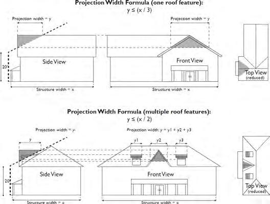
i. Individual cottage cluster dwellings must have a footprint of no more than 900 sq. ft. each.
ii. Common Courtyard Design Standards.
(1) Each cottage cluster shall include no more than one common courtyard per lot that meets the following standards:
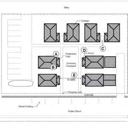
Figure 50.03.003-D: Cottage Cluster Orientation and Common Courtyard Standards
(a) The common courtyard must be a single, contiguous piece on one lot;
(b) Cottages must abut the common courtyard on at least two sides of the common courtyard;
(c) The common courtyard must contain a minimum of 150 sq. ft. per cottage within the associated cluster;
(d) The common courtyard must be a minimum of 15 ft. wide at its narrowest dimension;
(e) The common courtyard shall be developed with a mix of landscaping, lawn area, pedestrian paths, or paved area, and may also include recreational amenities. Impervious elements shall not exceed 75% of the total common courtyard area;
(f) Pedestrian paths must be included in a common courtyard;
(g) Paths that abut a courtyard shall count toward the courtyard’s minimum dimension and area. Parking areas, required setbacks, and driveways do not qualify as part of a common courtyard.
(2) A common courtyard may function as a community yard. Hard and soft landscape features may be included in a common courtyard, such as pedestrian paths, lawn, ground cover, trees, shrubs, patios, benches, or gazebos.
iii. Cottage Orientation.
(1) Each cottage within a cluster must either abut a common courtyard or must be connected to it by a pedestrian path.
(2) A minimum of 50% of cottages within a cluster must be oriented to the common courtyard by:
(a) Having a primary entrance into the living area of the cottage facing the common courtyard;
(b) Being within ten ft. from the common courtyard, measured from the wall or front porch of the cottage to the nearest edge of the common courtyard; and
(c) Being connected to the common courtyard by a pedestrian path.
(3) Cottages within 20 feet of a property line abutting a public street must have a primary entrance into the living area of the cottage facing the street, unless:
(a) The street is an unimproved or unopened right-of-way; or
(b) The cottage is required to face the courtyard to comply with subsection 1.d.iii(2) of this section.
(4) Cottages not facing the common courtyard or the street must have their primary entrance into the living area of the cottage facing a pedestrian path that is connected to the common courtyard.
See Figure 50.03.003-D: Cottage Cluster Orientation and Common Courtyard Standards.
iv. Community Buildings.
(1) Cottage cluster developments may include community buildings for the shared use of residents that provide space for accessory amenities such as community meeting rooms, guest housing, exercise rooms, day care, or community eating areas. Community buildings must meet the following standards:
(a) Each cottage cluster is permitted one community building, which shall count towards the maximum average floor area, pursuant to LOC § 50.04.001.1.d.iv, 2.d.iv, and 3.c.iii; and
(b) A community building that meets this Code’s definition of a dwelling unit must meet the maximum 900 sq. ft. footprint limitation that applies to cottages, unless a covenant is recorded against the property stating that the structure is not a dwelling unit and will not be used as a primary dwelling.
v. Pedestrian Access.
(1) A pedestrian circulation plan is required that provides accessible paths connecting the main entrance of each cottage to the following:
(a) The common courtyard;
(b) Shared parking area(s);
(c) Community building(s); and
(d) Sidewalks or public pathways in public rights-of-way abutting the site or rights-of-way if there are no sidewalks.
(2) The pedestrian path must be hard-surfaced and a minimum of four ft. wide.
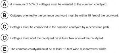
(1) Clustered Parking. Off-street parking shall be arranged in clusters, subject to the following standards:
(a) Cottage cluster developments are permitted parking clusters of not more than five abutting spaces.
(b) Parking clusters must be separated from other parking spaces by at least
Figure
four feet of landscaping.
(c) Clustered parking areas may be covered.
(2) Parking Location and Access.
(a) Off-street parking spaces and vehicle maneuvering areas shall not be located within 20 ft. of any front or side street lot line, except for lot lines abutting alleys.
(b) Off-street parking spaces and vehicle turnaround areas shall not be located between a front or side street lot line and the front facade of cottages located closest to the front or side street lot line.
(c) Off-street parking spaces shall not be located within ten ft. of any other lot line, except for lot lines abutting alleys. Driveways and drive aisles are permitted within ten ft. of other property lines.
(3) Screening. Landscaping screening that consists of a minimum of 50% evergreen shrubs or trees that can obtain a minimum height of three ft. within two years of planting, fencing, or walls at least three ft. tall shall separate clustered parking areas and detached garages from common courtyards and public streets.
(4) Garages.
(a) Garages (whether shared or individual) shall not abut common courtyards.
(b) Individual detached garages must not exceed 400 sq. ft. in floor area.
(c) Garage doors for attached and detached individual garages must not exceed 20 ft. in width.
(d) Garages with opening(s) that face the street must comply with LOC § 50.06.001.4, Garage Appearance and Location.
vii. Accessory Structures. Accessory structures shall not exceed 400 sq. ft. in gross floor area.
viii. Existing Structures. On a lot or parcel to be used for a cottage cluster development, an existing detached single-family dwelling on the same lot at the time of proposed development of the cottage cluster may remain within the cottage cluster development area under the following standards:
(1) The existing dwelling may be nonconforming with respect to the requirements of this subsection 1.d.
(2) An existing dwelling that is less than the maximum height of the underlying zone or the maximum building footprint of 900 sq. ft. may be expanded up to the maximum height or footprint.
(3) The floor area of the existing dwelling shall not count towards the maximum average floor area of a cottage cluster.
(4) The existing dwelling shall be excluded from the calculation of orientation toward the common courtyard, per subsection 1.d.ii(1) of this section.
ix. Shared Facilities. All shared garbage and storage facilities and mechanical equipment shall be screened from view so that garbage containers and equipment are not visible from the street.
e. Townhouse Projects. In addition to the standards in subsections 1.a through 1.c of this section, no more than four units shall be allowed in an attached townhouse structure.
2. Residential Uses in Commercial and Special Purpose Zones. [Ord. No. 2723, Amended, 10-18-2016; Ord. No. 2855, Amended, 12-15-2020; Ord. No. 2872, Amended, 10-5-2021]
a. GC and NC. Except as specifically allowed in LOC § 50.02.002.2, Specific Standards for Commercial, Mixed Use, and Industrial Zones, a residential use may occupy the ground floor in the GC or NC zones only if a commercial use is located along the street frontage and the residential use is located behind the commercial use with the following exceptions:
i. A residential use may occupy the ground floor in the GC zone at street frontage designated Park Lane, Crossroads Gateway or Campus Woods within the Lake Grove Village Center Overlay District (see Village Character Map, LOC Figure 50.05.007-D).
ii. On a corner site, the residential use is behind the commercial use as viewed from the higher classification street.
b. EC Zone. With a maximum 3.0:1 FAR (four unit minimum) on parcels > 6,000 sq. ft. in size. For parcels ≤ 6,000 sq. ft. in size, there is no minimum unit requirement. Use not allowed on ground floor within the area depicted on Figure 50.03.003-A: Area of Ground Floor Residential Use Prohibition in EC District.
Figure 50.03.003-A: Area of Ground Floor Residential Use Prohibition in EC District
c. CI Zone. Multifamily housing use is limited to Subarea I as shown on the Marylhurst Campus map in LOC § 50.11.006: Appendix F, and shall consist of 20 or more units where at least 10% of the units are continuously rented, leased or made available for an amount of rent plus expenses associated with occupancy, such as utilities and fees, totaling not more than 30% of the income level that is 80% of area median income according to the Clackamas County Housing Authority’s income limits for affordable housing, adjusted for household size.
d. WLG OC Zone. Residential uses are limited to multifamily residences in the vicinity of Boones Ferry Road and West Sunset Drive, as depicted on Figure 50.03.003-A.1, and shall consist of 20 or more units where at least ten percent of the units are continuously rented, leased or made available for an amount of rent plus expenses associated with occupancy, such as utilities and fees, totaling not more than 30% of the income level that is 80% of area median income according to the Clackamas County Housing Authority’s income limits for affordable housing, adjusted for household size.
Figure 50.03.003-A.1: Area of Residential Use Allowance in WLG OC Zone
In addition to the criteria contained in LOC § 50.07.005, Conditional Use Permits, an application to establish a new conditional use in the R-2 or R-6 zones must comply with the following criteria:
a. A new conditional use shall not be located on a street with a traffic level that exceeds the functional classification of the street as set forth in the Lake Oswego Comprehensive Plan connected community chapter.
b. If the street upon which the new use will be located is an arterial or collector and is currently operating within the parameters of its functional classification as set forth in the Lake Oswego Comprehensive Plan connected community chapter, the use shall not cause the street to exceed the allowable amount of traffic for its functional classification.
c. If the street upon which the new use will be located is a local street and is currently operating within the parameters of its functional classification as set forth in the Lake Oswego Comprehensive Plan connected community chapter, the use shall not have a traffic impact (TI) of greater than 10. Traffic impact is based on the increase in average daily trips (ADT) and is calculated as follows:
i. In the R-2 Zone: TI = ADT Increase/ (lot size/2,000);
ii. In the R-6 Zone: TI = ADT Increase/ (lot size/6,000).
d. Where available, a conditional use shall take access from collector or arterial streets and not from local streets.
Exception: A conditional use may take access from a local street if a traffic evaluation indicates that access to the local street would improve public safety or traffic management when compared to access from the available collector or arterial.
a. Residential Care Housing and Congregate Housing.
i. Generally Applicable Standards.
(1) Any site to be used for residential care housing or congregate housing shall be at least one-half acre in size. All abutting property, which is in one ownership or the subject of a joint application involving more than one ownership, shall be considered as the site.
(2) All requirements of the underlying zone, such as lot coverage, height limitations, setbacks and of the Lake Oswego Code generally, shall be complied with unless modified by this section. However, there are no density limitations on the number of residential care or congregate housing living units, which may be developed, provided all the other requirements of the Code and other governmental regulatory agencies are met.
(3) Within the allowed zones, residential care housing and congregate housing shall be permitted only on those properties which abut a major or minor arterial or a major collector or neighborhood collector. Access to the development site shall be by the street with the highest classification unless prohibited by access constraints.
(4) Any building to be occupied for residential care housing and congregate housing shall be designed or renovated specifically for this use. Any required regulatory licenses shall be obtained before residents occupy the building.
(5) All public services shall be available and have the capacity to serve the facility.
(6) Site design shall illustrate the accommodation of the special accessibility needs of those with varying levels of disabilities such as grade and width of walkways, exterior lighting, signage, resident parking, and orientation of entrances, which emphasize easy recognition.
(7) Buffering and screening of the facility with fences, walls and landscaping shall be required to mitigate external noise and other disruptive conditions from surrounding uses such as light glare.
(8) At least 20% of the development site exclusive of areas required for park land and Sensitive Lands protection shall be landscaped. The required landscaped area is inclusive of landscaping required for parking lots, and within required buffer areas. Landscaping may include courtyards, raised beds and planters, espaliers, arbors and trellises.
(9) Large expanses of paving, including surface off-street parking and loading
areas but excluding underground parking and loading, shall be landscaped. These areas shall be buffered and screened from adjoining land uses with landscaping. Trees shall be integral to the landscaping plan and incorporated into parking lot design to provide for shade and surface water runoff and quality benefits.
(10) Buildings and the development site shall be designed with a residential character and theme. Development in the EC zone is subject to the requirements of LOC § 50.05.004, Downtown Redevelopment Design District. If a conflict exists between LOC § 50.05.004 and the requirements below, LOC § 50.05.004 shall prevail. To achieve a residential character and theme, the reviewing authority may require design elements including, but not limited to, any or all of the following:
(a) Complex massing and asymmetrical building composition;
(b) Use of masonry, wood or wood appearing composites as exterior cladding materials;
(c) Use of harmonious building materials and earth and muted tone colors and compatible color accents;
(d) Lush landscaping including the use of border plantings and trees throughout the development site.
(11) Monotony of design in single or multiple buildings shall be avoided. Variation of detail, form, and building siting shall be used to enhance design quality. To achieve these objectives, the reviewing authority may impose requirements including, but not limited to, any or all of the following:
(a) No continuous blank walls shall be allowed along the public front of the buildings and shall not exceed 25 linear ft. without windows, recess, or change of plane. Appropriate use of windows shall be made to provide scale with the amount of fenestration or glazing proportional to the mass of the building facade.
(b) Architectural features and accents such as bay windows, gables, dormers and projecting eaves shall be used to break up roof expanses. Verandas and projecting balconies shall be used where safe and practical.
(c) Roof materials shall consist of cedar shingles, tiles, or three tab composite shingles in dark gray, green or black colors. Metal roofs and colored roofs, other than those mentioned above, and mansard or decorative roof forms are prohibited.
(12) Buildings shall use materials that are architecturally harmonious for all walls and exterior components. To achieve this objective, the reviewing authority may impose requirements including, but not limited to, the following:
(a) Materials for building walls may consist of wood shingle, brick,
horizontal wood or composite wood siding, stone, masonry, concrete block which mimics stone, brick or other masonry. Stucco and timbers shall be allowed on gable ends only.
(b) The following exterior materials are not allowed: EIFS or other synthetic stucco material; metal panels; flagstone; plywood paneling; vinyl cladding; mirrored glass; standard form concrete block; backlit fabrics.
(13) Building vents and mechanical devices shall be screened from view with materials harmonious to the building. Exterior site elements such as storage, trash collection areas and noise generating equipment shall be located away from abutting property lines and sight-obscuring fencing and landscaping shall be used to screen and buffer these areas.
(14) Access to public and commercial services, parks and other recreation areas, churches, shopping, and other places frequented by the public in the course of daily life shall be made available to the residents through a transport service privately provided by the residential care housing facility.
(15) Access to public sidewalks and/or pathways shall be provided. Street crossings bordering on streets three lanes and larger shall be located at traffic light controlled crossings. Crossings on two lane streets classified as either collectors or arterials may occur at sign controlled intersections. All other crossings may occur at noncontrolled intersections provided that safe sight distance per the AASHTO Standards is present. When projects are located on streets greater than 10,000 ADT and it can reasonably be expected that future residents will cross these streets, a traffic study shall be required to show that safe sight distance and adequate traffic "gaps" exist to allow safe crossing.
b. Residential Care Housing Facilities and Congregate Housing in R-7.5, R-10 and R-15 Zones.
i. Any site to be used for residential care housing or congregate housing in an R-7.5, R-10 or R-15 zone shall be at least one-half acre in size.
ii. Any site to be used for residential care housing or congregate housing and proposed to be located on a neighborhood or major collector street shall also have the following characteristics in addition to the other specific standards in this section:
(1) There are higher intensity land uses the vicinity of the site proposed for residential care housing such as:
(a) Commercial uses;
(b) Institutional uses such as schools, churches; or
(c) Multi-family residential development;
(2) The proposed residential care housing or congregate housing project would be a transitional land use between more intense land uses and the collector
street(s) and abutting or adjacent residential uses;
(3) Public parks or useable public open spaces are easily accessible via public or private bus service or are within walking distance; and
(4) Retail and professional services and churches are within a short distance from the development site and can be walked to or are easily accessible by public or private bus service.
iii. All abutting property, which is in one ownership or the subject of a joint application involving more than one ownership, shall be considered as one site.
iv. All setback and height requirements of the underlying zone shall be complied with unless modified by this section. However, there are no limitations on the number of residential care or congregate housing living units which may be developed, provided all the other requirements of the Code and other governmental regulatory agencies are met.
v. Maximum lot coverage shall be 40%.
vi. Except as modified by this section, all of the requirements of subsection 2.a of this section shall also be applied to applications for residential care or congregate housing.
vii. Minimize to the extent practicable the effects of traffic caused by shift changes, particularly noise and the safety of pedestrians, particularly school children.
viii. Maintain any existing surrounding residential neighborhood scale and character in regard to lot coverage, design and size of structures, landscaping, buffering and screening, location and width of driveways, signage, exterior lighting, and location of parking, loading and service facilities.
c. Skilled Nursing Facilities in the R-0, WLG R-2.5, R-3 and R-5 Zones.
i. Any site to be used for a skilled nursing facility shall abut a major or minor arterial street. Access to the development site shall be by the street(s) with the highest classification unless prohibited by access constraints.
ii. Any site to be used for a skilled nursing facility shall be at least one-half acre in size. All property, which is in one ownership or the subject of a joint application involving more than one ownership, shall be considered as the site.
iii. All requirements of the underlying zone, such as lot coverage, height limitations, setbacks and of the Lake Oswego Code generally shall be complied with unless modified by this section. However, there are no density limitations on the number of beds or rooms within a skilled nursing facility provided all the other requirements of the Lake Oswego Code and other governmental regulatory agencies are met.
iv. Any building(s) to be occupied as a skilled nursing facility shall be designed or renovated specifically for this use.
v. All public services shall be available and have the capacity to serve the facility.
vi. Minimum setbacks shall be as follows:
(1) 25 ft. for the front and rear yards and 15 ft. for side yards.
(2) 25 ft. from property lines abutting or adjacent to a residential zone or the setback required by the zone, whichever is greater. If an abutting or adjacent residential zone has been developed for a use other than for residential purposes the smaller setbacks shall apply.
vii. The maximum height of a skilled nursing facility shall conform to the height requirements of the applicable zone.
viii. Any of the requirements of subsection 2.a of this section, Residential Care Housing and Congregate Housing, may also be applied to applications for skilled nursing facilities by the reviewing authority as necessary to comply with conditional use permit requirements.
ix. On sites bordered by residential zones, the approval authority may apply additional conditions to:
(1) Mitigate the effects of traffic caused shift changes, particularly noise and the safety of pedestrians, particularly school children.
(2) Maintain residential neighborhood scale in regard to size of structures, location and width of driveways, signage, exterior lighting, and location of parking, loading and service facilities.
x. Any buildings and the development site to be used for a skilled nursing facility shall be designed with a residential character and theme. To achieve a residential character and theme, the reviewing authority may require design elements including, but not limited to, any or all of the following:
(1) Complex massing and asymmetrical building composition;
(2) Use of masonry, wood or wood appearing composites as exterior cladding materials;
(3) Use of harmonious building materials and earth and muted tone colors and compatible color accents;
(4) Lush landscaping including the use of border plantings and trees throughout the development site.
xi. Monotony of design in single or multiple skilled nursing facility buildings shall be avoided. Variation of detail, form, and building siting shall be used to enhance design quality. To achieve these objectives, the reviewing authority may impose requirements including, but not limited to, any or all of the following:
(1) No continuous blank walls shall be allowed along the public front of the buildings and shall not exceed 25 linear ft. without windows, recess, or
change of plane. Appropriate use of windows shall be made to provide scale with the amount of fenestration or glazing proportional to the mass of the building facade.
(2) Architectural features and accents such as bay windows, gables, dormers and projecting eaves shall be used to break up roof expanses. Verandas and projecting balconies shall be used where safe and practical.
(3) Roof materials shall consist of cedar shingles, tiles, or three tab composite shingles in dark gray, green or black colors. Metal roofs and colored roofs, other than those mentioned above, and mansard or decorative roof forms are prohibited.
xii. Buildings to be used for a skilled nursing facility shall use materials that are architecturally harmonious for all walls and exterior components. To achieve this objective, the reviewing authority may impose requirements including, but not limited to, the following:
(1) Materials for building walls may consist of wood shingle, brick, horizontal wood or composite wood siding, stone, masonry, concrete block which mimics stone, brick or other masonry. Stucco and timbers shall be allowed on gable ends only.
(2) The following exterior materials are not allowed: EIFS or other synthetic stucco material; metal panels; flagstone; plywood paneling; vinyl cladding; mirrored glass; standard form concrete block; backlit fabrics.
5. Standards for Public, Institutional and Civic Uses.
i. Access streets have capacity to carry the projected traffic volumes.
ii. The structure may exceed the maximum height limitation of the zone, to a structure height of no more than 50 ft.
iii. The lot is sufficient size to allow all required yards to be equal to at least two-thirds the height of the principal structure.
b. Minor Public Facilities.
i. In the WLG RMU zone, a minor public facility building shall be limited to a total floor area of 8,000 sq. ft. in a multi-story building, with no more than 5,000 sq. ft. on any floor.
c. Major Public Facilities and Institutional Uses Not Covered by Other Specific Standards.
i. Utilities, streets or other necessary improvements to the public facility or institutional use shall be provided by the agency constructing the use.
ii. When located in a residential zone, access should be located on a collector street if practical. If access is to a local residential street, consideration of a request shall include an analysis of the projected average daily trips to be generated by the proposed use and their distribution pattern, and the impact of the traffic on the capacity of the street system which would serve the use. A traffic study will be required of the applicant to identify the projected average daily trips to be generated and their distribution pattern. Uses which are estimated to generate fewer than 20 trips per week shall be exempted from the requirements of this subsection.
iii. When located in a residential zone, lot area shall be sufficient to allow required yards which are at least two-thirds the height of the principal structure.
iv. The height limitation of a zone may be exceeded to a maximum height of 50 ft.
v. Noise-generating equipment shall be sound buffered when adjacent to residential areas.
vi. Lighting shall be designed to avoid glare on adjacent residential uses.
vii. Levels of operations shall be adjusted to avoid conflict with adjacent uses where practical.
d. Park, Public.
i. Parks are a permitted use in the PNA zone, except activities defined as ‘major park improvements’ shall be allowed by conditional use only.
ii. Uses authorized under a Parks Master Plan are permitted uses.
e. Social, Recreational, or Cultural Facilities, Non-Profit. In the R-0, R-3, and R-5 zones, an application for a conditional use permit to locate a nonprofit social, recreational or cultural facility shall comply with the following standards.
i. The proposed facility or use shall be located on property adjacent on at least one side to a property of equal or larger size that is already developed with a nonprofit use permitted outright or as a conditional use in the zone.
ii. Members of the organization proposing and which will use the nonprofit facility or use shall reside in adjacent planned developments or within one-fourth mile of a planned development with participating residents and shall not be separated from the proposed development or each other by a freeway, a major or minor arterial or the urban service boundary of the City of Lake Oswego.
iii. Adequate utilities, streets or other improvements shall be provided by the developer of the facility or use.
iv. When located in a residential zone, lot area shall be sufficient to comply with the lot coverage, setbacks and yards required by the zone.
v. Sound barriers, buffers or reduction techniques shall be required for noise generating activities, facilities or equipment located on properties adjacent to residential areas.
vi. Lighting shall be designed to avoid glare on adjacent residential uses.
vii. The time, manner or nature of operation shall be adjusted to avoid conflict with adjacent uses.
f. Educational Institution and Day Care Center Uses.
i. All educational institutions and day care centers shall provide on-site circulation as required by LOC § 50.06.003.3.b, walkways as required by LOC Chapter 42, and safe loading, ingress, and egress on and to the site.
ii. In the WLG OC zone, this use is limited to 5,000 sq. ft. of gross floor area.
g. Telecommunications Facilities.
i. Purpose. The purpose of this section is to establish design and siting standards for telecommunication facilities that:
(1) Reduce visual impacts of antennas, towers and ancillary facilities through careful design, siting, and vegetative screening;
(2) Avoid damage to adjacent properties from tower failure and falling ice, through engineering and careful siting of tower structures;
(3) Maximize use of any new transmission tower and any existing suitable structures to reduce the need for additional towers; and
(4) Allow transmission towers in residential areas only when necessary to meet functional requirements of the telecommunications industry.
ii. Applicability. These standards shall apply to new telecommunication facilities and collocated telecommunication facilities and not pre-existing towers or preexisting antennas.
iii. Approval Criteria for Collocated Facilities.
(1) Site Size. No minimum lot size shall apply when a telecommunications facility is collocated on an existing building or structure.
(2) Facilities for Collocation.
(a) Priorities for Facilities. Collocation shall occur in the following order of facilities:
(i) Facilities where the collocated facility will project not more than ten ft. higher than the highest point of the existing facility:
(C) Utility (electric, cable, telephone, etc.) and light poles;
(D) Existing buildings.
(b) Suitability of Facility for Collocation. To determine the suitability of the existing facility for the proposed collocation facility or structure, the applicant must show that:
(i) There are no reasonably feasible telecommunication facilities in a higher classification under subsection 5.g.iii(2)(a) of this section that can meet the requirements of this subsection for a collocated facility and provide the necessary telecommunication service;
(ii) The addition of the antenna equipment will not interfere with the normal operation of utilities or existing transmission facilities and the collocated facility complies with the height limit in subsection 5.g.iii(3) of this section;
(iii) The collocation improvements must satisfy the standards for the underlying zone, except as provided by subsection 5.g.iii(3) of this section;
(iv) The existing structure, if structurally enhanced in order to permit collocation, does not result in a decrease of the setback of the reconstructed structure as described in subsection 5.g.iii(1) of this section and the height of the reconstructed facility complies with the height limit contained in subsection 5.g.iii(3) of this section as applied to the existing structure prior to replacement or reconstruction; and
(v) The collocation may not involve the removal of any previously approved landscaping/buffering.
(3) Height Limit. Collocated facilities are exempt from the height limits of the underlying zone, but shall be no more than ten ft. taller than the existing structure in a residential zone, a mixed residential/commercial zone, or Public Functions zone, or no more than 20 ft. taller than the existing structure in a commercial, public use, or industrial zone.
Exceptions: A collocated facility shall be no taller than the existing facility where the height of the existing facility has previously been increased in excess of the height limit of the underlying zone as a result of approval of a prior collocation application pursuant to this section.
(4) Visual Impact.
(a) All ancillary facilities shall be screened, hidden or disguised.
(b) Antennas shall be screened, hidden or disguised, or shall be painted or colored to blend into the structure or surroundings.
(5) Processed as New Facility. A proposed collocated facility that does not comply with the approval criteria for collocated facilities shall be processed as a new facility.
iv. Approval Criteria for New Facilities.
(1) Site Size. A new facility shall be sited on a parcel of a size and shape that complies with the following criteria:
(a) Setbacks – Tower. The tower footprint shall be set back at least twothirds the tower height from any property line. This setback may be reduced if the applicant can demonstrate that:
(i) The shape or configuration of the parcel prevents compliance with the setback standard or that a reduction in setback is necessary to take advantage of screening opportunities (such as tall trees, tree groves, buildings, or other tall elements) not available within the required setback area;
(ii) The reduction in setback is the minimum required to best camouflage the facility;
(iii) Adequate clearance between the facility and property line can be provided to accommodate landscaping and fencing; and
(iv) The reduction in setback will not cause a greater visual impact to adjacent uses.
(b) Setbacks – Ancillary Facilities. Ancillary facilities shall be set back the same as required for primary structures of the zone, except that the side or rear yard setback may be reduced in a residential zone if the ancillary facilities meet the criteria in LOC § 50.03.004.2.b.
(c) The tower pad shall be sited in a location that permits additional expansion to accommodate future collocated ancillary facilities. The tower shall be located centrally on this pad. This standard shall not apply to antennas attached to existing structures or towers located on rooftops.
(d) A licensed structural engineer’s analysis shall be submitted to
demonstrate that the potential impact of tower failure and ice falling from the tower will be accommodated on site.
(e) Separation from Pre-Existing Towers. New towers shall be separated from existing towers by at least the following distances, measured in a straight line from the base of the proposed new tower to the base of any pre-existing tower:
TABLE
50.03.003-1: SEPARATION FROM PRE-EXISTING TOWERS
(2) Collocation to Be Explored; Accommodated.
(a) Before an application for a new transmission tower is accepted, applicants shall demonstrate that they have exhausted all practicable collocation options within the proposed service area pursuant to LOC §§ 50.07.004.12.a.i and 50.07.004.12.a.iv including placement of antennas on existing tall structures and placing multiple antennas or attachments on a single tower. To demonstrate that all practicable collocation options have been exhausted, the applicant shall demonstrate that:
(i) No existing towers or support structures, or approved but not yet constructed towers or support structures, are located within the geographic area required to meet the applicant’s engineering requirements;
(ii) Existing towers or support structures are not of sufficient height to meet the applicant’s engineering requirements;
(iii) Existing towers or support structures do not have sufficient structural strength to support the applicant’s proposed antenna and related equipment;
(iv) The applicant’s proposed antenna would cause electromagnetic interference with the antenna on the existing tower or support structure, or the existing antenna would cause interference with the applicant’s proposed antenna; or
Lattice (ft.) Guyed (ft.)
(v) There are other limiting factors that render existing towers and support structures unsuitable.
(b) Accommodation of Future Collocation. New towers shall be constructed so as to accommodate future collocation, based on expected demand for transmission towers in the service area. Towers shall be designed so as to accommodate a minimum expansion of three two-way antennas for every 40 vertical ft. of tower.
(c) Multiple Attachments on Utility Towers. In conformance with the Telecommunication Act of 1996, Section 703, a utility shall provide any telecommunications carrier with nondiscriminatory access to any pole, duct, conduit, or right-of-way owned or controlled by it, unless there is insufficient capacity or access cannot be granted for reasons of safety, reliability, and generally applicable engineering purposes.
(d) Ancillary facilities for collocated facilities shall be set back the same as required for primary structures of the zone, except that the side or rear yard setback may be reduced in a residential zone if the ancillary facilities meet the criteria in LOC § 50.03.004.2.b
(3) Height. New telecommunication facilities shall not exceed the height limits of the underlying zone, unless the applicant demonstrates that:
(a) There is a service area need for the proposed facility at the proposed location;
(b) The increase in height above the maximum allowed height for the zone is the minimum increase necessary to eliminate service shadows;
(c) That providing coverage with telecommunications facilities which comply with the height requirements of the zone would result in unacceptable proliferation of such facilities. For the purposes of this subsection, "unacceptable proliferation" means an increase in the number of transmission towers by a factor of four in order to achieve the same level of adequate service. An increase in the number of transmission towers shall not include facilities or towers that would qualify as collocated facilities;
(d) The negative visual impacts on adjacent properties can be minimized by screening or disguising the facility.
The applicant may be required to pay for an independent radio frequency engineer or similar consultant to verify the need for this request.
(4) Visual Impact. The applicant shall demonstrate that telecommunications facilities will have the least practicable visual impact on the environment, considering technical, engineering, economic, and other pertinent factors.
(a) The height and mass of the telecommunications facilities shall not
exceed that essential for its intended use and public safety, as demonstrated in a report prepared by a licensed structural engineer.
(b) Telecommunications facilities 200 ft. or less in height shall be camouflaged to ensure the facility is visually subordinate to surrounding objects and colors.
(c) Towers more than 200 ft. in height shall be painted in accordance with the Oregon State Aeronautics Division and Federal Aviation Administration. Applicants shall attempt to seek a waiver from OSAD and FAA marking requirements. When a waiver has been granted, towers shall be painted and/or camouflaged in accordance with subsection 3.e.iv(4)(b) of this section.
(5) Accessory Uses. Accessory uses shall include only building facilities that are necessary for transmission function and associated satellite ground stations, and shall not include broadcast studios (except for emergency broadcast), offices, vehicle storage areas, nor other similar uses not necessary for the transmission or relay function. No unenclosed storage of materials is allowed.
(6) Lighting. No lighting shall be permitted on transmission towers except that required by the Oregon State Aeronautics Division or Federal Aviation Administration. This standard shall not prevent shared use or replacement of an existing light pole. For collocation on existing or replaced light poles, the transmission tower shall have no net increase to the spread, intensity, or direction of the existing light source.
(7) Fences and Landscaping.
(a) The tower(s) and ancillary facilities shall be enclosed by a six ft. fence meeting the requirements of LOC § 50.06.004.2
(b) Landscaping shall be placed outside of fences and shall consist of fast growing vegetation placed densely so as to form a solid hedge with a minimum planted height of six ft.
(c) For new towers, landscaping and fencing shall be compatible with other nearby landscaping and fencing.
(d) Where antennas or towers and ancillary facilities are to be located on existing buildings or structures and are secure from public access, landscaping and fencing requirements may be waived.
(8) Signs. One non-illuminated sign, not to exceed two sq. ft., shall be provided at the main entrance to the facility stating a contact name and phone number for emergency purposes. Signs shall not be placed on towers and antennas.
v. Abandoned Facilities. A telecommunication facility that is unused for a period of six consecutive months or longer is hereby declared abandoned. Abandoned
facilities shall be removed by the property owner no later than 90 days from date of abandonment. Failure to remove an abandoned facility is declared a public nuisance and is subject to the penalties established by LOC Article 34.04. Upon written application, prior to the expiration of the six-month period, the City Manager shall, in writing, grant a six-month extension for reuse of the facility. Additional extensions beyond the first six-month extension may be granted by the City Manager subject to any conditions required to bring the project or facility into compliance with current law(s) and make compatible with surrounding development.
h. Telecommunications Facilities in Residential or Mixed Residential/Commercial Zones. In addition to compliance with the approval standards in LOC §§ 50.03.003.5.g.iv and 50.07.004.12, and the general conditional use criteria in LOC § 50.07.005, Conditional Use Permits, telecommunications facilities designated as a conditional use in residential or mixed residential/commercial zones shall comply with the following standards:
i. New telecommunications facilities shall not be located on a parcel containing an existing single-family dwelling or middle housing.
ii. Antenna(s) must be located no closer than 35 ft. from any habitable structure. Tower guy anchors must meet the normal setbacks of the underlying zone.
iii. If the proposed facility will exceed the 50 ft. height limitation of the Lake Oswego Charter in a residential zone, the applicant shall demonstrate that:
(1) The facility could not feasibly be located outside of a residential zone;
(2) There are no alternatives available to meet the required coverage area; and
(3) The height is no taller than necessary to provide adequate transmission.
2851, Amended, 9-15-2020; amended 12-5-2023 by Ord. No. 2928]
50.03.003-B: IP Zone Additional Use Area
Figure
City
a. Conditional Uses Listed in Commercial or Industrial Zones and Not Covered by Other Specific Standards. City of Lake Oswego, OR
Figure 50.03.003-C: GC Zone Limited Use Area
Downloaded from https://ecode360.com/LA4508 on 2025-01-23
i. The site will be designed so that ingress and egress will not cause hazardous turning movements, traffic slow-downs or blockages due to storage of vehicles waiting for services.
ii. Public services are or can be provided at the site.
iii. All outdoor lighting except security lighting shall be extinguished at the close of business hours.
iv. Any adverse impacts on adjoining residential uses such as noise, lights, or loss of privacy will be mitigated by landscaping, screening or increased setbacks.
v. Parking shall meet the parking standards and may be increased if additional spaces are shown to be necessary.
b. Agriculture. The raising of livestock requires approval of a conditional use permit.
c. Arcade, Gaming. In the NC zone, uses exceeding 2,000 sq. ft. in gross floor area require approval of a conditional use permit.
d. Auto and Light Vehicle Rental. In the GC, EC, CR&D, MC and FMU zones, all vehicle storage shall be off site.
e. Auto and Light Vehicle Sales.
i. This use is not permitted on properties located in the Lake Grove Village Center Overlay district.
ii. In the IP zone, the storage and display of vehicles shall be within fully enclosed buildings.
f. Auto Service Station and Vehicle Repair.
i. If the primary use is an auto service station with vehicle repair as an accessory use, the use is only permitted in the Lake Grove Village Center Overlay (LGVCO) district with the approval of a conditional use permit and if the following additional criteria are met:
(1) The use is located no closer than 1,000 linear ft. to another auto service station;
(2) No more than two auto service stations are located within a distance of 5,000 linear ft.;
(3) The use does not include more than eight auto fueling devices; and
(4) The use is not located in a Village Transition Area.
ii. If the primary use is for vehicle repair with no auto fuel sales, or fuel sales as an accessory activity, the use is only permitted in the Village Transition Areas (VTA) of the LGVCO district with the approval of a conditional use permit, and if the following additional criteria are met:
(1) The use is an expansion of an existing vehicle repair use;
(2) The facility includes a retail or office use and a storefront appearance along fronting collector and local streets;
(3) No direct vehicle access is provided from streets adjacent to residential zones; and
(4) No operational repair doors face any collector or local street.
iii. In the GC and EC zones, vehicle repair activities shall be conducted wholly within an enclosed structure.
iv. In the I zone, vehicle repair activities shall be screened by sight-obscuring fence from public rights-of-way.
v. In the IP zone, light vehicle repair is only a permitted use without an associated auto service station.
g. Bakery.
i. In the WLG OC zone, the seating area shall not exceed 700 sq. ft. of gross floor area.
ii. Where on-site baked goods are sold within the building in the NC, HC, OC, CR&D, MC, and WLG OC zones, the business shall not exceed 5,000 sq. ft. gross floor area.
iii. Where the baked goods that are sold are manufactured elsewhere the cumulative square footage of retail businesses or buildings on a site shall not exceed 60,000 sq. ft. gross floor area on a single lot or parcel or on adjacent lots or parcels in the MC zone. In the CR&D zone, cumulative retail uses shall not exceed 20,000 sq. ft. gross floor area or 20% of the total building floor area per lot, whichever is less. The maximum numerical limitation on cumulative retail uses shall not exceed the retail square footage amount approved for the site.
iv. In the IP zone, retail and on-site consumption of bakery goods shall not exceed 2,000 sq. ft. of gross floor area and must either be co-located within a building with another permitted use or be accessory to a production bakery. The cumulative square footage of retail businesses or buildings on a site shall not exceed 60,000 sq. ft. gross floor area on a single lot or parcel or on adjacent lots or parcels. No drive-through service is allowed.
h. Bar. In the MC zone, bars shall not exceed 20,000 sq. ft. in gross floor area and the cumulative square footage of retail businesses or buildings on a site shall not exceed 60,000 sq. ft. gross floor area on a single lot or parcel or on adjacent lots or parcels.
i. Car Wash. Car washes in the GC zone in the Lake Grove Village Center Overlay District shall not exceed a total combined area of 4,200 sq. ft. in gross floor area and shall not be located in Village Transition Areas.
j. Community Garden.
i. Community gardens are allowed as a permitted or accessory use if the total planting area is less than 4,000 sq. ft. Community gardens with greater than 4,000 sq. ft. of planting area require a conditional use permit.
ii. The accessory sales of crops by a public entity or nonprofit organization is allowed between the hours between 7:00 a.m. to 8:00 p.m.
iii. Community gardens with a planting area less than 4,000 sq. ft. are exempt from parking requirements. Parking requirements for gardens larger than 4,000 sq. ft. shall be determined by the conditional use permit.
iv. Fencing is required and shall be no greater than six feet in height and no more than 40% opacity.
v. Composting areas shall be actively managed to control odors, pests, and all other potential nuisances to neighbors. Use of best management practices (BMP), as established by the Parks and Recreation Department, is recommended.
vi. Accessory community garden structures are permitted pursuant to the standards in this Code, but shall not exceed 500 sq. ft. cumulatively.
k. (Reserved)
l. Food Market.
i. In the CR&D zone, cumulative retail uses shall not exceed 20,000 sq. ft. or 20% of the total building floor area per lot, whichever is less. The maximum numerical limitation on cumulative retail uses shall not exceed the retail square footage amount approved for the site.
ii. For food markets over 25,000 sq. ft. in gross floor area, the use may not exceed 35,000 sq. ft. of gross floor area per business, except that:
(1) In the GC zone, uses over 35,000 sq. ft. and up to 45,000 sq. ft. of gross floor area require a conditional use permit.
(2) In the MC zone, the cumulative square footage of retail businesses or buildings on a site shall not exceed 60,000 sq. ft. on a single lot or parcel or on adjacent lots or parcels.
(3) In the FMU zone, a use larger than 35,000 sq. ft. of gross floor requires a conditional use permit.
m. Heavy Vehicle Repair. This use is subject to the following conditions:
i. The use is limited to 18 or less service bays.
ii. The use is located in an enclosed building.
iii. No outdoor storage of parts, materials, or partially or totally dismantled vehicles is
allowed.
iv. The use shall not emit noise, smoke, glare, vibration, fumes or other environmental effects which adversely affect people, property or uses beyond the property lines of the IP site.
n. Medical Clinic. In the area depicted on Figure 50.03.003-B, this use shall be limited to less than 20,000 sq. ft. in floor area.
o. Mortuary. In the GC and EC zones, on-site cremation requires a conditional use permit.
p. Office.
i. In the R-15, R-10, R-7.5, R-6, R-5, R-DD, R-3, R-2, and R-0 zones, the following standards apply.
(1) Office use is only permitted in structures that are on the City’s Historic Landmark List and are located on an arterial street.
(2) Public services are adequate to serve the facility.
(3) Notwithstanding LOC § 50.06.002.2, the required parking for office uses in historic landmarks shall be determined in the conditional use approval. In applying the general conditional use criteria under LOC § 50.07.005.3.a.iii and iv, the on-site parking may be reduced to protect the historic character of the landmark.
(4) Access should be located on an arterial street, if practicable. If access is to a local residential street, the applicant shall include an analysis of the projected average daily trips to be generated by the proposed use and their distribution pattern, and the impact of the traffic on the capacity of the street system that would serve the use. A traffic study will be required to identify the projected average daily trips to be generated and their distribution pattern. Uses that are estimated to generate fewer than 20 trips per week shall be exempted from the requirements of this subsection.
(5) Noise generating equipment shall be sound buffered when abutting a residential use.
(6) Exterior lighting and lighted signage shall be designated to avoid glare onto adjacent residential uses.
(7) Levels of operations shall avoid conflict with adjacent uses, where practicable.
(8) The historical designation of the property shall be maintained throughout the period of the conditional use. The property owner shall record a deed restriction that ensures that the property shall not be removed from the Historic Landmark List for the duration of the conditional use permit. Request for removal from the list shall void the conditional use permit.
ii. In the WLG OC and WLG RMU zones, the following standards apply:
(1) Office uses shall be limited to those with limited customer or client traffic intended to attract and serve customers or clients on premises, such as: attorneys, physicians, dentists, counselors, insurance, travel agents, investment and financial services, real estate, studios (photography, commercial art, advertising), architects, landscape architects, engineers or other design businesses, research, software development, corporate offices, medical testing laboratories, and specialty medical services.
(2) A single building with office use shall be limited to a maximum 5,000 sq. ft. footprint and in the WLG RMU zone, the total floor area shall be limited to 8,000 sq. ft.
iii. In the GC and OC zones in the Lake Grove Village Center Overlay district, the following standards apply:
(1) Financial and banking institutions with drive-through facilities are allowed only when no more than one access to the site from a public street is provided on the parcel. Additional access through abutting parcels is permitted.
(2) Financial and banking institutions with drive-through facilities are prohibited in Village Transition Areas.
iv. In the CI zone, this use is limited to commercial office space in buildings existing on December 16, 1982.
v. In the PF zone, this use is limited to uses related to public or quasi-public facilities.
q. Public Parking Facilities in the NC Zone – Conditional Use. A publicly owned (City or LORA) surface parking facility is conditionally allowed as the sole use on a lot in the NC zone, only within the Lake Grove Village Center Overlay (LGVCO) District and only as specifically identified in Figure 50.05.007-U: Parking Facilities and Access Coordination Map. Public garages are not a similarly allowed use to a public surface parking facility.
r. Personal Services.
i. In the WLG OC zone, this use is limited to 1,000 sq. ft. or less in gross floor area.
ii. In the CI zone, this use shall directly and primarily provide goods and services to persons employed in the CI zone.
s. Pet Day Care. This use must be conducted in a fully enclosed building, except that in the NC, GC, and MC zones, and the portion of IP zone depicted on Figure 50.03.003-B, pets may be kept outside during daytime hours with a conditional use permit.
t. Psilocybin Service Center.
i. Compliance with Oregon Health Authority (OHA) Rules. Service centers shall be
licensed by the OHA and comply with all applicable regulations and requirements administered by OHA per OAR 333-333 and ORS 475A.310.
ii. Restrictions on location. A psilocybin service center shall not locate:
(1) Within 1,000 ft., as measured by a straight-line measurement in a radius extending in any direction from the closest point anywhere on the boundary line of the real property comprising a school or registered childcare facility to the closest point of the licensed premises of a service center, of:
(a) A public elementary or secondary school for which attendance is compulsory under ORS 339.020;
(b) A private or parochial elementary or secondary school teaching children as described in ORS 339.030; and
(c) A childcare facility registered with the Oregon Department of Education.
(d) EXCEPTION: The 1,000-foot buffer required by Subsection (1)(a)-(c), above, may be reduced to 500 feet if there is a physical or geographic barrier capable of preventing children from traversing to the premises of the psilocybin service center, such as a body of water, an interstate freeway, or similar barrier that people cannot walk across. A door, fence, wall, or gate is not a physical or geographic barrier for the purpose of this standard.
(2) Within the same building that contains any of the following uses: marijuana production, processing, wholesale, laboratory/testing, or retail; or a residential unit.
(a) EXCEPTION: A psilocybin facility that met the location requirements, above, at the time of the issuance to the Oregon Health Authority of a land use compatibility statement may legally remain at that location if it existed before any of the uses listed in Subsections (1) and (2), above, later located within a required buffer from the facility or within the same building.
iii. In the HC, MC, CR&D, CI and IP zones, the cumulative square footage of commercial retail businesses, including psilocybin service centers, or buildings on a site shall not exceed 60,000 square feet gross floor area on a single lot or parcel or on adjacent lots or parcels.
u. Repair, Rental, Service. In the NC zone, this use is limited to 5,000 sq. ft. of gross floor area.
v. Restaurant.
i. Drive-through service is only allowed in the following:
(1) In the HC and FMU zones.
(2) In the GC zone, outside of the Lake Grove Village Center, after approval of a conditional use permit.
(3) In the Lake Grove Village Center Overlay district, a maximum of two restaurants with drive-through service windows are permitted with a conditional use permit, but no restaurant with drive-through service may be located in a Village Transition Area.
ii. In the WLG OC zone, service of food and beverages shall be primarily for consumption on the premises. The total size of indoor and outdoor seating areas of any restaurant shall be limited to 1,500 sq. ft. of gross floor area.
iii. In the CR&D and MC zones, this use shall not exceed 20,000 sq. ft. gross floor area. In the MC zone, the cumulative square footage of retail businesses or buildings on a site shall not exceed 60,000 sq. ft. on a single lot or parcel or on adjacent lots or parcels. In the CR&D zone, cumulative retail uses shall not exceed 20,000 sq. ft. or 20% of the total building floor area per lot, whichever is less. The maximum numerical limitation on cumulative retail uses shall not exceed the retail square footage amount approved for the site.
iv. In the OC and CR&D zones, specialty food stores, e.g., coffee shops and juice bars, shall not exceed 5,000 sq. ft. of gross floor area.
v. One seasonal dining restaurant enclosure and one entrance vestibule per restaurant business are allowed from November 1 to April 30. The enclosures must be removed by May 1. The seasonal restaurant enclosures shall meet the required dimensional standards (e.g., building setbacks, maximum lot coverage, etc.) of the zone.
w. Retail, Under 10,000 Sq. Ft. Gross Floor Area.
i. In the WLG OC zone, this use is limited to 5,000 sq. ft. or less in gross floor area.
ii. For conditional uses in the IP zone, this use is limited to those that directly and primarily provide goods and services to persons employed in the IP zone.
x. Retail, 10,000 – 20,000 Sq. Ft. Gross Floor Area.
i. For conditional uses in the IP zone, this use is limited to those that directly and primarily provide goods and services to persons employed in the zone.
y. Retail, Over 20,000 Sq. Ft. Gross Floor Area. This use may not exceed 35,000 sq. ft. of gross floor area per business, except that:
i. In the GC-zoned area in the vicinity of Jean Way and Boones Ferry Road, as depicted on Figure 50.03.003-C, retail use up to 45,000 sq. ft. is permitted, except as limited by subsection 50.03.003.6.x.iv of this section.
ii. In the GC zone, except as provided in subsection 6.x.i of this section, a business over 35,000 sq. ft. and up to 45,000 sq. ft. of gross floor area requires a conditional use permit.
iii. In the EC zone, the cumulative square footage of a single commercial business on a site shall not exceed 35,000 sq. ft.
iv. In the MC zone, the portion of IP zone depicted on Figure 50.03.003-B, and the GC-zoned area in the vicinity of Jean Way and Boones Ferry Road, as depicted on Figure 50.03.003-C, the cumulative square footage of retail businesses or buildings shall not exceed 60,000 sq. ft. on a single lot or parcel or on adjacent lots or parcels.
v. In the CR&D zone, cumulative retail uses shall not exceed 20,000 sq. ft. or 20% of the total building floor area per lot, whichever is less. The maximum numerical limitation on cumulative retail uses shall not exceed the retail square footage amount approved for the site.
z. Social, Recreational, or Cultural Facilities, Non-profit. This use is permitted if associated with a planned development and designed for use by residents of that development. If not associated with a planned development, this use requires a conditional use permit.
aa. Veterinary Clinic. This use must be conducted within a fully enclosed building, except that an outdoor run is permitted outright if the standards below are met. A larger outdoor run or other outdoor facilities may be approved with a conditional use permit. This does not preclude incidental activities such as dog walking.
i. An outdoor run shall be limited to 200 sq. ft. in area or five percent of lot area, whichever is greater;
ii. An outdoor run shall be enclosed by a six-foot-tall sight-obscuring fence for the portions facing the exterior site boundaries. A see-through fence may be permitted facing the building(s) on the site;
iii. Active use of the outdoor run (training, play, etc.) shall be limited to the hours between 8:00 a.m. and 6:00 p.m. Use of the run to allow a dog to relieve itself outside of these hours is permitted;
iv. Animals in the outdoor run shall be supervised by staff of the facility at all times;
v. The outdoor run shall be cleared of waste daily; and
vi. It shall be a violation to permit unreasonable annoyance, alarm or noise disturbance at any time of the day or night by repeated barking, whining, screeching, howling, braying or other like sounds which may be heard beyond the boundary of the veterinary clinic property.
ab. Repair, Rental, Service. In the NC zone, this use is limited to 5,000 sq. ft. of gross floor area.
ac. Restaurant.
i. Drive-through service is only allowed in the following:
(1) In the HC and FMU zones.
(2) In the GC zone, outside of the Lake Grove Village Center, after approval of a conditional use permit.
(3) In the Lake Grove Village Center Overlay district, a maximum of two restaurants with drive-through service windows are permitted with a conditional use permit, but no restaurant with drive-through service may be located in a Village Transition Area.
ii. In the WLG OC zone, service of food and beverages shall be primarily for consumption on the premises. The total size of indoor and outdoor seating areas of any restaurant shall be limited to 1,500 sq. ft. of gross floor area.
iii. In the CR&D and MC zones, this use shall not exceed 20,000 sq. ft. gross floor area. In the MC zone, the cumulative square footage of retail businesses or buildings on a site shall not exceed 60,000 sq. ft. on a single lot or parcel or on adjacent lots or parcels. In the CR&D zone, cumulative retail uses shall not exceed 20,000 sq. ft. or 20% of the total building floor area per lot, whichever is less. The maximum numerical limitation on cumulative retail uses shall not exceed the retail square footage amount approved for the site.
iv. In the OC and CR&D zones, specialty food stores, e.g., coffee shops and juice bars, shall not exceed 5,000 sq. ft. of gross floor area.
v. One seasonal dining restaurant enclosure and one entrance vestibule per restaurant business are allowed from November 1 to April 30. The enclosures must be removed by May 1. The seasonal restaurant enclosures shall meet the required dimensional standards (e.g., building setbacks, maximum lot coverage, etc.) of the zone.
ad. Retail, Under 10,000 Sq. Ft. Gross Floor Area.
i. In the WLG OC zone, this use is limited to 5,000 sq. ft. or less in gross floor area.
ii. For conditional uses in the IP zone, this use is limited to those that directly and primarily provide goods and services to persons employed in the IP zone.
ae. Retail, 10,000 – 20,000 Sq. Ft. Gross Floor Area.
i. For conditional uses in the IP zone, this use is limited to those that directly and primarily provide goods and services to persons employed in the zone.
af. Retail, Over 20,000 Sq. Ft. Gross Floor Area. This use may not exceed 35,000 sq. ft. of gross floor area per business, except that:
i. In the GC-zoned area in the vicinity of Jean Way and Boones Ferry Road, as depicted on Figure 50.03.003-C, retail use up to 45,000 sq. ft. is permitted, except as limited by subsection 50.03.003.6.x.iv of this section.
ii. In the GC zone, except as provided in subsection 6.x.i of this section, a business over 35,000 sq. ft. and up to 45,000 sq. ft. of gross floor area requires a conditional use permit.
iii. In the EC zone, the cumulative square footage of a single commercial business on a site shall not exceed 35,000 sq. ft.
iv. In the MC zone, the portion of IP zone depicted on Figure 50.03.003-B, and the GC-zoned area in the vicinity of Jean Way and Boones Ferry Road, as depicted on Figure 50.03.003-C, the cumulative square footage of retail businesses or buildings shall not exceed 60,000 sq. ft. on a single lot or parcel or on adjacent lots or parcels.
v. In the CR&D zone, cumulative retail uses shall not exceed 20,000 sq. ft. or 20% of the total building floor area per lot, whichever is less. The maximum numerical limitation on cumulative retail uses shall not exceed the retail square footage amount approved for the site.
ag. Social, Recreational, or Cultural Facilities, Non-profit. This use is permitted if associated with a planned development and designed for use by residents of that development. If not associated with a planned development, this use requires a conditional use permit.
ah. Veterinary Clinic. This use must be conducted within a fully enclosed building, except that an outdoor run is permitted outright if the standards below are met. A larger outdoor run or other outdoor facilities may be approved with a conditional use permit. This does not preclude incidental activities such as dog walking.
i. An outdoor run shall be limited to 200 sq. ft. in area or five percent of lot area, whichever is greater;
ii. An outdoor run shall be enclosed by a six-foot-tall sight-obscuring fence for the portions facing the exterior site boundaries. A see-through fence may be permitted facing the building(s) on the site;
iii. Active use of the outdoor run (training, play, etc.) shall be limited to the hours between 8:00 a.m. and 6:00 p.m. Use of the run to allow a dog to relieve itself outside of these hours is permitted;
iv. Animals in the outdoor run shall be supervised by staff of the facility at all times;
v. The outdoor run shall be cleared of waste daily; and
vi. It shall be a violation to permit unreasonable annoyance, alarm or noise disturbance at any time of the day or night by repeated barking, whining, screeching, howling, braying or other like sounds which may be heard beyond the boundary of the veterinary clinic property.
7. Industrial Uses.
[Ord. No. 2579, Repealed and Replaced, 3-20-2012; Ord. No. 2723, Amended, 10-18-2016; amended 12-5-2023 by Ord. No. 2928]
a. Prohibited Uses in Any Industrial Zone. Uses where the primary function is the storing or manufacturing of explosive materials are prohibited in the I and IP zones.
b. Dry Cleaning or Laundry Plant.
i. In the I zone, this use shall be a minimum of 3,000 sq. ft. of gross floor area.
ii. In the IP zone, this use shall contain less than 5,000 sq. ft. in gross floor area.
c. Psilocybin Production.
i. Compliance with Oregon Health Authority (OHA) Rules. Psilocybin production facilities shall be licensed by the OHA and comply with all applicable regulations and requirements administered by OHA per OAR 333-333 and ORS 475A.310.
ii. Restrictions on location. A psilocybin production facility shall not locate:
(1) Within 1,000 feet, as measured by a straight-line measurement in a radius extending in any direction from the closest point anywhere on the boundary line of the real property comprising a school or registered childcare facility to the closest point of the licensed premises of a service center, of:
(a) A public elementary or secondary school for which attendance is compulsory under ORS 339.020;
(b) A private or parochial elementary or secondary school teaching children as described in ORS 339.030;
(c) A childcare facility registered with the Oregon Department of Education; and
(d) EXCEPTION: The 1,000-foot buffer required by Subsection (1)(a)-(c), above, may be reduced to 500 feet if there is a physical or geographic barrier capable of preventing children from traversing to the premises of the psilocybin production facility, such as a body of water, an interstate freeway, or similar barrier that people cannot walk across. A door, fence, wall, or gate is not a physical or geographic barrier for the purpose of this standard.
(2) Within the same building that contains any of the following uses: marijuana production, processing, wholesale, laboratory/testing, or retail; or a residential unit.
(a) EXCEPTION: A psilocybin production facility that met the location requirements, above, at the time of the issuance to the Oregon Health Authority of a land use compatibility statement may legally remain at that location if it existed before any of the uses listed in Subsections (1) and (2), above, later located within a required buffer or within the same building.
iii. All manufacturing, growing and testing shall be conducted within a fully enclosed building.
i. Accessory uses are allowed in conjunction with the principal use and shall comply with the requirements of this section and all requirements for the principal use, except where specifically modified by this Code.
ii. A greenhouse or hothouse may be maintained accessory to a dwelling only if there are no sales.
iii. A guesthouse.
b. Standards for Specific Uses.
i. Farm Stand. As an accessory use, farm stands are limited to one per site with a maximum size of 800 sq. ft. floor area.
ii. Home Occupation. A home occupation may be conducted where allowed by other provisions of this Code if the following conditions are continuously complied with:
(1) The use does not alter the residential character of the neighborhood nor infringe upon the right of residents in the vicinity to the peaceful enjoyment of the neighborhood.
(2) A current and valid business license is maintained.
(3) No persons other than family members who reside at the dwelling may be employed or otherwise work in the home occupation, except persons performing housekeeping, yard maintenance, or other domestic services for the dwelling where the business occurs.
(4) No outside storage of goods or materials other than vegetation.
(5) No more than 25% of the aggregate floor area on the lot is devoted to nonresidential use, except that an entire dwelling unit or portion thereof may be used for short-term rental lodging; an accessory structure may be used, provided the provisions of this subsection are met.
(6) Marijuana facilities, psilocybin service centers, and psilocybin production are prohibited.
(7) Short-term rentals shall meet the following additional standards:
(a) A person who owns a lot containing a short-term rental (primary or secondary dwelling unit) must maintain their primary residence on the lot. The owner is not required to be on the lot when the dwelling is
rented.
(b) No other commercial uses are allowed in conjunction with or accessory to a short-term rental. The short-term rental shall not be marketed for group events such as weddings, classes, or similar events, for example.
iii. Large Animals Kept for Owner’s Personal Use. This use may be permitted with no commercial activity under the following conditions:
(1) The lot area shall be a minimum of one acre. The total number of large animals allowed on a specific property shall be determined by dividing the total area of the property by 15,000 sq. ft. per animal over the age of six months.
(2) Animal runs or barns shall not be closer than 70 ft. from the front property line and not closer than 35 ft. from a side or rear property line.
(3) Animals shall be properly housed and proper sanitation shall be maintained with food, other than hay or fodder, stored in metal or other rodent-proof receptacles.
iv. Restaurant. In the IP zone, this use shall not exceed 2,000 sq. ft. in gross floor area and shall be co-located within a building with another permitted use. No drive-through service allowed.
v. Retail. In the IP zone, this use is limited to 25% of gross floor area, not to exceed 5,000 sq. ft. per business.
vi. Accessory Dwelling Unit.
(1) Generally Applicable Standards. An accessory dwelling unit (ADU) may be allowed in conjunction with a single-family dwelling by conversion of existing floor area, by means of an addition, or as an accessory structure on the same lot with an existing dwelling, when the following conditions are met:
(a) Public services are to serve both dwelling units.
(b) The maximum size of the ADU is limited to 800 sq. ft. of gross floor area, except where a portion of a dwelling existing as of August 2, 2018, is converted to an ADU up to 200 sq. ft. of floor area consisting of circulation areas (halls, stairs, etc.), chimneys, and heating and ventilation systems is excluded from the gross floor area calculation.
(c) No more than one additional unit is allowed.
(d) The unit is in conformance with the site development requirements of the underlying zone, including any allowed adjustments and additions listed in the base zone, or is located within a lawful nonconforming structure, or the ADU is located in a structure that was previously granted a variance pursuant to LOC Article 50.08. Per LOC § 50.08.002.2, a minor
variance is allowed to the ADU design standards per subsection 1.b.vi(1)(e) of this section, to applicable zone dimensional standards, or to the Oswego Lake setback in order to locate an ADU on the site. Major variances and design variances solely to locate an ADU on the site are not allowed.
(e) The following standards shall be met where a detached ADU is placed less than ten ft. to a property line:
(i) The ADU entrance shall be placed no closer than ten ft. to any property line;
(ii) A six-foot-tall sight-obscuring wood fence shall be provided along the subject property line(s), from the ADU back to the closest side/ rear property corner; and
(iii) Where a wall that is less than ten ft. from a property line contains window(s), the window panes on that wall shall be at least 72 inches above the finished floor of the ADU.
(f) For an internal conversion ADU, the required separate entrance to the ADU shall not be placed on the front facade of the existing house. No variance to this limitation is permitted.
(2) Standards for Specific Zones.
(a) In the R-5, R-3, R-2, and R-0 zones this use shall be associated with a detached single-family unit only.
(b) In the R-15, R-10, R-7.5, R-6, and R-DD zones this use is limited to one per lot.
(1) Pool covers shall not exceed 15 ft. in height.
(2) Pool equipment shall be located within an enclosed structure.
ii. Parabolic antennas that have a diameter greater than 40 in. may only be placed in rear yards, on the ground, and must be screened by landscaping.
iii. Except as provided in LOC § 50.05.010, Sensitive Lands Overlay Districts, boathouses and docks along Oswego Lake and its canals may be placed on a
property line.
iv. Residential heat pumps, air conditioners or similar noise-producing mechanical equipment shall meet the required front setbacks of the zone. The equipment shall be set back from the side, street side and rear property lines as follows:
(1) Interior Side Yard: 5 ft.
(2) Street Side Yard, Local Street: 10 ft.
(3) Street Side Yard, All Other: 15 ft.
(4) Rear: 10 ft.
Exception: if the minimum required side, street side, or rear setbacks of the zone are less than the setbacks listed above, then the less restrictive setback(s) shall apply.
b. Reduction of Side or Rear Yard Setbacks for Accessory Structures.
i. Regular Lot. On a nonflag lot, a rear yard setback may be reduced to three ft. and a side yard setback may be reduced to five ft. for an accessory structure in a residential zone if the structure complies with the following criteria:
(1) The accessory structure is erected more than 40 ft. from any street. For the purposes of this subsection, an alley shall not be considered a street. The side and rear setbacks for a detached garage obtaining access from an alley may be reduced to three ft. or to the degree the garage maintains access that provides an outside front wheel turning radius of at least 25 ft., whichever is greater.
(2) For an accessory structure greater than four ft. in height, the accessory structure is detached from other buildings by three ft. or more.
(3) The accessory structure does not exceed a height of ten ft. nor an area of 600 sq. ft. footprint.
ii. Flag Lots. A side or rear yard setback may be reduced to six ft. on a flag lot when the criteria in subsections 2.b.i(1) through (3) of this section are met.
iii. The setback exception authorized by subsection 2.b.i or 2.b.ii of this section does not apply to:
(1) Setbacks required by LOC § 50.04.002, Special Street Setbacks;
(2) Noise-producing accessory structures such as heat pumps, air conditioners, swimming pool motors, etc.;
(3) Lot is zoned R-6;
(4) Accessory structures used as accessory dwelling units.
[Cross-Reference: LOC § 50.04.001.2.e.ii – R-6 Yard Setback Standards.]
§ 50.03.005. Temporary Structures and Uses.
Temporary structures and uses are permitted only as follows:
1. In Any Zone.
[Ord. No. 2579, Repealed and Replaced, 3-20-2012]
a. Temporary structures and use of recreational vehicles for temporary shelter for relief of victims of a disaster or emergency.
b. One temporary construction office not to exceed 1,000 sq. ft. located on the construction site. This use does not include real estate sales or promotion.
c. Temporary structures and uses in conjunction with installation or maintenance of utilities.
d. Upon property for which the primary existing use is other than residential, temporary uses and nonsubstantial structures* for public or nonprofit education, fund-raising, weekend fair, athletic events or jamborees/tournaments, artistic, musical/concert performances, or other similar uses, subject to obtaining a special event permit pursuant to LOC § 20.06.500. Such use shall not exceed 15 days within any calendar year unless approval is granted by the City Manager, upon a determination that the public interest is not adversely affected and that the impact upon the surrounding neighborhood is minimal; in no event shall the use exceed 120 days. Any weekend fair shall occur between Friday and the following Monday, provided the number shall not exceed one in any calendar quarter. Examples of weekend fairs include Festival of the Arts and classic car shows. All produce and debris will be removed at the end of the business day. Temporary security facilities for the weekend fair, including overnight security by the occupancy of a caretaker or security personnel in trailers or recreational vehicles, is permitted.
e. In addition to LOC § 50.03.005.5.a, below, a tent canopy of any nature may be placed in a setback yard or special street setback of any lot for not more than three days (any portion of a day, between 12:00 a.m. and ending at 11:59 p.m., shall be counted as a day) within any 30-day period. Tent canopies are typically composed of fabric or light metal roofs and sides, if any; they are also known as "cover-it garage," car or boat canopy, car shed, quick-up folding canopy, and/or portable carport. Examples of these canopies are illustrated in the pictures below.
f. Portable Outdoor Storage Units (Portable On-Demand Storage). Portable outdoor storage units may be placed on a lot, including within the setback areas, for not more than 60 days (any portion of a day, between 12:00 a.m. and ending at 11:59 p.m., shall be counted as a day) within any 12-month period.
i. Six-Month Renewal with Building Permit Exception. A permit for a portable outdoor storage unit may be extended by the City Manager for up to six months upon written request by a building permit holder, demonstrating the storage unit is used in conjunction with an active building permit on the site. This extension may be renewed for successive six-month periods.
2. In Residential Zones.
[Ord. No. 2579, Repealed and Replaced, 3-20-2012]
a. Overnight use of tent or similar structure, but not a trailer or recreational vehicle, for family use within the rear yard of a dwelling.
b. The showing of model or "showcase" homes, and nonsubstantial structures* for uses related thereto, within a subdivision for a fee is allowed for a period not to exceed one month, subject to obtaining a special event permit. Only one showing is allowed per phase of a subdivision.
*Examples of nonsubstantial structures include: tents or three-sided booths, stages, and removable decks, secured to the ground by no more than stakes or pins, and that can be easily disassembled and removed from the site without significant damage to the site.
3. Use of Recreational Vehicle as a Dwelling Unit Prohibited.
[Ord. No. 2579, Repealed and Replaced, 3-20-2012]
A recreational vehicle shall not be used as a dwelling unit. This section prohibits any use of such facilities for dwelling purposes for more than 72 hours in any seven-day period.
[Editorial Note: See ORS 197.493 for state preemption in limited circumstances related to manufactured dwelling or mobile home parks, or upon natural disaster, e.g., wildfires, earthquakes, flooding or storms.]
The following temporary uses are permitted in commercial and industrial zones. Business
licenses are required for all temporary commercial activities.
a. A tent, trailer or other portable structure for sales, promotional or educational events; such use shall not exceed two consecutive weeks and a total of 14 days (any portion of a day, between 12:00 a.m. and ending at 11:59 p.m., shall be counted as a day) in any six-month period.
b. Seasonal retail sales as detailed below:
i. Christmas tree sales from November 26 to December 31.
ii. Outdoor restaurant uses in conjunction with an existing indoor year-round restaurant. No additional parking is required for the outdoor use.
iii. "Pushcart" vendors in the EC and GC zones. Food vendors will have all required Health Department licenses and certificates. Such uses limited to food and flowers.
c. In the GC and EC zones, one sidewalk sale, not exceeding three days during each calendar quarter, when located in area abutting the seller’s permanent business.
d. A tent or similar temporary structure for restaurant seating or customer waiting, pickup or drop-off area, but excluding merchandise display, sales (other than food and drink), and promotional and educational events; such use shall be set back no less than ten feet from any residential zone, except where a larger setback is required for compliance with fire and life safety codes, and is limited to the months of October through May and not more than 180 consecutive days during years when Lake Oswego businesses are subject to an emergency or temporary State regulation related to the COVID-19 pandemic. Any lighting within the tent or similar temporary structure shall be directed downward and shielded or screened to prevent lighting off-premises areas.
The following temporary uses are permitted in commercial, industrial, and PF/PNA zones. Business licenses are required for all temporary commercial activities.
a. "Saturday Market" type sales of produce from temporary sales shelters (including vehicles) subject to the following standards:
i. Weekends: From 8:00 a.m. to 4:00 p.m. on Saturdays and 11:00 a.m. to 5:00 p.m. on Sundays.
ii. Weekdays: On one designated weekday from 8:00 a.m. to 4:00 p.m.
iii. Special Event Permit: Subject to obtaining a special event permit pursuant to LOC § 20.06.500
iv. Products: The type of products sold may include additional products, such as art, crafts, and food for consumption at the market, so long as such nonproduce sales are secondary to the market’s sale of produce.
v. Location: "Saturday Market" uses are allowed only in nonresidential zones within the following districts and overlays and may occur one at the same time in each district or overlay: Downtown Redevelopment Design District (see Figure 50.05.004-A), Lake Grove Village Center Overlay (see Figure 50.05.007-A) or Southwest Overlay District (see Figure 50.05.008-A).
vi. Parking: Markets shall have sufficient parking on site or shall arrange to utilize the parking areas of an adjacent business.
vii. Cleanup: All produce and debris will be removed at the end of the business day.
b. Fairs, carnivals, and other similar major public gatherings, and nonsubstantial structures* for uses related thereto, not to exceed 30 days in any 12-month period, and subject to the "Saturday Market" criteria above regarding special event permit, location, and cleanup. Major public gatherings shall have sufficient parking on site or shall arrange to utilize the parking areas of an adjacent business and/or provide a shuttle service from remote parking lots. Temporary security facilities for the fair, carnival, or other major public gathering, including overnight security by the occupancy of a caretaker or security personnel in trailers or recreational vehicles, is permitted.
*Examples of nonsubstantial structures include: tents or three-sided booths, stages, and removable decks, secured to the ground by no more than stakes or pins, and that can be easily disassembled and removed from the site without significant damage to the site.
LOC 50.04 Dimensional Standards
§ 50.04.001. Dimensional Table.
The following dimensional regulations apply to the base zones as identified in each table. These dimensions may have exceptions or modifications as identified in LOC § 50.04.003.1, Additional Dimensional Exceptions.
a. Dimensional Standards. Development in the R-7.5, R-10, and R-15 zones shall conform to the dimensional standards in Table 50.04.001-1 except as modified below.
Single-Family, Duplex, Triplex, Quadplex, and Cottage Cluster Developments; Townhouse Projects
Base Calculation:
TABLE 50.04.001-1: RESIDENTIAL LOW DENSITY ZONES DIMENSIONS
Accessory Structure Lesser of 24 ft. or height of roof form of primary structure Lesser of 24 ft. or height of roof form of primary structure Lesser of 24 ft. or height of roof form of primary structure
TABLE 50.04.001-1: RESIDENTIAL LOW DENSITY ZONES DIMENSIONS
Comments/ Additional Standards
Additional Standards and Modifications
Notes:
§ 50.04.001.1.b – g
[1] When subdivisions are proposed, the number of lots required shall be determined by dividing the net developable area by the minimum lot size per unit required in the underlying zone, and multiplying this number by 0.8. The result shall be rounded up for any product with a fraction of 0.5 or greater and rounded down for any product with a fraction of less than 0.5. The requirements of this section are subject to the exceptions contained in LOC § 50.04.003.10, Exceptions to the Minimum Density Requirement for All Zones.
[2] Net developable area divided by the minimum lot area per unit and rounded down to the nearest whole number. The actual density allowed on a site will be determined at the time of development review. Maximum density will be allowed to the extent that facts presented to the hearing body show that development at that density can occur within requirements set forth in the Development Standards. Duplexes, triplexes, quadplexes, and cottage cluster developments are exempt from maximum density standards. For townhouse projects, the maximum density is four dwelling units per equivalent minimum lot area required per single-family dwelling in that zone.
[3] Up to a 25% reduction in minimum required lot area for each dwelling unit shall be allowed to permit the relocation of a designated historic landmark, when relocation has been approved by the designated hearing body.
[4] Base building height of single-family and middle housing dwellings may be increased by one ft. for every five additional ft. in yard setback on all sides.
[5] Maximum base height across the site shall be established by a flat plane measured at 28 ft. (R-7.5 zone) or 30 ft. (R-10 zone) above the highest point of the natural ground surface within the building envelope, unless the natural ground surface is lowered, in which case the height is measured from the lowered ground surface per the definition of "height of building" in LOC § 50.10.003.2. In no case shall the base height exceed 32 ft. (R-7.5 zone) or 34 ft. (R-10 zone). See Figure 50.04.001-A: Height Adjustment for Sloping Topography.
[6] Building height exceptions shall not exceed the building height of the primary structure.
[7] Cottage cluster developments are exempt from maximum floor area standards, but maximum average floor area standards shall be applied to individual cottage cluster dwellings. See LOC § 50.04.001.1.d.iv, Maximum Average Floor Area of Units in a Cottage Cluster, and LOC § 50.03.003.1.d, use-specific standards for cottage clusters.
[8] Maximum floor area standards for townhouses shall be applied to a townhouse project, and not to individual townhouse lots or dwellings. See also LOC § 50.04.001.1.d.v, Maximum Floor Area of Townhouses.
[Cross-References: Height Limitation: see Charter Section 46A for 50 ft. Maximum Height of Structures in Residential Areas; Height Measure: see LOC § 50.04.003.4, General Exception to Structure Height Limitations.]
Figure 50.04.001-A: Height Adjustment for Sloping Topography
b. Density – Additional Standards. There are no additional standards for density in this section.
c. Lot Dimensions – Additional Standards. There are no additional standards for lot dimensions in this section.
d. Floor Area – Additional Standards.
i. Floor Area of Garages and Accessory Structures.
(1) Garage and Accessory Structures Included in Calculation. For purposes of calculating maximum floor area for dwellings in the R-7.5, R-10, and R-15 zones, the floor area of garages and accessory structures shall be included in the total that is subject to the maximum floor area standard of this section.
(2) Exceptions. Habitable areas of detached accessory structures that would normally be counted as floor area shall be exempt from floor area calculations:
(a) For lots less than or equal to 10,000 sq. ft. in area – up to 200 sq. ft.
(b) For lots greater than 10,000 sq. ft. in area – up to 400 sq. ft.
ii. Maximum Floor Area of Accessory Structures. An accessory structure A 18 ft. in height shall not exceed a total 800 sq. ft. in size, or the square footage of the footprint of the primary structure, whichever is less. An accessory structure > 18
ft. in height shall not exceed a total 600 sq. ft. in size or the square footage of the footprint of the primary structure, whichever is less.
iii. Maximum Floor Area of Nonresidential Structures. Maximum floor area for uses other than residential structures and their accessory structures shall be as follows:
(1) Conditional uses: Established as part of the conditional use process.
(2) Other nonresidential uses: No greater than 1:1.
iv. Maximum Average Floor Area of Units in a Cottage Cluster. Maximum average floor area for dwelling units within a cottage cluster development shall be as follows:
(1) R-7.5: 1,000 sq. ft.
(2) R-10 and R-15: 1,200 sq. ft.
v. Maximum Floor Area of Townhouses. Maximum floor area standards for townhouses shall be applied to a townhouse project, and not to individual townhouse lots or dwellings.
e. Yard Setback – Additional Standards.
i. Zero Lot Line Units. Two lots that have zero lot line units are considered a unified site for the purposes of meeting all required setbacks.
ii. Planned Development. Setbacks for a planned development will be determined at the time of review. The maximum setback that can be required is 35 ft.
iii. Special Setbacks for Steeply Sloped Lots. On steeply sloped lots the minimum required front yard setback for detached dwellings and middle housing shall be 18 ft.
iv. Corner Lots. Front lot lines on corner lots may face either street. The City Manager shall determine the front lot line after taking into consideration the orientation of structures on the site and nearby lots, the ability to meet setbacks without variances, and physical site or solar access limitations. Street access should be to local streets.
v. Measurement of Side Yard Setback. For purposes of this section, the width of the side yard setback shall be measured from that portion of the side property line that is nearest to any portion of the structure to that portion of the structure.
vi. Common Party Walls Prohibited – Accessory Structures. Except for boathouses within the Oswego Lake setback, accessory structures on abutting lots may not be built with common party walls.
vii. Cottage Cluster Building Separation. Cottages shall be separated from each other by a minimum distance of ten ft.
f. Lot Coverage – Standards.
i. Maximum Lot Coverage. Maximum lot coverage for the R-7.5, R-10, and R-15 districts shall be based on the "height of building"as defined in LOC § 50.10.003.2, as follows:
TABLE 50.04.001-2: RESIDENTIAL LOW DENSITY LOT COVERAGES
(1) Cottage clusters are exempt from maximum lot coverage standards.
(2) Maximum lot coverage standards shall be applied to a townhouse project, and not to individual townhouse lots or dwellings.
ii. Special Requirements for Schools.
(1) Lot coverage shall not exceed 30% for a school built to accommodate at least 100 students and that has at least two grades within the range of K-12;
(2) Lot coverage shall not exceed 30% for a mixed use development that includes a school built to accommodate at least 100 students and that has at least two grades within the range of K-12;
iii. Garage Footprint Exemption. The garage footprint, including any area directly above or below the garage, shall be exempt from lot coverage as provided below:
(1) Up to a cumulative maximum of 200 sq. ft. shall be exempt for garages that are:
(a) Rear- or side-loading, or
(b) Located 20 ft. or more back from the closest point of the dwelling to the front lot line, or
(c) In the case of corner lots, 20 ft. or more back from the closest point of the dwelling to the front and street side lot lines.
(2) Up to a cumulative maximum of 400 sq. ft. shall be exempt for a detached garage that meets subsection 1.f.iii(1) of this section, and the lot is greater than 10,000 sq. ft. in area.
g. Height – Additional Standards. A greater height than otherwise permitted is allowed for:
i. Single-Family Dwellings and Middle Housing. Base building height may be increased by one ft. for every five additional ft. in yard setback on all sides, beyond the minimum code standards provided in Table 50.04.001-1 above.
ii. Any Structure. Roof forms or architectural features (such as cupolas or dormers) of any structure provided that these roof forms or features:
(1) Do not extend more than six ft. above the maximum specified base height;
(2) Do not, in total, exceed one-third of the width of the building or buildings as measured on any elevation drawing for an individual roof form or projection or do not exceed one-half of the width of the building for two or more separate roof forms or projections; and
(3) Do not, in total, cover more than 20% of the roof area on which they are located as viewed from directly above for an individual roof form or projection or 30% for multiple roof forms or projections. Examples of permitted exceptions are illustrated in Figure 50.04.001-B: Height Exceptions.
Figure 50.04.001-B: Height Exceptions
[Cross-References: Height Limitation: see Charter Section 46A for 50 ft. Maximum Height of Structures in Residential Areas; Height Measure: see LOC § 50.04.003.4, General Exception to Structure Height Limitations.]
a. Dimensions. Development in the R-DD, R-5, and R-6 zones shall conform to the dimensional standards in Table 50.04.001-3 except as modified below:
Subdivisions: 5 lots/acre; Duplex
Subdivisions: 10 units/acre; MultiFamily
Subdivisions: 14 units/acre
Duplex and Triplex Dwellings; Townhouse Projects
Cottage Clusters and Quadplexes
TABLE 50.04.001-3: RESIDENTIAL MEDIUM DENSITY ZONES DIMENSIONS
Accessory Structure
Lesser of 24 ft. or height of roof form of primary structure
Lesser of 24 ft. or height of roof form of primary structure
Notes:
[1] When subdivisions are proposed in the R-5 and R-6 zones or multi-family development is proposed in the R5 zone, the number of lots or dwelling units required shall be determined by dividing the net developable area by the minimum lot size per unit required in the underlying zone, and multiplying this number by 0.8. The result shall be rounded up for any product with a fraction of 0.5 or greater and rounded down for any product with a fraction of less than 0.5. The requirements of this section are subject to the exceptions contained in LOC § 50.04.003.10, Exceptions to the Minimum Density Requirement for All Zones. When subdivisions are proposed in the R-DD zone, the density is computed by multiplying the net developable area by either five, ten, or 14 per the applicable type of development. The result shall be rounded up for any product with a fraction of 0.5 or greater and rounded down for any product with a fraction of less than 0.5.
[2] Net developable area divided by the minimum lot area per unit and rounded down to the nearest whole number. The actual density allowed on a site will be determined at the time of development review. Maximum density will be allowed to the extent that facts presented to the hearing body show that development at that density can occur within requirements set forth in the Development Standards. Duplexes, triplexes, quadplexes, and cottage clusters in residential zones are exempt from maximum density standards. For townhouse projects in residential zones, the maximum density is four dwelling units per equivalent minimum lot area required per single-family dwelling in that zone.
[3] R-DD zone maximum density expressed in number of dwelling units per net developable area is computed by dividing the net developable area by 2,000 sq. ft. and rounding down to the nearest whole number. Duplexes, triplexes, quadplexes, and cottage clusters in the R-DD zone are exempt from maximum density standards. For townhouse projects in the R-DD zone, the maximum density is four dwelling units per equivalent minimum lot area required per single-family dwelling in that zone.
[4] Except for structures that have been determined by the State or National Register of Historic Places as being of historic significance.
[5] Lots with sloping topography – Maximum base height across the site shall be established by a flat plane measured at 28 ft. above the highest point of the natural ground surface within the building envelope, unless the natural ground surface is lowered, in which case the height is measured from the lowered ground surface per the definition of "height of building" in LOC § 50.10.003.2. In no case shall the base height exceed 32 ft. See Figure 50.04.001-A: Height Adjustment for Sloping Topography.
[6] Cottage cluster developments are exempt from maximum floor area standards, but maximum average floor area standards shall be applied to individual cottage cluster dwellings. See LOC § 50.04.001.2.d.iv, Maximum Average Floor Area of Units in a Cottage Cluster, and LOC § 50.03.003.1.d, use-specific standards for cottage clusters.
[
Cross-Reference: Height Limitation: see Charter Section 46A for 50 ft. Maximum Height of Structures in Residential Areas; LOC § 50.04.003.4, General Exception to Structure Height Limitations; LOC § 50.06.001.5.b.]
b. Density – Additional Standards. In the R-5 and R-DD zones, applicants may request up to a 25% density bonus for public agency rental housing projects. In the R-5 zone this request is processed as a conditional use and may not include residential care housing or accessory dwelling units. In the R-DD zone this may not include accessory dwelling units.
c. Lot Dimensions – Additional Standards.
i. PD Designation.
(1) R-5. For projects reviewed for approval as planned developments, pursuant to LOC § 50.07.007.4, Planned Development Overlay, there is no required minimum lot area. Units may be placed on any portion of the site as long as the project complies with other requirements of this Code.
(2) R-6.
(a) Lot sizes and dimensions may be reduced for projects reviewed as planned developments and as provided by subsection b, below. However, the overall density allowed on the site may not be exceeded except as allowed by subsection 2.c.i(2)(b) of this section.
(b) Up to a 25% reduction in minimum required lot area for each dwelling unit shall be allowed in the R-6 zone to permit the relocation of a designated historic landmark, when relocation has been approved by the designated hearing body in conformance with the provisions of LOC § 50.07.004.4.
ii. R-5, R-6, and R-DD with Sensitive Lands Designation. For projects on properties subject to a Sensitive Lands designation, lot areas may be modified as provided in LOC § 50.05.010, Sensitive Lands Overlay Districts.
d. Floor Area – Additional Standards.
i. Both R-5 and R-6 Zones.
(1) For purposes of calculating maximum floor area for dwellings, the floor area of garages and accessory structures shall be included in the total that is subject to the maximum floor area standard of this section.
(2) Maximum FAR for uses other than residential uses and their accessory uses shall be as follows:
(a) Conditional uses: established as part of the conditional use process.
(b) Other nonresidential uses: No greater than 1:1.
ii. R-5 Zones.
(1) Garages. Floor area of attached garage located at the rear of the primary structure or for side-loading garages – up to 200 sq. ft. is exempt from floor area.
(2) Garages and Other Accessory Structures. Habitable areas of detached accessory structures that would normally be counted as floor area shall be exempt from floor area calculations as follows:
(a) For lot sizes up to 10,000 sq. ft. – up to a cumulative maximum of 200 sq. ft.
(b) For lot sizes greater than 10,000 sq. ft. – up to a cumulative maximum of 400 sq. ft.
iii. R-6 Zones.
(1) Habitable Areas of Accessory Structures. Provided only one garage is located on the site, habitable areas of detached accessory structures that would normally be counted as floor area for purposes of floor area calculations shall be exempt as follows in the floor area calculations, as follows:
(a) For lots less than or equal to 10,000 sq. ft. in area – up to 200 sq. ft.
(b) For lots greater than 10,000 sq. ft. in area – up to 400 sq. ft.
(2) Size of Accessory Structures. An accessory structure ≤ 18 ft. in height shall not exceed a total of 800 sq. ft. in size or the square footage of the footprint of the primary structure, whichever is less. An accessory structure > 18 ft. in height shall not exceed a total of 600 sq. ft. or the square footage of the footprint of the primary structure, whichever is less.
iv. R-6, R-5, and R-DD Zones.
(1) Maximum Average Floor Area of Units in a Cottage Cluster. Maximum average floor area for dwelling units within a cottage cluster development shall be 1,000 sq. ft.
e. Yard Setback – Additional Standards.
i. R-5 Yard Setback Standards.
(1) Required Setbacks.
TABLE
Attached Dwellings, Including Duplexes, Triplexes, Quadplexes, and Townhouse Projects
YARD SETBACK REQUIREMENTS
(2) Additional Setback Standards and Modifications.
(a) Where a lot zoned R-5 abuts a lot zoned R-6, 7.5, 10, or 15, the building on the R-5 lot shall be set back from the common line a distance equal to the required R-5 yard setback or the height of the primary building on the R-5 lot, whichever is greater.
(b) Special Setbacks for Steeply Sloped Lots. On steeply sloped lots, the minimum required front yard setback for detached dwellings and middle housing shall be 18 ft.
ii. R-6 Yard Setback Standards.
(1) Required Setbacks.
Adjacent to a Street
Collector: 20; Local: 7.5
Collector: 20 Local: 7.5
Collector: 20; Local: 15
Notes:
[1] < 600 sq. ft. and with walls < 10 ft. in height below the eave.
[2] Behind the front building line of the house (excluding a porch).
[3] On corner lots, the front setback shall be measured on the narrow street frontage.
(2) Additional Setback Standards and Modifications.
(a) A projecting covered front porch may extend into the front yard setback up to six ft.
(b) Additions to primary and accessory structures built before July 1, 2010, are subject to the following minimum side yard setbacks:
TABLE 50.04.001-6: MINIMUM SIDE YARD SETBACKS
Structures ≤ 18 ft. in height
5 ft.
Structures > 18 ft. in height
5 ft. minimum width on a side, 15 ft. cumulative, except a multistory structure may have a smaller side yard setback than required by this section where the ground floor is set back a minimum of 5 ft. and the remainder of the structure is stepped back from the building line by at least 4 ft. on each side.
iii. R-DD Yard Setback Standards.
(1) Required Setbacks.
(a) Except as otherwise provided in this section, the required setback in the R-DD zone is ten ft.
(b) Structures shall be set back from a street right-of-way line a minimum of ten ft., or such greater distance required to accommodate off-street parking.
(i) Exception. On lots abutting Durham Street, front yard setbacks for new structures may be reduced to three ft. for up to 50% of the building facade along Durham Street. The remaining 50% of the building may be between five ft. and ten ft. from the front property line.
(2) Additional Standards and Modifications.
(a) Zero Lot Line Unit Setbacks.
(i) Zero lot line units must comply with all required setbacks except for the area of the common wall or walls.
(b) Landscape Buffer Required. Where a lot zoned R-DD abuts a lot zoned EC or R-0/EC, a landscaped buffer a minimum of five ft. in width is required on the lot zoned R-DD in the setback area abutting the EC or R-0/EC zone. The purpose of the landscaped area is to provide a vegetative screen. Plant material used for screening and buffering shall be of a size that will achieve sufficient height within three years of the date of planting to provide adequate screening.
(3) Multi-Family Dwelling Development in R-DD.
(a) When a new multi-family development or the expansion or reconstruction of an existing multi-family development occurs in an RDD zone subject to minor development review which abuts an existing less intensive residential use, the proposed multi-family structure shall be set back from the boundary of the less intensive use by at least the amount of feet equal to the height of the multi-family structure.
(b) Developments subject to subsection 2.e.iii(3)(a) of this section shall provide a landscaped area at least five ft. wide within the setback area abutting the less intensive use. The purpose of the landscaped area is to provide a vegetative screen. Plant material used for screening and buffering shall be of a size that will achieve sufficient height within three years of the date of planting to provide adequate screening.
(4) Corner Lots. Front lot lines on corner lots may face either street. The City Manager shall determine the front lot line after taking into consideration the orientation of structures on the site and nearby lots, the ability to meet setbacks without variances, and physical site or solar access limitations. Street access should be to local streets.
iv. Cottage Cluster Building Separation in the R-6, R-5 and R-DD Zones. Cottages shall be separated by a minimum distance of ten ft.
f. Lot Coverage/Impervious Surfaces – Additional Standards.
i. R-5 Lot Coverage.
(1) Maximum Lot Coverage.
(a) The following maximum lot coverage percentages are applicable to townhouse projects and single-family detached, duplex, triplex, and quadplex structures in the R-5 zone and shall be based on the "height of building" as defined in LOC § 50.10.003.2, as follows:
TABLE 50.04.001-7: R-5 MAXIMUM LOT COVERAGE
(b) Cottage clusters and individual townhouse lots are exempt from maximum lot coverage standards.
(c) The maximum lot coverage for all other structures in the R-5 zone is 50%.
(2) Garage Footprint Exemption. The garage footprint, including any habitable area directly above or below the garage, shall be exempt from lot coverage as provided below:
(a) Up to a cumulative maximum of 200 sq. ft. shall be exempt for garages that are:
(i) Rear- or side-loading; or
(ii) Located 20 ft. or more back from the closest point of the dwelling to the front lot line; or
(iii) In case of corner lots, 20 ft. or more back from the closest point of the dwelling to the front and street side lot lines.
(b) Up to a cumulative maximum of 400 sq. ft. shall be exempt for a detached garage that meets subsection 2.f.i(2)(a) of this section, and the lot is greater than 10,000 sq. ft. in area.
(3) Detached Accessory Structures. Habitable areas of detached accessory structures that would normally be counted as floor area shall be exempt from lot coverage calculations as follows:
(a) For lots less than or equal to 10,000 sq. ft. in area – up to 200 sq. ft.
(b) For lots greater than 10,000 sq. ft. in area – up to 400 sq. ft.
ii. R-6 Lot Coverage/Impervious Surfaces.
(1) Lot coverage in the R-6 zone shall be based on the "height of building" as defined in LOC § 50.10.003.2, and shall not exceed the following:
TABLE 50.04.001-8: LOT COVERAGE IN THE R-6 ZONE
(2) No more than 60% of the lot may be covered with impervious surfaces.
(3) Provided it is the only garage on the site, the garage footprint, including any habitable area above or below the garage, of a detached garage area shall be exempt from lot coverage calculations as follows:
(a) Up to a cumulative maximum of 200 sq. ft. for lots less than or equal to 10,000 sq. ft. in area.
(b) Up to a cumulative maximum of 400 sq. ft. for lots greater than 10,000 sq. ft. in area.
(4) Cottage clusters are exempt from maximum lot coverage and impervious surface limitations. See LOC § 50.03.003.1.d.ii(1) for maximum impervious surface coverage standards applicable to cottage clusters.
(5) Maximum lot coverage standards shall be applied to a townhouse project, and not to individual townhouse lots or dwellings.
iii. R-DD Lot Coverage/Impervious Surfaces.
(1) The following maximum lot coverage shall be permitted in the R-DD zone:
TABLE 50.04.001-9: R-DD MAXIMUM LOT COVERAGE
(2) Impervious surface coverage shall be limited to a maximum of 60% in the RDD zone for all structures other than cottage clusters. See LOC § 50.03.003.1.d.ii(1) for maximum impervious surface coverage standards applicable to cottage clusters.
(3) Cottage clusters are exempt from maximum lot coverage requirements of the
zone.
(4) Maximum lot coverage standards shall be applied to a townhouse project, and not to individual townhouse lots or dwellings.
g. Height – Additional Standards.
i. R-5 Height Restrictions for Primary Structures.
(1) Projects Greater Than One-Half Acre. For attached development in the R-5 zone, the primary structure height shall not exceed:
No. of Primary Structures on Site
Maximum Base Height for Primary
Structures
One: 50 ft.
Two or more: 40 ft. average, with no individual primary structure exceeding 50 ft. base building height.
(2) Base Height. Except as provided in subsections 2.g.i(1), 2.g.i(4) and 2.g.ii of this section, the base height of a structure in the R-5 zone shall not exceed:
(a) Flat Lots – 28 ft.
(b) Lots with Sloping Topography – See subsection 2.g.iii of this section.
(c) Sloped Lots – 35 ft.
(3) In the R-5 zone, a structure shall not exceed the base height standards set forth in subsection 2.g.i(2) of this section if the structure is closer than 60 ft. to a lot carrying a residential designation other than R-0, R-3, or R-5.
(4) Exceptions to Base Building Height. A greater height than otherwise permitted is allowed for single-family and middle housing dwellings –building height may be increased by one ft. for every five additional ft. in yard setback on all sides, beyond the underlying zone code standards provided in subsections 2.g.i(1) and (2) of this section.
ii. Exceptions to the Base Building Height Applicable to All Zones and to Projects Greater Than One-Half Acre in R-5 Zone. A greater height than otherwise permitted is allowed for roof forms, or architectural features, such as cupolas or dormers; provided, that these roof forms or features:
(1) Do not extend more than six ft. above the maximum specified base height;
(2) Do not, in total, exceed one-third of the width of the building for an individual roof form or projection or do not exceed one-half of the width of the building for two or more separate roof forms or projections, as measured on any elevation drawing; and
(3) Do not, in total, cover more than 20% of the roof area on which they are
located, as viewed from directly above for an individual roof form or projection or 30% for multiple roof forms or projections.
Examples of permitted exceptions are illustrated in Figure 50.04.001-B.
iii. R-5 and R-6 Height Exceptions and Adjustments.
(1) Height Adjustment for Sloping Topography. Base building height across the site shall be established by a flat plane measured at 28 ft. above the highest point of the natural ground surface within the building envelope, unless the natural ground surface is lowered, in which case the height is measured from the lowered ground surface per the definition of "height of building" in LOC § 50.10.003.2. In no case shall the base height exceed 32 ft. See Figure 50.04.001-A: Height Adjustment for Sloping Topography.
iv. R-DD Additional Height Standards.
(1) Primary Structures. Average height may increase to 40 ft. over the entire site, with no individual structure exceeding 50 ft., in the following circumstances:
(a) The lot or lots developed are one-half acre or greater in area; and
(b) 25% or more of the gross site area is constrained by steep slopes, floodplain, or mapped Sensitive Lands; and
(c) Any portion of structures taller than 35 ft. is set back at least 50 ft. from a public street.
(2) Detached Single-Family Dwelling and Middle Housing/Greater Height Due to Greater Setback. In addition to the building base height exceptions in this section, the building base height for detached single-family dwellings and middle housing may be increased by one ft. for every five additional ft. in yard setback on all sides, beyond the minimum code standards for the zone.
a. Dimensions. Development in the R-W, R-3, R-2, and R-0 zones shall conform to the development standards in Table 50.04.001-11 except as modified below:
Lesser of 24 ft. or height of roof form of primary structure
Lesser of 24 ft. or height of roof form of primary structure
Lesser of 24 ft. or height of roof form of primary structure
Notes:
[1] When subdivisions are proposed in the R-W and R-3 zones or multi-family development is proposed in the R-3 zone, the number of lots or dwelling units required shall be determined by dividing the net developable area by the minimum lot size or units required in the underlying zone, and multiplying this number by 0.8. The result shall be rounded up for any product with a fraction of 0.5 or greater and rounded down for any product with a fraction of less than 0.5. The requirements of this subsection are subject to the exceptions contained in LOC § 50.04.003, Exceptions, Projections, and Encroachments.
[2] When subdivisions are proposed in the R-2 or R-0 zones or multi-family development is proposed in the R-0 zone, minimum density is computed by multiplying the net developable area by either 20 or 12 per the applicable zone. The result shall be rounded up for any product with a fraction of 0.5 or greater and rounded down for any product with a fraction of less than 0.5. The requirements of this subsection are subject to the exceptions contained in LOC § 50.04.003, Exceptions, Projections and Encroachments.
[3] Computed by dividing the net developable area by the minimum lot area per unit and rounding down to the nearest whole number. Duplexes, triplexes, quadplexes, and cottage clusters are exempt from maximum density standards. For townhouse projects, the maximum density is four dwelling units per equivalent minimum lot area required per single-family dwelling in that zone.
[4] Maximum base height across the site shall be established by a flat plane measured at 28 ft. above the highest point of the natural ground surface within the building envelope, unless the natural ground surface is lowered, in which case the height is measured from the lowered ground surface per the definition of "height of building" in LOC § 50.10.003.2. In no case shall the base height exceed 32 ft. See Figure 50.04.001-A: Height Adjustment for Sloping Topography.
[5] For any portion of the lot above the Oswego Lake surface elevation, maximum building height shall not exceed 25 ft. For any portion of the lot at or below the Oswego Lake surface elevation, maximum building height shall not exceed 27 ft. above the Oswego Lake surface elevation. The maximum building height of 27 ft. above the Oswego Lake surface elevation shall extend landward until it meets the 25 ft. height limit for the portion of the lot above the Oswego Lake surface elevation. See Figure 50.04.001-11[5].
[6] Site-specific dimensional standards, see LOC § 50.02.002.2.c
[7] Cottage cluster developments are exempt from maximum floor area standards, but maximum average floor area standards shall be applied to individual cottage cluster dwellings. See LOC § 50.04.001.2.d.iv, Maximum Average Floor Area of Units in a Cottage Cluster, and LOC § 50.03.003.1.d, use-specific standards for cottage clusters.
Height Measurement for R-W Zoned Lots
[Cross-References: Maximum Density: See LOC § 50.03.003.1.b – Conditional Uses in the R-2 and R-6 Zones; LOC § 50.03.003.2, Conditional Use Standards for Residential Uses – Group and Institutional Housing. Height Limitation: See Charter Section 46A for 50 ft. Maximum Height of Structures in Residential Areas; LOC § 50.04.003.4, General Exception to Structure Height Limitations; LOC § 50.06.001.5.b.]
b. Density – Additional Standards. In the R-0, R-2, and R-3 zones, applicants may
Figure 50.04.001-11[5]:
request up to a 25% density bonus for public agency rental housing projects. This request is processed as a conditional use and may not include residential care housing or accessory dwelling units.
c. Lot Area and Floor Area – Additional Standards.
i. For projects on properties with a Sensitive Lands overlay designation, lot areas and floor areas may be modified as provided in LOC § 50.05.010, Sensitive Lands Overlay Districts.
ii. Habitable areas of detached accessory structures that would normally be counted as floor area shall be exempt from floor area calculations up to a maximum of:
(1) For lot sizes up to 10,000 sq. ft. – up to a cumulative maximum of 200 sq. ft.
(2) For lot sizes greater than 10,000 sq. ft. – up to a cumulative maximum of 400 sq. ft.
iii. Maximum average floor area for dwelling units within a cottage cluster shall be 1,000 sq. ft.
iv. Maximum floor area standards for townhouses shall be applied to a townhouse project, and not to individual townhouse lots or dwellings.
d. Lot Coverage – Additional Standards.
i. R-2 Lot Coverage.
TABLE 50.04.001-12: R-2 MAXIMUM LOT COVERAGE
Detached 35
Project 55 Duplex, Triplex, and Quadplex 55 Other Structures 50
ii. R-0, R-2, and R-3 Exemptions.
(1) Garage Footprint Exemption. The garage footprint, including any habitable area directly above or below the garage, shall be exempt from lot coverage as provided below:
(a) Up to a cumulative maximum of 200 sq. ft. shall be exempt for garages that are:
(i) Rear- or side-loading, or
(ii) Located 20 ft. or more back from the closest point of the dwelling to the front lot line, or
(iii) In the case of corner lots, 20 ft. or more back from the closest point of the dwelling to the front and street side lot lines.
(b) Up to a cumulative maximum of 400 sq. ft. shall be exempt for a detached garage that meets subsection 3.d.ii(1)(a) of this section, and the lot is greater than 10,000 sq. ft. in area.
(2) Habitable areas of detached accessory structures that would normally be counted as floor area shall be exempt from lot coverage calculations as follows:
(a) For lots less than or equal to 10,000 sq. ft. in area – up to 200 sq. ft.
(b) For lots greater than 10,000 sq. ft. in area – up to 400 sq. ft.
(3) Cottage clusters are exempt from maximum lot coverage requirements.
(4) Maximum lot coverage standards for townhouses shall be applied to a townhouse project, and not to individual townhouse lots or dwellings.
e. Yard Setback – Additional Standards.
i. Corner Lots. Front lot lines on corner lots may face either street. The City Manager shall determine the front lot line after taking into consideration the orientation of structures on the site and nearby lots, the ability to meet setbacks without variances, and physical site or solar access limitations. Street access should be to local streets.
ii. R-2 Yard Setbacks. Development in the R-2 districts shall meet the following setbacks:
TABLE 50.04.001-13: R-2 YARD SETBACKS
Notes:
[1] Multi-story dwelling: Cumulative yard may be reduced where ground floor is set back minimum of 5 ft. and the remainder of the dwelling is set back a minimum of 9 ft. from the side lot line.
iii. Abutting Low Density Residential. Where a lot zoned R-0, 2, or 3 abuts a lot zoned R-6, 7.5, 10, or 15 or abuts a lot that would be zoned R-7.5, 10 or 15 upon annexation into the City per LOC § 50.01.004.5, the building on the R-0, 2, or 3 lot shall be set back from the common line a distance equal to the required yard setback for the zone in Table 50.04.001-13 or the height of the primary building on the R-0, 2, or 3 lot, whichever is greater.
iv. Special Setbacks for Steeply Sloped Lots. On steeply sloped lots, the minimum required front yard setback for detached dwellings and middle housing shall be 18 ft.
v. Cottage Cluster Building Separation. Cottages shall be separated by a minimum distance of ten ft.
f. Height – Additional Standards.
i. Projects Greater Than One-Half Acre.
(1) On a lot or lots developed as one project of one-half acre or greater in total area for the R-0 and R-3 zones, the primary structure height shall not exceed:
No. of Primary Structures on Site
Maximum Base Height for Primary
Structures
One: 50 ft.
Two or more: 40 ft. average, with no individual primary structure exceeding 50 ft. base building height.
(2) On a lot or lots being developed as one project of one-half acre or greater in total area for the R-2 zone, the primary structure height shall not exceed:
No. of Primary Structures on Site
Maximum Base Height for Primary Structures
One: 35 ft.
Two or more: 32 ft. average, with no individual primary structure exceeding 35 ft. base building height.
ii. Base Height. Except as provided in subsections 3.f.i and 3.f.v of this section, the base height of a structure in the R-0, R-2, and R-3 zone shall not exceed:
(1) Flat lots – 28 ft.
(2) Lots with sloping topography – Maximum base height across the site shall be established by a flat plane measured at 28 ft. above the highest point on the natural ground surface within the building envelope, unless the natural ground surface is lowered, in which case the height is measured from the lowered ground surface per the definition of "height of building" in LOC § 50.10.003.2. In no case shall the base height exceed 32 ft.
(3) Sloped lots – 35 ft.
iii. In the R-0 or R-3, a structure shall not exceed the base height standards set forth in subsection 3.f.ii of this section if the structure is closer than 60 ft. to a lot carrying a residential designation other than R-0, R-3 or R-5.
iv. Exceptions to Base Building Height. In addition to the maximum structure height determined by subsections 3.f.i through 3.f.iii of this section, a greater height than otherwise permitted is allowed as follows:
(1) Single-family and middle housing dwellings – Building height, inclusive of projections permitted by the building height exceptions under subsection 3.f.iv(2) of this section, may be increased by one ft. for every five additional ft. in yard setback on all sides, beyond the underlying zone code standards provided in subsections 3.f.i and 3.f.ii of this section; or
(2) Any primary structure – For roof forms, or architectural features, such as cupolas or dormers; provided, that these roof forms or features:
(a) Do not extend more than six ft. above the maximum specified base height;
(b) Do not, in total, exceed one-third of the width of the building or buildings as measured on any elevation drawing for an individual roof form or projection or do not exceed one-half of the width of the building for two or more separate roof forms or projections; and
(c) Do not, in total, cover more than 20% of the roof area on which they are located as viewed from directly above for an individual roof form or
projection or 30% for multiple roof forms or projections.
a. Dimensions. Development in the commercial, mixed use, and industrial zones shall conform to the following dimensional standards except as modified below:
TABLE 50.04.001-14: COMMERCIAL, MIXED USE, AND INDUSTRIAL DIMENSIONS
If a dimension or requirement is not shown it means there is no minimum or maximum, but that a requirement may be established at the time of Development Review Commission review.
FLOOR AREA RATIO
When Adjacent to R-0, R-2 or R-3 Zone
TABLE 50.04.001-14: COMMERCIAL, MIXED USE, AND INDUSTRIAL DIMENSIONS
[1] Standards in this table may be modified by the Lake Grove Village Center Overlay District.
[2] (Reserved)
[3] Structures placed closer than 60 ft. to the property line of a lot which carries any residential zone designation have a maximum height of
structure is from the residential zone, whichever is greater.
[4] Except along interior lot lines on a unified site.
[5] Percent of the net site area after any required dedications for roadway purposes. A minimum of 25% of the site area shall be used for landscaping, natural areas, or outdoor recreational use areas.
[6] Structures on corner lots shall observe the minimum setback on both streets.
[7] When a side or rear yard abuts a more restrictive zone setbacks shall be 15 ft. Ten ft. shall be added to the side or rear yard setback for each ten-ft. increment in building height over 35 ft.
[8] Structures placed closer than 60 ft. from the property line of a lot which carries any residential zone designation shall have a maximum height of 40 ft. minus one ft. for each ft. less than 60 ft. the structure is from the residential zone.
[9] Zero for common wall development.
[10] Front lot lines on corner lots may face either street. The City Manager shall determine the front lot line after taking into consideration the orientation of structures on the site and nearby lots, the ability to meet setbacks without variances, and physical site or solar access limitations. Street access should be to local streets.
[11] See LOC § 50.04.001.4.c.ii
[12] See LOC § 50.04.001.4.c.iii
[13] See LOC § 50.04.001.4.c.iv.
[14] Oswego Pointe Setback. Structures in the FMU zone shall maintain the following minimum setback measured from the structure listed below (as they existed on January 17, 2013):
a. Habitable structures – 85 ft.;
b. Nonhabitable structures – ten ft.
[15] Applies only to sites abutting a primary street.
[16] FMU FAR Transfer. FAR may be transferred from any site zoned FMU to another site zoned FMU as follows:
a. The total FAR averaged between transfer sites shall not exceed 4.0:1.
b. The FAR shall not be less than 1.0:1 on any site abutting a primary street.
c. The property owner(s) shall execute and record a covenant with the City on all sites reflecting the respective increase and decrease of the FAR.
[17] In the FMU, "Floor Area": (1) Includes the area devoted to structured parking that is above ground level; (2) Does not include areas where the elevation of the floor is four ft. or more below the lowest elevation of an adjacent right-of-way.
[18] FMU State Street Height. For any area of a site that is located within 100 ft. of the centerline of State Street, the maximum height is 45 ft.
[19] Site-specific dimensional standards, see LOC § 50.02.002.2.c
[Cross-References: In EC zone, see also Downtown Redevelopment Design District, LOC § 50.05.004; Height Limitation: see also LOC § 50.06.001.5.b.]
b. West Lake Grove Zones. The following dimensions are applicable in the West Lake Grove zone districts.
i. WLG Townhome Residential (WLG R-2.5).
(1) Site Development Limitations. Yard Setbacks. The following exterior wall setbacks shall be required in the WLG R-2.5 zone, except as modified by LOC § 50.04.003.1, Additional Dimensional Exceptions.
TABLE 50.04.001-15: WLG R-2.5 YARD SETBACKS
(2) Height of Structures.
(a) Primary Structures. The maximum height of any primary structure in the WLG R-2.5 zone shall not exceed 35 ft.
(b) Accessory Structures. The height of the roof form of the primary structure or 24 ft., whichever is less.
[Cross-References: (1) Height Limitation: See also LOC § 50.03.003.4.e.iii(3) for collocated telecommunication facilities, and LOC § 50.06.001.5.b for non-single-family dwellings; (2) see WLG Overlay Figures 50.05.005-J (discretionary track) and 50.05.005-W (clear and objective track) for min/max setbacks requirements.]
ii. WLG Residential Mixed Use (WLG RMU).
(1) Site Development Limitations.
(a) Professional Office Uses and Minor Public Facilities. A single building which provides for professional office uses or minor public facilities shall be limited to a total floor area of 8,000 sq. ft. in a multistory building, with no more than 5,000 sq. ft. on any floor.
(b) Yard Setbacks. The following yard setbacks are required in this zone, except as modified by LOC § 50.04.003.1, Additional Dimensional Exceptions.
TABLE 50.04.001-17: WLG RMU YARD SETBACKS
Attached Townhomes
(from property line)
and Side (abutting a singlefamily residential zone)
Rear and Side (not abutting a singlefamily residential zone)
Setbacks of structures abutting residential zones
Primary Structures (all other)
Setbacks of structures not abutting residential zones
25 ft. Structures shall be set back at least six ft. from the meandering pathway or sidewalk along Boones Ferry Road (see Figure 50.05.005-D, WLG Street Pedestrian Facilities and Pathways)
Accessory Structures
– Not Abutting
Accessory Structures – Abutting
(c) Height of Structures.
(i) Primary Structures: 35 ft.
(ii) Accessory Structures: 24 ft., or the height of the roof form of the primary structure, whichever is less.
[Cross-References: (1) Height Limitation: See also LOC § 50.03.003.4.e.iii(3) for collocated telecommunication facilities, and LOC § 50.06.001.5.b for non-single-family dwellings; (2) see WLG Overlay Figures 50.05.005-J (discretionary track) and 50.05.005-W (clear and objective track) for minimum setbacks requirements.]
iii. WLG Office Commercial (WLG OC).
(1) Site Development Limitations.
(a) Setbacks. Buildings shall be set back at least six ft. from the sidewalk along Boones Ferry Road (see Figure 50.05.005-D, WLG Street Pedestrian Facilities and Pathways). The provisions of LOC § 50.04.003.1, Additional Dimensional Exceptions, shall not be applied in this zone.
(b) Height of Structures.
(i) Primary Structures. The maximum height of any primary structure shall not exceed 35 ft., except an additional five ft. of height is permitted for multifamily development when located in the area of residential use allowance, as depicted in Figure 50.03.003-A.1, and is at least 80 ft. from all R-7.5 zoned properties. The maximum height of the wall plane shall be no greater than 30 ft. measured from grade at the exterior wall of the building to the gutter line.
(ii) Accessory Structures. The height of the roof form of the primary structure or 24 ft., whichever is less.
[Cross-References: (1) Height Limitation: See also LOC § 50.03.003.4.e.iii(3) for collocated telecommunication facilities, and LOC § 50.06.001.5.b for non-single-family dwellings; (2) see WLG Overlay Figures 50.05.005-J (discretionary track) and 50.05.005-W (clear and objective track) for min/max setbacks, build-to lines, and building orientation requirements.]
Structure is within 120 ft. of a lot zoned R-6 or R-7.5
Structure is within 120 ft. to 240 ft. of a lot zoned R-6 or R-7.5
All other lots and those portions of structures beyond 240 ft. of a lot zoned R-6 or R-7.5
Notes: [1] (Reserved)
40
35 for the portion of the structure within 120 ft. of a lot zoned R-6 or R-7.5 [2]
45 for the portion of the structure within 120 ft. to 240 ft. of a lot zoned R-6 or R-7.5 [2]
60
[2] The measured distance is exclusive of intervening public right-of-way if any exists.
ii. CR&D Zone Height Measurement. For each CR&D zone the average height of all structures shall not exceed 78 ft. One structure is allowed a maximum structure
height of 158 ft. No other structure shall exceed 104 ft. For the purpose of applying these height restrictions, all abutting lots with a Comprehensive Plan designation of CR&D, regardless of ownership, shall be considered as being located in one CR&D zone.
Within 120 ft. of property zoned R-7.5, R-10, or R-15 no structure shall exceed 60 ft.
iii. CR&D Zone Uses Allowed in Setback.
(1) The following uses may be allowed within a setback area which fronts a public road:
(a) Landscaping;
(b) Bikeways, trails, pedestrian walks and plazas;
(c) Access driveways;
(d) Bus shelters and other pedestrian amenities; and
(e) Identification signs.
(2) The following uses may be allowed within setback areas which are adjacent to other site areas:
(a) Landscaping;
(b) Bikeways, trails, pedestrian walks and plazas;
(e) Coordinated joint-use structures, subject to provisions of the Building Code.
iv. MC Zone Height Measurement. The maximum height limit shall be 95 ft. except in the MC zone located south of Kruse Way and east of Bangy Road, within which zone for no more than two structures the maximum allowable height is 175 ft. For the purpose of applying these height restrictions all adjacent lots zoned MC, regardless of ownership, shall be considered as being located in one MC zone.
To assure an adequate front yard setback is available in the event of possible future street
improvements, such as additional lanes, pedestrian and bicycle facilities, transit facilities, drainage management improvements, lighting, and street landscaping.
2. Establishment of Special Street Setback Reference Line.
The special street setback (SSS) shall be measured from the SSS reference line (as established pursuant to LOC § 42.03.135), the prescribed special setback distance in LOC § 50.04.002.5. On these streets, the front yard begins at either the front lot line or the SSS, whichever is furthest from the reference line.
Special street setbacks are minimums. If a greater amount of additional right-of-way is warranted by improvements identified in a traffic impact study, corridor study, or transportation system plan, then the greater amount shall prevail.
The special street setbacks set forth in Table 50.04.002-1 shall not be reduced, except as provided in the table.
SPECIAL STREET SETBACKS
Affected Streets From To Special Setback
Bangy Rd. South of Alyssa Terrace
Bergis Rd.
Cornell St. Stafford Rd.
Bergis Rd. Cornell St. Skylands Rd.
TABLE 50.04.002-1:
TABLE
50.04.002-1: SPECIAL STREET SETBACKS
Boones Ferry Rd. Mercantile Dr. Madrona St. 50 ft., unless reduced by the City Engineer, finding that the purpose is met by a lesser amount.
Boones Ferry Rd. Madrona St. West Sunset Dr.
Bonita Rd.
Bryant Rd. Boones Ferry Rd. Lake View Blvd.
Bryant Rd. Lake View Blvd. Childs Rd.
Burma Rd.
Carman Drive South and west of Kruse Way
Cornell St. Larch St. Bergis Rd.
Egan Way East/west leg only
Fielding Rd.
Firwood Road 30 ft. between Boones Ferry Rd. and Waluga Dr.; 20 ft. west of Waluga Dr.
Gassner Ln.
Inverurie Rd. North of Washington Ct.
Knaus Rd.
Lake Grove Ave.
Lake View Blvd. Bryant Rd. Iron Mt. Blvd.
Lamont Way
Lanewood St. Through south leg of Douglas Circle
Laurel St. Dyer St. Hallinan St.
Lower Dr.
McVey Ave. State St. South Shore Blvd.
Madrona St.
TABLE 50.04.002-1: SPECIAL STREET SETBACKS
Affected Streets From To Special Setback
North Shore Rd. Abutting the railroad right-of-way
Oakridge Rd. Quarry Rd. Bonaire Ave.
Oakridge Rd. Quarry Rd. Boones Ferry Rd.
30 ft. measured from the south line of the railroad right-of-way.
Overlook Dr. 30 ft.
Pilkington Road South of Rosewood St.
Special street setback line shall be measured 30 ft. from the east line of Rosewood Plat.
Quarry Rd. Boones Ferry Rd. Galewood St. and extension to Carman Dr.
Reese Rd. Boones Ferry Rd. Upper Dr.
Rosewood St. Pilkington Rd. Tualatin St.
South Shore Blvd.
40 ft., except between Lakeview Blvd. and Blue Heron Road.
Stafford Rd. 40 ft.
State Street
Summit Dr. Lake View Blvd. Ridgewood Rd.
Tualatin St.
Twin Fir Rd. Boones Ferry Rd. Upper Dr.
Upper Dr.
Waluga Dr. South of Oakridge Rd. North of Madrona St.
50 ft., unless reduced by the City Engineer through the minor development procedure, finding that applicable ODOT standards and the purpose in LOC § 50.04.002.1 are met by a lesser amount.
TABLE 50.04.002-1: SPECIAL STREET SETBACKS
Affected Streets From To Special Setback
West Sunset Dr. West of West Lake Grove Design District Boundary
§ 50.04.003. Exceptions, Projections, and Encroachments.
The following section may include exceptions to the dimensional standards of LOC § 50.04.001.
a. Adjustments. The setbacks set forth in LOC § 50.04.001 may be adjusted or excepted by LOC § 50.05.010.4.b (Sensitive Lands Setback Modifications), LOC § 50.04.003.3 (General Exceptions to Yard Requirements), LOC § 50.04.003.6 (Special Determination of Yards and Yard Requirements), LOC § 50.04.003.8 (General Exceptions for Building Projections, Decks, and Walkways and Pathways to Setbacks), and LOC § 50.03.004.2.b (Accessory Structures). Structures which are permitted within the Oswego Lake setback (LOC § 50.04.003.7) are similarly permitted within the setbacks in LOC § 50.04.001 to the extent the setback area is co-terminus with the Oswego Lake setback.
b. Additional Setbacks. The following setbacks are in addition to the setbacks in LOC § 50.04.001: LOC § 50.04.003.7 (Oswego Lake Setback) and LOC § 50.04.002 (Special Street Setbacks).
2. General Exception to Lot Area and Dimension Requirements. [Ord. No. 2579, Repealed and Replaced, 3-20-2012]
a. Exceptions. If a proposed partition or subdivision would result in any existing structure becoming noncomplying with any regulation of this Code, and the structure was constructed three or more years prior to the filing of the application for the partition or subdivision, the following adjustments are allowed: a 15% deviation from lot coverage, floor area, yard setback or height requirements (adjustment to yard setbacks and height may only be applied to the lot upon which the existing structure is located); or 10% deviation from the lot area, lot width, lot depth, or lot frontage standard; provided the following criteria are met:
i. After taking into consideration any proposed mitigation efforts, the adjustment will not have a significant negative impact on the neighborhood and adjacent properties, in terms of:
(1) Scale;
(2) Noise;
(3) Parking;
(4) Loss of privacy;
(5) Buffers from existing properties; and
(6) Neighborhood character.
ii. If more than one adjustment is requested, the cumulative effect of the adjustments will not cumulatively have a significant negative impact on the neighborhood and adjacent properties in terms of the criteria listed in subsection 2.a.i of this section.
iii. City-designated historic resources are preserved in accordance with LOC § 50.06.009.
iv. Any impacts resulting from the adjustment are mitigated to the extent practicable.
v. If in an RC or RP district, the partition or subdivision shall comply with LOC § 50.05.010, Sensitive Lands Overlay Districts.
b. Substandard Lots or Dimensions. A lot which does not comply with the minimum lot area or dimensional requirements required by this Code at the time of application for development may be occupied by a permitted use in the zone in which the lot is located. Any proposed use of the lot must comply with all other applicable code provisions, including but not limited to setbacks, height limits, and lot coverage requirements. The lot lines of a lot which does not comply with the minimum lot area or dimensional requirements of this Code at the time of application may be adjusted as long as the adjustment does not increase the degree of noncompliance.
[Cross-Reference: See LOC § 50.07.007.2.e.iii for flag lot height requirements.]
a. Front Yard Setback Averaging. Except as otherwise provided in this section, the following exception to the front yard requirement for a dwelling or detached garage is authorized for a lot in any zone. If there are lawful dwellings or detached garages (including dwellings or garages deemed lawful nonconforming or through a variance approval) on both abutting lots on the same block face with front yards of less than the required depth for the zone, the front yard for the lot need not exceed the average front yard of the abutting dwellings and/or detached garages. If there is a lawful, nonconforming dwelling or detached garage on one abutting lot on the same block face with a front yard of less than the required depth for the zone, the front yard for the lot need not exceed a depth one-half way between the depth of the abutting lot and the required front yard depth. The front yard setback in the R-5, R-7.5, R-10 or R-15 zone shall not be reduced to less than 15 ft.
b. Front Porch. Except as provided in LOC § 50.04.001.2.e.ii(2), a front porch may
project up to five ft. into the front yard setback required by the zone or as adjusted in subsection 3.a of this section, provided the front porch is no more than ten ft. in width and, if covered, the roof peak is no greater than 16 ft. in height.
c. R-DD Yard Setback Adjustment. For exterior modifications of a single-family detached dwelling in the R-DD zone built before 1960, minimum setbacks may be reduced by two ft. if the modification maintains at least 50% of the exterior walls (measured by sq. ft.) and does not increase height by more than 100%.
d. Solar Access Yard Setback Adjustment. In any zone district, side yard setbacks may be reduced by up to 50% and/or the front or rear yard setbacks by up to 25% if the construction of a proposed structure that complies with either the shade point height standard in LOC § 50.06.007.2.c, the allowed shade on a solar feature standard in LOC § 50.06.007.2.d, or the solar balance point standard in LOC § 50.06.007.2.e is not possible without that reduction.
4. General Exception to Structure Height Limitations.
a. General Exceptions. In addition to any other exceptions permitted to the maximum building height limitation of a zone, the following type of structures or structural parts are not subject to the structure height limitations of this Code in the following zones:
TABLE 50.04.003-1: EXCEPTIONS TO HEIGHT LIMITATIONS
Zone
Residential Zones –Residential Uses
Residential Zones –Nonresidential Uses
Commercial, Public Use, and Industrial Zones
Structures or Structural Parts Exempt from Height Limitations
a. Chimneys, flagpoles, radio and television antennas, ham radio aerials, and other structures.
b. Roof-mounted solar energy system1 .
a. Chimneys, church spires, belfries, domes, monuments, radio and television antennas, fire and hose towers, flagpoles, and other similar structures.
b. Roof-mounted solar energy system1
a. Chimneys, tanks, church spires, belfries, domes, monuments, radio and television antennas, fire and hose towers, observation towers, masts, ham radio aerials, cooling towers, elevator shafts, smokestacks, flagpoles, radio and television towers, and other similar structures.
b. Roof-mounted solar energy system1
TABLE 50.04.003-1: EXCEPTIONS TO HEIGHT LIMITATIONS
Zone
FMU Zone
Structures or Structural Parts Exempt from Height Limitations
a. Radio and television antennas and other similar structures, and public safety facilities.
b. Any structure exempt from height limitation in residential zone (residential or nonresidential use) in subsection (a) above that has a width, depth, or diameter of five ft. or less may exceed the zone’s height limitation by no more than ten ft., or five ft. above the highest point of the roof, whichever is greater.
c. Rooftop elevator mechanical equipment may extend up to 16 ft. above the height limit.
d. Stairwell enclosures and rooftop mechanical equipment (excluding elevator mechanical equipment) which cumulatively covers no more than 10% of the roof area may extend ten ft. above the height limit.
e. Small wind turbines2.
f. Roof-mounted solar energy system1.
Notes:
1See LOC § 50.04.003.4.b.ii for maximum height exception.
2See LOC § 50.04.003.4.b.iii for maximum height exception.
b. Aerials and Collocated Telecommunications Facilities and Solar Panels; Wind Turbines in the FMU Zone.
i. Aerials other than ham radio aerials are permitted to ten ft. over the building height maximum in a residential zone. Collocated telecommunication facilities in residential zones may exceed the height limits of the underlying zone, but shall not exceed ten ft. above the existing structure height. Collocated telecommunication facilities in commercial, public use, and industrial zones may exceed the height limits of the underlying zone, but shall not exceed 20 ft. above the existing structure height.
ii. Roof-mounted solar energy systems may exceed the maximum building height limitation by the following:
(1) Roof slopes 2:12 or less – no more than four ft. above the maximum building height or existing building height, whichever is less, or
(2) Roof slopes greater than 2:12 – no more than one ft. above the maximum building height or the existing roof height, whichever is less.
iii. In the FMU zone, small wind turbines are permitted and are not subject to the height requirements subject to the following standards:
(1) Wind turbine poles must be no greater than 30 ft. high;
(2) Wind turbine poles shall have a maximum outside diameter of 2.5 ft.;
(3) Wind turbines shall have a maximum fan diameter of ten ft.;
(4) All wind turbine components shall be painted white; and
(5) No more than four wind turbines may be installed per site.
[Cross-Reference: LOC § 50.04.003.8 – General Exceptions for Building Projections, Decks, and Walkways and Pathways to Setbacks.]
6. Special Determination of Yards and Yard Requirements; Setback Plane Exemption. [Ord. No. 2579, Repealed and Replaced, 3-20-2012; Ord. No. 2783, Amended, 6-19-2018; Ord. No. 2797, Amended, 11-6-2018; Ord. No. 2938, Amended, 4-2-2024]
a. Lots with More Than Two Street Frontages. In the case of lots with more than two street frontages, the City Manager shall determine the front yard requirements, subject to the following limitations: (1) at least one front yard shall be provided having the full depth required generally in the zone; (2) other front yards on such lot shall have setbacks equal to the street side yard setback of the zone; and (3) for sites where street front setback planes are required, only one frontage shall be required to meet the front yard setback plane standards. The other frontages shall comply with the setback plane requirements for side yards abutting a street.
b. Through Lots. Unless the prevailing front yard pattern on abutting lots on the same block face indicates otherwise, front yards shall be provided on all street frontages. Where one of the front yards that would normally be required on a through lot is not in keeping with the prevailing yard pattern, the City Manager may waive the requirements for the normal front yard and substitute therefor a special yard requirement which shall not exceed the average of the yards provided on abutting lots.
c. Determination of Front Yard for Flag Lots Created Other Than Under Flag Lot Section [LOC § 50.07.007.2], and Lots Accessing by Easement. The front yard shall be the area abutting the property line of the "flag" portion of the lot parallel to the street providing access to a flag lot created prior to September 6, 1998 or any other lot that would qualify as a flag lot but for the date of creation. If this standard is not practical due to placement of structures on adjacent lots, topography or similar reasons, then the front yard will be that portion of the lot abutting the property line of the greatest length abutting the access portion of the flag or easement.
a. Except as permitted under LOC § 50.04.003.7.b, a structure shall be set back a minimum of 25 ft. from the property line of the parcels which constitute Oswego Lake, its bays and canals in all zones except in the R-W zone, as shown in Figure 50.04.003-A: Measurement of Oswego Lake Setback. The exception in LOC § 50.03.004.2.b for siting accessory structures within setbacks shall not apply to this Oswego Lake setback.
Figure 50.04.003-A: Measurement of Oswego Lake Setback
b. The following uses and structures are permitted within the Oswego Lake setback:
TABLE 50.04.003-2: USES AND STRUCTURES PERMITTED WITHIN OSWEGO LAKE SETBACK
a. Projections from Buildings. Cornices, eaves, gutters, bay windows located on the ground floor (but not more than six ft. wide, with a maximum of two bay windows per building elevation), decorative metal balconies (but not more than six ft. in length), flower boxes, belt courses, leaders, sills, pilasters, lintels, ornamental features, and other similar architectural features may project not more than two ft. into a required yard (as adjusted by LOC § 50.04.003.3.a) or into required open space as established by lot coverage standards. Canopies, sunshades, chimneys, and flues may project not more than two ft. into a required yard or into required open space as established by coverage standards, but in no event may the projection be within five ft. of a side lot line.
b. Patios and Decks; Offset from Property Lines. Uncovered patios and decks that are no more than 30 in. above grade may not be closer than three ft. to any property line. (Patios and decks above 30 in., either covered or uncovered, shall be subject to the zone setbacks.)
c. Access Walkways and Pathways, Driveway Bridges, Trams and Staircase.
i. Walkways and pathways, regardless whether on grade or elevated, that provide principal access from the adjacent public right-of-way to a dwelling or as a public
entrance(s) to a commercial, industrial, or public facility building are permitted in the required yard, so long as (a) the elevation of the walkway or pathway is at or below the elevation of the driveway or parking area for the dwelling or building, or (b) if the walkway or pathway is elevated, it shall be the most direct route practicable.
ii. Bridges that form the driveway from the abutting street to the garage are permitted in the required yard, provided the driveway bridge is used for the most direct route practicable.
iii. Trams and staircases that provide access to Oswego Lake, and its bays and canals, and to the Willamette River are exempt from the Oswego Lake setback, if applicable, and rear yard setback.
d. Equipment for public service, e.g., utility meters, transformers, telephone switching equipment (but excluding such structures as pump houses) are permitted in a required yard provided the service provider can show that another location or undergrounding of equipment is not possible.
9. Exceptions for Survey/Construction Errors, Tree Protection, and Alignment for Additions to Existing Structures.
[Ord. No. 2579, Repealed and Replaced, 3-20-2012]
a. Exceptions. The following exceptions to underlying zoning standards are permitted provided the criteria listed in subsection 9.b of this section are satisfied:
i. Up to 2.5% exception to lot area; or.
ii. Up to six in. to dimensional standards.
b. Criteria.
i. The exception is for an alteration or addition to an existing structure (conforming or nonconforming); and
ii. At least one of the following circumstances applies:
(1) The adjustment is necessary to address survey or construction errors;
(2) The adjustment will result in greater tree protection, including root protection; or
(3) The adjustment for the alteration or addition will allow the alteration or addition to align with the existing portion of the structure.
10. Exceptions to the Minimum Density Requirement for all Zones.
a. The minimum density requirements are not applicable to sites identified on the City’s Historic Landmark Designation List.
b. The minimum density requirements are not applicable to publicly owned open space lands.
c. The number of lots required by the minimum density provisions may be reduced as necessary in any of the following circumstances:
i. Where the most appropriate design and location for a stormwater detention or water quality facility is above ground and outside a required open space; or
ii. Where in order to comply with the minimum density requirement it would be necessary to develop in a floodplain; or
iii. Where topographic, natural resources and/or soil constraints exist on site, to the extent that an applicant can demonstrate that compliance with LOC § 50.06.006.2, Hillside Protection, LOC § 50.05.010, Sensitive Lands Overlay Districts, or other soil constraints regulated by the City’s Codes or the State of Oregon Uniform Building Code, would preclude development such that the minimum number of lots could not be developed; or
iv. Where an application is for land division approval using the HBA incentives in LOC § 50.05.010; or
v. Where the total number of residential dwelling units resulting from the development will be at least 80% of the maximum number permitted in the zone. For the R-0, R-2 zones, the minimum lots per acre and methodology specified in LOC § 50.04.001.3.a, Residential High Density Zones, shall be used for calculating minimum density. For the R-DD zone, the minimum lots per acre and methodology specified in LOC § 50.04.001.2.a, Residential Medium Density Zones, shall be used for calculating minimum density; or
vi. Where the location of an existing dwelling is such that the applicant can demonstrate that other requirements of this Community Development Code cannot be met if the minimum required number of lots is developed; or
vii. Public park land, if transfer of the land from the development site is accepted by the governmental agency.
A development is exempt from the requirements of LOC § 50.06.007.1.c, Solar Design Standard, if the reviewing authority finds the applicant has shown that one or more of the following conditions apply to the site. A development is partially exempt from LOC § 50.06.007.1.c to the extent the reviewing authority finds the applicant has shown that one or more of the following conditions apply to a corresponding portion of the site. If a partial exemption is granted for a given development, the remainder of the development shall comply with the solar access requirements.
a. Slopes. The site, or a portion of the site for which the exemption is sought, is sloped 20% or more in a direction greater than 45° east or west of true south, based on a topographic survey by a licensed professional land surveyor.
b. Off-Site Shade. The site, or a portion of the site for which the exemption is sought, is within the shadow pattern of off-site features, such as but not limited to structures, topography, or solar-unfriendly vegetation, which will remain after development occurs on the site from which the shade is originating.
i. Shade from an existing or approved off-site dwelling in a residential zone and from topographic features is assumed to remain after development of the site.
ii. Shade from an off-site structure in a zone other than a residential zone is assumed to be the shadow pattern of the existing or approved development thereon or the shadow pattern that would result from the largest structure allowed at the closest setback on adjoining land, whether or not that structure now exists.
iii. Shade from off-site vegetation is assumed to remain after development of the site if: the trees that cause it are situated in a required setback; or they are part of a developed area, public park, or legally reserved open space; or they are in or separated from the developable remainder of a parcel by an undevelopable area or feature; or they are part of landscaping required pursuant to a development permit issued pursuant to this Code.
iv. Shade from other off-site sources is assumed to be shade that exists or that will be cast by development for which applicable development permits have been approved on the date a complete application for the development is filed.
c. On-Site Shade. The site, or a portion of the site for which the exemption is requested, is:
i. Within the shadow pattern of on-site features such as, but not limited to, structures and topography which will remain after the development occurs; or
ii. Contains solar-unfriendly trees at least 30 ft. tall and more than six in. in diameter measured four ft. above the ground which have a crown cover over at least 80% of the site or relevant portion. The applicant can show such crown cover exists using a scaled survey or an aerial photograph. If granted, the exemption shall be approved subject to the condition that the applicant preserve at least 50% of the trees that cause the shade that warrants the exemption. The applicant shall file a note on the plat or other documents in the office of the County Recorder binding the applicant to comply with this requirement. The City shall be made a party of any covenant or restriction created to enforce any provision of this section. The covenant or restriction shall not be amended without written City approval.
The reviewing authority shall reduce the percentage of lots that must comply with LOC
§ 50.06.007.1.c, Solar Design Standard, to the minimum extent necessary if it finds the applicant has shown one or more of the following site characteristics apply:
a. Density and Cost. If the solar design standard in LOC § 50.06.007.1.c is applied, either the resulting density is less than that proposed, or on-site development costs (e.g. grading, water, storm drainage and sanitary systems and roads) and solar related offsite development costs are at least 5% more per lot than if the standard is not applied. The following conditions, among others, could constrain the design of a development in such a way that compliance with LOC § 50.06.007.1.c would reduce density or increase per lot costs in this matter. The applicant shall show which if any of these or other similar site characteristics apply in an application for a development.
i. The portion of the site for which the adjustment is sought has a natural grade that is sloped 10% or more and is oriented greater than 45° east or west of true south based on a topographic survey of the site by a professional land surveyor.
ii. There is a significant natural feature on the site, identified as such in the Comprehensive Plan or development standard, that prevents given streets or lots from being oriented for solar access, and it will exist after the site is developed.
iii. Existing road patterns must be continued through the site or must terminate on site to comply with applicable road standards, future street plans, or public road plans in a way that prevents given streets or lots in the development from being oriented for solar access.
iv. An existing public easement or right-of-way prevents given streets or lots in the development from being oriented for solar access.
b. Development Amenities. If the solar design standard in LOC § 50.06.007.1.c applies to a given lot or lots, significant development amenities that would otherwise benefit the lot(s) will be lost or impaired. Evidence that a significant diminution in the market value of the lot(s) would result from having the lot(s) comply with the solar access requirement is relevant to whether a significant development amenity is lost or impaired.
c. Existing Shade. Solar-unfriendly trees at least 30 ft. tall and more than six in. in diameter measured four ft. above the ground have a crown cover over at least 80% of the lot and at least 50% of the crown cover will remain after development of the lot. The applicant can show such crown cover exists using a scaled survey of solarunfriendly trees on the site or using an aerial photograph.
i. Shade from solar-unfriendly trees is assumed to remain if: the trees are situated in a required setback; or they are part of an existing or proposed park, open space, or recreational amenity; or they are separated from the developable remainder of their parcel by an undevelopable area or feature; or they are part of landscaping required pursuant to LOC § 50.06.004, Site Design; and they do not need to be removed for a driveway or other development.
ii. Also, to the extent the shade is caused by on-site trees or off-site trees on land owned by the applicant, it is assumed to remain if the applicant files in the office
of the County Recorder a covenant binding the applicant to retain the trees causing the shade on the affected lots.
3. Exemption From the Maximum Shade Point Height Standard. [Ord. No. 2579, Repealed and Replaced, 3-20-2012; Ord. No. 2797, Amended, 11-6-2018]
The City Manager shall exempt a proposed structure or solar-unfriendly vegetation from LOC § 50.06.007.2.c, Maximum Shade Point Height Standard, if the applicant shows that one or more of the conditions in this section exist, based on plot plans or plats, corner elevations or other topographical data, shadow patterns, suncharts or photographs, or other substantial evidence submitted by the applicant.
a. Exempt Lots. When created, the lot was subject to LOC §§ 50.04.004.1 and 50.04.004.2, LOC § 50.06.007.1.a through 1.d, and was not subject to the provisions of LOC § 50.06.007.1.d, Protection from Future Shade.
b. Pre-Existing Shade. The structure or applicable solar-unfriendly vegetation will shade an area that is shaded by one or more of the following:
i. An existing or approved building or structure;
ii. A topographic feature;
iii. A solar-unfriendly tree that will remain after development of the site. It is assumed a tree will remain after development if it:
(1) Is situated in a required building setback;
(2) Is part of a developed area or landscaping required by this Code, a public park or landscape strip, or legally reserved open space;
(3) Is in or separated from the developable remainder of a parcel by an undevelopable area or feature; or
(4) Is on the applicant’s property and not affected by the development.
A duly executed covenant also can be used to preserve trees causing such shade.
c. Slope. The site has an average slope that exceeds 20% in a direction greater than 45° east or west of true south based on a topographic survey by a licensed professional land surveyor.
d. Insignificant Benefit. The proposed structure or solar-unfriendly vegetation shades one or more of the following:
i. An undevelopable area; or
ii. The wall of an unheated space, such as a typical garage; or
iii. Less than 20 sq. ft. of south-facing glazing.
e. Public Improvement. The proposed structure is a publicly owned improvement.
4. Adjustments to the Maximum Shade Point Height Standard. [Ord. No. 2579, Repealed and Replaced, 3-20-2012]
The City Manager shall increase the maximum permitted height of the shade point determined using LOC § 50.06.007.2.c, Maximum Shade Point Height Standard, to the extent it is found that applicant has shown one or more of the following conditions exist, based on plot plans or plats, corner elevations or other topographical data, shadow patterns, suncharts or photographs, or other substantial evidence submitted to the applicant.
a. Physical Conditions. Physical conditions preclude development of the site in a manner that complies with LOC § 50.06.007.2.c due to such things as a lot size less than 3,000 sq. ft., unstable or wet soils, or a drainage way, public or private easement, or right-of-way.
b. Conflict between the Maximum Shade Point Height and Allowed Shade on the Solar Feature Standards. A proposed structure may be sited to meet the solar balance point standard described in LOC § 50.06.007.2.e if:
i. When the proposed structure is sited to meet the maximum shade point height standard, its solar feature will potentially be shaded as determined using LOC § 50.06.007.2.c; and
ii. The application includes a form provided by the City that:
(1) Releases the applicant from complying with the maximum shade point height standard and agrees that the proposed structure may shade an area otherwise protected by that section; and
(2) Releases the City from liability for damages resulting from the adjustment; and
(3) Is signed by the owner(s) of the properties that would be shaded by the proposed structure more than allowed by the provisions of LOC § 50.06.007.2.c, Maximum Shade Point Height Standard;
iii. Before the City issues a permit for a proposed structure for which an adjustment has been granted pursuant to this subsection 4.b, the applicant shall file the form provided for in subsection 4.b.ii of this section in the office of the County Recorder with the deeds to the affected properties.
TABLE 50.06.001-1: BUILDING DESIGN STANDARDS APPLICABILITY
= Applicable /blank/ = Not Applicable
Structure Design –Residential Zones
50.06.001.2
Garage Appearance and Location 50.06.001.4
Zone Additional Standards 50.06.001.3 (R-6)
Commercial, Industrial, and Multi-Family Not Located in FMU Zone Standards for Approval 50.06.001.5
Development Located in FMU Zone Standards for Approval 50.06.001.6
Notes:
50.05.006, Old Town Neighborhood Design
§ 50.05.006, Old Town Neighborhood Design
[1] Structure design standards only apply to detached single-family dwellings and middle housing, and structures that are accessory to these development types (see LOC § 50.06.001.2.a).
[2] Ministerial development: development involving mechanical equipment, limited to LOC § 50.06.001.5.b.viii (mechanical equipment screening).
Notes:
[3] Minor and major development: development involving a structure for commercial, industrial, institutional, public use (including major public facilities and minor public facilities), multi-family residential, townhouses (three or more units), and to all minor development within the R-DD zone. This standard is also applicable to exterior modifications of a structure which does not qualify as a ministerial development.
[4] Development involving either mechanical equipment, or development involving structures, or both, including new development and exterior modifications, in the FMU zone.
i. In the R-0, R-2, R-3, and R-5 zones, this subsection applies only to the following types of development:
(1) Detached single-family dwellings;
(2) Middle housing; and
(3) Structures that are accessory to these development types listed above.
ii. This subsection is applicable to all structures in any other base residential districts, except R-W and R-DD.
iii. Conversions of single-family dwellings that result in the creation of middle housing and are not classified as an expansion or addition are exempted from the standards of this subsection; provided, that the conversion does not increase nonconformance with applicable standards.
iv. For additions to single-family dwellings that result in the creation of middle housing, this subsection 2.a shall apply only to the newly added and any replaced portion(s) of the structure. Existing nonconforming portions of the structure to remain in place are exempted from the standards of this subsection.
b. Street Front Setback Plane. Except as set forth in LOC § 50.06.001.2.d and for flag lots, the profile of a structure that fronts on a street shall fit behind a plane that starts at the setback line (front yard or side yard abutting a street) and extends upward to 20 ft. in height, then slopes toward the center of the lot up to the maximum base height of the zone, as illustrated below in Figure 50.06.001-A: Street Front and Street Side Setback Plane. Except as identified in LOC § 50.06.001.2.d, the finished grade at the foundation shall be used as the grade elevation at the setback line for purposes of measuring the setback plane.
Figure 50.06.001-A: Street Front and Street Side Setback Plane
The slope of the street front setback plane is dependent upon whether it applies to a front yard or side yard abutting a street, as follows:
i. Front yard – 6:12 slope, or
ii. Side yard abutting a street – 12:12 slope.
c. Street Front Setback Plane Exceptions.
i. Roof Form. Any individual roof form, such as a dormer or gable end, may penetrate the street front setback plane if it is less than one-third of the structure width, as illustrated in Figure 50.06.001-B: Exceptions to Street Front Setback Plane. Two or more separate and distinct roof forms may penetrate the street front setback plane if they are less than one-half of the structure width. For the purposes of this standard, a projecting dormer(s) must be enclosed in the roof
form on at least two sides. All portions of a compliant dormer may project.
ii. Plane Extension Limitations. Any eaves, bay windows, chimneys and other decorative features, front porch, cornices, eaves, gutters, belt courses, leaders, sills, pilasters, lintels, ornamental features, and other architectural features, canopies, sunshades, chimneys, and flues that are allowed to project into the front yard setback shall fit below the extension of the street front setback plane, as illustrated in Figure 50.06.001-C.
Figure 50.06.001-B: Exceptions to Street Front Setback Plane
Figure 50.06.001-C: Extension of Street Front Setback Plane
d. Street Front Setback Plane on Steeply Sloped Lots.
i. Down Slope. On steeply sloped lots where the average elevation of the ground surface at the setback line fronting a street is below the average elevation of the centerline of the street, the elevation at which the street front setback plane height is measured shall be the average elevation of the centerline of the street, as illustrated in Figure 50.06.001-D: Street Front Setback Plane on Steeply Sloped Down Slope Lot, below.
50.06.001-D: Street Front Setback Plane on Steeply Sloped Down Slope Lot
For this measurement, the average elevation of the street centerline shall be measured at points along the street centerline where a perpendicular line extended from the centerline would intersect the abutting property corners, as illustrated in Figure 50.06.001-E: Measurement Locations, below.
Figure 50.06.001-E: Measurement Locations
ii. Upslope. The front profile of a structure shall fit behind a plane that starts at the setback line fronting a street and extends upward, to 24 ft. in height, then slopes toward the center of the lot at a slope equal to the slope measured from the lot line abutting a street to the most distant point of the structure for a horizontal distance of ten ft., at which point the structure may rise to the maximum allowed height for the zone. The standard is illustrated in Figure 50.06.001-F: Front Setback Plane
Figure
on Upslope Lots, below.
50.06.001-F: Front Setback Plane on Upslope Lots
e. Side Yard Setback Plane – Interior Yards. Except as set forth in subsection 2.e.ii of this section, the side profile of a structure shall fit behind a plane that starts at the side property line and extends upward to 12 feet and slopes toward the center of the lot at a slope of 12:12 up to the maximum allowed height at the peak as illustrated in Figure 50.06.001-G: Side Yard Setback Plane, below. The finished grade at the foundation shall be used as the grade elevation at the property line for purposes of measuring the setback plane.
Figure
Figure 50.06.001-G: Side Yard Setback Plane
i. Roof forms may penetrate into the side yard setback plane required under subsection 2.e of this section, as follows:
(1) Any individual roof form, such as a dormer or gable end, may penetrate the side setback plane if it is less than one-third of the structure length at 12 ft. in height. Two or more separate and distinct roof forms may penetrate the side setback plane if they are less than one-half of the structure length at 12 ft. in height. For the purposes of this standard, a projecting dormer(s) must be enclosed in the roof form on at least two sides. All portions of a compliant dormer may project.
(2) Building projections allowed under LOC § 50.04.003.8, General Exceptions for Building Projections, Decks, and Walkways and Pathways to Setbacks, may project up to two ft. into the side yard setback plane. Chimneys are exempt from the setback plane requirement.
ii. On steeply sloped lots, no side yard plane is required.
f. Side Yard Appearance and Screening. At least one of the following design treatments shall be applied along side yards or side elevations. This section is applicable to both interior side yards and side yards that abut streets.
i. Treatment 1 – Maximum Side Yard Plane.
(1) When the side elevation of a primary structure is more than 500 sq. ft. in area in an R-0, R-2, R-3, R-5, or R-6 zone ("Group 1") or more than 750 sq. ft. in area in an R-7.5, R-10, or R-15 zone ("Group 2"), the elevation must be divided into distinct planes of 500 sq. ft. or less for Group 1or 750 sq. ft. or
less for Group 2. For the purpose of this standard, areas of side yard wall planes that are entirely separated from other wall planes are those that result in a change in plane, such as a recessed or projecting section of the structure that projects or recedes at least two ft. from the adjacent plane, for a length of at least six ft.
(2) Except in the R-0, R-2, R-3, and R-5 zones, the maximum side yard plane may be increased by 10% on a side for every additional five ft. of side yard setback provided beyond the minimum required by the zone, on the side property line.
ii. Treatment 2 – Side Yard Features.
(1) The side elevation of a structure shall consist of two or more planes that are offset by a minimum of 16 in. The wall planes shall be a minimum of four ft. in width, and shall result in a change in a wall plane for one full story.
Exception: Window bays may be utilized to satisfy the requirement for offsets. Such windows shall extend a minimum of 12 in. outward from the main wall of a building and shall form a functional bay or alcove in an interior room. Bay windows used to meet this requirement shall not be exempt from setback requirements.
(2) Walls shall include a roof eave overhang of 16 in. or greater, and
(3) Windows and/or doors shall occupy a minimum of 15% of the side elevation facing the street, and all windows shall have a window trim that is a minimum of four in. in width.
iii. Treatment 3 – Screening. The applicant shall provide screening and buffering of the wall plane with a minimum of one standard plant unit for every 50 linear ft. of side building elevation or fraction thereof. Planting shall occur within an area that is defined by the length of the side elevation plus 20 ft. beyond the width of the building at either end, and outward 20 ft. from the side elevation of the building, towards the side lot line, as shown in Figure 50.06.001-H: Screening and Buffering.
Figure 50.06.001-H: Screening and Buffering
Standard Plant Units are defined in Table 50.06.001-2. All landscape plants shall
be grouped and clustered within the side yard to visually break up wall planes into smaller segments.
Standard Plant Unit
Alternative
TABLE 50.06.001-2: STANDARD PLANT UNITS
Quantity – Minimum Size and Type of Plants Required
Standard Unit A 1 – 3" caliper canopy tree
2 – 1-1/2" caliper under story tree
13 – 3' high shrubs
Standard Unit B* 1 – 3" caliper canopy tree
1 – 1-1/2" caliper under story tree
1 – 6' high evergreen tree
11 – 3' high shrubs
Standard Unit C*
2 – 1-1/2" caliper under story tree
3 – 6' high evergreen trees
7 – 3' high shrubs
Standard Unit D** 2 – 3" caliper canopy tree
3 – 3' high shrubs
Standard Unit E* Minimum 10' long trellis, arbor, or pergola (minimum 6' tall)
1 – 1-1/2" caliper under story tree
10 – climbing plants (native)
Illustration
Notes:
*Preferred for year around screen.
**May be required where vision clearance is required for safe automobile operation.
Existing landscaping may be used to meet the screening requirement provided the landscaping meets the minimum size requirements set forth above or if multiple plants exist, the caliper, dimensions, and sizes of plants cumulatively meet the cumulative minimum sizes required.
(1) To use the screening option, the following standards must exist or be provided:
(a) A minimum distance of 15 ft. between dwellings,
(b) Columnar tree species shall be used when the setback is less than ten ft., and
(c) Root barrier techniques shall be used to avoid root growth damage to foundations.
g. Corner Lots – Side Yards That Abut Streets. As an alternative to the treatments set forth in this subsection 2.f, Side Yard Appearance and Screening, on a corner lot, either of the following treatments can be used for the side elevation that abuts a street:
i. Corner Treatment 1 – Covered Side Porch. The side yard elevation shall include a covered porch. The porch shall be a minimum of 80 sq. ft. in area, a minimum of five ft. deep, and shall extend along a minimum of 25% of the side elevation that faces the street. The porch must meet setbacks.
ii. Corner Treatment 2 – Balcony. The side yard elevation shall include a second floor balcony. The balcony shall be a minimum 30 sq. ft. in area, and a minimum of three ft. deep. The balcony may encroach four ft. into the setback.
h. Long Wall Planes. To break up building mass and provide greater privacy on narrow lots, on a lot that has greater than 2.5:1 ratio of lot depth to the average of the lengths of the front and rear setback lines, no portion of a residential structure shall exceed 18 ft. high for a cumulative length greater than 60 ft., unless the excess portion of the residential structure more than 18 ft. high beyond the 60 ft. cumulative length is set back not less than 20 ft. from the side lot lines. This is illustrated in Figure 50.06.001-I: Changes to Wall Planes, below.
Figure 50.06.001-I: Changes to Wall Planes
i. Rooftop Decks. Rooftop decks are prohibited on the pitched portion of any roof exceeding 2% slope. Decks on flat roofs shall not extend above the coping of the roof.
i. The minimum roof pitch for primary roof forms of a single-family or middle housing dwelling shall be 6:12. Shed type and flat roofs are not permitted as primary roof forms on single-family or middle housing dwellings. Secondary roof forms, such as sunrooms, balconies, dormers, porticos, or bays, may be flat or shed
roof types. See Figure 50.06.001-J: Identification of Primary and Secondary Roofs.
Figure 50.06.001-J: Identification of Primary and Secondary Roofs
ii. Roof pitch on an accessory structure shall either match the pitch of the primary structure or be a minimum pitch of 6:12.
b. Front Porch Required.
i. All new primary structures shall include a covered front porch at an entry. When applied to cottage clusters, this standard applies to cottages for which there are no other structures between it and the front lot line.
ii. The porch shall have a minimum depth of six ft. and a minimum width of either 50% of the building width, as measured within 40 ft. of the front lot line, or 15 ft., whichever is greater. See Figure 50.06.001-K: Minimum Front Porch Width.
iii. On corner lots, the covered front porch and entry shall be provided on the narrow street frontage. On lots with more than two street frontages, the front porch and entry shall be provided on the front yard providing the full depth required by the zone, as determined by LOC § 50.04.003.6.
iv. The covered front porch shall be open and unobstructed by structures on the side of the porch that faces the narrow street, except for porch supports and railings. Porch supports shall be provided on the front porch and shall be wood or masonry or a solid material with the appearance of wood or masonry. Railings shall not exceed 44 in. in height or the minimum height required by the building code, whichever is greater.
v. A pedestrian path shall provide direct access from the front porch to the public street/ sidewalk. On corner lots, the pedestrian path shall connect to the public street/sidewalk on the narrow street frontage.
Figure 50.06.001-K: Minimum Front Porch Width
c. Alleys. Alleys shall be surfaced in the following manner:
i. Alleys that serve single-family or middle housing residences only shall be paved with gravel or permeable material.
ii. Alleys that serve commercial or multi-family development, major public facilities structures, or institutional uses shall be paved with asphalt or concrete.
d. Street Trees. Two street trees for every 50 ft. of street frontage are required as a condition of approval of a new structure. Existing street trees can be counted in order to comply with this requirement, as long as the type, location and viability of the existing trees are sufficient to provide a full street-scape of trees.
a. R-0, R-2, R-3, R-5, R-7.5, R-10, and R-15 Residential Zones. The following standards for garage appearance and location shall be applicable:
i. Applicability Limited to Dwelling Type in the R-0, R-2, R-3 and R-5 Zones. The garage appearance and location standards of this section shall apply to the following types of development:
(1) Detached single-family dwellings; and
(2) Middle housing.
ii. Garage Wall Facing Street. When a garage has wall(s) other than the wall containing the garage opening facing a street, these wall(s) shall have more than one plane or shall include fenestration equal to at least ten percent of the garage wall.
iii. Garage Design Requirements Due to Location. The standards in subsection 4.a.iv of this section shall not apply in any one of the following circumstances:
(1) The garage is 20 ft. or more back from:
(a) The point of the dwelling closest to the front lot line, and
(b) If applicable, the point of the dwelling closest to the street side yard line;
(2) The garage is side-loading;
(3) The garage is rear-loading;
(4) The lot is a steeply sloped lot; or
(5) The garage is proposed to be set back at least 60 ft. from the public right-ofway.
50.06.001-L: Garage Design Requirements
iv. Garage Location and Appearance. The garage shall comply with subsections 4.a.iv(1) through (3) of this section:
(1) Maximum Garage Width.
(a) For lots with a width of 50 ft. or more, garage openings shall not occupy more than 60% of the width of the combined facade of the dwelling and garage.
(b) For lots with a width of less than 50 ft., garage openings may occupy up to 75% of the width of the front facade of the dwelling and garage when the following criteria are satisfied:
(i) The total combined width of all garage openings does not exceed 36 ft.;
(ii) Living area is provided above the garage. The front facade of the living area must have fenestration that is not less than 20% of the facade; and
(iii) The garage location and appearance standards in Table 50.06.001-3, below.
Figure
TABLE
50.06.001-3: GARAGE LOCATION AND APPEARANCE STANDARDS
(2) Minimum Garage Offset from Dwelling.
(a) If the width of the garage is less than 30% of the width of the front facade of the dwelling, then the garage shall not be located closer to the street than the dwelling. For the purpose of meeting this subsection, the exterior wall of at least one room of habitable space, other than any habitable space above the garage, shall be located closer to the street than the garage door. Habitable space above a garage shall be considered an acceptable method of meeting this standard for remodeling projects involving homes built prior to August 2004 in the R-5, R-7.5, R-10, and R-15 zones, and July 1, 2010, in the R-0, R-2, and R-3 zones.
(b) If the width of the garage exceeds 30% of the width of the front facade of the building, then the garage must set back further from the front lot line than the dwelling. The minimum additional garage setback is provided in Table 50.06.001-3.
(c) If the garages for the units are adjacent to one another, the horizontal planes of the garage doors shall be offset no less than two ft.
(3) Garage Appearance Standards. Garages shall comply with a minimum number of the following appearance standards intended to minimize the appearance of the garage. The minimum number of appearance standards that must be met is provided in Table 50.06.001-3.
(a) Provide individual garage doors, not to exceed 75 sq. ft. each, for each parking stall.
(b) Provide separate garage openings offset from one another by at least two ft. horizontally.
(c) Provide windows on each garage door that make up a minimum of 15% of the area of the door.
(d) Provide a decorative trellis, pergola, or other feature that will provide a shadow line giving the perception that the garage opening is recessed. The feature shall be provided across the top and along the width of the garage door(s) and shall be at least 12 in. deep and six ft. tall.
(e) Provide a covered porch that occupies at least 25% of the combined facade of the dwelling and garage.
(f) Provide a patio with a surrounding screening wall at a height of four ft. located between the front of the house, the garage, and the public rightof-way. The enclosure shall consist of wood, wrought iron, brick, stucco, stone, or other masonry fencing (excluding concrete block) and include an operable entryway gate as shown in Figure 50.06.001-L: Garage Design Requirements.
v. Multiple Garage Opening Setbacks. In any instance where a garage or a set of adjacent garages is designed to park three or more vehicles, only the garage openings for the first two vehicles may occupy the same building plane. Each additional building plane with a garage opening shall be offset by a minimum of two feet from the previous garage building plane.
Exceptions:
(1) The lot is a steeply sloped lot;
(2) The width of a parcel is less than 50 feet; or
(3) The garage is proposed to be set back at least 60 feet from the public right-ofway.
b. R-6 Residential Zones. In addition to compliance with the accessory structure setback requirements in LOC § 50.04.001.2, a garage shall comply with the following requirements:
i. Access.
(1) Garages shall be accessed from an alley, if available.
(2) If a property is located on a corner lot, garages may also be accessed from the street that abuts the side of the primary dwelling when the following criteria are met:
(a) The garage is located between the primary structure and the alley, if an alley abuts the lot;
(b) The garage is set back a minimum of 15 ft. from the side street property line; and
(c) The garage is set back a minimum of two ft. from a line extended from the side elevation of the primary dwelling to the rear lot line, and behind the primary structure. See Figure 50.06.001-M: Front Porch and Garage Measurements.
Figure 50.06.001-M: Front Porch and Garage Measurements
ii. Garage Wall Facing Street. When a garage has a wall(s) facing a street other than the wall containing the garage opening, these wall(s) shall have more than one plane or shall include fenestration equal to at least ten percent of the garage wall.
iii. Garage Width.
(1) For interior lots, garages shall be located so that the garage is set back a minimum of 15 ft. behind the front yard setback line of the house (excluding a porch). See Figure 50.06.001-M: Front Porch and Garage Measurements.
(2) Where no alley access is available, the garage shall comply with the following standards:
(a) For lots with a width of 50 ft. or more, the garage opening shall not occupy more than 60% of the width of the combined facade of the dwelling and garage.
(b) For lots with a width of less than 50 ft., garages may occupy up to 75% of the width of the combined front facade of the dwelling and garage when the following criteria are satisfied:
(i) The total combined width of all garage doors does not exceed 36 ft.; and
(ii) Living area is provided above the garage. The front facade of the living area must have fenestration that is not less than 20% of the facade.
(c) If the garages for the units are adjacent to one another, the horizontal planes of the garage doors shall be offset no less than two ft.
iv. Garage Location and Appearance.
(1) Minimum Garage Offset from Dwelling.
(a) If the width of the garage is less than 30% of the width of the front facade
of the dwelling, then the garage shall not be located closer to the street than the dwelling. For the purpose of meeting this subsection, the exterior wall of at least one room of habitable space, other than any habitable space above the garage, shall be located closer to the street than the garage door. Habitable space above a garage shall be considered an acceptable method of meeting this standard for remodeling projects involving homes built prior to July 7, 2022.
(b) If the width of the garage exceeds 30% of the width of the front facade of the building, then the garage must set back further from the front lot line than the dwelling. The minimum additional garage setback is provided in Table 50.06.001-2.
(2) Garage Appearance Standards. Garages shall comply with a minimum number of the following appearance standards intended to minimize the appearance of the garage. The minimum number of appearance standards that must be met is provided in Table 50.06.001-2.
(a) Provide individual garage doors, not to exceed 75 sq. ft. each, for each parking stall.
(b) Provide separate garage openings offset from one another by at least two ft. horizontally.
(c) Provide windows on each garage door that make up a minimum of 15% of the area of the door.
(d) Provide a decorative trellis, pergola, or other feature that will provide a shadow line giving the perception that the garage opening is recessed. The feature shall be provided across the top and along the width of the garage door(s) and shall be at least 12 in. deep and six ft. tall.
(e) Provide a covered porch that occupies at least 25% of the combined facade of the dwelling and garage.
(f) Provide a patio with a surrounding screening wall at a height of four ft. located between the front of the house, the garage, and the public rightof-way. The enclosure shall consist of wood, wrought iron, brick, stucco, stone, or other masonry fencing (excluding concrete block) and include an operable entryway gate as shown in Figure 50.06.001-L: Garage Design Requirements.
5. Commercial, Industrial, and Multi-Family Development Not Located in the FMU Zone, and Minor Development in the R-DD Zone Standards for Approval. [Ord. No. 2579, Repealed and Replaced, 3-20-2012; Ord. No. 2526, Amended, 12-18-2012; Ord. No. 2599, Amended, 12-18-2012; Ord. No. 2612-A, Amended, 5-21-2013; Ord. No. 2723, Amended, 10-18-2016; Ord. No. 2851, Amended, 9-15-2020; Ord. No. 2884, Amended, 4-5-2022; Ord. No. 2892, Amended, 6-7-2022; Ord. No. 2909, Amended, 2-7-2023]
a. Applicability. This standard is applicable in all zones except the FMU zone to:
i. Ministerial development: development involving mechanical equipment, limited to LOC § 50.06.001.5.b.viii (mechanical equipment screening); and
ii. Minor and major development: development involving a structure for commercial, industrial, institutional, public use (including major public facilities and minor public facilities), private recreational use, multi-family residential, townhouses (three or more units), and to all minor development within the R-DD zone. This standard is also applicable to exterior modifications of a structure which does not qualify as a ministerial development pursuant to LOC § 50.07.003.13.a.ii(3).
b. Design Standards. Buildings shall be designed and located to complement and preserve existing buildings, streets and paths, bridges and other elements of the built environment, and to assure accessibility for bicyclists, pedestrians, and users of other transportation modes.
i. Design buildings to be complementary in appearance to adjacent structures of good design that, if newly constructed, would either be subject to this standard or to a design overlay building design standard with regard to:
(1) Materials;
(2) Setbacks (for retail/commercial part specifically);
(3) Rooflines;
(4) Height; and
(5) Overall proportions.
Exceptions:
(1) This standard does not apply to seasonal restaurant enclosures.
(2) If there are existing buildings on a multibuilding site, the new building is exempt from this standard and must comply with subsection 5.b.ii of this section.
ii. Where existing buildings are to remain on site, new development shall be designed to:
(1) Integrate the remaining buildings into the overall design; or
(2) Provide separate landscaping, remodeling or other treatment which establishes a distinct character and function for the remaining buildings.
Where a residential building is to remain, a lot meeting the zone requirements must be provided.
iii. Design bus shelters, drinking fountains, benches, mailboxes, etc., to be complementary in appearance to buildings.
iv. Design those elements listed below to be complementary in appearance to those buildings or structures upon which they are associated:
Awnings
Chimneys
Decks and railings
Doors
Downspouts
Foundations
Lights
Mailboxes
Mechanical equipment
Signs
Stairs
Utility connections and meters
Vents
Windows
Weather vanes, aerials, and other appendages attached to the roof or projecting above the roofline
v. Design awnings, seasonal restaurant enclosures, signs, and lights to define the first floor or retail cornice height.
vi. Use trees and other natural elements to help define building proportion relationships and to provide scale to the structure as a whole.
vii. Limit the variety of styles of building elements.
viii. Screen mechanical equipment from view, or place in locations where they will generally not be visible.
c. Buildings shall be designed and located to complement and preserve existing natural land forms, trees, shrubs and other natural vegetation.
i. Consider land forms and trees as design elements which must relate to building elevations to determine scale and proportion.
ii. Design foundations to match the scale of the building being supported. Berming, resiting, or sheathing the foundation structure with wall siding are examples of methods which accomplish this purpose.
iii. Use decks, railings, and stairs to relate a building to the contours of the land.
d. Building shall be designed and constructed to reduce noise impacts on interior occupied
spaces and adjacent property.
i. Use solid barriers such as fences, berms, natural land forms and structures to reduce sound levels. The effectiveness of the barrier increases as barrier height increases and as it is moved closer to either the source or the receiver.
ii. Minimize the window surface on sides facing adverse sound sources, where possible.
iii. Mechanical equipment, including heat pumps and air conditioning equipment, shall meet the required setbacks of the zone and be located so that operating noise does not affect use of living areas such as bedrooms, outdoor decks or patio areas and adjacent property.
e. Buildings shall be designed and constructed with roof angles, overhangs, flashings, and gutters to direct water away from the structure.
f. Buildings shall incorporate features such as arcades, roofs, alcoves, porticos and awnings to protect pedestrians from the elements. These projections shall maintain a minimum vertical clearance of 13 ft. six in. where over fire lanes.
g. Building orientation shall be designed to encourage pedestrian access from public streets and make the street pedestrian friendly.
i. Applicability.
(1) This subsection shall apply to:
(a) New construction, including removal of existing buildings and construction of new buildings within existing footprint; and
(b) Modifications of existing buildings that are not removed and reconstructed, and that expand the building footprint by more than 50% as measured cumulatively from the footprint existing on December 6, 2005.
(2) This subsection is not applicable to construction or modifications of structures in the PF and PNA zones where conformance to this standard conflicts with the operational needs of the use, or to nonhabitable buildings.
ii. Building orientation shall include:
(1) Locating buildings within 30 ft. of a public street except where prevented by topographic constraints, existing natural resources, or where, in multibuilding complexes, the configuration of the lot prevents locating all buildings within 30 ft. of a public street.
(2) Buildings located on sites with multiple frontages on public and/or transit streets shall provide at least one public entrance within 30 ft. of the transit street.
(3) Buildings located on sites adjacent to a transit street shall have at least one
public entrance within 30 ft. of the transit street.
(4) Buildings that are within 30 ft. of a public street shall have a public entrance directly from the street.
[Cross-Reference: Parking garages, see LOC § 50.06.002 – Parking.]
h. Rooftop Decks. Rooftop decks are prohibited on the pitched portion of any roof exceeding 2% slope. Decks on flat roofs shall not extend above the coping of the roof.
6. Development in the FMU Zone Standards for Approval.
[Ord. No. 2599, Added, 12-18-2012]
a. Applicability. This standard is applicable to all development involving mechanical equipment and development involving structures in the FMU zone, including new development and exterior modifications.
b. Design Standards. Structures shall be designed and located in accordance with the FMU Building Design Standards, LOC § 50.11.007, Appendix G.
7. Clear and Objective Housing Standards for Approval.
a. Purpose. The following standards are intended to promote well-designed structures that include housing. By compliance with the clear and objective standards of this article, the following purposes will be met:
i. The structures will be constructed with high quality, durable materials, and have visually interesting and attractive building facades that respond to the individual identity and character of Lake Oswego’s commercial centers, employment districts, and neighborhoods.
ii. The building, site, and landscape elements will create a cohesive design that is contextually appropriate, maintains compatibility between land uses (including visual, sound, and other considerations), and is reasonably accessible to bicyclists, pedestrians, and users of other transportation modes.
b. Clear and Objective Track 2 Alternative Applicability.
i. Development that complies with subsection 7.b.ii of this section may comply with this article in lieu of compliance with LOC §§ 50.06.001.1 through 50.06.001.6.
ii. This article is applicable in all zones except the FMU zone to development that creates new dwelling units involving a residential mixed use, multi-family, or attached single-family (three or more units) residential structure.
c. Design Standards. New buildings shall meet the following massing and compositional standards. The standards achieve the above purpose by requiring buildings to be articulated, avoiding large uninterrupted wall planes; have detailing that creates visual
interest with appropriate proportions, rhythm, and scale; utilize attractive, high quality materials that are durable; and employ architectural styles that are contextually appropriate.
i. Standards for Multi-Family and Residential Mixed Use Structures.
Figure 50.06.001-N: Multi-Family and Residential Mixed Use Building Articulation
(1) Building Articulation. Multi-family and residential mixed use structures shall comply with the following standards (also see Figure 50.06.001-N):
(a) All building elevations facing a street, public courtyard or plaza shall be articulated along all stories by providing a minimum two-ft. horizontal change in building plane at least every 30 ft. For elevations not facing a street, public courtyard or plaza, articulation shall occur at least every 40 ft. For each story over two stories, the required horizontal change shall be increased by one ft. A change in plane shall be provided through at least two of the following:
(i) Projecting bays measuring at least six ft. in width.
(ii) Building recesses measuring at least six ft. in width.
(iii) Upper level balconies (projecting or recessed), measuring at least four ft. in width and projecting not more than two ft. beyond the building facade.
(iv) Front porch or stoop projections, measuring at least six ft. in width.
(v) Recessed building entries measuring at least six ft. in width.
Ground floors providing commercial uses are exempt from this requirement; they must comply with the standards for building facade elements in subsection 7.c.i(2) of this section.
(b) Roofline articulation shall be provided in a manner that corresponds with the facade articulation. This shall be accomplished by providing the following roofline or roof form elements at least every 30 ft., as viewed from adjacent street(s), public courtyards, and plazas.
(i) Roofline articulation shall include gables, dormers, offsets in
ridgeline, stepped parapets, cornice lines, or changes in roofline elevation.
(ii) The distance between rooflines where articulation occurs shall be measured from the center point of the street-facing gable, dormer, or offset, to the center point of the next street-facing gable, dormer, or offset, or to the edge of the roof if that is the next closest break in the roofline (see Figure 50.06.001-N).
(c) Ground floor entries to individual residential units shall provide a covered front porch, or a front entry that is recessed a minimum of two ft. behind the front building facade.
(d) Primary building entries (including shared entries to residential units) shall provide an awning or canopy, or be recessed a minimum of two ft. behind the front building facade.
(2) Building Facade Elements. The front building elevation of multi-family and residential mixed use structures with multiple stories shall meet the following standards, which are intended to avoid large uninterrupted wall planes and provide a defined building base, middle, and top as follows. Single-story multi-family and residential mixed use structures shall provide a defined building base and top (see Figure 50.06.001-O).
(a) Base: The "base" of a multi-story building extends from the sidewalk or landscape grade, as applicable, to the bottom of the second story or the belt course/string course/cornice that separates the ground floor from the
Figure 50.06.001-O: Building Facade Elements
upper levels of the building. The base of a single-story building extends from the sidewalk or landscape grade, as applicable, to the ceiling. The building base shall be defined by providing the following elements:
(i) All ground floor building entries shall be protected from the weather by canopies, or recessed behind the front building facade at least two ft.
(ii) Buildings providing a ground floor commercial component shall provide all of the following additional elements:
(A) The street-facing ground floor shall be divided into distinct architectural bays measuring not more than 30 ft. on center. An architectural bay is the zone between the outside edges of an engaged column, pilaster, post, or vertical wall area that provides a ground floor windowsill/base.
(B) A belt course/string course/cornice shall separate the ground floor from upper floors.
(C) Weather protection shall be provided in the form of structurally integrated canopies, awnings or projecting roof or arcade along a minimum of 50% of the length of the streetfacing ground floor facade. Canopies shall project at least four ft. from the facade or half the width of the sidewalk/pathway, and shall provide a minimum clearance of seven ft. from the bottom of the awning/canopy to the sidewalk. Canvas awnings are not permitted.
(D) Storefront windows ("glazing") with not less than 40% visual light transmittance shall be provided on a minimum of 60% of the street-facing ground floor building facade. The bottom edge of windows shall be constructed at or between 12 in. and 30 in. above the abutting walkway surface. Minimum glazing includes any glazed portions of doors.
(b) Middle: The “middle” of the building extends from the top of the belt course/string course/cornice at the top of the building base to the ceiling of the highest building story. The middle of the building shall be defined by providing all of the following elements:
(i) A minimum of 60% of all upper story windows shall be vertically oriented, with a minimum vertical to horizontal dimension ratio of 1.5:1. This vertical orientation applies to individual windows, as opposed to grouped window arrays as illustrated in Figure 50.06.001-O.
(ii) Upper building stories shall provide a minimum of 30% glazing on upper level building facades facing a street or public space. For the purposes of this standard, minimum glazing includes any glazed
portions of doors.
(iii) In addition to the required “middle” elements outlined above, two of the following building elements shall be provided in the middle section:
(A) A change in exterior cladding or detailing and material color between the ground floor and upper floors.
(B) Street-facing balconies or decks.
(C) A six-ft. minimum building step back on upper floors.
(c) Top: The “top” of the building extends from the ceiling of the uppermost floor to the highest vertical point on the roof of the building. The top of the building shall be defined as follows:
(i) All flat-roofed structures shall provide a cornice or parapet measuring at least 12 in. in height and distinguished from the wall plane either with a minimum six-in. projection or a change in building material and/or color.
ii. Standards for Townhouse/Rowhouse Structures.
Figure 50.06.001-P: Townhouse/Rowhouse Building Articulation
(1) All building elevations facing a street or public space shall be articulated along all stories by providing a minimum two-ft. horizontal change in building plane between abutting dwelling units (or units sharing a common wall). A change in plane shall be provided through at least two of the following:
(a) Projecting bays measuring at least six ft. in width.
(b) Building recesses measuring at least six ft. in width.
(c) Upper level balconies (projecting or recessed), measuring at least four ft. in width and projecting not more than two ft. beyond the building facade.
(d) Front porch or stoop projections measuring at least six ft. in width.
(e) Recessed building entries measuring at least six ft. in width.
(2) Roofline articulation shall be provided in a manner that corresponds with the facade articulation. This shall be accomplished by providing the following roofline or roof form elements at least every 30 ft., as viewed from adjacent street(s), public courtyards, and plazas.
(a) Roofline articulation shall include gables, dormers, offsets in ridgeline, stepped parapets, cornice lines, or changes in roofline elevation.
(b) The distance between rooflines where articulation occurs shall be measured from the center point of the street-facing gable, dormer, or offset, to the center point of the next street-facing gable, dormer, or offset, or to the edge of the roof if that is the next closest break in the roofline (see Figure 50.06.001-N).
(3) The front entry to each individual unit shall either provide a covered porch or stoop that is at least six ft. in depth, or be recessed at least two ft. into the front building elevation.
(4) All building elevations facing a street or public space shall provide a minimum of 25% glazing. Glazing may be provided in windows or doors.
iii. Rooftop mechanical equipment shall be screened by either a parapet or architectural screen along the building facade that is at least as tall as the equipment, or by setting back the equipment from the roof edges at least three ft. for each foot of height of the equipment. Solar or other renewable energy systems are exempt from this screening requirement, provided they meet the standards of LOC § 50.04.003.4.b.
d. Buildings shall be designed and constructed with roof angles, overhangs, flashings, and gutters to direct water away from the structure.
e. (Reserved)
f. Building orientation shall be designed to encourage pedestrian access from public streets and make the street pedestrian friendly.
i. Applicability. This subsection shall apply to:
(1) New construction, including removal of existing buildings and construction of new buildings within existing footprint; and
(2) Modifications of existing buildings that are not removed and reconstructed, and that expand the building footprint by more than 50% as measured cumulatively from the footprint existing on December 6, 2005.
ii. Building orientation shall include:
(1) Locating buildings within 30 ft. of a public street except where prevented by topographic constraints, existing natural resources, or where, in multibuilding complexes, the configuration of the lot prevents locating all buildings within 30 ft. of a public street.
(2) Buildings located on sites with multiple frontages on public and/or transit streets shall provide at least one public entrance within 30 ft. of the transit street.
(3) Buildings located on sites adjacent to a transit street shall have at least one public entrance within 30 ft. of the transit street.
(4) Buildings that are within 30 ft. of a public street shall have a public entrance directly from the street.
g. Rooftop Decks. Rooftop decks are prohibited on the pitched portion of any roof exceeding 2% slope. Decks on flat roofs shall not extend above the coping of the roof.
The provisions of this section shall apply to all development which generates a parking need. This shall include the construction of new structures, the remodeling of existing structures and a change of use which increases on-site parking or loading requirements or which changes access requirements.
[Cross-Reference: LOC § 50.06.002.3.b – Parking Standards in R-6 Zone.]
i. Required parking spaces shall be available for the parking of operable passenger vehicles of residents, customers, patrons and employees and shall not be used for the storage of vehicles or materials or for the loading and unloading or parking of vehicles used in conducting the business or use.
Editor’s note – EV charging capacity: Electrical service capacity for vehicle charging in the garage or parking area of newly constructed buildings is required per ORS 455.417(2), OAR 918-460-0200 and/or 660-012-0410:
• Multi-family residential and mixed-use buildings with five dwelling units – 40% of vehicle parking spaces; and
• Private commercial buildings – 20% of vehicle parking spaces.
(This will be reviewed by the Building Dept. at time of building plan review.)
ii. Number of Required Parking Spaces. The number of required parking spaces under this Article shall be determined by either the Numerical Method (subsection 2.a.ii(1) of this section) or the Parking Study Method (subsection 2.a.ii(2) of this section).
(1) Numerical Method. Refer to Tables 50.06.002-1, 50.06.002-3 and 50.06.002-4 to determine the number of parking spaces required. The minimum number of parking spaces specified for each type of use shall include reductions to parking requirements pursuant to subsection 2.a.v(1) of this section and Table 50.06.002-3.
TABLE
50.06.002-1: NUMERICAL METHOD OF DETERMINING MINIMUM PARKING SPACES REQUIRED
Determine:
Floor Area Amount
Number of Employees
Method of Determining:
From Table 50.06.002-3, determine if floor area is used to calculate the number of parking spaces required for the use(s). (Floor Area per Parking Space)
Determine number of full-time, temporary, part-time and contract employees, or independent contractors, if employee count is used in Table 50.06.002-3 to calculate the number of parking spaces required. (Employee Per Space amount)
Gross Parking Requirement
Reductions
Mixed Uses
Rounding
Minimum Parking Requirement
1. Multiply the adjusted Floor Area Amount by the Floor Area per Parking Space.
2. Multiply the Number of Employees by the Employee Per Space amount.
3. Add the results of (1) and (2) above together.
1. See Table 50.06.002-4 for possible reductions.
2. Apply reduction percentages to Gross Parking Requirement.
The total requirements for mixed uses on a site shall be the sum for the various uses computed separately.
Any fractional space amount determined following the application of Reductions and Mixed Uses above shall be rounded up to the next highest whole space.
The minimum parking requirement is the "rounded" number above.
(2) Parking Study Method. Use the parking study methodology for determining the parking needs of the proposed use as provided in subsection 2.a.ii(6) of this section.
(3) Except for residential parking requirements, the maximum number of parking spaces shall not exceed either 125% of the number of parking spaces required
under Table 50.06.002-3 (without applying the Parking Requirement Modifiers, Table 50.06.002-4), or the required number of parking spaces determined by the Parking Study Method above.
(4) Maximum Number of Parking Spaces.
TABLE 50.06.002-2: MAXIMUM OFF-STREET PARKING SPACE REQUIREMENTS
Zone
FMU
Other Zones
Nonresidential
3 spaces per 1,000 sq. ft. G.F.A.
Commercial Residential 1 space per room
Residential 1.6 spaces per dwelling unit
Nonresidential
Either 125% of the number of parking spaces required under Table 50.06.002-3 (without applying the Parking Requirement Modifiers, Table 50.06.002-4) or the required number of parking spaces determined by the Parking Study Method.
Residential No maximum
(5) Handicapped parking and ramps shall be provided in accordance with the Uniform Building Code.
(6) When Use Not Expressly Listed. When the proposed use is not expressly listed within Table 50.06.002-3, the minimum number of required parking spaces shall be determined by using either "the use most similar" to the proposed use or a parking study, pursuant to Table 50.06.002-3(H). If the applicant elects to determine the number of parking spaces required by a parking study, the parking study shall comply with the following:
(a) The total number of parking spaces required shall equal the number of spaces determined to be necessary to accommodate the average peak parking demand generated by the business or development use(s). "Peak parking demand" means the maximum number of parking required during the hours for the normal use of the development or business. The parking study shall be conducted by a registered traffic engineer.
(b) In preparing the parking study, the traffic engineer shall consider relevant references, guides, and factors that aid in the average peak parking demand determination. Such references, guides, and factors may include, but are not limited to:
(i) The factors and considerations recommended by the ITE Industry Standards.
(ii) Availability and projected use of alternative transportation modes
(iii) Parking demands at similar types of facilities, in similar types of locations, either within the City or elsewhere.
(c) Notwithstanding any other provision of this Code to the contrary, the minimum number of parking spaces determined to be necessary pursuant to this subsection shall not be eligible for reduction pursuant to subsection 2.a.v(1) of this section or Table 50.06.002-4.
TABLE 50.06.002-3: MINIMUM OFF-STREET PARKING SPACE REQUIREMENTS
Parking Space Required [1]
Type of Use
1.
2.
See Editor’s note following table regarding LCDC Rules reducing minimum off-street parking spaces requirements based on types of use or distance from transit.
FOOTHILLS MIXED USE ZONE
3. Nonresidential Use (commercial, industrial, institutional, etc.)
OTHER AREAS
(A) RESIDENTIAL
1. Single-family dwelling and middle housing
2. Accessory dwelling unit
None (ORS 197.312(5)(b))
3. Multi-family 25% of the required parking for multi-family use shall be located to provide for common or visitor use
i. Studio/efficiency
4. Rooming and boarding house; bed and breakfast 1 space per each guest room plus 1 for owner
(B) COMMERCIAL RESIDENTIAL
1.
TABLE 50.06.002-3: MINIMUM OFF-STREET PARKING SPACE REQUIREMENTS
Parking Space Required [1]
Type of Use
(C) PLACES OF PUBLIC ASSEMBLY
See Editor’s note following table regarding LCDC Rules reducing minimum off-street parking spaces requirements based on types of use or distance from transit.
1. Churches, clubs, lodges, meeting rooms, and auditoria 1 space per 4 seats of maximum capacity, or 1 space per each 5 occupants based on maximum capacity as calculated under the provisions of the Uniform Building Code
2. Library, reading room, museum, art gallery 1.88 spaces per 1,000 sq. ft. plus 1 space per 2 employees on the peak shift
3. Nursery, day or child care facility, kindergarten 2.5 spaces per 1,000 sq. ft. G.F.A.
4. Elementary or middle school or equivalent private or parochial school 16.6 spaces per 1,000 sq. ft. G.F.A in the auditorium or 2 spaces per classroom, whichever is greater
5. Senior high and equivalent private or parochial school 0.2 spaces per number of students and staff
6. College; commercial school for adults 3 spaces per 1,000 sq. ft. G.F.A. (excluding dorms)
2. Bowling alley 3 spaces per lane plus 0.5 space per employee
3. Sports club/recreation facilities, including billiard and pool parlors, video arcades, dance hall, gymnasium, health club 2 spaces per 1,000 sq. ft. G.F.A.
(E) COMMERCIAL
1. Office, including business and management services except medical or dental
2. Medical and dental offices or clinics including accessory laboratories for medicine, dentistry, veterinarian practice or other practices of the healing arts
3.33 spaces per 1,000 sq. ft. G.F.A.
3.9 spaces per 1,000 sq. ft. G.F.A.
3. Bank 2.5 spaces per 1,000 sq. ft. G.F.A.
4. Supermarket 2.9 spaces per 1,000 sq. ft. G.F.A.
TABLE 50.06.002-3: MINIMUM OFF-STREET PARKING SPACE REQUIREMENTS
Parking Space Required [1]
Type of Use
See Editor’s note following table regarding LCDC Rules reducing minimum off-street parking spaces requirements based on types of use or distance from transit.
5. Convenience food store 2.2 spaces per 1,000 sq. ft. G.F.A.
6. Specialty food stores, such as coffee, bagels, juice bars (take-out food/drink primarily) [2] 6.6 spaces per 1,000 sq. ft. G.F.A.
7. Eating or drinking establishment [2] 13.3 spaces per 1,000 sq. ft. G.F.A.
8. Eating or drinking establishment with drive-up window [2] 9.9 spaces per 1,000 sq. ft. G.F.A.
9. Barber shop, beauty salon, personal care services, such as nail, tanning, and therapeutic massage salons 4 spaces per 1,000 sq. ft. G.F.A. plus 0.5 space per station
10. Retail sales and rentals, except as otherwise specified herein [3] 3.3 spaces per 1,000 sq. ft. G.F.A.
11. Heavy equipment rentals, such as yard and tool equipment 1 space per 1,000 sq. ft. G.F.A. plus 0.5 per employee
12. Service or repair shop, such as electronic and home appliance repair, upholstery 1.6 spaces per 1,000 sq. ft. G.F.A.
13. Automotive repair garage and service station 1.6 spaces per 1,000 sq. ft. G.F.A. plus 0.5 per employee
14. Mortuary 1 space per 5 seats based on maximum auditorium capacity plus 1.5 space per employee
15. Martial arts, music, dance, gymnastics, yoga studios 1 space per 100 sq. ft. G.F.A. of lesson activity floor area, plus 0.5 space per employee
(F) BULK MERCHANDISE
1. Furniture, appliance store building materials 2 spaces per 1,000 sq. ft. G.F.A.
2. Auto, boat or trailer sales 1 space per 1,000 sq. ft. G.F.A. of building plus 0.5 space per employee
3. Truck, trailer and automobile rental parking lot 0.75 space per employee on largest shift
TABLE 50.06.002-3: MINIMUM OFF-STREET PARKING SPACE REQUIREMENTS
Parking Space Required [1]
Type of Use
(G) INDUSTRIAL
See Editor’s note following table regarding LCDC Rules reducing minimum off-street parking spaces requirements based on types of use or distance from transit.
1. Light industrial, industrial park, manufacturing 1.6 spaces per 1,000 sq. ft. G.F.A.
2. Storage, warehouse, wholesale establishment, freight terminal, truck or auto storage
1 space per 1,500 sq. ft. G.F.A. or 0.75 space per employee based on maximum shift, whichever is greater
3. Mini-storage facility 3.33 spaces per 1,000 sq. ft. of gross office floor area plus 1 space for resident manager
(H) USES NOT SPECIFICALLY MENTIONED
Parking requirement for uses not specifically mentioned in this section shall be determined by the requirements for off-street parking facilities for the listed use which, as determined by the City Manager, is most similar to the use not specifically mentioned, or by an analysis of the parking needs generated by the type of use (see subsection 2.a.ii(6) of this section).
Notes:
[1] Gross floor area does not include any parking area.
[2] Seasonal restaurant enclosures: No additional parking spaces required.
[3] Farm stands: When accessory use, no additional parking spaces required.
[4] No additional parking is required for outdoor restaurant uses or seasonal restaurant enclosures in conjunction with an existing, indoor year-round restaurant.
Editor’s note: Beginning January 1, 2023, Lake Oswego and other metro cities must apply LCDC rules (OAR 660-012-0430, 660-012-0435, 660-012-0440) regarding parking minimums to new development. See PP 22-0001 for applicability based on type of use or location from transit (map provided).
iii. On-Site Location of Required Parking Spaces.
(1) All required parking shall be off-street. Parking may not be located in a required yard or special street setback except where there are specific yard setback requirements or exceptions for parking established by the zone or use.
(2) Parking design shall ensure that the parking of any vehicle shall not interfere with the parking or maneuvering of any other vehicle.
Exceptions:
(a) Residential Use: Tandem parking in residential developments is permitted if the tandem parking space is owned by, leased or assigned to a single residential owner or tenant.
(b) FMU: In the FMU zone, tandem parking is permitted for a development if an attendant is present to move vehicles.
(c) Commercial Uses Other Than in FMU Zone: Tandem parking is permitted for hotels or motels, eating or drinking establishments without drive-up window, clubs, lodges, meeting rooms, and auditoria in commercial zones if the following criteria are met:
(i) An attendant is present to move vehicles and such movement of vehicles does not require backing onto a public right-of-way (an alley may be used if allowed by the City Engineer); or
(ii) If the tandem parking is for the exclusive use of employees.
iv. Off-Street Parking Options.
(1) Off-Site Parking. Within commercial, public use, industrial and campus institutional zones parking may be provided on remote lots within said zones which are within 500 ft. of the property line of the use to be served. Within the EC (East End General Commercial) zone only, unless otherwise prohibited, employee parking may be allowed within 1,000 ft. of the property line of the use to be served. Within the LGVCO only, unless otherwise prohibited, parking may be provided on remote lots within the District which are within 750 ft. (customer parking) and 1,000 ft. (employee parking) from the property line of the use to be served. If the remote parking lot is not owned by the owner of the property of the use to be served, said owner shall obtain an exclusive permanent easement in the remote lot so as to permit parking from the use to be served on the remote lot.
(2) Shared Parking.
(a) Except in the FMU zone, shared parking is allowed when a parking study demonstrates that there are a sufficient number (by actual or estimated count) of parking spaces to accommodate the parking needs generated by the applicant and other parking lot users during the applicant’s period(s) of use of the parking lot. A new parking study shall be submitted upon any one of the following events:
(i) Change from one type of use to another that has higher number of parking spaces required by Table 50.06.002-3 for the new use.
(ii) Where one use expands into the area of another use and it results in:
(A) A 10% or more increase in the number of parking spaces that would be required for the use under the Numerical Method, as if that method were applied to the use to determine the parking needs, rather than through a parking study; or
(B) For an "eating or drinking establishment" or a type of commercial amusement business, any increase in the number of parking spaces that would be required for the use under the Numerical Method, as if that method were applied to the use to determine the parking needs, rather than through a parking study.
(b) Parties involved in shared parking arrangements shall enter into reciprocal agreements, acceptable to the City for such use, by legal instrument which shall also provide for continuing maintenance of jointly used parking facilities.
v. Reduction for Parking Space Requirements.
(1) Parking space requirements shall be reduced in developments where compensating factors exist which would offset the parking demand (such as access to transit facilities, pedestrian and bicycle access, development size, or combined, or the parking study provision). Refer to Table 50.06.002-4 for reduction options.
TABLE 50.06.002-4: PARKING REQUIREMENT MODIFIERS
(For zone- and overlay-specific parking modifiers, refer to subsections 2.a.v(1)(a) – (c) of this section)
The parking study shall demonstrate sufficient number of parking spaces for the use per subsection 2.a.ii(2) of this section.
(a) Allowed FMU Modifiers: The only allowed modifiers to the minimum numerical parking requirements are:
(i) Mixed Use Development: Exclude up to 15,000 sq. ft. ground floor nonresidential gross floor area per building or site (in case of multiple buildings on the site).
(ii) Commercial Residential Uses: The transit facilities and pedestrian and bicycle access modifiers.
(b) Allowed LGVCO Modifiers: The only allowed modifiers to the minimum numerical parking requirements are:
(i) The development site size (DS) modifier; and
(ii) The pedestrian and bicycle access (PA) modifier.
(c) Allowed DRD District Modifiers:
(i) All Properties: Because of the layout of downtown Lake Oswego and the ready availability of on-street parking and transit, the minimum parking requirement shall be 0.75 of the total required for each use pursuant to Table 50.06.002-3.
(ii) Retail Uses: Retail uses within 1,000 ft. of 100 or more residential units may further reduce their total parking requirements to 0.9 of the total spaces required after all other applicable modifiers are applied.
(iii) Within the East End Commercial Zone Only: Properties within this zone may only use the development size modifier, the modifiers in subsection 2.a.v(1)(c)(i) and (ii) of this section, or the parking study provision under LOC § 50.06.002.2.a.ii(6)
vi. Parking Dimensions.
(1) Refer to Figure 50.06.002-A: Off-Street Parking Matrix to determine the minimum dimension and layout of parking spaces. All parking areas, except stacked or tandem parking areas, shall be designed so that a vehicle may enter or exit without having to move another vehicle. All parking areas must be designed to allow vehicles to enter and exit the street in a forward motion.
(2) The minimum dimension to meet single-family and middle housing residential parking space requirements shall be eight ft. six in. wide and 18 ft. six in. long for each space.
(3) Except within the LGVCO, up to 50% of the total parking requirement may be provided in compact car spaces. All parking spaces designated for compact vehicles shall be signed or labeled by painting on the parking space.
Figure 50.06.002-A-FMU and LGVC Overlay District: Off-Street Parking Matrix for
Notes:
A = Parking Angle
B = Stall Width
C = Stall Depth (no bumper overhang)
D = Aisle Width between Stall Lines, except for fire lanes, which are regulated by LOC Chapter 15, Fire Protection
E = Module Width (no bumper overhang)
F = Bumper Overhang
G = Curb Length
vii. Loading. Loading berths in sufficient numbers and size to adequately handle the needs of the development shall be required.
Exception – FMU Zone: Loading berths are not required.
The off-street parking areas to fulfill the requirements of this standard shall not be used for loading and unloading or the storage of vehicles or materials or parking of trucks used in conducting business or use.
viii. Employee Carpool and Vanpool Parking. Development in commercial and industrial zones, in the Public Function zone, and nonresidential development in mixed use zones that requires a total of 50 or more parking spaces shall designate at least 5% of the number of parking spaces as employee carpool or vanpool parking. The carpool/vanpool spaces shall be full sized parking spaces. The spaces shall be clearly marked "Reserved-Carpool/Vanpool Only" with hours of use. Except for designated handicapped parking spaces, employee carpool and vanpool parking spaces shall be located as follows:
(1) Where employee parking spaces are designated, the designated carpool and vanpool parking spaces shall be the closest employee parking spaces to the entrance normally used by employees.
(2) Where employee parking spaces are not designated, designated carpool and vanpool parking spaces shall be located in close proximity to the building
entrance normally used by employees.
b. Bicycle Parking.
i. Applicability.
(1) Bicycle parking shall be provided for all new multi-family residential developments (four units or more) and commercial, industrial, public facilities and institutional uses, except seasonal uses, such as fireworks stands and Christmas tree sales; drive-in theaters; and self-storage facilities are exempted.
(2) Modifications which increase the size of existing commercial, industrial, public function structures or institutional buildings by more than 10% or a change of use shall provide bicycle parking spaces to meet the requirements of Table 50.06.002-6 for the entire development. For the purposes of this section, an "existing building" is a building as it exists on February 19, 1998.
ii. The minimum number of required bicycle parking spaces is listed in Table 50.06.002-6; provided, however, that the owners of institutional categories under Table 50.06.002-6 may defer installation of a portion of the required bicycle parking facilities if:
(1) At least 30% of the required bicycle parking facilities are installed prior to issuance of the certificate for occupancy;
(2) The owner executes and records with the County Clerk of the county in which the property is located a covenant to undertake bicycle parking studies, and install a percentage of required bicycle parking facilities, as follows:
Timing of Bicycle Parking Study Required Percentage of Installed Bicycle Parking Facilities
Two studies within one year following initial study
Whenever requested by City Manager
Within 90 days following certificate of occupancy 150% of the greatest number of bicycles being parked or stored on the property at any time during the 14-day period of a bicycle parking study, up to the required number of bicycle parking facilities per Figure 50.06.002-A: OffStreet Parking Matrix.
Parking requirements for Use Categories and/or Specific Uses not specifically listed above shall be determined by the requirements for bicycle parking spaces for the Use Category/Specific Use which, as determined by the City Manager, is most similar to the use not specifically listed.
Notes:
1. Wherever this table indicates two numerical standards, such as 2, or 1 per 3,000 sq. ft. of gross floor area, the larger number applies.
2. FMU Zone: Of the required number of bicycle parking spaces, 10% shall be located in a location visible from and in close proximity to the main entrance, for visitor use, either outside or inside of the building on the ground floor. All other bicycle parking spaces may be provided within a building.
All Other Zones: These bicycle parking spaces may be provided within a building.
3. Fractional space requirements shall be counted as the next highest whole space.
4. G.F.A. (Gross Floor Area): The area included within the surrounding exterior walls of a building or portion thereof excluding allowable projections, decks, patios, uncovered exit stairways or uncovered above-grade driveways.
(3) The methodology and timing of the bicycle parking studies shall be proposed by the owner, for review and approval of the City Manager. Based on the results of any of the bicycle parking studies, the owner shall install additional needed bicycle parking facilities within 60 days following completion of the study. The cost of the bicycle parking studies, and installation of the bicycle parking facilities, shall be at the expense of the property owner. If the owner does not comply with the terms of the covenant, the City may give notice to the property owner to install the balance of the required bicycle parking facilities within 15 days following the date of the notice.
iii. (Reserved)
iv. Bicycle parking shall be separated from car parking and vehicular traffic by a physical barrier or sufficient distance to protect parked bicycles from damage by vehicles.
v. Bicycle parking for multiple uses may be clustered in one or several locations meeting all other requirements specified in this section for bicycle parking.
vi. Fifty percent of all required bicycle parking spaces shall be covered, unless it can be demonstrated that compliance is not practicable. These required bicycle parking spaces may be provided within a building. Cover for bicycle parking may be accommodated by building or roof overhangs, awnings, bicycle lockers, bicycle storage within buildings or freestanding shelters.
vii. Not less than 25% of the required bicycle parking spaces inside a building shall be
provided in a well illuminated, secure location within 50 ft. of a building entrance. The balance of the number of required bicycle parking spaces shall be provided either inside each individual dwelling unit or inside each individual dwelling unit’s designated storage area within the building.
viii. Outdoor bicycle parking spaces shall be clearly visible and shall be located within 50 ft. of any entrance to the building unless clustered pursuant to subsection 3.b.v of this section in which case the parking spaces shall be no more than 100 ft. from a public entrance.
ix. If the required bicycle parking spaces cannot be provided on site within the EC (East End General Commercial) zone, bicycle parking racks may be provided on the sidewalk adjacent to the property’s frontage providing a minimum five ft. unobstructed sidewalk width is maintained.
x. Bicycle parking spaces shall be a minimum of six ft. long and two ft. wide, and provide a minimum five ft. access aisle. For covered spaces the overhead clearance shall be at least seven ft.
[Cross-Reference: LOC § 50.06.002.3.b – Parking Standards in R-6 Zone.]
The surface of the parking and maneuvering area shall be constructed as a durable surface. The use of gravel in low use areas, such as church parking lots, recreational vehicle storage in a residential zone or outside equipment storage or fleet vehicles in industrial zones, may be approved, so long as the gravel is contained, the parking area is clearly defined, and where grade permits. Refer to LOC § 50.06.003.2.c.vi, Standards for Construction, for additional paving surface specifications.
b. Parking Standards in R-6 Zone.
i. Required off-street parking spaces shall be paved with concrete, masonry, asphalt, gravel, grasscrete products or a combination of listed materials.
ii. Defined parking areas may be created anywhere between the abutting property line and three ft. from the existing paved travel lane, except that a designated parking area shall not conflict with an existing pedestrian walkway. If this area is currently paved with asphalt or other hard surface material, it may remain hard surfaced. Otherwise, on-street parking shall be paved with gravel.
c. Bicycle Parking.
i. Areas set aside for required bicycle parking shall be clearly marked and reserved for bicycle parking only. If the bicycle parking is not visible from the street or main
building entrance, a sign shall be posted indicating the location of the parking facilities.
ii. Rack types and dimensions:
(1) Bicycle racks shall hold bicycles securely by the frame and be anchored.
(2) Bicycle racks shall accommodate both:
(a) Locking the frame and one wheel to the rack with a high-security Ushaped shackle lock; and
(b) Locking the frame and both wheels to the rack with a chain or cable not longer than six ft.
d. Parking Plan. Applicant shall provide scaled parking plan with dimensions and number of spaces accurately depicted.
a. Definition of Access. For the purposes of this section, access shall be defined as: "area within public right-of-way directly affected by the traffic generated by the particular development and necessary to provide safe and efficient ingress and egress to the property."
b. Applicability. This section is applicable to all major developments and to the following minor developments:
i. Construction or alteration of multi-family dwelling;
ii. Construction or alteration of major public facilities;
iii. Construction or alteration of commercial development;
iv. Construction or alteration of institutional development;
v. Construction or alteration of industrial development; and
vi. Land divisions (partitions and subdivisions).
c. Standards for Approval.
i. Every residentially zoned lot shall abut a street for the following minimum length:
TABLE 50.06.003-1: MINIMUM STREET FRONTAGE
Residentially Zoned Lot
Minimum Street Frontage
Townhouse 15 ft.
Flag Lot LOC § 50.07.007.2.c
All Other 25 ft.
ii. Access design shall be based on the following five criteria:
(1) Topography;
(2) Traffic volume to be generated by the development;
(3) Classification of the public street from which the access is taken (local, collector or arterial);
(4) Traffic volume presently carried by such street; and
(5) Projected traffic volumes.
iii. Direct permanent access from a development to an arterial street is prohibited where an alternate access is either available or is expected to be available. A temporary access may be allowed only where approved by the City Engineer under LOC Chapter 42.
iv. Direct access from a development or a structure to a local street is required unless such access is not available.
v. The City may require shared access with a neighboring site or an extension of residential streets across adjacent properties to provide access to the development if necessary to prevent adverse impacts on traffic flow.
vi. If no satisfactory access from a public street to a development is available, the City shall require postponement of the development until such time as a satisfactory access becomes available.
d. Standards for Access Lanes. Access lanes shall meet the following minimum standards:
i. Twenty-ft.-wide easement.
ii. Access to two to three lots – 12 ft. of pavement with a four-ft. shoulder on each side.
iii. One standard "on-lane" parking space shall be provided for each flag lot served by an access lane. This parking space may be used to meet minimum off-street parking requirements for detached single-family and duplex dwellings on flag lots served by the access lane.
iv. Access lanes shall only serve lots improved with detached single-family or duplex
dwellings.
v. Access lanes shall align with existing and/or planned streets or access lanes where practicable.
vi. All new or modified driveways shall follow access spacing as shown in Table 50.06.003-2, Access Spacing, where practicable, and, as determined by the City Engineer, shall not create a traffic operational or safety conflict.
TABLE 50.06.003-2: ACCESS SPACING
e. Traffic Study. Determination of the location and configuration of an access shall be based on a traffic study, unless otherwise approved by the City Manager.
f. Expenses Borne by Developer. The expense related to modification of an existing street to accommodate proposed access including all traffic control devices and lighting shall be paid for by the developer.
g. Distance between Access and Nearest Intersection. Except for partitions, access from a development to a collector or an arterial shall be not less than 100 ft. from the nearest intersection of street centerlines.
[Cross-Reference: LOC § 50.06.001.3.c – Alleys, R-6 Zone.]
2. On-Site Circulation – Driveways and Fire Access Roads.
a. Applicability. This section is applicable to all development proposing a new use or an increased use on a site when the development will result in the construction of or the increased use of private streets, driveways, or parking lot aisles. Increased use shall be defined as an increase in trip generation or parking requirement.
b. Standards for Approval.
i. Driveway Approaches – Locational Limitations and Restrictions.
(1) On corner lots where the adjacent streets are fully improved to their
anticipated ultimate width, the nearest edge of a proposed driveway to the intersection shall be no closer than 30 ft. when measured from the projected curb of the street that is the most parallel to the alignment of the proposed driveway.
(2) On corner lots where the adjacent streets are not fully improved to their anticipated ultimate width, the nearest edge of a proposed driveway to the intersection shall be no closer than 30 ft. when measured from the lot corner, or if the corner is a radius, from the point of intersection of the tangents. If right-of-way dedication is required as a condition of approval, the lot lines after dedication shall be used as the basis for determining compliance with this standard.
(3) On lots with less than 75 ft. of continuous frontage on a single public street, only one driveway shall be permitted along that frontage.
(4) All driveway approaches shall be located and designed so that the driver entering or exiting the driveway can see approaching traffic for a sufficient distance to make a safe entrance and exit. American Association of State Highway and Transportation Officials (AASHTO) standards shall be used in determining compliance with this standard.
(5) The maximum width of a driveway approach, measured where the edges of the driveway meet the right-of-way, shall be governed as follows:
(a) Single-family residential or middle housing dwelling with garage door(s) facing the street: 12 ft. per garage or carport stall, or surface parking space, but not to exceed 30 ft.
(b) Single-family residential or middle housing dwelling with side-loading garage: 24 ft.
(c) All other uses: 24 ft. unless otherwise justified by the recommendations of a traffic study.
(6) The driveway approach shall be within the right-of-way bounded by the extension of the lot’s side or street side lot lines.
ii. Driveway Widths. Driveways shall conform to the minimum width requirements of LOC § 15.06.610 (Oregon Fire Code Adopted) and LOC § 50.06.002, Parking. For lots less than 50 ft. wide, driveways on the lot may be no wider than the garage opening accessed from the driveway.
iii. Driveway Grades.
(1) The maximum grade of a driveway shall comply with LOC § 15.06.610 (Oregon Fire Code Adopted).
(2) For all uses except single-family or middle housing dwellings, there shall be a landing area where a driveway used by multiple drivers meets the public street. The landing area shall be a minimum of 25 ft. long and shall have a
maximum grade of five percent. The length and grade of the landing area described in this subsection presupposes that the abutting street has been fully improved to its ultimate anticipated width. If a driveway is proposed on a street that is not fully improved, and the development proposal is anticipated to proceed prior to the improvement of the street, the City Engineer shall determine the location and grade of the future street improvement and the applicant shall design the driveway and site grading so that this standard will not be compromised when the street is improved in the future.
(3) Along the traveled way, grade breaks shall not exceed an algebraic difference of 9% unless accomplished by the construction of a vertical curve complying with the City’s Standard Details.
(4) The maximum cross-slope of a driveway shall be 5%, except for that portion of a driveway which must blend with an adjacent street grade that exceeds 5%. When blending is necessary, the length of the blended section shall be limited to 30 ft.
iv. Fire Access Lanes.
(1) All developments shall comply with the minimum requirements for fire access roads as stipulated by the Fire Code and LOC Chapter 15.
(2) The paved improvement of fire lanes, their associated turnarounds and rightof-way dimensions shall comply with the City’s Standard Details.
(3) When a fire access road is required to be used as a primary or alternate access route for the provision of emergency services to or through an abutting property, the fire lane shall be declared as such on a legal instrument to be recorded against the title of the affected property(ies). A declaration on a plat or on a recorded development plan may also be used to satisfy this standard.
v. Turnarounds.
(1) If a dead-end driveway exceeds 150 ft. in length, it shall provide a fire department turnaround in compliance with the City’s Standard Details. Exception: The Fire Marshal may approve driveways greater than 150 ft. in length if the structures greater than 150 ft. from the public road are provided with alternative methods of fire suppression, i.e., sprinklering.
(2) Except where a continuous forward exit can be made out of the site, all developments with on-site loading and delivery areas shall provide a turnaround for delivery vehicles in compliance with the City’s Standard Details.
(3) Required turnarounds shall not overlap a required parking space.
vi. Schools – Special Provisions. Schools and similar institutional or instructional uses with a total enrollment of 25 or more students on any given day shall provide an on-site driveway that allows a continuous forward flow of vehicles through the
site for the loading and unloading of children.
vii. Easements Required.
(1) Driveways and their associated parking areas and turnarounds shall be located on the site or, if located off site, in an easement.
(2) A copy of the easement shall be submitted to the City as part of the development application. If the easement has not yet been obtained at the time of application, the applicant shall supply a letter of commitment from the party who has the authority to grant the easement indicating that the easement will be granted contingent upon the development’s approval by the City.
(3) Easements shall state the purpose of the easement, identify the benefiting and burdened properties, state the duration of the easement rights granted, and stipulate the maintenance responsibilities of the parties.
c. Standards for Construction.
i. All driveways that serve as fire lanes or fire access roads shall be paved, unless modified below, and shall be designed to support fire fighting vehicle loads. The City may require an engineered pavement section and a soil test to ensure compliance with this standard.
ii. Driveway approaches in the right-of-way shall be constructed according to the City’s Standard Details.
iii. In locations where there is a slope adjacent to a driveway edge, there shall be a minimum two ft. shoulder or other means of protecting the driveway and the adjacent land from the adverse effects of erosion.
iv. Stormwater running off a driveway shall be managed and disposed of in compliance with LOC Art. 38.25 or the Oregon Plumbing Code based on the impervious area created by the development or redevelopment.
v. Where a driveway approach needs to cross a roadside ditch, a culvert of ten in. minimum diameter shall be used. The City may require a larger culvert if warranted by the hydrology of the upstream drainage basin.
vi. All driveways shall be paved with a material that does not generate dust. Hard pavement is required except in the following circumstances:
(1) Low-use driveways, such as one serving a parking area for recreational vehicles, boat trailers, or access to a storage building or storage area.
(2) Where a driveway grade changes less than 10% from the street to the parking area serving a single-family residence or duplex.
(3) Existing unpaved driveways, when there is an existing use on the site that is rated at ten or less average daily trips per weekday pursuant to the applicable ITE (Institute of Transportation Engineers) category, and the rating will not
be increased with the proposed development.
(4) When the requirement for a paved driveway is waived, a paved approach shall be constructed to prevent the tracking of loose gravel onto the public street.
(5) Temporary construction access driveways.
(6) Combustible materials, erodable materials, or floatable materials shall not be approved as acceptable driveway surfaces (i.e., wood chips, bark dust, shredded tire rubber).
3. On-Site Circulation – Bikeways, Walkways, and Accessways.
a. Applicability. This section is applicable to all subdivisions and to all minor and major development involving the construction of a new structure other than a detached single-family dwelling, middle housing dwelling, or accessory structures. This section is also applicable to modifications which increase the square footage of commercial, industrial, public use or institutional buildings by more than ten percent. For the purposes of this section, an "existing building" is a building as it exists on February 19, 1998.
b. Standards for Approval. FMU Standards Note: If the below provisions address the same subject as provided in the Foothills Building and Site Design Standards, LOC § 50.11.007, Appendix G, those standards shall supersede the below provisions.
i. Commercial, industrial, public use, and institutional developments of one acre or more shall provide a pedestrian circulation plan for the site.
(1) Pedestrian connections between the proposed development and existing development on adjacent properties other than connections via the street system shall be identified and implemented, where feasible.
ii. Walkways shall connect at least one public entrance of each building accessible to the public to the nearest public walkway or other walkway leading to a public walkway. Walkways shall also connect to other areas of the site, such as parking lots and outdoor activity areas, to other building entrances, to adjacent streets and nearby transit stops.
iii. Walkways shall meet accessibility standards of the Americans with Disabilities Act (ADA) and standards as found in the Oregon State Structural Specialty Code, Section 1103, if applicable. Walkways within the site, connections to the public sidewalk, and external connections off site shall provide convenient, accessible, and the most practical direct, barrier-free route design.
iv. Portions of walkways shorter than 30 ft. across driveways, parking lots or walkways crossing surfaces shared by fork lift or heavy truck traffic may use a painted crossing zone. Otherwise, walkways crossing driveways, parking areas, and loading areas shall be clearly identifiable through the use of a different paving
material, raised elevation, or other similar method.
(1) Where walkways are adjacent to vehicle travel areas, they shall be separated by a raised curb, bollards, buttons, landscaping or other physical barrier. If a raised walkway is used, the ends of the raised portions shall be equipped with curb ramps.
v. Accessways for use by pedestrians and bicyclists shall be required when necessary to provide direct routes not otherwise provided by the existing right-of-way. Developments shall not be required to provide right-of-way for accessways off site to meet this requirement. If right-of-way is otherwise available off site, the developer may be required to improve an accessway off site to the nearest transit route.
c. Standards for Construction. FMU Standards Note: If the below provisions address the same subject as provided in the Foothills Building and Site Design Standards, LOC § 50.11.007, Appendix G, those standards shall supersede the below provisions.
i. The surfacing of walkways, bikeways and accessways shall consist of either two in. of asphaltic concrete over a minimum of four in. of compacted crushed rock, or of four in. of concrete, as determined by the City Manager. Other materials must be specifically approved by the City Manager.
ii. Walkway surfacing shall be five ft. in unobstructed width, unless specifically otherwise approved by the City Manager, and never less than four ft. in unobstructed width.
iii. Walkways without stairs shall have a maximum cross slope of 2% and a maximum slope of 8%. If the existing grade exceeds an 8% slope and the walkway construction requires an erosion control permit pursuant to LOC § 52.02.040.1, and construction of stairs is impracticable, then the pathway may follow the existing grade.
iv. Ramps for handicapped use are required on all walkways used by the public at all points where a path intersects a curb.
v. Walkways, bikeways and accessways must be constructed in such a way as to allow the surface drainage to sheet flow across them, and not flow along them longitudinally.
vi. An accessway shall include at least a 15-ft. wide right-of-way or easement and an eight-ft. wide hard surface. For safety, accessways shall be as straight as practicable. Bollards, buttons, or landscaping shall be used to block motor vehicular access.
vii. A residential accessway shall include at least a 15-ft. wide right-of-way or easement and a minimum six-ft. wide travel surface. Accessways may meander around major trees or vegetation, but shall be as straight as practicable, considering the circumstances related to the property.
viii. The surfacing of residential accessways shall consist of either two in. of asphaltic concrete over a minimum of four in. of compacted crushed rock, or four in. of concrete, as determined by the City Manager. Depending on location, topography or presence of sensitive lands, other materials may be specifically approved by the City Manager. Residential accessway surfacing for purposes of meeting this standard shall be a minimum of six ft. in width.
ix. Bollards, buttons or landscaping shall be used to block motor vehicle access at locations where accessways abut streets.
x. Accessways shall be constructed in such a way as to allow surface drainage to sheet flow across them, and not flow along them longitudinally.
i. Any development that results in the construction of a street; or
ii. A land division that:
(1) Is located on a parcel or parcels of vacant or redevelopable land of 1.75 acres or more, or
(2) Abuts a parcel upon which there is a street that has been "stubbed" to the proposed development site.
iii. Construction of a detached single-family dwelling, middle housing dwelling, multi-family dwelling, commercial, industrial, institutional, or public function structure that:
(1) Is located on a parcel or parcels of vacant or redevelopable land of 1.75 acres or more, or
(2) Abuts a parcel upon which there is a street that has been "stubbed" to the proposed development site.
This section is not applicable to development or construction in the FMU zone.
b. Purpose and Intent. The purpose of the connectivity standard is to ensure that:
i. The layout of the street system does not create excessive travel lengths or limit route choices. This will be accomplished through an interconnected street system to reduce travel distance, promote the use of alternative modes of travel, provide for efficient provision of utility and emergency services, provide for more even
dispersal of traffic, and reduce air pollution and energy consumption;
ii. Streets, alleys and residential accessways shall be designed to meet the needs of pedestrians and cyclists and encourage walking, bicycling and transit as transportation modes;
iii. Street and pedestrian and bicycle accessway design is responsive to topography and other natural features and avoids or minimizes impacts to LOC § 50.05.010, Sensitive Lands Overlay Districts; LOC § 50.05.011, Flood Management Area; and steep slopes pursuant to LOC § 50.06.006.2, Hillside Protection;
iv. Circulation systems and land development patterns do not detract from the efficiency of the adjacent collector or arterial streets;
v. The street and accessway circulation pattern contributes to connectivity to and from activity centers, such as schools, commercial areas, parks, employment centers and other major trip generators;
vi. Metro Regional Transportation Function Plan, Title 1, street connectivity requirements are met;
vii. Proposed development will be designed in a manner which will not preclude properties within the vicinity that meet the definition of further developable, from meeting the requirements of this standard; and
viii. Transportation connections improve access to schools, transit, shopping, and employment areas.
c. Standards for Approval of Development Which Requires the Construction of a Street.
i. Local and neighborhood collector streets, access lanes, and residential accessways shall be designed to connect to the existing transportation system to meet the requirements of this standard as determined by the reviewing authority.
ii. Local and neighborhood collector street design shall provide for full street connections between through streets with spacing of no more than 530 ft., measured between the center of the intersection of two through streets that provide for vehicle traffic movement in generally the same direction ("through street pairs") with the cross street. This requirement shall be applied to all through street pairs which surround the site. If the nearest boundary of the site (or boundaries extended to the street) is more than 100 ft. from the intersection of a through street nearest to the site and the cross street, the provisions of this standard shall be met, except when the provisions of subsection 4.c.vi of this section are met. See Figure 50.06.003-A: Street Connectivity.
Figure
50.06.003-A: Street Connectivity
iii. Streets shall be designed to connect to all existing or approved stub streets which abut the development site.
iv. Cul-de-sacs and permanent closed-end streets shall be prohibited except where (a) the requirements of this standard for street and residential accessway spacing are met and (b) construction of a through street is found to be impracticable. When cul-de-sacs or closed-end streets are allowed under subsection 4.c.vi of this section, they shall be limited to 200 ft. and shall serve no more than 25 dwellings, except where the reviewing authority has determined that this standard is impracticable due to the criteria listed in subsection 4.c.vi of this section.
v. Access lanes may be used to serve up to three lots.
vi. The reviewing authority may allow an exception to the review standards of subsections 4.c.i through 4.c.v of this section based on findings that the modification is the minimum necessary to address the constraint and the application of the standards is impracticable due to the following:
(1) Extreme topography (over 15% slope) in the longitudinal direction of a
projected automobile route;
(2) The presence of Sensitive Lands as described in LOC § 50.05.010, or LOC § 50.05.011, Flood Management Area, or other lands protected by City ordinances, where regulations discourage construction of or prescribe different standards for street facilities, unless the nearest through street pairs (see Figure 50.06.003-A: Street Connectivity) surrounding the subject site are more than one-quarter mile apart. The reviewing authority may determine that connectivity is not required under this circumstance, if a benefit/cost analysis shows that the traffic impacts from development are low and do not provide reasonable justification for the estimated costs of a full or limited access street connection;
(3) The presence of freeways, existing development patterns on abutting property which preclude the logical connection of streets or arterial access restrictions;
(4) Where requiring a particular location of a road would result in violation of other City standards, or state or county laws or standards, or a traffic safety issue that cannot be resolved;
(5) Where requiring streets (full or limited access) or accessways would violate provisions of leases, easements, covenants, restrictions or other agreements existing as of May 1, 1995, which preclude required street or accessway connections; or
(6) Where there is minimal public benefit of improved vehicular access and circulation, a limited access street connection (in lieu of a full street connection) may be approved provided it does not preclude development of adjacent property and is consistent with the purpose and intent in LOC § 50.06.003.4.b. For determining public benefit, the travel needs of existing, proposed and potential future development and emergency vehicle access needs shall be considered. Limited access streets shall conform to the spacing standards in subsection 4.c.vii of this section.
vii. If the reviewing authority allows an exception to subsection 4.c.ii of this section for full street connections, it shall require residential accessway connections on public easements or rights-of-way so that spacing between bicycle and pedestrian connections shall be no more than 330 ft. measured from the centerline of the nearest bicycle and pedestrian connection intersection with the cross street.
viii. The reviewing authority may allow a reduction in the number of residential accessway connections required by subsection 4.c.vii of this section based on findings that demonstrate:
(1) That reducing the number or location of connections would not significantly add to travel time or distance from the proposed development to bus lines or activity centers in the area, such as schools, shopping, or parks; or
(2) That existing development patterns on abutting properties preclude logical connection of residential accessways; or
(3) That the traffic impacts from development, redevelopment or both are low and do not provide reasonable justification for the estimated costs of such accessway.
[Cross-Reference: Subsection 4.c.iv – see also LOC § 42.03.085.]
d. Standards for Approval for a Land Division or Development That Does Not Require Construction of a Street. The review authority shall require:
i. A future connectivity plan to be filed with the City and recorded in the applicable County Clerk records. The future connectivity plan shall show how the location of future streets, access lanes, and accessways will provide for full development of the subject parcel as well as any abutting properties in order to meet the standards of LOC § 50.06.003.4.c.ii through viii; and
ii. Placement of structures in a manner that allows for the future street(s), access lanes, or accessways to be constructed, as well as an area sufficient to meet the required zone setbacks from the future streets.
e. Standards for Construction.
i. Standards for construction of full street and limited access street connections shall be those included in LOC Chapter 42. Where emergency vehicle access is required on limited access streets, the limited access street shall be 16 ft. in width, contain removable bollards where it adjoins other streets, and consist of a driving surface that accommodates emergency vehicle apparatus as approved by the City Engineer.
ii. Standards for construction of access lanes shall be those included in LOC § 50.06.003.1.d, Standards for Access Lanes.
iii. Standards for construction of residential accessways shall be those included in LOC § 50.06.003.3.c.
iv. Where a temporary street-end is created, it shall be stubbed to the property line with posted notification identifying it as temporary and planned for future extension.
a. Applicability. This standard is applicable to all new subdivisions, planned developments, multi-family residential developments, and new commercial, institutional and industrial developments, and major public facility structures located on a transit street or within one-quarter mile of a transit street.
b. Standards for Approval. All applicable development as defined above shall be required to provide transit facilities and transit-oriented features.
i. The extent of the transit-oriented features and transit facilities required for a particular site on a transit street shall be determined by the City, in coordination with Tri-Met, based upon an analysis of:
(1) Level of existing and projected adjacent transit facilities;
(2) Proximity of other ridership attractors, such as bus routes;
(3) Size and trip generation potential of proposed development adjacent to transit street (within one-fourth mile of a transit street); and
(4) Expected transit ridership generated by a development.
ii. Transit-oriented features for a site within one-fourth mile of a transit street shall be provided to connect the development with:
(1) The nearest adjacent transit street; or
(2) Adjacent paths which lead to the nearest transit street.
iii. Where a proposed development creates or contributes to a need for transit stops, pullouts, or other transit facilities, as identified by the City in coordination with Tri-Met, easements or right-of-way dedication may be required.
i. Except as provided in subsection 1.a.ii of this section, this section is applicable to:
(1) All major development;
(2) Multi-family dwelling;
(3) Major public facilities;
(4) Commercial development;
(5) Institutional development;
(6) Private recreational development;
(7) Industrial development;
(8) Subdivisions;
(9) Partitions; and
(10) Change of use that increases the number of required parking spaces by more than 25%.
ii. The above developments located within:
(1) The Downtown Redevelopment Design District shall comply with LOC § 50.05.004 rather than the provisions of this section.
(2) The FMU zone shall comply with the Foothills Building and Site Design Standards, LOC § 50.11.007, Appendix G.
b. Standards for Approval.
i. Commercial, institutional, and industrial development, other than in the Office Campus zone, shall provide a minimum of 15% of the net developable area in landscaping and/or open space visible from off site, including courtyards, planters, raised beds, espaliers, etc. Developments involving office campus and major public facilities shall provide a minimum of 20%.
Exception: the area of public park land, if transfer of the land from the development site is accepted by the governmental agency, may be deducted from the landscaping area requirement.
ii. Multi-family and manufactured home park development must provide 20% of the net developable area in landscaping in addition to the park and open space requirements.
Exception: the area of public park land, if transfer of the land from the development site is accepted by the governmental agency, may be deducted from the landscaping area requirement.
iii. Public and semi-public use must meet subsection 1.b.i or 1.b.ii of this section, depending on use.
iv. All development abutting streets shall provide street trees at the proper spacing for the species.
v. Parking lot plantings shall be designed to allow surveillance of the lot from the street at several points.
vi. For commercial, institutional, industrial, multi-family dwelling, manufactured home parks, office campus, and major public facilities:
(1) Screening and buffering shall be required:
(a) To mitigate noise, lighting or other impacts from dissimilar uses.
(b) To screen public or private utility and storage areas and parking lots.
(c) As a separation between dissimilar uses.
(2) Landscaping visible from the street or other public right-of-way shall be
complementary to the landscaping in the surrounding area.
vii. Rare and endangered species as identified below shall be preserved:
(1) Marsh or Sessile Trillium: "Trillium chloropetalum."
(2) Fawn Lily: "Erythronium oregonum."
(3) White Larkspur: "Delphinium leucophaeum."
viii. Landscaping that is required to be provided under LOC Article 38.25 Stormwater Management Code is counted towards meeting the landscaping required under this article/section.1
c. Standards for Installation and Construction.
i. All plant materials shall conform in size and quality grade to the American Standard for Nursery Stock, current edition.
ii. All plant material shall be installed according to Sunset Western Garden Book, current edition.
iii. Except for single-family dwellings and middle housing developments that require street trees, all planting shall have an irrigation system installed to meet standards of Turf Irrigation Manual, current edition, unless the applicant can demonstrate to the satisfaction of the reviewing authority that such system is not necessary.
iv. Existing vegetation may be used in a landscaping plan. Construction shall not be allowed within the drip lines of trees which are to remain. Finish grade shall be at the original grade or a well or planter constructed equal in size or greater than the drip line.
v. Topsoil removed during construction shall be replaced with topsoil.
vi. Plant materials for use in parking lots and streets shall have a mature height of less than 25 ft. in areas where overhead utilities are present.
vii. Plant materials listed as "Prohibited Street Trees" in the Lake Oswego Master Plant List, LOC § 50.11.004, Appendix D, shall be prohibited as street trees, except those cultivars that do not have the characteristics identified by its species.
viii. Plant materials listed as nuisance or invasive in LOC § 50.11.004, Appendix D, and the Invasive Tree Species List on file at the Planning Department shall be prohibited as required landscaping.
ix. When a tree is located within a sidewalk, the tree base shall be protected from damage by pedestrians and other causes in a manner that complies with the City Engineer’s specifications and applicable federal and state law, i.e., Americans with Disabilities Act.
1. Editor’s Note: Ord. 2695 incorrectly showed the partial amendment to a subsection that did not then exist; codified here as Subsection 1.b.viii.
x. Plant material used for screening and buffering shall:
(1) Be of a size to provide an effective screen within two to five years of the planting date.
(2) Be planted in a single row on centers equal to one-half mature width of the plant material or in staggered multiple rows.
(3) Be a minimum of six ft. high at maturity; or as determined by the City Manager to buffer or screen a specific situation except as prohibited by LOC § 42.03.130, Sight Distance at Roadway Intersections, Private Streets and Driveways.
[Cross-References: LOC Chapter 55 – Removal of Trees; LOC § 50.06.001.3.d – Street Trees in the R-6 Zone.]
a. Applicability. No person shall construct a fence, wall, or retaining wall in violation of this section.
b. Location and Height. FMU Standards Note: If the below provisions address the same subject as provided in the Foothills Building and Site Design Standards, LOC § 50.11.007, Appendix G, those standards shall supersede the below provisions.
i. In residential zones, fences and walls, or a fence/wall/retaining wall combination, shall not exceed six ft. in height unless otherwise provided below:
(1) Four ft. in height when located within ten ft. of a property line abutting a public street or an access easement that serves more than two lots. This restriction shall not apply to properties that abut an access easement but do not have a legal right to use the easement. For purposes of determining fence height under this subsection, alleys are not considered as public streets.
Exception 1: Fences or a fence/wall/retaining wall combination that is greater than four ft. but not more than six ft. in height may be located within ten ft. of a property line abutting a public street when the following criteria are met:
(a) The fence or fence/wall/retaining wall combination is located within ten ft. of a property line abutting Bryant Road, Carman Drive, Country Club Road, Lakeview Boulevard, McVey Avenue, South Shore Boulevard, Stafford Road, and Westlake Drive; and
(b) The top of the fence or fence/wall/retaining wall combination is not less than 25% open for a height of at least one ft.; and
(c) The bottom of the fence shall be screened by shrubs planted from three gallon (minimum) containers and spaced no more than three ft. apart at the time of planting.
Exception 2: Fences or a fence/wall/retaining wall combination that is greater than four ft. but not more than six ft. in height may be located within ten ft. of a property line abutting a public street when the following criteria are met:
(a) The fence or fence/wall/retaining wall combination is located within ten ft. of a property line abutting Bryant Road, Carman Drive, Country Club Road, Lakeview Boulevard, McVey Avenue, South Shore Boulevard, Stafford Road, and Westlake Drive; and
(b) The fence segments are staggered by at least 32 inches for every length over 20 ft., or 16 inches for every length over ten ft.; and
(c) The bottom of the fence shall be screened by shrubs planted from three gallon (minimum) containers and spaced no more than three ft. apart at the time of planting.
(2) Four ft. in height when located within the front yard setback of the Old Town Neighborhood.
ii. Gates in a fence or wall located within ten ft. of a property line abutting a public street or an access easement shall not exceed six ft. in height.
iii. Portals located within ten ft. of a property line abutting a public street or an access easement shall not exceed eight ft. in height.
iv. Fences, walls, and retaining walls in nonresidential zones shall not exceed eight ft. in height. Mixed use commercial/residential zones shall be considered a residential zone for purposes of this section. A fence, wall, or retaining wall over six ft. in height shall be screened by an evergreen hedge which shall be of a size and spacing so as to provide a six-ft. high, dense screen within three years of the date of planting. Any fence over seven ft. in height requires a building permit.
v. Fences, walls, retaining walls, gates, and portals shall comply with the provisions of LOC § 42.03.130, Sight Distance at Roadway Intersections, Private Streets and Driveways.
vi. Every body of water, as defined in LOC § 50.10.003.2, shall have a barrier as required by the State of Oregon One and Two Family Dwelling Specialty Code.
vii. Retaining Walls within Residential Zones.
(1) A retaining wall four ft. or less in height may be located in the required setback; provided, that if there are multiple retaining walls within the setback, each retaining wall shall be located no closer than five ft. to another retaining
wall, as measured from the back of one retaining wall to the front of the other retaining wall.
Exception: Retaining walls greater than four ft. in height are permitted if the retaining wall forms a window well that complies with the depth and length requirements for an exception to "Height of a Building," in LOC § 50.10.003.3.
(2) Retaining walls greater than four ft. in height shall be required to meet all setback requirements, except as otherwise exempted.
(3) Retaining walls shall not be permitted in any rights-of-way, except with prior approval of an encroachment permit.
viii. Fence Located on Top of or Near Retaining Walls.
(1) The combined height of a retaining wall and fence, where the fence is located either on top of or within five ft. of the face of the retaining wall on the upslope side, shall be less than eight ft., as measured from the lower side of the retaining wall.
(2) No fence shall be located either on top of or within five ft. of the face of the retaining wall on the upslope side when either the retaining wall or the fence is located within ten ft. of a public or private street or an access easement which serves more than two lots.
(3) When a fence is located on the top of a retaining wall, the fence shall be of a different class of material than the retaining wall, i.e., if the retaining wall is masonry, the fence must be wood or metal.
ix. Berms, when used in conjunction with fences or walls, shall be included in height determinations.
x. Exceptions from Height Limitations. The height limitations of this section do not apply to:
(1) Fences which either provide security or are accessory or incidental to the use of a major public facility, minor public facility, or public transportation facilities; or
(2) An open (80% open) fence which is not located in the front yard (forward of the primary structure to the front lot line) and which encloses part or all of a tennis court, swimming pool, playing field, park, commercial recreational facility, public or semi-public utility structure, or courtyards or play areas for day care and educational institutions. The evergreen hedge screening requirement in LOC § 50.06.004.2.b.iv does not apply to these fences; or
(3) A noise fence permitted by the Oregon Department of Transportation abutting the right-of-way of Highway 43, but only to such height limits approved by ODOT; or
(4) Retaining walls used to directly support a driveway, access lane, or car parking area for a single-family residence or middle housing; or
(5) Retaining walls used to support right-of-way embankments subject to approval by the City Manager or designee.
Such fence height exempted under the above subsections shall not exceed ten ft. except a noise fence under subsection 2.c.x(3) of this section.
c. Materials – Standards for Construction.
i. The unfinished or structural side of a fence or retaining wall shall face the owner’s property.
ii. Fences shall not be constructed of, or contain, any material which will do bodily harm, such as electric or barbed wire, broken glass, spikes, or any other hazardous or dangerous material, except as follows:
(1) Barbed wire or electrified fences enclosing permitted livestock are permitted provided the barbed wire and electrified fences shall be posted and flagged at not less than 15-ft. intervals with clearly visible warnings of hazard.
(2) Barbed wire or upturned barbed salvage is permitted more than six ft. above grade in GC and Industrial zones; provided, that barbed wire shall not extend over a public or private street, alley, fire lane, or the property boundary of a property zoned residential. When used along a public or private street, the fence shall be screened from the street by an evergreen hedge which shall be of a size and spacing so as to provide a six-ft. high, dense screen within three years of the planting date.
iii. The enclosure surrounding a body of water as defined in LOC § 50.10.003.2 shall be of a material type and constructed such that no openings, holes or gaps exist which are larger than four in. in any dimension except for doors or gates.
(1) All gates or door openings shall be equipped with an automatic closing and automatic latching device combined with a lock which must be locked when the facility is not in use. Doors of any occupied dwelling forming part of the enclosure need not be provided with the automatic locking and latching devices.
iv. Within the R-DD zone:
(1) Except for stone fences as authorized by subsection 3.d.iv(3) of this section, fencing included in the front yard shall be used in an ornamental or symbolic way, rather than as a visual barrier.
(2) Metal chain link fencing is prohibited except for:
(a) Temporary fencing used in tree protection measures as required in LOC § 55.08.030 or in construction fencing; and
(b) Vinyl clad metal chain link in the side and rear yards of properties located east of Furnace Street; provided, that the fence does not extend into the front yard setback.
(3) Construction of new stone fences or maintenance of existing stone fences is encouraged.
i. Minor or major development that results in increased use of public and private streets, public pathways and accessways, or open air parking lots;
ii. Addition, removal, alteration, or expansion of light fixtures or poles in open air parking lots or public pathways or accessways; or
iii. Addition, removal, alteration, or expansion of outdoor lighting on lots in PF and PNA zones.
Exception: Temporary lighting for theatrical, television, and performance areas, and lights associated with special events are not subject to this section if no development occurs.
b. Standards for Approval.
i. Public Pathways and Accessways. Low level lighting of less than 0.3 average foot-candles and with a maximum uniformity of illuminating ratio not to exceed 20:1 shall be required in all zones, except the PF and PNA zones, unless the applicant can show that no night use of such facilities is planned.
ii. Open Air Parking Lots. The following standards shall apply to open air parking lots in all zones, except the PF and PNA zones:
(1) General Provisions.
(a) For multi-level parking facilities, the roof level shall be considered an open air parking lot.
(b) Open air parking lot lighting shall be designed to provide uniform lighting throughout the facility, but shall accomplish uniform lighting with the minimum lighting necessary for safety, security, and identification of necessary features.
(c) Open air parking lot lighting shall not produce light trespass by the direct illumination of adjacent and nearby properties or streets.
(d) Open air parking lot lighting shall not produce annoying or disabling glare at normal viewing angles.
(e) Where an open air parking lot is not anticipated to have a nighttime use, or where lighting would be out of character with the immediate environment, the reviewing authority may waive the illumination requirement.
(2) Equipment and Installation Standards.
(a) Open air parking lot lighting shall employ the use of full cut-off fixtures as defined by the Illuminating Engineering Society of North America (IESNA), except in special design districts where a particular "period" or architectural style has been adopted, or as specifically allowed by the reviewing authority.
(b) Open air parking lot lighting shall use lamps whose emission is perceived as the warm (yellow/orange) end of the color spectrum, except under the circumstances permitted in this section.
(c) The maximum height of a pole mounted luminaire shall be 22 ft., or the height of the associated building, if less than 22 ft. in height.
(d) Fixtures shall be positioned or shielded so as to prevent light trespass onto adjacent properties, and glare from normal viewing angles.
(e) Luminaires and poles shall be coated with a decorative protective finish as approved by the reviewing authority or shall be manufactured of a colored composite material (such as fiberglass). Unpainted galvanized steel, stainless steel, or other "raw" metals are not acceptable.
(f) Luminaires and poles shall be architecturally compatible with the associated use.
(g) The use of wood poles shall be limited to parking lots in nature parks or similar natural areas.
(3) Lighting Standards.
(a) Minimum level of illumination – 0.15 foot-candles on the pavement.
(b) Maximum level of illumination – 4.0 foot-candles on the pavement.
(c) Uniformity ratio 4:1.
(d) The reviewing authority may grant an exception to the lighting standards upon finding that a particular use warrants a higher level of illumination to protect the public safety and welfare. The discouragement of property damage crime is not a sufficient factor in and of itself to warrant an exception to the lighting standards.
(4) Prohibitions.
(a) Mercury vapor lamp fixtures and lamps.
(b) Metal halide fixtures and lamps, unless the use thereof is warranted by exceptional security demands or the need for accurate color rendering, as determined by the reviewing authority. When approved, metal halide lamps shall be filtered.
(c) Laser source lights.
(d) Bare bulbs and strings of lights, except for traditional holiday lights during the respective holiday period.
(e) Flickering lights.
(f) Search lights.
(g) Overhead spans of wire.
(5) Curfew. The reviewing authority may impose a curfew on all, or part of, an open air parking lot’s lighting system, and may further impose the regulated system to be controlled by an automatic timer.
(6) Nonconforming Lights.
(a) Open air parking lot light fixtures that are in service and which were lawfully installed prior to July 11, 2003, are exempt from the requirements of this section, except that the replacement of damaged or obsolete nonconforming light fixtures shall conform to the requirements of this section.
(b) Nonconforming lighting shall be replaced with a system that complies with this section when the remodeling of any use associated with an open air parking lot exceeds 50% of the value of that use, or the removal and renewal or expansion of an open air parking lot exceeds 50% of the area occupied by the pre-existing parking lot.
(7) Lighting Plan Required – Content. Proposals to illuminate an open air parking lot shall include a lighting plan. Lighting plans shall be prepared by a qualified professional specializing in illumination, and shall illustrate isoilluminance circles expressed in foot-candles. Lighting plans shall be accompanied with all pertinent technical data for the proposed luminaires. The reviewing authority may require lighting plans to account for the influence of adjacent off-site lighting, reflection off vertical surfaces, window spill, shadow causing objects, and any other factors deemed relevant in evaluating the perceived level of illumination.
(8) Method of Measurement.
(a) Field measurements of illumination levels shall be measured with an instrument having a spectral response similar to that of the human eye, following the standard spectral luminous efficiency curve adopted by the International Commission on Illumination.
(b) The height of a luminaire is the vertical distance between the surface of the ground and the lowest part of the luminaire.
iii. Outdoor Lighting in PF and PNA Zones. The following standards shall apply to outdoor lighting in the Public Functions (PF) and Parks and Natural Area (PNA) zones, except the luminaires and lighting systems listed below, or when used to light the following, are exempt from the requirements of this section:
(1) Illuminated signs.
(2) Lighting in swimming pools and other water features governed by Article 680 of the National Electrical Code.
(3) Building Code required exit signs.
(4) Lighting specifically for stairs and ramps.
(5) Temporary and seasonal lighting; provided, that individual lamps are ten watts or less.
(6) Lighting required and regulated by the Federal Aviation Administration, U.S. Coast Guard, or other federal or state agency.
(7) Flagpole, provided the lighting is a maximum of 150 watts per flagpole and is mounted within three ft. of the centerline of the base of the pole and aimed upwards.
(a) All outdoor lighting shall comply with either the prescriptive option or the performance option, below. The applicant may be required to pay for the services of a qualified professional civil or electrical engineer to review such submittals and the cost thereof shall be an additional fee charged to the applicant.
(i) Prescriptive Option. If the lighting is to comply with this prescriptive option, the installed lighting shall meet all of the following requirements:
(A) The maximum luminaire lamp wattage and shielding shall comply with Table 50.06.004-1.
TABLE 50.06.004-1: MAXIMUM WATTAGE AND REQUIRED SHIELDING
§ 50.06.004.3.b.iv
Landscape and facade lighting 100 watts or less; ornamental lights on private streets and lanterns 40 watts or less.
(B) The total lighting power for the site shall be less than or equal to the allowed lighting power. The allowed lighting power shall be determined according to Table 50.06.004-2.
TABLE 50.06.004-2: ALLOWED LIGHTING POWER DENSITY
Determine the allowed lighting power for each application by multiplying the area in plan by the allowed lighting power density for the application. Only one lighting power allowance can be claimed for any area. The actual lighting power must be equal to or less than the sum of the allowed lighting power for all applications.
Hardscape Paved area plus 5 ft. of the perimeter of adjacent unpaved land. Includes planters and landscaped areas less than 10 ft. wide that are enclosed by hardscape on at least 3 sides.
Building Facade Lighting Nonresidential use Not allowed Not allowed Not allowed Exempt
(C) The maximum pole or mounting height shall not exceed the values listed in Table 50.06.004-3.
Special Exception LOC § 50.06.004.3.b.iv
for Private Roads, Driveways, Parking, Bus Stops and Other Transit Facilities
for Walkways, Bikeways, Plazas and Other Pedestrian Areas
Height limit to be determined by special exception
Lighting mounted on buildings or other structures shall not exceed a mounting height greater than 4 ft. higher than the tallest part of the building or structure at the place where the lighting is installed, nor higher than 33.33% of the horizontal distance of the light from the nearest property line, whichever is less.
(D) Each luminaire shall be set back from all property lines at least three times the mounting height of the luminaire.
[1] Exception 1: If the luminaire is used for the purpose of street, parking lot or public utility easement illumination purposes and is located less than three mounting heights from the property line, the luminaire shall employ a house side shield (opposite the direction of any public right-ofway nearest the luminaire).
[2] Exception 2: If the subject property includes an exterior column, wall or abutment within 25 ft. of the property line, luminaire(s) partially shielded or better and not exceeding the lighting power allowed under Table 50.06.004-2: Allowed Lighting Power Density (but in no event exceeding 60 lamp watts) may be mounted onto the building facade or under or within an overhang or canopy attached thereto.
(ii) Performance Option. If the lighting is to comply with this performance option, the proposed lighting plan demonstrating compliance with the following standards shall be submitted by the applicant for review and approval by the City Engineer, and the City Engineer’s decision shall be the final decision of the City:
(A) The maximum percentage of direct uplight lumens shall be no greater than the amount allowed per Table 50.06.004-4: Performance Method.
TABLE 50.06.004-4: PERFORMANCE METHOD
Plane Facing the Subject Site, from Grade to Mounting
(B) The maximum light level at any property line shall be no greater than the values in Table 50.06.004-4: Performance Method, as evidenced by a complete photometric analysis including horizontal illuminance of site and vertical illuminance on the plane facing the site up to the mounting height of the luminaire mounted highest above grade. The City Engineer may accept a photometric analysis report, demonstration or sample, or other satisfactory confirmation that the luminaire meets the shielding requirements of Table 50.06.004-1: Maximum Wattage and Required Shielding. Luminaires shall not be mounted so as to permit aiming or use in any way other than the manner maintaining the shielding classification required herein.
Exception 1: If the property line abuts a public right-of-way, the analysis may be performed at the property boundary across the public right-of-way from the site.
Exception 2: If unique site characteristics (topography, differences in grade between the subject property and the abutting parcel) make compliance impractical with the maximum light level requirements, an exception to this subsection may be granted by the City Engineer. The City Engineer may impose conditions of approval to mitigate any negative impacts resulting to the abutting parcel, based on best lighting practices and available lighting technology.
(b) Curfew. All prescriptive or performance based exterior lighting systems shall be controlled by automatic device(s) or system(s) that initiate operation at dusk and either extinguish lighting at the curfew times according to Table 50.06.004-5: Curfew Time, or reduce lighting density at the curfew time to not more than 50% of the requirements set forth in
PNA (Natural Area)
Table 50.06.004-2: Allowed Lighting Power Density.
Special Exception LOC § 50.06.004.3.b.iv Midnight (2400 hours) – 5:00 AM (0500 hours)
(i) Exception: Automatic lighting control systems or devices are not required for the following:
(A) When there is only one (conforming) luminaire for the site.
(B) Building Code required lighting.
(C) Lighting for ramps, steps and stairs.
(D) Uses that operate continuously or periodically after curfew.
iv. Special Exception for Lighting Fixtures and Systems Exceeding Subsection iii, Outdoor Lighting in PF and PNA Zones, Requirements.
(1) The reviewing authority may allow site lighting systems to be installed, modified, or replaced that do not comply with subsection 3.b.iii of this section. Such lighting may include sports lighting systems (including but not limited to sport fields and stadiums, such as baseball field and football field lighting, tennis court lighting, and swimming pool area lighting), other very intense lighting defined as having a light source exceeding 200,000 lumens or an intensity in any direction of more than 2,000,000 candelas, construction lighting for public infrastructure and similar projects, emergency construction projects that require construction at night, bridges, building facade lighting to light portions of buildings over two stories high, and public monuments.
(a) Applicants shall demonstrate that the proposed lighting installation:
(i) Is within the PF or PNA zone.
(ii) Has no practicable alternative.
(iii) Has received every reasonable effort to mitigate glare, light trespass, and artificial sky glow, by application of best lighting practices or available technology, and supported by a signed statement from a registered civil or electrical engineer describing the mitigation measures. Such statement shall include calculations
indicating the light trespass levels (horizontal and vertical at ground level) at the property line(s).
(b) The reviewing authority may impose conditions of approval to mitigate any negative impacts resulting to the abutting parcel(s), based on best lighting practices and available lighting technology.
v. Street Lighting.
(1) Street lighting installations shall achieve criterion values listed in Table 50.06.004-6.
(Natural Area) Zone
R-3, R-5, R-7.5, R-6, R-10, and R-15, R-DD, PNA (Developed Park Area), PF and R-W Zones
R-0, R-2, WLG R-2.5, I, IP, and CR&D Zones
Notes:
* Luminaires only within 150 ft. of the center point of an intersection.
(a) Exception: Federal or state requirements that require a higher illumination value than required by this Code.
(2) Street lighting systems shall be designed using the IES "Classical" horizontal foot-candle method per IES/ANSI RP-8-01, and as follows:
(a) The applicant shall demonstrate compliance with Table 50.06.004-6 by submitting to the City Engineer point-by-point calculations assuming 65% light loss factor for metal halide and 80% for LED, high pressure sodium, tungsten, fluorescent and induction lamp sources. Submitted
TABLE 50.06.004-6: CITY STANDARD CRITERIA FOR STREET AND ROADWAY LIGHTING (FOOT-CANDLES – FC)
street lighting plans shall indicate luminaire types and locations and provide isocandle plots including statistical summaries of roadway lighting.
(b) Luminaires shall be fully shielded.
(i) Exception: Historic or architectural street lights located in a designated design district.
(c) The City Engineer may require street lighting that deviates from Table 50.06.004-6: City Standard Criteria for Street and Roadway Lighting upon finding that a particular street, or portion thereof, warrants a higher level of illumination to protect the public safety and welfare. The City Engineer’s decision shall be the final decision of the City. The discouragement of property damage crime is not a sufficient factor in and of itself to warrant the deviation from Table 50.06.004-6.
i. All developments, except as otherwise provided by this section, shall provide open space land approved by the City in an aggregate amount equal to at least 20% of the net developable area of the development.
ii. Commercial (except commercial development in OC zone), institutional, and industrial development shall provide open space approved by the City in an aggregate amount equal to at least 15% of the net developable area of the development.
iii. Land divisions listed in LOC § 50.06.005.1.a.vii on sites of greater than 75,000 sq. ft. in size shall provide open space approved by the City in an aggregate amount equal to at least 20% of the net developable area of the development.
iv. Subdivisions and major partitions of 75,000 sq. ft. or less shall provide open space for the following areas of the site, in order of priority:
(1) Areas identified as RP (Resource Protection) on the Sensitive Lands Map.
(2) If a pathway identified on the Transportation System Plan already exists on or abutting the site, or is to be dedicated or improved as part of the subdivision or major partition, a five-ft. buffer shall be provided along each side of the pathway, to a maximum of 20% of the gross site area. If the buffer area would exceed 20% of the gross site area, the buffer area shall be uniformly reduced along the pathway so that the buffer area is 20% of the gross site area.
Exception: The buffer width may be reduced to a lesser amount, up to zero, as designated by an adopted plan for the mapped pathway.
(3) The area of the site contains resources identified as Class I or II Riparian Corridors/Wild-life Habitat that are not designated RP; provided, however, the maximum required area is 20% of the gross site area.
[Cross-Reference: Class I or II Riparian Corridors/Wildlife Habitat are identified on the Metro map of Regionally Significant Fish and Wildlife Habitat Inventory Map. See MetroMap at https://gis.oregonmetro.gov/metromap/?_ga=1.107051716.739631480.1447199768, and select "Riparian Habitat" for interactive map that can zoom in to the specific area.]
(4) The area of the site contains resources meeting the criteria for Habitat Benefit Areas (HBA) and the applicant elects to use the code incentives in LOC § 50.05.010.7.
b. Required Open Space – How Provided.
i. Open space land in commercial, institutional, public use, industrial and office campus development may be provided as a combination of reserved land and landscaping.
ii. Where no RP or RC district resources are located on the site, the open space requirement can be met by protecting designated Habitat Benefit Area (HBA) area pursuant to LOC § 50.05.010.7, by protecting nondesignated natural resource areas, and/or providing landscaping which meets the requirements of the landscaping standard.
iii. Public park land, if transfer of the land from the development site is accepted by the governmental agency.
i. Natural Areas. Natural areas shall remain in natural condition existing at the time of their designation, except as follows:
(1) Removal of invasive plants (i.e., see the Lake Oswego Master Plant List).
(2) Removal of litter.
(3) Installation and maintenance of any soft surface trails (note: see LOC §§ 50.05.010.5.c.iii(5) and 50.05.010.6.c.ii(1)(e)(i)(C).
(4) Irrigation and maintenance of trees and vegetation as necessary for their survival.
(5) Planting of trees and vegetation necessary to maintain the functions and values of the natural resource, but primarily not for decorative landscaping purposes.
(6) Repair of any natural waterway or wetland which is necessary to maintain the functions and values of any waterway or wetland resource within the natural area.
(7) Installation of any signage that identifies or protects the natural resource, natural vegetation, and passive recreation facilities.
(8) Removal of any hazardous trees, pursuant to LOC Article 55.02 (note: condition of approval may require tree to be converted to a wildlife tree).
(9) Installation and maintenance of fencing that complies with the following:
(a) No taller than three ft.;
(b) Non-sight-obscuring; and
(c) No wire mesh or cyclone fence.
Such fencing shall be compliant with the provisions of LOC § 50.06.004.2 regarding standards for construction and standards for maintenance of fences, and, if applicable, LOC §§ 50.05.010.5 or 50.05.010.6
(10) Removal of invasive, hazardous or emergency trees, notwithstanding any recorded restriction limiting removal of vegetation; and removal of dead trees, except as otherwise restricted by LOC § 50.05.010, Sensitive Lands Overlay.
ii. Parks. Parks shall be maintained by undertaking the following:
(1) Any activities permitted in natural areas above.
(2) Repair of any natural waterway or wetland which is necessary to maintain the functions and values of any waterway or wetland resource within the park.
(3) Installation of any signage that identifies or protects the park facilities or vegetation.
(4) Installation and maintenance of recreation facilities.
b. Responsibility and Enforcement. Maintenance of private open space shall be the common responsibility of the lot owners, which may be exercised through a homeowners association. If not maintained in accordance with this section, the City of Lake Oswego may enforce the maintenance obligations against the association and lot owners as provided in the covenants.
5. Density Transfer.
[Ord. No. 2579, Repealed and Replaced, 3-20-2012]
a. Density Transfer Allowed. Open space may be included in the net site area when determining the maximum allowable density. Structures that otherwise might have been located on open space may be transferred to other portions of the site, and lot areas may be reduced to offset for land reserved as open space, as long as the overall density remains within the maximum permitted by the zone.
§ 50.06.006. Geologic Hazards and Stormwater Management.
a. Applicability. This section applies in all areas identified as "Potential Weak Foundation Soils" to all:
i. Minor and major development which will involve proposed structures, or
ii. Ministerial construction of structures where the requirements of this article have
not been previously applied to the development site.
b. Weak Foundation Soils Maps.
i. Weak foundation soils are identified in the "Engineering Geology" report supplement and accompanying map of the Lake Oswego Physical Resources Inventory, March 1976.
ii. These soils are also identified and described in the report entitled "Soil Survey Interpretations for Land Use Planning and Community Development, Lake Oswego Area, Oregon," USDA Soil Conservation Service, December 1975.
The SCS map units which correspond to the Engineering Geology units above are listed in Table II: Characteristics and Limitations of Earth Materials, in the Engineering Geology Report of L.O.P.R.I.
c. Development Review. The review procedures for a determination of weak foundation soils are located in LOC § 50.07.004.10, Weak Foundation Soils Determination Procedures.
d. Standards for Approval. The actual presence of weak foundation soil is not a cause for denying development, but may cause structural modifications to be required, or structures to be relocated.
a. Applicability. This section applies in areas identified as "Slide Area," "Slide Hazard," or parcels that have undisturbed slopes in excess of 12%, and where:
i. Minor and major development will involve proposed structures; or
ii. Ministerial construction of structures where the requirements of this article have not been previously addressed.
b. Hazard Area Maps. Known Potential Severe Landslide Hazard Areas are described and mapped in the Engineering Geology chapter of the Lake Oswego Physical Resources Inventory, March 1976, on file at City Hall; specifically in Table II, Characteristics and Limitations of Earth Materials, and Engineering Geology map.
c. Development Review. The review procedures for development in a hillside protection area are located in LOC § 50.07.004.3, Hillside Protection.
d. Standards for Approval.
i. All developments on undisturbed slopes shall be designed to minimize the disturbance of natural topography, vegetation and soils.
ii. Cuts and fills shall conform to the minimum requirements of LOC Chapter 45
iii. Development Prohibited.
(1) Where landslides have actually occurred, or where field investigation confirms the existence of a severe landslide hazard, development shall be prohibited except as provided in subsection 2.d.iii(2) of this section.
(2) Exceptions. A licensed geotechnical engineer, registered civil engineer experienced in soils engineering, or licensed engineering geologist shall certify that methods of rendering a known hazard site safe for construction are feasible for a given site. The applicant shall establish that the proposed methods are adequate to prevent landslides or damage to property and safety. The granting authority may allow development in a known or confirmed landslide hazard area if specific findings are made that the specific provisions in the design of the proposed development will prevent landslides or damage. The granting authority may apply any conditions, including limits on type or intensity of land use, which it determines are necessary to assure that landslides or property damage will not occur.
iv. Cuts and Fills. On land with unretained undisturbed slopes in excess of 12%, cuts and fills shall be regulated in accordance with LOC Chapters 45 and 52, and as follows:
(1) Toes of cuts and fills shall be set back from boundaries of separate private ownerships at least three ft., plus one-fifth of the vertical height of the cut or fill. Where a variance is required from that requirement, slope easements shall be provided.
(2) Cuts shall not remove the toe of any slope where a severe potential landslide or erosion hazard exists (as defined in this standard).
(3) Any structural fill shall be designed by a registered engineer, in accordance with standard engineering practice; the engineer shall certify that the fill has been constructed as designed and in accordance with the provisions of LOC Chapter 45
(4) Retaining walls shall be constructed in accordance with the Oregon State Structural Specialty Code, as enacted on January 1, 2002, or as thereafter amended by the Oregon Building Codes Division.
(5) No more than 65% of area in undisturbed slopes of 20% to 50% shall be graded or stripped of vegetation.
v. Roads shall be the minimum width necessary to provide safe vehicle access, minimize cut and fill, and provide positive drainage control, all in accordance with LOC Chapter 42.
vi. Land over 50% undisturbed slope shall be developed only where density transfer is not feasible. The development will provide that:
(1) At least 70% of the site will remain free of structures or impervious surfaces.
(2) Emergency access can be provided.
(3) Design and construction of the project will not cause erosion or land slippage.
(4) Grading, stripping of vegetation, and changes in terrain are the minimum necessary to construct the development.
e. Construction Standards.
i. All development activity on undisturbed slopes shall minimize stripping or other soil disturbance and shall provide prevention measures in accordance with LOC Chapter 52, Erosion Control.
ii. Plastic mulch may be used only temporarily, during construction activities.
iii. Slope stabilization and revegetation measures:
(1) No grading, clearing or excavation of any land shall be initiated prior to approval of the grading plan. The plan shall be approved by the City Manager as part of the development permit.
(2) The developer shall be responsible for the proper execution of the approved grading plan.
a. Applicability. See LOC Article 38.25.120 Project Classification.
b. Standards for Approval. The applicant must demonstrate that, based upon LOC Article 38.25, Stormwater Management Code, the capacity, type, location, feasibility and land area required of the proposed stormwater management system and stormwater disposal facilities as well as any connection to off-site facilities can be provided.
Stormwater management measures and requirements are detailed in LOC §§ 38.25.001 through 38.25.190 and in the current version of the Lake Oswego Stormwater Management Manual.
a. Purpose. The purposes of the solar access provisions for new development are to ensure that land is divided so that structures can be oriented to maximize solar access and to minimize shade on adjoining properties from structures and trees.
b. Applicability. The solar design standard in LOC § 50.06.007.1.c shall apply to subdivision applications (except Middle Housing Land Divisions (ORS 92.031)), that
create lots intended for single-family detached or middle housing dwellings in any zone, except to the extent the reviewing authority finds that the applicant has shown one or more of the conditions listed in LOC § 50.04.004.1, Exemptions from Solar Design Standard, and LOC § 50.04.004.2, Adjustments to Solar Design Standard, exist and exemptions or adjustments provided for therein are warranted.
c. Solar Design Standard. At least 80% of the lots in a development subject to this section shall comply with one or more of the options in this section. In order to be included in the 80% requirement, a lot must also comply with LOC § 50.06.007.1.d.
i. Basic Requirement. A lot complies with this section if it:
(1) Has a north-south dimension of 90 ft. or more; and
(2) Has a front lot line that is oriented within 30° of a true east-west axis.
ii. Protected Solar Building Line Option. In the alternative, a lot complies with this section if a solar building line is used to protect solar access as follows:
(1) A protected solar building line for the lot is designated on the plat, or documents recorded with the plat; and
(2) The protected solar building line for the lot is oriented within 30° of a true east-west axis; and
(3) There is at least 70 ft. between the protected solar building line on the lot to the north and the middle of the north-south dimension of the lot to the south, measured along a line perpendicular to the protected solar building line; and
(4) There is at least 45 ft. between the protected solar building line and the northern edge of the buildable area of the lot, or habitable structures are situated so that at least 80% of their south-facing wall will not be shaded by structures or solar-unfriendly vegetation.
iii. Performance Option. In the alternative, a lot complies with this section if:
(1) Habitable structures built on the lot will have their long axis oriented within 30° of a true east-west axis and at least 80% of their ground floor south wall protected from shade by structures and solar-unfriendly trees; or
(2) Habitable structures built on the lot will have at least 32% of their glazing and 500 sq. ft. of their roof area which faces within 30° of south and is protected from shade by structures and solar-unfriendly trees.
d. Protection from Future Shade. Structures and solar-unfriendly vegetation must comply with the Solar Balance Point provisions, LOC § 50.06.007.2, for existing lots if located on a lot that is subject to the solar design standard in LOC § 50.06.007.1.c, or if located on a lot south of and adjoining a lot that complies with the solar design standard.
a. Purpose. The purposes of this section are to promote the use of solar energy, to minimize shading of structures by structures and accessory structures, and, where applicable, to minimize shading of structures by trees. Decisions related to these provisions are intended to be ministerial and not subject to a public hearing and are to be processed as a part of the consideration of the minor development permit for the affected structures.
b. Applicability. This section applies to an application for a building permit for all structures in the R-7.5, R-10 and R-15 zones and all single-family detached structures in any zone, except to the extent the City Manager finds the applicant has shown that one or more of the conditions listed in LOC § 50.04.004.3, Exemption from the Maximum Shade Point Height Standard, and LOC § 50.04.004.4, Adjustments to the Maximum Shade Point Height Standards, exists, and exemptions or adjustments provided for therein are warranted. In addition, solar-unfriendly vegetation planted on lots subject to the provisions of LOC § 50.06.007.1.d, Protection from Future Shade, shall comply with the maximum shade point height standard. Solar plan procedures are located in LOC § 50.07.004.9.12
c. Maximum Shade Point Height Standard. The height of the shade point shall comply with either subsection 2.c.i or ii of this section.
i. Basic Requirement. The height of the shade point shall be less than or equal to the height specified in Table 50.06.007-1 or computed using the following formula. If necessary, interpolate between the five-ft. dimensions listed in Table 50.06.007-1.
Where:
H = The maximum allowed height of the shade point.
SRL = Shade reduction line (the distance between the shade point and the northern lot line); and
N = The north-south lot dimension; provided, that a north-south lot dimension more than 90 ft. shall use a value of 90 ft. for this section.
Provided, the maximum allowed height of the shade point may be increased one ft. above the amount calculated using the formula or Table 50.06.007-2 for each ft. that the average grade at the rear property line exceeds the average grade at the front property line.
2. Editor’s Note: LOC § 50.007.004.9 Repealed by Ord. 2797, effective December 16, 2018.
TABLE 50.06.007-1: CALCULATION OF HEIGHT OF SHADE POINT
ii. Performance Option. The proposed structure, or applicable solar-unfriendly vegetation, will shade not more than 20% of the south-facing glazing of existing habitable structure(s), or, where applicable, the proposed structure or solarunfriendly vegetation complies with LOC § 50.06.007.1.c.ii or iii. If the protected solar building line is used, solar-unfriendly trees and the shade point of structures shall be set back from the protected solar building line two and one-half ft. for every one ft. of height of the structure or of the mature height of solar-unfriendly vegetation over two ft.
d. Analysis of Allowed Shade on Solar Feature.
i. The applicant is exempt from this section if the lot(s) south of and adjoining the applicant’s property is exempt from LOC § 50.06.007.2.c, Maximum Shade Point Height Standard.
ii. Applicants shall be encouraged to design and site a proposed habitable structure so that the lowest height of the solar feature(s) will not be shaded by buildings or solar-unfriendly trees on lot(s) to the south. The applicant shall complete the following calculation procedure to determine if the solar feature(s) of the proposed structure will be shaded. To start, the applicant shall choose which of the following sources of shade originating from adjacent lot(s) to the south to use to calculate the maximum shade height at the north property line:
(1) Existing structure(s) or solar-unfriendly trees; or
(2) The maximum shade that can be cast from future buildings or solar-unfriendly trees, based on Table 50.06.007-3. If the lot(s) to the south can be further divided, then the north-south dimension shall be assumed to be the minimum
lot width required for a new lot in that zone.
iii. The height of the lowest point of any solar feature of the proposed structure shall be calculated with respect to either the average elevation or the elevation at the midpoint of the front lot line of the lot to the south.
iv. The applicant shall determine the height of the shadow that may be cast upon the applicant’s solar feature by the source of shade selected in subsection 2.d.ii of this section by using the following formula or Table 50.06.007-4.
SFSH = SH – (SGL/2.5)
Where:
SFSH = The allowed shadow height on the solar feature.
SH = The height of the shade at the northern lot line of lot(s) to the south as determined in LOC
§ 50.06.007.2
SGL = The solar gain line (the distance from the solar feature to the northern lot line of adjacent lot(s) to the south).
Table 50.06.007-3 may be used to determine (SH) in the above formula.
v. If the allowed shade height on the solar feature calculated in subsection 2.d.iv of
this section is higher than the lowest height of the solar feature calculated in subsection 2.d.iii of this section, the applicant shall be encouraged to consider any changes to the house design or location which would make it practical to locate the solar feature so that it will not be shaded in the future.
e. Solar Balance Point. If a structure does not comply with the maximum shade point height standard in LOC § 50.06.007.2.c and the allowed shade on a solar feature standard in LOC § 50.06.007.2.d, then the solar balance point of the lot shall be calculated. The solar balance point is the point on the lot where a structure would be the same from complying with both of these standards.
f. Yard Setback Adjustment. A yard setback may be adjusted for solar access according to the provisions of LOC § 50.04.003.3.d, Solar Access Yard Setback Adjustment.
§ 50.06.008. Utilities; Streets/Sidewalks (Pathways) and Other Public Infrastructure.
a. For residential and nonresidential development: Requires connection to utilities or connection to utilities is elected; or
b. For residential development: Increases residential density by additional dwelling units or creates lots by land division or lot line adjustment, or street/sidewalk (pathway) or other public infrastructure is required or elected; or
Exception: Residential density not applicable when the additional density is limited to either one detached dwelling unit on a vacant lot, an accessory dwelling unit or a duplex on an existing lot, or middle housing created through the addition to, or conversion of, an existing detached single-family dwelling. "Conversion" means a remodel of an existing single-family dwelling that creates middle housing but does not involve "demolition" as defined in LOC § 45.12.100.
c. For nonresidential development – minor or major development: See LOC § 50.07.003.5.a.iii.
The review procedures are located in LOC § 50.07.004.11, Utilities; Streets/Sidewalks (Pathways) and Other Public Infrastructure.
3. Standards for Approval.
[Ord. No. 2579, Repealed and Replaced, 3-20-2012; Ord. No. 2908, Amended, 6-6-2023; Amended, 11-19-2024 by Ord. No. 2948]
a. Dedication Required. Dedication of easements or right-of-way for utilities, streets/ sidewalks (pathways) and other public infrastructure, and associated and related facilities, shall be provided by the property owner. See subsection 3.d.ii of this section for additional dedication requirements relating to streets/sidewalks (pathways) and other public infrastructure.
b. Designs and Specifications Required.
i. Source of Design and Specifications. All designs and construction specifications shall be prepared by a registered engineer, unless waived by the City Engineer or Public Works Director, in which case the applicant shall comply with the City’s design plans, specifications and details. The City’s design plans and specifications on file with the Engineering Department and Public Works Department include:
(1) Design standards within Transportation System Plan and Comprehensive Plan.
(2) LOC Chapters 42 and 50 and Article 38.25
(3) Engineering design standards, or other Engineering and Public Works Departments plans, specifications (including technical specifications and standard details) and policies.
(4) Rules and regulations of the Public Utility Commissioner of the state relating to the installation and safety of underground lines, plant, system, equipment and apparatus.
(5) Other applicable standards.
ii. Sanitary Sewer.
(1) Design shall take into account the capacity and grade to allow for future extension beyond the development and, where required by the City Manager, shall be extended to the upstream property line to allow for such future extension unless waived by the City Manager upon a finding that future extension is not likely to occur because of topography, existing development patterns, sensitive lands, or other barriers to extension.
(2) Sanitary sewers shall be designed to serve the development and to connect the development to existing mains.
(3) Upsize inadequate sewer lines when needed for adequate sewage flow from the development per accepted engineering standards.
(4) All sanitary sewer designs shall include appurtenant structures, such as:
(a) Pipe size and materials;
(b) Manholes;
(c) Cleanouts;
(d) Backfill requirements;
(e) Service laterals.
iii. Water System.
(1) Design shall provide for extension beyond the development to adequately grid or loop the City system unless waived by the City Manager upon a finding that gridding or looping is not feasible because of topography, existing development patterns, sensitive lands, or other barriers.
(2) Design shall include materials, size and location of water mains, service lines, valves and hydrants. Hydrants shall be located as required by the Oregon Fire Code.
(3) Upsize inadequate water lines when needed for adequate water flow to the development per accepted engineering standards.
iv. Streets, Sidewalks (Pathways) and Other Street Public Infrastructure. Design streets, sidewalks (pathways) and other street public infrastructure in accordance with subsection 3.b.i of this section:
(1) Any special pedestrian ways and bicycle paths;
(2) Street name signs;
(3) Traffic control signs and devices;
(4) Street lights, which shall be served from a source of power; and
(5) Streets, sidewalks (pathways), curb and gutters or other street improvements. Where sidewalks (pathways), and curbs and gutters or other street improvements (e.g., gravel shoulders, drainage swales) are required, they shall be designed to be on the site’s frontage that abuts the street(s), or across the street from the site if City Public Facility Master Plans direct that they be across the street from the development.
v. Additional Public Infrastructure. Additional or alternative public infrastructure shall be designed in accordance with applicable plans and specifications referenced in subsection 3.b.i. of this section.
c. Utilities Required. The following utilities, whether on or off site, are required when this standard is applicable per subsection 1.a of this section:
i. Sanitary Sewer Systems. Sanitary sewers shall be installed to serve the development and to connect the development to existing mains.
ii. Water Distribution Systems.
(1) All development shall be served by service lines, main water lines, valves and fire hydrants which are connected to City mains or the water mains of water
districts which provide service within the City.
(2) One water service line shall be provided to each lot in a development. Each structure with plumbing shall connect to the water system. The system shall be designed to supply fire flow requirements of LOC Chapter 45.
iii. Underground Utility and Service Facilities, as Required. Utility easement widths shall be to the satisfaction of the franchise utility companies. For City utilities, the utility easements shall be a minimum of 15 ft. (seven and one-half ft. on each side) in width on easements not adjacent to a street right-of-way per LOC § 42.18.1030(1)(c), unless otherwise approved by the City Engineer. A greater width is required when necessary to facilitate utility installation and maintenance, as determined by the City Manager.
d. Streets, Sidewalks (Pathways) and Other Street Public Infrastructure; Additional Public Infrastructure.
i. The following streets, sidewalks (pathways), other street public infrastructure, and additional public infrastructure shall be installed, when required by City codes or plans referenced in subsection 3.b.i of this section, whether on or off site, or when this standard is applicable per either subsection 1.b or 1.c of this section:
(1) Any special pedestrian ways and bicycle paths;
(2) Street name signs;
(3) Traffic control signs and devices;
(4) Street lights, which shall be served from a source of power; and
(5) Streets, sidewalks (pathways), curb and gutters or other street improvements (e.g., gravel shoulders, drainage swales).
(6) Additional public infrastructure.
ii. Additional Street Right-of-Way Dedication Requirements. If existing rightsof-way for streets contiguous to the property are not adequate in width to meet the referenced standards in subsection 3.b.i of this section, the applicant shall dedicate right-of-way sufficient to allow streets that are adequate in width and that connect to existing public streets and sidewalks/pathways and related public infrastructure.
Dedication of the minimum right-of-way is that required for the minimum width necessary as provided in the referenced plans and specifications in subsection 3.b.i of this section for streets where the City is the road authority. For streets where another governmental entity is responsible for the design and construction standards of a street, e.g., road authority per ORS 810.010 or county authority over county roads per ORS 368.016, then dedication to the minimum width is that required by the applicable governmental standards.
Urbanizing Rural Fringe and Transition Neighborhoods3
iii. Street Paving. Streets shall be designed and pavement installed from the continuation of the roadway centerline out to the applicable stated distance as provided in the relevant plans and specifications.
e. City Engineer Reduction or Elimination. The City Engineer may reduce or eliminate the specific utilities, streets/sidewalks or other public infrastructure requirements of this subsection 3 upon a finding that:
i. Existing infrastructure meets the standard;
ii. It is not the appropriate time to connect the required utilities, streets/sidewalks or other public infrastructure with other nearby utilities, streets/sidewalks or other public infrastructure. In that event, the owner shall execute and record a covenant that the owner shall construct the specific utilities, streets/sidewalks or other public infrastructure upon notice by the City Manager, or if permitted by the City Manager, in lieu of a covenant, the owner shall execute a waiver of remonstrance for the formation of a local improvement district for said utilities, streets/sidewalks or other public infrastructure; or
iii. The required utilities, streets/sidewalks (pathways) and other public infrastructure must be reduced because the requirement would exceed the rough proportionality legally permissible, considering the factors listed in subsection 7.b of this section, to the extent stated in subsection 7.c of this section.
a. Utility construction within easements shall minimize disturbance to existing conditions, especially trees and other vegetation.
b. Any disturbed areas within easements shall be restored to a condition similar to the
3. Editor’s Note: The Engineering Department’s Urbanizing Rural Fringe and Transition Neighborhoods Policy is presently applicable to the area shown below, except for streets where the county is the road authority.
condition prior to construction, including the replacement of plants of similar species as those removed or damaged. Replacement trees shall be of similar species and be a minimum of one and one-half in. caliper.
c. Utilities to the development and existing utilities along the development’s street frontage shall be installed underground unless exempted by the City Manager for any of the following reasons:
i. Developments which need multiphase voltages or high kilo volt amperes (kVA) demands may develop with pad transformers where underground transformers are not feasible. Padmounted transformers shall be buffered from sight by landscaping or other suitable methods.
ii. Pad-mounted transformers are allowed in subdivisions, but shall be buffered from sight by landscaping or other suitable methods.
iii. Above ground telephone and cable television junction boxes are allowed.
iv. Accessory Dwelling Units (ADUs). No undergrounding of existing or new utilities along street frontages is required. Undergrounding of new on-site utilities is required for ADUs that add floor area.
v. Remodel of Structures. No undergrounding of existing or new utilities along street frontages is required. Undergrounding of new on-site utilities is required for building additions that add floor area.
vi. Land Division in Residential Zone. If the parcel of land that is the subject of a land division ("parent parcel") is less than four times the minimum lot area for the residential zone (regardless of the actual number of lots created by the land division), existing utilities along the street frontage are exempt, but new utilities to development within the area of the parent parcel shall be installed underground.
vii. Deferred Undergrounding. Any requirement to underground existing utilities along the street frontage ("street frontage" applies to both sides of a street) of a development may be deferred by the City Manager upon finding that undergrounding of utilities is not practicable at the time. In lieu of then undergrounding, the owner shall execute a covenant, approved by the City Attorney, and recorded in the official records of the county where the real property is located, binding upon the lots created by the land division of the parent parcel in any zone, and any later land divisions of those lots:
(1) Waiving the right to remonstrate regarding the formation of a local improvement district to underground utilities; and
(2) Obligating the owner(s) to underground existing utilities along the frontage of the parent parcel when the City Manager determines that it is practicable to underground the frontage utilities. The covenant shall provide that the cost of undergrounding is a joint and several obligation of the owner(s), and shall provide for the right of any owner to perform the undergrounding and to lien the other properties for the cost. If the owner(s) fail to perform the
undergrounding as required, the City shall have the right to undertake the undergrounding and to lien all properties jointly and severally for the cost of the undergrounding, including an additional 20% for administrative cost.
d. Sanitary Sewers. Capacity, grade and materials shall be as approved by the City Manager. Minimum size shall be eight in. diameter with six in. diameter allowed at the terminus of a sewer line.
e. Service Laterals. One service lateral shall be provided to each lot.
f. All facilities as described in this section shall be constructed in compliance with the rules and regulations of the City Manager.
The cost of all utility, street/sidewalks (pathway) and other public infrastructure improvements shall be borne by the developer.
[Cross-Reference: See also LOC Chapter 39 – System Development Charges.]
7. Limitation to Requirement to Design and Install Required Utilities; Streets/Sidewalks (Pathways) and Other Public Infrastructure.
[Ord. No. 2908, Added, 6-6-2023]
a. Application for Limitation. If the applicant asserts that the required utilities, streets/ sidewalks (pathways) and other public infrastructure cannot legally be required, as a requirement or condition of structural permit or development review approval, to provide dedications or improvements at the level otherwise required by this section, then the applicant shall file a minor development application to seek a limitation on the requirement for installation of utilities, streets/sidewalks (pathways) and other public infrastructure;
b. Rough Proportionality Report. In addition to the requirements for a minor development application per LOC § 50.07.003.1 and .14, the structural permit or development review application shall include a rough proportionality report, prepared by a qualified civil or traffic engineer, as appropriate, showing:
i. The estimated extent, on a quantitative basis, to which the improvements will be used by persons served by the building or development, whether the use is for safety or for convenience;
ii. The estimated level, on a quantitative basis, of improvements needed to meet the estimated extent of use by persons served by the building or development;
iii. The estimated impact, on a quantitative basis, of the building or development on the public infrastructure system of which the improvements will be a part;
iv. The estimated level, on a quantitative basis, of improvements needed to mitigate the estimated impact on the public infrastructure system; and
c. Amount of Limitation. If the reviewing authority concludes that the required utilities, streets/sidewalks (pathways) and other public infrastructure must be limited because the requirement would exceed the rough proportionality legally permissible, the applicant shall, instead, be required to provide dedications and improvements on site or off site that are roughly proportional to what is needed to mitigate the impacts of the building, structure or development upon the public infrastructure system, and for the convenience of persons served by the building, structure, or development.
a. No landmark or contributing resource or part thereof shall be demolished, moved, or altered, nor shall any major or minor development take place within a Historic District or involving a landmark nor shall a land division or lot line adjustment of any landmark take place, except in conformity with the requirements of this section. No alterations to noncontributing resources shall be made except in conformity with the requirements of this section.
b. In addition, per OAR 660-23-0200, no structure or site listed on the National Register of Historic Places shall be demolished, relocated, or altered except in compliance with this section.
c. Archaeological resources shall be protected and preserved per subsection 10 of this section.
The following actions are exempt from the provisions of this section:
a. The demolition, moving, or alteration of noncontributing resources;
b. Water quality protection actions;
c. Maintenance or repair that does not involve a change in design, materials, or appearance;
d. Alterations, demolitions, or relocations determined by the City Manager to be necessary to proceed without delay in order to preserve the public safety and convenience due to the presence of an unsafe, dangerous, or emergency condition;
e. Interior alterations; and
f. Development relating to a National Register property that is not on the Local Landmark List and that does not constitute demolition (as defined by subsection 9.b of this section) or relocation.
3. Cultural Resources Inventory.
[Ord. No. 2841, Added, 9-1-2020]
a. Purpose of Cultural Resource Inventory (CRI). The CRI consists of surveys of examined structures and/or sites. It is used as a resource document in determining whether the structure or site meets the criteria for historic designation.
b. Content of CRI Survey of Property or Site. The CRI survey shall describe the historic name, ownership, location and setting, age, use, architectural style, design elements, alterations/additions, significant landscape features, and statement of historic significance of the property or site. The survey shall comply with the State Historic Preservation Office "Guidelines for Historic Resource Surveys in Oregon." Current photographs or archival documentation for properties already listed in the Landmark Designation List or National Register may be included. The survey shall classify the property or site as Eligible/Significant (ES), Eligible/Contributing (EC), NonContributing (NC), or Not in Period (NP).
c. Effect of Inclusion in CRI. Inclusion of property or sites in the CRI does not mean that the property or site is automatically eligible for historic designation and placement on the Landmark Designation List, and property or sites not included in the CRI may also be considered for historic designation. The property or site included in the CRI must be later reviewed to determine if it qualifies as a landmark under the Criteria for Designation (subsection 4 of this section).
d. Acceptance of CRI Survey of Property or Site. When the City Manager surveys properties or sites for inclusion in the CRI, the owner shall be notified by mail not less than 10 days prior to conducting the survey. Within six months of the City Manager’s completion of the draft survey, it shall be submitted to HRAB for review and acceptance. The review shall be held at a public meeting and interested persons may comment and supplement the survey. HRAB’s review shall be for accuracy and acceptance of the survey with any appropriate corrections or additions.
i. In order to designate a site, object or structure as a landmark, the Historic Resources Advisory Board (HRAB) shall find that the owner has, pursuant to ORS 197.772(1), consented to the proposed designation; and
(1) The resource is nominated to be placed on the National Register of Historic Places; or
(2) The resource is 50 years old or older and the resource has historical or architectural significance to Lake Oswego; or
(3) The resource is less than 50 years of age but of exceptional historic or architectural significance.
ii. HRAB shall consider the following factors in determining whether the criteria found in subsection 4.a.i(2) or (3) of this section are satisfied:
(1) Historical Significance.
(a) Significant association with the lives, events or activities of a person(s), group, organization, or institution, which at the time, made a significant contribution to local (Lake Oswego), regional, state, or national history;
(b) A birthplace or grave site of a historical figure of outstanding importance if there is no building standing that is directly associated with the activities for which the figure is celebrated;
(c) A high likelihood that, if preserved, would yield important information on the local area’s prehistory or history; or
(d) Significance because the resource contributes to the continuity or historic character of the local (Lake Oswego) area, region, state, or nation.
(2) Architectural Significance.
(a) Distinctive characteristics of a type, period, or method of construction, or represents the work of a master (outstanding work of a designer, builder, or architect who has made a substantial contribution to the field), or possesses high artistic values, or represents a significant and distinguishable entity whose components may lack individual distinction;
(b) Significance because the resource retains its original design features, materials, and/or character;
(c) Significance as the only remaining, or one of the few remaining, resources of a particular style, building type, design, material, or method of construction;
(d) Is a historic resource removed from its original location but which is significant for its architectural value; or
(e) Is a creative and unique example of folk architecture and design created by persons not formally trained in the architectural or design professions and which does not fit into formal architectural or historical categories.
The considerations listed in this section are not standards for approval and are not intended to be an exclusive list of considerations. The considerations are to be used as a guide in the granting authority’s deliberations.
b. Criteria for Designation of a Historic District.
i. In order to designate a geographic area as a Historic District, HRAB shall find that:
(1) A majority of the parcels contain structures that are designated as landmarks or contributing resources; and
(2) A perceptible common theme, which is either of historic or architectural significance, unifies the area.
ii. HRAB shall consider the following factors in determining whether the criteria found in subsection 4.b.i of this section are satisfied:
(1) The district size is large enough to create a visual identity;
(2) A majority of parcels contain structures eligible for landmark or contributing resource designations;
(3) The prevalence of other historic or environmental features in the area such as mature landscaping, original street layout, stone fences, etc;
(4) Perceptible common theme;
(5) Sites, objects, structures and buildings contribute to the integrity of the district’s theme;
(6) More than one theme may exist; however, a dominant theme or common element among themes establishes the district identity. An example of a common theme could be a period of time or development phase in the City’s growth.
The factors listed in subsection 4.b.ii of this section are not standards and are not intended to be an exclusive list of considerations, but are intended to be used as a guide in the granting authority’s deliberations.
iii. In order to approve expansion of the boundaries of a Historic District, HRAB shall consider the proposed expansion area with the existing district, and then determine whether the designation criteria found in subsection 4.b.i of this section are satisfied for the entire new district after the proposed expansion is added.
c. Criteria for Designation of a Contributing Resource.
i. In order to designate a site, object, or structure as a contributing resource, HRAB shall find that:
(1) The resource is or, at the time the designation becomes effective, will be
within a Historic District; and
(2) The resource is 50 years old or older, may have received alterations, but retains its overall physical integrity; and
(3) The resource contributes to the integrity of the Historic District; and
(4) The resource does not merit a landmark designation; and
(5) The resource is compatible with landmarks in the district considering overall proportions, scale, architectural detail and materials.
ii. Contributing resources shall be identified upon the creation of a Historic District and a list shall be created containing the same information for each resource as is required for landmarks in subsection 5 of this section and shall be maintained in Table 50.06.009-1 under a separate heading for each Historic District.
d. Criteria to Remove a Designation.
i. In order to remove a landmark designation HRAB shall find either:
(1) The landmark designation is no longer justified after consideration of the criteria found in subsection 4.a of this section, Criteria for Designation of a Landmark; and through an ESEE analysis the benefits of removing the designation of the proposed landmark outweigh the benefits of continuing the designation; or
(2) The Building Official declares that the locally significant historic resource poses a clear and immediate hazard to public safety and must be demolished to abate the unsafe condition; or
(3) Per ORS 197.772(3), the designation was imposed on the property and the owner at the time of designation:
(a) Has retained ownership since the time of designation; and
(b) Can demonstrate that the owner objected to the designation on the public record or was not provided an opportunity to object to the designation; and
(c) Requests that the HRAB remove the resource from the inventory.
ii. In order to approve reduction of a Historic District boundary or abolish a district HRAB shall find that the district or its configuration is no longer justified after consideration of the criteria found in subsection 4.b of this section.
iii. In order to remove a contributing resource designation HRAB shall find that the contributing resource designation is no longer justified after consideration of the criteria found in subsection 4.c of this section.
a. Adoption of Landmark Designation List. The sites, structures and objects listed in the Landmark Designation List, Table 50.06.009-1, are subject to the provisions of this section.
b. Landmark Designation List. The buildings, sites, structures, and objects listed below are designated as a Historic Landmark unless removed pursuant to LOC § 50.07.002.5 and Table 50.07.001-1. (The City Recorder may revise the list upon final designation or removal decision.) The findings of fact regarding the historical and architectural significance of the historic resource for its designation or removal for each property on the Landmark Designation List are on file with the Planning Department.
TABLE 50.06.009-1: LANDMARK DESIGNATION LIST
TABLE 50.06.009-1: LANDMARK DESIGNATION LIST
INDIVIDUAL BUILDINGS
51 1136 Westward Ho Road
52 1139 Westward Ho Road
53 40 Wilbur Street
54 59 Wilbur Street
55 774 First Street
56 606 Second Street
57 791 Fourth Street
58 841 Fifth Street
59 469 Seventh Street
60 398 Tenth Street
61 Pacific Highway
62 Pacific Highway
Allen House II
Cleary House
Worker’s Cottage
Rogers House
Sacred Heart School
Warren House
Brown-Vose House
Vose House
Rosentreter House
Murphy Company Bldg.
Christie School
Marylhurst Adm. Bldg.
63 Pacific Highway St. Catherine’s Dormitory
64 Pacific Highway Flavia Hall
65 Pacific Highway Acquinas Hall
66 Pacific Highway
Education Hall
SITES, STRUCTURES AND OBJECTS
Address
67 George Rogers Park Iron Furnace Chimney
68 16500 Old River Road Log Hoist
69 141 Leonard Street Peg Tree
70 Tualatin-Oswego Canal
71 Pacific Highway
72 4700 Jean Road
73 Prestwick and Fairway
74 Stafford Road
Tualatin-Oswego Canal
Marylhurst Cemetery/Altar
Bryant Home Marker
Old Mine Trail
Pioneer Cemetery
6. Moving or Demolition of a Landmark or Contributing Resource. [Ord. No. 2579, Repealed and Replaced, 3-20-2012; Ord. No. 2841, Amended, 9-1-2020]
a. Criteria for Moving a Landmark.
i. In order to allow the moving of a landmark HRAB shall find that:
(1) The proposed relocation site will not greatly reduce the historical or architectural significance of the landmark; and
(2) Relocation is the only alternative for preservation of the landmark; and
(3) Through an ESEE analysis the proposed new development provides a greater community benefit than keeping the landmark on its present site; and
(4) If the landmark is to be relocated within the City of Lake Oswego, the owner of the relocation site agrees, as a condition of the purchase agreement, to apply within 90 days of relocation to the City for protection of the landmark at its new location.
ii. HRAB shall consider the following factors in determining whether the criteria found in subsection 6.a.i of this section are satisfied:
(1) The designated resource cannot reasonably be used in conjunction with the proposed use.
(2) The continued location of the landmark on a proposed development site precludes development on the site which would provide a greater community benefit.
(3) The designated landmark is structurally capable of relocation.
(4) The proposed relocation site is a contextually appropriate setting for the designated landmark.
(5) The proposed relocation site is within the City limits or preferably within the neighborhood where it is currently located.
b. Criteria for Demolition of a Landmark.
i. In order to allow the demolition of a landmark, the HRAB shall find that:
(1) The landmark is a severe hazard to public health or safety; or
(2) Through an Economic Social Environmental and Energy (ESEE) analysis, that the benefits of demolishing the landmark and the construction of the conflicting use outweigh the benefits of preserving the landmark, and that there are no alternatives to demolishing the landmark; or
(3) A denial of the request will deny the property owner reasonable economic use of the property; and
(4) The applicant completed a viable site development plan for the site including plans approved, if applicable, by the Building Official.
ii. HRAB shall consider the following factors in determining whether the criteria found in subsection 6.b.i of this section are satisfied:
(1) The significance of the landmark;
(2) If within a Historic District, the landmark’s contribution to the district and the effect on the integrity of the district if the landmark is demolished;
(3) Existing City plans, policies or City Council actions that identify community benefit in either preserving or demolishing the landmark;
(4) The physical condition of the resource.
The findings of fact regarding the historical or architectural significance for the designation of the landmark shall be used as the primary factual basis upon which decisions are based concerning the historical or architectural significance of the landmark.
c. Balancing of Competing and Conflicting Interests. A determination of whether the criteria set forth in subsection 6.a.i or 6.b.i of this section are satisfied necessarily involves the balancing of competing and conflicting interests.
The factors listed in subsection 6.a.ii or 6.b.ii of this section are not standards for approval and are not intended to be an exclusive list. The factors are to be used as a guide in HRAB’s consideration.
d. Conditions of Approval of Demolition Permit. As a condition of approval of a demolition permit, HRAB shall:
i. Require photographic documentation, preparation of architectural drawings, and other graphic data or history as it deems necessary to preserve an accurate record of the resource. The historical documentation materials shall be the property of the City or other party determined appropriate by HRAB.
ii. Require that the property owner document that a qualified local preservation group has been given the opportunity to salvage and/or record the resource.
e. Criteria of Approval of Moving or Demolition of a Contributing Resource. In order to allow the demolition or moving of a contributing resource, the City Manager shall find that:
i. The contributing resource is a severe hazard to public health or safety; or
ii. Loss of the contributing resource will not affect the integrity of the Historic District; and adequate effort has been made to seek a relocation site within the Historic District.
The findings of fact regarding the historical or architectural significance for the designation of the Historic District shall be used as the primary factual basis upon which decisions are based concerning the Historic District’s significance.
7. Alterations of a Landmark or Contributing Resource.
a. Maintenance and Repair of a Landmark or Contributing Resource. Nothing in this section shall be construed to prevent the maintenance or repair of a landmark, or of a contributing resource within a district. Maintenance and repair actions include, but are not limited to:
i. Replacement of gutters and downspouts, or the addition of gutters and downspouts, using materials that match those that were typically used on similar style buildings;
ii. Repairing or providing a new foundation that does not result in raising or lowering the building elevation more than one foot unless the foundation materials and/or craftsmanship contribute to the historical and architectural significance of the landmark;
iii. Repair and/or replacement of roof materials with the same kind of roof materials existing, or with materials which are in character with those of the original roof;
iv. Replacement of siding, trim, and window components when such material is beyond repair and where the new piece is of the same size, dimension, material, and finish as that of the original historic material;
v. Application of storm windows made with wood, bronze or flat finished anodized aluminum, or baked enamel frames which complement or match the color detail and proportions of the building;
vi. Replacement of existing sashes with new sashes, when using material which is consistent with the original historic material and appearance;
vii. Painting and related preparation, unless paint color is specifically noted in the findings of architectural significance for the designation of the landmark and the paint is of a different color or colors as noted in the findings;
viii. Water quality protection actions;
ix. Alteration, addition, repair and replacement of equipment, piping and flumes functionally related to the generation of electric power with efficient, economical and technologically current materials and components;
x. Site maintenance such as pruning, landscaping maintenance, brush clearing and removal of debris;
xi. Temporary removals of roofs or other access obstructions for purposes of repair or maintenance of interior components of industrial or power generation facilities;
xii. Maintenance of landscaping that is specifically identified in the findings of historical or architectural significance for the designation of the landmark as an integrated element of the historical or architectural significance.
b. Criteria of Approval for a Minor Alteration of a Landmark. In order to approve a request for a minor alteration, the reviewing authority shall find that:
i. There is no substantial change in the appearance or material of the resource as it exists; or
Exception: Alterations to provide handicapped access shall be allowed; to the extent practicable the design of the handicapped access shall not diminish the landmark’s historical or architectural significance.
ii. The proposed alteration duplicates or restores the affected exterior features and materials as determined from historic photographs, original building plans, or other evidence of original features or materials; or
iii. Through an ESEE analysis, it can be shown that the benefit to the community of allowing the alteration outweighs the benefit to the community of preserving the resource in its present condition; and
iv. The additional considerations under subsection 7.e of this section are considered and the additional criteria under subsection 7.f of this section are met. The findings of fact regarding the historical or architectural significance for the designation of the landmark shall be used as the primary factual basis upon which decisions are based concerning its historical or architectural significance.
c. Criteria of Approval for Major Alteration of a Landmark. In order to approve a major alteration of a landmark, the reviewing authority shall find that:
i. The proposed alteration will not diminish the historical or architectural significance of the landmark; or
Exception: Alterations to provide handicapped access shall be allowed; to the extent practicable the design of the handicapped access shall not diminish the landmark’s historical or architectural significance.
ii. For alterations that diminish the historical or architectural significance, through an ESEE analysis, it can be shown that the benefit to the community of allowing the alteration outweighs the benefit to the community of preserving the resource in its present condition; and
iii. The additional considerations under subsection 7.e of this section are considered and the additional criteria under subsection 7.f of this section are met. The findings of fact regarding the historical or architectural significance for the designation of the landmark shall be used as the primary factual basis upon which decisions are based concerning its historical or architectural significance.
d. Criteria of Approval for Alteration to a Contributing Resource. In order to approve an alteration to a contributing resource the reviewing authority shall find that:
i. There is no substantial change in the appearance or material of the resource as it exists; or
Exception: Alterations to provide handicapped access shall be allowed; to the extent practicable the design of the handicapped access shall not diminish the landmark’s historical or architectural significance.
ii. The proposed alteration duplicates or restores the affected exterior features and materials as determined from historic photographs, original building plans, or other evidence of original features or materials; or
iii. The proposed alterations will not diminish the historical or architectural significance of the contributing resource; or
iv. Through an ESEE analysis, it can be shown that the benefit to the community of allowing the alteration outweighs the benefit to the community of preserving the resource in its present condition; and
v. The additional considerations under subsection 7.e of this section are considered and the additional criteria under subsection 7.f of this section are met.
The findings of fact regarding the historical or architectural significance for the designation of the contributing resource shall be used as the primary factual basis upon which decisions are based concerning its historical or architectural significance.
e. Additional Considerations for Granting Authority’s Deliberations. The following considerations are to be used as a guide in the granting authority’s deliberations when approving applications under subsections 7.b through 7.d of this section:
i. The alteration is consistent with the use of the resource.
ii. The significance of the resource and the community benefit to preserving it.
iii. The public interest in the preservation of the resource.
iv. The physical condition of the resource.
f. Additional Criteria for Reviewing Authority’s Deliberations. The following criteria shall be met when approving applications under subsections 7.b through 7.d of this section:
i. Building Height: Existing building height should be maintained. Raising or lowering a structure’s permanent elevation when constructing a foundation should be avoided, except as required by Building Code or floodplain requirements.
ii. Horizontal Additions: The scale and proportion of building additions, including the relationship of windows to walls, shall be visually compatible with the traditional architectural character of the historic building. Contemporary construction is acceptable if the design respects the building’s original architectural style and is compatible with the original scale, materials, window and door opening proportions of the structure.
iii. Roof Form: Alteration of roof pitches, roof shapes, and materials should maintain the architectural style of the building.
iv. Rehabilitation Work: Preserve existing historic building elements or replace with building elements and materials that replicate the historic elements, as documented through verifiable evidence, such as photographs.
v. Window Restoration: Windows (frames, sashes, muntins, glazing, sills, heads, hoodmolds, paneled or decorated jambs, moldings and exterior shutters) that define the historic character of the building should be retained and preserved. This is achieved by:
(1) Protecting and maintaining the wood and architectural metal that comprise the window frame, sash and muntins.
(2) Making windows weathertight by reglazing, recaulking and replacing or installing weather-stripping.
(3) Repairing window frames and sashes by patching, splicing, consolidating or otherwise reinforcing, and replacing in kind parts that are extensively deteriorated or missing.
(4) Replacing a window in kind that is documented to be too deteriorated to repair.
vi. Window Replacement: Window replacements shall match the original windows in materials and appearance. The original number of window panes (or lights) shall be maintained or restored when window replacements are required. Doublepane windows may be installed if:
(1) No observable tinting of the glass panes is used.
(2) A spacer bar is present between the inner and outer mullion.
(3) The same trapezoidal profile of the outside putty seam is used.
(4) The same frame size as the original windows is used.
(5) The same inside profile is used.
vii. Signs, Lighting, Landscaping, Fences: Signs, lighting, and other appurtenances, such as walls, fences, awnings, and landscaping, shall be visually compatible with the scale and traditional architectural character of the historic building.
viii. Additional Standards (Secretary of Interior Standards).
(1) Retention of Original Construction: A property shall be used for its historic purpose or be placed in a new use that requires minimal change to the defining characteristics of the building and its site and environment.
(2) Historic Integrity: The historic integrity of the property shall be retained and preserved. The removal of historic materials or alteration of features and spaces that characterize a property shall be avoided.
(3) Time Period Consistency: Each property shall be recognized as a physical record of its time, place, and use. Changes that create a false sense of historical development, such as adding conjectural features or architectural elements from other buildings, shall not be undertaken.
(4) Historic Changes: Most properties change over time; those changes that have acquired historic significance in their own right shall be retained and preserved.
(5) Distinctive Architectural Features: Distinctive features, finishes, and construction techniques or examples of craftsmanship that characterize a property shall be preserved.
(6) Preservation, Restoration and Rehabilitation: Deteriorated historic features shall be repaired rather than replaced. Where the severity of deterioration requires replacement of a distinctive feature, the new feature shall match the old in design, color, texture, and other visual qualities and, where possible, materials. Replacement of missing features shall be substantiated by documentary, physical, or pictorial evidence.
(7) Appropriate Treatments: Chemical or physical treatments, such as sandblasting, that cause damage to historic materials shall not be used. The surface cleaning of structures, if appropriate, shall be undertaken using the gentlest means possible.
(8) Archaeology: Significant archaeological resources affected by a project shall be protected and preserved. If such resources must be disturbed, mitigation measures shall be undertaken.
(9) New Additions: New additions, exterior alterations, or related new construction shall not destroy historic materials that characterize the property. The new work shall be differentiated from the old and shall be compatible with the massing, size, scale, and architectural features to protect the historic integrity of the property and its environment.
(10) Reversibility: New additions and adjacent or related new construction shall be undertaken in such a manner that if removed in the future, the essential form and integrity of the historic property and its environment would be unimpaired.
8. Land Divisions and Lot Line Adjustments in Historic Districts.
a. Applicability. This subsection applies to land divisions and lot line adjustments on sites containing landmarks or contributing resources within a Historic District.
b. Criteria for Approval for Land Division or Lot Line Adjustment. A proposed land division or lot line adjustment on a landmark site or within a Historic District must meet the following criteria:
i. The land division or lot line adjustment does not result in a landmark or contributing resource being split into separate lots.
ii. The land division or lot line adjustment plat or map requires adequate setbacks
from landmark or contributing resource improvements to provide for buffering and mitigation of impacts associated with development on the resulting parcels.
iii. Yard and landscaped areas including large trees and shrubs that contribute to its historical or architectural significance shall be retained, unless landscaping conflicts with utilities or other requirements of this section or applicable City, state or federal regulations. (The reviewing authority may require replacement landscaping as mitigation under these circumstances.)
The findings of fact regarding the historical or architectural significance of the yard and landscaped area as stated in the landmark’s designation shall be used as the primary factual basis upon which decisions are based concerning retention of yard and landscaped areas.
c. Considerations of HRAB Recommendation. Where HRAB is not the reviewing authority for development applications involving historic resources, the reviewing authority shall consider the recommendations by HRAB.
[Cross-Reference: See LOC § 50.06.009.7 for Alterations of Historic Resources.]
9. Demolition or Relocation of National Register Resources.
[Ord. No. 2841, Added, 9-1-2020]
a. Purpose. The purpose of this subsection is to comply with OAR 660-023-0200
b. Definition. Notwithstanding other definitions applicable to this section, for the purposes of this subsection 9:
i. "Demolish" or "demolition" means "any act that destroys, removes, or relocates, in whole or part, a significant historic resource such that its historical or architectural character and significance is lost." (OAR 660-023-0200(1)).
c. Review of Demolition or Relocation of National Register Resources. An application to demolish or relocate a National Register Resource shall demonstrate, and the reviewing body shall find the following factors have been considered: condition, historic integrity, age, historic significance, value to the community, economic consequences, design or construction rarity, and consistency with and consideration of other policy objectives in the Comprehensive Plan have been considered (OAR 660-023-0200(8)(a)). The factors are not criteria to be applied by the reviewing authority.
10. Preservation of Archaeological Resources.
[Ord. No. 2841, Added, 9-1-2020]
Applicants shall preserve archaeological resources under Oregon State law by complying with the following:
a. Archeological resources must be protected and preserved in place subject to the
requirements of federal, state and local regulations including the guidelines administered by the Oregon State Historic Preservation Office and ORS 358.905 through 358.962.
b. A person may not excavate, injure, or destroy or alter an archaeological site or object, or remove an archaeological object located on public or private lands, unless that activity is authorized by a permit issued under ORS 390.235. A violation of this subsection is a misdemeanor.
a. Purpose. The purpose of this subsection 11 is to safeguard the City’s historical, architectural, archaeological, or cultural significance as embodied and reflected in its historic landmarks. It is declared as a matter of public policy that the retention of historic landmarks is a public necessity and promotes the public health, prosperity, safety and welfare.
b. Definitions. For the purpose of this subsection 11, the following definition shall apply:
i. "Neglect of landmark" means the gradual deterioration of a landmark building when routine or major maintenance is not performed that if left unrepaired could lead to:
(1) Structural deficiency or a deficiency in a building part, which left unrepaired could lead to deterioration of the building's structural frame.
(2) The building being open to entry by vandals or vagrants.
c. Applicability. This subsection 11 is applicable to all buildings that are designated as landmarks under subsection 4 of this section.
d. Criteria for Determining Neglect of Landmark. The criteria for neglect of landmark are met if one or more of the following are met:
i. The deterioration of a building to the extent that it creates or permits a hazardous or unsafe condition as determined by the Building Official;
ii. The deterioration of a building(s) characterized by one or more of the following:
(1) Those buildings, which have parts thereof which are so attached that they may fall and injure members of the public or property;
(2) Deteriorated or inadequate foundation;
(3) Defective or deteriorated floor supports or floor supports insufficient to carry imposed loads with safety;
(4) Members of walls or other vertical supports that split, lean, list, or buckle due to defective material or deterioration;
(5) Members of walls or other vertical supports that are insufficient to carry
§ 50.06.010. Maintenance and Operation. imposed loads with safety;
(6) Members of ceiling, roofs, ceiling and roof supports, or other horizontal members which sag, split, or buckle due to defective material or deterioration;
(7) Members of ceiling, roofs, ceiling and roof supports, or other horizontal members that are insufficient to carry imposed loads with safety;
(8) Fireplaces or chimneys which list, bulge, or settle due to defective material or deterioration; or
(9) Any fault, defect, or condition in the building which renders the same structurally unsafe or not properly watertight; or
iii. Action by the City Fire Marshal or Building Official relative to the safety or physical condition of any building.
e. Inspection of Landmark; Notice to Correct.
i. When the City Manager has cause to believe that the condition of a landmark building exists that constitutes neglect of landmark, the City Manager shall notify the owner and request inspection of the landmark building. If the owner does not permit entry for inspection, the City Manager may obtain an administrative warrant for entry to the property, if necessary to determine the condition of the landmark.
ii. If the City Manager determines that the condition of a landmark building exists that constitutes neglect of landmark, the City Manager shall issue a notice and order directed to the owner of the landmark building. The notice and order shall contain:
(1) The street address and a legal description sufficient for identification of the premises upon which the building is located.
(2) A statement that the City Manager has found condition(s) existing that constitute neglect of landmark, with a brief and concise description of the conditions.
(3) A statement of the corrective action required to be taken as determined by the City Manager to eliminate the condition(s), and the dates as determined by the City Manager to be reasonable under all of the circumstances by which the corrective action is to be commenced and completed.
The notice shall be mailed to the owner by first class mail, to the owner’s mailing address as shown by the most recent property tax assessment roll.
1. Applicability.
[Ord. No. 2579, Repealed and Replaced, 3-20-2012]
This section identifies how various property and improvement requirements need to be
maintained and/or operated following construction.
2. Landscape Materials Standards for Maintenance.
[Ord. No. 2579, Repealed and Replaced, 3-20-2012]
All landscape materials shall be guaranteed by the owner for a period of one 12-month growing season from the date of installation. Security in the amount of 5% of the total landscaping cost shall be provided to ensure necessary replacement. A schedule of continuing maintenance of plantings shall be submitted and approved for industrial, multifamily, major public facilities, and commercial developments.
3. Fences and Walls Standards for Maintenance.
[Ord. No. 2579, Repealed and Replaced, 3-20-2012]
Fences, exterior side of walls, and retaining walls shall be maintained in sound condition and good repair at all times.
4. Stormwater Detention and Retention Areas Standards for Maintenance.
[Ord. No. 2579, Repealed and Replaced, 3-20-2012; Amended, 11-19-2024 by Ord. No. 2948]
All stormwater detention or retention areas shall be maintained and operated per LOC Art. 38.25
5. Driveways That Serve as Fire Lanes Standards for Maintenance.
[Ord. No. 2579, Repealed and Replaced, 3-20-2012]
Driveways that serve as fire lanes shall be maintained in a state of good repair and free of obstruction for their entire length and width. They shall also be kept free of overhead obstructions for a vertical clearance of 13-1/2 ft.
6. Walkways, Bikeways, and Accessways Standards for Maintenance.
[Ord. No. 2579, Repealed and Replaced, 3-20-2012]
Maintenance of walkways, bikeways or accessways shall be the responsibility of the owner or owners of the land abutting or through which the way passes. If the maintenance is proposed to be by an association or other entity, the maintenance agreement or bylaws, as the case may be, shall be subject to the review and approval by the City.
7. Park and Open Space Standards for Maintenance.
[Ord. No. 2579, Repealed and Replaced, 3-20-2012]
(Reserved)
8. Utilities Standards for Maintenance.
[Ord. No. 2579, Repealed and Replaced, 3-20-2012]
There are no standards for maintenance for the Utility Standard, LOC § 50.06.008.
City of Lake Oswego, OR
§ 50.06.011. Vision Clearance. [Repealed by Ord. No. 2617]
The material and information on this website are made available for general informational purposes only. Although Metro makes reasonable e�orts to ensure the accuracy, completeness, and currency of this information, the data and maps may contain errors or inaccuracies. No representations or warranties of any kind, express or implied, are provided.
Address
LAKEVIEW BLVD
City Lake Oswego ZIP code 97035
County Clackamas
State OR
Taxlot Information
Metro councilor Christine Lewis
Metro councilor
Land Use and Planning
Urban growth boundary Inside
Watershed Johnson Creek
Sub-watershed Oswego Creek-Willame�e River
Basin Willame�e
Sub-basin Lower Willame�e
Residential hauler Republic Services
Residential hauler phone (503) 981-1278
Commercial hauler Republic Services
Commercial hauler phone (503) 981-1278
Dropbox provider Republic Services
Dropbox provider phone (503) 981-1278
School district LAKE OSWEGO
School district number 7J
Fire district No data
Park district Lake Grove Park District #1
Sewer district No data
Water district No data
Topography
CUSTOM
MAPS
Water Features
Aerial
Aerial Environmental
Community
Transit
Vacant Land
The information contained is provided by WFG’s Customer Service Department to our customers, and while deemed reliable, is not guaranteed.
LAKE FOREST
BLUE
LAKE GROVE
BRYANT
LAKEVIEW-SUMMIT
ROSEWOOD
COMMUNITY
Demographics
Traffic Counts INFORMATION
The information contained is provided by WFG’s Customer Service Department to our customers, and while deemed reliable, is not guaranteed.
Other health and personal care stores (NAICS 44619) $1,109,354 $1,570,404 -$461,050 Food (health) supplement stores (NAICS 446191) $392,072 $477,684 -$85,612 All other health and personal care stores (NAICS 446199) $717,282 $1,092,721 -$375,439 Gasoline stations (NAICS 447) $21,251,012 $11,813,903 $9,437,109
4323 Lakeview Blvd, Lake Oswego, OR 97035 Sitewise Online
Retail Market Power Opportunity Gap Report By Retail Store Types
Retail Market Power Opportunity Gap Report
Retail Market Power data is derived from two major sources of information. The demand data is derived from the Consumer Expenditure Survey (CE Survey or CEX), which is fielded by the U.S. Bureau of Labor Statistics (BLS). The supply data is derived from the Census of Retail Trade (CRT), which is made available by the U.S. Census. Additional data sources are incorporated to create both supply and demand estimates. The difference between demand and supply represents the opportunity gap or surplus available for each merchandise line in the specified reporting geography. When this difference is positive (demand is greater than the supply), there is an opportunity gap for that merchandise line; when the difference is negative (supply is greater than demand), there is a surplus.