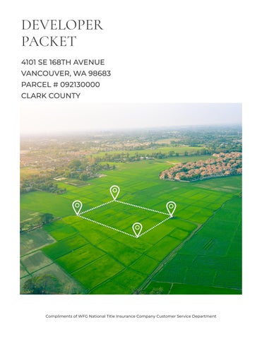
4101 SE 168TH AVENUE VANCOUVER, WA 98683 PARCEL # 092130000 CLARK COUNTY DEVELOPER PACKET Compliments of WFG National Title Insurance Company Customer Service Department

TABLE OF Property Details Custom Maps Zoning Information Community Information -Demographics -Traffic Counts CONTENT S The information contained is provided by WFG’s Customer Service Department to our customers, and while deemed reliable, is not guaranteed.
The information contained is provided by WFG’s Customer Service Department to our customers, and while deemed reliable, is not guaranteed.
Property
Assessors Tax Map Vesting Deed
County GIS Details DETAILS
PROPERTY
Information
Exhibit A
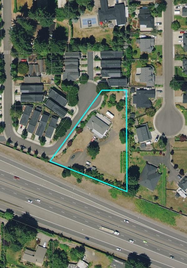
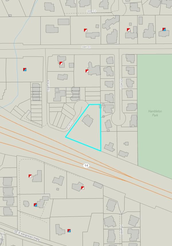
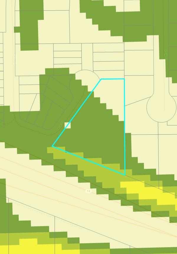
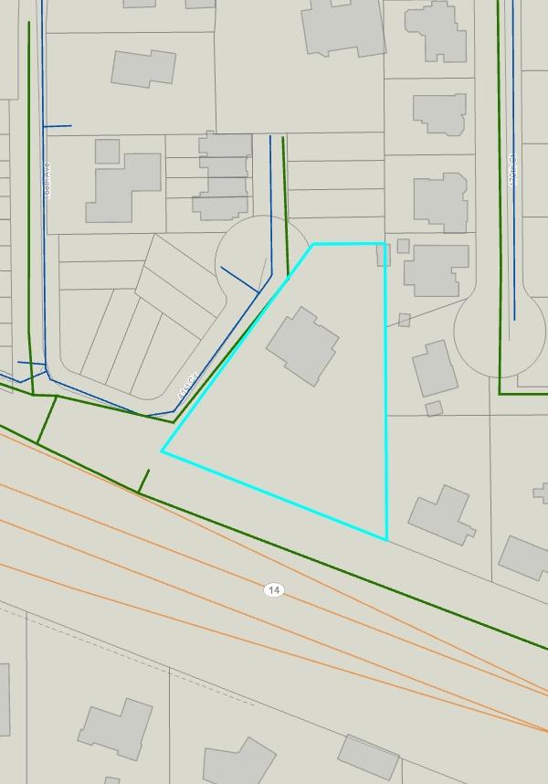
Parcel#:092130000
RefParcel#: Owner:PacificHoldingGroupInc
CoOwner: Site:4101SE168thAve VancouverWA98683-1409 Mail:1100NWKlickitatLn CamasWA98607-7940
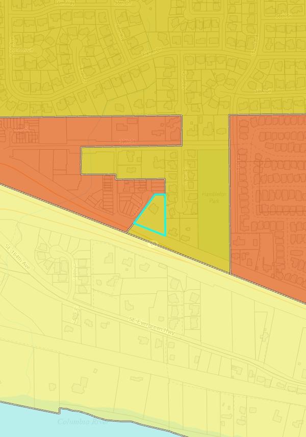
Zoning:R-9LowDensityResidential-9du/Ac(R9)
SchoolDist:114Evergreen Census:1014041325
LandUse:11Household,SingleFamilyUnits Legal:ALLMANPARK#1LOTS7,8&9112A
ASSESSMENT&TAXINFORMATION
MarketTotal:$838,429.00 MarketLand:$260,377.00 MarketImpr:$578,052.00 AssessedTotal:$838,42900
Exemption: Taxes:$6,725.18 LevyCode:114008 LevyRate:101862
SALE&LOANINFORMATION
SaleDate:11/10/2016 SaleAmount:$600,00000 Document#:5345903
DeedType:Deed LoanAmount:$476,000.00 Lender:ALBINACMNTYBK LoanType:Conventional InterestType:ADJ TitleCo:CHICAGOTITLECO

IMPROVEMENT1
BldgDesc:CONVENTIONAL
Stories:1
PROPERTYCHARACTERISTICS
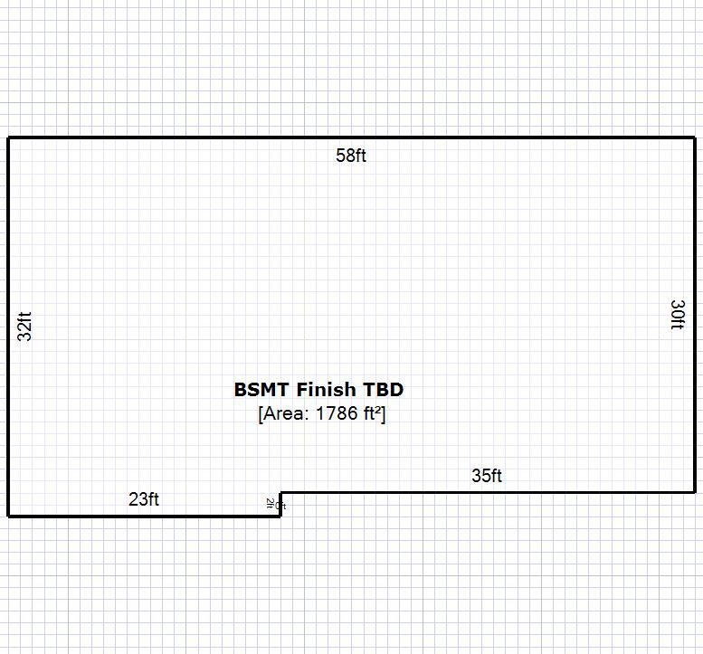
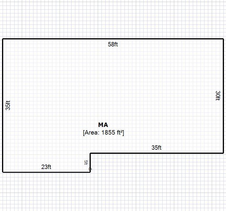
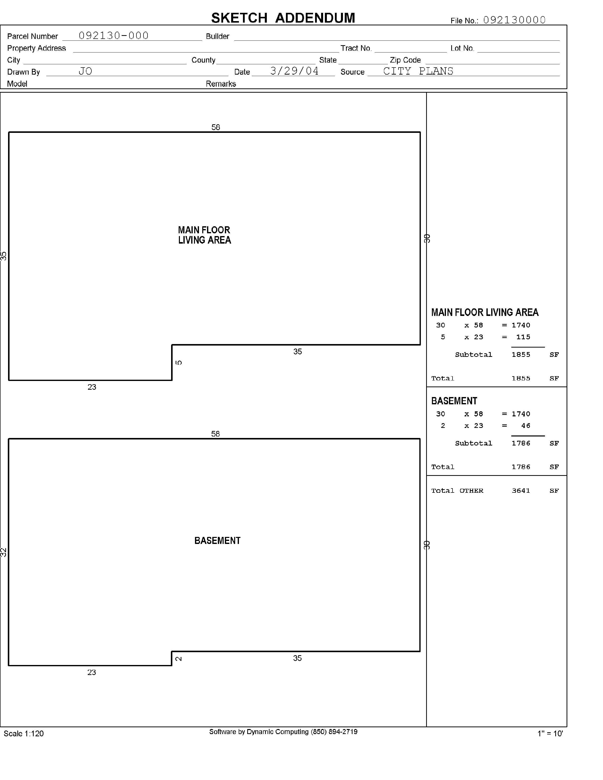
ParcelType:RESIDENTIALACREAGE YearBuilt:1966 Bedrooms:6 Bathrooms:325 BuildingTotal: 1stFloor:2,135SqFt 2ndFloor: AC:Yes BsmtFin/Unfin:1,786SqFt/ LotSize:112Acres(48,787SqFt) LotWidth/Depth:216/216 Garage: HeatSource:FA Fireplace: ImprType:01Ranch Plat/Subdiv:AllmanPark Map:568-E3 Waterfront: Watershed:SalmonCreek-FrontalColumbiaRiver Recreation: Latitude:45590982 Longitude:-122498699

ParcelID:092130000
Description:RANCH
Condition:AVERAGE Baths,Full:1 2ndFloor: Use:RESIDENTIAL Baths,3/4:3 YearBuilt:1966(1966) Quality: Baths,1/2: BsmtFin:1786 RoofingMatl:CMP Baths,1/4: BsmtUnfin: Garage: Deck: BldgFinTotal:2,135SqFt Carport: ExtWall:SS AC:Yes #Fireplaces:1 HeatType:FA %Complete:10000%
Bedrooms:6 1stFloor:2,135SqFt
ClarkCountyPropertyProfileInformation
SentryDynamics,Inc anditscustomersmakenorepresentations,warrantiesorconditions,expressorimplied,astotheaccuracyor completenessofinformationcontainedinthisreport

AssessorMap
ParcelID:092130000 SiteAddress:4101SE168thAve SentryDynamics,Inc anditscustomersmakenorepresentations, warrantiesorconditions,expressorimplied,astotheaccuracyor completenessofinformationcontainedinthisreport
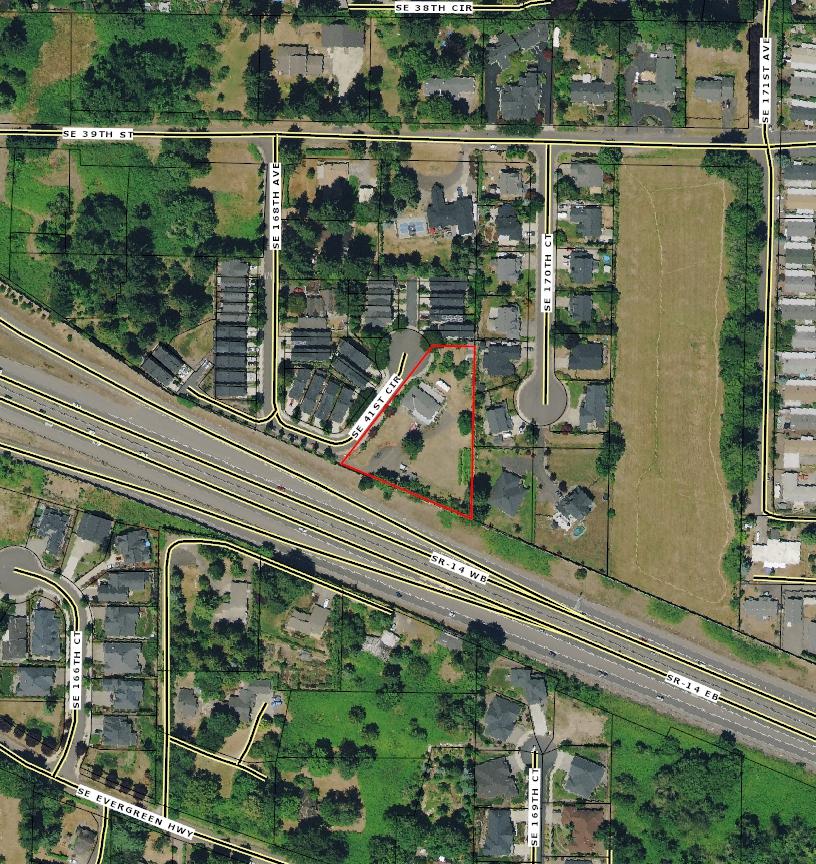
AerialMap ParcelID:092130000 SentryDynamics,Inc anditscustomersmakenorepresentations, warrantiesorconditions,expressorimplied,astotheaccuracyor completenessofinformationcontainedinthisreport
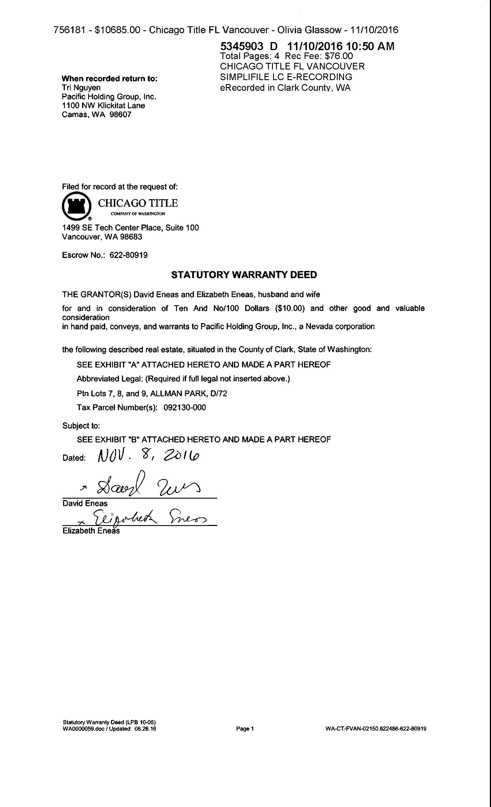
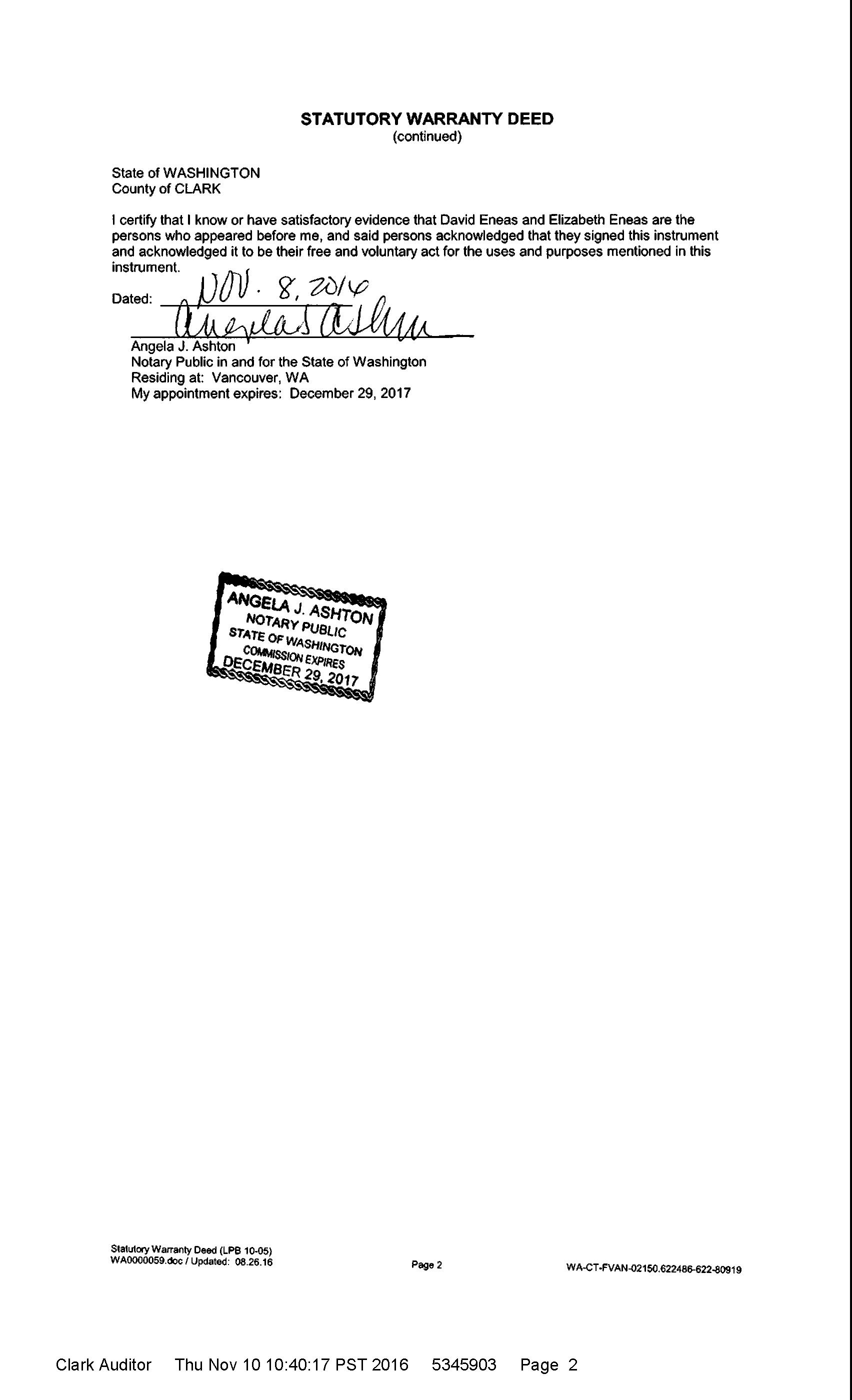
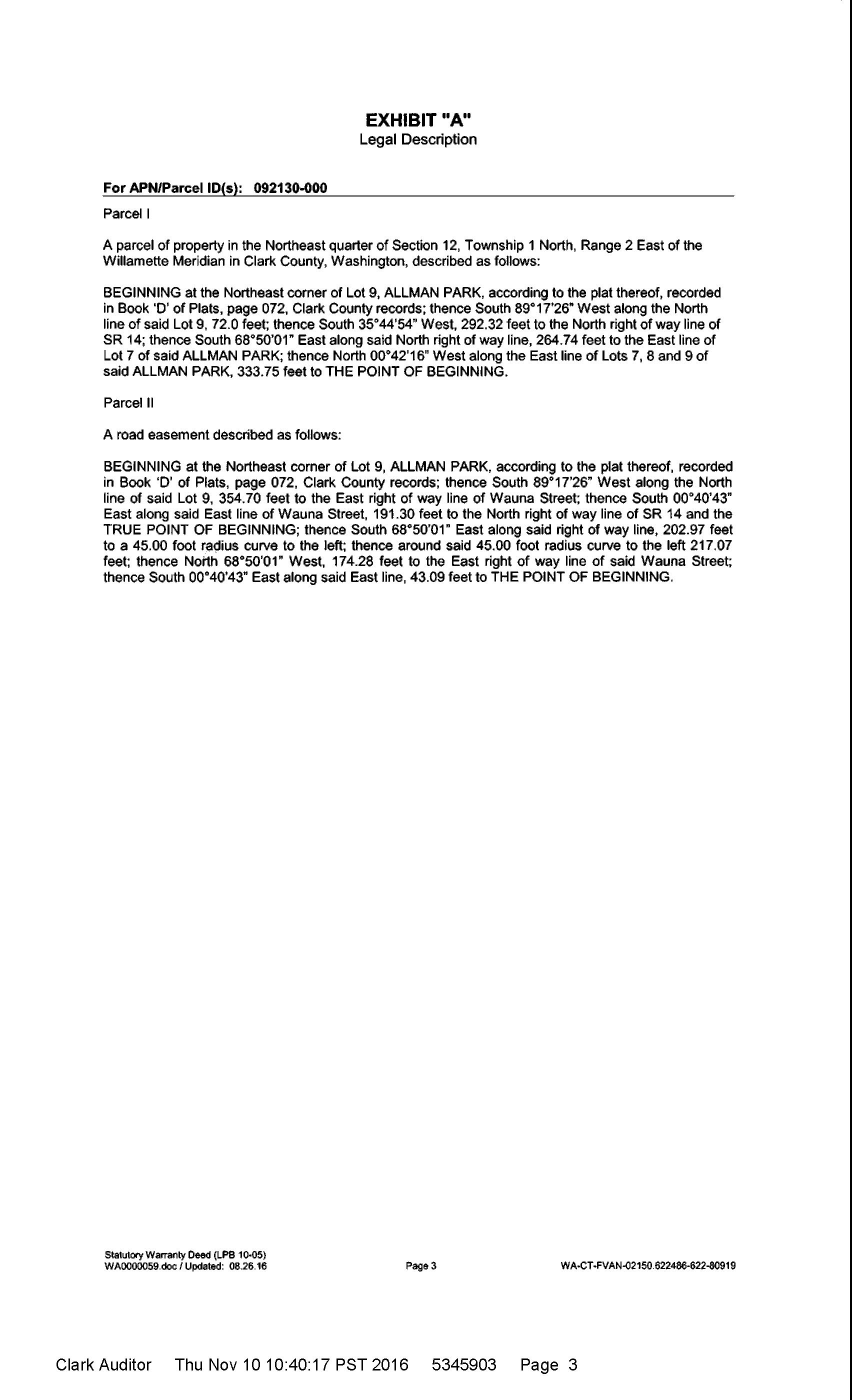
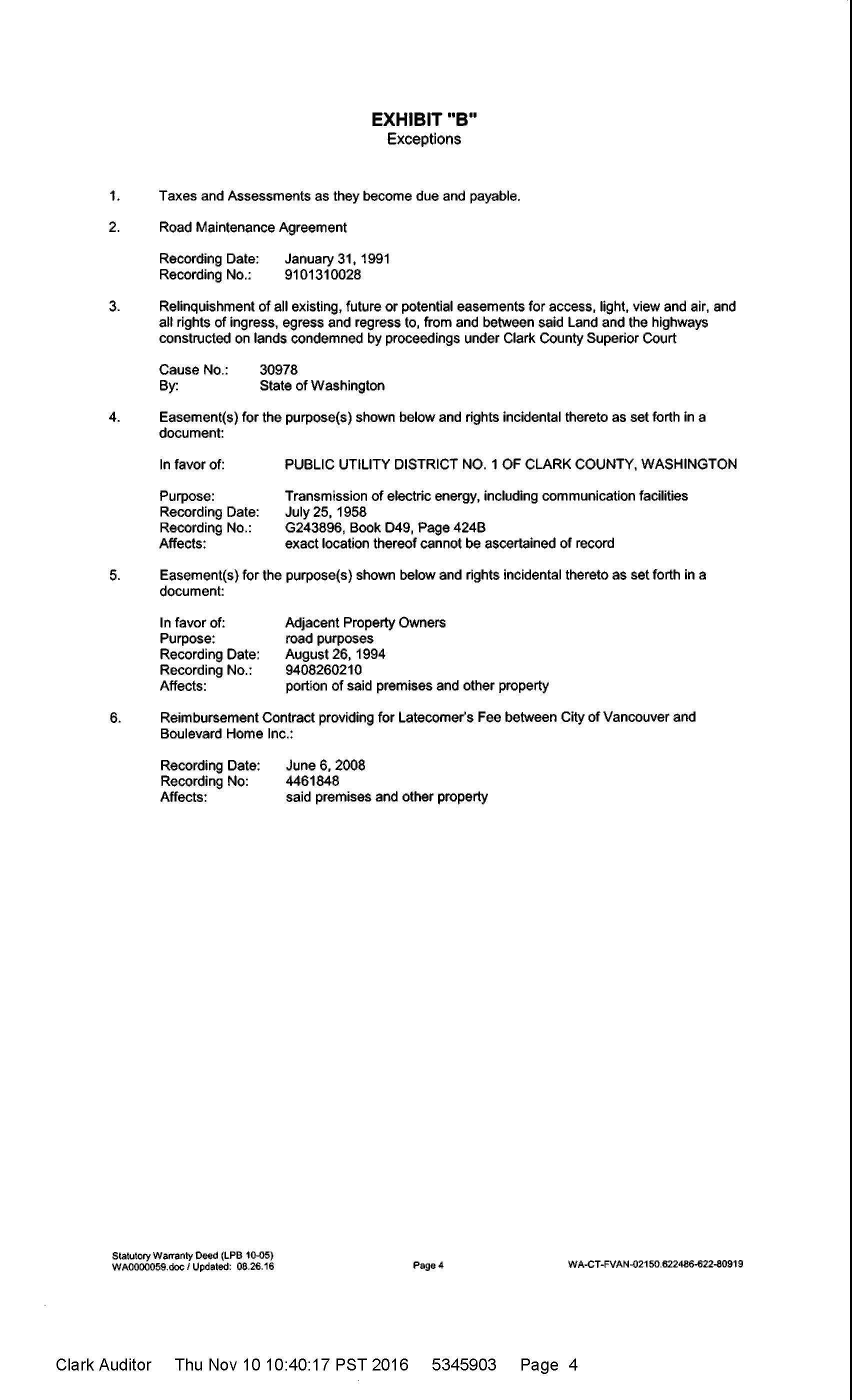
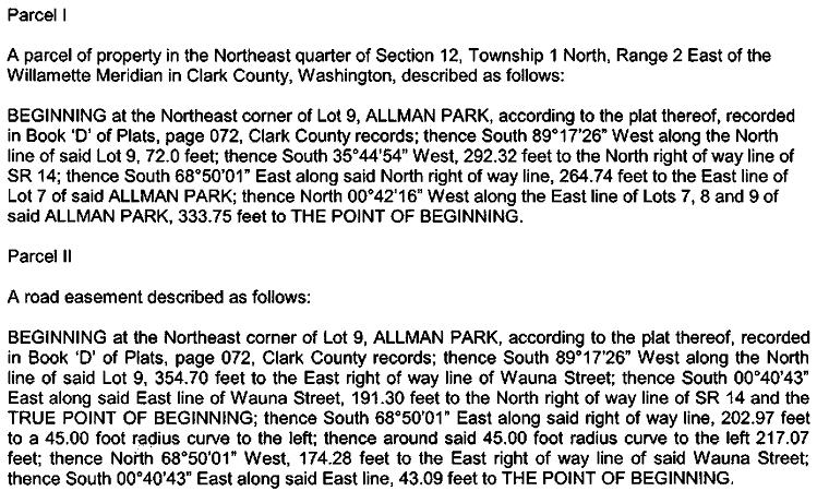
Exhibit “A” The real property described above is commonly known as: [__________] [__________] __________ [__________] [__________] __________ Buyer Initials Date Seller Initials Date 4101 SE 168th Avenue Vancouver, WA 98683
PROPERTY INFORMATION CENTER
Account Summary
Property Identification Number: 92130000 MapsOnline Fact Sheet
Property Type: Real Property Status: Active Site Address: 4101 SE 168TH AVE, VANCOUVER, WA 98683 (Situs Addresses)
Abbreviated Description: ALLMAN PARK #1 LOTS 7, 8 & 9 1.12A
Tax Status: Regular
Info for Senior/Disabled Property Tax Exemption
Property Owner
PACIFIC HOLDING GROUP INC
Administrative Data Info...
Jurisdiction Vancouver Land Use Planning
Comprehensive Plan Designation UL
Comprehensive Plan Overlay(s) none
Urban Growth Area Vancouver Zoning DesignationCodes
Low Density Residential9du/ac (R-9) Zoning Overlay(s) none
Miscellaneous
Census Tract 413.25 Drainage District n/a Neighborhood n/a Park District C
Public Safety Burning Allowed No EMS Response Area AMR Fire District Vancouver Increased Wildfire Danger Area No
Police Jurisdiction VPD East District 4
Schools
School District Name Evergreen Elementary School
Attendance Area Fishers Landing Middle School Attendance Area Shahala
High School Attendance Area Mt. View
Transportation
Owner Mailing Address
1100 NW KLICKITAT LN CAMAS WA , 98607
Electoral Data
Board of County Councilors District 3 Camas Council Ward n/a CPU Commissioner District 2
Election Precinct 696 Legislative District 17 Library District Fort Vancouver Regional Library
Port District Vancouver Port District 3 School District Board Director District Director District 4 Sewer Board District Vancouver State Weed Board District 2
Land Data Approximate Area Info... 48,787 sq. ft. 1.12 acres
Clark County Road Atlas Page 1 DOR Land Use Code Info... 11 Section-Township-Range NE 1/4,S12,T1N,R2E PDF
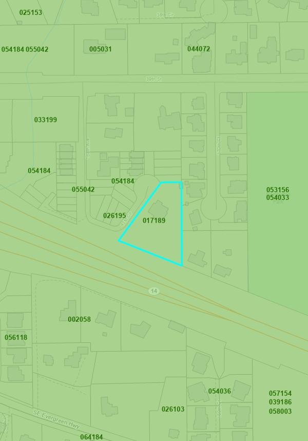
Subdivision ALLMAN PARK Survey 017189 026195
Sales History
Date of Sale 11/08/2016 Document Type D-SWD Document Number Excise Number 756181 Sale Amount $600,000.00
Property Site Address
4101 SE 168TH AVE, VANCOUVER, WA 98683
Google Maps Street View
Assessment Data Info...
2022 Values for 2023 Taxes
Market Value as of January 1, 2022
Land Value $260,377.00 Building Value $578,052.00 Total Property $838,429.00
Taxable Value Info... Total $838,429.00
2021 Values for 2022 Taxes
Market Value as of January 1, 2021
Land Value $202,402.00 Building Value $454,687.00 Total Property $657,089.00
Taxable Value Info Total $657,089.00
General Assessor Neighborhood 47 Re-valuation Cycle 5 Notice of Value 2022 2021 2020 2019 2018 2017 2016
Property assessment value is valid as of the date printed on the linked notice of value. The notice of value will not reflect any updates to property value that occurred after the notice mail date Please contact the Assessor's office
C-TRAN Public
Transportation Benefit Area Yes
Traffic Impact Fee (TIF) District Cascade Transportation Analysis Zone 244 Utilities
CPU Lighting Utility District n/a Last Street Sweeping n/a Sewer District Vancouver Waste Collection Provider n/a Waste Collection Day No Data Water District Vancouver
Date of Sale 04/17/2001 Document Type DEED Document Number Excise Number 478744 Sale Amount $277,000.00
Date of Sale 11/22/2000 Document Type D-QCD Document Number Excise Number 472272 Sale Amount $0.00
Date of Sale 06/14/2000 Document Type DEED Document Number Excise Number 465192 Sale Amount $236,900.00
Date of Sale 08/23/1994 Document Type DEED Document Number Excise Number 372123 Sale Amount $184,000.00
If you have questions concerning the data on this page, please contact the Clark County Assessor’s Office. Main Phone: (564) 397-2391, Email: assessor@clark.wa.gov
if you have a question about your assessed value
PROPERTY INFORMATION CENTER
Land & Building Details
Property Identification Number: 92130000 MapsOnline Fact Sheet
Property Type: Real Property Status: Active Site Address: 4101 SE 168TH AVE, VANCOUVER, WA 98683 (Situs Addresses)
Abbreviated Description: ALLMAN PARK #1 LOTS 7, 8 & 9 1.12A
Tax Status: Regular
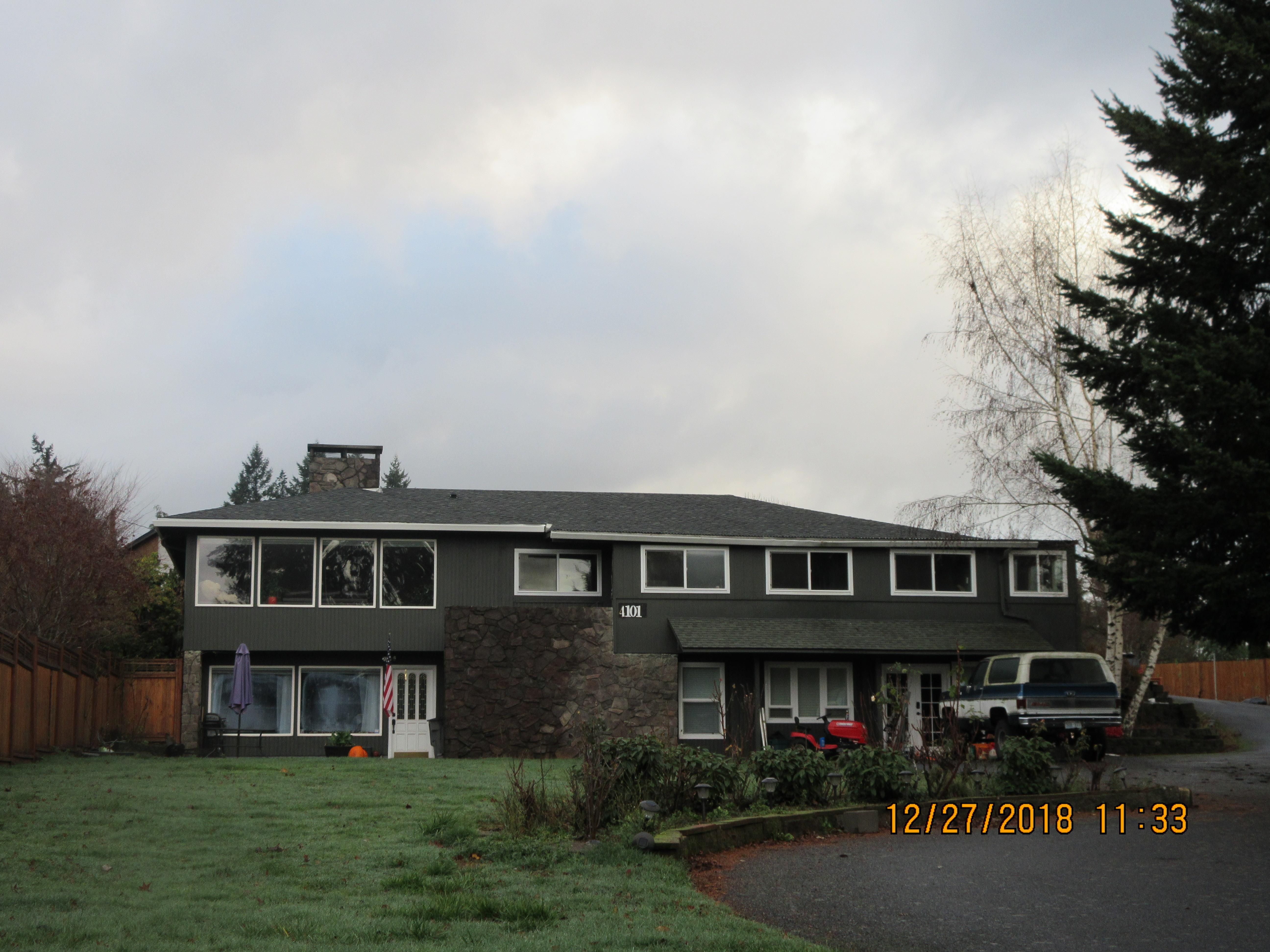
Info for Senior/Disabled Property Tax Exemption Photos
Property Photo
Building 1
Summary Information
Building Style
RANCH Number of Bedrooms 6 Number of Bedrooms Approved for Septic System no data
FULL BATH 1 3/4 BATH 3
HEAT TYPE FA A/C Y Fireplace FIRE2-DBL 1.00 Details 1 MAIN 2135 sq. ft. Effective Year Built 1966 Actual Year Built 1966 Building Type
CONVENTIONAL Construction Quality GOOD Condition AVERAGE Details 2
DAY FINISHED BASEMENT 1786 sq. ft. Effective Year Built 1966 Actual Year Built 1966 Building Type RESIDENTIAL Construction Quality GOOD Condition AVERAGE
& Imagery
Photo Date: 12/27/2018 Click photo for printable image Building Sketch
If you have questions concerning the data on this page, please contact the Clark County Assessor’s Office. Main Phone: (564) 397-2391, Email: assessor@clark.wa.gov
PROPERTY INFORMATION CENTER
Environmental Constraints
Property Identification Number: 92130000 MapsOnline Fact Sheet
Property Type: Real Property Status: Active Site Address: 4101 SE 168TH AVE, VANCOUVER, WA 98683 (Situs Addresses)
Abbreviated Description: ALLMAN PARK #1 LOTS 7, 8 & 9 1.12A
Tax Status: Regular
Info for Senior/Disabled Property Tax Exemption
Cultural Resources
Archaeological Probability: Level BLower Probability
Archaeological Site Buffer: Yes Historic Site: No Mapping Indicators
Forest Practice
Moratorium Info... none
Geological Hazards Info...
Geological Hazard: Liquefaction: Very Low NEHRP Class: C Slope Stability:
Habitat and Species Resources Info...
Habitat and Species Impacts: No Mapping Indicators
Wetlands and Soil Types
Critical Aquifer Recharge Area: Critical Aquifer Recharge Area (Vancouver)
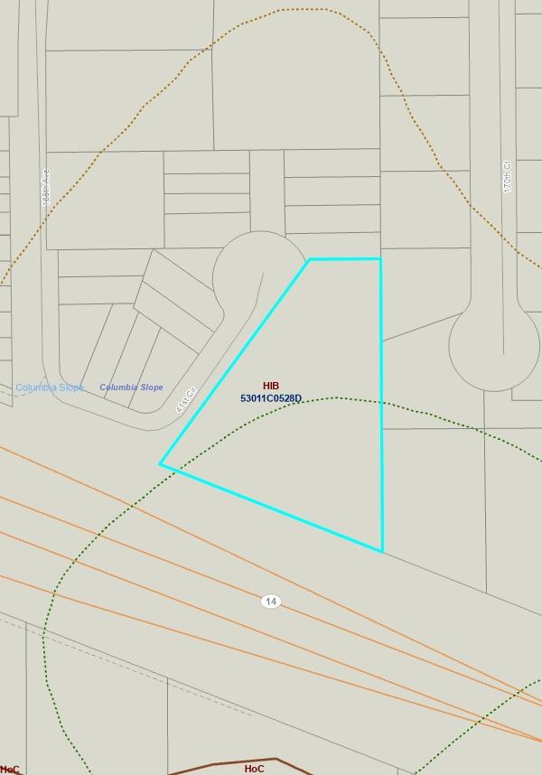
FEMA Map / FIRM Panel: Info... 53011C0528D
Flood Hazard Area: Info... Outside Flood Area Shoreline Designation: none Soil Types / Class: Non-Hydric / HlB
Water Resource Inventory Area:
Name: SALMONWASHOUGAL Sub-Basin: Burnt Bridge
Watershed: Columbia Slope Sub Watershed: Columbia Slope Wetland Class: No Mapping Indicators
Wetland Inventory: Info No Mapping Indicators
Septic Document Details
none Water Well Details
Ecology Well Tag ID Unknown Program Element Category DW ECY Grant Public Health ID WP0007703
Well Depth 105 Well Type Drilled Well
If you have any questions concerning the data on this page, please contact Clark County Environmental Services. Main Phone: (564) 397-4489, Email: landuse@clark.wa.gov
PROPERTY INFORMATION CENTER
Tax Summary
Property Identification Number: 92130000 MapsOnline Fact Sheet
Property Type: Real Property Status: Active Site Address: 4101 SE 168TH AVE, VANCOUVER, WA 98683 (Situs Addresses)
Abbreviated Description: ALLMAN PARK #1 LOTS 7, 8 & 9 1.12A
Tax Status: Regular
Info for Senior/Disabled Property Tax Exemption
Property Owner
PACIFIC HOLDING GROUP INC
2022 Tax Information
Owner Mailing Address
1100 NW KLICKITAT LN CAMAS WA, 98607
Property Location Address
4101 SE 168TH AVE, VANCOUVER, WA 98683 Google Maps Street View Bing Maps Birds Eye
Pay Online Payment service fees: Free E-Check, 2.39% Credit Card, $3.95 Debit Card
Other Payment Options
Tax Code Area: 114008 Millage Rate: 10.1862006219
Tax Bill Summary
Taxable Value $657,089.00 Tax Amount $6,726.18 Tax Paid $0.00
Tax and Assessment Distribution Tax Statements
1st Half Billed - Does not reflect payments
Amount Billed $3,363.14 Payment Due Date Apr. 30, 2022
2nd Half Billed - Does not reflect payments
Amount Billed $1.00 Payment Due Date May. 18, 2022
2nd Half BilledDoes not reflect payments Amount Billed $3,362.04 Payment Due Date Oct. 31, 2022
Tax Years Owing *Interest & Penalty calculates on delinquent taxes
Tax Year Statement ID Amount Billed Calc Date* Interest Penalty Total Due
2022 31993 $6,726.18 $537.37 $2.63 $7,266.18
2021 32053 $6,639.93 $1,327.55 $730.15 $8,697.63
2020 32092 $6,290.12 $1,886.53 $503.08 $8,679.73
Tax History
12/21/2022 12/21/2022 12/21/2022
Tax Year Statement ID Billed Paid Interest Paid Penalty Paid
2022 31993 $6,726.18 $0.00 $0.00 $0.00
2021 32053 $6,639.93 $0.00 $0.00 $0.00
2020 32092 $6,290.12 $0.00 $0.00 $0.00
2019 32129 $6,373.30 $6,373.30 $2,230.21 $700.91
2018 32157 $6,700.54 $6,700.54 $2,532.43 $733.06
2017 32174 $5,600.09 $5,600.09 $0.00 $0.00
2016 32196 $5,353.95 $5,353.95 $0.00 $0.00
2015 32395 $5,193.47 $5,193.47 $0.00 $0.00
2014 32400 $4,992.55 $4,992.55 $0.00 $0.00
2013 32409 $4,644.46 $4,644.46 $0.00 $0.00
2012 32417 $4,431.84 $4,431.84 $0.00 $0.00
2011 32442 $4,283.34 $4,283.34 $0.00 $0.00
2010 32427 $3,997.62 $3,997.62 $0.00 $0.00
2009 32387 $4,263.77 $4,263.77 $0.00 $0.00
2008 360625 $4,201.90 $4,201.90 $0.00 $0.00
2007 201133 $4,010.16 $4,010.16 $0.00 $0.00
2006 45358 $4,005.42 $4,005.42 $0.00 $0.00
If you have any questions concerning the data on this page, please contact Clark County Treasurer's Office. Main Phone: (564) 397-2252, Email: treasoff@clark.wa.gov
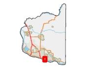
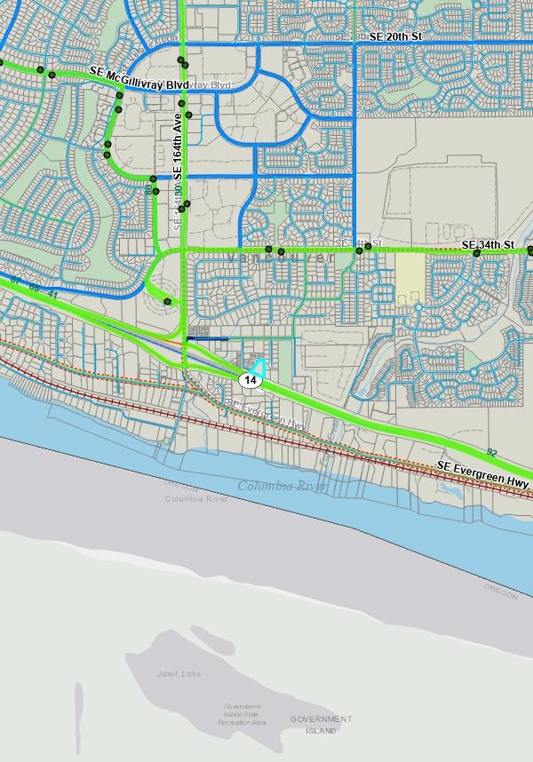
Aerial Transportation Environmental Public Health Slopes & Geologic Hazards Soils, Wetlands & Natural Resources Surveys Utilities (Water & Sewer lines)
The information contained is provided by WFG’s Customer Service Department to our customers, and while deemed reliable, is not guaranteed.
CUSTOM
MAPS


Aerial Clark County, WA. GIS - http://gis.clark.wa.gov 188.0 WGS_1984_Web_Mercator_Auxiliary_Sphere Feet 188.0 0 94.00
Notes: This map was generated by Clark County's "MapsOnline" website. Clark County does not warrant the accuracy, reliability or timeliness of any information on this map, and shall not be held liable for losses caused by using this information. 1,128 1:
Legend
Taxlots
Legend
C-Tran Bus Stop C-Tran Facilities
C-Tran Transit Center
C-Tran Park and Ride
C-TRAN Routes
Road Route Systems
State Route
Battle Ground Route
LaCenter Route
Other Municipal Route
Vancouver Route County Route
Proposed Route
Concurrency Route
Bike Routes
Bike Lanes or wide shoulders, usually on higher
Shared Roadway, on lower traffic street
Shared Roadway, with wider outside Lane on higher traffic street
Difficult Connection
Shared Roadway/Difficult Connection, lower traffic sight limitations and higher speeds
Paved Multi-use Paths, closed to motor vehicles
Unpaved Multi-use Paths, closed to motor vehicles Cyclists Prohibited
Planned Bikeways
Main Track
All Roads
Interstate State Route Arterial Forest Arterial Minor Collector Forest Collector Private or Other
Taxlots
GIS - http://gis.clark.wa.gov
WGS_1984_Web_Mercator_Auxiliary_Sphere
Transportation Clark County, WA.
3,009.3
Feet 3,009.3 0 1,504.67
Notes: This map was generated by Clark County's "MapsOnline" website. Clark County does not warrant the accuracy, reliability or timeliness of any information on this map, and shall not be held liable for losses caused by using this information. 18,056 1:

- http://gis.clark.wa.gov 376.2 WGS_1984_Web_Mercator_Auxiliary_Sphere Feet 376.2 0 188.08 Legend Notes: This map was generated by Clark County's "MapsOnline" website. Clark County does not warrant the accuracy, reliability or timeliness of any information on this map, and shall not be held liable for losses
this information. 2,257 1:
System No Associated Documents Apps. and As-Builts online RME Documents Both Available Landfills Building Footprints Taxlots
Environmental Public Health Clark County, WA. GIS
caused by using
Septic
Taxlots
Percent Slope
0-5 percent
>5-10 percent
>10-15 percent
>15-25 percent >25-40 percent >40-80 percent >80 percent
Severe Erosion Hazard Areas

Steep Slopes and Landslide Hazard Areas
Areas of Historic or Active Landslides
Areas of Potential Instability Areas of Older Landslide Debris Slopes > 15% Slopes > 25%
Clark County, WA. GIS - http://gis.clark.wa.gov 188.0 WGS_1984_Web_Mercator_Auxiliary_Sphere Feet 188.0 0 94.00
not
the accuracy,
of any information
this
and
be
liable for losses
by using this information. 1,128 1:
Slopes & Geological Hazards
Legend Notes: This map was generated by Clark County's "MapsOnline" website. Clark County does
warrant
reliability or timeliness
on
map,
shall not
held
caused
188.0 WGS_1984_Web_Mercator_Auxiliary_Sphere Feet
0
Legend
1,128 1: Taxlots FIRM Panels Base Flood Elevation Flood Zone Designation Floodway Floodway Fringe 500 Year Flood Area Area Not Studied Soil Type Potential Wetlands Presence Permitted Wetland NWI Wetland Modeled Wetland Depth to Water 10 ft 20 ft 30 ft Watershed Sub-Watershed
Soils, Wetlands & Natural Resources Clark County, WA. GIS - http://gis.clark.wa.gov
188.0
94.00
Notes: This map was generated by Clark County's "MapsOnline" website. Clark County does not warrant the accuracy, reliability or timeliness of any information on this map, and shall not be held liable for losses caused by using this information.

Surveys Clark County, WA. GIS - http://gis.clark.wa.gov 376.2 WGS_1984_Web_Mercator_Auxiliary_Sphere Feet 376.2 0 188.08 Legend Notes: This map was generated by Clark County's "MapsOnline" website. Clark County does not warrant the accuracy, reliability or timeliness of any information on this map, and shall not be held liable for losses caused by using this information. 2,257 1: Survey - Recorded Survey - Performed by County Building Footprints Taxlots
Utilities
WGS_1984_Web_Mercator_Auxiliary_Sphere Feet
Legend Notes:
1,128
Sanitary Sewer Water Line Building Footprints Taxlots
Clark County, WA. GIS - http://gis.clark.wa.gov 188.0
188.0 0 94.00
This map was generated by Clark County's "MapsOnline" website. Clark County does not warrant the accuracy, reliability or timeliness of any information on this map, and shall not be held liable for losses caused by using this information.
1:
ZONING
The information contained is provided by WFG’s Customer Service Department to our customers, and while deemed reliable, is not guaranteed.
Detailed Zoning
Zoning Map
Information DETAILS
Legend Notes:
Zoning Overlay
Urban Reserve - 10 (UR-10)
Urban Reserve - 20 (UR-20)
Urban Holding - 10 (UH-10)
Urban Holding - 20 (UH-20)
Railroad Industrial Urban Reserve
Freight Rail Dependent Use
Railroad Industrial Overlay District Airport Environs Overlay
Surface Mining Overlay District
Rural Center Mixed Use
Existing Historic Resort
Mill Creek Overlay District Highway 99 Overlay District
Activity Center Overlay
Transitional Area Overlay
Single Family Residential Area Overlay
Mixed Residential Area Overlay
Multifamily Residential Area Overlay 78th Street Property
Columbia River Gorge Scenic Area
Vancouver - Multiple Overlays Sewer Capacity Overlay
Infill Residential Development Area Woodburn Hills Subarea
Downtown Overlay District
Cardroom Overlay District
Sensitive Utility Corridor Overlay Dist
Employment Mixed Use Overlay Airport Overlay
Gateway Corridor
Ridgefield Mixed Use Overlay (RMUO)
Zoning - Outline
Zoning
Single-Family residential (R1-20, R-20)
Single-Family residential (R1-15, R-15)
Single-Family residential - 12 (R-12)
Single-Family residential (R1-10, R-10, R10)
Single-Family residential (R1-7.5, R-7.5, LDR-7.5)
Single-Family residential (R1-6, R-6, LDR-6)
Single-Family residential (R1-5)
Residential (R-12, R12)
Residential (R-18, MF-18)
Residential (R-22, AR-22)
Residential (R-30)
Residential (R-43)
Office residential-15 (OR-15)
Office residential-18 (OR-18)
Clark County, WA. GIS - http://gis.clark.wa.gov 752.3 WGS_1984_Web_Mercator_Auxiliary_Sphere Feet 752.3 0 376.17
Zoning
This map was generated by Clark
Clark County does not warrant the accuracy, reliability or timeliness of any information on this map, and shall not be held liable for losses caused by using this information. 4,514 1:
County's "MapsOnline" website.
Chapter 20.410
LOWER DENSITY RESIDENTIAL DISTRICTS
Sections: Purpose. List of Zoning Districts. Lower Density Residential Zone Function and Location Criteria. Uses. Minimum and Maximum Densities. Development Standards.
20.410.010 20.410.020 20.410.025 20.410.030 20.410.040 20.410.050
20.410.010 Purpose.
Preserve and promote neighborhood livability and protect the consumer’s choices in housing. The Low-Density Residential Districts are primarily designed to preserve and promote neighborhoods of detached single dwellings at low intensities. Flexibility in housing type is promoted by allowing manufactured homes, duplexes, and planned unit developments under special conditions. Compatible nonresidential development, such as elementary schools, churches, parks, and child care facilities are permitted at appropriate locations and at an appropriate scale. (Ord. M-3709 § 3, 2005; Ord. M-3643, 2004)
20.410.020 List of Zoning Districts.
A. R-2: Low-Density Residential District. The R-2 zoning district is designed to accommodate detached single dwellings with or without accessory residential units at a minimum lot size of 20,000 square feet and a density of 1.8 to 2.2 units/net acre. Some civic and institutional uses are permitted as limited or conditional uses. The R-2 zoning district was referred to as R1-20 zone prior to March 11, 2004.
B. R-4: Low-Density Residential District. The R-4 zoning district is designed to accommodate detached single dwellings with or without accessory residential units at a minimum lot size of 10,000 square feet and a density of 2.3 to 4.4 units/net acre. Some civic and institutional uses are permitted as limited or conditional uses. The R-4 zoning district was referred to as R1-10 zone prior to March 11, 2004.
C. R-6: Low-Density Residential District. The R-6 zoning district is designed to accommodate detached single dwellings with or without accessory residential units at a minimum lot size of 7,500 square feet and a density of 4.5 to 5.8 units/net acre. Some civic and institutional uses are permitted as limited or conditional uses. The R-6 zoning district was referred to as R1-7.5 zone prior to March 11, 2004.
D. R-9: Low-Density Residential District. The R-9 zoning district is designed to accommodate detached single dwellings with or without accessory residential units at a minimum lot size of 5,000 square feet and a density of
The Vancouver Municipal Code is current through Ordinance M-4383, passed November 14, 2022.
Your Selections | Vancouver Municipal Code Page 1 of 38
5.9 to 8.7 units/net acre. Some civic and institutional uses are permitted as limited or conditional uses. The R-9 zoning district is a new zoning district that combines what was referred to as R1-6 and R1-5 zones prior to March 11, 2004.
E. R-17: Low-Density Residential District. The R-17 zoning district is designed to accommodate detached and attached single dwellings with or without accessory residential units at a minimum lot size of 2,000 square feet and a density of 8.8 to 21.8 units/net acre. Some civic and institutional uses are permitted as limited or conditional uses. (Ord. M-4377 § 2(a), 2022; Ord. M-3643, 2004)
20.410.025
Lower Density
Residential
Zone Function and Location Criteria.
A. General Criteria. The Lower Density Residential designation is applied to areas that provide predominantly single-family structures (attached or detached) on individual lots. Application of individual zones to specific areas in the City should enhance and support the integrity of existing neighborhoods, provide for a range of choices in housing styles and cost, and encourage compatible infill development and redevelopment.
B. Lower Density Residential Zone (R-2, R-4, R-6, R-9) Location Criteria. The Lower Density zone designations defined above can be appropriately applied and maintained in areas meeting one of the following criteria:
1. Blocks, intersection-to-intersection street segments, or areas with defined physical edges, which have at least eighty (80) percent of the existing structures in single-family residential use on lots whose average size falls within the minimum and maximum lot size standards of the zone to be applied. Half-blocks at the edges of single-family zones with more than fifty (50) percent single-family structures, or portions of blocks on an arterial with a majority of single-family structures, shall generally be included. This shall be decided on a caseby-case basis, but the policy is for inclusion.
2. Blocks, intersection-to-intersection street segments, or areas with defined physical edges, which have less than eighty (80) percent of the existing structures in single-family residential use but in which an increasing trend toward single-family residential use can be demonstrated; for example:
a. The construction of single-family structures in the last five (5) years has been increasing proportionately to the total number of constructions for new uses in the area, or
b. The area shows an increasing number of improvements and rehabilitation efforts to single-family structures, or
c. The number of existing single-family structures has been very stable or increasing in the last five (5) years, or
d. The area’s location is topographically and geographically connected to, and compatible with, existing single-family residential development, with physical edges (such as major arterials, topography, waterways, open space, existing natural or landscape screening, etc) that separate and buffer the area from Higher Density Residential, Commercial, and Industrial.
The Vancouver Municipal Code is current through Ordinance M-4383, passed November 14, 2022.
Your Selections | Vancouver Municipal Code Page 2 of 38
3. Areas with sensitive physical, environmental or natural resource characteristics that make lower intensity development advisable and appropriate.
4. Areas that meet the above criteria for designation as Lower Density Residential shall not be rezoned for nonresidential uses, except NC (Neighborhood Commercial), unless the change has been adopted as part of a sub-area planning study.
5. No vacant or underutilized land areas (per Vacant Buildable Lands Model criteria) within the City shall be rezoned R-2 or R-4 for new residential development. Land use and zoning designations for residential lands being annexed into the City shall be converted to City designations in accordance with VMC Table 20.230.030. (Ord. M-3946 § 6, 2010; Ord. M-3730 § 9, 2005)
20.410.030 Uses.
A. Types of uses. For the purposes of this chapter, there are four kinds of use:
1. A permitted (P) use is one that is permitted outright, subject to all of the applicable provisions of this title.
2. A limited (L) use is permitted outright providing it is in compliance with special requirements, exceptions or restrictions.
3. A conditional use (C) is a discretionary use reviewed through the process set forth in Chapters 20.245 and 20.210 VMC, governing conditional uses and decision-making procedures, respectively.
4. A prohibited use (X) is one that is not permitted in a zoning district under any circumstances.
B. Use table. A list of permitted, limited, conditional, and prohibited uses in low-density residential districts is presented in Table 20.410.030-1. Table 20.410.030-1. Lower-Density Residential Districts Use Table
The Vancouver Municipal Code is current through Ordinance M-4383, passed November 14, 2022.
USE R-2 R-4 R-6 R-9 R-17 RESIDENTIAL Household Living P1 P1 P1 P1 P1 Group Living P/X1 P/X1 P/X1 P/X1 P/X1
L2 L2 L2 L2 L2
Center
L23 L23 L23 L23 L23
Home Occupation
Medical
Residential
Your Selections | Vancouver Municipal Code Page 3 of 38
HOUSING TYPES
Table 20.410.030-1. Lower-Density Residential Districts Use Table
USE R-2 R-4 R-6 R-9 R-17
Single Dwellings, Attached L18 L18 L18 L18 L18
Single Dwellings, Detached P P P P P
Accessory Dwelling Units L4 L4 L4 L4 L4
Duplexes22 L21 L21 L21 L21 L24
Multi-Dwelling Units X X X X L24
Existing Manufactured Home Developments L5 L5 L5 L5 L5
Designated Manufactured Homes L/X19 L/X19 L/X19 L/X19 L/X19
New Manufactured Homes L20 L20 L20 L20 L20 Cottage Cluster Housing P25 P25 P25 P25 X CIVIC (Institutional)
Basic Utilities C C C C C Colleges C C C C C Community Centers X X X X X Community Recreation C6 C6 C6 C6 C6
Cultural Institutions P/C 7 P/C7 P/C 7 P/C 7 P/C 7
Day Care
– Family Day Care Homes P8 P8 P8 P8 P8
– Child Care Centers L/C11 L/C11 L/C11 L/C11 L/C11
– Adult Day Care L/C/X9 L/C/X9 L/C/X9 L/C/X9 L/C/X9
Emergency Services (except ambulance services) L/C11 L/C11 L/C11 L/C11 L/C11
The Vancouver Municipal Code is current through Ordinance M-4383, passed November 14, 2022.
Your
Page 4 of 38
Selections | Vancouver Municipal Code
Table 20.410.030-1. Lower-Density Residential Districts Use Table
The Vancouver Municipal Code is current through Ordinance M-4383, passed November 14, 2022.
–
–
COMMERCIAL Commercial and Transient Lodging
Eating/Drinking Establishments X X X X X Entertainment-Oriented – Adult Entertainment X X X X X – Indoor Entertainment X X X X X – Major Event Entertainment X X X X X
Retail Your Selections | Vancouver Municipal Code Page 5 of 38
USE R-2 R-4 R-6 R-9 R-17 Ambulance Services X X X X X Medical Centers X X X X X Parks/Open Space
Neighborhood Parks P P P P P
Community Parks P P P P P – Regional Parks C C C C C – Trails P P P P P Postal Service C C C C C Religious Institutions L/C11 L/C11 L/C11 L/C11 L/C11 Schools L/C11 L/C11 L/C11 L/C11 L/C11 Social/Fraternal Clubs X X X X X Transportation Facilities C12 C12 C12 C12 C12
L/C/X13 L/C/X13 L/C/X13 L/C/X13 L/C/X13
General
INDUSTRIAL
The Vancouver Municipal Code is current through Ordinance M-4383, passed November 14, 2022.
–
–
–
X
–
X
–
X
X
–
X
Offices –
X X X X X –
X X X X X –
X X X X X Nonaccessory
X X X X X Self-Service
X X X X X Marinas C
Table 20.410.030-1. Lower-Density Residential Districts Use Table USE R-2 R-4 R-6 R-9 R-17
Sales-Oriented C14 C14 C14 C14 C14
Personal Services C14 C14 C14 C14 C14
Repair-Oriented
X X X X
Bulk Sales
X X X X
Outdoor Sales
X X X X Motor Vehicle Related – Motor Vehicle Sales/ Rental
X X X X – Motor Vehicle Servicing/ Repair X X X X X – Vehicle Fuel Sales X X X X X – EV Basic Charging Stations (accessory only) P P P P P – EV Rapid Charging Stations (accessory only) P P P P P
EV Battery Exchange Stations
X X X X
General
Medical
Extended
Parking
Storage
C C C C
Your Selections | Vancouver Municipal Code Page 6 of 38
Table 20.410.030-1. Lower-Density Residential Districts Use Table
USE R-2 R-4 R-6 R-9 R-17
Industrial Services X X X X X
Manufacturing and Production X X X X X
Railroad Yards X X X X X Research and Development X X X X X Warehouses/Freight Movement X X X X X
Wholesale Sales X X X X X Waste-Related X X X X X Major Utility Facilities X X X X X
OTHER
Agriculture/Horticulture P P P P P
Airports/Airparks X X X X X
Animal Kennels/Shelters X X X X X
Cemeteries C15 C15 C15 C15 C15
Detention and PostDetention Facilities X X X X X
Dog Day Care X X X X X Heliports X X X X X
Recreational or Medical Marijuana Facilities X X X X X
Medical Marijuana Cooperatives X X X X X
Mining X X X X X Rail Lines/Utility Corridors P P P P P
The Vancouver Municipal Code is current through Ordinance M-4383, passed November 14, 2022.
Your
|
Page 7 of 38
Selections
Vancouver Municipal Code
Table 20.410.030-1. Lower-Density Residential Districts Use Table
USE R-2 R-4 R-6 R-9 R-17
Temporary Uses L16 L16 L16 L16 L16
Wireless Communication Facilities
L/C/X17 L/C/X17 L/C/X17 L/C/X17 L/C/X17
1 Residential care homes, state or federally approved, with six or fewer residents and any required on-site residential staff permitted by right; all larger group living uses prohibited.
2 Subject to the provisions of Chapter 20.860 VMC, Home Occupations.
3 Reserved for future use.
4 Subject to the provisions of Chapter 20.810 VMC, Accessory Dwelling Units.
5 Subject to the provisions of Chapter 20.880 VMC, Manufactured Home Parks. Manufactured home developments established prior to July 1, 2005, are exempt from the standards of VMC 20.410.050(F), Criteria for Placement of Manufactured Homes, and may continue to exist and expand within existing previously approved boundaries. An existing manufactured home in a development or subdivision may be replaced or may be relocated either to an approved manufactured home development or an approved manufactured home subdivision.
6 Subject to provisions in VMC 20.895.040, Community Recreation and Related Facilities.
7 Libraries only permitted outright; all other cultural institutions are conditional uses.
8 Family day care homes for no more than 12 children are permitted when licensed by the state.
9 Adult day care facilities for six or fewer adults allowed as limited uses subject to compliance with the development standards governing home occupations, per VMC 20.860.020(B)(1) through (B)(7); facilities with seven to 12 adults allowed as conditional uses; and larger facilities are prohibited.
10 Repealed by M-4289.
11 Schools, religious institutions, government buildings, fire stations, child care centers, and emergency services facilities that meet all of the criteria contained in VMC 20.410.050(D) are permitted by right; all others require conditional use approval. Child care centers permitted by right shall be consistent with Chapter 20.840 VMC, Child Care Centers, and be subject to Type II review pursuant to VMC 20.210.050.
12 Except bus, trolley and streetcar stops, including bus shelters, which are allowed by right.
13 One- and two-bedroom bed-and-breakfast facilities are permitted outright and three- to six-bedroom bedand-breakfast facilities are allowed as conditional uses, with all bed-and-breakfast facilities subject to provisions of Chapter 20.830 VMC, Bed and Breakfast Establishments. No more than six bedrooms are allowed under any circumstances. All other commercial lodging is prohibited.
14 Retail commercial uses limited to 1,500 gsf per use to a maximum of 5,000 square feet in planned developments of 150 units or more. See VMC 20.260.020(B)(1)(b)(2).
The Vancouver Municipal Code is current through Ordinance M-4383, passed November 14, 2022.
Your Selections | Vancouver Municipal Code Page 8 of 38
15 Subject to provisions in VMC 20.895.030.
16 Subject to provisions in Chapter 20.885 VMC, except sales of fireworks which are prohibited in residential zones.
17 Building-mounted antennas are allowed by conditional use on nonresidential buildings in single-family residential zones subject to requirements contained in Chapter 20.890 VMC, Wireless Communication Facilities.
18 Subject to VMC 20.260.020(B)(1)(a)(2), planned development, VMC 20.910.050, Zero Lot Line Developments, and Chapter 20.920 VMC, Infill Development Standards.
19 A “designated manufactured home” is exempt from the development standards of VMC 20.410.050(F) and may continue to exist and expand. An existing unit may be replaced or may be relocated either to an approved manufactured home development or an approved manufactured home subdivision. After July 1, 2005, only “new manufactured homes” that also meet the “designated manufactured home” criteria will be permitted on individual lots not part of an existing approved manufactured home development or manufactured home subdivision, except that a new manufactured home placed on an individual lot after July 1, 2005, may be relocated as permitted by this title if within five years of the date of the original placement.
20 Subject to VMC 20.410.050(F), Development Standards – Criteria for Placement of Manufactured Homes.
21 Subject to Chapter 20.920 VMC, Infill Development Standards.
22 Existing duplexes built on lots meeting the minimum infill lot size standards of Table 20.920.060-1 shall be considered conforming uses even if not part of an infill development.
23 Medical center residential uses, as defined in VMC 20.160.020, are permitted outright if approved through a public facilities master plan per VMC 20.680.040.
24 Two-family dwellings (duplexes), three-family, or four-family dwellings are permitted subject to density and development standards of the R-17 district.
25 Pursuant to Chapter 20.950 VMC, Cottage Cluster Housing.
(Ord. M-4377 § 2(a), 2022; Ord. M-4325 § 3, 2020; Ord. M-4289 § 4, 2019; Ord. M-4255 § 6, 2018; Ord. M-4254 § 3(BB), 2018; Ord. M-4187 § 5, 2016; Ord. M-4071 § 7, 2014; Ord. M-4066 § 5, 2013; Ord. M-4035 § 2, 2012; Ord. M-4034 § 10, 2012; Ord. M-4024 § 6, 2012; Ord. M-4002 § 5, 2011; Ord. M-3931 § 9, 2009; Ord. M-3922 § 19, 2009; Ord. M-3840 § 18, 2007; Ord. M-3709 § 4, 2005; Ord. M-3663 § 12, 2004; Ord. M-3643, 2004)
20.410.040 Minimum and Maximum Densities.
A. Purpose. The purpose of this section is to establish minimum and maximum densities in each residential zoning district. To ensure the quality and density of development envisioned, the maximum density establishes the ceiling for development in each zoning district based on minimum lot size. To ensure that property develops at or near the density envisioned for the zone, the minimum density for each zoning district is set at just above the maximum density of the next less intense zone.
B. Maximum and minimum densities. The maximum and minimum densities for the low-density residential districts are contained in Table 20.410.040-1.
The Vancouver Municipal Code is current through Ordinance M-4383, passed November 14, 2022.
Your Selections | Vancouver Municipal Code Page 9 of 38
Zone
Table 20.410.040-1. Minimum and Maximum Densities and Lot Sizes1, 2
Minimum Lot Size Maximum Net Density Maximum Average Size Minimum Net Density
R-2 20,000 sf 2.2 30,000 sf 1.8
R-4 10,000 sf 4.4 19,000 sf 2.3
R-6 7,500 sf 5.8 10,500 sf 4.5
R-9 5,000 sf 8.7 7,400 sf 5.9
R-17 2,000 sf 21.8 4,900 sf 8.8
1 The minimum and maximum density factors shall only be used for calculating densities of planned unit developments governed by Chapter 20.260 VMC, infill development, density transfer, and situations where an existing house is allowed on a larger than maximum lot size per subsection (C)(2)(c) of this section (Exceptions). Minimum and maximum densities shall be calculated based on the gross area of the site minus any public rightsof-way, street tracts, private road easements, lots for dwellings existing on December 11, 2004, or designated critical areas.
2 Housing projects devoted entirely to housing affordable to households earning 80 percent or less of area median income (AMI) and providing guarantee acceptable to the planning official that such units will remain affordable at this level for 50 years may increase the maximum net density and reduce the associated minimum lot size requirement of the underlying zone by up to 50 percent in the R-2, R-4, R-6, R-9, and R-17 zones, provided this is not used to exceed underlying zoning district requirements for permitted structure or use types, building heights, or other development regulations.
C. Exceptions. The following exceptions are permitted to the lot size and density provisions for the R-2 through R-9 zoning districts contained in Table 20.410.040-1 above:
1. Minimum lot size/maximum density.
a. Lots developed or approved before March 11, 2004, are exempt from the requirements for minimum density. However, if a site is completely redeveloped, the new development must comply with the minimum density requirements contained in Table 20.410.010-1 above.
b. Nonresidential uses are exempt from minimum lot sizes.
c. Within a development of two or more lots, the minimum lot size may be averaged as long as no lot is smaller than 80 percent of the minimum required lot size.
d. Legal lots of record (lots legally created) that do not meet the minimum lot size requirement may be developed with a single dwelling unit.
The Vancouver Municipal Code is current through Ordinance M-4383, passed November 14, 2022.
Your Selections | Vancouver Municipal Code Page 10 of 38
e. When the maximum density contains a fraction of a unit, the applicant must round to the nearest whole unit. For calculations of X.1 through X.4, this means rounding down; for calculations of X.5 through X.9, this means rounding up to the next whole unit.
2. Maximum lot size/minimum density.
a. Nonresidential uses are exempt from maximum lot sizes.
b. On large parcels containing an existing dwelling on March 11, 2004, a lot no greater than one acre may be created around the existing dwelling with the remainder platted to create the number of dwelling units required within the range of minimum and maximum density established for the zoning district in which the parcel is located.
c. When the minimum density contains a fraction of a unit, the applicant must round to the nearest whole unit. For calculations of X.1 through X.4, this means rounding down; for calculations of X.5 through X.9, this means rounding up to the next whole unit.
d. On sites that contain sensitive environmental conditions, all or a portion of the sensitive resources areas may be deducted from the gross lot area before the minimum and maximum densities are calculated unless the applicant chooses to transfer density per the requirements of Chapter 20.940 VMC, On-Site Density Transfers.
3. Planned Developments. See VMC 20.260.060, Development Standards, Item 4 for additional exceptions to lot size requirements. (Ord. M-4377 § 2(a), 2022; Ord. M-4354 § 3(F), 2021; Ord. M-4325 § 3, 2020; Ord. M-3931 § 10, 2009; Ord. M-3701 § 13, 2005; Ord. M-3643, 2004)
20.410.050 Development Standards.
A. Compliance Required. All developments must comply with:
1. All of the applicable development standards contained in the underlying zoning district, except where the applicant has obtained a variance(s) in accordance with Chapter 20.290 VMC.
2. All other applicable standards and requirements contained in this title.
B. Development standards. Development standards in low-density residential zoning districts are contained in Table 20.410.050-1. These apply to all primary dwellings and accessory buildings on the site. For additional regulations governing accessory buildings, see Chapter 20.902 VMC.
1. Additional standards within R-6, R-9, and R-17 Zoning Districts. The following standards are in addition to the requirements in Table 20.410.050-1:
a. Garages. The width of the garage door facing the street may be up to 50 percent of the width of the street-facing building façade or 10 feet in length, whichever is greater. Garage limitations do not apply to residential development accessed through rear alleys, or where the garage is located in the rear of the lot.
The Vancouver Municipal Code is current through Ordinance M-4383, passed November 14, 2022.
Your Selections | Vancouver Municipal Code Page 11 of 38
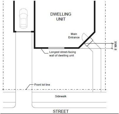
b. Main Entrances. Main entrances shall be visible from the street and must have a porch or entry, and face the street or be oriented at an angle of not more than 45 degrees from the street-facing façade. Corner lot homes may face either street.
c. Front Façade Variety. Duplicative front façades of detached single-family structures facing the same street are prohibited. Sufficient differences can be achieved through meeting at least three of the following design features:
i. Varied or staggered front setbacks, with variations of at least five feet;
ii. Different building heights, with the two heights varying by at least five feet;
iii. Varied rooflines such as hipped or pitched roofs;
iv. Different window opening locations and designs;
v. Different garage location, configuration, and design.
d. Alleys. Where alleys are present, all garages and on-site parking shall be accessible from the alley. In R-17 zones, single-family residential developments shall utilize rear alley loading as follows:
i. Alleys shall be required for developments on sites of four acres or larger where the proposed average new lot size is less than 3,000 square feet unless the application demonstrates and the planning official agrees that alleys are unfeasible due to significant site constraints such as significant variations in topography, irregular site shape, or presence of natural resource constraints.
The Vancouver Municipal Code is current through Ordinance M-4383, passed November 14, 2022.
Your Selections |
Page 12 of 38
Vancouver Municipal Code
ii. Alleys are encouraged in all other cases.
e. Compliance with Narrow Lot Development Standards. Developments within the R-17 zoning district shall be subject to Chapter 20.927 VMC, Narrow Lot Developments, with the exception of VMC 20.927.040(A)(5)(d) garage width standards.
f. Location and configuration of driveways. Driveways shall be located to preserve space for on-street parking by meeting one of the following requirements:
i. For housing units or developments on corner lots, off-street parking areas shall be accessed on the back façade or located in the rear yard. No off-street parking shall be allowed in the front yard or side yard.
ii. Driveways providing access to the front façade must be consolidated for adjacent dwellings.
iii. Consolidated driveways shall be tapered (i.e., narrower where they connect to the street and wider at the back of the driveway) to minimize the width of curb cuts and to enhance pedestrian safety.
iv. Individual driveways must be separated by at least 20 feet as measured from the edge of the driveway apron.
g. Solid Waste Provisions. The development application shall include a plan for access for solid waste and recycling collection service, indicating common or individual unit collection points with demonstrated access and turning space for solid waste vehicles.
The Vancouver Municipal Code is current through Ordinance M-4383, passed November 14, 2022.
Your Selections | Vancouver Municipal Code Page 13 of 38
The Vancouver Municipal Code is current through Ordinance M-4383, passed November 14, 2022.
Your Selections | Vancouver Municipal Code Page 15 of 38
Table 20.410.050-1. Development Standards in Lower-Density Residential Zones STANDARD R-2 R-4 R-6 R-9 R-17 Minimum Off-Street Parking Spaces 1 1 1 1 1 Minimum Landscaping Requirement (percentage of total net area) 10% 10% 10% 10% 10%
1 Subject to VMC 20.910.050.
2 For each additional 10 feet of building height, or fraction thereof, over 25 feet, add two feet to the setback to a maximum of 10 feet on each side or rear yard.
3 There must be a minimum of 20 feet maneuvering space from entrance edge of the carport or garage to opposite edge of the alley.
4 A through lot will be treated as an interior rear yard, especially with respect to placement of principal and accessory structures, location of parking and height of fences only when there is no vehicular access to the abutting street. If access occurs then the through lot yard will be treated in all respects as a front yard.
5 Smaller lot sizes and dimensions may be allowed subject to Chapter 20.920 VMC, Infill Development Standards.
6 Covered porches, eaves, bay windows, columns, or other structural extensions may extend up to five feet into the front setback or in accordance with VMC 20.910.040(A)
C. Institutional development standards. Institutional uses such as colleges, schools, religious institutions, and emergency services facilities that locate within low-density residential districts shall comply with the following development standards:
1. For portions of an institutional campus abutting residentially zoned property (not separated by a street):
a. Minimum setback: 35 feet.
b. Maximum height: 35 feet at the setback increasing one foot for every one foot of additional setback to a maximum of 75 feet.
c. Minimum landscaped buffering between the institutional use and residential development: 15 feet.
2. The development standards in subsection (C)(1) of this section do not apply to existing buildings.
3. All other development standards on the institutional campus are the same as those in the underlying base zone except as follows:
a. Modified through a variance procedure per the requirements of Chapter 20.290 VMC alone or in conjunction with a conditional use procedure per the requirements of Chapter 20.245 VMC; or
b. Established as part of a public facilities master plan procedure per the requirements of Chapter 20.268 VMC.
D. Criteria for institutions as limited uses. As noted in Table 20.410.030-1 above, a school, religious institution, government building, fire station, child care center or emergency services facility is allowed as a limited use if it meets all of the criteria described below. An institution that does not comply with all of these criteria must be reviewed as a conditional use, except for school modular classrooms, which shall be permitted outright.
1. The site contains no more than 12 acres for a school, not to exceed 75,000 gross square feet.
The Vancouver Municipal Code is current through Ordinance M-4383, passed November 14, 2022.
Your Selections | Vancouver Municipal Code Page 16 of 38
2. The site contains no more than two acres for a religious institution, not to exceed 30,000 gross square feet.
3. The site contains no more than one acre for a child care center, not to exceed 10,000 gross square feet.
4. The site takes its primary access from no less than a minor arterial.
5. If a religious institution also has a school, the total development shall not exceed 60,000 gross square feet and seven acres.
E. (Reserved for future use)
F. Criteria for Placement of Manufactured Homes.
1. General Provisions.
a. Manufactured homes are permitted on individual lots in the R-2, R-4, R-6, and R-9 residential zones in accordance with the placement standards as set forth in this section and other provisions which apply to conventionally built dwellings.
b. Nothing in these provisions shall be interpreted as superseding deeds, covenants, or restrictions which are generally not enforced by the city.
c. Existing manufactured home developments and manufactured home subdivisions are permitted and are not subject to the provisions of this chapter. An existing manufactured home in a development or subdivision may continue to lawfully exist and be replaced or can be relocated either to an approved manufactured home development or an approved manufactured home subdivision.
d. A new manufactured home placed on an individual lot subsequent to the adoption of this ordinance may be relocated as permitted by this title if within five years of the date of the original placement.
2. Manufactured Home Placement Standards. Except as allowed in subsections (F)(1)(c) and (F)(1)(d) of this section, all manufactured homes placed within the city of Vancouver shall comply with the following standards:
a. Manufactured homes must meet the development standards of the base zone unless otherwise noted.
b. The manufactured home must meet the definition of a “new manufactured home,” unless otherwise noted. A new manufactured home means any manufactured home required to be titled under RCW Title 46, which was not titled to retail purchaser before July 1, 2005, and was not a “used mobile home” as defined in RCW 82.45.032(2).
c. The manufactured home must meet the requirements of a “designated manufactured home”; provided, that manufactured homes built to 42 U.S.C. §§ 5401 through 5403 standards (as amended in 2000) must be regulated in the same manner as site-built homes.
d. The manufactured home must meet the following requirements:
The Vancouver Municipal Code is current through Ordinance M-4383, passed November 14, 2022.
Your Selections | Vancouver Municipal Code Page 17 of 38
i. For the principal dwelling unit: is comprised of at least two fully enclosed parallel sections each of not less than 12 feet wide by 36 feet long;
ii. Was originally constructed with and now has a composition of wood shake or shingle, coated metal, or similar roof of not less than 3:12 pitch;
iii. Has exterior siding similar in appearance to siding materials commonly used on conventional site-built building code single-family residences.
e. The manufactured home must comply with all local design standards applicable to all other homes within the neighborhood in which the manufactured home is to be located.
f. The manufactured home must be set on a permanent foundation, as specified by the manufacturer, and the space from the bottom of the home to the ground must be enclosed by concrete or an approved concrete product which can be either load bearing or decorative.
g. The manufactured home must be thermally equivalent to the State Energy Code.
3. Review and Inspection.
a. City will review building permit applications and will issue appropriate zoning and building permits and conduct the installation inspection.
b. The Department of Labor and Industries is responsible for inspections including replacement, addition, modification, or removal of any equipment or installation and issuing permits under Chapter 43.22 RCW. (Ord. M-4377 § 2(a), 2022; Ord. M-4289 § 4, 2019; Ord. M-4066 § 5, 2013; Ord. M-3959 § 24, 2010; Ord. M-3931 § 11, 2009; Ord. M-3922 § 20, 2009; Ord. M-3840 § 19, 2007; Ord. M-3709 § 5, 2005; Ord. M-3701 § 14, 2005; Ord. M-3663 § 13, 2004; Ord. M-3643, 2004) 20.550.010
Chapter 20.550 TRANSIT OVERLAY DISTRICT
The Vancouver Municipal Code is current through Ordinance M-4383, passed November 14, 2022.
20.550.020 20.550.030 20.550.040 20.550.050 20.550.060 20.550.070 20.550.080
Your Selections | Vancouver Municipal Code Page 18 of 38
Sections: Purpose. Applicability. Densities/Floor Area Ratios. Development Regulations. Incentives. Development Plan Approval (Reserved). Special Requirements – Master Development Plan Within the Transit Overlay District. Periodic Review.
20.550.010 Purpose.
A. Purpose. The provisions of this Chapter are voluntary and incentive based, and may be applied to parcels located within the boundaries of the Transit Overlay District at the applicant’ s request. This Chapter shall establish densities and development regulations applicable to any development in the Transit Overlay District but shall also provide for separate standards for different development environments. These development environments shall be designated as Tier 1 and Tier 2. The Tier 1 environment will be oriented towards higher densities and more transit-friendly urban design that could be associated with high capacity transit or increased transit service. Development within Tier 2 shall encourage increased densities and be subject to certain development regulations, at a less restrictive level, but will also encourage the use of alternative transportation modes and pedestrian and transit friendly development. This Chapter shall also set forth regulations applicable to transit streets, as defined herein, located within the Vancouver Urban Growth Area. (Ord. M-3643, 01/26/2004)
20.550.020 Applicability.
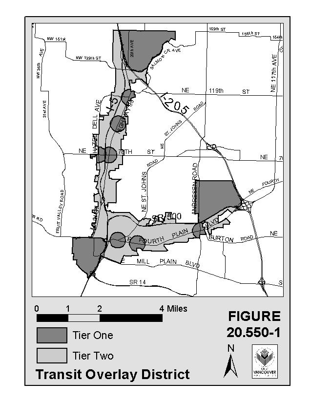
A. General Boundaries. The boundaries of the Transit Overlay District and the delineation between Tier 1 and Tier 2 shall be indicated at Figure 20.550-1 contained herein.
The Vancouver Municipal Code is current through Ordinance M-4383, passed November 14, 2022.
Your Selections | Vancouver Municipal Code Page 19 of 38
The Vancouver Municipal Code is current through Ordinance M-4383, passed November 14, 2022.
Your Selections | Vancouver Municipal Code Page 20 of 38
B. Tier 1 Description. Tier 1 shall include the following areas located within the general boundaries of the Transit Overlay District:
1. Urban Centers. Those areas identified as major activity centers on the Clark County and City of Vancouver Comprehensive Land Use Plans commonly known as: Downtown Vancouver, Vancouver Mall and Washington State University.
2. Transit Nodes. Transit nodes are those locations where fixed route transit routes intersect and provide potential transfer points between routes plus a 1/4 mile radius surrounding such intersection. Transit nodes are those intersections at which weekday transit service is or will be at a minimum level of 15 minute peak frequency for at least one of the two streets and at least 30 minute peak period frequency for the other street. Transit nodes shall also be identified in C-TRAN’s annually updated 6-year Transportation Development Plan. Based on these criteria, the following intersections are identified as transit nodes located outside the urban centers:
a. Fourth Plain Boulevard and St. Johns Boulevard
b. Fourth Plain Boulevard and Grand Avenue
c. Fourth Plain Boulevard and Andresen Road
d. Highway 99 and 78th Street
e. Highway 99 and 99th Street
f. Highway 99 and 117th Street
g. Hazel Dell Avenue and 78th Street
If a development is proposed within a transit node, it shall be the responsibility of the applicant, subject to the review and approval of the planning official, to determine whether the site is within 1/4 mile walking distance of the above-defined intersection within the transit node, as measured along established or proposed pedestrian routes, whether or not sidewalks or other pedestrian improvements currently exist. If the site is within this walking distance, development shall be subject to Tier 1 regulations. If the site is not within this walking distance, development of the site shall be subject to Tier 2 regulations.
3. Transit Stations.
a. Transit stations shall be defined as those areas located within a 1/2 mile radius of high capacity transit stations as identified in this chapter. No transit stations have been identified upon the passage of this chapter but will be identified at such time as a locally preferred alternative is adopted pursuant to the Federal Alternatives Analysis Study. Additional transit stations may be identified at a future time. Until such time as the transit stations are identified in this chapter, such areas will remain in Tier 2. Once transit stations are identified in this chapter, such areas may be subject to Tier 1 regulations if the conditions of 20.255.020(B)(3)(b) are met.
The Vancouver Municipal Code is current through Ordinance M-4383, passed November 14, 2022.
Your Selections | Vancouver Municipal Code Page 21 of 38
b. If a development is proposed within a transit station area, it shall be the responsibility of the applicant, subject to the review and approval of the planning official, to determine whether the site is within a 1/2 mile walking distance to the transit station, as measured along established or proposed pedestrian routes, whether or not sidewalks or other pedestrian improvements currently exist. If a proposed development is within this walking distance, such development shall be subject to Tier 1 regulations. If the site is not within this walking distance, development of the site shall be subject to Tier 2 regulations.
C. Tier 2 Designation. Tier 2 shall be those areas within the general boundaries of the Transit Overlay District that are not identified as Tier 1.
D. Tier 1 Transit Streets.
1. Tier 1 transit streets shall be identified as those streets or segments of streets located within the Vancouver Urban Growth Area, at which weekday transit service is or will be at a minimum level of ten (10) minute peak frequency. In order to be considered by the City of Vancouver as a Tier 1 transit street, said street shall be identified in C-Tran’s annually updated 6-year Transit Development Plan. Development adjacent to such transit streets shall be subject to Tier 1 regulations.
The city and C-Tran shall work cooperatively in designating streets as transit streets through the following process and such other processes as the agencies shall agree: once C-Tran formally, through Board action, lists a street in its 6-year Transit Development Plan which has or will have a minimum level of ten (10) minute peak frequency, the city shall consider amending this chapter to include such street as a transit street subject to the Tier 1 regulations.
E. Tier 2 Transit Streets. (Reserved for future use) (Ord. M-3643, 01/26/2004)
20.550.030 Densities/Floor Area Ratios.
A. Minimum Residential Density. The minimum residential density within the Transit Overlay District shall be as established in Table 20.550.030-1, but shall not exceed twenty (20) dwelling units per acre.
B. Maximum Residential Density. The maximum residential density within the Transit Overlay District shall be as established in Table 20.550.030-1.
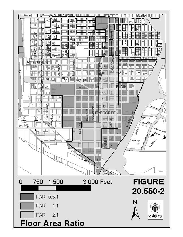
C. Minimum Floor Area Ratio for Non-residential Development. The minimum floor area ratio for nonresidential development within the Transit Overlay District shall be established in Tables 20.550.030-1 and 20.550.030-2. Except for the Downtown Activity Center the floor area ratio requirement may be phased-in on a site when a master plan is submitted which demonstrates that a site can meet the floor area ratio requirements at full buildout. Figure 20.550.030-2 shows the boundaries of areas in the Transit Overlay District with floor area ratio requirements. Refer to Section 20.260.070 for master planning requirements.
The Vancouver Municipal Code is current through Ordinance M-4383, passed November 14, 2022.
Your Selections | Vancouver Municipal Code Page 22 of 38
The Vancouver Municipal Code is current through Ordinance M-4383, passed November 14, 2022.
Your Selections | Vancouver Municipal Code Page 23 of 38
Minimum Residential Density
Table
20.550.030–
1. Tier 1 Minimum and Maximum Densities
Downtown Vancouver Mall WSU Nodes Stations Streets
65% of the maximum density established in the base zone
65% of the maximum density established in the base zone
65% of the maximum density established in the base zone
65% of the maximum density established in the base zone
65% of the maximum density established in the base zone
65% of maximum density established in the base zone
Maximum Residential Density
125% of the maximum density established in the base zone
125% of the maximum density established in the base zone
125% of the maximum density established in the base zone
125% of the maximum density established in the base zone
125% of the maximum density established in the base zone
125% of the maximum density established in the base zone
Minimum NonResidential Floor Area Ratio (FAR)
Refer to Table 20.550-2 and corresponding FARs
.50 to 1 FAR .50 to 1 FAR1 .50 to 1 FAR .50 to 1 FAR .50 to 1 FAR
1 It is anticipated that Washington State University Campus construction and future expansions will utilize provisions under Master Planning for Large Scale Developments.
Table 20.550.030– 2
Tier 2 Minimum and Maximum Densities
Minimum Residential Density 65% of the maximum established in base zone
Minimum Non-Residential Density .35 to 1 FAR (Ord. M-3643, 01/26/2004)
20.550.040 Development Regulations.
A. Uses.
The Vancouver Municipal Code is current through Ordinance M-4383, passed November 14, 2022.
Your Selections | Vancouver Municipal Code Page 24 of 38
1. Purpose. The purpose of this section is to prohibit or conditionally allow certain uses within the Transit Overlay District which are permitted in the base zone but would, if allowed, be contrary to the purposes of the Transit Overlay District as set forth in Section 20.550.010 of this chapter.
2. Applicability. Certain uses shall be permitted, prohibited or conditionally allowed within the Transit Overlay District as indicated in Table 20.550.040-1.
Table 20.550.040– 1. Uses
The Vancouver Municipal Code is current through Ordinance M-4383, passed November 14, 2022.
2
3
4
5
6
7
8
9
10
11
12
13
14
15
16
Your
|
Municipal Code Page 25 of 38
Tier 1 Tier 2 1 Ambulance Services C C
Automobile Washing X C
Cold Storage Plants X X
Commercial agriculture and silviculture X X
Concrete mixing as a permanent use X X
Fuel and oil distributors X X
Gas stations C C
Gas stations incidental to retail sales C C
Hay, feed, grain stores X X
Heavy equipment, sales, rental and repair X X
Indoor and outdoor target shooting X X
Manufacturing, fabricating, processing, packing, and storage X X
Mini-storage as a primary use X C
Motels C C
Motor Freight terminals X X
Off site hazardous waste treatment and storage facilities X X 17 Motor vehicle dealers, new and used, such as automobiles, and trucks X C 18 Sales of boat, marine supplies, and boat trailers X X 19 Sales of manufactured housing if housing stored off-site P P
Selections
Vancouver
Table 20.550.040– 1. Uses
Tier 1 Tier 2
20 Sales of recreational vehicles, motor homes and trailers and equipment X X 21 Sales and storage of wholesale lumber, building materials and heavy equipment X X 22 Auto parts stores C P 23 Sales of home improvement supplies, landscaping materials, and hardware C C 24 Trailer, truck, automobile, recreational vehicles or boat storage X X 25 Vehicle rental if vehicles are stored in a location outside of the Transit Overlay District P P 26 Vehicle repair C C 27 Veterinary clinics C C 28 Any permitted use with a drive through facility subject to the criteria set forth in Section 20.550.040(A)(3) of this Chapter C C
X = Prohibited C = Conditional Use P = Permitted
3. Criteria applicable to uses with drive-through facilities. Drive-through facilities are prohibited in transit nodes and transit station areas. Such facilities are permitted as conditional uses throughout the rest of the Transit Overlay District. In addition to the criteria set forth at VMC 20.245 (conditional uses), the following shall also be met:
a. Except where constrained by the size or configuration of a proposed site, drive-through facilities and related driveways shall not be located between a public street and a structure; and
b. The drive-through facility incorporates a safe, clearly identifiable pedestrian crossing through the use of elevation changes, different paving material, or other similar methods approved by the planning official.
B. Pedestrian Access.
1. Purpose. The purpose of this section is to provide for safe and convenient pathways or sidewalks between uses, as well as along street frontages which will increase the convenience and appeal of leaving one’s car and
The Vancouver Municipal Code is current through Ordinance M-4383, passed November 14, 2022.
Your Selections | Vancouver Municipal Code Page 26 of 38
walking from place to place. The pedestrian access standards encourage a safe, attractive, and usable pedestrian circulation system in all developments and ensure a direct pedestrian connection between the street and buildings on the site. Parking areas should facilitate pedestrian access to and from buildings via clearly designated pedestrian walkways connecting building entrances with parking areas and with pedestrian systems in the public right-of- way. The walkways and landscaping area will be compatibly designed.
2. Applicability. This section shall apply throughout the Transit Overlay District.
3. Sidewalks. Sidewalks shall be required and constructed according to adopted Vancouver standards.
4. Pedestrian Access Standard. An on-site pedestrian circulation system which connects the street to the primary entrances of the structure(s) on the site shall be provided. The circulation system must be hardsurfaced and be at least 5 feet wide. Where the system crosses driveways, parking areas, and loading areas, the system must be clearly identifiable, through the use of elevation changes, speed bumps, a different paving material, or other similar method approved by the planning official. The on-site pedestrian circulation system must be adequately illuminated for night-time use to a level where the system can be used at night by employees, residents, and customers. Sidewalks or pedestrian ways must connect the required pedestrian system to existing pedestrian systems on adjacent developments if adequate safety and security can be maintained and a physical connection to adjacent pedestrian systems can be constructed.
5. Internal Access. Internal access pedestrian paths shall be provided in locations generally consistent with the project’s development plan. The internal access system may be private and provided for by easement as each phase of a development on a site within the District develops.
6. Lighting. Lighting for parking lots and pedestrian ways shall be provided to ensure personal safety. Lighting shall be integrated into the architectural character both in terms of illumination and fixtures. Lighting shall not produce glare or negatively impact off-site uses or traffic on adjacent streets.
C. Landscaping and Walls, Hedges and Fences.
1. Purpose. Landscaping, street trees and certain walls, hedges and fences improve the aesthetic character of an area and create a more pedestrian friendly environment. Urban settings are more enjoyable when natural elements are retained, added or enhanced. This section requires landscaping and street trees as elements of new development and regulates the size and type of walls, hedges and fences within the Transit Overlay District.
2. Applicability. This section shall apply throughout the Transit Overlay District.
3. Street Trees
a. Street trees shall be planted on all street frontages and within all median planting strips within the Transit Overlay District, as further specified in this section.
b. Street trees shall be spaced no further than 30 feet on center;
c. Street trees shall be planted within the public right-of-way or the front yard setback;
The Vancouver Municipal Code is current through Ordinance M-4383, passed November 14, 2022.
Your Selections | Vancouver Municipal Code Page 27 of 38
d. Street trees shall be placed a minimum of 2 feet from the curb.
e. At planting, street trees shall have a minimum height of six feet and a minimum diameter of two inches measured at four feet above the ground at grade level;
f. Street trees shall be species approved by the planning official; provided, that the planning official shall have the authority to reduce or waive the street tree requirements for expansion or enlargement of a development existing prior to the effective date of this ordinance upon finding that there are special circumstances or conditions affecting the property that make compliance with the street tree requirements impractical or infeasible.
4. General Landscaping Requirements. See Section 20.925, VMC.
5. Free-Standing Walls, Hedges and Fences. Except as otherwise provided herein, no solid free-standing walls, hedges or fences shall be allowed in the Transit Overlay District along a public street or sidewalk. Freestanding walls, fences, and hedges along public streets may be allowed under the following conditions:
a. Solid walls, fences and hedges 4 feet in height or less shall be allowed.
b. Decorative walls, fences and hedges that allow visibility, such as wrought iron and split rail fences, shall be allowed throughout the Transit Overlay District and shall not exceed 6 feet in height.
c. Barbed wire, razor wire, electric fences and other dangerous fences are prohibited in the Transit Overlay District.
d. All allowable walls, hedges and fences between a building and public street must provide for access as set forth in Table 20.550.040– 2.
e. Solid walls greater than 4 feet in height shall be allowed only if required by the planning official to mitigate significant noise impacts.
Table 20.550.040– 2
Access Standards
Access in allowable walls, hedges and fences between a building and public street
D. Building Orientation.
Tier 1
Openings or gates operable from both sides at least every 100 feet
Tier 2
Access between structures and public streets must be ensured
1. Purpose. The purpose of the building orientation requirement in the Transit Overlay District is to facilitate pedestrian access between public ways and buildings. In general, this development standard requires new buildings to be oriented so as to face a public street or public open space.
The Vancouver Municipal Code is current through Ordinance M-4383, passed November 14, 2022.
Your Selections | Vancouver Municipal Code Page 28 of 38
2. Applicability. Except as otherwise provided in this section, this section applies to all property which abuts a public street.
3. Orientation. Primary ground floor building entrances shall have an entrance oriented to pedestrianoriented streets, plazas, or parks. The building may also have other entrances so long as direct pedestrian access is provided from all entrances.
4. Two or More Frontages. If a building has frontage on more than one public street, the building need only have one main entrance oriented to the public street or alternatively to the corner where the two public streets intersect.
5. Master Planning for Large-Scale Developments. Any nonresidential development greater than 5 acres in size with 2 or more building pads equal to or greater than 100,000 square feet shall not be subject to this section provided that the master planning requirements of Section 20.550.070 of this chapter are met.
E. Building Frontage.
1. Purpose. Ensure that space between a building and a public street is minimized to encourage pedestrian related activity at the street level and create a more desirable and enjoyable pedestrian experience. This allows buildings to be readily accessible to the pedestrian system at a level of convenience and interest that does not generally exist when buildings are set too far back from the street. The creation of a street frontage is important to the perceived comfort and convenience of pedestrians.
2. Applicability. Except as otherwise provided in this section, this regulation applies to all uses in Tier 1 except uses devoted exclusively to single family detached residential development and duplexes.
3. Extent of Frontage. See Table 20.550.040– 3.
Table 20.550.040-3
Frontage Requirement
Frontage Standard Tier 1 Tier 2
Minimum extent of frontage 75% 75%
4. Master Planning for Large-Scale Developments. Any nonresidential development greater than 5 acres in size with 2 or more building pads equal to or greater than 100,000 square feet shall not be subject to this section provided that the master planning requirements of Section 20.550.070 of this chapter are met.
F. Setbacks.
1. Purpose. All uses other than single-family detached residential development and duplexes along public streets shall provide pedestrian and transit convenience which can be best achieved through eliminating space and/or obstructions between a structure and a public street. Pedestrian convenience is a critical element in making the use of alternative modes effective since most all trips begin and end as pedestrian trips.
The Vancouver Municipal Code is current through Ordinance M-4383, passed November 14, 2022.
Your Selections | Vancouver Municipal Code Page 29 of 38
2. Applicability. Except as otherwise provided in this section, these regulations shall apply to all uses in Tiers 1 and 2 of the Transit Overlay District.
3. Minimum Setbacks. The minimum setbacks shall be set forth in Table 20.550.040-4.
4. Maximum Setbacks.
a. All Uses other than Single-Family Detached Dwellings and Duplexes. For those buildings that are required to be located along the front setback line, except single-family detached dwellings and duplexes, the maximum setback shall be set forth in Table 20.550.040-4. In the Downtown Activity Center, setbacks may be extended to accommodate pedestrian areas.
Table 20.550.040-4
Setbacks
Setback Standard Tier 1 Tier 2
Minimum Maximum Minimum Maximum
Maximum and minimum setbacks 75% of base zone standard 125% of base zone standard 75% of base zone standard 125% of base zone standard
5. Parking in Setback. No vehicle parking or garage shall be allowed in a setback which abuts a public street. Nothing in this chapter shall prohibit the use of services entrances or loading zones restricted for deliveries and not available for use by the general public for parking purposes.
6. Master Planning for Large-Scale Developments. Any nonresidential development greater than 5 acres in size with 2 or more building pads equal to or greater than 100,000 square feet shall not be subject to this section provided that the master planning requirements of Section 20.550.070 of this chapter are met.
G. Blank Walls.
1. Purpose. Unscreened, flat, blank walls at ground level are not permitted in the Transit Overlay District in order to provide a pleasant and enjoyable pedestrian experience by connecting activities within a structure to the adjacent sidewalk and/or transit stop.
2. Applicability. This section shall apply throughout the Transit Overlay District except to exclusive residential uses.
3. Blank Walls Prohibited. At least 75% of the width of any new or reconstructed first story building wall facing a public street or pedestrian way and 50% of the ground level wall area which is defined as the area 9 feet above the grade shall be devoted to interest creating features, such as pedestrian entrances, reliefs, murals, landscaping, transparent show or display windows, or windows affording views into retail, office or lobby space.
The Vancouver Municipal Code is current through Ordinance M-4383, passed November 14, 2022.
Your Selections | Vancouver Municipal Code Page 30 of 38
4. Exemption for Historic Building. The following types of buildings may be exempted by the planning official from the ground floor requirements with respect to the percent of wall devoted to windows and entrances, where in conflict with the character of the architecture, in accordance with the procedures specified concerning Development Plan Review.
a. Existing buildings entered into the National Register of Historic Places, Buildings or Structures or listed in the Washington State Inventory of Historical Sites and Buildings, or designated by the City Council as a building site or structure of historical, architectural, or cultural significance or merit, or as a historical, architectural landmark, where the first story of the building is being restored or has been restored to its original architectural character or as near as possible to its original architectural character, and where application of the requirements of this Section would interfere with such restoration.
b. Existing or new buildings located with an area designated as a conservation area, where the requirements of this section are found by the planning official to be inconsistent with the requirements, standards, and design guidelines applicable to buildings in a designated conservation area.
H. Parking.
1. Purpose. The purpose of parking standards within the Transit Overlay District is to manage the supply of surface parking by establishing minimum and maximum parking requirements in order to promote transit and pedestrian use and the efficient use of land; to substantially reduce the number of parking spaces between the building and the street to create more direct and convenient pedestrian/transit access; and to encourage pedestrian-oriented activity at the street for a more enjoyable pedestrian experience.
2. Applicability. This section shall apply to all proposed uses within the Transit Overlay District except exclusively residential uses.
3. Minimum Parking Requirements. The minimum number of parking spaces required shall be set forth in Table 20.550.040-5. On-street parking which is both along the frontage of a development and available may be counted toward the minimum parking requirement. Joint use or shared parking may be counted toward the minimum parking requirement if a formal joint use agreement is executed.
4. Maximum Parking Allowances. The maximum number of parking spaces to be provided shall be as set forth in Table 20.550.040-5. On-street parking spaces that are both along the frontage of a development and available shall be counted toward the maximum parking requirement.
a. Upon approval of the planning official, applicants may be eligible to exceed the maximum parking allowed based on the following criteria provided that the applicant can demonstrate that it has explored all available options to maximize parking, such as shared parking agreements and that all other standards of this chapter are met and:
1. The applicant can demonstrate an expected employee density ratio that is significantly higher than what is commonly experienced (based on Institute of Transportation Engineers parkinggeneration standards); or
The Vancouver Municipal Code is current through Ordinance M-4383, passed November 14, 2022.
Your Selections | Vancouver Municipal Code Page 31 of 38
2. The applicant can demonstrate trip generation characteristics of its proposed use are significantly higher than what is commonly experienced with similar uses (based on Institute of Transportation Engineers trip-generation standards); or
3. The applicant can demonstrate that parking at or below the maximum may have a detrimental causal effect on adjacent/adjoining uses; or
4. The applicant can demonstrate that significant trip reduction cannot be achieved because there is no transit service in place or planned within one quarter mile of the proposed site.
5. An allowance for additional parking may also require mitigation measures, for which the applicant is responsible.
Table 20.550.040-5
Minimum and Maximum Parking
Parking Standard Tier 1 Tier 2
Minimum Maximum Minimum Maximum
Maximum and minimum parking requirements
75% of base zone standard 125% of base zone standard 75% of base zone standard 125% of base zone standard
6. Shared Parking. Shared or joint use of parking areas shall be permitted when the users sign and record a shared parking agreement that specifies the duration of the agreement and:
b. There is a relationship among the land uses utilizing shared parking that will attract drivers to two or more uses in a single trip.
c. There is adequate linkage between the parking and each of the uses sharing the parking.
d. The applicant shall submit a properly drawn legal instrument executed by the parties concerned, agreeing to such joint use. Said instrument shall be reviewed by the City Attorney as to the form, and recorded against all properties involved.
5. Location and Configuration of Parking Areas. No off-street parking shall be allowed between a public street or pedestrian way and the required frontage for a building, other than in a driveway accessory to residential development. Except as otherwise provided in this subsection, off-street parking areas shall only be allowed in surface lots on the side or rear of a lot, in an underground lot or in a parking structure, provided however, for commercial development (excluding the identified downtown center), parking shall be allowed between a public street or pedestrian way and a building if it does not obstruct pedestrian access as defined in 20.550.040(B)(4) and,
a. There are unusual site characteristics making it impossible to meet the minimum parking requirement on the side or rear of a building; or
The Vancouver Municipal Code is current through Ordinance M-4383, passed November 14, 2022.
Your Selections | Vancouver Municipal Code Page 32 of 38
b. No more than 2 rows of parking are provided.
6. Landscaping and Walkways in Parking Areas. All surface parking areas of 50 or more spaces shall be divided by landscaping and/or walkways at least 10 feet in width, or by a building or group of buildings.
7. Parking Structures. Retail uses shall be incorporated in the ground floor of parking structures adjacent to streets within the Downtown Blank Walls Combining District (Section 20.630.030). This subsection shall not prohibit subterranean parking areas. Parking structures adjacent to streets not subject to the Downtown Blank Walls standards of Section 20.630.030 are encouraged to incorporate retail uses in the ground floor. (Ord. M-4034 § 18, 12/03/2012; Ord. M-3643, 01/26/2004)
20.550.050 Incentives.
A. Purpose. The below incentives are intended to encourage development within the Transit Overlay District that is in keeping with the guidelines of this section.
B. Applicability. These incentives shall only be made available to any development which meets the use provisions of section 20.550.040(A) and the minimum design standards of sections 20.550.040 (B) Pedestrian Access, (C) Landscaping and Walls, Hedges and Fences, (D) Building Orientation, (E) Building Frontage, (F) Setbacks, (G) Blank Walls, and (H) Parking.
C. Transportation Impact Fee Reduction. In recognition of the potential reduction in vehicle trip demand that may result from the implementation of transportation demand management measures, a reduction of the transportation impact fee (TIF) may be granted pursuant to this Section with the implementation and maintenance of the corresponding action in Table 20.550.050-1.
1. The maximum reductions identified in Table 20.550.050-1 are based on nationally-accepted relationships between transportation demand management measures and traffic generation.
2. For actions which require regular maintenance, as noted in Table 20.550.050-1, the TIF reduction granted shall be revoked and the amount of the reduction shall become due if the regular maintenance is discontinued in whole or in part during the six years following the granting of the TIF reduction.
Table 20.550.050-1 Traffic Impact Fee Reduction
The Vancouver Municipal Code is current through Ordinance M-4383, passed November 14, 2022.
Action TIF Reduction 1 Construction of direct walkway connection to the nearest arterial 1% 2 Installation of pedestrian-convenient information kiosk, with maintained information1 2% Your Selections | Vancouver Municipal Code Page 33 of 38
Table 20.550.050-1
Traffic Impact Fee Reduction
Action
TIF Reduction
3 Installation of on-site sheltered bus-stop (with current or planned service) or bus stop within 1/4 mile of site with adequate walkways if approved by C-TRAN 1% 4 Installation of bike lockers 1% 5 Commercial development which would be occupied by employer subject to Commute Trip Reduction Ordinance 4% 6 Voluntary compliance with Commute Trip Reduction Ordinance1, where compliance is not required 5% 7 Connection to existing or future regional bike trail (either directly, or by existing, safe access) 1% 8 Direct walk/bikeway connection to destination activity (such as a commercial/ retail facility, park, school, etc.) if residential development, or to origin activity (such as a residential area) if commercial/retail facility
2% 9 Construction of on-site internal walk/bikeway network 2% 10 Installation of parking spaces which will become paid parking (by resident or employee)1 3% 11 Installation of preferential carpool/vanpool parking facilities1 1% 12 Regular distribution of Transportation Demand Management information packet to all new tenants1 1%
TOTAL IF ALL STRATEGIES WERE TO BE IMPLEMENTED 24%
1 Requires regular maintenance of program.
D. Density Bonus. Any development within Tier 1 of the Transit Overlay District shall receive a density bonus equal to the percentage shown in Table 20.550.050-2 if five or more of the actions listed in Table 20.550-.050-1 are implemented. These bonuses are in addition to base zoning bonuses, if the required criteria are met. Any development within Tier 2 of the Transit Overlay District shall be entitled to this incentive provided that the requirements of Section 20.550.040(D) Building Orientation, Section 20.550.040(E) Frontage and Section 20.550.040(F) Maximum setback are met.
The Vancouver Municipal Code is current through Ordinance M-4383, passed November 14, 2022.
Your
|
Page 34 of 38
Selections
Vancouver Municipal Code
Residential
Non-residential
Mixed-use (residential and nonresidential)
Table 20.550.050-2
Density Bonus
125% of maximum density requirement
N/A
Determine bonus separately for each use according to this Table
E. Redevelopment of Parking Spaces. The minimum number of parking spaces required by Section 20.550.040(H) may be reduced by 10% to allow any structure existing prior to the adoption of this ordinance to be expanded. (Ord. M-3922 § 27, 07/06/2009; Ord. M-3643, 01/26/2004)
20.550.060
Development Plan Approval (Reserved).
(Ord. M-3643, 01/26/2004)
20.550.070 Special Requirements – Master Development Plan Within the Transit Overlay District.
A. General. For large scale developments defined in Section 20.550.040(D)(5) of this chapter, which do not meet the requirements of Section 20.550.050(D) Building Orientation, Section 20.550.040(E) Frontage and Section 20.550.040(F) Maximum Setbacks, the applicant shall meet the requirements of this section.
For any development other than a development in the Downtown Activity Center, which does not meet the floor area ratio requirements in Section 20.550.040(C), the applicant shall meet the requirements of this section.
The applicant shall be required to submit a Master Development Plan which must be approved by the planning official. The Master Development Plan shall consist of both a concept plan which shows the location and distribution of land uses and related facilities and a development plan which deals with site specific issues.
The purpose of the Master Development Plan is to:
1. Assure that the proposed development is considered as a whole and conforms to the comprehensive plan, the base zone and the requirements of this chapter. The master plan may serve to allow phasing of projects and flexibility of uses and development standards. Any other reviews needed for the development review process, such as conditional uses, plan amendments or zone changes may be considered at the same time as the master plan.
2. Assure that phased development is properly coordinated.
The Vancouver Municipal Code is current through Ordinance M-4383, passed November 14, 2022.
Your Selections | Vancouver Municipal Code Page 35 of 38
B. Components of Master Plan. The applicant must submit a master plan with all the following components. The review body may modify the proposal, especially those portions dealing with development standards and review procedures. The greater the level of detail in the plan, the less need for extensive reviews of subsequent phases. Conversely, the more general the details, the greater the level of review that will be required for subsequent phases.
1. Boundaries of the use. The master plan must show the current and possible future boundaries of the use for the duration of the master plan.
2. General statement. The master plan must include a narrative that addresses a description in general terms of the use’s expansion plans for the duration of the master plan.
3. Uses and functions. The master plan must include a description of present uses, affiliated uses, proposed uses, and possible future uses. The description must include information as to the general amount and type of functions of the use, the hours of operation and the approximate number of members, employees, visitors, special events must be included. For projects which include residential units, proposed minimum and maximum floor areas and densities, number of units and building heights must be indicated. For office/ commercial projects, minimum and maximum floor area ratios must be indicated.
4. Site plan. The master plan must include a site plan, showing to the appropriate level of detail, buildings and other structures, existing mature trees and landscaping, the pedestrian and vehicle circulation system, parking areas, open areas, and other required items. This information must cover the following:
a. All existing improvements that will remain after development of the proposed use;
b. All improvements planned in conjunction with the proposed use;
c. Conceptual plans for possible future uses; and
d. General locations of usable open space, any land proposed to be dedicated for open space, pedestrian and transit connection between the site and public or private streets serving the development and connecting to off-site open space, internal circulation (both auto and pedestrian), location of proposed gates and fencing.
5. Development standards. The master plan may propose standards that will control development of the possible future uses that are in addition to or substitute for the requirements of this chapter. These may be such things as height limits, setbacks, frontage, FAR limits, landscaping requirements, parking requirements, signage, view corridors or facade treatments. Standards that do not meet the minimum standards in existing city codes require a variance.
6. Phasing of development. The master plan must include the proposed development phases, probable sequence for proposed developments, estimated dates, and interim uses of the property awaiting development. Developments other than large scale developments shall demonstrate on the site plan how required FARs will be achieved as development is phased. Developments that propose to add additional floors to the base structure shall provide all necessary plans to adequately demonstrate that all structures can carry
The Vancouver Municipal Code is current through Ordinance M-4383, passed November 14, 2022.
Your Selections | Vancouver Municipal Code Page 36 of 38
additional floors in the future. In addition, the plan should address any proposed temporary uses or locations of uses during construction periods.
7. Transportation and parking. The master plan must include information on the following items for each phase:
a. Projected transportation impacts. This includes the expected number of trips (peak and daily), an analysis of the impact of those trips on the adjacent street system, and proposed mitigation measures to limit any projected negative impacts. Mitigation measures may include improvements to the street system or specific programs to reduce traffic impacts such as encouraging the use of public transit, carpools, vanpools, and other alternatives to single occupancy vehicles. Any mitigation measures shall be in addition to transportation impact fees.
b. Projected parking impacts. This includes projected peak parking demand, an analysis of this demand compared to proposed on-site and off-site supply, potential impacts to the on-street parking system and adjacent land uses, and mitigation measures.
8. Procedures. Master plan review shall be conducted under current review procedures. Other land use reviews may be conducted concurrently with the master plan review.
a. Any modifications, additions or changes to an approved master plan are subject to the following:
1. Minor changes shall be reviewed for compliance and compatibility with the approved master plan. A determination is made by the planning official.
2. Major changes shall be subject to the original procedural application type, subject to the fees in effect at the time of the request for change application. (Ord. M-3643, 01/26/2004)
20.550.080 Periodic Review.
A. Purpose. The purpose of this Section is to ensure that adequate monitoring of development trends within the Transit Overlay District occur. The purpose of this monitoring is threefold:
1. To provide a mechanism that ensures that development is occurring in a manner consistent with the intent of the Transit Overlay District;
2. To verify and adjust if required the requirements within the Transit Overlay District; and,
3. To provide decision makers with objective data that can be used to evaluate the performance of the Transit Overlay District in achieving the goals that it is intended to promote.
B. Annual Review. It is a requirement of this Chapter that the following data be collected, analyzed and summarized on an annual basis in the form of a report to the City of Vancouver Planning Commission and City Council. This data shall be collected through existing development activity reporting procedures.
The Vancouver Municipal Code is current through Ordinance M-4383, passed November 14, 2022.
Your Selections | Vancouver Municipal Code Page 37 of 38
1. Development activity. Various statistics describing actual development activity within and outside the Transit Overlay District, including anticipated population density.
2. Development design. Information shall be collected describing development design features of individual developments including, building orientation, setback and frontage throughout the Vancouver Urban Area.
3. Incentive utilization. Information shall be collected describing utilization of incentives provided within this Chapter. (Ord. M-3643, 01/26/2004)
The Vancouver Municipal Code is current through Ordinance M-4383, passed November 14, 2022.
Disclaimer: The city clerk's office has the official version of the Vancouver Municipal Code. Users should contact the city clerk's office for ordinances passed subsequent to the ordinance cited above.
City Website: www.cityofvancouver.us
City Telephone: (360) 487-8711 Code Publishing Company
The Vancouver Municipal Code is current through Ordinance M-4383, passed November 14, 2022.
Your Selections | Vancouver Municipal Code Page 38 of 38
COMMUNITY
INFORMATION
Demographics
Traffic Counts
The information contained is provided by WFG’s Customer Service Department to our customers, and while deemed reliable, is not guaranteed.
4101 SE 168th Ave, Vancouver, WA 98683

4101 SE 168th Ave, Vancouver, WA 98683
Sitewise Online
Pop-Facts: Population Quick Facts
Pop-Facts: Population Quick Facts
4101 SE 168th Ave, Vancouver, WA 98683 0 - 1 mi
Population 2027 Projection 10,679 2022 Estimate 10,047 2010 Census 8,691 2000 Census 6,438
Growth 2022-2027 6.29% Growth 2010-2022 15.60% Growth 2000-2010 34.99%
2022 Est. Population by Age
10,047
Age 0 to 4 475 4.73%
Age 5 to 9 531 5.28%
Age 10 to 14 581 5.79%
Age 15 to 17 367 3.65% Age 18 to 20 329 3.28% Age 21 to 24 433 4.31% Age 25 to 34 1,041 10.37% Age 35 to 44 1,284 12.78% Age 45 to 54 1,252 12.46% Age 55 to 64 1,212 12.06% Age 65 to 74 1,168 11.62% Age 75 to 84 923 9.18% Age 85 and over 450 4.48%
Age 16 and over 8,340 83.01% Age 18 and over 8,093 80.55% Age 21 and over 7,764 77.27% Age 65 and over 2,541 25.29%
2022 Est. Median Age 44.85
2022 Est. Average Age 44.62
White Alone 7,375 73.40% Black or African American Alone 209 2.08% American Indian and Alaska Native Alone 57 0.57% Asian Alone 1,397 13.91%
Native Hawaiian and Other Pacific Islander Alone 60 0.60%
Some Other Race Alone 382 3.80% Two or More Races 566 5.64%
955 9.50%
9,092 90.50%
47.98%
52.02%
Single-Classification
2022 Est. Population by
Race 10,047
Est. Population by Ethnicity (Hispanic or Latino)
Hispanic or Latino
Not Hispanic or Latino
Est. Population by Sex
2022
10,047
2022
10,047 Male 4,820
Female 5,227
Copyright © Claritas, LLC 2022. All rights reserved. 4101 SE 168th Ave, Vancouver, WA 98683 Sitewise Online Pop-Facts: Population Quick Facts Pop-Facts: Population Quick Facts 4101 SE 168th Ave, Vancouver, WA 98683 0 - 1 mi
Income Less than $15,000 273 6.23% Income $15,000 to $24,999 242 5.53% Income $25,000 to $34,999 264 6.02% Income $35,000 to $49,999 350 7.99% Income $50,000 to $74,999 648 14.79% Income $75,000 to $99,999 575 13.13% Income $100,000 to $124,999 533 12.17% Income $125,000 to $149,999 438 10.00% Income $150,000 to $199,999 459 10.48% Income $200,000 to $249,999 249 5.68% Income $250,000 to $499,999 242 5.52% Income $500,000 or more 108 2.47%
Facts
Projection
Est. Households by Household Income
2022 Est. Average Household Income $ 118,988 2022 Est. Median Household Income $ 92,979 2022 Median HH Inc. by Single-Classification Race White Alone $ 92,420 Black or African American Alone $ 27,482 American Indian and Alaska Native Alone $ 74,618 Asian Alone $ 120,635 Native Hawaiian and Other Pacific Islander Alone $ 85,174 Some Other Race Alone $ 70,388 Two or More Races $ 81,226 Hispanic or Latino $ 81,785 Not Hispanic or Latino $ 93,733 2022 Est. Households by Household Type 4,382 Family Households 2,756 62.90% Nonfamily Households 1,626 37.10% 2022 Est. Group Quarters Population 0
4101 SE 168th Ave, Vancouver, WA 98683 Sitewise Online Pop-Facts: Household Quick Facts Pop-Facts: Household Quick
4101 SE 168th Ave, Vancouver, WA 98683 0 - 1 mi Households 2027
4,635 2022 Estimate 4,382 2010 Census 3,855 2000 Census 2,801 Growth 2022-2027 5.78% Growth 2010-2022 13.66% Growth 2000-2010 37.64% 2022
4,382
4101 SE 168th Ave, Vancouver, WA 98683
Sitewise Online
Pop-Facts: Household Quick Facts
Pop-Facts: Household Quick Facts
4101 SE 168th Ave, Vancouver, WA 98683 0 - 1 mi
2022 Est. Households by Household Size 4,382
1-person 1,368 31.22% 2-person 1,615 36.86% 3-person 607 13.86% 4-person 487 11.11% 5-person 204 4.66% 6-person 68 1.55% 7-or-more-person 32 0.73%
2022 Est. Average Household Size 2.29
4101 SE 168th Ave, Vancouver, WA 98683
Sitewise Online
Pop-Facts: Household Quick Facts
Pop-Facts: Household Quick Facts
4101 SE 168th Ave, Vancouver, WA 98683 0 - 1 mi
2022 Est. HHs by Type by Presence of Own Children 2,756
Married-Couple Family, own children 858 31.11%
Married-Couple Family, no own children 1,386 50.29%
Male Householder, own children 72 2.60%
Male Householder, no own children 72 2.60%
Female Householder, own children 237 8.59%
Female Householder, no own children 133 4.81%
Copyright © Claritas, LLC 2022. All rights reserved.
Online
Demographic Snapshot
Demographic Snapshot (Part
Projection
Estimate
Census
2022 Est. Population by Single-Classification Race
or
American Alone
and
2022 Est. Population Hispanic or Latino by Origin
Hispanic or Latino
or Latino
Hispanic or Latino by Origin
Other Hispanic or Latino
2022 Est. Hisp. or Latino Pop by Single-Classification Race
Alone
or African American Alone
Indian and Alaska Native Alone
Alone
and Other Pacific Islander Alone
Race Alone
or
Races
4101 SE 168th Ave, Vancouver, WA 98683 Sitewise
Pop-Facts:
(Part 1) Pop-Facts:
1) 4101 SE 168th Ave, Vancouver, WA 98683 0 - 1 mi Population 2027
10,679 2022
10,047 2010
8,691 2000 Census 6,438 Growth 2022-2027 6.29% Growth 2010-2022 15.60% Growth 2000-2010 34.99%
10,047 White Alone 7,375 73.40% Black
African
209 2.08% American Indian
Alaska Native Alone 57 0.57% Asian Alone 1,397 13.91% Native Hawaiian and Other Pacific Islander Alone 60 0.60% Some Other Race Alone 382 3.80% Two or More Races 566 5.64%
10,047 Not
9,092 90.50% Hispanic
955 9.50%
955 Mexican 620 64.92% Puerto Rican 60 6.31% Cuban 25 2.61% All
250 26.15%
955 White
459 48.05% Black
20 2.11% American
18 1.86% Asian
11 1.12% Native Hawaiian
4 0.45% Some Other
368 38.57% Two
More
75 7.84%
4101 SE 168th Ave, Vancouver, WA 98683
Sitewise Online
Pop-Facts: Demographic Snapshot (Part 1)
Pop-Facts: Demographic Snapshot (Part 1)
2022 Est. Pop by Race, Asian Alone, by Category
4101 SE 168th Ave, Vancouver, WA 98683
0 - 1 mi
1,397
Chinese, except Taiwanese 359 25.68%
Filipino 110 7.89% Japanese 75 5.35% Asian Indian 193 13.82% Korean 168 12.01%
Vietnamese 226 16.20%
Cambodian 21 1.48%
Hmong 0 0.00% Laotian 19 1.34% Thai 0 0.00%
All other Asian Races, including 2 or more 227 16.23%
2022 Est. Population by Ancestry
10,047
Arab 40 0.40%
Czech 61 0.61%
Danish 81 0.81%
Dutch 86 0.86%
English 1,066 10.61%
French (except Basque) 259 2.58%
French Canadian 27 0.27%
German 1,499 14.92%
Greek 13 0.13% Hungarian 29 0.29%
Irish 673 6.69%
Italian 284 2.83%
Lithuanian 24 0.24%
Norwegian 239 2.38%
Polish 127 1.26%
Portuguese 26 0.26%
Russian 131 1.30% Scottish 257 2.56%
Scotch-Irish 105 1.04%
Slovak 0 0.00%
Subsaharan African 67 0.67%
Swedish 215 2.14%
Swiss 42 0.42% Ukrainian 109 1.09%
United States or American 384 3.83%
Welsh 78 0.78%
West Indian (except Hisp. groups) 13 0.13%
Other Ancestries 3,030 30.16%
Ancestry Unclassified 1,078 10.73%
2022 Est. Pop Age 5+ by Language Spoken At Home 9,572
4101 SE 168th Ave, Vancouver, WA 98683
Sitewise Online
Pop-Facts: Demographic Snapshot (Part 1)
Pop-Facts: Demographic Snapshot (Part 1)
4101 SE 168th Ave, Vancouver, WA 98683 0 - 1 mi
Speak only English 7,455 77.88% Speak Asian or Pacific Island Language 947 9.90%
Speak IndoEuropean Language 504 5.26% Speak Spanish 531 5.55% Speak Other Language 135 1.41%
4101 SE 168th Ave, Vancouver, WA 98683
Sitewise Online
Pop-Facts:
Pop-Facts:
2022 Est. Population by Sex 10,047
Male 4,820 47.98%
Female 5,227 52.02%
2022 Est. Population by Age 10,047
Age 0 to 4 475 4.73%
Age 5 to 9 531 5.28%
Age 10 to 14 581 5.79%
Age 15 to 17 367 3.65%
Age 18 to 20 329 3.28%
Age 21 to 24 433 4.31%
Age 25 to 34 1,041 10.37% Age 35 to 44 1,284 12.78% Age 45 to 54 1,252 12.46%
Age 55 to 64 1,212 12.06%
Age 65 to 74 1,168 11.62%
Age 75 to 84 923 9.18% Age 85 and over 450 4.48%
Age 16 and over 8,340 83.01% Age 18 and over 8,093 80.55% Age 21 and over 7,764 77.27% Age 65 and over 2,541 25.29%
2022 Est. Median Age 44.85 2022 Est. Average Age 44.62
Demographic Snapshot (Part 1)
Demographic Snapshot (Part 1)
4101 SE 168th Ave, Vancouver, WA 98683 0 - 1 mi
4101 SE 168th Ave, Vancouver, WA 98683
Sitewise Online
Pop-Facts: Demographic Snapshot (Part 1)
Pop-Facts: Demographic Snapshot (Part 1)
4101 SE 168th Ave, Vancouver, WA 98683 0 - 1 mi
2022 Est. Male Population by Age 4,820
Age 0 to 4 245 5.07%
Age 5 to 9 276 5.73%
Age 10 to 14 303 6.28%
Age 15 to 17 189 3.92%
Age 18 to 20 175 3.63%
Age 21 to 24 231 4.80%
Age 25 to 34 507 10.51%
Age 35 to 44 641 13.30%
Age 45 to 54 617 12.81%
Age 55 to 64 564 11.69%
Age 65 to 74 509 10.55%
Age 75 to 84 387 8.02%
Age 85 and over 178 3.69%
2022 Est. Median Age, Male 42.57
2022 Est. Average Age, Male 42.79
2022 Est. Female Population by Age
5,227
Age 0 to 4 230 4.41%
Age 5 to 9 255 4.87%
Age 10 to 14 279 5.33%
Age 15 to 17 178 3.41%
Age 18 to 20 155 2.96%
Age 21 to 24 202 3.87%
Age 25 to 34 535 10.23%
Age 35 to 44 643 12.30%
Age 45 to 54 635 12.15%
Age 55 to 64 648 12.40%
Age 65 to 74 659 12.62%
Age 75 to 84 536 10.25%
Age 85 and over 272 5.21%
2022 Est. Median Age, Female 47.16
2022 Est. Average Age, Female 46.33
4101 SE 168th Ave, Vancouver, WA 98683
Sitewise Online
Pop-Facts: Demographic Snapshot (Part 1)
Pop-Facts: Demographic Snapshot (Part 1)
4101 SE 168th Ave, Vancouver, WA 98683 0 - 1 mi
2022 Est. Pop Age 15+ by Marital Status 8,460
Total, Never Married 1,957 23.13% Males, Never Married 1,154 13.64% Females, Never Married 803 9.49%
Married, Spouse present 4,522 53.45% Married, Spouse absent 299 3.53% Widowed 703 8.31% Males, Widowed 97 1.15% Females, Widowed 606 7.16%
Divorced 979 11.57% Males, Divorced 328 3.87% Females, Divorced 651 7.70%
Less than 9th grade 52 0.71% Some High School, no diploma 113 1.54% High School Graduate (or GED) 1,306 17.82%
Some College, no degree 1,694 23.10% Associate Degree 761 10.38% Bachelor's Degree 2,139 29.19% Master's Degree 947 12.92% Professional School Degree 158 2.16% Doctorate Degree 160 2.18%
501
No High School Diploma 10 2.05% High School Graduate 134 26.76% Some College or Associate's Degree 220 44.02% Bachelor's Degree or Higher 136 27.18%
Copyright © Claritas, LLC 2022. All rights reserved.
2022 Est. Pop Age 25+ by Edu. Attainment 7,330
2022 Est. Pop. Age 25+ by Edu. Attain., Hisp./Lat.
4101
Sitewise Online Pop-Facts: Demographic Snapshot (Part 2) Pop-Facts: Demographic Snapshot (Part 2) 4101
Households 2027 Projection
2022 Estimate
2010 Census
2000 Census
Growth
2022 Est. Households by Household Type 4,382 Family Households
Nonfamily Households
2022 Est. Group Quarters Population 0 2022 HHs by Ethnicity: Hispanic/Latino 273
2022 Est. Households by HH Income
Income
2022 Est. Average Household Income $ 118,988 2022 Est. Median Household Income $ 92,979 2022 Median HH Income by Single-Class. Race or Ethn. White Alone $ 92,420 Black or African American Alone $ 27,482 American Indian and Alaska Native Alone $ 74,618 Asian Alone $ 120,635 Native Hawaiian and Other Pacific Islander Alone $
Some Other Race Alone $
Two or More Races $
Hispanic or Latino $
SE 168th Ave, Vancouver, WA 98683
SE 168th Ave, Vancouver, WA 98683 0 - 1 mi
4,635
4,382
3,855
2,801
2022-2027 5.78% Growth 2010-2022 13.66% Growth 2000-2010 37.64%
2,756 62.90%
1,626 37.10%
6.22%
4,382
< $15,000 273 6.23% Income $15,000 to $24,999 242 5.53% Income $25,000 to $34,999 264 6.02% Income $35,000 to $49,999 350 7.99% Income $50,000 to $74,999 648 14.79% Income $75,000 to $99,999 575 13.13% Income $100,000 to $124,999 533 12.17% Income $125,000 to $149,999 438 10.00% Income $150,000 to $199,999 459 10.48% Income $200,000 to $249,999 249 5.68% Income $250,000 to $499,999 242 5.52% Income $500,000+ 108 2.47%
85,174
70,388
81,226
81,785
Not Hispanic or Latino
4101 SE 168th Ave, Vancouver, WA 98683 Sitewise Online
Pop-Facts: Demographic Snapshot (Part 2)
Pop-Facts: Demographic Snapshot (Part 2)
4101 SE 168th Ave, Vancouver, WA 98683 0 - 1 mi
$ 93,733
133 4.81%
Est. Family HH Type by Presence of Own Children
Family, own children
Married-Couple Family, no own children
Householder, own children
Male
no own children
own children
no own children
2022 Est. Households by Household Size
1-person
2-person
3-person
4-person
5-person
6-person
7-or-more-person
2022 Est. Average Household Size
2022 Est. Households by Presence of People Under 18 4,382 Households with 1 or more People under Age 18 1,234
Households with No People under Age 18 3,148
Households with 1 or more People under Age 18 1,234 Married-Couple Family
Other Family, Male Householder
Other Family, Female Householder
Nonfamily, Male Householder
Nonfamily, Female Householder
Households with No People under Age 18
Family
Other Family, Male Householder
Other Family, Female Householder
Nonfamily, Male Householder
Nonfamily, Female Householder
Ave,
Online
Demographic Snapshot (Part 2)
Demographic Snapshot (Part 2)
2022
2,756 Married-Couple
858 31.11%
1,386 50.29% Male
72 2.60%
Householder,
72 2.60% Female Householder,
237 8.59% Female Householder,
4,382
1,368 31.22%
1,615 36.86%
607 13.86%
487 11.11%
204 4.66%
68 1.55%
32 0.73%
2.29
28.16%
71.84%
882 71.51%
86 6.95%
256 20.71%
8 0.65%
2 0.18%
3,148 Married-Couple
1,361 43.22%
60 1.89%
115 3.65%
623 19.80%
990 31.44% 4101 SE 168th
Vancouver, WA 98683 Sitewise
Pop-Facts:
Pop-Facts:
4101 SE 168th Ave, Vancouver, WA 98683 0 - 1 mi
2022 Est. Households by Number of Vehicles 4,382 No Vehicles 376
1 Vehicle
2 Vehicles
3 Vehicles
4 Vehicles 122
5 or more Vehicles 38
2022 Est. Average Number of Vehicles 1.73 Family Households 2027 Projection 2,919 2022 Estimate
2010 Census
2000 Census
Growth 2022-2027
Growth 2010-2022
Growth 2000-2010
2022 Est. Families by Poverty Status 2,756 2022 Families at or Above Poverty 2,588
2022 Families at or Above Poverty with Children 1,068
2022 Families Below Poverty 168
2022 Families Below Poverty with Children 124
2022 Est. Pop Age 16+ by Employment Status 8,340 In Armed Forces 13 0.16% Civilian - Employed 4,758 57.06% Civilian - Unemployed 220
Not in Labor Force 3,348 40.15% 2022 Est. Civ. Employed Pop 16+ by Class of Worker 4,492 For-Profit Private Workers 3,083
Non-Profit Private Workers 468
Local Government Workers 260
State Government Workers
Federal Government Workers 103
Self-Employed Workers 437
Unpaid Family Workers 1
4101 SE 168th Ave, Vancouver, WA 98683 Sitewise Online Pop-Facts: Demographic Snapshot (Part 2) Pop-Facts: Demographic Snapshot (Part 2) 4101 SE 168th Ave, Vancouver, WA 98683 0 - 1 mi
8.57%
1,386 31.63%
1,865 42.57%
596 13.59%
2.77%
0.86%
2,756
2,418
1,880
5.89%
13.98%
28.63%
93.90%
38.73%
6.10%
4.51%
2.63%
68.63%
10.41%
5.79%
140 3.12%
2.30%
9.72%
0.03%
Architect/Engineer 167 3.72%
Arts/Entertainment/Sports 135 3.01%
Building Grounds Maintenance 70 1.55%
Business/Financial Operations 312 6.93%
Community/Social Services 68 1.51%
Computer/Mathematical 240 5.35%
Construction/Extraction 167 3.71%
Education/Training/Library 226 5.02%
Farming/Fishing/Forestry 2 0.04% Food Prep/Serving 124 2.76% Healthcare Practitioner/Technician 367 8.18% Healthcare Support 72 1.61%
Maintenance Repair 29 0.65%
Legal 81 1.79%
Life/Physical/Social Science 26 0.57% Management 627 13.96% Office/Admin. Support 594 13.22%
Production 135 3.01% Protective Service 114 2.53% Sales/Related 616 13.72% Personal Care/Service 44 0.98% Transportation/Moving 277 6.16%
Est. Civ. Employed Pop 16+ by Occupation
2022
4,492
2022 Est. Pop 16+ by Occupation Classification 4,492 Blue Collar 608 13.53% White Collar 3,459
Service & Farm
2022 Est. Workers Age 16+ by Transp. To Work 4,491 Drove Alone 3,285 73.15% Car Pooled
Public Transportation
Walked
Bicycle
Other Means
Worked at Home
2022 Est. Workers Age 16+ by Travel Time to Work* Less than 15 minutes 1,156 15 to 29 Minutes 1,356 30 to 44 Minutes 784 45 to 59 Minutes 347 60 or more Minutes 371 4101 SE 168th Ave, Vancouver, WA 98683 Sitewise Online Pop-Facts: Demographic Snapshot (Part 2) Pop-Facts: Demographic Snapshot (Part 2) 4101 SE 168th Ave, Vancouver,
77.00%
426 9.47%
424 9.44%
166 3.71%
53 1.18%
15 0.33%
97 2.15%
451 10.05%
WA 98683 0 - 1 mi
2022 Est. Avg. Travel Time to Work in Minutes* 29.35 2022 Est. Occupied Housing Units by Tenure 4,382 Owner-Occupied 2,863 65.35% Renter-Occupied 1,519 34.65% 2022 Occupied Housing Units: Avg. Length of Residence Owner-Occupied 11 Renter-Occupied 6 4101 SE 168th Ave, Vancouver, WA 98683 Sitewise Online Pop-Facts: Demographic Snapshot (Part 2) Pop-Facts: Demographic Snapshot (Part 2) 4101 SE 168th Ave, Vancouver, WA 98683 0 - 1 mi
Value Less than $20,000 17 0.61%
Value $20,000 to $39,999 27 0.93% Value $40,000 to $59,999 10 0.36%
Value $60,000 to $79,999 28 0.96% Value $80,000 to $99,999 5 0.17% Value $100,000 to $149,999 26 0.92%
Value $150,000 to $199,999 16 0.57%
Value $200,000 to $299,999 160 5.58%
Value $300,000 to $399,999 584 20.38% Value $400,000 to $499,999 894 31.21% Value $500,000 to $749,999 822 28.70%
Value $750,000 to $999,999 225 7.85% Value $1,000,000 to $1,499,999 39 1.35% Value $1,500,000 to $1,999,999 10 0.36% Value $2,000,000
0.04%
Est. Owner Occupied Housing Units by Value
2022
2,863
2022 Est. Median All Owner-Occupied Housing Unit Value $ 462,522 2022 Est. Housing Units by Units in Structure 4,677 1 Unit Attached
1 Unit Detached
2 Units
3 or 4 Units
5 to 19 Units
20 to 49 Units
50 or More Units
Mobile Home or Trailer
Boat, RV, Van, etc.
Dominant structure type 1 Unit Detached 2022 Est. Housing Units by Year Structure Built 4,677 Housing Units Built 2014 or Later
Housing Units Built 2010 to 2013
Housing Units Built 2000 to 2009
Units Built 1990 to 1999
Units Built 1980 to 1989
Units Built
to 1979
Units Built
to 1969
Units Built
to 1959
Units Built
to 1949
Housing Units Built 1939 or Earlier
2022 Est. Median Year Structure Built** 1995 Dominant Year Structure Built 1990 to 1999
Sitewise Online
Demographic Snapshot (Part 2)
Demographic Snapshot (Part 2)
or more 1
293 6.27%
2,698 57.69%
0 0.00%
400 8.55%
426 9.10%
126 2.68%
514 10.99%
221 4.72%
0 0.00%
531 11.35%
93 1.98%
743 15.90% Housing
2,068 44.21% Housing
806 17.23% Housing
1970
329 7.03% Housing
1960
21 0.44% Housing
1950
29 0.63% Housing
1940
17 0.37%
41 0.87%
4101 SE 168th Ave, Vancouver, WA 98683
Pop-Facts:
Pop-Facts:
4101 SE 168th Ave, Vancouver, WA 98683 0 - 1 mi
4101 SE 168th Ave, Vancouver, WA 98683
Sitewise Online
Pop-Facts: Demographic Snapshot (Part 2)
Pop-Facts: Demographic Snapshot (Part 2)
Copyright © Claritas, LLC 2022. All rights reserved.
* This row intentionally left blank. No Total Category.
**1939 will appear when at least half of the Housing Units in this reports area were built in 1939 or earlier.
4101 SE 168th Ave, Vancouver, WA 98683 0 - 1 mi
4101 SE
Online
Census Demographic Overview (Part 1)
Census Demographic Overview (Part 1)
2027 Projection
2022 Estimate
Census
Census
2010 Population by Single-Classification Race
Population By Ethnicity
Hispanic or Latino by Single-Classification Race
Population by Sex
168th Ave, Vancouver, WA 98683 Sitewise
Pop-Facts:
Pop-Facts:
4101 SE 168th Ave, Vancouver, WA 98683 0 - 1 mi Population
10,679
10,047 2010
8,691 2000
6,438 Growth 2022-2027 6.29% Growth 2010-2022 15.60% Growth 2000-2010 34.99%
8,691 White Alone 6,786 78.08% Black or African American Alone 171 1.97% American Indian and Alaska Native Alone 47 0.54% Asian Alone 1,090 12.54% Native Hawaiian and Other Pacific Islander Alone 38 0.43% Some Other Race Alone 191 2.20% Two or More Races 368 4.24% 2010
8,691 Not Hispanic or Latino 8,174 94.05% Hispanic or Latino 518 5.95% 2010
518 White Alone 264 50.94% Black or African American Alone 9 1.82% American Indian and Alaska Native Alone 10 2.00% Asian Alone 7 1.28% Native Hawaiian and Other Pacific Islander Alone 3 0.50% Some Other Race Alone 176 34.01% Two or More Races 49 9.46% 2010
8,691 Male 4,143 47.67% Female 4,548 52.33% Male/Female Ratio 0.91
4101 SE 168th Ave, Vancouver, WA 98683
Sitewise Online
Pop-Facts: Census Demographic Overview (Part 1)
Pop-Facts: Census Demographic Overview (Part 1)
4101 SE 168th Ave, Vancouver, WA 98683 0 - 1 mi
2010 Population by Age 8,691
Age 0 to 4 498 5.73%
Age 5 to 9 543 6.25%
Age 10 to 14 580 6.67%
Age 15 to 17 290 3.34%
Age 18 to 20 216 2.49%
Age 21 to 24 327 3.76%
Age 25 to 34 993 11.42%
Age 35 to 44 1,172 13.49% Age 45 to 54 1,146 13.19%
Age 55 to 64 973 11.20%
Age 65 to 74 833 9.59% Age 75 to 84 733 8.44% Age 85 and over 386 4.45%
Age 16 and over 6,960 80.08%
Age 18 and over 6,780 78.01% Age 21 and over 6,564 75.53% Age 65 and over 1,953 22.47%
2010 Median Age 42.67
4101 SE 168th Ave, Vancouver, WA 98683
Sitewise Online
Pop-Facts: Census Demographic Overview (Part 1)
Pop-Facts: Census Demographic Overview (Part 1)
2010 Male Population by Age
4101 SE 168th Ave, Vancouver, WA 98683 0 - 1 mi
4,143
Age 0 to 4 261 6.30%
Age 5 to 9 283 6.83%
Age 10 to 14 320 7.71%
Age 15 to 17 137 3.29%
Age 18 to 20 105 2.54%
Age 21 to 24 158 3.81%
Age 25 to 34 500 12.07%
Age 35 to 44 570 13.76%
Age 45 to 54 552 13.32%
Age 55 to 64 440 10.61%
Age 65 to 74 370 8.94%
Age 75 to 84 304 7.34%
Age 85 and over 144 3.48%
2010 Median Age, Male 40.41
2010 Female Population by Age 4,548
Age 0 to 4 237 5.21%
Age 5 to 9 260 5.72%
Age 10 to 14 260 5.72%
Age 15 to 17 153 3.37%
Age 18 to 20 111 2.44%
Age 21 to 24 169 3.71%
Age 25 to 34 492 10.83%
Age 35 to 44 602 13.24%
Age 45 to 54 594 13.07%
Age 55 to 64 534 11.74%
Age 65 to 74 463 10.19%
Age 75 to 84 429 9.44%
Age 85 and over 242 5.32%
2010 Median Age, Female 44.82
Copyright © Claritas, LLC 2022. All rights reserved.
4101 SE
Ave,
Online
Census Demographic Overview (Part 2)
Census Demographic Overview (Part 2)
Households 2027 Projection
2022 Estimate
2010 Census
2000 Census
Growth
Growth
Growth
2010 Households by Household Type
Family Households
Non-family Households
2010 Group Quarters Population 0 2010 Hispanic or Latino Households
2010 Households by Household Size
168th
Vancouver, WA 98683 Sitewise
Pop-Facts:
Pop-Facts:
4101 SE 168th Ave, Vancouver, WA 98683 0 - 1 mi
4,635
4,382
3,855
2,801
2022-2027 5.78%
2010-2022 13.66%
2000-2010 37.64%
3,855
2,418 62.73%
1,437 37.27%
148 3.84%
3,855 1-person 1,206 31.27% 2-person 1,477 38.31% 3-person 506 13.12% 4-person 432 11.20% 5-person 164 4.24% 6-person 48 1.24% 7-or-more-person 24 0.62%
Married-Couple
19.22%
1.71% Female Householder, own children 210 5.46%
Male Householder,
Married-Couple
1.61%
3.00%
Married-Couple Family 763 70.97% Other Family, Male Householder 76 7.09% Other Family, Female Householder 226 21.01% Nonfamily, Male Householder 8 0.73% Nonfamily, Female Householder 2 0.20%
2010 Households by Type and Presence of Children 3,855
Family, own children 741
own children 66
Households
2010 Households by Presence of People Under Age 18 3,855 HH with 1 or More People Under Age 18:
Households with No People Under Age 18:
HH with 1 or More People Under Age 18:
Family, no own children 1,224 31.74% Male Householder, no own children 62
Female Householder, no own children 116
Non-family
1,437 37.27%
1,074 27.87%
2,781 72.13%
1,074
with No People Under Age 18:
Households
2,781
2010 Occupied Housing Units by Tenure
Owner-Occupied
Renter-Occupied
Copyright © Claritas, LLC 2022. All rights reserved. 4101 SE 168th Ave, Vancouver,
Sitewise Online Pop-Facts: Census Demographic Overview (Part 2)
Census Demographic Overview (Part 2)
Married-Couple Family 1,202 43.23% Other Family, Male Householder 52 1.86% Other Family, Female Householder 100 3.60% Nonfamily, Male Householder 553 19.90% Nonfamily, Female Householder 874 31.41%
3,855
2,495 64.72%
1,360 35.28%
WA 98683
Pop-Facts:
4101 SE 168th Ave, Vancouver, WA 98683 0 - 1 mi
4101 SE 168th Ave, Vancouver, WA 98683
Sitewise Online
Retail Market Power Opportunity Gap Report By Retail Store Types
Retail Market Power Opportunity Gap Report By Retail Store Types
4101 SE 168th Ave, Vancouver, WA 98683 0 - 1 mi
2022 Demand 2022 Supply Opportunity Gap/Surplus
Total retail trade including food and drink (NAICS 44, 45 and 722) $ 246,384,835 $ 57,690,218 $ 188,694,617
Total retail trade (NAICS 44 and 45) $ 219,575,067 $ 48,612,272 $ 170,962,794
Motor vehicle and parts dealers (NAICS 441) $ 48,083,818 $ 4,455,201 $ 43,628,617
Automobile dealers (NAICS 4411) $ 40,003,307 $ 4,014,036 $ 35,989,271
New car dealers (NAICS 44111) $ 35,563,096 $ 4,014,036 $ 31,549,060
Used car dealers (NAICS 44112) $ 4,440,210 $ 0 $ 4,440,210
Other motor vehicle dealers (NAICS 4412) $ 4,598,397 $ 0 $ 4,598,397
Recreational vehicle dealers (NAICS 44121) $ 1,847,399 $ 0 $ 1,847,399 Motorcycle, boat, and other motor vehicle dealers (NAICS 44122) $ 2,750,998 $ 0 $ 2,750,998
Boat dealers (NAICS 441222) $ 1,097,074 $ 0 $ 1,097,074
Motorcycle, ATV, and all other motor vehicle dealers (NAICS 441228) $ 1,653,924 $ 0 $ 1,653,924
Automotive parts, accessories, and tire stores (NAICS 4413) $ 3,482,116 $ 441,165 $ 3,040,951
Automotive parts and accessories stores (NAICS 44131) $ 2,202,102 $ 0 $ 2,202,102
Tire dealers (NAICS 44132) $ 1,280,014 $ 441,165 $ 838,849
Furniture and home furnishings stores (NAICS 442) $ 4,712,429 $ 0 $ 4,712,429
Furniture stores (NAICS 4421) $ 2,592,886 $ 0 $ 2,592,886
Home furnishings stores (NAICS 4422) $ 2,119,543 $ 0 $ 2,119,543
Floor covering stores (NAICS 44221) $ 1,013,394 $ 0 $ 1,013,394
Other home furnishings stores (NAICS 44229) $ 1,106,149 $ 0 $ 1,106,149
Window treatment stores (NAICS 442291) $ 54,173 $ 0 $ 54,173
All other home furnishings stores (NAICS 442299) $ 1,051,976 $ 0 $ 1,051,976
Electronics and appliance stores (NAICS 443) $ 2,917,462 $ 0 $ 2,917,462
Household appliance stores (NAICS 443141) $ 707,513 $ 0 $ 707,513 Electronics stores (NAICS 443142) $ 2,209,950 $ 0 $ 2,209,950
Building material and garden equipment and supplies dealers (NAICS 444) $ 17,789,515 $ 1,571,440 $ 16,218,075
Building material and supplies dealers (NAICS 4441) $ 15,408,558 $ 1,571,440 $ 13,837,117
Home centers (NAICS 44411) $ 8,493,202 $ 334,442 $ 8,158,760
Paint and wallpaper stores (NAICS 44412) $ 521,562 $ 70,388 $ 451,175
Hardware stores (NAICS 44413) $ 1,327,431 $ 102,611 $ 1,224,821
Other building material dealers (NAICS 44419) $ 5,066,361 $ 1,063,999 $ 4,002,362
Lawn and garden equipment and supplies stores (NAICS 4442) $ 2,380,957 $ 0 $ 2,380,957
Outdoor power equipment stores (NAICS 44421) $ 490,517 $ 0 $ 490,517
Nursery, garden center, and farm supply stores (NAICS 44422) $ 1,890,440 $ 0 $ 1,890,440
Food and beverage stores (NAICS 445) $ 32,622,836 $ 9,934,193 $ 22,688,643 Grocery stores (NAICS 4451) $ 28,951,169 $ 8,634,077 $ 20,317,092
Supermarkets and other grocery (except convenience) stores (NAICS 44511) $ 27,802,736 $ 8,611,098 $ 19,191,638
Convenience stores (NAICS 44512) $ 1,148,432 $ 22,978 $ 1,125,454 Specialty food stores (NAICS 4452) $ 840,382 $ 1,090,391 - $ 250,009
4101 SE 168th Ave, Vancouver, WA 98683 Sitewise Online
Retail Market Power Opportunity Gap Report
Retail Market Power Opportunity Gap Report
By Retail Store Types
By Retail Store Types
4101 SE 168th Ave, Vancouver, WA 98683 0 - 1 mi
2022 Demand 2022 Supply Opportunity Gap/Surplus
Meat markets (NAICS 44521) $ 253,982 $ 0 $ 253,982
Fish and seafood markets (NAICS 44522) $ 99,966 $ 19,060 $ 80,906
Fruit and vegetable markets (NAICS 44523) $ 174,617 $ 222,361 - $ 47,744
Other specialty food stores (NAICS 44529) $ 311,817 $ 848,970 - $ 537,152
Baked goods and confectionery and nut stores (NAICS 445291 + 445292) $ 165,449 $ 0 $ 165,449
All other specialty food stores (NAICS 445299) $ 146,368 $ 848,970 - $ 702,602
Beer, wine, and liquor stores (NAICS 4453) $ 2,831,285 $ 209,725 $ 2,621,560
Health and personal care stores (NAICS 446) $ 13,463,829 $ 2,335,343 $ 11,128,486
Pharmacies and drug stores (NAICS 44611) $ 11,662,624 $ 2,335,343 $ 9,327,281
Cosmetics, beauty supplies, and perfume stores (NAICS 44612) $ 787,544 $ 0 $ 787,544
Optical goods stores (NAICS 44613) $ 388,533 $ 0 $ 388,533
Other health and personal care stores (NAICS 44619) $ 625,129 $ 0 $ 625,129
Food (health) supplement stores (NAICS 446191) $ 221,003 $ 0 $ 221,003
All other health and personal care stores (NAICS 446199) $ 404,125 $ 0 $ 404,125
Gasoline stations (NAICS 447) $ 16,244,166 $ 6,958,079 $ 9,286,087
Clothing and clothing accessories stores (NAICS 448) $ 8,536,283 $ 166,260 $ 8,370,022
Clothing stores (NAICS 4481) $ 5,576,117 $ 166,260 $ 5,409,857
Men's clothing stores (NAICS 44811) $ 252,684 $ 0 $ 252,684
Women's clothing stores (NAICS 44812) $ 1,003,386 $ 166,260 $ 837,126
Children's and infants' clothing stores (NAICS 44813) $ 173,473 $ 0 $ 173,473
Family clothing stores (NAICS 44814) $ 3,347,410 $ 0 $ 3,347,410
Clothing accessories stores (NAICS 44815) $ 281,773 $ 0 $ 281,773
Other clothing stores (NAICS 44819) $ 517,391 $ 0 $ 517,391
Shoe stores (NAICS 4482) $ 1,166,548 $ 0 $ 1,166,548
Jewelry, luggage, and leather goods stores (NAICS 4483) $ 1,793,618 $ 0 $ 1,793,618
Jewelry stores (NAICS 44831) $ 1,192,358 $ 0 $ 1,192,358
Luggage and leather goods stores (NAICS 44832) $ 601,259 $ 0 $ 601,259
Sporting goods, hobby, musical instrument, and book stores (NAICS 451) $ 3,306,931 $ 325,018 $ 2,981,913
Sporting goods, hobby, and musical instrument stores (NAICS 4511) $ 2,968,642 $ 325,018 $ 2,643,623
Sporting goods stores (NAICS 45111) $ 2,150,004 $ 325,018 $ 1,824,985
Hobby, toy, and game stores (NAICS 45112) $ 582,131 $ 0 $ 582,131
Sewing, needlework, and piece goods stores (NAICS 45113) $ 110,702 $ 0 $ 110,702
Musical instrument and supplies stores (NAICS 45114) $ 125,805 $ 0 $ 125,805
Book stores and news dealers (NAICS 4512) $ 338,290 $ 0 $ 338,290
Book stores (NAICS 451211) $ 314,868 $ 0 $ 314,868
News dealers and newsstands (NAICS 451212) $ 23,422 $ 0 $ 23,422
General merchandise stores (NAICS 452) $ 28,017,267 $ 11,090,200 $ 16,927,066
Department stores (NAICS 4522) $ 3,477,073 $ 0 $ 3,477,073
Other general merchandise stores (NAICS 4523) $ 24,540,194 $ 11,090,200 $ 13,449,993
Warehouse clubs and supercenters (NAICS 452311) $ 22,153,645 $ 10,964,191 $ 11,189,455
All other general merchandise stores (NAICS 452319) $ 2,386,549 $ 126,010 $ 2,260,539
4101 SE 168th Ave, Vancouver, WA 98683
Sitewise Online
Retail Market Power Opportunity Gap Report By Retail Store Types
Retail Market Power Opportunity Gap Report
By Retail Store Types
4101 SE 168th Ave, Vancouver, WA 98683 0 - 1 mi
2022 Demand 2022 Supply Opportunity Gap/Surplus
Miscellaneous store retailers (NAICS 453) $ 4,826,999 $ 349,768 $ 4,477,231
Florists (NAICS 4531) $ 242,134 $ 0 $ 242,134
Office supplies, stationery, and gift stores (NAICS 4532) $ 1,055,493 $ 0 $ 1,055,493
Office supplies and stationery stores (NAICS 45321) $ 454,286 $ 0 $ 454,286
Gift, novelty, and souvenir stores (NAICS 45322) $ 601,207 $ 0 $ 601,207
Used merchandise stores (NAICS 4533) $ 703,016 $ 288,578 $ 414,438
Other miscellaneous store retailers (NAICS 4539) $ 2,826,356 $ 61,190 $ 2,765,166
Pet and pet supplies stores (NAICS 45391) $ 822,730 $ 16,528 $ 806,202
Art dealers (NAICS 45392) $ 474,916 $ 662 $ 474,254
Manufactured (mobile) home dealers (NAICS 45393) $ 315,930 $ 3,819 $ 312,111
All other miscellaneous store retailers (NAICS 45399) $ 1,212,779 $ 40,180 $ 1,172,599
Tobacco stores (NAICS 453991) $ 287,104 $ 0 $ 287,104
All other miscellaneous store retailers (except tobacco stores) (NAICS 453998) $ 925,675 $ 40,180 $ 885,496
Non-store retailers (NAICS 454)
$ 39,053,531 $ 11,426,770 $ 27,626,761
Electronic shopping and mail-order houses (NAICS 4541) $ 37,003,599 $ 11,426,770 $ 25,576,830
Vending machine operators (NAICS 4542) $ 268,126 $ 0 $ 268,126
Direct selling establishments (NAICS 4543) $ 1,781,805 $ 0 $ 1,781,805
Fuel dealers (NAICS 45431) $ 873,706 $ 0 $ 873,706
Other direct selling establishments (NAICS 45439) $ 908,099 $ 0 $ 908,099
Food services and drinking places (NAICS 722) $ 26,809,768 $ 9,077,945 $ 17,731,824
Special food services (NAICS 7223) $ 2,137,873 $ 197,615 $ 1,940,258
Food service contractors (NAICS 72231) $ 1,692,472 $ 197,615 $ 1,494,858
Caterers (NAICS 72232) $ 405,818 $ 0 $ 405,818
Mobile food services (NAICS 72233) $ 39,583 $ 0 $ 39,583
Drinking places (alcoholic beverages) (NAICS 7224) $ 911,357 $ 389,757 $ 521,600
Restaurants and other eating places (NAICS 7225) $ 23,760,538 $ 8,490,573 $ 15,269,965
Full-service restaurants (NAICS 722511) $ 11,958,512 $ 3,625,271 $ 8,333,242
Limited-service restaurants (NAICS 722513) $ 10,014,814 $ 3,701,765 $ 6,313,049
Cafeterias, grill buffets, and buffets (NAICS 722514) $ 255,292 $ 98,594 $ 156,698 Snack and nonalcoholic beverage bars (NAICS 722515) $ 1,531,920 $ 1,064,944 $ 466,976
GAFO* $ 47,491,428 $ 11,581,479 $ 35,909,948
General Merchandise Stores-452 $ 28,017,267 $ 11,090,200 $ 16,927,066
Clothing & Clothing Accessories Stores-448 $ 8,536,283 $ 166,260 $ 8,370,022
Furniture & Home Furnishings Stores-442 $ 4,712,429 $ 0 $ 4,712,429
Electronics & Appliance Stores-443 $ 2,917,462 $ 0 $ 2,917,462
Sporting Goods, Hobby, Book, Music Stores-451 $ 3,306,931 $ 325,018 $ 2,981,913 Office Supplies, Stationery, Gift Stores-4532 $ 1,055,493 $ 0 $ 1,055,493
* GAFO (General merchandise, Apparel, Furniture and Other) represents sales at stores that sell merchandise normally sold in department stores. This category is not included in Total Retail Sales Including Eating and Drinking Places.
4101 SE 168th Ave, Vancouver, WA 98683
Sitewise Online
Retail Market Power Opportunity Gap Report By Retail Store Types
Retail Market Power Opportunity Gap Report By Retail Store Types
Retail Market Power data is derived from two major sources of information. The demand data is derived from the Consumer Expenditure Survey (CE Survey or CEX), which is fielded by the U.S. Bureau of Labor Statistics (BLS). The supply data is derived from the Census of Retail Trade (CRT), which is made available by the U.S. Census. Additional data sources are incorporated to create both supply and demand estimates.
The difference between demand and supply represents the opportunity gap or surplus available for each merchandise line in the specified reporting geography. When this difference is positive (demand is greater than the supply), there is an opportunity gap for that merchandise line; when the difference is negative (supply is greater than demand), there is a surplus.
Copyright © 2022 Environics Analytics. All rights reserved.
4101 SE 168th Ave, Vancouver, WA 98683 0 - 1 mi
2022 Demand 2022 Supply Opportunity Gap/Surplus
Powered by Sitewise Data Source: Kalibrate TrafficMetrix Traffic Listing 4101 SE 168th Ave, Vancouver, WA 98683 December 21, 2022 Map # Street Cross Street Dir. Volume Type/Year Dist. (mi) 1. SE 164th Ave W 4,518 Current Year 0.2 2. SE 39th St SE 168th Ave E 874 Published (1992) 0.2 3. Lewis & Clark Hwy SE 164th Ave NW 61,268 Current Year 0.2 4. Southeast Lewis and Clark Highway SE 164th Ave NW 61,573 Current Year 0.2 5. SE Evergreen Hwy SE 166th Ct SE 1,180 Current Year 0.2 6. SE 164th Ave SE Evergreen Hwy SW 3,261 Current Year 0.2 7. SE 164th Ave Lewis & Clark Hwy N 3,758 Published (1998) 0.3 8. SE 164th Ave Lewis and Clark Hwy S 21,535 Current Year 0.3 9. Southeast Lewis and Clark Highway SE 164th Ave SE 54,507 Current Year 0.3 10. SE 164th Ave Lewis and Clark Hwy S 15,301 Current Year 0.3 11. SE 164th Ave SE 1,097 Current Year 0.3 12. SE Evergreen Hwy SE 164th Ave E 3,090 Current Year 0.3 13. Southeast 164th Avenue SE Fisher Dr E 14,944 Current Year 0.3 14. Southeast 164th Avenue SE McGillivray Blvd N 15,955 Current Year 0.3 15. Lewis and Clark Hwy SE 164th Ave SE 93,339 Current Year 0.3 16. 16,472 Current Year 0.3