Property Details
Utility As-Builts (Water & Sewer)
Zoning Information
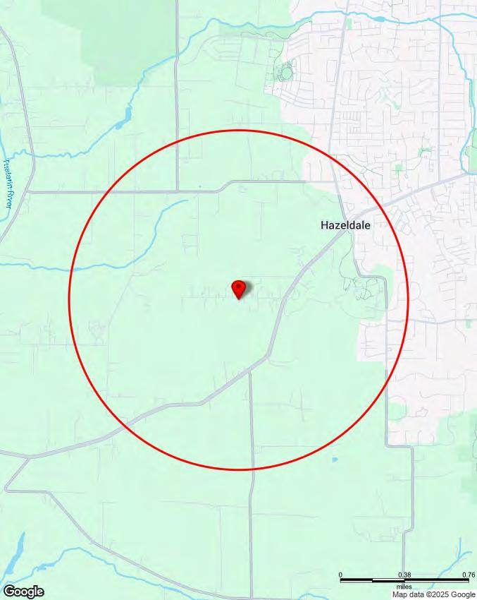
Custom Maps
Community Information -Demographics -Traffic Counts
information contained is provided by WFG’s Customer Service Department to our customers, and while deemed reliable, is not guaranteed.
Property Information
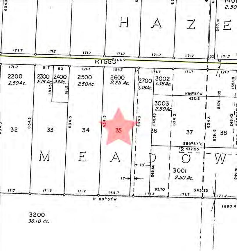
Assessors Tax Map
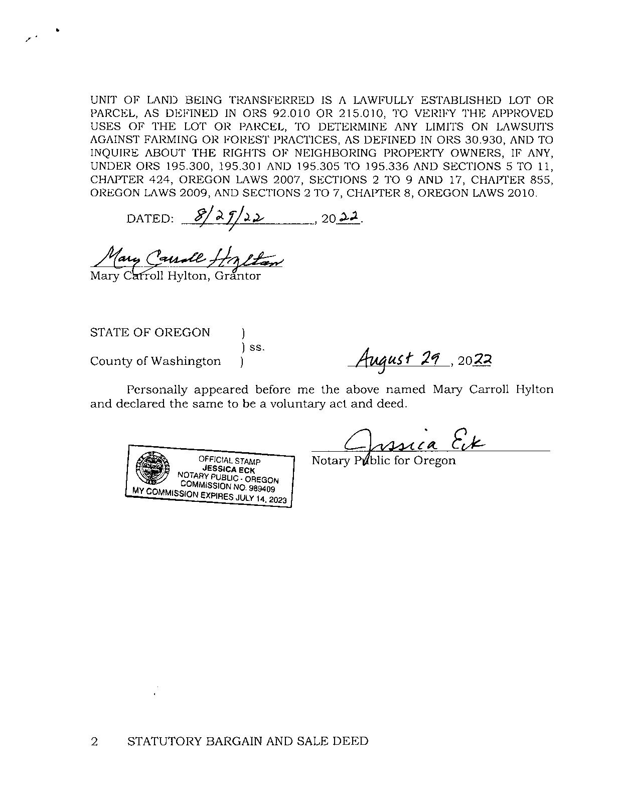
Vesting Deed
The information contained is provided by WFG’s Customer Service Department to our customers, and while deemed reliable, is not guaranteed.
PropertyDetailReport
Owner:HyltonFamilyTrust
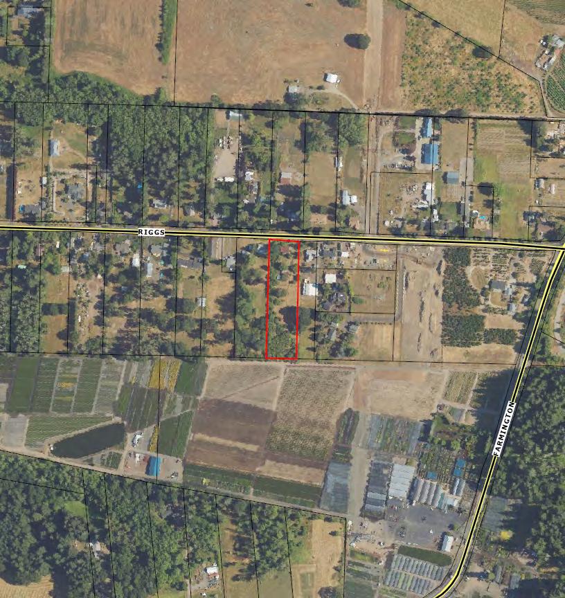
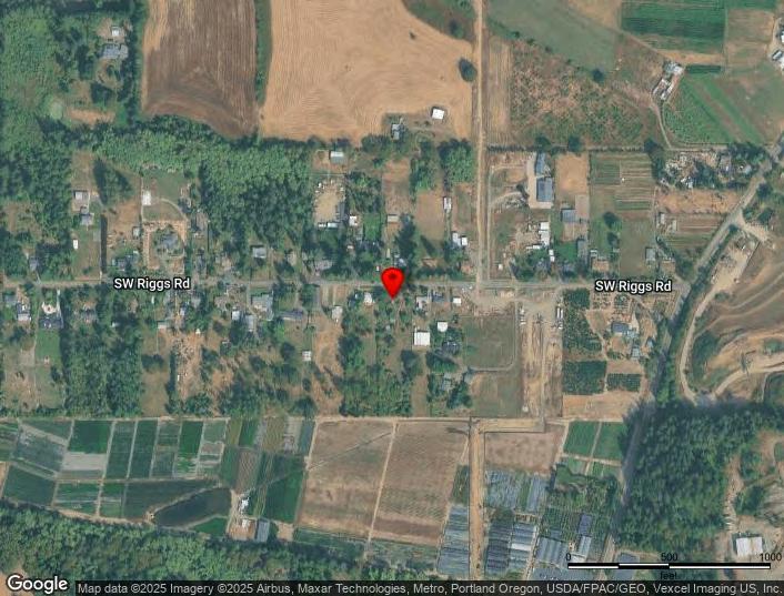
Site:22250SWRiggsRdBeavertonOR97078
Mail:22250SWRiggsRdBeavertonOR97078
LocationandSiteInformation
County: Washington
LegalDescription: HAZELMEADOWS,LOTPT35,ACRES 2.25
APN: R395833
TaxLot: 1S226B002600
Twn-Rng-Sec: 01S/02W/26/NW
LotSqFt: 98,010
LotAcres: 2.25
LandUse: 4010-Non-SpeciallyAssessed-Rural ResidentialZone(af5/af10)-Improved
LandUseSTD: SingleFamilyResidential
CountyBldgUse: 1001-ResidenceSingleFamily
Neighborhood: Cpo10Laurel/Blooming/Scholls/River Road #Dwellings: 1
Subdivision: HazelMeadows
LegalLot/Block: 35
CensusTract/Block: 032301/1004
MapPage/Grid: 624-A7
Zoning: WashingtonCo.-AF-5
Watershed: RockCreek-TualatinRiver
ElementarySchool: HazeldaleElementarySchool HighSchool: AlohaHighSchool MiddleSchool: MountainViewMiddleSchool SchoolDistrict: Beaverton
PropertyCharacteristics
BuildingArea: 1,300 Bedrooms: 2 YearBuilt/Eff: 1930(1970)
FirstFloorSqFt: BathroomsTotal: 1
SecondFloorSqFt: BathroomsFull/Half:
Heating: Forcedairunit
Cooling: Yes
BasementFin/Unfin: Stories: Fireplace: AtticFin/Unfin: Foundation: 03 Pool:
GarageSqFt: RoofMaterial: Composition Shingle Kitchen:
AssessmentandTaxInformation
SaleandLoanInformation
SaleDate: Lender:
SaleAmount: LoanAmount:
Document#: LoanType: DeedType: Price/SqFt: TitleCo: SellerName:
PreparedBy:WFGNationalTitleCustomerServiceDepartment 12909SW68thPkwy,Suite350,Portland,OR97223 P:5036031700|3608915474E:cs@wfgnationaltitle.com|cccs@wfgtitle.com
ParcelID:R395833
SiteAddress:22250SWRiggsRd
SentryDynamics,Inc.anditscustomersmakenorepresentations, warrantiesorconditions,expressorimplied,astotheaccuracyor completenessofinformationcontainedinthisreport.
SentryDynamics,Inc.anditscustomersmakenorepresentations, warrantiesorconditions,expressorimplied,astotheaccuracyor completenessofinformationcontainedinthisreport.
ParcelID:R395833
ZONING
DETAILS
Detailed Zoning Information
AF5 (Agriculture and Forest District 5-Acre)
Zoning Map
Community Jurisdiction
The information contained is provided by WFG’s Customer Service Department to our customers, and while deemed reliable, is not guaranteed.
348-1
Intent and Purpose
The AF-5 District is intended to retain an area's rural character and conserve the natural resources while providing for rural residential use in areas so designated by the Comprehensive Plan.
The purpose of this agricultural and forestry district is to promote agricultural and forest uses on small parcels in the rural area, while recognizing the need to retain the character and economic viability of agricultural and forest lands, as well as recognizing that existing parcelization and diverse ownerships and uses exist within the farm and forest area. Residents of rural residential tracts shall recognize that they will be subject to normal and accepted farming and forestry practices.
348-2
Uses Permitted Through a Type I Procedure
The following uses are permitted subject to the specific standards for the use set forth below and in applicable Special Use Sections of Section 430, as well as the general standards for the District, the Development Standards of Article IV and all other applicable standards of the Code. A waiver of the right to remonstrate against commonly accepted farm or forest practices shall be recorded for each permitted use.
348-2.1
348-2.2
Accessory Uses and Structures - Section 430-1.
Conservation Areas and Structures (public and private) for the conservation of water, soil, open space, forest or wildlife resources (exempt from waiver).
348-2.3
348-2.4
348-2.5
348-2.6
348-2.7
348-2.8
Detached Dwelling Unit (one), on a lot of record or legally created lot.
Home Occupation - Section 430-63.1.
Property Line Adjustment - Section 610-1.1.
Parks - Section 430-97
Temporary Use - Sections 430-135.1 C. (6) and (7); 430-135.1 H.
Alteration, restoration or replacement of a lawfully established dwelling on a lot or parcel upon which two or more lawful dwellings exist. In the case of replacement, the existing dwelling shall be removed, demolished, or converted to an accessory structure, pursuant to Section 430-8.1. For required standards see Section 430-8.1.
348-2.9
Boarding or training of horses for profit, not to exceed a total of 14 horse stalls (includes stalls for the owner's horses) - Section 430-21.
348-2.10
Co-location of antennas, excluding those antennas exempt pursuant to Sections 430-109.3 and 201-2 - Section 430-109.
348-2.11
New Telecommunication Facilities with towers using Stealth Design to a maximum height of 100 feet and new Small Wireless Facilities, excluding those facilities exempt pursuant to Sections 430-109.3 and 201-2Section 430-109.
348-2.12
Marijuana Production - Section 430-80
(Ord. No. 810, § 2.A.(Exh. 1, § 19), 10-25-16; Ord. No. 826A, § 2.A.(Exh. 1, § 21), 10-24-17, eff. 11-24-17; Ord. No. 856A, § 2.A.(Exh. 1, § 20), 10-22-19, eff. 11-28-19)
348-3
Uses Permitted Through a Type II Procedure
The following uses are permitted subject to the specific standards for the use set forth below and in applicable Special Use Sections of Section 430, as well as the general standards for the District, the Development Standards of Article IV and all other applicable standards of the Code. Approval may be further conditioned by the Review Authority pursuant to Section 207-5. A waiver of the right to remonstrate against commonly accepted farm or forest practices shall be recorded for each permitted use.
348-3.1
348-3.2
348-3.3
348-3.4
348-3.5
Family Day Care Provider - Section 430-53.4.
Home Occupation - Section 430-63.2.
Parks - Section 430-97.
Public Utility - (except commercial facilities for the purpose of generating power for public use by sale) - Section 430-105.3 through 430-105.7.
Expansion of Existing Telecommunication Facilities, including co-located antennas, not otherwise allowed through a Type I Procedure pursuant to Section 430-109.5 or exempt pursuant to Sections 430-109.3 and 201-2 - Section 430-109.
348-3.6
348-3.7
348-3.8
348-3.9
Stockpiling of aggregate, sand and gravel for road maintenance purposes - Section 430-132. Temporary Use - Section 430-135.2 A.
Day Care Facility - Section 430-53.1 I.
Alteration, restoration or replacement of a lawfully established dwelling on a lot or parcel upon which two or more lawful dwellings exist that is not permitted through a Type I procedure. For required standards see Section 430-8.2.
348-3.10
Boarding or training of horses for profit with 15 or more horse stalls (includes stalls for the owner's horses) - Section 430-21
348-3.11
Unless exempt under 201-2, importing fill material as a customarily accepted farming practice or for a use allowed in the district - Section 410.
348-3.12
Clean Fill Site - A site that provides for the long term storage and disposal of soil, rock, concrete, brick, building block, tile or other inert materials considered "clean fill" as defined by DEQ rules - Section 410.
(Ord. No. 826A, § 2.A.(Exh. 1, § 21), 10-24-17, eff. 11-24-17; Ord. No. 832A, § 2.A.(Exh. 1, § 17), 9-18-18, eff. 1018-18; Ord. No. 889A, § 2.C.(Exh. 3, § 12.), 2-7-23, eff. 3-9-23)
348-4
Uses Which May be Permitted Through a Type III Procedure
The following uses may be permitted subject to the specific standards for the use set forth below and in applicable Special Use Sections of Section 430, as well as the general standards for the District, the Development Standards of Article IV and all other applicable standards of the Code. Approval may be further conditioned by the Review Authority pursuant to Section 207-5. Unless the use is specifically exempted, the Review Authority shall make specific findings with respect to the standards in Section 348-4.2.
348-4.1
Uses which may be allowed:
A. B. C. D. E. F. G. H. I. J. K. L. M. N. O. P. Q. R. S. T.
Airport, including associated hangar, maintenance and service facilities - Section 430-7
Campground - Section 430-25.
Cemetery - Section 430-27.
Contractor's Establishment - Section 430-34
Day Care Facility - Section 430-53.1.
Golf Course - Section 430-50
Heliport - Section 430-59.
Housing for Seasonal Farm and Forest Labor - Section 430-67.
Hunting and Fishing Preserve (including a trout farm) Section 430-69.
Kennel - Section 430-73.
Operation for Exploration of Geothermal Resources as defined in ORS 522.005.
Membership Organization - Section 430-99.
Public Building, limited to Governmental Structures, community buildings and museums, which serve the local area - Section 430-103.
Schools - Section 430-121
Shooting Clubs - Section 430-125.
Utility Facility (Commercial) for the generation of power for sale for public use and transmission towers over 200 feet in height - Section 430-141.
Veterinary or Animal Hospital.
Winery - May include accessory tasting room and incidental sales - Section 430-145.8.
Emergency Response/Safety Training Center - Section 430-44.
New Telecommunication Facilities with towers not using Stealth Design to a maximum height of 100 feet - Section 430-109.
348-4.2 A. B. C.
Home Occupation - Section 430-63.3.
Religious Institution - Section 430-116.
Required Findings:
The requested use is compatible with the surrounding uses or may be made more compatible through conditions of approval.
The proposed use does not interfere seriously with "accepted farming practices" as defined in ORS 215.203(2)(c) or forestry uses on adjacent lands devoted to farm or forest use.
The applicant has signed and recorded in the Department of Assessment & Taxation, Recording Division, a waiver of the right to remonstrate against customarily accepted farming practices.
(Ord. No. 815B, § 2.A.(Exh. A, § 4), 9-26-17, eff. 11-24-17; Ord. No. 826A, § 2.A.(Exh. 1, § 21), 10-24-17, eff. 1124-17; Ord. No. 832A, § 2.A.(Exh. 1, § 17), 9-18-18, eff. 10-18-18)
348-5
Prohibited Uses
348-5.1
348-5.2
Structures or uses of land not specifically authorized by Section 348.
The use of a recreational vehicle for a residence, except as provided for under Section 430135.2 A.
348-5.3
Outdoor advertising displays, advertising signs or structures except as provided in Section 414.
348-5.4
The location of service facilities which house groups of people and public assembly facilities in airport approach zones. These facilities shall be avoided within any existing June, 1983 Airport Year 2000 LDN 55 contour.
348-5.5
Mounting a communication tower or antenna, that is not a permitted accessory use, on a detached dwelling.
348-5.6
Mounting an antenna, that is not a permitted accessory use, on a communication tower that is accessory to a detached dwelling.
348-5.7
348-5.8
Auto wrecking yards.
The outdoor parking or storage of any five or more operable vehicles on a single lot or parcel for more than 48 hours, except in conjunction with an approved development or with a farm use.
348-5.9
Any parking or storage of tractor trailers, semi-trucks, or heavy equipment, except in conjunction with an approved development or with a farm or forest use.
348-6
Dimensional Requirements
348-6.1
Lot Area:
348-6.2
A. (1) (2)
Lot area as used in this subsection shall be determined as follows:
The lot area shall be the entire area described in the deed to which the owner holds title, including such land as may be described in the deed as "subject to the rights of the public to any portion lying within the right-of-way," or similar clause. If the lot described in the deed has not been surveyed, a survey may be required to determine the exact acreage.
If the lot was created by a plat, the lot area is the sum of the net area for the lot as shown on the plat plus land contiguous to the lot shown as having been dedicated to the public for road right-of-way.
348-6.3
B. (1) (2)
The minimum lot area shall be five acres except: For lots of record; and
The lot area for new lots or parcels created through the Standard Land Division process of Article VI may be varied by 20% provided there is no increase in lot density.
Yard Requirements:
The minimum yard requirements shall be:
Thirty-foot front yard;
Ten-foot side yard;
Twenty-foot rear yard;
Thirty-foot street side yard; and
E.
Additional setbacks may be required as specified in Section 418.
Height:
A. B. C. D.
Maximum height of dwellings and residential accessory structures shall be 35 feet.
Normal building appurtenances and projections such as spires, belfries, cupolas, chimneys, ventilators, elevator housings or other structures placed on or extending above roof level may exceed the 35-foot building height limit to a maximum height of 60 feet.
The height of telecommunication facilities are regulated by the Permitted Use sections of this Land Use District, Sections 201, 430-1, 430-109 and other applicable provisions of this Code.
No structure or structural part shall exceed the height standards established for any airport in the county established in accordance with Federal Aviation Administration's Aviation Regulations.
348-6.4
Minimum lot width at the street:
The minimum lot width at the street shall be 30 feet, or the lot shall have an easement of record at least 30 feet at the street or as approved by the appropriate fire marshal.
All lots in this District shall either:
348-7.1
348-7.2
Abut a public street; or
Have an easement of record at least 30 feet wide at the street or as approved by the appropriate fire marshal.
348-7.3
348-8
Access roadways shall be approved, developed and maintained in accordance with the requirements of the appropriate fire protection agency for the geographical location. Where no fire protection agency has jurisdiction, access roadways shall meet the requirements of the nearest or most likely fire protection jurisdiction to annex the property under consideration.
Article IV - Development Standards
In addition to the requirements of this district, the standards of Article IV - Development Standards, including Section 422 (Significant Natural Resources), are applicable as required by Subsection 4034.
The material and information on this website are made available for general informational purposes only. Although Metro makes reasonable e�orts to ensure the accuracy, completeness, and currency of this information, the data and maps may contain errors or inaccuracies. No representations or warranties of any kind, express or implied, are provided.
Metro councilor Gerri� Rosenthal
Metro councilor email
Metro council district 3
Neighborhood association or community planning organization CPO10 Laurel/Blooming/Scholls/River Road
Jurisdiction Unincorporated Washington County
Voter precinct 322 US congressional district (2020) 1
Oregon house district (2020) 36
Oregon senate district (2020) 18 gerri�.rosenthal@oregonmetro.gov
Land Use and Planning
Urban growth boundary Outside
Watershed Rock Creek-Tualatin River
Sub-watershed Davis Creek-Tualatin River
Basin Willame�e
Sub-basin Tualatin
Flood plain Outside
Urban or rural reserve No data
Reserve name No data
Local zoning
RLIS zoning classi�cation
RLIS zoning type RUR
Service Districts
Residential hauler Pride Disposal
Residential hauler phone (503) 625-6177
Commercial hauler Pride Disposal
Commercial hauler phone (503) 625-6177
Dropbox provider Pride Disposal
Dropbox provider phone (503) 625-6177
School district BEAVERTON
School district number 48J
Fire district Tualatin Valley Fire and Rescue District
Park district Tualatin Hills Park and Recreation District
Sewer district No data
Water district No data
Topography
CUSTOM
MAPS
Water Features
Aerial
Aerial Environmental
Community
Transit
Vacant Land
The information contained is provided by WFG’s Customer Service Department to our customers, and while deemed reliable, is not guaranteed.
COMMUNITY
Demographics
Traffic Counts INFORMATION
The information contained is provided by WFG’s Customer Service Department to our customers, and while deemed reliable, is not guaranteed.
LLC
22250 SW Riggs Rd, Aloha, OR 97007
22250 SW Riggs Rd, Aloha, OR 97007
22250 SW Riggs Rd, Aloha, OR 97007 Sitewise Online
Pop-Facts:
22250 SW Riggs Rd, Aloha, OR 97007
Pop-Facts:
22250 SW Riggs Rd, Aloha, OR 97007
Sitewise Online
Pop-Facts: Demographic Snapshot (Part 2)
Pop-Facts: Demographic Snapshot (Part 2)
22250
22250 SW Riggs Rd, Aloha, OR 97007
Pop-Facts: Demographic Snapshot (Part 2)
Pop-Facts:
22250 SW Riggs Rd, Aloha, OR 97007
Pop-Facts:
22250 SW Riggs Rd, Aloha, OR 97007
22250 SW Riggs Rd, Aloha, OR 97007 Sitewise Online
Pop-Facts: Demographic Snapshot (Part 2)
Pop-Facts: Demographic Snapshot (Part 2)
Copyright © Claritas, LLC 2025. All rights reserved.
* This row intentionally left blank. No Total Category.
**1939 will appear when at least half of the Housing Units in this reports area were built in 1939 or earlier.
Total retail trade including food and drink (NAICS 44, 45 and 722)
(NAICS 44 and 45)
vehicle and parts dealers (NAICS 441)
dealers (NAICS 4411)
car dealers (NAICS 44111)
(NAICS 44112)
(NAICS 4412)
(NAICS 44121)
44122)
441222)
22250 SW Riggs Rd, Aloha, OR 97007 Sitewise Online
Retail Market Power Opportunity Gap Report By Retail Store Types
Retail Market Power Opportunity Gap Report By Retail Store Types
(NAICS 44521)
(NAICS 44522)
(NAICS 44523)
(NAICS 44529)
(NAICS 45111)
22250
22250 SW Riggs Rd, Aloha, OR 97007
Sitewise Online
Retail Market Power Opportunity Gap Report By Retail Store Types
Retail Market Power Opportunity Gap Report By Retail Store Types
store retailers (NAICS 453)
(NAICS 4531)
stationery, and gift stores (NAICS 4532)
and stationery stores (NAICS 45321)
and
stores (NAICS 45322)
stores (NAICS 4533)
miscellaneous store retailers (NAICS 4539)
(NAICS 45392)
(NAICS 45391)
(mobile) home dealers (NAICS 45393)
(NAICS 45399)
(NAICS 453991)
other miscellaneous store retailers (except tobacco stores) (NAICS 453998)
22250 SW Riggs Rd, Aloha, OR 97007 Sitewise Online
Retail Market Power Opportunity Gap Report By Retail Store Types
Retail Market Power Opportunity Gap Report By Retail Store Types
Retail Market Power data is derived from two major sources of information. The demand data is derived from the Consumer Expenditure Survey (CE Survey or CEX), which is fielded by the U.S. Bureau of Labor Statistics (BLS). The supply data is derived from the Census of Retail Trade (CRT), which is made available by the U.S. Census. Additional data sources are incorporated to create both supply and demand estimates. The difference between demand and supply represents the opportunity gap or surplus available for each merchandise line in the specified reporting geography. When this difference is positive (demand is greater than the supply), there is an opportunity gap for that merchandise line; when the difference is negative (supply is greater than demand), there is a surplus.
Copyright © 2025 Environics Analytics. All rights reserved.
22250 SW Riggs Rd, Aloha, OR 97007
October 13, 2025