Developers

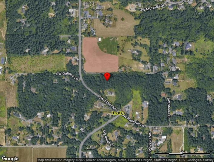
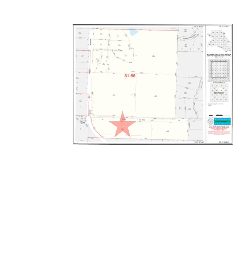
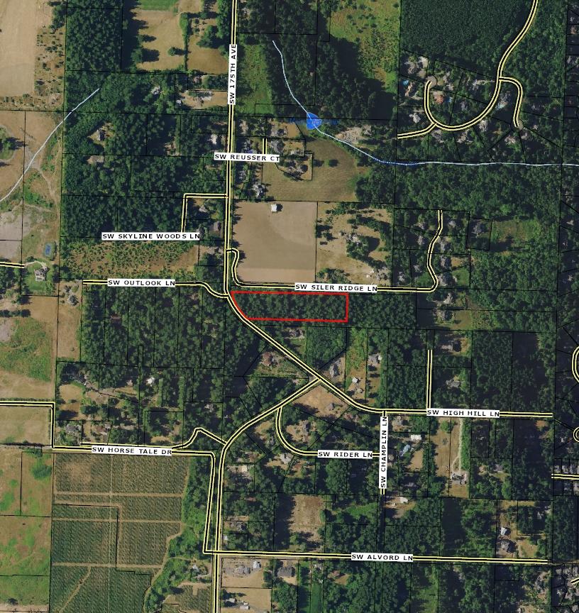
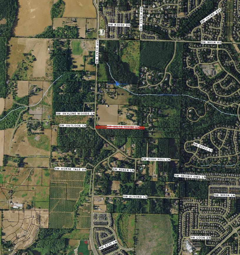
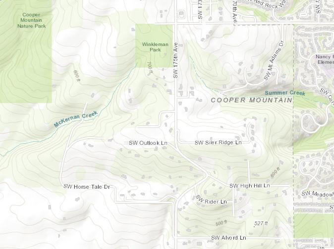
Packet Subject Property 1S131AC Tax Lots 1000, 1100 & 0900 U1 Parcel #s: R1279592, R259384 & R259393 City of Beaverton/Washington County Compliments of WFG National Title Insurance Company Customer Service Department
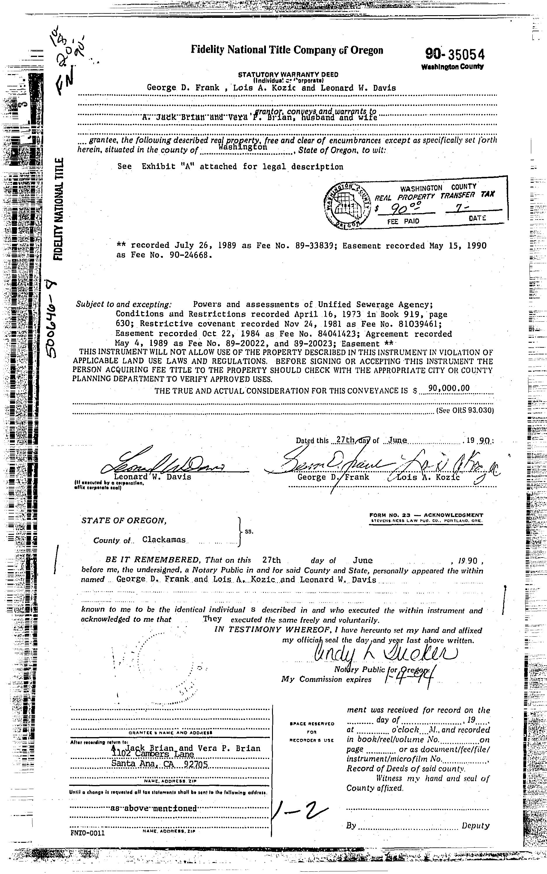
Owner:BrianAJackTrust Site:BeavertonOR97007 Mail:1102CamberaLnSantaAnaCA92705
County: Washington
LotSqFt: 182,952
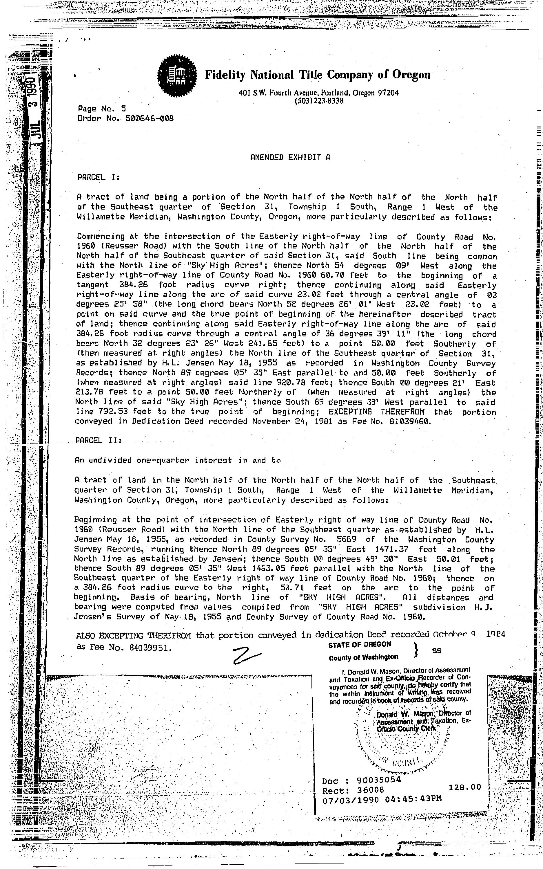
LegalDescription: ACRES4.20 LotAcres: 4.20
APN: R1279592
LandUse: 4000-Non-SpeciallyAssessed-Rural ResidentialZone(af5/af10) Vacant TaxLot: 1S131AC01000 LandUseSTD: VacantMisc
TwnRngSec: 01S/01W/31/SE CountyBldgUse: VMSC Neighborhood: Cpo6CooperMtn-AlohaS #Dwellings: Subdivision: MapPage/Grid: 654-F2
LegalLot/Block: Zoning: WashingtonCo FD20
CensusTract/Block: 031813/1027 Watershed: FannoCreekTualatinRiver
ElementarySchool: NANCYRYLESELEMENTARYSCHOOL HighSchool: MOUNTAINSIDEHIGHSCHOOL
MiddleSchool: HIGHLANDPARKMIDDLESCHOOL SchoolDistrict: Beaverton
TotalLivingArea:
Bedrooms:
YearBuilt/Eff:
FirstFloorSqFt: BathroomsTotal: Heating: SecondFloorSqFt: BathroomsFull/Half: Cooling: BasementFin/Unfin: Stories: Fireplace: AtticFin/Unfin: Foundation: Pool:
GarageSqFt: RoofMaterial: Kitchen:
MarketTotal: $485,15000
PropertyTax: $3,57933 MarketLand: $485,15000 Exemption: MarketStructure: MarketImproved%:
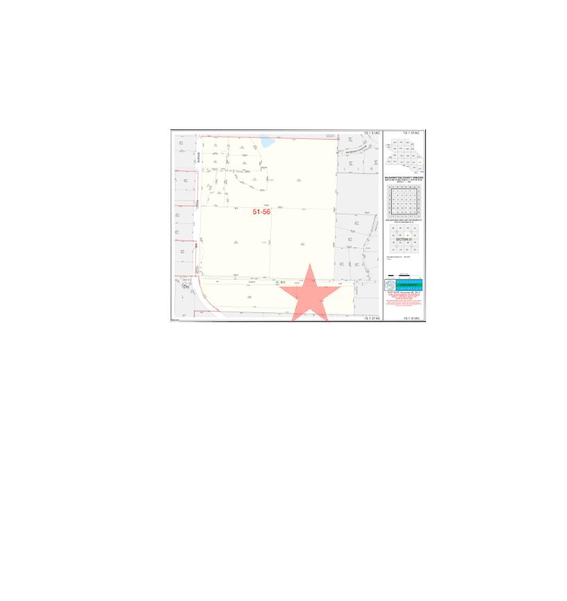
AsssessmentYear: 2021 LevyCode: 5156 AssessedTotal: $243,630.00 MillRate: 14.6916
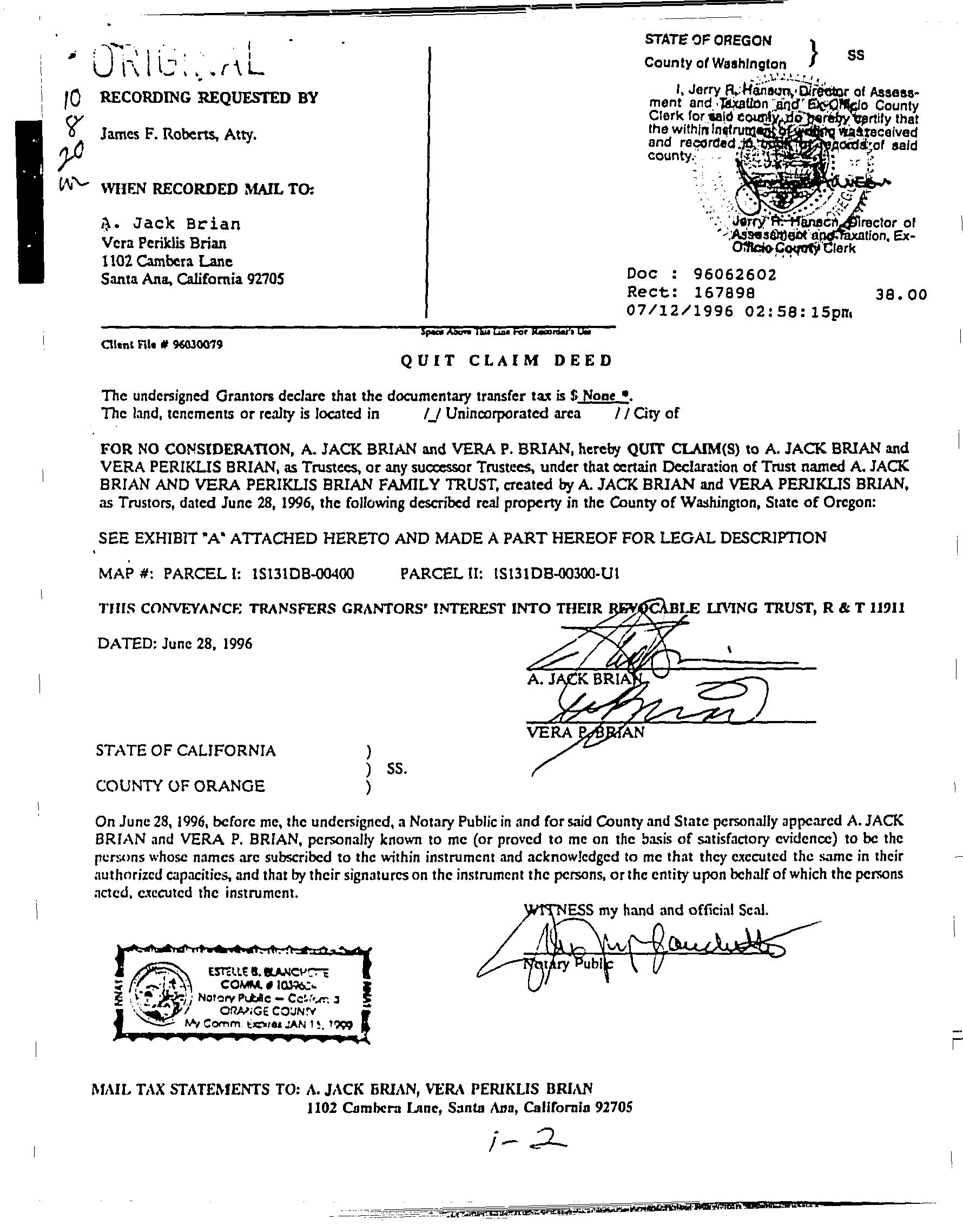
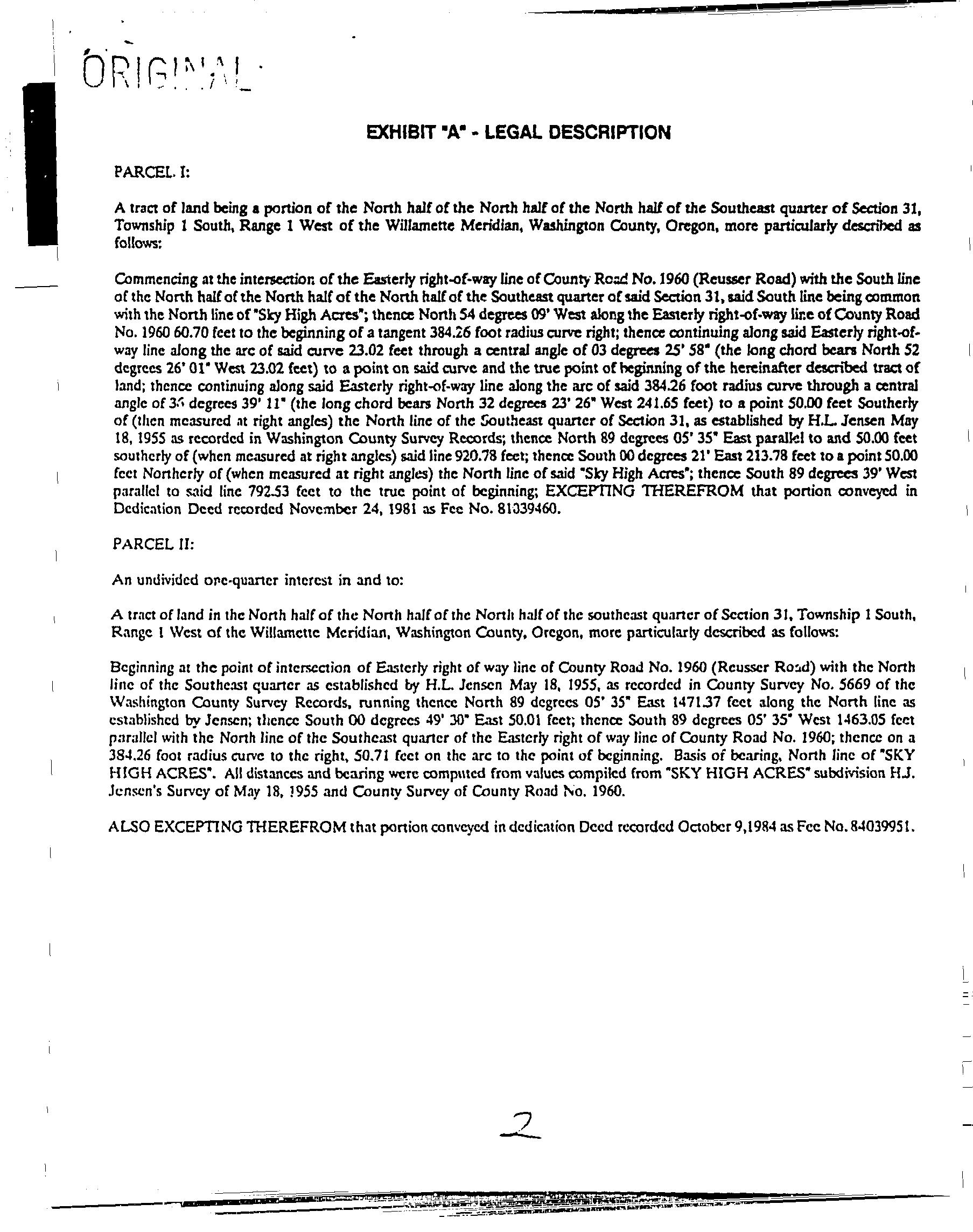
SaleDate: 07/12/1996
Lender:
SaleAmount: LoanAmount: $0.00 Document#: 62602 LoanType:
DeedType: Deed Price/SqFt: $000
TitleCo: SellerName: BRIANAJ&VERAP
PreparedBy:WFGNationalTitleCustomerServiceDepartment 12909SW68thPkwy,Suite350,Portland,OR97223 P:5036031700|3608915474E:cs@wfgnationaltitlecom|cccs@wfgtitlecom
SentryDynamics,Inc anditscustomersmakenorepresentation,warrantiesorconditions,expressorimplied, astotheaccuracyorcompletenessofinformationcontainedinthisreport

If applicable, the described property isreceiving special valuation basedupon itsuse.Additionalrollbacktaxeswhichmay become due based on theprovisions ofthe special valuation are not indicated in this listing.
TAXYEAR AD VALOREM SPECIAL ASMT TOTAL BILLED
E�ective Date: 10/7/2022
LEVY BALANCE INTEREST OWING DATEPAID TOTAL OWED
CurrentYear Due $3,610.22
PastYears Due $0.00
2022 $3,721.88 $3,721.88 $3,721.88 $0.00 $3,610.22
Installment
1 $1,240.63 $0.00 $1,240.63
Installment 2 $1,240.63 $0.00 $1,191.00
Installment 3 $1,240.62 $0.00 $1,178.59
2021 $3,579.33 $3,579.33 $0.00 $0.00 2-25-2022 $0.00
Installment 1 $1,193.11 $0.00 11-30-2021 $0.00
Installment 2 $1,193.11 $0.00 2-25-2022 $0.00
Installment 3 $1,193.11 $0.00 2-25-2022 $0.00
2020 $3,471.77 $3,471.77 $0.00 $0.00 11-202020 $0.00 Installment 1 $1,157.26 $0.00 11-20-2020 $0.00
Installment 2 $1,157.26 $0.00 11-20-2020 $0.00
Installment 3 $1,157.25 $0.00 11-20-2020 $0.00
2019 $3,351.16 $3,351.16 $0.00 $0.00 5-19-2020 $0.00
Installment 1 $1,117.06 $0.00 11-21-2019 $0.00
Installment 2 $1,117.05 $0.00 11-21-2019 $0.00
Installment 3 $1,117.05 $0.00 5-19-2020 $0.00
2018 $3,236.76 $3,236.76 $0.00 $0.00 11-212018 $0.00
Installment 1 $1,078.92 $0.00 11-21-2018 $0.00
Installment 2 $1,078.92 $0.00 11-21-2018 $0.00
Installment 3 $1,078.92 $0.00 11-21-2018 $0.00
2017 $3,118.36 $3,118.36 $0.00 $0.00 11-212017 $0.00
Installment 1 $1,039.46 $0.00 11-21-2017 $0.00
Installment 2 $1,039.45 $0.00 11-21-2017 $0.00 Installment 3 $1,039.45 $0.00 11-21-2017 $0.00
Total Due $3,610.22
2016 $3,000.88 $3,000.88 $0.00 $0.00 11-222016 $0.00
Installment 1 $1,000.30 $0.00 11-22-2016 $0.00
Installment 2 $1,000.29 $0.00 11-22-2016 $0.00
Installment 3 $1,000.29 $0.00 11-22-2016 $0.00
2015 $2,877.60 $2,877.60 $0.00 $0.00 11-192015 $0.00 Installment
1 $959.20 $0.00 11-19-2015 $0.00
Installment 2 $959.20 $0.00 11-19-2015 $0.00
Installment 3 $959.20 $0.00 11-19-2015 $0.00
2014 $2,789.89 $2,789.89 $0.00 $0.00 11-202014 $0.00
Installment 1 $929.97 $0.00 11-20-2014 $0.00
Installment 2 $929.96 $0.00 11-20-2014 $0.00
Installment 3 $929.96 $0.00 11-20-2014 $0.00
2013 $2,760.85 $2,760.85 $0.00 $0.00 11-212013 $0.00
Installment 1 $920.29 $0.00 11-21-2013 $0.00 Installment 2 $920.28 $0.00 11-21-2013 $0.00
Installment 3 $920.28 $0.00 11-21-2013 $0.00
$0 $0
2012 $0.00 $2,419.07 $0.00 $0.00 11-212012 $0.00
Installment 1 $806.36 $0.00 11-21-2012 $0.00
Installment 2 $806.36 $0.00 11-21-2012 $0.00 Installment 3 $806.35 $0.00 11-21-2012 $0.00
2011 $0.00 $2,350.13 $0.00 $0.00 11-212011 $0.00 Installment 1 $783.38 $0.00 11-21-2011 $0.00
Installment 2 $783.38 $0.00 11-21-2011 $0.00
Installment 3 $783.37 $0.00 11-21-2011 $0.00
2010 $0.00 $2,289.19 $0.00 $0.00 11-182010 $0.00
Installment 1 $763.07 $0.00 11-18-2010 $0.00 Installment 2 $763.06 $0.00 11-18-2010 $0.00
Installment 3 $763.06 $0.00 11-18-2010 $0.00
2009 $0.00 $2,245.58 $0.00 $0.00 12-142009 $0.00
$0
Installment 1
$748.53
$0.00 11-25-2009 $0.00
Installment 2 $748.53 $0.00 11-25-2009 $0.00
Installment 3 $748.52 $0.00 12-14-2009 $0.00
2008 $0.00 $2,090.65 $0.00 $0.00 11-202008 $0.00
Installment 1 $696.89 $0.00 11-20-2008 $0.00
Installment 2 $696.88 $0.00 11-20-2008 $0.00
Installment 3 $696.88 $0.00 11-20-2008 $0.00
$0 $0
2007 $0.00 $2,075.67 $0.00 $0.00 11-202007 $0.00
Installment 1 $691.89 $0.00 11-20-2007 $0.00
Installment 2 $691.89 $0.00 11-20-2007 $0.00
Installment 3 $691.89 $0.00 11-20-2007 $0.00
2021 WASH-2022-7886 2-25-2022 No $1,256.74
2021 WASH-2021-221033 11-30-2021 No $2,338.50
2020 WASH-2020-198523 11-20-2020 No $3,367.62
2019 WASH-2020-7281 5-19-2020 No $1,117.05
2019 6146663 11-21-2019 No $2,189.43
2018 5934514 11-21-2018 No $3,139.66
2017 5722705 11-21-2017 No $3,024.81
2016 5510660 11-22-2016 No $2,910.85
2015 5289877 11-19-2015 No $2,791.27
2014 5075375 11-20-2014 No $2,706.19
2013 4857966 11-21-2013 No $2,678.02
2012 4641836 11-21-2012 No $2,346.50
2011 4420007 11-21-2011 No $2,279.63
2010 4194136 11-18-2010 No $2,220.51
2009 3985519 12-14-2009 No $77.35
2009 3983263 11-25-2009 No $2,178.21
2008 3757262 11-20-2008 No $2,027.93
2007 3540398 11-20-2007 No $2,013.40
ParcelID:R1279592 SiteAddress: SentryDynamics,Inc anditscustomersmakenorepresentations, warrantiesorconditions,expressorimplied,astotheaccuracyor completenessofinformationcontainedinthisreport
Owner:BrianAJackTrust Site:BeavertonOR97007 Mail:1102CamberaLnSantaAnaCA92705
County: Washington
LotSqFt: 182,952
LegalDescription: ACRES4.20 LotAcres: 4.20
APN: R259384
LandUse: 4000-Non-SpeciallyAssessed-Rural ResidentialZone(af5/af10) Vacant TaxLot: 1S131AC01100 LandUseSTD: VacantMisc
TwnRngSec: 01S/01W/31/SE CountyBldgUse: VMSC
Neighborhood: Cpo6CooperMtn-AlohaS #Dwellings: Subdivision: MapPage/Grid: 654-F2
LegalLot/Block: Zoning: WashingtonCo FD20
CensusTract/Block: 031813/1027 Watershed: FannoCreekTualatinRiver
ElementarySchool: NANCYRYLESELEMENTARYSCHOOL HighSchool: MOUNTAINSIDEHIGHSCHOOL
MiddleSchool: HIGHLANDPARKMIDDLESCHOOL SchoolDistrict: Beaverton
TotalLivingArea:
Bedrooms:
YearBuilt/Eff:
FirstFloorSqFt: BathroomsTotal: Heating: SecondFloorSqFt: BathroomsFull/Half: Cooling: BasementFin/Unfin: Stories: Fireplace: AtticFin/Unfin: Foundation: Pool:
GarageSqFt: RoofMaterial: Kitchen:
MarketTotal: $485,15000
PropertyTax: $3,57933 MarketLand: $485,15000 Exemption: MarketStructure: MarketImproved%:
AsssessmentYear: 2021 LevyCode: 5156
AssessedTotal: $243,630.00 MillRate: 14.6916
SaleDate: 07/12/1996
Lender:
SaleAmount: LoanAmount: $0.00 Document#: 62603 LoanType:
DeedType: Deed Price/SqFt: $000
TitleCo: SellerName: BRIANAJ&VERAP
PreparedBy:WFGNationalTitleCustomerServiceDepartment 12909SW68thPkwy,Suite350,Portland,OR97223 P:5036031700|3608915474E:cs@wfgnationaltitlecom|cccs@wfgtitlecom
SentryDynamics,Inc anditscustomersmakenorepresentation,warrantiesorconditions,expressorimplied, astotheaccuracyorcompletenessofinformationcontainedinthisreport
If applicable, the described property isreceiving special valuation basedupon itsuse.Additionalrollbacktaxeswhichmay become due based on theprovisions ofthe special valuation are not indicated in this listing.
TAXYEAR AD VALOREM SPECIAL ASMT TOTAL BILLED
E�ective Date: 10/7/2022
LEVY BALANCE INTEREST OWING DATEPAID TOTAL OWED
CurrentYear Due $3,610.22
PastYears Due $0.00
2022 $3,721.88 $3,721.88 $3,721.88 $0.00 $3,610.22
Installment
1 $1,240.63 $0.00 $1,240.63
Installment 2 $1,240.63 $0.00 $1,191.00
Installment 3 $1,240.62 $0.00 $1,178.59
2021 $3,579.33 $3,579.33 $0.00 $0.00 2-25-2022 $0.00
Installment 1 $1,193.11 $0.00 11-30-2021 $0.00
Installment 2 $1,193.11 $0.00 2-25-2022 $0.00
Installment 3 $1,193.11 $0.00 2-25-2022 $0.00
2020 $3,471.77 $3,471.77 $0.00 $0.00 11-202020 $0.00 Installment 1 $1,157.26 $0.00 11-20-2020 $0.00
Installment 2 $1,157.26 $0.00 11-20-2020 $0.00
Installment 3 $1,157.25 $0.00 11-20-2020 $0.00
2019 $3,351.16 $3,351.16 $0.00 $0.00 5-19-2020 $0.00
Installment 1 $1,117.06 $0.00 11-21-2019 $0.00
Installment 2 $1,117.05 $0.00 11-21-2019 $0.00
Installment 3 $1,117.05 $0.00 5-19-2020 $0.00
2018 $3,236.76 $3,236.76 $0.00 $0.00 11-212018 $0.00
Installment 1 $1,078.92 $0.00 11-21-2018 $0.00
Installment 2 $1,078.92 $0.00 11-21-2018 $0.00
Installment 3 $1,078.92 $0.00 11-21-2018 $0.00
2017 $3,118.36 $3,118.36 $0.00 $0.00 11-212017 $0.00
Installment 1 $1,039.46 $0.00 11-21-2017 $0.00
Installment 2 $1,039.45 $0.00 11-21-2017 $0.00 Installment 3 $1,039.45 $0.00 11-21-2017 $0.00
Total Due $3,610.22
2016 $3,000.88 $3,000.88 $0.00 $0.00 11-222016 $0.00
Installment 1 $1,000.30 $0.00 11-22-2016 $0.00
Installment 2 $1,000.29 $0.00 11-22-2016 $0.00
Installment 3 $1,000.29 $0.00 11-22-2016 $0.00
2015 $2,877.60 $2,877.60 $0.00 $0.00 11-192015 $0.00 Installment
1 $959.20 $0.00 11-19-2015 $0.00
Installment 2 $959.20 $0.00 11-19-2015 $0.00
Installment 3 $959.20 $0.00 11-19-2015 $0.00
2014 $2,789.89 $2,789.89 $0.00 $0.00 11-202014 $0.00
Installment 1 $929.97 $0.00 11-20-2014 $0.00
Installment 2 $929.96 $0.00 11-20-2014 $0.00
Installment 3 $929.96 $0.00 11-20-2014 $0.00
2013 $2,760.85 $2,760.85 $0.00 $0.00 11-212013 $0.00
Installment 1 $920.29 $0.00 11-21-2013 $0.00 Installment 2 $920.28 $0.00 11-21-2013 $0.00
Installment 3 $920.28 $0.00 11-21-2013 $0.00
$0 $0
2012 $0.00 $2,419.07 $0.00 $0.00 11-212012 $0.00
Installment 1 $806.36 $0.00 11-21-2012 $0.00
Installment 2 $806.36 $0.00 11-21-2012 $0.00 Installment 3 $806.35 $0.00 11-21-2012 $0.00
2011 $0.00 $2,350.13 $0.00 $0.00 11-212011 $0.00 Installment 1 $783.38 $0.00 11-21-2011 $0.00
Installment 2 $783.38 $0.00 11-21-2011 $0.00
Installment 3 $783.37 $0.00 11-21-2011 $0.00
2010 $0.00 $2,289.19 $0.00 $0.00 11-182010 $0.00
Installment 1 $763.07 $0.00 11-18-2010 $0.00 Installment 2 $763.06 $0.00 11-18-2010 $0.00
Installment 3 $763.06 $0.00 11-18-2010 $0.00
2009 $0.00 $2,245.58 $0.00 $0.00 12-142009 $0.00
$0
Installment 1
$748.53
$0.00 11-25-2009 $0.00
Installment 2 $748.53 $0.00 11-25-2009 $0.00
Installment 3 $748.52 $0.00 12-14-2009 $0.00
2008 $0.00 $2,090.65 $0.00 $0.00 11-202008 $0.00
Installment 1 $696.89 $0.00 11-20-2008 $0.00
Installment 2 $696.88 $0.00 11-20-2008 $0.00
Installment 3 $696.88 $0.00 11-20-2008 $0.00
$0 $0
2007 $0.00 $2,075.67 $0.00 $0.00 11-202007 $0.00
Installment 1 $691.89 $0.00 11-20-2007 $0.00
Installment 2 $691.89 $0.00 11-20-2007 $0.00
Installment 3 $691.89 $0.00 11-20-2007 $0.00
2021 WASH-2022-7885 2-25-2022 No $1,256.74
2021 WASH-2021-221034 11-30-2021 No $2,338.50
2020 WASH-2020-198524 11-20-2020 No $3,367.62
2019 WASH-2020-7280 5-19-2020 No $1,117.05
2019 6146664 11-21-2019 No $2,189.43
2018 5934515 11-21-2018 No $3,139.66
2017 5722706 11-21-2017 No $3,024.81
2016 5510661 11-22-2016 No $2,910.85
2015 5289876 11-19-2015 No $2,791.27
2014 5075374 11-20-2014 No $2,706.19
2013 4857965 11-21-2013 No $2,678.02
2012 4641837 11-21-2012 No $2,346.50
2011 4420006 11-21-2011 No $2,279.63
2010 4194135 11-18-2010 No $2,220.51
2009 3985519 12-14-2009 No $77.35
2009 3983264 11-25-2009 No $2,178.21
2008 3757263 11-20-2008 No $2,027.93
2007 3540399 11-20-2007 No $2,013.40
ParcelID:R259384 SiteAddress: SentryDynamics,Inc anditscustomersmakenorepresentations, warrantiesorconditions,expressorimplied,astotheaccuracyor completenessofinformationcontainedinthisreport
Owner:Jack&VeraBrian Site:BeavertonOR97007 Mail:1102CamberaLnSantaAnaCA92705
County: Washington
LotSqFt: 73,181
LegalDescription: ACRES1.68 LotAcres: 1.68
APN: R259393
LandUse: 4000-Non-SpeciallyAssessed-Rural ResidentialZone(af5/af10) Vacant TaxLot: 1S131AC00900U1 LandUseSTD: VacantMisc
TwnRngSec: 01S/01W/31/SE CountyBldgUse: VMSC
Neighborhood: Cpo6CooperMtn-AlohaS #Dwellings:
Subdivision: MapPage/Grid: 654-F2
LegalLot/Block: Zoning: WashingtonCo FD20
CensusTract/Block: 031813/1027 Watershed: FannoCreekTualatinRiver
ElementarySchool: NANCYRYLESELEMENTARYSCHOOL HighSchool: MOUNTAINSIDEHIGHSCHOOL
MiddleSchool: HIGHLANDPARKMIDDLESCHOOL SchoolDistrict: Beaverton
TotalLivingArea:
Bedrooms: YearBuilt/Eff:
FirstFloorSqFt: BathroomsTotal: Heating:
SecondFloorSqFt: BathroomsFull/Half: Cooling: BasementFin/Unfin: Stories: Fireplace: AtticFin/Unfin: Foundation: Pool:
GarageSqFt: RoofMaterial: Kitchen:
MarketTotal: $71,40000
PropertyTax: $33646 MarketLand: $71,40000 Exemption: MarketStructure: MarketImproved%:
AsssessmentYear: 2021 LevyCode: 5156 AssessedTotal: $22,900.00 MillRate: 14.6916
SaleDate: 11/12/1998
Lender:
SaleAmount: LoanAmount: $0.00 Document#: 127487 LoanType:
DeedType: Deed Price/SqFt: $000
TitleCo: SellerName: SILERRICHARDA SALLYJ
PreparedBy:WFGNationalTitleCustomerServiceDepartment 12909SW68thPkwy,Suite350,Portland,OR97223 P:5036031700|3608915474E:cs@wfgnationaltitlecom|cccs@wfgtitlecom
SentryDynamics,Inc anditscustomersmakenorepresentation,warrantiesorconditions,expressorimplied, astotheaccuracyorcompletenessofinformationcontainedinthisreport
If applicable, the described property isreceiving special valuation basedupon itsuse.Additionalrollbacktaxeswhichmay become due based on theprovisions ofthe special valuation are not indicated in this listing.
E�ective Date: 10/7/2022
TAXYEAR AD VALOREM SPECIAL ASMT TOTAL BILLED LEVY BALANCE INTEREST OWING DATEPAID TOTALOWED
2022 $349.75 $349.75 $349.75 $0.00 $339.26
Installment
1 $116.59 $0.00 $116.59
Installment 2 $116.58 $0.00 $111.92
Installment 3 $116.58 $0.00 $110.75
2021 $336.46 $336.46 $0.00 $0.00 12-152021 $0.00
Installment
1 $112.16 $0.00 11-30-2021 $0.00
Installment 2 $112.15 $0.00 11-30-2021 $0.00
Installment 3 $112.15 $0.00 12-15-2021 $0.00
2020 $326.43 $326.43 $0.00 $0.00 11-202020 $0.00
Installment 1 $108.81 $0.00 11-20-2020 $0.00
Installment 2 $108.81 $0.00 11-20-2020 $0.00
Installment 3 $108.81 $0.00 11-20-2020 $0.00
2019 $315.18 $315.18 $0.00 $0.00 11-212019 $0.00
Installment 1 $105.06 $0.00 11-21-2019 $0.00 Installment 2 $105.06 $0.00 11-21-2019 $0.00
Installment 3 $105.06 $0.00 11-21-2019 $0.00
2018 $304.56 $304.56 $0.00 $0.00 11-212018 $0.00
Installment 1 $101.52 $0.00 11-21-2018 $0.00
Installment 2 $101.52 $0.00 11-21-2018 $0.00
Installment 3 $101.52 $0.00 11-21-2018 $0.00
2017 $293.42 $293.42 $0.00 $0.00 11-212017 $0.00
Installment 1 $97.81 $0.00 11-21-2017 $0.00
Installment 2 $97.81 $0.00 11-21-2017 $0.00
Installment 3 $97.80 $0.00 11-21-2017 $0.00
2016 $282.40 $282.40 $0.00 $0.00 11-22- $0.00
CurrentYear Due $339.26
PastYears Due $0.00
Total
Installment
1
$94.14 $0.00 11-22-2016 $0.00
Installment 2 $94.13 $0.00 11-22-2016 $0.00
Installment 3 $94.13 $0.00 11-22-2016 $0.00
2015 $270.86 $270.86 $0.00 $0.00 11-192015 $0.00
Installment 1 $90.29 $0.00 11-19-2015 $0.00
Installment 2 $90.29 $0.00 11-19-2015 $0.00
Installment 3 $90.28 $0.00 11-19-2015 $0.00
2014 $264.44 $264.44 $0.00 $0.00 11-202014 $0.00
Installment
1 $88.15 $0.00 11-20-2014 $0.00 Installment 2 $88.15 $0.00 11-20-2014 $0.00
Installment 3 $88.14 $0.00 11-20-2014 $0.00
2013 $260.06 $260.06 $0.00 $0.00 11-212013 $0.00
Installment 1 $86.69 $0.00 11-21-2013 $0.00
Installment 2 $86.69 $0.00 11-21-2013 $0.00
Installment 3 $86.68 $0.00 11-21-2013 $0.00
2012 $0.00 $227.95 $0.00 $0.00 11-212012 $0.00 Installment 1 $75.99 $0.00 11-21-2012 $0.00
Installment 2 $75.98 $0.00 11-21-2012 $0.00 Installment 3 $75.98 $0.00 11-21-2012 $0.00
2011 $0.00 $221.50 $0.00 $0.00 5-18-2012 $0.00
Installment 1 $73.84 $0.00 11-21-2011 $0.00 Installment 2 $73.83 $0.00 2-17-2012 $0.00
Installment 3 $73.83 $0.00 5-18-2012 $0.00
2010 $0.00 $215.83 $0.00 $0.00 11-182010 $0.00
Installment 1 $71.95 $0.00 11-18-2010 $0.00 Installment 2 $71.94 $0.00 11-18-2010 $0.00
Installment 3 $71.94 $0.00 11-18-2010 $0.00
2009 $0.00 $211.77 $0.00 $0.00 12-142009 $0.00 Installment $70.59 $0.00 11-25-2009 $0.00
Installment
2
$70.59 $0.00 11-25-2009 $0.00
Installment 3 $70.59 $0.00 12-14-2009 $0.00
2008 $0.00 $197.26 $0.00 $0.00 11-202008 $0.00
Installment 1 $65.76 $0.00 11-20-2008 $0.00
Installment 2 $65.75 $0.00 11-20-2008 $0.00
Installment 3 $65.75 $0.00 11-20-2008 $0.00
2007 $0.00 $195.93 $0.00 $0.00 11-202007 $0.00
Installment 1 $65.31 $0.00 11-20-2007 $0.00
Installment 2 $65.31 $0.00 11-20-2007 $0.00
Installment 3 $65.31 $0.00 11-20-2007 $0.00
TAXYEAR RECEIPTNUMBER
TRANSACTIONDATE VOIDED PAYMENTAMOUNT
2021 WASH-2021-222992 12-15-2021 No $11.60
2021 WASH-2021-221035 11-30-2021 No $326.36
2020 WASH-2020-198522 11-20-2020 No $316.64
2019 6146662 11-21-2019 No $305.72
2018 5934513 11-21-2018 No $295.42
2017 5722704 11-21-2017 No $284.62
2016 5510659 11-22-2016 No $273.93
2015 5289875 11-19-2015 No $262.73
2014 5075373 11-20-2014 No $256.51
2013 4857967 11-21-2013 No $252.26
2012 4641838 11-21-2012 No $221.11
2011 4464478 5-18-2012 No $73.83
2011 4440557 2-17-2012 No ($73.83)
2011 4440557 2-17-2012 Yes $73.83
2011 4444289 2-17-2012 No $73.83
2011 4420008 11-21-2011 No $73.84
2010 4194134 11-18-2010 No $209.36
2009 3985519 12-14-2009 No $7.29
2009 3983262 11-25-2009 No $205.42
2008 3757261 11-20-2008 No $191.34
2007 3540397 11-20-2007 No $190.05
ParcelID:R259393 SiteAddress: SentryDynamics,Inc anditscustomersmakenorepresentations, warrantiesorconditions,expressorimplied,astotheaccuracyor completenessofinformationcontainedinthisreport
* Nearby Service Provider map included
ON
INFORMATION
DESIGN ENGINEER OR CONTRACTOR

VERIFY IN FIELD. THIS
DOES NOT CONTAIN METERS AND SERVICES THAT MAY EXIST IN FIELD. ASSETS THAT EXIST OUTSIDE OF REQUESTED AREA MAY HAVE BEEN REMOVED FROM MAP.
INFORMATION
DESIGN ENGINEER OR CONTRACTOR
VERIFY IN FIELD. THIS
DOES NOT CONTAIN METERS AND SERVICES THAT MAY EXIST IN FIELD. ASSETS THAT EXIST OUTSIDE OF REQUESTED AREA MAY HAVE BEEN REMOVED FROM MAP.
INFORMATION
DESIGN ENGINEER OR CONTRACTOR
VERIFY IN FIELD. THIS
NOT CONTAIN METERS AND SERVICES THAT MAY EXIST IN FIELD. ASSETS THAT EXIST OUTSIDE OF REQUESTED AREA MAY HAVE BEEN REMOVED FROM MAP.
Oregon Metro, Bureau of Land Management, State of Oregon, State of Oregon DOT, State of Oregon GEO, Esri Canada, Esri, HERE, Garmin, GeoTechnologies, Inc., USGS, METI/NASA, EPA, USDA

The
20 District applies to the unincorporated urban lands added to the urban growth boundary by Metro through a Major or Legislative Amendment process after 1998 The FD 20 District recognizes the desirability of encouraging and retaining limited interim uses until the urban comprehensive planning for future urban development of these areas is complete. The provisions of this District are also intended to implement the requirements of Metro's Urban Growth Management Functional Plan
Uses Permitted Through a Type I Procedure:
The following uses may be permitted unless specified otherwise by the applicable Community Plan or Policy 41 of the Comprehensive Framework Plan for the Urban Area These uses are permitted subject to the specific standards for the use set forth below and in applicable Special Use Sections of Section 430, as well as the general standards for the District, the Development Standards of Article IV and all other applicable standards of this Code.
Any Type II or III use, expansion of an existing use or change of use which meets all of the following:
Is exempt from application of the Public Facility Standards under Section 501 2 or meets the standards for a Type I review pursuant to Section 501 3.2;
Is not in an Area of Special Concern as designated on the applicable Community Plan or the Future Development Areas Map in Policy 41 of the Comprehensive Framework Plan for the Urban Area;
Is on an existing lot;
Does not amend any previous approval or previous condition of approval;
Is in compliance with all applicable standards of this Code; and
Is not a telecommunication facility.
Bus Shelter Section 430 23.
Detached Dwelling Unit (one) when a city's future comprehensive plan designation for the subject property is single family residential; or when the county land use district that was applicable to the property prior to designating the subject property FD 20 permitted a detached dwelling through a Type I procedure Section 430 37.1 A. and 430 37.1 B.(1) & (2).
Home Occupation Section 430 63.1.
Parks Section 430 97; see also Section 308 7.1.
Public and Private Conservation areas and structures for the conservation of water, soil, open space, forest or wildlife resources
Temporary Use Section 430 135 1, excluding C (9) and J
Manufactured Home Section 430 76.
Co location of antennas, excluding those antennas exempt pursuant to Sections 430 109.3 and 201 2 Section 430 109; see also Section 308 7.1.
New Telecommunication Facilities with Towers using Stealth Design to a maximum height of 100 feet and new Small Wireless Facilities, excluding those facilities exempt pursuant to Sections 430 109 3 and 201 2 Section 430 109; see also Section 308 7.1.
Accessory Dwelling Unit(s) only with an existing or approved detached dwelling unit that complies with 308 2 4
2.1.
Ord. No. 826A, § 2.A.(Exh. 1, § 9), 10 24 17 , eff. 11 24 17; Ord. No. 831A , § 2.A.(Exh. 1, § 9), 7 17 18, eff. 8 16 18; Ord. No. 855
§ 2.A.(Exh. 1, § 9), 8 6 19, eff. 11 28 19; Ord. No. 856A , § 2.A.(Exh. 1, § 8), 10 22 19, eff. 11 28 19; Ord. No. 859 , § 2.A. (Exh 1, § 8), 9 17 19, eff 11 28 19)
The following uses may be permitted unless specified otherwise by the applicable Community Plan or Policy 41 of the Comprehensive Framework Plan for the Urban Area These uses are permitted subject to the specific standards for the use set forth below and in applicable Special Use Sections of Section 430, as well as the general standards for the District, the Development Standards of Article IV and all other applicable standards of the Code Approval may be further conditioned by the Review Authority pursuant to Section 207 5
Home Occupation Section 430 63.2.
Parks Section 430 97; see also Section 308 7.1.
Construction of a local street not in conjunction with a development application or within existing right of way
Temporary Use Section 430 135 2 A and B
Expansion of Existing Telecommunication Facilities, including co located antennas, not otherwise allowed through a Type I Procedure pursuant to Section 430 109.5 or exempt pursuant to Sections 430 109.3 and 201 2 Section 430 109; see also Section 308 7 1
Day Care Facility 430 53 2 I , except as prohibited in Areas of Special Concern 4, 5, 6 and 7 in Policy 41 of the
Comprehensive Framework Plan for the Urban Area, Area of Special Concern 1 in the West Union Community Plan and Areas of Special Concern 6 and 7 in the East Hillsboro Community Plan
Tree removal in areas identified in the applicable Community Plan as Significant Natural Resources, Section 407 3.
( Ord. No. 826A, § 2.A.(Exh. 1, § 9), 10 24 17 , eff. 11 24 17; Ord. No. 832A , § 2.A.(Exh. 1, § 9), 9 18 18, eff. 10 18 18)
The following uses may be permitted unless specified otherwise by the applicable Community Plan or Policy 41 of the Comprehensive Framework Plan for the Urban Area. These uses may be permitted subject to the specific standards for the use set forth below and in applicable Special Use Sections of Section 430, as well as the general standards for the District, the Development Standards of Article IV and all other applicable standards of the Code Approval may be further conditioned by the Review Authority pursuant to Section 207 5.
Cemetery Section 430 27 , except as prohibited in Areas of Special Concern 4, 5, 6 and 7 in Policy 41 of the
Comprehensive Framework Plan for the Urban Area, Area of Special Concern 1 in the West Union Community Plan and Areas of Special Concern 6 and 7 in the East Hillsboro Community Plan
Commercial Chicken or Rabbit Raising
Commercial Greenhouse
Commercial Equestrian Uses, including Training Tracks, Riding Arenas and Stables (See Boarding of Horses Section 430 21).
Day Care Facility Section 430 53 2 , except as prohibited in Areas of Special Concern 4, 5, 6 and 7 in Policy 41 of the Comprehensive Framework Plan for the Urban Area, Area of Special Concern 1 in the West Union
Community Plan and Areas of Special Concern 6 and 7 in the East Hillsboro Community Plan.
Public Building Section 430 103; see also Section 308 7.1.
Public Utility Section 430 105; see also Section 308 7 1
New Telecommunication Facilities with towers not using Stealth Design, to a maximum height of 100 feet Section 430 109; see also Section 308 7 1
School Section 430 121., except as prohibited in Areas of Special Concern 4, 5, 6 and 7 in Policy 41 of the Comprehensive Framework Plan for the Urban Area, Area of Special Concern 1 in the West Union Community Plan and Areas of Special Concern 6 and 7 in the East Hillsboro Community Plan
Religious Institution Section 430 116 except as prohibited in Areas of Special Concern 7 and 9 in Policy 41 of the Comprehensive Framework Plan for the Urban Area, and Areas of Special Concern 6, 7 and 8 in the East Hillsboro Community Plan; see also Section 308 7 1
( Ord No 826A, § 2 A (Exh 1, § 9), 10 24 17 , eff 11 24 17)
Structures or uses not specifically authorized in Section 308, except as listed under Section 201 2 (Exclusions from Permit Requirement)
Structures or uses prohibited by the applicable Community Plan or Policy 41 of the Comprehensive Framework Plan for the Urban Area.
The use of a recreational vehicle as a residence except where specifically authorized as a temporary use in Sections 308 2 8 and 308 3 4 or as allowed under Section 201 2 (Exclusions from Permit Requirement)
The outdoor parking or storage of any five or more vehicles on a single lot or parcel for more than 48 hours, except as approved in conjunction with a development or as allowed under Section 201 2 (Exclusions from Permit Requirement).
Keeping of fowl for sale, keeping of swine (except for up to three purebred potbelly pigs as household pets and not for breeding purposes) or operating a feed lot, except as provided in Section 308 4 2
Mounting a communication tower or antenna, that is not a permitted accessory use, on a detached dwelling Mounting an antenna, that is not a permitted accessory use, on a communication tower that is accessory to a detached dwelling.
Any parking or storage of tractor trailers, semi trucks, or heavy equipment, except in conjunction with an approved development or with a farm or forest use
Any recreational marijuana activity or use that requires a license from the Oregon Liquor Control Commission.
( Ord. No. 810, § 2.A.(Exh. 1, § 7), 10 25 16 ; Ord. No. 867 , § 2.A.(Exh. 1, § 3), 9 1 20, eff. 10 1 20)
applying the minimum lot size provisions of this District, the boundary lines used in the deed or sales contract shall be used. If a lot is bounded by a dedicated road, 50% of the area of the road contiguous to the lot shall be considered as a portion of the lot If the lot is severed by the road, 100% of the road area within the lot shall be considered a portion of the lot This provision shall be liberally construed in favor of the landowner
The minimum lot area shall be 20 acres unless specified otherwise by the applicable Community Plan or Policy 41 of the Comprehensive Framework Plan for the Urban Area, or as provided below
Partitions or property line adjustments to create or reconfigure parcels less than 20 acres may be allowed for public facilities and services associated with the provision of sewer, water, school, fire, and park and recreation services If the partition is required to accommodate the sale of land for the noted public facilities and services, application submittal materials shall include the following in order to demonstrate proof of a qualified service provider's intent to purchase the parcel(s) created through such a partition:
A letter of intent to purchase or signed purchase agreement from the applicable service provider for the proposed parcel(s), and
Application by all the owners of the subject property and the service provider(s) intending to purchase the proposed parcel(s), or any person authorized in writing to act as agent of the owners or service providers
In the North Bethany Subarea Plan, the minimum lot area for a property line adjustment may be less than 20 acres when the following requirements are met:
The proposed configuration of each parcel is consistent with the applicable land use district(s) shown on the Subarea Plan's "Future Land Use Designations" map;
The proposed configuration of each parcel is consistent with the dimensional standards of the applicable land use district shown on the "Future Land Use Designations" map or the lot dimensions of Section 308 6.4, whichever is greater;
The proposed configuration of each parcel complies with any applicable requirements of the North Bethany Subarea Plan; and
The proposed configuration of each parcel complies with the provisions of Section 605 1 3
The minimum yard requirements shall be:
Thirty foot front yard;
Ten foot side yard;
Thirty foot street side yard;
Twenty five foot rear yard;
Additional setbacks may be required as specified in Sections 411 and 418; and Required yards shall be horizontally unobstructed except as provided by Section 418
The maximum height for structures shall be 35 feet, except as modified by other Sections of this Code
The maximum height for accessory structures shall be 15 feet except as modified by other Sections of this Code.
Normal building appurtenances and projections such as spires, belfries, cupolas, chimneys, ventilators, elevator housings or other structures placed on or extending above roof level may exceed the 35 foot building height limit to a maximum height of 60 feet
The height of telecommunication facilities are regulated by the Permitted Use sections of this Land Use District, Sections 201, 430 1, 430 109 and other applicable provisions of this Code.
For any detached dwelling or manufactured dwelling (except manufactured dwellings in a manufactured dwelling park or a manufactured dwelling approved as a temporary use), and their accessory structures, the maximum building height shall comply with the Solar Balance Point Standard in Section 427 4.
Lot Dimensions:
The minimum lot width at the street shall be 40 feet;
The minimum lot width at the building line shall be 70 feet; and
The minimum lot depth shall be 100 feet.
All new permitted uses shall be constructed in a manner which does not interfere with future conversion of the land to planned urban densities and/or uses
Lawful nonconforming uses in the FD 20 District may be expanded or rebuilt to the limit of available services, through a Type II procedure when in conformance with the adopted Comprehensive Plan for the area.
Expansion or replacement shall be subject to the provisions of development review and shall not include new uses.
Property in an Area of Special Concern on the Future Development Areas Map in the Comprehensive Framework Plan for the Urban Area is subject to the applicable Area of Special Concern provisions in Plan Policy 41
All lots in this District shall either:
Abut a public street; or Have an easement of record at least 40 feet wide at the street or as approved by the appropriate fire marshal In cases where no fire marshal has jurisdiction, the easement shall be subject to the standards of Fire District #1.
In addition to the requirements of this District, the standards of Article IV Development Standards, including Section 422 (Significant Natural Resources), are applicable as required by Subsection 403 3


Lot

Building Area
Market Total Value
Land Use
Built
Date
Sale Price
Market Land Value
Building Value
General
Jurisdiction

Generalized Zoning FUD
Classi�ed Zoning FUD
Watershed Fanno Creek-Tualatin River
Sub Watershed Rock Creek Tualatin River Basin Willamette
Sub Basin Tualatin
Flood Plain Outside
Wetland Not in a wetland
Urban Growth Boundary Inside
Urban/Rural Reserve
Reserve Name
USGS Quad Name Beaverton
SERVICE DISTRICTS
Garbage Hauler Waste Management of Oregon Commercial Hauler Waste Management of Oregon
Dropbox Provider Waste Management of Oregon
School District BEAVERTON School District Number 48J
Oregon Dept. of Ed. Dist. ID 2243
Natl. Center for Ed. Statistics Dist. ID 4101920
Water District Tualatin Valley Water District Park District
Sewer District
Fire District Tualatin Valley Fire and Rescue District
Fire Management Zone
CENSUS INFORMATION
Census Tract
Census Block Group
Census Block Population (2010)
600 Northeast Grand Avenue, Portland, OR 97232 503 797 1742
drc@oregonmetro gov
© Oregon Metro www oregonmetro gov/rlis
This Web site is offered as a public service, integrating various government records into a region wide mapping system. The property assessment records are a multi county integration of Clackamas, Multnomah and Washington County records MetroMap blends each county's records into a common database on a quarterly basis Therefore, to view each county's of�cial records, go to their respective web sites or of�ces The other MetroMap data are derived from city, county, state, federal and Metro sources The metadata (data about the data) are included on this site, including the sources to be consulted for veri�cation of the information contained herein It describes some cases where Metro blends city and county records by generalizing the disparities. Metro assumes no legal responsibility for the compilation of multi source government information displayed by Metro Map Users of this information are cautioned to verify all information
R1W
45.439847,
Tax Lot ID:
Number:
Lot Size: 4.1
Building Area N/A
Market Total Value $4
Land Use VA
Year Built N/A
Date 19
Sale Price Un Market Land Value 48
Building Value N/A
General Property Class 400
Tax Code 05 Site Address

Jurisdiction
Voting Precinct
Council District

House District
Senate District
USE

Generalized Zoning FUD
Classi�ed Zoning FUD
Watershed Fanno Creek-Tualatin River
Sub Watershed Rock Creek Tualatin River Basin Willamette
Sub Basin Tualatin
Flood Plain Outside
Wetland Not in a wetland
Urban Growth Boundary Inside
Urban/Rural Reserve
Reserve Name
USGS Quad Name Beaverton
SERVICE DISTRICTS
Garbage Hauler Waste Management of Oregon Commercial Hauler Waste Management of Oregon
Dropbox Provider Waste Management of Oregon
School District BEAVERTON School District Number 48J
Oregon Dept. of Ed. Dist. ID 2243
Natl. Center for Ed. Statistics Dist. ID 4101920
Water District Tualatin Valley Water District Park District
Sewer District
Fire District Tualatin Valley Fire and Rescue District
Fire Management Zone
CENSUS INFORMATION
Census Tract
Census Block Group
Census Block Population (2010)
600 Northeast Grand Avenue, Portland, OR 97232 503 797 1742
drc@oregonmetro gov
© Oregon Metro www oregonmetro gov/rlis
This Web site is offered as a public service, integrating various government records into a region wide mapping system. The property assessment records are a multi county integration of Clackamas, Multnomah and Washington County records MetroMap blends each county's records into a common database on a quarterly basis Therefore, to view each county's of�cial records, go to their respective web sites or of�ces The other MetroMap data are derived from city, county, state, federal and Metro sources The metadata (data about the data) are included on this site, including the sources to be consulted for veri�cation of the information contained herein It describes some cases where Metro blends city and county records by generalizing the disparities. Metro assumes no legal responsibility for the compilation of multi source government information displayed by Metro Map Users of this information are cautioned to verify all information
Number:
Lot Size:
Building Area
Market Total Value
Land Use
Built
Date
Price
Land Value
Building Value
General
Generalized Zoning FUD
Classi�ed Zoning FUD
Watershed Fanno Creek-Tualatin River
Sub Watershed Rock Creek Tualatin River Basin Willamette
Sub Basin Tualatin
Flood Plain Outside
Wetland Not in a wetland
Urban Growth Boundary Inside
Urban/Rural Reserve
Reserve Name
USGS Quad Name Beaverton
SERVICE DISTRICTS
Garbage Hauler Waste Management of Oregon Commercial Hauler Waste Management of Oregon
Dropbox Provider Waste Management of Oregon
School District BEAVERTON School District Number 48J
Oregon Dept. of Ed. Dist. ID 2243
Natl. Center for Ed. Statistics Dist. ID 4101920
Water District Tualatin Valley Water District Park District
Sewer District
Fire District Tualatin Valley Fire and Rescue District
Fire Management Zone
CENSUS INFORMATION
Census Tract
Census Block Group
Census Block Population (2010)
600 Northeast Grand Avenue, Portland, OR 97232 503 797 1742
drc@oregonmetro gov
© Oregon Metro www oregonmetro gov/rlis
This Web site is offered as a public service, integrating various government records into a region wide mapping system. The property assessment records are a multi county integration of Clackamas, Multnomah and Washington County records MetroMap blends each county's records into a common database on a quarterly basis Therefore, to view each county's of�cial records, go to their respective web sites or of�ces The other MetroMap data are derived from city, county, state, federal and Metro sources The metadata (data about the data) are included on this site, including the sources to be consulted for veri�cation of the information contained herein It describes some cases where Metro blends city and county records by generalizing the disparities. Metro assumes no legal responsibility for the compilation of multi source government information displayed by Metro Map Users of this information are cautioned to verify all information
Barro ws Park

1S131AC 1000, 1100 & 0900-U1 Sitewise Online
Pop-Facts: Population Quick Facts
1S131AC 1000, 1100 & 0900-U1 0 - 1 mi
2027 Projection 6,468
2022 Estimate 6,114 2010 Census 5,186 2000 Census 4,166
Growth 2022-2027 5.80%
Growth 2010-2022 17.90% Growth 2000-2010 24.48%
2022 Est. Population by Age 6,114
Age 0 to 4 250 4.09%
Age 5 to 9 271 4.43%
Age 10 to 14 298 4.87%
Age 15 to 17 250 4.08%
Age 18 to 20 238 3.89%
Age 21 to 24 357 5.84%
Age 25 to 34 1,049 17.16%
Age 35 to 44 711 11.62%
Age 45 to 54 853 13.94%
Age 55 to 64 981 16.04%
Age 65 to 74 630 10.30% Age 75 to 84 190 3.10% Age 85 and over 38 0.62%
Age 16 and over 5,213 85.27%
Age 18 and over 5,046 82.53%
Age 21 and over 4,808 78.64% Age 65 and over 858 14.03%
2022 Est. Median Age 39.85
2022 Est. Average Age 40.41
Quick
Est. Population by Single-Classification Race
1000, 1100 & 0900-U1
Online
Population Quick Facts
1000, 1100 &
-
White Alone 4,243 69.41%
Black or African American Alone 156 2.55% American Indian and Alaska Native Alone 32 0.53%
Asian Alone 1,320 21.59%
Native Hawaiian and Other Pacific Islander Alone 7 0.11%
Some Other Race Alone 67 1.10% Two or More Races 288 4.71%
2022 Est. Population by Ethnicity (Hispanic or Latino)
Hispanic or Latino 283 4.63% Not Hispanic or Latino 5,831 95.37%
2022 Est. Population by Sex
Male 2,991 48.92%
Female 3,123 51.08%
Copyright
2022-2027
2010-2022
2000-2010
Income Less than $15,000 102 4.81%
Income $15,000 to $24,999 40 1.86%
Income $25,000 to $34,999 74 3.49%
Income $35,000 to $49,999 140 6.58%
Income $50,000 to $74,999 236 11.09%
Income $75,000 to $99,999 178 8.33%
Income $100,000 to $124,999 192 9.00%
Income $125,000 to $149,999 207 9.73%
Income $150,000 to $199,999 363 17.04%
Income $200,000 to $249,999 217 10.17%
Income $250,000 to $499,999 255 11.96% Income $500,000 or more 127 5.95%
1S131AC 1000, 1100 & 0900-U1 Sitewise Online
Pop-Facts: Household Quick Facts
1S131AC 1000, 1100 & 0900-U1
-
2022 Est. Households by Household Size 2,131
1-person 361 16.92%
2-person 640 30.04%
3-person 421 19.74%
4-person 455 21.34%
5-person 173 8.14% 6-person 53 2.49% 7-or-more-person 28 1.33%
2022 Est. Average Household Size 2.87
1000, 1100 & 0900-U1 Sitewise Online
Pop-Facts: Household Quick Facts
2022 Est. HHs by Type by Presence of Own Children
Married-Couple Family, own children
1000, 1100 & 0900-U1 0 -
48.27%
Married-Couple Family, no own children 619 37.48%
Male Householder, own children 35 2.09%
Male Householder, no own children 36 2.17%
Female Householder, own children 115 6.96%
Female Householder, no own children 50 3.03%
Copyright © Claritas, LLC 2022. All rights reserved.
Pop-Facts: Demographic Snapshot (Part
Pop-Facts: Demographic Snapshot (Part
2027 Projection
Census
Growth 2022-2027
2010-2022
2000-2010
2022 Est. Population by Single-Classification Race
White Alone 4,243 69.41%
Black or African American Alone 156 2.55%
American Indian and Alaska Native Alone 32 0.53%
Asian Alone 1,320 21.59%
Native Hawaiian and Other Pacific Islander Alone 7 0.11%
Some Other Race Alone 67 1.10% Two or More Races 288 4.71%
2022 Est. Population Hispanic or Latino by Origin
Not Hispanic or Latino 5,831 95.37% Hispanic or Latino 283 4.63%
Hispanic or Latino by Origin
Mexican 168 59.41%
Puerto Rican 21 7.43% Cuban 6 1.99%
All Other Hispanic or Latino 88 31.17%
White Alone 189 66.96%
Black or African American Alone 3 0.99%
American Indian and Alaska Native Alone 7 2.51% Asian Alone 8 2.66%
Native Hawaiian and Other Pacific Islander Alone 0 0.07%
Some Other Race Alone 59 20.82% Two or More Races 17 6.00%
1000, 1100 & 0900-U1 Sitewise Online
Pop-Facts: Demographic Snapshot (Part 1)
Pop-Facts: Demographic Snapshot (Part 1)
2022 Est. Pop by Race, Asian Alone, by Category
1,320
Chinese, except Taiwanese 173 13.12%
Filipino 229 17.36%
Japanese 133 10.07%
Asian Indian 108 8.16% Korean 372 28.22% Vietnamese 66 4.99% Cambodian 37 2.77% Hmong 0 0.00% Laotian 2 0.16% Thai 31 2.37%
All other Asian Races, including 2 or more 169 12.77%
2022 Est. Population by Ancestry 6,114
Arab 1 0.02% Czech 1 0.01% Danish 47 0.77% Dutch 93 1.52% English 474 7.75% French (except Basque) 118 1.93% French Canadian 26 0.42% German 704 11.51% Greek 28 0.46% Hungarian 6 0.09% Irish 633 10.35% Italian 163 2.67% Lithuanian 15 0.25% Norwegian 157 2.56% Polish 47 0.77% Portuguese 1 0.02% Russian 38 0.63% Scottish 147 2.41%
Scotch-Irish 49 0.81% Slovak 4 0.06%
Subsaharan African 118 1.94% Swedish 119 1.95% Swiss 81 1.33% Ukrainian 4 0.07%
United States or American 123 2.01% Welsh 45 0.74%
West Indian (except Hisp. groups) 7 0.12%
Other Ancestries 2,491 40.74% Ancestry Unclassified 371 6.07%
2022 Est. Pop Age 5+ by Language Spoken At Home
Speak only English
79.53%
1S131AC 1000, 1100 & 0900-U1
Pop-Facts: Demographic Snapshot (Part 1)
Pop-Facts: Demographic Snapshot (Part 1)
Speak Asian or Pacific Island Language
1S131AC 1000, 1100 & 0900-U1 0 - 1 mi
13.20%
Speak IndoEuropean Language 319 5.43%
Speak Spanish 91 1.55%
Speak Other Language 17 0.29%
2022 Est. Population by Sex
1S131AC 1000, 1100 & 0900-U1 Sitewise Online
Pop-Facts: Demographic Snapshot (Part 1)
Pop-Facts: Demographic Snapshot (Part 1)
1000,
&
Male 2,991 48.92%
Female 3,123 51.08%
Age 0 to 4 250 4.09%
Age 5 to 9 271 4.43%
Age 10 to 14 298 4.87%
Age 15 to 17 250 4.08%
Age 18 to 20 238 3.89%
Age 21 to 24 357 5.84%
Age 25 to 34 1,049 17.16%
Age 35 to 44 711 11.62%
Age 45 to 54 853 13.94%
Age 55 to 64 981 16.04%
Age 65 to 74 630 10.30%
Age 75 to 84 190 3.10%
Age 85 and over 38 0.62%
Age 16 and over 5,213 85.27%
Age 18 and over 5,046 82.53%
Age 21 and over 4,808 78.64%
Age 65 and over 858 14.03%
2022 Est. Median Age 39.85
2022 Est. Average Age 40.41
1S131AC 1000, 1100 & 0900-U1 Sitewise Online
Pop-Facts: Demographic Snapshot (Part 1)
Pop-Facts: Demographic Snapshot (Part 1)
1S131AC 1000, 1100 & 0900-U1 0 - 1 mi
Age 0 to 4 127 4.26%
Age 5 to 9 138 4.61%
Age 10 to 14 159 5.32%
Age 15 to 17 119 3.98%
Age 18 to 20 117 3.91%
Age 21 to 24 179 5.98%
Age 25 to 34 530 17.72%
Age 35 to 44 345 11.54%
Age 45 to 54 394 13.18%
Age 55 to 64 470 15.73%
Age 65 to 74 305 10.20%
Age 75 to 84 90 3.01%
Age 85 and over 17 0.57%
2022 Est. Median Age, Male 38.66
2022 Est. Average Age, Male 39.84
Age 0 to 4 123 3.93%
Age 5 to 9 133 4.25%
Age 10 to 14 139 4.44%
Age 15 to 17 131 4.18%
Age 18 to 20 121 3.88%
Age 21 to 24 178 5.71%
Age 25 to 34 519 16.63%
Age 35 to 44 366 11.71%
Age 45 to 54 458 14.67%
Age 55 to 64 510 16.34%
Age 65 to 74 325 10.40%
Age 75 to 84 100 3.20%
Age 85 and over 21 0.67%
2022 Est. Median Age, Female 40.97
2022 Est. Average Age, Female 40.87
1S131AC 1000, 1100 & 0900-U1 Sitewise Online
Pop-Facts: Demographic Snapshot (Part 1)
Pop-Facts: Demographic Snapshot (Part 1)
1S131AC 1000, 1100 & 0900-U1 0 - 1 mi
Total, Never Married 1,670 31.54%
Males, Never Married 876 16.55%
Females, Never Married 794 14.99%
Married, Spouse present 2,985 56.37%
Married, Spouse absent 108 2.03%
Widowed 233 4.40% Males, Widowed 66 1.25% Females, Widowed 166 3.14%
Divorced 300 5.66% Males, Divorced 112 2.12% Females, Divorced 187 3.54%
2022 Est. Pop Age 25+ by Edu. Attainment 4,451
Less than 9th grade 49 1.11%
Some High School, no diploma 49 1.10% High School Graduate (or GED) 518 11.64%
Some College, no degree 787 17.69%
Associate Degree 300 6.74%
Bachelor's Degree 1,536 34.51% Master's Degree 967 21.72% Professional School Degree 68 1.52% Doctorate Degree 177 3.97%
2022 Est. Pop. Age 25+ by Edu. Attain., Hisp./Lat.
No High School Diploma 6 3.33%
High School Graduate 39 23.07%
Some College or Associate's Degree 46 27.01% Bachelor's Degree or Higher 79 46.59%
$15,000
$15,000
$24,999
$25,000 to $34,999
4.81%
1.86%
3.49%
$35,000 to $49,999 140 6.58%
$50,000 to $74,999 236 11.09%
$75,000 to $99,999 178 8.33%
$100,000 to $124,999 192 9.00%
$125,000 to $149,999 207 9.73%
$150,000 to $199,999
17.04%
$200,000 to $249,999 217 10.17%
$250,000
$499,999 255 11.96%
5.95%
1S131AC 1000, 1100 & 0900-U1 Sitewise Online
Pop-Facts: Demographic Snapshot (Part 2)
Pop-Facts: Demographic Snapshot (Part 2)
1S131AC 1000, 1100 & 0900-U1 0 - 1 mi
Not Hispanic or Latino $ 139,464
2.09%
2.17%
6.96%
3.03%
16.92%
30.04%
421 19.74%
21.34%
8.14%
2.49%
1.33%
3.79%
12.65%
0.29%
0.02%
2.93%
3.60%
18.00%
22.96%
Architect/Engineer 171 5.28%
Arts/Entertainment/Sports 97 2.99%
Building Grounds Maintenance 13 0.41%
Business/Financial Operations 306 9.47%
Community/Social Services 54 1.68%
Computer/Mathematical 255 7.89% Construction/Extraction 21 0.65% Education/Training/Library 194 6.00%
Farming/Fishing/Forestry 5 0.15% Food Prep/Serving 118 3.66%
Healthcare Practitioner/Technician 193 5.98% Healthcare Support 41 1.27% Maintenance Repair 13 0.40%
Legal 33 1.03% Life/Physical/Social Science 27 0.84% Management 521 16.11% Office/Admin. Support 471 14.56%
Production 113 3.51%
Protective Service 47 1.45% Sales/Related 320 9.90% Personal Care/Service 122 3.77% Transportation/Moving 97 3.00%
7.56%
81.72%
10.72%
74.35%
9.86%
131 4.06%
33 1.03%
2 0.07%
65 2.01%
8.62%
Value Less than $20,000
Value $20,000 to $39,999
Value $40,000 to $59,999
Value $60,000 to $79,999
0.07%
0.11%
0.24%
0.00%
Value $80,000 to $99,999 0 0.00%
Value $100,000 to $149,999
0.08%
Value $150,000 to $199,999 3 0.18% Value $200,000 to $299,999 11 0.71%
Value $300,000 to $399,999 63 4.00%
Value $400,000 to $499,999 185 11.76%
Value $500,000 to $749,999 695 44.08%
Value $750,000 to $999,999 452 28.67% Value $1,000,000 to $1,499,999 138 8.77% Value $1,500,000 to $1,999,999 11 0.67% Value $2,000,000 or more 10 0.65%
1S131AC 1000, 1100 & 0900-U1 Sitewise Online
Pop-Facts: Demographic Snapshot (Part 2)
Pop-Facts: Demographic Snapshot (Part 2)
Copyright © Claritas, LLC 2022. All rights reserved.
* This row intentionally left blank. No Total Category.
**1939 will appear when at least half of the Housing Units in this reports area were built in 1939 or earlier.
1S131AC 1000, 1100 & 0900-U1 0 - 1 mi
Pop-Facts: Census Demographic Overview (Part 1)
Population
2027 Projection
Census
2000 Census
Growth 2022-2027
2010-2022
Growth 2000-2010
2010 Population by Single-Classification Race
White Alone 3,909 75.38%
Black or African American Alone 95 1.84%
American Indian and Alaska Native Alone 25 0.48% Asian Alone 880 16.96%
Native Hawaiian and Other Pacific Islander Alone 6 0.11%
Some Other Race Alone 60 1.15% Two or More Races 211 4.08%
Not Hispanic or Latino 4,956 95.57% Hispanic or Latino 229 4.43%
White Alone
Black or African American Alone
63.50%
0.84%
American Indian and Alaska Native Alone
Native Hawaiian and Other Pacific Islander Alone
Some Other Race Alone
2.65%
2.18% Asian Alone
0.07%
22.58%
Two or More Races 19 8.18%
Male
Female
Male/Female Ratio
48.96%
51.04%
1S131AC 1000, 1100 & 0900-U1 Sitewise Online
1S131AC 1000, 1100 & 0900-U1 0 1 mi
2010 Population by Age 5,186
Age 0 to 4 260 5.01%
Age 5 to 9 416 8.03%
Age 10 to 14 492 9.48%
Age 15 to 17 335 6.47%
Age 18 to 20 185 3.56%
Age 21 to 24 228 4.40%
Age 25 to 34 510 9.84%
Age 35 to 44 854 16.47%
Age 45 to 54 1,017 19.62%
Age 55 to 64 601 11.59%
Age 65 to 74 187 3.61%
Age 75 to 84 77 1.48% Age 85 and over 23 0.43%
Age 16 and over 3,907 75.35%
Age 18 and over 3,682 71.01%
Age 21 and over 3,497 67.45% Age 65 and over 286 5.52%
2010 Median Age 36.95
1000, 1100 & 0900-U1
1 mi
2,539
Age 0 to 4 139 5.46%
Age 5 to 9 202 7.97%
Age 10 to 14 252 9.94%
Age 15 to 17 165 6.50%
Age 18 to 20 94 3.69%
Age 21 to 24 114 4.49%
Age 25 to 34 242 9.55%
Age 35 to 44 400 15.75%
Age 45 to 54 489 19.28%
Age 55 to 64 303 11.92%
Age 65 to 74 92 3.63%
Age 75 to 84 38 1.48%
Age 85 and over 9 0.36%
2010 Median Age, Male 36.53
Age 0 to 4 121 4.59%
Age 5 to 9 214 8.09%
Age 10 to 14 239 9.04%
Age 15 to 17 170 6.43%
Age 18 to 20 91 3.45%
Age 21 to 24 114 4.32%
Age 25 to 34 268 10.11%
Age 35 to 44 455 17.17%
Age 45 to 54 528 19.94%
Age 55 to 64 299 11.28%
Age 65 to 74 95 3.59%
Age 75 to 84 39 1.47%
Age 85 and over 13 0.51%
2010 Median Age, Female 37.31
1,815
1,440
17.40%
2000-2010 26.02%
1,406 77.47%
22.53%
3.35%
309 17.00%
550 30.30%
356 19.62%
390 21.48%
144 7.96%
43 2.39%
23 1.25%
2010
by Type and Presence
Married-Couple Family, own children 678 37.37%
Male Householder, own children 29 1.62%
Female Householder, own children 98 5.39%
Married-Couple Family, no own children 528 29.07%
Male Householder, no own children 30 1.68%
Female Householder, no own children 42 2.34%
Non-family
2010 Households by Presence of
22.53%
HH with 1 or More People Under Age 18: 826 45.53%
Households with No People Under Age 18: 989 54.47%
HH with 1 or More People Under Age 18: 826
Married-Couple Family 688 83.23%
Other Family, Male Householder 31 3.78%
Other Family, Female Householder 104 12.63% Nonfamily, Male Householder 3 0.33% Nonfamily, Female Householder 0 0.02%
Households with No People Under Age 18:
Married-Couple Family 518 52.41%
Other Family, Male Householder 29 2.89%
Other Family, Female Householder 36 3.63%
Nonfamily, Male Householder 178 18.04%
Nonfamily, Female Householder 228 23.04%
73.72%
Renter-Occupied
26.28%