Property Details
Utility As-Builts (Water & Sewer)
Zoning Information
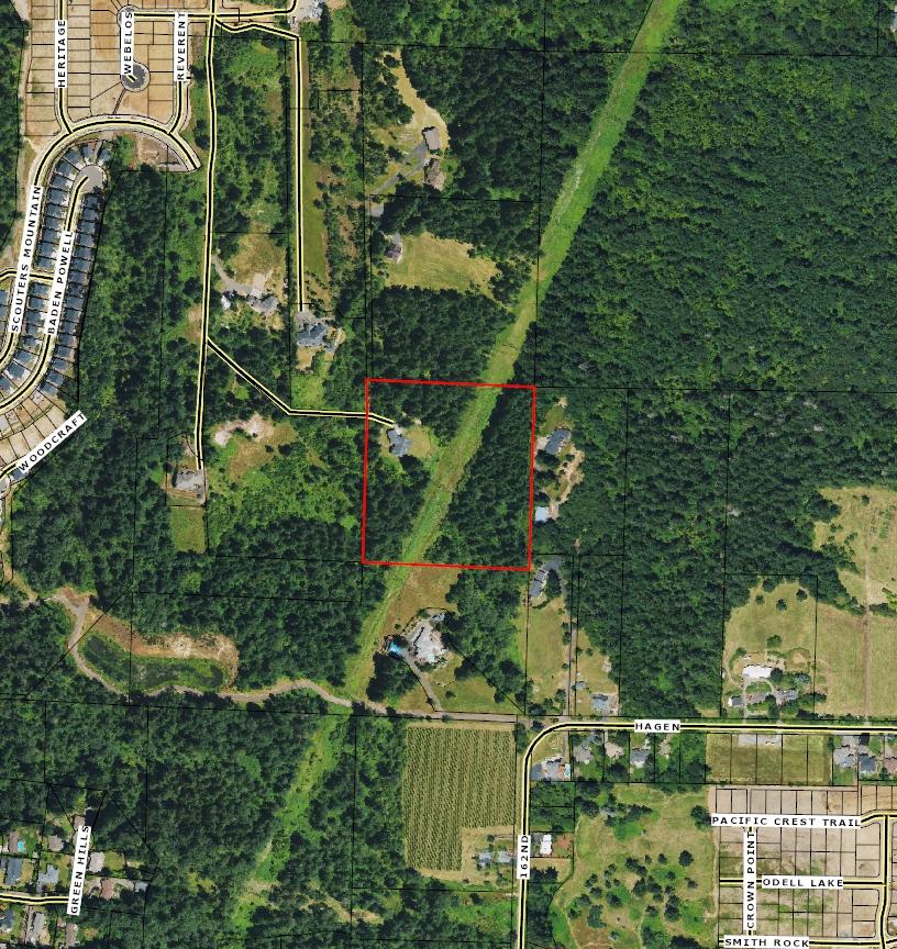
Custom Maps
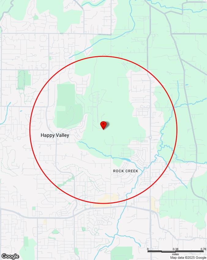
Community Information -Demographics -Traffic Counts
The information contained is provided by WFG’s Customer Service Department to our customers, and while deemed reliable, is not guaranteed.
Property Information
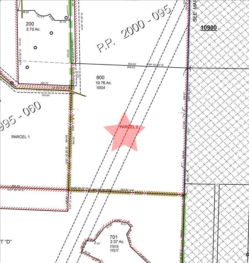
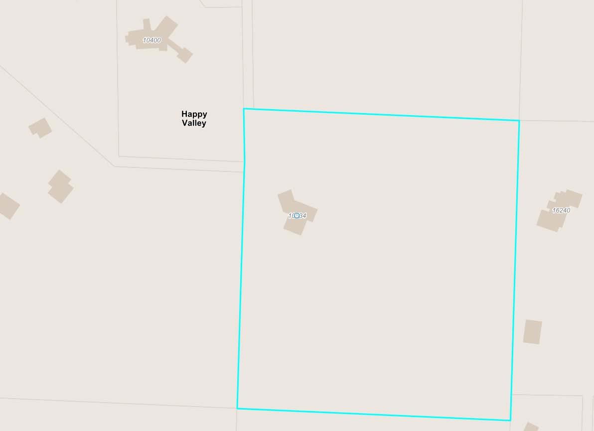
Assessors Tax Map
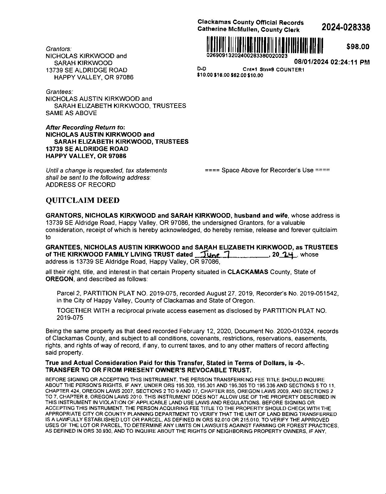
Vesting Deed
The information contained is provided by WFG’s Customer Service Department to our customers, and while deemed reliable, is not guaranteed.
PropertyDetailReport
Owner:Jeffrey&TamaraSmith
Site:10534SEVradenburgRdHappyValleyOR97086
Mail:10534SEVradenburgRdHappyValleyOR97086
LocationandSiteInformation
County: Clackamas
LotSqFt: 468,706
LegalDescription: PartitionPlat2000-095PARCEL2 LotAcres: 10.76
APN: 00127428
TaxLot: 12E36A00800
Twn-Rng-Sec: 01S/02E/36/NE
LandUse: 401-Tractlandimproved
LandUseSTD: SingleFamilyResidential
CountyBldgUse: 1001
Neighborhood: HappyValley #Dwellings:
Subdivision: MapPage/Grid: 658-E3
LegalLot/Block: 2
Zoning: HappyValley-R20 CensusTract/Block: 022208/3019 Watershed: LowerClackamasRiver
ElementarySchool: ScoutersMountainElementary HighSchool: AdrienneC.NelsonHighSchool MiddleSchool: HappyValleyMiddleSchool SchoolDistrict: NorthClackamas
PropertyCharacteristics
TotalLivingArea: 6,296 Bedrooms: 5
FirstFloorSqFt: BathroomsTotal: 3.5
YearBuilt/Eff: 2004
Heating: SecondFloorSqFt: BathroomsFull/Half: 3/1
Cooling: BasementFin/Unfin: Stories:
Fireplace:
AtticFin/Unfin: Foundation: Pool: GarageSqFt: RoofMaterial: Kitchen:
AssessmentandTaxInformation
MarketTotal: $2,622,447.00 PropertyTax: $18,671.98
MarketLand: $1,569,597.00 Exemption: MarketStructure: $1,052,850.00
SaleandLoanInformation
SaleDate:
Lender:
SaleAmount: LoanAmount: Document#: LoanType:
DeedType: Price/SqFt: TitleCo: SellerName:
PreparedBy:WFGNationalTitleCustomerServiceDepartment 12909SW68thPkwy,Suite350,Portland,OR97223 P:5036031700|3608915474E:cs@wfgnationaltitle.com|cccs@wfgtitle.com
SentryDynamics,Inc.anditscustomersmakenorepresentation,warrantiesorconditions,expressorimplied, astotheaccuracyorcompletenessofinformationcontainedinthisreport.
ParcelID:00127428
SiteAddress:10534SEVradenburgRd
SentryDynamics,Inc.anditscustomersmakenorepresentations, warrantiesorconditions,expressorimplied,astotheaccuracyor completenessofinformationcontainedinthisreport.
ParcelID:00127428
SentryDynamics,Inc.anditscustomersmakenorepresentations, warrantiesorconditions,expressorimplied,astotheaccuracyor completenessofinformationcontainedinthisreport.
ZONING
DETAILS
Detailed Zoning Information
Happy Valley R20 (Residential 20,000 Sq Ft)
Zoning Map
Community Jurisdiction
The information contained is provided by WFG’s Customer Service Department to our customers, and while deemed reliable, is not guaranteed.
City of Happy Valley, OR Friday, March 21, 2025
Title 16. Land Development Code
ARTICLE 16.2. LAND USE DISTRICTS
Chapter 16.22. RESIDENTIALLAND USE DISTRICTS
§ 16.22.020. Very low density residential zones.
Purpose.
Residential—Forty thousand Square Feet (R-40). This district reflects the first developmental step in the conversion of agricultural or open space land to residential purposes. Through benefit of available public services and faculties, land in this district is capable of supporting lower densities, yet constraints may still exist which would limit present and future carrying capacities. This district provides the transition to the more fully urban development of higher districts while expressing physical limitations on the potential of the land. The district may be applied in sloped areas where clustering and other hillside protection standards are applied. The numerical designation R-40 shall be interpreted to mean that the maximum density shall be one primary dwelling unit per 40,000 square feet of lot area.
Residential—Twenty thousand Square Feet (R-20). This low density urban residential district responds to development patterns already established in the City and perpetuates those patterns in recognition of the potential for infilling and the overall carrying capacity of the land. Single-family detached dwellings on larger lots are encouraged in this district which seeks to maintain "elbow room and breathing space" within the urban framework of the City. This district is a buffer between the low density and undeveloped areas and the higher density, more typical urban residential districts. It is within this district that uses and standards begin to change to reflect the desired urban trends and patterns. The district may be applied in sloped areas where clustering and other hillside protection standards are applied. The numerical designation of R-20 shall be interpreted to mean that the maximum density shall be one primary dwelling unit per 20,000 square feet of lot area.
Residential—Fifteen thousand Square Feet (R-15). This low density urban residential district responds to the continuing urbanization of the City due to the availability of public sanitary sewers in areas previously zoned R-40 or R-20. Single-family detached dwellings are encouraged in this district which seeks to maintain "estate development" within the urban framework of the City. This district is a buffer between the densities allowed in the lower density R-20 district and the densities allowed in the medium density, more typical urban residential districts. The numerical designation of R-15 shall be interpreted to mean that the maximum density shall be one primary dwelling unit per 15,000 square feet of lot area.
Permitted Uses. Table 16.22.020-1 identifies the land uses allowed in the R-40, R-20 and R-15 Districts.
Table 16.22.020-1
Very Low Density Residential (R-40,
R-20,
R-15) Permitted Uses
P=Permitted; C=Conditional Use; X=Prohibited
Use
Residential
One single-family dwelling, townhome, duplex, triplex, quadplex, cottage cluster, modular dwelling unit or manufactured home per lot
1,2
Multiple-family units or manufactured housing, approved as part of a PUD application pursuant to Section 16.63.130
Accessory dwelling units complying with Section 16.44.050
Temporary manufactured home to allow for care of an aged or infirmed relative, provided that adequate water, sewage, disposal and fire protection are available, and that tongue, undercarriage and axles remain intact on the unit. Undercarriage wheels and supporting base must be covered with a full ground length sign-obscuring skirting around the entire circumference of the manufactured home.
Home occupation as defined in Section 16.12.030, per the provisions of Section 16.69.020
Special event centers for hosting functions such as weddings, anniversary celebrations, corporate parties and similar events
Other
Agriculture and related activities, not to include the commercial processing of any type of agricultural products, whether animal or vegetable
Public or private open spaces, parks and playgrounds, tennis courts and similar outdoor recreational activity areas and recreational buildings, facilities and grounds, which include fully or partially enclosed structures for the primary or secondary use
Large scale recreational facilities such as golf courses, aquatic centers, aquariums, amusement parks and similar uses
Table 16.22.020-1 Very Low Density Residential (R-40, R-20, R-15) Permitted Uses
P=Permitted; C=Conditional Use; X=Prohibited
Use
Temporary use of a trailer, mobile home, or other building for a use incidental to construction work provided that:
The maximum time period is six months, with a maximum extension for another six months;
The trailer, mobile home, or other building is connected to an approved sewage disposal system;
Abuilding permit for a permanent structure has been issued;
The temporary home or building shall be removed upon completion or abandonment of construction; and
No reasonable alternative, such as the availability of nearby rental housing exists.
Wireless communication facilities, not to include antenna support structures, subject to the provisions of Section 16.44.020 of this title
Construction of new streets and roads, including the extensions of existing streets and roads, that are included with the adopted transportation system plan
Helipad
Any accessory structure which is customarily incidental to any of the permitted uses, located on the same lot
NOTES:
Applies to a parent lot. Duplexes, triplexes, quadplexes, and cottage clusters are not permitted on a child lot (i.e., previously subdivided lot from a middle housing land division).
Cottage clusters are not permitted within the Flood Management Overlay Zone (Chapter 16.35) or on any property within the Cottage Cluster Limitation Overlay Zone (Chapter 16.38).
C.
Development Standards. The development standards in Table 16.22.020-2 apply to all uses, structures, buildings, and development in the R-40, R-20 and R-15 Districts.
Table 16.22.020-2 Development Standards for R-40, R-20, R-15
Lot size (minimum and maximum density): Single-family detached, duplex, triplex, quadplex
fronting on cul-de-sac
Building setbacks (minimum)
Building height (maximum): Cottage cluster 17 feet and one story
Shared outdoor recreation areas 400 sq. ft./unit provided in accordance with Section 16.42.080
NOTES:
Density calculations for single-family detached shall be made pursuant to Section 16.63.020(F)
Cottage clusters must meet a minimum density of four units per gross acre.
Townhomes are exempt from the lot width requirements.
Cottage cluster housing is exempt from lot coverage requirements.
Interior side yard setbacks for townhomes may be reduced to zero in compliance with applicable sections of the adopted Uniform Building Code.
The single-family residential building height maximum is 45 feet at the front elevation; side and rear elevations may not exceed 49 feet.
If a duplex, triplex, fourplex, or cottage cluster has been divided by a middle housing land division, per LDC 16.61, the development standards that are applicable to the lot shall apply to the middle housing parent lot, not to the middle housing child lot.
Maximum lot coverage for townhomes is the greater of the percentage identified in the table or up to 1,000 square feet of buildings, decks, stairways and entry bridges that are more than 30 inches above grade (excluding eaves). Compliance with all other standards is required.
(Ord. 389 § 1(Exh.A), 2009; Ord. 406 § 1, 2010; Ord. 427 § 1, 2012; Ord. 433 § 1, 2013; Ord. 446 § 1, 2014; Ord. 468 § 1, 2014; Ord. 561 § 1(Exh.A), 2022; Ord. 571 § 1, 2022; Ord. 582, 3/19/2024; Ord. 589, 9/17/2024)
Objectid: 139021
PrimaryAddress: 10534 SE Vradenburg Rd, Happy Valley, 97086
Jurisdiction: Happy Valley (https://www.happyvalleyor.gov)
Map Number: 12E36A
Taxlot Number: 12E36A00800
Parcel Number: 00127428
Document Number: 2015-059017
Census Tract: 022208
Landclass: 401
Assessment
EstimatedAcres: 10.78
CurrentYearAssessed Value: $958,196.00
Market Building Value: $1,052,850.00
Market Land Value: $1,569,597.00
Market Total Value: $2,622,447.00
Sq Ft: 6296
Bedrooms: 5
Baths: 3
Year Built: 2004
Sale Price: $0.00
Doc Date: 08/26/2015
Doc Type: S
Taxcode: 012276
Schools
Elementary School
Scouters Mountain Elementary (https://scoutersmountain.nclack.k12.or.us/)
North Clackamas
10811 SE 172ndAve, Happy Valley, 97086
503-353-3250
Middle School
Happy Valley Middle (https://happyvalleyms.nclack.k12.or.us/)
North Clackamas
13865 SE King Rd, Happy Valley, 97086
503-353-1920
High School
Adrienne C. Nelson High School (https://anhs.nclack.k12.or.us/)
North Clackamas 14897 SE Parklane Dr, Happy Valley, 97015
503-353-5750
Public Safety
Nearest Police Station
Clackamas County Sheriff
Nearest Fire Station
Pleasant Valley Station #7
10921 SE 172ndAve, Happy Valley 97086
Clackamas RFPD #1
Zoning & Development
Designation: Contact City
Urban Growth Boundary: METRO UGB
Voting
Voting Precincts: 105
State House District: 39
State Senate District: 20
Congressional District: 3
Utilities & Districts
Community Planning Organization
City
Lighting District
CLACKAMAS, HV, DAMASCUS
Sanitary Hauler
Waste Management of Oregon (https://clackamas.us/recycling/garbage/company.html)
Rural Fee Zone
School District
North Clackamas (http://www.nclack.k12.or.us)
Water District
Sunrise WaterAuthority (http://sunrisewater.com)
Environmental & Hazards
Flood
Likely not in a flood zone.
Wildfire
You may be at moderate to high risk.
Earthquake Hazard
You may be at a higher risk.
Soils
13D - Cascade Silt Loam, 15To 30 Percent Slopes
13C - Cascade Silt Loam, 8To 15 Percent Slopes
13B - Cascade Silt Loam, 3To 8 Percent Slopes
Approximate Elevation
660.00 ft
North Folk Dam Failure
Most likely not at risk of flooding due to dam failure
River Mill Dam Failure
Most likely not at risk of flooding due to dam failure
Timothy Dam Failure
Most likely not at risk of flooding due to dam failure
Parks
Nearby
Ashley Meadows Park (http://ncprd.com/parks/ashley-meadows-park)
15410 SE OregonTrail Dr
1.36 miles
Happy Valley Park (http://ncprd.com/parks/happy-valley-park)
13770 SE Ridgecrest Rd
1.38 miles
Happy Valley Wetland Park
13770 SE Ridgecrest Rd
1.09 miles
Scouters Mountain Nature Park (http://ncprd.com/parks/scouters-mountain-nature-park)
SE Boy Scout Lodge Rd and SE 147thAve
0.52 miles
Summerfield Park (http://ncprd.com/parks/summerfield-park)
14001 SE Summerfield Loop
1.44 miles
Documents
Surveyor Documents
Survey - SN4847 (https://maps.clackamas.us/survey/PSImages/1S2E/36/PS4847.tif)
Plat - PP2000-095 (https://maps.clackamas.us/survey/SDImages/1S2E/36/PP2000-095-P1.tif)
Plat - PP2000-095 (https://maps.clackamas.us/survey/SDImages/1S2E/36/PP2000-095-P2.tif)
Taxmap - 1S2E36A(https://maps.clackamas.us/taxmap/03_1s2e36a.pdf)
District Maps
State House District
Disclaimer & Liability
The information and maps accessed through this web site provide a visual display for your convenience using data from Clackamas County's Geographic Information System. Every reasonable effort has been made to assure the accuracy of the maps and associated data from several sources. Clackamas County makes no warranty, representation or guarantee as to the content, sequence, accuracy, timeliness or completeness of any of the data provided herein. Clackamas County explicitly disclaims any representations and warranties, including, without limitation, the implied warranties of merchantability and fitness for a particular purpose. Clackamas County shall assume no liability for any errors, omissions, or inaccuracies in the information provided regardless of how caused. Clackamas County assumes no liability for any decisions made or actions taken or not taken by the user of this information or data furnished hereunder. Users are strongly advised to verify from authoritative sources any information displayed in this application before making decisions. Liability Statement (http://www.clackamas.us/liability.html)

The material and information on this website are made available for general informational purposes only. Although Metro makes reasonable e�orts to ensure the accuracy, completeness, and currency of this information, the data and maps may contain errors or inaccuracies. No representations or warranties of any kind, express or implied, are provided.
Address
City
County Clackamas
Taxlot Information
Metro councilor
Land Use and Planning
Urban
Sub-watershed Rock Creek-Clackamas River
Basin Willame�e
Sub-basin Clackamas
Residential hauler Waste Management of Oregon
Residential hauler phone (800) 808-5901
Commercial hauler Waste Management of Oregon
Commercial hauler phone (800) 808-5901
Dropbox provider Waste Management of Oregon
Dropbox provider phone (800) 808-5901
School district NORTH CLACKAMAS
School district number 12
Fire district Clackamas Fire District #1
Park district No data
Sewer district No data
Water district Sunrise Water Authority
Topography