From the outset, our studio nvestigated the Public house (Pub), a typical form of British Public space, cultural infrastructure, which serve communities as a place of gathering. Pubs, which are nearly 50 thousand in the UK varied in terms of architectural features, ale, cuisine, setting, and history, have been significantly contributing to a multitude of health and social problems due to excessive drinking however they have also been the best parts of the communities for serving the same purpose as cultural infrastructure for socializing and connecting.
Our studio sought to re imagine this critical piece of Public infrastructure as a place for gathering for a broader community of creatures, species, minerals, chemicals and microbes which create a network of support for our buildings and lives and not only as traditionally for the continually changing communities of people who support and live around the public place.
Some institutions and societies can exist without so form of building however the existence of building is in dependence of geological and biological systems from which they are created from.
Hence, every single piece of architecture is technically a site of gathering as a building is erected from an enormous set of components, which each carries its own history, origin and hence its own identity.
Consequently, we manifested manifested these histories and origins in order to acknowledge the role the wider community plays in sustaining our existence and contemplating ways the public house might employ, respect, protect, represent and preserve our relationship with public trust(air, waters, and lands)
INDUSTRIAL RE[SOLUTION]
The Public house
Ambiguous edges
ACADEMIC EXPERIENCE
Mapping 03
Anchors,Borders & Boundaries
Investigation of the impact of technological inventions
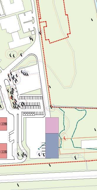
This is the current setting of the site infrastructure which I mapped depicting railway lines, main road and canals which are still active today and perhaps improved from the industrial revolution era. The site seemed to be enclosed by these network infrastructures which created boundaries between residents, the site and its surrounding to the rest of the area. Therefore, my mapping brings the attention to the impact of the industrial revolution not only on the exploitation of the resources but how it affected the layout of the place.
I have attempted to look closely to the surroundings, regarding to the impact of the enclosure(boundary) and I have realised most of the residents within the enclosed area have also fences which are not porous while the residents outside the boundaries have porous fences. Additionally, I have mapped anchors in the area, which mostly are public spaces such as schools, hospitals, churches, supermarkets, pubs and so forth to start imaginiAng how residents living in an enclosed space move around the area. They are seemed to be a good number of borders on the north part however, perhaps only one border at the South that allows vehicular accessibility. Hence, there is a limited accessibility from the south. To access some of the anchors from the south you have to use only one border which may cause a lot of traffic during rush hour.
long wall along the canal that encloses the industrial site
Mapping 02
Industrial revolution
Investigation of the evolution of technological inventions
During the industrial revolution, a lot of technological inventions took place which were aimed for mass production. The invention of Steam engine for transporting coal from mines, steam train and construction of canals which were used to network Mines industries in Moxley area and other parts of the country, and therefore, stimulated the exploitation of mineral wealth of Black country unproportionally.
This drawing which I created depicts the deconstruction of these facilities which made possible the exploitation of resources and reconstruction of them in pursuit of creating new tools and infrastructure which will reverse the negative impacts of the industrial revolution by preserving resources and heal the land, the environment and the species that live in.
1. The existing building footprint is being used to develop a building design. Hence, no single tree will be cut or more further land will be used.
2. Layout of different building forms due to their functionality oriented due to their requirements, accessibility, and sunlight.
5. Added more spaces/volumes to massing due to their space requirements and their functionality.
6. Creating spacious circulation that connects all the buildings and spaces for effective accessibility and wandering around
8. The scheme is holistically designed to stimulate Wbiodiversity, enviromentand encourages other animals to be living underneath the building.
9. Green roofs, solar panels, photovoltaics, rooflights installed for sustainability purposes of producing own energy and reducing energy consumption hence only small amount of embodied carbon can be emitted.
3.Change the long orientation of the adminstration space to face the street while long glazing facing south for sunlight.
6. Expanding green house vertically for vertical farming to maximise solar gain to crops
10. Habitat corridors designed to bring other small species such as hedgehogs closer to the scheme and become an ecological zone.
Passive
site Strategy
4.Displace and rearange other forms for max. solar gain and creating courtyard for passive cross ventilation and sunlight accessibility to all building spaces.
7. Lifting up the whole scheme at least 3m high to allow expansion of the nature reserve underneath while blending in with the site context as the site is a nature reserve surrounded by trees.
11. The outer glass skin which absorbs the sunlight to keep the buildings passively warm in order to reducing energy consumption.
Spatial organisation
Form, function & circulation
TRAINING/SMALL EVENTS
-Small gathering, 40sq. m
-Activities/training, 45sq. m
The building is designed to bring the community together which translated on the ‘circulation’ as not only it connects all of the building spaces but also it acts as a communal space for people to interact.
Structural and aesthetic considerations are subjected to enviroment rather than functionality. Hence, some of these spaces have open floor plans and some have partions that can be altered.
ADMINISTRATION
-Office, 40sq. m
-Kitchennette, 30sq. m
-Meeting, 15sq. m
-Private office, 15sq. m
-Reception, 10sq. m
-Waiting area, 10sqm
-Multi functional space, 320 sq. m -Kitchen, 30sq. m -Storage, 10sq. m
This is a project proposal’s site plan which shows building design in context. The building is in the Woods nature reserve which acts as a anchor that invite the community to nature. On the right, the scheme plan shows building spaces strongly connected by circulation translating its robustness in terms of structure, and a community anchor
Detailed building design
Timber materials & structure
This is the whole scheme in context that displays a pragmatic high quality design with clear material & logic. Furthermore, the building model depicts enviromental and sustainability design strategies employed such as green roofs, green footprint, rooflights, long glazing windows, PV & thermal panels to make the building energy efficient while inciting biodiversity.
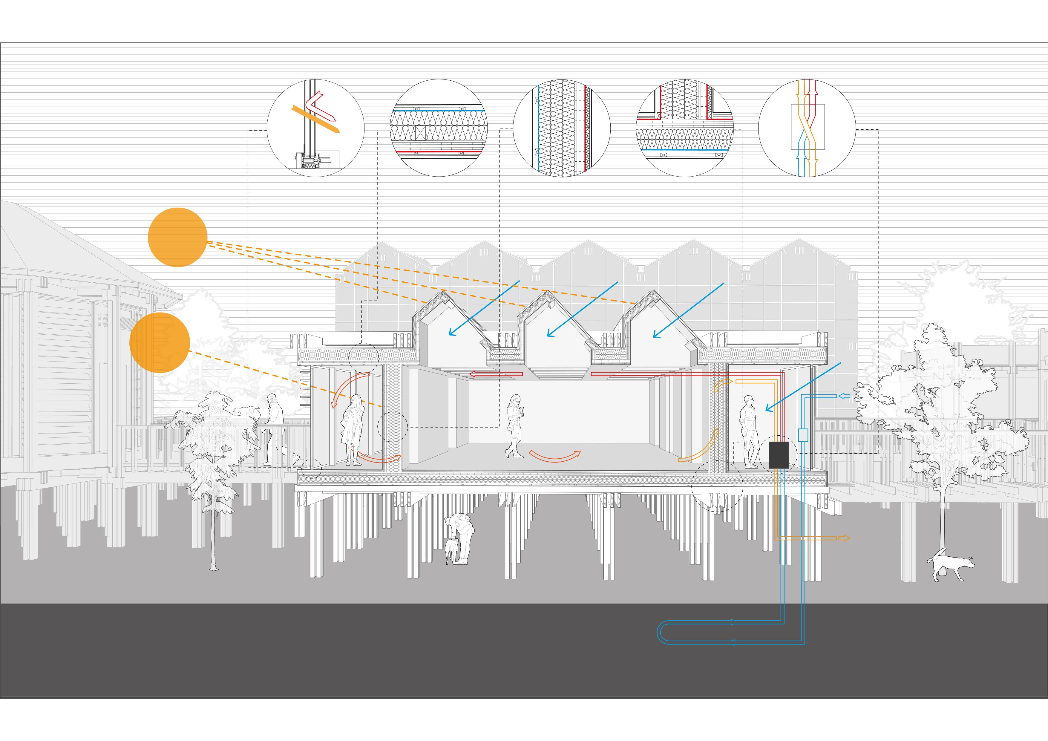
Perspective section
Primary hall
This is a perspective section of the primary hall which is in the middle of the whole design scheme. The primary hall is strategically designed to provide ernomous natural light into the building while harnessing solar energy for power and water and space heating, making the most use of site orientation that is facing North West(NW) .
The whole design scheme is lifted three(3) meters high to extend the Moorcroft Wood nature reserve into the site while inciting biodiversity and mimicking the trees forms. CLT and glulam are primary materials technically chosen to fit with the site context which is full of trees, for carbon sequestration, for its durability and most importantly suitable to design for disassembly .
Whole Scheme
External view
This is an exterior view which depicts the circulation that creates spaces for people to interact and wander around the courtyard while enjoying beautifl views of the woodlands.
Primary hall Internal view
This is an interior view which shows an art exhibiton taking place on the Primary building. The free plan multi-purposes space is designed with ernomous amount of natural light from its ceiling to make the space more vibrant and reduce the need for artificial light.
Green House Urban farming
This is a perspective section which shows the greenhouse in context. The greenhouse mainly grows produce(vegetables and fruits), train the community members about and sell their produce to the local communities. It is essentially green in the inside and most importantly on the outside to support other lives underneath the building design such as plants and small animals like Hedgehogs and squirrels which are freely moving to create a bubble of life and improve biodiversity.
Internal view of the third floor that depicts the planting activties in the green house.
Administration building Section drawing
This is the detailed section of the front of the building (Administration). to depict materiality, structure and environmental strategies such as Long glazing, Photovoltaics and louvers facing South.
repurposed.
EXPLODED ISOMETRIC DESIGNED FOR DISASSEMBLY
particular drawing I tried to depict the exclusively timber structure, which is installed independently on the outside to facilitate agency of assemblage, has been together by interlocking joints of beams on of one another.
Furthermore, bolts and nuts have been crucially used to connect between columns beams and the steel knife plate connector and the foundation.
method of installation allows materials to remain intact a the end of life which can be repurposed.
1. Roof
2. 75x200mm beam 1
3. 75x400mm beam 2
4. 75x40mm beam 2
5. Bolts & nuts
6. 125x125mm column
7. 52mm triple glazing
8. 22mm black siberian cladding
9. air gap
10. 34mm battens
11. Wind protection
12. 170mm insulation and vertical studs
13. 2x13mm plasterboard
14. 45mm insulation and studs
15. 100mm CLT
16. Vapour retarder
17. 170mm insulation and horizontal studs
18. 3mm foam underlay
19. 140mm CLT slab
20. 95x2mm insulation
21. 28mm battens
22. 22mm black siberian cladding
23. 14mm wood flooring
24. 22mm fiberboard
25. acoustic matting
26. 22mm fibreboards
27. 125X125mm columns
28. Bolts and nuts connection
29. Steel knife plate
30. Concrete foundation
Scale 1:120 in A4
PASSIVHAUS PLUS
Winter solstice at 14 degrees.
TRIPLE GLAZED WINDOWS
Triple glazing window. 52mm thickness
U value 0.8 W/M Sq, K Allows heat energy to pass through but not losing the internal heat through glazing.
Photovoltaics and Solar thermal collectors angled at 45 degrees to absorb the lowest angled winter’s solar energy
AIR TIGHTNESS
The building has wind tight layer to eliminate unintended gaps and cracks to minimiWWse draughts/air leakage through the building structure.
Optimal winter solar gains
Long glazing facing S.E for maximum solar gain
Winter solstice at 14 degrees.
Warm fresh air
SUPER INSULATION
The wall thickness 567mm with insulation which the U-value sq. K]. Hence, the heat transfer walls and keeps in during winter out during summer
INSULATION thickness is 215mm only which makes of 0.10[W/m Hence, it reduces transfer through keeps warmth winter and heat summer
THERMAL BRIDGE FREE DESIGN
The building envelope is free from timber structure, which is on the outside( poor conductor of heat) and is elevated about 3m high above the ground to avoid heat
Rooflights facing North West at almost 50 degrees for soft skylight into the building
HEAT RECOVERY VENT.
Circulates fresh air at or near room temperature into the building during winter to provide thermal comfort and prevent from stuffiness and heat lost.
Intake Air
Long glazing windows facing North West (N.W) at almost 50 degrees for soft skylight and view to the courtyard.
Extract air
MVHR
Exhaust Air
Multi_Storey CarPark PRACTICE
QEKLNH
Designing New Hospital For Queen Elizabeth Hospital Kings Lynn (QEHKL) before 2030.
BDP has been commissioned to design a new hospital to replace the current Hospital which will be unable to function by 2030. In these drawing, I was assigned to design a Multi-story Car Park (MSCP) that adhere to the principles of Hospital2.0, a designed template supplied by New Hospital Program. I took the lead to design the whole Car Park on my own under supervision of my Team Lead and Director.
Consequently, The base drawing has been extracted from a Revit model which was created in collaboration with me and my other colleagues on different occassions of the model development.
Site Information Report
Designing New Hospital For Queen Elizabeth Hospital Kings Lynn (QEHKL) before 2030.
These are some of the diagrams which I have produced using infromation ,from various sources, some from the Trust to mount a site information document. I have produced all of the diagrams on my own under supervision of my Team Lead. However, The base drawing has been extracted from a Revit model which was created in collaboration with me and my other colleagues on different occassions of the model development.
Hospital 2.0 Design Templates
I was given a task to produce drawings of Hospital2.0 templates and lay them on the site to see if they fit properly on the site as the site has number of contraints including TPO’s.
The base drawing has been extracted from a Revit model which was created in collaboration with me and my other colleagues on different occassions of the model development.
H-Shape
Toes-Rack 01
Toes-Rack 02
I was given a task to create the Hospital2.0 wards drawings and compare the number of rooms and area of the wards to see if theres gaps or compartibility between the two documents, Hospital 2.0 templates and Schedule Of Accomodation(SOA) which are both supplied by the Trust.
I used revit to create the diagrams and the information, which alerted us with ernomous discrepancies between SOA and H2.0 design guidance
Pepsico Visuals Planning Permission
These are visuals which I produced of the Pepsico project which has been granted planning permission recently. I was given images, of the building with a few of trees and entourage ,which were extracted from a Revit model and rendered from Enscape. However, I manipulated the images further using photoshop to add depth to .
I added cyclists and a lot of pedestrians to visually encourage ‘Green Travel’ while discouraging driving in the efforts of reducing Carbon emissions, which most vehicles use fussil fuels.
3D Model Making Planning Permission
These are some of the models I have created using 3D printer and other materials to procude models that can placed in the Studio for office use, since Metaswitch and UK Pavilion were already built. Tea factory BBC is under construction currently and its model was for studying.
I have never produced the UK Pavilion 3D model, although I was assigned to add a structure which was quite critical due to the shape of the pavilion that mimics the Beehive.
This is a small mosque on the junction of Soho Road and Hampstead road which is run by a local community West Africans. The mosque is quite small , as the community is growing also it needs a proper reparing as it does not seem to be fit to accomodate such activities.
The community has raised a few hundred thousands pounds for reparing. However, I advised them to be more strategic on the repair in terms of how they can improve their building to be more efficient.
Hence, I was recently given an opportunity to be incharge and I have been doing some research to develop a brief. These are some ideas I have develop so far.
Soho Hill Mosque Project
Proposed Extension
Proposed New Layout
Before my first meeting with the Mosque management, I have tried to develop some ideas which divert from their t idea of making just simple repairings and doing painting.
Therefore, my ideas which i am going to sell to them is either to do a building extension and improve the building internal structure and the building’s fabric or to demolish the whole of the internal timber structure and create a new CLT structure while adding some new architectural features such as an appealing facade and a green roof.
The British cultural infrastructure (place of gathering).
INDUSTRIAL
Industrial Re-solution is the name of my project which aims on restoring and preserving common resources such as land, water sources, ecosystems which during the Victorian time, ‘Industrial Revolution’, particularly in my site, Moxley, in Black country was one of the leading heavy industries in England for the extreme and faster extraction of the mineral wealth due to technological advances which caused a great level of air pollution as well as mining subsidence. Its impact is still experienced today around the Black Country as many suffered with cancer due to air pollution and many buildings sunk into forgotten mine workings .