

 Mrunmayee Umesh Pawar
Georgia Institute of Technology
Urban design | Architecture
Mrunmayee Umesh Pawar
Georgia Institute of Technology
Urban design | Architecture
portfolio
2021-2024

Mrunmayee Umesh Pawar
Georgia Institute of Technology
Urban design | Architecture
LinkedIn: Mrunmayee Pawar
mpawar9@gatech.edu
(470)-917-1726
Atlanta, GA
An architect aspiring to be the cause of better social and humane spaces in our daily urban, by pursuing a Master in Urban Design. have an avid interest in architecture and urban design. Being an artist, I believe, architecture is just an art we live in and cities are galleries that embodies this art.
+ Georgia Institute of Technology | Aug 2023 - Dec 2024
Master of Science in Urban Design
GPA: 3.40/4.00
Courses:
- Urban Design Studio - Urban Ecological Design
- Theories of Urban Design - GIS - Real Estate and Development
+ University of Mumbai, India | Aug 2016 - May 2021
Bachelor of Architecture
GPA: 8.05/10.00
Courses:
- Urban Design
- Landscape Design
- Architectural Design - Basic Design
- Allied Design - Building construction - Interior Design
+ Urban design
+ Placemaking
+ Urban planning
+ Conceptual design
+ Landscape architecture
+ Public space design
+ Transportation design
+ Autodesk AutoCAD (2D Drafting)
+ Adobe Photoshop (Post-Production)
+ Adobe Illustrator (Post-Production)
+ Adobe Indesign (Post-Production)
+ Rhinoceros (3D Modelling)
+ Sketchup (3D Modelling)
+ ArcGIS (GIS)
+ Urban Foorprint (GIS)
+ Vray (Rendering)
+ Lumion (Rendering)
+ Enscape (Rendering)
+ Microsoft Office (Management)
+ English, Fluent + Hindi, Fluent
+ Marathi, Fluent
+ Anil Nagrath and Associates | Design Architect
Mumbai, India | November 2021 - July 2023
Architecture and urban design for a wide range of projects, in India, UAE and Rwanda, which included the creation of conceptual designs, municipal drawings, tender drawings, cost estimates, specifications, 3D visualisations, and so forth. involves working on the planning and design at ANA to create residential, urban design, public, landscape, solid waste management projects. Involved in the following projects:
- Detailed Masterplanning Report of a city in UAE
- Master planning and Urban Design of Kamonyi city, Rwanda
- Masterplanning and DMP Report of Al Mirfa Industrial Area, Abu Dhabi (Lead)
- Development of Material Recovery Facilities in India
- Designing 2 key Streets at Rohtak, Haryana, India
- Self-Redevelopment Residential Projects in Chembur, India
- Urban Park Rejuvenation and development in Chembur, India (Lead)
- Skywalk development in the station precinct of Chembur, India (Lead)
+ Edifice Consultants Pvt. Ltd. | Trainee Architect
Mumbai, India | November 2019 - April 2020
Part of the Hospitality vertical and has worked on conceptual drawings, municipal and construction drawings, design development portfolio, and working details, site visits & client presentations for a variety of architectural and interior design projects. Involved in the following projects:
- International Exhibition and Convention Center (IECC) at New Delhi, India
- Hilton, Alexis: Luxury Hotel in Pune, India
- Taj Resorts at Pawna Lake in Lonavala, India
Anil Nagrath and Associates | Design Architect
+ Detailed Masterplanning Report of a city in Abu Dhabi, UAE
Master Planning support for a city in Abu Dhabi, Dubai. Paperwork and assessment of an upcoming city in Abu Dhabi, illustrative documentation for reports, plot calculations and diagram creation, 3D modelling and visualisation, client presentations and meetings
+ Master planning and Urban Design of Kamonyi city, Rwanda
Concept, design and urban stratergy development for the Kamonyi City in Rwanda. Illustrative documentation for reports, 3D modelling and visualization, client presentations and meetings
+ Masterplanning and DMP Report of Al Mirfa Industrial Area, Abu Dhabi (Lead)
Master Planning and DMP Report for industrial area of Al Mirfa in Abu Dhabi, Dubai. Paperwork and assessment of an upcoming city in Abu Dhabi, illustrative documentation for reports, plot calculations and diagram creation, 3D modelling and visualisation, client presentations and meetings
+ Designing two key Streets at Rohtak, Haryana, India
Existing street documentation and analysis, design options for each street, schematic drawings, tender drawings, cost estimates, 3D modelling and visualisation, client presentations and meetings
+ Urban Park Rejuvenation and Skywalk development in Chembur, India (Lead)
Led the research, design production team for the development of an urban park and skywalk design. Involved in client meetings with public and government bodies
ARCHITECTURE
Anil Nagrath and Associates | Design Architect
+ Self-Redevelopment of Multi-storeyed Residential Apartment in Mumbai, India
At various stages of the project, preparation of schematic and working drawings, presentations, and 3D models
+ Bangalow in Tanhau, Uttarakhand, India
Conceptual designing and client presentations, 3D modelling and visualization
URBAN DESIGN
Georgia Institute of Technology | Graduate student
+ Nexus24, Seatlle, USA | ULI Hines Competition | Spring 2024
Participated in the ULI Hines Competition 2024, with the role of a Presentation Maestro and storyteller in a team of five. Involved in design development, implementation stratergy, cost analysis and proforma development. Led the diagramming, production and post-production drawings
+ ATL: City of Corridors, Atlanta, USA | Urban Design Studio | Fall 2023
Analysing and exploring the Beltline, an untapped resource in the western side of the city of Atlanta, along with stating the problem statement, forming a narrative, developing an urban design framework, and proposing urban design interventions for the master planning of the site
University of Mumbai, India | Undegraduate student
+ Art in Progress: Reminiscing the Art & Heritage of Mumbai | Final Year Thesis Readiness of a dissertation research book that is the pinnacle of research on art districts around the world to comprehend Mumbai’s vibrant art district, the Kala Ghoda Precinct. Design interventions for two historic buildings in the chosen art district precinct predicated on the notions of adaptive reuse and heritage conservation
+ COA Registered Architect: CA/2022/144731
Council of Architecture - India
+ Paper title: Art in Progress: Reminiscing the Art and Heritage of the City
Journal Name: International Journal of Engineering Research
Issue: Volume No.10, Special Issue No.1, May 2021
Paper Type: Research Paper
‘Art in Progress’ is an award winning Research Paper based on my Final Year B. Arch
Thesis. The Research Paper won the Best Paper Award in the B.Arch Category at the National Students Conference 2021 - Research in Architecture organised by D. Y. Patil School of Architecture in association with MASA
+ ULI Hines Urban Design Competition 2024: Honorable Mention
+ Best Thesis Research Paper Award: Research in Architecture in B.Arch Category
+ Paper Presentation: the National Students Conference 2021
+ Paper Publication: International Journal of Engineering Research, Vol No.10,Special Issue No.1, May 2021
+ Speaking Stones |University of Mumbai | 2018
+ 3rd Rank|B.Arch Final year - University of Mumbai | 2020-2021
CO-CURRICULAR ACTIVITIES:
+ ULI Hines Urban Design Competition | 2024
+ Asian Contest of Architectural Rookies Award | Top 15 | 2019
+ Archmello: Rethinking Student Housing Compeition | 2019
+ Council of Architecture Water Heritage Awards | 2019
+ Annual Nasa and Zonal NASA Design Trophy | 2018
+ Participation in Nari Gandhi competition | 2018
+ Team Leader for Panel Discussion Trophy at the Annual NASA (National Association of Students of Architecture)| 2018
+ Led exhibitions for multiple college events and outreach | Sem 2 to Sem 8
+ Lead the installation team for CTES College of Architecture, B.Arch | 2018
+ Lead the installation team for CTES College of Architecture, B.Arch | 2018
+ Hands-on Workshop at Hunnarshala, Ahmedabad | 2018
Nexus24
Empower+Enrich+Everyday Downtown Seattle, USA
Competition Project: 2024 (Honorable Mention)
ATL: City of Corridors
Connect+Stitch+Protect Westside Atlanta, GA
Academic Project: 2023
Design Guidelines and Detailed Masterplan Report Yas Island, Abu Dhabi, UAE
Professional: 2021-Present
Street Design & Play(ce)making Rohtak, India
Professional: 2022
SkyHigh Mumbai, India
Professional: 2022
Urban Park Development Mumbai, India
Professional: 2022
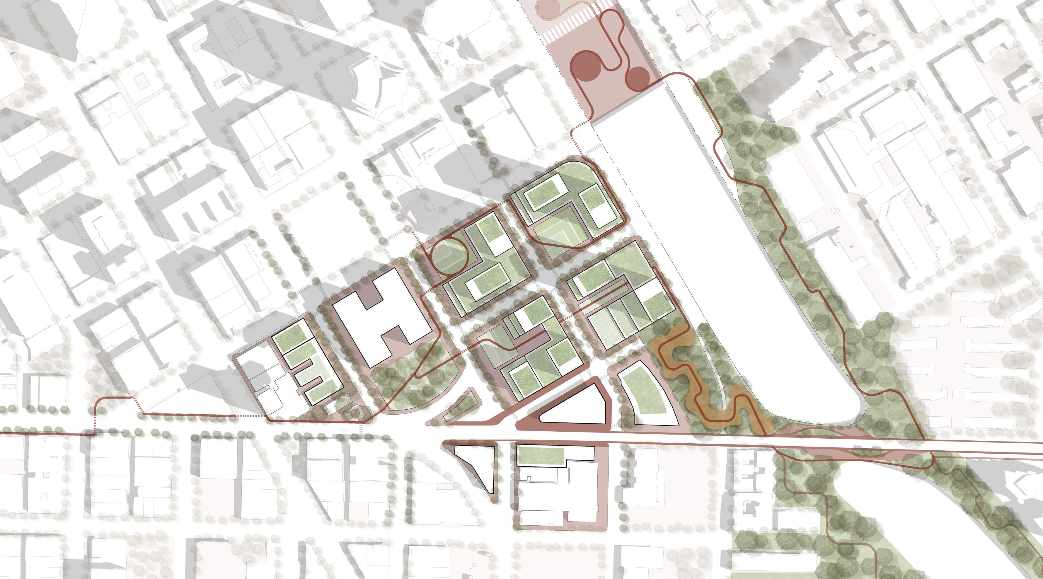
EMPOWERING AND ENRICHING THE COMMUNITY TO LEAD A THRIVING EVERYDAY LIFE.
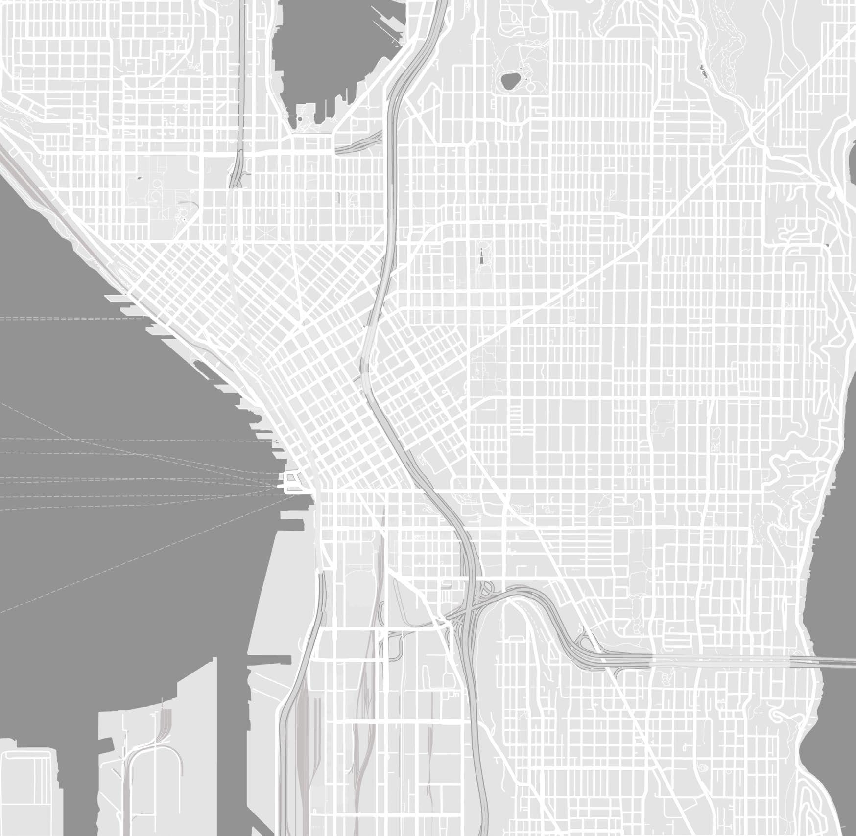
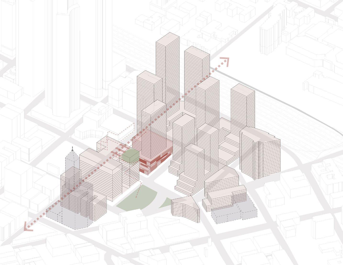
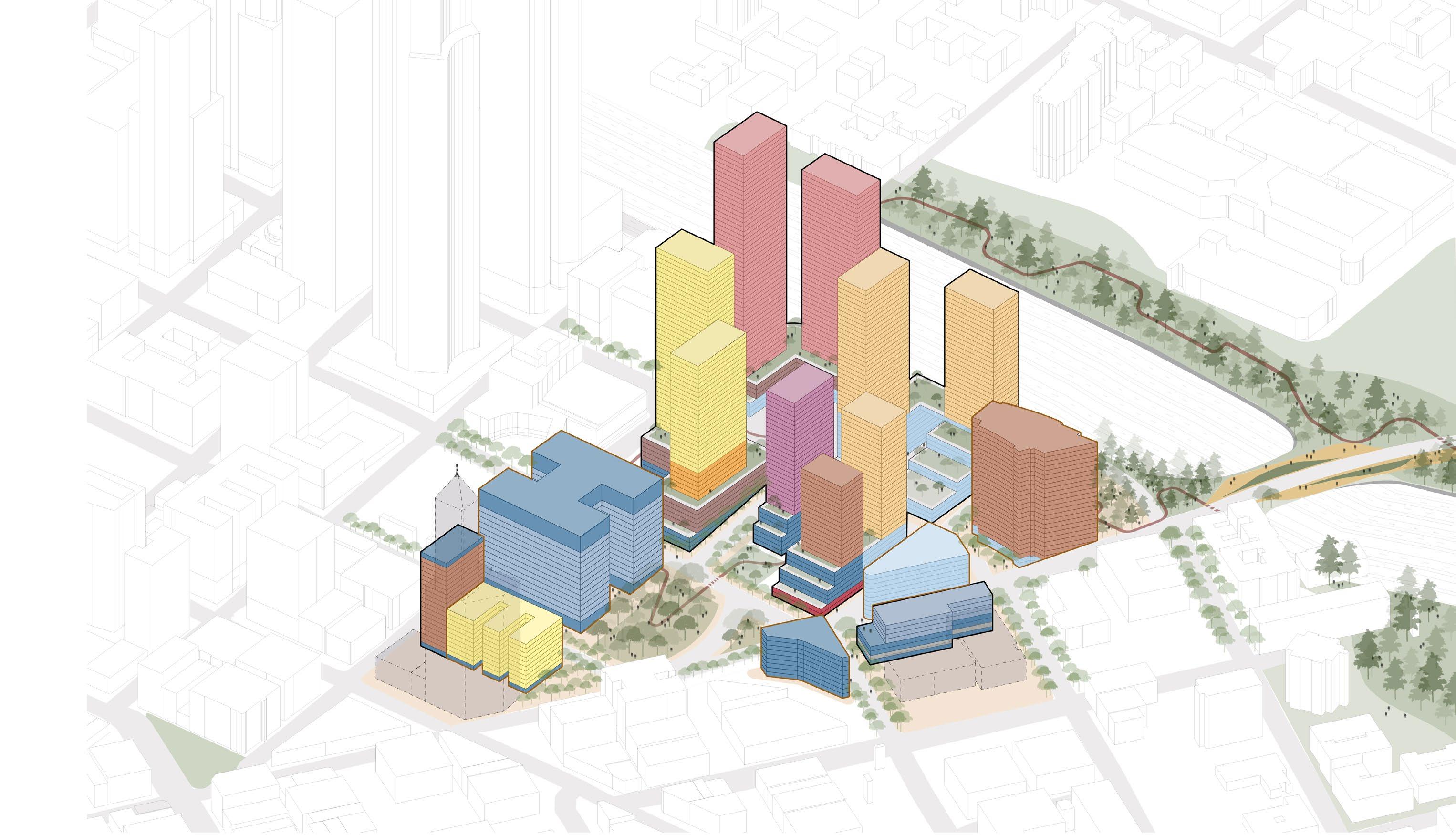
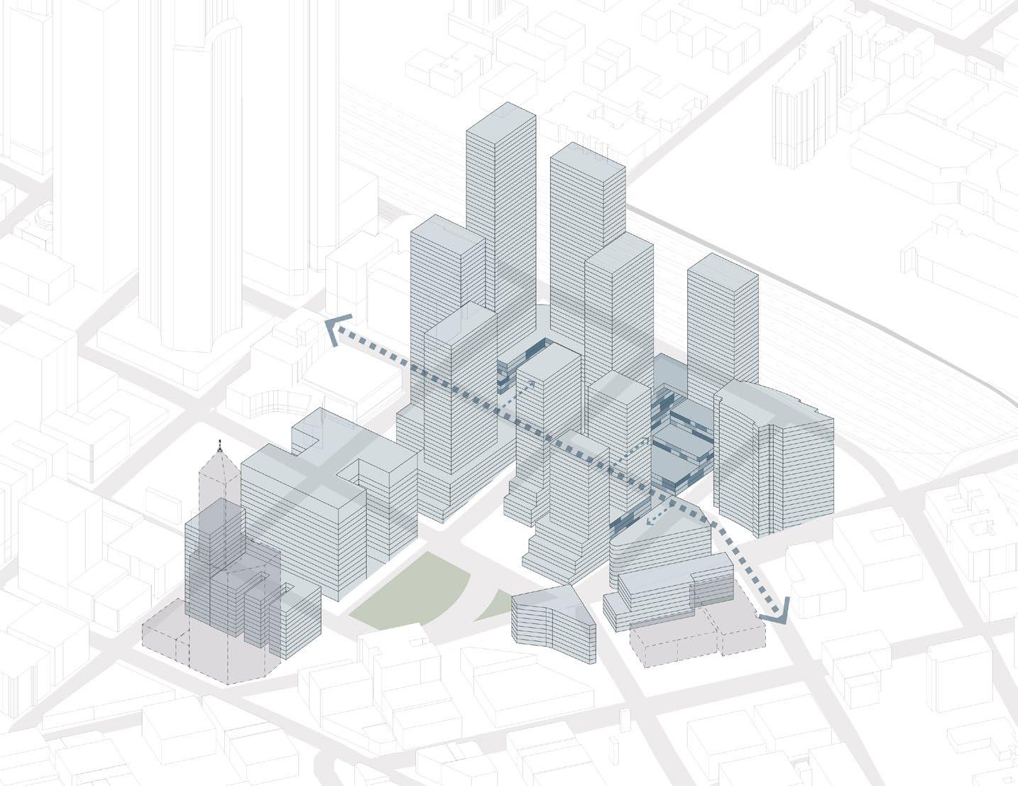
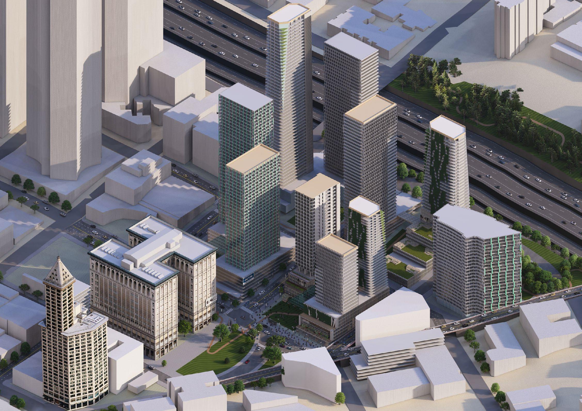
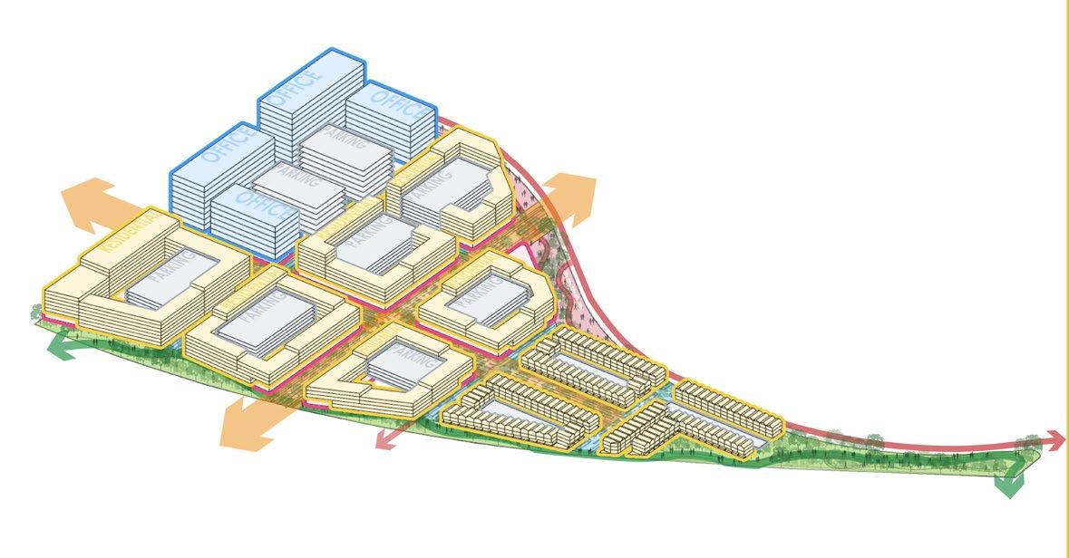
At an intersection of Seattle’s history and global diversity is the Nexus24. It is a new vision for the development of Seattle, developed for the people. Set on the highest standards of sustainability, the mixed-use, mixedincome neighborhood is designed on the guidelines of LEED and WELL. It connects and transforms, facilitating a thriving community. Nexus24, a 24-hour neighborhood, is an ecosystem of residential, retail, health, art, and innovation developed as an amalgamation of holistic new development and historically preserved and repurposed architecture. The new development responds to the deficit in the community and attempts to enable a more prosperous civic life. It is designed to be a transformative beacon in downtown Seattle.
Competition: ULI Hines Urban Design Competition 2024 | Honorable Mention Georgia Institute of Technology: Spring 2024
Team: Anushka Reddi, Atharva Belsare, Christian Perry, Mrunmayee Pawar, Raj Guide: Ingeborg Rocker, Chirag Date, Geoff Koski
Roles: Presentation Maestro and storytelling, illustrative diagramming, production and post production
Digital workflow: ArcGIS + AutoCad + Rhino/SketchUp + Photoshop + Illustrator + Indesign
Studying the city for deficits and opportunities - an analysis to determine the needs of the city, to provide; and the strengths of the city, to bring in a study of a 10 min walk from the site.
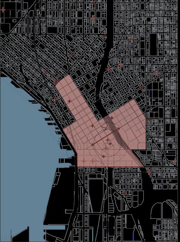
The site is located in an area with a bad health index exceeding the 90th percentile - largely due to no exercise. The pluses show the network homeless shelters and free food banks.
To the north of the site are abundant cultural centers (plus-circles), markets (green circles), parks, and technology companies (ochre). There is a noticable gap from the south of the site.
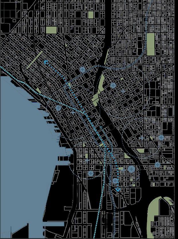
The project development and phasing strategy has been developed to prioritize the holistic development of the neighborhood and a potential increase in revenue over the years as the phases progress.
Along the north-south spine of Seattle, the site is connected with public transit very well. The site is surrounded by community centers and daily markets - although, lacks these facilities in the heart of the site.
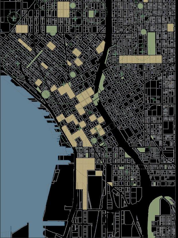
Framework of streets as spines of development - Punctuated with cultural nodes - Overlayed with green public infrastructure as sustainability management strategies
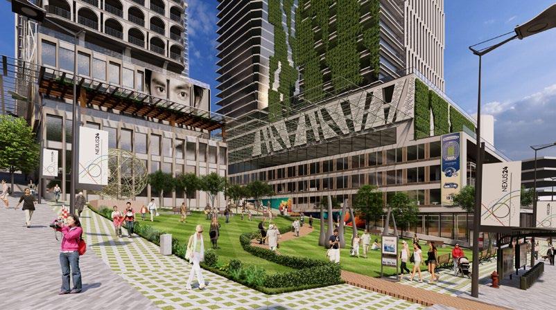
The urban design framework is a network of streets as the spines of development - offering the programs of empower, enrich and everyday.
The intersections of these spines become nodes - art at the renovated Courthouse museum; justice at the plaza across City Hall, and Art+Tech at the intersection at Yesler way.
The next overlay is the network of green spaces that act as stormwater management featuresslow filtration courtyards. These help the stormwater streets that flow down toward the water to reduce run-off.
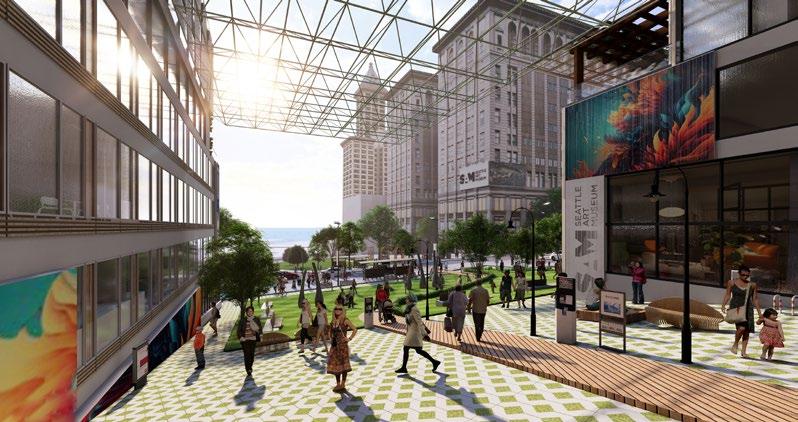
Upon this, is a neighborhood for the public - walkable, vibrant and homely. Topped with apartments catering to a diverse demographic.
Justice Street - In the context of the city hall, the justice street invites people living in a deficit. It offers a resource center for homeless and low-income people. It houses a transitional housing program, supported by an in-house NGO. The program extends into training centers for basic skills inorder to train these people to get jobs. The street also has the justice plaza - a place for conversation and awareness.
Combination of program to meet the goals of the project - Empower, Enrich and Everyday

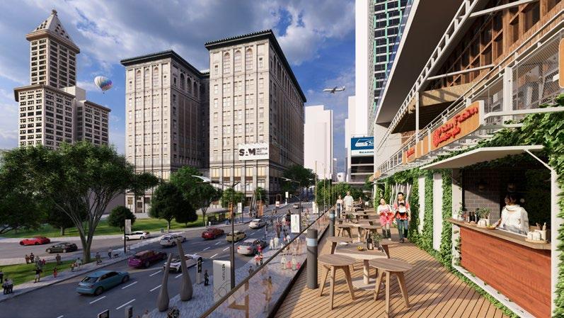
Community Street - The cultural spine of Nexus24 - offers retail, restaurants, bars and public plazas for the community to enjoy. This street, within the project is blocked off after 7 PM for the activity to spill out onto the street. The cultural nodes also stand here, bringing life, art and technology together.
Everyday Street - Here, the community lives together - they go to the grocery, the gym, drop kids off at the daycare, elder people meet at the senior care, children enjoy the youth recreational center. This street also has the Early Learning Facility for children from low-income families. This program is associated with the daycare to teach the children values of a better society.
+
+
Art + Tech Activties
Affordable Housing
Affordable & Market Rate Housing
Condo Apartments
Rental Luxury Apartments
Student Housing Apartments
Retail Activities: F&B, event spaces
Community: International market, local business hub
Transitional housing program
Mobility Hub
Hotel
The first phase focuses on developing the central core - a public ‘plus’ along Enrichment Street that brings in revenue from rentals and activates the neighborhood’s vibrancy. This phase also includes redeveloping critical historic nodes, the Courthouse, and the Yesler building.
The second phase extends with added housing units, a combination of affordable, market-rate, and luxury apartments. The historic Morrison building has been restored as an entirely reasonable housing building. The Prefontaine building is purchased to connect across the Yesler Way, tying the project to the international district and symbolizing future development. This phase also extends into the development of public infrastructure under the I-5 to enrich the neighborhood further and generate more significant revenues in future phases.
The last phase ties the project across the I-5 with the development of 5th Avenue and the expansion of Yesler Bridge as a public plaza. The spines of landscape along the I-5 further tie the initiative together.


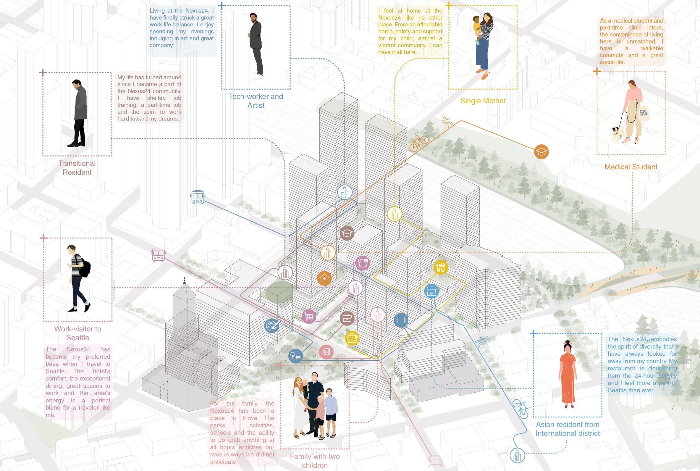
Tech-worker and Artist Medical Student Transitional Resident Single Mother Asian resident from International district Family with two children Work-visitor to Seattle
Alex works as an engineer in Downtown. He takes after-work art classes at the NexusCourthouse and lives down the with a view of the Elliot bay.
Sarah is a medical student in the UW Harborview hospital across the I-5. She works part time at the clinic for transitional residents.
Michael lives at the transitional residency since a year. He takes computer classes at the training center and works at a coffee shop.
Emily is a stylist. She lives with her 4-year old son in the affordable housing. She works in Capitol Hill and uses the daycare for her son.
Jun-Soo lives in the International district and runs a Korean restaurant. She sells food at the international market and attends community events.
Lisa and David, with their children of ages 5 and 8 own an apartment in the Nexus24. They enjoy spending time in the plazas and amenities.
Alex Johnson, 32 Sarah Ray, 25 Michael Mason, 45 Emily Riviera, 36 Jun-Soo Kim, 40 Nguyen Family, 33 John Parker, 42 At
John is an architect and visits Seattle frequently from work. He usually stays at the hotel, uses the co-working spaces and enjoys the bars under the hotel.
The spirit of Nexus24 is its 24-hour vibrancy - different people, early risers and night owls; kids and adults, on their preferred schedule can find things to do at all hours. This increases safety and strengthens the sense of being.
Activities
Market street- Intersecting Enrich & Everyday streets
Public ‘Plus’ plaza view
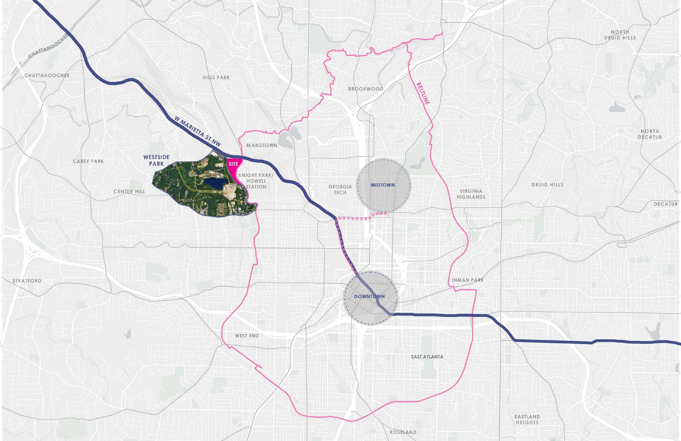
UTILIZING W MAREITTA ST TO CONNECT NEW ATLANTA TO OLD THROUGH OUR SITE
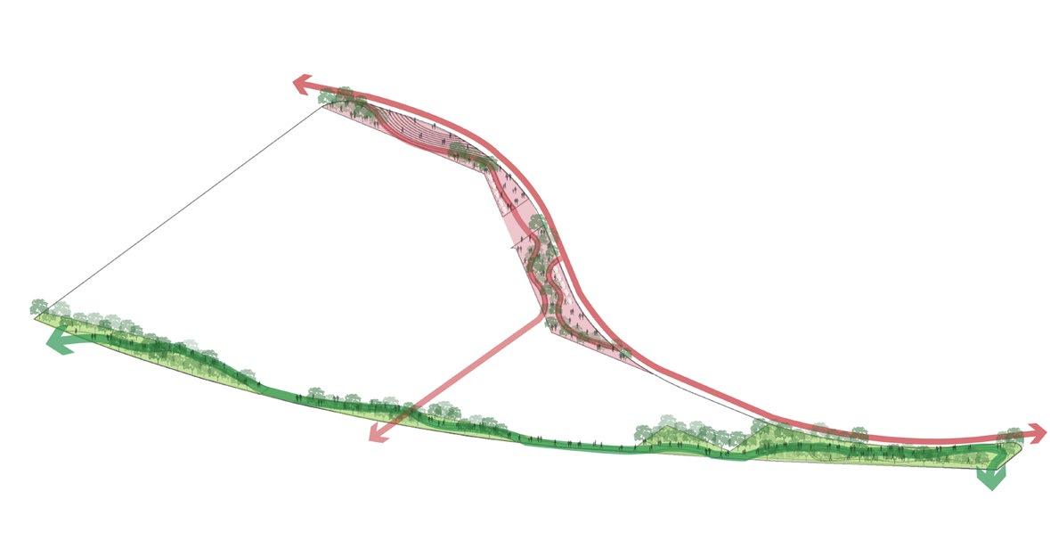
Atlanta is a city of Corridors and one such important corridor is the W Marietta St which connects the New Atlanta to the Old Atlanta through our site, dictating the overall development of the project. The second important aspect about the site is the BeltLine, currently an untapped resource, the project imagines its east edge as an activated waterfront where the main character, water, is the BeltLine. And the third important factor is the Westside Park, the largest park in the city, which inspires a park edge activation, creating a soft green boundary for the site where the existing rail line becomes a connector of the park and our site, rather than a typical divider.
Academic: Urban Design Studio
Georgia Institute of Technology: Fall 2023
Team: Mrunmayee Pawar
Guide: Cassie Branum
Roles: Research, concept and design development, illustrative productions, post-production, design presentation
Digital workflow: ArcGIS + AutoCad + Rhino/SketchUp + Photoshop + Illustrator + Indesign
+
Study of various social and physical factors affecting the site and derivation of a problem statement
CONNECT STITCH PROTECT
Atlanta is a city of Corridors, these corridors act as connectors between every part of the city.
Yet so, our site on the Greater Atlanta Westside is nothing less than an island. Although very close from the core of Atlanta,, the connectivity to the site is not great, which makes for the first big move, Connect
The Corridors of ATL, not only connect various places of the city, but on a macro level, connects the Old Atlanta to the New Atlanta. These various corridors help bring the demographics from the Greater Atlanta region to the core of Atlanta and has an opportunity to Stitching the older Atlanta to the upcoming newer developments
Atlanta is a city of Corridors and one such important corridor is the W Marietta St which connects the New Atlanta to the Old Atlanta through our site, dictating the overall development of the project. The second important aspect about the site is the BeltLine, currently an untapped resource, the project imagines its east edge as an activated waterfront where the main character, water, is the BeltLine. And the third important factor is the Westside Park, the largest park in the city, which inspires a park edge activation, creating a soft green boundary for the site where the existing rail line becomes a connector of the park and our site, rather than a typical divider
Among all these corridors, W Marietta Rd is one such corridor that connects New Atlanta to Old Atlanta through our Site & this major connectionintersection happens at our site, where it also meets the BeltLine. W Marietta Rd is also the only point of transit for our site’s neighbor, the Westside Park, therefore, the project aims to Protect it
unemployment
vacant lands gentrification poverty crime rates rent burden low income neighborhood
SOCIAL
affecting the site
Connecting this site to the city Old Atlanta to New Atlanta
WESTSIDE PARK: largest park of the city connectivity site is an island
un
Into the Neighborhood
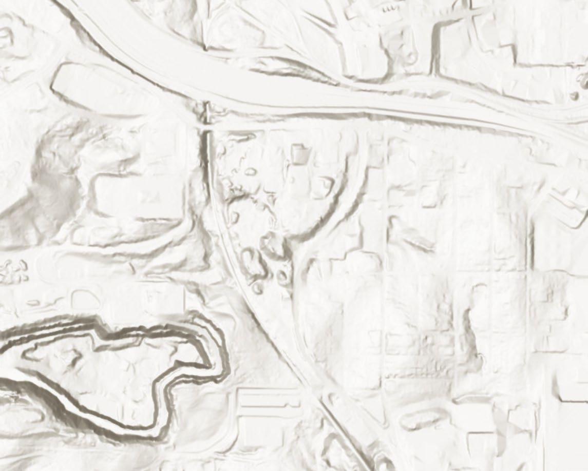
Watershed + Tree Canopy
PHYSICAL
of the site
industrial character
+
The site is significantly affected by both social and physical factors, however, for the development of a design proposal, physical factors are further worked upon extensively
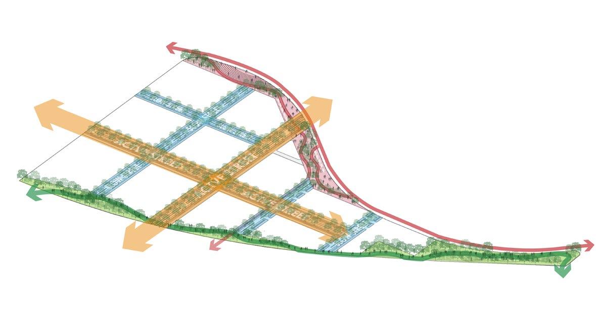
Three major ‘moves’ to develop an urban design framework for the disconnected, unstitched and unprotected site.
disCONNECTed unSTITCHed unPROTECTed FRAMEWORK
W Marietta St being the most important street here, the project utilizes it to make a connection to the city, which connects New Atlanta to Old. A Central Spine is branched from Marietta along with other two edges
The street grid is borrowed from the neighborhood and it stitches the site into its context. A major street connection is created through the Access street which comes from the neighborhood and goes to the park
West Atlanta are the lungs of the city. Tree canopies are visualized throughout the streets to expand the western lung and protect the watershed through the design ideas and proposals of stormwater infiltration collection
Overlaying the three moves creates a final framework plan which promotes activated park edge to bring in the Westside park into our site and a public edge which untaps the beltline as a major resource of the site
7.
6.
5.
4.
3.
2.
1.
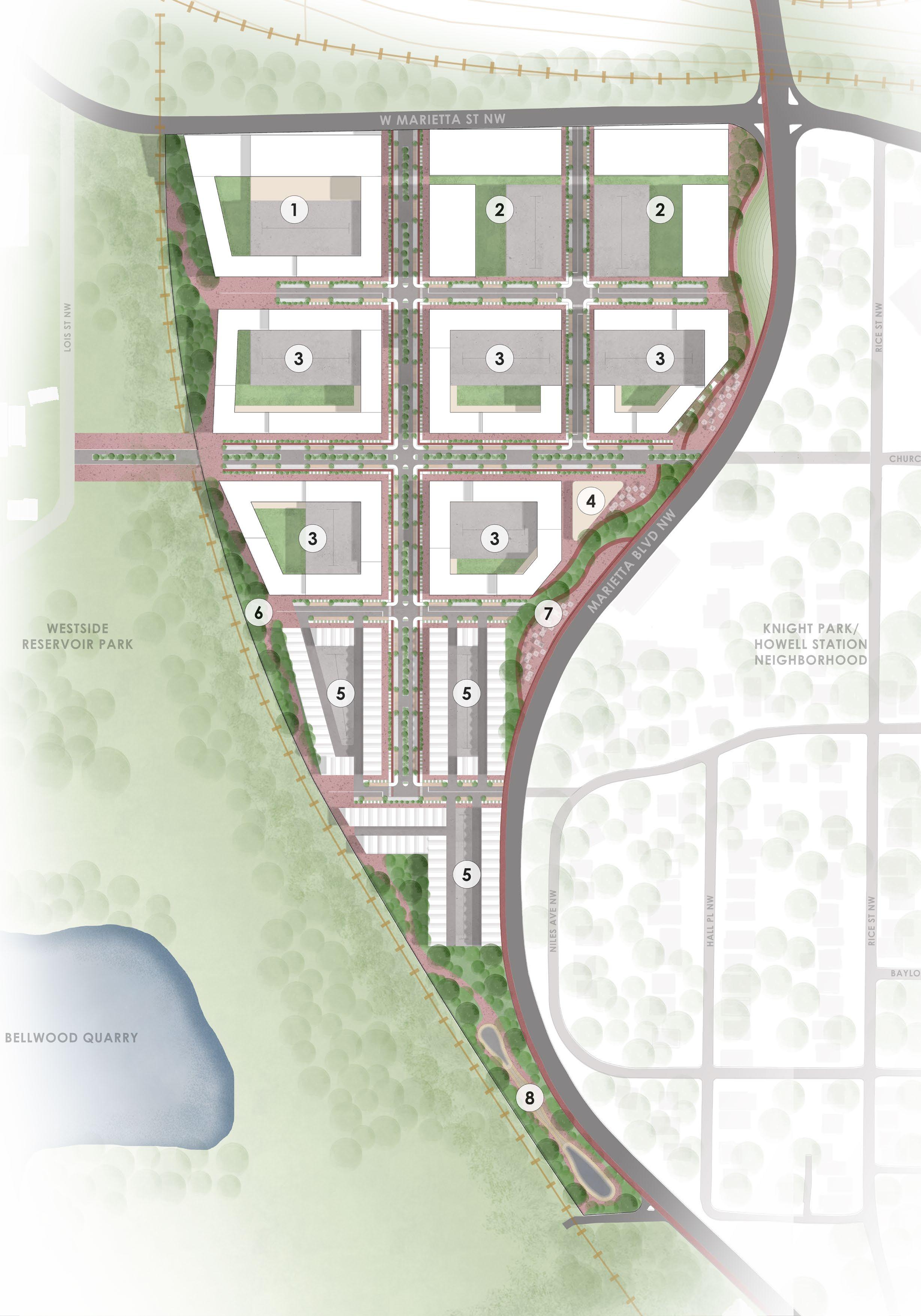
Study
5.
3.
1.
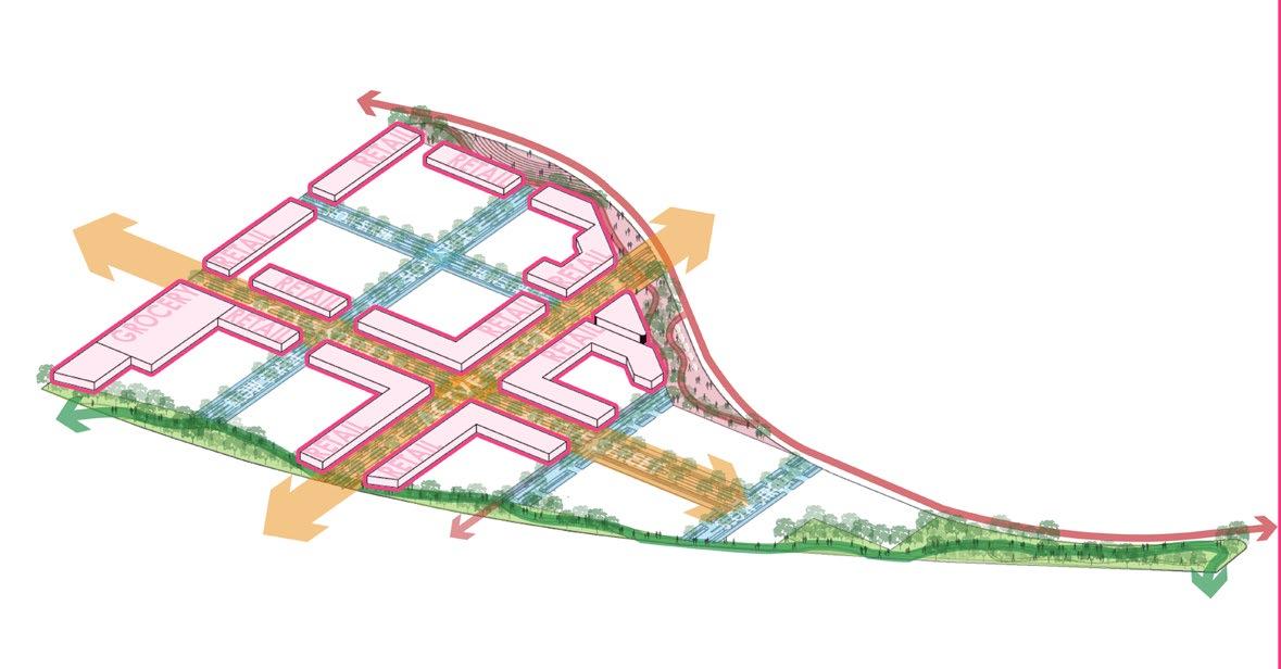
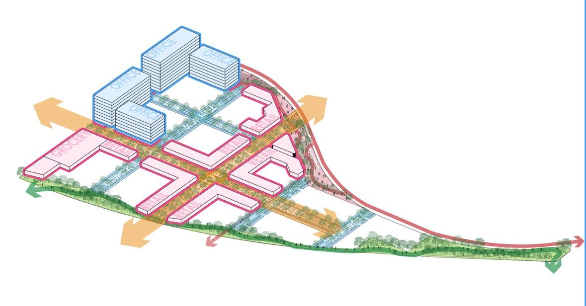
activating the western edge as an extension to the westside park and east as an activation to the beltline
2.
creating main active street as a connector between the neighborhood and park and slow street; and expanding the western lung
4.
activating the ground floor with retail activites densifying the major junction with office blocks

cascading the built from the W Marietta junction down to the Westside park
6.
providing office spaces for all types of uses

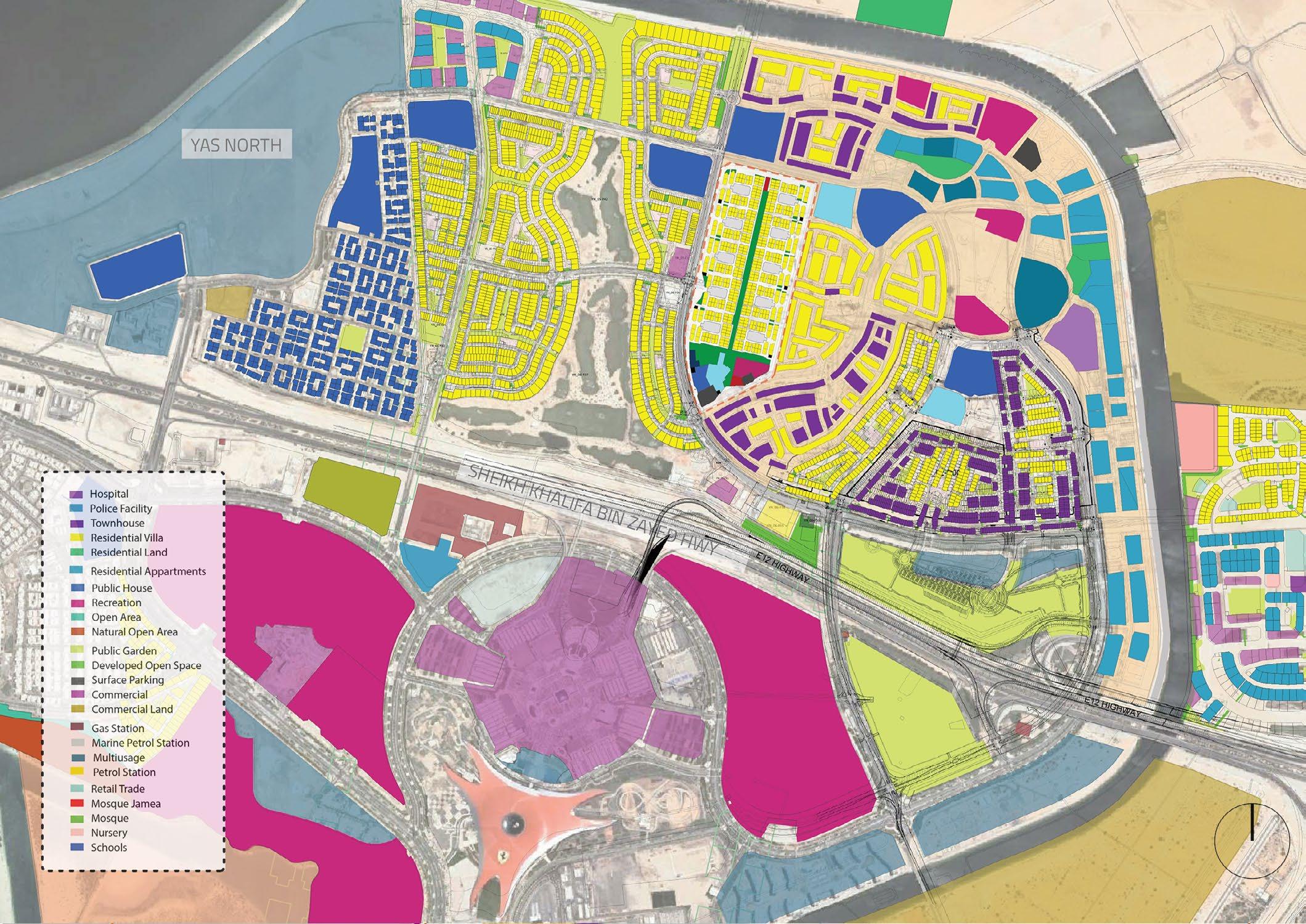
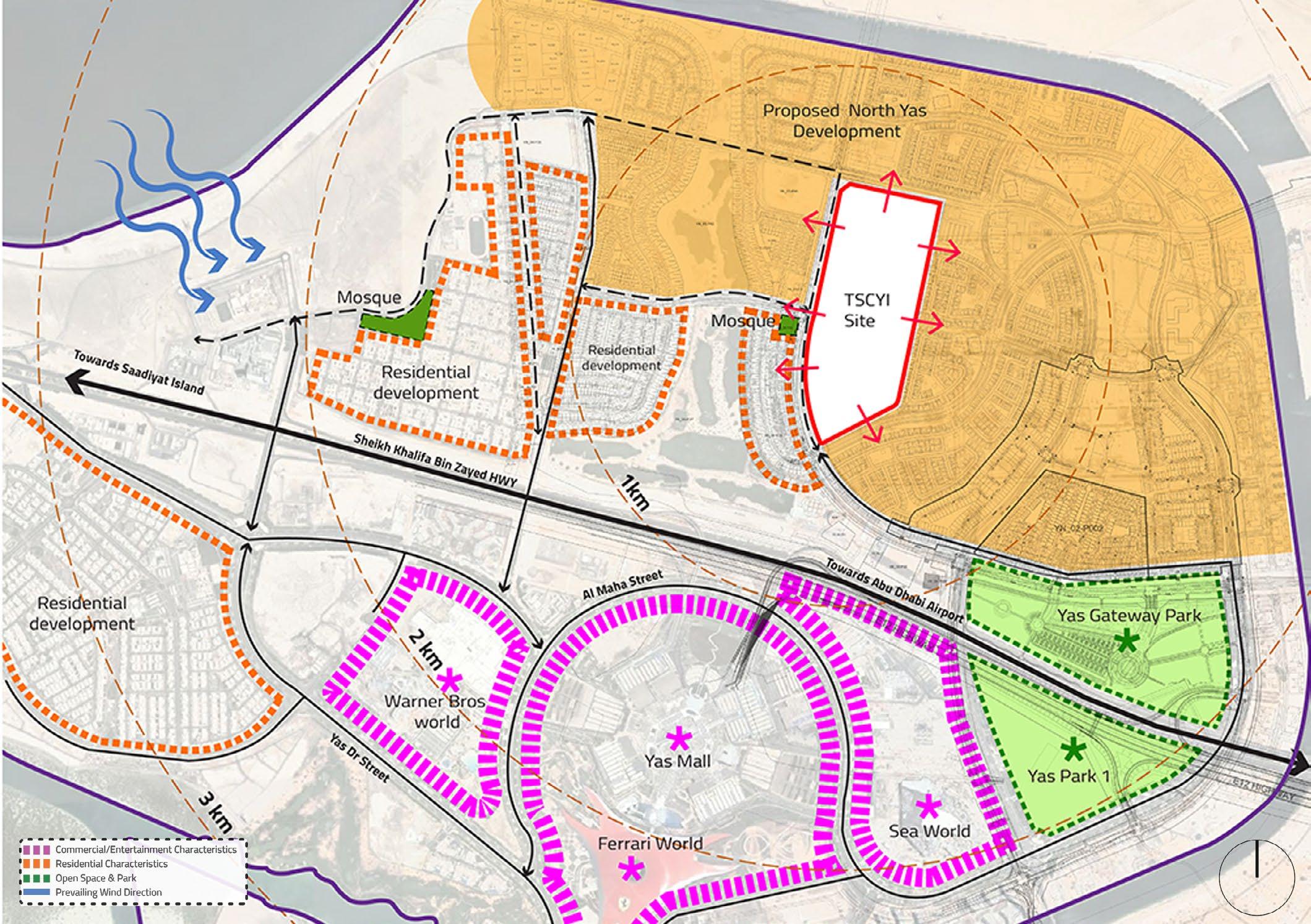
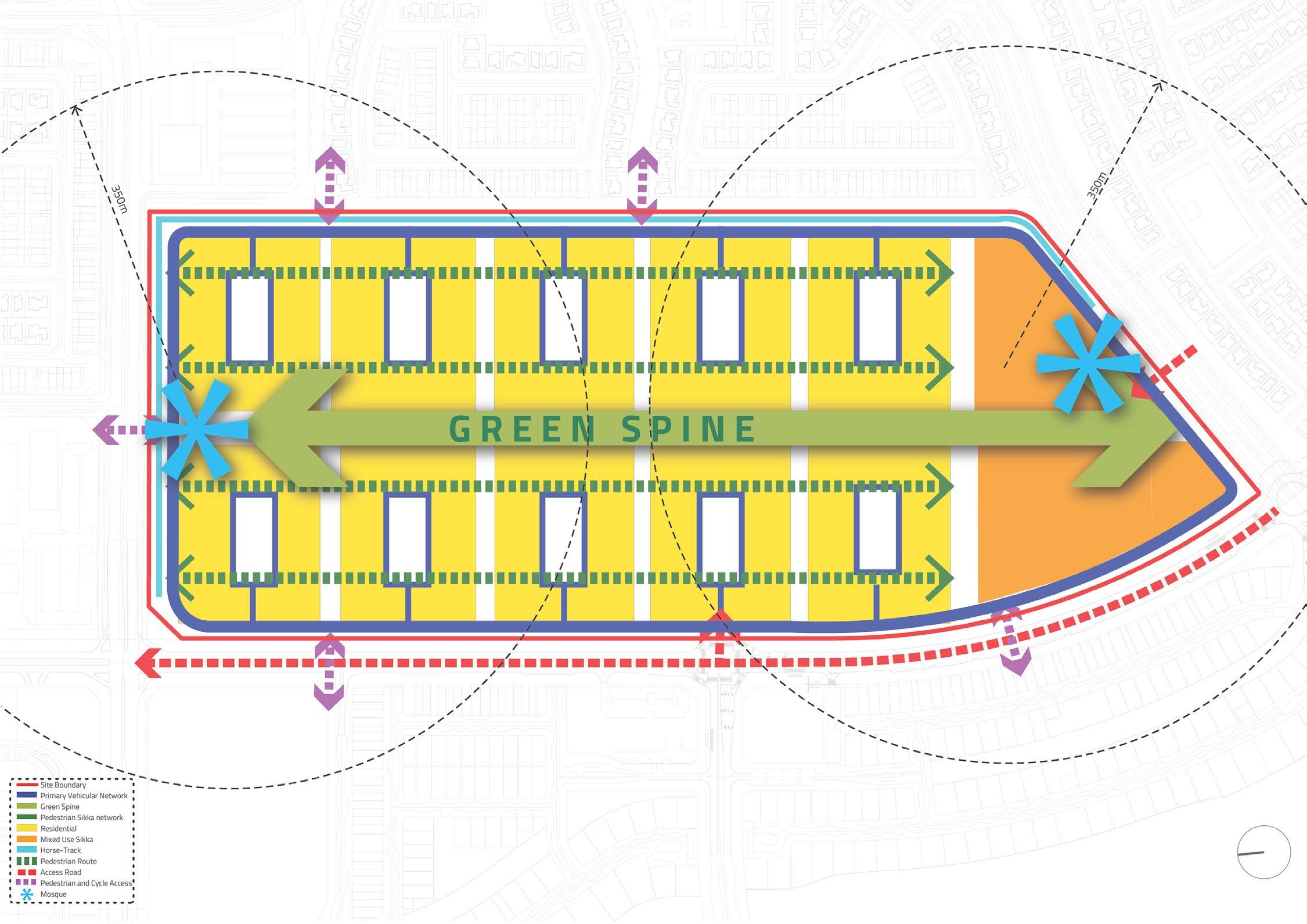
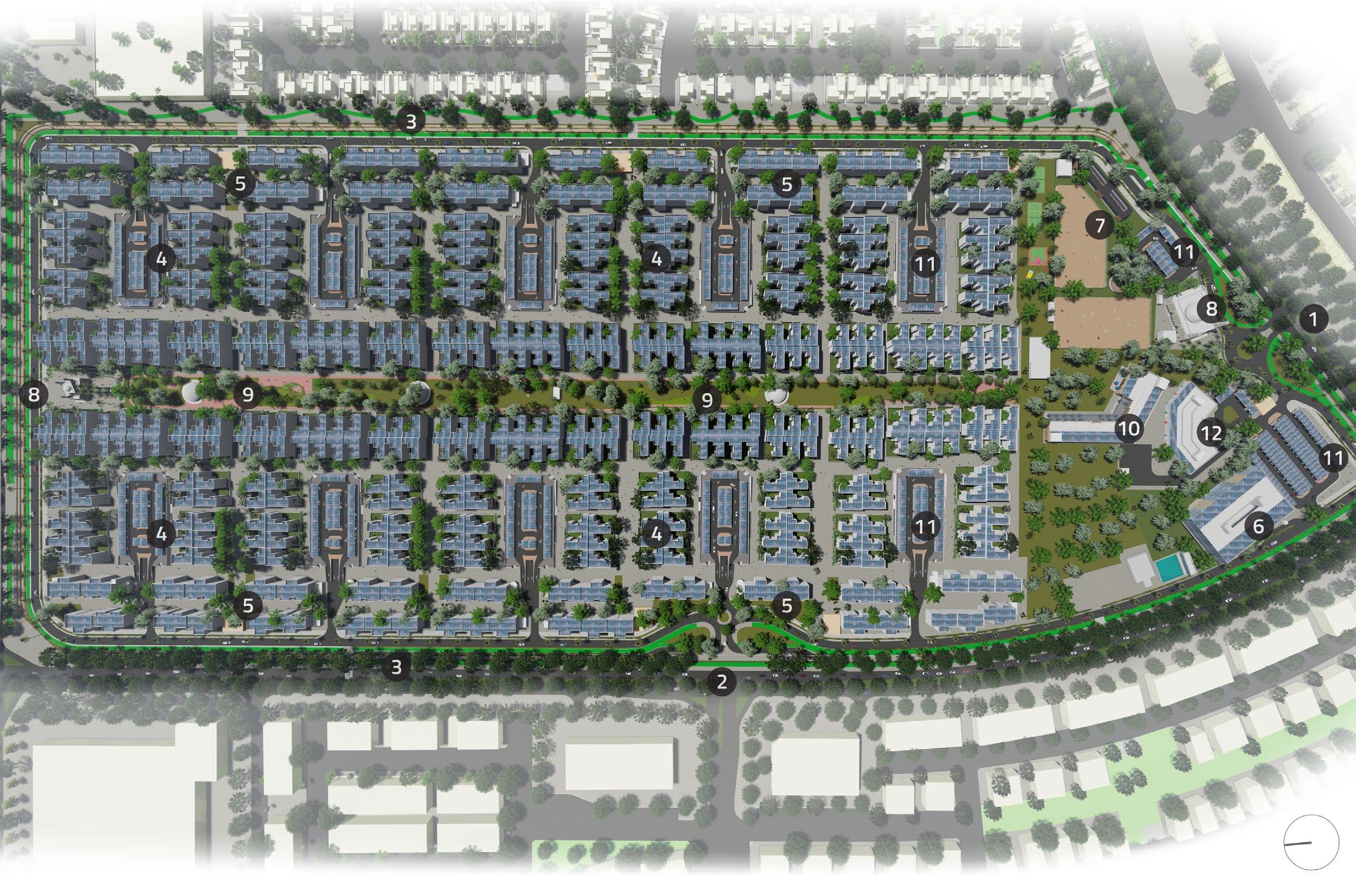
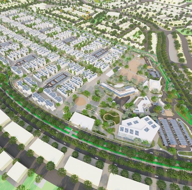
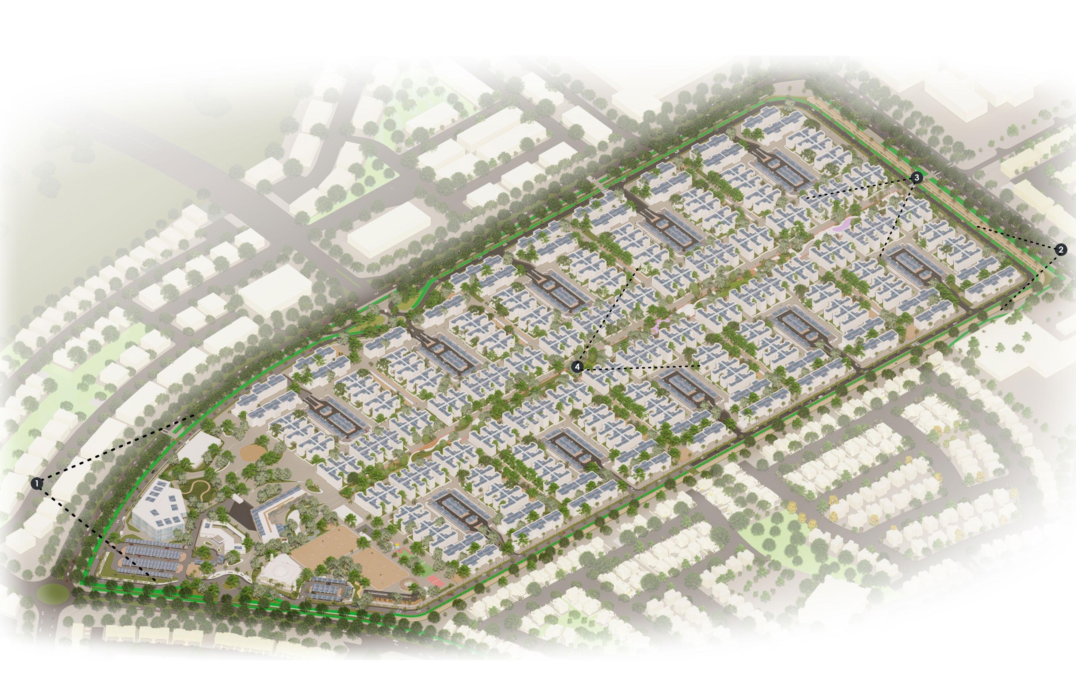
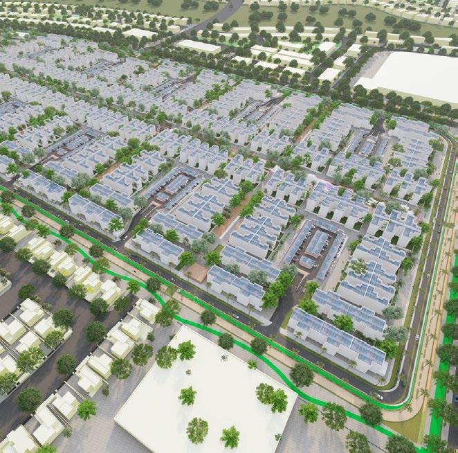
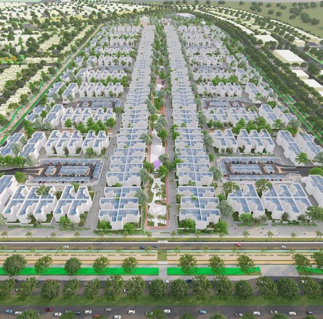
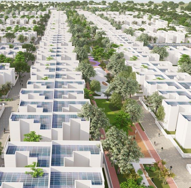
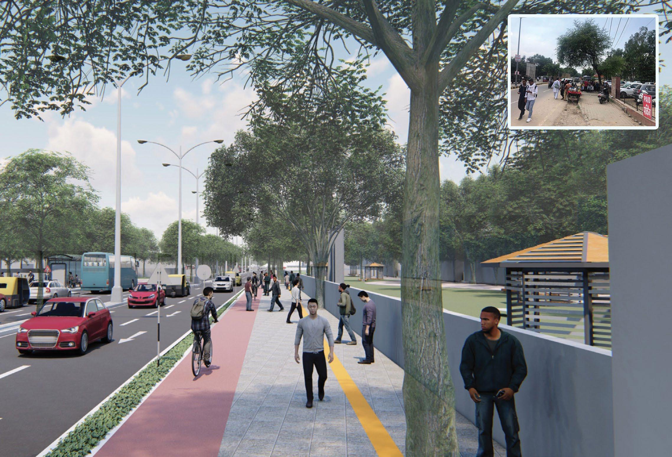
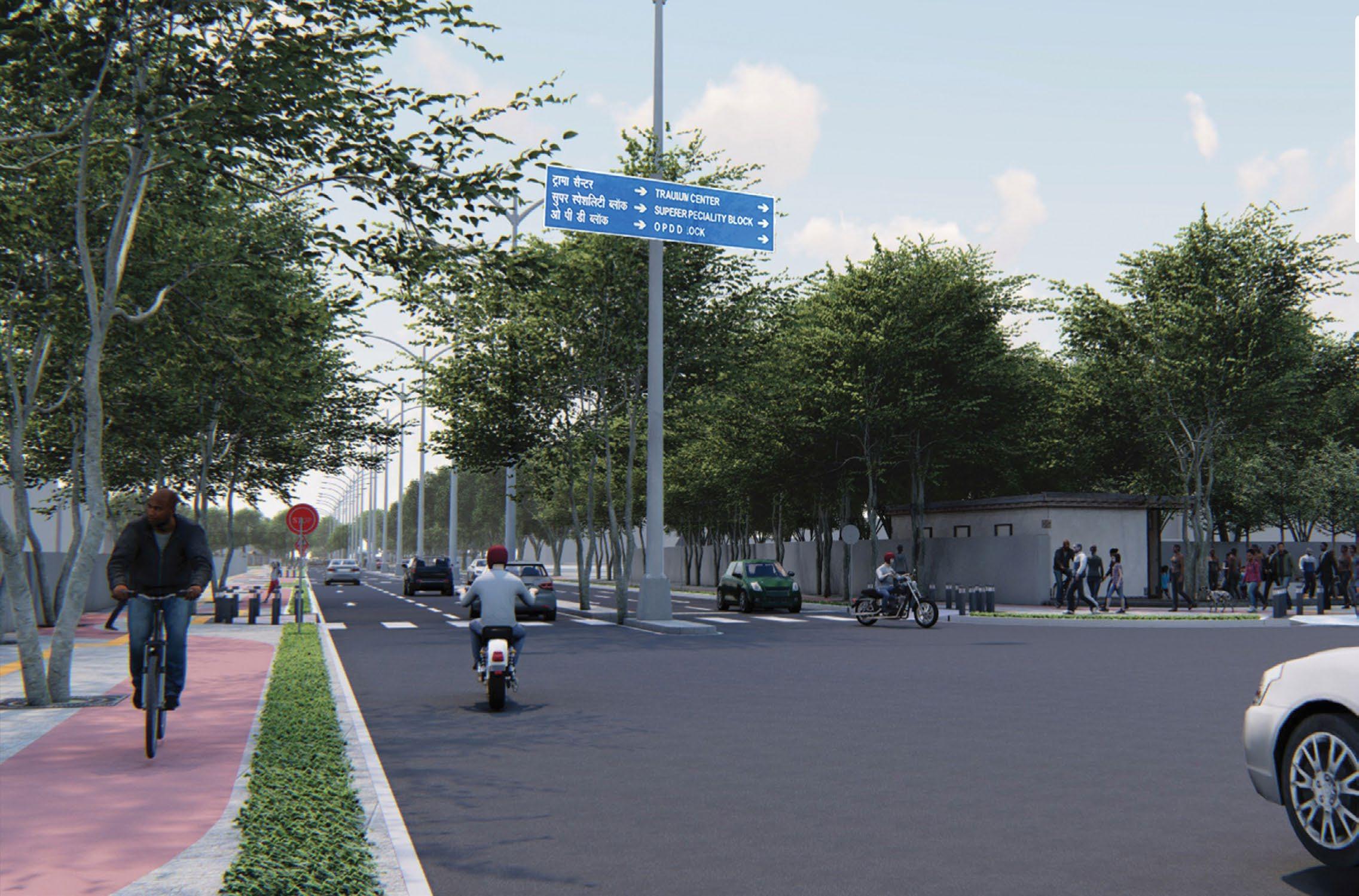
DESIGN GUIDELINES AND DETAILED REPORT OF THE MASTERPLANNING OF A SUSTAINABLE CITY IN UAE
The Sustainable City Yas Island (TSCYI) project sits on a 39.6 hectare piece of land & is a unique development which aims to demonstrate how the three elements of Sustainability: social, environmental and economic can come together harmouniously to create a beautiful and thriving community for its 3,600 residents. Some key features include maximizing comfort zones within the public realm, limiting vehicular access to the periphery of the city so as to maximise pedestrianized spaces, implementing the concept of shared parking so as to provide better and more sustainable opportunities for space utilization, mitigating the urban heat island effect through landscape and light coloured construction materials and incorporating energy production through solar panels throughout the city. The scope of work paperwork and assessment, detailed masterplanning report, illustrative documentation for reports, plot calculations and diagram creation, 3D modelling & visualisation, client presentations.
Professional: Detailed Masterplanning Report
Anil Nagrath & Associates: 2021-Present
Team: Aditya Hajare, Dhruv Karmokar, Mrunmayee Pawar
Guide: Anil Nagrath, Arijit Sen
Roles: Concept and Design Developemnt Report, GIS drawings, Development Control Regulation sheets, client presentations and 3D visualisation
Digital workflow: ArcGIS + AutoCad + Rhino/SketchUp + Photoshop + Illustrator + Indesign
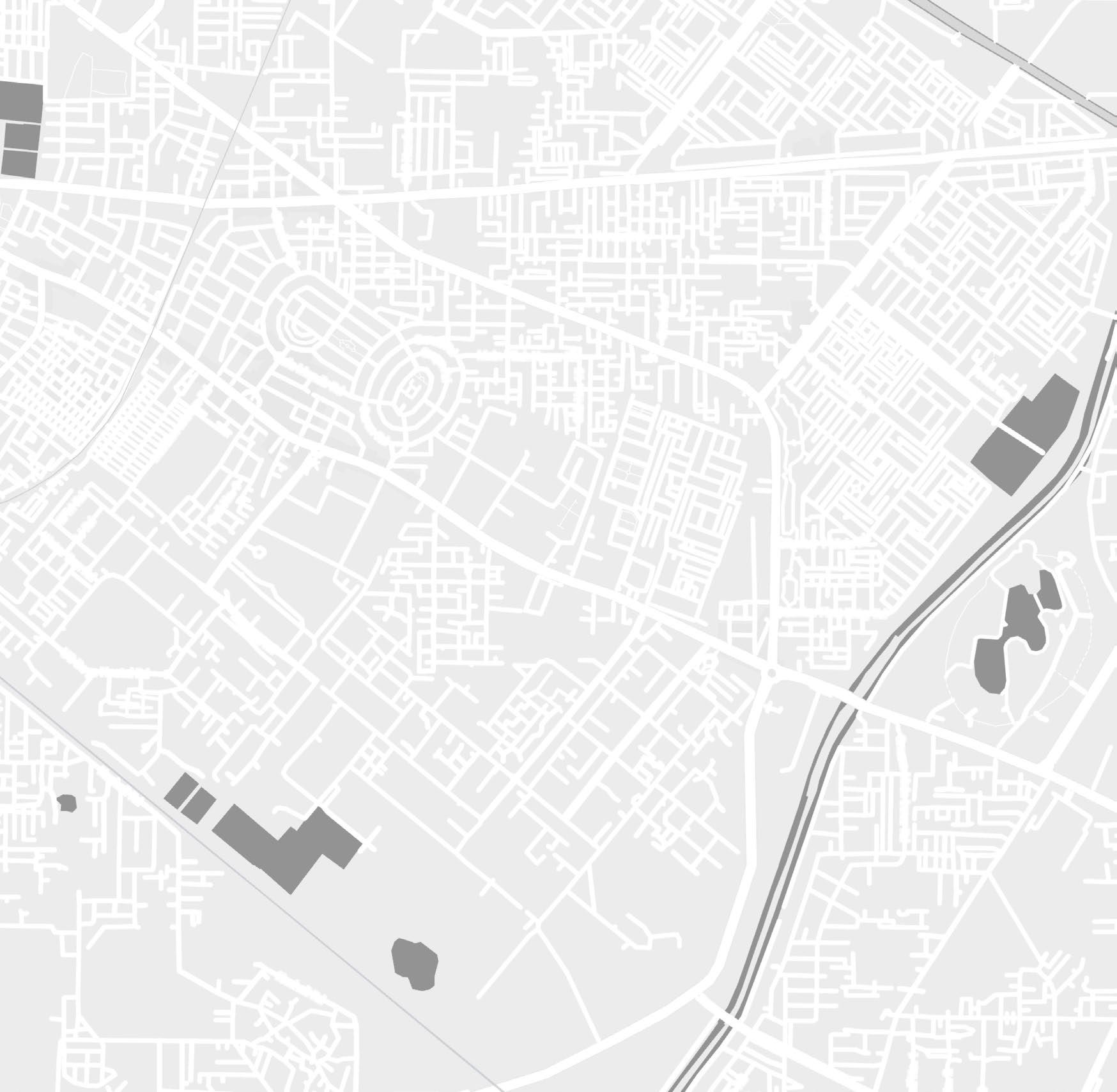
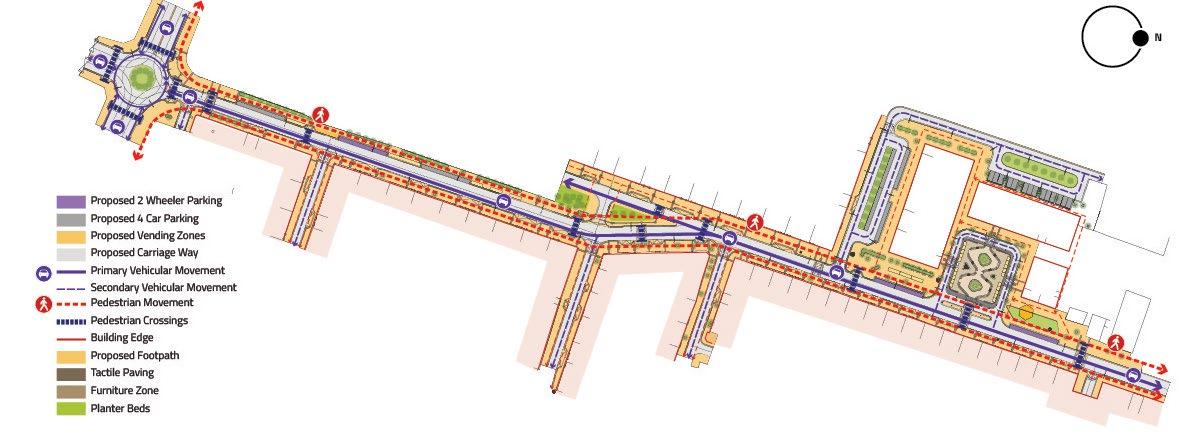
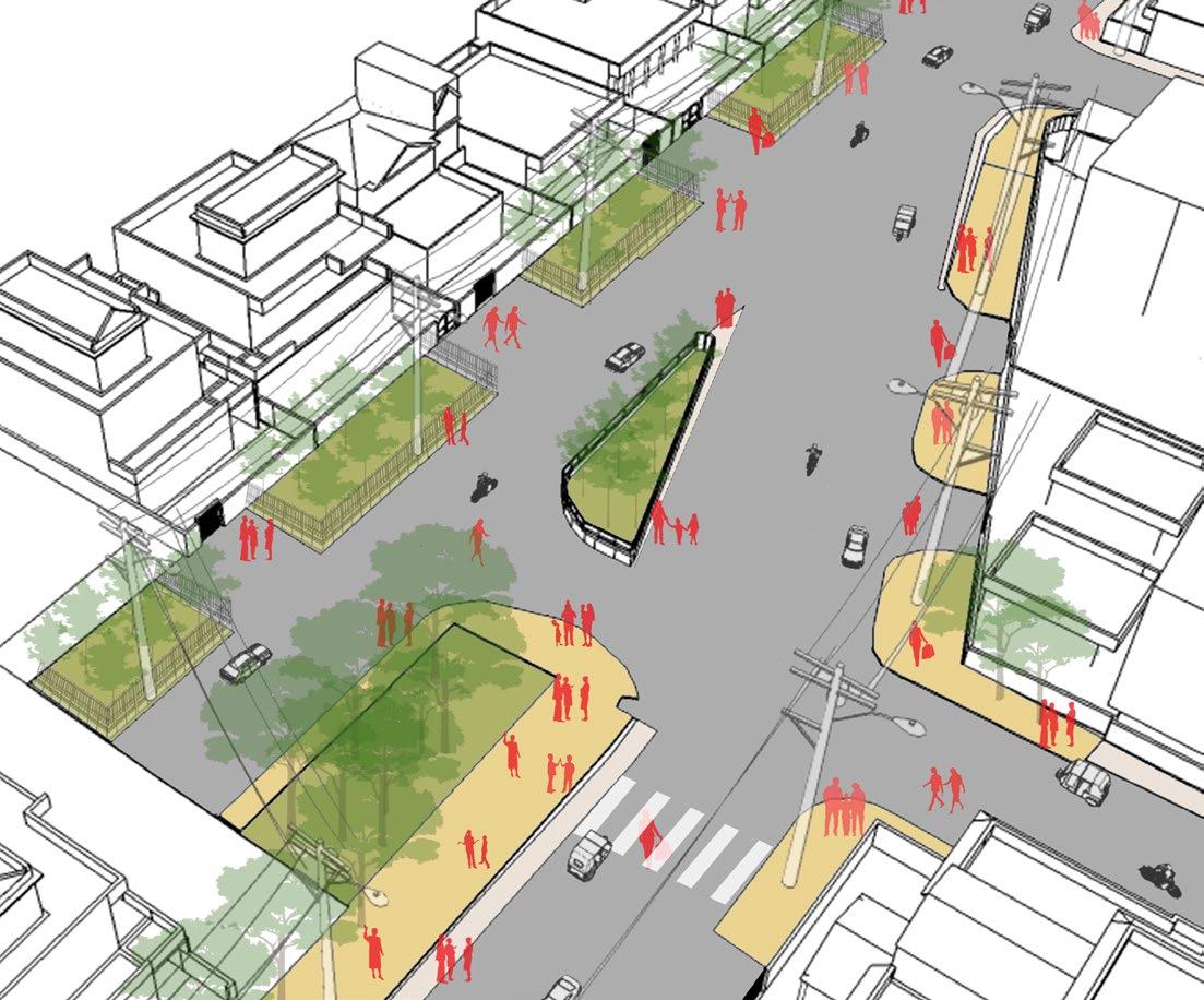
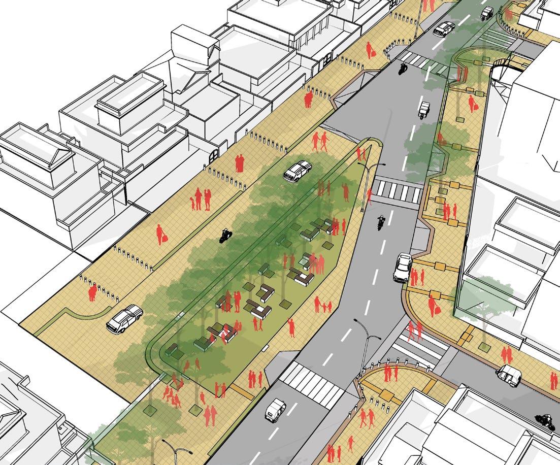
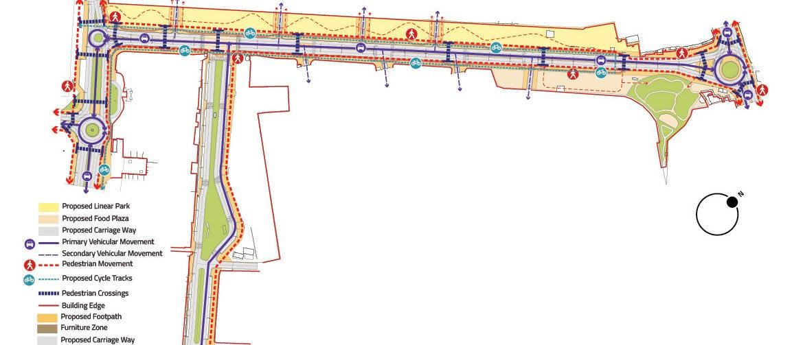
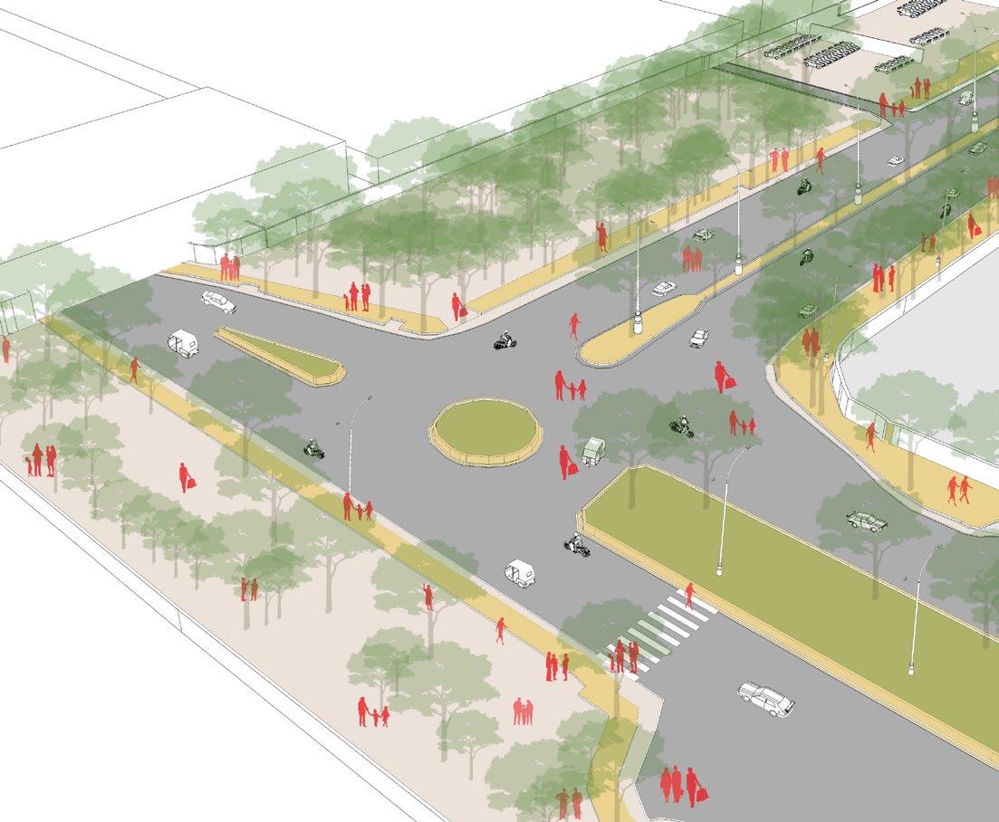
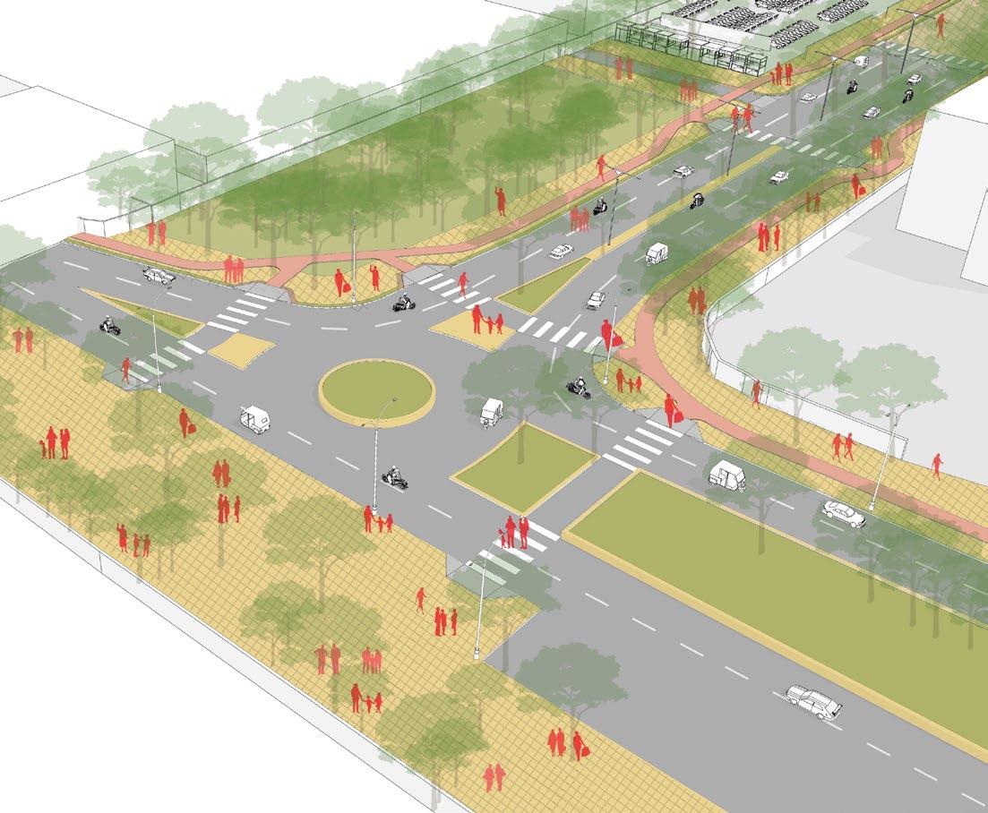
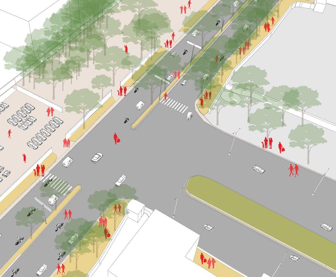
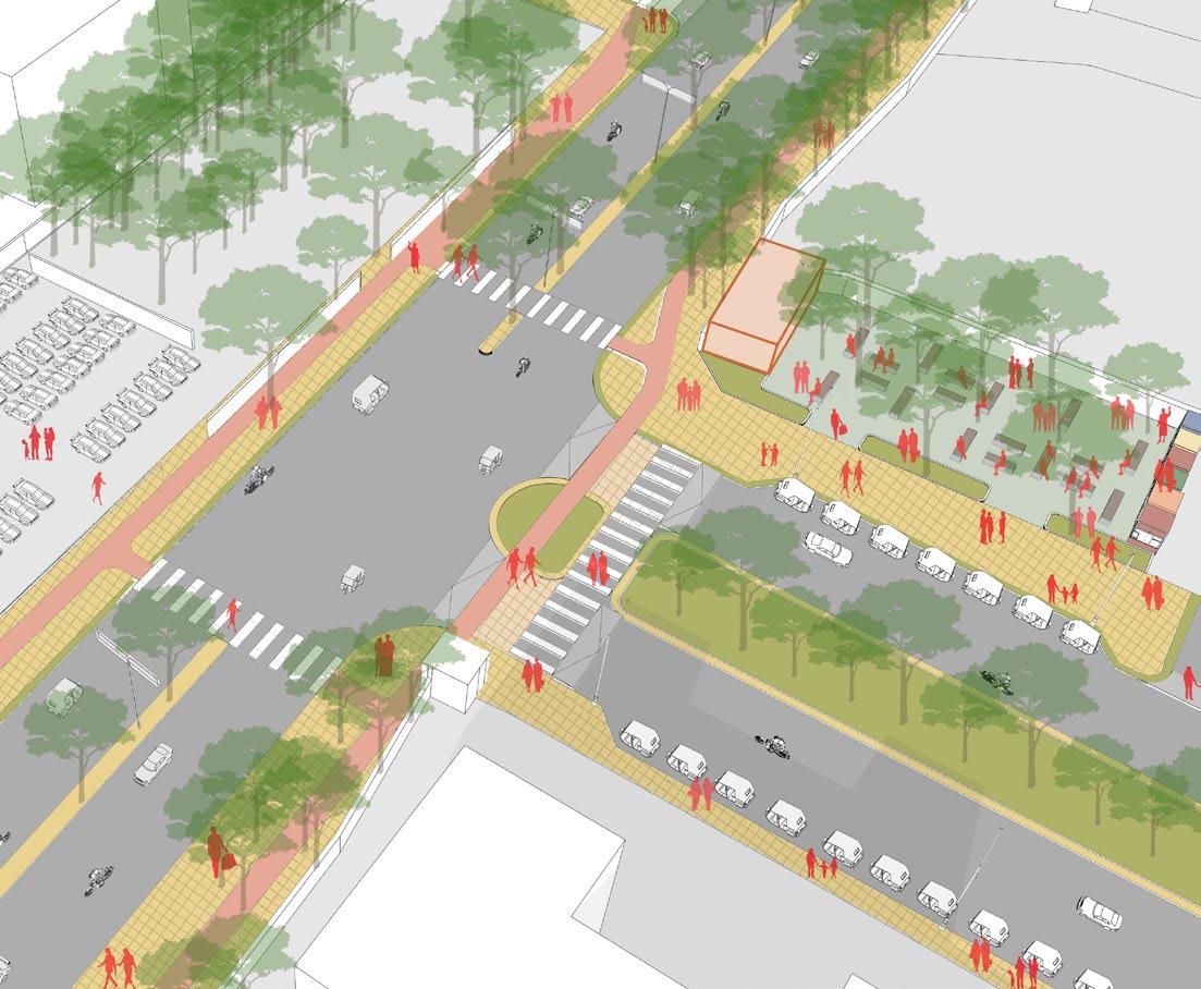
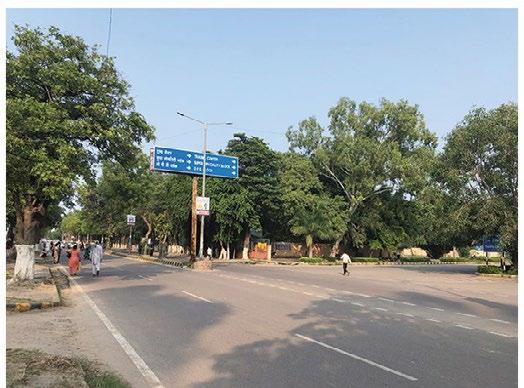
STREETSCAPE, PLACEMAKING AND TACTICAL URBANISM FOR 2 KEY STREETS IN THE CITY OF ROHTAK, INDIA
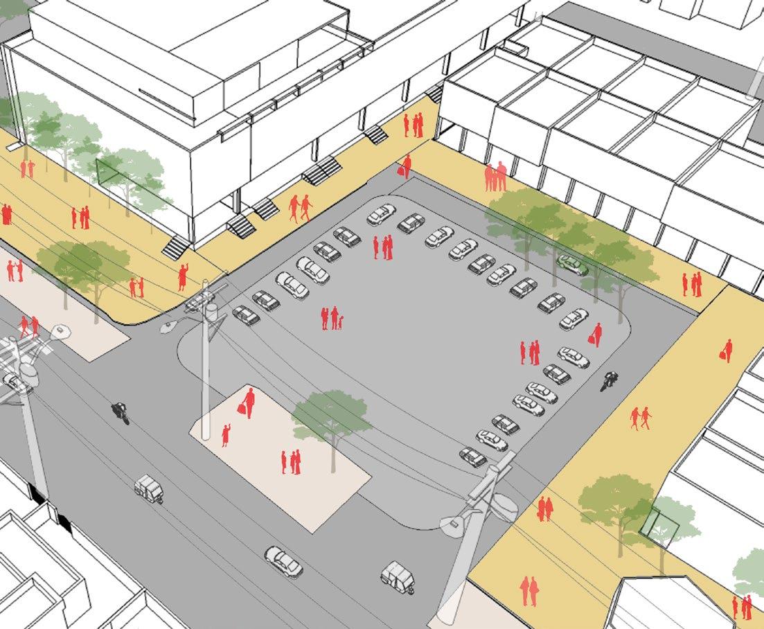
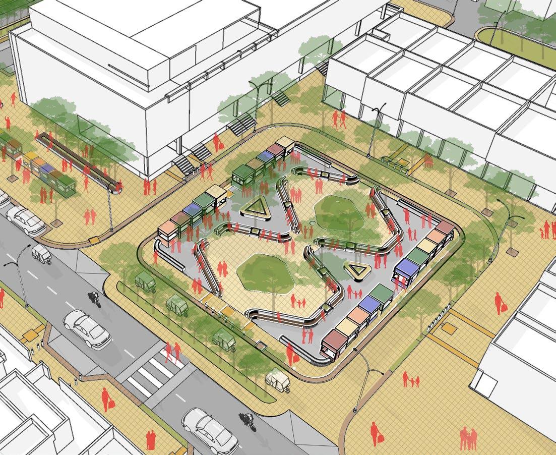
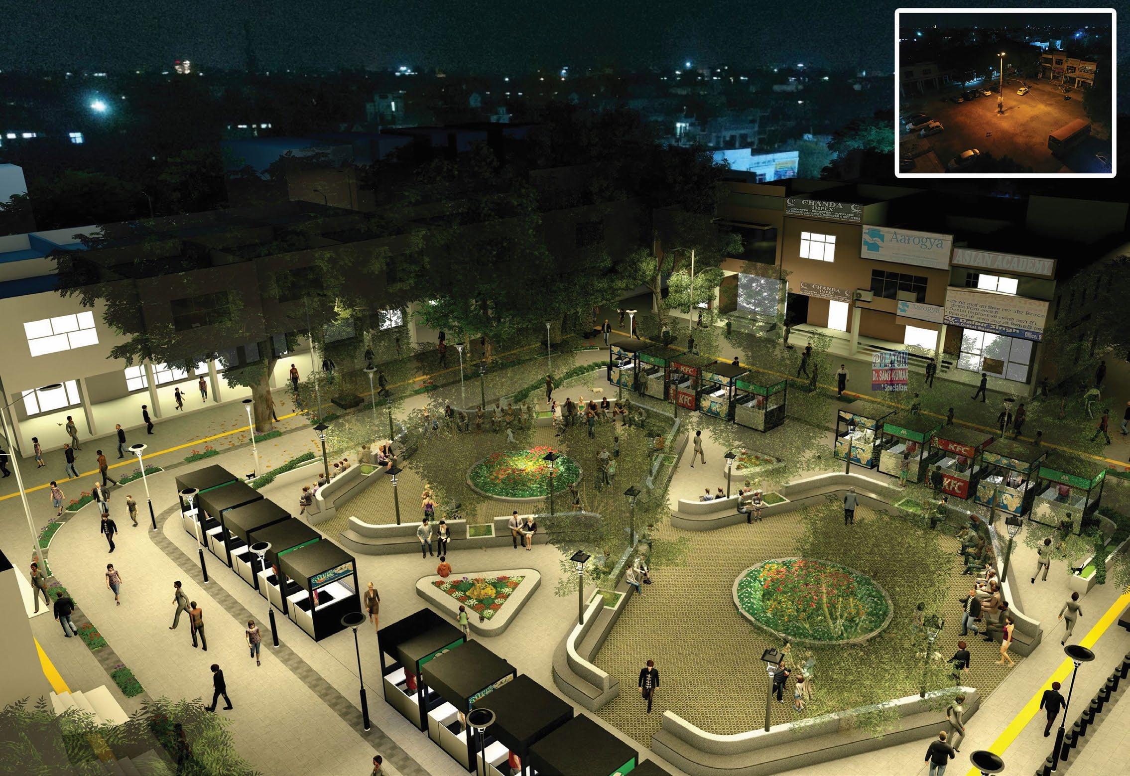
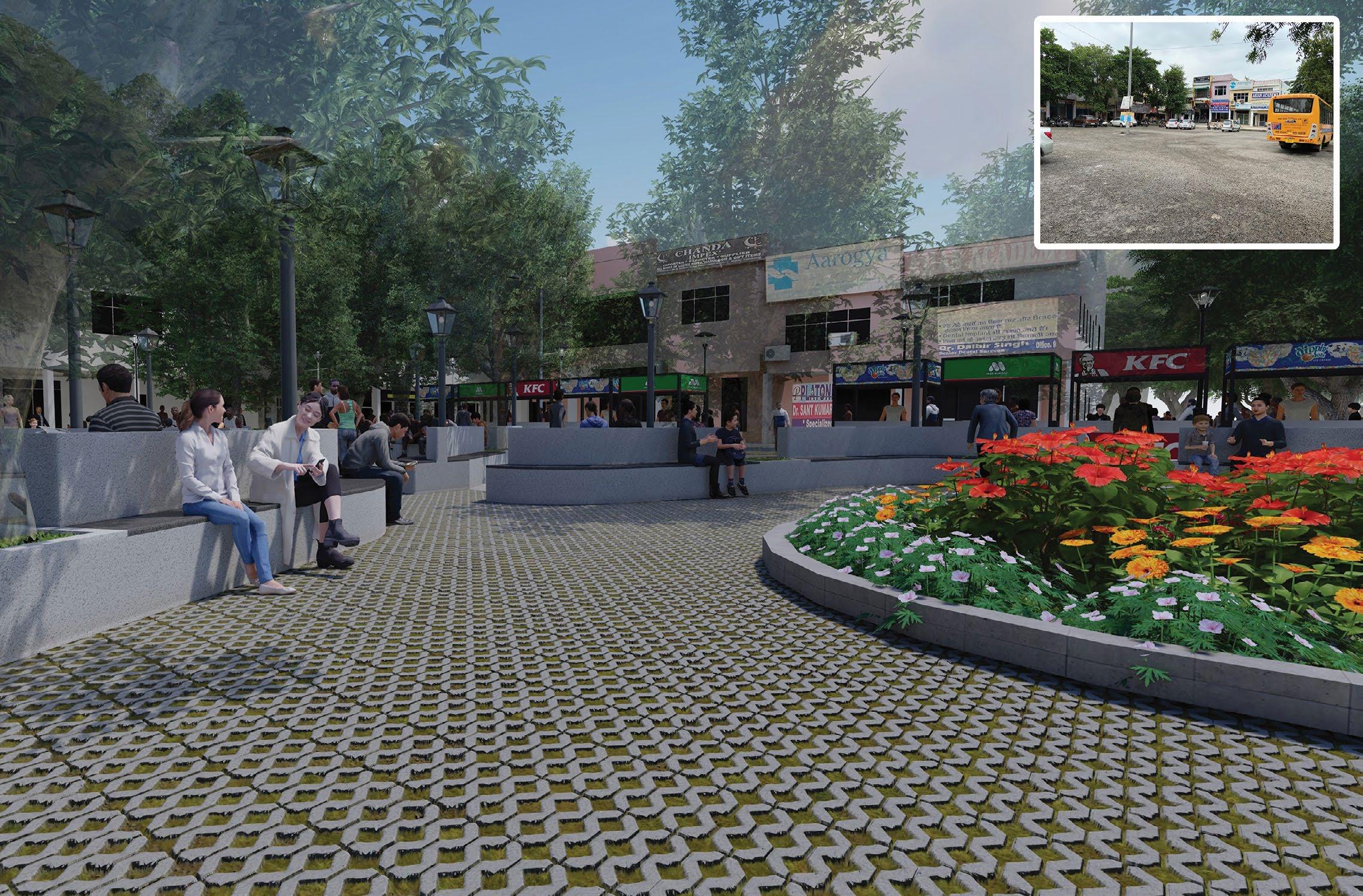
The Mahra Rohtak Play(ce)making project provides and opportunity to reimagine public spaces and streets for safer, inclusive and public centric spaces, keeping the focus on the youth. The scope of work includes documentation of two streets, design and layout developments and experimentations of Tactical Urbanism. Proposal for two streets have been worked out keeping in mind the character of each street. The Sector-14 street is admist a residential area for which a homely vibe has been created by provided vending activities, pocket parks, neighbourhood plazas, etc. Medical Road is an institutional street for which youth appealing spaces have been proposed, such as food zones, theme plazas, public parks, etc. Each street with its character tells its own story through the spaces designed for them.
Professional: Street Design and Placemaking
Anil Nagrath & Associates: 2022
Team: Aditya Hajare, Dhruv Karmokar, Mrunmayee Pawar
Guide: Anil Nagrath, Arijit Sen
Roles: Detail design development, Street layouts, Schematic and detail drawings, tender drawings, and 3D visualisations
Digital workflow: ArcGIS + AutoCad + Rhino/SketchUp + Photoshop + Illustrator + Indesign
+
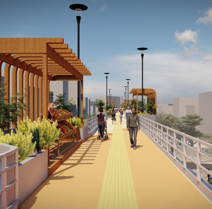
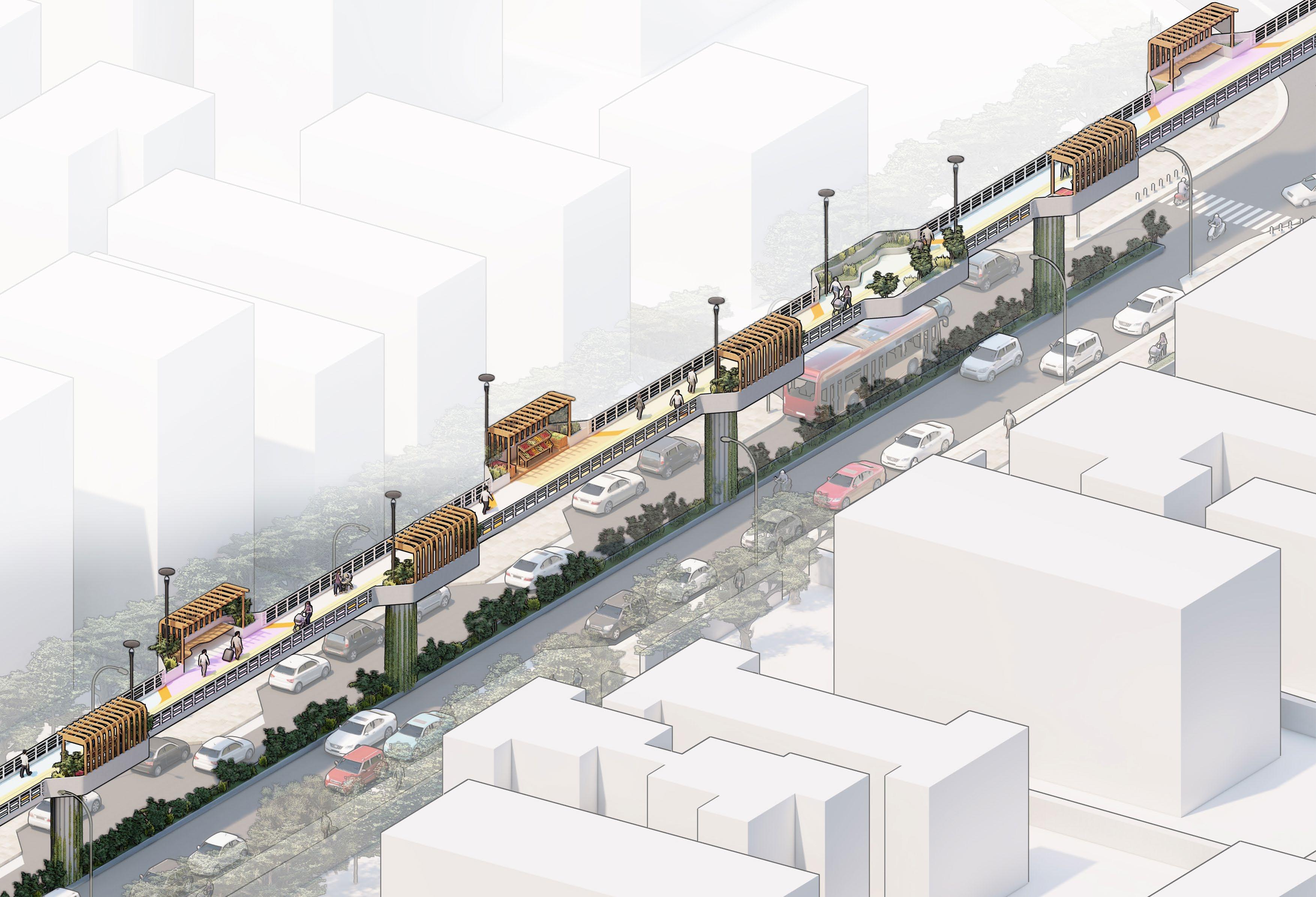
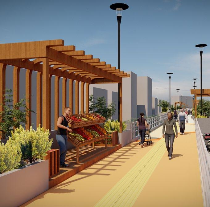
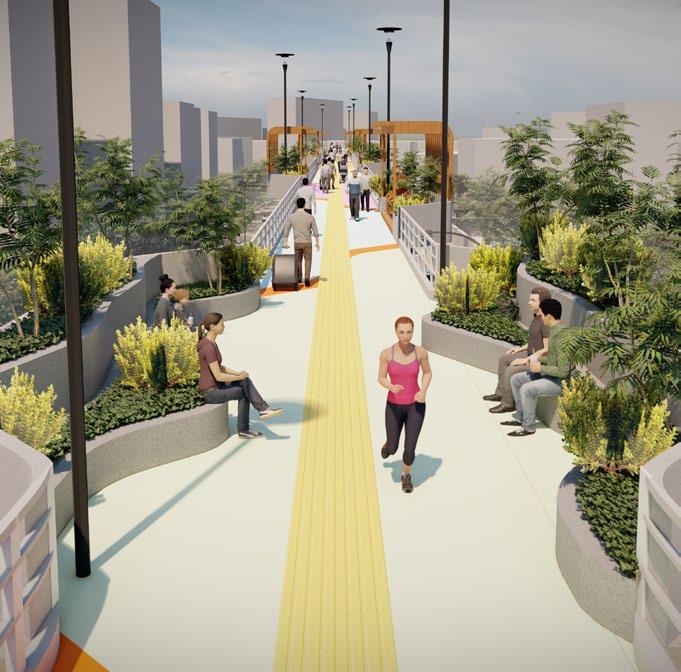
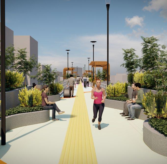
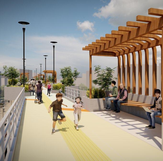
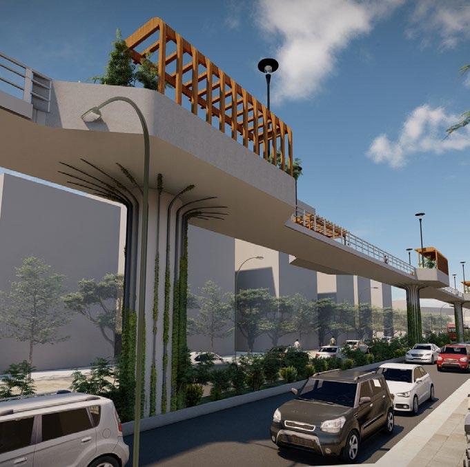
The Central Avenue is the main road connecting the Chembur station with a public garden. This connectivity becomes the hotspot for buildings and commercial along the peripheral roads consisiting of restaurants, food shops, etc. The existing road has high footfall as it connects two major spots of the Chembur precinct, this also gives rise to major traffic congestion in the area on daily basis. To decioher this alarming concern, a design for skywalk has been proposed within the railway station precinct. The skywalk is imagined to not only solve the traffic congestion of roads but to also activate the pedestrian friendly movement in the precinct. The potential of the Central Avenue skywalk is also to develop green landscaping pockets, integrates the concept of biophilic design, proposes semi-covered seating, hawking zones, graphical apporach and also is tactically paved for universal accessibility.
Professional: Urban Inrastructure
Anil Nagrath & Associates: 2022
Team: Dhruv Karmokar and Mrunmayee Pawar
Guide: Anil Nagrath, Arijit Sen
Roles: Project Co-Lead, Concept and Design Developemnt, Schematic and detail drawings, 3D visualisations
Digital workflow: ArcGIS + AutoCad + Rhino/SketchUp + Photoshop + Illustrator + Indesign
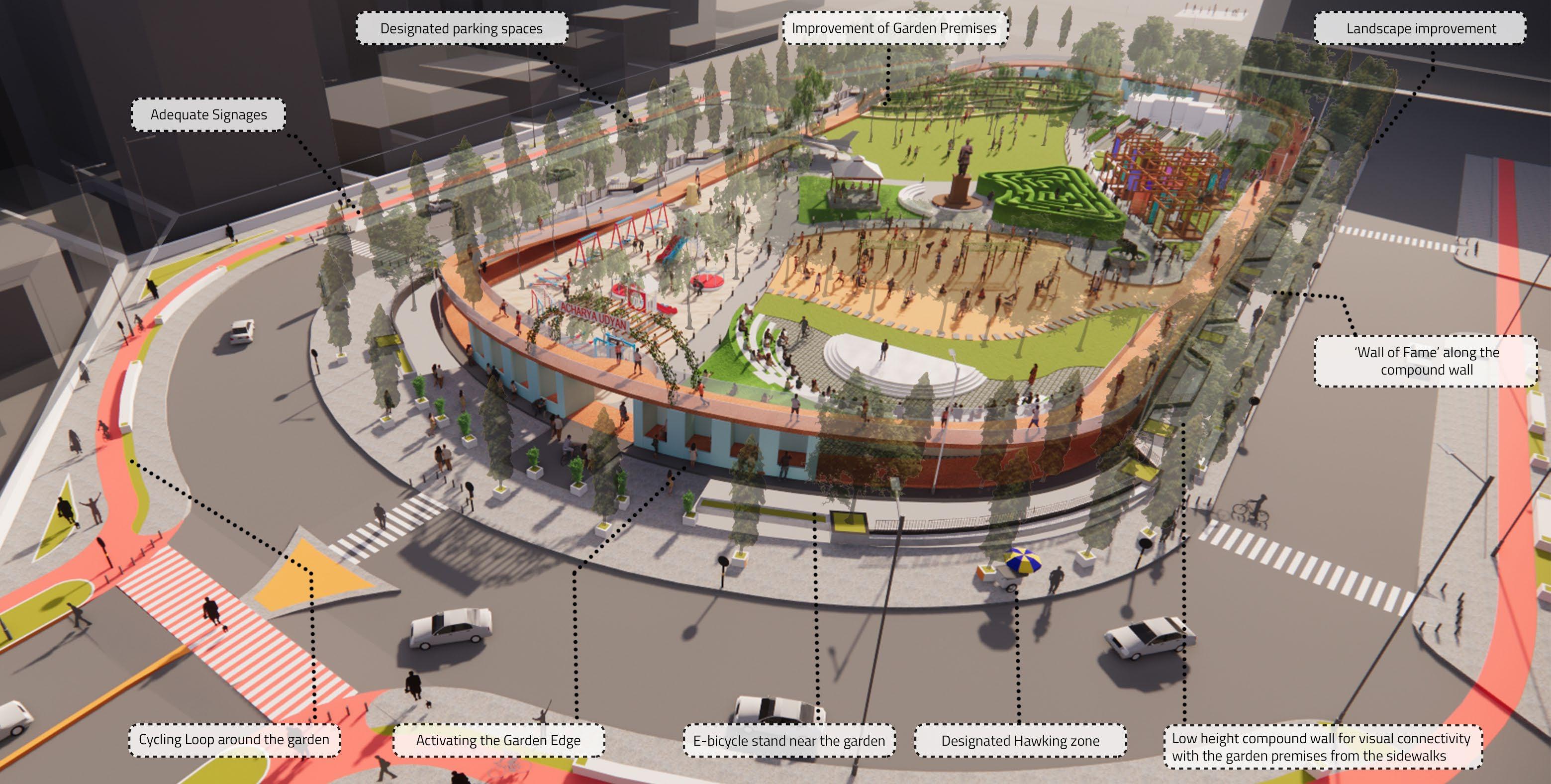
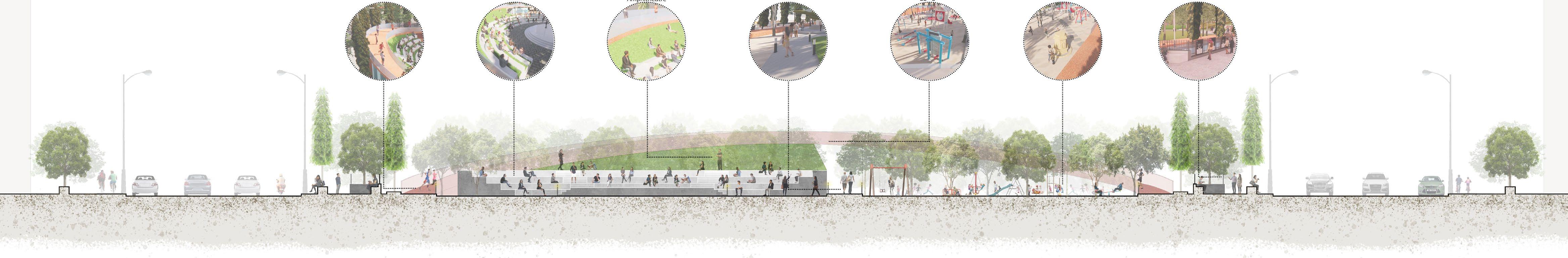
Acharya Garden, commonly also known as Diamond Garden is a huge public park situated in the busy streets of Chembur, Mumbai. The garden is a link between the main expressway and Chembur Railway station. Being located in such locality, it attracts public throughout the day. The junction formed by the garden also an attractive spot for recreational activities and along the peripheral roads we have restaurants, food shops, etc. To maintain this food and public culture, kiosks are introduced at the entrances of the garden. Along with-it other activities like the yoga lawn, the open gym, plant nursery, open air exhibition, etc. are a result of various on going and ill-maintained program. The newer program introduced to rejuvenated the garden develops a strategy in way that activates the entire pedestrian movement in and around the garden premises.
Professional: Urban Park Development
Anil Nagrath & Associates: 2021
Team: Mrunmayee Pawar and Rushabh Sanghvi
Guide: Anil Nagrath, Arijit Sen
Roles: Project Lead, Concept and Design Developemnt, Landscape Layouts, Client Presentations
Digital workflow: ArcGIS + AutoCad + Rhino/SketchUp + Photoshop + Illustrator + Indesign
Thank