DRAFT STRATEGIC REGENERATION FRAMEWORK
Volume 2: Supporting Regeneration Strategy
January 2023
1

Station Square Visual CHESTER CITY GATEWAY 2 3


CHESTER CITY GATEWAY 5
Fo reword 6 0 1 E xecutive Summary 8 0 2 I ntroduction and Overview 1 6 03 D rivers for Change 2 6 04 Local Context 3 4 05 S trategic Regeneration Context 6 4 06 Ch ester City Gateway Vision 7 2 07 Key Moves 80 08 Places 1 14 09 C ross-cutting Themes 1 86 10 Il lustrative Masterplan 1 92 11 De livery and Implementation 1 98 12 A ppendices 2 06 Contents Potential view looking east from Station Road towards the Carriage Shed 4
Project Team
FOREWORD
Chester is proud of its history and confident about its future. Chester benefits from a strong economy, unique heritage assets, world-class tourist attractions and is a regional gateway and economic driver to North Wales, Merseyside and the North West. Chester is a great place to live, do business and study.
Chester City Gateway is a key part of the City’s transformation. Chester attracts 36 million visitors each year, many of whom arrive at Chester Railway Station before onward travel to world-class tourist attractions and into the City’s primary shopping streets. The Railway Station is also a key connector to the wider Cheshire, North Wales and Merseyside area, and beyond, with many residents and businesses reliant on the railway network to connect into other principal towns and cities. Nearly 5 million passengers use Chester Railway Station each year.
The location of the Gateway links existing residential communities to the north and east, such as Hoole Village, with Chester City Centre, and has an ability to become a destination in its own right, with the potential to create a thriving new hub for Chester, complete with new independent retailers and eateries alongside high-quality offices at City Place and new homes. Importantly the success of the Gateway will be measured on its ability to draw new people into the City Centre, to want to live and work in Chester, and encourage more footfall and vibrancy into the heart of the primary shopping area.
The Gateway is a key project, which, once delivered will build upon the achievement of Chester’s One City Plan’s significant investment of over £222 million in regeneration projects from public and private sectors.
We are working with LCR who are a UK Governmentowned company which specialises in railway-led regeneration, and have a clear mandate to support the drive to deliver new homes, jobs and public value, and the levelling up of the economy.
LCR’s success stories include the exemplary transformation around Kings Cross in London and the redevelopment of the long derelict Mayfield Depot in Manchester, which includes a new urban park.

This Draft SRF presents a strong vision for the Gateway, recognising the untapped potential that this part of Chester can deliver and unlock, not only supporting the resurgence of the Gateway’s hinterland, but also its potential in regenerating the wider City Centre and Chester’s local economy.
We recognise that it will take time to deliver our ambition and that the Council cannot deliver this alone. We will need to work in partnership with key landowners and stakeholders in the Gateway to ensure its success. This Draft SRF provides a tool in which to attract new investment into Chester, as well as set out the Council’s position and aspirations on development and design standards that we want to see come forward.

This Draft SRF is a critical first step on the journey to transform the Chester City Gateway. It will raise the profile of this part of Chester, it will support public funding bids, and will give confidence and planning certainty to private sector investors and developers.
We look forward to hearing your thoughts on our proposals and working with you to deliver continued success for the Gateway and Chester.
The Draft SRF proposes:
CHESTER CITY GATEWAY 6
7
new homes and workspaces and opportunities for Biodiversity Net Gain. 600 business opportunities new trees Up to Enhanced High-quality greening, including planting of providing new independent retail, food and beverage outlets and community uses including enhancing the concourse and consolidating car parking into a new mobility hub
Railway Station Active Improvements to Chester New high quality public realm including an enhanced Station Square New active travel routes for walking and cycling, better connecting the Gateway into the City Centre
ground floor uses
Councillor Louise Gittins Leader, Cheshire West and Chester Council
LCR Peter Hawthorne Chief Executive, London and Continental Railways Ltd (LCR)

9
Chester City Gateway (“the Gateway”) offers a pivotal opportunity for transformative change; there is the potential to create a new high-quality City Centre living quarter for Chester and an enhanced Gateway which is sustainably connected to Cheshire, North Wales, Merseyside and beyond.
The Chester City Gateway Draft Strategic Regeneration Framework (Draft SRF) sets out a 10 year vision for the area around Chester Railway Station, including potential development and new infrastructure opportunities which will support the regeneration of a key part of Chester City Centre.
This Draft SRF will help to attract new investment into the City, help support future funding bids and be a tool for the Council to use in informing a future Local Plan and in determining future planning applications. This draft SRF is a high level document which sets out the potential scale of development that could be achieved. It is not intended to address the individual streets and properties within the Gateway.
The Council and public sector partners will support and facilitate development coming forward within the Gateway and help to unlock key infrastructure projects. A key part of the public sector’s role will be to help seek external investment, recognising the importance of the new infrastructure for the betterment of the Gateway as a whole.
The SRF is the first stage of the development process – it provides the strategic context for the Gateway and has been prepared to align with the principles contained within the One City Plan (2022). A series of planning applications will be required to deliver the proposed infrastructure and development sites.
The Gateway will build upon key opportunities which are already planned, for example the proposed improvements to Chester Railway Station, and identify the potential for further change which could be delivered subject to funding and investment being secured.
The SRF will help the Council deliver their ambitions for the Gateway, so that the Railway Station and its surrounding land work hard to advance regeneration, and deliver new homes, jobs, community assets, public realm, and transport improvements.
Chester City Gateway must respond to the opportunity to create a new connected and sustainable City Centre community, supporting the vibrancy of the City Centre. Developing the Gateway will help to improve the perceptions of Chester, by visitors and investors, given that the Gateway is one of the main arrival points into the City. Development will also enhance our heritage assets, including the Grade II* Listed Railway Station.
The Council is proud to support the Draft SRF which provides a clear plan, vision and objectives to ensure the future sustainability of our City.
Vision
Together, we will create a beautiful Gateway to the City Centre, where residents and visitors can easily reach all that Chester and its Cheshire region have to offer.
Underpinned by the Gateway’s heritage and its excellent transport connectivity, new infrastructure investment and development will transform underutilised brownfield land for public benefit. The Gateway will comprise:
A highly-accessible central hub for the City, focused around Chester Railway Station, that encourages sustainable movement and enhances the experience of the city for residents and visitors alike
A network of peoplefriendly routes and spaces that promote walking and cycling and the use of public transport for regional and national travel
Making better use of brownfield land to create liveable and integrated neighbourhoods including new homes that support healthy living, working and culture
Community facilities and distinctive commercial uses that stimulate independence and vibrancy
The highest standards of sustainable design and biodiversity to contribute to Chester’s Net ZeroCarbon ambitions
10
01 — EXECUTIVE SUMMARY CHESTER CITY GATEWAY
11 “ “
SUMMARY
This vision aligns with the adopted Development Plan and One City Plan and recognises the key principles of delivering a 15-minute neighbourhood through delivering new development close to key public transport nodes.
The Vision is underpinned by a series of guiding objectives:
Objectives
Deliver a modern and attractive gateway into the City Centre and the wider region (Cheshire, North Wales, and the North of England)
01 06
Deliver a mix of c. 600, well-designed new homes, aimed at encouraging young professionals into the City Centre
02 07
Address key constraints within the Gateway, including making Hoole Bridge a much better pedestrian-focused and cycle crossing
Create an integrated transport hub with a world-class Railway Station, and from which it is easy to travel by bus, walking and cycling
04 09 01 — EXECUTIVE
Achieve appropriate densities that take full advantage of the Gateway’s excellent transport connectivity and promote the more efficient use of land at this key, regional transport hub
Take account of the Gateway’s history and celebrate and enhance designated heritage assets
Promote new inclusive and accessible routes and public spaces that encourage active travel and provide new places for the community and visitors to enjoy

Integrate new development sensitively with existing communities
05 10
Provide beautiful and characterful architecture and placemaking
Achieve the highest standards of sustainable design and biodiversity net gain
CHESTER CITY GATEWAY 12
13
Potential enhancements to City Road, creating a green boulevard for pedestrian and cyclists
03 08
6
The vision and objectives are supported by Key Moves and a comprehensive spatial framework for the Gateway. This identifies seven key places across the Gateway and puts forward potential interventions, from both a development and place-making perspective, that could be adopted by the Council, key landowners and developer partners to create a revitalised quarter with the Railway Station at its heart.

Our proposed Draft SRF will take time to deliver and, as such, we have set out a phased approach to bring forward these key changes and interventions. Notwithstanding this, there are early interventions that could come forward independently of the identified infrastructure enhancements. This could include the introduction of potential meanwhile uses to activate and enable a step change in the perception, placemaking opportunity and aspirations of wider Gateway area, as well as bringing forward smaller individual development opportunities which are not reliant on key infrastructure to be unlocked.
Opportunities for early delivery are likely to include public realm improvements (City Road, Brook Street North and The Bars) and bringing forward smaller development parcels at Flookersbrook North, Lightfoot Street West (aligned with the proposed History Centre) and Brook Street North.
There are also key sites which are available for redevelopment now. A planning application for Chester’s new History Centre on the site of the former Enterprise Centre on Lightfoot Street West. This project has already secured £20.5m funding, and a further National Lottery Heritage Fund bid has been submitted in November 2022.
We look forward to hearing your views on this ambitious vision for Chester City Gateway and working collectively to shape our plans for the future. Details on how to respond to the consultation are set out on page 20.
2 5 1 CITY CENTRE The Bars City Road Brook Street ForegateStreet Grosvenor Park Eastgate StAnneStreet HOOLEBRIDGE 3 4 7 Shropshire Union Canal HooleRoad LightfootStreet STATIONSQUARE 14 1 / STATION SQUARE 2 / Q UEENS ROAD 3 / HOOLE WAY EDGE (Royal Mail, Black Diamond Street, and St Anne’s Field) 4 / FLOOKERSBROOK 5 / LIGHTFOOT STREET WEST 6 / LIGHTFOOT STREET EAST 7 / NORTHGATE LINKS (TRAFFORD STREET) River Dee
01 — EXECUTIVE SUMMARY 15
Hoole Bridge City Connections Station Square City Road Brook Street The Bars

17
Chester City Gateway (“the Gateway”) provides an opportunity to transform Chester’s Railway Station area into a new destination to live and work over the next 10 years through attracting public and private investment into the area. The regeneration of the Gateway will include the delivery of key infrastructure which in turn will unlock transformational change to draw in a mix of uses that encourages sustainable working and living, whilst maximising the potential of the Gateway’s natural and physical assets.
This Draft SRF has been prepared collaboratively by Cheshire West and Chester Council (“the Council”), Network Rail, and LCR - the UK Government’s placemaking expert - to guide the development of the wider Gateway regeneration area and elevate the offer of Chester as a city.
The SRF presents a vision, illustrative masterplan and set of design and development principles to guide the future development of the Gateway over the next 10 years. The SRF responds to existing planning policies and the One City Plan refresh, and seeks to nurture the assets and opportunities that are unique to this part of Chester, including its green and blue infrastructure, major development site opportunities, and exceptional connectivity.

02 — INTRODUCTION &
Overview CHESTER CITY GATEWAY
OVERVIEW
CHESTER RAILWAY STATION
LIGHTFOOT ST. EAST
FLOOKERSBROOK
LIGHTFOOT ST. WEST
ROYAL MAIL
BLACK DIAMOND STREET CAR PARK
QUEENS ROAD
HOOLE BRIDGE
Chester Meadows
One City Place
Chester Shot Tower
Shropshire Union Canal
18 19
INTRODUCTION & OVERVIEW
Status and Purpose of The Draft SRF
The Draft SRF will guide development within the area until 2032, and will be used to attract public and private sector investment. It establishes a clear vision, strategic objectives, and development principles to support and guide development within the Gateway. It encourages mixed-use development that supports the economic growth of Chester alongside high quality housing to retain and attract new young professionals and new families to the area. It will secure long-lasting economic, social and environmental benefits for the area.

The SRF has been developed with full regard to national planning policy and Chester’s statutory Development Plan Documents (see Chapter 5) and the One City Plan refresh. Following endorsement, the SRF will give planning certainty in the determination of all future planning applications relevant to the study area. Whilst it does not form part of the Development Plan, it has been prepared to be generally consistent with the policies of the Council’s statutory Development Plan and act as part of the evidence base to inform the new Local Plan.
This Draft SRF is formed of two parts: Strategic Regeneration Framework
Vol 1. Regeneration Vision
Volume 1 - sets out the strategic vision, key moves and overarching principles for Chester City Gateway, which will be used to inform landowners of the proposed uses and attract new investment to the area.
Volume 2 - provides more information and detail on these principles and outlines specific regeneration opportunities referred to as ‘Places’.
Vol 2. Supporting Regeneration Strategy
Chester City Gateway must respond to the opportunity to create a new connected and sustainable City Centre community to support the vibrancy of the City Centre. Developing the Gateway will help to improve the perceptions of Chester by visitors and investors, given that the Gateway is one of the main arrival points into the City. The Draft SRF provides the opportunity to advance regeneration, and deliver new homes, jobs, community assets, public realm, and transport improvements.
Public Consultation
We want to know what you think of the vision for Chester City Gateway. Please complete a feedback form online at www.chestercitygateway.co.uk
Consultation closes Friday 3 February 2023.
The Draft SRF and supporting documents are also available to download from the website.
If you have any questions, or require the documents in a different format, please speak to a member of the team or email
E: srfconsultation@chestercitygateway.co.uk
T: 0800 089 0362
CHESTER CITY GATEWAY 20 02 —
21 Draft SRF Public consultation starts Public consultation ends Project team reviews all comments and updates SRF Final SRF document issued and taken to Cabinet for endorsement STAGE 1STAGE 2STAGE 3STAGE 4STAGE 5
INTRODUCTION & OVERVIEW
Introducing Chester City Gateway
The Gateway includes the area surrounding Chester Railway Station which is a key transport hub for the City and the wider region, and is a 15-minute walk from the heart of Chester City, making it a highly sustainable area.The SRF area primarily falls within the Newton & Hoole and Chester City & the Garden Quarter wards. The Gateway has witnessed piecemeal development over recent years, with some success, including the improvements along Brook Street which have helped to bolster new independent business start-ups, and the creation of One City Place. Despite this, the area remains unloved and there are key prominent sites which remain under-developed. There is therefore an opportunity to look at the area comprehensively.
Chester is an important economic centre for the borough, the North of England and North Wales. Nearly 5 million people passed through the Railway Station in 2018/19, making it the 8th busiest in the North West1 .
It is a key gateway for some of the 36 million visitors to Chester per year, as well as the 81,570 residents and 14,060 businesses located in the Chester area.
The Railway Station is a key transport hub providing connections to Wrexham in 17 minutes, Crewe in 25 minutes, Liverpool in 40 minutes, Manchester in 1 hour, and London in 2 hours. Transport for Wales operate the Railway Station building and rail services for Wales, while Avanti West Coast, Mersey Rail and Northern operate cross-country and regional rail services.
The Gateway’s prime location around the Railway Station is its strength; development in this area will capitalise on improved national and regional rail connections, including those set out in the Union Connectivity Review 2 . It has the potential to increase the appeal for modal share of journeys made by train, thereby reducing Chester population’s reliance
on private vehicles. Additionally, investment into pedestrian and cycling infrastructure will increase the accessibility and permeability of Chester City Centre.
Chester provides good value for money – both for residents and businesses wanting to relocate and grow - with a multitude of attractions and services on their doorstep. This is reinforced by Chester’s 9 million visitors a year who come to the City to experience Chester Races, Chester Zoo, Chester Christmas Markets, cultural and historical attractions such as walking along the City walls, the Historic Chester Rows, Chester Cathedral, Eastgate’s 1897 Eastgate Clock, the amphitheatre, and more. The City Centre offers plenty of amenities including: access to highquality parkland and greenspace; independent eateries and shops to suit a range of budgets; and a vibrant night economy.
It is imperative that Chester extends this offering by delivering high quality housing and employment opportunities to strengthen the economic position of Chester in the North West region. The Gateway will support the Council’s ambitions to diversify Chester’s population by providing homes suitable for young professionals, first time buyers, and families. A new housing offering will attract new residents to Chester, in turn stimulating inward investment and job creation in Chester City Centre.
36m visitors to Chester per year LIVERPOOL RD STOSWALDSWAY A51 Shropshire Union Canal
40 BrookSt StationRd City Rd Queens Rd
mins from Chester Railway Station to Liverpool LightfootSt
people passed through the station in 2018/19 CHESTER Chester
Brook Ln Victoria Rd
A56HOOLEROAD City Place 23 Footnotes 1. Office of Rail and Road, Estimates of Station Usage: https://dataportal.orr.gov.uk/statistics/usage/estimates-of-station-usage; 2. Union Connectivity Review: https://www.gov.uk/government/publications/union-connectivity-review-final-report; 3. City Place, Chester: http://cityplacechester.co.uk/
CHESTER CITY GATEWAY 22 02 —
River Dee TOCREWE TOWARRINGTON TO HOLYHEAD THE GATEWAY MOLLINGTON MOSTON UPTON NEWTON MICKLE TRAFFORD LITTLETON HOOLE HANDBRIDGE SALTNEY GREAT BROUGHTON ECCLESTON BALDERTON BLACON HUNTINGTON Chester CHESTER TO WREXHAM TOBIRKENHEAD BACHE A56HOOLEROAD A51 A41 A55 N WALES EXPY A41 LIVERPOOL RD ST MARTIN’S WAY NWALESEXPY A483 c.5m
The Gateway will support the ambitions of City Place3 providing high-quality housing which will help attract new talent into Chester and a potential workforce for the new business offer within the Gateway. One City Place provides almost 70,000 sq.ft. of BREEAM Excellent, Grade A office space within a 3-minute walk of Chester Railway Station, and the building is fully let. RIVER DEE
The Delivery Partners
Cheshire West and Chester Council
– is a unitary authority with the powers of a nonmetropolitan county and district council, where the Chester City Gateway project is located. The Council manages the project locally and is also involved in taking forward other regeneration initiatives throughout the City. The Council will support and enable development within the Gateway to come forward, through adopting the final SRF and delivering on the objectives set out within the One City Plan (2022). The Council is also leading on the History Centre project within the Gateway, which is a committed project. Other proposals within the Gateway will need to be subject to future funding bids and planning applications. The Council will be supported by other public-sector bodies in preparing funding bids.
Network Rail
– Network Rail Property create exceptional spaces for customers, alongside developing sustainable neighbourhoods surrounding stations. This generates income from the extensive property portfolio and is reinvested back into the continued transformation of the railway.
The regeneration of railway land supports the delivery of new homes, workspace, retail and public realm for communities. Unlocking value from our land across the UK regions allows us to make a stronger contribution to both communities and wider economic growth. We create successful strategic partnerships across both the public and private sector to enable this regeneration and the continued delivery of vital infrastructure.
Structure of the Draft SRF
LCR – is a regeneration expert with a track record of over 25 years in creating exciting new destinations for people to live, work, and experience. LCR works to unlock the most complex sites, creating value from underutilised public sector assets, and delivering great places for the benefit of all. LCR is embarking on an ambitious strategy to facilitate the delivery of tens of thousands of new homes and jobs and generate in excess of £7bn of public value, through leveraging its unique position at the interface of the public, private, rail, and real estate sectors. LCR is wholly-owned by the Department for Transport.
Network Rail own, operate and develop Britain’s railway infrastructure including 20,000 miles of track, 30,000 bridges, tunnels and viaducts in addition to running 20 of the UK’s largest stations while the others, over 2,500, are run by the country’s train operating companies.
Other key partners within the Gateway include landowners. Collaboration between landowners and partners noted above will be key to ensuring the success of the Gateway. A land ownership plan is provided in Appendix A – Landownership Plan
This SRF covers the following:
Section 3: Drivers for Change
Section 4: Local Context
Section 5: Strategic Regeneration Context
Section 6: Chester City Gateway Vision
Section 7: Key Moves
Section 8: Places
Section 9: Cross-cutting Themes
Section 10: Illustrative Masterplan
Section 11: Delivery and Implementation
02 —
CHESTER CITY GATEWAY 24
INTRODUCTION & OVERVIEW
25

27
DRIVERS FOR CHANGE
The Gateway presents a major opportunity to bring forward mixed-use regeneration and economic growth to Chester. The poor configuration of the existing Railway Station and surrounding road network is uninspiring and heavily congested, creating barriers to movement and a poor environment for people living, working and visiting the area. Redevelopment around the area can help to mitigate these transport-led issues and create a vibrant and popular destination for business, living and tourism.
The Draft SRF is a bold and transformational vision that forms a vital part of Chester’s future. The study area is an integral part of the City Centre and has the potential to become a new sustainable residential quarter within Chester, a key project of the One City Plan.
The refreshed One City Plan is based upon 4 key themes (these are outlined below). These themes represent the foundations on which the new plan is built. In order to ensure that this SRF is aligned with the ambitions of the One City Plan, the proposed drivers for change have been assessed against the 4 themes of the refreshed Plan.
Chester
Creating a new gateway into Chester
The Gateway has the opportunity to positively change perceptions of Chester on arrival into the City Centre, and reinforce the City as an attractive, vibrant, and unique place, where people want to live, work, visit and enjoy. The scale and location of the SRF area, along with its status as a key gateway into the City Centre, creates the opportunity to do something truly unique that will create an attractive and authentic “front door” to the City of Chester.

The opportunity for transformational change
Given the size and scale of the urban location (including the Railway Station, which is adjacent to the existing City Centre) there is an opportunity to support the regeneration of the wider City Centre, complementing existing investment already being funnelled into the City and creating an exemplar development which drives future change within the City Centre and sets the standard in terms of design quality.
SUSTAINABILITY
CITY EXPERIENCE & PLAY CONNECTIVITY & ACCESSIBILITY THRIVING PEOPLE & COMMUNITIES
SUSTAINABLE DEVELOPMENT GOALS
BUSINESS FRIENDLY ECONOMY & SKILLS
Eastgate Street
03
CHESTER CITY GATEWAY 28
—
29
Four Themes of the Refreshed One City Plan
A need to provide new high-quality housing to meet local needs
To support the City’s population growth, as well as the opportunity to diversify the socio-demographic mix within Cheshire. Recent demographic data confirms that Chester has an ageing population and there is therefore an opportunity to seek to attract young professionals and more young families into the area4 In addition, helping to attract and retain graduates will support the economic growth of the borough. There is a lack of new high-quality rental stock available, with no new schemes coming forward over the past 2 years. Therefore, the SRF should consider a mix of tenures and housing types within the Gateway.
An opportunity to provide a viable live/work balance
Given the recent pandemic influencing cultural shifts and trends, the Gateway provides both the opportunity for people to live and work locally, within a high-quality green environment, as well as using the site’s connectivity to provide options for commuters. This flexibility appeals to a wide demographic and promotes a better work/life balance, as leisure and retail opportunities are accessible within 15-minutes of people’s front doors or places of work.

Creating strong amenity
To support existing commercial space in the wider area and a high-quality residential offer, there is scope to deliver ancillary retail and leisure uses in and around the Railway Station entrance as well as promoting active uses along City Road to encourage better connections between the Gateway and the City Centre.
The role of the Railway Station in unlocking growth
Chester’s Railway Station has the potential to evolve from a purely transport-focused hub into a destination for the local community, visitors, and business-users. National and regional rail connections will be improved creating a greater frequency of services, the potential for 9 new through-routes for Chester as well as scope to introduce electrification in the future. This greater level of service along with improvements to the physical environment around the Railway Station will create opportunities for a range of residential, business and leisure uses to thrive. Railway Station car parking will remain important, as a means of promoting rail travel as a viable choice for travellers.
30 31 03
CHESTER CITY GATEWAY
— DRIVERS FOR CHANGE
Residential development by Shropshire Union Canal
Watergate Street
Footnote 4. Nomis – Official Census and Labour Market Statistics (2021)
Promoting the more efficient use of land
The area around the Railway Station is characterised by large areas of surface level car parking. These surface level car parks suffer from poor way-finding and a lack of coherent strategic access. This encourages congestion around the Railway Station as a result of commuters and visitors not knowing where to access available car parking spaces. Re-providing and repositioning car parking in a coherent and planned manner will make a significant contribution to the overall improvement of the Gateway by creating opportunities for the re-use of land, reduction of congestion and the promotion of Chester Station as a key regional transport hub.
Improving sustainable connections
Between Chester City Gateway (including Chester Railway Station), the City Centre, Hoole, Boughton, The Chester Millennium Greenway, and other surrounding neighbourhoods. This area can potentially act as the link from existing and proposed communities to the railway station and City Centre. Importantly the Gateway needs to address existing connectivity issues through an urban design solution that ensures that existing residential communities can be brought together and re-connected more effectively with the City Centre. This could serve to both improve links between key parts of the City, promote social mobility, and complement the existing retail offer both within Local Centres, as well as the City Centre.
Delivering economic growth
With the opportunity to support the transformation of Chester City Gateway from a traditional industrial and commercial base to one which is a ‘thriving digital-led5 , high-value and a clean economy’.


Complementing the wider regeneration of Chester

The proposals contained within the Draft SRF would complement regeneration initiatives within the Gateway (such as the Townscape Heritage Initiative for Brook Street) as well as heritage-led proposals more widely being delivered in the City Centre.
The identified drivers for change respond to at least two or more of the key themes of the refreshed One City Plan. Importantly, this demonstrates that the Chester City Gateway SRF closely aligns with the One City Plan and that there is an opportunity to deliver upon the ambitions of the One City Plan through the regeneration of the Gateway.
32
CHESTER CITY GATEWAY
03 — DRIVERS FOR CHANGE
Chester Railway Station
Hoole Bridge
Hoole Bridge access staircase to Brook Street north
33
River Dee
Footnote 5. Chester One City Plan – Action 6 - Invest in the City’s Infrastructure (page 35): http://chester.westcheshiregrowth.co.uk/wp-content/ uploads/sites/2/2015/12/Chester-One-City-Plan-2012-20127-PDF-8.1MB.pdf

35
04 — LOCAL CONTEXT
The Gateway Chester Railway Station benefits from excellent connectivity and is within a 12-minute walk of Chester Bus Interchange and within a 15-minute walk of Chester’s Primary Shopping Area. The area is surrounded by established residential communities in Hoole, Flookersbrook, and Northgate as well as new residential developments coming forward within the City Centre.
The site is bound by Chester Millennium Greenway to the north, Lightfoot Street to the north east, Westminster Road to the East, St Oswald’s Way and the Bars roundabout to the South and Brook Lane to the West. The site occupies a key location bridging the gap between the City Centre’s Primary Shopping Area and the Railway Station and residential communities, including Hoole Village to the north. One City Place, a commercialled scheme delivered by Muse Developments is just located outside the SRF boundary6 Chester’s Northgate scheme7 is within 8-minutes’ walk of the Gateway, and 12-minutes’ walk from the Railway Station and residential communities to the north.

CHESTER CITY GATEWAY 36 HooleRoad Ermine Road LightfootStreet StationRoad HooleWay StAnneStreet Brook Street HooleBridge ChesterMillenniumGreenway St Oswald’sWay City Road The Bars Foregate Street Northgate
Hoole Narrows Grosvenor Park Westminster Road RIVER DEE CITY CENTRE 37 Hoole Footnotes 6. City Place comprises a hybrid planning permission (12/04895/FUL) for c.500,000 sq.ft. of Grade A office space 200 residential units, c. 21,500 sq.ft. of ancillary retail F&B uses, and up to 379 car parking spaces. One City Place has been completed as the first phase of the project; 7. Chester Northgate comprises the completed Picturehouse cinema; various cafes, bars and restaurants; a new indoor market; new parking and cycle hub; and office spaces. One City Place
Ponds
Existing Land Uses
The Railway Station remains the most central function in the area and has given rise to supporting leisure uses of public houses and hotels on Station Road, City Road and part of Brook Street. The Carriage Shed has also been developed into a successful semi-covered events space, with events taking place throughout the year, including monthly Makers Markets.
Beyond the Railway Station, leisure and commercial
A number of surface car parks are present which are poorly sign-posted, difficult to access and detract from the overall character of the Gateway.
There are a few employment uses within the area: office and business uses at The Bars, the Royal Mail Delivery Office, Centrica Business Park and One City Place, which sits just outside the proposed SRF area.
Existing Urban Grain
The Gateway has been dictated by north-south road infrastructure radiating from the City Centre to the Railway Station (Brook Street, Egerton Street, City Road, Westminster Road), which are bisected by eastwest routes which were filled in with development later. The urban form consists of planned tight back-ofpavement development with an irregular grid pattern (Sibell Street), planned back-of-pavement development
with regular grid pattern (Queens Road area), larger plot development (City Road), 1960s Radburn Style (Crewe Street, Francis Street), and contemporary apartment buildings that generally reflect the earlier industrial form using buildings of larger massing. Hoole includes very successful compact terraced housing, which is set against the more sprawling suburban Newton and Upton areas.
Existing

CHESTER CITY GATEWAY 39 04 — LOCAL
CONTEXT
KEY Residential Retail Commercial Car parks Vacant Brownfield Land
land use plan of the Gateway.
KEY Historic Centre (within walls) Medieval City Gateway Mixed High Street Character Compact 19th century terraces Suburbs Block/Flats Industrial heritage Light industrial/Sheds 1960s/Mix Uncategorised
Movement & Connectivity
Walking and Cycling
Chester Railway Station is a 15-minute walk to the City Centre’s main shopping street, Eastgate. Poor connectivity, car focused pedestrian routes and street clutter makes this distance seem further.

There are two main pedestrian routes between Chester Railway Station and the City Centre, travelling as follows, via:
City Road, crossing the St Oswald’s Way at the Bars roundabout.
Brook Street, crossing St Oswald’s Way at the Supertrees roundabout.
Hoole Way provides an important walking route between neighbourhoods to the north and east and the Gateway. Hoole Bridge is a particular problem for pedestrians with narrow footways and high levels of traffic creating a poor environment for walking and cycling.

Pedestrians accessing the Railway Station from the east must use bridges on Westminster Road or Hoole Lane and use an informal route along Charterhall Drive towards the Railway Station. Chester’s Local Cycling and Walking Infrastructure Plan envisages an improved pedestrian connection between the Railway Station and Westminster Road.
The Shropshire Union Canal provides a popular traffic free route for pedestrians, thus avoiding the A5268
the Gateway to the Canal is constrained via narrow steps.
Key Pedestrian Movements and Routes
Cycle Movements and Routes
CHESTER CITY GATEWAY 40
Supertrees roundabout The Bars underpass 04 — LOCAL CONTEXT 41 MillenniumGreenway Shrophire Union Canal Shrophire Union Canal Chester Racecourse Newton Hoole Vicars Cross Handbridge Chester Meadows University of Chester Parkgate Rd Campus GrosvenorPark RiverDee Chester City Centre Chester Station Bus Interchange HooleRd/A56 City Rd Liverpool Rd/A5116 Parkgate Rd/A540 Bouverie St GrosvenorA483 Rd A548 A5268 A5268 A5268 HooleLane A51 A5115 Faulkner St 5 mins 10 mins 15 mins 20 mins 0m200m400m600m800m1000m MillenniumGreenway Shropshire Union Canal Chester Racecourse Newton Hoole Vicars Cross Handbridge Chester Meadows University of Chester Parkgate Rd Campus GrosvenorPark RiverDee Chester City Centre Chester Station Bus Interchange HooleRd/A56 City Rd Liverpool Rd/A5116 Parkgate Rd/A540 Bouverie St GrosvenorA483 Rd A548 A5268 A5268 A5268 HooleLane A51 A5115 Faulkner St 5 mins 10 mins 0m200m400m600m800m1000m
KEY Millennium Greenway Canal and river traffic free paths Key pedestrian routes LCWIP infrastructure Chester City Gateway KEY Millenium Greenway traffic free route River and canal traffic free routes Existing most cycled routes LCWIP cycle infrastructure LCWIP quietway Chester City Gateway
Bus
Chester Bus Interchange is served by three bus operators offering ten services to a range of destinations including Chester City Centre, Chester Zoo, Cheshire Oaks, Liverpool and North Wales8. Bus stops located on City Road directly outside the Railway Station are generally of good quality, providing seating, shelter and timetable information and facilitating multi-modal journeys by bus and train. Bus stops located on Hoole Way, immediately south of the Hoole Way (A56)/ Black Diamond Street / Brook Street junction are also of a high quality.
Chester Bus Interchange is located an approximate 1km walk from Chester Railway Station, however walking routes between these key transport hubs are not clearly sign-posted. High frequency bus services run between the station and bus interchange throughout the day.
Cycle Movements and Routes
15 buses per hour between 08:00-09:00 weekdays
Train
From Chester Railway Station, popular rail services include those to Liverpool, Birkenhead, Manchester, London, as well as to North Wales and Cheshire towns. Services to the Wirral, Liverpool and Manchester has two or more trains an hour, and hourly services to many other local and regional destinations.
There have been recent improvements to the rail network, including a new hourly service to Leeds via Manchester and an additional hourly service to Liverpool via Runcorn and Liverpool South Parkway. New rolling stock is planned to serve Chester through the Avanti West Coast services to London from late 2022.
46 mins to Liverpool Lime Street
Chester Bus Interchange is a National Rail (https://www.nationalrail.co.uk/)
1 hour
2 mins to Manchester Piccadilly
Cardiff (1tph) Holyhead (1tph) Liverpool (5tph) Runcorn (2tph) Birkenhead (4tph) Llandudno (1tph) Wrexham (2tph) Birmingham (1tph) London (1tph) Crewe (2tph) Northwich (1tph) Warrington (2tph) Manchester Airport (2tph) Manchester (2tph) Stockport (1tph) Shrewsbury (1tph) Leeds (1tph) Frodsham (2tph) Footnote 8. For example, 15 buses per hour between 08:00-09:00 weekdays.
CHESTER CITY GATEWAY 42 WESTMINSTER ROAD HOOLERD Brook Street Egerton Street FAULKNER STREET StationRoad LIVERPOOL ROAD ST OSWALDS WAY LightfootRoad CITY WALLS EASTGATE STREET FORGATE STREET A51 CITY ROAD Chester Meadows Grosvenor Park Northgate Ponds Alexandra Park HOOLE Chester City Centre HOOLE LANE HOOLEWAY SHROPSHIRE UNION CANAL RIVERDEE Bus Interchange Chester Station
04 — LOCAL CONTEXT MOVEMENT & CONNECTIVITY
1km walk from Chester Railway Station BUS STOPS KEY 84 serving eastern suburbs and villages X30 serving northern suburbs and villages East - West park and ride (SealandBoughton Heath) Opportunity to connect East - West park and ride to Chester Station North - South park and ride (Upton / ZooChester Business Park) Opportunity to connect North - South park and ride to Chester Station 1 and X1 serving northern and southern suburbs, Chester Business Park, Countess of Chester Hospital, Chester Zoo, and Cheshire Oaks 43
04 — LOCAL CONTEXT MOVEMENT & CONNECTIVITY
Vehicular access
The Inner Ring Road (A5268) provides direct access across the City Centre, City Road, Brook Street, and Station Road with convenient drop off facilities immediately outside the Railway Station. However, this convenience has resulted in car-dominated streets and spaces, which is compounded by the lack of a coherent, well-planned car parking offer with immediate access to the Chester Station.


CHESTER CITY GATEWAY 45
44
Northwich
A35 (1km) A494
Road Hierarchy, Car Parks, and EV Charging Wrexham (20km)
Manchester (65km) Liverpool (34km) Hoole Bridge The Bars roundabout
(35km) Super Trees roundabout 3 1
(7km) 1
The Wirral (20km) 137 351 625 450
120 93
500 75 333
410 425
145
130 335
82 Chester Racecourse
Newton Hoole Vicars Cross Handbridge
Chester Meadows
University of Chester Parkgate Rd Campus GrosvenorPark RiverDee
Chester City Centre
Chester Station Bus Interchange
HooleRd/A56 City Rd
Liverpool Rd/A5116 Parkgate Rd/A540 Bouverie St GrosvenorA483 Rd
A548 A5268
A5268 A5268
HooleLane A51 A5115
Faulkner St KEY Publicly accessible car parks Electric vehicle charging points Primary routes City distributer Local links
Tight
pavements on Brook Street Dominance of highway on City Road
Heritage
The Gateway has undergone change between 19th-21st Century and continues to be a zone of transition.
1820
The Lead Works was established on the site north of the Shropshire Union Canal in early 1800’s, which started to shape Chester’s skyline. However, the Gateway remains as rural agricultural land in the 1820’s and 1830’s.
1840
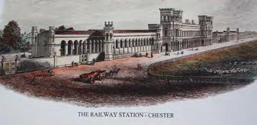
The railway lines to Chester were built between 18401846, and the Grade II* Listed Chester Station building was constructed in 1847-48 by Thomas Brassey, a Chester-born engineer. At the time of construction in the italianate style, it was the longest railway building in England.

1855

John McGahey’s sketch of Chester from a hot air balloon in 1855 shows the River Dee to the left of the image and the Shropshire Union Canal to the right. The original Roman street pattern is clearly visible.

1860
The Queens Hotel opened in 1860, but was damaged by fire in 1861. The building was swiftly repaired in 1862 without its turret type roof features.

04 — LOCAL CONTEXT HERITAGE CHESTER CITY GATEWAY 46
Bradshaw’s Guide of Chester 1848Inside Chester Train Station / Chester Station Frontage
47
Bryant’s Map of 1831 Rural Upton, with Chester City Gateway
1855 View of Chester from a Balloon - John McGahey
1861 Queens Hotel before fire damage
Around 1875, a railway siding extended to London and North Western Railway Wagon Works at Crewe Street, with terraced housing on Egerton Street, Francis Street, Albert Street, and the former Church of St Barnabas infilling the western side of the railway to Hoole Road.
By 1898 terraced housing in Flookersbrook and Hoole were constructed. In the 1902 map below, a railway station on Liverpool Road is clearly visible, which was opened in March 1890 and closed in April 1965. Two further railway stations were also located between the existing Chester Railway Station and the now closed Liverpool Road Station, these were Chester General and Chester Northgate (now the site of the Northgate Arena). Both of these railway stations closed in October 1969.

Listed buildings, Scheduled Monuments, and Conservation Areas
Heritage assets contribute to the character of the Gateway, including 2 Grade II* listed buildings9 and 24 Grade II listed buildings within the site, although some later modern additions have partially eroded the historic character of the area.
There are two Conservation Areas within the area boundary - City Centre Conservation Area10 and Flookersbrook Conservation Area11 . Grosvenor Park which is Grade II* Registered Park & Garden is directly adjacent to the site to the south and must be considered in the design of development proposals coming forward in this location.
There are eight Scheduled Monuments within 2km of the Gateway, six of which are within 500m. The area to the south of the Gateway, beyond St Oswalds Way, is allocated as an area of Archaeological Importance.
The Gateway is covered by the Chester Archaeological Plan12 (Railway Character Zone) which provides significant information about archaeological work requirements as part of the development process.
To the south and southwest of the Gateway is the Boughton Canalside Conservation Area and the Boughton and the Meadows Conservation Area, along with many statutorily Listed Buildings and Scheduled Monuments including the City Walls and Towers. To the northeast of Lightfoot Street is the Flookersbrook Conservation Area.
Non-designated heritage assets13 of local importance are present throughout the Gateway. Local heritage plays an essential role in creating and reinforcing a sense of local character and distinctiveness.
04 —
48 CHESTER CITY GATEWAY
LOCAL CONTEXT HERITAGE
1902 1875
49
Bartholomew’s 1902 half inch map of Chester
Special Areas of Conservation Scheduled Monument Grade listed buildings Grade II* listed buildings Grade II listed buildings Conservation Areas 1 City Centre 2 Boughton Canalside 3 Chester Canal (West) 4 Boughton and the Meadows 5 Flookersbrook 6 Hoole Road 7 Liverpool Road Footnotes 9. Chester Railway Station and 6-11 Grosvenor Park Road; 10. Designated in January 1969; 11. Designated in November 1976; 12 The Chester Archaeological Plan: http://www.cheshirearchaeology. org.uk/?page_id=165#:~:text=The%20Chester%20Archaeological%20Plan%20is,the%20City’s%20built%20historic%20environment; 13. Chester Characterisation Study (Page 51 of appendix H): https://inside.cheshirewestandchester.gov.uk/policies_plans_and_strategies/planning_policy/local_plan/key_social_economic_and_environmental_planning_evidence_base/chester_ characterisation_study
KEY PLAN
04 — LOCAL CONTEXT ENVIRONMENT
Flood Risk
The Gateway is within the Environment Agency Flood Zone 1 and has a less than 1 in 1,000 annual probability of river or sea water flooding, although there are areas of potential surface water flooding given the local topography.


Future development will need to incorporate Sustainable Urban Drainage Systems (SuDS), design surface levels accordingly and adhere to restrictions on surface run-off in line with the NPPF and local policy (DM33).
Landscape, Ecology and Biodiversity
The River Dee (SSSI* and SAC**) is located approximately 250m from the Bars roundabout and 750m from the Railway Station, with part of the Gateway within the SSSI’s Impact Risk Zone. Development proposals coming forward will need to consider the protection and potential enhancement of the River Dee SSSI and SAC.

The Gateway is located within the Mersey Community Forest area which aims to create a growing network of woodlands and green spaces across Cheshire and Merseyside.

The Greenway Local Wildlife Site is located just to the north of the site which is an existing Millennium Cycle route along a former railway line.
The Gateway is mainly urban and densely built up and as such there is limited diverse habitat within the locality. There are some areas of woodland within the northern edge of the site, including around North Gate Ponds. To the south is Grosvenor Park which is a woodland & parkland Biodiversity Action Plan (BAP) priority habitat area.


Blue-Green Infrastructure
The Shropshire Union Canal is to the south of the Gateway, and the canal-side walkway can be accessed from the City Road. The walkway provides a scenic route east-west through Chester and onto the countryside.
The ‘Flooker’s Brook’ is an old water course which was culverted at the time the railway was constructed over 150 years ago. Traces of this waterway are referenced in surrounding street names and remnants to be found close to Hoole Bridge. Whilst this brook is well hidden, the small amount which remains exposed is part of Chester’s history.
The Chester Millennium Greenway is a 22.2 km green corridor which runs parallel to the northeast of the Flookersbrook neighbourhood of Chester. The route provides great opportunities for cycling, walking and running, with a number of amenity stops along the way.
Grosvenor Park is a Grade II* registered, green flag award winning park which dates back to 1867 and covers 20 acres. It includes ornamental gardens, numerous statues, fully accessible play area, a café, and in summer the Grosvenor Park Open Theatre is open providing a range of shows.


CHESTER CITY GATEWAY 50
Maxar, Microsoft, Contains OS data © Crown Copyright and database right 2022 Contains data from OS Zoomstack 0 0.3 0.6 0.15 Kilometers
KEY PLAN Site boundary Water Bodies Sites of Special Scientific Interest (SSI) Noise Action Planning Important Areas Air Quality Management Areas (AQMA) Flood Map Zone 3 Flood Map Zone 2 Green Spaces
51
* SSSI - Site of Special Scientific Interest. ** SAC Special Area of Conservation
River Dee Grosvenor Park
Air Quality Noise
Chester City Centre Air Quality Management Area (AQMA) is partially located within the Gateway, relating to Hoole Way, St Oswalds Way roundabout, and The Bars roundabout. This AQMA is declared in response to exceedances of the annual mean Nitrogen Dioxide (N02) Air Quality targets due to road traffic, and as such is a key consideration as the Gateway is developed.
The Council’s ‘Low Emission Strategy (2018-2021)14 sets outs that there needs to be a modal shift away from cars which are the main cause of air pollution. Sustainable alternative modes of transport such as public transport, cycling or walking should become the main ways to travel across the Gateway. It is noted within the strategy that a long-term approach to delivering the infrastructure to support sustainable travel is needed.
Utilities and Drainage
Major utilities are located across the Gateway. Liaison with utility providers is ongoing to confirm if any network reinforcement is required to bring forward development. To facilitate the Gateway proposals there may be a requirement to divert existing utilities (to be considered on a caseby-case basis). The unedited utility search plan showing all utilities is provided in Appendix B –Utility Constraints Plan
There are four Noise Action Planning Important Areas (NAPIA) which the Department for Environment, Food and Rural Affairs (DEFRA) define as locations where the highest 1% levels of noise in a residential level can be found. There are four within 500m of the Gateway, including two which are located within the Gateway boundary. Hoole Bridge NIA relates to road and rail noise and The Bars NIA is associated with the road network only.

Noise impacts are inevitable in a busy urban setting, but through further mitigation and design measures proposed in the SRF, there are opportunities to reduce this impact on communities. Noise implications would be considered further at detailed design stage.

CHESTER CITY GATEWAY 52
53
Footnote 14. https://www.cheshirewestandchester.gov.uk/residents/pests-pollution-food-safety/pollution-and-air-quality/low-emission-strategy
04 — LOCAL CONTEXT ENVIRONMENT
Shropshire Union Canal
04 — LOCAL CONTEXT SOCIO-DEMOGRAPHIC
Assessing the Residential Demand
The Gateway can deliver housing to a diverse demographic range. Understanding the affordability of the occupiers will inform the types of housing to be developed.
The population of the CH1 postcode (currently estimated at 35,000 and encompassing the City Centre) is expected to increase by 2,300 (5.9%%) between 2021 and 2030. This is lower than the 6.5% increase predicted across drawn to the borough over, although almost double the growth rate for the North West (3%). This suggests people are drawn to Borough over other authorities in the North West, yet the City Centre is not set to capitalise on this population growth to its fullest extent.
Over a fifth (20.4%) of the Borough’s population is over 65 years of age, while this figure drops to 18% for England, suggesting that Chester (in line with England) has an ageing population. The City Centre ward comprises mostly 16-44 year olds (59%), with comparatively few (8%) 0-15 year olds, and a moderate number of 65+ year olds (14%)16. Few families are residing in the City Centre. Most likely, 17-35 year olds are the dominant age bracket, given the significant student population (16%) compared to the Borough (4.4%) and England (5.8%).
Empty Nesters
10% Self-employed (1,922)
5.4% Unemployed (922)
11.6% Students (in employment) (2,147)
72.6% Employed (13,424)
Young Families
Access to public transport
Quality to reinvest their money
Space for grandchildren
Garden / balconies
Walking and cycling provisions
Good schools / child care
Amenities (parks and entertainment)
Friendly neighbourhood
Local cycling routes
Good access to work
Access to their home towns
Students
Comfortable apartments
Low maintenance outdoor space
Central location
High quality apartments
2/3 bedroom townhouses with outdoor amenity space (garden)
Car parking
Sizeable homes
Townhouses
(Semi) Detached dwellings
Gardens
Car parking
Proximity to university
Nightlife and leisure
Affordable
Aspiring Homemakers
Sizeable homes
Townhouses
(Semi) Detached dwellings
Renters
Value for money
Neighbourhoods
Good access to work
Improved product to what it available
Creates a community
City centre living with amenity access
Apartments / smaller houses
Affordable housing
Apartments
Housing
The city of Chester has an estimated population of circa 88,000 people15, of which 17,000 are over 65 years old (19%).
CHESTER CITY GATEWAY 54
Experian data (2021) estimates that for the CH1 postcode (which encompasses the City Centre), economic activity is broken down as follows:
55
Demographic Key Drivers Type of Residential Product Over 55’s
outdoor space
amenities
Local
Local
Footnotes 15. City Population 2020 estimate: https://www.citypopulation.de/en/uk/northwestengland/cheshire_west_and_chester/K06000004__chester/ 16. CWaC Ward Profiles- Chester City and the Garden Quarter Ward: Population Estimates 2017; Economic Activity- Census 2011
Assessing the Residential Demand
A fifth of residents within the City Centre are employed within wholesale and retail and vehicle repair, compared to 17% for the borough, which is understandable given the given the postcode encompasses the retail core. Relatively fewer residents are employed in professional occupations (15.6%) than in the Borough (18.6%), suggesting the City Centre is less attractive to professionals than the hinterlands, semi-rural and rural areas.
Positively, the area within and immediately surrounding the Gateway benefits from a local population who are economically active17 and reasonably affluent albeit there are pockets of deprivation that need addressing.
The Lower Super Output Areas (LSOAs) directly to the north and south of the railway station are within the 40% most overall deprived neighbourhoods in the country and have high levels of health deprivation and disability. The northern LSOA (Cheshire West and Chester 033C) is within the top 10% most deprived neighbourhoods in the UK for health deprivation and disability.
In the two wards surrounding Chester Station, Boughton and Hoole, there is an above national average of working age and over-65 populations. The Borough is projected to see a 4% increase in its over-65 population, and a decrease of 2% in both its 0-15 populations and working age populations by 2030.

Looking at Chester City and Garden Quarter ward, over 50% of residents are living in areas of relatively high deprivation. The most acute issues facing residents are in
<50% homes are owner occupied (postcode CH1)
the indices of living environment and health and disability, the latter of which relates to the relatively high number of elderly people. The poor living environment relates to both public spaces and indoor living environments and points to a need to address the built environment.
In terms of tenure, the largest cohort in the borough are owner occupiers at 76%, which is higher than the North West (66%) and the UK (63%). The five-year projections expect the number of private renters to increase in all areas and the number of owner occupiers to decrease in all areas.
At the local scale (postcode CH1), just under 50% of homes are owner occupied, and just over a half are rented properties, with c. 30% being social housing and the remaining are privately rented properties.
Given the above information on the socio-demographic of the Gateway and the residential demand, there is a clear opportunity for for a range of housing types to be included within the Gateway.
c.30% homes are social housing (postcode CH1)
56 57
CHESTER CITY GATEWAY 04 — LOCAL CONTEXT
Footnote 17. Percentage of population who are economically active in both Hoole and Boughton wards is higher than national average.
SOCIO-DEMOGRAPHIC
Severance from the railway creates a barrier between existing neighbourhoods, Chester Railway Station and the City Centre.
Summary of Opportunities & Challenges
As has been set out within the previous sections, a detailed analysis of the Chester Gateway SRF area has been undertaken to fully understand the challenges and opportunities of the area and responding to the local context.

This was accompanied by an extensive consultation exercise with stakeholders identified by and including the Council and Network Rail, and involved community groups, landowners, Council departments, local businesses, and transport operators.
The main issues are the underwhelming sense of arrival at Chester Station and its surroundings combined with the sense of separation from the City Centre.
04 — LOCAL CONTEXT 58 CHESTER CITY GATEWAY 59
04 — LOCAL CONTEXT SUMMARY OF OPPORTUNITIES & CHALLENGES


KEY
Chester Railway Station

Railway line
Key route enhancement
Quiet route enhancement (cycling and pedestrian)

History Centre
Areas of severance
Opportunities for improved public realm/enhanced sense of arrival


Grade II* Listed building
Potential to enhance existing Community Orchard on
Grade II Listed building
Publically accessible car parks


Key Gateway siteopportunity for height
ChesterMillenniumGreenway
Improvements/creation of residential frontages
Northgate Ponds
Existing retail frontages

Improvement/creation of active frontages
Strengthening existing community orchard
HooleRoad
HooleBridge
LightfootStreet
StationRoad
The Bars
Foregate Street

Westminster Road
RIVER DEE CITY CENTRE
Hoole Narrows Grosvenor Park
CHESTER CITY GATEWAY 60
Ermine Road
S
61
Unattractive and unwelcoming Hoole Bridge
Trafford Street
Limited connection / accessibility from Hoole Bridge to Railway Station
Dominance of the highway along City Road
Independent and successful Brook Street south
Inactive frontages on Station Road
Arrival into Chester from Chester Railway Station
Surface car parking
04 — LOCAL CONTEXT SUMMARY OF OPPORTUNITIES & CHALLENGES
Constraints Opportunities
Poor sense of arrival when arriving into Chester at Chester Railway Station.
Severance caused by the railway line running east-west across the Gateway.
Improvements to Station Square public realm to improve sense of arrival into Chester as a place to visit, work, and live.
Planned electrification of the railway line provides the opportunity for improved bridge linkages over the railway line for pedestrians and cyclists, which will minimise the perception of severance caused by the railway.
Constraints Opportunities
Lack of vibrant uses spilling out onto the pavements around Chester Railway Station, limiting amount of time people choose to spend within the Gateway.
Surface car parking can be consolidated into one location, preferably at Chester Railway Station to create this as a key transport interchange with trains, car parking, buses, cycle parking, cycle hire, and electric scooter hire in the immediate vicinity.
Hoole Bridge creates an abrasive, unattractive and over-engineered road, which creates a difficult and unfriendly environment for pedestrians and cyclists.
Opportunity for a new bridge across the railway line, adjacent to the existing Hoole Bridge, specifically designed for pedestrians and cyclists.
Limited appreciation of heritage assets. Opportunity to conserve and celebrate Chester’s heritage through improved streetscapes and increased areas of public realm to improve the setting and enhance local historic character and distinctiveness. Public art could be used to promote the understanding of Chester’s rich history.
Vacant brownfield land and surface car parks are unattractive and create a perceived unsafe environment for people walking past or through these sites.
Lack of wayfinding and legibility, creating poor linkages into Chester City Centre, and also between the Gateway and surrounding residential areas.
Vacant brownfield land provides the opportunity for redevelopment which will in turn increase footfall to the area, and activate street frontages, improving the perception of safety.
There is an opportunity to visibly connect and orientate visitors, residents and workers between the Railway Station, Chester Millennium Greenway, the City Centre, Flookersbrook, Hoole, Northgate Arena, the Shropshire Union Canal, the Bars, Grosvenor Park, and the River Dee. A key opportunity is creating better links for walking and cycling between existing residential communities to the Gateway and beyond.
Ageing population within the Gateway. Opportunity to retain Chester University graduates in Chester City Centre and for local businesses to tap into this talent pool through diversifying housing stock and providing new highquality accommodation for young professionals and families.
Lack of variety of housing stock within the Gateway.
Opportunity for high quality housing for young families, young professionals, as well as supported accommodation.
Opportunity to improve existing residential street frontages through adjacent complementary residential development at ground floor and complementary community uses.
Lack of street tree planting, parklets and street furniture.
Vacancies within retail units within Chester City Centre and Grosvenor Shopping Centre.
Lack of footfall and visitation to the Gateway.
The Bars roundabout is a hostile environment for pedestrians and cyclists travelling to/from the Railway Station and provides a poor gateway into the City Centre.
City Road is dominated by parked cars, highway infrastructure, and street furniture, with limited pavements for pedestrians and no segregated cycle lanes.
Opportunity for improved pedestrian and cycle routes across the Bars, along with a clearer wayfinding strategy to promote active travel into or out of the City Centre and onto Chester Railway Station.
Opportunity for City Road to be turned into a green promenade which prioritises pedestrians and cyclists, and limits private vehicle use.
Lack of appreciation of existing green infrastructure, such as the Community Orchards on Trafford Street, and St Anne’s Field.
Opportunity for greener streets through street planting, parklets / pocket parks, creative play spaces, and suitably placed street furniture to improve the Gateway’s street environment.
Opportunity for increased vibrancy and place-making within the Gateway, including drawing footfall into the City Centre, along key routes such as City Road. This will in turn promote visitation and dwell time in the City Centre, and reduce vacancy rates as more independent retail businesses thrive in the City Centre.
Opportunity for place-making and increased footfall to the Gateway through the delivery of the History Centre on Lightfoot Street, and other ground floor activation along Brook Street north, Hoole Way, Black Diamond Street junction to complement the existing retail and commercial offering.
Opportunity to enhance connectivity from the Railway Station to St Anne’s Field and onto the Community Orchards, which could be enhanced as part of future development within the Trafford Street area.
CHESTER CITY GATEWAY 62
63

65
Relevant national, regional, local policy and strategies underpin the proposals set out within this Draft SRF. A more detailed policy context is provided in Appendix C – Policy Context.
Policy and Strategic Context
National UK Levelling Up and Regeneration Bill (2022)
Build Back Better: Our plan for growth (2021)
Northern Powerhouse Strategy (2016)
Union Connectivity Review (2021)
National Planning Policy Framework (2021)
UK Industrial Strategy (2017)
Living with Beauty – Report of the Building Better, Building Beautiful Commission (2020)
The Environment Act (2021)
Regional Cheshire
West
Transport for the North: Strategic Transport Plan (2019)
Local Industrial Strategy
West and Wales Strategic Rail Prospectus (2018)
Mersey Dee: Our Unique City Region – Unlocking Our True Potential (2017)
Strategic Economic Plan (2017)
Local City of Chester
Cheshire West and Chester Local Plan (Part One) Strategic Policies (2015)
Cheshire West and Chester Local Plan (Part Two) Land Allocations and Detailed Policies (2019)
Chester One City Plan 2022-2045 (refreshed)
Chester Characterisation Study
Local Transport Plan – Update 2017
Chester’s Local Cycling and Walking Infrastructure Plan (LCWIP) (2020)
Cheshire West and Chester Housing Strategy
Cheshire West and Chester Climate Emergency Response Plan (2020)
Low Emissions Strategy (2018)
Contributing toward the Government’s flagship Levelling Up Strategy
Levelling Up and Regeneration Bill (2022)
Planning is critical to the Government’s ambition to level-up the country. The new planning system will be based on the principles of beauty, infrastructure, democracy, environment, and neighbourhood engagement. Principles of relevance to the Gateway include enhancing local public transport connectivity, providing gigabit-capable broadband, ensuring pride in place, enabling renters to have a secure path to home ownership and increasing the number of first-time buyers, and boosting productivity.
Build Back Better: Our plan for growth (2021)
Sets out the UK Government’s plan for growth which reflects the changes in the business and economic environment since the launch of the UK Industrial Strategy in 2017. Infrastructure, skills, and innovation are the three core pillars of growth which will support levelling up, the transition to net zero, and the vision for a ‘Global Britain’.
The Northern Powerhouse (2016) is a vision for joining up regions of the North, pooling strengths, improving connections, and tackling major barriers to productivity to ‘unleash’ the economic potential of the North. High Speed 2 (HS2) will become the backbone of the national railway network and will transform connectivity and journey times between Northern cities, the Midlands, and London. There is the opportunity for Chester to be connected to the HS2 network through interchanges at Crewe and Warrington.
66
CHESTER CITY GATEWAY 05 — STRATEGIC
CONTEXT
REGENERATION
01. 67
The sections below summarise what are considered to be the key issues which this SRF is responding to.
05 — STRATEGIC REGENERATION CONTEXT
Promoting integrated, sustainable, and green transport options
New development is encouraged to be located close to transport infrastructure and key public facilities, facilitating a modal shift from the car to active travel and public transport, with higher densities in the bestconnected locations. The location of the Gateway capitalises on the opportunity to create a sustainable and connected neighbourhood.
Union Connectivity Review (2021)18
The establishment of a multi-modal transport network (UKNET)19 will significantly improve transport connectivity across the UK. A key recommendation is for a multimodal review of the North Wales transport corridor and improvements focused on the North Wales Main Line (including better connectivity with HS2, and electrification), the A55, the M53, M56, and onward travel to and from the island of Ireland. Chester is at the heart of this transport corridor.
Transport for the North: Strategic Transport Plan (2019)20
seeks to drive major rail and road improvements to improve strategic connectivity throughout the North up to 2050. Chester is within the ‘West and Wales’ strategic development corridor, aiming to improve connectivity across the important economic centres and assets of Cheshire, Liverpool City Region, and Greater Manchester.
West and Wales Strategic Rail Prospectus (2018)21
produced by Growth Track 360, calls for investment in the strategic rail hubs of Crewe, Warrington, Manchester Airport and Chester, so HS2 can fulfil its true potential by improving connectivity and mobility. Chester City Gateway is a key development opportunity as Chester Station forms the primary gateway between Cheshire,
Warrington and North Wales and the focal point of the Mersey-Dee area. Rail improvements are proposed to establish the station area as a world-class place to do business, attracting employment and residential opportunities.
Local Transport Plan Update (2017)
Identifies the key transport interventions to ensure the City can support economic growth. A key recommendation is to create an integrated transport network with enhanced rail services and infrastructure, station improvements for pedestrians and cyclists, line electrification, improvements to rolling stock quality, and service frequency enhancements. This includes a need to enhance the interchange and increase car parking at Chester. It lists other potential interventions relevant to the Gateway: bus priority measures, e.g. A56 Hoole Road; new park and ride site serving the A56 Hoole Way corridor; feasibility review for a new footbridge to run in parallel with Hoole Way Bridge; and to identify, design and deliver junction improvement schemes to address current and future congestion and pinch point problems.
Chester’s Local Cycling and Walking Infrastructure Plan (LCWIP) (2020)
The LCWIP provides a new strategic approach to help identify local-level cycling and walking improvements. Proposals include improved cycling provision on City Road from the Station to The Bars roundabout, a new route between the Millennium Greenway and northwest of the Gateway, and a designated quiet route between the Gateway and Grosvenor Park.
Unlocking the Chester Northern Gateway regeneration area
Local Industrial Strategy (LIS) is being produced by the Cheshire and Warrington Local Enterprise Partnership (CWLEP). ‘Developing the Cheshire and Warrington LIS – Evidence and Insight Summary’ 22 identifies key headlines and potential priorities for action:
Infrastructure: HS2 and Northern Powerhouse Rail.
Economy: CWLEP’s ambition is that the region becomes a £50bn economy by 2040.
Key Sectors: manufacturing, life sciences, and energy/clean growth are key attributes of the region, whilst finance and business services, and logistics and distribution have the potential to make a strong contribution to the region’s growth.
Housing: many parts of the sub-region are too expensive for people to afford to buy a home, with limited supply of housing options including private and social rented properties. New housing is aimed at established families looking for larger suburban or edge-of-town locations, which leaves out younger professionals who prefer urban living and rely on public transport for their commute.
Strategic Economic Plan (2017)23 - covers the period up to 2040 and sets out an ambitious growth strategy for the sub-region, delivering a £50 billion GVA a year. Transport and connectivity will be central to achieving Cheshire and Warrington’s aspirations for growth and supporting economic development. Effective transport networks will be crucial for the continued success of the sub region as an attractive place in which to live and do business.
Mersey Dee: Our Unique City Region
Unlocking Our True Potential (2017) - The Mersey Dee Alliance24 confirms the infrastructure investment required to unlock the economic growth potential for the Mersey Dee area. Opportunities identified by the Alliance include the importance of the re-construction and realignment of Hoole Road bridge in Chester to unlocking electrification between Crewe and Holyhead.
Cheshire West and Chester Local Plan Parts 1 & 2 The development plan for Cheshire West and Chester comprises the Local Plan (Part One) Strategic Policies (2015) and the Local Plan (Part Two) Land Allocations and Detailed Policies (2019). The site is allocated within Policy CH2.A “Chester Northern Gateway” regeneration area where development must be high quality, and where possible, improve the road and pedestrian accessibility into and out of the City from Hoole Road. Proposals supported include: improvements to the level and quality of station car parking; high grade office development; a mix of high quality affordable and market housing on suitable sites; and higher density development where compatible with conservation / design policies.
Chester One City Plan (2022)
The original One City Plan was published in 2012. This document has now been refreshed and covers the period 2022-2045, following an extensive consultation exercise. The refreshed plan uses the United Nations’ Sustainable Development Goals, adapted for a localised approach, to create what will be known as The Chester Test. This will ensure projects, initiatives and large economic developments all support Chester in becoming a greener, fairer society for all.
CHESTER CITY GATEWAY 68
02.
03. 69 Footnotes 22. Cheshire and Warrington LEP, Local Industrial Strategy (accessed on 31/08/22): ai-9-lis-summary-doc_march-19_low.pdf (cheshireandwarrington.com) 23. Cheshire & Warrington Local Enterprise Partnership (LEP) - Strategic Economic Plan - https://cheshireandwarrington.com/about/vision-and-strategy/ 24. Mersey Dee Prospectus: http://www.merseydeealliance.org.uk/wp-content/uploads/2020/05/Mersey-Dee-Growth-Prospectus.pdf Footnotes 18. Union connectivity Review (2022), accessed on 31/08/22: Union connectivity review: final report - GOV.UK (www.gov.uk); 19. UKNET: https://www.raildeliverygroup. com/media-centre-docman/123-2018-02-station-car-parking-guide/file.html; 20. Transport for the North, Strategic Transport Plan (2019), accessed on 31/08/22: https:// transportforthenorth.com/our-north/strategic-transport-plan/; 21. West and Wales Strategic Rail Prospectus, accessed on 31/08/22: https://www.growthtrack360.com/home/ westandwalesrailprospectus/
Boosting Housing Delivery
The UK Government has a target to deliver 300,000 new homes each year to meet housing need25, address the backlog of housing delivery, provide for projected population growth, and support economic growth ambitions.
National Planning Policy Framework (NPPF)
Came into force in July 202126 and outlines the importance of providing a range of housing (type and tenure), including provision of affordable housing, to create mixed and balanced communities. The creation of new communities should reflect the area’s economic potential, realise net environmental gains, provide good connectivity to services and employment opportunities, make the most of masterplans to ensure high quality development comes forward, and have a realistic approach in terms of how sites come forward and are delivered.
Cheshire West and Chester Local Plan
Sets out several housing policies which are relevant to the SRF: Policy SOC 1 Delivering Affordable Homes; Policy SOC 3 Housing Mix and Type; Policy DM19 Proposals for Residential Development; Policy DM20 Mix and Type of New Housing Development; and Policy DM23 Delivering Affordable Housing.
Cheshire West and Chester Housing Strategy
The Housing Strategy sets out key drivers and issues affecting the borough and outlines how the Council will create the right conditions to meet housing needs and support a balanced local housing market.
Living with Beauty – Report of the Building Better, Building Beautiful Commission (2020)27 is an independent body set up to advise the UK Government on how to promote and increase the use of high-quality design for new build homes and neighbourhoods. ‘Living with Beauty’ (January 2020) sets out three aims: ask for beauty, refuse ugliness, and promote stewardship, and made 45 detailed policy propositions. These recommendations resulted in an amendment to the NPPF (2021 - Paragraph 134) to have a stronger focus on beauty and the introduction of a National Model Design Code in July 2021.
Cheshire West and Chester Local Plan sets out a number of design policies which are relevant to the SRF: Policy STRAT 1 Sustainable Development; Policy ENV 5 Historic Environment; Policy STRAT 10 Transport and accessibility; Policy CH 5 Chester Conservation Areas; Policy CH 6 Chester key views, landmarks, and gateways and historic skyline; Policy DM 46 Development in Conservation Areas; Policy DM 47 Listed Buildings; and Policy DM 44 Protecting and Enhancing the Natural Environment.
The Environment Act (2021)
Sets out the legislation to improve air and water quality, tackle waste, increase recycling, halt the decline of species, and improve our natural environment. All new development proposals to include a 10% (+) increase in on site biodiversity, which is captured through a Biodiversity Net Gain (BNG) calculation.
Cheshire West and Chester Climate Emergency Response Plan (2020)
Sets out the scale of the challenge that the borough faces in achieving carbon neutrality by 2045. It includes proposals to ensuring a more sustainable public transport system and considering residential design and layouts to help drive modal shift and support the achievement of carbon neutrality.
Low Emissions Strategy (LES) (2018)
Outlines the Council’s measures to deliver air quality improvements through a broad range of interventions including modal shift, reduction of emissions and improvements in electric vehicle infrastructure.
Chester One City Plan sets out that ambition for Chester to achieve net zero by 2045.

CHESTER CITY GATEWAY 71 70
04.
05 — STRATEGIC REGENERATION CONTEXT
Creating high-quality, beautiful, and sustainable buildings and places
Contributing to a net zero Chester and a thriving environment Footnotes 25. Conservative Manifesto Pledge: https://www.conservatives.com/our-plan/conservative-party-manifesto-2019 26. NPPF (2021) https://www.gov.uk/government/publications/national-planning-policy-framework--2
05. 06. Footnote 27. Living with Beauty – Report of the Building Better, Building Beautiful Commission: https://www.gov.uk/government/publications/living-with-beauty-report-of-the-buildingbetter-building-beautiful-commission

73
CHESTER CITY GATEWAY VISION
Together, we will create a beautiful Gateway to the City Centre, where residents and visitors can easily reach all that Chester and its hinterland have to offer. Underpinned by the Gateway’s heritage and its excellent transport connectivity, new infrastructure investment and development will transform underutilised brownfield land for public benefit.
The Gateway will comprise:
A highly-accessible central hub for the City that encourages sustainable movement and enhances the experience of the city for residents and visitors alike
a network of people-friendly routes and spaces that promote walking and cycling and the use of public transport for local, regional and national travel community facilities and distinctive commercial uses that stimulate independence and vibrancy better use of brownfield land to create liveable and integrated neighbourhoods that support healthy living, working and culture
the highest standards of sustainable design and biodiversity to contribute to Chester’s net zero-carbon ambitions
This vision aligns with the policies contained within the statutory Development Plan and One City Plan refresh, recognising the key principles of delivering new development close to key public transport nodes.

CHESTER CITY GATEWAY 74 Vision 06
—
75 City Road “ “
06 — CHESTER CITY GATEWAY VISION
Deliver a modern and attractive gateway into the City Centre and the wider region (Cheshire, North Wales and the North of England).
There is significant potential to create a more attractive and vibrant gateway into Chester City Centre, as well as one which also reflects its importance as the Gateway into North Wales and the wider Cheshire area. Delivering development which is of a high-quality, embraces heritage, and has an appropriate mix of uses and new public spaces to encourage vibrancy and greater dwell-time will be important. The Gateway will be the opportunity to create a new vibrant quarter of the City Centre but equally will serve to complement the existing offering within both City and Local Centres.
Address key constraints within the Gateway, including making Hoole Bridge a much better pedestrian-focused crossing.
Part of the rationale for the SRF and the identification of the Gateway as an area for change is the opportunity to deliver important infrastructure which will address key constraints within the Gateway (and also impacting the City Centre more broadly, given their strategic importance). This includes unlocking investment to improve the existing Hoole Bridge crossing which currently provides a poor environment for pedestrians and cyclists and acts as a key constraint for movement from residential areas to the north, including Hoole Village, to the Railway Station and City Centre. Improving the accessibility and quality of car parking for Railway Station users, is also a key move, which could unlock development sites.
Create an integrated transport hub with a world-class Railway Station, and from which it is easy to travel by bus, walking and cycling.
We will encourage greener and cleaner trips by promoting walking, cycling and public transport for local, regional and national trips. A key principle for the Gateway is to provide a fully integrated transport hub with accessible, quality parking facilities to encourage people to travel by rail. There will be no net increase in parking numbers; the proposal is to consolidate parking which is currently dispersed across the Gateway.
The hub will include a broad mobility offer, including electric vehicle (EV) charging points, parcel collection areas, e-mobility facilities (such as e-scooters) and cycle hire which will make it easy for people to cycle into the City Centre and make local trips more inclusive, accessible and safe. We will make travelling by bus more attractive for users and operators by improving the infrastructure to, from and at the Mobility Hub. A variety of ground floor uses, including food and beverage will also be encouraged around the Railway Station to create a world-class experience for passengers.
Promote new inclusive and accessible routes and public spaces that encourage active travel and provide new places for the community and visitors to enjoy.
A network of high-quality active travel routes across the Gateway will help to encourage the use of more sustainable modes and improve accessibility for all. Key destinations will be connected through new walking and cycling routes, incorporating green links including planting and urban greening. The ‘Healthy Streets’ principles and transport user hierarchy are central to this, ensuring space is provided for all pedestrians and cyclists and placemaking benefits are fully realised.
The vision is underpinned by a series of guiding objectives which will help achieve our vision for the Chester City Gateway:
01 02
CHESTER CITY GATEWAY 76
03 04 77
06 — CHESTER CITY GATEWAY VISION
Provide beautiful and characterful architecture and placemaking
Placemaking is a principal element of the SRF, which will establish the Key Moves to ensure the highest quality of design, architecture and public realm across the Gateway. The focus on people-first is key, opening the opportunity for greater social interaction through the creation of high-quality public spaces.
We will animate and improve the streetscape across the Gateway through a mix of uses at ground floor level, as well as the potential for meanwhile uses to positively change the perceptions of the place.
Deliver a mix of well-designed new homes, particularly for younger people.
The Gateway will accommodate a mix of new homes to meet identified local needs and support economic growth in the City Centre. A proportion of the new housing will be designed appropriately to attract younger people, which will help to retain young professionals to live, work and play in the City.
Achieve appropriate mix of densities that take full advantage of the site’s excellent transport connectivity.
We will ensure that previously used ‘brownfield land’ is developed first. The priority for development within the Gateway is for new aspirational and high-quality housing and a mix of housing types, which will be sustainably connected via active travel routes, to both Chester Railway Station and the City Centre. Maximising the efficiency of land through the re-use of former surface-level car parking will be important, ensuring appropriate densities can be achieved which respond to the local and surrounding context.
Take account of the site’s history and celebrate and enhance designated heritage assets.
The history of Chester extends back nearly 2,000 years, covering all periods of British history, including its inception by the Romans in AD 79. We will promote and celebrate Chester’s wider rich heritage and cultural attractions, as well as complement the immediate historic buildings and conservations areas within and surrounding the Gateway. Restoring and repurposing heritage is an important stakeholder priority. The SRF area includes the Grade II* Listed Station Building, and several Grade II Listed Buildings across two different and distinctive Conservation Areas.
We will promote and celebrate Chester’s wider rich heritage and revitalise the latent potential of areas such as the Station Square, which in turn will ensure the Railway Station is a key feature within the Gateway. With a focus and emphasis on high quality architecture we will stitch together and work positively with established heritage assets to enrich the area.
Integrate new development sensitively with existing communities.
We will ensure that new housing developments fully consider neighbouring residential communities to provide a sense of coherence and community between existing residents and new. New walking and cycling connections will be provided to better link existing communities with the Railway Station and City Centre.
Achieve the highest standards of sustainable design and biodiversity net gain.
The Gateway will support the Council’s goal for carbon neutrality through ensuring new development embraces net zero carbon opportunities and passive design, adhering to the latest sustainable design standards.
CHESTER CITY GATEWAY 78 79
06 09 05
10
07
08

81
The following key moves are proposed which underpin development coming forward within the Gateway.
1 / An improved Chester Railway Station experience
2 / Supporting greater accessiblity

3 / Consolidating and improving car parking

4 / Delivering highquality place-making and public realm


improved Chester Railway Station experience
Supporting Greater Mobility
5 / Meeting local housing need
Consolidating and improving Car Parking

Delivering high-quality place-making and public realm
Meeting local housing need
07 — KEY
MOVES
CHESTER CITY GATEWAY
82 RIVER DEE HooleRoad Ermine Road LightfootStreet HooleWay StAnneStreet BrookStreet St Oswald’sWay cathedralsightline City Road The Bars Grosvenor Park Westminster Road
83
Key Move 1
AN IMPROVED CHESTER RAILWAY EXPERIENCE
84 CHESTER CITY GATEWAY 84 07 — KEY MOVES 85
07 — KEY MOVES 1 / AN IMPROVED CHESTER RAILWAY EXPERIENCE
Chester Railway Station marks the arrival into Chester and acts as the key strategic transport asset for the City and sub-region. An overarching ambition of the SRF is to create an improved Chester Railway Station experience and an enhanced Gateway into the City.


Chester Railway Station
The Railway Station is a vital transport hub for commuters, business travellers, leisure users, and tourists both on a regional and national basis. The Grade II* Listed Railway Station building has been earmarked for improvements to improve the user experience by the Council, the Mersey Dee Alliance (Growth Track 360), and Transport for Wales. Some improvements have already been planned, including Transport for Wales committing £7.5 million to enhance the concourse, install free WIFI, improve CCTV, include additional help points, ticket selling facilities, passenger waiting facilities, seating, lighting, and cycle storage facilities.
There are wider aspirations to secure further funding for additional rail enhancements from the Department for Transport through the Rail Network Enhancement Pipeline to deliver key strategic investments. These larger proposals include additional platforms to the north of the Railway Station, a new eastern railway junction, and electrification of the line. Funding is also being sought to further enhance the Railway Station environment to make it more inclusive and appealing for users.
Enhanced Gateway
There is the potential to create an enhanced gateway through improving the public realm immediately outside of the Railway Station. This will remove street clutter and give priority to pedestrians and cyclists, through consolidating private vehicle movements within and outside the proposed Mobility Hub. This new gateway will encourage and draw people into the City Centre, with improved legibility and activity along City Road.
Bus Services
To encourage users of the Railway Station to arrive by bus, there is an aspiration to provide at least 8 bus stops in Station Square (4 in each direction). This will improve east-west public transport connectivity and to serve the Railway Station to broaden the options for rail passengers, and supports a modal shift to public transport for multi-modal journeys. There are also plans for bus priority measures on Hoole Way to improve access across the Gateway and to the Railway Station, which will further promote the use of sustainable transport modes to reach the Railway Station.
86
CHESTER CITY
GATEWAY
87
Chester Railway Station potential improvements
Inside Chester Station
Key Move 2 SUPPORTING GREATER ACCESSIBLITY
88 CHESTER CITY GATEWAY 07 — KEY MOVES 88 89
2 / SUPPORTING GREATER ACCESSIBLITY
Accessibility by sustainable modes of transport across the Gateway (such as taking a bus, cycling, e-transport, or walking) needs to be prioritised and encouraged, whilst also providing for those who must drive (such as vulnerable users, people who live in more remote locations, and those that travel at times when public transport is not readily available).
Hoole Bridge
The existing Hoole Bridge is a particular problem for pedestrians and cyclists due to narrow pavements, lack of a segregated cycle lane, and high levels of traffic creating a poor environment for walking and cycling. It has been identified within the Council’s Local Cycling and Walking Infrastructure Plan (LCWIP) as a priority project.
Options for a future replacement bridge have been undertaken to accommodate safe pedestrian and cycle access with segregated cycle lanes and pavements. The most viable option is to construct a new high-quality pedestrian and cycle bridge28 in addition to the existing road bridge.
There is also potential for it to be landscaped to create a new green link which runs through the Gateway.

This new bridge can be future-proofed by ensuring sufficient clearance by trains for any future electrification of the rail lines. If the proposed electrification proceeds, the existing Hoole road bridge may need to be raised in its current location, or it could be demolished and replaced with a new road bridge. Appendix D – Options for Hoole Bridge and safeguarded land.
The SRF is an important first step to unlocking this project and it will inform the development of a business plan, and support future planning application and funding bids. It is anticipated, therefore, that the project is likely to take between 5-10 years to deliver.
CHESTER CITY GATEWAY 90 07 — KEY MOVES
91 Footnote 28. Cycle infrastructure design (LTN 1/20) - GOV.UK (https://assets.publishing.service.gov.uk/government/ uploads/system/uploads/attachment_data/file/951074/cycle-infrastructure-design-ltn-1-20.pdf )
Visual showing indicative new pedestrian and cycle bridge adjacent to Hoole Bridge
Improved cycling and walking
A network of high-quality active travel routes across the Gateway will be provided alongside new facilities for cycling provision, which will improve the accessibility of the Gateway to Chester City Centre and enhance permeability through the area for pedestrians and cyclists.
The ‘Green and Healthy Streets’ principle will be embedded across the Gateway to help create a green, healthy, and inclusive place which considers all users and encourages walking and cycling.


The long-term vision is to substantially reduce private vehicle use from parts of Brook Street and City Road, and completely remove through traffic on Station Road (access to properties for residents and for deliveries would be maintained). This would allow these roads to be converted into active travel routes, with more space for public realm, segregated cycle lanes, trees, pocket parks, and planting, to promote walking and cycling. This will create low speed and low traffic zones for pedestrians, cyclists, buses and emergency vehicles only (i.e. wide pavements, segregated cycle lanes, and bus lanes), which will further reduce emissions and improve air quality and reduce noise.
A network of active-travel routes will be created including:
New Hoole Bridge pedestrian and cycle connection.
New ‘Mobility Hub’ at the Railway Station, alongside the walking, cycling and public transport priority loop established by closing Station Road to through-traffic.
Segregated cycle and walking routes which connect to other key routes across the Gateway and further afield i.e. Chester Millennium Greenway. These could include enhancing existing off-road routes or creating ‘quiet’ street routes for cyclists and pedestrians to use, as well as new pedestrian and cycle crossings on main roads, and traffic reduction on existing streets.

CHESTER CITY GATEWAY 92
Precedent image: Precedent image: segregated ‘green’ cycle route, Grey to Green, Sheffield. Source: Source: Grey to Green Sheffield
07 — KEY MOVES 2 / SUPPORTING GREATER ACCESSIBLITY 93 The Bars City Road STATIONSQUARE Brook Street KEY PLAN Improved Station Hub Existing Green Routes Enhanced Routes New Routes Development Areas Active Routes Walking / Cycling
Precedent image: segregated ‘green’ pedestrian route, Grey to Green, Sheffield. Source: Source: Grey to Green Sheffield
07 — KEY MOVES 2 / SUPPORTING GREATER ACCESSIBLITY
New Mobility Hub
Provision of a new integrated transport hub - encompassing the Railway Station, its forecourt (Station Road/ Station Square) and a dedicated new ‘Mobility Hub’ on the site of the existing NCP Chester Station West car park - will improve access into and out of the Railway Station for all users.
The Mobility Hub would also provide a choice in sustainable travel modes (bus links, cycle parking and hire, and e-transport such as e-scooters and e-bikes).
A new Mobility Hub is intended to improve the facilities and experience for passengers. There is also potential to consolidate the existing surface level car parking into a new car park that would be located above the Mobility Hub.
The Mobility Hub is intended to deliver:
Increased and improved secure covered cycle parking spaces for 160 cycle spaces;
A cycle hub for repairs and bike hire;

A location to access scooter/micro-mobility options (i.e. e-scooters, e-bike);
A new covered blue badge, pick-up/drop-off and short stay parking facility;
A new taxi rank to include taxi EV charging in front of the Station building; and
The volume and architectural treatment of the Mobility Hub will need to respect both long distance views across the Gateway and the heritage significance of the Grade II* Listed Railway Station complex. Initial feasibility work has been undertaken to determine the acceptable building envelope/ footprint for the proposed Mobility Hub, which respects and responds to the local context.
CHESTER CITY GATEWAY 94
95
Precedent image: Precedent image: Utrecht Stationsstalling (Railway Station cycle parking garage). Source: Source: Bicycle Dutch World
Key Move 3
CONSOLIDATING AND IMPROVING CAR PARKING
96 CHESTER CITY GATEWAY 07 — KEY MOVES 96 97
3 / CONSOLIDATING AND IMPROVING CAR PARKING
The Gateway includes a large amount of surface car parks, which detract from the street frontages and create a perception of a lack of safety for pedestrians and cyclists. The current car parking provision does not fulfil its role. Existing car parking provision is land hungry, poorly located and poorly sign posted. It detracts from the character of the Gateway as well as the role that Chester Railway Station performs as a regional transport hub.
There will always be a requirement for private vehicle access at railway stations, whether this be for dropoff, blue badge parking, and long stay provision. To meet the demands of travellers, and to ensure the rail network plays a full and positive part in a sustainable and integrated transport system, car parking around the Railway Station needs to be improved for rail customers who drive to the Railway Station. This will add value to the customer journey and help to promote rail travel as the mode of choice for all.
Forecasts suggest an increase in rail passengers over coming years. Therefore, it is essential that the Railway Station includes sufficiently high-quality car parking offer that is reflective of the quality of Chester Railway Station and the train services it connects with.
On this basis, this SRF seeks to consolidate the existing surface car parking offer within a new centrally located facility that provides a substantially improved experience for passengers while releasing prime City Centre land for redevelopment (thereby providing wider placemaking and public benefit).
These proposals are driven by a desire for a qualitative improvement in the provision of car parking around the Railway Station to encourage the use of rail travel and importantly, not, a desire for an increase in the number of parking spaces. The level of proposed car parking is in line with other railway stations across
the North of England (please refer to the comparable data contained within Appendix E – North of England railway stations car parking study) albeit towards the lower end of this scale.
A range of locations have been considered for a new multi-storey car park to service the Railway Station. This needs to be carefully considered across the Gateway. A potential location for this could be on the existing Chester Station West NCP above the proposed Mobility Hub as this could provide: immediate access to the concourse;
the potential to connect to the proposed new Mobility Hub (see Key Move 2 above);
the potential for direct access from the proposed new pedestrian and cycle Hoole Bridge; and should car parking demand decrease, the car parking element of the Mobility Hub will be designed with flexibility to be converted into other uses (office / leisure).
This would need to be considered carefully from a design context and all opportunities within the Gateway explored.
Alongside any proposal for a new car park, the Council will consider the merits of a resident car parking scheme to restrict parking to those that live in the area.
KEY Car parks
*Planning Permission 19/03845/OUT obtained on 3rd July 2020 for the erection of 244 bed Hotel (Class C1) over 7 storeys on the Black Diamond Car Park site.
648 publicly available car parking spaces across the Gateway within 6 public pay and display car parks.
251 car parking spaces dedicated to Chester Railway Station.
CHESTER CITY GATEWAY 98 07 — KEY MOVES
99 Brook St Pay & Display Car Park Royal Mail Black Diamond St Car Park* Brook St Car Park Chester Railway Station NCP Royal Mail Sta Car Park Short Stay Network Rail YourParkingSpace Queen’s Hotel NCP Network Rail NR Sta Network Rail Cestrian Court
Existing public and private car parks across the Gateway
Key Move 4
DELIVERING
HIGH-QUALITY PLACE-MAKING & PUBLIC REALM
100 CHESTER CITY GATEWAY 07 — KEY MOVES 100 101
4 / DELIVERING HIGH-QUALITY PLACE-MAKING & PUBLIC REALM
The Gateway contains a range of different urban settings and distinct character areas, ranging from the formal City Road Boulevard, the varied and intimate quality of Brook Street, the large waterside warehouses and industrial buildings, to the grid patterned two-storey terraces which comprise the successful ‘village-like’ qualities of Hoole. There is an opportunity to improve, promote and enhance the Gateway’s unique qualities to encourage footfall, increase dwell time, and promote the Gateway as a place people choose to live, spend time or work.

The aim is to deliver high-quality place-making through provision of key amenities and improved public realm to create an offer to meet rail passengers’ expectations, support local businesses and office users, and attract in new residents and occupiers to the Gateway, particularly those of a younger demographic.


Heritage
Existing heritage assets will be conserved or enhanced through the proposed development, recognising the importance and contribution that the historic environment make to the character and uniqueness of the Gateway.
CHESTER CITY GATEWAY 102 07 — KEY
MOVES
Precedent image: Precedent image: The Storyhouse, Chester – showing a successful re-use of a listed building with integrated modern architectural design. Source: Peter Cook Architectural Photography.
Precedent image: Chester Shot Tower Source: DLA
103
Precedent image: The Carriage Shed, Chester – showing successful use of public realm for events / attractions and place-making. Source: Donald Insall Associates.
4 / DELIVERING HIGH-QUALITY PLACE-MAKING & PUBLIC REALM


KEY PLAN
Active Frontages
Active frontages providing a range of food and beverage, leisure and independent retail at ground floor level will be encouraged which will promote vibrancy and footfall throughout the day and evening (albeit these will remain ancillary to the retail uses within the City Centre). All proposed ground floor uses will complement and support the existing offer in the local centres on Hoole High Street and Brook Street north.
There is the opportunity to include active frontages along: Station Road (including within the station building itself); Brook Street north (uses are to complement existing independent uses which have been established);

City Road; and
The Bars
The inclusion and concentration of active uses along these street frontages will encourage the wider transformation of the Gateway as well as support the vibrancy of the City Centre and Primary Shopping Centre; people will be encouraged to walk and cycle along key routes leading into the City Centre.
In the short-term, there is the opportunity to activate underused sites and empty shop fronts through the use of ‘meanwhile’ uses, until an appropriate development or tenant infills the space.
Existing ground floor active frontages
Proposed development with commercial ground floor uses
Existing local centres (as defined by the local plan)
Proposed residential frontages
Public realm improvements
Future improvements as recommended by this project
CHESTER CITY GATEWAY 104 07 — KEY MOVES
Precedent image: Frith Street, London – showing active frontages and vibrant streets. Source: 5th Studio Architects.
105 City Road Brook Street Frodsham Street Brook Street Local Centre StAnneStreet CITY CENTRE BROOK STREET CITY ROAD River Dee Shropshire Union Canal LightfootStreet ForegateStreet Boughton District Centre Chester Business Quarter Faulkner Street Local Centre Faulkner Street HooleWay HOOLEBRIDGE
Map to show the existing ground floor active uses, local centres, proposed locations for ground floor active uses, proposed new residential frontages and areas for public realm improvements.
4 / DELIVERING HIGH-QUALITY PLACE-MAKING & PUBLIC REALM


Public Realm
The SRF proposes six landscape features intersecting the Gateway aiming to establish a network of rich, varied and connected streetscapes and landscapes. This network would serve a navigational and recreational function for the Gateway, and create an important sequence of green and open spaces for residents, workers and visitors. These linear landscape features would connect to the existing Millennium Greenway in the north, and Grosvenor Park in the south, and establishing Hoole Way and City Road as a new green gateway to the City Centre.

Each of the six landscape strands, identified on the drawing alongside, are summarised as follows:
City Road Boulevard - converting City Road into a leafy, people focussed boulevard by reclaiming road space for additional areas of seating and landscaping. It has the potential to be reimagined as Chester’s longest park with a tree lined boulevard, rain gardens, and parklets. The southern end of City Road reaches the Bars roundabout, which also has the potential to be improved through the removal of the gyratory and the introduction of a more legible at grade junction.
Hoole Way Landscapes – planting interventions will respond to the changing character and layout of different sections of the road to create a green corridor linking the mature trees of the existing Flookersbrook Plantation, the Supertrees Roundabout, and the green roof of Chester Bus Interchange, whilst considering the important view to the Cathedral beyond.
Station Square - enhancing the Railway Station forecourt to create a landscaped space aimed at social interaction and activity, increasing dwell time at this place. The introduction of landscape features will allow for the reclamation of the space from an area of parking to a pedestrianised area of public realm. Greening will move beyond the immediate Railway Station frontage to provide a high-quality continuous link beyond Hoole Bridge in the west, and into the Business Quarter in the east.
Re-finding the Flookersbrook - reflecting the presence (and possibly opening up the culverted course) of the historic brook between the Greenway and Hoole Road at the ‘Flookersbrook Plantation’ site.
Shropshire Union Canal - preserving and enhancing the existing waterside setting by looking for opportunities to introduce pockets of waterside landscape and planted pontoons.
Lightfoot Street - street tree planting and on street rainwater gardens.

CHESTER CITY GATEWAY 106 07 — KEY MOVES
107 City Road Boulevard
theFlookersbrook
Hoole Roa d La ndscapes Shropshire Union Canal STATIONSQUARE
Refinding
LightfootStreetTrees
City walls, Chester
F LOOKERSBROOK CITY R O AD HOOLEROADCATHE D R A L V I WE
Proposed six landscape strands
4 / DELIVERING HIGH-QUALITY PLACE-MAKING & PUBLIC REALM
Way-finding
An improved clear legible wayfinding strategy will be introduced across the Gateway, to direct pedestrians and cyclists.
Public Art and Play
Place-making through the inclusion of public realm or public art will also be considered, which will integrate information on Chester’s history into its design, as well as key views in relation to listed buildings and conservation areas.

New areas of public realm should consider the inclusion of informal and formal play spaces in both physical and digital form. This will attract families into the Gateway and wider area.

Precedent image: Precedent image: Public art and wayfinding bollardsFrodsham Street, Chester. Source: Source: Katayoun Dowlatshahi


CHESTER CITY GATEWAY 108 07 — KEY
MOVES
109
Precedent image: Precedent image: Brook Street mural, Chestershowing activation of blank building elevations.
Precedent image: Interactive public art, habitat trail in Alexandra Park, Hoole, Chester. Source: Source: Katayoun Dowlatshahi
Key Move 5
MEETING LOCAL HOUSING NEED
110 CHESTER CITY GATEWAY 07 — KEY MOVES 110 111
5 / MEETING LOCAL HOUSING NEED
There is a need for new homes within the Gateway to meet local housing need and provide a range of tenures and house types. The existing housing stock needs to be diversified and expanded further to meet the needs of young professionals and attract new families into Chester, maximising the opportunity for people to live close to a key public transport hub. At the same time, it is important to ensure the Gateway caters for the more vulnerable groups.
The Gateway is on the edge of the City Centre boundary with direct access to the jobs and services that the City Centre has to offer within a 15-minute travel time. New residential development within the Gateway will also play an important role in bringing more people into the City Centre and increasing footfall at all times of day and into the evening to ensure the vitality and vibrancy of centres.
Mix of Housing Types
A range of housing types will be encouraged to provide a range of unit sizes, including mid-to-high-rise apartment buildings and low-rise townhouse terraces. New housing layouts must maximise the development potential of the site, be of high quality, address any amenity issues for existing residential uses nearby, include the highest achievable sustainable design, and include a low level of car parking (see crosscutting theme ‘high quality, low carbon, contemporary development’ for more details on design standards).

Affordable housing will be actively encouraged to be included within new residential proposals in the Gateway. It is important that families and people have access to homes they can afford in locations in which they wish to live. There is also the opportunity to include homes adapted for people with disabilities and care leavers accommodation.

Subject to market analysis and locational requirements, Build to Rent accommodation and Purpose Built Student Accommodation would be found acceptable within the Gateway.

Supported Accommodation
The Gateway provides the opportunity to accommodate more specialist accommodation to meet the needs of the most vulnerable. There is potential for a supported accommodation to be accommodated within the Northgate Links ‘Place’, at Trafford Street.
CHESTER CITY GATEWAY 112 07 —
KEY MOVES
113
Precedent image: The Mailings, Ouseburn. Source: Source: Jill Tate Photography.
Precedent image: Goldsmith Street, Norwich. Source: Source: Rod Edwards Photography.
Precedent Image: Claredale Street, Bethnal Green –showing successful low-rise residential infill development next to a heritage asset, and greening of the street. Source: KCA.

115
The SRF area is defined by seven ‘Places’ which have formed the basis for the development of the Illustrative Masterplan.

08 — PLACES 116 2 5 1 CITY CENTRE The Bars City Road Brook Street ForegateStreet Grosvenor Park Eastgate StAnneStreet HOOLEBRIDGE 3 4 7 1 / STATION SQUARE 2 / QUEENS ROAD 3 / HOOLE WAY EDGE (Royal Mail, Black Diamond Street, and St Anne’s Field) 4 / FLOOKERSBROOK 5 / LIGHTFOOT STREET WEST 6 / LIGHTFOOT STREET EAST 7 / NORTHGATE LINKS (TRAFFORD STREET)
Shropshire Union Canal River Dee 6 HooleRoad LightfootStreet 117 STATIONSQUARE
STATION SQUARE

08 — PLACES 1 /
CHESTER CITY GATEWAY 118 119
STATION SQUARE
Station Square ‘Place’ includes the area immediately outside Chester Railway Station, Station Road, Brook Street north, and the pedestrian connection to Hoole Bridge. The Grade II* Listed Chester Railway Station is the predominant building frontage along Station Road, along with the grade II listed Queens Hotel and Town Crier Public house buildings opposite. The area also includes several gap sites and low-rise, poor-quality buildings.
LOCATION
The long-term ambition is to limit the use of private vehicles along Station Road and City Road, expanding the public realm and creating a public square, known as Station Square, with only access allowed for bus, cycle, and pedestrians.

There are opportunities for residential-led or mixed-use development within Station Square on sites on the west side of Station Road and at the north end of Brook Street. There is the potential for a new hotel scheme for example. Station Square will incorporate additional bus stops, dedicated cycle lanes, public realm improvements, tree planting, parklets, seating areas and active ground floor uses outside the station and Queens Hotel.
The Live Rooms is located within the Station Square boundary and is Chester’s largest independent live music venue and night club. This is a huge asset to the Gateway in terms of leisure and economy and therefore this use will be retained. However, the quality of the building detracts from the area and limits the opportunity for a comprehensive redevelopment of this frontage along Station Road. Proposals will be encouraged to redevelop the site only if re-provision for The Live Rooms is included as part of the scheme, and if required, that a suitable meanwhile location can be provided. The site has therefore been included as a developable opportunity within this SRF.

08 — PLACES CHESTER CITY GATEWAY 1
/
120
121
1 / STATION SQUARE
The proposed development for Station Square includes:
New Mobility Hub – see Key Move 2 above ‘supporting greater mobility’.
New larger Station Square public realm which prioritises walking, cycling, and public transport.
Active ground floor uses include restaurants, cafes, bars, gyms, and convenience / ancillary retail
Creation of new, high-quality residential apartments or hotel (subject to a detailed market analysis) set back from Station Road.
The continuation of The Live Rooms ‘use’ as a night club and music venue, albeit this could be relocated within the wider Gateway boundary.
Proposed Land Uses
There is the opportunity for the new Mobility Hub structure to extend to the existing station concourse at ground level, and into the public realm of Station Road. However, it is noted that the location of the Mobility Hub on the site of the existing Chester Station West Car Park is not fixed, and the Mobility Hub could be located on another site.


Active ground floor uses are to be encouraged in all new developments, proposed uses include restaurants, cafes, bars, gyms, and convenience / ancillary retail. The Live Rooms venue will be either accommodated within new development or relocated.
Outside of the station complex there are a number of opportunities for development on the series of currently under-utilised, and relatively unconstrained sites on the
south side of Station Road and at the north end of Brook Street. It is assumed that these new buildings would be predominantly residential, or a potential hotel use29 subject a wider market assessment of need.
Delivery of an active travel bridge approach ramp alongside Hoole Way would leave an unusual narrow plot north of the Deva Tap with split levels facing the bridge and, at the lower level, Brook Street. The unusual and potentially less commercially attractive shaped site along with levels make this a good location for creative workspace and studios on upper levels, and workshops, shops and cafes at the ground level. There is also an opportunity to re-purpose the existing Hoole Bridge arches with more active uses to enliven this space. This will secure the unique identity of Brook Street as a place for independent businesses and start-ups.
CHESTER CITY GATEWAY 122
08 —
1 / STATION SQUARE blue badge parking scooter hire ped/cycle ramp to Hoole Bridge DROP-OFF COMMERCIAL FRONTAGE COMMERCIAL FRONTAGE VENUE TAXIS P to5th 123 USES SUMMARY Residential Residential above ground floor commercial uses Residential entrances Active ground floor commercial frontages Commercial uses
PLACES
Footnote 29. The hotel sector in the Chester City Centre currently has a strong hotel pipeline in the short term, but the market could open-up for long-term opportunities within the Gateway, particularly around Station Square. KEY Improved Station Hub Proposed Development Priority Public Realm Priority Active Travel Route Future Vehicular Access Public Transport Access Proposed Trees
Station Square Public Realm
There is the opportunity for the proposed Mobility Hub to remove surface car parking and taxi pick-up / drop-off on Station Road.There is the potential to relocated the taxi pick-up / drop-off area immediately in front of the Mobility Hub, to consolidate transport uses together. These key moves enable the creation of an improved public square to:
improve the setting of the Grade II* Listed Station building to re-introduce a visual appreciation of its impressive length as originally intended;
encourage greater dwell-time; create vibrancy and sense of place / arrival into Chester;
be used as spill-out space from active uses such as cafes and restaurants; include informal play space; and include public art that builds on a sense of civic pride and draws on Chester’s history.
A new wayfinding signage strategy will provide clearer directions for pedestrians and cyclists from Station Square to other areas within the Gateway. This will actively encourage walking and cycling through to the City Centre, key residential areas and surrounding green and blue infrastructure.

CHESTER CITY GATEWAY 124
Station Square 125
08 — PLACES 1 / STATION SQUARE
Scale and Massing
Station Square can support greater densification and a more diverse range of uses, making the most of the opportunity around a key public transport hub. The design of new development in terms of height and massing must consider and assess their potential impact on the setting of the Grade II* Listed Railway Station Building, the Grade II Listed Queens Hotel, and the City Conservation Area, as well as protect key views to the Cathedral.
More dense development could occur on the north of Brook Street, with taller building heights to the east of the ‘Place’ area, aligning with the existing taller buildings currently facing Station Road.
A realignment of the highway boundaries around the north of Brook Street to coincide with the new Mobility Hub and active travel bridge may yield a larger more usable development plot, without negatively impacting the public realm.
The development envelope for the proposed Mobility Hub will be determined by key views towards the City Centre, the Cathedral and from Station Square immediately outside the Railway Station entrance. High quality design and materials will be adopted to complement the scale and character of the existing Railway Station.
Transport and Accessibility
The ambition is to eventually remove through traffic from Station Road, ensuring this route only permits bus, cycle and pedestrian access.
Pedestrian and cycle linkages will be enhanced across Station Square Place to the City Centre via City Road and Brook Street north, through wider pavements, cycle lanes, and landscaping / planting.

All accessible parking will be relocated into the Mobility Hub. The existing taxi rank will be relocated

slightly further west, in front of the new Mobility Hub on Station Road, to enable a larger area of pedestrianfriendly public realm within Station Square.
To encourage users of the Railway Station to arrive by bus, future provision will include circa 8 bus stops in Station Square (4 in each direction). This will improve east-west public transport connectivity and enable Park and Ride services to serve the Station.
MASSING SUMMARY
Existing Low Rise Development
Proposed Low Rise Development
Existing Medium Rise Development
Proposed Medium Rise Development
Opportunity for further height subject to planning approval
CHESTER CITY GATEWAY
126
127
Potential low traffic improvements looking towards the Railway Station on Brook Street outside the Egerton Arms pub.
QUEENS ROAD

128 129 08 — PLACES 2 /
08 — PLACES
2 / QUEENS ROAD
Queens Road is connected to City Road and leads to the Chester Railway Station long stay NCP car park and One City Place. Queens Road is notable for the grandeur and prominence of the Grade II Listed Queens Hotel. To the south-east of the Hotel is a series of Edwardian and Victorian terraces, leading to a cluster of large late-20thcentury apartment buildings on Shot Tower Close and the Grade II* Listed Shot Tower.
LOCATION
Following the potential consolidation of the surface car parking into one suitable location, the existing NCP Station car park on Queens Road could be released for development.


Existing car parking provision will be retained for existing use by Queens Hotel to ensure any future development proposals won’t impede on the Hotel’s operation.
The potential for this ‘Place’ is to create a new mixed-use development comprising new residential apartments fronting Queens Road, and business space with complementary ancillary ground floor active uses fronting a new area of public realm.
CHESTER CITY GATEWAY
130 131
The northern half of the site is located within the City Centre Conservation area.
2 / QUEENS ROAD
The proposed development at Queens Road includes:

Opportunity for higher density residential development, with the taller element of the building set back from the Queen Hotel and Queens Road to enable views to the Shot Tower and other heritage landmarks.
Queens Court – the creation of a new area of public realm. Active ground floor food and beverage or small-scale retail and business uses within the new development have the opportunity to face The Carriage Shed.

CHESTER CITY GATEWAY 132 133 132
Queens Road
KEY Improved Station Hub Proposed Development Priority Public Realm Priority Active Travel Route Future Vehicular Access Public Transport Access Proposed Trees busgate busgate
08 — PLACES 2 / QUEENS ROAD
STATIONSQUARE
Proposed Land Uses
Queen’s Court Public Realm
There is the potential for a new area of public realm (Queens’s Court) in front of a new residential development and active ground floor uses, providing a space for outdoor seating and events to enliven the streetscape. This area of public realm will connect to the newly repurposed Station Square and existing covered events space onto the City Place development and beyond.
Existing heritage features within the public realm will be retained, including the cobbles to the northeast corner which signifies the layout of a former WWII Railway Emergency Control Room.
Significant street greening along Queens Road and along the One City Place boundary is proposed which will enhance the amenity for existing and future residents.
Proposed Scale and Massing
This ‘Place’ offers the opportunity to deliver higher density residential development. As identified in the massing plan, the highest part of the building should front onto the newly created Queen’s Court, with the remainder of the building to be stepped back to allow views of the Shot Tower to be seen from the east of Station Square.

Where proposals come forward which are taller than the surrounding buildings, these must be appropriately designed through a detailed analysis of the site, which includes an assessment of townscape and visual impact including key views, assessment on the setting of the surrounding heritage assets, and consideration of residential amenity, including existing residential buildings along Queens Road. This assessment must be presented to the Council early-on in the design stage process of the development proposals.

USES SUMMARY
Residential
Residential above ground floor commercial uses
Residential entrances
Commercial Uses
Active ground floor commercial frontages
MASSING SUMMARY
Existing Low Rise Development
Proposed Low Rise Development
Existing Medium Rise Development
Proposed Medium Rise Development
Opportunity for further height subject to planning approval
CHESTER CITY GATEWAY 134 135
2
08 — PLACES
/ QUEENS ROAD
/ HOOLE WAY EDGE

136 136 137 08 — PLACES 3
3 / H OOLE WAY EDGE
Hoole Way Edge comprises three sites which share a common relationship with Hoole Way (A56), which runs to the southeast of the Gateway. The three sites comprise:

LOCATION
Brook Street Car Park – a surface carpark which is an ‘L’ shape, and is bound by Hoole Way, St Anne’s Field and a cluster of commercial and retail businesses on St James Street. The site is wholly owned by the Council and is currently used as a short-stay car park.
Black Diamond Street Car Park – a surface car park which sits at the junction of Hoole Way and Black Diamond Street. The Site has planning consent for a 7-storey hotel scheme, having previously secured planning permission in 2018 for student accommodation. The site is in private ownership.
Royal Mail Delivery Office – is a key employer and crucial asset for last-mile delivery across the City Centre.
The proposals in this ‘Place’ include the development of new residential apartments, townhouses, the potential for a new hotel, and opportunity for enhancements to Royal Mail’s Delivery Office. The key opportunities for Hoole Way Edge include redeveloping existing surface car parking sites and creating improved connectivity.

CHESTER CITY GATEWAY
08 — PLACES
138 139
3 / HOOLE WAY EDGE
SITE 2 Black Diamond Street Car Park
SITE 3
Royal Mail Delivery Office
SITE 1 Brook Street Car Park
The proposed development at Hoole Way Edge includes:
Opportunity for residential-led development to complement the existing residential community
Potential to re-position Royal Mail’s office facilities within their existing footprint/yard space to create a more public-facing frontage and improved operational access to the site via St Anne Street.


Active ground floor uses to include a mix of community uses (doctors, pharmacy, nursery), and commercial uses fronting onto Hoole Way and Black Diamond Street.
KEY
Proposed Development
Priority Public Realm
Priority Active Travel Route
Alternative Active Travel Route
Future Vehicular Access
Alternative Vehicular Access
USES SUMMARY
Residential
Residential above ground floor commercial uses
Residential entrances
Commercial Uses
Active ground floor commercial frontages
CHESTER CITY GATEWAY 140 141 140 HIGHSTREET Black Diamond Street Black Diamond Park Talbot Street Walter Street ChurchStreet Cornwall Street
B
ALIGNFRONTAGE
08 — PLACES 3 / HOOLE WAY EDGE
141
Proposed Land Uses
Site 1: Brook Street Car Park
This site has the opportunity for a mid-rise residential apartment building to the south of the site fronting along Hoole Way, and a low-rise suite of townhouses to the north of the site along the St Anne’s Street frontage. The ground floor corner plot facing Black Diamond Street is suitable for food and beverage use or commercial use to animate an enhanced public realm across this junction.
There is the opportunity for new public realm to be created, fronting onto the St Anne’s Field. Street planting along all streetscapes and areas of public realm will be encouraged and promoted, especially along Hoole Way to mitigate the negative impact of the busy roadway.
Site 2: Black Diamond Street
There is the opportunity for a new hotel30 or residentialled development on Black Diamond Street Car Park, with active ground floor uses (community uses and commercial floorspace), particularly along Hoole Way.
The site is an important gateway site with the potential to deliver a landmark building to articulate a sense of arrival into the City. The redevelopment of Black Diamond Street Car Park will support the delivery of improved public realm, including the potential for wider pavements which will provide a buffer onto Hoole Way.
Site 3: Royal Mail Delivery Office
The Royal Mail Delivery Office is a crucial asset that underpins last-mile delivery and provides key local employment. There is the potential for Royal Mail’s existing site to be reconfigured to better respond to the opportunities within the Gateway and to create a more public facing frontage for parcel collection by members of the public. The proposals for this site will be subject to further discussion with Royal Mail as the landowner. The reconfiguration would enable the creation of a quiet through-route from the Railway Station, under Hoole Bridge to Black Diamond Street and onto St Anne Street.
Royal Mail Delivery Office
Royal Mail’s existing access is primarily designed for arrival by private vehicle for employees and visitors despite its proximity to Chester Railway Station. Access to and from the facility could be better integrated into the Railway Station environment to encourage more sustainable travel modes.
Royal Mail’s existing vehicular access limits the height of vehicle usable for Royal Mail’s operations and is often prone to flooding.

S taff parking is fragmented, with one car park on Station Road behind the Live Rooms building, and the other north of the bridge in front their office facilities.
Royal Mail are reliant on access beneath Hoole Bridge, therefore access and operations may be disrupted while the proposed Active Travel bridge is under construction and parking would continue to be fragmented between sites.
The below diagram sets out the existing highway network and lack of connectivity from Black Diamond Street to the Royal Mail site, and the challenges to this area (dead-end on Black Diamond Street; inactive street frontages and fragmented surface car parks; historic flooding events under the Hoole Bridge; and limited vehicular height access under the bridge). The possible long-term aspiration for the ‘Place’ is to be interconnected with Station Road and have an enhanced street frontage, enabling Royal Mail to benefit from improved operations and an enhanced connection to the Railway Station.
CHESTER CITY GATEWAY 142 143 142
08 — PLACES 3 / HOOLE WAY EDGE
MOBILITYHUB Possible Future MOBILITYHUB
Existing Challenges
Footnote 30. Planning Permission 19/03845/OUT obtained on 3rd July 2020 for the erection of 244 bed Hotel (Class C1) over 7 storeys, with associated parking, landscaping and other works with access from Black Diamond Park.
Proposed Scale and Massing Proposed Form and Character
Black Diamond Street Car Park is an important gateway site with the potential to deliver a landmark high-rise building, which would articulate a sense of arrival into the City. There is an opportunity for some height if development is appropriately designed through a detailed analysis of the site, which includes an assessment of townscape and visual impacts, key views into the City Centre Conservation Area, the heritage assets on Brook Street, and residential amenity to
the north. This assessment must be presented to the Council early-on in the design stage process of the development proposals.
The St Anne’s Field development, on the site of the Brook Street Car Park, has the opportunity for a midrise residential apartment building to the south of the site fronting along Hoole Way, and a low-rise suite of townhouses to the north of the site along the St Anne’s Street frontage.
High quality materials will be used which enhance and complement the neighbouring buildings in terms of colour and texture.
Black Diamond Street
Black Diamond Street Car Park will be designed to complement the residential frontages along St Anne Street, and consider residential amenity, whilst also responding to the changing site levels caused by the Hoole Bridge infrastructure.
Brook Street Car Park
The most northern frontage of the Brook Street Car Park site adjacent to St Anne’s Field, will include a predominantly residential frontage of townhouses along St Anne’s Street to reflect the existing residential neighbourhood. The ground floor corner plot facing Black Diamond Street will be suitable for food and beverage use or commercial use to animate an enhanced public realm across this junction.
There is opportunity to set back proposed development, aligning the new street frontage with the access road into St Anne’s Field. This will remove the fenced frontage to Hoole Way and help to screen the dominant highway with appropriate landscaping and tree planting.
Proposed Public Realm and Public Spaces
St Anne’s Field is an important piece of green infrastructure for amenity and includes a well-equipped children’s play area and a basketball court. Access to and from this space will be improved through increased interconnectivity with the surrounding streets, and an improved pedestrian and cycling environment to promote active travel.
Pedestrian linkages through the Brook Street Car Park site to the Black Diamond Street Car Park site will be promoted to connect Hoole Edge to St Anne’s Field and the new areas of public realm to be delivered as part of future proposals.

The redevelopment of the Brook Street Car Park enables an additional area of public realm to be created which fronts onto the park.
The redevelopment of Black Diamond Street Car Park will enable more public realm and wider pavements to provide a buffer onto Hoole Way, which is considered an active travel route.
Street planting along all streetscapes and areas of public realm will be encouraged and promoted.
CHESTER CITY GATEWAY 144 145
08 — PLACES 3 / HOOLE WAY EDGE
MASSING SUMMARY Existing Low Rise Development Proposed Low Rise Development Existing Medium Rise Development Proposed Medium Rise Development Existing High Rise Development Opportunity for further height subject to planning approval
Transport and Accessibility
Currently access to Hoole Way Edge is via Brook Street / Station Road, and under Hoole Bridge. The long term aspiration would be for access to be via Black Diamond Street. This would reduce vehicular traffic along Brook Street north. In the short term, improved connectivity should be provided under Hoole Bridge to access the Royal Mail site, but also as an access point for the Mobility Hub, should the Mobility Hub be located within the Chester Station West Car Park. (see Development Principle 3).
In the short term, Royal Mail are reliant on access beneath Hoole Bridge, therefore access and operations may be disrupted while the proposed bridge is under construction and parking would continue to be fragmented between the surface car parks on Station Road.
Limited car parking to be provided on site due to highly sustainable location, however if any car parking is proposed it will include EV charging. Secure (indoor) cycle parking will be provided as one space per residential unit, and on street cycle parking will be included in a suitable location within the public realm.

CHESTER CITY GATEWAY 146
3
08 — PLACES
/ HOOLE WAY EDGE
147 Hoole Edge View

148 149 08 — PLACES 4
/ FLOOKERSBROOK
4 / FLOOKERSBROOK
The residential neighbourhood of Flookersbrook bounds the railway line to the north, which consists of predominantly two-storey Victorian terraced properties. The Place is named after the historic water course, the Flooker’s Brook, which runs through the site. This brook is now mostly culverted with traces to be seen beneath the dense tree canopy of the plantation to the southeast of the site, which screens the Flookersbrook Village Conservation Area from Hoole Way.
There is a parcel of developable land bound by the Chester Millennium Greenway embankment to the north; Network Rail Maintenance Unit to the south (used for storing maintenance materials); Birch Tree Court, West Street and South Avenue to the east; and Hoole Way to the south. In the south-east corner of the site is The Flookersbrook Pub and a vacant commercial building (former Honda garage).

The proposal for this ‘Place’ is to introduce new residential ‘infill’ development along Brookside Terrace and West Street, and the potential for a residential apartment scheme on the former Honda garage site, as well as opening up pedestrian and cycle links to the Millennium Greenway.

08 — PLACES CHESTER CITY GATEWAY
LOCATION
150 151
4 / FLOOKERSBROOK
The proposed development for Flookersbrook includes:
Low rise residential development with suitable active ground floor uses front onto Hoole Way.
Re-development of the former Honda garage site into mid-rise apartment complex. This site could also include the Flookersbrook Pub if an alternative location for the pub is identified.

Active ground floor uses to include community uses (doctors, pharmacy, nursery, etc.) with active shop frontages on Hoole Way.
Improved pedestrian and cycle connections from the Station to Chester Millennium Greenway to integrate the Gateway to the existing wider green infrastructure network, as set out within the LCWIP.
This Place will need to consider the future development of the new Hoole ‘Road’ bridge as its retaining structures may impact upon the footprint of this site.
RAIL OPERATIONS
CHESTER CITY GATEWAY 152 153 152 08 —
PLACES 4 / FLOOKERSBROOK
KEY Proposed Development Priority Public Realm Priority Active Travel Route
Ponds HooleRoad WaverleyTerrace RAILOPERATIONS Alternative Active Travel Route Future Vehicular Access Alternative Vehicular Access
Northgate
08 — PLACES 4 / FLOOKERSBROOK
Proposed Land Uses
To complement the existing residential neighbourhood of Flookersbrook further residential infill development is considered suitable on vacant parcels of land bordering West Steet and South Avenue (potential townhouses) and on the site of the former Honda garage (apartments).
Ground floor uses will be implemented to activate the street frontage and may include community uses (doctors, pharmacy, nursery) and commercial floorspace, as well as a relocated pub.
Proposed Scale and Massing
There is potential to introduce new townhouses along West Street as appropriate infill development, which will act as a buffer between the operational railway depot and the existing residential neighbourhood.


The former Honda Garage site which fronts onto Hoole Way provides the opportunity to create a mid-rise development, stepping back to respect the two-storey
housing to the north. Development should consider the potential Hoole Bridge proposals for a new pedestrian and cycle bridge, and the potential raising or replacement of the existing road bridge to make way for the electrification of the railway line.
MASSING SUMMARY
Existing Low Rise Development
Proposed Low Rise Development
Existing Medium Rise Development
Proposed Medium Rise Development
Area excluded - pending NR assessment of future operational need
Opportunity for further height subject to planning approval
USES SUMMARY
Residential
Residential above ground floor commercial uses
Residential entrances
Commercial Uses
Active ground floor commercial frontages
CHESTER CITY GATEWAY 154 155 154
08 — PLACES 4 / FLOOKERSBROOK
Proposed Form and Character
High quality materials will be used which enhance and complement the neighbouring buildings and heritage assets in terms of colour and texture.
Any proposal will need to be informed by a detailed analysis of the site, which includes an assessment of key views, surrounding heritage assets, and residential amenity to the north. This assessment must be presented to the Council early-on in the design stage process of the development proposals.
The infill sites along West Street will be carefully designed to address key views within the Flookersbrook Conservation Area and beyond, whilst also providing a substantial amount of green infrastructure.

CHESTER CITY GATEWAY 156 157
Flookersbrook
Proposed Public Realm and Public Spaces
The road between Hoole Way and the existing former Honda garage building will be an area of public realm, which will also safeguard the land for the future new road bridge.
An area of public realm is proposed on the corner of South Avenue which will provide green infrastructure connectivity between the new Hoole active travel bridge and the Flookersbrook Plantation.

Transport and Accessibility
A key opportunity for this site is to establish a walking and cycling connection from the Chester Millennium Greenway to the north with Hoole Bridge and the Station area to the south. This could be a direct, landscaped connection from the embankment to Brookside Terrace, followed with improvements to West Street and / or Ermine Road to create an appealing quiet route connecting with the City’s existing green infrastructure.
Street improvements will include street greening in the form of tree planting, which will aid in the delivery of SUDS, and enhance the biodiversity of the area.
Areas of public realm will be selectively resurfaced to ensure priority for pedestrian and cyclists using the route.
Traffic management interventions on West Street and South Avenue would unlock the pedestrian and cycling routes, and provision of cycling parking for residents. An improved junction crossing at Hoole Road / Lightfoot Street / Ermine Road could be provided improved crossings for cyclists and pedestrians and linking Flookersbrook to the Railway Station and City Centre via the proposed active travel bridge in a safer and more inclusive way.
CHESTER CITY GATEWAY 158
08 — PLACES 4 / FLOOKERSBROOK
159
Image: Arup – Greener Grangetown Project, Cardiff, Wales, showing street greening and parklets along residential streets.
LIGHTFOOT STREET WEST

160 161 08 — PLACES 5
/
5 / LI GHTFOOT STREET WEST
Lightfoot Street West describes the area between Lightfoot Street and the railway line on the east side of Hoole Bridge. The area includes large sites of previously developed land (the site of the former Enterprise Centre and the site of the Hoole Bridge Building Supplies), which are currently fenced off and detract from the existing street frontages. The Council are also progressing exciting plans for a new History Centre within this Place.
LOCATION
5 / LIGHTFOOT STREET WEST
Future development in this location will also be informed by the proposed new active travel bridge landing and associated changes to the Hoole Way frontage and vehicular access.

The whole site is located within the City Centre Conservation Area. These sites are significant development opportunities although regard will be needed to easements to underground sewers31

CHESTER CITY GATEWAY 162
08 — PLACES
163
Footnote 31. See utilities constraints plan at Appendix B.
The proposed development for Lightfoot Street West includes:
New History Centre on site of former Enterprise Centre. Proposals are being progressed by the Council for the site for a sustainably designed (BREEAM ‘Excellent’) two storey building which fronts onto and is accessed by Lightfoot Street.

Inclusion of a new pedestrian and cycle route to the History Centre which connects to the proposed new pedestrian and cycle bridge.
Proposed Land Uses
Proposed History Centre
The Council is progressing development proposals for a new History Centre to be located on the site of the former Enterprise Centre, which will have direct access from Lightfoot Street. The new History Centre will house the Cheshire Archives and Local Studies service, providing a climate-controlled environment to store Cheshire’s archives, better display them, and make them more accessible to view by members of the public. This project is at RIBA Stage 3 (Developed Design) and funding commitments have been made from Cheshire West and Chester and Cheshire East Councils.
A funding bid has been submitted to the National Lottery Heritage Fund for a decision by the end of 2022. A planning application will be submitted during Winter 2022/23. In line with funding criteria, the aim is to complete this project by Winter 2024/25.
Active ground floor uses to include retail and commercial use along the Hoole Way frontage, and residential frontages along Lightfoot Street west, with the exception of the History Centre.
Residential buildings arranged around a new internal access route from Lightfoot Street.
Inclusion of large parcels of public realm with considerable amounts of planting and greening.
Residential-led development
There is the opportunity to develop the other proportion of the Council owned site (to the east) into a residential-led development, as well as the existing Hoole Bridge Building Supplies site in the longer-term. Commercial uses could be accommodated at ground floor level, fronting onto Hoole Way bridge to enliven the frontage and increase footfall.
Proposed History Centre

CHESTER CITY GATEWAY 164 165 164
08 — PLACES 5 / LIGHTFOOT STREET WEST
USES SUMMARY Residential Residential above ground floor commercial uses Residential entrances Commercial Uses Active ground floor commercial frontages
08 — PLACES
5 / LIGHTFOOT STREET WEST
Proposed Scale and Massing
East of Proposed History Centre
The massing of this site will consist of a low-rise element to the front of Lightfoot Street, which steps up in height towards the railway and could include a high-rise element. However, any high-rise element within development proposals will need to be informed by a detailed analysis of the site, which includes an assessment of key views within the City Centre Conservation Area, surrounding heritage assets, and
residential amenity to the north. This assessment must be presented to the Council early-on in the design stage process of the development proposals.
Hoole Way Bridge site
There is the opportunity for further height on the most western corner of the site fronting onto the new active travel bridge, which would step down at the back towards an area of public realm adjacent to the new History Centre.

Phasing Approach
There is an opportunity to deliver the new History Centre in the short-term, which is anticipated to be open by winter 2024/25.
In the medium to longer-term, an active travel bridge will be constructed to the south of the existing Hoole,
with direct pedestrian and cycle connections provided through to the History Centre.
In the longer-term, there is the opportunity to bring forward the Hoole Bridge Building Supplies site, subject to consolidating or relocating this existing use.
CHESTER CITY GATEWAY 166 167 166
Builders Yard Consolidated HISTORYCENTRE NetworkRailAccess Builder’sYard Possible Future Residential Phase HISTORYCENTRE New Access Road+ History Centre HISTORYCENTRE NetworkRailAccess Builder’sYard NetworkRailAccess FormerEnterprise Centre Builder’sYard Existing
MASSING SUMMARY Existing Low Rise Development Proposed Low Rise Development Existing Medium Rise Development Proposed Medium Rise Development Opportunity for further height subject to planning approval
Proposed Form and Character Proposed Public Realm and Public Spaces
Development coming forward on the Hoole Road site will need to be of a very high-quality and designed to appropriately frame the view of the Cathedral from Hoole Road/Flookersbrook.
This History Centre site is set down lower than the adjacent residential street and is located behind a substantial, historic brick wall facing Lightfoot Street. Existing access is via the Network Rail owned ramp linking to Hoole Bridge.
A new area of public realm is proposed to the west and south of the History Centre.


There is an opportunity for a new access point into Lightfoot Street which will also maintain the Network Rail access to their land adjacent to the railway, whilst reducing traffic crossing conflicts on Hoole Road. There is also the opportunity for a new pedestrian and cycle route to connect the new area of public realm surrounding the proposed History Centre to Hoole Way without travelling via Lightfoot Street.
Public art and informal play space within the new area of public realm surrounding the History Centre could also enliven this space.
CHESTER CITY GATEWAY 168
KEY Proposed Development Priority Public Realm Priority Active Travel Route Alternative Active Travel Route Future Vehicular Access Alternative Vehicular Access HISTORYCENTRE West Street 08 — PLACES 5 / LIGHTFOOT STREET
Lightfoot Street West 169
WEST
LIGHTFOOT STREET EAST

170 171 08 — PLACES 6
/
6 / LIGHTFOOT STREET EAST
Lightfoot Street East is the area which is north of the railway tracks, bounded by Lightfoot Street to the south, Westminster Road to the east, and a row of terraced properties to the north leading to the wider residential neighbourhood of Hoole. Faulkner Street Local Centre is located circa 250m to the north. The area is characterised by a mix of uses, including small businesses within Cestrian Court and commercial units. The land to the south is owned by Network Rail, which is accessed through the ‘Place’.
LOCATION
There is an opportunity to consolidate the existing light industrial and commercial units into a single generously proportioned mixed-use space to the east of the site, which would free-up a significant portion of the site for residential-led development along the Lightfoot Street frontage.

CHESTER CITY GATEWAY 173
08 — PLACES
172
6 / LIGHTFOOT STREET EAST
08 — PLACES 6 / LIGHTFOOT STREET EAST
Key opportunity to consolidate the existing businesses uses into a new development which would enable Lightfoot Street to be fronted with new terraced townhouses and apartments, completing the residential character of the road. Further engagement would be required with landowners and occupiers to facilitate this.

A new small public square to the east would provide amenity for workers and residents, and create an orientation space into Hoole, the Narrows and Faulkner Street. Significant street greening will also be encouraged.

Proposed Land Uses
The existing businesses and car parking can be relocated into the new business park which includes a mix of commercial floorspace and continued light industrial uses. The proposed consolidated business park will be located to the back of the new residential townhouses.
There is an opportunity for a suite of townhouses along the Lightfoot Street frontage to create a tree lined uniform residential street, which enhances the character of the area.
There is the potential for a new apartment building, which could accommodate active ground floor uses which activate the proposed new public square.
CHESTER CITY GATEWAY 174 175
USES SUMMARY Residential Residential above ground floor commercial uses Residential entrances Commercial Uses Active ground floor commercial frontages
Hoole Narrows St Werburgh’s & St Columba’s Catholic Primary School NETWORK RAIL OPERATIONS KEY Proposed Development Priority Public Realm Priority Active Travel Route Future Active Travel Route Future Vehicular Access Alternative Vehicular Access
The proposed development for Lightfoot Street East includes:
08 — PLACES 6 / LIGHTFOOT STREET EAST
Proposed Scale and Massing
The design of the townhouses should draw on the character of the surrounding terraced properties, with a modern twist. New housing will be low-rise and of a comparable in scale and type to those north of the street, with south-facing back gardens.
There is an opportunity for a taller element in the south west corner of the site, to mark the approach, raised ground, and crossing of Westminster Road Bridge32 , with the potential to deliver new apartments with close links to the Railway Station and could capitalise on the sense of openness that the space over the railway provides with views northward to Hoole Narrows.
Proposed Form and Character
High quality materials will be used which enhance and complement the neighbouring residential buildings and heritage assets in terms of colour and texture.
The suite of townhouses will line Lightfoot Street creating a tree lined uniform residential street, which enhances the character of the area. The design of the townhouses should draw on the surrounding terraced properties, whilst divulging a modern twist.
All residential dwellings must conform to residential space standards and design standards.
Limited car parking to be provided on site due to highly sustainable location, however if any car parking is proposed it will include EV charging. Secure (indoor) cycle parking will be provided as one space per residential unit, and on street cycle parking will be included in a suitable location within the public realm.

Proposed Public Realm and Public Spaces
There is opportunity at the eastern edge of the site for a high-quality public square or pocket park, for use by residents or workers of the business space, along with additional public cycle parking spaces. This space marks the transition to Hoole from south of the railway and may be a point of orientation northwards to Hoole Community Centre, Hoole Narrows, and Faulkner Street to the northwest.
Street planting and greening will be encouraged to improve the green infrastructure connectivity to Hoole Park.
CHESTER CITY GATEWAY 176 177
Footnote 32. See page 189 for more details for the requirement for an assessment of Townscape and Visual Impact for schemes which propose taller elements within the Gateway. MASSING SUMMARY Existing Low Rise Development Proposed Low Rise Development Existing Medium Rise Development Proposed Medium Rise Development Opportunity for further height subject to planning approval

178 179 08 — PLACES 7 /
NORTHGATE LINKS
PLACES
LINKS
Two infill-sites have been identified and form the ‘Northgate Links Place’:
Land to the north of Chester Fire Station (currently a surface car park)
Land to the east of Trafford Street (currently vacant commercial units and a community orchard)

The area surrounding Northgate Links is fragmented and feels cut off from the wider City Centre due to the dominance of the Inner Ring Road (St Oswald’s Way) to the south and west, and the railway line to the north.
LOCATION
7 / NORTHGATE LINKS
Northgate Arena, a leisure centre renovated in 2021, is located to the west of Northgate Links. The building fronts onto the inner ring road and Victoria Road with parking to the north and rear.
Chester’s Fire Station is located to the east of the Arena, which is surrounded to the north and east by medium density apartment buildings, and a mix of 1960s terraced housing, mid-rise
maisonettes, and high-rise tower blocks across St Anne Street to the south. Trafford Street marks the transition from mid-sized apartment blocks and larger building types, such as the Fire Station and Northgate Arena, to a lower density grid iron network of Victorian terraces.
CHESTER CITY GATEWAY 180
181
08 —
7 / N ORTHGATE
Land to the north of Chester Fire Station
Land to the east of Trafford Street
08 — PLACES 7 / NORTHGATE LINKS
The
proposed development for Northgate Links includes:
Infill underused brownfield land with residential development, to contribute to the existing established residential neighbourhood.
Enhance the existing green infrastructure and interconnectivity for active travel of the sites west towards Northgate Arena and east towards St Anne Street and onto St Anne’s Field and the Railway Station.
Proposed Land Uses
The two infill sites are suitable for residential-led development, although there is the potential opportunity to create supported accommodation for vulnerable people, to the rear of the existing Fire Station.


CHESTER CITY GATEWAY 182 183
KEY Proposed Development Priority Public Realm Priority Active Travel Route Future Active Travel Route Vehicular Access TraffordStreet QUIETROUTE
Residential entrances USES SUMMARY Residential
08 — PLACES 7 / NORTHGATE LINKS
Proposed Scale and Massing Proposed Form and Character
Behind the Fire Station there is the opportunity for a taller, mid-rise development, with planting to the south to screen the operations of the Fire Station. This site could accommodate new apartments or supported accommodation, dependent on local need.
On the Trafford Street site, there is the opportunity for low-rise townhouses to complement the surrounding heights of the terraced housing to the east of the site.
New development will comply to current residential sustainability standards and space standards.
Material palette informed by existing surrounding residential terraced housing and apartment blocks, but there is scope for a more inventive and modern design.
Transport and Accessibility
There is an opportunity to create an enhanced pedestrian and cycle route along St Anne Street and onto Trafford Street to improve the route through the residential area to Northgate Arena.

Links from Northgate Arena into the City Centre should be improved. There is an opportunity to improve the crossing of St Oswald’s Way to the south, continuing the link to the City Centre and addressing the severance of the area by the ring road.
Limited parking will be acceptable within new proposals and if spaces are included, they will include EV charging spaces.
The existing community orchard will be retained and enhanced, with the opportunity for improved public realm and providing improved links to St Anne Street.
CHESTER CITY GATEWAY 185 184
MASSING SUMMARY Existing Low Rise Development Proposed Low Rise Development Existing Medium Rise Development Proposed Medium Rise Development Existing High Rise Development

187
CROSS-CUTTING THEMES
New development proposals coming forward within the Gateway will need to adhere to the following design considerations, which have been summarised from Local and National Planning Policy and Guidance to ensure the delivery of sustainable development.
Contribute to a resilient urban environment
Landscaping, parklets and tree planting –green infrastructure helps combat overheating, surface water run-off, increase biodiversity and health and well-being benefits. Proposals which improve connectivity to blue and green infrastructure will be supported by the Council, which could be through the creation of good quality walking and cycling links to nearby green infrastructure such as Grosvenor Park, Northgate Ponds, St Anne’s Field and, via the Greenway, the surrounding countryside.
Biodiversity Net Gain – proposals will be encouraged to include a range of plant and tree species within the Gateway to achieve at least 10% biodiversity net gain when compared to the existing condition of the site. This will ‘Green’ the Gateway at every scale, for example, planting on roofs, green walls, public realm, balconies and gardens, and street edges.
Flood Risk and surface water drainage – proposals will be encouraged to use nature-based solutions such as SuDS and green spaces, for example, rain gardens, bio-retention areas and tree pits, to help to reduce surface run-off rates and increase resilience against flash flooding events.
Daylight, sunlight and wind microclimate - if taller elements are included within development proposals, they will need to be designed through a detailed analysis of the site to understand if the proposals would have an impact on existing homes in terms of reducing the amount of daylight and sunlight they receive or creating a very windy environment. This assessment must be presented to the Council early-on in the design stage process of the development proposals.
Safeguarding and investing in Chester’s rich heritage

Engagement with the Local Planning Authority and Conservation Officer will be key to ensure that any new development, including the proposed Mobility Hub, aligns with the local heritage context.
Townscape and Visual Impact – Chester has a number of key views which need to be maintained and considered by new development proposals. Should taller build elements be proposed within new development, a townscape and visual impact analysis must be completed at an early stage in the design process and agreed with the Local Planning Authority to ensure key views are not impacted negatively by proposals. This will also form part of any future planning application.
Heritage Impact – proposals must assess any impact they may have on any surrounding
heritage assets and their settings, key views, and conservation areas. Engagement with the Local Planning Authority and Conservation Officer will be key to ensure that any new development aligns with the local heritage context.
Archaeological Impact – planning applications must include an archaeological desk-based assessment. Proposals must also be discussed with the archaeological officer to understand if mitigation is required ahead of submitting a planning application. The archaeological Written Scheme of Investigation and mitigation can be agreed through planning conditions.
Materials - for new development and public realm will be of the highest quality and draw upon the existing material types and palettes within the Gateway; to complement and respect heritage assets.

09 —
CHESTER CITY GATEWAY 188
189
Image: Novartis Campus Forum 3, Basel Switzerland. Source: Source: Vittorio Magnago Lampugnani Image: Newgate, Chester – designated Grade II Listed structure.
CROSS-CUTTING THEMES
High quality, low carbon, contemporary development
The Council will promote the appointment of good quality designers and establish a Design Review Panel and process to ensure that individual schemes deliver the required level of quality and consider sustainability, quality of design, layout, and materials.
New development within the Gateway will need to:
Consider people with disabilities in terms of accessibility around buildings and the inclusion of considerate welfare facilities.
New homes should achieve the Homes Quality Mark and adhere to the Nationally Described Space Standards to ensure suitable room sizes within dwellings.
Adopt a fabric-first approach to minimise heat loss or heat gain, maximise the use of natural light, include low energy lighting systems, and include low temperature heating and cooling systems based on heat pumps where practicable.
Maximise the use of land through efficient building layouts.
Use materials that: respond and enhance the existing palette of colours in the surrounding vicinity; are of high-quality; and are justified by whole life-costing that demonstrates the lower carbon and maintenance impact of its use over time.
Provision of ancillary retail, community facilities, green space must be included within proposals where appropriate to support future and existing residential communities.

Parking, traffic, & transport
New residential and commercial developments should:
Promote the use of sustainable transport choices by enhancing connectivity to Chester Railway Station and Chester Bus Station, through improving the pedestrian environment and providing segregated cycle lanes where possible.
Include limited car parking on site due to the Gateway’s highly sustainable location. Where parking is proposed, include electric vehicle charging points to reduce NO2 pollution33 , aligning with the ambitions and targets in the Government’s Transport Decarbonisation Plan.
Include secure (indoor) cycle parking for residentialled and commercial-led developments, and on-street cycle parking in a suitable location for ground floor ancillary retail uses (i.e. short-stay cycle parking). Cycle stands should also be provided in suitable locations within the public realm.

CHESTER CITY GATEWAY 190 191
09 —
Image: Image: Tramways Student Accommodation, Chester Source: Source: University of Chester
Footnote 33. NO2 forms when fossil fuels such as coal, oil, gas or diesel are burned at high temperatures. NO2 and other nitrogen oxides in the outdoor air contribute to particle pollution and to the chemical reactions that make ozone.
Image: Electric car charging point on residential street.

193
10 — ILLUSTRATIVE MASTERPLAN
An illustrative masterplan has been prepared which identifies the potential proposals for each Place as set out across the Gateway. Key deliverables are expected to include:

Up to 600 new homes (comprising a mix of townhouse and apartments)
Enhanced business workspace
Small-scale commercial, food and beverage and independent retail units
New Mobility Hub as part of an integrated transport hub, including consolidated car parking spaces
An improved Hoole Bridge to enhance opportunities for active travel
Potential for supported accommodation for vulnerable people
60,000sqm new/ enhanced public realm including new tree planting
1.8km new segregated cycleways
CHESTER CITY GATEWAY 194 195
Illustrated Overview
A comprehensive landscaping plan has also been prepared which sets out the proposed improvements across the Gateway, including potential for new tree planting, creation of new green links which also encourage active travel, and opportunities to deliver biodiversity net gain.

Illustrative landscaping strategy 197
River Dee
Eastgate
StAnneStreet Grosvenor Park
Shropshire Union Canal HooleRoad ForegateStreet
LightfootStreet The Bars
Hoole Narrows Northgate Ponds City Road Brook Street CITY CENTRE
Chester Millennium Greenway

199
DELIVERY AND IMPLEMENTATION
Delivery Partners
The key delivery partners for Chester City Gateway include Cheshire West and Chester Council, Network Rail and will be supported by LCR as well as individual landowners within the Gateway.

LCR will act in a supporting capacity to help unlock key development parcels. The Council will work alongside landowners and partners to bring key sites forward, as well as supporting the delivery of key infrastructure projects within the Gateway, for example Hoole Bridge, which is one of the LCWIP priority projects. The Council will lead on future funding bids to help unlock key infrastructure, although there is no secured funding at this stage to deliver these projects.
Network Rail will be responsible for leading on the Mobility Hub project, aligning this with the proposals from Transport for Wales in terms of improving the rail passenger experience at Chester Railway Station.
These key elements of infrastructure are vital to unlocking and enabling the Gateway to come forward. There are also key development parcels which can be delivered without the need for unlocking infrastructure.
A breakdown of roles and responsibilities is outlined in Appendix F – Project team roles and responsibilities.
CHESTER CITY GATEWAY 200 11
—
Delivery Strategy
The Chester City Gateway SRF will be delivered through involvement with key landowners and partners across the Gateway, including the delivery partners as outlined at the outset of this document. There is the opportunity to deliver ‘quick wins’ within the Gateway, as some parcels are not constrained by infrastructure requirements. Development is also already in the pipeline, including the proposed History Centre to be located at Lightfoot West which has already secured investment.

A Delivery Strategy plan has been prepared which identifies the potential standalone development opportunities (coloured in green on the map overleaf), and a series of projects which are interrelated (for example, the proposals for the Mobility Hub will in turn help to unlock development on Queens Road and Brook Street Car Park).
The Delivery Strategy, as with the SRF is intended to be flexible to respond to changing market conditions, developer and investor interest and key projects could be accelerated with the recipient of new funding streams.
As outlined within the SRF, there are a series of standalone development opportunities which are not reliant on key infrastructure moves to come forward. These sites will be developed in accordance with the SRF but will be the responsibility of individual landowners to bring development parcels forward.
Infrastructure Requirements
Infrastructure will be key to unlock development opportunities and realise the vision and objectives for the SRF. This will require strong collaboration with partners. Whilst the public-sector will be preparing funding bids to secure some funding of key infrastructure, there will also be a requirement to secure Section 106 contributions from landowners within the Gateway.
The timing of the delivery of the infrastructure will be dependent on receipt of funding for the specific projects. For example, the Table overleaf provides an indication of the potential timescales and process for the design and approval of the proposed new Hoole bridge.
The estimated timescales for the delivery of the new active travel bridge is as follows:
Funding the Delivery of Infrastructure
The scale of infrastructure required to unlock the development of the Gateway will need significant funding from a range of sources. The LCWIP sets out the Gateway and Hoole bridge as priority regeneration projects, and further discussions with key stakeholders will help identify other funding streams to enable the Mobility Hub and wider public realm proposals to be delivered.
This is likely to be a combination of transportrelated funding streams for example infrastructure growth fund, as well as the opportunity to use developer contributions.
Monitoring and Review
This Draft SRF provides development partners, landowners, developers and the local community with a proposed vision for the creation of a successful Gateway. The masterplan which accompanies this document is illustrative only and the document is intended to be flexible to respond to changing market conditions over time. The SRF will be monitored, and formal reviews undertaken when appropriate.
Place Management
To deliver the Vision and Objectives of the SRF the future management and maintenance of development, public realm and new public spaces will need careful place management to ensure the quality of the place can be maintained in perpetuity. Key consideration of place management will need to be factored into future funding bids/ allocations.
202 CHESTER CITY GATEWAY
203
Develop a Strategic Outline Business Case and progress initial concept design 9-12 months Develop an Outline Business Case and progress to planning application submission 9-12 months Develop a Full Business Case and detailed design to construct and deliver the project 12-18 months 11 — DELIVERY AND IMPLEMENTATION
KEY
History Centre - planning application submitted and funding secured for its delivery. Construction work is expected to commence in Autumn 2023, with completion by winter 2024/25.
Chester Railway Station - planned improvements to Railway Station delivered by Transport for Wales.
Residential Developments - landowners and developers to promote and deliver new homes on the following sites:
Land immediately available for development:
1. Flookersbrook
2. Lightfoot Street West (the land adjacent to History Centre)
3. Northgate Links
4. Black Diamond Street
**Planning Permission 19/03845/OUT obtained on 3rd July 2020 for the erection of 244 bed Hotel (Class C1) over 7 storeys on the Black Diamond Car Park site.
Land to become available subject to the parking strategy:
5. Queens Road Car Park
6. St Annes Car Park
Land to become available subject to the consolidation of existing businesses:
7. Lightfoot Street West (builders yard)
8. Lightfoot Street East
*Opportunity for consolidation of businesses within this site to open up brownfield land for residential development fronting Lightfoot Street.
TO BE DELIVERED SUBJECT TO FUNDING:
Car Parking Strategy - to be developed across the Gateway to inform approach for consolidation and managing onstreet car parking.

Mobility Hub - will be located on the site of the NCP Chester Station West car park. The delivery of the Mobility Hub would be subject to a Business Case and funding. This site may also include additional parking but this would be dependent on the outcome of the car parking strategy.
Hoole Bridge - the delivery of Hoole Bridge additional active travel bridge will be subject to a Business Case and funding.
Public Realm Improvements
City Road
Brook Street
The Bars
Black Diamond Street Junction
Link to Millennium Greenway
River Dee Shropshire Union Canal LightfootStreet HooleRoad ForegateStreet THE BARS CITY ROAD BROOK STREET
CHESTER CITY GATEWAY 204 205 HOOLEBRIDGE CITY CENTRE ** * 1 7 7 4 6 5 8 2 7 3 3
Delivery Strategy 11 — DELIVERY AND IMPLEMENTATION

207
LANDOWNERSHIP PLAN A
208 CHESTER CITY GATEWAY 12 — APPENDICES 208 209
CHESTER CITY GATEWAY 210 211 Royal Mail Key Network Rail Cheshire West and Chester Council Third party ownership - private
BUTILITY CONSTRAINTS PLAN
212 CHESTER CITY GATEWAY 12 — APPENDICES 212
213
Information on buried services is provided for information only and is based upon records available at the time of issue. Accuracy of information cannot be guaranteed and must be verified prior to undertaking any works.


CHESTER CITY GATEWAY 214 215
DRAWN: DATE: CHECKED: DATE: APPROVED: DATE: ISSUE: DESCRIPTION: SCALE: NOTE: Client: TITLE: Reference No: BY:DATE:
RiverDee


ChesterStation

CHESTER CITY GATEWAY 216 217 SPEN Primary Substation (33kV) PS-SJ4166/033 Tomular Place SPEN Primary Substation (33kV) PS-SJ4067/029 Newton Chester SPEN Primary Substation (33kV) PS-SJ4066/112 Tower Wharf SPEN Primary Substation (33kV) 04/4067/011/E - Brook Lane SPEN Primary Substation (33kV) 04/4166/001/ E-Station View DR AS AJ P01 Major Utility Constraints Plan DR 14/08/2020 14/08/2020 Key Site Boundary Substations (33kV) HV Cables (33kV) Surface Water Sewers (450mm and above) Combined Sewers (450mm and above) Water Mains (200mm and above) Low Pressure Gas Mains (200mm and above) Medium Pressure Gas Mains (and above) RC 750 x 1220mm Conc 975mm Conc 516mm Conc 675mm BWK 773 x 1000mm BWK 890 x 890mm Conc 624 x 690mm BWK 471 x 570mm Conc 900mm BWK 800 x 1000mm BWK 688 x 525mm Multiple smaller surface water connections from residential properties VC 450mm VC 875mm BWK 772 x 640mm BWK 861 x 850mm Conc 1050mm Conc 600mm BWK 800mm Conc 600mm Conc 1050mm Conc 525mm Surface water outfall into the River Dee BWK 450mm Combined sewer continues along the River Dee towards Handbridge 250mm PE 315mm PE 250mm PE MP Meter Kiosk 300mm DI 300mm DI 610mm ST Date: Scale: Job Title: Job No: Dwg Title: Rev: Dwg No: A NTS Chester City Gateway 274897 Major Utility Constraints Plan CGW-ARP-ZZ-XX-ZZ-CX-187001 14/08/2020
BWK 525mm BWK 410 x 500mm BWK 525mm BWK 525 x 450mm VC 450mm
RiverDee
ChesterStation
CHESTER CITY GATEWAY 218 219 SPEN Primary Substation (33kV) PS-SJ4166/033 Tomular Place SPEN Primary Substation (33kV) PS-SJ4067/029 Newton Chester SPEN Primary Substation (33kV) PS-SJ4066/112 Tower Wharf SPEN Primary Substation (33kV) 04/4067/011/E - Brook Lane SPEN Primary Substation (33kV) 04/4166/001/ E-Station View DR AS AJ P01 Major Utility Constraints Plan DR 14/08/2020 14/08/2020 Key Site Boundary Substations (33kV) HV Cables (33kV) Surface Water Sewers (450mm and above) Combined Sewers (450mm and above) Water Mains (200mm and above) Low Pressure Gas Mains (200mm and above) Medium Pressure Gas Mains (and above) RC 750 x 1220mm Conc 975mm Conc 516mm Conc 675mm BWK 773 x 1000mm BWK 890 x 890mm Conc 624 x 690mm BWK 471 x 570mm Conc 900mm BWK 800 x 1000mm BWK 688 x 525mm Multiple smaller surface water connections from residential properties VC 450mm VC 875mm BWK 772 x 640mm BWK 861 x 850mm Conc 1050mm Conc 600mm BWK 800mm Conc 600mm Conc 1050mm Conc 525mm Surface water outfall into the River Dee BWK 450mm Combined sewer continues along the River Dee towards Handbridge 250mm PE 315mm PE 250mm PE MP Meter Kiosk 300mm DI 300mm DI 610mm ST Date: Scale: Job Title: Job No: Dwg Title: Rev: Dwg No: A NTS Chester City Gateway 274897 Major Utility Constraints Plan CGW-ARP-ZZ-XX-ZZ-CX-187001 14/08/2020
BWK 525mm BWK 410 x 500mm BWK 525mm BWK 525 x 450mm VC 450mm
POLICY CONTEXT
220 CHESTER CITY GATEWAY 12 — APPENDICES 220
221
C
APPENDIX C – POLICY REVIEW
This section sets out the regional and local context which frames the regeneration of the Chester City Gateway area. It demonstrates that development at the Chester City Gateway has the potential to support the delivery of key national, regional, and local strategic objectives and policy initiatives.
NATIONAL CONTEXT
The UK Government has a target to deliver 300,000 new homes each year to meet housing need [1], address the backlog of housing delivery, provide for projected population growth, and support the economic growth ambitions of the country.
There has been an increased focus on ensur ing that development is located appropriately in relation to transport infrastructure and key public facilities, facilitating a modal shift from the car to active travel and public transport. This can be achieved by encouraging higher densities in the best-connected locations, such as the opportunity offered as part of the Chester City Gateway. Increasing density in and around town centres also fosters economic growth within them due to the presence of a captive population likely to spend time there. The location of Chester City Gateway places it in an exceptionally strong position to capitalise on this opportunity to create a sustainable and connected neighbourhood.
Levelling Up and Regeneration Bill (2022)
The UK Government published the Levelling Up and Regeneration Bill [2] on 11 May 2022 confirming that Planning is critical to the Government’s ambition to level-up the country. The new system will be based on the principles of beauty, infrastructure, democracy, environment, and neighbourhood engagement. Principles of relevance to the Chester City Gateway area include enhancing local public transport connectivity, providing gigabit -capable broadband, ensuring pride in place, enabling renters to have a secure path to home ownership and increasing the number of first -time buyers, and boosting productivity.
National Planning Policy Framework (2021)
A revised National Planning Policy Framework (NPPF) came into force in July 2021 [3]. Chapter 5 relates to ensuring sufficient sup ply of homes to meet Government’s objective of 300,000 new homes built per year. It outlines the importance of providing a range of housing (type and tenure) to meet the needs of different groups, including provision of affordable housing, with the overall objective of creating mixed and balanced communities. The NPPF confirms that strategic policy -making authorities should establish a housing requirement for their area which sets out how their housing need can be met ove r the plan period, identifying specific, developable sites or broad locations for growth. It recognises that the supply of larger numbers of homes is best ach ieved through delivering significant extensions to existing villages or towns, where these are well located and designed, and supported by the required infrastructure, including a choice of transport modes, and facilities (Paragraph 73).
The creation of new communities (or extensions to existing) should reflect the area’s economic potential, the opportunity to realise net environmenta l gains, provide good connectivity to services and employment opportunities, make the most of masterplans to ensure high quality development comes forward, and have a realistic approach in terms of how these sites come forward and are delivered (Paragraph 73 continued).
CHESTER CITY GATEWAY 222 223
National Planning Practice Guidance
The Planning Practice Guidance (PPG) accompanies and provides clarification on the NPPF. Of particular relevance is the guidance around planning for higher density development, outlining that appropriate densities should be identified with reference to a site’s proximity to facilities and public transport hubs, taking into consideration the services and destinations available [4]. The PPG also outlines the need for early engagement and collaboration with stakeholders in the delivery of strategic matters, including the provision of housing and infrastructure [5] .
Living with Beauty – Building Better, Building Beautiful Commission
The Building Better, Building Beautiful Commission is an independent body set up to advise the UK Government on how to promote and increase the use of highquality design for new build homes and neighbourhoods. In its report, ‘Living with Beauty’ (January 2020), the Commission se t out three overall aims: ask for beauty, refuse ugliness, and promote stewardship, and made 45 detailed policy propositions. These recommendations resulted in an amendment to national policy (NPPF) (2021) (Paragraph 134) to have a stronger focus on beauty and the introduction of a National Model Design Code in July 2021.
Build Back Better: Our plan for growth (2021)
The UK Government introduced a refreshed plan for growth [6] in March 2021 to reflect the changes in the business and economic environment since the launch of the UK Industrial Strategy in 2017. The new plan to build back better takes a transformational approach, tackling long -term problems to deliver growth that creates high-quality jobs across the UK. The plan focuses on infrastructure, skills, and innovation as the three core pillars of growth which will support levelling up, the transition to net zero, and the vision for a ‘Global Britain’.
Union Connectivity Review (2021)
The review [7], led by Sir Peter Hendy CBE, made recommendations to improve transport connectivity across the UK. The primary recommendation is for the establishment of a multi-modal transport network (UKNET). Transport projects that would support better connectivity were identified for consideration by the government for future investment. This included a recommendation for a multimodal review of the North Wales transport corridor and develop a package of improvements focused on the North Wales Main Line (including better connectivity with HS2, and electrification), the A55, the M53, M56, and onward travel to and from the island of Ireland. Chester is at the heart of this transport corridor.
REGIONAL CONTEXT
Chester is located within the West of Cheshire region and falls within the Northern Powerhouse, and Cheshire and Warrington Local Enterprise Partnership (LEP) area, which has over 340,000 residents. Chester is a highly connected area, easily accessible by rail and road and is located in a unique position on the border of England and Wales, with c. 15 million people and a third of British indu stry within two-hours drive[8].
There are benefits from a well skilled workforce and research capabilities at the University of Chester, with significant expertise in healthcare and education.
CHESTER CITY GATEWAY 224 225
Northern Powerhouse
The Northern Powerhouse is a vision for joining up regions of the North, pooling strengths, and tackling major barriers to pr oductivity to ‘unleash’ the economic potential of the North, with the primary objective being to achieve an increase in productivity across the North. The need to improve connections within and between regions of the north is at the heart of the Northern Powerhouse vision.
The government has announced its preferred route for High Speed 2 (HS2) which will become the backbone of the national railway network and will transform connectivity and journey times between the great cities of the North and the Midlands, as well as to London. There are potential opportunities for Chester to be connected to the HS2 network through interchanges at Crewe and Warrington.
Transport for the North: Strategic Transport Plan
The Strategic Transport Plan [9] seeks to drive major rail and road improvements to improve strategic connectivity throughout the North up to 2050. The Plan’s main purpose is to truly support transformational economic growth through connecting the North’s economic assets and clusters .
A fit for purpose rail system with strong North –South and East –West connections will be the backbone of a strong economy, as rail is the fastest and most reliable way to carry significant numbers of people directly into City Centres and economic clusters. HS2 feeds into this, and the Northern Powerhouse Rail programme will radically improve journey times and service frequencies between some of the major cities and economic areas in the North and HS2 hubs in Crewe and Manchester, unlocking capacity and capability to deliver a more effective rail network.
Chester is located within the ‘West and Wales’ strategic development corridor which aims to improve connectivity across the i mportant economic centres and assets of Cheshire, Liverpool City Region, and Greater Manchester, including: Manchester Airport; Liverpool John Lennon Airport; the Cheshire Science Corridor Enterprise Zones; the Atlantic Gateway; the North Wales Arc; the Port of Liverpool; and the Crewe HS2 Hub.
Local Industrial Strategy
A Local Industrial Strategy (LIS) is being produced by the Cheshire and Warrington Local Enterprise Partnership (LEP) to promote the coordination of fundin g streams and establish new ways of working between government and private stakeholders. The LEP published the ‘Developing the Cheshire and Warrington LIS
– Evidence and Insight Summary’ [10] identifies key headlines and potential priorities for acti on:
• Infrastructure: HS2 and Northern Powerhouse Rail will be game changers for Cheshire and Warrington, with the potential to unlock housing, employment and productivity gains for our region.
• Economy: Cheshire and Warrington’s £30.9bn economy has the high est Gross Value Added (GVA) per head of all northern LEPs and the fourth highest of all LEPs, producing £33,384 per person. The Cheshire and Warrington LEP’s ambition is that the region becomes a £50bn economy by 2040.
• Key Sectors: The LEP has identified manufacturing, life sciences, and energy/clean growth as key attributes of the region. The key sectors which have the potential to make a strong contribution to the region’s growth include finance and business services, and logistics and distr ibution.
• Housi ng: many parts of the sub -region are too expensive for people to afford to buy a home, and there is a limited supply of other housing options including private and social rented properties. New housing being delivered is aimed at established families looking for larger suburban or edge -of-town locations, which leaves out younger professionals who prefer urban living and rely on public transport for their commute.
CHESTER CITY GATEWAY 226 227
Growth Track 360
Growth Track 360 produced the ‘West and Wales Strategic Rail Prospectus’ [11] (2018) which calls for investment in the strategic rail hubs of Crewe, Warrington, Manchester Airport and Chester, so that HS2 can fulfil its true potential for investment by improving connectivity and mobility. The prospectus identifies four ‘Core Hubs’, including Chester, where investment should be focused to deliver ‘a step change in connectivity and growth’. Chester City Gateway is noted as a key development opportunity.
Chester Station forms the primary gateway between Cheshire, Warrington and North Wales and acts as the focal point of the Mersey -Dee area. Rail improvements are proposed to help establish the station area as a world -class place to do business, attracting employment and residential opportun ities.
Mersey Dee: Our Unique City Region – Unlocking Our True Potential
The Mersey Dee Alliance [12] sets out the infrastructure investment required to unlock the economic growth potential for the Mersey Dee area. The opportunities identified by the Alliance include the importance of the re -construction and realignment of Hoole Road bridge in Chester to unlocking electrification between Crewe and Holyhead.
Strategic Economic Plan
The Strategic Economic Plan (2021) [13] produced by the Cheshire and Warrington Local Enterprise Partnership (CWLEP), covers the period up to 2040. It sets out an ambitious growth strategy for the sub -region focussing on delivering a £50 billion a year economy in terms of GVA. Transport and connectivity will be c entral to achieving Cheshire and Warrington’s aspirations for growth and supporting economic development, in particular to these spa tial priorities. Effective transport networks will be crucial for the continued success of the sub region as an attractive p lace in which to live and do business.
[1] Conservative Manifesto Pledge: https://www.conservatives.com/our-plan/conservative-party-manifesto-2019
[2] Levelling-up and Regeneration Bill: https://bills.parliament.uk/bills/3155
[3] NPPF (2021) https://www.gov.uk/government/publications/national-planning-policy-framework 2
[4] Planning Practice Guidance, Effective Use of Land, Planning for higher density development (Paragraph: 004 Reference ID: 66-004-20190722), accessed on 31/08/22: https://www.gov.uk/guidance/effective-use-of-land
[5] Planning Practice Guidance, Plan making, Delivery of strategic matters (Paragraph: 059 Reference ID: 61-059-20190315), accessed on 31/08/22: https://www.gov.uk/guidance/plan-maki ng
[6] Build Back Better: our plan for growth, accessed on 31/08/22: Build Back Better: our plan for growth (HTML) - GOV.UK (www.gov.uk)
[7] Union connectivity Review (2022), accessed on 31/08/22: Union connectivity review: final report - GOV.UK (www.gov.uk)
[8] City Place Chester, accessed on 31/08/22: http://cityplacechester.co.uk/connectivity/#:~:text=Chester%20is%20accessible%20to%20all,will%20further%20strengthen%20Chester's%20connectivity
[9] Transport for the North, Strategic Transport Plan (2019), accessed on 31/08/22: https://transportforthenorth.com/our-north/strategic-transport-plan/
[10] Cheshire and Warrington LEP, Local Industrial Strategy (accessed on 31/08/22): ai-9-lis-summary-doc_march-19_low.pdf (cheshireandwarrington.com)
[11] West and Wales Strategic Rail Prospectus, accessed on 31/08/22: https://www.growthtrack360.com/home/westandwalesrailprospectus/
[12] Mersey Dee Prospectus: http://www.merseydeealliance.org.uk/wp-content/uploads/2020/05/Mersey-Dee-Growth-Prospectus.pdf
[13]Cheshire & Warrington Local Enterprise Partnership (LEP) - Strategic Economic Plan - https://cheshireandwarrington.com/what-we-do/analysis-and-plans/
CHESTER CITY GATEWAY 228 229
LOCAL CONTEXT
Cheshire West and Chester Local Plan (Part One) Strategic Policies (2015)
The Local Plan (Part One) sets out the strategic policies for Cheshire West and Chester and is the starting point when considering any planning application. The Local Plan (Part One) includes the overall vision for the borough, strategic objectives, the spatial strategy for the borough, strategic economic, social and environmental policies as well as retained policies.
The site is allocated within Policy CH2.A “Chester Northern Gateway” regeneration area, as illustrated by the green hatched a rea in Figure x below. Development must be of a high quality and, where possible, improve the road and pedestrian accessibility into and out of the City from Hoole Road. Within this area the following proposals would be supported: improvements to the level and quality of station car parking; high grade office development; a mix of high quality affordable and market housing on suitable sites; and higher density development where compatible with conservation / design policies.
Local Plan policies most relevant to the study area are included below.
Policy Reference Description
Sustainable Development
Policy STRAT 1
Sustainable Development
The Local Plan seeks to enable development that improves and meets the economic, social and environmental objectives of the borough in line with the presumption in favour of sustainable development. Proposals that are in accordance with relevant policies in the Plan and support the following sustainable development principles will be approved without delay, unless material considerations indicate otherwise:
o Mitigate and adapt to the effects of climate change, ensuring development makes the best use of opportunities for renewable energy use and generation.
o Provide for mixed-use developments which seek to provide access to homes, employment, retail, leisure, sport and other facilities, promoting healthy and inclusive communities whilst reducing the need to travel.
o Locate new housing, with good accessibility to existing or proposed local shops, community facilities and primary schools and with good connections to public transport
o Protect, enhance and improve the natural and historic environment whilst enhancing and restoring degraded and despoiled land, seeking opportunities for habitat creation. Encourage the use and redevelo pment of previously developed land and buildings in sustainable locations that are not of high environmental value.
o Minimise the loss of greenfield land and high grade agricultural land.
o Support regeneration in the most deprived areas of the borough and en sure those reliant on non-car modes of transport can access jobs and services.
o Ensure the prudent use of our natural finite resources whilst promoting the re -use, recovery and recycling of materials. The Council will always work proactively with applicants where proposals are not in accordance with the Plan to find solutions which mean that proposals can be made sustainable and approved wherever possible. However, proposals that fundamentally conflict with the above principles or policies within the Local Plan will be refused. Where there are no Local Plan policies relevant to the application or relevant policies are out of date at the time of making the decision, the Council will grant permission unless material considerations indicate otherwise, taking into account whether any adverse impacts of granting permission would significantly and demonstrably outweigh the benefits when assessed against the National Planning Policy Framework, or specific policies in the Framework indicate that development should be refused.
Area Designation
Policy STRAT 3 Chester Chester is the key economic driver for the borough and will deliver at least 5,200 new dwellings of which in the region of 1,300 dwellings will be provided through Green Belt release.
Development will enhance the City’s role as a sub-regional shopping and leisure destination and support its role as an international tourism destination. Key retail and leisur e proposals are:
o the comprehensively planned development of the Northgate area f or major leisure and retail uses.
o a new theatre in the City Centre to sustainably enhance the City's cultural offer.
CHESTER CITY GATEWAY 230 231
Policy Reference Description
The Chester Business Quarter is identified as a broad location for mixed use, employment led regeneration to the east of the City Centre. This will include in the region of 44,000 m2 of high-quality office floorspace adjacent to Chester Railway Station. In recognition of the national and international importance of Chester as a historic walled city, any development within or on the periphery of the City Centre or within or on the edge of the urban area should be compatible with the conservation or enhancement of the City Centre and the character and setting of the City.
Employment and Economic Growth Policy ECON 1 Economic Growth, Employment, Enterprise
The Council will promote sustainable economic growth, supporting existing businesses, encouraging indigenous business growth and attracting new inward investment. The creation of new job opportunities across a range of secto rs will be supported. The Council will promote competitive town centre environments and bring forward sites to meet a range of town centre uses inc luding commercial, retail, leisure, culture and office uses.
A flexible supply of land for industrial and business use (falling within use classes B1, B2 and B8) will be provided to meet a range of types and sizes of site in locations across the borough through existing commitments and new allocations.
In reviewing the continued suitability of existing employment allocations and in releasing new sites to meet future economic development needs, the Council will consider the following:
o Proposals having the potential to support the growth and expansion of key business sectors as identified in sub -regional and local economic growth strategies.
o Proposals supporting the delivery of major regeneration programmes in Cheshire West and Chester.
o Proposals should be in accessible locations by a range of transport modes and compatible with neighbouring land uses.
o Where sustainable and viable town centre sites for new office uses are not available, suitable edge of centre sites will be brought forward that are well connected to town centres and by public transport.
o There should be a reasonable prospect of the site being developed for employment (B1, B2 and B8 use) within the Plan period.
Chester Business Quarter is designated a key employment location and safeguarded as essential to meet the future economic growth in the area. The refurbishment and enhancement of existing sites and premises for continued employment use will be supported. Redevelopment to non-employment uses will be permitted where the proposed use is compatible with existing retained employment uses in the locality and where:
o the proposal would not limit the range, choice and quality of employment sites available to meet future employment needs; or
o it can be demonstrated that the continued use of the premises for employment use is no longer commercially viable or environm entally acceptable.
Housing
Policy SOC 1 Delivering Affordable Homes
Affordable homes will be sought within all new residential development, including as part of mixed use schemes on sites that:
o in the urban areas have a capacity for ten or more dwellings or comprise an area of 0.3 hectares or more; and
o in the rural areas have a capacity of three or more dwellings or comprise an area of 0.1 hectares or more.
Affordable housing provision will be sought on site unless there are exceptional circumsta nces which can be demonstrated to justify off site contributions.
The Council will seek to maximise the proportion of affordable housing provided up to a target of 30%. Within this target, the proportion, type, tenure and size of affordable housing sought in each case will depend on site specific circumstances and the overall effect on the viability of the scheme and will take account of the most up to date assessment of affordable housing needs.
Where scheme viability may be affected and where proposals do not meet the identified proportion, mix and type of affordable housing, then applicants will be expected to justify any alternative proposals through the submission of a full open book viability appraisal.
Affordable housing must be dispersed throughout t he site unless there are specific circumstances or benefits that warrant otherwise. Market and affordable homes on sites should be indistinguishable and achieve the same high quality design.
Affordable housing should include provisions to remain at an affordable price for future households or for the subsidy to be recycled to enable the delivery of new or additional affordable housing.
New and innovative ways to provide affordable housing will be encouraged, along with the re -use of long term empty homes.
Policy SOC 3
Housing Mix and Type
In order to support mixed, balanced and sustainable communities, the Council will seek to provide a mix of housing types, ten ures and sizes of both market and affordable housing. Proposals for new housing should take accou nt of the needs of that particular area and especially of:
o the provision of small family homes to assist households into home ownership and for older people who may wish to downsize.
o the provision of a range of accommodation types to meet the long term needs of older people. This could include the provision of Lifetime Homes, bungalows and extra care housing.
CHESTER CITY GATEWAY 232 233
Policy Reference Description
The Council will support the provision of specialised student accommodation within Chester in appropriate, accessible locatio ns, convenient for the facilities at the University of Chester.
The Council will work with organisations such as Community Land Trusts to help bring forward land and schemes for self -build groups and individuals.
Heritage
Policy ENV 5
Historic Environment
The Local Plan will protect the borough's unique and significant heritage assets through the protection and identification of designated and non -designated heritage assets* and their settings.
Development should safeguard or enhance both designated and non -designated heritage assets and the character and setting of areas of ackn owledged significance. The degree of protection afforded to a heritage asset will reflect its position within the hierarchy of designations.
Development will be required to respect and respond positively to designated heritage assets and their settings, avoiding loss or harm to their significance. Proposals that involve securing a viable future use or improvement to an asset on the Heritage at Risk register will be supported. Development which is likely to have a significant adverse impact on designated heritage assets and their settings which cannot be avoided or where the heritage asset cannot be preserved in situ will not be permitted.
Where fully justified and assessed, the Council may consent to the minimal level of enabling development consistent with securing a building’s future in an appropriate viable use.
Development in Chester should ensure the city's unique archaeological and historic character is protected or enhanced.
*Heritage assets are defined as a building, monument, site, place, structure, area or landscape identified as having a degree of significance meriting consideration in planning decisions, because of its heritage interest. Heritage assets include designated heritage assets and non -designated heritage assets identified in the Cheshire Historic Environment Record, including local assets.
Transport
Policy STRAT 10
Transport and accessibility
In accordance with the key priorities for transport set out in the Local Transport Plan, development and associated transport infrastructure should:
o Provide and develop reliable and efficient transport networks that support sustainable economic growth in the borough and the surrounding area
o Reduce carbon emissions from transport and take steps to adapt our transport networks to the effects of climate change
o Contribute to safer and secure transport and promote forms of transport that are beneficial to health
o Improve accessibility to jobs and key services which help support greater equality of opportunity
o Ensure that transport helps improve quality of life and enhances the local environment
In order to minimise the need for travel, proposals for new development should be located so as they are accessible to local services and facilities by a range of transport modes.
New development will be required to demonstrate that:
o Additional traffic can be accommodated safely and satisfactorily within the existing, or proposed, highway network
o Satisfactory arrangements can be made to accommodate the additional traffic befo re the development is brought into use
o Appropriate provision is made for access to public transport and other alternative means of transport to the car
o Measures have been incorporated to improve physical accessibility and remove barriers to mobility, especially for disabled and older people. The safety of all road users should be taken into account in the design and layout of new developments.
Opportunities to improve public transport facilities will be taken wherever possible, through improved services, interchange facilities and parking at railway stations. Developments that would generate significant amounts of movement should be accompanied by a Transport Assessment and Travel P lan, in accordance with Council guidance.
New developments will be expected to provide adequate levels of car and cycle parking in accordance with the Council’s parking standards, taking account of:
o The accessibility of the development
o The type, mix and use of the development
o The availability of, and opportunities for, public transport
o Local car ownership levels
Parking provision should support the viability of town centres whilst minimising traffic congestion. Proposals should seek to maximise use of sustainable (low carbon) modes of transport, by incorporating high quality facilities for pedestrians, cyclists and public transport and where appropriate charging points for electric vehicles.
Opportunities will be sought to extend and improve access to local footpath and cycle networks, including greenways, canal towpaths and the Public Rights of Way networks.
CHESTER CITY GATEWAY 234 235
Policy Reference Description
Current and disused transport corridors and infrastructure, including roads, railway lines, sidings and stations, will be safeguarded from development which would preclude their future transport use.
Natural Environmeent
Policy ENV 1
Flood Risk and Water Management
The Local Plan will seek to reduce flood risk, promote water efficiency measures, and protect and enhance water quality throu gh the following mechanisms:
o All development must follow the sequential approach to determining the suitability of land for development, directing new development to areas at the lowest risk of flooding and where necessary apply the exception test, as outlined in national planning policy.
o Developers will be required to demonstrate, where necessary, through an appropriate Flood Risk Assessment (FRA) at the planning application stage, that development proposals will not increase flood risk on site or elsewhere, and should seek to reduce the risk of flooding. New development will be required to include or contribute to flood mitigation, compensation and/or protection measures, where necessary, to manage flood risk associated with or caused by the development.
o Development proposals should comply with the Water Framework Directive by contributing to the North West River Basin Management Plan and Dee River Basin Management Plan objectives, unless it can be demonstrated that this would not be technically feasible.
o The drainage of new development shall be designed to reduce surface water run-off rates to include the implementation of Sustainable Drainage Systems (SUDS) unless it can be demonstrated that it is not technically feasible or viable.
o Proposals within areas of infrastructure capacity and/or water supply constraint should demonstrate that there is adequate wastewater infrastructure and water supply capacity to serve the development or adequate provision can be made available.
Policy ENV 4
Biodiversity and Geodiversity
The Local Plan will safeguard and enhance biodiversity and geodiversity through the identification and protection of sites and/or features of international, national a nd local importance.
Sites will be protected from loss or damage taking account of:
o The hierarchy of designations of international, national and local importance
o The irreplaceability of habitats, sites and/or features and contribution to the borough's ecological network of sites and features
o Impact on priority habitats and protected/priority species
Development should not result in any net loss of natural assets, and should seek to provide net gains. Where there is unavoidable loss or damage to habitats, sites or features because of exceptional overriding circumstances, mitigation and compensation will be required to ensure there is no net loss of environmental value.
Cheshire West and Chester Local Plan (Part Two) Land Allocations and Detailed Policies (2019)
The Local Plan (Part Two) provides more detailed policies which will support the strategic objectives and policies set out in the Local Plan (Part One) including a number of allocations. Local Plan policies most relevant to the study area are included below.
Policy Reference Description
Allocation
Policy CH 2
Chester Regenerations Areas
Policy CH 2.A
Chester Northern Gateway
The Chester Northern Gateway is within a Regeneration Area and Policy CH2 states that development within regenerations area must:
o Promote safe walking and cycling routes into and within these areas, and minimise the impact of traffic;
o Create high quality active and vibrant street frontages, incorporating active uses at ground floor level and/or high quality landscaping of the public realm;
o Promote opportunities for mixed use development on previously developed land within the City Centre boundary as defined by Lo cal Plan (Part Two) policy DM 14; Not harm the vitality and viability of the City Centre and the district and local retail centres.
The site largely is allocated within the wider “Chester Northern Gateway” .
Chester Northern Gateway states that development proposals should be in line with the relevant site -specific development plan policies, in particular land allocations as set out in Local Plan (Part Two) policy CH 3. Development must be of a high quality an d, where possible, improve the road and pedestrian accessibility into and out of the City from Hoole Road. Proposals that incorporate the following will be supported:
o Improvements to the level and quality of station car parking;
o High grade office development;
CHESTER CITY GATEWAY 236 237
Policy Reeference Description
o A mix of high quality affordable and market housing on suitable sites; Higher density development where compatible with conservation / design policies.
Developme
Policy DM 1
Development on Previously Developed Land
The development of previously developed land will be supported in line with Local Plan (Part One) policy STRAT 1 where it doe s not conflict with other relevant development plan policies.
Development proposals must be of an appropriate mix of uses and density whilst fully respecting the existing character and la yout of the surrounding area to maximise the use of land.
Employment and Economic Growth
Policy CH 3 Employment Land
Provision in Chester
Policy DM 5
Protection and refurbishment of employment land and premises
There are three employment allocations at the site, which are allocated to meet the strategic requirements for new employment development. To the north of the railway line is Northern Gateway - Hoole Enterprise Centre (CH 3.C), and to the south-east of the station is the Northern Gateway - Chester Business Quarter (CH 3.B) and Northern Gateway
o Hoole Lane, Boughton (CH 3.D) allocations - Development proposals on these sites must also meet specified design guidance for the area and have regard to the principles established in relevant masterplans and development briefs where appropriate.

To ensure the borough-wide strategic development requirement can be met, these sites will be protected from alternative forms of development. Policy ECON1 below sets out the policy for the redevelopment of employment sites.
Development proposals that would result in the loss of employment land or premises (use classes B1, B2, B8 or other similar employment uses) will only be supported where they meet the requirements of Local Plan (Part One) policy ECON 1 and the following criteria:
1. the proposal would not limit the range, quality and quantity of employment land allocated to meet the strategic development requirements to 2030 set out in Local Plan (Part Two) policies;
2. reasonable attempts must have been made (and evidenced) to continuously let or sell the premises for employment use for at least 12 months at a reasonable rate and there is no reasonable prospect of the site being re-used for employment uses;
3. the proposed use is compatible with the location, neighbouring land uses, the character of the surrounding area and would contribute towards achieving a more sustainable pattern of development in line with Local Plan (Part One) policy STRAT 1;
4. the development is necessary to secure additional employment development that would not ot herwise be viable; and
5. the development would meet relevant requirements of neighbourhood plan policies on the protection of employment land and loca l priorities.
Housing
Policy DM19 Proposals for residential development within identified settlements, on sites that have not been allocated/designated for a particular use, will be supported in line with the relevant development plan policies
CHESTER CITY GATEWAY 238 239
Figure 12: CW&C Interactive Proposals Map – Chester Northern Gateway Sustainable
ent
Development
Policy DM20 Mix and Type of New Housing Development
In line with Local Plan (Part One) policy SOC 3 proposals for residential development must take account of the housing needs of the local area to ensure a range of house types, tenures and sizes are provided across the borough.
Taking account of the most up to date housing information and where relevant, policies in neighbourhood plans, applications for major residential development should demonstrate how the proposal will address:
1. need for smaller properties for first time buyers;
2. requirements of an ageing population and people wishing to downsize, including where justified the provision of adaptable and accessible homes and/or singlestorey dwellings; and
3. demand for self-build and custom build housing.
The Council will work with the developer to agree a suitable housing mix taking full account of the characteristics of the site and viability considerations. Where a neighbo urhood plan sets out locally specific policies on housing mix and type these will take priority.
Policy DM23
Delivering Affordable Housing
Proposals for residential development should meet the affordable housing requirements set out in Local Plan (Part One) policy SOC 1. Affordable housing should be provided on site. Where this cannot be achieved and exceptional circumstances can be demonstrated the Council will consider the following:
o 2nd Preference: off-site provision, located within the same spatial area as the approved development, secured through a Section 106 legal agreeme nt;
o 3rd Preference: financial contributions to be used to deliver affordable dwellings within the same spatial area as the approved development, secured through a Section 106 legal agreement.
The Council must be satisfied that the proposed size and design of any affordable housing, will meet the specific identified need for that type of affordable housing in that area.
Heritage
Policy CH 5 Chester Conservation Areas
Development proposals will be supported where:
o it can be demonstrated that they have been sensitively designed, to have regard to their location;
o it can be demonstrated that Chester's key views, landmarks, gateways and historic skyline will not be adversely affected in line with Local Plan (Part Two) policy CH 6;
o they show careful attention to spaces between buildings, scale, height, mass and architectural detail, respecting the building lines, building hierarchy and urban grain;
o they use high quality and durable materials appropriate to the building and its setting;
o the proposal, adopts visually appropriate and discreet security fixtures and fittings to minimise their visual impact;
o they will not result in the loss of any historic routes. Proposals which would result in the reinstatement of any historic routes will be supported. Proposals for roof extensions to existing buildings (which may include the installation of conservatories, roof terraces, telecommunications equipment or so lar collectors) should be carefully designed so that they do not:
o adversely affect either the architectural character or unity of a building or group of buildings;
o be visually intrusive or unsightly when seen in longer public or private views from ground or upper levels;
o result in the loss of unusual or historically significant or distinctive roof forms, coverings, constructions or features.
Policy CH 6
Chester key views, landmarks, and gateways and historic skyline
In line with Local Plan (Part One) policies STRAT 3 and ENV 5, development proposals within Chester, which are higher than th e general prevailing height of the surrounding townscape will only be supported where they:
o are of an appropriate design which will have a positive and contextual relationship with the City’s key gateways;
o would make a positive contribution and would not intrude upon strategic views; landmark buildings and their contextual roofscapes, historic townscapes and skyline;
o would not intrude upon the setting of the Walls, the Town Hall, The Rows, the Cathedral, Amphitheatre, Castle Complex or Riverside;
o have regard to the surrounding townscape context in terms of scale, streetscape and built form;
o enhance the skyline, and views from and to locally important views and prospects;
o where relevant meet the requirements of policies DM 46 and DM 47;
o are of the highest architectural quality with an appropriate scale, form and silhouette;
CHESTER CITY GATEWAY 240 241
Policy Reeference Description Proposals for Residential
Policy Reeference Description
o create, where relevant, appropriate stop views and termi nation of vistas of the highest quality of design; and
o enhance the key approaches into Chester by their profile, aspect ratio and choice of facing and glazing materials. Existing tall buildings in Chester do not set a policy precedent for similar development on adjacent sites, unless they are contextually appropriate in that locality or townscape setting and sit comfortably within the topography of the area.
Development within or affecting the setting of C onservation Areas will be expected to pay special attention to the desirability of preserving or enhancing the character or appearance of that area, taking into account the significance of heritage assets. Where applicable, development should take into consideration such things as:
o topography, landscape setting and natural features;
o existing townscapes, local landmarks, views and skylines;
o the architecture of surrounding buildings;
o the quality and nature of materials, both traditional and modern;
o the established layout and spatial character of building plots, the existing alignments and widths of historic routes and str eet hierarchy (where physically and historically evident);
o the contribution that open areas make to the special character and appearance of the conservation area;
o the scale, height, bulk and massing of adjacent townscape;
o architectural, historical and archaeological features and their settings;
o the need to retain historic boundary and surface treatments;
o the local dominant building materials, the building typology that best reflects the special character and appearance of the area and features and detailing; and
o minimising and mitigating the loss of hedgerows, trees and other landscape features. Development proposals which will not be supported include the following:
o demolition of non-listed buildings which make a positive contribution to the character or appearance of conservation areas, other than in excep tional circumstances;
o the erection of buildings and structures which are unsympathetic in design, scale, mass and use of materials;
o alterations and extensions which are unsympathetic in design, scale, mass and use of materials;
o the erection or extension of buildings and structures which will obstruct important views within, or views in or out of conservation areas. Applicants will be expected to submit a Heritage Impact Assessment for all applications which affect heritage assets.
Development proposals or works, including alterations, extensions and changes of use shall have special regard to the desirab ility of preserving the building or its setting or any features of special architectural or historic interest which it possesses. Where relevant, development proposals or works will only be supported which would:
o conserve the significance of a listed building and its setting, securing its optimum viable use;
o preserve or enhance a listed building or structure, and any curtilage listed structures or features of special architectural or historic landscape interest. Development proposals or works within or affecting the setting of listed buildings will be expected to achieve a high quality of design, making a positive relationship between the proposed and existing context by taking account of:
o topography, landscape setting and natural features;
o existing townscapes, local landmarks, views and skylines;
o the architecture of surrounding buildings;
o the need to retain trees;
o the quality and nature of materials, both traditional and modern;
o established layout and spatial character;
o the scale, height, bulk and massing of adjacent townscape;
o architectural, historical and archaeological features and their settings; and
o the need to retain historic boundary and surface treatments. All applications for development proposals or works to Listed Buildings must be accompanied by a heritage impact assessment.
In order to ensure that appropriate provision is made for access and parking, development proposals will be supported which m eet the requirements of Local Plan (Part One) policy STRAT 10 and which:
CHESTER CITY GATEWAY 242 243
Policy DM 46 Development in Conservation Areas
Policy DM 47 Listed Buildings
Transport Policy T 5 Parking and Access
Policy Reeference Description
o make safe provision for access to and from the site for all users of the development;
o allow for safe movement within the site, having regard to the requirements of the emergency services and service providers;
o will not create any unacceptable impacts on amenity or road safety that cannot be satisfactorily miti gated by routeing controls or other highways improvements;
o are designed to incorporate measures to assist access to and around the site by pedestrians, cyclists and to meet the needs of people with disabilities;
o provide sufficient parking facilities to serve the needs of the development and have regard to the Council's latest adopted parking standards for cars and other vehicles as necessary, including cycles;
o provide appropriate charging infrastructure for electric vehicles in new developments. The Council will encourage improved parking facilities for residents and their visitors in older housing areas and to serve railway stations, where a clear need for such facilities can be demonstrated. Redevelopment of existing public car parks will be only be su pported where adequate alternative provision is available or capable of being provided.
Natural Environment
Policy DM 40 Development and Flood Risk
In line with Local Plan (Part One) policy ENV 1, flood risk must be avoided or reduced by:
1. locating development within areas of lower flood risk through the application of a borough-wide sequential test and then, where required, applying the exception test in line with the National Planning Policy Framework; and
2. ensuring development proposals in flood risk areas are actively managed and reduce flood risk by applying the sequential approach at site level. Where a site specific Flood Risk Assessment is required in line with the National Planning Policy Framework (NPPF) (vi), this will be expected to demonstrate whether a proposed development is likely to be affected by current or future flooding (including effects of climate change) from any so urce. Development proposals for sites that are at risk will only be supported where the site -specific Flood Risk Assessment shows that:
1. the effects of climate change have been taken into account;
2. there is no loss in floodplain storage resulting from the development;
3. the development will not increase flood risk elsewhere;
4. there is no adverse effect on the operational functions of any existing flood defence infrastructure;
5. proposed resistance / resilience measures designed to deal with current and future risks are appropriate;
6. where applicable, appropriate Sustainable Drainage System (SuDS) techniques have been co nsidered and are to be incorporated into the design of the site, in line with Local Plan (Part Two) policy DM 41; and
7. the development will be safe and pass the exceptions test, if applicable.
A Flood Risk Assessment will be required for development within a Critical Drainage Area (CDA) as notified by the Environment Agency. All development in a designated CDA will be required to incorporate measures to alleviate surface water flood risk through the layout and form of the develop ment, including the appropriate application of SuDS to intercept and attenuate overland flow and drained water in line with Local Plan (Part Two) policy DM 41 and the Counc il's Draft SuDS Design and Technical Guidance.
Flood risk should be considered at an early sta ge in deciding the layout and design of a site to provide an opportunity to reduce flood risk within the development. Applicants will be required to provide schemes to reduce flood risk on individual sites through flood resilient design and on site flood risk management measures. It is essential that the scheme proposed does not create any additional flood risk outside the development in any part of the catchment, either upstream or downstream. Existing structures and other features that help to reduce the risk of flooding or mitigate its impacts should be protected. Their loss, alteration or replacement will only be permitted where there would be no increase in flood risk. Where appropriate, the Council may request that phasing of development should be carr ied out to avoid any cumulative impacts of flood risk.
Policy DM 44
Protecting and Enhancing the Natural Environment
In line with Local Plan (Part One) policy ENV 4, development will be supported where there is no net loss of natural assets a nd (wherever possible) it delivers net gains within the borough. Development likely to have an impact on protected sites (statutory and non-statutory), protected/priority species, priority habitats or geological sites must be accompanied by an Ecological Assessment. Development that makes a positive contribution towards the borough's ecological network will be supported.
CHESTER CITY GATEWAY 244 245
One City Plan
The Chester One City Plan is a framework that sets the vision for Chester’s City Centre over a 15 year period (2012 -2027), which has recently been refreshed to 2022-2045. The refreshed One City Plan’s vision is: ‘proud of its history and confident about its future, Chester is a unique city that prioritises inclusivity and sustainability to ensure a healthier, greener and faire r future for all its people ’ .
The One City Plan refresh sets out ‘The Cheser Test’ and how the city will use the United Nations’ Sustainable Development Goals to achieve the One City Plan’s 45 actions by 2045. These goals have been fed into the Chester City Gateway SRF.
Chester Characterisation Study
The Chester Characterisation Study is a record of the character of the built environment and natural and designed landscape as derived from its heritage and history. It forms part of the evidence base of the Local Development Framework. The Chester City Ga teway falls within two -character areas: the Station Gateway and the Hoole Road areas.
Chester Station and its immediate surroundings (the station, Station Road and the corner onto City Road) has been assessed as being of critical importance to the charact er of the Station Gateway area. Other sub -areas within the Station Gateway and the Hoole Road areas are assessed as either having a neutral, positive, or negative impact on the character of the area.
The two areas along Hoole Road closest to Chester Station (Hoole Way and the Former Station Goods Depot) have been assessed as having a negative impact on the character of the area. The sub -areas adjacent to and including Hoole Road are assessed as either having a positive impact on or critical to character of the area.
The following table sets out the character of the two areas in detail:
Character Area Description
Station Gateway Area
The Station Gateway Area is a mixed area. It has undergone change several times in the 20th and 21st centuries and is in many places still a zone of transition. There remain important heritage assets that contribute to the character of the City overall (no tably the Station gateway itself). There are also areas of heritage value that still require enhancement of varying degree (i.e. Brook Street and Egerton Street) and a large number of Buildings of Townscape Merit that currently have no special protection. Elsewhere modern development and ill-considered approaches have created areas that do not reflect the historic importance or wider character of the area.
CHESTER CITY GATEWAY 246 247
Character Assessment H. Station Gateway (source: Chester Characterisation Study)

Sub-areas within the Station Gateway are assessed as follows:
o H1. Station Gateway: Critical – a strong townscape set-piece and arrival point at the City.
o H2. Brook Street: Positive – historically important, with many interesting historic buildings and improved in recent years, although need for further enhancement in parts.
o H3. City Road: Positive – a varied and strong townscape. Though with a few detractors.
o H4. Egerton Street: Positive – the southern half is a strong Georgian streetscape.
o H5. The Royals: Positive – a good consistent example of planned lower middle class Victorian/Edwardian housing.
o H6. Charterhall Drive Office Park: Negative – an area that has lost the relationship with its past with plain modern redevelopment.

o H7. Sibell Street: Neutral – evidence of the previous planned workers housing remains but this is compromised by later developments and poor views at the end of terraced streets.
o H8. Francis Street: Negative – an infill area of 1960s social housing that pays no regard to surrounding context or the historic character of the area.
o H9. Charles Street: Negative -an infill area that is partly redeveloped in a neutral style and partly a low grade industrial environment. In terms of key views and vistas, a number of key views from the Hoole Way bridge have been identified, including views of the station itself as well as across the study area towards Chantry House. Two further key vistas of the station have been identified, from the Westminster building and from the car park of W E Anfield & Co Ltd. Hoole Road Area The Hoole Road area can be divided into two halves of very distinct character. The first half, sub-area P2 which stretches from the Hoole Way to Lightfoot Street, is of little heritage significance, consisting of a 1960s social housing estate. Beyond Lightfoot Street, the area develops a much stronger character in terms of both its townscape qualities and the quality of individual buildings, which date primarily from the nineteenth century and are built in Regency and early Victorian styles. The character of Hoole Road is defined by its villas and terraces and the continuity and enclosure these provide to the street scene. Ashby Place has a different character, deriving mainly from its rural history and intimate and secluded setting and relationship with The Green. Derby Place and Hamilton Street also provide strong, distinct areas of character.
CHESTER CITY GATEWAY 248 249
Character Area Description
Character Assessment H. Station Gateway (source: Chester Characterisation Study)

Sub-areas within the Hoole Road area are assessed as follows:
o P1. Hoole Road: assessed as Positive. Hoole Road is a key route into the City with a well -defined built form of townscape interest.
o P2. Hoole Way: assessed as Negative. Hoole Way is a 1960s social housing estate with three tower blocks that dominate the sky line.
o P3. Ashby Place: assessed as Critical. Ashby Place is a well preserved and secluded enclave of early and mid -19th century cottages and villas.
o P4. Flookersbrook: assessed as Positive. Flookersbrook has an attractive open space setting and planned Edwardian housing in good order on Halkyn Road.
o P5. Shavington Avenue/Kilmorey Park: assessed as Positive – Pleasant. This sub-area consists of suburban residential streets with consistent housing styles.
o P6. Derby Place: assessed as Critical. Derby Place is an excellent example of a Georgian-style (early Victorian) street.
o P7. Hamilton Street: assessed as Positive. Hamilton Street is an interesting street with a mix of historic buildings.
o P8. Alexandra Park: assessed as Positive. The attractive park provides g ood amenity and setting.
o P9. Former Station Goods Depot: assessed as Negative. This is an important building sadly at risk and in poor appearance after a fire. The associated yard is also unsightly.
In terms of key views, a number of key views from the Hoole Way bridge have been identified, including views of the station itself as well as across the study area towards Chantry House (on City Road).
Local Transport Plan – Update 2017
Chester’s Transport Strategy identifies the key transport interventions required to ensure the City can support future econom ic growth:
1. City Centre pedestrianisation and public realm improvements;

2. Bus strategy and infrastructure;
3. Congestion relief and access to employment;
4. Chester parking strategy;
5. Mobility impaired access, shop -mobility and dial a ride;
6. Rail services and infrastructure;
CHESTER CITY GATEWAY 250 251 Character
Area Description
7. City Centre pedestrian and cycle enhancements;
8. Strategic pedestrian and cycle enhancement s;
9. Smarter choices and behavioural change; and
10. Coach and taxi strategy.
In terms of rail services and infrastructure, a key recommendation is to create an integrated transport network with enhanced rail services and infrastructure, consisting of s tation improvements for pedestrians and cyclists, line electrification, improvements to rolling stock quality, and service frequency enhancements. This includes a need to enhance the interchange and increase car parking at Chester.
Relevant to the Gateway site, other proposed interventions include:
• The potential to introduce bus priority measures along key corridors including A56 Hoole Road
• The potential for a new park and ride site serving the A56 Hoole Way corridor
• Scope for a feasibility review for a new footbridge to run in parallel with Hoole Way railway bridge linking Chester Railway Station and Chester Business Quarter from Hoole
• To identify, design and deliver junction improvement schemes to address current and future congestion and pinch point p roblems.
Cheshire West and Chester Housing Strategy
The Housing Strategy sets out key drivers and issues affecting the borough and outlines how the Council will create the right conditions to meet housing needs and support a balanced local housing market.
Cheshire West and Chester Climate Emergency Response Plan
CW & C Climate Emergency response plan sets out the scale of the challenge that we face, as a borough, to achieve carbon neutrality by 2045. It outlines the action required to achieve carbon neutrality, and how the delivery of these actions will be tracked. There are proposals to ensuring a more sustainable public transport system (for example, reviewing options for zero emissions buses) as well as considering residential design and layouts to help drive modal shift and support the achievement of carbon ne utrality.
Chester’s Draft Local Cycling and Walking Infrastructure Plan (LCWIP)
The Council is seeking to develop a new culture for promoting active travel in the Borough and to encourage increased levels of walking and cycling. They hope that these become the first choice in how people choose to travel especially when making shorter journeys, supporting the ambition to tackle the climate emergency and be a carbon neutral Borough.
A Local Walking and Cycling Infrastructure Plan (LCWIP) has been developed. The plan provides a new strategic approach to help identify where cycling and walking improvements are required at a local level over a 10 year period. They form an important part of the Government’s str ategy to increase the number of trips made on foot and cycle. In doing so the plan will help the Council and its partners to:
• Identify cycling and walking infrastructure improvements for future investment in the short, medium and long term;
CHESTER CITY GATEWAY 252 253
• Ensure that consideration is given to walking and cycling within local planning and transport policies and strategies; and
• Make the case for future investment and funding for walking and cycling infrastructure.
The Local Cycling and Walking Plan (LCWIP) for Chester proposes improved cycling provision on City Road from the Station to The Bars roundabout (an idea submitted through the Walk Ride Thrive, the Council’s online COVID -19 active travel measures ideas portal), a new route between the Millennium Greenway and north west of the gateway area, and a designated quiet route between the gateway area and Grosvenor Park. There is an opportunity to deliver part of these plans within a masterplan for the gateway area.
Low Emissions Strategy (LES) (2018)
Chester West and Chester Council have pursued measures to deliver air quality improvements including publishing a Low Emissions Strategy (LES) (2018) which covers a broad range of interventions including model shift, reduction of emissions and improvements in electric vehicle infr astructure.
CHESTER CITY GATEWAY 254 255
DOPTIONS FOR HOOLE BRIDGE AND SAFEGUARDED LAND
256 CHESTER CITY GATEWAY 12 — APPENDICES 256
257
HOOLE BRIDGE SUPPORTING STUDY
HOOLE BRIDGE DESIGN OPTIONS
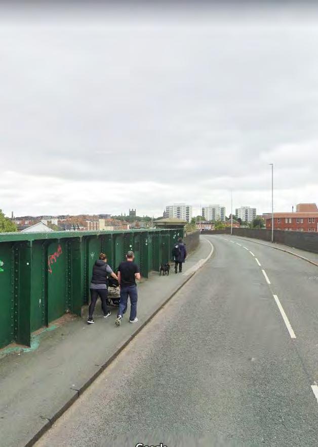
Initial feasibility work has been undertaken to inform the potential options for a new Hoole Bridge. Further technical work will be required to feed into future Business Cases for the preferred option, but at this stage, the analysis considers a series of options which have fed into the Strategic Regeneration Framework.
In reviewing the options, a number of ‘critical success factors’ were considered to identify an initial long-list and this longlist was then further refined, to inform the shortlisted options.
Based on the high-level technical work undertaken to date, a preferred option for Hoole Bridge has been identified. Further technical, strategic and cost analysis work will need to be undertaken as the proposal moves from concept stage through to a Strategic Outline Business Case and Full Business Case.
This supporting study provides an overview of the work that has taken place on the proposed bridge options to date.
259
D
The initial options for the bridge have been presented, discussed and appraised in terms of:
• Their regeneration potential
• Their transport and civil engineering constraints and opportunities
• How they relate to the wider project for improvements to the Hoole Road Corridor

• Their potential to enable development for the Gateway
The issues associated with Hoole Bridge are well known...
• An inadequate gateway into the city, separating Hoole and neighbourhoods north of the rail from the Station area and connections to the city centre.
• A dangerous experience for pedestrians and cyclists, with no segregation and inadequate visibility and pavement width.


• Underutilised land at either side of the bridge, with no step free access from the bridge to the station area.

• Large areas of land dedicated to carriageway and convoluted crossings, reinforcing the sense of separation between existing communities and the railway station and city centre.

CHESTER CITY GATEWAY 260 261
1 2 3 4 1 2 3 4
Report 5th
4 5
EXISTING HOOLE BRIDGE
Chester
City Gateway - Further Feasibility
Studio
EXISTING OWNERSHIP
Landing any new bridge will rely on safeguarding land from Network Rail and from third parties.
The operational requirements and access arrangements to the Network Rail depots need to be understood. Engagement with Network Rail is ongoing.
There is an opportunity to better integrate with the station boundary and improve pedestrian and cyclist access to the station.
Network Rail Freehold
Right of Access
Network Rail Leasehold Light Maintenance Depot (LMD)
Network Rail Leasehold Maintenance Delivery Unit (MDU)
Station Lease Boundary
Land owned by ArchCo with a buy-back option from Network Rail
Land in Private Ownership
Heritage / Listed Buildings
CHESTER CITY GATEWAY 262 263
Chester City Gateway - Further Feasibility Report 5th Studio 6 7
DEVELOPMENT CONSTRAINTS
The bridge is also a major utilities connection for Gas and Electricity, owing to it being the only point crossing the railway in over 1km.
The northern sidings contain two sewers, one containing the culverted ‘Flooker’s Brook’.
The existing Bridge has a number of development constraints which have informed the options analysis.
1. The utilities connection for Gas and Electricity
2. The northern sidings contain two sewers, one containing the culverted ‘Flooker’s Brook’.
3. There is a railway signal attached to the existing bridge which would need to be renewed and slightly repositioned to enable a foot/cycle bridge to be installed.

CHESTER CITY GATEWAY 264 265
Sewers Gas Electric Substation Electric HV Cables Welsh Water Telecoms Welsh Water 900mm Concrete Combined Sewer Welsh Water 1800mm Concrete Surface Water Sewer Cadent 250mm Gas Main Scottish Power HV Substation Scottish Power 33kV Cables Railway Signal Multiple surface water, foul and combined sewer connections Chester City Gateway - Further Feasibility Report 5th Studio 8 9
LONG LISTED DESIGN OPTIONS

1St Anne’s Street link
This option would require extensive engineering work to divert utilities under the MDU access ramp, and reconfigure access to Network Rail sites, and would require the safeguarding of land on third party sites. However, could establish a positive connection between St Anne’s Fields and Flookersbrook Plantation via St Anne Street.
2Hoole Way Bridge upgrade
The Discovery Phase concluded that maximum potential for regeneration and connectivity improvement would be achieved by focussing options around the existing Hoole Bridge.
3Brook Street link
Establishing a clear desire line between Hoole Way and Brook Street for pedestrians and cyclists wishing to cross the railway and continue on to the city centre.
4Station link via Council Land
Adding a pedestrian bridge into the north of the station directly from Lightfoot Street would provide a route to the station avoiding Hoole Bridge.
5Walker Street Station link
Adding a pedestrian bridge into the north of the station directly from Lightfoot Street would provide a route to the station avoiding Hoole Bridge.
6Faulkner Street link (north)
Provides a direct extension of Faulkner Street for pedestrians and cyclists, landing in a key public space proposed for the heart of the Chester Business Quarter masterplan. However, the limited approach distances would mean that ramped access would need to diverge from this direct route. The bridge would be the longest and likely most expensive of these options.

7Faulkner Street link (south)
New bridge connection integrated with / enabled by development of Cestrian Court would provide a direct extension of Faulkner Street for pedestrians and cyclists.
8Westminster Bridge upgrade
Refurbishment or more likely replacement of the road bridge to provide a wider, segregated walking and cycling route, and enable electrifaction of the railway lines beneath.
CHESTER CITY GATEWAY 268 269 StAnn’sStreet StOswald’sWay Frodsham Street CITY CENTRE Brook Street Foregate Street The Bars ChesterMillenniumGreenway Egerton Street City Road 1 2 34 POSSIBLE CROSSINGS 450m Shropshire Union Canal HooleWay RIVER DEE CBQ Link Westminster Road Faulkner Street Newton Lane LightfootStreet Walker Street 5 6 7 8
Railway Possible Crossing Future Connections Existing Cycle Network LCWIP Proposed Cycle Network 650m Chester City Gateway - Further Feasibility Report 5th Studio 12 13
HOOLE BRIDGE OPTIONS
The Discovery Phase concluded after reviewing the possible crossings, shown on the previous page, that the maximum potential for regeneration and connectivity improvement would be achieved by focussing options around the existing Hoole Bridge. The drawings below and over the following pages explore the potential for crossings in this location in greater detail.
The proposals can be categorised into three types of intervention...
MANAGERIAL CHANGES
• Do nothing
• Widen pavements
• Make One Way
• Sustainable transport only
AN ADDITIONAL CROSSING
Additional Active Travel Bridge
• Clip-on cycleway
• South of existing
• North of existing
• Into north of the station
Additional Underpass
The diagram above overlays the long list of options, which are explained and evaluated over the following pages.
Description Relative cost?
1 Ped/cycle improvements to existing bridge£
2 Reduce vehicular traffic to one way (tidal or shuttle arrangement or permanent inbound only) - reallocating space to ped/ cycles
3 Close bridge except to pedestrians, cyclists and buses (single lane over bridge, traffic light controlled) - reallocating space to ped/cycles
Highlighted= most significant spatial consequences for a spatial masterplan in this area
5 Add walking and cycling bridge alongside retained existing bridge [road bridge could be replaced/raised as a separate second phase]
£££
£
6 Add walking and cycling fly-under alongside retained existing bridge [road bridge could be replaced/raised as a separate second phase]
££££
£
4 Add ‘clip-on’ foot/cycleway ££
7 New multimodal bridge ££££££££
8 Hybrid North: Add walking and cycling bridge alongside retained existing bridge. Road bridge extended North alignment
££££££££
• North of existing
• Into north of the station
ONE NEW REPLACEMENT BRIDGE
Singular New Bridge (Big Bang)
• Existing alignment
• Brook Street alignment
• Northern of existing alignment
CHESTER CITY GATEWAY 270 271
Chester City Gateway - Further Feasibility Report 5th Studio 14 15
HOOLE BRIDGE OPTIONS
DO NOTHING
Doing nothing would continue to limit regeneration potential. Doing nothing would:
• remain unsafe for pedestrains, and cyclists
• entrench the severance between Hoole and City Centre
• continue with development paralysis around the station
• limited possibility to electrify the lines or improve the bottle neck of transport connections to Wales and wider region.
Existing bridge is heavily trafficked with narrow pavements
MANAGERIAL ADJUSTMENTS
Limited scope to widen pavements without significantly altering the carriageway and vehicle movement.
AN ADDITIONAL BRIDGE
2 3
• There is limited scope to widen pavements to make the bridge safer for pedestrians.
• Reducing vehicular traffic to one way (tidal or shuttle arrangment or inbound only) would cause unacceptable impact across the wider network.
• Closing bridge except to pedestrians, cyclists and buses (single lane over bridge, traffic light controlled) would cause unacceptable impact across the wider network.
An additional walking and cycling bridge constructed in parallel to the existing bridge. Clearance enough to allow electification of the railway lines beneath.
1. Adding a clip on walkway/ cycle bridge would be potentially abortive if bridge later removed / raised. Implicit risk of working with existing structure.
2. Adding an Active Travel walking and cycling bridge alongside the retained road bridge would improve the crossing for pedestrians and cyclists, overcoming the railway severance. The road bridge could be replaced in a second phase. Yet creates the challenge of accommodating level differential between phases.
3. Adding a pedestrian bridge into the north of the station from Lightfoot street would provide a route to the station avoiding Hoole Bridge, but would not create a desire line to the city centre or enable a level crossing for active travel users.
CHESTER CITY GATEWAY 272 273
1
Chester City Gateway - Further Feasibility Report 5th Studio 16 17
HOOLE BRIDGE OPTIONS
Example project:
1. A new northern alignment would provide necessary level rise to clear 5.8m and allow electrification of the lines. It would require extensive engineering work to divert utilities under the MDU access ramp, and reconfigure access to Network Rail sites. A new bridge to the north could be phased with the existing bridge but requires safeguarding of third party sites.
1. An underpass to the north would require extensive engineering work to divert utilities under the MDU access ramp, and would require reconfiguring access to Network Rail sites. An underpass was considered an inappropriate placemaking solution.
2. An underpass into the Station may provide direct access for pedestrains without the need to use Hoole Bridge, however does not support other active modes / address wider connectivity issues.

2. A new bridge on the existing alignment would bring a phasing risk for utilities and traffic. Still significant level difficulties to resolve but would have the benefit of solving in one go.
3. Brook Street alignment would bring placemaking potential to bring an acvtive mode station entrance off the bridge. Could be phased but would lead to level differential to resolve.
CHESTER CITY GATEWAY 274 275
AN ADDITIONAL UNDERPASS
A13 Underpass, Delft, Netherlands
1 2
REPLACEMENT BRIDGE 1 3 2
Chester City Gateway - Further Feasibility Report 5th Studio 18 19
A new multimodal bridge constructed to replace the existing bridge. Clearance enough to allow electification of the railway lines beneath.
SHORT LISTED DESIGN OPTIONS

OPTIONS REFINEMENT
REASONS FOR AREA OF FOCUS
• The Discovery Phase explored a number of alternative crossing points across the Gateway, and concluded that maximum potential for regeneration benefit and connectivity improvement would be achieved by focussing options around the existing Hoole Bridge.
• The Westminster Road Bridge is also an area where an improved crossing to the railway would have regenerative potential, and may be necessary to achieve the clearance needed should the rail lines beneath be electrified.
REASONS FOR EXCLUDING OPTIONS
• Options to manage traffic / the carriageway of the existing bridge were ruled out due to the limited scope to widen pavements and make a substantial difference to make the bridge safer for pedestrians and cyclists. Closing the bridge except to pedestrians, cyclists and buses (single lane over bridge, traffic light controlled), or by reducing vehicular traffic to one way (tidal or shuttle arrangement or inbound only) would cause unacceptable impact across the wider network.
• Adding a clip on walkway/ cycle bridge was excluded as this would be potentially abortive if bridge later removed / raised to allow the electrification of the railway. There is also an implicit risk of delays to construction when working with the existing structure.
• Adding a pedestrian bridge into the north of the station directly from Lightfoot Street was excluded as despite providing a route to the station avoiding Hoole Bridge, it would require a long detour, a very long new bridge, considerable complexity in the interface with the station, and little positive benefit that could not also be achieved by short-listed options.
• Westminster Bridge, whilst sub-standard, carries significantly less traffic than Hoole Way and as such is a lower priority for intervention.
• The location of Hoole Bridge is central to the masterplan and is therefore the area of focus to unlock a series of adjacent opportunities to benefit the Gateway area.

• The station bridge option would not create a desire line to the city centre for those not wishing to access the station, or enable a level crossing for active travel users, or enable further development and regeneration opportunity.
• Both underpass options were excluded owing to the view that this would lead to an unsatisfactory placemaking solution. Concerns were raised regarding safety, the likelihood to require a high level of maintenance, and the extensive engineering work to divert utilities. An underpass into the Station may provide direct access for pedestrians without the need to use Hoole Bridge, however does not support other active modes / address wider connectivity issues.
• Constructing a new multi-modal bridge to replace Hoole Bridge on a similar alignment as the existing bridge would be impractical as the existing bridge would have to be closed and alternative traffic arrangements made during construction. The option would cause unacceptable impact across the wider network.
LONG LISTLOCATION
MANAGE EXISTING
• Do nothing
• Widen pavements
• Make One Way
• Sustainable transport only
ADDITIONAL BRIDGE
• Clip-on cycleway
• South of existing
• North of existing
• Into north of the station
REASONS FOR SHORT-LISTING OPTIONS
• Adding a walking and cycling (Active Travel) bridge to the south side of the retained road bridge was shortlisted to improve the crossing for pedestrians and cyclists, on the desire line for users wanting to reach the city centre via Brook Street (Option 1). The option also allows the potential replacement of the road bridge as a second phase (Option 3).
• Replacing Hoole Bridge with a singlular road bridge replacement to the north (Option 2) is included for comparison to the additional benefits that would be brought if the replacement road bridge were to be combined with a walking and cycling bridge to the south (Option 3).
• A new northern alignment multi-modal bridge (Option 4) would allow the issues of the existing bridge to be resolved in a single development phase, providing the necessary railway clearance of 5.8m to allow electrification of the lines. A new bridge to the north could be phased with the existing bridge. This option would require extensive engineering work to divert utilities under the MDU access ramp, and reconfigure access to Network Rail sites, and would require the safeguarding of land on third party sites.
SHORT LIST
OPTION 1: NEW ACTIVE TRAVEL BRIDGE
OPTION 2: REPLACEMENT
ROAD BRIDGE
• North of existing
• Into north of the station
• Existing alignment
Phase
Phase
UNDERPASS OPTION 3: PHASED APPROACH (OPTION 1 + 2)
• North of existing alignment
• Brook Street alignment
NEW BRIDGE OPTION 4: NEW
CHESTER CITY GATEWAY 278 279
Brook Street ForegateStreet The Bars ChesterMillenniumGreenway 1 2 34 Shropshire Union Canal HooleWay CBQ Link Faulkner Street Newton Lane 5 6 7 8 650m 1 2 3 1 2 1 3 2
MULTIMODAL BRIDGE 1 Chester City Gateway - Further Feasibility Report 5th Studio 22 23
SHORT-LISTED OPTIONS
The short-listed options are sketched indicatively below, with qualitative assessment via a Multi-Criteria Assessment Framework (MCAF) summarised over the following pages, and appended in full.
OPTION 1: NEW ACTIVE TRAVEL BRIDGE
OPTION 3: PHASED APPROACH (OPTION 1 + 2)
OPTION 2: REPLACEMENT ROAD BRIDGE
OPTION 4: NEW MULTIMODAL BRIDGE
CHESTER CITY GATEWAY 280 281 Phase 2 Phase 1
Chester City Gateway - Further Feasibility Report 5th Studio 24 25
Assessment Framework (MCAF)

Total Score -29 36 1 36 27
Score Justification Narrative:
The existing bridge provides access and utilities connections across the Gateway and wider city, but does not support future demand and growth aspirations for all modes of travel. The existing bridge does not comply with walking and cycling standards, with no dedicated bus lane provision, which negatively impacts users journey quality, resilience, reliability, safety and wellbeing. The access to and from the bridge to the station is also limiting for users. This also holds back opportunities to promote active travel which supports reduced carbon emissions and improves air quality. The bridge clearance from the rail is also not high enough to allow future electrification. Given the age of the structure there is likely to be higher maintenance costs going forwards.
A new active travel bridge constructed in isolation of the existing and/or a new road would transform connections for pedestrians and cyclists across the Gateway and the wider City. It would be constructed to enable full LTN1/20 provision, providing a safe, direct and accessible quality connection, improving wellbeing and inclusion for active travel users; aligning with the user hierarchy objective of the SRF. It would be built to provide clearance for future rail electrification. Utilities could also be diverted through the bridge whilst a future road bridge is constructed. A road only bridge would also be counter to policy drivers around decarbonisation and economic growth. It is likely that a dedicated bridge for active travel would be more publicly acceptable. A new bridge will require significant capital expenditure, with likely positive return on investment and reduced maintenance costs over the 120 year life span.
A new road traffic only bridge would have marginal benefits. It would provide an improved, resilient, quality road corridor with clearance for rail electrification, but would provide limited provision for cyclists and bus trips. It would also impact on potential developable land at Flookersbrook. It is also likely the value for money, and wider economic impacts of a road based travel only bridge would be low. A new bridge will require significant capital expenditure, with likely positive return on investment and reduced maintenance costs over the 120 year life span.
A packaged, phased delivery of a dedicated active travel bridge and road traffic only bridge in the assessment would likely provide significant benefits for users across the Gateway and the City. It would allow an active travel bridge to be in place prior to an enhanced, resilient road traffic bridge being constructed. With the active travel bridge providing spatial provision for active travel users, this will enhance the user experience, safety, inclusion and wellbeing, reducing severance. The active travel bridge would also improve connections to the Station and surrounding communities. The road traffic would also facilitate improved private vehicles and bus trips. Phased construction would also allow utilities provision to be provided through the active bridge prior to the road bridge being constructed. A phased design, development and construction may result in increased cost and construction impacts, and also impact on developable land at either side of the bridge. Two new bridges will require significant capital expenditure, with likely positive return on investment and reduced maintenance costs over the 120 year life
A new multi-modal bridge would have significant benefits for all users across the Gateway and wider City. Providing a wider road space for private vehicles and buses, as well as wider pavement and dedicated cycle lanes to LTN1/20 standards, the new bridge would improve the quality, capacity and resilience for users. Wellbeing would be improved, but would likely have slightly reduced socio-distributional benefits and environmental benefits. The new bridge would also improve access to the Station and surrounding communities through more accessible connections to it. A new multi-modal bridge would like have greater complexities in its buildability and deliverability, and would require greater land take of developable land. A new bridge will require significant capital expenditure, with likely positive return on investment and reduced maintenance costs over the 120 year life span.
CHESTER CITY GATEWAY 282 283
Hoole Bridge - Multi-Criteria
Long List Option Existing Bridge - Baseline Option 1 - A new active travel bridgeOption 2 - A new road traffic bridge Option 3 (Option 1 + 2) - A phased, packaged delivery of an active travel and road traffic bridge Option 4 - A new multi-modal bridge
Chester City Gateway - Further Feasibility Report 5th Studio 26 27
OPTIONS ASSESSMENT
Scoring is assigned from -2 to 2 based on a qualitative assessment of overall benefit. -2 signifies extreme negative impact, -1 marginal negative impact, 0 neutral benefit, 1 positive impact and 2 signifies extreme positive impact and opportunity. The scoring matrix is included over the following pages in Appendix D.1.
+ Positive Attributes
- Negative Attributes
NEXT STEPS:
A New Active Travel Bridge Only is selected as the preferred solution, though neighbouring development opportunities, and officers assessing affected applications, should anticipate the possibility of a second phase replacement road bridge to the north (Option 1 followed by Option 3). Land should be safeguarded for the possibility of this later phase in affected development areas. Based on and building from this initial feasibility testing and qualitative judgement of the options, a further business case and design work is required to develop the proposals further.
CHESTER CITY GATEWAY 284 285
Existing Bridge New Active Travel Only
New Road Bridge Only Active Travel + New Road Bridge (phasable) New Multi Modal Bridge Total Score -29 36 1 36 27
Chester City Gateway - Further Feasibility Report 5th Studio 28 29
APPENDIX D.1
MULTI-CRITERIA ASSESSMENT FRAMEWORK (MCAF)
Hoole Bridge - Multi-Criteria Assessment Framework (MCAF)
Long List Option
Existing Bridge - Baseline Option 1 - A new active travel bridge
Option 2 - A new road traffic bridge
Narrative What is the high level narrative for the bridge option
The existing Hoole Bridge remains
Infrastructure What bridge infrastructure is being proposed
Modes What are modes of transport that the bridge option provides for
Interdependencies What are the potential infaces of the bridge options to be considered
Active travel only bridge to the east of the existing Hoole Bridge
Existing bridge as is New bridge structure with rail clearance of 5.8m and width of 9.5m
Multi-modal (two lane road traffic and narrow pavements at either side)
Option 3 (Option 1 + 2) - A phased, packaged delivery of an active travel and road traffic bridge
Road traffic only bridge Package delivery of the active travel followed by the road traffic bridge
New bridge structure with rail clearance of 5.8m and width of 12m
Active travel only Road travel (private vehicle, bus and cycling lanes only)
Proximity to the platform and signalling will require changes to NR infrastructure
Would require the active travel to be in situ before being developed - scored and assessed presently in isolation with utilities changes required.
Two new bridge structures with rail clearance of 5.8m and widths of 9.5m and 12m
One active travel only bridge, and one road traffic bridge
Delivered as part of a package, with the active travel bridge in place prior to the road traffic bridge being completed. Will require changes to the NR signalling infrastructure and utilities in the existing bridge being moved
Option 4 - A new multi-modal bridge
A new multi-modal bridge to the west of the existing Hoole Bridge
New bridge structure with rail clearance of 5.8m and width of 25m
Road, sustainable and active travel
Will require changes to the NR signalling infrastructure and utilities
Delivering economic benefits Answers questions such as will journeys get quicker, shorter or cheaper; what will the impact on resilience and reliability be; what wider economic benefits could be expected and will it support the delivery of housing/employment
Enhancing connectivity and accessibility
Integrating and enabling sustainable journeys
0 1 0 2 2
Considers likely journey times and opportunities for further enhancements to connectivity. -2 1 0 2 2
Considers potential enabling opportunities for options, and the extent to which upgrades to sustainable and active travel provision could be included.
-2 2 -1 2 2
Considers impact on carbon emissions during construction and once in operation. -2 2 0 2 1
CHESTER CITY GATEWAY 288 289
Contributing to net zero carbon, air quality and enhancing the environment Chester City Gateway - Further Feasibility Report 5th Studio 32 33
Hoole Bridge - Multi-Criteria Assessment Framework (MCAF)
Considers national, regional and local policy drivers alignment -2
Degree of consensus over outcomes -2 2 -1 2 1
-2 2 0 2 1
-2 2 0 2 1
Wellbeing Considers physical wellbeing, road safety, crime, severance.
Expected VfM category Considers expected costs versus benefits. Approximation at this stage.
-2 2 -1 2 1
0 -1 -1 -1 -2
2 1 0 -2 -2
0 2 0 1 1
Considers the long term cost of the looking after the bridge going forwards
Long List Option Existing Bridge - Baseline Option 1 - A new active travel bridge Option 2 - A new road traffic bridge Option 3 (Option 1 + 2) - A phased, packaged delivery of an active travel and road traffic bridge Option 4 - A new multi-modal bridge Chester City Gateway - Further Feasibility Report 5th Studio 34 35
CHESTER CITY GATEWAY 290 291
Fit with wider transport and government objectives and policy 2 1 2 2
Considers the consultation that has taken place with relevant stakeholders
-2 2 0 2 2
0 1 1 2 2
Socio-distributional impacts Considers whether the option may have an impact on specific groups of people, such as children, older people, disabled people or Black and Ethnic Minorities.
Local environment Considers air quality impacts, noise, the natural environment, heritage, landscape and townscape.
Public acceptability An assessment of whether there are likely to be issues around public acceptability of the option.
Practical feasibility An assessment of whether the options considered have governance issues associated.
Affordability A consideration of the budget and capital investment required -2 2 2 2 2
Fundability Would the bridge be appealing for investment from local, regional and/or national funding streams
Operational and maintenance costs
List Option
Flexibility of option Considers how easy would it be to stop the scheme, scale it up or down.
Reliability Considers whether the reliability of the network improves or reduces as a result of the option.
Resilience Considers how resilience the network would be improved through the options.
Journey Quality Considers the quality of the journey, for example whether it is improved for all users.
Reduced
Utilities

120 year design life Is the option designed and developed for 120 year life span
LTN1/20 compliance and dedicated active travel routes
Development
Has recent active travel guidance and compliance been considered or possible with the option
clearance and
passive provision
Deliverability
works
CHESTER CITY GATEWAY 292 293
-2 1 1 2 2
-1 1 1 2 2
-2 1 1 2 2
-2 1 0 2 2
0 1 0 1 1
-1 1 0 2 2
2 2 -2 0 -2
-2 2 2 2 2
-2 2 -2 2 2
1 1 -1 -1 -2 Electrification
-2 1 2 2 2
Generalised Journey Time Considers the overall time taken for people to get to their final destination and journey times 0 -1 -1 -2 -2 Total Score -29 36 1 36 27
severance Does the option reduce severance for all users in the Gateway area, and the wider City
changes Does the option require changes to utilities crossing the bridge and railway
opportunities Does the option impact current or future development planned
Does the option allow for future electrification on the railway line
Considers the ease of deliverability, such as the scale and level of complexity of
Long
Existing Bridge - Baseline
1 -
bridge
2 -
bridge
3 (Option 1 + 2) - A phased, packaged delivery of
active travel and road traffic bridge Option 4 - A new multi-modal bridge Chester City Gateway - Further Feasibility Report 5th Studio 36 37
Hoole Bridge - Multi-Criteria Assessment Framework (MCAF)
Option
A new active travel
Option
A new road traffic
Option
an
ENORTH OF ENGLAND RAILWAY STATIONS CAR PARKING STUDY
294 CHESTER CITY GATEWAY 12 — APPENDICES 294
295
APPENDIX E North of England Railway Stations Car Parking Study
The Table below shows the amount of car parking available across similar train stations across the North West and the number of travellers associated with these stations. It is demonstrated that Chester has a lower number of car parking spaces when compared to similar railway stations across the North West.
CHESTER CITY GATEWAY 296 297 Railway Station Number of passengers a year Number of spaces Chester 5.1 million 500 spaces within a 9-minute walk Preston 5 million 1,853 spaces within a 8-minute walk Crewe 3.4 million 922 within a 7-minute walk York 10 million 846 spaces within a 6-minute walk (but long-stay will be replaced with a larger car park) Stockport 4.3 million 1, 253 spaces within 9-minute walk
FPROJECT TEAM ROLES AND RESPONSIBILITIES
298 CHESTER CITY GATEWAY 12 — APPENDICES 298
299
APPENDIX F Project Team Roles and Responsibilities
Project Project Lead Place Funding Streams
History Centre
Cheshire West and Chester Council
Lightfoot Street West Heritage Lottery Funding
Chester Railway Station Transport for Wales Station Square
Flookersbrook
Indicative Delivery Timescale
Short-term
Short-term
Residential developments
Various – private landowners, Cheshire West and Chester Council, Network Rail
Lightfoot Street West
On a case by case basis – mix of private and public sector funding streamsShort-Medium term Car Parking Strategy
Cheshire West and Chester Council with support from partners
Existing surface car parking sites – scope for redevelopment
Further phases at Lightfoot Street West and East
Mobility Hub
Cheshire West and Chester Council, LCR, Network Rail and individual landowners/ stakeholders
Cheshire West and Chester Council, LCR, Network Rail and individual landowners/ stakeholders
Northgate Links Black Diamond Street
Existing surface car parking sites within the Gateway Revenue funding to be confirmed
Queens Road St Annes
Capital funding streams to be confirmed – potential mix of private and public funding.
Short-term
Medium-term
Lightfoot Street West Lightfoot Street East
Cheshire West and Chester Council, LCR, Network Rail Station Square
Hoole Active Travel Bridge
Cheshire West and Chester Council, LCR, Network Rail and key landowners
Public Realm Improvements
Cheshire West and Chester Council, LCR, Network Rail and key landowners
Hoole Bridge
City Road
Brook Street
The Bars
Black Diamond Street Junction Millennium Greenway link
Capital funding streams to be confirmed – potential mix of private and public funding.
Capital funding streams to be confirmed and will be subject to a formal Business Case. Would require public funding streams to be delivered.
Capital funding streams to be confirmed and will be subject to a formal Business Case. Would require public funding streams to be delivered albeit potential to secure some developer contributions as match funding.
Medium-term
Medium-term (subject to Funding/ Business Case approval)
Long-term subject to Business Case and Funding approval.
Capital funding streams to be confirmed. Would require public funding streams to be delivered albeit potential to secure some developer contributions as match funding.
Medium-longer-term, subject to funding approvals.
CHESTER CITY GATEWAY 300 301
CHESTER CITY GATEWAY 302
