


“Given the significance of the Canal and River Dee as a network of waterways from a leisure, visual , urban form and heritage perspective it is vital that a comprehensive Waterways Strategy is developed for the city…to maximise the potential of the waterways as an economic and social asset.”

This Waterways Strategy for Chester is a direct deliverable from Chester’s One City Plan focusing in detail on the opportunities that the waterways present
The strategy development has been undertaken in partnership between Chester Renaissance, Cheshire West and Chester Council, Canal and River Trust, Chester Canal Heritage Trust and the Inland Waterways Association. Importantly it has taken into consideration views and aspirations from a large body of local stakeholders who have attended workshops and consultation meetings
The Waterways Strategy also takes into account the large body of work, studies, development briefs and research related to the waterways over the last 20 years. These source documents provide a very strong foundation on which to form the strategy and on which to build
The 2010 Urban Land Institute Report highlights both the River Dee and Shropshire Union Canal in the top ten assets of Chester

The key aims of this strategy are:
1 Provide clear direction for how developments related to waterways can contribute to the growth agenda
2 Improve the connectivity between the canal, river and city encourage increased inward investment and increased tourism
3 Encourage increased employment relating to the leisure economy and maximise the potential of the waterways for recreational purposes
4 To complement the emerging transport strategy, cycling strategy and importantly, provides input to the statutory Local Plan which guides development
Chester Waterways will be better connected. The ‘joined up ’ strategy will deliver an impact in terms of social, economic and physical regeneration more than the sum of its individual parts. Chester’s waterways will, once again, play their part in delivering growth and vitality for the city.

The sub-regional context and position of the waterways is important to appreciate in order to maximise the potential connections and opportunities that could be achieved. This map demonstrates the wider connections.


Main focus of Chester’s Waterways Strategy is on the River Dee corridor and the Shropshire Union Canal corridor. For the purpose of this strategy the Dee corridor is defined as extending from Eccleston Ferry through Chester to the Welsh border at Saltney. The Shropshire Union Canal Corridor is defined as extending from Quarry Bridge, Christleton, through to Caughall Bridge incorporating the Dee Branch to the river lock The One City Plan area is highlighted within these corridors

The towpaths and riverside paths can offer traffic free alternative routes which by their nature tend to be level, providing accessible walking and cycling throughout the year with links to the footpaths and cycleways across Chester. The Waterways Strategy builds on and dove-tails with the newly adopted Cycling Strategy for Chester and the emerging Transport Strategy for the city Key access routes are indicated on this map


It is evident from the nature of the waterways that a whole range of agendas are touched upon when considering the waterways: environmental factors, flood defence, health benefits, transport routes, heritage assets, social and recreational opportunities, visitor economy, regeneration etc. For the purpose of this Waterways Strategy we will set the broad policy contexts in order to establish a coherent and considered approach for Chester’s waterways and then focus in detail on the ‘Contexts for Growth’ and ‘Character Areas ’

It is widely recognised that Chester’s environment plays a significant role in ensuring the attractiveness of the city for visitors, residents and business.
This was acknowledged in the One City Plan, which identified as a key action the effective use and integration of the city’s blue and green infrastructure This recognises the many functions of water within the city; for example, providing a high quality environment, encouraging access by linking its urban and rural greenspaces and natural habitats
Having water in the heart of the city is a great asset and the River Dee is of clear environmental significance

The Dee is internationally important having been designated as a Special Area of Conservation (SAC) and is also a Site of Special Scientific Interest (SSSI) It is valued as a river system from source to sea and brings Atlantic Salmon and Otters through the city
The Shropshire Union Canal provides an important route for the movement of people and wildlife through the urban area As well as the obvious use by inland waterway craft it is also an important route for walkers and cyclists and has been designated as a Local Wildlife Site, providing important aquatic and terrestrial habitats
Water and adjacent greenspace also provide an important buffer against the effects of climate change as waterside trees provide shade and evaporation cools the surrounding built areas.
Seeing blue and green spaces as a whole, and managing them in an integrated way, shows us that they are greater than the sum of their parts. Understanding their multifunctional benefits ensures the most efficient use is made and in turn balances the needs of people and the natural environment
Chester has a fascinating system of interconnected waterways that are the result of its history as a trading and administrative city.
The Romans sited their legionary fortress at Chester around AD 72 because the River Dee at this point swung west through a bridgeable narrow gorge and opened out to form suitable moorings for a port for North Wales and Ireland. The location of the Old Dee Bridge was fixed from then on A thousand years later Hugh Lupus, Earl of Chester, was responsible for building the first Dee Mills and erecting Chester Weir to provide a head of water to power the mill wheels The weir created a barrier between the upper and lower Dee that remains today and makes it difficult for boats to pass from one to the other. Other mills were built at the Handbridge end of the weir They closed in 1954 whilst the Dee Mills closed in 1908 The site was subsequently used to generate hydro-electricity.
Chester’s wealth in medieval times was built on its trade with Ireland and overseas, and the port became the most important in north-west England The Dee was, however, silting up and in 1733 the river downstream from Chester was canalised to become the straight waterway we see today The scheme failed to save Chester’s port, however, partly because the waterway was defective and also because the River Dee Company did not maintain it. By the 1800s even small vessels of 100 tons struggled to reach Chester Liverpool overtook Chester to become the north-west’s premier port
Liverpool’s rise was partly helped after 1766 by the building of the Grand Trunk Canal from the River Mersey to the Midlands Chester’s business leaders thought that if they could connect with the Grand Trunk at Middlewich they would divert some trade back to the Port of Chester To do this they opened the Chester Canal in 1779 It was a failure The owners of the Grand Trunk Canal would not allow Chester’s canal to link with their own and siphon off its traffic.
The Chester Canal was forced to stop at Nantwich, a dead end. By 1796 it ‘ was in a ruinous condition’ Nevertheless, it was this canal that gave us today’s waterway through the dramatic Northgate cutting and out of the city through Boughton.
After 1795 the Chester Canal was revived by the new waterway that was built from Chester to what became Ellesmere Port This created the unusual and attractive canal layout we see today with its locks at the Northgate, the wharf, warehouse and boatyard at Tower Wharf and the branch canal down to the Dee near Crane Wharf Between 1795 and 1835 new canals linked Chester with the Mersey, the Potteries, North Wales and the industrial midlands These schemes did little, however, for the Port of Chester which continued to decay. Chester was now merely a point on canals going elsewhere, but the canal banks at Boughton attracted new industries like the leadworks, corn mills, timber yards and chemical works Their surviving buildings are a valuable part of Chester’s heritage.
By the nineteenth century Chester’s waterways were an interconnected system Trading boats sailed on the River Dee up to Farndon whilst both sea-going vessels and canal craft from North Wales, the Mersey and the Midlands went to the wharves, mills and factories located on the River Dee and the canal In 1845 various amalgamations created the Shropshire Union Canal system, the modern general name of the canal through Chester After 1840 the railways took over as Chester’s main transport system, but the waterways, including the port, continued to be actively used into the twentieth century. The upstream River Dee became popular for leisure boating and rowing Even so, decline set in and the growth of motorised road transport took the final traffic from the local waterways. By the 1950s the canal and the old Port of Chester were littered with derelict or decaying waterside premises and abandoned boats
Chester had turned its back on its unique waterway system
Things started to change in the 1960s. The growth of leisure boating began to bring some new traffic to the canal After 1968 the urgent need to conserve Chester’s decaying historic areas led to recognition of the city’s waterway heritage. Chester City Council’s Canal Study of 1973 was the first attempt to officially recognise the canal as an asset and promote policies to improve its surroundings. Since then much has been achieved and the waterway environment is better than it was fifty years ago Even so, there are still significant challenges in the Chester waterway system
As well as the strong heritage of the canal the River Dee also has significant untold stories
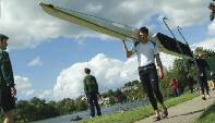
Chester Regatta was established 280 years ago in 1733, although
rowing races were certainly held in Chester before this Chester Regatta is the oldest competition on the ARA rowing calendar and is the oldest regatta for club entries in the world To put this achievement in an historical context, the first Boat Race between Oxford and Cambridge Universities was held in 1829 and what was to become Henley Royal Regatta started in 1839.
Records show rowing in Chester for more than a millennium
In 973AD King Edgar visited Chester following his coronation in Bath and was rowed on the River Dee by the “eight kings of Britain” Another account says in 1541 the scholars of King’s School Chester rowed Henry VIII on the Dee.
The task of the Waterways Strategy is to build positively on all of the city’s historic waterway legacy
Main picture right: Chester History and Heritage Collection: The Chester Canal through industrial Boughton in the early twentieth century
Inset picture left: Francis Nicholson (1753-1844): Chester Castle and Skinner’s Yard. Grosvenor Museum Industry and shipping on the River Dee at Skinner’s Yard below Chester Castle in the early 19th century
Inset picture right: Grosvenor Museum or Chester History and Heritage collection Links between the canal and the River Dee Shropshire Union canal flat stranded on Chester weir at some date in the 1870s


Creating a sustainable waterway environment will improve health and wellbeing – through high quality green infrastructure that creates places that promote active travel and encourages social interaction, exercise, play and contact with nature.


The Marmot 2008 Independent Review of Health Inequalities recommended that access to good quality air, water, food, sporting, recreational and cultural facilities and green spaces all contribute to reducing health inequalities as well as helping create sustainable
communities Access to green space and green infrastructure improves mental and physical health and reduces health inequalities Regular physical activity is associated with a greater sense of well-being and lower rates of depression and anxiety across all age groups. Exercise outside often can have more positive mental health benefits than exercise of other kinds – the concept of green or indeed blue gyms should therefore be encouraged Physical activity does not necessarily need to be particularly intense for feeling good. Slower-paced activities, like
walking, can also have the benefit of encouraging social interactions at the same time.
The New Economics Foundation have shown that the Five Ways to Wellbeing - Connect, Be Active, Take Notice, Keep Learning and Give - has wide social and economic benefits. Evidence shows that building these actions into your daily life can add 7 5 years to your life Use of high quality green and blue spaces such as the waterways can enable many of us to take these positive steps to greater wellbeing.


It is known that waterways can act as a catalyst for the development of property alongside them and this works in a number of ways:
Waterside developments can create destinations and help areas feel safer and more accessible whilst providing linkages between locations.
Appropriate waterside development can add significantly to the appeal of an area by


introducing quality and excitement in buildings and their use. Waterside developments have the potential to deliver external spaces that draw people to enjoy the environment creating a positive context for inward investment Their linear form means that canals can also help to integrate discrete development schemes.
Waterside locations are special places for those who live, work and play in a city They can be
both tranquil and vibrant with an ever changing scene on the water and along the verges providing attractive and special places to encourage inward investment
Evidence suggests that property developments at waterside locations command a premium value of between 15-20% when compared to schemes based elsewhere and are easier to sell or let
“Property located at an at tractive waterside location at tracts a premium . Independent research found that when compared to similar property in a non waterside location , canal and riverside properties enjoy an uplift in value of nearly 20%” English Heritage & British WaterwayS”
England’s Historic Waterways

“The River Dee corridor – a Site of Special scientific Interest (SSSI) – will be better integrated into the city for the enjoyment of all by making access to it across the inner ring road much more pedestrian friendly. Whilst mindful of the delicate habitat, recreational uses along the River Dee and its waterfront will be encouraged and supported. Rowing will be promoted, including holding events and galas, by working jointly with the University of Chester and private sporting clubs.”
One City Plan 2012
Almost all the waterways system is used for leisure. This includes boating of all kinds; angling; sport and informal recreation. The navigable waterways host opportunities for long distance flat water trails and events with the broader rivers and canals used for watersports.
Recreational angling is the most popular participation sport in the country The navigable waterway

network forms the biggest and most valuable coarse fishing resource in the country.
Towpaths and other waterside paths provide local and long distance walking and cycle routes, as well as providing attractive off-road routes for activities such as commuting and dog walking. Canal towpaths are often flat and level, enabling their use by a wide range of people of all ages and
abilities to improve their physical fitness through moderate regular exercise.
96% of the use of the waterways is on the towpaths and not on water but it is the activity on the water that adds the vibrancy people enjoy. Chester’s waterways present a great opportunity in this respect as currently only one in four boats visiting Cheshire come to Chester
47% of the population lives within 8kms of a waterway….with nearly one million living within 100 metres. The network attracts approximately 270 million visitors per year, with over 93% of visitors being ‘ever yday explorers’ TCPA British Waterways policy advice note inland waterways.


Tourism is of enormous importance to the economy and can bring benefits to local communities The waterways are an important national tourism resource – they enhance the attractiveness of both urban and rural areas, they link places of interest and they generate tourism in their own right.
A study by the British Marine Federation published in 2008 estimates that the inland marina sector generates some £47 million turnover each year When on-site businesses, suppliers and visitor and employee expenditure in the wider economy are taken into account, the inland marina sector is estimated to support the equivalent of about 10,000 full-time jobs in local economies around the UK. Revenue from hire boat businesses amounted to nearly £90 million in the same year and supported over 1,700 full-time jobs.
“The enhancements of the River Dee Waterfront will improve the quality of the public realm from Lower Bridge Street and along Castle Drive. This could include enhanced lighting of the Walls Walkway (utilising energy generated from the weir proposal) Animation and use of the riverside for independent quality markets and events is also a key part of encouraging people to use the waterfront space. ”
One City Plan 2012
“The Shropshire union Canal is a multifunctional asset for the city – providing a corridor of open space, water infrastructure and a sustainable transport route. The opportunities to promote the canal and its integration with canalside developments and surrounding areas are extensive and should be fully realised This also includes exploring opportunities to maximise the linkages of the water spaces between the River Dee and the Shropshire Union Canal, in the ports and wharfs area ”
One City Plan 2012

“Waterway network owned and managed by Canal & River Trust contributes £1 2 billion per annum to the visitor economy with potential for growth to £2 billion.”
TCPA British Waterways policy advice note inland waterways

It is useful to understand the different character areas presented by the waterways in Chester. Much of the analysis relating to these specific areas is drawn directly from stakeholder workshops and local input These can be broadly understood as the following: 1


The Boughton Corridor waterside character area relates to areas within the One City Plan and is typical of a canalside linear development. This section of the canal represents a critical connection between suburban and central Chester Significant potential for this area derives from the Chester Central Business Quarter development with a new pedestrian and cycle bridge which offers connectivity through this new quarter to the station.


• Poor lighting – not fit for evening economy
• Isolation from wider city fringes and inner city – disconnected
• Inconsistent public realm
• Weak connections and way finding
• Little or no accommodation for cyclists –City Road bridge and hence wider city (including railway station)
• Inner ring road flyover – barrier between character areas (Bars and Business and City Gateway)
• Limited waterside openspace to form waterside focus
• Lack of visible boating activity to animate waterway

• Emerging Business Quarter increases profile and visibility of canal corridor
• Canal enables direct links between the new quarter and City Centre
• Public realm to establish new quality
• Integration of public realm, making canal part of wider City and its communities
• Extend night time economy – expansion of waterside businesses
• Traffic free, off road route linking new business quarter, city centre and suburbs

• Creation of new visitor moorings linking with existing and new businesses

• Potential for a water taxi business.
• Management to ensure waterside business has confidence in value of waterway
• Landscape treatment to establish the towpath as a key pedestrian route within the City’s street treatments (landscape design guide/CWaC)
• Ensure waterside developers create a positive connection to the waterside, active edges
• Planning Policy Design Guidance for waterside development
• Acknowledge impact of waterside development in local plan and integrate potential of waterways into strategic planning
Located near to the proposed Chester Central Business Quarter development and adjacent to existing businesses, the area has great potential to support existing waterside trade and create a vibrate leisure economy to support new ventures The opportunity exists to enhance the public realm and create a key pedestrian route within the city, linking with existing and new communities.
The City Gateway character area is a significant entry and welcome point for the city The water space is presently dominated by a backdrop of outward facing buildings and is crossed by the Chester inner ring road. The towpath provides good pedestrian links between the proposed Chester Central Business District development, the city centre and the regenerated Tower Wharf at Chester Basin There are a number of popular visitor moorings along the canal in the character area which are used by those visiting the city by boat.


• Dominated by highway infrastructure
• Inconsistent and poorly maintained public realm
• Back facing businesses – dominated by bingo hall and service road
• Lighting not maximised
• Limited way finding
• Poor connection to the newly emerging business quarter
• No sense of arrival or welcome or sense of place
• Close proximity to city centre not exploited or recognised
• Winding hole encourages boats to turn around and leave the city
• View of walls obscured by vegetation, connection to city lost
• Creation of a gateway to the city
• Potential to maximise positive impact of potential bus interchange
• Uplift of surrounding public realm and landscaping
• Water facing development
• Key waterside commercial and leisure development opportunity to bridge gap between city and canal corridor
• Integration of the canal into the public realm – high quality interface
• Greater connectivity with city centre –way finding – support retail economy
• Greater connectivity with the city walls, architectural lighting to showcase links
• Improvement of visitor moorings
• Maximise visibility of canal
• Existing visitor moorings, colour in the canal, opportunity to grow sense of life on the water
• This area is the most visible section of the canal in Chester and therefore should be most exciting to developers


• Scope for a water taxi
• Transport Strategy highlights improved access points to the towpath.
• Ongoing management of the canal to ensure waterside business has confidence in value of waterway
• Landscape treatment to establish to the towpath as a key pedestrian route within the city’s street treatments (landscape design guide/CWaC)
• Ensure waterside developers create a positive connection to the waterside, active edges
• Planning Policy/Design Guidance for waterside development
• Ensure key waterside sites engage and link through to the city and Cathedral Quarter with pedestrian circulation which connects the city and canal
• Improved access points onto canal network, link with Transport Strategy
• Improved visitor moorings including offside moorings
• Opportunities for appropriate floating trade boats around Cow Lane Bridge
Comprised of improved and integrated public realm and landscaping with greater connectivity to the city centre, the City Gateway character area represents an opportunity to create a gateway and dynamic face to Chester. Floating commercial businesses could evolve throughout the year to link the canal with the city centre. New waterside development with open and active frontages would also contribute to the welcome of the city. Proposals for architectural lighting would add a further dimension of interest and connectivity with the city walls and city centre.
The Walls character area extends from Gorse Stacks to Northgate Staircase Locks which descend to the historic Tower Wharf at Chester Canal Basin. The main line railway and the A5268 St. Martin’s Way Flyover both cross the canal at the staircase locks, giving an enclosed feel to this particular length of the waterway To reach the locks the canal skirts the outside of the historic walls passing by King Charles Tower, North Gate and Water Tower. The deep sandstone cutting, which links a number of green open spaces, provides a striking feature along this length


• City Walls create a visual and physical barrier
• Poorly maintained green space
• Poor visual sight lines to the walls due to overgrown vegetation and trees
• Perception of poor personal safety due to overgrown green spaces
• Lighting and security problems
• Poor connectivity with the city and cathedral (visitor attractions within the city walls) – hidden from the city
• Limited way marking
• Underused pocket parks
• Northgate Locks – off putting
• Fly over at the locks creates an threatening atmosphere
• Failing to realise potential to link Tower Wharf with the city
• Locks are a barrier to boating, needs to be a suitable destination below locks, and pleasant passage of locks
• Environmental management looks and smells a tertiary space in the city
• Appropriate management and clearance of trees and vegetation to open up the canal corridor and sightlines from and of the city walls
• Way finding between the cathedral, city centre and canal
• Interpretation of the city walls on the canalside – create stronger links at Northgate
• The walls should feel amazing to look up at part of the experience of the walls
• Adjacent residential homes do have eyes on the water – how can this be improved?
• Create new pocket park by George Street to open vistas of the walls and cutting and encourage active use, especially from workers/visitors to new Health centre development.
• Heritage stories can be promoted e g bridge of sighs
• Use lockkeeper volunteers as information points/guides
• Actively promote waterway tours –blue badge guides
• Landscape treatment to establish the towing path as a key pedestrian route within the city’s street treatments (landscape design guide/CWaC)
• Appropriate and sensitive vegetation management
• Art lighting projects to enhance the walls (bat friendly) – and improving evening safety
• Canal/Towpath adoption schemes
• Promote the view of walls and towpath walk as one of the ‘tick list’ activities of a visit to Chester


• Improve management – should feel like a city park
• Access and wayfinding improvements
• Art Project – roving boat
• Actively manage volunteer programme to maximise impact of lock-keepers
• Pocket parks redeveloped to create dwell spaces and increase visibility and connections between canal and river
The canal and its towpath in the Walls character area represents a significant opportunity to establish the waterway as a key pedestrian route through the city linking the historic Tower Wharf with the city centre and the proposed Chester Business Quarter development. The opportunity exists to manage the adjoining green spaces to give a more open feel to the waterway. The installation of architectural lighting on the Walls would add interest while giving an added feeling of safety at night
Tower Wharf is the historic focal point for the waterways in Chester. In its height the Wharf area became an important boat building centre. Taylor’s Boat Yard still operates and is perhaps the finest example of a traditional boatyard remaining on the canal system

Today the Wharf and Basin are being regenerated with a mixed residential and commercial development which will see an extensive transformation to the area The site has good connections with the University of Chester and beyond into Ellesmere Port linking Chester Zoo and the National Waterways Museum The Wharf is a popular hub for pedestrians using the towpath to access the city centre and wider residential areas. The River Dee Branch which leads from Tower Wharf is a critical link in the River Dee’s pathways and its navigation enabling users to access the wider waterway network

• Poor visual appearance of the dry dock
• Poor visual appearance of the Roving Bridge
• No sense of arrival or sense of place
• Phased construction site
• Restricted physical access between Tower Wharf, Chester Basin and Dee Lock
• Limited night time economy
• No day time retail economy to serve local community
• Underused by visiting boats (Northgate Locks acts as barrier)
• Heritage buildings in need of repair
• Dee Branch – silting and disrepair of lock gates making access difficult
• Empty units in the new development
• Perception that the site is not secure for visiting craft
• Could become overly residential and not a visitor destination
• Remote from city (although only 0.5 miles - 11 minute walk).
• A key canalside space in the city with an important group of heritage buildings (listed)
• Traditional boat building, in development of Taylors boat yard
• Potential for waterspace activity

• Uplift of built environment to bring wider Wharf in line with new development –heritage grants
• Extend night time economy and café culture with occupation of empty units
• Stronger links with Riverside Link and walkway – way finding
• Emerging mixed used development
• To create a visitor destination in its own right
• Potential waterway taxi to link Tower Wharf, Chester Zoo and National Waterways Museum


• Well used pedestrian route way –strong links with Chester cycle ways
• Strong links with the Garden Quarter residents and the University
• Potential canal boat hire location
• Management to ensure waterside business has confidence in value of waterway, e g canal boat hire operators
• Landscape treatment to establish the towpath as a key pedestrian route within the city’s street treatments (landscape design guide/CWaC)
• Ensure waterside developers create a positive connection to the waterside, active edges
• Planning Policy Design Guidance for waterside development
• SV Activity calendar for waterside spaces including canal festival
• Explore connection to Dee, and the value this will generate to boating activity and wider tourist economy
• Promote links between river and canal
• Tourist potential of Tower Wharf and canal heritage
• Improve sitting out areas for Telford’s Warehouse
• Increase partnership working with National Waterways Museum
• Encourage development of urban canoe safari
Located near to the city centre Tower Wharf has the potential to become a unique visitor destination in Chester. Set in an historical setting the waterside regeneration would support the improvement and enhancement of existing and new businesses by extending the night time economy and café culture. An opportunity exists to create open and active frontages with improved public realm to host a variety of water based activities throughout the year. Improved connections with the River Dee junction will bring greater movement between the two waterways and the opportunity to create long distance routes

The Riverside Link character area represents a key pedestrian and waterway link between the Shropshire Union Canal and the River Dee navigation with the area extending as far as the A483, Grosvenor Bridge crossing The Riverside Promenade opens up the Little Roodee and Roodee so that walkers and cyclists can explore the riverside between The Groves, the Old Port and Cop Park. The trail is a short distance from the city centre and its visitor attractions The river is tidal as far as the Chester Weir

• Poor site lines of the river – overgrown vegetation and lack of management
• No way marking between canal basin, the road and start of the riverside cycleway –road crossing not pedestrian/cycle friendly
• Link to the riverside link is through private housing – off putting
• Poorly maintained residential block next to the lock – reflects badly on the immediate area
• The lock environment is overgrown and poorly maintained
• No direct access between the Cop Park and Riverside promenade across the lock
• Heritage significance as key port untapped
• Depth gauge to monitor water levels necessary for navigation
• Unique opportunity to walk or cycle around the race track –very well maintained pathway
• Opportunity to contrast the river and canal environment

• Open up River Dee Lock to enable navigation between the two water courses – further opportunity to reate loop

• Open up views of the river from the pathway – greater connection with the waterside environment
• Alternative connection into the city centre leading through to the city waterside area
• Way finding to connect effectively with river
• Potential to enhance access to the river
Actions
• Address connectivity, paths between canal and river
• Management to ensure waterside business has confidence in value of waterway
• Landscape treatment to establish the towpath as a key pedestrian route within the city’s street treatments (landscape design guide/CWaC)
• Landscape Management Plan to address overgrowth

• Ensure waterside developers create a positive connection to the waterside, active edges
• Planning Policy Design Guidance for waterside development
• Explore increase visitor moorings and link with Connahs Quay and Flintshire Coast

• Explore heritage interpretation to rediscover Old Port
• Navigation depth gauge to be installed at the River Dee Lock.
The Riverside Link represents a significant opportunity to create a key waterside pedestrian route between the canal, river and city centre. Proposals to improve public realm and way-finding will encourage greater pedestrian use of the waterways, increasing activity at the key locations of Tower Wharf and The Groves Management of the bankside vegetation along the Riverside Promenade would open up key views of the water to take full advantage of its unique setting.

The City Riverside character area extends from the Grosvenor Bridge to The Meadows and is an example of a Victorian riverside promenade City Riverside represents a key access point to the river from the city An outstanding feature of this length is a Grade 1 listed weir and salmon leap. The weir creates a linear lake able to support a well-established river calendar and other activities. The weirgate is a critical connection enabling navigation (restricted to high spring tide) between the Dee Branch and the non-tidal River Dee

• Poor river access for canal craft
• Boat movement restricted by the weir
• River at capacity at peak times –concentrated use by river users
• Disconnected from the city and hidden –city effectively turned its back on the river
• Poor visibility of river from Little Roodee
• Poor way marking making it difficult to find from the city centre
• Not joined up to the canal network
• Queens Promenade poor quality public realm
• Security issues with insufficient lighting
• Significant heritage not highlighted
• Congestion on Groves at peak times concentrated within limited spaces
• Maintenance of the Dingle
• New development opportunities along the Groves expanding benefit of Groves to new areas
• Create stronger links with the Meadows –way marking – creation of circular walks
• Acknowledge previous aspirations and project work on a potential new footbridge linking the Meadows to Huntington
• Create stronger link with Queens Promenade, rediscover World War II Tunnel entrances, create circuits for visitors
• Ferry link between Sandy Lane and the Meadows
• Manage additional river based activities
• Co-ordinate activities and events between the river and the canal

• Increase use of bandstand as focal point for activity
• Potential riverside markets Castle Drive
• Hydroelectric power (HEP) at the weir –interpretation opportunity/visitor attraction
• Develop a river pageant
• Way marking to promote connectivity between water, city and attractions

• Support emerging transport strategy initiative to reduce impact of Pepper Street barrier between city and river
• Improve navigation between lower and upper Dee
• Improvements to the Dingle.
• Queens Park promenade improvements
• Wayfinding to increase connectivity
• Increase promotion and scope of river events programme
• Expand HEP scheme to maximise impact for visitor economy, fish counters as attraction etc
• Architectural lighting to showcase bridges and walls
• Waterway heritage walking tours for tourists
• Feasibility study to explore improved navigation between the lower and upper Dee by way of the old mill race on the Handbridge side of the weir
• Explore increased activity/ pop-up stalls at Castle Drive
• Improve access to the River Dee at Sandy Lane for a range of activities.
With improved public realm and way-finding City Riverside offers a significant opportunity to improve connectivity with city routes and wider networks An opportunity exists to create a dynamic gateway to the city with an expanded programme of riverside activities and events linked with the proposals for the HEP station. The addition of architectural lighting would give an added dimension to the visitor experience Proposals to explore the feasibility for improved navigation at the weir could open up the non-tidal river to canal craft. New moorings would allow waterside businesses to take advantage of passing boats.
There exists a huge opportunity to consider the potential connections made possible by the waterway system and the benefit of linking with sub-regional attractions. Also marketing and promotion of the waterway can help generate growth in visitor numbers and active use on the water This element deals with opportunities that cut across the different geographical character areas and contributes to the waterways as a whole
Issues
• No circular sub-regional route available for boaters
• Lack of information about opportunities/trails on waterways
• Tourist attractions on waterways not linked
• Marketing for waterside events weak
• Landing stages up river lacking
• No significant national/international events
• Canoe touring potential not fully realised
• Create new tourism offer for boaters –West Cheshire Ring, Chester to Ellesmere Port link

• Significant quality tourism attractions could be linked via water
• Enhance Farndon/Holt links
• River Dee canoe trail linking to Llangollen
• Walking towpath trails
• Blue badge guides waterway tour
• Publicise events better, increase links with commercial sector
• Use lock-keepers as information points/guides
• Visitor information on the Groves
• Waterway apps & increased web-site presence
• Increased interpretation and realisation of heritage value
• Sandy Lane coffee shop
• Link to cycling strategy & transport strategy to maximise benefit to water to connections
• New watersports community facility
• Development of canoe touring trails
Actions
• Explore and develop tourism circuits
• Develop new walking trails targeted at waterside
• Coordinate and enhance marketing of waterways
• Use Apps and web presence more effectively
• Ensure transport strategy & cycling strategy implemented to maximise benefit of waterside development
• Acknowledge impact of waterside development in local plan
• Increasing access for all on waterways and towpath to be addressed in partnership
• Support where possible the development of new community watersports facility
• Work in partnership with canoe clubs to enhance touring offer
• Strengthen links along canal corridor between Ellesmere Port and Chester
The ‘Broader Links’ offer the potential to develop and promote the significance of Chester’s waterways sub-regionally, regionally and nationally. The potential creation of a ‘Chester ring’ could deliver a new vibrancy and activity on the waterways which could be marketed further afield to drive recognition and growth for Chester.


The high quality environment that a canal location can bring linked with the animation associated with increased numbers of visitors and boats can turn under-used areas into positive and vibrant places. The Stratford-upon-Avon Canal runs the 25 miles from Birmingham to Stratford where it joins the River Avon at the Bancroft Basin
The Bancroft was originally an area of land where the townspeople grazed their animals, and the Basin formed the canal terminus. The Bancroft Gardens occupy the site of the former canal wharves, warehouses and a second canal basin which was built in 1826 and refilled in 1902. The Gardens and waterfront paths are overlooked by the famous Royal Shakespeare Theatre
In the 1950’s both the Stratfordupon-Avon Canal and the River Avon were derelict, marooning Stratford on a short length of the river Following the enthusiastic efforts of volunteers working closely with the National Trust and the local authority, a safe navigable river link was opened in 1964. Restoration of navigation on both the canal and the river made the town the focus of a major cruising ring and was the key to the
revival of Bancroft Basin, a focus for water-based regeneration in the town
As part of the World Class Stratford programme, Stratford District Council secured funding to work in partnership with British Waterways to revitalise the site The project presented an opportunity to upgrade the waterside public realm with the proposal of new footbridges and walkways to improve access through the site The improvement and replacement of existing canal structures and better links to the river Avon created an opportunity to develop a high quality canal terminus.
By taking a partnership approach and understanding the wider perspective the project has delivered high quality improvements to the area and has substantially enhanced the appearance of Bancroft Gardens as the central feature of Stratford The canal basin is considerably more visible and accessible, with a new lock bridge giving panoramic views over the basin and towards the river Access to the waterside and gardens has been greatly enhanced
Today the regenerated gardens attract over 1 million visitors each year with the Canal Basin a popular destination for those arriving by boat. The regeneration of the site has improved the visitor experience and with it brought an enhanced environment for commercial and boater activity in the basin The new footbridges and improved access has increased the flow of visitors across the site creating both an active waterfront and a vibrant visitor economy
Improvements to the canal environment can bring a number of economic benefits particularly in terms of tourism and leisure This activity generates an economic return through increased expenditure by visitors, which in turn leads to money being retained locally within the economy, supporting jobs in local businesses
London’s canals over the past five years have been the focus of over £5 million investment in towpath improvements These greenways have proved to be a popular traffic free way to travel across the city with a 21% increase in use in 2012.
The Towpath Café found near to Whitmore Bridge, Hackney on the Regents Canal is a thriving business which has built on the success of the canalside improvements. The café is accessible from either direction on the canal with the

communities of Kingsland Road, Broadway Market and Islington close by The operation opened in 2010 since when the business has expanded into neighboring premises, growth achieved by word of mouth rather than direct website marketing It has proved to be a popular destination for passing walkers and cyclists with its original setting and simple menu. In the summer months customers have the option to sit outside with the canal and its wildlife providing a unique backdrop
To increase the number of seats they have on offer and accommodate the growing number of customers, the Towpath Café has further expanded their premises with the addition of a floating pontoon on the canal. This additional space has given the café the unique advantage of flexibility enabling them to host a range of events


The public benefit generated and delivered by canals, rivers and docks is dependent on their performance A well-performing waterway network is characterised by good access to, from and along; good quality waterside development; the presence of visitor attractions and destinations and active use by boats

The 2 3km Liverpool Canal Link opened to navigation in 2009 to connect the Leeds & Liverpool Canal (and hence the rest of the inland waterway network) with the Liverpool South Docks The scheme involved the construction of two new stretches of canal, tunnels, two locks and the creation of a new public plaza around the Pier Head Through the scheme 1 62 hectares of derelict and under-used land have been remediated
The Link was not created in isolation. Other major developments have taken place along the new canal corridor such as an office and residential
development at Mann Island, the Liverpool Cruise Terminal and the Museum of Liverpool The mix of improvements throughout the city centre waterfront has been transformational.

The Canal Link, a highly valued public space, has brought an increase in visitors and repeat visits to the Link area The high quality public realm enhancements have improved the attractiveness of the Waterfront giving the visitor more things to see and do which in turn has increased dwell time and visitor spend in local businesses Improved connections between the South Docks and the Pier Head have also helped to increase footfall and customers for the water font businesses, with many experiencing an up-lift in visitor expenditure The creation of the new link has opened up opportunities for boats from the wider canal network to visit and stay in the city – making the waterfront a unique destination
for many. With the boats a new vibrancy and activity has been brought to the Waterfront, adding further colour to the visitor experience Water festivals are a popular attraction bringing canal boats from across the waterway network in to Liverpool. The construction of the Link has also been a catalyst for wider regeneration activity along the waterway. The canal corridor has become less deprived as new housing and workplace – leisure facilities have been developed New residential units have brought a growing and more affluent population to the area – and this is in a city that as a whole remains one of the most deprived local authority areas in the country Overall the City Waterfront regeneration has made a significant contribution to the local economy through job creation, increased visitor spend and improved attractiveness of the waterfront as a location for business and tourism


• Cheshire West and Chester Local Plan
Emerging CWAC LP Retained Chester District Publication Draft Policies LP Policies
Vision ENV13 City Corridors
Strategic objectives ENV 11 Safety and security
STRAT 1 Sustainable ENV 19 Urban corridors Development
STRAT 3 Chester ENV 29 ANCVs
SOC 5 Health and ENV 31 Sites of national well being importance
ENV5 Historic Environment ENV 35-43 Conservation areas
ENV 6 High quality ENV 44 River and canal corridor design and sustainable ENV 45-47 Listed Buildings construction TR 4 Pedestrians TR 5 Cycling URBREN 2 Urban renaissance
• Review of Sports Activities on Outdoor Waterways 2011
• Ellesmere Port and Chester GI Links Action Plan 2012 (draft)
• Byelaws with respect to pleasure boats and Vessels on the River Dee at Chester 2003 / River Dee Emergency Plan
• Chester One City Plan 2012
• Feasibility Study into the Use of an Archimedean Screw Turbine for Hydroelectric Generation at Chester Weir
• Water in Historic Cities – Chester was a partner in an EU project looking at use of Water in urban context
• River Dee Masterplan 2009
• Old Port to Groves Riverside Promenade, outline design proposals for Planning Consent 2004
• The Canal Towpath Trail – Explore – between Chester & Ellesmere Port
• Chester, UK ULI Report 2010
• Chester Waterways Study 1994
• Example: Waterways: Contributing to the vision for a Greater Manchester 2011
• TCPA, British waterways Policy Advice Notice: Inland Waterways
• Chester Water Sports Centre ‘The Blue Gym’
• Chester Transport Strategy – draft
• CWAC Cycling Strategy
• Microeconomic Evidence for the Benefits of Investment in the environment – review Natural England
• Environment Agency response to DEFRA consultation, “Waterways for Everyone’
• Old Port – River Dee Path design guidelines, Old Port Masterplan 1999
• Old Port of Chester – Vision of the Future 1991
• Old Port Regeneration Phase One 1995, Urban design Masterplan 1995
• Old Port Planning Brief
• Riverside Development Brief 2002
• Taylors Yard Development Tony Hirst 2002
• Taylor Yard, Past, Present and Future
• Boughton Canal Corridor Development Brief 2000
• Canal Conservation Area Character Appraisal 2012
• England’s Historic Waterways: A Working Heritage
• Navigable Links in Chester, IWA
• Explore a guide to the Promenade along the River Dee in Chester
• Chester Canal Trail – Canal Heritage Trust


Many thanks to all the stakeholders and partners who contributed to the development of this strategy Special thanks to Chester Renaissance, Canal River Trust, Inland Waterways Association and Chester Canal Heritage Trust for their support and commitment to the strategy.