Chester and Merseyside Branch


November 2021

In May 2021 the Maritime Heritage Trust, National Historic Ships and European Maritime Heritage fully recognised Chester as the first Canal and River System Heritage Port. Official designation by Historic England is currently in progress. This document outlines the historical development of the Port, its main features and its relationship to the MHT criteria for Heritage Harbour designation. It reviews the Port’s current opportunities and challenges and concludes with the benefits that designation as a Heritage Port will bring. A list of possible stakeholders in future Heritage Port initiatives is identified. The appendix covers a detailed gazetteer of the Port’s main features.

Chester’s waterways form part of an interconnected system linking the open sea, the Dee Estuary and the upper non-tidal Dee with the Shropshire Union Canal, the national canal network and the River Mersey. The navigational history of these waterways goes back over 2,000 years and the Heritage Port includes both maritime and inland waterway components. This appraisal covers in detail the heritage focus of the Chester network at Tower Wharf, Northgate Locks, the Dee Branch Canal and the adjacent tidal river frontage of the old Port of Chester, but the proposal inherently includes the historic downstream anchorages on the Wirral side of the Dee Estuary as well as the Chester Canal through the Boughton area of the city

There may have been a harbour at the site of Chester even in pre-Roman times, and its initial use by the Romans probably occurred around AD 60. The port’s location lay at the effective navigable limit of craft on the tidal Dee where a narrow defile also provided a convenient bridging point. The Romans developed their harbour immediately to the west of the military encampment but even they had to cope with the progressive silting of the tidal river which began to form the area today known as the Roodee. They did this by building jetties out into the channel which appear to have been backed by the “Quay Wall”, probably a defensive wall, whose remains can be seen on the east side of the racecourse. The silting and shifting channels of the tidal estuary were to bedevil the port for the rest of its history.
During Roman times Chester was the busiest harbour on the west coast. It is uncertain to what extent the port remained in use after the Romans left but by the Eighth Century there was extensive trade to other west coast destinations and to Ireland. In the Tenth Century the port operated in two locations – south of the Burh downstream of the Old Dee Bridge and below the north-west corner of the Burh at a location that came to be called the Portpool.
By the Thirteenth Century the Portpool was the main city harbour. Chester became the regional capital of north-west England and the base for the subjugation of Wales, and despite many setbacks the port’s trading importance continued to grow down to around 1700. Silting and the shifting channels in the Dee Estuary nevertheless stimulated the development of outport anchorages at Shotwick, Burton, New Haven (Ness), Gayton, Heswall, Dawpool and particularly, in the Eighteenth Century, Parkgate along the south-western shore of the Wirral Peninsula. By the Seventeenth Century even vessels of 20 tons could not reach the city of Chester itself.
Measures were needed to rectify this situation and in 1733 Nathaniel Kinderley was instrumental in obtaining Parliamentary powers to make a new channel of 16 feet depth largely following the Welsh side of the estuary. The work was completed in 1737, the River Dee Co. was established and during the 1740s a new wharf was established on the west side of the Roodee. A cheese warehouse and quay near the site of the old Portpool were built in the 1760s and New Crane Wharf and warehouses erected in the 1770s.
The Eighteenth Century improvements failed to revive the Port of Chester’s fortunes, however, and Liverpool grew to be the dominant port of the region. The Dee remained in a poor state and trade continued to decline, reaching insignificant levels by the 1900s. Final abandonment of the Port by sea-going vessels probably occurred around 1950. Many detailed changes were made to the river frontage and associated land uses during the late Eighteenth and Nineteenth Centuries but New Crane Wharf and warehouses are key elements of the built heritage of the old Port of Chester still surviving today. Most other port-associated buildings along the waterfront were removed by redevelopment in the Nineteenth and Twentieth Centuries.
The Chester Canal and its successors
Improvements to the River Weaver after 1730 and the building of the Grand Trunk Canal (Trent and Mersey) after 1766 strengthened the regional dominance of Liverpool. Chester interests sought to counter that by promoting a canal from the city to the Trent and Mersey at Middlewich and to Nantwich. Its Act was passed in 1772 but the Middlewich link was vetoed and the Chester Canal which finally opened to Nantwich in 1779 was a dead end and a financial failure. A dispute with the River Dee Co. had also delayed access to the river.
Having passed through Boughton and the Northgate Cutting, the Chester Canal dropped down to the Dee through the Northgate staircase of five wide locks leading to a tidal basin off the river. The canal was saved from ignominious closure by the opening of the Wirral Line of the Ellesmere Canal to the Mersey in 1795. In Chester the Northgate Staircase was severed below the third lock and a link created to a new basin at Tower Wharf. From there a branch canal fell through two locks to a new non-tidal basin linked to the Dee by the River Lock. Warehousing, canal offices, a graving dock and a graving lock were provided at Tower Wharf and the North Basin added with extra warehousing in 1802. Most of these facilities remain today and form the core of the Chester Heritage Port.
In 1806 Chester was linked to Shropshire and the North Wales coalfield by the completion of the Ellesmere Canal and the two concerns amalgamated in 1813. Chester was initially an important transhipment point but from the 1820s new facilities at Ellesmere Port reduced that role. The opening of the Middlewich link in 1833 and the Birmingham and Liverpool Junction Canal to Wolverhampton in 1835 connected Chester to the national canal network. In 1846 the various canals amalgamated as the Shropshire Union Canal and Railway Co. which was immediately leased to the London and North Western Railway. The SUC continued to be vigorously operated because it lay mostly in the territory of the rival Great Western Railway. Chester was the management focus of the system and in the 1850s a new boatyard for the company’s large fleet was created at the north end

of Tower Wharf. The yard remains in use today and is probably the best remaining example of a traditional boatbuilding facility on the national network.
The Dee Branch canal was provided for trade between the canal and the Dee estuary but in the early decades of the Nineteenth Century the Ellesmere concern frustrated its use because it drained revenue and water from the main line. There was, nevertheless, significant traffic through it, particularly between North Wales and the Chester Leadworks established on the canal in Boughton in 1800. Canal flats also used it to carry North Wales coal to Cheshire and canal craft entered the river to serve the Dee Mills at the Old Dee Bridge. A complex pattern of river and canal traffic in the Chester area therefore developed in this period.
Commercial traffic on the Shropshire Union Canal declined steeply after the Great War. Trade through the Dee Branch ended in 1939 and regular carriage finished on the main line in 1957, although spasmodic carrying continued until the early 1970s. The demise of commercial traffic was to some extent offset by the growth of leisure craft on the canal, some of which were built at the Chester boatyard, by now Taylor’s Yard. From the 1970s the heritage value of the canal and river port at Chester began to be recognised and regeneration of the environment took place. Some of these developments were of questionable quality.
The Chester Heritage Port today represents an asset of great historical value but also one with significant challenges.
Gazetteer of heritage features of the Canal and Port (see Appendix)
The appended gazetteer details and illustrates the major features of Chester Heritage Port in a geographical sequence from the north end of Tower Wharf through to Northgate Locks, the Dee Branch and ending with the Old Port area on the River Dee. It shows that the Heritage Port has a wealth of historic features in both its inland waterway and tidal areas, and also how these are intermixed with many modern developments to produce a rich, diverse and unusual multi-level waterway environment.
Heritage Port Criteria Evaluation
This evaluation is divided into two parts – the old riverside Port of Chester and the Chester Canal. Evaluation scores range from 0=no evidence to 5=high evidence.
Criteria
Historic waterside buildings and structures
Public access to wharf areas and moored vessels
Historic ships and boats
Historic ship maintenance
Evaluation Details
4 Crane Wharf and warehouses indicate the nature of the Eighteenth Century facilities. Wharf remains also survive at Denhall, Little Ness and Parkgate.
5 A riverside walkway provides unrestricted access from the Dee lock all the way round the Roodee and to the Old Dee Bridge. There is also access to the river along the ‘Kop’ to the north. There are normally no moored vessels on the tidal Dee frontage. Outport remains are freely accessible.
0 There are no historic vessels on the tidal Dee at Chester
0
None on the tidal Dee; facilities provided at Taylor’s Yard on the canal (below)
Regeneration potential
3 All of the available river frontage has been redeveloped in the past thirty years, mostly with apartment buildings of varying quality. Crane Wharf House (formerly the HQ of the Crosville Bus Co.) is now subdivided into small business units and needs restoration to its original character. The old warehouse building is the HQ for the local Sea Scouts, an appropriate use which has retained the character of the structure. The overall ensemble would benefit from new initiatives to increase activity both on the river and along its banks.
3 The surviving historic structures, the tidal river frontage and outport wharf remains provide substantial evidence of the history of the Port of Chester from Roman times to the present day. Measures are needed to generate increased activity in the Old Port area
5 Tower Wharf, the Dee Branch and Northgate Locks provide a rich assemblage of historic canal buildings and structures, notably Taylor’s Yard, the graving lock and dock, the towpath crossover bridge, the wharf crane, Telford’s Warehouse, the former canal offices and Northgate Locks, all within a unique multilevel water environment. The canal in Boughton also has some adjacent historic structures.
5 There is towpath access throughout the length of the main canal and the Dee Branch
4 Historic narrowboats and other historic canal and river craft (including examples built at Taylor’s Yard) frequently moor at Tower Wharf, particularly during the annual Easter Gathering of boats.
4 Taylor’s Yard and the associated graving dock are actively used for the maintenance of all types of suitable canal and river craft.
2 Almost all the available land in the Tower Wharf, Dee Branch and Boughton areas has been redeveloped in the past thirty years. Some of the schemes have been of good quality, especially on the Dee Branch. Redevelopment of land around the restored North Basin made a reasonable attempt to echo the character of the original (demolished) warehouses but the success of the scheme has been vitiated by failure to let the ground floor commercial accommodation and a refusal by the developers to allow boat access to the basin. The student accommodation building between there and Telford’s Warehouse was only allowed on appeal and is generally regarded as an unfortunate
Overall heritage port attraction
addition to the canalside whose long-term viability is questionable.
5 The heritage harbour of Tower Wharf with the Dee Branch and Northgate Locks is one of the most important historic locations on the canal network, providing substantial evidence of the inland waterway economy of the canal age.
This evaluation indicates that Chester Heritage Port contains a canal environment which is in many ways unique and fulfils the designation criteria to a very great extent whilst the old Port of Chester, symbiotically linked to the canal since the 1770s, still preserves elements of its long history amidst substantial more recent development.
The majority of the heritage port area lies within designated Conservation Areas, as shown on the associated map. The canal at Tower Wharf, and indeed the whole canal from Ellesmere Port to

Nantwich, was designated a Conservation Area in 2018 whilst contiguous areas of the Old Port lie within the Chester City Conservation Area which was first designated in 1968. Two substantial lengths of the river frontage to north and south do not benefit from Conservation Area status however.
In 2011 the Chester Characterisation Study concluded that the Heritage Port area ‘plays an important role in the Character of the City of Chester’ but that ‘connectivity with the city centre is an issue and heavy traffic along New Crane Street detracts from the quality of the environment and pedestrian experience.’ Even so ‘the area contains some critical heritage assets, namely the Water Tower, buildings around Tower Wharf and the canalside and Crane Wharf’.
The main Shropshire Union Canal in Boughton, down through Northgate Locks and in Tower Wharf is reasonably well used and visitors to the area can normally expect to see boat movements. Recent housing developments at the basin, on the Dee Branch and in the Old Port area have been successful in attracting residents to an area which thirty years ago was fairly run down. In 2010 the Urban Land Institute report on Chester identified the Heritage Port as one of the top ten assets of the city and argued that it had the potential to ‘generate activity between the city centre and the port that will eventually result in the development of additional tourist and commercial facilities. …. thus bringing into value assets currently neglected.’
In 2014 the Chester Waterways Strategy was produced through a partnership between Cheshire West and Chester Council, the Canal and River Trust, the Inland Waterways Association and the Chester Canal Heritage Trust. It argued for a joined-up approach to Chester’s waterways to maximise their economic, social and tourism benefits. The Strategy nevertheless identified a range of issues. Key ones in the Tower Wharf area were:
• Underuse by visiting boats (Northgate Locks perceived as a barrier)
• Area becoming overly residential and not a visitor destination
• Empty units in the North Basin development
• No retail economy
• Heritage buildings in need of repair
• Silting and disrepair of the Dee Branch making access difficult.
In the Old Port area the key issues were:
• Heritage significance of the Port untapped
• Poor maintenance of the River Lock and unchecked growth of vegetation in the entrance.
• Poor sight lines of the river (overgrown and unmanaged vegetation)
• Link to riverside walk through private housing is off-putting.
These issues remain significant in 2021.
The major strategic issue facing the Heritage Port relates, however, to navigation on the River Dee and between the river and the canal. Despite past proposals for a marina or moorings, Chester still has no facilities for sea-going craft which, as a consequence, are scarcely ever seen on the river. There are equally challenges for canal craft. Downstream the treacherous tidal estuary is not open to them and the upper non-tidal Dee is effectively inaccessible because of the barrier posed by the Weir or Causeway. That combination of factors means that there is almost no incentive for canal craft to navigate the Dee Branch which, below Williams Moorings, is effectively disused and in danger of becoming silted up and derelict. The Sealand Road Bridge which crosses the middle of the River Lock was unfortunately rebuilt as a low-level fixed structure in the 1960s. This complicates locking through and prevents any boats with significant air draught, particularly sea-going craft, from accessing the Dee Branch lower basin. The River Lock itself and its access into the river are also in a very poor state.
A possible and exciting remedy to most of these problems would be to convert the old mill race on the south side of the Causeway above the Old Dee Bridge into a lock. This would be accessible at certain regular states of the tide and afford safe and practicable access to over twelve miles of cruising on the upper river. It would, similarly, allow river craft currently ‘locked up’ on the upper Dee access to both the tidal river and the canal network. The Chester Waterways Strategy proposed
(page 43) a feasibility study to explore this improved navigation between the lower and upper Dee. Work is needed to bring this objective to fruition.
The Chester Heritage Port therefore has a unique combination of both maritime and inland waterway assets, but it remains the case that its potential has only been grasped to a limited extent.
Chester is an ancient city embraced by its waterways. Its designation as a Heritage Port aims to help maximise the potential of this unique urban and waterway environment by:
• Raising the national and international profile of the city with a new perspective on its history and environment.
• Encouraging community ownership and participation in the conservation and regeneration of Chester’s waterway environment, particularly by younger people.
• Promoting policies which demonstrate that Chester’s waterways are a joined-up system surrounding, and integral to, the ancient walled city, not a range of disparate and often neglected assets beyond the Walls
• Making Chester a destination of choice, and an interchange point, for canal, river and seagoing craft, in particular by:
o Regenerating the Dee Branch canal and access to the tidal Dee
o Aiming towards the provision of facilities for sea-going craft and historic vessels in the Old Port area.
o Improving the riparian environment of the tidal Dee from the Old Port to the Old Dee Bridge, particularly by managing vegetation growth.
o Undertaking a feasibility study to explore improved navigation between the lower and upper Dee by way of the old mill race on the Handbridge side of the river.
• Attracting visitors and tourists to all areas of Chester’s waterway environment and stimulating the provision of new commercial opportunities and jobs, particularly in the Old Port and Tower Wharf areas.
• Encouraging more effective conservation policies and development of the Port’s heritage potential.
• Integrating waterway and heritage initiatives with policies contained in the designated Conservation Area documents, the One City Plan, Chester Waterways Strategy and the Local Plan.
This designation document was prepared by a partnership group comprising representatives from the Inland Waterways Association, Chester and Merseyside Branch, the Chester Civic Trust and Cheshire West and Chester Council.
Other bodies who will be stakeholders or interested parties in the development of initiatives for the Heritage Port are:
• Canal and River Trust
• The Environment Agency and Natural Resources Wales
• Historic England
• Chester Chamber of Trade and Chester BID
• The communities of Chester, particularly the Riverside and Garden Quarter
GAZETTEER OF THE ENVIRONMENTAL AND HERITAGE FEATURES OF CHESTER PORT
Photograph Description
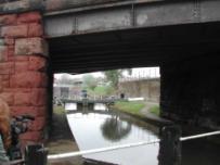
From this bridge it is possible to look both ways and see all of the major features of Chester Canal


Ownership Protection
N/a N/a
Part of the original SURCC boat building yard. More recently used as a fish warehouse and locally known as the Fish Dock or Flat Shed Currently unused.


Private None
Cast-iron and timber; grey slate roof. An open shed with cast-iron columns. The roof is carried on long lattice girders, with no intermediate columns, to the canal front from each end to the angle. Weather boarded gables.
CRT Grade II Listed –1375730
CRT Grade II Listed1375731
Red brick; grey slate roof. Single storey, 3 bays; formerly sliding doors; iron casements; 2 square stacks, both reduced. Interior: noted to contain king post trusses,2 brick hearths and remains of bellows.

This is a wooden building It used to be the heart of the boatyard and was used for sawing wood and building boats.


CRT Grade II Listed –1375713
Originally the SURCC boat yard, taken over by Taylor's in 1921, then by Bithells, then by David Jones. JP Marine from December 2010.
CRT Grade II Listed1375715
Formerly workshops and offices for SURCC boat yard. In the 1970s and 80s it was the base for a horse drawn trip boat, but now it is used as offices.

CRT Grade II Listed –1375731
Unknown; let to tenants
Grade II Listed1375714
Lock chamber of brick with massive sandstone blocks to corners of lock-gate recesses. 2 sets of steel-lined grooves, for inserting planks to allow boats to be graved; brick-andsandstone walls to lower entrance to lock. There used to be a sliding shed over the lock.
CRT Grade II Listed1375932
Sandstone and brick; slate roof. The dock has brick floor and lower walls. Pair of lockgates from canal, north; 12 stone-on-brick steps to dock floor, axial from south end; brick drainage channel around edge of dock floor; steel shutter to sluiceway in southwest corner; battered sleeper walls support timber bearers for boats; the dock will accommodate 2 canal-boats side by side.
Cambered wrought-iron span on stone-coped brick abutments and ramps. A slightly curved approach-ramp from south on west bank; a spiral ramp south of the bridge on east bank leads down and under the bridge to towpath to north.
This basin was re-excavated and re-opened in 2000. It was originally surrounded by warehouses and was a major trans-shipment point. There is a modern swing bridge across the entrance. Mersey Flats were found when the basin was excavated.


Built around North Basin following its re-excavation. The commercial units on the ground floor have never been let.
CRT Grade II Listed1375931
CRT Grade II
Listed –1375933
CRT Unknown
Private with some shared ownership
None
Replaced an original structure (horse steps?) slightly to the north of original position when Towpath development was built.
CRT None
Student accommodation development allowed on appeal in the 2010s on the site of former BW maintenance yard, canal stables and open ground.


Originally attached to the stable block which was demolished c2008 to make way for the development of the wharf.
Operated by Student Roost, subsidiary of Student Finance Holdings Ltd.
None
Projects over the water to allow boats to be loaded/unloaded under cover. Converted to a pub/restaurant in the 1980s.


CRT None
CRT? Leased to pub operator.
Grade II Listed –1375919
Originally housed the offices of the Ellesmere & Chester Canal Co. and the ‘Packet House/Ellesmere Canal Tavern’. Later the headquarters of the Shropshire Union Canal & Railway Co. and BW regional office. Currently empty.
CRT Grade II Listed –1375918
Flat span iron box girder bridge with stone parapet, probably dating from the building of the nearby railway line in the 1840s.
CWAC Council None
Shows the major features of Chester Canal Basin (Tower Wharf).


N/a N/a
Mounted on the wall near Raymond Street bridge (123L). Towlines were attached to this to enable boats to get round the sharp bend in the canal.

CRT None
Provided to give space for boats to get round the sharp bend necessitated by the connection to the Wirral line in 1795. Originally rather larger but reduced in length when the adjacent railway was quadrupled in the 1900s.
The staircase of three locks lifts the canal by 33 feet. Most of the structure is cut out of the sandstone bedrock augmented by stone blockwork and some brick infills. There are original bollards just above the top lock on the offside of the canal. There is a footbridge with metal railings across middle lock. Originally built as


CRT None
CRT Grade II Listed –1375934
five locks 1772-79 by Samuel Weston, but In 1795 reengineered to create the present day three-lock staircase. The bottom two locks were filled in and replaced by two created on the Dee Branch. Formerly known as the Water Tower Locks.
Wooden hut with felted pitched roof alongside the top lock.

CRT Within curtilage of listed structure.
A classic Thomas Telford structure. Square brick-built house of two storeys with hipped slate roof. Now overshadowed by the bridge carrying the Inner Ring Road.
Private Grade II Listed –1375735
Showing the close relationship between the ancient city walls and the adjacent urban canal.
The lower level of the Dee Branch below the Graving Lock. Used as private moorings with locked access on the west side and open access on the east side.


CRT leased to Taylor’s Yard
Within the curtilage of the Chester Canal Conservation Area
Shows the lower level of the Dee Branch in relation to that of Chester Basin and Tower Wharf with the modern developments on the opposite side of the canal.


N/a N/a
Takes the Dee Branch down into Chester Basin. The lock is frequently impassable due to siltation and lack of boat movements. The bridge over the lock carries South View Road.


The top photo shows the curve of the waterway in the Dee Basin with the Water Tower beyond whilst the bottom photo shows Williams’ Moorings and the Graving Lock.
CRT Grade II Listed –1375930
This area is all that remains of the original basin connected to the River Dee, much reduced in size and surrounded by modern development.
CRT None
The Water Tower was built in 1322 on an extension of the City Walls. At that time the River Dee and wharfage came up to its base. It was later used to monitor shipping arriving and departing the port.

The design, in the shape of a boat, was intended to reflect Medieval trading vessels with their high stern castles. It received a Millennium Civic Award.
CWAC Grade I Listed –1376129
Modern structure installed when the adjacent developments around the Basin were built in the 1990s. Infrequently raised due to the neglected state of the Dee Branch and consequently subject to mechanical problems.


Flat concrete bridge carrying the A548. It replaced a swing bridge in the 1960s but the low-level crossing of the lock creates difficulties for boat passage. In recent years the Environment Agency has installed a removable flood barrier between the bridge and the lock gates which has also hindered boat passage.
8th Chester Scouts None
CRT None
Highways Agency None
Showing the eastern end of the River Lock, the Dee Basin beyond and adjacent modern developments.

N/a N/a
The connection between the River Dee and the Chester Canal, accessible at suitable states of the tide. In recent years the bottom gates have been removed due to structural problems in the lock floor but the lock is still navigable, though subject to silting from the river.


Modern development on the site of the former Roberts’ boat-building yard to the north of the River Lock. Archaeological investigations prior to the development revealed much about the history of the Old Port area.
Small house built c1800 but with possibly mid-18th century features and 19th century alterations. Effectively the northerly termination of the Old Port frontage.

CRT Within the curtilage of the Chester Canal Conservation Area.
Two historic views from the north-west. The River Lock entrance to the Chester Canal is on the left with Crane Wharf on the river frontage beyond. The modern view is considerably obscured by vegetational growth.
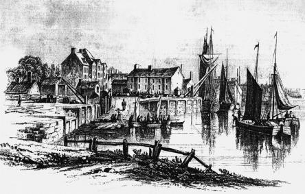
Private None
Unknown Grade II Listed –1375959
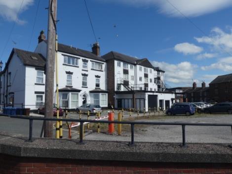
A group of major buildings comprising the Harbour Master’s House and warehousing built in the mid18th century. From 1906 the HQ and works of the Crosville bus company covered the site. The works have been demolished but the 18th century buildings remain, now subdivided into a number of small businesses and much altered.


The best surviving buildings in the Old Port of Chester. A major 3-storey warehouse and 2-storey cottages built in the 1750s or 1760s. The northwest end of the warehouse was rebuilt in the 19th century after a fire. Now occupied by the Sea Cadet Corps (TS Deva).


Private None but in City Centre Conservation Area
Unknown Grade II Listed1375880
An area with a complex history of uses culminating at various times in the 19th century with a shipyard, an iron foundry, the Workhouse and finally the city gasworks. Nothing remains visible of these uses and the whole area has been redeveloped since 2000, mostly with private apartments but also with the stables for Chester Racecourse. The site is terminated at the southern end by the railway bridge over the Dee.

Two visible portions of the Deva harbour or port defensive wall, probably the latter, and probably dating from the 2nd century AD. The only clearly visible remains of the original Roman port of Chester.

The original Watergate was probably built in the 1100s with the westward extension of the City Walls. Tolls were exacted from goods passing through from the port. Enlarged in 1712-13 and rebuilt to today’s classical arch by Joseph Turner in 1788.
The original port customs office was in Chester Castle but in 1633 a new Custom House was built in Watergate Street. That building was replaced in 1868 by the current structure of red brick and Gothic revival detailing In recent years occupied by catering outlets.
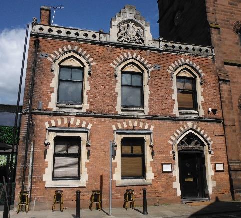


Various None
CWAC? Grade II*
Listed –1375955 and 1375956
CWAC Grade I
Listed1376468
Not known Grade II
Listed1376449
Probably built in the 1120s, the Romanesque arch of the Shipgate lay above the wharves to the west of the present Bridgegate. Tolls were also exacted here but the gate may have fallen out of use in the 17th Century. It was removed in 1828 when the City Walls were altered at this point and re-erected in the garden of a house in Abbey Square. In 1897 it was finally removed to Grosvenor Park where it remains today.

CWAC Grade II Listed1375833
