Connecting the Community since 1876
AND WESTERN DISTRICTS ADVERTISER
THURSDAY 6 October 2022
Ph: (02) 6366 8017
$2.00 inc gst
Email: molongex@bigpond.net.au www.molongexpress.com.au
Why has my cold dragged on so long? And how do I know when it’s morphed into something more serious?
Electric utes unlikely to cart hay this year
NSW Open in Molong a huge success
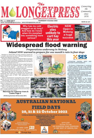
Widespread flood warning Preparations underway in Molong Inland NSW warned to prepare for one month's rain in four days
Residents in inland NSW are being warned to prepare for "a month's rain in just four days" with heavy falls forecast for already flood-affected communities. The Bureau of Meteorology has briefed the SES as it prepares for another week of concerning conditions with much of the state's west already impacted by ongoing floods as rain falls on already full catchments and rivers. Some rural residents remain cut off due to high floodwaters on their properties and impacted roads — in some cases for "three, four weeks already" — with farmers also concerned about keeping stock safe and potential crop losses. Two separate fronts are expected to bring unwelcome, widespread deluges between Wednesday and Sunday. "The bureau has said we're expecting one rain front this Wednesday that could drop 20–40mm across much of the inland western parts of NSW," SES spokesperson David Rankine said. "There's a thunderstorm warning that comes with that and the risk of 50–80mm under those isolated storms. "Unfortunately, there's a second front coming across the far west of NSW on Friday and could bring anywhere from 20–40mm of rain as it moves west into Saturday. "Then on Sunday the northern inland and central west of NSW could experience another 20–40mm. "That's a very broad part of the state about to receive all it's average rainfall for October in the next seven days. For us, that's quite concerning."
Warnings for Cabonne rivers & creeks Page 5 (R) Molong downtown 26 November 2021)
ATTENTION CENTRAL WEST WESTERN PLAINS RESIDENTS
AND
The Bureau of Meteorology is monitoring a weather system that has a high potential to bring widespread rainfall of between 50100mm over a seven-day period across inland NSW from Wednesday. Increased thunderstorm activity is also likely with isolated heavy falls possible increasing the potential for localised flash flooding. Several inland river systems already have moderate to major flooding. Residents and visitors in the Central West and Western Plains need to closely monitor weather conditions and make informed decisions based on their individual circumstances. This Upper and Lower Macquarie, Belubula, Bell, Castlereagh, Talbragar River and Molong and Mandagery Creek catchments may experience renewed river rises as a result of the forecast rainfall. NSW river catchments remain saturated, with most major dams at or near capacity. Any further rainfall is likely to lead to flash flooding developing very quickly resulting in road closures without warning.