


A station area with a unique opportunity to incorporate a new multi-modal station into mixed-use development that anchors and catalyzes downtown reinvestment.
Introduction
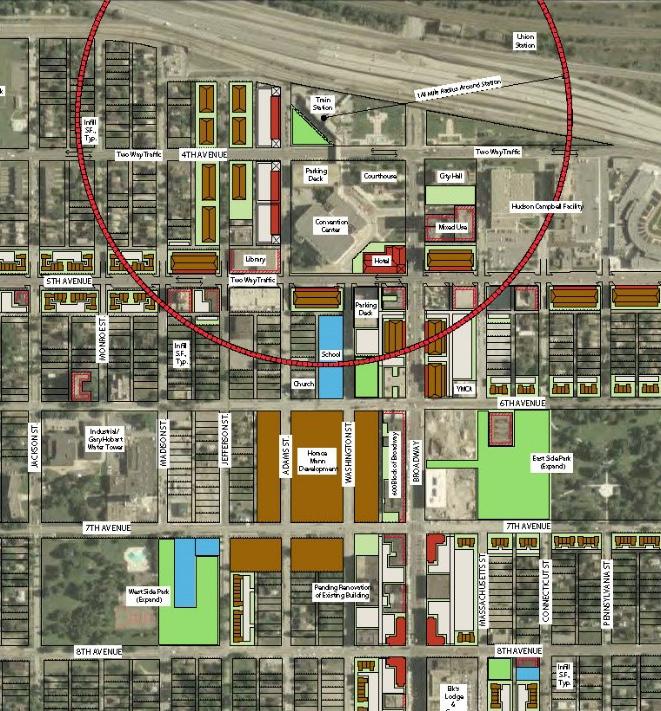
The Gary Metro TDD (315.5 acres) benefits from the momentum to revitalize Downtown Gary through targeted infrastructure improvements, blight elimination, and community-focused redevelopment in partnership with state, regional, and local partners. The TDD is envisioned to take advantage of State Funding provided by SB 434, which became law in 2023 and funds a blight elimination matching grant program and multi-modal station replacement matching grant program. Such an investment will spearhead and support revitalization and economic development efforts in Downtown Gary. The Northwest Indiana RDA will administer this program. More information about this legislation can be found here. A revitalized Gary Metro Station block has the potential to create immense opportunity or equitable transit-oriented development throughout Downtown Gary. By prioritizing a new multi-modal station area and capitalizing on property in public control, a multi-pronged approach to redevelopment should be pursued. Walkable pedestrian-scaled street corridors and paths that link to existing and planned local and regional trail systems could capitalize on Gary’s prime location in the region. Phasing and prioritizing redevelopment and improvements are crucial to ensuring Gary’s sustainable growth and revitalization, catalyzed by the Gary Metro Station.
• Replace the Gary Metro Station incorporating ADA accessibility, a new station platform, kiss-and-ride, and Gary Public Transportation Corporation (GPTC) bus service
• Promote transit-oriented mixed-use development around the station area
• Redesign Broadway as a Complete Street with streetscape, multi-modal functionality, and traffic calming and study the feasibility of two-way conversions of 4th and 5th Avenues.
• Rebuild the housing market, prioritizing affordable housing and transitioning into new market-rate
• Create a new demolition and land-banking strategy where blocks transition to temporary conservation green spaces as the market matures

Relevant Planning: : RDA TDD boundaries (ongoing), The Marquette Plan (2005), Comprehensive Plan (2008), Livable Center Plan 2025 (2014)
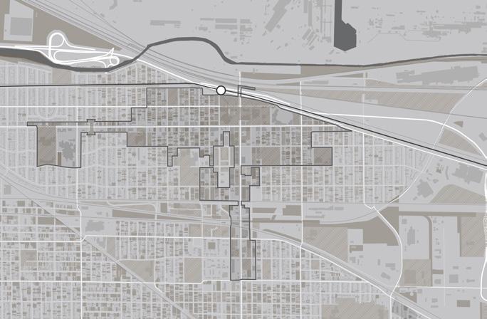
Zoning Ordinance Overview: The ordinance, adopted in 2009, is an outdated ordinance that could be simplified to consider mixed-use and transit-oriented development. Parcels along Broadway and 5th Avenue east of Broadway are zoned Commercial/Business. Blocks beyond these corridors primarily consist of Residential zoning districts. Large blocks immediately adjacent to the station area, which include the Genesis Convention Center and the Hudson-Campbell Sports Complex, are zoned Manufacturing (M1-1). North of the South Shore Line/I-90 is entirely industrial uses and zoned Manufacturing, and the area between 8th Street and 11th Street which consists of industrial uses and rail corridors is also zoned Manufacturing (with the exception of the Broadway corridor).
Public Engagement: : To kick off the study of the Gary Metro Center TDD station area, a walking tour was held in July 2022 with leadership, initially as part of the TOD Implementation Strategy (2023). In September 2023, a hybrid in-person and virtual public engagement session was held in Gary and via Zoom video conferencing, and approximately 55 community members attended the session. The session was also posted to YouTube, which received 32 views. Materials from this engagement session were also posted to the project website.
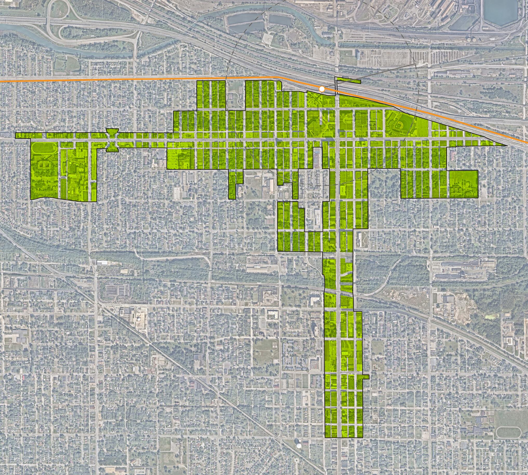
The analysis required for creating the boundary focused on floodplains and flood zones; land use patterns, including community anchors (destinations such as schools, parks, city halls, churches, etc.), commercial areas and corridors, residential neighborhoods near these places of activity, agricultural or preserved land, industrial land, and vacant or underutilized and publicly-owned land; TIF Districts and Opportunity Zone boundaries; and previous planned areas or other areas of interest identified by the city. Locating land uses and destinations in the station area provides a sense of where generators of economic activity, community gathering, and employment opportunities currently exist in the community. Locating vacant or underutilized and publicly-owned land and other areas of interest helps identify sites that may have a low barrier to redevelopment or have already been considered for redevelopment by the city and suggest where future development and investment could occur.
Existing land use patterns can inform opportunities for future investment that is compatible and complementary for the community. Downtown Gary is organized by commercial corridors, primarily Broadway and secondarily 4th and 5th Avenues. The station area is anchored by civic uses immediately to the south of the station consisting of the Lake County Courthouse, City Hall, park space, and the Genesis Convention Center Other community anchors near the station include the Railcats’ US Steel Yard Stadium, the Hudson-Campbell Sports Complex, and the Public Library. Residential areas consist of tighter, urban neighborhood fabric which also include neighborhood-scale parks, schools, and churches. To the north, major industrial sites, including US Steel, exist on the other side of the elevated South Shore Line and interstate. Industrial uses are also clustered to the southeast of downtown closer to interstate and rail access.
Much of downtown consists of vacant land and vacant, deteriorating buildings. As a result of city-wide demolition led by the City, several properties have been taken under public control and have been cleared or will be cleared for redevelopment. In addition to these recently cleared sites, civic uses around the station area, neighborhood parks, former schools, and scattered residential properties are owned by the City or the Gary Housing Authority.
Previously planned areas in downtown focus on taking advantage of the Gary Metro Center station. The City of Gary Comprehensive Plan (2008) concentrated development concepts within a one-quarter mile radius of the station, specifically with the goal of significantly increasing residents downtown through residential infill and multi-family housing. Broadway, 4th Avenue, and 5th Avenue have been previously considered for road diets and Complete Street improvements. Additional areas of interest include future planned trail corridors that would connect Gary to the regional trail network as part of the Marquette Plan (2005) and Gary Green Link Master Plan (2005).

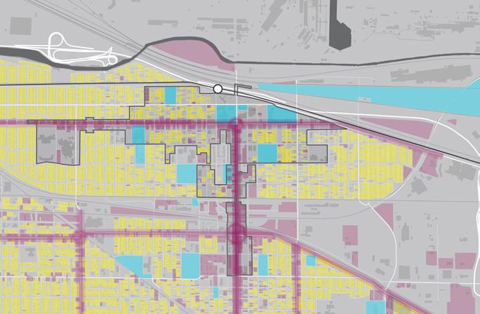
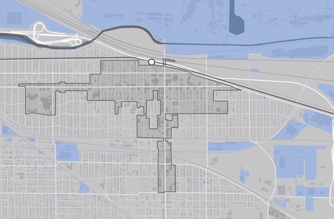
The resulting TDD boundary for the Gary Metro TDD station area focuses on three future investment strategies: Corridor, Mixed-Use Town Center, and Infill Development. The redevelopment of Gary Metro Center and its neighboring sites will anchor proposed future development for downtown Gary. Parallel to this process, the City should continue to acquire under-performing or vacant properties in strategic locations. The City should target properties within the core of the downtown area located on prime developable property for demolition, stabilization, and a blend of subsidized and market-rate infill residential development. As a second phase, priority sites in close proximity to the Gary Metro station, including that occupied by the Genesis Convention Center today, could form a mixed-use development core. Southern sites along Broadway Avenue form a corridor for future commercial and mixed-use development. Within this process, contributing historical buildings in good condition could be candidates for historic preservation and/or adaptive reuse. The goal is to create a critical mass of development in the core of Downtown Gary that can create a market around TOD and support the City’s economic development path.