
AncientMesoamerica (2022),1–40 doi:10.1017/S0956536122000244
LiDARanalysesinthecontiguousMirador-CalakmulKarstBasin, Guatemala:anintroductiontonewperspectivesonregionalearly Mayasocioeconomicandpoliticalorganization
RichardD.Hansena ,CarlosMorales-Aguilarb ,JosephineThompsonc ,RossEnsleyd,EnriqueHernándeze , ThomasSchreinerf,EdgarSuyuc-Leyf andGustavoMartíneze,f
aDepartmentofAnthropology,IdahoStateUniversity,Pocatello,Idaho,andFoundationforAnthropologicalResearchandEnvironmentalStudies(FARES), Idaho,UnitedStates; bDepartmentofGeographyandtheEnvironment,UniversityofTexas,Austin,UnitedStates,andLaboratoireArchAm,UMR8096CNRS,Paris,France; cMiradorConservationFund,RedwoodCity,California,UnitedStates; dTerraGeoSolutions,Houston,Texas,UnitedStates; eEscueladeHistoria,UniversidaddeSanCarlos,GuatemalaCity,andProyectoCuencaMirador,GuatemalaCity,Guatemalaand fFARESFoundation/ MiradorBasinProject,GuatemalaCity,Guatemala
Abstract
LiDARcoverageofalargecontiguousareawithintheMirador-CalakmulKarstBasin(MCKB)ofnorthernGuatemalahasidentifieda concentrationofPreclassicMayasites(ca.1000 B.C.–A.D.150)connectedbycauseways,formingawebofimpliedsocial,political,and economicinteractions.Thisarticleisanintroductiontooneofthelargest,contiguous,regionalLiDARstudiespublishedtodatein theMayaLowlands.Morethan775ancientMayasettlementsareidentifiedwithintheMCKB,and189moreinthesurrounding karsticridge,whichwecondensedinto417ancientcities,towns,andvillagesofatleastsixpreliminarytiersbasedonsurface area,volumetrics,andarchitecturalconfigurations.ManytieredsitesdatetotheMiddleandLatePreclassicperiods,asdetermined byarchaeologicaltesting,andvolumetricsofcontemporaneouslyconstructedand/oroccupiedarchitecturewithsimilarmorphologicalcharacteristics.Monumentalarchitecture,consistentarchitecturalformats,specificsiteboundaries,watermanagement/ collectionfacilities,and177kmofelevatedPreclassiccausewayssuggestlaborinvestmentsthatdefyorganizationalcapabilities oflesserpolitiesandpotentiallyportraythestrategiesofgovernanceinthePreclassicperiod.Settlementdistributions,architectural continuities,chronologicalcontemporaneity,andvolumetricconsiderationsofsitesprovideevidenceforearlycentralizedadministrativeandsocio-economicstrategieswithinadefinedgeographicalregion.
Resumen
LacoberturaLiDARdeunagranáreacontiguadentrodelaCuencaKársticaMirador-Calakmul(CKMC)delnortedeGuatemala, hapermitidolaidentificacióndeunaconcentracióndeantiguossitiosmayaspreclásicos(ca.1000a.C.–150d.C.)conectadospor calzadaselevadas,formandounareddeimplicacionessociales,políticasyeconómicas.Hastalafecha,sehanidentificado775asentamientosmayasantiguosdentrodelCKMC,asícomocientosmásenelsistemageomorfológicocircundante,quecomprendeal menos417sitiosqueformabanciudades,pueblosyaldeasantiguas.Seproponeunajerarquíadesitiosdeasentamientosdealmenos seisnivelesdedistintostamaños,áreadesuperficie,configuracionesarquitectónicasyvolúmenesderelleno,conunamayoríaquedata delosperíodospreclásicomedioytardío.Laarquitecturamonumental,losformatosarquitectónicosconsistentes,loslímitesyunificacionesdesitiosespecíficos,lasinstalacionesdegestiónyrecoleccióndeaguaymásde177kmdecalzadaselevadaspreclásicassugiereninversioneslaboralesquedesafíanlascapacidadesorganizativasdeentidadespolíticasmenoresyrepresentanlasestrategiasde gobiernoenlosperíodospreclásicos.Lasdistribucionesdelosasentamientos,lascontinuidadesarquitectónicas,lacontemporaneidad cronológicaylaorganizaciónjerárquicadelossitios,brindanevidenciadeunaadministracióncentralizadatempranayestrategias socioeconómicas,dentrodeunaregióngeográficadefinidaenlastierrasbajasmayas.
Correspondingauthor:RichardD.Hansen,email: hansric2@isu.edu
Citethisarticle: Hansen,RichardD.,CarlosMorales-Aguilar,Josephine Thompson,RossEnsley,EnriqueHernández,ThomasSchreiner,EdgarSuyucLey,andGustavoMartínez(2022).LiDARanalysesinthecontiguousMiradorCalakmulKarstBasin,Guatemala:anintroductiontonewperspectivesonregional earlyMayasocioeconomicandpoliticalorganization. AncientMesoamerica 1–40. https://doi.org/10.1017/S0956536122000244

“Stateswereoriginallydefinedbyanthropologistsandpoliticalscientists,butarchaeologistscannowidentifytheskeletonsoftheirinstitutions” (Flannery 1998:16).
“Becausetheearlystatemusthavebeen aregionalphenomenon,methodologicalcontroloverregionalanalysismustbeemphasizedinthestudyofthetransitionphenomenon” (Jonesand Kautz 1981:34).
©TheAuthor(s),2022.PublishedbyCambridgeUniversityPress.ThisisanOpenAccessarticle,distributedunderthetermsoftheCreativeCommonsAttributionlicence (http://creativecommons.org/licenses/by/4.0/),whichpermitsunrestrictedre-use,distributionandreproduction,providedtheoriginalarticleisproperlycited.
Introduction
Thisarticlepresentsoneofthelargest,contiguous,regional LiDARstudiespublishedtodateintheMayaLowlands, revealingmorethan775ancientMayasettlementswithin theMirador-CalakmulKarstBasin(MCKB),and189more inthesurroundingkarsticridgethatcomprisethegeomorphologicalbordersofthegeographicalarea,togetherforming 964archaeologicalsettlements.A “settlement” isdefinedasa groupingorindependentclusterofarchitecture,butwhena groupofsettlementscanbedemonstratedasrelatedvia intrasitecausewaysorotherarchitecturalaffiliations,such assharedlogisticsfacilitieslikereservoirsormarshes,we suggesttheycanbedefinedasa “site” or “polity.” Asingle settlementcanalsobeasite,dependingonthequantityof publicorresidentialarchitecture,asdeterminedbythevolumetricsofcontemporaryconstructionfill.Thesettlements thatdemonstrateastrongpolitical/social/geographicalrelationshipwithothersettlementswithinthebasinviaintrasite causewayshaveallowedustosuggestacondensationof “settlements” intoatleast417centralizedsitehierarchies formingancientcities,towns,andvillages(definedbelowin SettlementDistribution)withspecificboundaries,suchas bajo or arroyo edgesorlargeareasofuninhabitedterrain.A preliminarysettlementandadministrativehierarchyofat leastsixtiersisproposedforsitesbasedonsurfacearea, numbers,anddensitiesofmonumentalarchitecture,and volumetriccalculationsofarchitectureextractedfrom surface-mappingmeasurementsandLiDARdata.The approximatevolumetricassessmentswereconductedin eachsiteofwhatappearedtobetheciviccenterofan area1km2,withmonumentalarchitectureandspecific architecturalconfigurationsdatingtotheMiddleandLate Preclassicperiods,asdeterminedbyextensiveregional archaeologicaltestingbytheMiradorBasinProjectin56 sites,consistingoftestpits,archaeologicalsalvageoflooters ’ trenches,andbroadhorizontalarchitecturalexposure ofstructures,aswellasmorphologicalcharacteristicsof architecture(e.g.,Mejía 2008, 2012;Mejíaetal. 2007, 2010).Monumentalarchitecture,consistentarchitectural formats,specificsiteboundaries,watermanagementand collectionfacilities,andmorethan177kmofelevated Preclassiccausewayssuggestlaborinvestmentsthatdefy organizationalcapabilitiesoflesserpolitiesandportray thestrategiesofgovernancebyunitingmajorsitesinanetworkintheMiddleandLatePreclassicperiods.
Mesoamericaisoneoftheidealareasoftheworld wheretheprocessofcultural,political,andeconomiccomplexitycanbecriticallyevaluated(Clark 2016;Loveand Guernsey 2022;Rosenswig 2021a;TraxlerandSharer 2016). Thewiderangeofnaturalresourcesandvariantcultures withinalimitedgeographicalframeworkpermittedsocial, political,andeconomicinteractionsviaemulation, adaptation,and/orindependentinnovation.Datarelevant tositeformationandcomplexityaremorereadilyavailable, duetothedurationandconsistencyofarchaeological researchandnewtechnologiessuchasLiDAR(light detectionandranging),whichhavebeenconductedinthe Mirador-CalakmulKarstBasin(MCKB;Ensleyetal. 2021;
ForceandDohrenwend 2008, 2021)ofnorthernGuatemala andsouthernCampeche,Mexico(Figures1 and 2; Table1; seealsoSupplementaryFigure1).Multidisciplinaryresearch overthepastfourdecadesintheareaoftheMCKB bytheFoundationforAnthropologicalResearchand EnvironmentalStudies(FARES)andtheMiradorBasin Projecthasresultedinthefieldmappingandexcavations in56separatearchaeologicalsitesofvaryingsizes,providingaground-truthingofLiDARandGISanalyses.Many ofthesestudieshavebeenpublishedinannualsymposium volumesintheNationalMuseumofAnthropologyand EthnologyofGuatemala(https://www.asociaciontikal.com), inscientificpapers(e.g., https://www.researchgate.net/ profile/Richard-Hansen-3),andintechnicalreportsprovidedtotheGovernmentofGuatemala.LiDARstudiesofa contiguousareaofthesouthernMCKBhaveprovidednew informationthat,whencombinedwithsystematicarchaeologicalresearch,suggeststhatamoreadequateand improvedinterpretationoftheculturalprocesscanbe obtainedviaimprovedarchaeologicalmethodologies,a greaterutilizationofmultidisciplinaryapproaches,applicationofmoreadvancedtechnologies,improvedchronometricmethods,andarchaeologicalinvestigationsconducted onaregionalscale(Hansen 2016b:333).Long-term,comprehensiveregionalinvestigationshavetheadvantageof broader,multidisciplinaryperspectivesbasedonmultiple linesofevidenceandallowtestingofhypotheses,identificationofmulti-causalfactors,andalternativemodelsforthe riseofcomplexitywithinspecificregions(Clark 2016; Rosenswig 2021a;SharerandSedat 1987;Shareretal. 2006).ThisstudyusesairborneLiDARdatatodemonstrate howcomplexsocietiesorganizedtheirinfrastructureto reflecttheirsocio-economicorganizationandpolitical power,conformingtoaproposedincipientkingdom/state duringthePreclassicperiodintheMayaLowlands.
Thesedataarerelevanttotheculturaldevelopment withintheMirador-Calakmulregion,akarstbasindefined byhydrologicalandgeomorphologicalfeatures,groundwaterflow,andnaturalboundaries(Ensleyetal. 2021;Force andDohrenwend 2008, 2021).Overrecentyears,LiDAR datahavebeenacquiredthatcover85.8percentofthe southern,orGuatemalan,MCKB.Thesedatahaveunveiled aremarkabledensityofMayasites(Table2),manyof themlinkedbyanetworkofelevatedcauseways.Usinga GISandremote-sensingmethodology,wehaveidentified andareproposingasix-tieredsettlementandadministrativehierarchyofsites,withmonumentalceremonialarchitecture,thatwerepresentduringthePreclassicperiod, basedonarchaeologicaldata,densityofarchitecture,superficialareas,calculatedvolumetricsofarchitecturalfillof contemporaneouslyconstructedoroccupiedarchitecture, consistentorsimilararchitecturalorartistictraits,andgeographicalcharacteristics.Asimilarstudywassuggestedfor theregionbetweenYaxunaandCobabyStantonandcolleagues(Stantonetal. 2020),witharchitecturaldensities, surfaceareas,andarchitecturalvolumestobeconsidered insettlementpatternresearch.Extensivemonumental architectureintheMCKBhasbeenmapped,including E-Groups,triadiccomplexes,ballcourts,causeways,and
ModifiedafterEnsleyetal.(2021).
reservoirsthroughoutthebasin.Collectively,wearguethat thedevelopmentofinfrastructuredemonstratesthepresenceofcomplexsocietieswithstronglevelsofsocioeconomicorganizationandpoliticalpowerduringthe MiddleandLatePreclassicperiods.
TheMirador-CalakmulKarstBasin
TheMirador-CalakmulareaisaNeogenefluviokarstlandscape(Gates 1992, 1999),locatedonthesouthernPeten Plateauanddefinedbyitsgeomorphologicalfeatures (Ensley 2018;Ensleyetal. 2021:Figure1;Folanetal. 2001;

politicalcohesionofthearea.Thebackgroundnear-infraredimageindicatesthevegetationtypeswithlowland,orbajo,vegetationinbluegreenanduplandvegetationinred.Causewaysdonotextendbeyondthenaturalbordersofthebasin,suggestinganenclosedcentralization associatedwithsettlementnucleationintheMiddleandLatePreclassicperiods.Sentinel-2multispectraldata:

ForceandDohrenwend 2008;GunnandFolan 1992;seealso Figure1).Theareaisdominatedbylow-lyingseasonal swamps,knownas bajos,wherewatercollectsfromthesurroundingkarsticuplandhillsthatformthenaturalborders (Ensley 2018;EnsleyandHansen 2020;Ensleyetal. 2021:20; GunnandFolan 1992;Hansen 2012a, 2012b, 2016a, 2016b, 2017;Hansenetal. 2002).Theareaisparticularlyvisible oninfraredsatelliteimages,firstpublishedin1992 (SupplementaryFigure1),duetothedominant,stunted bajo vegetation(blueininfraredcolor)thatvariesfrom tropicalforestsinmoreelevatedareas(redininfrared color;Stuart 1992;seealsoHansen 2016b:340, 2017:308).
TheMCKBexhibitshydrologicalfeaturescommonto drainagebasins,inadditiontoinferredgroundwaterflow routesanddefinedboundaries(Ensleyetal. 2021:20; QuinlanandEwers 1989:66;Ray 2001:236;Taylorand Greene 2008:81;White 1988:112–113,153–155).Regional visualizationandhydrogeologicalinterpretationofthe basinanditssurroundinglandscapesusedsatellite-derived elevationdatarecordedbytheJapanAerospace
https://earthexplorer.usgs.gov
ExplorationAgency(Takakuetal. 2014, 2016),andwasconfirmedbyLiDARdatacoveringmuchofthesouthernportionofthebasin.BordersoftheMCKBdrainagebasinare delineatedbytheMiradorAnticlineonthesoutheast,the CalakmulAnticlinetothenortheast,anorthernlineof karsthillsthatdenotesthedividebetweentheCalakmul andDesempeñodrainages,andthelineoflow,residual hillsinterruptedbykarstvalleysalongthewest.Likethe westernflankoftheMiradorAnticline,theeasternflank ispartoftheuplandkarstlandscape(Ensleyetal. 2021:19–20)andhasasimilarkarstgeomorphology,dominatedbynumerousperennialmarshesknownas civales Karstlandscapesformaperipherysurroundingthe MCKB.Tothesoutheast,thebasinisboundedbyarugged polygonalkarstlandscape(e.g.,Ensleyetal. 2021:17–19,Figure3)thatisageomorphologicallydefinedbuffer zone(Adams 1999:Figures1and2;AdamsandJones 1981: Figure2;Gunnetal. 2019:Figure11.5)flankedbythe BuenavistaEscarpment.Onthewestside,akarstmargin plainisaseasonallyfloodedalluvialplainwithresidual
Figure2. SitemapofthesouthernMCKB.TheconcentrationofsitesandcausewaysintheMCKBdemonstratesthelikelyeconomicandhills(Figure1)whichconstrainsthebasin.Northof Calakmul,thebasinisboundedbyarangeofhillsthatseparatestwofluviokarstdrainages,theDesempeñotothe northwestandtheEscondidotothenortheast.Theareais believedtobeanimportantwatersourceformuchofthe Yucatecanshelf(Baueretal. 2011).
MaterialsandmethodsofLiDARexplorationofthe MCKB
TheMCKBcontainssomeofthelargestancientMayacities, andtheantiquityofmany,ifnotmost,ofthesitesdatesto theMiddleandLatePreclassicperiods(ca.1000 B.C.–A.D.150), withamoremodestoccupationoftheareaduringtheLate Classicperiod(A.D.600–900;ClarkandHansen 2001;Clark etal. 2000;Hansen 1998, 2001, 2005, 2012a, 2012b, 2016a, 2016b, 2017;HansenandSuyuc-Ley 2016;Hansenetal. 2008;Morales-Aguilar 2010, 2021).Previousarchaeological mappinginthesouthernMCKBsurveyedthesitesof Nakbe,LaFlorida,ElMirador,andTintalwithTotal Stationlasertechnology,allowing3-Dcapability.ThesuccessofLiDARinthearchaeologyoftropicalforestsinthe MayaLowlandsofBelize(Chaseetal. 2011,2014;Ford etal. 2014;Pruferetal. 2015;Weishampeletal. 2011), Mexico(Fernandez-Diazetal. 2014;Hareetal. 2014; HutsonandWelch 2014;Rosenswigetal. 2013),and Angkor,Cambodia(Evansetal. 2013)promptedthepioneeringuseofLiDARinthenorthernPetenofGuatemalabythe MiradorBasinProject.Startingin2015,theprojectrecorded twolarge-scaleaerialLiDARsurveyswithinthesouthern halfoftheMCKB,coveringanareaof1703km2 (Figure2), makingitoneofthelargestcontiguousLiDARsurveys recordedforarchaeologicalresearchintheMayaLowlands todate.Ourreviewofover150publicationsandunpublishedreports,whichdetailtheuseofLiDARdatainMaya Lowlands,hasdocumented26individualsurveysdesigned forarchaeologicalresearchthatconstitute18contiguous regionsof100km2 orgreater(Table1;seealsoCanuto etal. 2018;Inomataetal. 2021),demonstratingtheimportanceofregional-scalesurveysinMayaarchaeology.In theseregionalstudies,LiDARhasfacilitatedmappingofsettlementobservationsandculturalfeatures,andenabled detailedenvironmental,geological,geomorphological,and hydrologicalinterpretation.
EagleMappingconductedtheLiDARsurveyofthesouthernMCKB,undercontractwithFARES,intwophases(Phase I:2015;PhaseII:2018),usingtheRieglLMS-Q1560system andaRieglLMSQ780scanneratnominalaltitudesof 550mand650m.TheRieglsystemsusedascanangleof 58degrees.Thelight-beamdivergencewas0.25mradsand thenominalpulsedensitywas20pulses/m2.Becauseof weatherconditions,thePhaseIIsurveywasrecordedat lowerlevels,requiringmoreflightlines,atalowerpulse densityof15pulses/m2.Theswathwidthwas513–741m, withanoverlapof55–70percent.Theaveragedensityof totalreturns(includingvegetation)was48.39points/m2 in PhaseIand39.64points/m2 inPhaseII,whiletheground returndensity(Grtn)was2.18points/m2 inPhaseIand 2.95Grtn/m2 inPhaseII.TheLiDARpointdatawere
deliveredtoFARESinLAS1.2in500m2 tiles.Postprocessing ofthePhaseIsurveywithRapidlasso’sLASToolssoftware providedagrounddensityreturnof5.2Grtn/m2.Theoverallaccuracyofbothsurveysis+/ 15cmhorizontaland+/ 30cmvertical.QuickTerrainModelerwasusedtocreate bare-earthdigitalelevationmodel(DEM)anddigitalterrain models(DTM)witha0.5mresolution.Oncethe LiDAR-derivedDEMwasgenerated,weproduceddifferent surfaceandvisualizationmodelstointerpretarchaeological features,includinghillshadewithdifferentlightpositions. Hillshademodelshavebeenwidelyappliedinarchaeology intropicalenvironmentstoenhance,detect,anddefineculturalremains(A.S.Z.Chaseetal. 2017;Chaseetal.2014; Dunningetal. 2019;Evansetal. 2013;Goldenetal. 2021; HornandFord 2019;RosenswigandLópez-Torrijos 2018; Šprajcetal. 2021;Thompson 2020).Togeneratevisualizationsandinterpretarchaeologicalfeatures,weusedseveral softwareprograms,includingRVT,ArcMap,GlobalMapper, QuickTerrainModeler,andQGIS.
Settlementdistribution
TheLiDARsurveyrevealedanextraordinarydensityand distributionofMayasitesconcentratedintheMCKB, manyofthemlinkeddirectlyorindirectlybyavastcausewaynetwork(Figure2).Usinghillshademodelsderivedfrom aLiDARDEM,atpresent775ancientMayasettlements (definedasanarchitecturalcluster)havebeenidentified withinthesouthernlowlandMCKB,ofwhich581are unnamed(Figure3, Table2).Anadditional189ancient Mayasettlementsofvaryingsizeswereidentifiedwithin thegeomorphologicalbordersofthesouthernMCKB, includingtheuplandkarstlandscapealongtheMirador Anticline,foratotalof964settlements(ofallperiods),of which645areunnamedasyet.Anadditional52known sitesarelocatedontheCampecheside,butwithoutthebenefitofcontiguousLiDAR,withtheexceptionofdispersed areasinCampeche,Mexico(seeBreweretal. 2017; Reese-Taylor 2017;Schroderetal. 2020; Šprajc 2020; Šprajc etal. 2021).Varyingscalesandstructuraldensitiesaredependentpartiallyonthe bajo landscapes(seealsoCanuto 2021).A settlementthatwasthoughttoberelativelysmall,onasmall elevationsurroundedbylarge bajos,hasproventobemuch largerinsizewhendirectlinks,suchasintrasitecauseways, dams,dikes,canals,commonreservoirs,andcommon bajo utilizations,weredetectedbetweenthesitecenterandits dependentperipheries.Whensettlementsaredetermined tobedependentperipheriesoflargerpolities,anddefined by bajo bordersor arroyos withcontemporaryoccupation andarchitecture,thenatotalofatleast417centers,consistingofcities,towns,andvillageswithdemarcatedboundaries, havebeenidentifiedtodatewithintheMCKBpolygon (Figure3;SupplementaryFigure2).Thedefinitionofthese termsisathornyissue,andscholarshaveattemptedto definethemforyears(e.g.,Smith 2016, 2020),withwildly variantresultsforpopulationandsettlementdistributions basedondefinitionandnumbersofresidences,thecontemporaneityofstructures,andfamilysizesperresidence(Rice andPuleston 1981:144).AMesoamerican “city” hasbeen
previouslydefinedas “asemi-urbancenterofatleast4000–5000people” (Clark 2016:124).A “town” couldbeconsidered asaconglomerateofresidencesandpublicstructuresthat wouldhavehad1000–3000inhabitants,whilea “village” wouldbelessthan1000inhabitants.Architecturally,a “city” wouldberepresentedbylargegroupsofresidential andpublicarchitecture,whilea “town” wouldbeamuch sparsercollectionofresidencesandreducedpublic/ceremonialarchitecture,anda “village” isdefinedasasocialgroupingofresidenceswithatleastoneorlessceremonial/public structure.
Tofurthercomplicateissues,theMiradorBasinProject hasidentifiedanastonishingpresenceof “invisible” house mounds,withpackedearthenfloors,postholes,and Preclassicpotteryinsitu,butwithnosurfaceindications ofarchitecture(Johnstonetal. 2015;Paine 2019, 2020; PaineandHansen 2018;Paineetal. 2018a, 2021;seealso Chase 1990;Pyburn 1990).Weareunpreparedtotackle thisissueuntilenoughsamplinghasbeenconductedtoprovideastatisticallyvalidalgorithmthatwouldallowarefinementofPreclassicpopulationestimatesintheMCKB.Inthis
article,wehavepreferredtodefinesitesizesas “tiers” with specificspatialqualities,numbersofmonumentalstructures,andvolumetricsofcontemporarybuildingsand/or platforms.Largersites,mostofwhicharecontemporaneous basedontestexcavations,arelinkedbyanextensivecausewaynetworkthatestablishesapremiseforearlysophisticationofsocio-economicprocessesthatgaverisetocultural complexity(Hansen 2016a, 2016b, 2017;Hansenetal. 2020;Hernández-Salazar 2021;Hernándezetal. 2013, 2016; Morales-AguilarandCastanet 2017).Allthecausewayspreviouslydetectedwithsurfaceexplorationmapping,testing andtrenchingexcavations,and,later,withLiDARwere plottedindifferentbare-earthmodelstobetterunderstand howtheMayabuilttheircausewaysystemtoconsolidatea powerfulstate-levelsocietyduringtheMiddleandLate Preclassicperiods(seeCauseways,below).
Yearsoffieldmapping,combinedwithLiDARdataand decadesofarchaeologicalresearch,haverevealedahierarchyofcontemporaneousPreclassicsettlementsinsites withceremonialcharacteristics,large,monumentalarchitecture,andresidentialdensitieswithintheMCKB

Table1. Selectedlarge-scaleLiDARsurveysintheMayaLowlands.Includedarecontiguoussurveysgreaterthan100km2 insize,designedforMaya archaeologicalresearch.Notincludedinthislistareverylarge,butlow-resolutionsurveysrecordedinMexico,primarilyforterrainanalysis, environmentalstudies,andemergencyplanning(Inomataetal. 2021;InstitutoNacionaldeEstadística,GeografíaeInformática 2022).Alsonot includedistheG-LiHTsurvey,asetofdiscontinuousprofilesacrosstheYucatanPeninsulaandChiapasrecordedbyNASAanddesignedforthe analysisofterrestrialecosystems(Cooketal. 2013;Hutsonetal. 2021;Inomataetal. 2021;Schroderetal. 2020).
(Figures4 and 5; Table3).Othershaveattemptedtheidentificationofatieredsitehierarchybasedonplazacounts, housestyles,palaces,platforms,andsurfacearea(e.g., Adams 1990;AdamsandJones 1981;WrightandJohnson 1975:270,281).Additionaltiersofsites,notnotedinthis article,includeresidentialgroupswithnoceremonialor “public” architecture,suchasthatnotedpreviouslyby HammondinhisidentificationoftheninetiersofLate ClassicBelize(Hammond 1975).Thevarioussettlement tiersintheMCKBwereidentifiedbyvariationsin(1)the surfaceareaofsiteswithmonumentalarchitecturelarger than12mhigh;(2)thepresence,consistentsizes,andnumbersofceremonial/publicarchitecture,suchaspyramids, E-Groupsandtriadgroups;(3)thevolumeofartificialcontemporaneousconstructionswithina1km2 areaidentifiedas asiteorciviccenterwithvolumetrics,aconceptpreviously
suggested(AdamsandJacksonAdams 2003),butnotapplied (butseeStantonetal. 2020);(4)thepresenceofintrasite andintersitecauseways;(5)thenumberofPreclassicresidenceplatforms;(6)thepresenceofballcourts;(7)logistics facilities,includingreservoirsandterracesystems;and(8) thepresenceofdefensiveconstructions.
Thediachronicchangesinsiterankandstatusreveal changesofthepolitical,economic,andsocialstatusofsites throughtime.Thelargestsitesvariedchronologically:Nakbe, Wakna,ElPesquero,Xulnal,ElMirador,Kunal,Yaxnohcah, andBalamnalhaveastrongpresenceintheMiddlePreclassic period(ca.900–400 B.C.).SitessuchasElMirador,Tintal, Nakbe,andBalamnalbecameevenmoredominantbythe earlyLatePreclassicperiod(ca.300 B.C.),indicatingfluctuating fortunesofvariouscentersthroughtime(Hansenetal. 2020; Morales-Aguilar 2021;Reese-Tayloretal.
(https://www.eorc.jaxa.jp/ALOS/en/aw3d30/),andFARESLiDAR.
BythelateMiddlePreclassicandearlyLatePreclassic periods,ElMiradorbecamethedominantsite,withmonumentalplatforms,pyramids,agriculturalterraces,watercollectionmechanisms,raisedfields,E-Groupandtriadic architecturalconstructions,massivecauseways,andahigh demographicdensityaspartofanetworkofalliedsites withanucleatedpowerstructurethroughoutthegeographicalconfinesoftheMCKB(seeHansenandGuenter 2005). Theciviccenterofthesite,togetherwithitssubordinate suburbs,populatedaffiliated bajos,residentialarchitecture, andmonumentalarchitecture,covers132km2,makingit thelargestcenterinthebasin,comparabletothe post-LiDARareaofsitessuchasCaracol,at177–317km2 (e.g.,ChaseandCesaretti 2018;ChaseandChase 2017; Chaseetal. 2014a:214–216, 2016)orpre-LiDARdataat Tikal,at120km2 (Culbertetal. 1990)to165km2 (Lentz etal. 2015:287).Thesurroundingterracesystems, bajo fieldsystems,andoutlyingresidentialcompoundswould makeElMiradorevenlarger,butthenaturalbordersof bajos,plusthestructuralformatofsitesinthebasin,suggestsacertainautonomyundertheoverallhegemonyof ElMirador.
Partofthisareaincludesseveraladjacent bajos,which wereincorporatedspecificallyinthesitesizebecauseof extensiveancientmodifications,includingthepresenceof residentialarchitecture(Dahlinetal. 1980),raisedfields, “chinampa-like” structures,canals,andotherartificialmodificationswithinthe bajo areasdirectlyaffiliatedwiththecivic center(seebelow).LiDARrevealedsimilarmodificationsin the bajos ofadjacentareas(e.g.,Beachetal. 2019).

LiDARsitedefinitionsandboundaryidentifications
LiDARremotesensingintropicalforestshasbecomeausefultoolfordetectionofarchaeologicalremainsthroughthe applicationofaGIS-basedapproach(Canutoetal. 2018; Chaseetal. 2011, 2014b;Evansetal. 2013;Fordetal. 2014;Garrisonetal. 2019;Inomataetal. 2019, 2020, 2021; RosenswigandLopez-Torrijos 2018;Rosenswigetal. 2013).
Ourextensivepreviousarchaeologicalsurveyscarriedout beforeLiDARacquisitionwereusedtosupportourinterpretationofarchaeologicalfeaturesobservedonLiDARdata. OneofthecommonproblemsinLowlandMayaarchaeology
eratedensityinshadesofgreen,andhigharchitecturaldensityinblue.Digitalelevation:ALOSWorld3D(AW3D30),JapanAerospace ExplorationAgency(https://www.eorc.jaxa.jp/ALOS/en/aw3d30/),andFARESLiDAR.
hasbeentheidentificationofsiteboundariesandborders (AdamsandJones 1981:301;Culbertetal. 1990;Drápela etal. 2016).LiDARdatacoveringthecontiguousareain thesouthernMCKBhaveofferedtheopportunitytorefine thesedetails.Forexample,ourcriteriaforsitedefinitions
consistedofindividualsettlementsthatwerefoundto haveintrasitecauseways,contemporaneousarchitectureof consistentforms,and/orsharedsubsistencefacilitiesor constructionswhicharticulatedwithasitehomogeneity thatwasabsentwithothersites.Inthisstudy,remote-

sensingmethodshavebeenappliedtodeterminesitelimits usinggeographicalcharacteristics.Thiswascombinedwith thenaturaltopographyoftheareatoprovideidentifiable circumscribedborders,suchas bajos, civales,or arroyos,to settlementswhichappearnowtohavebeenpartofthe samesite.Thisallowedsurfaceareadeterminationsofspecifiedsiteswithchronologicalsimilarities,andmanyhave beenconfirmedbymappingsurvey,salvageoflooters’ trenchesandtestpits,andhorizontalarchitecturalexcavationsat56separatesitesconductedonaregionalscaleby theMiradorBasinProject.
UsingLiDARdataandanalyses,combinedwithsurface mappingandarchaeologicalexcavations,weproposeasixtieredsettlementhierarchyforsiteswithmonumental architectureestablishedbytheMiddlePreclassicandLate Preclassicperiods(Figure6).Thissix-tieredsettlementhierarchyisconsistentwiththeuseoffour-tieredsettlement dataelsewhereintheworldtosuggesttheexistenceofa morecomplexor “state-level” governance(Wrightand Johnson 1975).Thishierarchywasderivedbythesurface areaofthesiteepicenters,theassociatednumberof majorbuildings,platforms,plazas,andagriculturaland hydraulicfeatures,asdeterminedbyarchaeologicaldata andcalculationsofthevolumeofthebuiltenvironment ofcontemporaneousarchitecture(constructionand/orutilization).Theselectedexamplesarenotcomprehensive, butindicativeofsitesizes(Figure4).Thepresenceof densesettlementsandcentersofvaryingsizeswithinthe MCKBanditssurroundingnaturalframeindicatesaprodigiousgrowthanddevelopmentintheMiddleandLate PreclassicperiodsofMayaoccupation(Figures2 and 3). Thetieredlayersofsiteswereestablishedthroughtheanalysisoftopographyfornaturalsiteboundaries,aswellasthe concentrationanddistributionofPreclassicstructures, numbersandsizesofplazas,publicandresidentialstructures,platforms,intrasitecauseways,E-Groups,ballcourts, thenumberofdominanttriadicstructures,chronological contemporaneity,andarchitecturalvolumetrics(Figures 5a
5f; Tables3 and 4).Inaddition,theuniformityofthe testingstrategyfortieridentificationwhichcouldbe appliedtoanyMayasitewouldbetoidentifyanareaof 1km2 anddeterminethevolumetricsofconstructionfill ofcontemporaneousarchitecturewithinthearea.Based onthosecriteria,wesuggestthatthelargestsiteinthe MCKBisElMirador,whichrepresentsTier1,coveringan areaof132km2,withmonumentalarchitecturegreater than15mhigh.Thisareaincludedseveralsurrounding bajos becauseofthepresenceoflowresidentialarchitecture throughoutthem(e.g.,Dahlinetal. 1980;Hernándezetal. 2019),andtheextensiveraisedfieldsimmediatelyassociatedwiththeciviccenterintheBajoLaJarilla(Hansen etal. 2018a, 2018b; Figure7).Itisevenpossiblethatthe civales/bajos withintheciviccenterofElMiradorwere denselypopulatedwith “stilt” communities,orelevated woodenresidentialplatforms,judgingbythepresenceof Preclassicslippedandutilitarianceramicsfoundinnumeroustestpitsthroughoutthe bajos (e.g.,Dahlinetal. 1980; Hernándezetal. 2019;Jacob 1994;Johnstonetal. 2015; Paineetal. 2018a, 2018b).Evenexcludingthe bajos within
Table4. Sampleofvolumetricevaluationsofa1km2 areaforselected sites.GlobalMapperwastheprogramusedforthemajorityof volumetricsinthisarticle.
ElMirador14,306,86755
Nakbe2922,39348
Tintal2776,62150
Balamnal2905,73822
Wakna3207,06324
Kunal3203,14521
ElLimon4*194,18917
Noholnal4156,60118
Hospital4137,46916
ElPesquero5*85,09316
Cantetul568,62510
LaCeibita6*94,99722
Hunal633,26620
Total8,092,066
theconfinesofthesite(37.93km2,or28.64percent),the uplandareawithPreclassicmonumentalandresidential architectureis94.51km2,or71.36percentofthesuggested sitearea.ElMiradorisalsocomposedofaperipherywith largeareasofresidentialstructuresconnectedbyacausewaynetwork.Theassociated bajos werehighlyexploited bytheMayaduringthePreclassicperiod.Raisedfields, largereservoirs,andcanalswereconstructedinthewetland systemandwerekeyelementsinPreclassicagrarianand watermanagementstrategies.LargenumbersofE-Groups, triadicpyramids,andothercomplexesatElMirador,in additiontothepresenceofcarvedmonumentsdepicting rulers(see Table3;e.g.,Hansen 2012a:155, 2016b:382,386, 394–397,409;HansenandGuenter 2005;Hansenetal. 2018a:160;JustesonandMathews 1983),representahigh concentrationofpoliticalpowerintheMayaLowlandsduringPreclassictimes.Combinedarchitecturalmassina1km2 sampleofourTier1siteciviccenterwascalculatedintwo ways:(1)computergenerationsofvolume,usingprograms ofArcGISPro,GlobalMapper,andQGIS;(2)geometrical mathematicalcalculationsusingtotalstationcontourmeasurementsforplatformvolumes,andtruncatedandpointed pyramidalsuperstructureswhichamountedtoacalculated minimumof4,809,310m3 ofconstructionfillforcontemporaneousstructuresforthe1km2 oftheWestGroupofEl Mirador.Calculationsofthemassofarchitectureusing threeseparateprogramsprovidedanapproximatevolumetricestimateofapproximately4,306,867m3 (GlobalMapper), intheselected1km2 atthesite.
TheTier2sites,suchasTintal,Balamnal,andNakbe,have asurfacearearangingbetween13and19km2 (Figure8),but someofthefeaturesdescribedabovearelessfrequentor absent.Thepresenceoffewerlargereservoirsandcarved monumentssuggestsadifferentlevelofpoliticalorganization.Nevertheless,alloftheTier2sitesshowmonumental architectureupto50minheightandcausewaynetworks. Tier2siteshavea1km2 massofcontemporaneousartificial construction,rangingfrom922,392m3(GlobalMapper)to 945,678m3 (QGIS)atNakbe,776,620m3 (GlobalMapper)to 781,645m3 (QGIS)atTintal,and905,737m3 (GlobalMapper) to941,633m3 (QGIS)atBalamnal.
Tier3sitesincludecenterssuchasElPesquero,Wakna, Porvenir,Uaymil,Xulnal,andotherswithciviccenters withsurfaceareasrangingbetween2.7and8.0km2 (Figure9).Tier3sitesaresmallerinsurfaceareathanTier 2sites,butdifferfromTier4sitesbecauseofthelarger sizeandgreaterabundanceofmonumentalarchitecture, withatleastfivestructuresrangingfrom8to20minheight withintheciviccenters.AllTier3siteshaveE-Groups,but thesizesandscalesoftheeasternplatformsare150–200m inlength.AllTier3siteshaveintrasitecausewayswhich linkarchitecturalcomplexeswithintheciviccenters,indicatinganadministrativeandsettlementdistributionhierarchy. ComputervolumetricsofTier3sitesrangebetween200,000 and300,000m3/km2,basedonGlobalMappercalculations.
Tier4sitesincludecenterssuchasNoholnal,ElCivalon, LaUnion,andElHospital,withanaveragesurfacearea between1.01and4km2 (Figure10).Thesesitesdiffer fromTier5sitesinthattheygenerallyhavemoretriadic structures(2+),usuallyatleastoneballcourt,andintrasite causewaystolinkvariousarchitecturalgroupswiththe
civiccenters.Computer-generatedvolumetricsestimated thesetiersatbetween137,000m3 (Hospital),156,000m3 (Noholnal),andsitesuptoapproximately200,000m3 of contemporaneousconstructionswithinthe1km2 selected.
Tier5sitesincludeLaTortuga,Naranjito,LosTorres, Cantetul,andLaPailona,withasurfaceareaof1.2–3.04km2 (Figure11).AllTier5siteshaveE-Groups,inspite ofthediminishedsurfaceareaoftheciviccentersofthe sitesandcomputer-generatedvolumetrics(GlobalMapper) of68,000m3 (Cantetul)toabout100,000m3 (ElPesquero).
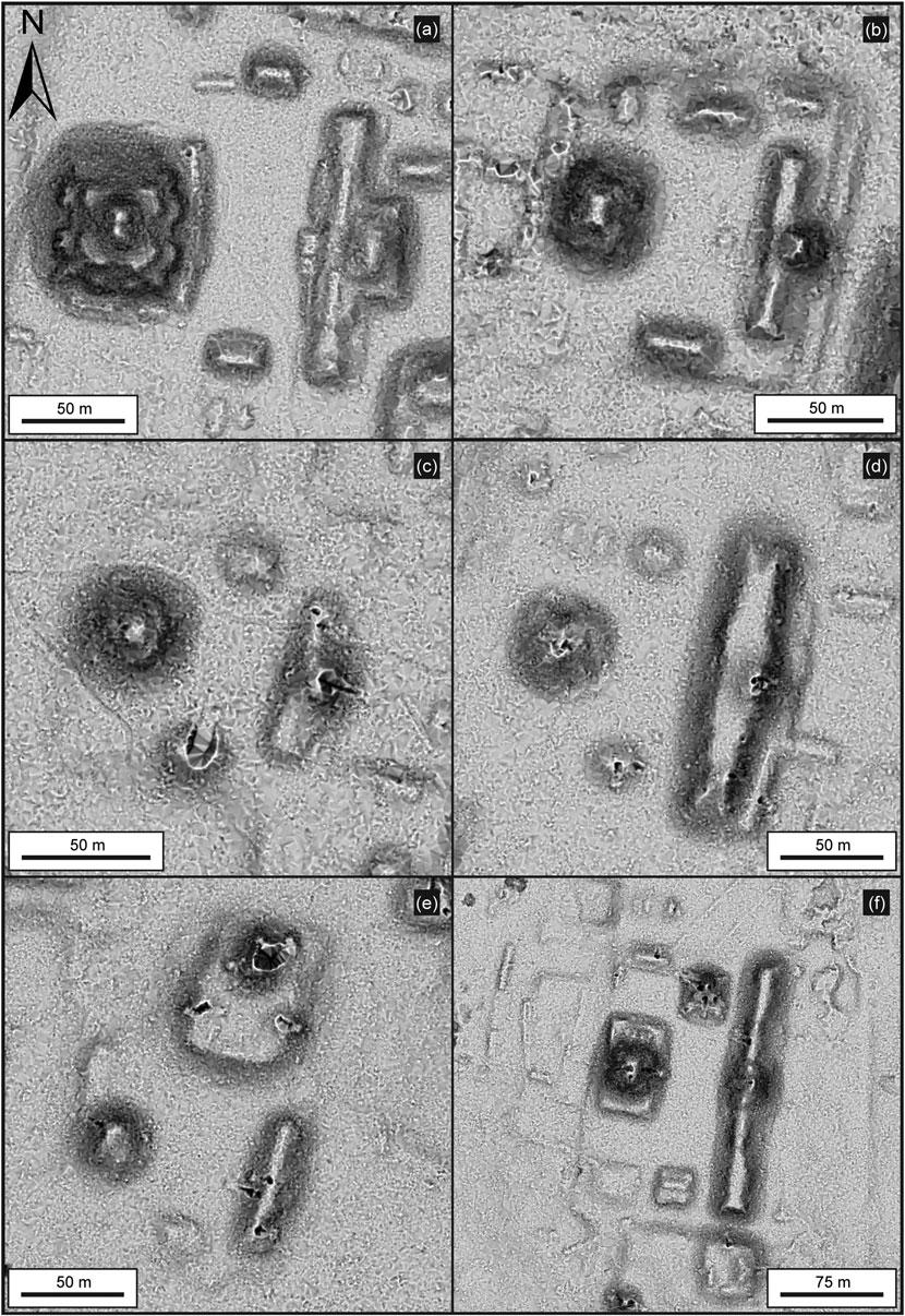
ExamplesofTier6sitesincludeLasIlusiones,LaCeibita, Hunal,ElKarstico,LaFlorida,Hunbe,andNoholtun,with surfaceareasbetween0.16and1.5km2 (Figure12).Only oneoftheTier6siteshasanE-Group,butallofthese siteshaveatleastonemonumentalstructurethatexceeds 12–22minheight.SitessuchasOxkinal,locatedonthe westernmarginoftheMCKBconsistssolelyofan E-Group.SitessuchasLaCeibitaandHunalhaveamassive singlepyramid,withavolumeofabout33,000–95,000m3, butnoothermonumentalbuildings.Randomlyselected examplesofsitehierarchiesarelistedin Table3,witha sampleofvolumetricslistedin Table4
WeappliedaKerneldensitymethodinArcGISProto analyzethespatialpatternsofE-Groups,triadiccomplexes, intersitecauseways,intrasitecauseways,ballcourts,and largereservoirs(Figure5).Asaresult,sixdifferent modelsshowhotspotsofconcentrationofthesefeatures. ThemainhotspotislocatedatElMirador,representing thelargestcityscapeinthesouthernMCKB.AnotherimportanthotspotisrepresentedatBalamnal,demonstratingits sociopoliticalinfluenceintheregionduringthePreclassic period.

NewperceptionsoftheMCKBsettlementsviaLiDAR
Ourdocumentationofhundredsofarchaeologicalsitesin theMCKBofnorthernGuatemalachallengestheoldnotion ofsparseearlyhumanoccupationintheMayaLowlands, particularlyinthePreclassicperiod(Fox 1977:40;Fry 1969; Haviland 1965:19;SandersandWebster 1988;Thompson
1954:50).ThepresenceofdensesettlementswithinthenaturalconfinesoftheMCKBindicatesprodigiousgrowthand unusualculturaldynamicsintheMiddleandLate PreclassicperiodsofMayaoccupation.Ourpreliminarysixtieredsettlementandadministrativehierarchyofceremonial sitesinthePreclassicperiod,asidentifiedbyexcavations

conductedoverseveraldecadesintheMCKB(Figure5)is indicativeofageneraluniformityofsitemorphologyin thisregion.WhiletheLateClassic(A.D.600–900)presence inthesouthernMCKBislimitedtosmallerresidentialsettlements,withtheexceptionofthesitesofNaachtun,Porvenir, Tamazul,LaPailona,andLechugal(ontheGuatemalanside), andUxul,Calakmul,andPareddelosReyesontheMexican side,awiderrangeoftieredhierarchyseemstobefoundin thePreclassicsites.Theconsistencyofarchitecturalforms andpatterns,ceramics,sculpturalart,architecturalpatterns, andunifyingcausewayconstructionswithinaspecified geographicalterritorysuggestsacentralizedpolitical,social,
andeconomicorganicsolidarityamongtheoccupants (HansenandSuyuc-Ley 2011).Thisisnottoimplyeither thereducedorenhancedpoliticalimportanceofthecenters, however,sincesiteslikeXulnalarelocatedinTier3dueto therestrictedareaoftheciviccentersurroundedby large bajos.Clearly,itwasanimportantsocialandeconomic hub,basedonthenumberofE-Groups(three),withat leastthreeintrasitecauseways,largeearlyarchitecture, anddefensiveorrestrictedaccessmoats.Itisalso oneofthefewsitesinthebasinwithanorth–southorientation,whilemostotherearlysiteshaveaneast–west orientation.

Themagnitudeofthelaborintheconstructionofmassiveplatforms,palaces,dams,causeways,andpyramidsdatingtotheMiddleandLatePreclassicperiodsthroughoutthe MCKBsuggestsapowertoorganizethousandsofworkers andspecialists,rangingfromlimeproducers,mortarand quarryspecialists,lithictechnicians,architects,logistics andagriculturalprocurementspecialists,andlegalenforcementandreligiousofficials,alloperatingunderapolitical andideologicalhomogeneity.Thesocial,economic,and ideologicalbranchesofculturalcomplexitywithinademarcatedgeographicterritoryaresuggestedbydifferential
causewayaccessibility.ThevariedsiteswithintheMCKB areatestamenttoregionalpublicprograms,suchas E-Groups,monumentalceremonialarchitecture,including triadiccomplexes,intersitecauseways,intrasitecauseways, ballcourts,reservoirs,dams,canals,terraces,andraised fields(Figures4–6).Residentialarchitecturewithinlarge sitesdemonstratesamarkedinequalityofsizeandsophisticationofarchitectureandthepresence,orlack,ofimported commodities(e.g.,Hansen 2016b:362–369).
Theconsistentarchitecturalconstructiontechniques (stone,mortar,stucco,andarchitecturalart),andboth

utilitarianandceremonialartifactsintheMiddlePreclassic period,plustheinnovationoflargetriadicarchitecture throughouttheareabythebeginningoftheLatePreclassic period,implyaformationandinstitutionalizationofaunified religiousideology(Coe 1981;Durkheim 1915;Keatinge 1981; Weber 1956).Wehaveyettoidentifygriddedsites,suchas theMiddlePreclassicsiteofNixtunCh’ich’ (PughandRice 2017;Pughetal. 2019),whichsuggeststheindependent natureoftheformationofsociopoliticalcomplexitybythis earlyperiod.Agriculturalterracinghasbeenidentifiedby LiDARandsurfaceexcavationsinnearlyallareasofthe southernMCKB,similartotheClassicperiodterracing
identifiedatCaracol,Belize(ChaseandChase 1998;Chase etal. 2014a:214ff.)andNaachtun(Morales-Aguilar,personal communication2021),aswellasthePreclassicterracesat NakbeandElMirador(Hansen 2012a, 2016b, 2017;Hansen etal. 2002, 2018a, 2018b;MartínezHidalgoetal. 1999). Terracesandsitesappeartodecreasenearthenaturalbordersofthebasin,butitmaybepossibletodeterminethe effectsofsuchextensivepopulationsinthePreclassiconsubsequentpopulationsandcontemporaryrainforestcanopy (Hightoweretal. 2014).Theagriculturalandlogisticalcapacity toaccommodatelargePreclassicpopulationsrequiredamarshallingoflabor,onanindustrialscaleperhaps,forthe

architecturalconstruction,planting,weeding,watering,and harvestingoftheterracecrops.
Themonumentalarchitecture,majorplatforms,complexesknownasE-Groups(seebelow),andassociatedcauseways(seebelow)wereformedbythelateMiddlePreclassic period,andsubsequentconstructionswerebuiltwithupto 1.5million–2.8millionm3 offillinasinglestructureinthe LatePreclassicperiod(Hansen 2012a, 2016b;Hansenetal. 2018a;Suyuc-LeyandHansen 2013).Massivetriadicpyramidalstructures,suchasthepyramidofTigreatElMirador, measuring145×150×55mhassimilarcounterpartsinat
least12majorsitesinthesouthernMCKB,andsimilarconstructionsarenotedatYaxnohcah,Calakmul,andprobably BalakbalinCampeche,indicatingthemagnitudeofthecontemporaneouslaborconscription.EstimatesfortheconstructionofDantaarebetween6and10millionperson-daysof labor,dependingonthevolumethatmightbeaffectedby anundulatingbedrocksurface(Hansenetal. 2018a:185). Thequantityanddensityofcontemporaneousconstructions intheMCKBallowanunderstandingofthelabor,ideological consistency,anduniformityofconstructionmaterials investedin,andon,themonumentalarchitecture

Figure12. LiDARimagesofexamplesofTier6sites:(a)LaCeibita,whichcoversanareaof1.0km2,buthasvolumetricsof94,997m3, whichcouldplacethesiteinaTier5category,pendingfurtherinvestigation.Severalresidentialgroupsatthesitewerenotincludedincalculationsbecauseofinconsistentcontemporaneitywiththelargerarchitecture;(b)Hunal,whichcovers0.7km2 andhasvolumetricsof 33,265m3/km2.Notethesinglemonumentalstructuresateachsite,of22mand20mhigh,respectively,withlittleadditionalassociatedarchitecture.Colorcodesfortheshadedimageareprovidedinthelegendshownin Figures6 and 7b

(E.Hansenetal. 1995, 1996, 1997;Hansenetal. 2020; Schreiner 2001, 2002, 2009, 2021).
Theevidenceforcomplexsocial,economic,andpolitical organizationsandtheemergenceofahierarchicalsociopoliticalstructurewithinstitutionsofkingshipallowthetestingofmodelsandhypotheses(Hansen 2016b, 2017).The formationofsuchhierarchicalpowerstructureshasanthropologicalimplicationsthatarebestobservedviadiachronic andsynchronicperspectivesonaregionalbasis(Haas 1982:216).
Monumentalityofritualandreligiousarchitecture, ballcourts,causeways,andwatercollectionsystems E-Groups
PrimarysitesoftheMCKBhavestructuresbuiltforceremonialorreligiousideology(e.g.,DemarestandConrad 1992).
LiDARanalyseshavefacilitatedtheidentificationofmore structuralcomplexesknownasE-Groups.Thesearchitectural complexesareofaconsistentform,withadominantpyramid onthewestandanelongatednorth–southplatformonthe
eastofaplazagroup,andwerepurportedtobeassociated withsolsticeandequinoxalignments,asfirstidentifiedin GroupEatUaxactuninthe1920s(Blom 1924:218;Doyle 2012;Freidel 1981;Freideletal. 2017;Hansen 1998:63–70; Ruppert 1940:222).However,theseassessmentsarenotreliable(seeAveniandHartung 1989; Šprajc 2021a, 2021b). Theyhadimportantritualandceremonialfunctionsin earlyMayaandMixe-ZoquesitesandaretheearliestconsistentarchitecturalgroupformatintheMayaLowlands(Chase andChase 1995, 2017:32;Hansen 1998:63–64;Inomata 2017; Inomataetal. 2013, 2020).WhilethereisdebateovertheoriginsofE-Groups(seeClarkandHansen 2001;Hansen 2005:55; Inomata 2017),thereisnodoubtthatthisarchitecturalformat wasdevelopedandutilizedintheMiddlePreclassicperiod throughouttheMayaLowlands(Doyle 2012, 2013; Estrada-Belli 2017;Estrada-Bellietal. 2003a, 2003b;Hansen 1992, 1998, 2000;Morales-Aguilar 2021).E-GroupsarecommonthroughouttheMCKB(e.g.,Hansen 1998:69–70;and Figures4 and 13),butvaryinquantityandsize.Analysisof LiDARimageryhaslocatedatleast30centersinthesouthern MCKB,whichaltogetherhave42E-Groupcomplexes (Figure13).ATier1sitesuchasMiradorhaseight E-Groups,whileTier2siteslikeBalamnalhaveatleasttwo E-groups,and “endoftheroad” tertiarysitessuchas NoholnalandNoholtun,locatedtothesouthandsouthwest ofBalamnal,havetwoandoneE-Groupcomplexes,respectively.Thesizeofthesite,though,seemstobeirrelevant, sinceE-Groupsarefoundinallidentifiedtiersofsitesize. SomeTier6siteslikeOxkinalconsistoflittleotherthan thestructuresofanEGroup.WhileElMiradorhasperhaps thelargestwesternstructureofanyE-GroupintheBasin, withtheLeonstructureat33minheight(Figure13a), theelongatedeasternstructureatWaknaisprobablythe largest,at210minlength(Figure13f ).TheE-GroupcomplexintheEastGroupatNakbe(Figure13b)isamongthe earliestintheMCKB,withconstructionandoccupationdatingfrom900
600 B C.(Figure14).Ceramicsfromexcavations atElPesquero,Balamnal,Wakná,Kunal,Xulnal,andEl MiradorsuggestthatthoseE-Groupsarecontemporaneous.
Triadicarchitecture
Thevastmajorityofthelargestarchitecturethroughout theMCKBisatriadicconfiguration,a “dominantstructure flankedbytwo,inward-facingsmallermounds” (Figures15a–15f;seeFreidel 1979;Graham 1967:45–46; Hansen 1990:171ff., 1998:77
78, 2000, 2016a, 2016b, 2017). Whilenotriadicstructuresareyetknownfromthe MiddlePreclassicperiod,theformatappearssuddenlyand ubiquitouslythroughouttheentiretyoftheMCKBbythe earlyLatePreclassicperiod(ca.350–300 B C.).Thetriadic patternispossiblyrelatedtoanearlycosmologyof “three hearthstonesofMayacreation” (Tedlock 1996:236,n72). TheLatePreclassicTigrepyramidintheWestGroupatEl Mirador(Figure16a)wasestimated,basedonreplication experimentsbytheMiradorBasinProjectandothers,to havebeenconstructedataminimumof2,803,595 –5,000,000persondaysoflabor(Erasmus 1965;Hansen 1982, 1984, 1990:215;Hansenetal. 2018a;Sidrys 1978:159).
ThepyramidofDanta(Figure16b)locatedontheeastside oftheciviccenterofElMiradorconsistsofthreecontinuous elevatedplatforms,withamajortriadicgrouponthesummit ofthethirdplatformandmeasures600×320×72minheight, andapossiblevolumeof2,816,016m3 offill,pendingadditionalexcavationsintheprimaryplatformofthestructure (HansenandSuyuc-Ley 2011;Hansenetal. 2018a:184; Suyuc-LeyandHansen 2013).Basedonourcalculations,the buildinghasasurfacecoveringof205,508limestoneblocks atanaveragesizeof1.30×0.45×0.40m,requiring158workers continuallyforfiveyearstoquarrythestones,basedonour detailedexperimentsinthefield(Hansenetal. 2018a:182–186;WoodsandTitmus 1994, 1996).Dependingonthenatural configurationsofthebedrockbelowthestructure,theentire buildingcouldhavehadasmuchas6,000,000to10,000,000 person-daysoflabor,exceedingthecapacityofpolitiesof lowerhierarchicalpoliticalandeconomicstatus,andsuggestingahighleveloforganizationasthesociopoliticalandeconomicpatronofsuchprodigiousgrowth(Hansenetal. 2018a:185).ThisisconsistentwiththepatternsofPreclassic platformsandmonumentalconstructions,asidentifiedin otherareasoftheMayaLowlands(Inomataetal. 2013, 2020, 2021).Inomataandcolleagues(2013, 2020, 2021)haveargued thatsuchmonumentalconstructionsatAguadaFenixand CarmelitainTabasco,Mexicomayhavebeenconstructedby societieswithlesscomplexitycomparedwiththeOlmecneighborsofSanLorenzoandLaVenta.Wesuggestthatsuchobservationsmaybepremature.Therearereasonstosuspectthat theearlysitesofTabascomaynotbeMaya,andtheymay bemorealignedpoliticallyandeconomicallywiththeOlmec (seealsoRosenswig 2021b).ExtensiveexperimentaldataconductedbytheMiradorBasinProjectsuggeststhatthelabor requirementsfortheconstructionofPreclassicMayamonumentalarchitecturewerealsohigh,requiringagreaterdiversityandspecialization,especiallyinconstructionswith quarriedlimestoneblocks,limecement,sascabquarries,mortarpreparation,watercollectionandutilization,andquarried limestonefill(Hansen 2016b;Hansenetal. 2018a;Schreiner 2001, 2002, 2009, 2021;WoodsandTitmus 1994, 1996).
Ballcourts
ThesitesintheMCKBhaveacombinedtotalofatleast30ballcourtsthatarescatteredthroughoutthesystem(Figure4), with26associatedwithMiddleandLatePreclassicarchitecture.Severalexcavatedexamples,suchastheoneatTintal, isoneofthelargerballcourtsintheMCKB,butthefinalversiondatestotheLateClassicperiod(Balcárceletal. 2021).The ballcourtslocatedintheMCKBshowtwoparallelstructures,ofteninanorth – southaxis,andareapproximately 10 – 20mlong.ThesiteofElMiradorhassevenpresumed ballcourts,consistingoffoursmallonesandthreepossible largercourtsintheGreatCentralAcropolisatthesite.The presenceofaroyalthrone,specializedceremonialsunken plazas,elaboratecosmologicaliconography,reservoirsand hydraulicsystems,andmassiveplatformsandconstructionssuggeststhattheGreatCentralAcropolismayhave beentheseatofpowerofPreclassicrulersatthesite (Hansen 2016b :397 – 400).
Causeways
OneofthecrowningachievementsoftheMiddleandLate PreclassicMayawastheconstructionofadendriticsystem
ofcausewaysthroughouttheentiretyoftheMCKB(Hansen etal. 2020;Hernández 2008;Hernández-Salazar 2021; HernándezandSchreiner 2006;Hernándezetal. 2007, 2013, 2016, 2019;and Figures17 and 18).Whilecausewayswere
withaheavyclusterofdatesbetweenca.1200and500 B C .ina2-sigmarange.Theearliestdatesarefromburnedpostsinpostholesinthebedrockinfrontofthestructureandareconsistentwithearlydatesfrom thecoresextractedfromlakesonthewesternedgeoftheMCKB(OxCalv.4.4.2,BronkRamseyetal. 2020;atmosphericdata:Reimeretal. 2020).

knowntohaveexistedthroughouttheMayaarea(e.g., Benavides-Castillo 1981;Bennett 1930;ChaseandChase 2001;CobosandWinemiller 2001;Folan 1991;Gómez 1996; HutsonandWelch 2021;Kurjack 1977;Maldonado-Cárdenas
1979;Shaw 2001, 2008;Villa 1934)andtheMCKB(e.g., Graham 1967:41–47),thescopeandscaleofthefeaturesare nowfullyevidentwiththeairborneLiDAR,supportedby satelliteimageryandGISsoftware.


DigitalelevationmapofElMiradorwithcausewaysandreservoirs.MajorcausewaysfromtheciviccenterofElMiradorshowthe extentandnatureofthevastintrasiteandintersitenetworks.PrimarycausewaysextendfromDantapyramidnortheastintoCampeche, Mexico(Yaxnohcah?),andsoutheasttoNakbe.OtherintersitecausewaysextendfromtheCentralAcropolissouthtoTintal,andfrom theLasCrucesGroupnorthwesttoElLimónandPaxbán.Intrasitecausewaysconnecttheciviccentertoneighboringsuburbsof Sacalero,LosFaisanes,Chacté,LosPericos,LaMuerta,Yaxché,LasArdillas,andothers.Backgroundcolorrepresentsterrainelevation withlowestelevationsinlightblueandgraduallyincreasingtohighestelevationsinbrownsandwhite.
LiDARmappinginthesouthernMCKBhasrevealeda networkofatleast133.22kmofintersiteand38.23kmof intrasitePreclassic nohbe (“bigroad”)or chibalbe (“large lineageroad”)causeways(BollesandFolan 2001).An additional3.89kmcouldbeaddedifthesitedestination platformsareincluded.ThemappedPreclassicintrasite causewaysindicateintracommunityconnectivityandintegration.Preclassiccausewaysareeasilydistinguishedfrom Classicperiodcausewaysbythewidthofthefeaturesand thelackoflowstonewallsorparapetsalongtheedges. AllLateClassiccausewaysaredefinedbythepresenceof lowparapetsoneachsideofthecauseway.Only12.13km ofClassicperiodcausewaysarefoundthroughoutthe entiretyoftheSouthernBasin,andnoneofthemareintersite,indicatingthevastdifferencesindemographicdensity andadministrativeprocessbetweenthetwoperiods.The majorityofPreclassiccausewayshavealocusatElMirador, with12intrasitecausewaysandfivemajorintersite
causeways.Theintrasitecausewaysmeasure9–40mwide, whiletheintersitecausewaysrangefrom28to40mwide. Thereareatleast11suburbanresidentialareas(densegroups intheperipheralregions),directlylinkedbyintrasitecausewaystotheciviccenterofElMirador(Hansenetal. 2020; Hernández-Salazar 2021:23;Morales-Aguilaretal. 2015;and Figure17).LargeintersitecausewaysincludethePaixban causeway,whichextendstothenorthwestofMiradorto thesitesofElLimonandPaixban.Thiscausewayis30–40m wideand2–4mhigh,andextends21kmbeforereaching thelimitsofourLiDARsurvey.Anotherpreviouslyundetected causeway(Campechecauseway)extendsfromDantapyramidtothenortheastformorethan12km,andcrosses intothestateofCampeche,Mexico.Thisfeatureis30–40mwideand2–4mhigh,andextends7.4kmtoasemirectangularapertureintheterrainofthenaturaltopographybeforecontinuingonanother2.3kmtothenortheast Mexicanborder.Thereisalikelypossibilitythatthis

causewayextendstowardsYaxnohcahorChicanticanalin Campeche,andnotCalakmul,aspurportedearlier(Folan etal. 2001:296–297).Atpresent,thereisnoindicationon LiDARdataofacausewaybetweenElMiradorand Calakmul,whichislogicalconsideringthedifferencesin contemporaneityofthesites,eventhoughCalakmuldoes havesomePreclassicoccupationandatleastonemonumentalsubstructure.

Animportantcauseway(Mirador–Nakbecauseway) extendsfromthesoutheastcornerofthesecondplatform ofDantapyramid,13kmtothesiteofNakbe.Thiscauseway variesbetween0.5mand5minheight(Figure18a)andis
35–40minwidth.Another,theTintal–Miradorcauseway, extendstothesouthwestofElMiradorandis40mwide, 1.0–4.5minheight,and24kmlongtoTintal(Figures18b and 18c).ItunitestheCentralAcropolisatMiradorwith theHenequenandManodeLeonGroupsatTintal. Furthermore,ithasamid-coursedirectionalchangeto thewestfromtheoriginallineofsightonthelargepyramid atthesiteofLaCeibita,suggestingthattheconstruction originofthecausewaywasfromElMirador.Excavations onthiscausewayrevealedaseriesofC-14dates(Table5), ceramics,andaconsistentsequencethatplacestheinitial constructionpossiblyasearlyasthelateMiddlePreclassic
Figure18. PhotographsofseveralMCKBintersitecauseways:(a)edgeoftheMirador–Nakbecauseway;(b)theMirador–Tintalcauseway, showingtherelativeheightsnormalfortheelevatedintersitecauseways;(c)theJadecausewayinTintalis40mwide,typicalofthePreclassic causewaysintheMCKB.Figure19. DetailedLIDARimageoftheMirador–Tintalcauseway:(a)profileofOp.500-A,excavationoftheMirador–Tintalcauseway, showingthestratigraphicsequencesoftheconstructionphaseswithfourfloors(afterHernández-Salazar 2021:129;Hernándezetal. 2013:950);(b)LiDARimageofGavilan “ElParaiso” IslandintheBajoCarrizal,locatedsouthofElMirador,showingthelargePreclassiccauseway.Backgroundcolorrepresentsterrainelevationwithlowestelevationsinlightblueandgraduallyincreasingtohighestelevationsinbrowns andwhite.

period,butcertainlybythebeginningoftheLatePreclassic period(Figure19;Hernández-Salazar 2021:152–154,60ff.; Hernándezetal. 2016;SchreinerandHernández 2009; Schreineretal. 2015).
CalculationsofthevolumeoftheTintal–Miradorcauseway,basedonexcavations,determinedthatthePreclassic Mayausedasmuchas10,000m3/kmoflimeplasterand limereinforcedfillforelevatedsectionsofthecauseway. SchreinerandHernándezalsodeterminedthatupto 40,000m3/kmof tzaal stone(asoft,porouslimestoneof
nearlypurecalciumcarbonate,with2percentmontmorilloniteclay)wasusedonthecombinedvolumeofthefour sequentialrenovationsofthecauseway(Hansen 2012b:263–264;Hansenetal. 2018a;Schreiner 2001, 2002, 2021; SchreinerandHernández 2008 , 2009 ;Schreineretal. 2015 ).Suchconsumptionrequiredtheburningofgreat amountsoflimestoneandwood,withlargelaborrequirementstomakethequicklimeforthelimeplasterofthe surfacesandsubstratematerials(Hansen 2012b ;Hansen etal. 2018a , 2020 ;Hernándezetal. 2013 , 2016 ;Schreiner
2001 , 2002 , 2021 ).Onwetlandstretches,thecausewaylime usewascloserto5000m 3 /km,withthetechnicalinnovationoflimeandclaymixturesthatcontrolled moisture-inducedheavingofavailableexpansiveclay basesubstrates(Schreiner 2021 ).
TheTintal–Miradorcausewaydivergedatthesiteof Tintaltoformanotherimportantcauseway(Tintal–Ceibita causeway),25
30mwide,whichextended5kmtothe southeastfromthesite,connectingdirectlytothemonumentalpyramidatthesiteofLaCeibita(HernándezSalazar 2021:72).Theprimarycauseway(Tintal–Balamnal causeway)continuedfromTintalinasoutherlydirection forapproximately3kmbeforecurvingtothesoutheast andrunningparallelwiththenaturalkarstborderofthe MCKBfor17km,tothesiteofBalamnal(Figure20).Itis clearfromthesize,distribution,andquantityofmajor structuresthatBalamnalwasoneofthemostimportant centersintheMCKB,withdominantE-Groupsinthecenter ofthesite,andaseriesofelevatedintrasiteandintersite causeways,15
20meterswide,thatextendedtolowertiered sitesinadendriticformat(Hansenetal. 2020;seeChaseand Chase 2001:276
280forasimilarClassicperiodsystemat Caracol).Theprimarycauseway(Tintal–Balamnalcauseway) comesfromTintaltothenorthwest.Anotherelevated causeway,theNoholtuncauseway,extends5kmtothe
southwesttothesiteofNoholtun.TheNoholnalcauseway extends5.5kmfromBalamnaltothesouthtothesiteof Noholnal.ThePesquerocausewayextends7.5kmtothe eastandsoutheasttothesiteofElPesquero,andyet another,theUnioncauseway,extends9.5kmtothenortheasttothesiteofLaUnion.Thesmalleroutliersitesmay haveservedasfrontierstationsfortheMCKB,andnocausewayshaveyetbeenobservedthatextendbeyondthe MiradorAnticlineonthenorth,eastorsoutheastorthe low,residualkarsthillsonthewestthatformthenatural bordersofthebasin.
ExcavationsatbothBalamnalandElPesquerohavelocated uptosevensequentialfloorsintheplazasoftheE-Group complexes,withthelowerlevelsdatingtotheMiddle Preclassicperiod(Mejía 2008, 2012;Mejíaetal. 2007, 2010). Theunificationofthesesites,directlyandindirectly,with theTier1siteofElMiradorviathecausewaynetworksuggestsanadministrativecentralizationandanautochthonous developmentofeconomicandpoliticalpowerindicativeofa complexauthorityatkingdom(andstate)level.

Watermanagement:Reservoirs
TheLiDARsurveyintheMCKBsystemhasprovidednew insightsintothecontrolofwater.TheMCKBhasno
Noholtún;(f)intersitecausewaytothesiteofNoholnal.
perennialriversorlakes,asidefrommaturemarshesona smallscale(civales ),requiringtheancientMayatoconstruct largereservoirsystemsforwatercollectionandrainwater management(seeChaseandCesaretti 2018 forsimilar observationsinCaracolandTikal,aswellasNakum; ŹrałkaandKoszkul 2015).LiDARdatalocated195artificial waterreservoirs(termed aguadas bylocals,althoughnaturallyoccurring aguadas arerarelyfoundinthebasin)and aseriesofmonumentalreservoirsystemsdesignedfor largewatercaptureandcontrolinthesouthernhalfof theMCKB.OtherscholarshavecontributedtounderstandingwatermanagementstrategieswithintheMCKB (Brewer 2017;Breweretal. 2017;Parry 2007;Seefeld 2013, 2017)andsuchstudiescanbesubstantiallyrefinedwith LiDAR.StrategiesatElMiradorbetween300and100 B.C. includedtheconversionofsunkenceremonialplazasinto watercollectionreservoirs,suchasthoseintheGreat CentralAcropolisatElMiradorandtheconstructionof limecementpoolsforwatercapture(Argyle 2008, 2009, 2010;ArgyleandHansen 2010, 2015, 2016:135–140). Subsistencestrategiesincludedtheconstructionofavariety ofreservoirsandtheconstructionofdamsandcanalsbythe MiddleandLatePreclassicperiods(Hansenetal. 2002; Hernándezetal. 2013, 2019:462–463;Morales-Aguilaretal. 2015;Schreineretal. 2015),allofwhichexceededthecapacitiesofloweradministrativelevels.ThePreclassicreservoir systematthebaseoftheescarpmentintheWestGroupatEl Miradorheldanestimated336,653m3 ofwaterinadefined areaof224,435.41m2.Fourothermajorreservoirsatthesite (excluding aguadas )hadacombinedestimatedcapacity(via HydrologyToolset)ofanadditional374,490.53m3 (Table6). ThevolumeofreservoirswascalculatedwithArcGISPro Hydrotool.StorageCapacity,Fill,andPixelEditortools wereperformedusingLiDARDEMwithanarbitrarydepth of1m(basedonpriorexcavations)toobtainthevolumetricsofthereservoirs.
TheprimarydamfortheBajoLaJarrillawasconstructed acrossanarrowstretchof bajo betweentheciviccenterofEl MiradorandthesuburbofLaMuerta,measuringmorethan 400mlong,3mhigh,and50mwideinitscurrentstate, formingareservoircontainingatleast166,468m3 ofwater (Figure21).TheMirador–LaMuertacausewaywasdirectly
attachedtothedamalongitswesternedge.Excavations ofthedamrecovered184ceramicsherds,97percentdating totheMiddlePreclassic(ca.600–400 B C.)period(Hernández etal. 2019:462).Acalibratedcarbonsample(woodcharcoal) fromthelowerlevelsofthecausewayassociatedwiththe damprovidedapossible2σ dateof245030B.P.(δ13C= 23.3%;775–410cal B.C.)withamedianageof580cal B.C. (Beta345791).Similarmonumentalwatercollectionsystems werelocatedatthesouthernborderofthePalmacauseway atNakbe,wherearectangularwalledenclosureallowedcaptureandaccessofwater.
Finalobservations
Theformationofaunified “kingdom ” intheMCKBmay haveemergedassmallerentitieswereabsorbedintoa largerhegemony,analternativemodeltothatproposed byClarkfortheMiddlePreclassickingdomsofthe WesternMayaHighlands(Clark 2016).AccordingtoClark, the “criticalcompetitionfacingMiddlePreclassicrulers was … nurtured … withintheboundariesoftheirown domains” (Clark 2016:223,editingHansen).Inthecaseof ElMirador,extraordinaryeconomic,political,andsocial powerwaswieldedatleastbytheMiddlePreclassicperiod toformthenetworkingofcontemporaneoussites,welded togetherbyanextraordinaryweboflarge,dendriticcausewaysystems,aunifiedandhomogeneousreligiousand politicalideology,asportrayedfirstinE-Groupcompounds datingtotheMiddlePreclassicperiod,andmodifiedby about350–300 B.C.toincludethelargerepertoireoftriadic architecturalcomplexesthroughouttheMCKB.Weconcur withChaseetal.(2009:181)thatMesoamericanpolities seemtohavebeendefinedbyrelationshipswiththeruler, butintheMCKBtheregionseemstohaveincludedaterritorialframework,sincenoneofthelargecausewaysystems extendbeyondthenaturalbordersoftheBasin.Theexpansionandcontroloflaborforsuchmassive,contemporaneousmonumentalarchitecturalgroupssuggestsaunified powerthatcoulddrawonlaborandresourcesfrom throughouttheentiretyoftheMCKB.Furthermore,the monumentalityevidentinthearchitectureoftheMCKBis alsofoundincontemporaryculturesorantecedentsocieties intheWesternMayaLowlandsorGulfCoastareas(Inomata etal. 2021;seealsoRosenswig 2021b).
Contiguous,regionalLiDARstudiesofthissouthernhalf oftheMCKBareahavepresentlyrevealed964archaeologicalsites.Manyofthesesettlementsdemonstrateapolitical/ social/geographicalrelationshipwithothernearbysettlements,whichhasresultedintheconsolidationintoat least417ancientcities,towns,andvillageswithidentifiable siteboundaries.Asettlementandadministrativehierarchy ofatleastsixtiersisproposedforsites,basedonsurface areaofthesites,numbersanddensitiesofmonumental architecture,andvolumetriccalculationsofarchitecture extractedfromgeometriccalculationsandLiDARdata.The approximatevolumetricassessmentsofconstructionfill withintheciviccenterofa1km2 areawithcontemporary monumentalarchitectureallowssimilarmethodologyto beappliedinotherareasoftheMayaLowlands,asa
meansofdeterminingthesociopoliticalandeconomic prowessofsites.Large-scalemonumentalarchitecture,consistentarchitecturalformats,specificsiteboundaries,water managementandcollectionfacilities,andmorethan177km ofelevatedPreclassiccausewayssuggestasocialandeconomiccohesionthatexceedthoseoflesserpolitiesduring theseperiodsandportraythestrategiesofgovernancein incipientkingdom-/state-likeformationintheMiddleand LatePreclassicperiodsoftheMCKB.

ThecomplexsocietiesthatemergedintheMCKBorganizedinfrastructuretopromoteandreflectsocio-economic organizationandpoliticalpowerduringthePreclassic periodofMayahistory.Thepeculiarityofdensedemographicregionsinthewetland bajos bolstersthehypothesis thatanincipientstate-levelkingdomhadbeenformedby theseperiodsinanareathattodaywouldhavebeenconsideredinhospitablefordemographicandarchitecturalexpansion.Thiswasasequentiallydefinedprocessthatevolvedto atieredhierarchyofsiteswithinaspecificterritorialarea, possiblyasanautochthonousprocess,butthatmayhave beeninspiredbycompetitiveideologies,peerpolityinteractions,orotherinfluencesbyotherHighlandorLowland societies.Theadoptionandadaptationof “importantingredientstocontemporaneousMesoamericansocialandpoliticalidentities ” providedtheculturalfoundationsforlater MayaandMesoamericanstates(Hansen 2016b:330).The contemporaryandconsistentarchitectureconnectedby thedendriticnetworkofcausewayswithinageographically
defined,congruent,natural,socio-economic,andpolitical regionissuggestiveofacentralizedpolitical,economic, and/orideologicalauthority,whichwebelievetohave emergedatElMiradorbytheMiddlePreclassicperiodand expandedbythebeginningoftheLatePreclassicperiod. Laterpatternsofdendriticnetworksofcausewayselsewhere inMesoamerica,suchasChichenItza,Caracol,andthe BasinofMexico,suggestthatthepoliticalandeconomicintegrationmayhavehadantecedentssuchasthosefoundinthe MCKB.Majornewcitieshavebeenfoundbythisresearch, suchasthegreatsiteofBalamnal,witharchaeologicalexcavationsplacedinthesite(alsoknownas “ElCedro”)bythe MiradorBasinProjectin2008and2009(Mejíaetal. 2010), whichwaspartoftheunifiedsettlementsandcausewaysin thebasin.Newsiteboundariesandarchitecturalgroupintegrations(asnotedbyintrasitecauseways)wereidentified, amplified,ormodifiedduetoLiDARanalysesaswell.
LiDARanalyseshavedemonstratedthepresenceofdense concentrationsofnewandpreviouslyunknowncontemporaneoussites,massiveplatformandpyramidconstructions, includingtriadicgroups,numerousE-Groupcomplexes, causewaynetworks,ballcourts,andreservoirsthatrequired vastamountsoflaborandresources,amassedbyapresumablycentralizedorganizationandadministration.Theskeletonoftheancientpoliticalandeconomicstructureasa kingdom-stateintheMiddleandLatePreclassicperiods hasatantalizingpresenceintheMirador-CalakmulKarst Basin.
Acknowledgments. AppreciationisextendedtotheMinisteriode CulturayDeportesofGuatemala(MICUDE,ContractDAJ270-2018), theDirecciónGeneraldelPatrimonioCulturalyNatural,andthe InstitutodeAntropologíaeHistoriadeGuatemala(IDAEH)forthe authorizationsandpermitstocarryoutthisresearch.Fieldworkin thesouthernMirador-CalakmulKarstBasinwasaccomplishedaspart oftheongoingMiradorBasinProject,directedbyRichardD.Hansen undertheauspicesoftheDepartmentofAnthropologyofthe UniversityofUtahandtheDepartmentofAnthropologyatIdaho StateUniversity,withfinancialassistancefrommanyotherprivate andpublicdonors.WearethankfultotheDirecciónGeneralde AeronáuticaCivilofGuatemala(ContractsDGAC/FA1-2009,016-2014) forthenecessaryflightpermitsandauthorizations.ALOSGlobal DigitalSurfaceModel(AW3D)digitalelevationdata,usedforinterpretationoftheterrainandlarge-scalegeologicalfeatures,wereprovided bytheJapanAerospaceExplorationAgency.Sentinel-2multi-spectral data,includingnear-infraredbands,usedforinterpretationofhydrologicalfeatures,wereprovidedbytheEuropeanSpaceAgencyand theNationalCentreforSpaceStudies(CNES).LiDARdatawereprovided byFARES,theMiradorConservationFund,theNationalGeographic Society,andEagleMapping.WeextendourappreciationtoJody Hansen,Dr.RobertRosenswigandfiveanonymousreviewersfortheir commentsandsuggestionsforimprovingthisarticle.Weextendour appreciationtothethousandsofworkersfromthecommunitieswho haveparticipatedinthecollectionofmuchofthesedataandwho havefosteredakeeninterestintheconservationoftheiruniqueculturalheritage.Weappreciateandgivethankstotheentirestaffand personneloftheMiradorBasinProject,withoutwhomnoneofthis wouldhavebeenpossible.
SupplementaryMaterial. Toviewsupplementarymaterialforthis article,pleasevisit https://doi.org/10.1017/S0956536122000244
CompetingInterests. Allauthorshavecontributedtothisarticle, andtherearenocompetingorconflictsofinterestamongtheauthors.
FundingStatement. Fundingfortheresearchnotedinthisarticle wasprovidedbytheFARESFoundation,FARES-Guatemala,Pettit Foundation,MiradorConservationFund,GlobalConservation, MammelFoundation,GlobalHeritageFund,RosalindeandArthur GilbertFoundation,NAISA,WolfCreekFoundation,MorganFamily Foundation,MoonFamilyFoundation,JayI.KislakFoundation,Peace, LoveandHappinessFoundation,SelzFoundation,APANAC-Guatemala, FundaselvaGuatemala,NationalGeographicSociety(Grant#SP08-15 andSP-Garcia18),U.S.DepartmentoftheInteriorInternational AffairsProgram,VictoriaEarl-MionTrust,HarryandRobertoSalter Foundation,RobertBerry,JohnPaulDeJoria,Dr.NancyFurlotti,Adam andChontalGreen,JohnandPatHansen,LindaPierce,JeffMorgan, JoannaMiller,DarinMoon,PitchandCathyJohnson,SpencerKirk, FrancoisandNiniBergerandfamily,FrancoisDuBoisandfamily,Jose MariaKong,BarbyPickett,andPeterSmith.
2008InvestigacióndelossistemasderecoleccióndeaguaenEl Mirador,Operación610A-L.In Informefinaldeinvestigaciones2007: Investigaciónyconservaciónenlossitiosarqueológicosdelazonacultural ynaturalMirador,editedbyNoraLopez,RichardD.Hansen,and EdgarSuyuc-Ley,pp.487–497.Reportfiledwiththe DepartamentodeMonumentosPrehispánicosyColoniales, InstitutodeAntropologíaeHistoria,MinisteriodeCulturay Deportes,GuatemalaCity.
2009ManejodeaguaenelperíodopreclásicoenElMirador,Petén, Guatemala:Operación610O,2008.In InvestigacionesmultidisciplinariasenElMirador:Informefinaldelatemporada2008,Vols.1&II, editedbyHéctorMejía,RichardD.Hansen,andEdgarSuyuc-Ley, pp.586–612.ReportfiledwiththeMinisteriodeCulturay Deportes,InstitutodeAntropologíaeHistoria,Departamentode MonumentosPrehispánicosyColoniales,GuatemalaCity.
2010LospanelesyrasgosasociadosalmanejodeaguaenlaGran AcrópolisdeElMirador:Operación610-O.In Exploraciones arqueológicasenlaCuencaMirador,2009,editedbyHéctorE.Mejía, RichardD.Hansen,andEdgarSuyuc-Ley,pp.539–556.Report filedwiththeInstitutodeAntropologíaeHistoria,Guatemala, DepartamentodeMonumentosPrehispánicosyColoniales, GuatemalaCity.
Argyle,J.Craig,andRichardD.Hansen
2010Lacosmovisióndeestuco:Lospanelesestucadosdelsistema hidráulicodelMirador.In Lacosmovisiónatravésdeltiempo:Tresmil añosdehistoriamaya.IIIConvenciónMundialdeArqueologíaMaya, 2010.CasaConventoConcepción,AntiguaGuatemala,June18–20,2010.
2015ExcavacionesdelaPlazaHundidaOeste,GranAcrópolis Central,ElMirador:Operaciones610KK,610LL,610MM,610 NN,610OO.TemporadadeCampo2014.In Investigacionesenla CuencaMirador,Temporada2014,editedbyRichardD.Hansenand EdgarSuyuc-Ley,pp.154–171.ReportpresentedtotheInstituto deAntropologíaeHistoria,MinisteriodeCulturayDeportes, GuatemalaCity.
2016ElfrisopreclásicodelaGranAcrópolisCentralenElMirador: Distribuciónderecursosymitosrelatadosenestuco/The PreclassicFriezeoftheGreatCentralAcropolisatElMirador: ResourceAllocationandMythRecountedinStucco.In Mirador: ResearchandConservationintheAncientKaanKingdom,editedby RichardD.HansenandEdgarSuyuc-Ley,pp.131
152.Foundation forAnthropologicalResearchandEnvironmentalStudies(FARES), CorporaciónLitográfica,GuatemalaCity.
Aveni,AnthonyF.,andHorstHartung 1989Uaxactun,Guatemala,GroupEandSimilarAssemblages:An ArchaeoastronomicalReconsideration.In WorldArchaeoastronomy, editedbyAnthonyF.Aveni,pp.441–461.CambridgeUniversity Press,Cambridge.
Balcárcel,AnaBeatriz,RichardD.Hansen,CarlosMorales-Aguilar,and JuanLuisVelásquez 2021GamesorPrehispanicRituals?TheBallCourtsoftheMirador Basin.Paperpresentedatthe86thAnnualMeetingoftheSociety forAmericanArchaeology,SanFrancisco.
Bauer-Gottwein,Peter,BibiR.N.Gondwe,GuillaumeCharvet,Luis E.Marin,MarioRebolledoVieyra,andGonzaloMerediz-Alonso 2011Review:TheYucatánPeninsulaKarstAquifer,Mexico. HydrogeologyJournal 19:507–524. https://doi.org/10.1007/s10040010-0699-5
References
Adams,RichardE.W.
1990ArchaeologicalResearchattheLowlandMayaCityofRioAzul. LatinAmericanAntiquity 1:23–41.
1999 RioAzul:AnAncientMayaCity.UniversityofOklahomaPress, Norman.
Adams,RichardE.W.,andJaneJacksonAdams
2003VolumetricandStylisticReassessmentofClassicMayaSitesin thePeten,RioBec,Chenes,andPuucHills. AncientMesoamerica
14:139–150.
Adams,RichardE.W.,andRichardC.Jones
1981SpatialPatternsandRegionalGrowthamongClassicMaya Cities. AmericanAntiquity 46:301–22. https://doi.org/10.2307/280210
Argyle,J.Craig
Beach,Timothy,SherylLuzzadder-Beach,SamanthaKrause,Tom Guderjan,FredValdez,JuanCarlosFernandez-Diaz,SaraEshleman, andColinDoyle
2019AncientMayaWetlandFieldsRevealedunderTropicalForest CanopyfromLaserScanningandMultiproxyEvidence. PNAS 116:21469–21477. https://doi.org/10.1073/pnas.1910553116
Benavides-Castillo,Antonio
1981 LoscaminosdeCobáysusimplicacionessociales.Instituto NacionaldeAntropologíaeHistoria,CentroRegionaldelSureste, ColecciónCientífica,MexicoCity.
Bennett,RobertR.
1930 TheAncientMayaCausewayinYucatan.IndianNotesVII(3). MuseumoftheAmericanIndian,HeyeFoundation,NewYork.
Blom,Franz
1924ReportonthePreliminaryWorkatUaxactun,Guatemala. CarnegieInstitutionofWashingtonYearBook23:217–219.
Bolles,David,andWilliamJ.Folan
2001AnAnalysisofRoadsListedinColonialDictionariesandtheir RelevancetoPre-HispanicLinearFeaturesintheYucatan Peninsula. AncientMesoamerica 12:299–314.
Brewer,JeffreyL.
2017 ALandscapeArchaeologyApproachtoUnderstandingHousehold WaterManagementPracticesoftheAncientLowlandMaya.Ph.D.dissertation,DepartmentofGeography,CollegeofArtsandSciences, UniversityofCincinnati.
Brewer,JeffreyL.,ChristopherCarr,NicholasP.Dunning,Debra S.Walker,ArmandoAnayaHernandez,MeaghanPeuramaki-Brown, andKathrynReese-Taylor
2017EmployingAirborneLiDARandArchaeologicalTestingto DeterminetheRoleofSmallDepressionsinWaterManagementat theAncientMayaSiteofYaxnohcah,Campeche,Mexico. Journalof ArchaeologicalScience:Reports 13:2291–2302.
BronkRamsey,Christopher,TimothyHeaton,M.BlaauwBlackwell, PaulaJReimer,RonWReimer,andMarionScott
2020StatisticalApproachesandToolsforIntCal20. EGUGeneral Assembly:EGU2020–9336. https://doi.org/10.5194/egusphere-egu20209336.
Bundzel,Marek,MiroslavJaščur,MilanKováč,TiborLieskovský, PeterSinčák,andTomáš Tkáčik
2020SemanticSegmentationofAirborneLiDARDatainMaya Archaeology. RemoteSensing 12(22):3685. https://doi.org/10.3390/ rs12223685
Canuto,MarcelloA.,andLukeAuld-Thomas
2021TakingtheHighGround:AModelforLowlandMaya SettlementPatterns. JournalofAnthropologicalArchaeology 64:101349. https://doi.org/10.1016/j.jaa.2021.101349
Canuto,Marcello,FranciscoEstrada-Belli,ThomasG.Garrison,Stephen D.Houston,MaryJaneAcuña,MilanKováč,DamienMarken,Philippe Nondédéo,LukeAuld-Thomas,CyrilCastanet,DavidChatelain,CarlosR. Chiriboga,Tomáš Drápela,TiborLieskovský,AlexandreTokovinine, AntolínVelasquez,JuanC.Fernández-Díaz,RameshShrestha
2018AncientLowlandMayaComplexityasRevealedbyAirborne LiDARScanningofNorthernGuatemala. Science 361(6409). https://doi.org/10.1126/science.aau0137.
Chase,AdrianS.Z.,andRudolfCesaretti
2018DiversityinAncientMayaWaterManagementStrategiesand LandscapesatCaracol,Belize,andTikal,Guatemala. WIREsWater 6(2):e1332,1
13. https://doi.org/10.1002/wat2.1332
Chase,AdrianS.Z.,DianeZ.Chase,andArlenF.Chase
2017LiDARforArchaeologicalResearchandtheStudyofHistorical Landscapes.In SensingthePast:FromArtifacttoHistoricalSite,editedby NicolaMasiniandFrancescoSoldovieri,pp.89–100.Springer,NewYork.
Chase,ArlenF.,andDianeZ.Chase
1995ExternalImpetus,InternalSynthesis,andStandardization:E GroupAssemblagesandtheCrystallizationofClassicMaya SocietyintheSouthernLowlands.In TheEmergenceofLowland MayaCivilization:TheTransitionfromthePreclassictotheEarly Classic,editedbyNikolaiGrube,pp.87–101,ActaMesoamericana
8.AntonSaurwein,Möckmühl.
1998ScaleandIntensityinClassicPeriodMayaAgriculture: TerracingandSettlementatthe “GardenCity” ofCaracol,Belize. CultureandAgriculture 20:60–77.
2001AncientMayaCausewaysandSiteOrganizationatCaracol, Belize. AncientMesoamerica 12:273–281. https://doi.org/10.1017/ S0956536109990095
2017EGroupsandtheRiseofComplexityintheSoutheasternMaya Lowlands.In MayaE-Groups:CalendarsAstronomy,andUrbanisminthe EarlyLowlands,editedbyDavidA.Freidel,ArlenF.Chase,AnneS, Dowd,andJerryMurdock,pp.31
71.UniversityPressofFlorida, Gainesville.
Chase,ArlenF.,DianeZ.Chase,andMichaelE.Smith
2009StatesandEmpiresinAncientMesoamerica. AncientMesoamerica 20:175
182. https://doi.org/10.1017/S0956536109990095.
Chase,ArlenF.,DianeZ.Chase,JohnF.Weishampel,JasonB.Drake, RameshL.Shrestha,K.ClintSlatton,JaimeAwe,andWilliamE.Carter 2011AirborneLiDAR,Archaeology,andtheAncientMaya LandscapeatCaracol,Belize. JournalofArchaeologicalScience 38:387–398. https://doi.org/10.1016/j.jas.2010.09.018
Chase,ArlenF.,DianeZ.Chase,JaimeJ.Awe,JohnF.Weishampel, GylesIannone,HolleyMoyes,JasonYaeger,andM.KathrynBrown
2014aTheUseofLiDARinUnderstandingtheAncientMaya Landscape. AdvancesinArchaeologicalPractice 2:208–221. https:// doi.org/10.7183/2326-3768.2.3.208
Chase,ArlenF.,DianeZ.Chase,JaimeJ.Awe,JohnF.Weishampel, GylesIannone,HolleyMoyes,JasonYaeger,M.KathrynBrown, RameshL.Shrestha,WilliamE.Carter,andJuanFernandezDiaz
2014bAncientMayaRegionalSettlementandInter-SiteAnalysis: The2013West-CentralBelizeLiDARSurvey. RemoteSensing 6:8671–8695. https://doi.org/10.3390/rs6098671
Chase,ArlenF.,KathrynReese-Taylor,JuanC.Fernandez-Diaz,and DianeZ.Chase
2016ProgressionandIssuesintheMesoamericanGeospatial Revolution. AdvancesinArchaeologicalPractice 4:219–231. https:// doi.org/10.7183/2326-3768.4.3.219.
Chase,DianeZ.
1990TheInvisibleMaya:PopulationHistoryandArchaeologyat SantaRitaCorozal.In PrehistoricPopulationHistoryintheMaya Lowlands,editedbyT.PatrickCulbertandDonS.Rice,pp.199
213. UniversityofNewMexicoPress,Albuquerque.
Clark,JohnE.
2016WesternKingdomsoftheMiddlePreclassic.In TheOriginsofthe MayaStates,editedbyLoaP.TraxlerandRobertJ.Sharer,pp.123–224. UniversityofPennsylvaniaMuseum,Philadelphia.
Clark,JohnE.,andRichardD.Hansen
2001TheArchitectureofEarlyKingship:ComparativePerspectives ontheOriginsoftheMayaRoyalCourt.In RoyalCourtsofthe AncientMaya,Vol.2:DataandCaseStudies ,editedby TakeshiInomataandStephenD.Houston,pp.1 – 45.Westview Press,Boulder,Colorado.
Clark,JohnE.,RichardD.Hansen,andTomasPerez
2000Lazonamayaenelpreclásico.In HistoriaAntiguadeMéxico,2nd ed.,editedbyLindaManzanillaandLeonardoLópezLujan,Vol.1, pp.437–510.InstitutoNacionaldeAntropologíaeHistoria, CoordinacióndeHumanidades,InstitutodeInvestigaciones Antropológicas,MexicoCity.
Cobos,Rafael,andTeranceL.Winemiller
2001TheLateandTerminalClassicPeriodCausewaySystemsof ChichenItza,Yucatan,Mexico. AncientMesoamerica 12:283–291. https://doi.org/10.1017/S0956536101122066
Coe,MichaelD.
1981ReligionandtheRiseofMesoamericanStates.In TheTransition toStatehoodintheNewWorld,editedbyGrantD.Jonesand RobertR.Kautz,pp.157–171.CambridgeUniversityPress, Cambridge.
Cook,BruceD.,LawrenceA.Corp,RossF.Nelson,Elizabeth M.Middleton,DouglasC.Morton,JoelT.McCorkel,Jeffrey G.Masek,KennethJ.Ranson,VuongLy,andPaulM.Montesano 2013NASAGoddard’sLiDAR,HyperspectralandThermal(G-LiHT) AirborneImager. RemoteSensing 5:4045–4066. https://doi.org/10. 3390/rs5084045.
Culbert,T.Patrick,LauraJ.Kosakowsky,RobertE.Fry,andWilliam R.Haviland
1990ThePopulationofTikal,Guatemala.In Precolumbian PopulationHistoryintheMayaLowlands,editedbyT.Patrick CulbertandDonS.Rice,pp.103–121.UniversityofNewMexico Press,Albuquerque.
Dahlin,BruceR.,JohnE.Foss,andMaryElizabethChambers 1980ProjectAlcalches,ReconstructingtheNaturalandCultural HistoryofaSeasonalSwampatElMirador,Guatemala: PreliminaryResults.In ElMirador,Peten,Guatemala:AnInterim Report,editedbyRayT.Matheny,pp.37–57,PapersoftheNew WorldArchaeologicalFoundation45.BrighamYoungUniversity, Provo.
Demarest,ArthurA.,andGeoffreyW.Conrad(editors)
1992 IdeologyandPre-ColumbianCivilizations.SchoolofAmerican ResearchAdvancedSeminarSeries.SARPress,SantaFe.
Doyle,James
2012Regroupon “E-Groups”:MonumentalityandEarlyCentersin theMiddlePreclassicMayaLowlands. LatinAmericanAntiquity 23:355
379. https://doi.org/10.7183/1045-6635.23.4.355.
2013EarlyMayaGeometricPlanningConventionsatElPalmar, Guatemala. JournalofArchaeologicalScience 40:793–798. https://doi. org/10.1016/j.jas.2012.08.006
Drápela,Tomáš,MilanKováč,TiborLieskovský,JakubStraka,and RobertPeschl
2016NuevossitiosmayasenelcentroynorestedePetén: RecorridosdelequipoSAHIentrelafronteranortedelParque TikalhastalafronteradeMexico(2009–2015).In XXIXSimposio deInvestigacionesArqueológicasenGuatemala,editedby BárbaraArroyo,LuisMéndezSalinas,andGloriaAjúÁlvarez,pp. 357–370.MuseoNacionaldeArqueologíayEtnología,Ministerio deCulturayDeportes,InstitutodeAntropologíaeHistoria, AsociaciónTikalGuatemala.Electronicdocument, http://www. asociaciontikal.com/wp-content/uploads/2020/09/29-Drapela-et-al.pdf
Dunning,NicholasP.,ArmandoAnayaHernández,TimothyBeach, ChristopherCarr,RobertGriffin,JohnG.Jones,DavidL.Lentz, SherylLuzzadder-Beach,KathrynReese-Taylor,andIvan Šprajc 2019MarginforError:AnthropogenicGeomorphologyof Bajo Edges intheMayaLowlands. Geomorphology 331:127–145. https://doi.org/ 10.1016/j.geomorph.2018.09.002
Durkheim,Émile
1915 TheElementaryFormsoftheReligiousLife.Allen&Unwin, London.
Ensley,RossA.
2018KarstLandscapesofthePeténPlateau.Paperpresented attheMesoamericanConference,November16–17,2018, SaltLakeCity.Electronicdocument, https://www.researchgate. net/publication/344157824_Karst_landscapes_of_the_Peten_Plateau, accessedSeptember30,2022.
Ensley,Ross,andRichardD.Hansen
2020ElpaisajecársticodelaCuencaMirador-Calakmul.In InvestigacionesmultidisciplinariasenlaCuencaMirador:Informefinal delatemporada2019
,editedbyRichardD.Hansen,Edgar Suyuc-Ley,CarlosMorales-Aguilar,andBeatrizBalcárcelVillagran,pp.591–654.MinisteriodeCulturayDeportes, DirecciónGeneraldelPatrimonioCulturalyNatural, DepartamentodeMonumentosPrehispánicosyColoniales, InstitutodeAntropologíaeHistoria,GuatemalaCity.
Ensley,Ross,RichardD.Hansen,CarlosMorales-Aguilar,and JosieThompson
2021GeomorphologyoftheMirador-CalakmulKarstBasin:A GIS-BasedApproachtoHydrogeologicMapping. PloSONE 16(8): e0255496. https://doi.org/10.1371/journal.pone.0255496
Erasmus,CharlesJ.
1965MonumentBuilding:SomeFieldExperiments. Southwestern JournalofAnthropology 21:277–301. https://doi.org/10.1086/soutjanth.21.4.3629433
Estrada-Belli,Francisco
2017TheHistory,Function,andMeaningofPreclassicE-Groupsin theCivalRegion.In MayaE-Groups:Calendars,Astronomy,and UrbanismintheEarlyLowlands,editedbyDavidA.Freidel,Arlen F.Chase,AnneS.Dowd,andJerryMurdock,pp.293–327. UniversityPressofFlorida,Gainesville.
Estrada-Belli,Francisco,JeremyBauer,MollyMorgan,andAngelChavez 2003aSymbolsofEarlyMayaKingshipatCival,Petén,Guatemala. AntiquityProjectGallery77(298): http://www.antiquity.ac.uk/ projgall/estrada_belli298/
Estrada-Belli,Francisco,NikolaiGrube,MarcWolf,KristenGardella,and ClaudioLozanoGuerra-Librero
2003b PreclassicMayaMonumentsandTemplesatCival,Peten, Guatemala.Antiquity.Electronicdocument, http://www.antiquity. ac.uk/projgall/belli296,accessedJuly2015.
Evans,DamianH.,RolandJ.Fletcher,ChristophePottier,JeanBaptisteChevance,DominiqueSoutif,BounSuyTan,SokrithyIm, DarithEa,TinaTin,SamnangKim,ChristopherCromarty,StéphaneDe Greef,KasperHanus,PierreBâty,RobertKuszinger,IchitaShimoda, andGlennBoornazian
2013UncoveringArchaeologicalLandscapesatAngkorUsingLiDAR.
PNAS 110:12595–12600.Electronicdocument, https://www.pnas.org/ content/pnas/110/31/12595.full.pdf,accessedSeptember30,2022. Fernandez-Diaz,JuanCarlos,WilliamE.Carter,RameshL.Shrestha,and CraigL.Glennie
2014NowYouSeeIt NowYouDon’t:UnderstandingAirborne MappingLiDARCollectionandDataProductGenerationfor ArchaeologicalResearchinMesoamerica. RemoteSensing 6:9951–10001. https://doi.org/10.3390/rs6109951
Flannery,KentV.
1998TheGroundPlansofArchaicStates.In ArchaicStates,editedby GaryM.FeinmanandJoyceMarcus,pp.15–57.SchoolofAmerican Research,SantaFe.
Folan,WilliamJ.
1991SacbesoftheNorthernMaya.In AncientRoadNetworksand SettlementHierarchiesintheNewWorld,editedbyCharles D.Trombold,pp.222–229.CambridgeUniversityPress,NewYork. Folan,WilliamJ.,JacintoMayHau,JoyceMarcus,W.FrankMiller,and RaymundoGonzálezHeredia
2001LoscaminosdeCalakmul,Campeche. AncientMesoamerica 12:293–298.CambridgeUniversityPress. https://doi.org/10.1017/ s0956536101122017
Force,Eric,andJohnDohrenwend
2008GeologicandGeomorphologicAnalysisoftheAreaofthe MiradorCulturalandNaturalSystem.UnpublishedreportpresentedtotheFoundationforAnthropologicalResearchand EnvironmentalStudies(FARES),Idaho.Electronicdocument, https://miradorbasin.com/wp-content/uploads/2017/06/Force-andDohrenwend-2008.-Geologic-Geom orphic-analysis-Mirador.pdf , accessedSeptember30,2022.
2021AnálisisgeológicoygeomorfológicodeláreadelProyecto ArqueológicoCuencaMirador.In Investigacionesmultidisciplinarias enlaCuencaMirador:Informedelostrabajosdellaboratorio2020,edited byRichardD.Hansen,EdgarSuyuc-Ley,andGustavoMartínez,pp. 570–577.ReportpresentedtotheMinisteriodeCulturayDeportes, DirecciónGeneraldelPatrimonioCulturalyNatural,Departamento deMonumentosPrehispánicosyColoniales,Institutode AntropologíaeHistoria,GuatemalaCity.
Ford,Anabel,HugoBihr,andPaulinoMorales
2014UsandométodosvanguardistasLiDARenElPilar, Guatemala-Belice:Cambiandolaarqueologíaenlaselvamaya.In XXVIISimposiodeInvestigacionesArqueológicasenGuatemala,edited byBárbaraArroyo,LuisMéndezSalinas,andAndreaRojas,pp. 805–812.MuseoNacionaldeArqueologíayEtnología,Ministerio deCulturayDeportes,InstitutodeAntropologíaeHistoria, AsociaciónTikal,GuatemalaCity.Electronicdocument, http:// www.asociaciontikal.com/wp-content/uploads/2017/07/Simp27-65Ford-Bihr-y-Morales.pdf,accessedSeptember30,2022.
Fox,RichardG.
1977 UrbanAnthropology:CitiesintheirCulturalSettings.Prentice-Hall, EnglewoodCliffs.
Freidel,DavidA.
1979CultureAreasandInteractionSpheres:Contrasting ApproachestotheEmergenceofCivilizationintheMaya Lowlands. AmericanAntiquity 44:36–54.
1981CivilizationasaStateofMind:TheCulturalEvolutionofthe LowlandMaya.In TheTransitiontoStatehoodintheNewWorld,edited byGrantD.JonesandRobertR.Kautz,pp.188–227.Cambridge UniversityPress,Cambridge.
Freidel,DavidA.,ArlenF.Chase,AnneS.Dowd,andJerryMurdock (editors)
2017 MayaEGroups:Calendars,Astronomy,andUrbanismintheEarly Lowlands.UniversityPressofFlorida,Gainesville.
Fry,RobertE.
1969 CeramicsandSettlementinthePeripheryofTikal,Guatemala UnpublishedPh.D.dissertation,UniversityofArizona,Tucson, Arizona.
Garrison,ThomasG.,StephenHouston,andOmarAlcoverFirpi
2019RecenteringtheRural:LiDARandArticulatedLandscapes amongtheMaya. JournalofAnthropologicalArchaeology 53:133–146. https://doi.org/10.1016/j.jaa.2018.11.005
Gates,GaryR.
1992Fisiografía,geologíaehidrología.In Programademanejodela ReservadelaBiósferaCalakmul,Campeche,editedbyWilliam J.Folan,JoseM.GarcíaOrtega,andMariaC.SánchezGonzáles, pp.22–27.Campeche,Mexico.
1999Fisiografía,geologíaehidrología.In Naturalezayculturaen Calakmul,Campeche,editedbyWilliamJ.Folan,MaríaConsuelo
SánchezGonzáles,andJoseM.GarcíaOrtega,pp.31–39. UniversidadAutónomadeCampeche,Campeche.
Golden,Charles,AndrewK.Scherer,WhittakerSchroder,Timothy Murtha,ShantiMorell-Hart,JuanCarlosFernandezDiaz,Socorro DelPilarJiménezÁlvarez,OmarAlcoverFirpi,MarkAgostini, AlexandraBazarsky,MorganClark,G.VanKollias,Mallory Matsumoto,AlejandraRocheRecinos,JoshuaSchnell,and BethanyWhitlock
2021AirborneLiDARSurvey,Density-BasedClustering,andAncient MayaSettlementintheUpperUsumacintaRiverRegionofMexico andGuatemala. RemoteSensing 13(20):4109. https://doi.org/10. 3390/rs13204109
Gómez,Oswaldo
1996Calzadasmayas:UnestudiodesdeelsurestedelPetén.In IX SimposiodeInvestigacionesArqueológicasenGuatemala,1995,edited byJuanPedroLaporteandHéctorL.Escobedo,pp.115–129. MuseoNacionaldeArqueologíayEtnología,Institutode AntropologíaeHistoria,AsociaciónTikal,GuatemalaCity. Electronicdocument, http://www.asociaciontikal.com/wp-content/ uploads/2016/11/09.95_-_Oswaldo.pdf,accessedSeptember30,2022.
Graham,Ian
1967 ArchaeologicalExplorationsinElPetén,Guatemala.Middle AmericanResearchInstitutePublication33.TulaneUniversity, NewOrleans.
Gunn,JoelD.,andWilliamJ.Folan
1992Clima.In ProgramademanejodelaReservadelaBiosfera Calakmul,Descripción,Vol.1,pp.34
55.SecretaríadeDesarrollo Social,CentrodeInvestigacionesHistóricasySociales, UniversidadAutónomadeCampeche,Campeche.
Gunn,JoelD.,WilliamJ.Folan,NuriaTorrescano-Valle,BettyB.Faust, HelgaZ.Geovannini-Acuña,andAlfredH.Siemens
2019FromCalakmultotheSea:TheHistoricalEcologyofaClassic MayaCitythatControlledtheCandelaria/ChampotónWatersheds. In TheHoloceneandAnthropoceneEnvironmentalHistoryofMexico, editedbyNuriaTorrescano-Valle,GeraldA.Islebe,andPriyadarsi D.Roy,pp.209–248.SpringerPress,Cham. https://doi.org/10. 1007/978-3-030-31719-5_11.
Haas,Jonathon
1982 TheEvolutionofthePrehistoricState.ColumbiaUniversityPress, NewYork.
Hammond,Norman
1975MayaSettlementHierarchyinNorthernBelize.In Studiesin AncientMesoamerica,II,editedbyJohnA.Graham,pp.40
55. ContributionsoftheUniversityofCaliforniaArchaeological ResearchFacility27.UniversityofCalifornia,Archaeological ResearchFacility,Berkeley.Electronicdocument, https://escholarship.org/uc/item/8fc5f0wr,accessedSeptember30,2022.
Hansen,EricF.,RichardD.Hansen,andMicheleF.Derrick
1995Losanálisisdelosestucosypinturasarquitectónicasde Nakbe:Resultadospreliminaresdelosestudiosdelosmétodosy materialesdeproducción.In VIIISimposiodeInvestigaciones ArqueológicasenGuatemala,1994,editedbyJuanPedroLaporte andHéctorL.Escobedo,pp.543–560.MuseoNacionalde ArqueologíayEtnología,MinisteriodeCulturayDeportes,Instituto deAntropologíaeHistoria,AsociaciónTikal,GuatemalaCity.
Hansen,EricF.,CarlosRodriguez-Navarro,andRichardD.Hansen
1996IncipientMayaBurnt-LimeTechnology:Characterizationand ChronologicalVariationsinPreclassicPlaster,Stucco,andMortar atNakbe,Guatemala.In MaterialsIssuesinArtandArchaeologyV, editedbyPamelaB.Vandiver,JamesR.Druzik,JohnF.Merkel, andJohnStewart,pp.207
216.MaterialsResearchSociety,Vol. 462.MaterialsResearchSociety,Pittsburgh. https://doi.org/10. 1557/PROC-462-207.
Hansen,EricF.,ArieWallert,andMicheleR.Derrick
1997AnOrganicColorantFoundintheAncientMayaArchitectural SculptureatNakbe,Peten,Guatemala.In MaterialsIssuesinArtand ArchaeologyV,editedbyPamelaB.Vandiver,JamesR.Druzik,John F.Merkel,andJohnStewart,pp.287–300.MaterialsResearch Society,Vol.462.MaterialResearchSociety,Pittsburgh. https:// doi.org/10.1557//PROC-462-287.
Hansen,RichardD.
1982ExcavationsintheTigrePyramidArea,ElMirador,Guatemala: ANewEvaluationofSocialProcessinthePreclassicMaya
Lowlands.In Abstractsofthe44thInternationalCongressof Americanists.UniversityofManchester,Manchester.(Summarized in PastandPresentintheAmericas:ACompendiumofRecentStudies, editedbyJohnLynch,1984,pp.133–134.ManchesterUniversity Press,Manchester.)
1984 ExcavationsonStructure34andtheTigreArea,ElMirador,Petén, Guatemala:ANewLookatthePreclassicLowlandMaya.Master’sthesis, DepartmentofAnthropology,BrighamYoungUniversity,Provo.
1990 ExcavationsintheTigreComplex,ElMirador,Petén,Guatemala PapersoftheNewWorldArchaeologicalFoundation62.Brigham YoungUniversity,Provo.
1992 TheArchaeologyofIdeology:AStudyofMayaPreclassic ArchitecturalSculptureatNakbe,Petén,Guatemala.Ph.D.dissertation, DepartmentofArchaeology,UniversityofCalifornia,LosAngeles. UniversityMicrofilms,AnnArbor.
1998ContinuityandDisjunction:ThePre-ClassicAntecedentsof ClassicMayaArchitecture.In FunctionandMeaninginClassicMaya Architecture,editedbyStephenD.Houston,pp.49–122. DumbartonOaksResearchLibraryandCollection,Washington,D.C.
2000Ideologíayarquitectura:Poderydinámicasculturalesdelos mayasdelperíodopreclásicoenlastierrasbajas.In Arquitecturae ideologíadelosantiguosmayas:Memoriadelasegundamesaredonda dePalenque,editedbySilviaTrejo,pp.71–108.InstitutoNacional deAntropologíaeHistoria,ConsejoNacionalparalaCulturay lasArtes,MexicoCity.
2001TheFirstCities:TheBeginningsofUrbanizationand StateFormationintheMayaLowlands.In Maya:DivineKingsof theRainForest,editedbyNikolaiGrube,pp.50–65.Könemann, Cologne.
2005PerspectiveonOlmec–MayaInteractionintheMiddle Formative(Preclassic)Period.In NewPerspectivesonFormative MesoamericanCultures,editedbyTerryG.Powis,pp.51–72.BAR InternationalSeries1377.Archaeopress,Oxford.Electronicdocument, https://miradorbasin.com/wp-content/uploads/2017/06/ OlmecMayainteraction.pdf,accessedSeptember30,2022.
2012aKingshipintheCradleofMayaCivilization.In Fanningthe SacredFlame:MesoamericanStudiesinHonorofH.B.Nicholson,edited byMatthewA.BoxtandBrianDervinDillon,pp.139
171. UniversityPressofColorado,Boulder.
2012bTheBeginningoftheEnd:ConspicuousConsumptionand EnvironmentalImpactofthePreclassicLowlandMaya.In An ArchaeologicalLegacy:PapersinHonorofRayT.Matheny,editedby JoelJanetski,DeanneGurr,andGlennaNielson-Grimm,pp.241
285.BrighamYoungUniversityPress,Provo.
2016aTheMirador-CalakmulCulturalandNaturalSystem:A PricelessTreasureinGuatemalaandMexico/Elsistemacultural ynaturalMirador-Calakmul:UntesoroinvaluableenGuatemala yMexico.In Mirador:ResearchandConservationintheAncientKaan Kingdom,editedbyRichardD.HansenandEdgarSuyuc-Ley, pp.9–36.FoundationforAnthropologicalResearchand EnvironmentalStudies,CorporaciónLitográfica,GuatemalaCity.
2016bCulturalandEnvironmentalComponentsoftheFirstMaya States:APerspectivefromtheCentralandSouthernMaya Lowlands.In TheOriginsofMayaStates,editedbyLoaP.Traxler andRobertJ.Sharer,pp.329–416.UniversityofPennsylvania Press,Philadelphia. https://doi.org/10.9783/9781934536087-013
2017TheFeastbeforeFamineandFighting:TheOriginsand ConsequencesofSocialComplexityintheMiradorBasin, Guatemala.In Feast,FamineorFighting?MultiplePathwaystoSocial Complexity,editedbyRichardJ.ChaconandReubenMendoza,pp. 305–335.Springer,NewYork. https://doi.org/10.1007/978-3-31948402-0_12.
Hansen,RichardD.,andEdgarSuyuc-Ley
2011L’émergencedel’Étatdanslemondemaya:Unevuedubasin deMirador.In Maya:del’aubeaucrepuscule,Collectionsnationalesde Guatemala,editedbyDominiqueMichelet,pp.32–37.Somogy Editionsd’art,MuséedequaiBranly,Paris.
Hansen,RichardD.,andEdgarSuyuc-Ley(editors)
2016 Mirador:ResearchandConservationintheAncientKaanKingdom FoundationforAnthropologicalResearchandEnvironmental Studies(FARES),CorporaciónLitográfica,GuatemalaCity.
Hansen,RichardD.,andStanleyP.Guenter
2005EarlySocialComplexityandKingshipintheMiradorBasin.In LordsofCreation:TheOriginsofSacredMayaKingship,editedby
VirginiaM.FieldsandDorieReents-Budet,pp.60–61LosAngeles CountyMuseumofArt,ScalaPublishers,LosAngeles.
Hansen,RichardD.,StevenBozarth,JohnJacob,DavidWahl,and ThomasSchreiner
2002ClimaticandEnvironmentalVariabilityintheRiseofMaya Civilization:APreliminaryPerspectivefromNorthernPetén. Ancient Mesoamerica 13:273–295. https://doi.org/10.1017/S0956536102132093
Hansen,RichardD.,WayneK.Howell,andStanleyP.Guenter 2008ForgottenStructures,HauntedHouses,andOccupied Hearts:AncientPerspectivesandContemporaryInterpretations ofAbandonedSitesandBuildingsintheMiradorBasin, Guatemala.In RuinsofthePast:TheUseandPerceptionof AbandonedStructuresintheMayaLowlands,editedbyTravis W.StantonandAlineMagnoni,pp.25–64.UniversityPressof Colorado,Boulder.
Hansen,RichardD.,DonaldW.Forsyth,JamesC.Woods,EricF.Hansen, ThomasSchreiner,andGeneL.Titmus
2018aDevelopmentalDynamics,Energetics,andComplexEconomic InteractionsoftheEarlyMayaoftheMiradorBasin,Guatemala.In PathwaystoComplexity:AViewfromtheMayaLowlands,editedby GeorgeBeyandKatherineBrown,pp.147
194.UniversityPressof Florida,Gainesville. https://doi.org/10.5744/florida/9780813054841. 003.0007
Hansen,RichardD.,CarlosMorales-Aguilar,ThomasSchreiner,and EnriqueHernández
2018bElusodeLiDARenlaidentificacióndelosantiguossistemas agrícolasmayasdelaCuencaMirador.In XXXISimposiode InvestigacionesArqueológicasenGuatemala,2017,editedby BárbaraArroyo,LuisMéndez-Salinas,andGloriaAjú-Álvarez,pp. 583
590.MuseoNacionaldeArqueologíayEtnología,Ministerio deCulturayDeportes,InstitutodeAnthropologíaeHistoria, AsociaciónTikal,GuatemalaCity.
Hansen,RichardD.,EdgarSuyuc-Ley,StanleyP.Guenter,Carlos Morales-Aguilar,EnriqueHernández,andBeatrizBalcárcel 2020EconomicInteractionsandtheRiseofSociopolitical ComplexityintheMayaLowlands:APerspectivefromthe Mirador-CalakmulBasin.In TheRealBusinessofAncientMaya Economies:FromFarmers’ FieldstoRulers’ Realms,editedbyMarilyn A.Masson,DavidA.Freidel,andArthurA.Demarest,pp.317–339.UniversityPressofFlorida,Gainesville. https://upf.com/ book.asp?id=9780813066295
Hare,Timothy,MarilynMasson,andBradleyRussell
2014High-DensityLiDARMappingoftheAncientCityofMayapán. RemoteSensing 6:9064–9085. https://doi.org/10.3390/rs6099064
Haviland,WilliamA.
1965PrehistoricSettlementatTikal,Guatemala. Expedition 7:14–23. Hernández-Salazar,Enrique
2021InvestigacionesarqueológicasenelSacbéTintal-Mirador, Petén,Guatemala.Unpublishedlicenciaturathesis,Escuelade Historia(Arqueología),UniversidaddeSanCarlos,GuatemalaCity.
Hernández,Enrique
2008SitiosasociadosalacalzadaTintal-Mirador:Sitioarqueológico ElArroyón.In Informefinaldeinvestigaciones2007:Investigacióny conservaciónenlossitiosarqueológicosdelazonaculturalynatural Mirador,editedbyNoraLopez,RichardD.Hansen,and EdgarSuyuc-Ley,pp.1084–1103.Reportfiledwiththe DepartamentodeMonumentosPrehispánicosyColoniales, InstitutodeAntropologíaeHistoria,MinisteriodeCulturay Deportes,GuatemalaCity.
Hernández,Enrique,andThomasSchreiner
2006ExploracionesyexcavacionesdelSacbéTintal-Mirador,Petén, Guatemala.In InvestigaciónyconservaciónenlossitiosarqueológicosEl Mirador,LaMuerta,Wakná,ElPorvenir,ElGuiro,LaIglesia,LaSarteneja, ChabChéylaCeibita:Informefinaldelatemporada2005,editedby EdgarSuyuc-LeyandRichardD.Hansen,pp.318–357.Foundation forAnthropologicalResearch&EnvironmentalStudies,Idaho StateUniversity,Pocatello.
Hernández,Enrique,ThomasSchreiner,andDavidWahl
2007TheTintal-MiradorCauseway:AMonumentalPrehispanic SacbeintheMiradorBasin,Guatemala.Paperpresentedatthe 72ndAnnualMeetingoftheSocietyforAmericanArchaeology, Austin.
Hernández,Enrique,ThomasSchreiner,andCarlosMorales-Aguilar
2013Usopúblico,usoprivadoymitosasociadosalascalzadasysacbeobdeElMirador.In XXVISimposiodeInvestigacionesArqueológicas enGuatemala,2012,editedbyBárbaraArroyoandLuis MéndezSalinas,pp.939–950.MuseoNacionaldeArqueologíay Etnología,MinisteriodeCulturayDeportes,Institutode AntropologíaeHistoria,AsociaciónTikal,GuatemalaCity.
Hernández,Enrique,ThomasSchreiner,RichardD.Hansen, CarlosMorales-Aguilar,EdgarOrtegaG.,andDouglasMauricio 2016LascalzadasysacbeobdelaCuencaMirador/TheCauseways andSacbeoboftheMiradorBasin.In Mirador:Researchand ConservationintheAncientKaanKingdom,editedbyRichard D.HansenandEdgarSuyuc-Ley,pp.219–254.Foundationfor AnthropologicalResearchandEnvironmentalStudies, CorporaciónLitográfica,GuatemalaCity.
Hernández,Enrique,ThomasSchreiner,CarlosMorales-Aguilar,and RichardD.Hansen
2019Resultadosdelasinvestigacionesarqueológicasenelreservorio,dique,ycalzadadelbajoLaJarrilla,ElMirador,Petén.In XXXIISimposiodeInvestigacionesArqueológicasenGuatemala2018, editedbyBárbaraArroyo,LuisMéndezSalinas,andGloria AjúÁlvarez,pp.459–468.MuseoNacionaldeArqueologíay Etnología,MinisteriodeCulturayDeportes,Institutode AnthropologíaeHistoria,AsociaciónTikal,GuatemalaCity. Hightower,JessicaN.,A.ChristineButterfield,andJohnF.Weishampel 2014QuantifyingAncientMayaLandUseLegacyEffectson ContemporaryRainforestCanopyStructure. RemoteSensing 6:10716–10732. https://doi.org/10.3390/rs61110716
Horn,ShermanW.,andAnabelFord
2019BeyondtheMagicWand:MethodologicalDevelopmentsand ResultsfromIntegratedLiDARSurveyattheAncientMaya CenterElPilar. ScienceandTechnologyofArchaeologicalResearch 5 (2):164–178. https://doi.org/10.1080/20548923.2019.1700452
Hutson,ScottR.,andJacobA.Welch
2014SacredLandscapesandBuildingPracticesatUci,Kancab,and Ucanha,Yucatan,Mexico. AncientMesoamerica 25:421–439. https:// doi.org/10.1017/S0956536114000285
2021Roadwork:Long-DistanceCausewaysatUci,Yucatan,Mexico. Latin AmericanAntiquity 32:310–330. https://doi.org/10.1017/laq.2020.98
Hutson,ScottR.,NicholasP.Dunning,BruceCook,ThomasRuhl,Nicolas C.Barth,andDanielConley
2021AncientMayaRuralSettlementPatterns,Household Cooperation,andRegionalSubsistenceInterdependencyinthe RíoBecArea:ContributionsfromG-LiHT. JournalofAnthropological Research 77:550–579. https://doi.org/10.1086/716750.
Inomata,Takeshi
2017TheIsthmianOriginsoftheEGroupanditsAdoptioninthe MayaLowlands.In MayaEGroups:Calendars,Astronomy,and UrbanismintheEarlyLowlands,editedbyDavidA.Freidel,Arlen F.Chase,AnneS.Dowd,andJerryMurdock,pp.215–252. UniversityPressofFlorida,Gainesville.
Inomata,Takeshi,DanielaTriadan,KazuoAoyama,VictorCastillo,and HitoshiYonenobu
2013EarlyCeremonialConstructionattheSiteofCeibal,Guatemala andtheOriginsofLowlandMayaCivilization. Science 340 (1126):467–471.
Inomata,Takeshi,DanielaTriadan,FloryPinzón,andKazuoAoyama 2019ArtificialPlateauConstructionduringthePreclassicPeriodat theMayaSiteofCeibal,Guatemala. PLoSONE 14(8):e0221943. https://doi.org/10.1371/journal.pone.0221943
Inomata,Takeshi,DanielaTriadan,VerónicaA.VázquezLópez,Juan CarlosFernandez-Diaz,TakayukiOmori,MaríaBelénMéndezBauer, MelinaGarcíaHernández,TimothyBeach,ClarissaCagnato, KazuoAoyama,andHirooNasu
2020MonumentalArchitectureatAguadaFénixandtheRiseof MayaCivilization. Nature 582:530–533. https://doi.org/10.1038/ s41586-020-2343-4
Inomata,Takeshi,JuanCarlosFernandez-Diaz,DanielaTriadan,Miguel GarcíaMollinedo,FloryPinzón,MelinaGarcíaHernández, AtastaFlores,AshleySharpe,TimothyBeach,Gregory W.L.Hodgins,JuanJavierDurónDiaz,AntonioGuerraLuna,Luis GuerreroChávez,MaríadeLourdesHernándezJiménez,andManuel MorenoDíaz
2021OriginsandSpreadofFormalCeremonialComplexesinthe OlmecandMayaRegionsRevealedbyAirborneLiDAR. Nature HumanBehaviour 5:1487
1501. https://doi.org/10.1038/s41562021-01218-1
InstitutoNacionaldeEstadística,GeografíaeInformática
2022Relievecontinental.Electronicdocument, https://inegi.org. mx/temas/relieve/continental/,accessedApril25,2022.
Jacob,John
1994EvidenciasparacambioambientalenNakbe,Guatemala. VII SimposiodeInvestigacionesArqueológicasenGuatemala,editedby JuanPedroLaporte,HéctorL.Escobedo,andSandraVillagrande Brady,pp.275–280.MinisteriodeCulturayDeportes,Instituto deAntropologíaeHistoria,AsociaciónTikal,MuseoNacionalde ArqueologíayEtnología,GuatemalaCity.
Johnston,Kevin,RichardHansen,BeatrizBalcárcel,andCarlos Morales-Aguilar
2015Non-MoundedArchitecture,InvisibleHousemounds,andthe ProblemofSettlementIdentificationandDemographicsinthe MiradorBasin.PaperpresentedattheSocietyforAmerican Archaeology,80thAnnualMeeting,SanFrancisco.
Jones,GrantD.,andRobertR.Kautz
1981IssuesintheStudyofNewWorldStateFormation.In The TransitiontoStatehoodintheNewWorld,editedbyGrantD.Jones andRobertR.Kautz,pp.3–34.CambridgeUniversityPress, Cambridge,London,andNewYork.
Justeson,JohnS.,andPeterMathews
1983TheSeatingoftheTun:FurtherEvidenceConcerningaLate PreclassicLowlandMayaStelaCult. AmericanAntiquity 48:586 –593.
Keatinge,RichardW.
1981TheNatureandRoleofReligiousDiffusionintheEarlyStages ofStateFormation:AnExamplefromPeruvianPrehistory.In The TransitiontoStatehoodintheNewWorld,editedbyGrantD.Jones andRobertR.Kautz,pp.172
187.CambridgeUniversityPress, Cambridge.
Kurjack,EdwardB.
1977Sacbeob:Parentescoydesarrollodelestadomaya.In LosprocesosdecambioenMesoaméricayáreascircunvecinas:XVMesaRedonda delaSociedadMexicanadeAntropología,pp.217–230.Sociedad MexicanadeAntropología,Guanajuato.
Lentz,DavidL.,NicholasP.Dunning,andVernonL.Scarborough
2015 Tikal:PaleoecologyofanAncientMayaCity.CambridgeUniversity Press,Cambridge,London,andNewYork.
Love,Michael,andJuliaGuernsey(editors)
2022 EarlyMesoamericanCities:UrbanismandUrbanizationinthe FormativePeriod.CambridgeUniversityPress,Cambridge.
Maldonado-Cárdenas,Rubén
1979LossacbeobdeIzamal-AkéyUci-Cansacabenelnoroestede Yucatán. AntropologíaeHistoria 27:23
29.
MartínezHildalgo,Gustavo,RichardD.Hansen,JohnJacob,andWayne K.Howell
1999Nuevasevidenciasdelossistemasdecultivodelpreclásicoen laCuencaMirador.In XIISimposiodeInvestigacionesArqueológicasen Guatemala,editedbyJuanPedroLaporte,HéctorL.Escobedo,and AnaClaudiaM.deSuasnavar,pp.327–336.MuseoNacionalde ArqueologíayEtnología,MinisteriodeCulturayDeportes, InstitutodeAntropologíaeHistoria,AsociaciónTikal,Guatemala City.
Mejía,HéctorE.
2008DesarrolloyestructuradelasciudadesalsurdeElMirador, Petén.In XXISimposiodeInvestigacionesArqueológicasenGuatemala, 2007,editedbyJuanPedroLaporte,BárbaraArroyo,andHéctor E.Mejía,pp.543–564.MuseoNacionaldeArqueologíay Etnología,MinisteriodeCulturayDeportes,Institutode AntropologíaeHistoria,AsociaciónTikal,Fundación ArqueológicadelNuevoMundo,GuatemalaCity.
2012Caminandobajolaselva:PatróndeasentamientoenlaCuenca Mirador.In XXVSimposiodeInvestigacionesArqueológicasen Guatemala,2011,editedbyBárbaraArroyo,HéctorL.Escobedo, OlgadeHazard,JuanCarlosMelendez,andZoilaRodríguezGirón, pp.85–96.MuseoNacionaldeArqueologíayEtnología,Ministerio deCulturayDeportes,InstitutodeAntropologíaeHistoria, AsociaciónTikal,GuatemalaCity.Electronicdocument, http://
www.asociaciontikal.com/wp-content/uploads/2017/03/008_Mejia_ 2.pdf,accessedSeptember30,2022.
Mejía,Héctor,GendryValle,FranciscoCastañeda,andEnriqueHernández 2007Sobreviviendoalaselva:PatrondeasentamientoenlaCuenca Mirador.In XXSimposiodeInvestigacionesArqueológicasenGuatemala, editedbyJuanPedroLaporte,BárbaraArroyo,andHéctorE.Mejía, pp.241–264.MuseoNacionaldeArqueologíayEtnología, MinisteriodeCulturayDeportes,InstitutodeAntropologíae Historia,AsociaciónTikal,FundaciónArqueológicadelNuevo Mundo,GuatemalaCity.Electronicdocument, http://www.asociaciontikal.com/wp-content/uploads/2017/01/19.06_-_Mejia_et_al. 06_-_www.pdf ,accessedSeptember30,2022.
Mejía,Héctor,BorisAguilar,JulioCotom,HiroIwamoto,and AntonioPortillo
2010RescatearqueológicoenElPesquero:UnsitioderangointermedioenellímitesurdelaCuencaMirador.In XXIIISimposiode InvestigacionesArqueológicasenGuatemala,2009,editedby BárbaraArroyo,AdrianaLinaresPalma,andLorenaPaizAragón, pp.567–582.MuseoNacionaldeArqueologíayEtnología, MinisteriodeCulturayDeportes,InstitutodeAntropologíae Historia,AsociaciónTikal,GuatemalaCity.Electronicdocument, http://www.asociaciontikal.com/wp-content/uploads/2016/12/43. 09_Mejia_et_al.pdf,accessedSeptember30,2022.
Morales-Aguilar,Carlos
2010PatronesdeasentamientoeneláreacentraldeElMirador, Petén,Guatemaladuranteelperíodoclásicotardío(600–850 d.C.).Unpublishedlicenciaturathesis,EscueladeHistoria,Área deArqueología,UniversidaddeSanCarlos,GuatemalaCity.
2021 LaocupaciónmayadelnortedePetén(Guatemala)enelclásico (150–950d.C.)ysuestructuraciónsociopolítica.UnpublishedPh.D. dissertation,Institutd’artetd’archéologie,Ecoledoctoraled’ archéologie,(ED112)UniversitéParis1,Panthéon-Sorbonne,Paris.
Morales-Aguilar,Carlos,andCyrilCastanet
2017AnálisispreliminaresdelaimagenLiDARdelamicro-región deNaachtún.In ProyectoPetén-NorteNaachtún2015–2018:Informede laSextaTemporadadeCampo2016,editedbyPhilippeNondédéo, DominiqueMichelet,JulienHiquet,andLilianGarrido,pp.53–82. InstitutodeAntropologíaeHistoria,GuatemalaCity,and UniversitéParis,1Panthéon-Sorbonne,Paris.
Morales-Aguilar,Carlos,DouglasMauricio,RichardHansen,and EnriqueHernández
2015LossuburbiosdelaantiguaciudaddeElMirador,Petén, Guatemala.In XXVIIISimposiodeInvestigacionesArqueológicasen Guatemala,2014, editedbyBárbaraArroyo,LuisMéndezSalinas, andLorenaPaiz,p.497–510.MuseoNacionaldeArqueologíay Etnología,MinisteriodeCulturayDeportes,Institutode AntropologíaeHistoria,AsociaciónTikal,GuatemalaCity. Electronicdocument, http://www.asociaciontikal.com/wp-content/ uploads/2017/07/Simp28-40-Morales-Aguilar-et-al.pdf,accessed September30,2022.
Paine,RichardR.
2019Excavacionesenresidenciasnovisibles,ElMirador: Operaciones118E,118F,118G,118H,118J,118N,118P,118Q, 118R,118S,y118T.In Investigacionesmultidisciplinariasenla CuencaMirador:Informefinaldelatemporada2018,editedby RichardD.Hansen,CarlosMorales-Aguilar,EdgarSuyuc-Ley,and BeatrizBalcárcel-Villagran,pp.39–56.Reportpresentedtothe MinisteriodeCulturayDeportes,DirecciónGeneraldel PatrimonioCulturalyNatural,DepartamentodeMonumentos PrehispánicosyColoniales,InstitutodeAntropologíaeHistoria, GuatemalaCity.
2020InvestigacionesenestructurasnovisiblesenElMirador, Temporada2019:Operaciones119A-D,K,L,M,P,Q,R,S,T.In InvestigacionesmultidisciplinariasenlaCuencaMirador:Informefinal delatemporadadecampo2019,editedbyRichardD.Hansen, EdgarSuyuc-Ley,CarlosMorales-Aguilar,andBeatrizBalcárcel, pp.118–141.ReportpresentedtotheMinisteriodeCulturay Deportes,DirecciónGeneraldePatrimonioCulturalyNatural, DepartamentodeMonumentosPrehispánicos,Institutode AntropologíaeHistoria,GuatemalaCity.
Paine,RichardR.,andRichardHansen
2018AncientDemographicsoftheMiradorBasin:TheProblemof InvisibleStructures.Paperpresentedatthe2018Mesoamerican
ConferenceoftheUniversityofUtah:ASymposiuminHonorofDr. NormanHammondandDr.RayT.Matheny.Departmentof Anthropology,UniversityofUtah,andNaturalHistoryMuseum ofUtah.
Paine,RichardR.,AndreaBrunelle,andBenjaminMarconi
2018aSondeosarqueológicosyregistrospedológicosenTzunún,El Mirador:Operaciones117H,117I,117J,117Z,117AA,117AB,117AC, y117AD.In InvestigacionesmultidisciplinariasenlaCuencaMirador: Informefinaldelatemporadadecampo2017,editedbyRichard D.Hansen,CarlosMorales-Aguilar,EdgarSuyuc-Ley,andBeatriz Balcárcel-Villagran,pp.129–148.ReportpresentedtotheMinisterio deCulturayDeportes,DirecciónGeneraldelPatrimonioCulturaly Natural,DepartamentodeMonumentos,GuatemalaCity.
Paine,RichardR.,RichardHansen,CarlosMorales-Aguilar,and KevinJohnston
2018bIssuesReconstructingtheAncientPopulationofElMirador Guatemala.Paper.presentedatthe83rdAnnualMeetingofthe SocietyforAmericanArchaeology,Washington,D.C.
Paine,RichardR.,KevinJohnston,EnriqueHernández,and RichardHansen
2021HiddenStructuresatElMirador:ChallengesandProspects. Paperpresentedatthe87thAnnualMeetingoftheSocietyfor AmericanArchaeology,Chicago.
Parry,RobertaG.
2007 MayaWaterManagement:ExcavationsintheReservoiratNaachtún, ElPetén,Guatemala.Master’sthesis,DepartmentofArchaeology, UniversityofCalgary,Alberta.
Prufer,KeithM.,AmyE.Thompson,andDouglasJ.Kennett
2015EvaluatingAirborneLiDARforDetectingSettlementsand ModifiedLandscapesinDisturbedTropicalEnvironmentsat Uxbenká,Belize. JournalofArchaeologicalScience 57:1–13. http:// dx.doi.org/10.1016/j.jas.2015.02.013.
Pugh,TimothyW.,andPrudenceM.Rice
2017EarlyUrbanPlanning,SpatialStrategies,andtheMaya GriddedCityofNixtun-Ch’ich’,Petén,Guatemala. Current Anthropology 58:576–603.
Pugh,TimothyW.,EvelynM.ChanNieto,andGabrielaW.Zygadło 2019FacelessHierarchyatNixtun-Ch’ich’,Petén,Guatemala. Ancient Mesoamerica 31:248–260.
Pyburn,Anne
1990SettlementPatternsatNohmul:PreliminaryResultsofFour ExcavationSeasons.In PrehistoricPopulationHistoryintheMaya Lowlands,editedbyT.PatrickCulbertandDonS.Rice,pp.183–197. UniversityofNewMexicoPress,Albuquerque.
Quinlan,JamesF.,andRalphO.Ewers
1989SubsurfaceDrainageintheMammothCaveArea.In Karst Hydrology:ConceptsfromtheMammothCaveArea,editedbyWilliam B.WhiteandElizabethL.White,pp.65–103.VanNostrand Reinhold,NewYork. https://doi.org/10.1007/978-1-4615-7317-3_3.
Ray,JosephA.
2001SpatialInterpretationofKarstDrainageBasins.In Geotechnical andEnvironmentalApplicationsofKarstGeologyandHydrology: ProceedingsoftheEighthMultidisciplinaryConferenceonSinkholes andtheEngineeringandEnvironmentalImpactsofKarsts,edited byBarryF.Beck,andJ.GayleHerring,pp.235–244.Balkema,Lisse.
Reese-Taylor,KathrynV.
Hughen,K.FelixKaiser,BerndKromer,SturtW.Manning,MuNiu, RonW.Reimer,DavidA.Richards,E.MarianScott,JohnR. Southon,RichardA.Staff,ChristianS.M.Turney,andJohannesvan derPlicht
2013IntCal13andMarine13RadiocarbonAgeCalibrationCurves0–50,000YearscalBP. Radiocarbon 55:1869–1887. http://dx.doi.org/ 10.2458/azu_js_rc.55.16947
Reimer,PaulaJ.,WilliamE.N.Austin,EdouardBard,AlexBayliss,PaulG. Blackwell,ChristopherBronkRamsey,MartinButzin,HaiCheng,R. LawrenceEdwards,MichaelFriedrich,PieterM.Grootes,ThomasP. Guilderson,IrkaHajdas,TimothyJ.Heaton,AlanG.Hogg,Konrad A.Hughen,BerndKromer,SturtW.Manning,RaimundMuscheler, JonathanG.Palmer,CharlottePearson,JohannesvanderPlicht, RonW.Reimer,DavidA.Richards,E.MarianScott,JohnR. Southon,ChristianS.M.Turney,LukasWacker,FlorianAdolphi,Ulf Büntgen,ManuelaCapano,SimonM.Fahrni,AlexandraFogtmannSchulz,RonnyFriedrich,PeterKöhler,SabrinaKudsk,FusaMiyake, JesperOlsen,FrederickReinig,MinoruSakamoto,AdamSookdeo, andSahraTalamo
2020TheIntCal20NorthernHemisphereRadiocarbonAge CalibrationCurve(0–55calkBP). Radiocarbon 62:725–757. http:// dx.doi.org/10.1017/RDC.2020.41
Rice,DonS.,andDennisE.Puleston
1981AncientMayaSettlementPatternsinthePeten,Guatemala.In LowlandMayaSettlementPatterns,editedbyAshmoreWendy,pp. 121–156.SAR.UniversityofNewMexicoPress,Albuquerque. Rosenswig,RobertM.
2021aReconstructingSovereigntyonAncientMesoamerica’ s SouthernPacificCoast. AmericanAnthropologist 123:370–388. 2021bEarlyMesoamericanMonumentality. NatureHumanBehaviour 5:1469–1470.
Rosenswig,RobertM.,andRicardoLópez-Torrijos
2018LiDARRevealstheEntireKingdomofIzapaduringtheFirst Millenniumb.c. Antiquity 92:1292–1309. https://doi.org/10.15184/ aqy.2018.166
Rosenswig,RobertM.,RicardoLopez-Torrijos,CarolineE.Antonelli,and RebeccaR.Mendelsohn
2013LiDARMappingandSurfaceSurveyoftheIzapaStateonthe TropicalPiedmontofChiapas,Mexico. JournalofArchaeological Science 40:1493–1507. http://dx.doi.org/10.1016/j.jas.2012.10.034
Ruppert,Karl
1940ASpecialAssemblageofMayaStructures.In TheMayaand theirNeighbors,editedbyClarenceL.Hay,RalphL.Linton, SamuelK.Lothrup,HarryL.Shapiro,andGeorgeC.Vaillant, pp.222 – 223.D.Appleton-CenturyCompany,NewYorkand London.
Sanders,WilliamT.,andDavidWebster
1988TheMesoamericanUrbanTradition. AmericanAnthropologist 90:521–546.
Schreiner,Thomas
2017FoundingLandscapesintheCentralKarsticUplands.In Maya E-Groups:Calendars,Astronomy,andUrbanismintheEarlyLowlands, editedbyDavidA.Freidel,ArlenF.Chase,AnneS.Dowd,and JerryMurdock,pp.480
513.UniversityPressofFlorida,Gainesville.
Reese-Taylor,Kathryn,ArmandoAnayaHernández,AtastaFloresEsquivel, KellyMonteleone,AlejandroUriarte,ChristopherCarr,HelgaGeovannini Acuña,JuanCarlosFernandez-Diaz,MeaghanPeuramaki-Brown,and NicholasDunning
2016BootsontheGroundatYaxnohcah:Ground-TruthingLiDARin aComplexTropicalLandscape. AdvancesinArchaeologicalPractice
4:314–338. https://doi.org/10.7183/2326-3768.4.3.314.
Reimer,PaulaJ.,EdouardBard,AlexBayliss,J.WarrenBeck,PaulG. Blackwell,ChristopherBronkRamsey,CaitlinE.Buck,HaiCheng,R. LawrenceEdwards,MichaelFriedrich,PieterM.Grootes,ThomasP. Guilderson,HaflidiHaflidason,IrkaHajdas,ChristineHatté, TimothyJ.Heaton,DirkL.Hoffmann,AlanG.Hogg,KonradA.
2001FabricacióndecalenMesoamérica:Implicacionesparalos mayasdelpreclásicoenNakbé,Petén.In XIVSimposiode InvestigacionesArqueológicasenGuatemala,editedbyJuan PedroLaporte,AnaC.deSuasnavar,andBárbaraArroyo,pp. 405–418.MuseoNacionaldeArqueologíayEtnología,Ministerio deCulturayDeportes,InstitutodeAntropologíaeHistoria, AsociaciónTikal,GuatemalaCity.Electronicdocument, http:// www.asociaciontikal.com/wp-content/uploads/2016/11/25.00.pdf, accessedSeptember30,2022.
2002 TraditionalMayaLimeProduction:EnvironmentalandCultural ImplicationsofaNativeAmericanTechnology.UnpublishedPh.D.dissertation,DepartmentofArchitecture,UniversityofCalifornia, Berkeley.
2009ExcavacionesyprospecciónarqueológicaenelSacbé Tintal-Mirador:ExcavaciónenelBajoCarrizal,Op.500FyLa NaranjitaOp.500G.In InvestigacionesmultidisciplinariasenEl Mirador:Informefinaldelatemporada2008,Vols.1&II,editedby HéctorMejía,RichardD.Hansen,andEdgarSuyuc-Ley,Vol.II, pp.217–242.ReportfiledwiththeMinisteriodeCulturay Deportes,InstitutodeAntropologíaeHistoria,Departamentode MonumentosPrehispánicosyColoniales,GuatemalaCity,and FARESFoundation,IdahoStateUniversity,Pocatello.
2021ProductionandUseofLimeforPreclassicArchitectureand CausewayConstructionintheMiradorKarsticBasin.PaperpresentedattheSocietyforAmericanArchaeology,Session48: RecentMultidisciplinaryInvestigationsintheMiradorBasin, Guatemala.
Schreiner,Thomas,andEnriqueHernández
2008InvestigacionesenelSacbeTintal,MiradoryNaranjita,2008. In Informepreliminartemporada2008:Investigaciónyconservaciónen lossitiosarqueológicosdelazonaculturalynaturalMirador2008,edited byNoraLopez,RichardHansen,andEdgarSuyuc-Ley,pp.120–123. ReportfiledwiththeInstitutodeAntropologíaeHistoria, MonumentosPrehispánicosyColoniales,MinisteriodeCulturay Deportes,GuatemalaCity.
2009ExcavacionesyprospecciónarqueológicaenelSacbé Tintal-Mirador:ExcavaciónenelBajoCarrizal,Op.500Fy LaNaranjitaOp.500G.In Investigacionesmultidisciplinarias enElMirador:Informefinaldelatemporada2008,Vols.1&II, editedbyHéctorMejía,RichardD.Hansen,and EdgarSuyuc-Ley,Vol.II,pp.217
242.Reportfiledwiththe MinisteriodeCulturayDeportes,InstitutodeAntropologíae Historia,DepartamentodeMonumentosPrehispánicosy Coloniales,GuatemalaCity.
Schreiner,Thomas,EnriqueHernández,DavidWahl,andRichard Hansen
2015 PreclassicCausewaysoftheMiradorBasin,Guatemala.Paperpresentedatthe80thAnnualMeetingoftheSocietyforAmerican Archaeology,SanFrancisco.
Schroder,Whittaker,TimothyMurtha,CharlesGolden,Armando AnayaHernández,AndrewScherer,ShantiMorell-Hart,Angélica AlmeydaZambrano,EbenBroadbent,andMadelineBrown
2020TheLowlandMayaSettlementLandscape:Environmental LiDARandEcology. JournalofArchaeologicalScience:Reports 33:102543. https://doi.org/10.1016/j.jasrep.2020.102543.
Seefeld,Nicolaus
2013PublicProvisionsforDrySeason:TheHydraulicSystemof UxulanditsRelevancefortheSurvivaloftheSettlement. ContributionsinNewWorldArchaeology 5:57–84.
2017 TheHydraulicSystemofUxul:Origins,Functions,andSocialSetting Ph.D.dissertation,InstitutfürArchäologieundKulturanthropologie (IAK),Philosophische,RheinischeFriedrich-Wilhelms-Universität Bonn,Bonn.Electronicdocument, https://bonndoc.ulb.uni-bonn. de/xmlui/handle/20.500.11811/7058,accessedSeptember30,2022.
Sharer,RobertJ.,andDavidW.Sedat
1987 ArchaeologicalInvestigationsintheNorthernMayaHighlands, Guatemala:InteractionandtheDevelopmentofMayaCivilization UniversityMuseumMonograph59,UniversityofPennsylvania, Philadelphia. https://doi.org/10.2307/280812
Sharer,RobertJ.,AndrewK.Balkansky,JamesH.Burton,GaryM.Feinman, KentV.Flannery,DavidC.Grove,JoyceMarcus,RobertG.Moyle, T.DouglasPrice,ElsaM.Redmond,RobertG.Reynolds,Prudence M.Rice,CharlesS.Spencer,JamesB.Stoltman,andJasonYaeger.
2006OntheLogicofArchaeologicalInference:EarlyFormative PotteryandtheEvolutionofMesoamericanSocieties. Latin AmericanAntiquity 17:90–103. https://doi.org/10.2307/25063038.
Shaw,JustineM.
2001MayaSacbeob:FormandFunction. AncientMesoamerica 12:261–272. https://doi.org/10.1017/S0956536101121048.
2008 WhiteRoadsoftheYucatan:ChangingSocialLandscapesofthe YucatecMaya.UniversityofArizonaPress,Tucson.Electronicdocument, https://uapress.arizona.edu/book/white-roads-of-the-yucatan,accessedSeptember30,2022.
Sidrys,Raymond
1978MegalithicArchitectureandSculptureoftheAncientMaya.In PapersontheEconomyandArchitectureoftheAncientMaya,editedby RaymondSidrys,pp.155–183.MonographVIII,Instituteof Archaeology,UniversityofCalifornia,LosAngeles.
Smith,MichaelE.
2016HowCanArchaeologistsIdentifyEarlyCities:Definitions, Types,andAttributes.In EurasiaattheDawnofHistory: Individualization,UrbanizationandSocialDifferentiation,editedby ManuelFernández-GötzandDirkKrausse,pp.153–168. CambridgeUniversityPress,Cambridge,London,andNewYork.
2020DefinitionsandComparisonsinUrbanArchaeology. Journalof UrbanArchaeology 1:15–30.
Šprajc,Ivan 2020 LostMayaCities:ArchaeologicalQuestsintheMexicanJungle.Texas A&MUniversityPress,CollegeStation.
2021aEquinoctialSunandAstronomicalAlignmentsin MesoamericanArchitecture:FictionandFact. AncientMesoamerica, 1–17. https://doi.org/10.1017/S0956536121000419
2021bAstronomicalAspectsofGroupE-TypeComplexesand ImplicationsforUnderstandingAncientMayaArchitectureand UrbanPlanning. PLoSONE 16(4):e0250785. https://doi.org/10. 1371/journal.pone.0250785
Šprajc,Ivan,NicholasP.Dunning,Jasmina Štajdohar,Quintin HernándezGómez,IsraelChatoLópez,Aleš Marsetič,Joseph W.Ball,SaraDzulGóngora,OctavioQ.EsparzaOlguín,Atasta FloresEsquivel,and ŽigaKokalj
2021AncientMayaWaterManagement,Agriculture,andSocietyin theAreaofChactún,Campeche,Mexico. JournalofAnthropological Archaeology 61:101261. https://doi.org/10.1016/j.jaa.2020.101261.
Stanton,TravisW.,TraciArdren,NicolasC.Barth,Juan C.Fernandez-Diaz,PatrickRohrer,DominiqueMeyer,Stephanie J.Miller,AlineMagnoni,andManuelPérez
2020 “Structure” Density,Area,andVolumeasComplementaryToolsto UnderstandMayaSettlement:AnAnalysisofLiDARDataalongthe GreatRoadbetweenCobaandYaxuna. JournalofArchaeologicalScience: Reports 29:102178. https://doi.org/10.1016/j.jasrep.2019.102178
Stuart,GeorgeE.
1992MayaHeartlandUnderSiege. NationalGeographic 192(5):94–107. Stuiver,Minze,andPaulaJ.Reimer
1993Extended14CDataBaseandRevisedCALIB3.014CAge CalibrationProgram. Radiocarbon 35:215–230.
Suyuc-Ley,Edgar,andRichardD.Hansen
2013ElcomplejopiramidalLaDanta:EjemplodelaugeenElMirador.In MillenaryMayaSocieties:PastCrisesandResilience,editedby M.CharlotteArnauldandAlainBreton,pp.217–234.Electronicdocument, http://mesoweb.org/publications/MMS/14_Suyuc-Hansen.pdf, accessedSeptember30,2022.
Takaku,Junichi,TakeoTadono,andKenTsutsui
2014GenerationofHigh-ResolutionGlobalDSMfromALOSPrism. InternationalArchivesofthePhotogrammetry,RemoteSensingand SpatialInformationSciences XL-4:243–248. https://doi.org/10.5194/ isprsarchives-XL-4-243-2014
TakakuJunichi,TakeoTadono,KenTsutsui,andMayumniIchikawa 2016Validationof “AW3D” GlobalDSMGeneratedfromALOSPrism. ISPRSAnnalsofthePhotogrammetry,RemoteSensingandSpatial InformationSciences III-4:25–31. https://doi.org/10.5194/isprsannalsIII-4-25-2016
Taylor,CharlesJ.,andEarlA.Greene
2008HydrogeologicCharacterizationandMethodsUsedinthe InvestigationofKarstHydrology.In FieldTechniquesforEstimating WaterFluxesbetweenSurfaceWaterandGround Water,editedbyDonald O.RosenberryandJamesW.LaBaugh,pp.71–114.U.S.Geological SurveyTechniquesandMethods4-D2.Electronicdocument, https:// pubs.usgs.gov/tm/04d02/,accessedSeptember30,2022.
Tedlock,Dennis
1996 PopolVuh:TheDefinitiveEditionoftheMayanBookoftheDawnof LifeandtheGloriesofGodsandKings.Touchstone,Simon&Schuster, NewYorkandLondon.
Thompson,AmyE.
2020DetectingClassicMayaSettlementswithLiDAR-DerivedRelief Visualizations. RemoteSensing 12(17):2838. https://doi.org/10.3390/ rs12172838
Thompson,J.EricS.
1954 TheRiseandFallofMayaCivilization.UniversityofOklahoma Press,Norman.
Traxler,LoaP.,andRobertJ.Sharer(editors)
2016 TheOriginsoftheMayaStates.UniversityofPennsylvania Museum,Philadelphia.
VillaR.,Alfonso
1934 TheYaxuna-CobaCauseway.ContributionstoAmerican Archaeology9.CarnegieInstitutionofWashingtonPublication 436,Washington,DC.
Weber,Max
1956 TheSociologyofReligion,translatedbyEphraimFischoff.Beacon Press,Boston.
Weishampel,JohnF.,JessicaN.Hightower,ArlenF.Chase,DianeZ. Chase,andRyanA.Patrick
2011DetectionandMorphologicAnalysisofPotentialBelow-Canopy CaveOpeningsintheKarstLandscapearoundtheMayaPolityof CaracolUsingAirborneLiDAR. JournalofCaveandKarstStudies 73:187–196.
White,WilliamB.
1988 GeomorphologyandHydrologyofKarstTerrains.OxfordUniversity Press,Oxford.
Woods,JamesC.,andGeneL.Titmus
1996StoneonStone:PerspectivesofMayaCivilizationfromLithic Studies. EighthPalenqueRoundTable,1993,editedbyMerle GreeneRobertson,MarthaJ.Macri,andJanMcHargue,pp.479–489. Pre-ColumbianArtResearchInstitute,SanFrancisco.
Woods,JamesC.,andGeneL.Titmus
1994Piedraenpiedras:Perspectivasdelacivilizaciónmayaatravés delosestudioslíticos.In VIISimposiodeInvestigacionesArqueológicas enGuatemala,1993,editedbyJuanPedroLaporteandHéctorL. Escobedo,pp.349–368.MinisteriodeCulturayDeportes, InstitutodeAntropologíaeHistoria,AsociaciónTikal,Museo NacionaldeArqueologíayEtnología,GuatemalaCity.Electronic document, http://www.asociaciontikal.com/wp-content/uploads/ 2016/11/28.93-Woods-y-Titmus.pdf ,accessedSeptember30, 2022.
Wright,HenryT.,andGregoryA.Johnson
1975Population,Exchange,andEarlyStateFormationin SouthwesternIran. AmericanAnthropologist 77:267–289.
Źrałka,Jarosław,andWiesławKoszkul
2015ArchaeologicalEvidenceforAncientMayaWater Management:TheCaseofNakúm,Peten,Guatemala. Antiquity 39:397–416.