
MIHIR SARAF Urban Planner / Architect mihirs96@gmail.com +1 (312) 694-3908 Urban Planning Portfolio Selected Works 2021-2023
This page is left intentionally blank


My name is Mihir Shirish Saraf and an urban planner & designer enthusiast. I am currently in my second year of the MUPP (Master of Urban Planning & Policy) program at the University of Illinois - Chicago.

As an international student growing up in Dubai, moving to Chicago has abetted me in understanding the urban context from a different lens to the world of planning given the fact that this city is a perfect urban laboratory for a budding urban planner like myself. Additionally, a great case study for transportation planning given the city’s accessibility to transit stops be it bus or train, affordability and high demand.
As an Architect, I have a proclivity for design and hope to integrate my design skills with planning to engender sustainable and just communities enabling residents lead a better quality of life. This is what drives me to become a Sustainable Urban Planner.
Moreover, having completed my graduate studies at UIC, I have developed an inclination towards both spatial and transportation planning wherein I intend to use my design skills to visualize transportation related improvements in terms of accessibility, traffic flow efficiency and pedestrian safety. I intend to have a holistic approach when it comes to community development in projects that I will be a part of.
As far as my long-term plans go, I have always had an interest diving in the management arena and climb the corporate ladder running my own Planning + Design Consultancy focusing on bolstering transportation accessibility, improvements and environmental sustainability in neighborhoods. With time and experience, I will gravitate towards international projects keeping in mind that people lead a healthy, comfortable and safe lifestyle globally.
Urban Planner / Architect
Chicago, IL 60612
Email: mihirs96@gmail.com
Phone: (312) 694-3908
The University of Illinois at Chicago (Illinois, United States)
Master of Urban Planning & Policy | August 2021 - May 2023
Manipal Academy of Higher Education (Dubai, U.A.E.)
Bachelor of Architecture | September 2014 - June 2019
UIC Great Cities Institute (Illinois, United States)
Graduate Research Assistant | October 2022 - May 2023
Created a design layout for comprehensive document on Puerto Rico Town in Chicago, IL containing maps, charts and figures pertaining to demographics, transportation and employment among others.

Conducted research on potential benefits including cost benefit analysis for water reuse as part of the water reuse and supply project for the town of Joliet, IL.
Life After Life (New York, United States)
Planning Intern | May 2022 - December 2022
Prepared RFP Outline for the company and managed outreach work for collaboration with other organizations.
Conducted research using GIS to discern vacant lot parcels in the U.S. for potential redevelopment into recreational green space. Assisted in preparing 3D visualizations for client meetings for potential green redevelopment of various land parcels.
Design Concepts Consulting Architects & Engineers (Dubai, U.A.E.)
Architect Intern | September 2018 - July 2019
Created 3D models/renderings for client meetings and was appreciated for my visualization skills.
Drafted 2D drawings (floor plans, site plans, elevations) of a private villa project for a renowned client in U.A.E. requiring meticulous detail work. Involved in preparation of BOQs for several projects.
Collaborated with a multidisciplinary team of Architects, Designers, and Engineers to prepare client deliverables; coordinated among team members to gather materials for submission.
Summer School Program: Urban Analysis of Kollur (Manipal, India) Volunteer | May 2017
Collaborated in teams to make sustainable policy recommendations to improve existing urban conditions and safety for residents.
International Vertical Studio (Tbilisi, Georgia)
Volunteer | April 2018
Surveyed selected areas of the city for urban design best practices; studied the development of the built environment on a regional scale, landscape design, construction techniques and materials.
American Planning Association - Illinois Chapter Volunteer | September 2022
“A Sustainable Approach to Waterfront Planning Against Environmental Hazards”, International Journal of Creative Research Thoughts, April 2021
Link: Click here
Autodesk AutoCAD, Revit
Geographic Infromation Systems ArcGIS, ArcGIS Online, ArcMap

Adobe Suite Photoshop, InDesign, Illustrator
3D & Rendering Software SketchUp, Lumion, Enscape
Microsoft Office MS Word, MS Excel, MS Powerpoint
Other Skills Teamwork, Creative Thinking & Problem Solving, Time Management, Project Management, Inquisitiveness
Plan-Making Studio
Ridgeland: Connect
18.
Inequity in Urban Flooding
21.
Summer Internship - Life After Life
22.
Disaster Planning solutions in Florida
Cicero, IL Community Profile
Plano, IL Site Plan visualization
InDesign: Cut Sheets Project

Software used: AutoCAD, SketchUp, Lumion and Photoshop
Group Members:
Mihir Saraf, Ateet Kawa, James Sullivan, Scott Williams, Nick Rockway
Bronzeville, a priority community in Chicago’s INVEST South/West strategy, is the focus of our studio project. We conducted an analysis of the corridor’s existing conditions and identified a vacant lot adjacent to The Forum as a potential community anchor. We developed three alternatives, each addressing the three pillars of sustainability, and proposed improving the streetscape with bike lanes, medians, outdoor seating, and landscape features. I participated in the visualization of the alternatives and streetscape design.
I was primarily involved in the visual communication aspect of planning work given my design expertise where I created renderings showing potential developments along the corridor and redevelopment of the vacant lot beside The Forum in turn bolstering community development and investment into the neighborhood.


The Bronzeville Commercial Corridor is a vital socio-economic hub, serving as a “front door to the community,” with a mix of retail, residential, and institutional spaces. It runs along 43rd St., Cottage Grove Ave., and 47th St. for approximately 1.65 miles, starting at the 43rd Green Line station.
Despite its economic and cultural highlights, such as the Washington Cultural Center and the Legacy District development, the corridor suffers from the pervasive issue of vacant lots, as seen in the figure. It is part of the initial phase of Mayor Lightfoot’s INVEST South/West strategy.

This site offers strategic opportunities for sustainable development. It’s close to major transportation hubs and is owned by the City of Chicago, providing more flexibility for proposals. It’s located in a critical development node with ongoing planning efforts to serve residents and generate economic value. New development is already occurring in the area. It complements the historic Forum Theater and can serve as a model for transformation in the Commercial Corridor and Bronzeville.
The POP!Court Community Plaza recommendation addresses all legs of sustainability:
Social Impact
Environmental Impact
Economic Impact


Design choices can serve multiple purposes. For instance, using fully paved lots can save on costly land remediation and provide space for recreational and commercial activities. Honeycomb pavers can guide pedestrians to plazas while raised tree planters and sun shades keep them cool. Eye-catching bike lanes and crosswalks enhance safety by increasing driver awareness.


• Intersection lacks traffic management, stoplights, and separation from pedestrians.
• Lack of vegetation and aesthetic appeal makes it unattractive for businesses and bike/ped traffic.
• Streetscape needs renovations to support development of Forum and accommodate tourists, residents, and community activities.
• Commercial Corridor planning team designed a reimagined streetscape rendering in-house.

• Bioswales, green medians, and permeable pavers address environmental concerns and improve mental and physical health benefits.
• Access to greenspace has been linked to increased property values.
• Updated streetscaping will support the reactivation of the Commercial Corridor as a community hub, including the 43 Green Development.

• 4249 S. Calumet St. and the Bronzeville streetscape have been reimagined to meet community needs and transform liabilities into amenities.

• This planning process is an example of how the Bronzeville Comprehensive Plan can be implemented on the ground.
• The goal is to achieve a more resilient, livable, and equitable community.


Software used: SketchUp, Photoshop
We were tasked with analyzing Berwyn’s socioeconomic and environmental conditions, identifying pressing issues, and implementing pragmatic and sustainable solutions. Initially, I focused on collecting transportation data.
Berwyn’s location provides excellent access to the Chicago area via rail and road, with CTA, PACE, and Metra transit options available to residents. As a result, Berwyn’s transportation availability index is rated “High,” surpassing even that of Chicago. The city’s grid layout includes sidewalks that facilitate pedestrianfriendly environments in residential and commercial areas, although safety concerns arise due to street widths, traffic speed, and a lack of bike lanes, which could discourage walking and biking. The accompanying images illustrate missing key streetscape elements such as street medians, sporadic landscaping, and bike lanes.
To better understand the spatial conditions of Berwyn, we created transects of four commercial corridors (16th St., Cermak Rd, Depot District and Ridgeland Ave). For various reasons, we felt each of these corridors, which are located throughout the city, presented an interesting opportunity for redevelopment. By exploring these corridors on a detail level through aerial and street view photos, a street section, as well as 3D massing models. The four transects are presented in these spreads. I was heavily involved in the 3D massing for these transect areas starting with Land Use to better understand the context of the corridors and then decide accordingly which one is to be finalized by considering numerous factors.

We focused on Ridgeland Ave. for strategic interventions to revive the economy, community, and environment. Three potential alternatives were created: Plaza Verde, the Cultural Corridor, and Tiny Urbanism. The Plaza will serve as the anchoring point for civic unity and environmental resiliency, adapting to community needs and merging Latinx heritage with natural flooding mitigation and green infrastructure. Community-led development and design will allow for greater involvement.


Software used: ArcGIS
For this project, I was involved in researching and finding data on population by race (by zip code) and discerning which communities are impacted the most by urban flooding.
The maps indicate that Black/ African American residents are most impacted by urban flooding. They are a valuable tool for targeting vulnerable areas lacking the resources to address flooding. Future efforts should focus on identifying neighborhoods that would benefit from green and grey infrastructure improvements in an equitable manner.
To improve stormwater management and control urban flooding, open spaces should be expanded and protected. The maps provide insight into where such infrastructure improvements would be most effective in addressing the issue and benefiting affected residents.


Software used: SketchUp, Photoshop
As a Planning Intern, I was involved in the green redevelopment conceptualization of this site located in Buffalo, NY. The intention was to create a mixed-use development with an active green space in between that will bolster the real estate market value of the neighborhood and attract new residents. I was primarily involved with developing a 3D concept proposal depicting various phases of development for this potential property in Buffalo, NY and used SketchUp 3D and Photoshop for making the renderings and adding effects which the client was impressed by.
Besides the economic development development, this project also weighs in the environmental planning aspect by conserving existing vegetation on site and developing around that. ‘Life After Life’ aims to promote sustainable design solutions which I have been heavily involved in through conceptual renderings.
Disaster Planning in St. Petersburg, FL
Software used: SketchUp, Lumion, Photoshop

• St. Petersburg is located in Pinellas County on Florida’s Gulf Coast
• It has a Flood Vulnerability Score of 100/100 and experiences almost 70 floods annually
• The city faces increasing risk of flooding due to rising sea levels and high tides
• Future land use is expected to prioritize multifamily residential development, particularly in coastal regions and parts of the inland area.
• Green solutions can increase St. Petersburg’s resilience to natural hazards.
• Incorporating bioswales, permeable pavements, native vegetation, and green roofs can improve environmental quality and address stormwater flooding.
• Green solutions prevent inundation at the street level and provide benefits such as reduced energy consumption, local gardens, and rainwater capture.
Riparian Forest Buffers are a sustainable nature-based solution with numerous benefits, including preventing erosion, mitigating floods, improving environmental quality, restoring wildlife habitat, and balancing water and air temperatures. They are crucial for St. Petersburg to adapt to climate change and promote economic development, making it essential for the city council to invest in them.


Cicero is a large and old municipality in Illinois, composed of eight neighborhoods. As of the 2020 census, it had a population of 85,268 people, with a population density of 14,538.45 inhabitants per square mile. The racial makeup of the town was 19.22% White, 3.72% African American, 4.26% Native American, 0.59% Asian, 46.86% from other races, and 25.30% from two or more races.
Based on the Trend Extrapolation, population for 2030 is estimated to be at 91,340. The figure portrays a ‘optimistic’ picture in terms of population growth. There has also been a significant increase in population percentages for the early 20s to early-mid 30s age bracket and those in their late 50s. Additionally, there is possible growth in job opportunities.
Cicero has lower employment percentages in health care sector and higher in admin./support/waste management and remediation services compared to Illinois. The town’s median household income is $53,726 (2020 dollars) or $57,495 (2021 inflation adjusted) and is less economically strong than nearby communities like Berwyn and Oak Park.


Cicero has good public transit services with two Pink Line stations and one Metra commuter rail station. The bus network is well-connected with high ridership on bus stops along Cermak Road and Cicero Avenue. There is also high demand for vehicles despite the availability of public transit.


Skills: Manual Sketching

The Plano site plan exercise involved playing with blocks and drawing block constructions on a grid sheet for the development of a TOD promoting economic and transit development of the community.
Based on the block placement, each member of the group came up with their own variation of site plan. I sketched one as well as two- point perspective of the site plan to get a sense of what the site could look like.
Group Members: Mihir Saraf, Bec DeLaura, Jarod Rhymes, James Sullivan
A contemporary mixed-use block with shops and restaurants/cafes surrounding a railway station is the focus of the Transit-Oriented Development (TOD) concept for the Plano site, as seen in the sketch below. The design aims to blend the interior with the exterior environment to create a natural light and ventilation system that makes commuters feel part of the surrounding environment.


Connected and automated vehicle (CAV) technologies have the potential to transform the transportation industry. Using technologies such as on-vehicle sensors, smart infrastructure, and advanced wireless communications, CAVs can significantly improve safety, reduce congestion, provide greater mobility and equity, and create a more efficient transportation network.
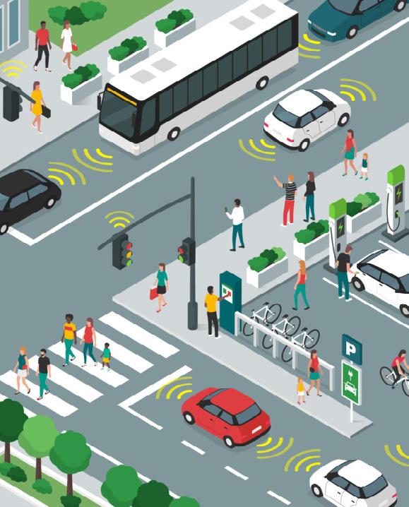
With a rapidly urbanizing world, the need for sustainable urban mobility is increasing. Transportation accounts for about half of the carbon footprint in any city. Anything that we can do to reduce the impact of transportation in our urban spaces will reduce pollution, aid mobility, and make our cities more attractive places to live, work, and play.
Smart city mobility is a concept that has been created to address this. It has been created to make it easier for people to move around the city and help create a more sustainable future. Smart city mobility is a relatively new perspective on urban planning, transportation planning, and city planning. Artificial intelligence (AI) offers intelligent systems and technologies that can help plan and improve mobility in cities.
Since 2016, funding activity to companies working on semi-autonomous and autonomous driving technology has eclipsed all other segments of auto tech combined. Note that this includes investments in enabling technologies such as sensors, vision, 3D mapping, etc.


Connected and automated vehicle (CAV) technologies have the potential to transform the transportation industry. Using technologies such as on-vehicle sensors, smart infrastructure, and advanced wireless communications, CAVs can significantly improve safety, reduce congestion, provide greater mobility and equity, and create a more efficient transportation network.

Minnesota is preparing for connected and automated vehicles by observing trends and advancements in vehicle automation, connected vehicle technology, and other emerging trends. MnDOT’s Connected and Automated Vehicle Office (CAV-X) is the convening office for the state’s connected and automated vehicle transportation technology engagement, policy, testing and partnerships.
Increased safety. Nearly 94 percent of fatalities are caused by human factors; automation has the ability to save lives.
Greater mobility and equity. CAV may reduce transportation barriers by providing broader access to live, work and play where they choose.

Efficiency. CAVs may reduce traffic congestion and improve traffic flow.
Maximize health and environment. CAV could help us rethink the way we plan our communities to maximize health and sustainable transportation.


