2024 All rights reserved. No part of this book may be reproduced in any form without permission of copyright owner. All figures are by author unless otherwise noted.
1- without anyone’s help, without a share, on your own
2- the structure is both trying to be selfsufficient, and it can be installed and disassembled by itself
Merve
Design Brief
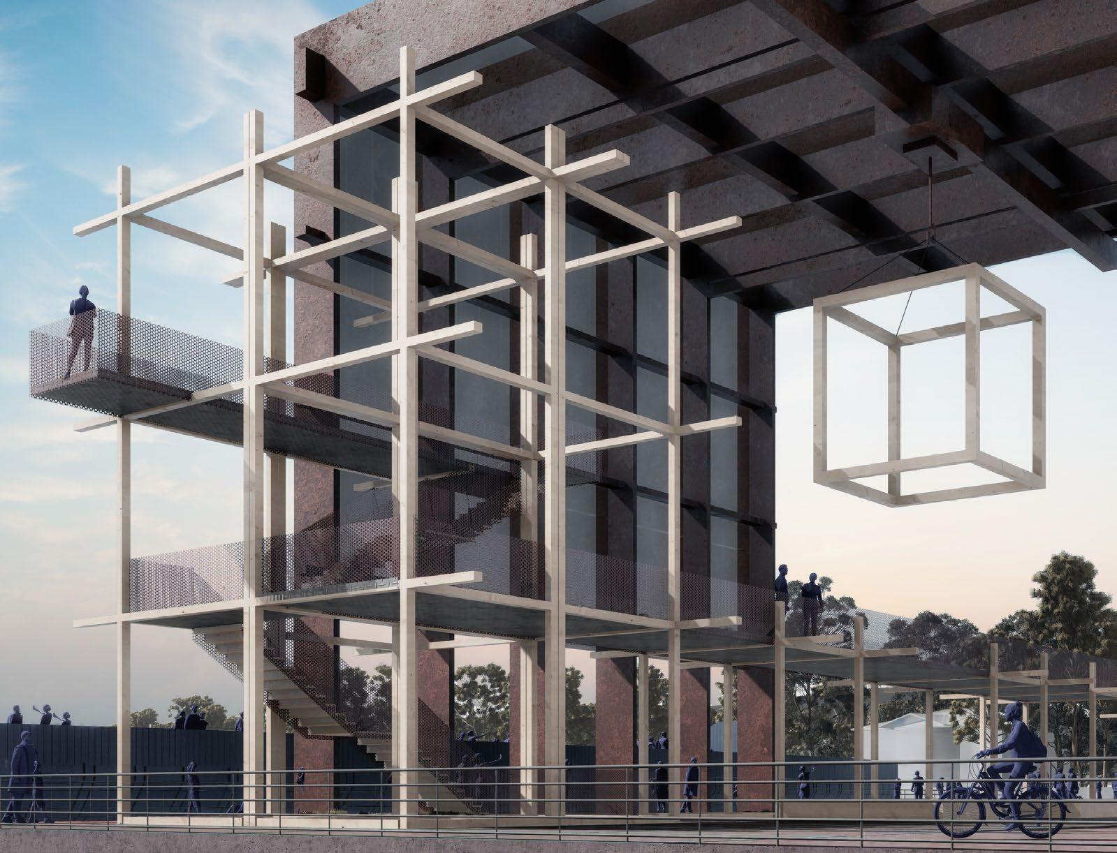
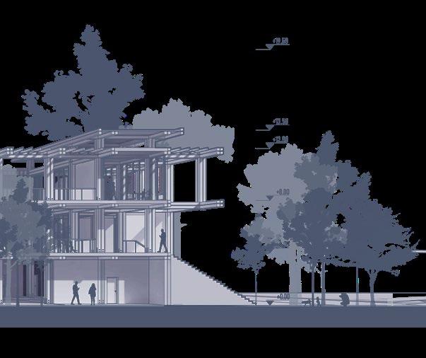
The motto that forms the project proposal and summarizes our view of sustainability is; “The most environmentally friendly and carbon emission-reducing construction method is not to build the building at all”. However, in order to meet the requirements of the given needs program, this point of departure has been considered as “producing a structure with the spatial adaptation in the most flexible way with the minimum dimensions”. We can also describe this approach as “if you have to build, build wisely and with a minimum amount”. In this context, a structure that is quite modular, can grow and shrink very easily, even outdoor/ indoor relationships have been considered with flexibility, and a “self-producing” structure has been proposed. The given needs program has been interpreted according to this understanding, and indoor and outdoor areas have been designed in accordance with the minimum needs.
The idea of the project was inspired by the port cranes at the Alaybey shipyard, while the “Moving shell crane”, which is at the center of the backbone and is the spatial organization generator of the project, was created. This crane is both the element that structurally creates the structure and initiates the construction process; and it is the dominant element of the project that determines the open/ semi-open/ closed space relationships while the structure is being used. In other words, it is the “element that provides self-production”
The proposed structure, unlike a conventional structure layout, is highly permeable and publicly designed. The structure can be entered from many points. It is easy to reach the outdoor and indoor areas of the structure from many points, especially from the park and sea front
self-producing structure
Author’s Image
empty site area
rail system and moving crane installation
preperation
construction
according to the needs, the building units are placed
using the moving system, the areas are functioned in multiple ways seasonally and periodically
the structure can be rearranged or completely removed after completing its service life
de-construction
the moving system that completes its function is also deconstructed and can be used again in different places
Designing a structure with the spatial adaptation in the most flexible way with the minimum dimensions
Merve
Merve
Installation of foundation and movable cranes
Leaving gaps that will create interaction with the park
Construction of the necessary modules with the help of a moving crane
Construction of fixed elements (technical volume)
Integration of the system
1- without anyone’s help, without a share, on your own
2- the structure is both trying to be self-sufficient, and it can be installed and disassembled by itself
“Kendi Kendine”
Merve
bostanlı
bostanlı
mavisehir
Continuous Shoreline
ferry pier
ferry pier
Atatürk memorial
alaybey
shipyard karsiyaka karsiyaka Industrial Area
arena
Continuous Coastal Interaction
It has been observed that the ongoing coastal-urban interaction between Konak and Bayraklı shoreline has decreased or even decayed towards the Turan region. In the proposed route, it is envisaged that the road line passing in front of the project land will be closed to vehicle traffic and expanded, and the continuation of the bicycle route from the Bayraklı coast. In order to increase the coastal - urban interaction, vertical urban extensions that are also incorporated into the project itself it is planned.
Project Area
Bicycle Path Proposal
Existing Bicycle Path
Vertical Urban Extensions
Continuous Shoreline Industrial Area
konak
bayraklı
bornova
ferry pier
bayrakli
Local Material Network
In order to promote sustainability, it is crucial to consider the use of locally sourced natural materials and collaborate with skilled craftsmen in the area. Specifically, it is important to assess the unique properties and range of natural materials available in the Izmir region to minimize environmental impact and bolster the local economy.
First Hand Glass
Glass
First Hand
Tactical Urbanization
Tactical urbanization is a method of incorporating useless or empty spaces into urban life by providing fast, flexible and lowcost solutions in urban transformation processes. This approach aims to transform temporarily or permanently inactive areas in a way that suits the needs and use of communities. Deconstruction of sustainability-oriented units such as permaculture, natural building installations, emergency shelters, community structures and urban gardens are among the tactical urbanization strategies. It has been observed that under viaducts and viaduct nodes constitute the largest urban useless areas in the city and they have formed the first nodal points in the spread of the project to the city.
Coastal Permeability
There are roads that connect directly to the coast along the coastal axis. Marine mobility with dashed lines defined. Bayraklı pier is not currently in use but the ferry route is visible. As a proposal, the barge we recommend using the unused route and the pier.
Contunious Paths
Points that start on the coast
Inactive Ferry Lines Active Ferry Lines Ferry Stops
Render by Omercan Bakan
Author’s Image
Author’s Image
C-C Kesit Ölçek: 1/500 Cross Section
Permeable Floor
Gabion Wall
Ecological Green Corridor
Bioswale Axle
Construction Detail Drawing
Merve Turan_
Merve Turan_
Urban Design Competition
Partners_ Arda Ozdemir, Merve Aktas
Location_Antakya, Turkey
Debi, Urban Square Design
Debi (TR) : “The flow rate is the volume of fluid that passes through any cross-section of the track through which a fluid flows in unit time.”
Design Brief
The Asi River, which serves as a threshold for the city through which it passes, has an important place in the daily life of urban dwellers with its old and new urban texture, which it defines by dividing Antakya into two. The city square has the potential to host the urban dynamics that can be associated with the river, but due to its current urban situation, it cannot reflect this experience to users. The urban design area that is the subject of the project has the potential to be in an approach that provides a “coexistence” for the urban population and increases the use of public space due to the fact that the central region divided into two by the Asi River is the backbone of transportation and communication.
The concept of “debi”, which is the title of the project, emphasizes the importance of pedestrian density, which changes as organically as possible along the river shoreline. Pedestrian, bicycle and tram circulations working together with urban extensions designed as meeting and meeting places are aimed to improve and enrich the daily life of the Asi River and its immediate surroundings, which have been identified as the project area during the day.
As a design approach, re-organizing the flow rate of the entire square has begun to be of great importance for increasing both the perception of the square and what the urban dweller receives from the square.
Stadi-
Gastronomy Points
Cultural Points
Accommodation Points
Existing Traffic Flow
Diagram, Focal Points
Shopping Mall
Archeology Museum
Historical Mosque
During the design process, the urban foci located in the immediate vicinity of the proposed project area and these axes forming the urban intersection have been the guiding factors in making design decisions. The project area has been evaluated as an urban focus that gathers and brings together the function axes that make up the context in which it is located. Thus, it is aimed to increase the reflection of Antakya’s multi-identity urban structure on daily life and to define urban extensions and traces that strengthen the relationship between the Asi river and the city in line with the deciphered focuses and axes.
Diagram, Main Axles
Archeology
Mosque
The project area, which has the Asi River and Cumhuriyet Square at its focal point, has the potential to become a city square with various gastronomic and cultural centers to the east and south, and important centers such as the archaeological museum and the Archaeological
Historical
Ataturk Street
Saray Street
Uzun
Gastron-
Gastron-
GastronSilk
A*Kunefe: a traditional and iconic dessert from
Urban convergence on the river with urban axles is the goal of the design of the piers that extend to it. Urban axes, or axes that appear as urban extensions on the river, start to develop discourse for both sides of the city as a result. Urban squares are created by combining these piers, or urban extensions, with the open green spaces that have been created around them.
Considering that Antakya is a city of courtyards, it has been proposed that the courtyards, which are usually housed in private buildings, can also be reflected in urban spaces and areas to serve the public can be provided. In this context, public semi-courtyard spaces have been designed on
It is aimed to improve the use of public space along the riverside by providing a “coexistence” for the urban dweller with the pedestrian and bicycle route and to create an urban reunion for the city divided into two by the Asi River. Pedestrian walking routes, which are the main form of movement of Antakya Square, have been re-examined together with the bicycle route. The pedestrian circulation associated with the square has been articulated next to the bicycle route, which has a close relationship with the Asi River, and public pedestrian movement has been strengthened. In order to evaluate the potential of the city square, the dominant pedestrian axes throughout the city and the bicycle route, which supports uninterrupted movement, have been
Kunefe* Niche
Town Hall Niche
Garden Niche
Ataturk Tram Stop
Silkman Pier
Fishing Pier
Asi River
Section A-A
Section B-B
Section C-C Section
Ata Bridge
Carriegeway
Carriegeway
Carriegeway Path
Ataurk Park Housing
Cumhuriyet Square
Asi River
Ulu Mosque
Asi River
Asi River
Asi River
Tramline
Tramline
No part of this book may be reproduced in any form without permission of copyright