Let

Improve your farm with DJI Agriculture
AgDrone.au be your trusted partner in innovation and success.

Let
AgDrone.au stands as a pioneering force in the realm of drone solutions, specialising in precision agriculture and serving diverse sectors. Driven by cutting-edge technology and a commitment to excellence, we empower our clients to soar to new heights of success.
Our core competency lies in precision agriculture, where we harness advanced DJI drone technologies to reshape farming practices. From pinpoint spraying and precise seeding to strategic fertilisation and comprehensive crop monitoring, AgDrone.au leads the charge in optimising agricultural efficiency and sustainability with the reliability of DJI equipment.
As pioneers in the drone industry, we redefine industry standards through our aerial imaging and mapping capabilities. High-resolution aerial imagery, powered by DJI technology, empowers sectors like mining and real estate with crucial data for resource management and strategic planning.
We offer a partnership grounded in trust and dependability. Our comprehensive services encompass drone sales, unwavering post-sale support, repairs, and maintenance, ensuring our clients derive maximum value from their investment in DJI equipment.
Safety, compliance, and quality underscore our operations. Our adept drone pilots and technical experts uphold industry-leading standards, ensuring secure and efficient drone operations tailored to our clients’ diverse needs while leveraging the excellence of DJI products.
AgDrone.au takes pride in its environmentally conscious approach. Our drone solutions, utilising DJI technology, promote sustainability by minimising chemical usage and reducing environmental impact, charting a course for a greener future.
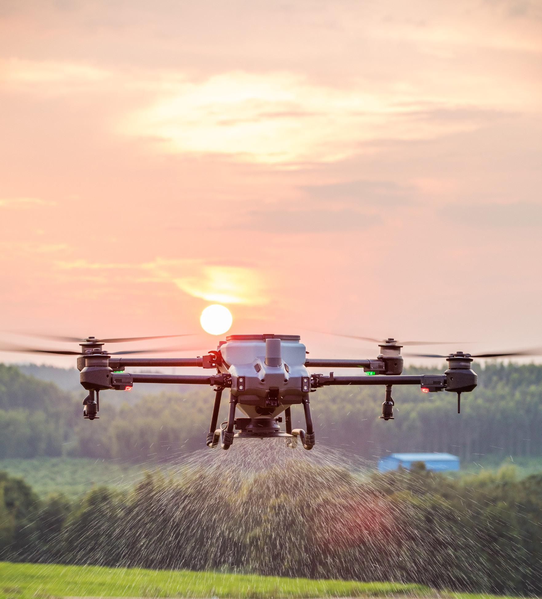
Agricultural drones can play an important part throughout the lifecycle of crop.


DJI Agricultural drones are suitable for multiple application scenarios, such as grassland reseeding, granular fertiliser spreading, and spreading feed for aquatic animals like fish and shrimp. Installation of the spreading system can be completed in under three minutes, proving that Agras drones are always ready for the task at hand.
DJI Agricultural drones spray more accurately and evenly thanks to their automated features and precision spraying systems. Agricultural drones can effortlessly operate over challenging terrain that is typically hard for large machines, such as tractors and fixed-wing aircraft. Moreover, agricultural drones save chemicals and water, which effectively minimises the risk of chemical run-off and ensures the conservation of water resources.
Farmers can use DJI aerial platforms such as the Mavic 3 Multispectral imaging system to gather precise crop data, perform diverse agricultural tasks, monitor the environment, and more.
Manual mapping has become a thing of the past with the Mavic 3 Multispectral, which performs aerial mapping 100 times faster than manual operations. The entire mapping process is displayed on screen, ensuring that planning and editing are done accurately.


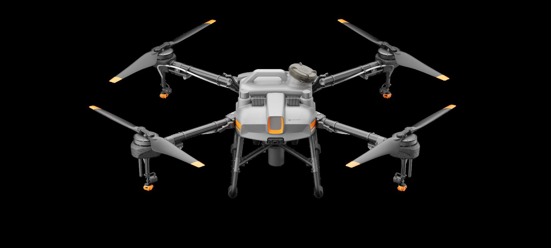
The AGRAS T40 is equipped with the revolutionary Coaxial Twin Rotor design, enabling it to carry a spraying payload of 40kg and a spreading payload of 50kg (70L)1. The aircraft is built in with a Dual Atomised Spraying System, DJI Terra, Active Phased array Radar and Binocular Vision. It supports multiple missions from surveying, mapping, to spraying and spreading, helping you achieve ultimate precision in your agricultural operations.

50kg spreading and 40kg spraying payload 1
Active Phased Array Radar + Binocular Vision
Dual atomised spraying system Supports flight spraying/ spreading and RC mapping

Improved efficiency with coaxial twin rotor design
- 10m swathe width 4
- Highly efficient field operations 5
- Orchard operation efficiency of 4 ha/hour 6
- Efficient spreading operations using the Agras Spreading System 3.0 7
Superior dispense rate of 12L/min
- Magnetic transmission design, prevention of chemical corrosion
- Two atomising centrifugal sprinklers for even spraying
- Proprietary centrifugal valve to prevent leakage
- Real-time monitoring of pesticide levels to estimate when reload is needed
Omnidirectional sensors for greater safety
- Obstacle avoidance with Active Phased Array Radar + Binocular Vision
- 360° Omnidirectional Obstacle Sensing, intelligent terrain following 8
- Radar detection range of 50m 9
- 3D terrain following ensures smooth flight over complex terrain
1. Data was measured at sea level. The payload weight is greatly affected by the ambient temperature and altitude. The payload weight needs to be reduced by 10kg for every 1,000m increase in altitude. The DJI Agras app will recommend the payload weight according to the current status and surroundings of the aircraft. When adding materials, the maximum weight should not exceed the recommended value, otherwise flight safety may be compromised.
2. The core modules include: the avionics module, radio frequency module, breakout board, power distribution board, Electronic Speed Controller, Magnetic Drive Impeller Pump, Dual Atomised Centrifugal Sprinkler, Active Phased Array Omnidirectional/Backward and Downward Radar, Binocular Vision System, UHD FPV camera, and LED supplement light. The IPX6K rating is not permanent and may reduce over time after long term use due to aging and wear.
3. When charging at 9kW, an EFI generator consumes 15% less fuel compared to a carburetor generator.
4. An effective spray width is when the droplet quantity is equal to or greater than 20pcs/cm, as measured with water sensitive paper.
5. Data was subject to the operating environment and parameters. T40 flight parameters for paddy field operations: consumption rate 15L/ ha, spray width 11m, flight speed 7m/s, flight altitude 3m.
6. Data was subject to the operating environment and parameters. T40 flight parameters for citrus operations: consumption rate 75L/ha, spray width 4m, flight speed 3m/s, flight altitude 2m.
Versatile, perfect for mapping or spraying/spreading
- FPV ultra-HD 12MP camera
- Adjustable gimbal angles for real-time data acquisition
- Works with the D-RTK 2 Mobile Station for mapping
- Automatic detection of boundaries and obstacles
Large screen controller for easy mapping
- Coverage of 6.67 hectares in ten minutes 10
- Intelligent flight path planning to minimise wasted journeys
- Large 7 inch high brightness screen
- Octa-core processor for smoother operation
7. Data was measured with urea and subject to the operating environment and parameters. Actual data may vary in operation. T40 flight parameters: consumption rate 149kg/ha, spread width 7m, flight speed 7m/s, flight altitude 3m, spreading disc rotation speed 1,000rpm. The area is free of obstructions and in a regular terrain shape. The fertilisers are prepared in advance and can be loaded quickly. The effective detection range varies depending on the size and material of the obstacle. Obstacle sensing may malfunction or be invalid in areas outside of the effective detection range.
8. The effective detection range varies depending on the size and material of the obstacle. Obstacle sensing may malfunction or be invalid in areas outside of the effective detection range.
9. The effective sensing range varies depending on the material, position, shape, and other properties of the obstacle.
10. The remote controller’s mapping time for paddy fields, which can be affected by the firmware version, survey target, and other relevant factors.
Equipped with an 8L spraying tank, the T10 agriculture drone can cover 15 acres per hour. It can be quickly folded, reducing its size by 70%, to facilitate convenient transfer between job sites. The battery and spraying tank are easy to attach and detach, significantly improving refilling efficiency. The T10 comes with an RTK module as standard for centimetre-level positioning, together with a new ultrabright screen remote controller, making it easy to get started with aerial applications.
8L spray tank High precison operation
IP67 water and dust resistance Dual FPV cameras for monitoring Spherical radar system Smart agriculture cloud platformCompact but powerful
- 10L tank and 5m spraying width
- Four spray nozzles with a flow rate of 2.4L/min
- Covers up to 6.7 hectares of farmland p/hr
- Flexible folding and easy transportation
Safety focus
- Spherical obstacle avoidance system for all-round perception
- Intelligent detour and autonomous terrain adaptation
- Front and rear cameras for real-time monitoring
- High-brightness searchlight for low-light
- Designed for harsh weather operations
Autonomous operation and precise application
- One button take-off, intelligent planning, and automatic edge sweeping
- Transmission up to 5km
- Dual channel, high precision electromagnetic flow meter
- RTK centimetre level, high precision positioning
Designed for long-term service
- IP67 Dust and Water Protection
- Triple protection for core modules
- Strong and reliable truss-type drone body
- Board level protection against water and corrosion
Rapid refilling for efficient spreading
- 10kg spreading tank, 7m spreading width
- Covers 5.6 hectares of farmland per hour
- Real-time weight monitoring for accurate empty tank alarm
- Washable and corrosion resistant
In-cloud farming and digital agriculture
- Create maps in the cloud for visual management of plots
- Field patrol by drones and crop condition monitoring by AI
- Variable amount spraying and spreading operation for higher production and lower costs
- Supervision on agricultural machinery operation and traceability of fertilisers and pesticides
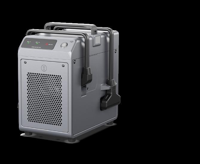
Two batteries and quick-charger facilitate easy reuse
9,500mAh battery for 1000 ultra long cycles Charge on landing with no cooling required 3600W charger for 7 minute ultra fast charging Adaptive power for safer charging

A 70L spreading tank increases the amount of fertiliser spread in a single flight, thus improving the spreading efficiency.
With fully automatic spreading featuring high spreading uniformity, and a large adjustable flow range, drones can provide efficient and uniform spreading of a variety of seed mixes at differing hectare rates.

In fish, shrimp, and crab aquaculture, feed must be spread very frequently, which is time-consuming and laborious. Drones can spread feed precisely and more efficiently and are easy to operate.
Utilising maps generated by the Mavic 3 Multispectral, efficient and precise variable rate spreading can be achieved, saving fertiliser and time while increasing production and revenue.


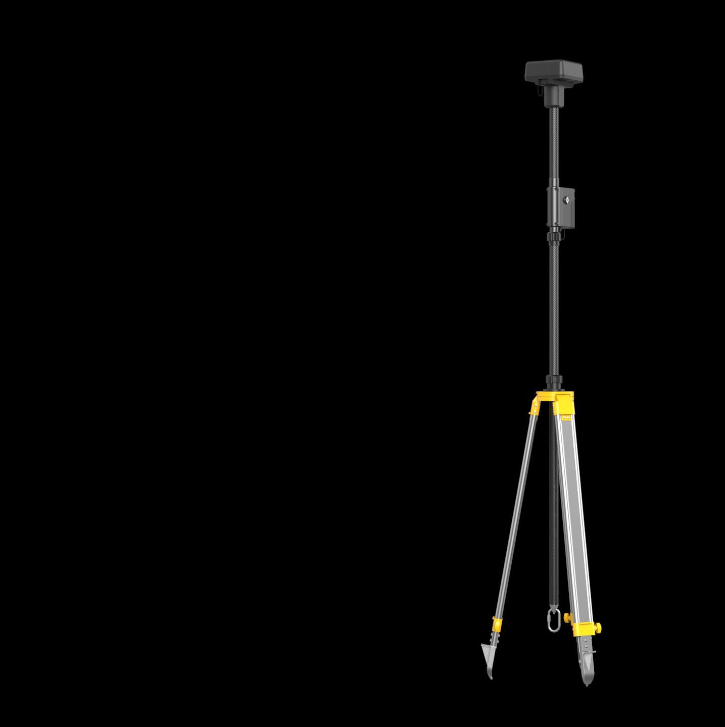
D-RTK 2 Mobile Station is DJI’s upgraded high-precision GNSS receiver that supports all major global satellite navigation systems, providing real-time differential corrections that generate centimetrelevel positioning data for improved relative accuracy.
D-RTK 2 Mobile Station fully supports GPS, GLONASS, Beidou, and GALILEO signals. Easy and quick to set up, the D-RTK 2 Mobile Station provides real-time differential data for drones to achieve centimetre-level positioning accuracy. The built-in high gain antenna offers better signal reception from more satellites even when obstructions are present.
D-RTK 2 Mobile Station supports communication via 4G, OcuSync, WiFi, and LAN, ensuring uninterrupted, stable data transmission under any application scenario. Up to five remote controllers can be connected to the D-RTK 2 Mobile Station simultaneously when used with DJI Agras drones, the Phantom 4 RTK, P4 Multispectral, and the Mavic 3 Enterprise range. When used with the Matrice 300/350 RTK, it can be connected to multiple aircraft, making coordinated operations involving multiple drones a possibility and significantly improving efficiency.
Featuring IP65 level ingress protection and a lightweight carbon fiber body, the D-RTK 2 Mobile Station is ultraportable and up for any task, no matter how tough. The built-in IMUs monitor movements and calibrate the tilt sensors to alert the operator of any abnormalities during the mission, minimising risks.
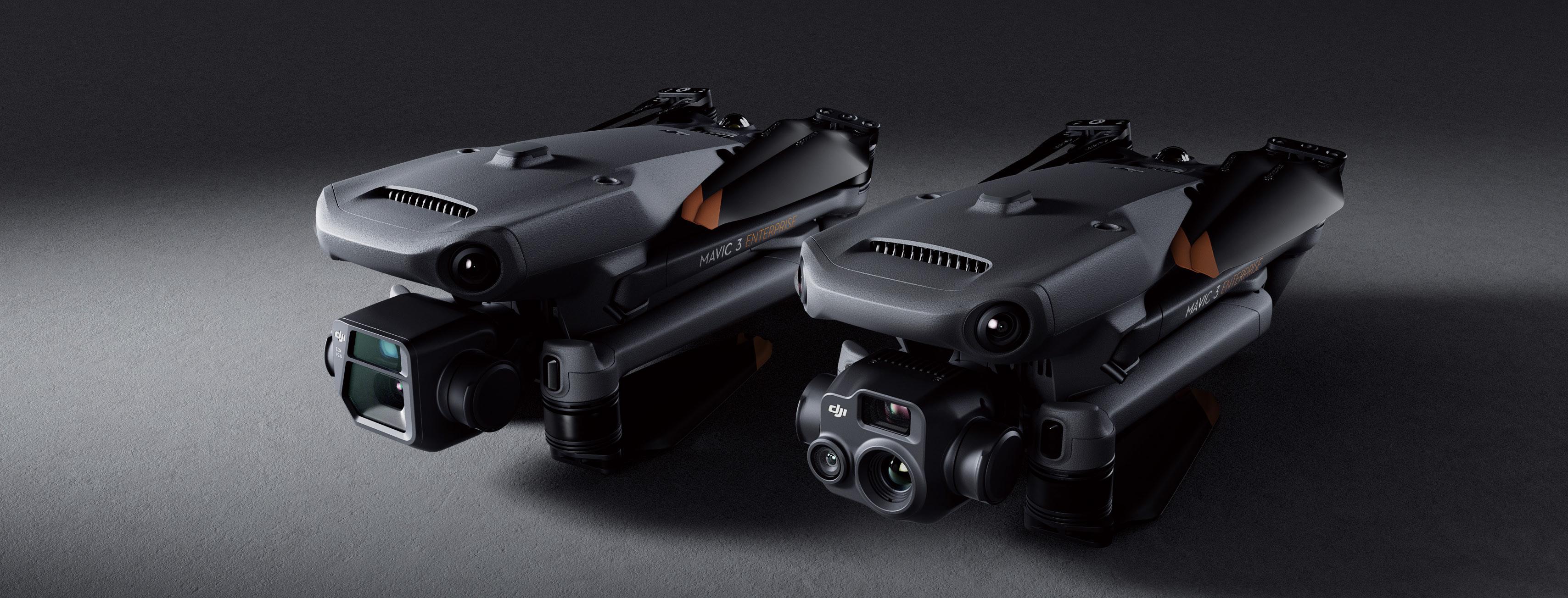
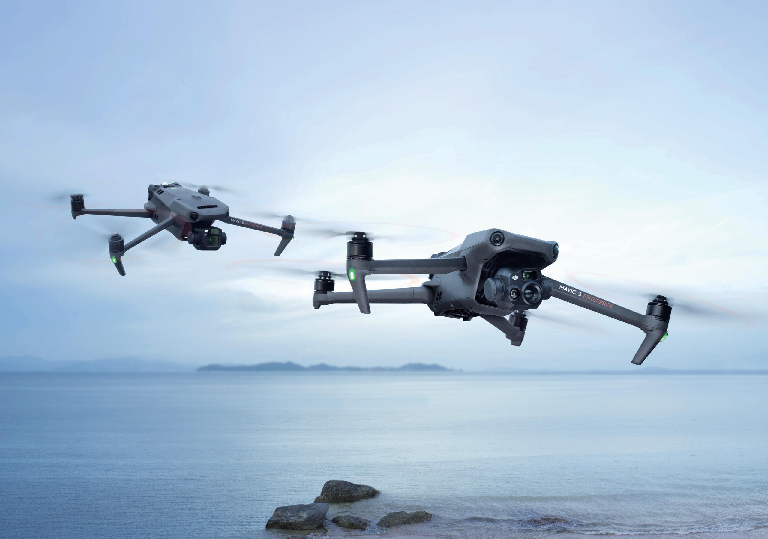
The Mavic 3 Enterprise redefines industry standards for small commercial drones. With a mechanical shutter, a 56x zoom camera, and an RTK module for centimetre-level precision, the Mavic 3E brings mission efficiency to new heights. A thermal version is available for firefighting, search and rescue, inspection, and night operations.
DJI MAVIC 3E
Wide: 4/3 CMOS, 20 MP, Mechanical Shutter
Zoom: Equivalent Focal Length 162mm, 12MP, 56× Hybrid Zoom
DJI MAVIC 3T

Wide: Equivalent Focal Length 24mm, 48MP
Zoom: Equivalent Focal Length 162mm, 12MP, 56× Hybrid Zoom Thermal 1:
DFOV: 61°, Equivalent Focal Length 40mm, Resolution 640 × 512
Enterprise redefines industry standards for small commercial drones. With a mechanical shutter, a 56× zoom camera, module for centimeter-level precision, the Mavic 3E brings mission efficiency to new heights. A thermal version is available search and rescue, inspection, and night operations.
Premium camera performance
- HD wide camera
- Smart low light photo
- Thermal
- Synchronised split-screen zoom
Compact and portable
- Lightweight 915g/920g airframe 2
- Compact body that fits in the palm of your hand
- Perfect for beginners and veteran pilots alike
Ultra-long battery life
- 45 minute max flight time 3
- 100W charging hub for fast charging batteries
- 88W drone direct charging
Flagship flight safety
- Wide-angle lenses for omnidirectinoal obstacle sensing with zero blind spots 4
- Advanced RTH
- APAS 5.0 for automatic rerouting around obstacles 5
Abundant accessories
- DJI RC Pro Enterprise 6
- RTK Module 7
- Loudspeaker 7
- D-RTK 2 Mobile Station 7
Full software suite
- DJI Pilot 2
- DJI FlightHub 2
- DJI Terra
- DTAT 3.0
1. DO NOT expose the thermal camera lenses to strong sources of energy such as the sun, lava, or a laser beam. Otherwise, the camera sensor may be burned leading to permanent damage.
5. Supported in manual flight mode only. Caution is recommended when flying in hazardous environments.
6. Currently available only with the purchase of DJI Mavic 3 Enterprise Series.
2. DJI Mavic 3E (with propellers) 915 grams; DJI Mavic 3T (with propellers) 920 grams.
3. Measured at 32.4km/h uniform speed at sea level in a windless environment until battery was fully drained to 0%.
4. Omnidirectional sensing capability is limited by environmental conditions like weather and electromagnetic interference. Please fly with caution when working in challenging conditions (e.g. wind speeds over 12m/s).
7. Accessories sold separately.
Effective aerial surveying needs to see the invisible. That’s why Mavic 3 Multispectral has two forms of sight. It combines an RGB camera with a multispectral camera to scan and analyse crop growth

COMPACT AND PROTABEL
Foldablefor easy storage
Highly integrated imaging system
PRECISE
MULTISPECTRAL CAMERA
4 x 5 MP G/R/RE/NIR
SAFE AND STABLE
RGB CAMERA
20 MP 4/3 CMOS, mechanical shutter
EFFICIENT AERIAL SURVEYING
Up to 200 hectares per flight [3]

Lightweight and portable, highly integrated
- Small and foldable for easy storage
- Integrates RGB and multispectral cameras
RGB camera
- 4/3 CMOS, 20 MP
- 1/2000 second mechanical shutter in order with no rolling shutter
- 0.7 second, high speed, burst shooting when shooting with RGB camera only
Multispectral camera
- Four 5MP multispectral cameras
- Green (G) 560 nm ± 16nm
- Red (R) 650 nm ± 16 nm
- Red edge (RE) 730 nm ± 16 nm
- Near-infrared (NIR) 860 nm ± 26 nm
- Light sensor, NDVI is more accurate
Accurate images, capturing every pixel
- RTK centimetre level positioning
- Microsecond level time synchronisation
- Phase-less aerial surveying
1. DO NOT fly in severe weather conditions, such as in strong winds (wind speeds of 12m/s or more), snow, rain, or lightning. DO NOT fly in areas that are 6,000m or higher above sea level. DO NOT fly the aircraft in environments where the temperature is below -10°C (14°F) or above 40°C (104°F). DO NOT take off from moving objects, such as cars and ships. DO NOT fly close to reflective surfaces, such as water or snow. Otherwise, the vision positioning system may not work properly. When the GNSS signal is weak, fly the aircraft in environments with good lighting and visibility. The vision system may not work properly in poor light conditions. Be aware of flight safety when flying near sources of electromagnetic interference. Common sources of electromagnetic interference include highvoltage power lines, high-voltage transmission stations, radar stations, cell phone base stations, broadcast towers, Wi-Fi hotspots, routers, and Bluetooth devices.
2. The 15km transmission distance can only be achieved under the FCC standard when measured in an outdoor environment without interference. The SRRC standard is adopted in mainland China, and the furthest transmission distance is 8km. The above data are the
Extra-long battery life, highly efficient aerial surveying
- 43 minute flight time 4
- Aerial surveying of up to 200 hectares per flight
- 100W Battery Charging Hub, 88W fast charging
Stable image transmission, omnidirectional obstacle sensing
- 15km image transmission, stable signal 2
- Omnidirectional obstacle sensing 1 , terrain-follow aerial surveying 5
Extensive applications
- Aerial surveying of farmland, mountains, and orchards
- Multispectral aerial surveying to guide variable operations
- Smart field patrols to monitor crop status
- Environmental monitoring and natural resource surveying
Open ecosystem
- Cloud API, access to third party platforms
- MSDK, an exclusive app
furthest communication distances for one-way, non-return flights under each standard. Please pay attention to return prompts in the DJI Pilot 2 app during flight.
3. Specific test conditions: In a sunny environment without wind, the orthographic flight aerial photography is obtained with a flight speed of 15m/s, a flight altitude of 217m, a ground sampling distance (GSD) of 5.73cm for visible and 10cm for multispectral, a fore-and-aft overlap rate of 70%, and a side overlap rate of 60%.
4. Data was measured using a DJI Mavic 3M flying at a constant speed of 36kph at sea level in a windless environment until 0% power remained. It is for reference only. Please pay attention to Return to Home prompts on the DJI Pilot 2 app during flight.
5. Terrain-Follow Aerial Surveying supports aerial surveying 80 – 200m from the ground. Low light, water, electrical towers, glass structures, buildings with large, repeated patterns, and other areas with dynamic obstacles may present risks. Please use caution.
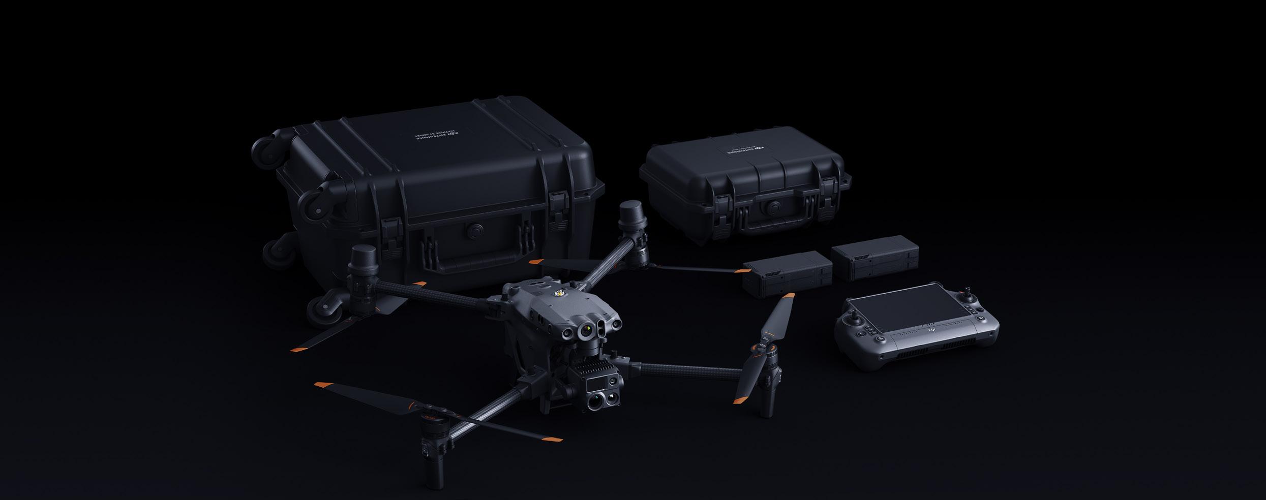
The Matrice 30 Series package includes M30 Series drone (M30 or M30T), DJI RC Plus, TB30 batteries *2, BS30 Intelligent Charging Station, and a hard travel case.
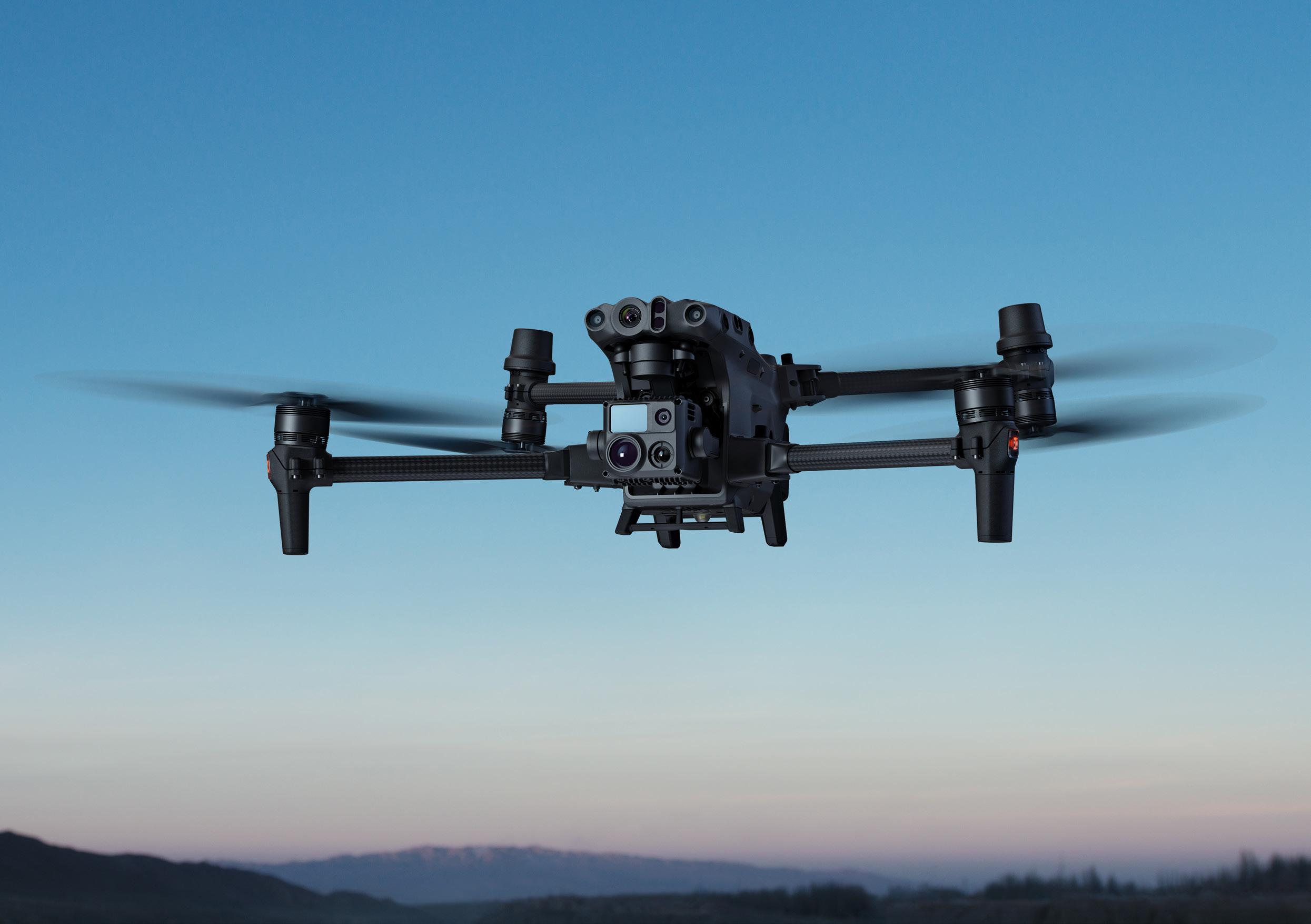
ZOOM CAMERA
48 MP 5x – 16x optical zoom
THERMAL IMAGING CAMERA1
Resolution: 640 x 512 @ 30HZ
Temperature measurment accuracy ±2ºC or ±2% 2
WIDE CAMERA
12 MP 1/2” CMOS sensor
LASER RANGEFINDER
Range: 3m – 1200m, Accuracy: ± (0.2m + D x 0.15%) 3
Package includes M30 Series drone (M30 or M30T), DJI RC Plus, TB30 batteries *2, BS30 Intelligent Charging Station, and a hard travel case.
Powerful flight performance
- 41 minute maximum flight time 4
- 15 m/s wind resistance 5
- 7000m service ceiling 6
- 23m/s maximum speed
Safe and reliable
- IP55 Protection
- -20ºC – 50ºC temp. operating range
- 6 directional sensing and positioning
- Quad-Antenna OcuSync 3 Enterprise + DJI Cellular 7
- AirSense ADS-B receiver 8
Revolutionary flight experience
- DJI RC Plus with IP54 Protection
- Redesign Pilot 2 Flight App
- 6 hour on-screen time 9
- 4 Antenna OcuSync 3 Enterprise 7
Advanced intelligence
- Smart inspection
- Smart low light photo
- Low light FPV camera
DJI FlightHub 2
- 2.5D base map and cloud mapping
- Low latency live streaming
- Live annotations
- Cross-device compatibility
DJI Dock 10
- IP54 Protection
- -35 – 50ºC temp. operating range
- 25 minute fast charge 11
- 7 km 12 operation radius
- DJI Cloud API
1. Infrared camera only included in M30T model.
2. The maximum value is taken for both.
3. Where D indicates the distance from the vertical reflective surface.
4. Measured at 36 km/h uniform speed in a windless environment.
5. Takeoff and landing can withstand wind speeds up to 12 m/s.
6. The service ceiling of 7000m is achievable with high altitude propellers.
7. Quad-antenna design includes two transmitting and four receiving antennas. DJI Cellular module is not available in some regions. Please consult your local dealer for details.
8. Integrated ADS-B receiver gives alerts of nearby aircrafts and helicopters.
9. DJI RC Plus internal battery works in conjunction with its hotswappable external battery.
10. Only the M30 Series (Dock Version) can be used with DJI Dock.
11. 25 minutes to charge the drone from 10 to 90%.
12. Measured in clear environments without transmission or signal interference.
Rugged, reliable and built to operate 24/7, day or night, rain or shine. Each DJI Dock houses a Matrice 30 – where it lands, recharges, takes off and executes missions programmed in DJI FlightHub 2.

Complete Cloud Control
With FlightHub 2, unlock full DJI Dock functionality from the cloud. Schedule missions, create and edit flight routes, and manage data collected.
DJI DOCK FEATURES:
– Integrated and easy to deploy
– Work smarter with automation
– Cloud management at your fingertips
– 7km operation radius 1
– Fast charge for minimal downtime 2
– -30ºC to 50ºC operating temperature
– Support for private deployment
– Open edge computing
Rugged and reliable
- Ingress Protection: IP55
- Operating temperature: -35ºC to 50ºC
- Active temperature control
- Minimum turnaround time: 25 min 2
- Surge Protection System: 40kA 3
- Backup battery: 5 hours 4
- Maintenance interval: 6 months 5
Integrated design
- Wide-angle security camera
- Integrated weather station
- LTE network card slot 6
- Internal omni-directional antenna
- RTK module
- Edge computing expansion slot
Simple setup
- < 100kg Weight
- < 1m2 Footprint
- Quick configuration
- Support for private deployment
Matrice 30 Series dock version
- 15 m/s wind resistance 7
- Ingress Protection: IP55
- Zoom camera
- Thermal imaging camera (M30T only)
- Laser rangefinder
DJI FlighHub 2 unified cloud management
- Mission live streaming
- Route planning
- Mission management
- Media uploading and storage
- Centralised operations and maintenance
1. Measured in environments without transmission or signal interference, and wind speeds <4m/s, where the drone has a flight speed of 15m/s and reserves 20% battery as a safety buffer for landing.

2. Measured at a temperature of 25ºC. As temperature increases, battery cooling time will increase and lengthen downtime.
3. AC surge protection capacity is 40kA (8/20 I u s waveform), and meets EN/IEC 61643-11 TYPE 2 protection levels. RJ45 surge protection capacity is 1.5ka (8/20 I u s waveform). These meet the CATEGORY C protection level of EN/IEC 61643-21. Surge protection capability depends on the capacity and reliability of grounding. To minimise the risk of surges, please make sure that grounding is done properly during installation.
4. Each DJI Dock has a built-in backup battery that can provide power for 5 hours and ensure the drone can safely return and land in the event of an emergency power outage.
5. Depending on environmental conditions and the frequency of DJI Dock operations, it is recommended that maintenance be conducted every 6 months or less.
6. Optional DJI Cellular Module can be installed to provide wireless network access to the DJI Dock. It requires a SIM card from local service provider to work. 4G availability varies in different countries and regions. Please consult your local dealer for details.
7. Takeoff and landing can withstand wind speeds up to 12m/s.
* Tested in a controlled environment. Actual results may vary depending on the environment, usage, and firmware version. For details, please refer to the product page on the official DJI website.
*Tested in a controlled environment. Actual results may vary depending on the environment, usage, and firmware version. For details, please refer to the product page on the official DJI website.


DJI Terra is 3D model reconstruction software that has photogrammetry as its core technology. It supports a range of accurate and efficient 2D and 3D reconstruction of visible light, and data processing through DJI LiDAR. DJI Terra is a perfect solution for mapping and generating 3D flight paths for DJI Agras drones.

Capable of creating centimetre-level accurate high resolution maps, identification of target spray areas and easily avoiding non spray and obstacle, DJI Terra is a key tool for effectively utilising DJI Agriculture drones. Photogrammetry missions with the Mavic 3 Multispectral or Matrice 300 RTK are easily reconstructed, managed and modified, giving you complete control of where and how your drone will fly.


A challenge put before the AgDrone.au team has been the integration of AI detection into the DJI Terra system. Now, utilising our own third party software package, AgDrone.au can offer a range of AI detection services and several modification functions to the DJI Terra system.
An ever evolving AI detection model has been built in to our software, allowing the detection of a variety of weed species. Further, integration of other third party detection files into the Terra system has been made possible. Allowing quick and easy mass-modification of detection areas within Terra, we can quickly change the classification of different objects, whilst also creating accurate buffer zones around these classification areas. Aircraft safety has also been accounted for, through our ability to ‘smooth’ the 3D flight path around obstacles. Finally, a compression function allows you to reduce your orthomosaic map, making it much easier to share or upload.