This portfolio is a collection of my most prominent projects over the past five years, from 2017 to 2022.

The selected projects are a representation of my work in various scales and demonstrate my ability to utilise landscape architecture and architectural design to tackle a wide range of issues on different sites.
The aim of these projects is to not only provide a functional space for the users but also to give them a pleasurable and memorable experience while being sensitive to the area’s aesthetic and sustainability.
CONTENTS
CWMCARN FOREST RENEWAL MLA Year 2 Design Project Landscape Architectural Design Projects Architectural Design Projects Appendix GRAND SASSO FOR ALL MLA Year 1 Design Project PERFORMING ART CENTRE B.Arch Year 4 Design Project WESTERN BANGKOK AIRPORT INTL. B.Arch Thesis HAND SKETCHES From Hand Sketches to Final Design 3 15 27 44 37
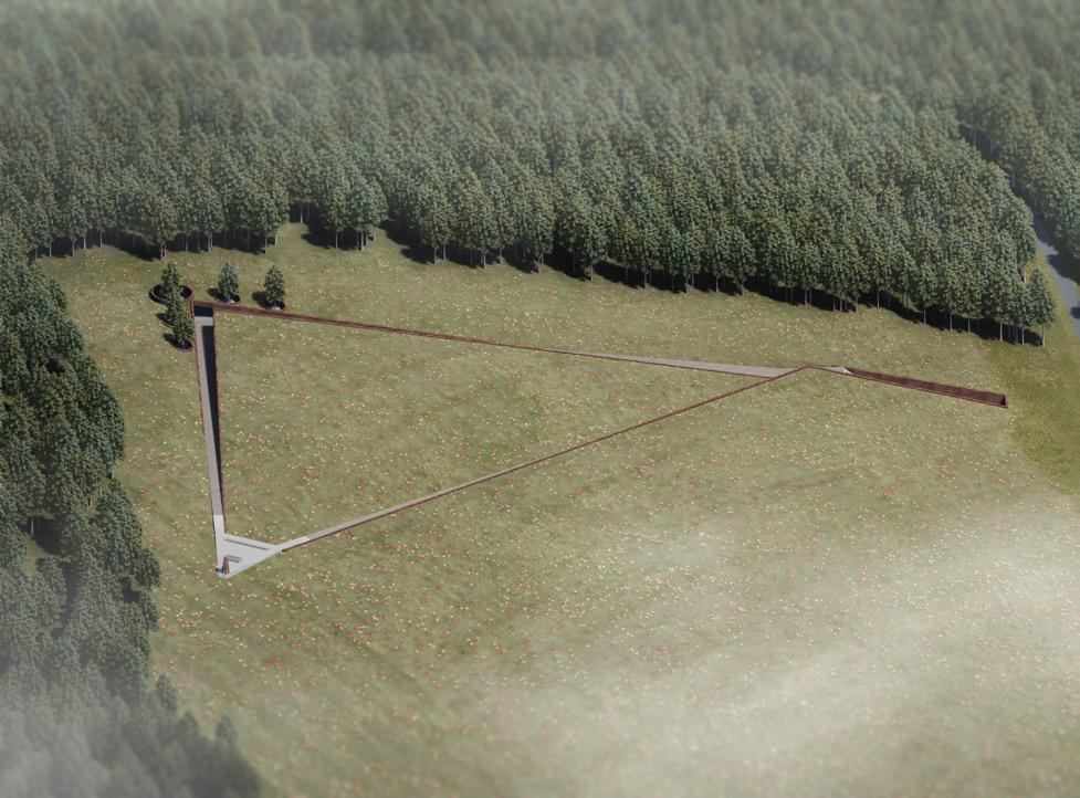
CWMCARN FOREST RENEWAL
2nd Year Landscape Design Project
Project Year 2021-2022
Advisor: Tim Waterman & Emma Colthrust
Cwmcarn forest area in Wales, known as a recreational destination for families and hikers as well as a source for the timber industry in the UK, had suffered the Larch disease caused by microorganism called Phytophthora ramorum which damaged and killed more than 150,000 larch trees in 2013. This is one of many unique examples of the loss of forests that does not relate to global warming and human activities.
As a result of the unpredictable infection, all the larch trees must be felled to stop the spreading of the disease, according to the Welsh nationwide strategy, and the area has to be reforested. It is also a great opportunity to introduce new species which are less susceptible to the disease to increase the biodiversity of the area. This studio design project will focus on the root cause of the massive forest renewal project.
The interventions consist of the prevention of the forest-wide spread of the pathogen by introducing water canals to evacuate the infected run-off water out of the site. Moreover, the planting areas are divided into sectors to support selective logging and further control the disease. Lastly, the pathways are redesigned to enhance the visiting experience as well as the introduction of scientists and logging routes to reduce cross circulation between three disciplines of the site.
CWMCARN FOREST RENEWAL - 3
UNDERSTANDING THE LARCH DISEASE

It’s deadly to Larch trees once infected. Water droplets are the key factor in the transmission since it carries the spores of P. ramorum from a tree to others. This makes the rainy season the most effective season for the spread of the disease. The transmission also involves wind direction, air temperature, humidity, precipitation, terrain slopes, surface runoff, groundcovers, and human and animal activities.

DETECTION METHOD
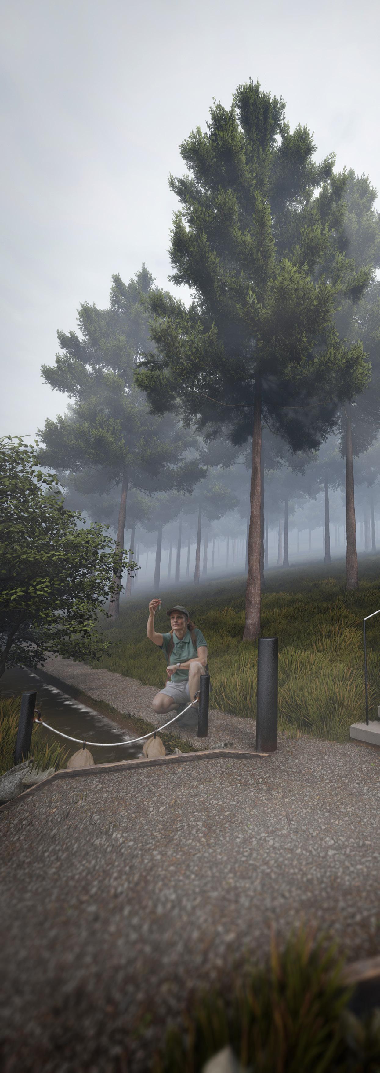
The pear submerged in the adjacent watercourse is the indication of the presence of Phytophthora oomycota in the collected run-off water from the higher area. If the pear shows signs of infection, the pear will be carried to the lab to identify the presence of P. ramorum

4 - CWMCARN FOREST RENEWAL
EXISTING CONDITION
The forest has been wooded for UK’s timber industry since the 1800s. In 2013, The larch disease is identified on the site via periodical aerial imagery. The felling project has begun in 2015.
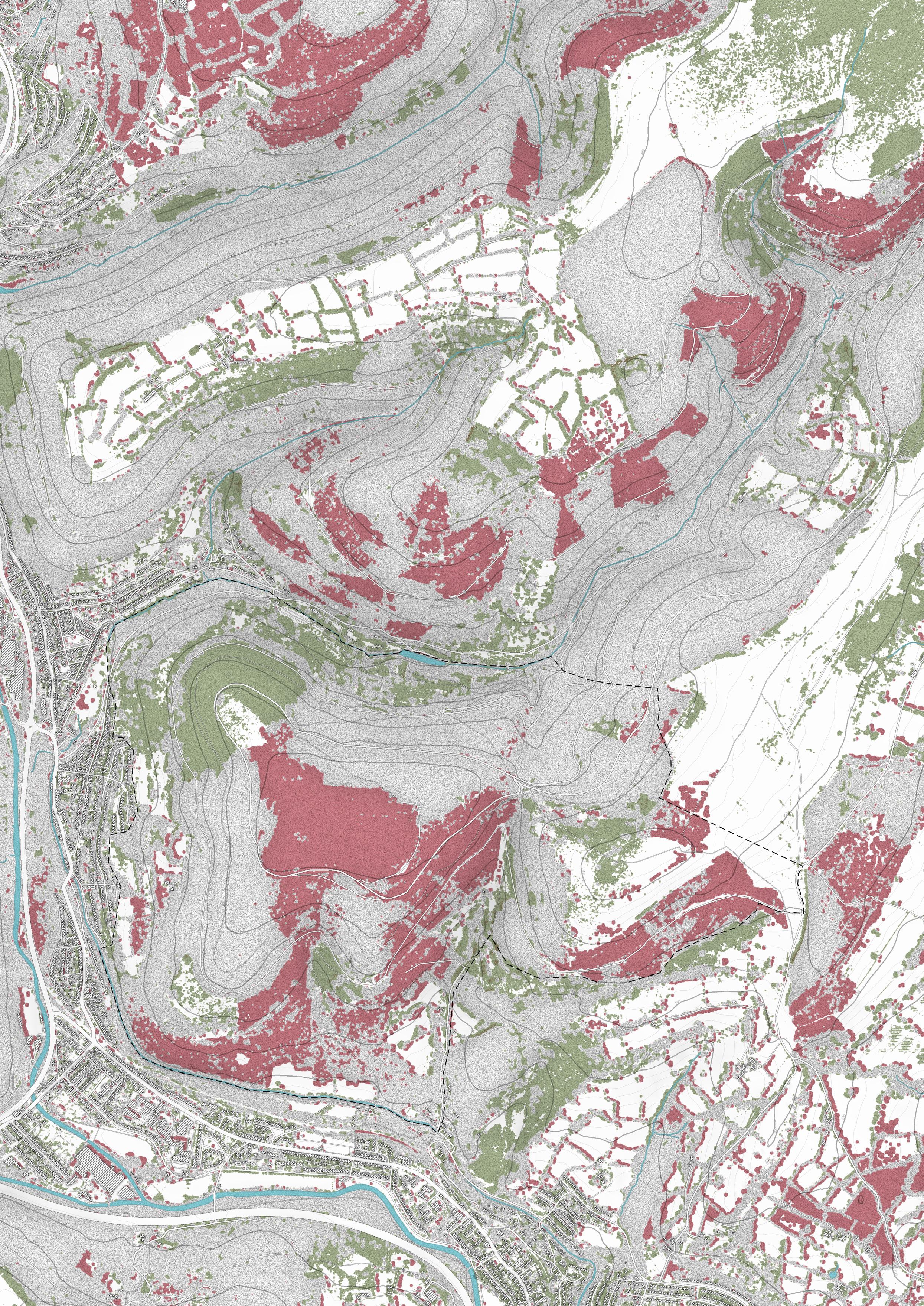
The loss of forest area is the result of the forestry industry and the felling project caused by the disease. The gain in forest area comes from the planned forestation for the UK’s timber industry and the forest renewal project began in 2017.

CWMCARN FOREST RENEWAL - 5
APPROACH OF INTERVENTION
The intervention can be done by lowering the larch density and introducing non-host trees. The other approach is to divide the planting area into sectors with a space between each plot. The water canal is introduced to collect the infected runoff water to control the possible spreading. The two approaches are combined to increase controlling efficiency.

The planting design aims to reduce the coverage of Larch trees and introduce broadleaves such as English Oak and European Beech to the site. These tree species can be used as a source of hardwood for the UK’s timber industry and they are immune to the Larch Disease.

TREE SPECIES PLANTING AREAS 6 - CWMCARN FOREST RENEWAL
PROPOSED EXPLODED DIAGRAM

The proposed layout of Cwmcarn Forest consists of three circulation layers and two canal types.
The top layer of the exploded diagram shows the suggested and casual route for the visitor to experience the forest.
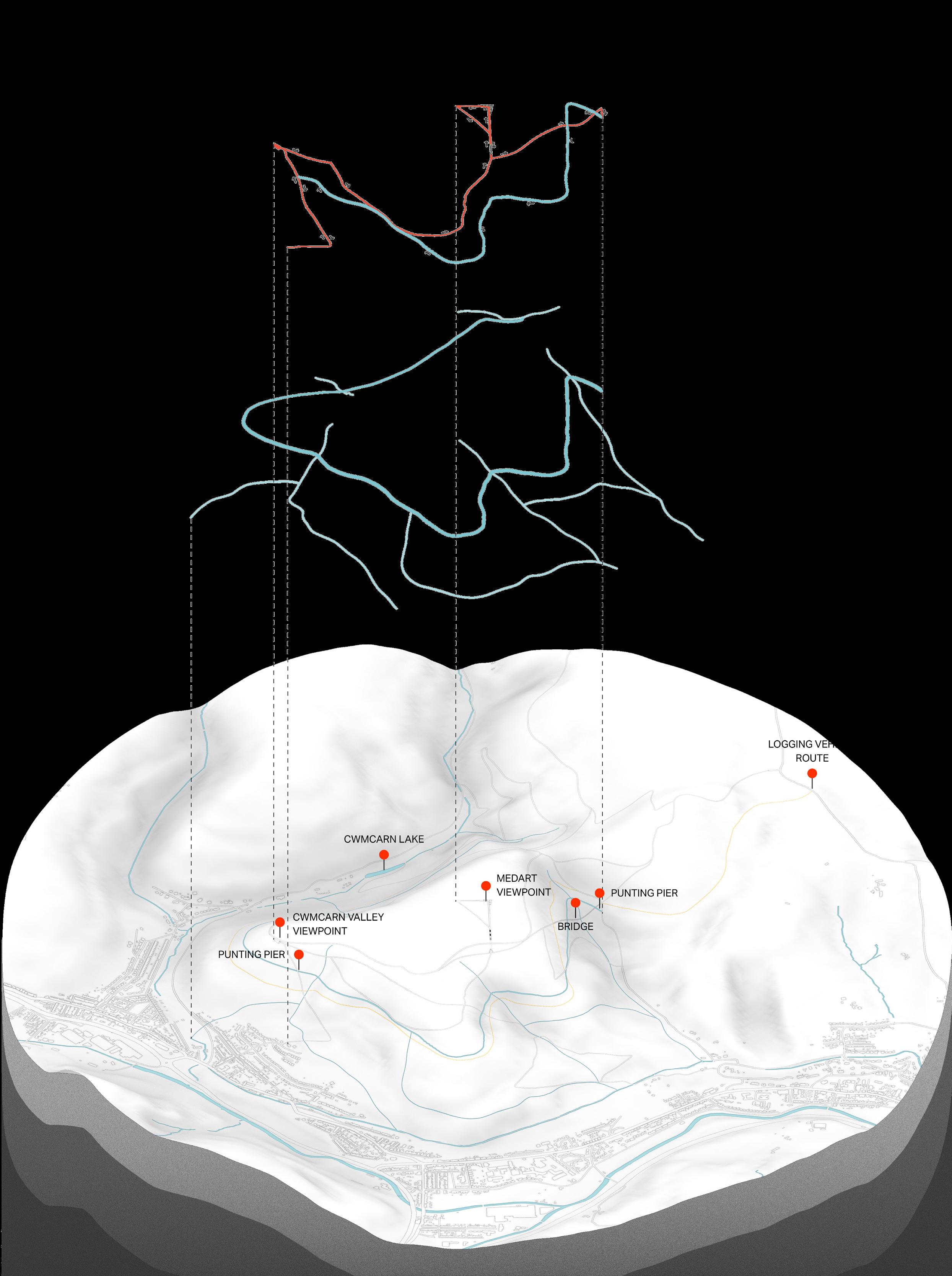
The middle layer shows the canal system introduced to counter the surface run-off infection between tree planting plots.
The base terrain shows the location of point-of-interest of the site as well as the “Logging route” highlighted in yellow.
CWMCARN FOREST RENEWAL - 7
PROPOSED SITE PLAN
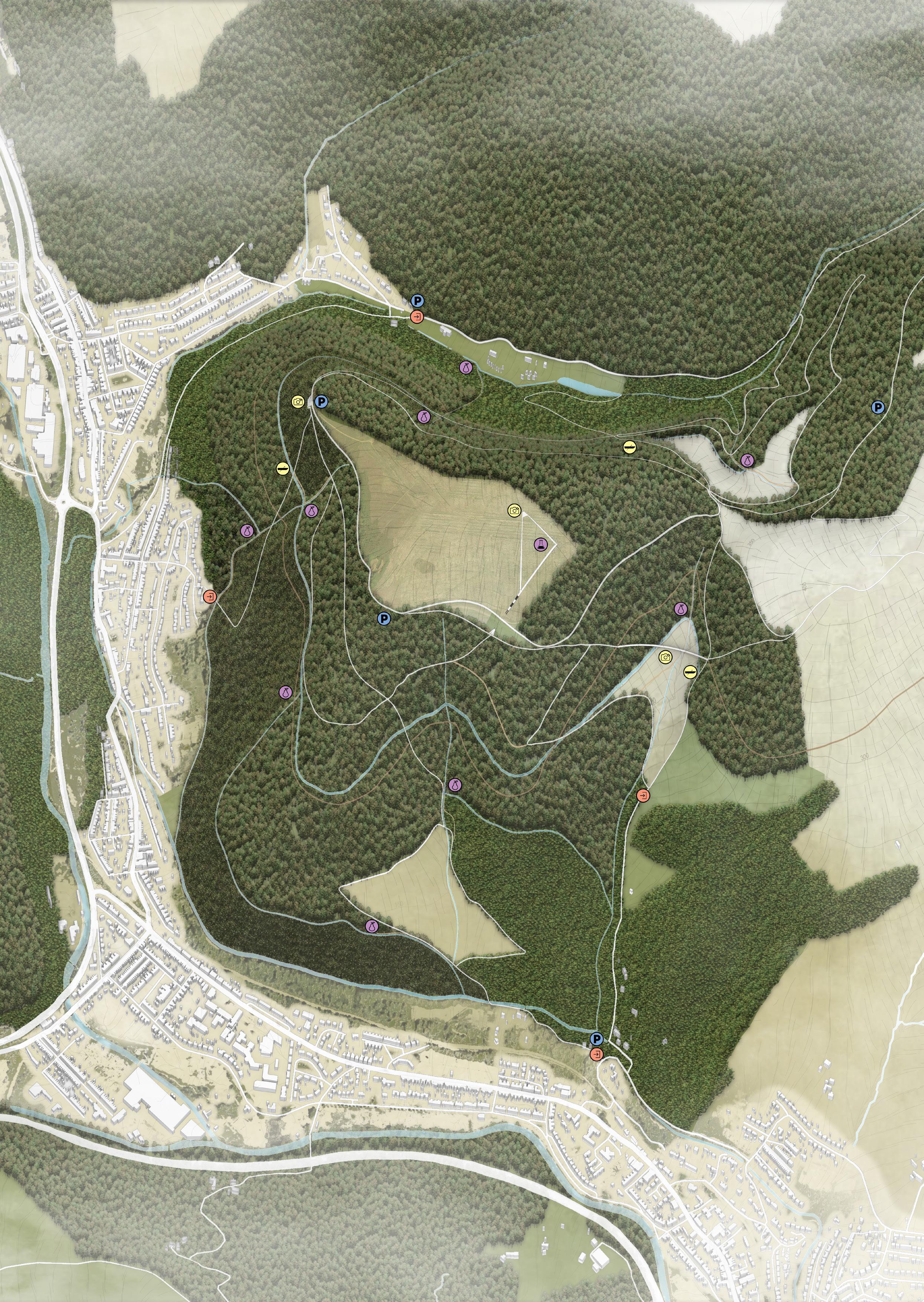
The site plan includes the development of pathways to be more stable to serve more users. Some difficult paths are created for a more challenging experience. The hidden routes for scientific research and logging are also created to reduce crosscirculation between different routines.
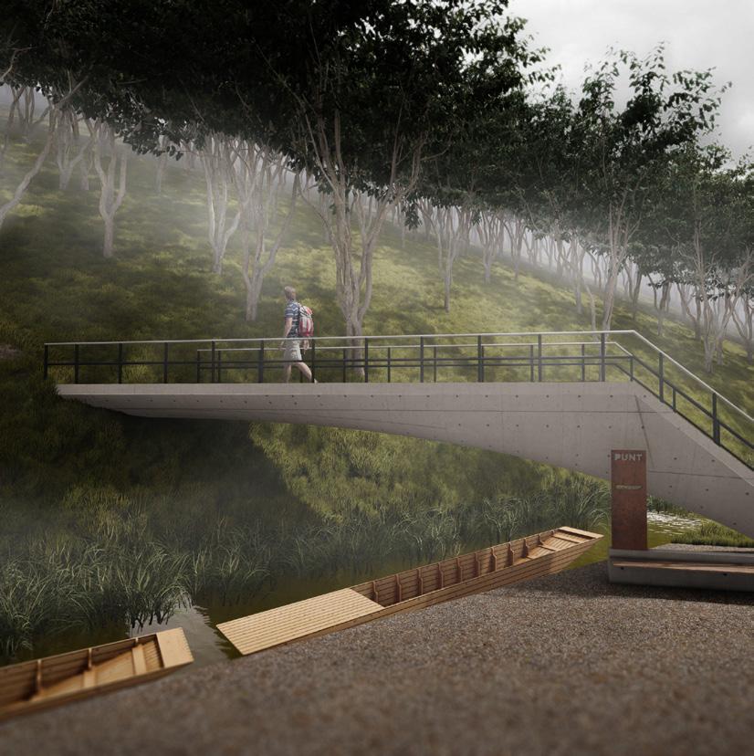
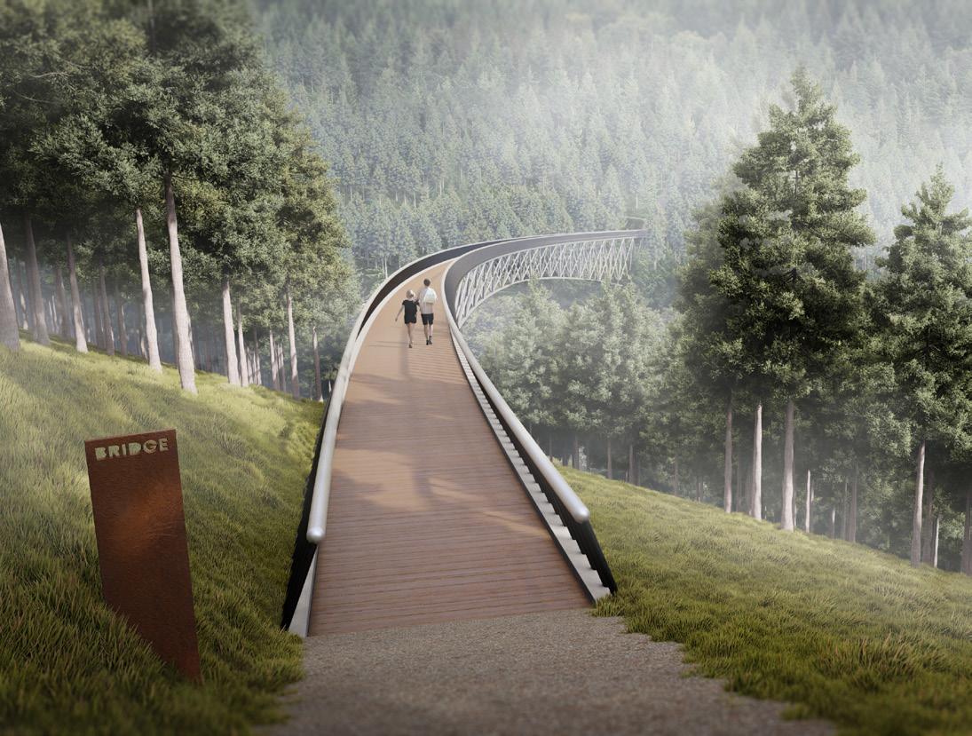
3 proposed entrances provide access to the visitors from the local bus stops. The new pathogen learning centre and laboratory is located on the summit as a destination for visitors. The proposed bridge gives users a new stunning experience and adds more dynamics to the forest area.

8 - CWMCARN FOREST RENEWAL
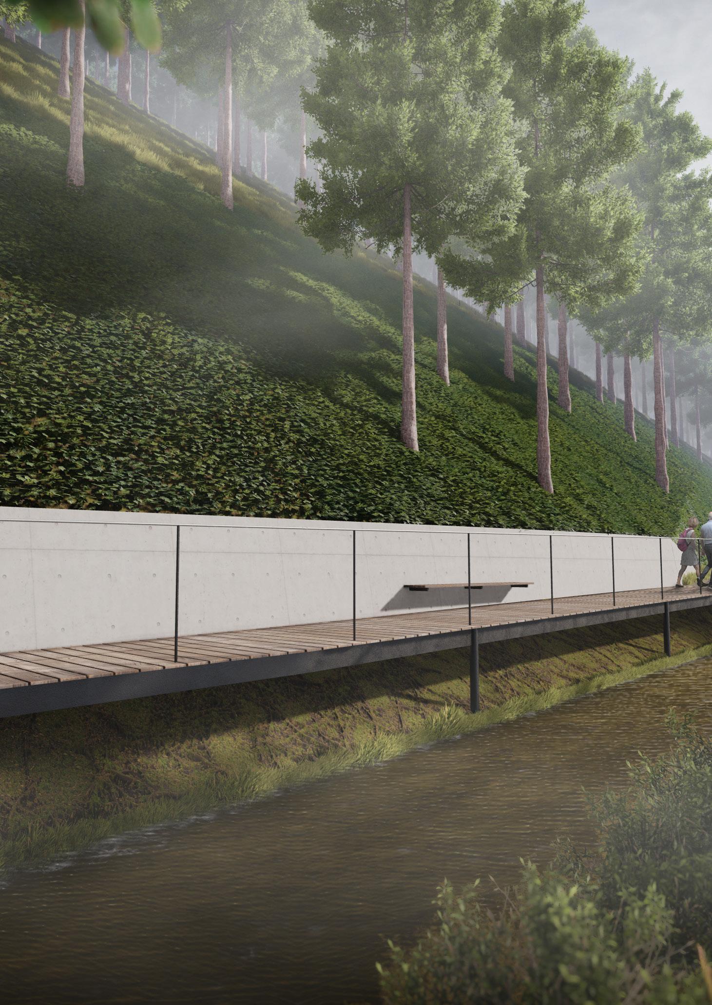
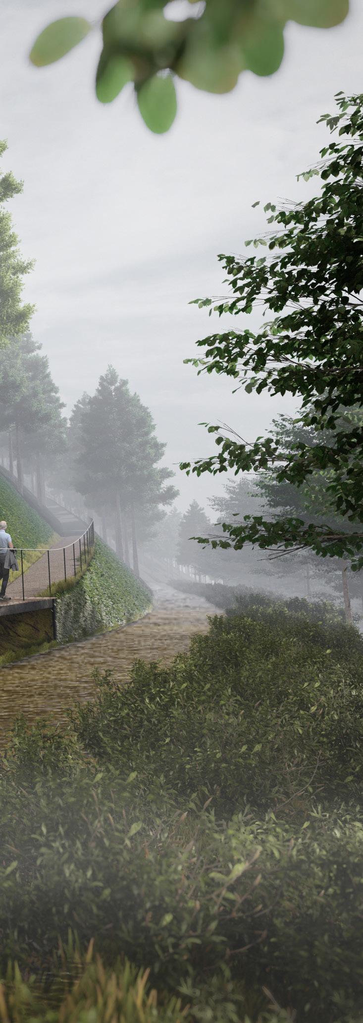
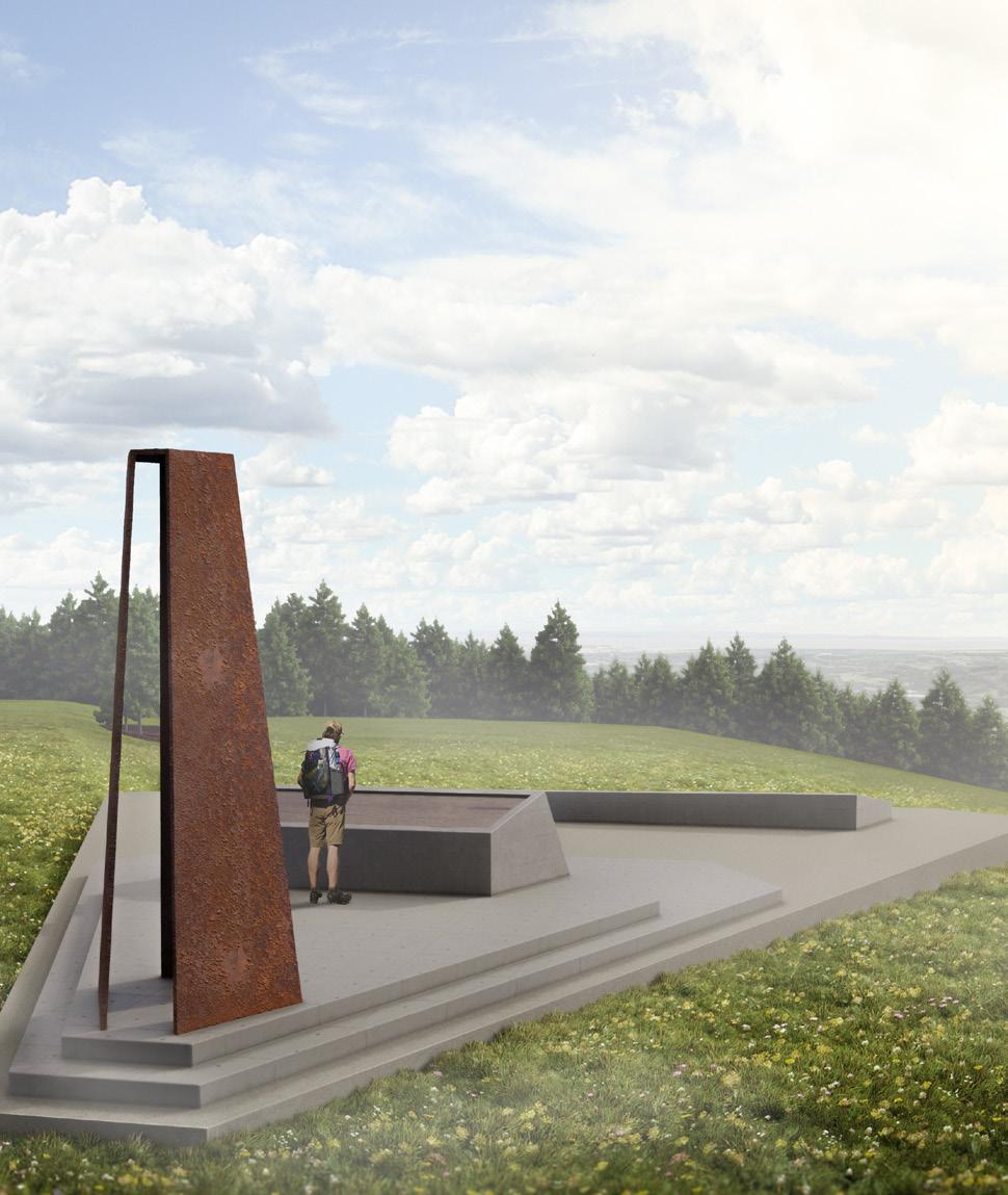
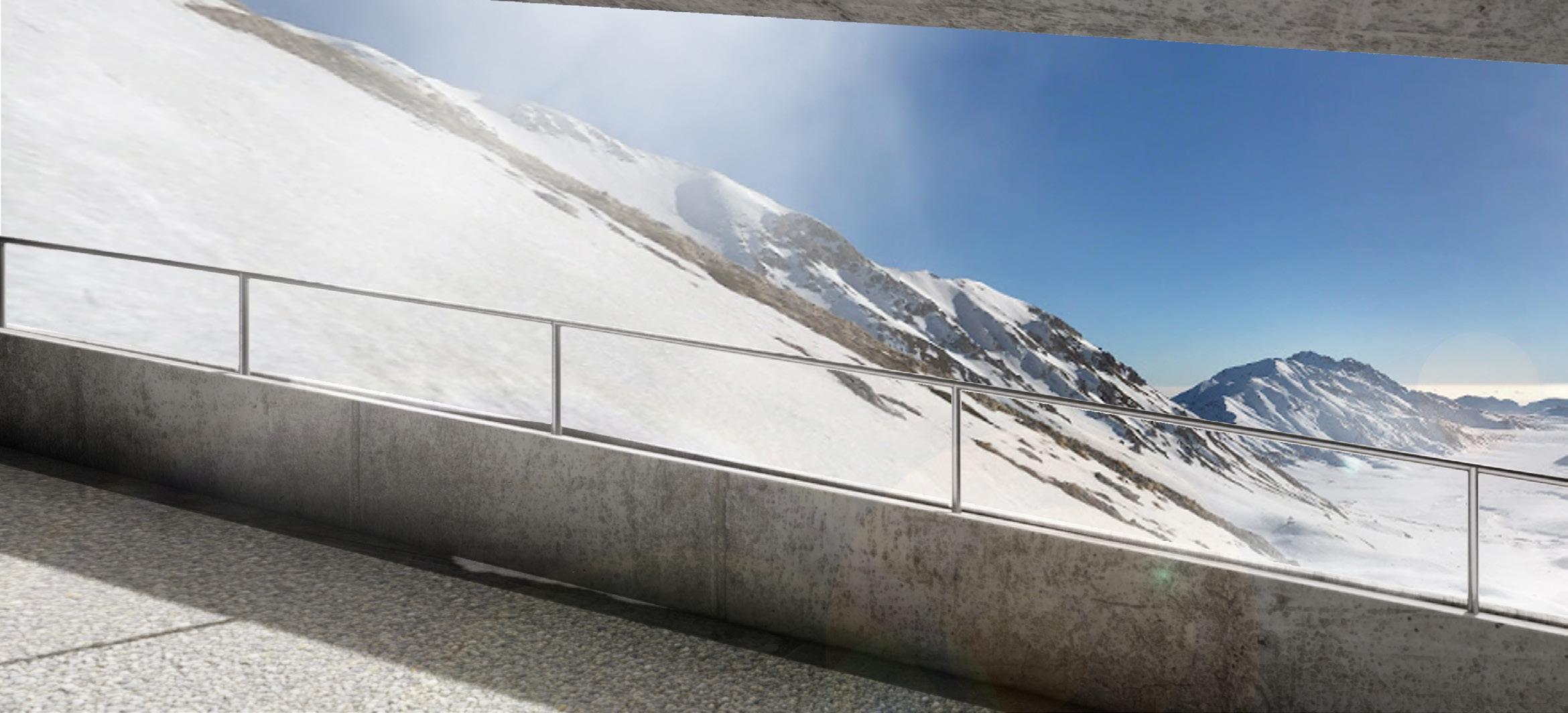
ELEVATED RAILINGS
The railings are made of brushed stainless steel for durability. These railings reflect the sky which creates an illusion of glowing lines to lead visitors in the desired direction. The black poles supporting the rail create an illusion of levitating handrails.
THE LANGUAGE OF WAYSHOWING
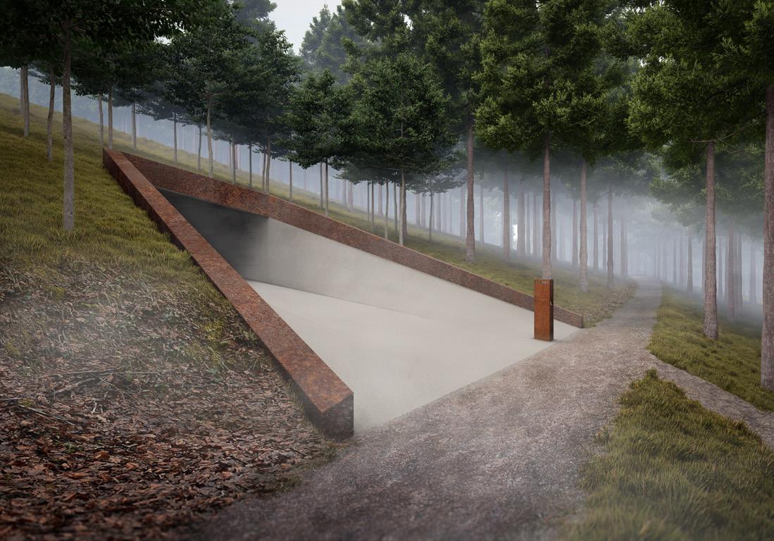
To guide the visitors to the destinations in Cwmcarn Forest, the visual languages are designed. The signs are made of plates of Corten steel cut out the texts and symbols with a CNC machine.


Concrete is used to highlight man-made interventions which contrast the surrounding forest environment, this helps visitors spot them easily. The railings are made of brushed stainless steel placed on the black poles to create the levitating effect and draw the line of sight to a certain destination.
CONCRETE SLAB


The stairs are located on the steeper areas of the pathways. They are made of concrete slabs, partly buried into the terrain to emphasise the contrast of man-made elements in the forest.
SIGNS
The sign is the most universal and basic way of providing direction to the visitors. The signs in Cwmcarn Forest are made of a plate of Corten steel. The texts and symbols of the destination are made of the negative space on these steel plates.
BENCH
The benches use wooden planks for more comfort when sitting. The cantilever design from the concrete half wall is in line with other interventions. They are placed over the forest to allow visitors to rest during their walk.
FONT SYMBOLS
CWMCARN FOREST RENEWAL - 9


10 - CWMCARN FOREST RENEWAL
VISITING EXPERIENCE
The series of pathways and roads laid throughout the forest are connected, this allows the visitors to always choose the alternate paths to the summit.
The long-span bridge linking two mountains together uses a lightweight design to reduce the overall aesthetic impact on the nature area. It also overlooks the Bristol Channel.
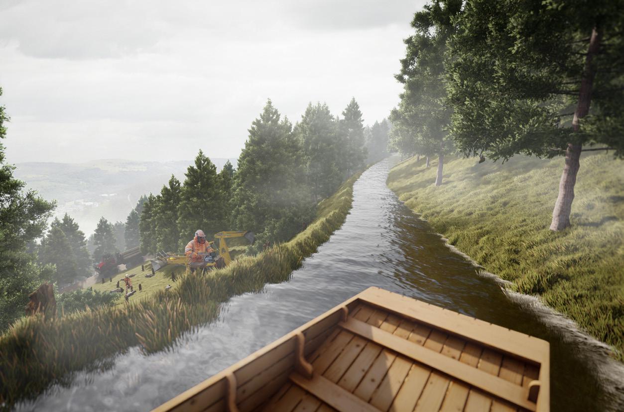
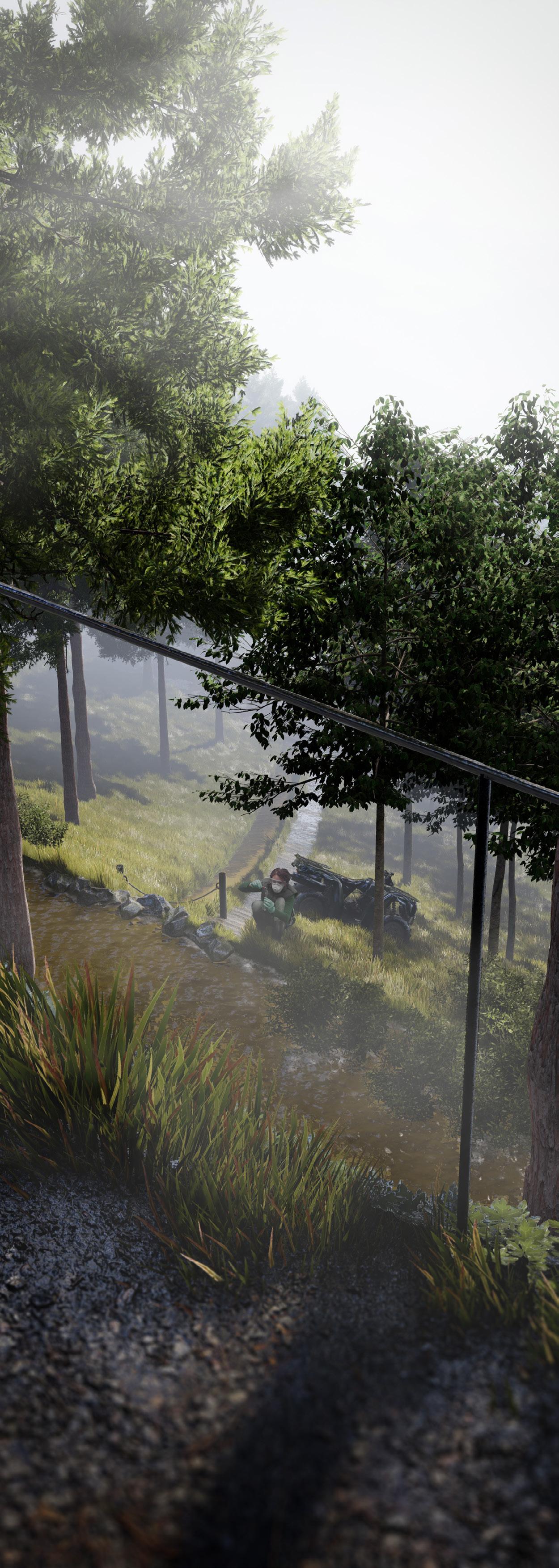
During the walk, some pathways merge with the main canal where hikers might see the process of sample collection as well as the logging practice. This is designed specifically for the educational aspect of the visit.
CWMCARN FOREST RENEWAL - 11
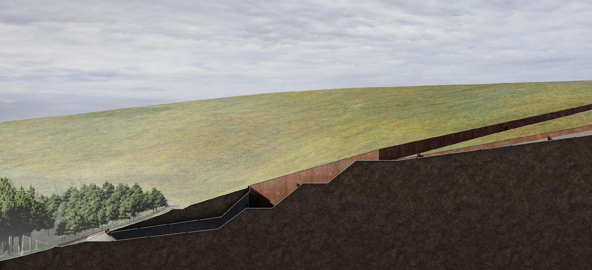
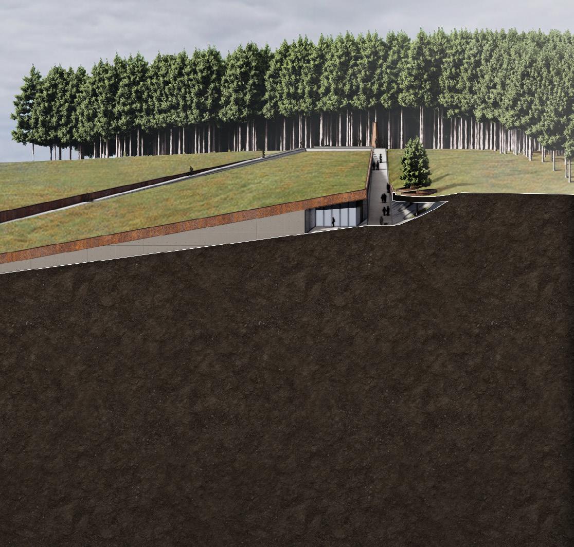
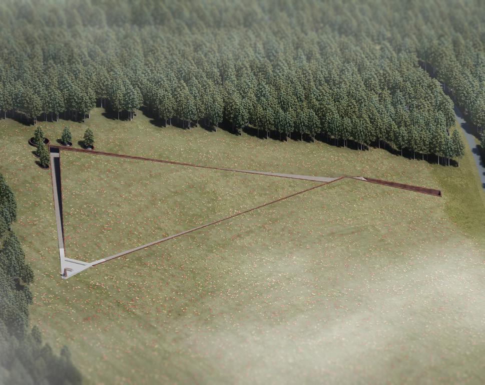
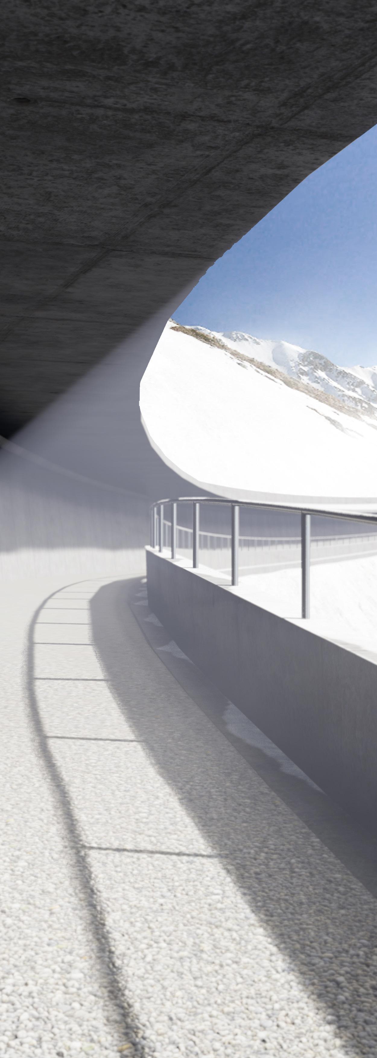
SUBTERRANEAN SECRET LABORATORY
The secret laboratory and learning centre are buried under the summit creating the unobstructed panorama. The area can be accessed only by the tunnel connected to the pathway network to eliminate the cross-circulation between pedestrians and vehicles (see the section below).
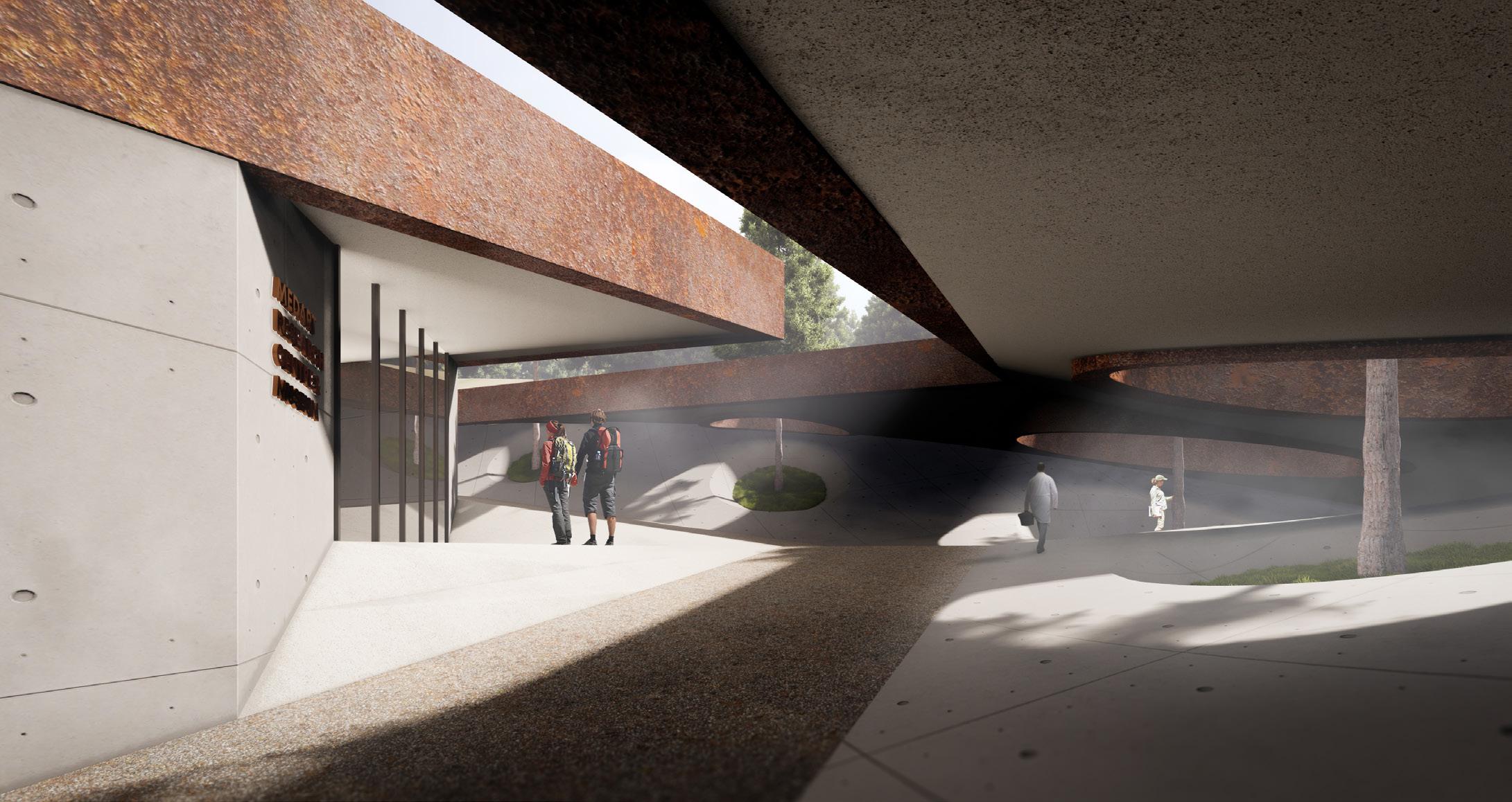
The laboratory is used for analysing the collected samples for P. ramorum. Sample Larches are planted here for the visitors to closely inspect the appearance of the tree.
12 - CWMCARN FOREST RENEWAL
CWMCARN FOREST RENEWAL - 13
GRAN SASSO FOR ALL
1st Year Landscape Design Project
Project Year 2020-2021
Advisor: Elise Hunchuck & Nico Alexandroff
The Gran Sasso, a part of the Apennines mountain, situated in the northern part of Abruzzo is the home of beautiful scenery and biodiversity. The northern area itself contains both oceanic and continental climates which define various types of plants and inhabitants.
The unpaved walking trails on the Gran Sasso mountain help people get around the mountainous area, as means of leisure. Walking through different elevations enables people to experience different stunning views. In addition to the trails, the existing ropeway and a roadway to Campo Imperatore hotel help non-adventurous people to get from the foothill to the higher elevation with ease.
This design proposal responds to the need for accessibility and introduces the beautiful scenery of Gran Sasso to both local and international visitors. Developing the existing steep pathway that is vulnerable to landslides to allow almost every tourist, including disabled people, to experience hiking is the ultimate goal of the project. The path should address the difficulties and dangers of the area, especially injuries from slips and falls while maintaining the looks and feels of natural surfaces.
At the altitude of the proposed area, there is no tall tree but only grass and flowers that intersperse with each other. Nonetheless, these small plants are vital to the area in terms of biodiversity and they also help retain snow from sliding down the hill in the winter. Due to the increasing temperature yearly caused by global warming, these plants are prone to extinction. This is where the amplification in the growth of these plants is introduced to conserve the nearly extinct species and to maintain the same natural surface.
GRAN SASSO FOR ALL - 15
ROUTES TO THE RIDGE

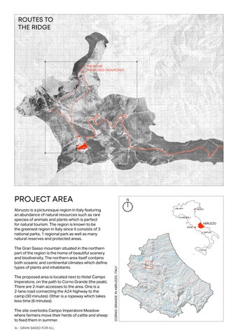
PROJECT AREA
Abruzzo is a picturesque region in Italy featuring an abundance of natural resources such as rare species of animals and plants which is perfect for natural tourism. The region is known to be the greenest region in Italy since it consists of 3 national parks, 1 regional park as well as many natural reserves and protected areas.
The Gran Sasso mountain situated in the northern part of the region is the home of beautiful scenery and biodiversity. The northern area itself contains both oceanic and continental climates which define types of plants and inhabitants.

The proposed area is located next to Hotel Campo Imperatore, on the path to Corno Grande (the peak). There are 2 main accesses to the area. One is a 2-lane road connecting the A24 highway to the camp (30 minutes). Other is a ropeway which takes less time (6 minutes).

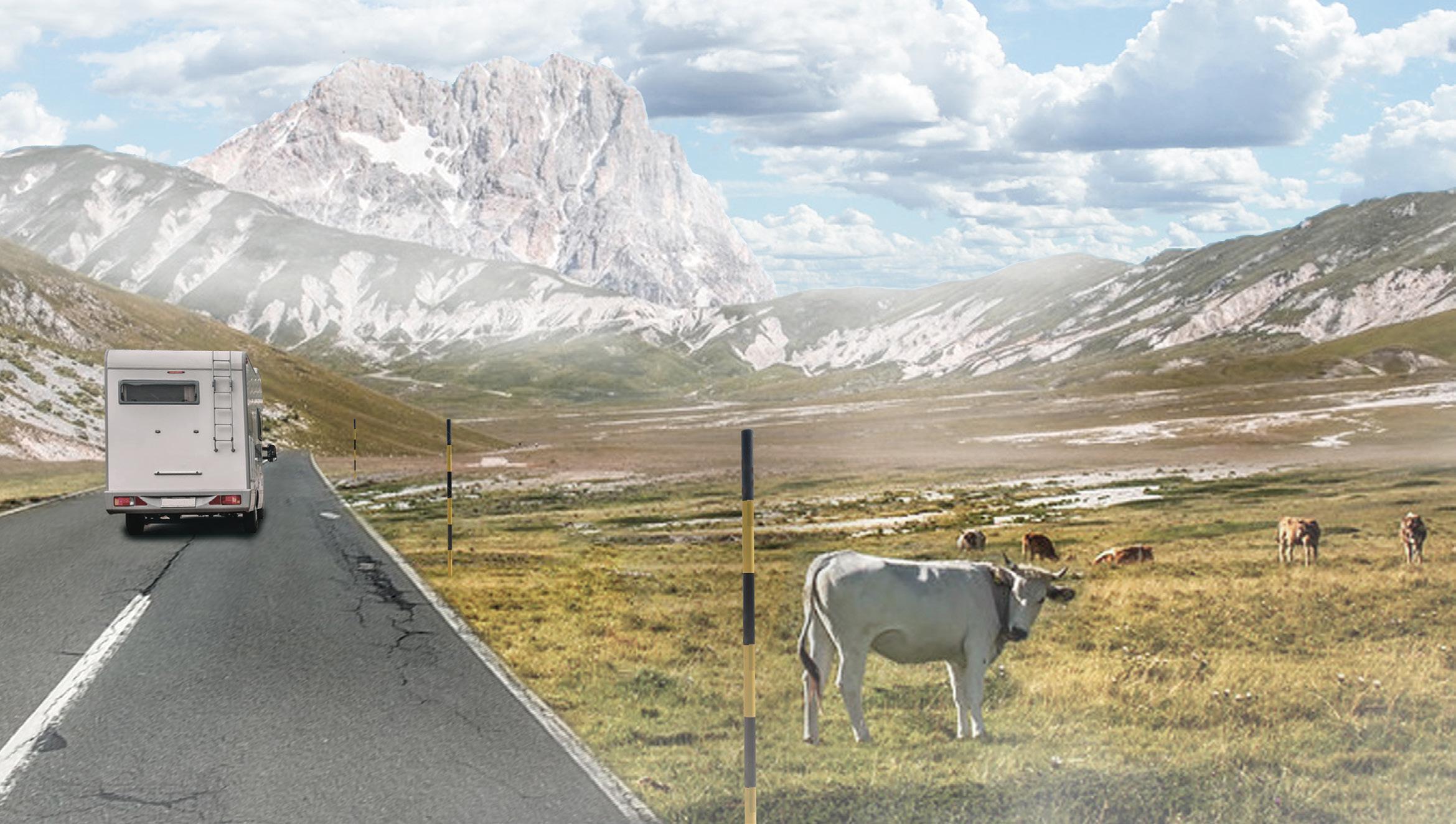
The site overlooks Campo Imperatore Meadow where farmers move their herds of cattle and sheep to feed them in summer.
 THE RIDGE (PROPOSED VIEWPOINT)
CORNO
16 - GRAN SASSO FOR ALL
GRANDE IN ABRUZZO, ITALY
EXISTING CONDITION
The proposed area is located next to Hotel Campo Imperatore, on the path to Corno Grande (the peak).
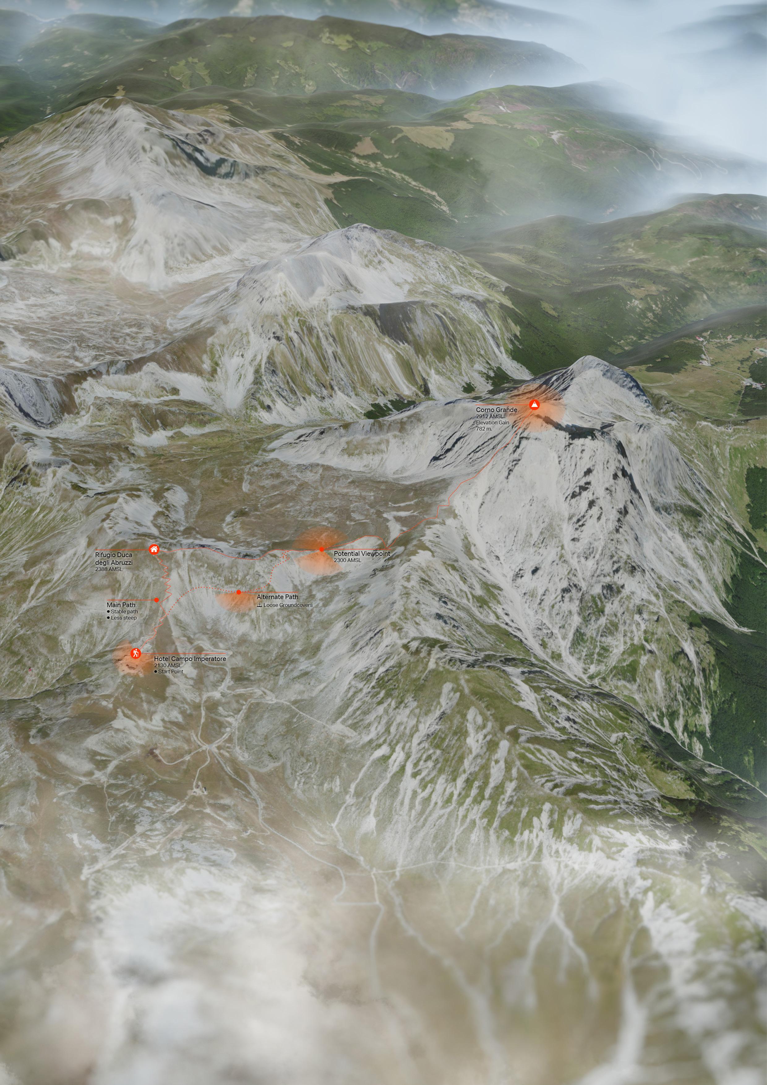
There are 2 main accesses to the area. One is a 2-lane road connecting the A24 highway to the camp (30 minutes). Another is a ropeway which takes less time (6 minutes)
The site overlooks Campo Imperatore Meadow where farmers move their herd of cattle and sheep in to feed them in summer.
SASSO FOR ALL - 17
GRAN
UNREACHABLE PICTURESQUE
The view from the Corno Grande is stunning; however, getting all people up there is not an easy task. This project questions why these stunning sceneries are limited to only people who are fit enough to climb up the high and dangerous mountain. How can these mountain sceneries be accessible by anyone who can move?
The site selection begins by selecting an area that has a comparable view to the peak. The current condition of the pathway on the mountain is uneven with loose gravel and rocks as paving material.
On the very slope surface (70-130%), the ground is covered by just gravel which cannot adhere to the surface of a thick snow slab in winter. Therefore, an avalanche can occur easily from the seismic force since this area situates on the edges of two tectonic plates (Africa and Eurasian).
To address these difficulties, a stable path with accessible slope and avalanche protection has to be built from the Campo Imperatore hotel area to the proposed viewpoint.

CAMPO IMPERATORE AREA
The rendered aerial perspective of Corno Grande area made using satellite imagery combined with DEM, rendered in Lumion and Photoshop.
The perspective looking from over 3000 metres above sea level to the east direction shows the path from a foot hill to the viewpoint. It also show an extensive field of Campo Imperatore, the tree mountain peaks, the coastal area covered by mist and the Ionian sea at the horizon.
 CORNO GRANDE LOOKING TO THE EAST
18 - GRAN SASSO FOR ALL
WEATHER MATTERS

The area has been facing heavy amount of snowfall in the winter (December to March) which can cause up to 400 cm. of snow depth on the meadow area. On the other hand, the area in summer is covered by grassland and rocks. The average precipitation is minimal at around 20mm per month throughout a year.

To address these difficulties, a stable path with accessible slope and avalanche protection has to be designed from the Campo Imperatore hotel area to the proposed viewpoint.

VEGETATIONS AND GROUNDCOVERS


Due to the increasing temperature, some native plants of Corno Grande are likely to die out. As these plants and grasses have a tendency to retain snow to prevent avalanche, the thick layer of snow in the winter also protect these plants from frozen out in the freezing winter as well.

It is vital to consider the planting design to conserve the native species of this area to maintain biodiversity and balance of the site’s nature.
During the hike, hikers will see two types of the surfaces, rocks and grass. The flowers on the diagram above is commonly found growing on rocks and grass. The strategy of planting is to amplify the growth of these flowers in the area.


WEATHER DATA OF CAMPO IMPERATORE GRAN SASSO FOR ALL - 19
PROPOSED SITE PLAN
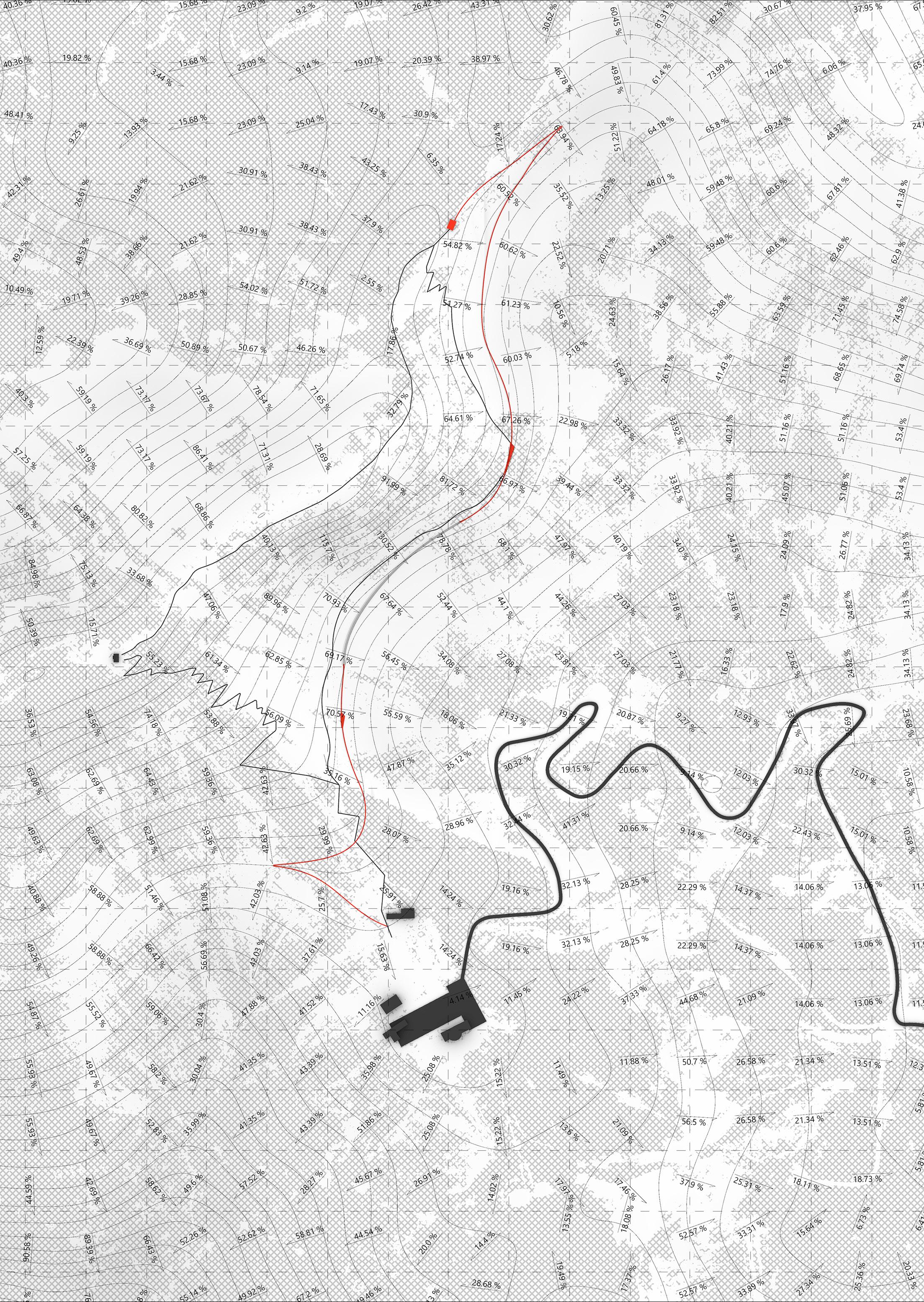
The project focuses on developing an existing pathway which is located on the hillside to be an accessible path for both non-hikers and disabled people who want to experience basic hiking and the stunning scenery of the Gran Sasso mountain.

SECTION E VIEWPOINT
SECTION C
SECTION B
SECTION D
SECTION A
20 - GRAN SASSO FOR ALL
GRID OF 100x100m2
Section A
Terrain Slope: 30-50%
PATHWAY DESIGNS
The pathway consists of five types of intervention to deal with different slopes of the existing terrain. All of them are designed to support the activities of hikers. The joy of hiking is not only from gaining elevation uphill to take a natural view and fresh air but also from feeling different ground covers with different traction and sound.
Section B
Terrain Slope: 50-70%

Section C
Terrain Slope: 70-130% With Half Tunnel


TERRAIN CROSS-SECTION
The terrain cross-section shows the overall altitude of the area. The different altitude of the Campo Imporetore Hotel area and the proposed viewpoint indicates the elevation gain of the hike. It also illustrates the slope of the new pathway which is less steep and has a gradual incline compared to the existing pathway.

Section D
Terrain Slope: 50-70% With Crossing Platform

Section E
Terrain Slope: 50-70% With Switchback


GRAN SASSO FOR ALL - 21
The Viewpoint Mountain Ridge Panoramic View


22 - GRAN SASSO FOR ALL
HIKING FOR ALL
The hotel area connects to the trail network laid over the area of the Gran Sasso mountain. Although every path is connected to each other and the viewpoint, the difficulty is differently defined by types of groundcovers and steepness. The new path is the easiest route to walk.

The viewing platforms located along the path provide panoramic balconies looking to Campo Imperatore. The tunnel allows people to walk on the steep surface without worrying about rockfalls and avalanches. The new pathway composes of only gravel grids and limestone gravel to minimise the impact on nature.


GRAN SASSO FOR ALL - 23
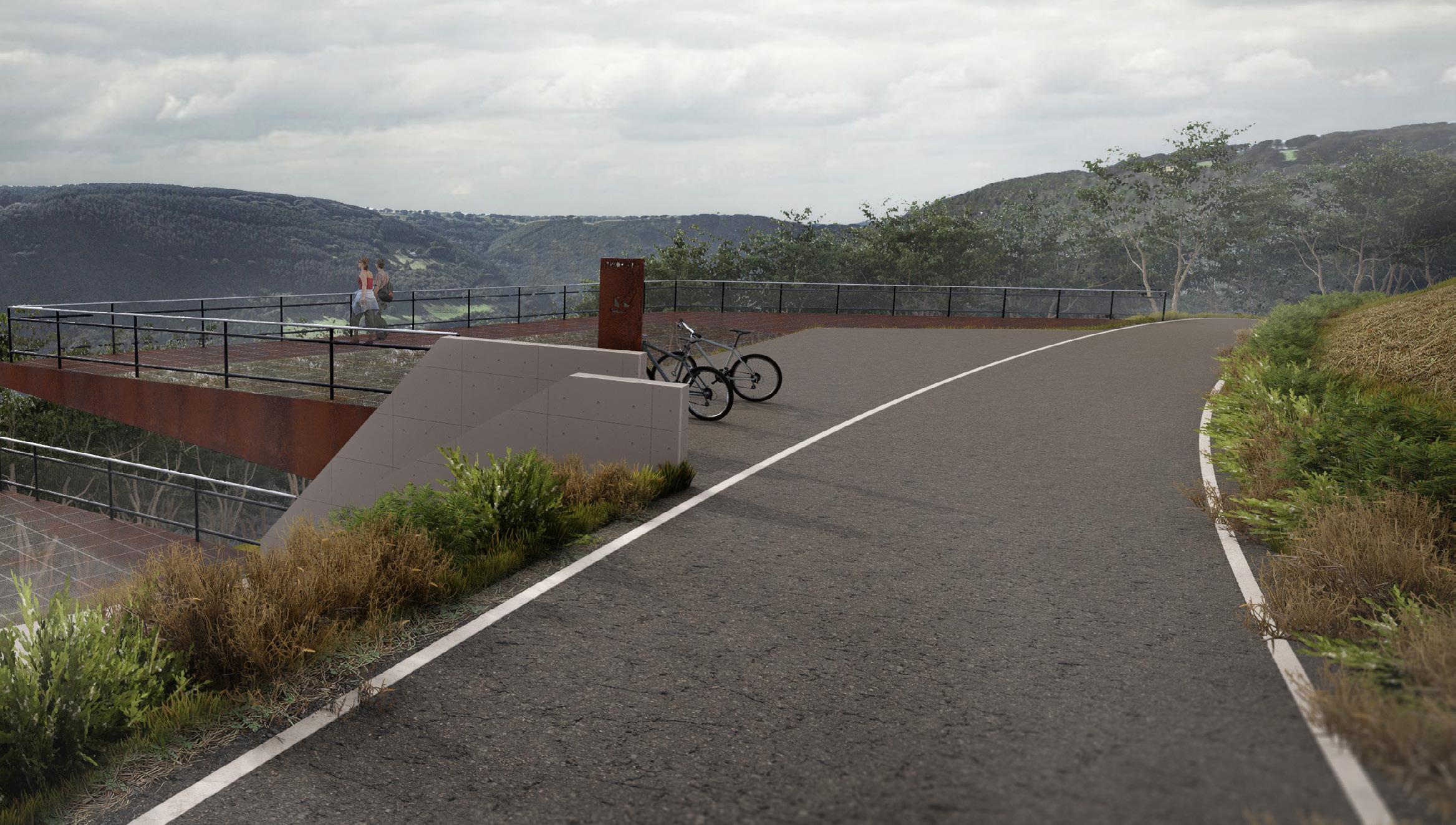
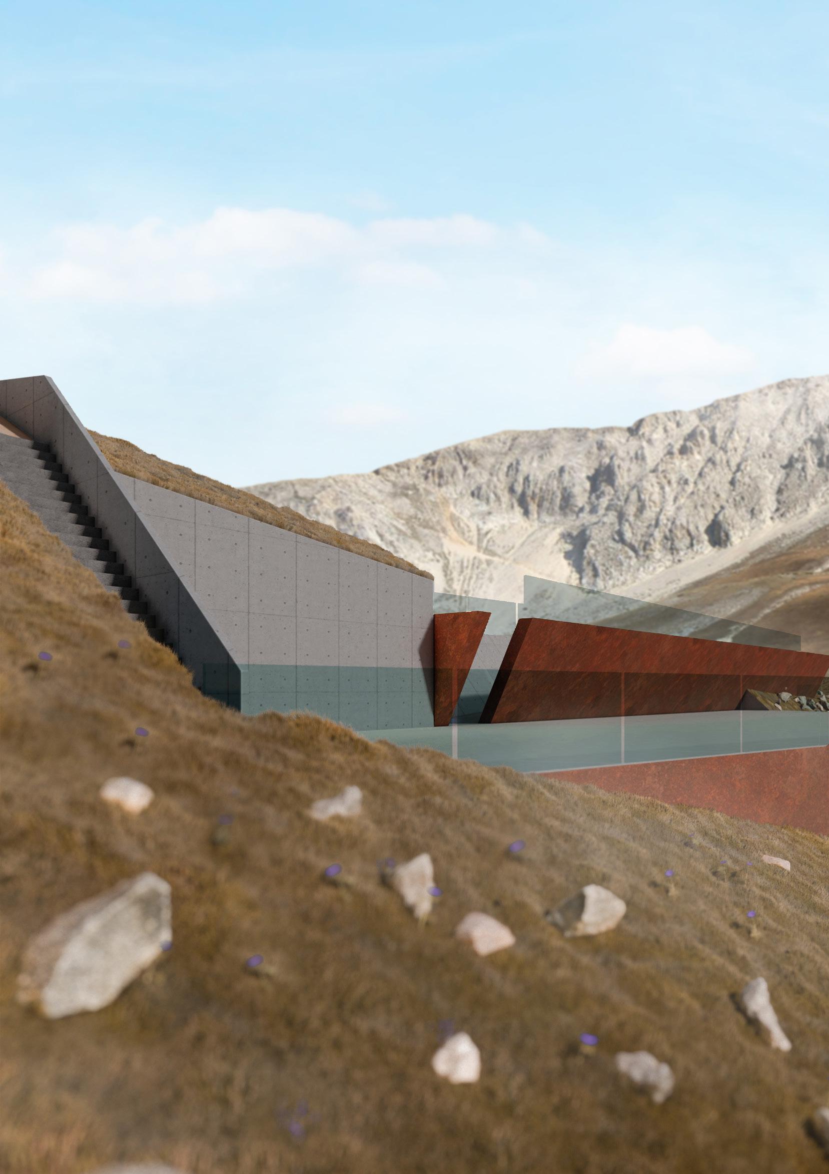
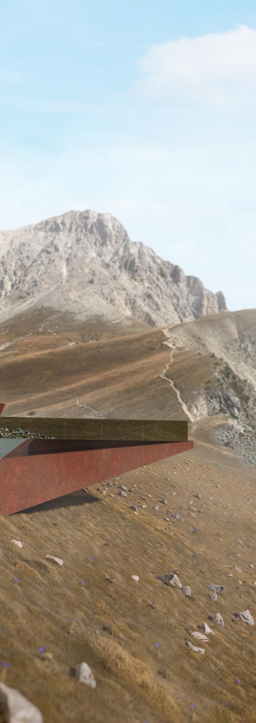
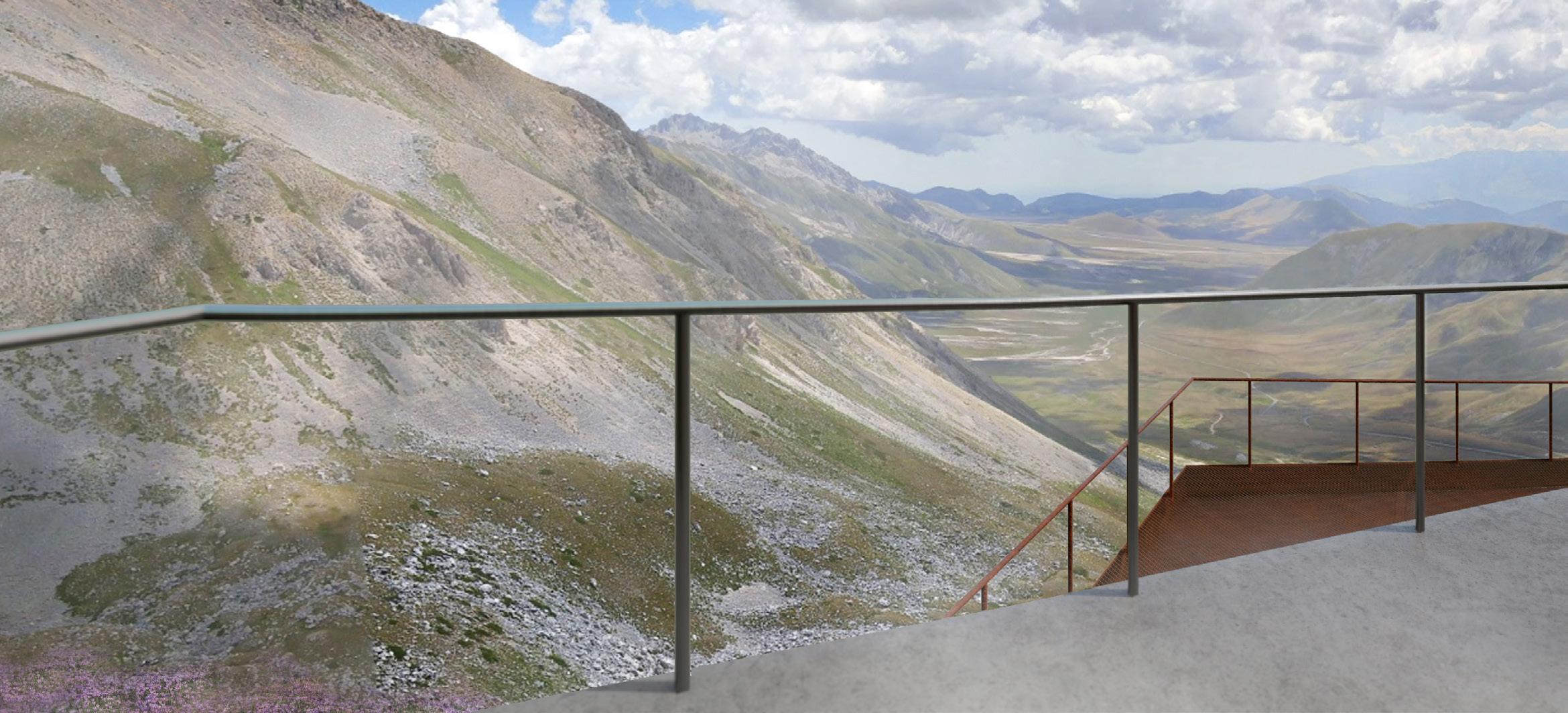
THE ACCESSIBLE VIEWPOINT
The destination of the 2000-metre hike is the viewpoint designed to take a 360 ° view of the mountain without any obstacles. The viewpoint features a double viewing deck with tempered glass railings and public restrooms. The form of the panoramic viewpoint resembles the shape of the “reverse fault” located below the Gran Sasso mountain.


The viewpoint is made of natural-looking materials with a low amount of maintenance. It is also connected by the existing trail between Rifugio Duca degli Abruzzi to the peak of Corno Grande which is the common route for expert hikers. The location of the platform facing both east and west provides rewarding panoramas to people who arrive.
24 - GRAN SASSO FOR ALL


GRAN SASSO FOR ALL - 25
WESTERN BANGKOK AIRPORT INTL.
Architectural Thesis Project
Project Year 2018-2019

Advisor: Satta Panyakaew
This architectural thesis project aims to study the design of airports, by setting tasks based on the current situation, focusing on the weaknesses of airport service in Bangkok, which may not be sufficient to cope with the increasing population in the city. When looking at major travel destinations, the integration and service of airports can support the needs of each part of the city, such as in the case of London, England, which has six airports distributed throughout the city.
The introduction of Western Bangkok’s new 20gate international airport would be a significant development for the city, as it aims to support the increase in both leisure and business travel. This growth is driven by the availability of more affordable plane tickets and improved communication infrastructure. However, one area where Thailand has struggled is in the connectivity of its public transportation systems.
The new airport aims to address this issue by seamlessly integrating air, rail, and road transportation, making it easy for both locals and tourists to travel to and from any part of the country. With its strategic location and advanced facilities, this airport has the potential to play a crucial role in Thailand’s national development plan, making it a key hub for business and tourism in the region.
Scan Here for Project’s Video
WESTERN BANGKOK AIRPORT INTL. - 27
BANGKOK: THE EXPANDING CITY

Bangkok is ranked 2nd in the world’s traffic congestion data. As the population is expanding towards the western side of Bangkok, travelling to the airports located on the eastern side is inconvenient. Moreover, Thai tourism is increasing due to the visa exemption for the members of the Association of Southeast Asian Nations (ASEAN).


The current serviceability of the two existing airports could not meet the demand of the users, so constructing one more airport on the west seems to be a good idea to tackle this problem. This also gives choices to locals and tourists to choose the airport that suits them the best.
SITE SELECTION CRITERIA
The site specifically needs to be located in the farmland area of Western Bangkok. Site selection is based on the availability of existing and planned public transportation in that area, distance to the city centre, and distance to nearby residential areas.
Two potential areas were selected and the scores were given based on the criteria stated above. The site with the higher score is chosen for the design process.
DISTANCE/COMMUTING TIME FROM CITY CENTRE
28 - WESTERN BANGKOK AIRPORT INTL.
EXISTING PUBLIC TRANSPORTATION LINKED TO AIRPORTS
SITE PLAN & LINKAGE
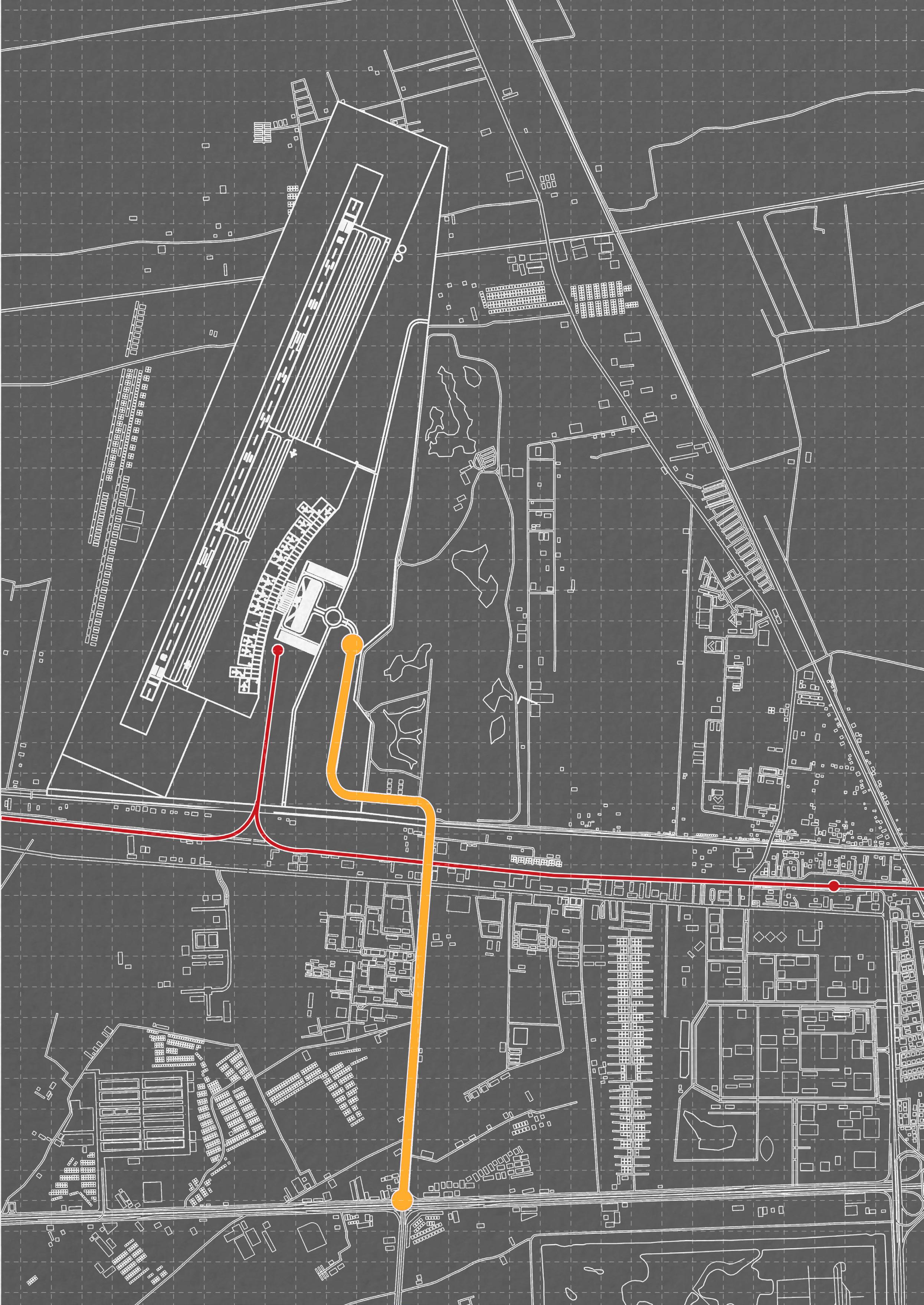
Elevated highway: The main roadway access is connected to the main highway. This could reduce the time users have to spend in the airport.
City & High-speed train: The main linkage to Bangkok’s city centre and the newly developed railway allows users to travel between the city centre and the western and southern parts more easily.
WESTERN BANGKOK AIRPORT INTL. - 29
GRID OF 100x100m2
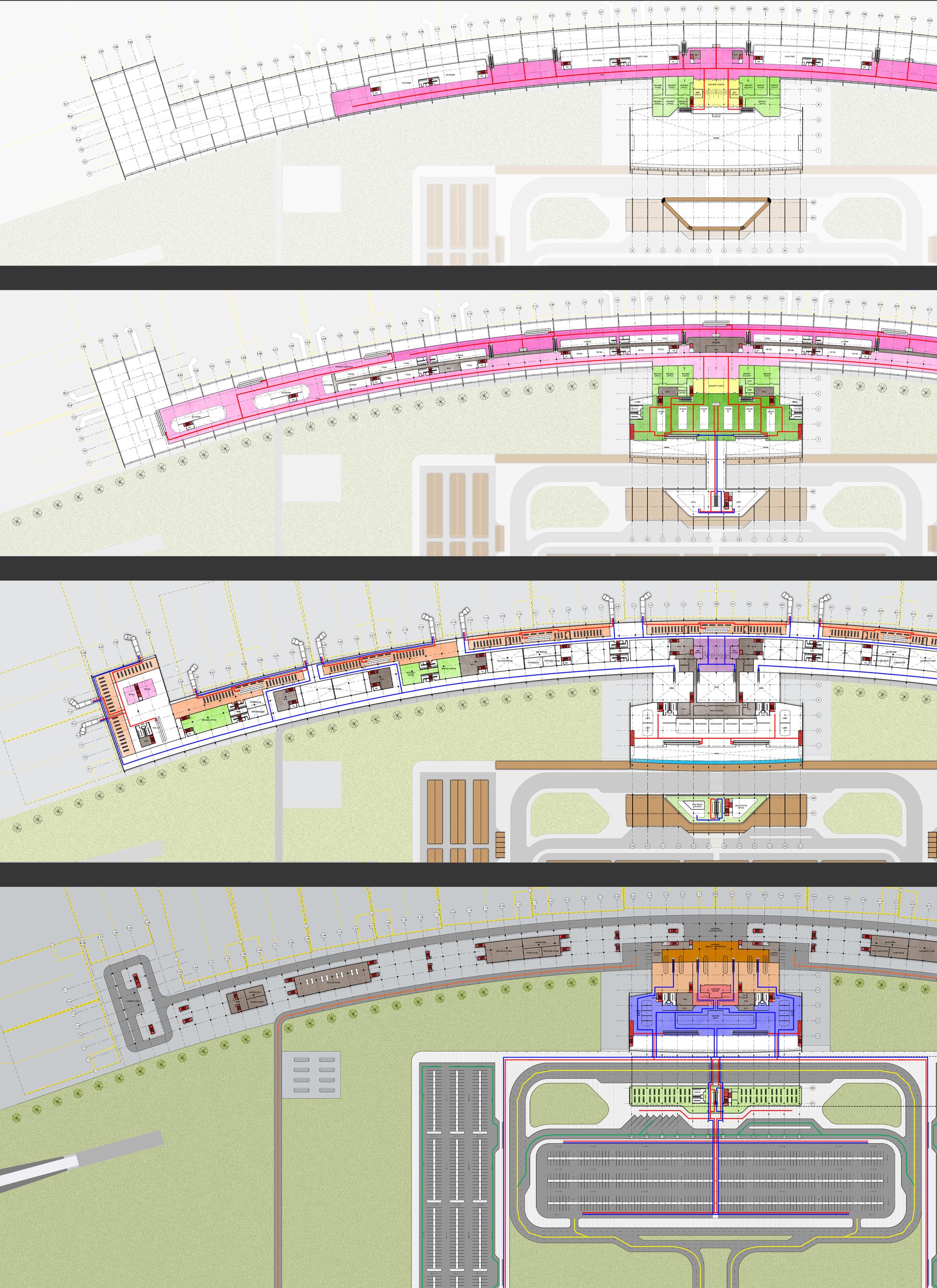
ZONING AND CIRCULATION

The proposed site for the project is located in Salaya, a small city renowned for its university on the western side of Bangkok. It offers excellent connectivity through various existing modes of transportation, such as trains and buses and the location on a highway, with available land in a non-residential area, making it an ideal spot for the project’s owners and users.
The direction of the runway is a crucial factor in the design of an airport, as it determines the overall orientation of the facility. It is generally considered best practice to align the runway parallel to the average wind direction in the area, as this allows aircraft to take off and land easily and safely.
The master plan’s zoning is based on the hierarchy of accessibility. The terminal and parking area should be easily accessible by the public and staff. The access to aircraft’s circulation area must be strictly prohibited to airport staff.

After the zoning was planned, the main terminal circulations and functions were designed following the airport design standard. This process is essential for the airport design as the circulation of different users must not be mixed due to security concerns.

PUBLIC RESTRICTED 30 - WESTERN BANGKOK AIRPORT INTL.
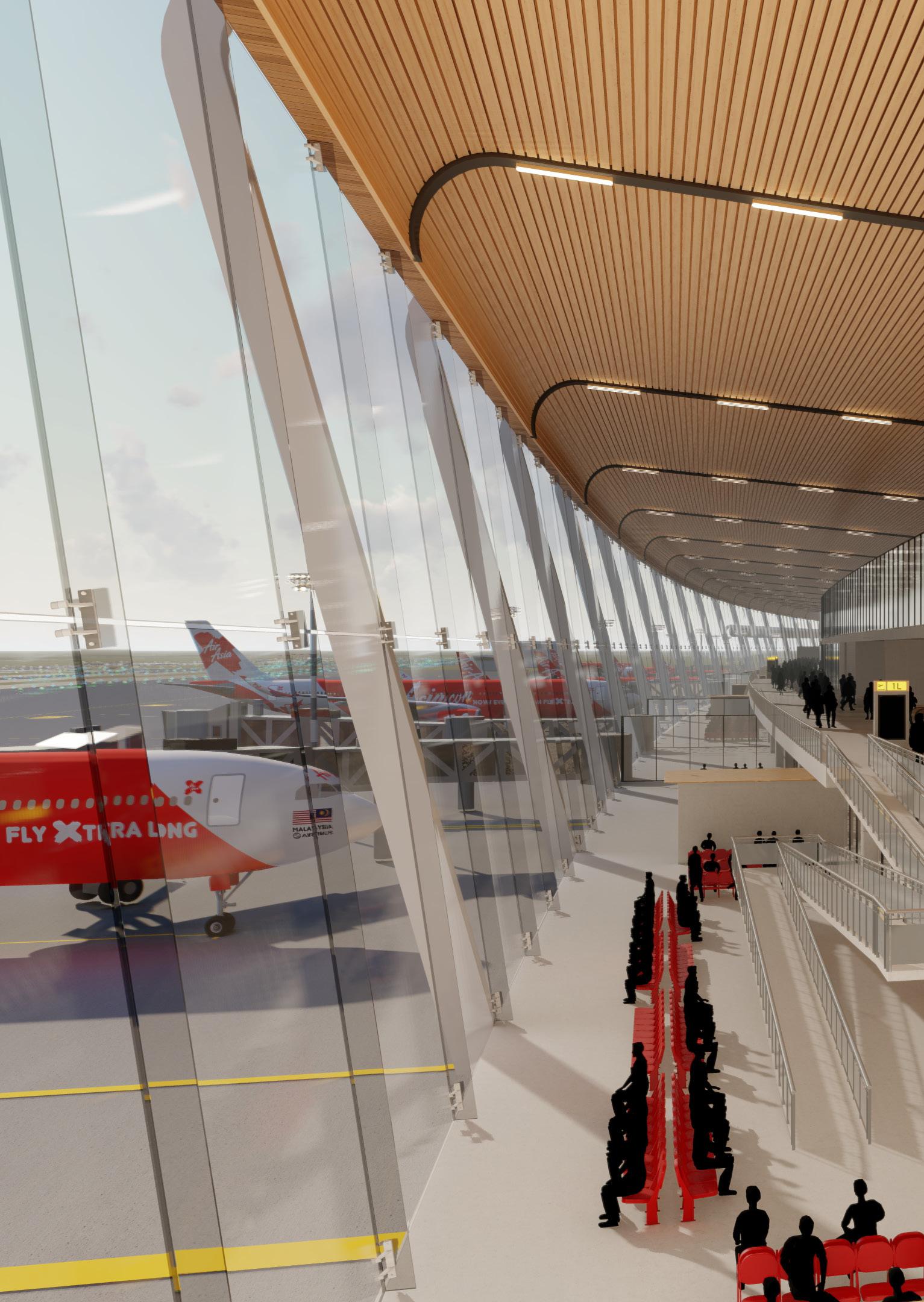
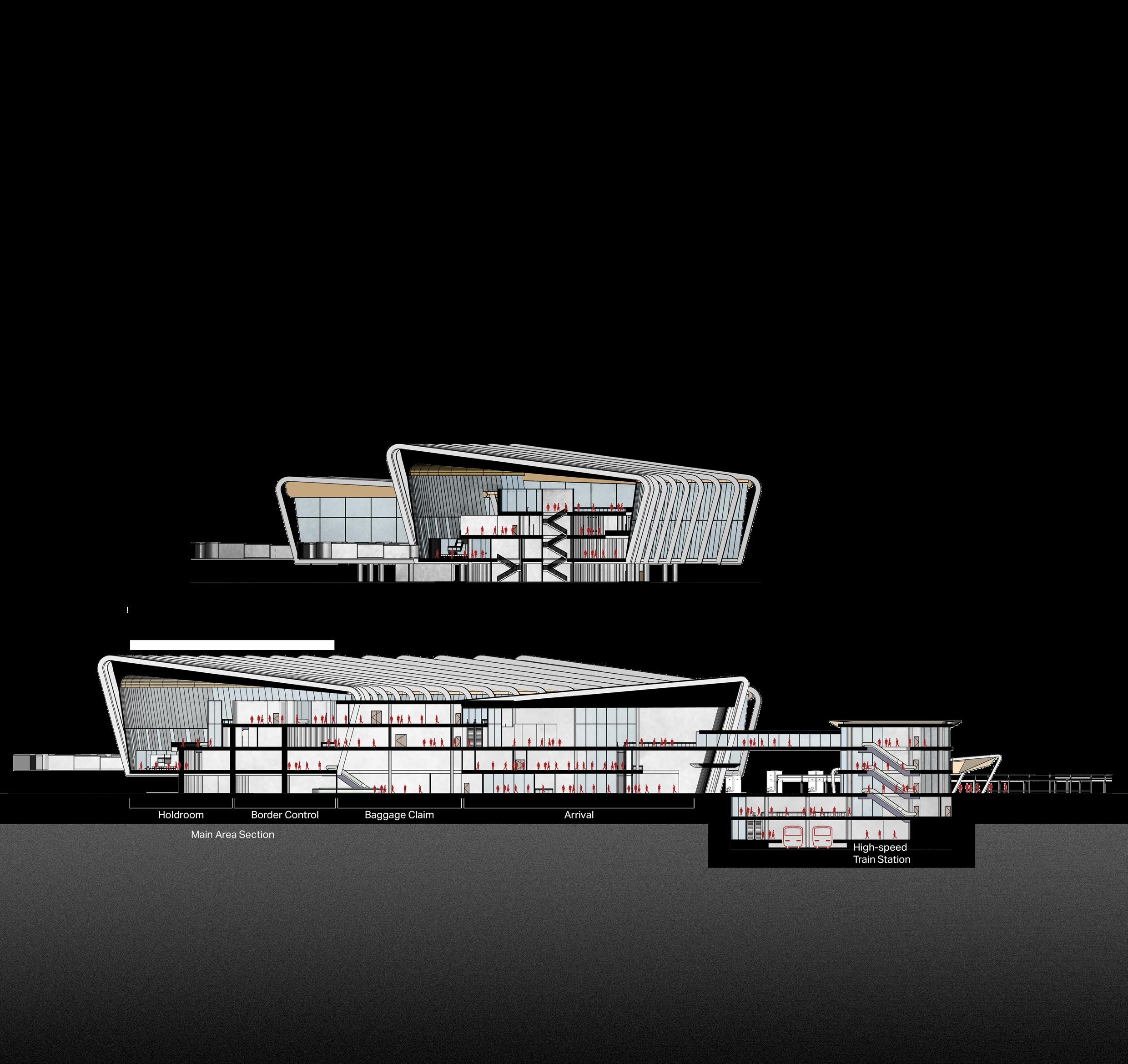
TERMINAL DESIGN


The architectural design of the airport is curved-linear since it allows maximum aircraft flow which is the main concern for low-cost airlines. The typical terminal wings consist of two sides, one facing the apron (an aircraft parking pad) other facing trees and green spaces. This creates a dynamic perception for the users.
The structures that are used in the building consist of posttension slabs and columns to create interior spaces covered
WESTERN BANGKOK AIRPORT INTL. - 31
2nd
1st fl. - Arrival Circulation
3rd fl. - Intl. Departure Hall
fl. - Departure Hall
32 - WESTERN BANGKOK AIRPORT INTL.
G. fl. - Arrival Hall
TERMINAL PLANNING


The proposed project consists of a main terminal with four floors, and a bus terminal with three floors, as well as a basement that also houses an underground railway station. The main access to the building is located on the ground floor, with the roadway divided into a car drop-off and bus stop for improved traffic flow. There are three parking lots located in front of the main terminal, and shuttle buses are provided to transport passengers between the parking lots and the main terminal.
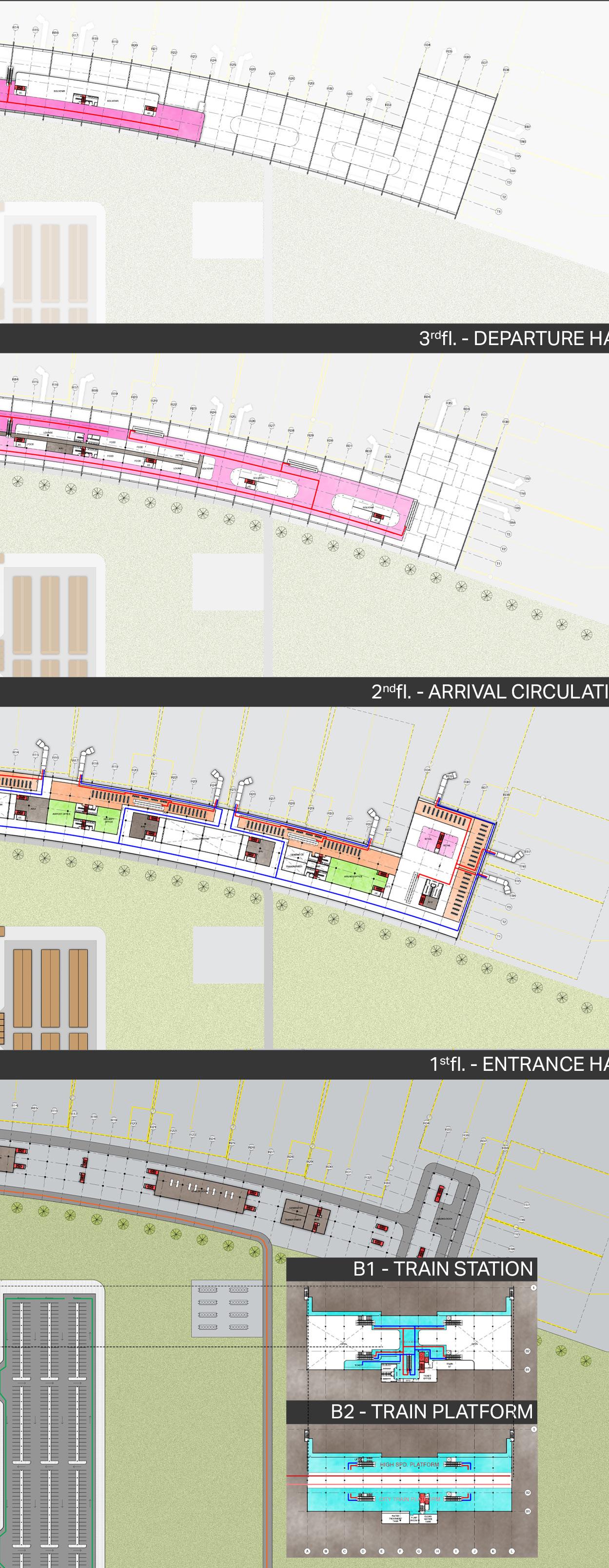

The main departure area is located on the 2nd and 3rd floors, while the main arrival area is located on the G. and 1st floors. Service rooms, MEP rooms, fire exits, and restrooms are situated along both wings of the terminal.

Circulation within the terminal is an important consideration, and it is necessary to ensure that different types of users are separated in certain areas due to varying security procedures. This is accomplished by separating different circulation areas for passengers, staff, and cargo, to ensure that the airport functions smoothly and safely.
FUNCTIONS
CIRCULATION


PROJECT BENEFITS

WESTERN BANGKOK AIRPORT INTL. - 33
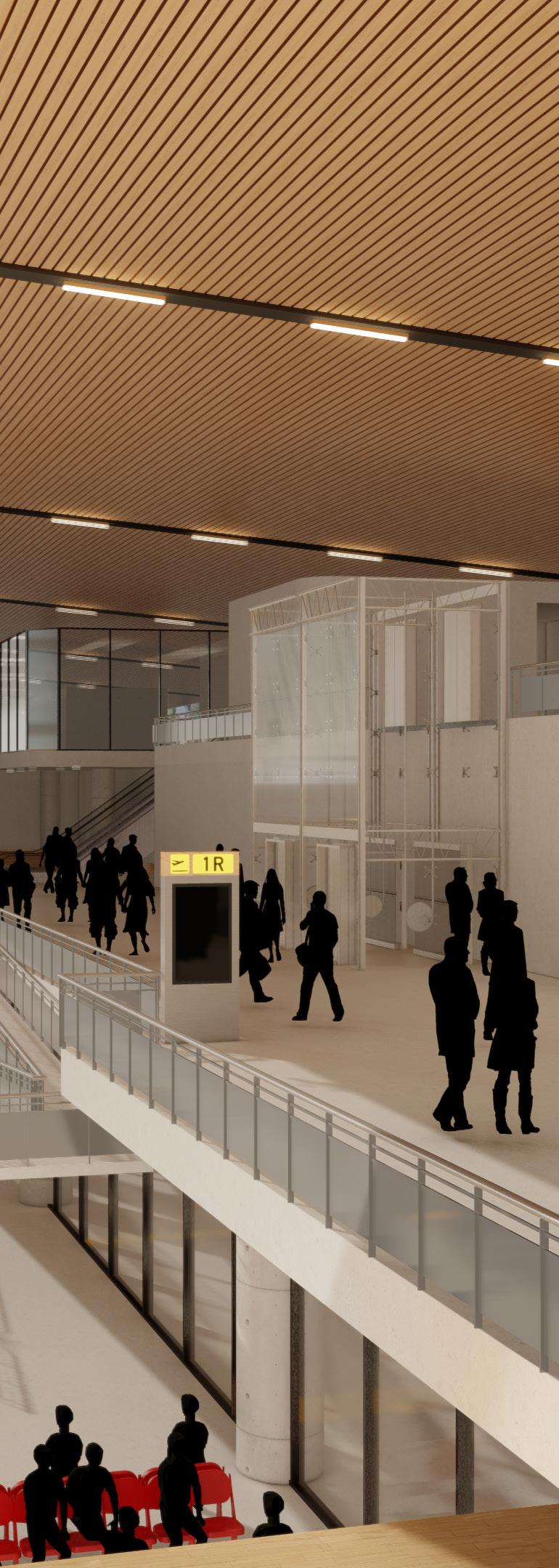
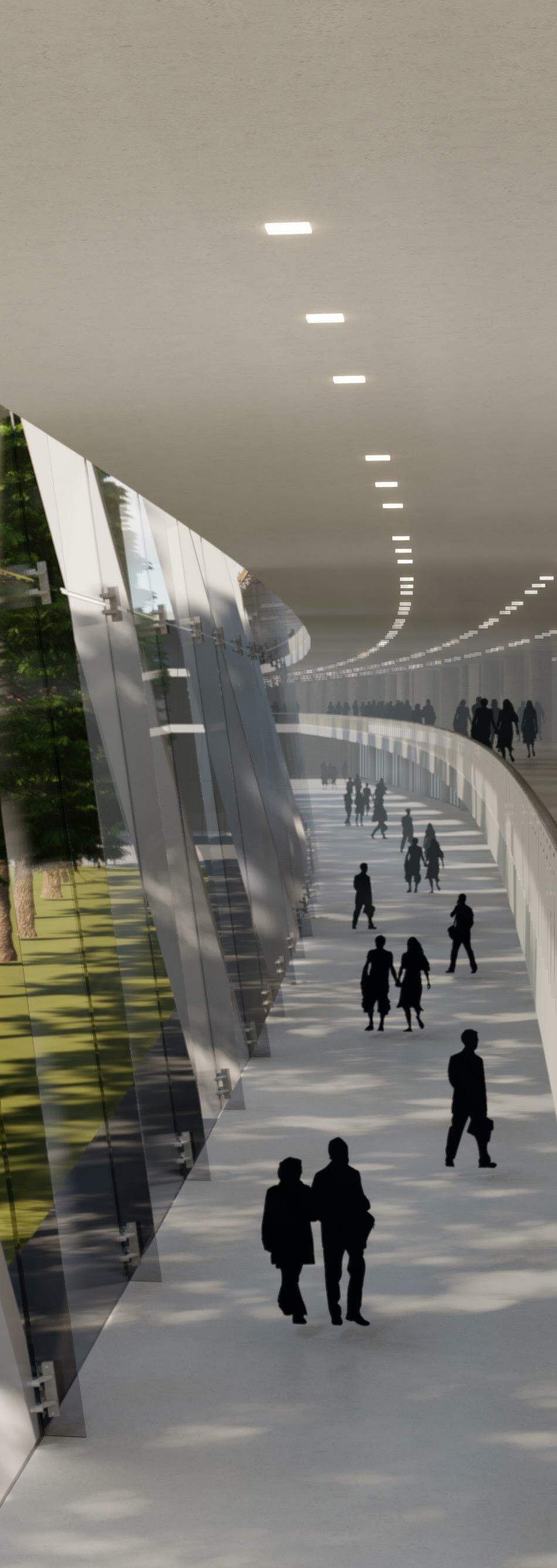
UNIQUE VIEWS
The concession area on the apron side of the terminal offers passengers an unobstructed view of aircraft activity. It features a variety of shops, including tax-free and souvenir stores, as well as restaurants. The open, vertical design of the space enhances the feeling of openness and reduces feelings of enclosure.

On the other side, the circulation area is designed to promote relaxation, with a nature-facing design. The upper walkway is designated for the departure of domestic passengers, and includes additional retail options. The lower walkway is for the arrival of domestic passengers, and leads to border control and baggage claim areas.

34 - WESTERN BANGKOK AIRPORT INTL.


WESTERN BANGKOK AIRPORT INTL. - 35
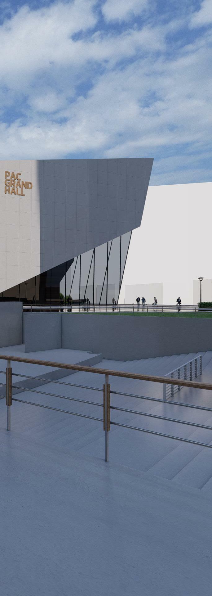
PERFORMING ARTS CENTRE
4th Year Architectural Design Project Project Year 2017
Advisor: Tonkao Panin
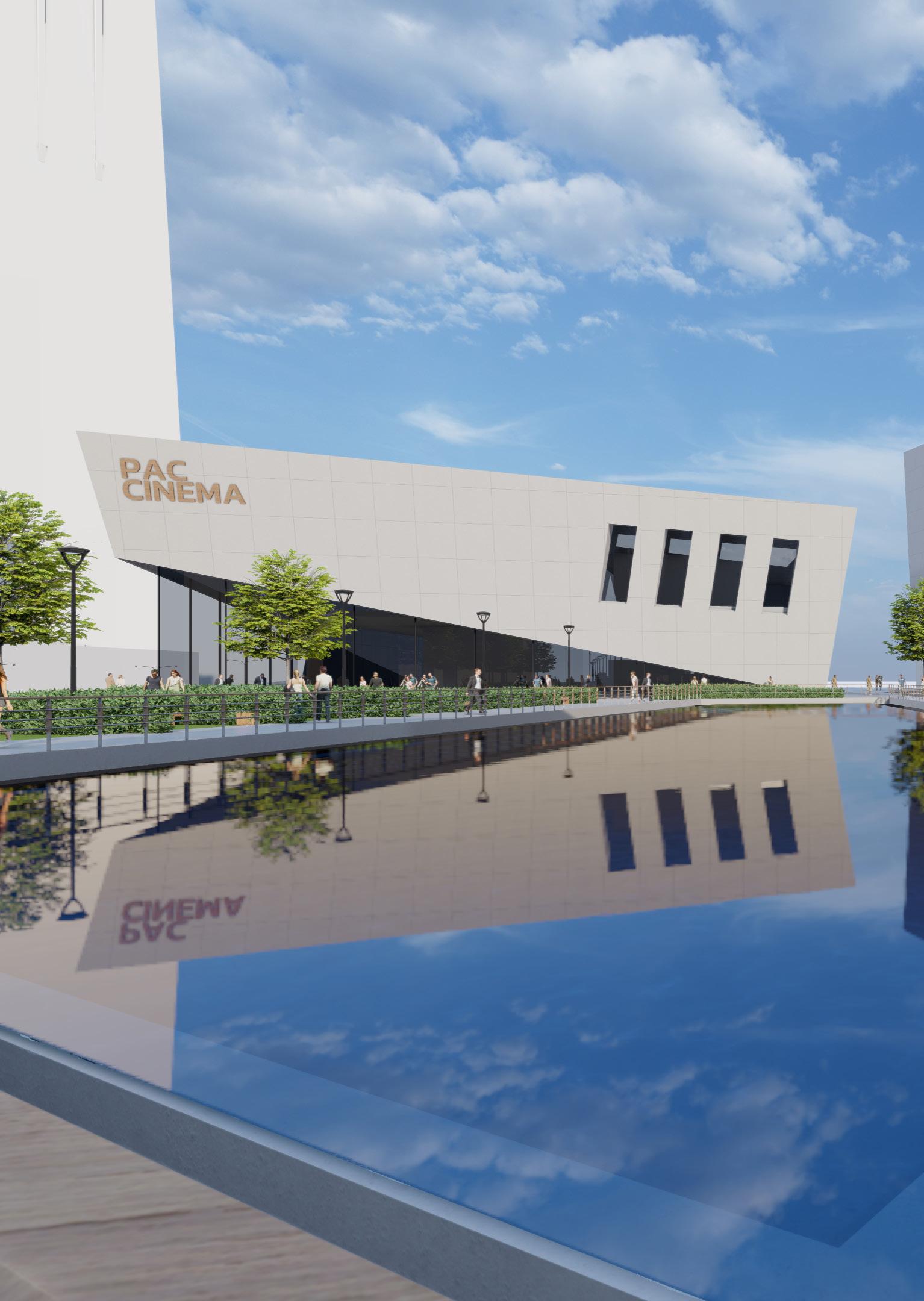
Bangkok’s performing arts centre is a state-of-theart complex located in Silom district, the heart of Thailand’s largest business district. The new facility boasts a wide array of venues, from movie cinemas to traditional theatres, all designed to cater to a diverse range of performances and audiences.
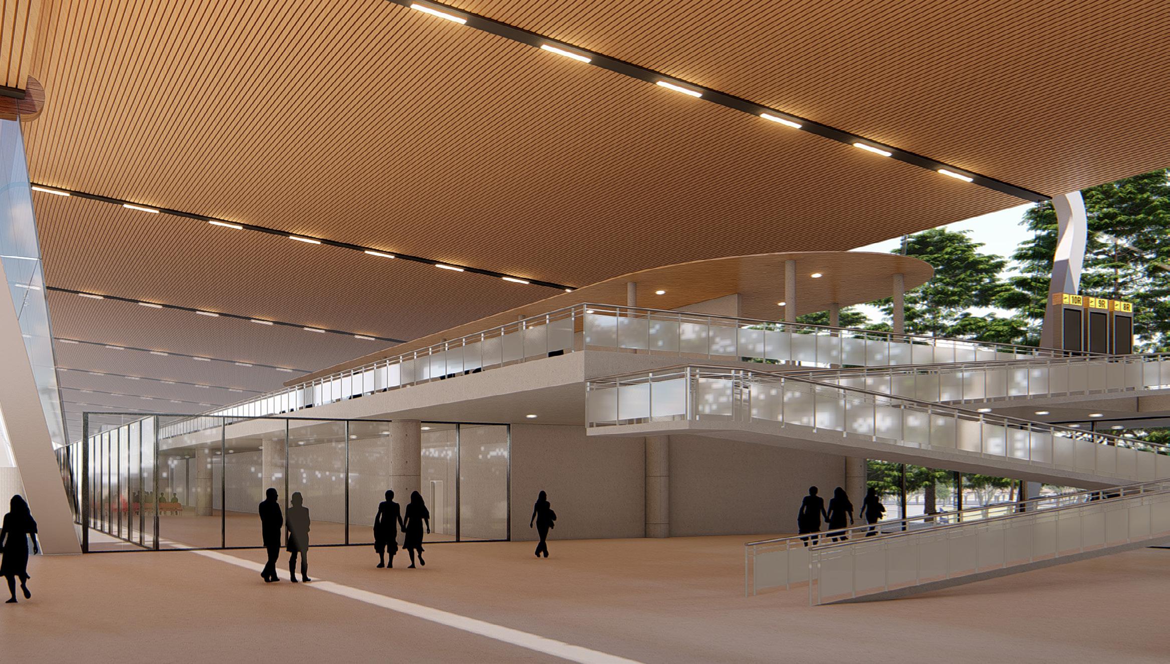
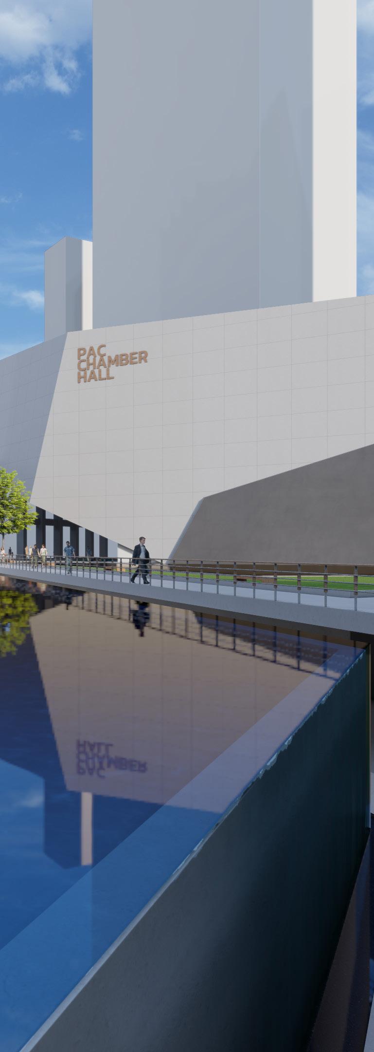
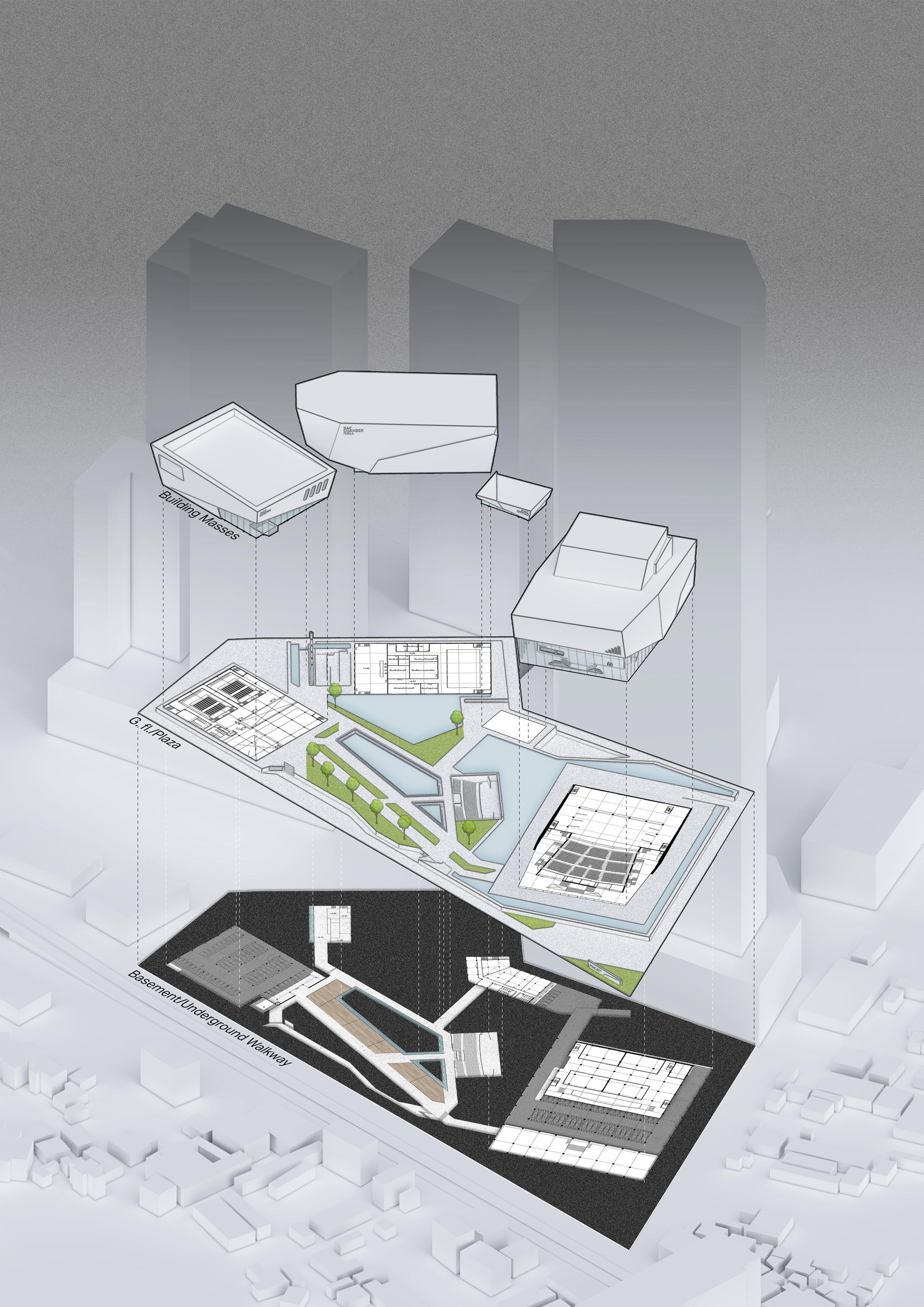
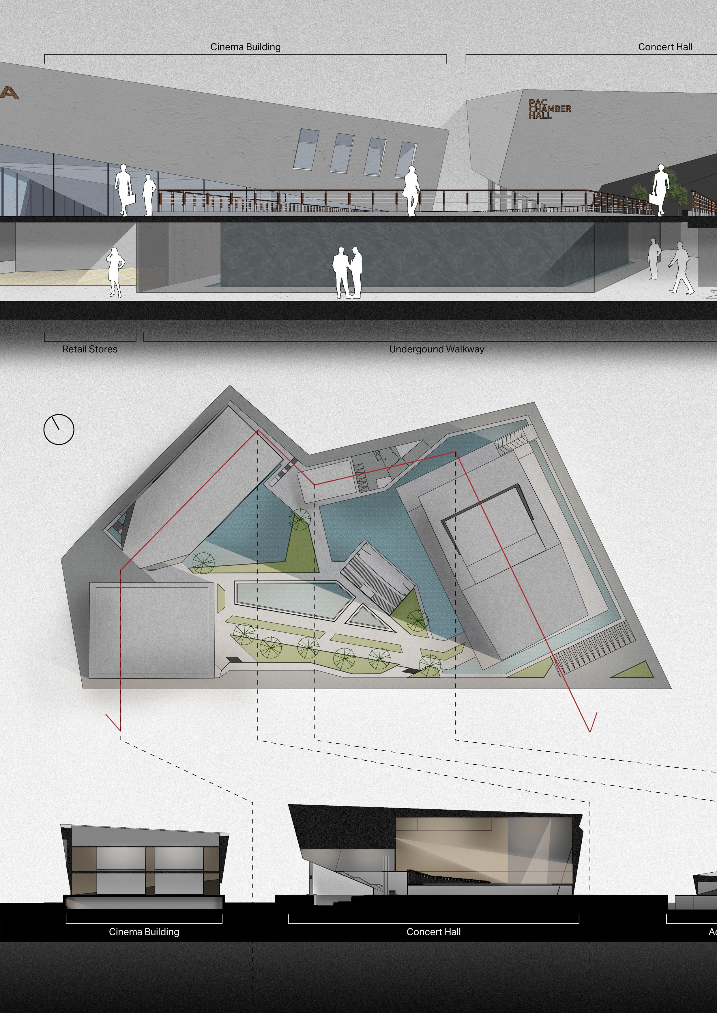
The complex is comprised of several separate buildings that are connected by a dual-layer walkway. The subterranean level of the walkway features various amenities for the public, including a selection of restaurants and the entrance to an outdoor amphitheatre. The top deck walkway, meanwhile, is elevated from the ground level, creating a large-scale plaza that can be used for a variety of public events and gatherings.
The unique architectural style of the complex reflects the functions of each individual building and serves to attract the attention of those passing by. The design is sure to draw the attention of both locals and visitors and serves as an attractive destination for those passing through the area. Whether you’re looking for a night out at the movies or a cultural experience at the theatre, this new performing arts centre is the place to be.
PERFORMING ARTS CENTRE - 37
SITE CONTEXT


Bangkok, Thailand’s crowded capital city with a trend of overpopulation, and bad work-life balance. One key aspect that Bangkok lacks is public open space that is truly meant for leisure. The destination for Bangkok’s residents nowadays is malls. A sense of calmness seems to be dominated by the hectic environment. This project comes up with the intention to provide a calm and relaxing public space, enclosed by the theatre buildings, to the city. The project does not only provide a public space but also promotes performing arts.
The site of the project is located in the heart of Si-lom, Bangkok’s largest business district. The location is easily accessible by citywide transportation, with an MRT underground train station located on the west side of the complex. In the north of the complex, there are two planned high-rise developments set to be completed in 2027, further adding to the area’s bustling atmosphere. This project is a much-needed addition to the city and will provide a much-needed oasis of calm in the midst of the hustle and bustle of Bangkok.
PRESENCE OF WATER
Water, the element that represents calmness in many cultures, is the main feature of the project. It also indicates the surrounding dynamics through its reflection and waves. The interaction of water in the project has many levels, including seeing, hearing and touching, each giving different feelings to the users. Green spaces are introduced to compensate for the lack of parks in the area. The area is soundtracked by the performance in the outdoor amphitheatre in the middle. All is to provide a relaxing and pleasurable experience.
38 - PERFORMING ARTS CENTRE
CONCEPTUAL SKETCH
FEATURED FUNCTIONS
The required functions are the performing hall, the concert hall, the outdoor amphitheatre, and movie cinemas.

Considering the nature of these functions, they all require long-span structures with an unobstructed line of sight from the seats to the stage, or screen. Separating these functions into their own building is an ideal solution for the project layout.
PERFORMING ARTS CENTRE - 39
ROOF PLAN
40 - PERFORMING ARTS CENTRE
DUAL-LAYER WALKWAY
A dual-layer walkway plays a key role in this complex since it serves various types of users. The upper level serves as a plaza for public activities and as the main circulation between functions. The lower path is air-conditioned and features restaurants and food kiosks for the audience. It is also used as a main circulation when it rains.
PROJECT’S SECTIONS
As each building has its own orientation, the custom section cut is made to illustrate the vertical spatial relationship in one drawing. The water feature is also drawn to the underground through the wall outside the full-height glass panel in the middle. This also provides natural light for the underground walkway.
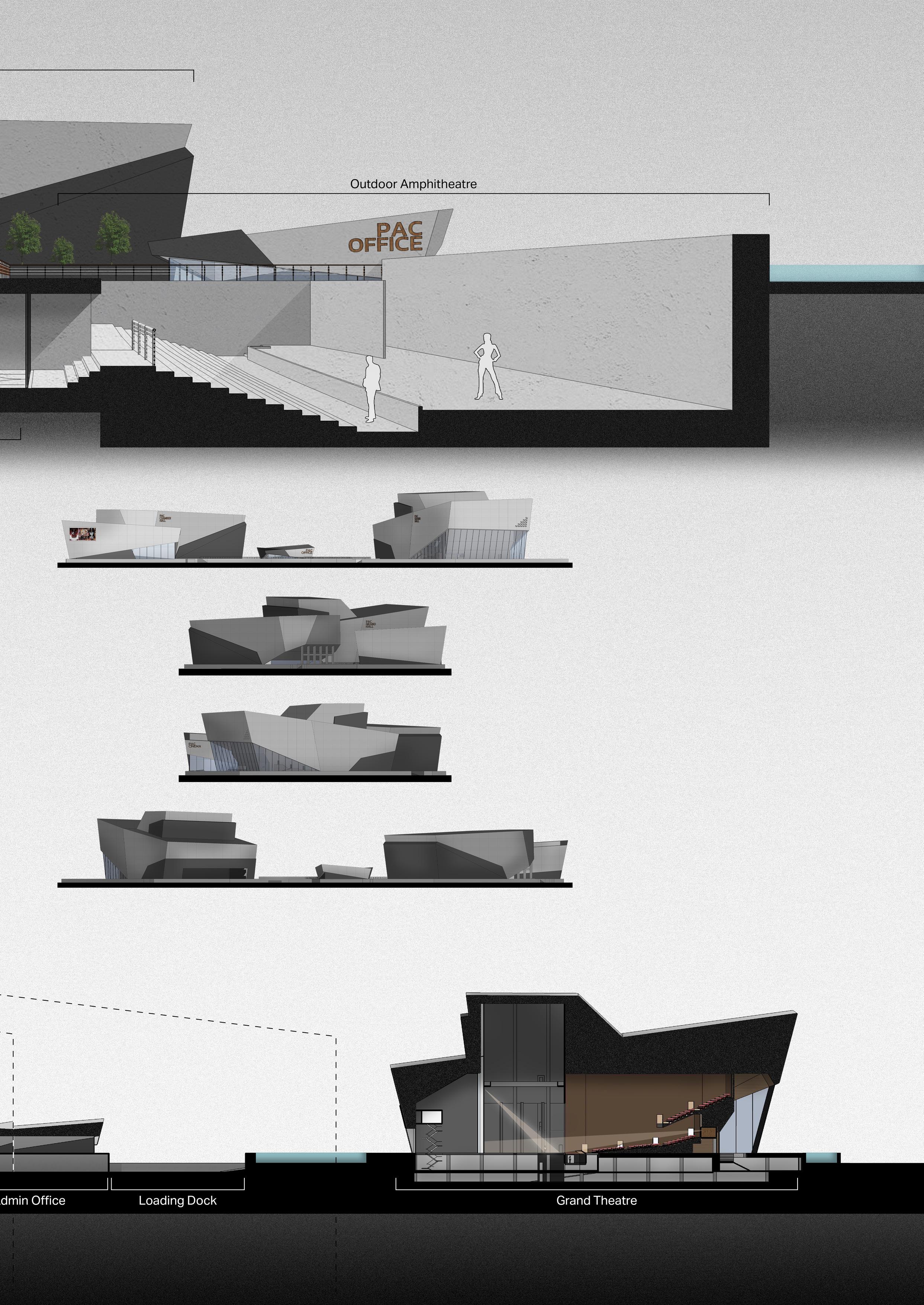
The outdoor amphitheatre in the middle is designed for outdoor events. The only access is through the lower walkway. This allows some events to use the ticketing scheme to control the number of audiences and profit from the event as well.
The hall designs are massive as they need to support
- 1000 seats for the Concert Hall
- 1700 seats for the Grand Theatre
- 4 standard-size cinemas
SW Elevation
NW Elevation
NE Elevation
SE Elevation
PERFORMING ARTS CENTRE - 41
AN ICONIC DESIGN
The non-perpendicular design, based on the principle of acoustic, is known to reduce the possible echoes caused by the reflection of sound waves. It is introduced in the project’s architectural style to create an iconic and modern look, to stand out from its context skyscrapers. The design also represents creativity in the same way performing arts do.

In addition to the intended public open space for the area itself, the landscape design needs to be user-friendly since it also acts as the gateway for the planned project that is located behind the complex.


42 - PERFORMING ARTS CENTRE


PERFORMING ARTS CENTRE - 43
APPENDIX FROM SKETCHES TO FINAL DESIGNS


A hand sketch is one of the best ways to start a project. It helps visualise the idea initially, in a way that has no bound of software limitation. It is just all about the proportion and aesthetic of the design.


44 - HAND SKETCHES


THANK YOU SIRAPAT AJKARN (SAM) LinkedIn