MAP MAN.qxp:Layout 2
23/4/14
15:38
Page 1
CITY | LIVES
ALL MAPPED OUT Samantha Coleman meets Bristol illustrator, Gareth Wood, who has hand-drawn a map of Bristol, with references to the city’s culture and history
B
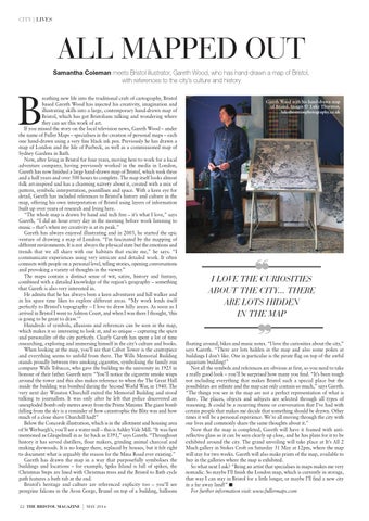
reathing new life into the traditional craft of cartography, Bristol based Gareth Wood has injected his creativity, imagination and illustrating skills into a large, contemporary hand-drawn map of Bristol, which has got Bristolians talking and wondering where they can see this work of art. If you missed the story on the local television news, Gareth Wood – under the name of Fuller Maps – specialises in the creation of personal maps – each one hand-drawn using a very fine black ink pen. Previously he has drawn a map of London and the Isle of Purbeck, as well as a commissioned map of Sydney Gardens in Bath. Now, after living in Bristol for four years, moving here to work for a local adventure company, having previously worked in the media in London, Gareth has now finished a large hand-drawn map of Bristol, which took three and a half years and over 500 hours to complete. The map itself looks almost folk art-inspired and has a charming naïvety about it, created with a mix of pattern, symbolic interpretation, pointillism and space. With a keen eye for detail, Gareth has included references to Bristol’s history and culture in the map, offering his own interpretation of Bristol using layers of information built up over years of research and living here. “The whole map is drawn by hand and tech free – it’s what I love,” says Gareth, “I did an hour every day in the morning before work listening to music – that’s when my creativity is at its peak.” Gareth has always enjoyed illustrating and in 2005, he started the epic venture of drawing a map of London. “I’m fascinated by the mapping of different environments. It is not always the physical state but the emotions and trends that we all share with our habitats that excite me,” he says. “I communicate experiences using very intricate and detailed work. It often connects with people on a personal level, telling stories, opening conversations and provoking a variety of thoughts in the viewer.” The maps contain a distinct sense of wit, satire, history and fantasy, combined with a detailed knowledge of the region’s geography – something that Gareth is also very interested in. He admits that he has always been a keen adventurer and hill walker and in his spare time likes to explore different areas. “My work lends itself perfectly to Bristol’s topography – I love to draw hilly areas. As soon as I arrived in Bristol I went to Ashton Court, and when I was there I thought, ‘this is going to be great to draw.’” Hundreds of symbols, allusions and references can be seen in the map, which makes it so interesting to look at, and so unique – capturing the spirit and personality of the city perfectly. Clearly Gareth has spent a lot of time researching, exploring and immersing himself in the city’s culture and books. When looking at the map, you’ll see that Cabot Tower is the centrepiece and everything seems to unfold from there. The Wills Memorial Building stands proudly between two smoking cigarettes, symbolising the family run company Wills Tobacco, who gave the building to the university in 1925 in honour of their father. Gareth says: “You’ll notice the cigarette smoke wisps around the tower and this also makes reference to when the The Great Hall inside the building was bombed during the Second World War, in 1940. The very next day Winston Churchill exited the Memorial Building and stood talking to journalists. It was only after he left that police discovered an unexploded bomb only metres away from the Prime Minister. The giant bomb falling from the sky is a reminder of how catastrophic the Blitz was and how much of a close shave Churchill had!” Below the Concorde illustration, which is in the allotment and housing area of St Werburgh’s, you’ll see a water mill – this is Ashley Vale Mill. “It was first mentioned as Glaspelmull in as far back as 1391,” says Gareth. “Throughout history it has served distillers, flour makers, grinding animal charcoal and making dyewoods. It is no longer there, replaced by houses, but it felt right to document what is arguably the reason for the Mina Road ever existing.” Gareth has drawn the map in a way that purposefully symbolises the buildings and locations – for example, Spike Island is full of spikes, the Christmas Steps are lined with Christmas trees and the Bristol to Bath cycle path features a bath tub at the end. Bristol’s heritage and culture are referenced explicity too – you’ll see peregrine falcons in the Avon Gorge, Brunel on top of a building, balloons 22 THE BRISTOL MAGAZINE
|
MAY 2014
Gareth Wood with his hand-drawn map of Bristol. Images © Luke Thornton, lukethorntonphotography.co.uk
❝
I LOVE THE CURIOSITIES ABOUT THE CITY... THERE ARE LOTS HIDDEN IN THE MAP
❞ floating around, bikes and music notes. “I love the curiosities about the city,” says Gareth. “There are lots hidden in the map and also some pokes at buildings I don’t like. One in particular is the pirate flag on top of the awful aquarium building!” Not all the symbols and references are obvious at first, so you need to take a really good look – you’ll be surprised how many you find. “It’s been tough not including everything that makes Bristol such a special place but the possibilities are infinite and the map can only contain so much,” says Gareth. “The things you see in the map are not a perfect representation of what is there. The places, objects and subjects are selected through all types of reasoning. It could be a recurring theme or conversation that I’ve had with certain people that makes me decide that something should be drawn. Other times it will be a personal experience. We’re all moving through the city with our lives and commonly share the same thoughts about it.” Now that the map is completed, Gareth will have it framed with antireflective glass so it can be seen clearly up close, and he has plans for it to be exhibited around the city. The grand unveiling will take place at It’s All 2 Much gallery in Stokes Croft on Saturday 31 May at 12pm, where the map will stay for two weeks. Gareth will also make prints of the map, available to buy in the galleries where the map is exhibited. So what next I ask? “Being an artist that specialises in maps makes me very nomadic. So maybe I’ll finish the London map, which is currently in storage, that way I can stay in Bristol for a little longer, or maybe I’ll find a new city in a far away land!” ■ For further information visit: www.fullermaps.com