Table of Contents
In the Design Studio
Chapel of Perpetual Adoration
Tropical Park Fencing Academy
Pigeon Key Environmental Research Station Interventions at El Ingenio de Engombe
Other Schoolwork
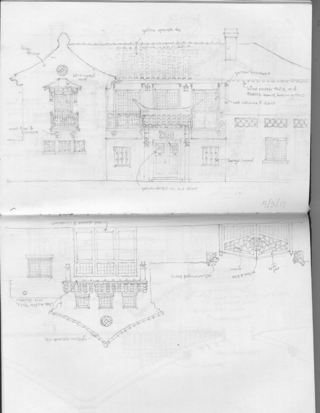
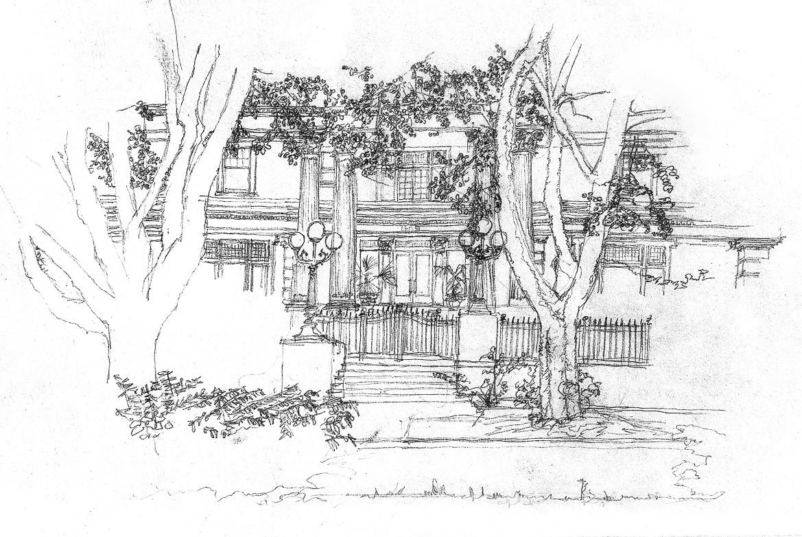
The San Lorenzo Hines Competition 2019 - The Green Line Wharf Observational Sketch of Parker-Fersen Mansion
Hometown Map
Governor’s Residence HABS Documentation
Professional Work
House at Santa Lucia Preserve
Party Barn & Offce for Park City Estate
Personal Work
The Langford
Bungalow Court
Sketches & Watercolor
Sketches in Italy
Watercolors in Italy
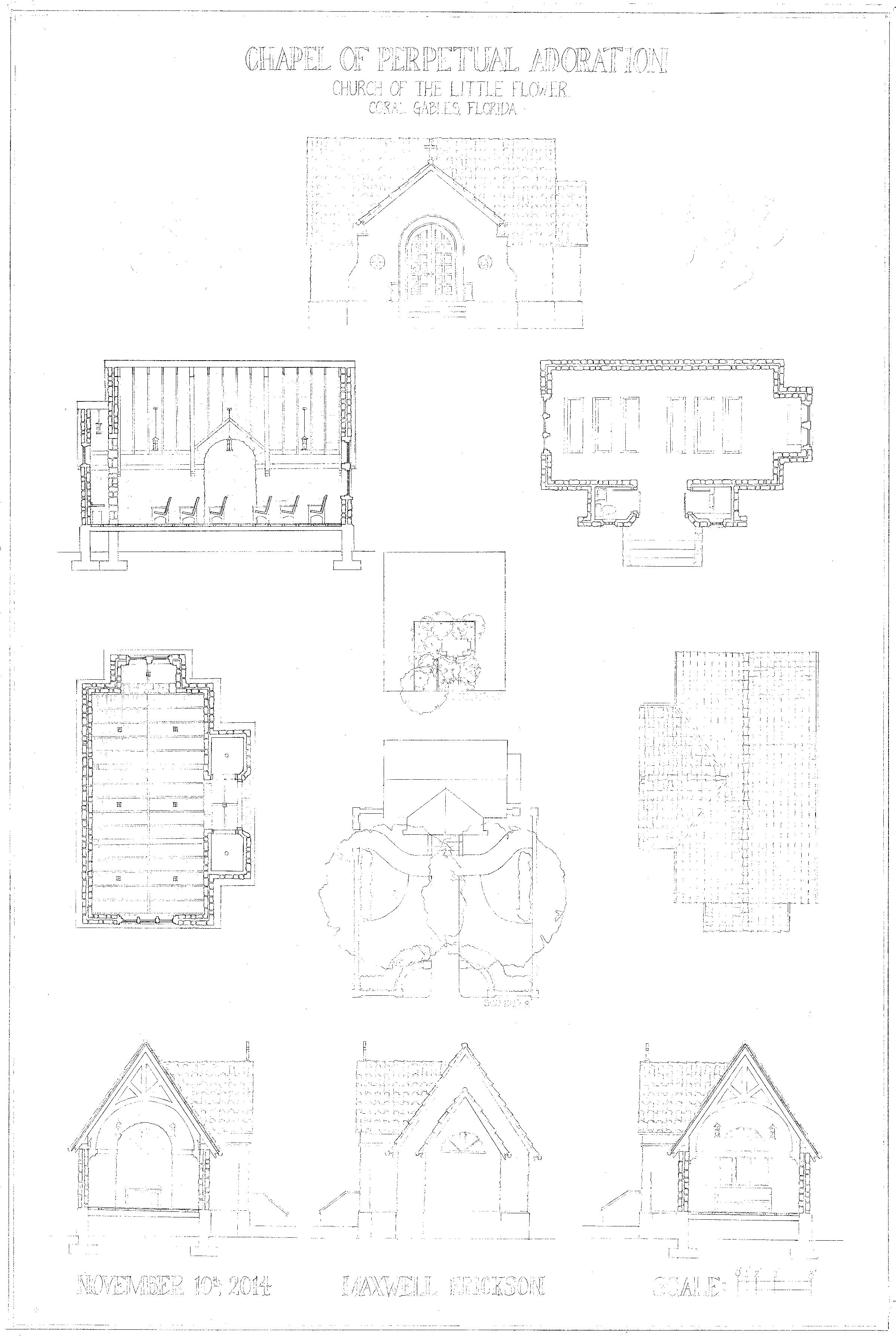
Chapel of Perpetual Adoration
Coral Gables, FL | Prof. Teofilo Victoria Pencil on Vellum | Fall 2014
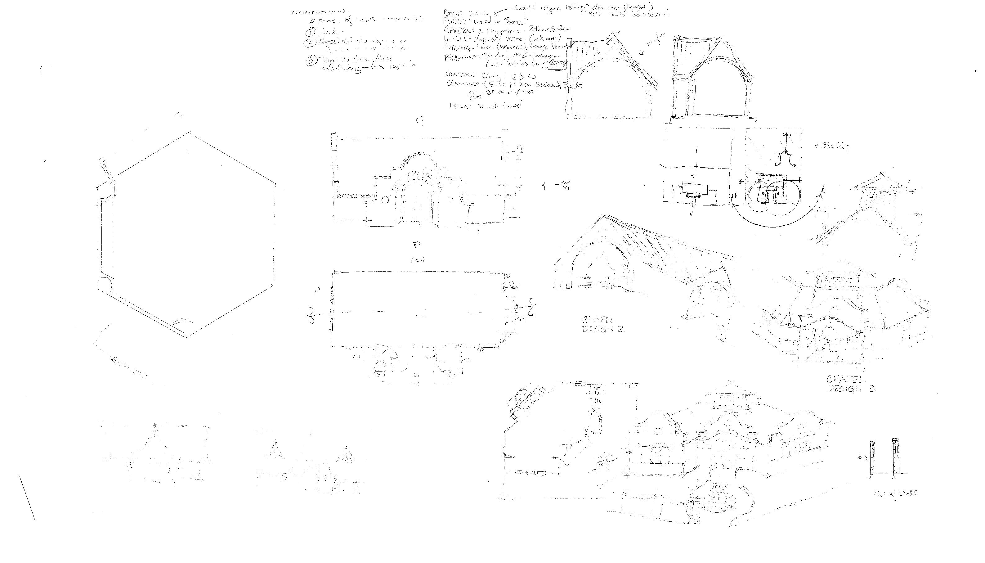
Nestled in the heart of Merrick’s Coral Gables sits the Church of the Little Flower, prominently sited fronting a plaza, across from which there is a parking lot. This project reinvisions that lot as a chapel sitting in a walled-in garden, framed by two magnolia trees. Built from structural rough-hewn local Oolidic limestone with a spanish tile roof and salvaged wood plank foors, this chapel would be a ftting contribution to the Mediterranean Revival of the neighborhood. From the formal, axial path one enters into an intimate vestibutle before the body of the chapel opens up before them, with a soaring ceiling and arched wooden trusses. This creates a ftting and beautiful space for self-refection.
 Above: South (Front) Elevation
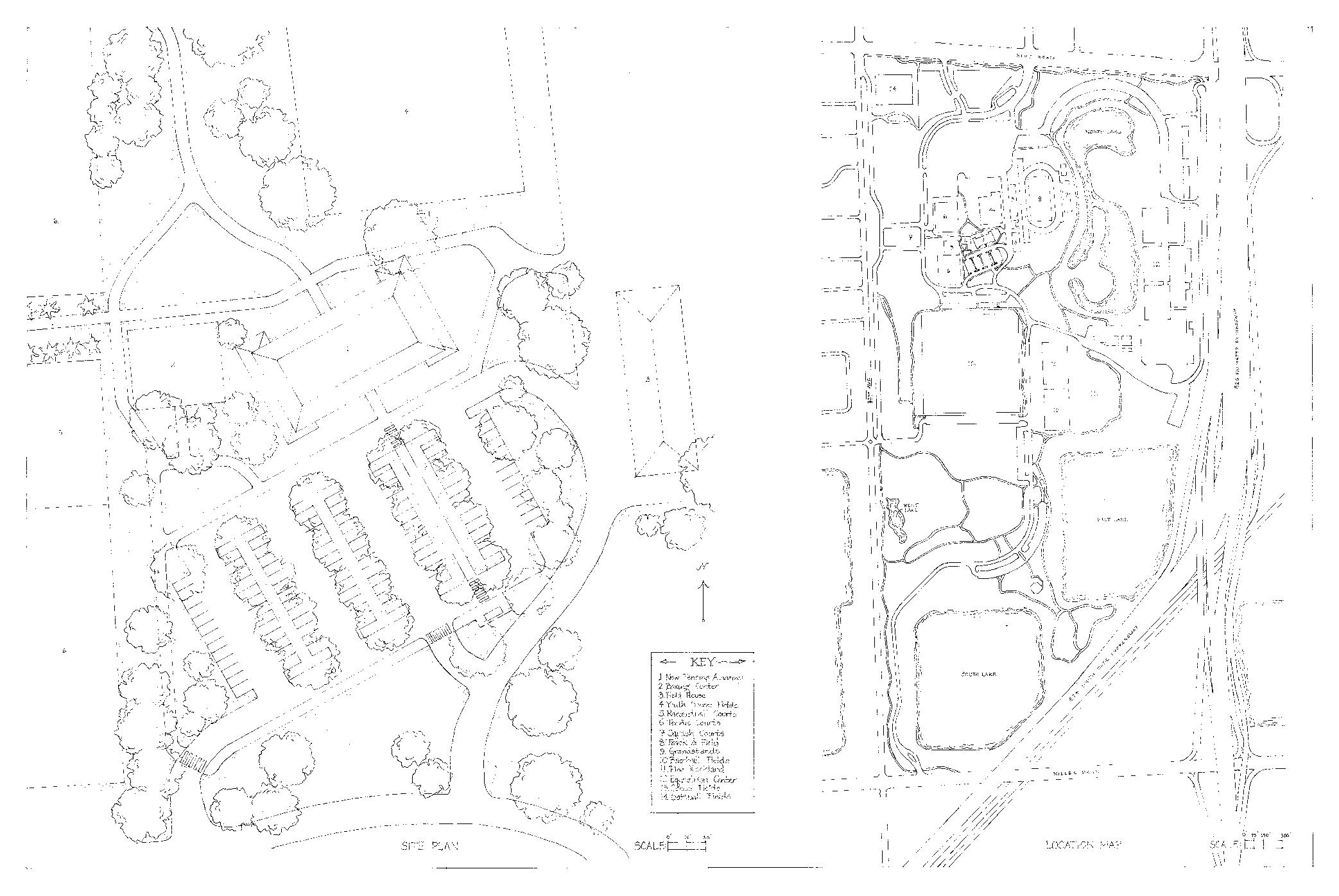
Right: Site Plan, Location Map and Architectural Context. This drawing was produced as a studio of 8 students; my contribution was all freehand typography and the Church of the Little Flower facade vignette
Above: South (Front) Elevation
Right: Site Plan, Location Map and Architectural Context. This drawing was produced as a studio of 8 students; my contribution was all freehand typography and the Church of the Little Flower facade vignette
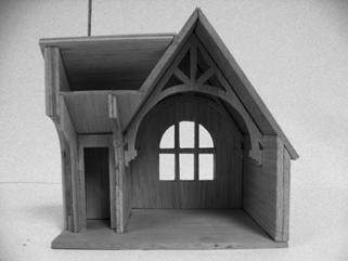
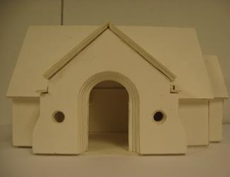
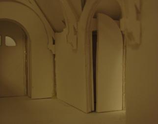
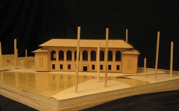
 Top: early design studies, Center: foam core study model, Bottom: basswood final model
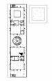
Right: Plans, sections, elevations, reflected ceiling, roof and site plans of chapel
Top: early design studies, Center: foam core study model, Bottom: basswood final model
Right: Plans, sections, elevations, reflected ceiling, roof and site plans of chapel
Tropical Park Fencing Academy
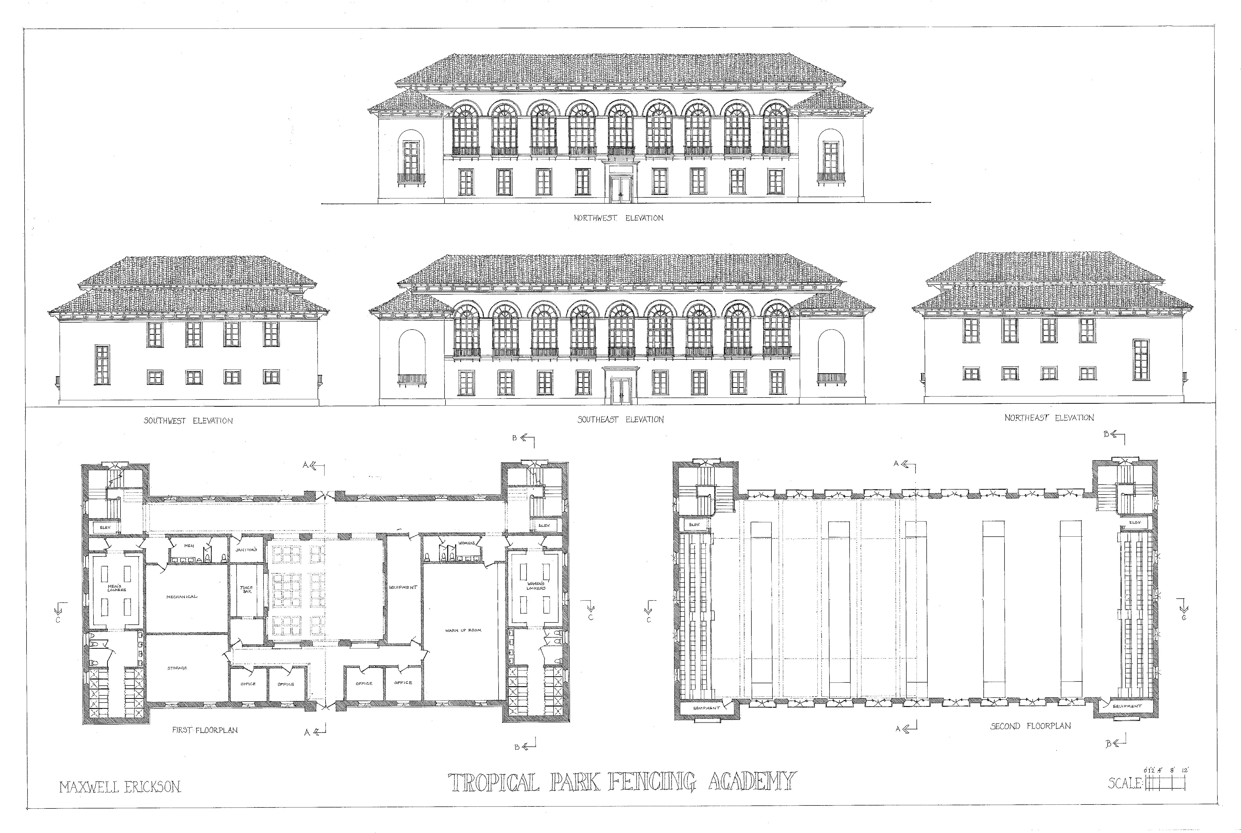
Miami, FL | Prof. Richard John Ink on mylar | Spring 2016
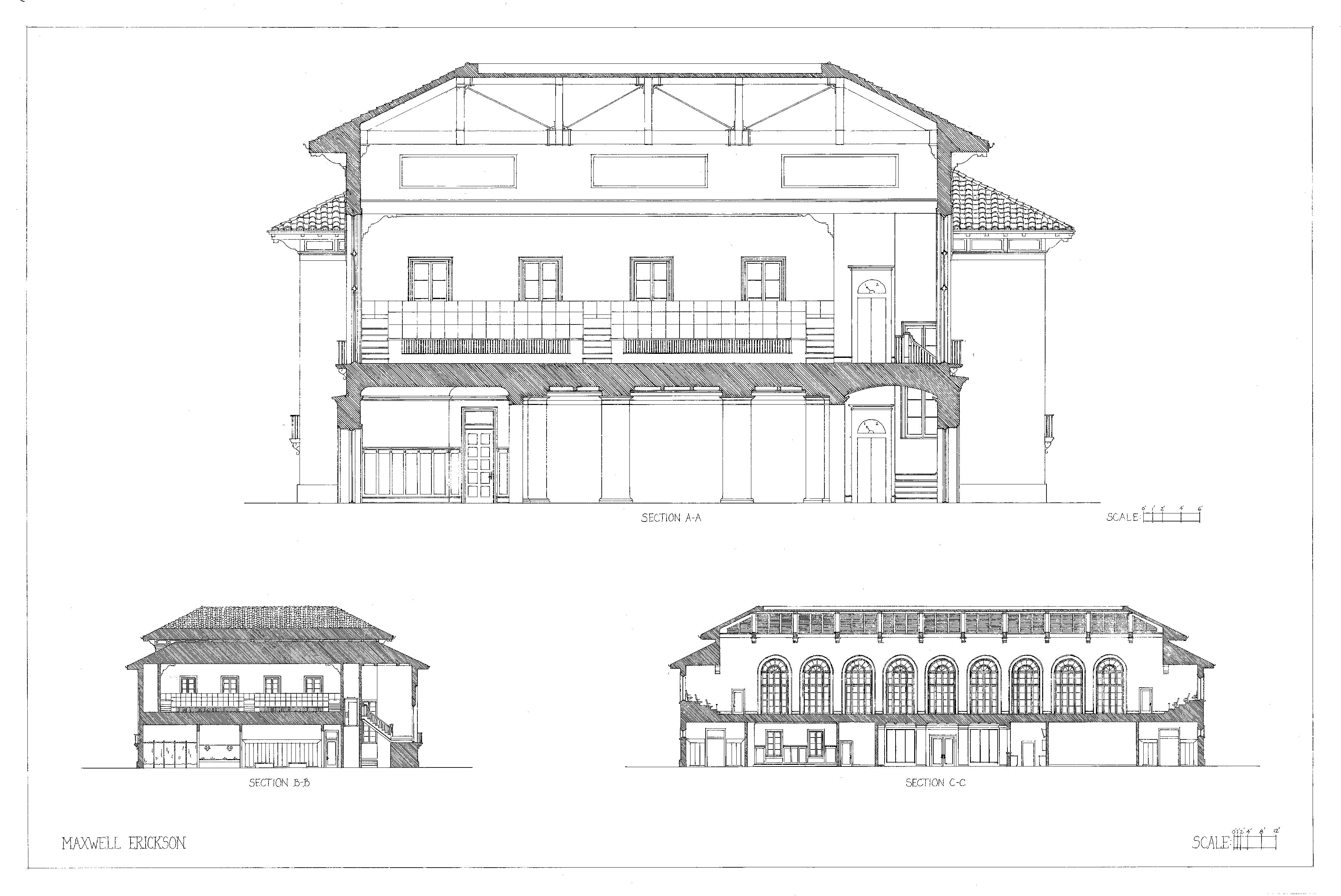
Aside from Moretti’s famous hall in Rome, there are few facilities dedicated solely to the art of fencing, providing the unique opportunity to invent a new type. This site nestled within the heart of sprawling Tropical Park was uninspired, but allowed for placemaking through not only a landmark structure, but also a miniature urban intervention. In the Mediterranean Revival tradition of South Florida, the fenestration is inspired by Battle Hall at UT Austin, but the function adapted. Its focalpoint is the second foor competition hall, a grand open space


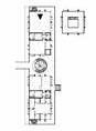
Top: detailed latitudinal section facing East
Below: latitudinal section facing East and side elevation facing West
Top Right: longitudinal section facing North
Center and Bottom Right: first and second floor plans


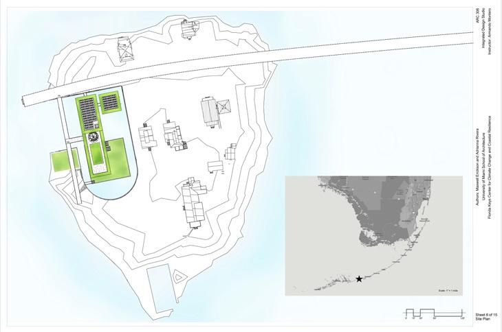
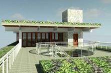
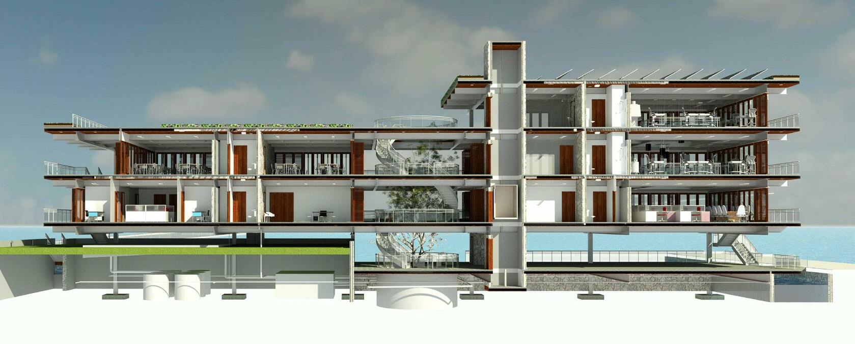
Pigeon Key Environmental Research Station
Pigeon Key, FL | Produced with Adrianna Rivera | Prof. Armando Montero Revit, Photoshop | Spring 2017
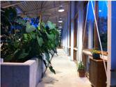
This new facility for the Pigeon Key Foundation does more than provide new spaces for research, education and public outreach- it is a lifeline for future survival on this tiny island as the Florida Keys face the threat of rising sea levels. By creating an elevated, man-made island-within-an-island, built from the material underneath the building which sits on a new inlet, this facility allows for agriculture and life to exist here long into the future when the rest of the island is underwater. The facility is net-zero, generating all of its electricity needs on-site with solar panels and water turbines and handling all of its own wastewater, with a four-step fltration system pioneered by the Omega Center for Sustainable Living as a means to turn blackwater back into fresh, drinkable water through anoxic tanks, wetlands, lagoons and a sand flter. The building is oriented in the same direction as the historic houses on the island, north-south, to minimize solar heat gain and maximize the collection of breezes to passively cool the interior. Only 32’ wide, most spaces are exposed on both sides, and all are dynamically sensored to mnimize HVAC usage. Green roofs and shelves help shade and cool the interior spaces as well. The central space is an open-air green courtyard where visitors can interact with a tree and the lagoons below, reinforcing the building’s environmental focus.
Top
Bottom Right: 3D views of project
 Above: View of project from the East (rest of the island)
Right:Site plan and location within Florida Keys
Above: View of project from the East (rest of the island)
Right:Site plan and location within Florida Keys
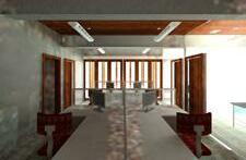
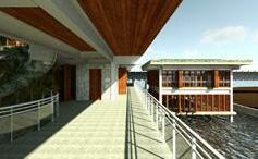
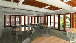
Authors: Maxwell Erickson and Adrianna Rivera ARC 306 Integrated Design Studio Instructor: Armando Montero Florida Keys Center for Cl imate Change and Coastal Resilience University of Miami School of Architecture Sheet 2 of 15 Renderings View from the second floor outdoor corridor looking North towards the library/indoor exhibition building View of the second floor open office area looking East towards the rest of the island View of the third floor north classroom looking Northwest towards the central open green space View of the second floor research space looking up towards the hanging lanterns on the fourth floor ceiling in the lab space View of the second floor main approach to the building facing East from the ramp towards the rest of the island View of the fourth floor rooftop green deck facing north towards the wet labs, and down into the central green space
Accessible green roof
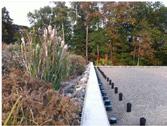
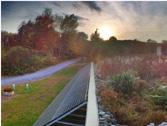
Wide eaves to facilitate shading, and green shelves to absorb heat
Exterior circulation to minimize conditioned space
Top: Section perspective showing envronmental features
Bottom: Description of water reclamation system
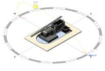
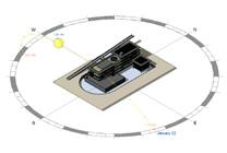
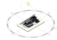
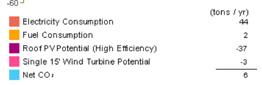
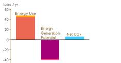
Right: diagrams showing energy use and generation and sun studies
Central blocks clad in coral
Sun
Wind
First blackwater is sent to anoxic tanks, where it is treated with bacteria.
Second, it is pumped into rubberlined wetlands 3’ deep with gravel and marshy plants
Third, it is pumped into plant-flled lagoons 10’ deep, divided into four chambers.
Fourth, it is sent through a gently sloped sand flter which seperates out fne particulates before it goes into collection tanks where it is safe to drink
Solar panels on roof
Operable exterior walls comprised of glass folding doors and track-mounted salvaged wood louvered shutters
North-south orientation, mostly one room wide to capture prevailing breezes
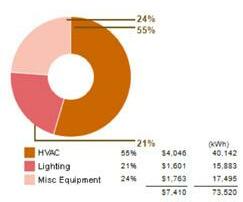
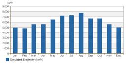
Monthly Energy Consumption
Sun Studies
coral stone quarried from site
Humidity
March 21, 1pm June 21, 1pm January 21, 1pm
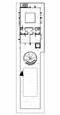
Above: Floor plans, levels 1, 2 (top) and 3, 4 (bottom)
Top Right: HVAC system axonometric Bottom Right: Plumbing and waste systems axonometric
UP UP UP UP DN DN DN DN UP UP DN F 1 9 3 9 2 9 1 2 REST 1 9 3 9 2 9 3 16 13 15 12 12 14 11 10 10 4 5 88 8 8 8 7 7 6 9 3/32" = 1'-0" 1 Level 1 3/32" = 1'-0" 2 Level 2 0' 6' 12' 24' 48' Authors: Maxwell Erickson and Adrianna Rivera ARC 306 Integrated Design Studio Instructor: Armando Montero Florida Keys Center for Cl imate Change and Coastal Resilience University of Miami School of Architecture Sheet 7A of 15 Floor Plans Level 1 & 2 Key 1. Outdoor Exhibit (1981 sq ft) 2. Indoor Exhibit (982 sq ft) 3. Library (726 sq ft) 4. Reception (266 sq ft) 5. Conference Room (377 sq ft) 6. Open Office (351 sq ft) 7. Meeting Room (114 sq ft) 8. Office (57 sq ft) 9. Kitchen (57 sq ft) 10. Restroom (45 sq ft) 11. Storage (107 sq ft) 12. Mechanical Room (68 sq ft) 13. Digital Fab Lab (488 sq ft) 14. Material Storage (96 sq ft) 15. Server (107 sq ft) 16. Open Research (977 sq ft) UP UP DN DN DN DN 1 9 3 9 2 9 17 22 22 20 21 23 25 24 19 18 18 1 9 3 9 2 9 26 26 17 19 18 18 0' 6' 12' 24' 48' 3/32" = 1'-0" 1 Level 3 3/32" = 1'-0" 2 Level 4 Authors: Maxwell Erickson and Adrianna Rivera ARC 306 Integrated Design Studio Instructor: Armando Montero Florida Keys Center for Cl imate Change and Coastal Resilience University of Miami School of Architecture Sheet 7B of Floor Plans Key 17. Open Lab (721 sq ft) 18. Bathroom (60 sq ft) 19. Instrument Storage (94 sq ft) 20. Fabrication Shop (488 sq ft) 21. Material Storage (96 sq ft) 22. Classroom (653 sq ft) 23. Storage (73 sq ft) 24. Storage (89 sq ft) 25. Restroom (45 sq ft) 26. Wet Lab (200 sq ft) 27. Accessible roof terrace 27 UP UP DN DN DN DN 1 9 3 9 2 9 17 22 22 20 21 23 25 24 19 18 18 1 9 3 9 2 9 26 26 17 19 18 18 0' 6' 12' 24' 48' 3/32" = 1'-0" 2 Level 4 Authors: Maxwell Erickson and Adrianna Rivera ARC 306 Integrated Design Studio Instructor: Armando Montero Florida Keys Center for Cl imate Change and Coastal Resilience University of Miami School of Architecture Sheet 7B of 15 Floor Plans Key 17. Open Lab (721 sq ft) 18. Bathroom (60 sq ft) 19. Instrument Storage (94 sq ft) 20. Fabrication Shop (488 sq ft) 21. Material Storage (96 sq ft) 22. Classroom (653 sq ft) 23. Storage (73 sq ft) 24. Storage (89 sq ft) 25. Restroom (45 sq ft) 26. Wet Lab (200 sq ft) 27. Accessible roof terrace 27


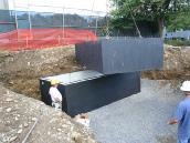
Authors: Maxwell Erickson and Adrianna Rivera ARC 306 Integrated Design Studio Instructor: Armando Montero Florida Keys Center for Cl imate Change and Coastal Resilience University of Miami School of Architecture 1 MECHANICAL ISOMETERIC Sheet 12 of Mechanical Systems We chose to combine a Split DX with VRF forced air HVAC system on the main building with a VRF system on the auxilary building, due to efficiency concerns. The split DX has an AHU on each wing of each floor and localized ducted supply and partially ducted return. Outdoor units are grouped together outside each wing of the building. These are tied to a motion sensor system to dynamically adjust supply based on loading. The VRF system in the auxilary building was the most practical way to keep the HVAC system out of sight since there were no spaces to hide it in. VRF units Air Handling Units 7-ton Outdoor units for each AHU Authors: Maxwell Erickson and Adrianna Rivera ARC 306 Integrated Design Studio Instructor: Armando Montero Florida Keys Center for Cl imate Change and Coastal Resilience University of Miami School of Architecture 1 PLUMBING ISOMETERIC Roof drainage sloped to feed into gutters inside columns which lead to water collection barrels KEY Green: Sanitary Waste & Venting Black: Rainwater collection Blue: Cold Water Supply Red: Hot Water Supply Sand Filter (stage 3 of reclamation process) Water collection barrels Septic Tanks Lagoons filled with tropical plants (stage 2 of reclamation process) Wetlands, 3 feet deep with rubber lining (stage 1 of reclamation process) Sheet 13 PIPE SIZING Vertical stacks: Waste 4 inches Hot & Cold Water 1.25 inches Venting 1.5 inches Drainage 2 inches Branches: Waste 4 inches to water closets, 2 inches to lavatories and showers Hot & Cold Water 1 inch Venting 1.5 inches
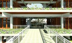
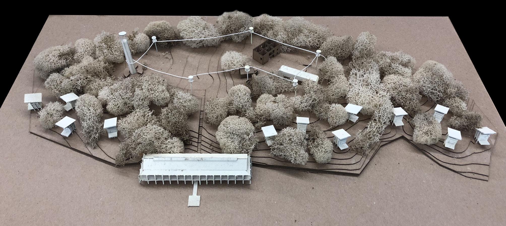
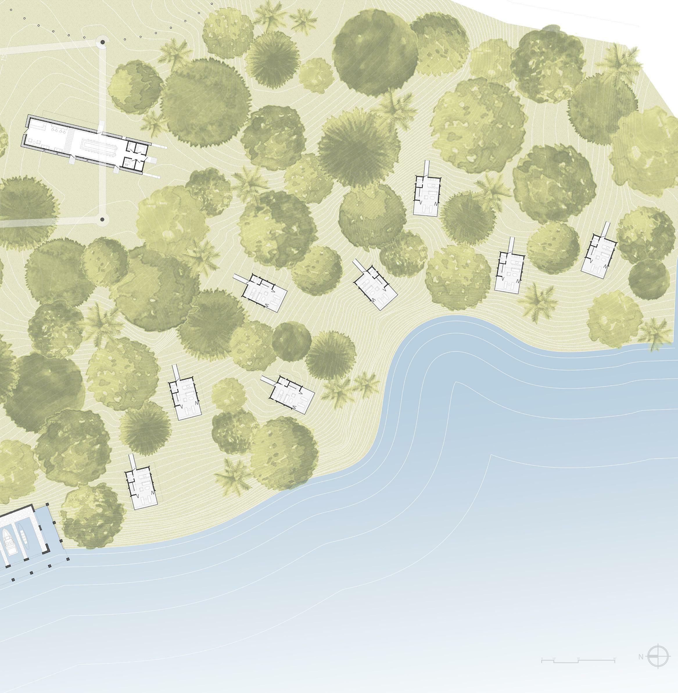
Interventions at El Ingenio de Engombe
Santo Domingo, DR | Produced with Olivia Kramer | Profs. Jaime Correa and Carmen Guerrero AutoCAD, Rhino, SketchUp, Photoshop, Pen, Chipboard, Wire, Basswood, Moss, String| Spring 2019
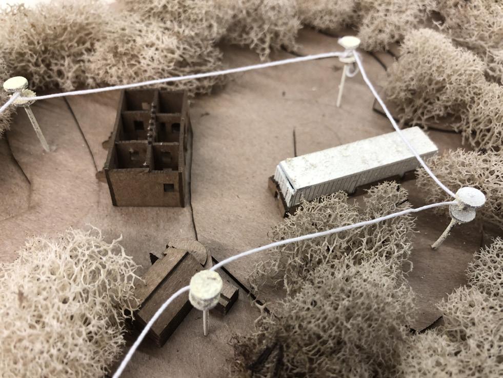
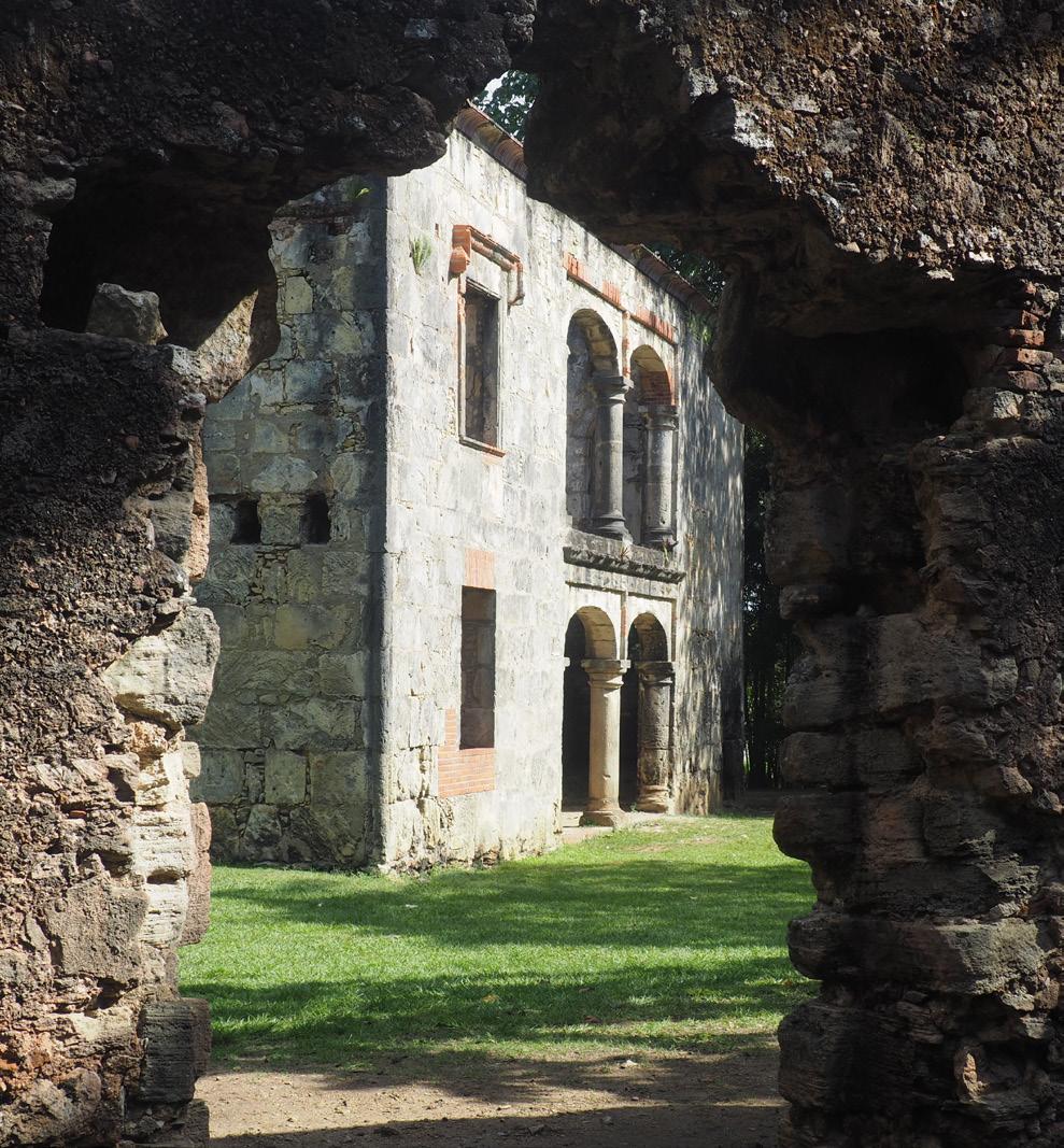
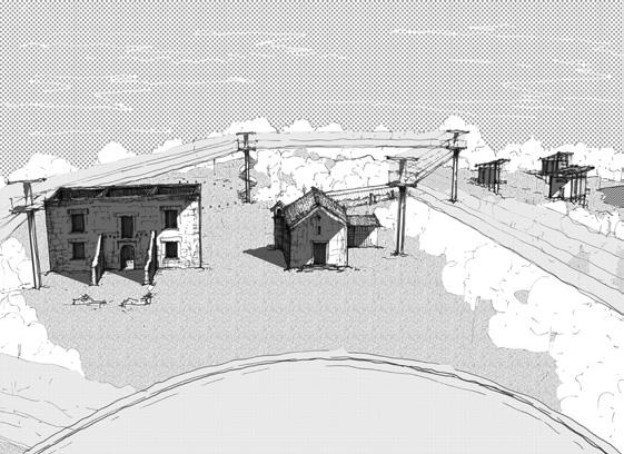
Our studio visited the ruins of four historic sugar mills on the outskirts of Santo Domingo, DR. Sugar cane production was historically a central part of the island nation’s economy, and these historic plantations are now endangered by informal settlements infringing upon their sites. The government is interested in preservation and promoting tourism while surveys of the local community show a lack of accessibility, a need for greater safety and desire for indoor public gathering spaces. I worked with Olivia Kramer on Engombe, the most urban of the four, along the River Haina. This studio was conducted in collaboration with UNPHU, a leading university in Santo Domingo, with their studdents engaging in parallel projects to ours. While in the DR, we engaged in a charette with them, local historians, and government ministers of public monuments and tourism. The historically slave and ox-powered mill comprises today of the trapiche (mill) itself, a round building with an attached furnace room, of which only the foundations remain, a drying building, of which only a fragment of one wall remains, a warehouse, of which partial height walls remain, a church, which has been reconstructed, and an owner’s mansion, which has received restoration work as well, and all but the roof remains. The community today takes Quinciniera photos in the mansion and attends services at the church on Sundays, so we left these two structures untouched.
At the macro level, a ferry system will connect our site to Palave, another mill located upstream, stopping at local communities along the way. A biking/walking trail along the river’s edge with intermittently placed stations offering frst aid, bicycle repair and snacks could make this a safe, attractive recreational amenity.
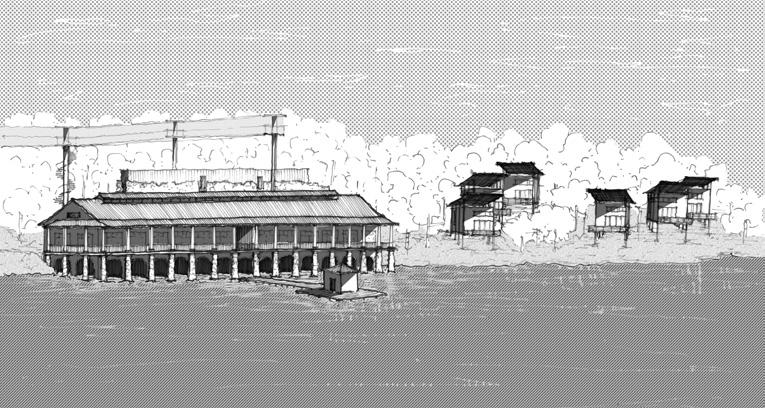
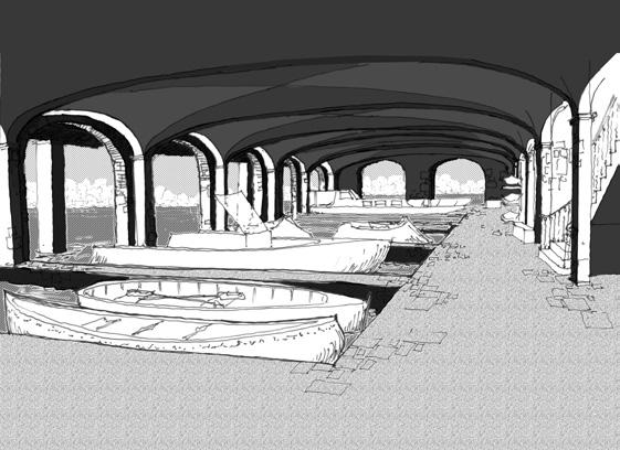
Approaching the site by water, the visitor experiences a long boathouse sitting at the water’s edge inspired by vernacular Dominican architecture with a ferry pier extending into the river.. Here they can disembark on the dock or pull private watercraft into safe harbor in a boat slip underneath the building. Either way, they will fnd themselves in a grotto-like stone room with a groin-vaulted ceiling. From here they can ascend one of two staircases to ground level, where they can turn into the site, or step out onto a wraparound porch with panoramic views of the river. A restaurant and bar on one side and a community room on the other are connected with an internal spine. Each has a series of glass front doors opening out onto the porch and a ceiling exposed to the roof structure with a lantern to allow for air to escape, facilitating passive cooling. The community room could be used for job training programs, community meetings or even weddings.
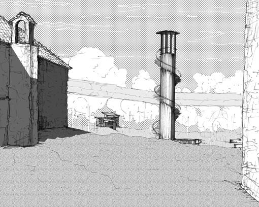
Rising from the center of the trapiche is an observation tower, inspired by Angiolo Mazzoni’s water towers at Termini station in Rome.. A staircase winds around a core of louvers, rendering a see-through structure that hosts an observation deck towering over the site which provides views down the river and to the ocean. This building ties into an aerial walkway system.
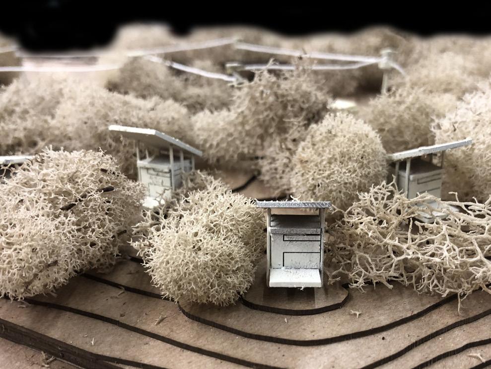
Starting from the base of the tower, the arrival plaza or a vehicular drop off point at the landside entrance to the site, spiral stairs lead up to an interactive netted aerial walkway system, with stops at strategic locations along the route with educational signage teaching the history of each historic building on the site, crossing over the roofs of the ruins, shaded by a lush canopy of trees overhead.
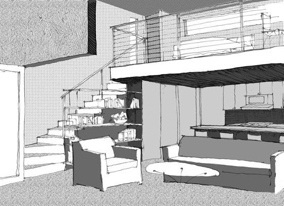
Sitting just within the warehouse walls is a pure glass and polycarbonate box containing an italian coffee bar, lounge, community library and reception space lined in bookshalves cantilevered off the glass walls exposing the rustic stone ruins behind. Small booths inspired by those at the cloister of Santa Maria Della Pace frame narrow windows that once protexted the sugar stored within from rotting. Lastly, a series of 12 cabins comprises an eco-hotel, providing accomodation for the family members of locals, NGO workers or visitors interesting in connecting with the culture. Nestled in the trees framing views of the river, each cabin is raised on stilts allowing the forest foor to run unabated underneath. Inspired by Peter Zumthor’s Zinc Mines Museum in Norway, each has an exposed steel superstructure with a wide sloping roof encapsulating a pure wood box, allowing air to fow all around the living space to keep it cool. Arriving along a narrow walkway, the giuest walks in on the land side, entering a low space with a bathroom and eat in kitchen before arriving in the two-story liiving space that spills out onto a covered deck overlooking the river. A bedroom loft above features a built-in desk and windows on all sides, so they can sleep among the treetops.
OTHER SCHOOLWORK IN THE DESIGN STUDIO PROFESSIONAL WORK PERSONAL WORK SKETCHES & WATERCOLORS
Opp. Top: Photos of the existing conditions, Bottom: a model of the proposed interventions
Above:
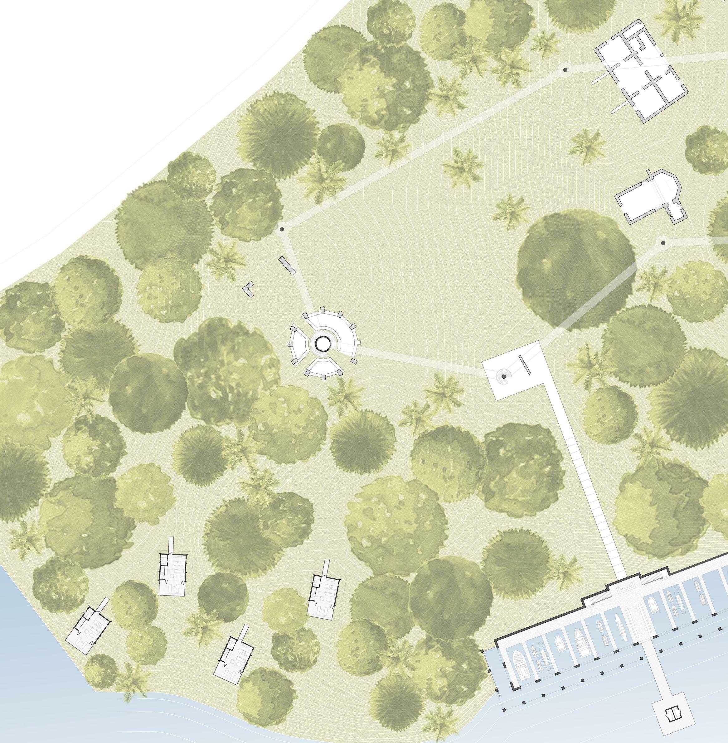 Site Plan (ruins hatched in light gray and new interventions hatched in dark gray) L to R: approaching the site by water, the boathouse slips, the tower framed by the chapel and mansion, the view from the observation tower over the site, inside the cafe/library/ reception space in the warehouse, the cabins
0'1' 8' 4' 16' 32' N
Above: The boathouse; site section showing its relationship to the river Opp. Left: The observation tower, Top right: The warehouse, Bottom right: The cabins
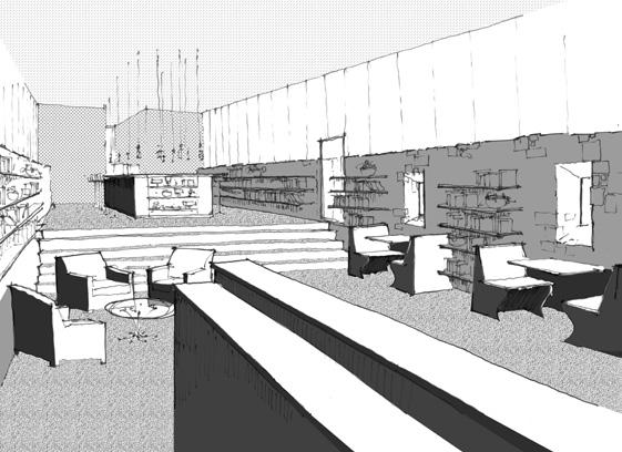
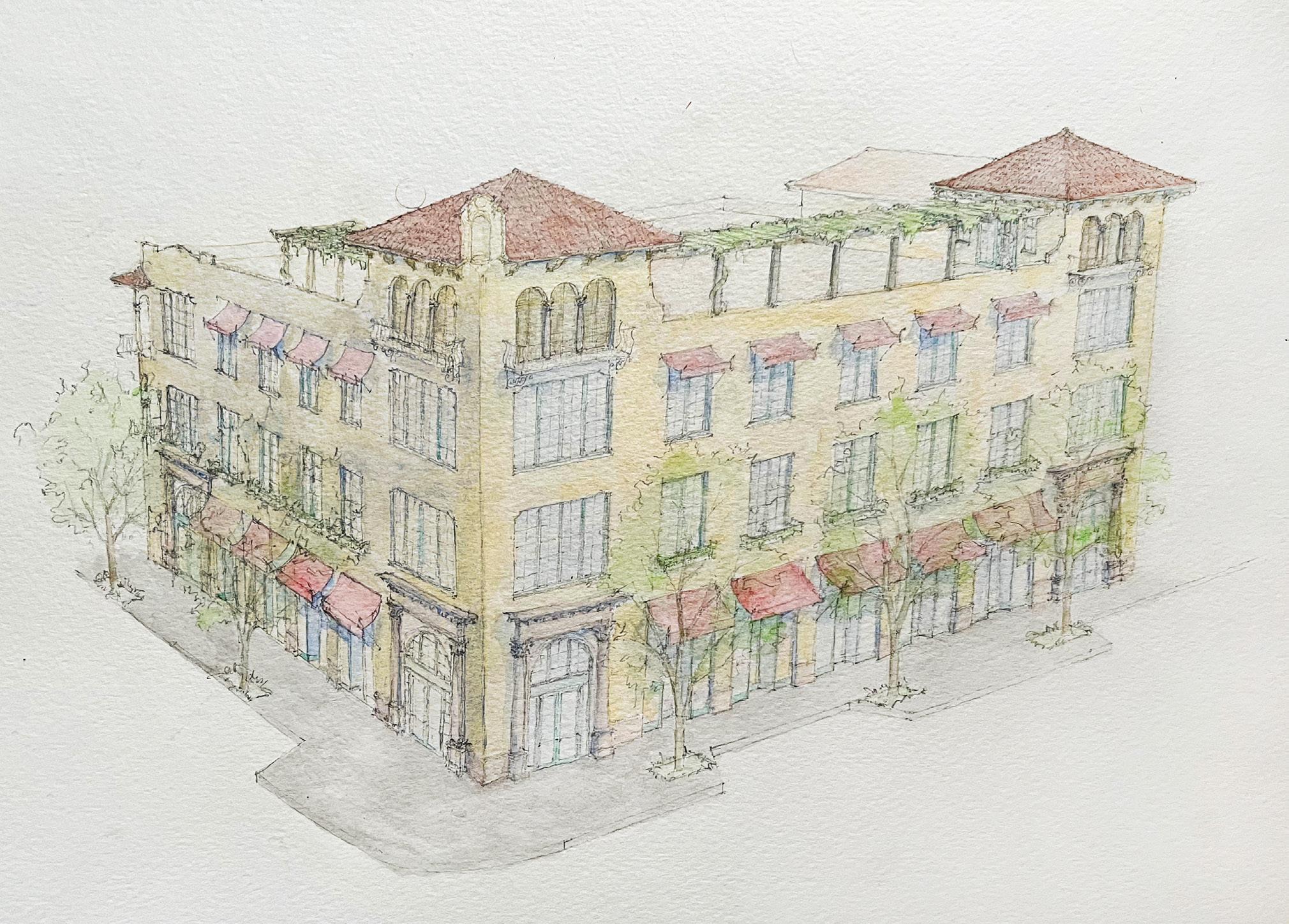
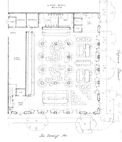
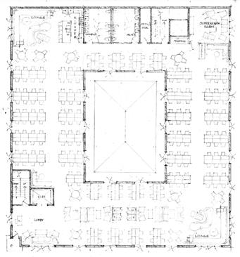
e San Lorenzo
351 San Lorenzo Ave, Coral Gables, FL
Pencil, SketchUp | Fall 2018
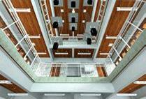
This mixed-use food hall and coworking offce building with a rooftop bar was designed for a Real Estate Development + Urbanism course. I was the sole designer as part of a team of MBA and MRED students doing a mock project on an assigned site. We were tasked with developing a program to ft real-life market needs, complying with real-life planning, zoning and building code requirements, and justify it with a Pro Forma. This site is directly across from the main entrance to the Shops at Mer rick Park, an upscale outdoor mall, so an affuent market base was ready to tap into. Since thousands of adjacent luxury residential units in the immediate area outstipped demand, we studied missing program types.. Neither a food hall nor coworking space were in the immediate area, and there was a hot market at the time for these uses. I maintained a Mediterranean Revival architectural language consistent with the local vernacular, with iconic corner towers speaking to those fanking the entrance to the mall across the street. A large central lightwell over a glass atrium provides ample natural light and promotes air fow through the building’s narrow masses. The rooftop complete with a pergola provides stunning views over the central green space of the mall and the neighborhood beyond. The building is designed to easily adapt itself to changing market trends by accomodating conventional individual retail storefronts or a traditional restauranrt concept on the ground level, and to a conventional offce tenant on the upper foors.
OTHER SCHOOLWORK IN THE DESIGN STUDIO PROFESSIONAL WORK PERSONAL WORK SKETCHES & WATERCOLORS
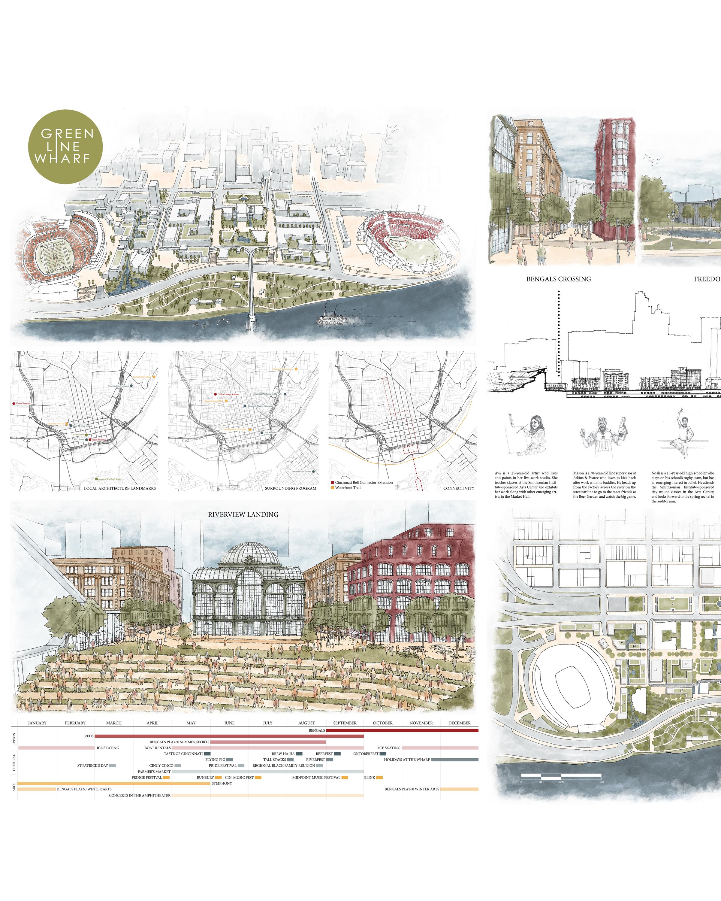
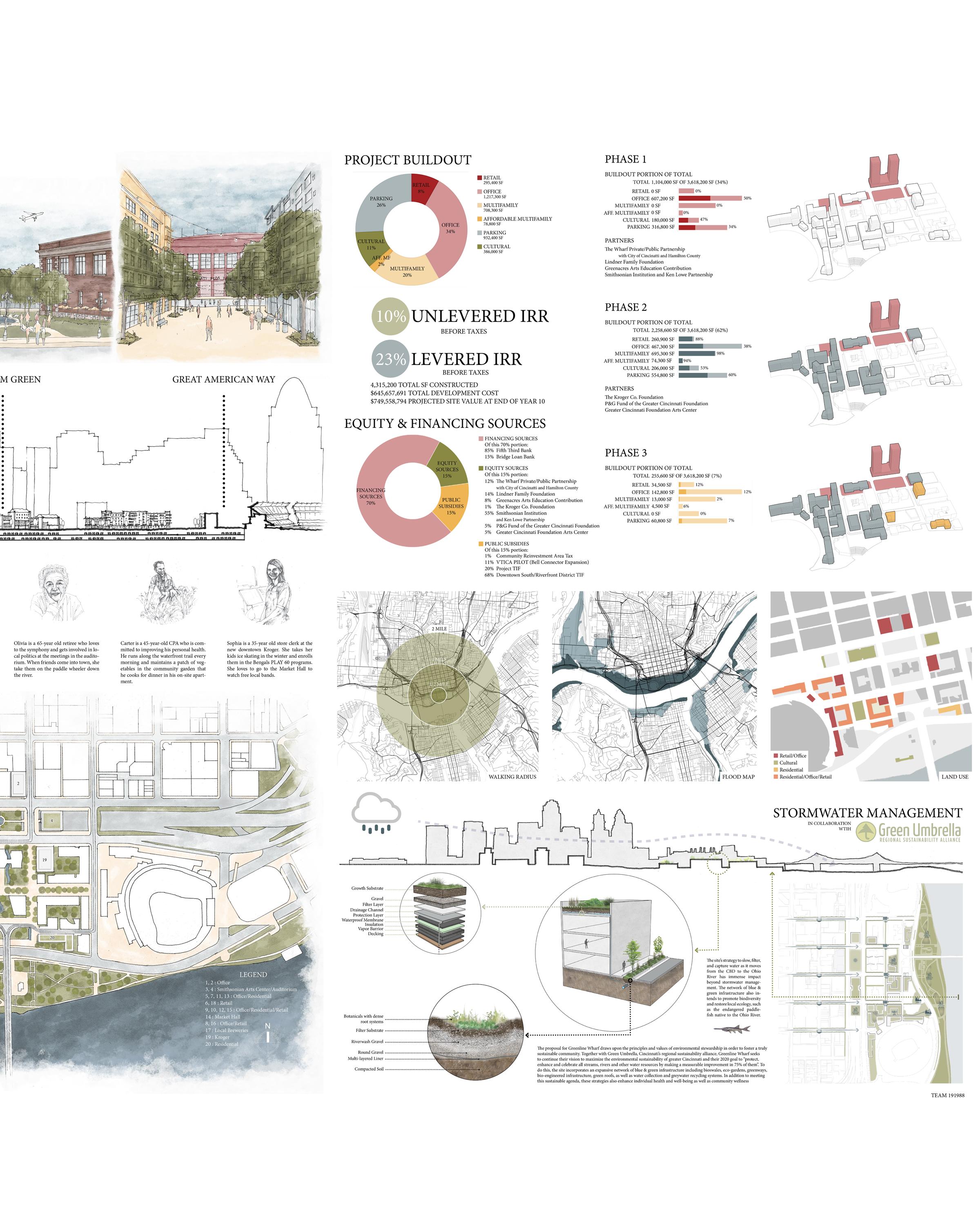
Hines Competition 2019 - Green Line Wharf
Cincinnati, OH | Produced with Olivia Kramer, Jennifer Lamy, Elizabeth Perry and Peyton Smyth Ink, Trace, Rhino, SketchUp, Excel, Photoshop, Illustrator, Indesign | January 2019
We were tasked with revitalizing a site along the Ohio River that has long lacked energy and character. The site was once the heart of Cincinnati’s historic downtown, and held the Greene Line Wharf, the main dock for a series of competing passenger steamboats. A midcentury urban renewal project led to the leveling of this historic fabric and the construction of a wide snaking freeway cutting off the waterfront from downtown. Since then, construction of football and baseball stadiums for the Bengals and Reds, respectively led to a district only activated on gamedays. Most recently, The Banks, a public-private redevelopment initiative designed by Urban Design Associates made infrastructural improvements including “burying” the freeway in a trough and creating a system of elevated roadways, mainly to address chronic fooding issues. This work laid the foundation for our proposal.
Green Line Wharf will be Cincinnati’s new arts, culture and sports epicenter. Supplementing the previouslyannounced symphony hall with centers for arts education, outreach and performance, providing a large indoor venue to facilitate year-round public gatherings and events, and linking the existing stadiums with a new sportscentered retail street, this proposal will reinvigorate the waterfront into a dynamic live-work-play destination. Arts. A new Smithsonian Institute and Ken Low Partnership-sponsored center for music, visual and performing arts will establish a community education hub with a new auditorium, hosting performances and community gatherings. Fronting the central square on the new freeway lid, with ground-foor retail, these facilities will provide a welcoming gateway to the neighborhood. Culture. A new iconic civic space will draw on an existing symphony hall amphitheater to add a craft brewerylined beer garden and market hall plaza to enjoy live music, local products and sweeping views of the Ohio River. The new market hall will provide an expansive winterized space facilitating year-round programming for the many cultural events, festivals, and community gatherings that already give this neighborhood its heart. Sports. A new pedestrian-only street lined with sports bars and team-branded shops will serve the local, tourist and the game day communities and will be elevated to link directly to the stadium platform enabling seamless pedestrian connectivity to their entrances. New greens and public spaces can expand the reach of the youth-focused Bengals athlete outreach programs to include arts and sports, along with community access to ice skating in the winter and boat rentals in the summer.
The elevated base of Green Line Wharf’s streets and sidewalks connecting to the football stadium platform will also extend to the existing riverfront street separating the site from the water. The lowering of one of the perpendicular streets to grade will establish a new ground for development that allows for expansive views while facilitating food protection for the neighborhood. A retaining wall along the byway will provide a canvas for street art and green walls. The existing elements of a waterfront trail will be stitched together to provide an east-west pedestrian corridor, while an expansion of the existing streetcar line across the landmark John A. Roebling Suspension Bridge will provide a convenient north-south connection. A new riverboat landing commemorates the historic Greene Line Wharf.
The northern and western edges of Green Line Wharf will draw a signifcant and diverse population to live, work and shop in new eight to twelve-story mixed-use offce, retail and residential buildings featuring hallmark towers ranging to seventeen stories. Along the river, four-story structures will enable views for the inland buildings which climb in height while sharing an architectural language and scale consistent with historic downtown Cincinnati. All service will be accomplished through an extensive two-storyh underground parking garage feeding into an existing transit center.
New buildings will be clustered around lushly planted courtyards that rely on a blue infrastructure collection system which also recycles and flters water to sustain newly planted street trees and urban agriculture. Green roofs, photovoltaic glass on southern exposures and the use of recycled and local materials will establish Green Line Wharf as an environmentally just and socially responsible community. Its prominent green profle and high-impact facilities for arts and cultural, and recreational opportunities, grounded by new retail, residential and offce space will establish Green Line Wharf as an exciting year-round destination that all Cincinnatians can feel proud to call their own.
All of us participated equally in the conceptual design, urban planning and overall branding. I was heavily involved in the graphics, helping to select the color palette, creating the event timeline, four of the fve regional map diagrams, the graphics conveying the fnancial information and phasing breakdown for the project, designing all of the architectue seen in the renderings, and producing all of the hand-drawn ink underlays for the ground-level perspective views (the color in these renderings was added by teammates in Photoshop). I also wrote all of the written components of the submission.
The Hines competition challenges participants to work together to reinvigorate real-life urban neighborhoods in varying cities, creating a detailed development proposal over the course of two weeks. Architecture, urban design, landscape architecture, real estate development and business students join together in teams of fve representing at least three of these disciplines to propose a solution including branding, an urban plan, identifying program types, implementation strategy and fnancial Pro Forma addressing reallife market needs. A panel of judges representing a range of disciplines, including real-life community stakeholders, reviews these submissions.
Please see following page
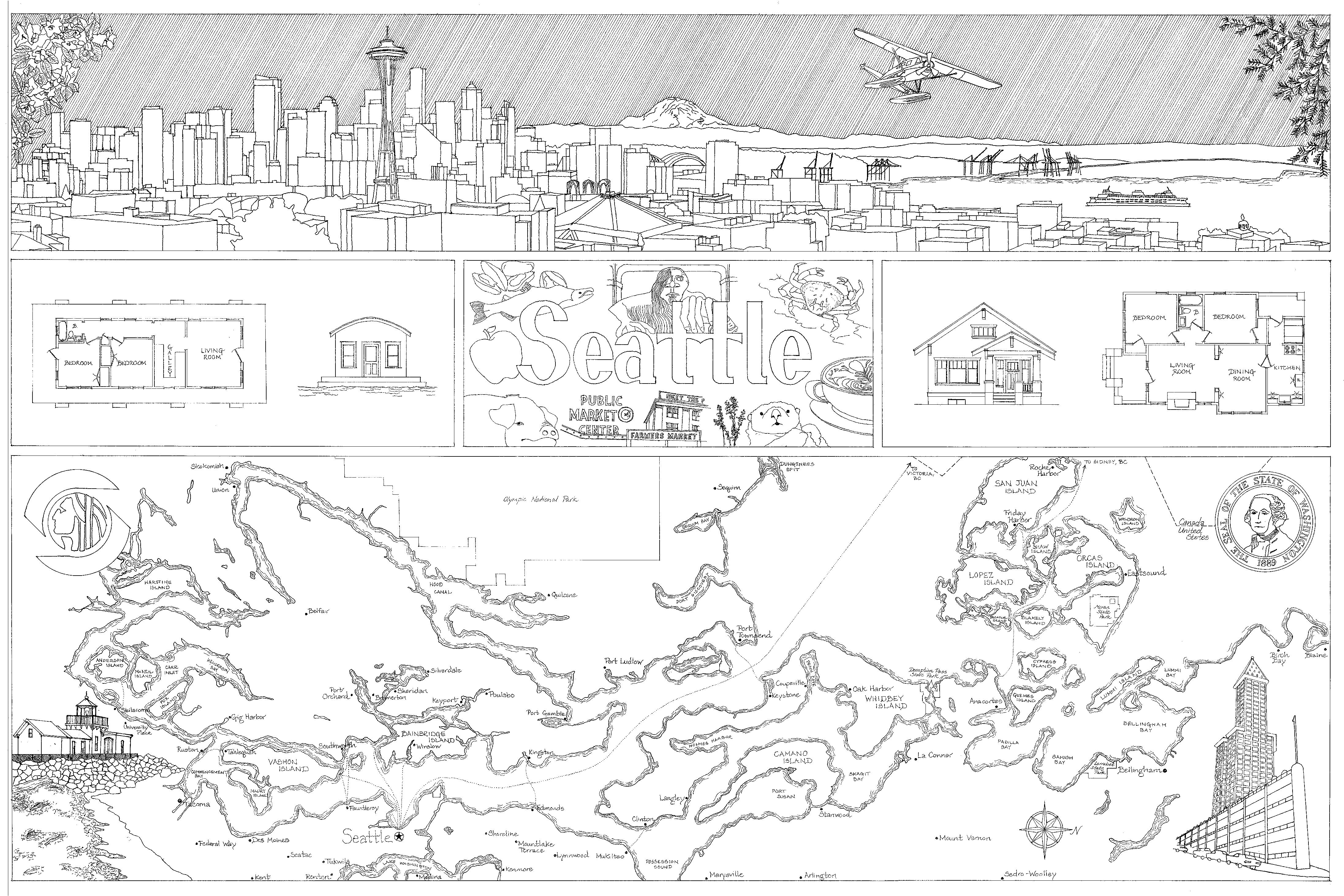
Hometown Map
Seattle, WA | Prof. Steven Fett
Ink on mylar | Fall 2015
A celebration of all things Seattle, the hometown map is more than just a geographic outlay, it is a representation of the natural and man-made environment and the culture and icons of one’s city. In the top corners are the state fower and tree, the Rhododendron and Western Hemlock, respectively. Between them is the view from Kerry Park, with Seattle’s famous ferries and seaplanes, complete with stylized rain. Below it to the left is a typical logger’s houseboat from the early 20th century and to the right is a house of my own design modeled after a typical 1920s bungalow. In the center is the Fremont Troll, seafood, coffee, sea otters, lavender, the Pike Place Market sign, Rachel the pig, apples and salmon. Below is a map of Puget Sound showing the ferry lines, along with the seal of the city of Seattle and the state of Washington. Finally in the lower corners are the Discovery Point lighthouse and the Smith Tower framed behind the “sinking ship” parking garage in Pioneer Square, a reminder of the city’s past and present.
Please see following page
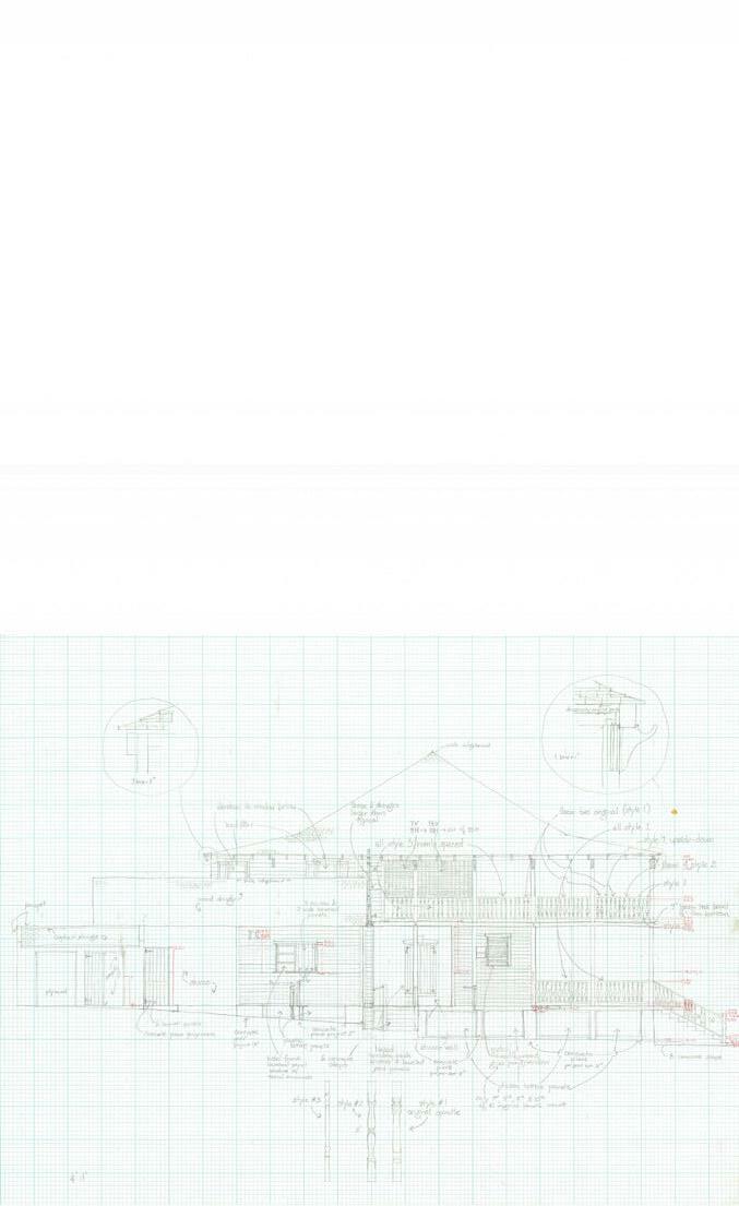
Governor’s House HABS Documentation
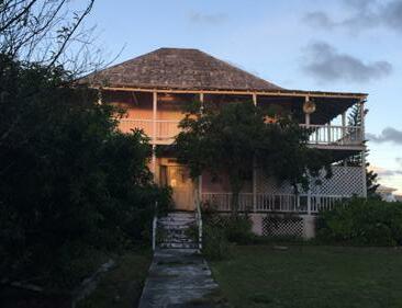
Dunmore Town, Harbour Island, The Bahamas | Prof. Ricardo Lopez AutoCAD produced from pencil and pen field sketches | Spring 2016
I had the extraordinary opportunity to travel to Harbour Island to document the historic home of Lord Dunmore of Virginia, occupied when the island was an American colony. Standing prominently atop the island’s tallest hill, on axis with its main street, this house was once a proud landmark but has fallen into disrepair. Now the island government is planning to restore and preserve it as a museum, and this documentation of its existing condition will serve as a jumping o point to that e ort. All drawings here were produced individually as part of the team documenting the house in its entirety. is project has since won an ICAA Florida Chapter Addison Mizner Award for Research & Documentation.
Above:
Top Right: Field sketch of north elevation
Bottom Right: North elevation
4'-5" 1' 5' 5'-9" 4'-5" 6' 9'-6" 2'-6" 6'-3" 2'-6" 2'-4" 21'-6" 18'-7" 3'-4" 1' 3'-4" 5'-4" 3'-4" 5' 9'-6" 5' 9'-6" 30'-7" 3'-4" 2'-11" 7'-3" 3'-4" 5'-10" 8' 5' 3'-4" 2'-6" 2'-7" 32'-3" 12'-7" 7'-6" 1'-3" 3'-4" 2'-11" 7'-3" 3'-4" 5'-10" 8' 5' 3'-4" 8' 36'-10" 5'-10" 10'-7" 17'-1" 13'-10" 12'-9" 6'-11" 13'-10" 13'-10" 2.5 10 7.5 15 25 FEET METERS SCALE: 1/4" = 1'- 0" S E C O N D F L O O R P L A N
View of existing condition (front elevation) and second floor plan
OPEN OPEN STUCCO STUCCO STUCCO WOOD SIDING JALOUSIE WINDOW ASPHALT SHINGLE WOOD SHINGLE PLASTIC LATTICE WOOD LATTICE AWNING WINDOW PLYWOOD SHEATHING CONCRETE STEPS CONCRETE PIER CONCRETE STEPS CRAWL SPACE ACCESS WOOD DOOR DRAWN BY: MAXWELL ERICKSON SHEET X OF XX SHEETS THE RESIDENCY DUNMORE STREET DUNMORE TOWN HARBOR ISLAND BAHAMAS UNIVERSITY OF MIAMI NATIONAL PARK SERVICE UNITED STATES DEPARTMENT OF THE INTERIOR HISTORIC AMERICAN BUILDINGS SURVEY IF REPRODUCED, PLEASE CREDIT THE HISTORIC AMERICAN BUILDING SURVEY, NATIONAL PARK SERVICE, NAME OF DELINEATOR, DATE OF DRAWING 0 5 10 15 0 3 5 FEET METERS SCALE: 3/8" = 1'- 0" 1 2 0.5 1.5 2 N O R T H E L E V A T I O N 4'-5 13'-6" TOP OF BEAM 6'-5 SECOND FLOOR LINE 0'-0" DATUM LINE -4'FIRST FLOOR LINE 29'-35 8 TOP OF ROOF -9'-0" GROUND LINE 2'-9" 4'-11 10'-1 10'-1 15'-9 38'-3
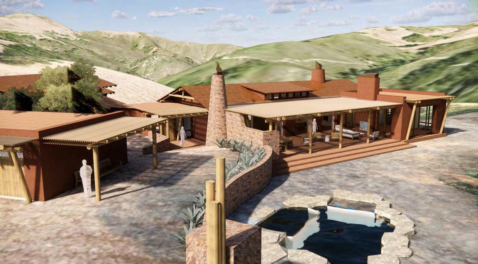
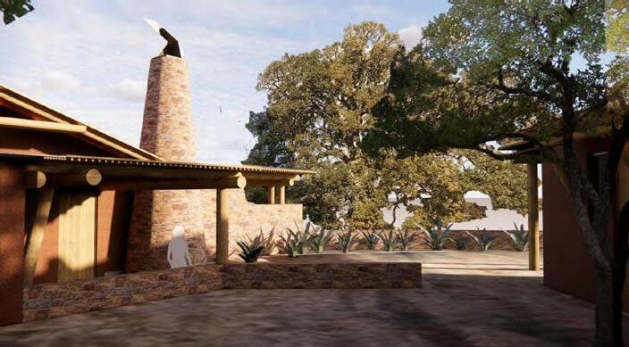
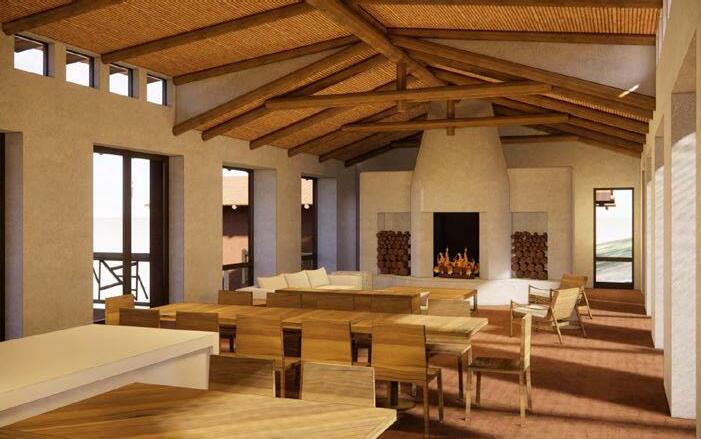
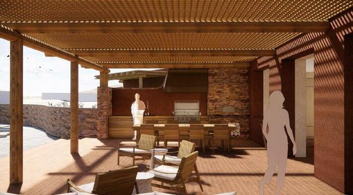
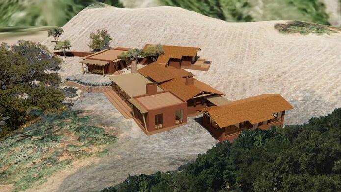
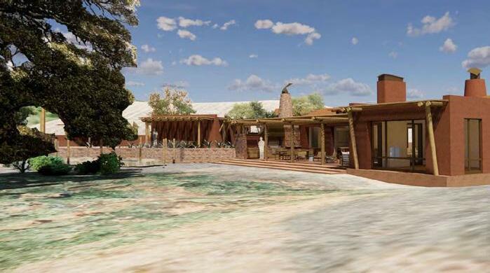
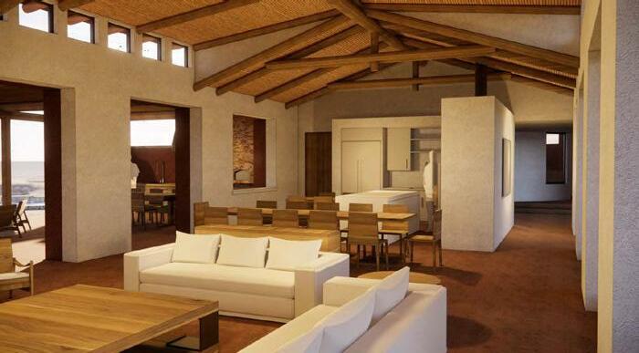
House in Santa Lucia Preserve
Carmel, CA | Producted for Hart Howerton (lead designer Craig Roberts) AutoCAD, SketchUp, Enscape, Photoshop | Spring 2021
This unique residence was designed for a South African couple looking to evoke the vernacular of their home country in central alifornia. In response to very specifc owner re uirements, the program was broken into a series of pavilions evocative of a village, and incorporates stone, gum poles and rustic stucco to create a lodge like architecture. I was the sole draftsperson for the pro ect, working directly with the principal and pro ect manager. any aaspects were designed in , due to the extensive use of organic forms.
OTHER SCHOOLWORK IN THE DESIGN STUDIO PROFESSIONAL WORK PERSONAL WORK SKETCHES & WATERCOLORS
A EA A E A E A E art owerton he designs and concepts property of art owerton without the prior written consent A E E I I A P E A E E A E E eidemann esidence P P A AI E E A A . E ax Erickson, lot slp A A A x sheetfiles A ain evel Plan.dwg, Page etup .ctb, Plot cale P .pc E EA E A E A E art owerton he designs and concepts shown property of art owerton without the prior written consent A E E A I P E A E E A E eidemann esidence IE E A A . E ax Erickson, P lot slp A A A x sheetfiles A odel iews.dwg, Page etup .ctb, Plot cale P .pc
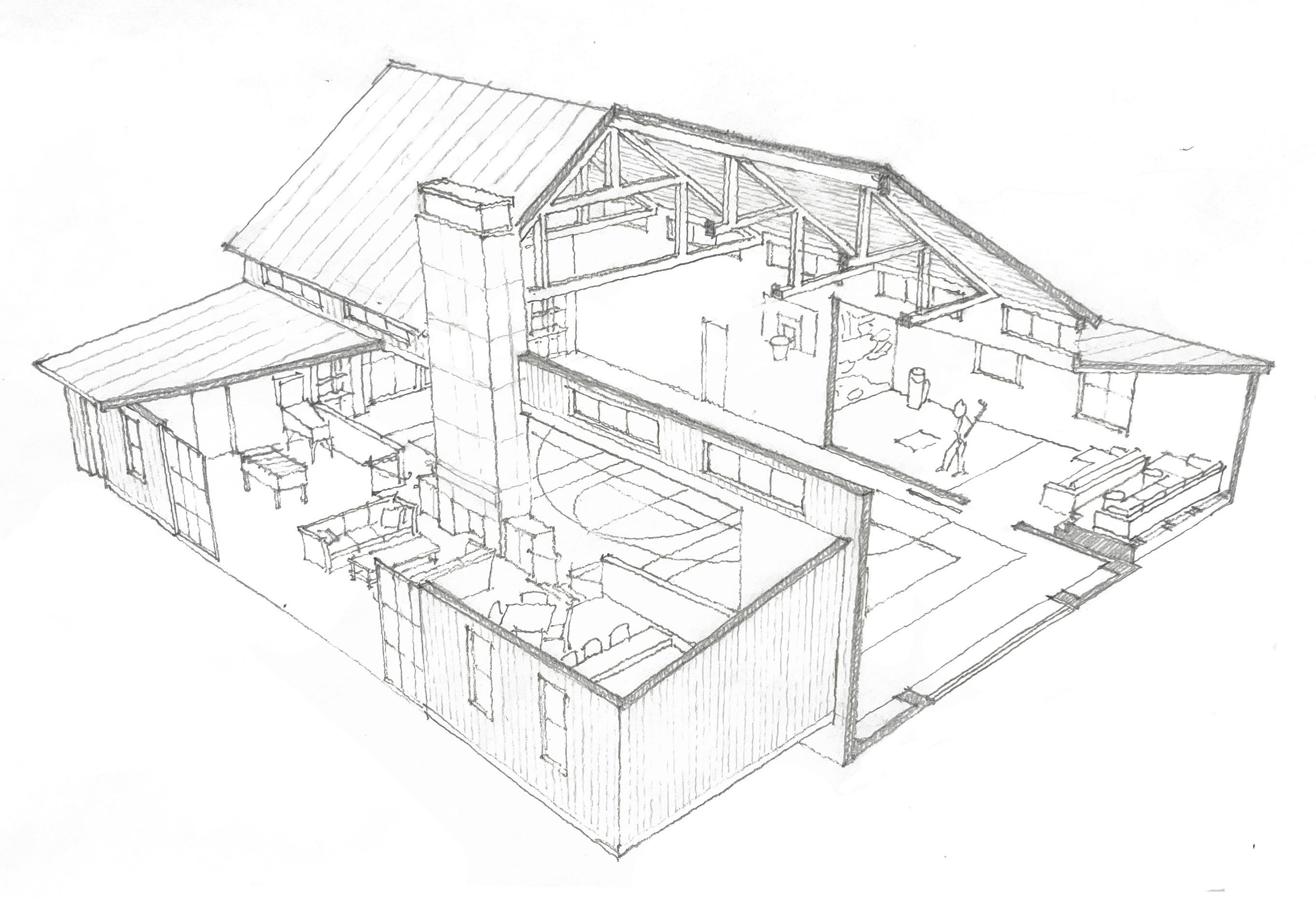
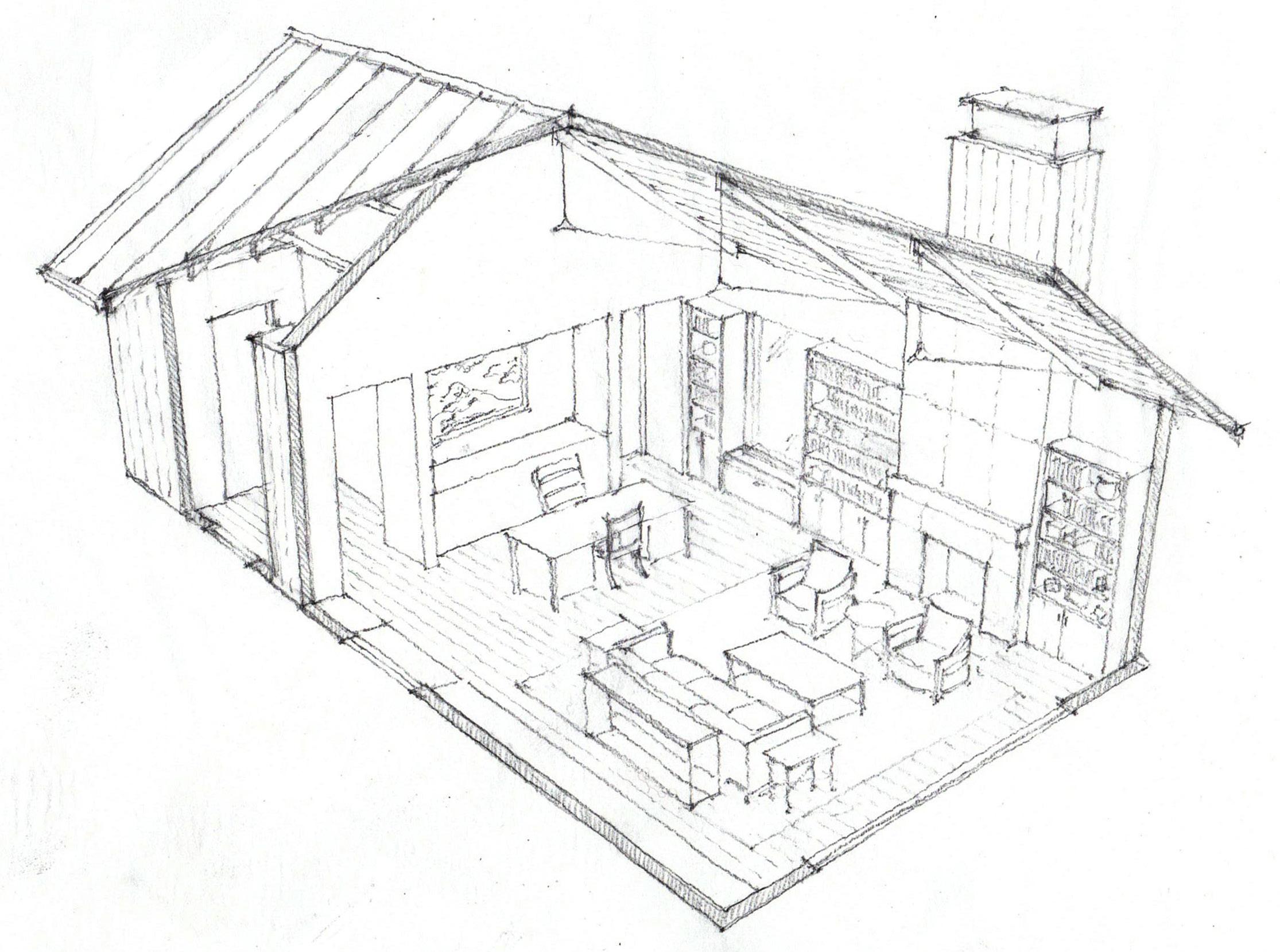
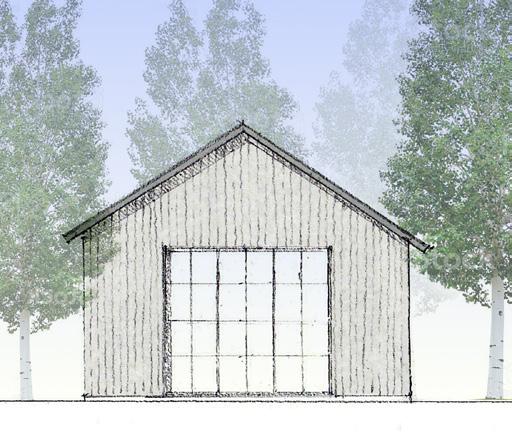
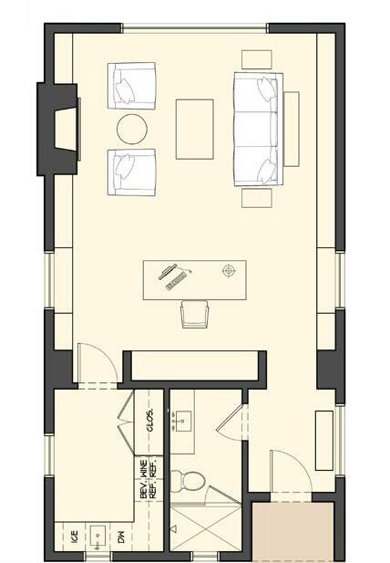
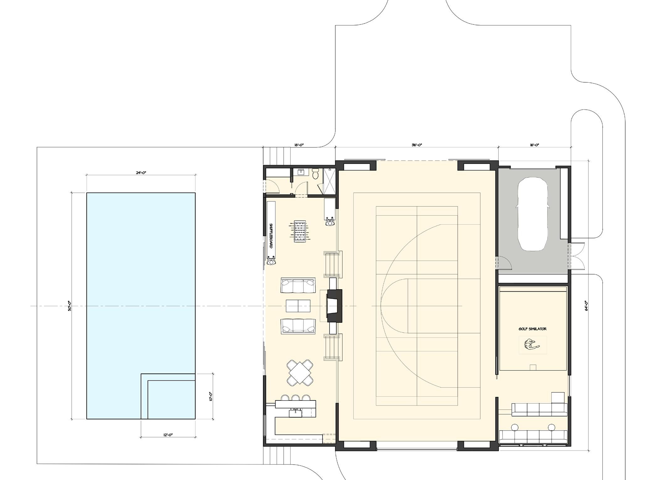
Party Barn & O ce for Park City Estate
Park City, UT | Producted for Hart Howerton
Pencil, Photoshop, AutoCAD, SketchUp | Summer 2022
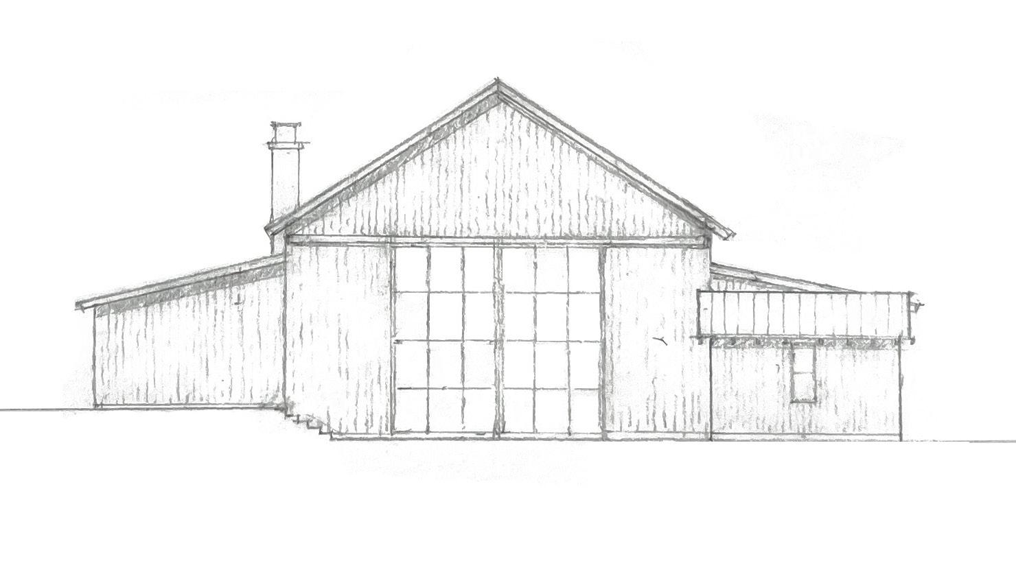
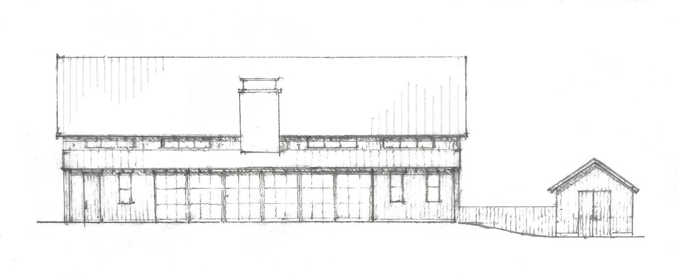
I took the lead design role for these two structures on a large, family-owned property just minutes from the slopes in Park City. Housing a complex program consisting of vehicle and trailer parking, a sports court, golf simulaator, game room and kitchen/pool bar, the party barn is strategically sited to buffer a neighboring barn, navigate a grade change and spill out to a swimming pool. The offce fronts a pond in the heart of an aspen grove, offering a private retreat. We went for a clean, yet rustic aesthetic inspired by the work of Backen, Gillam & Kroeger. Since the project was still in the schematic phase, we designed in sketchup and hand-sketched trace overlays.
OTHER SCHOOLWORK IN THE DESIGN STUDIO PROFESSIONAL WORK PERSONAL WORK SKETCHES & WATERCOLORS
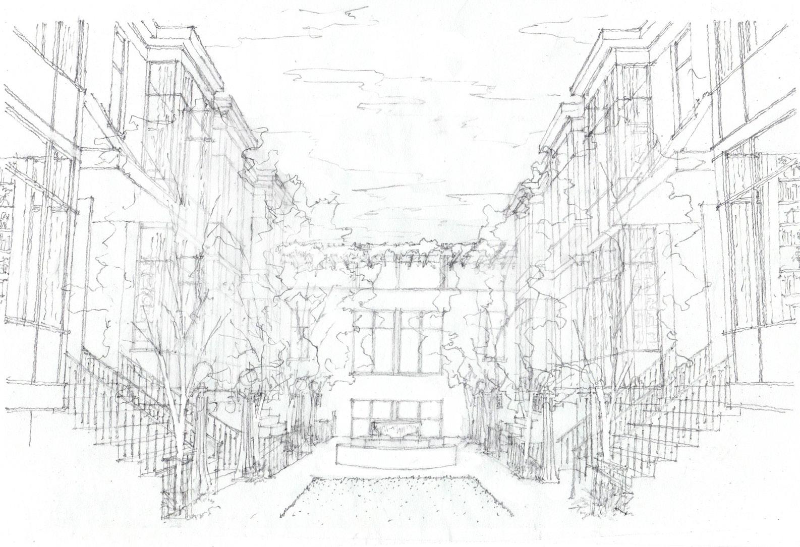
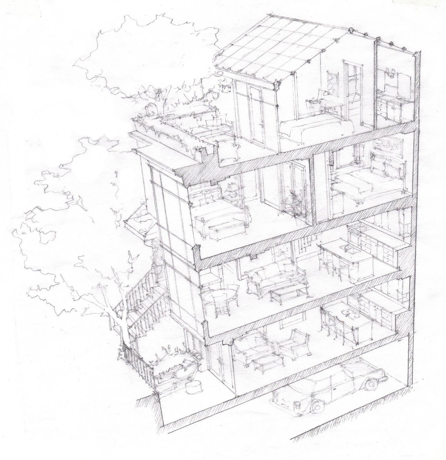
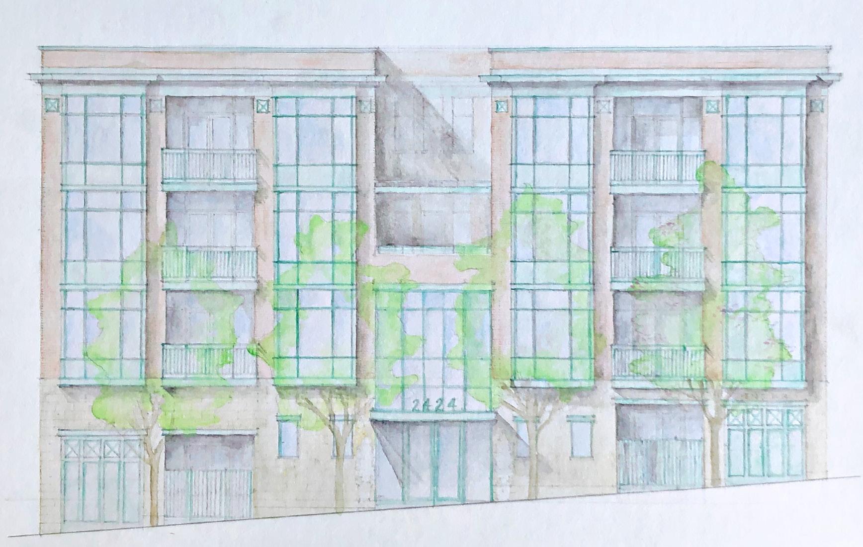
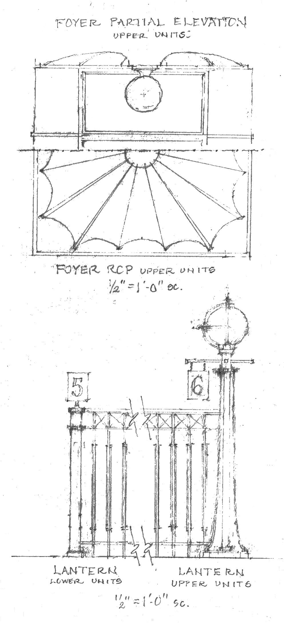
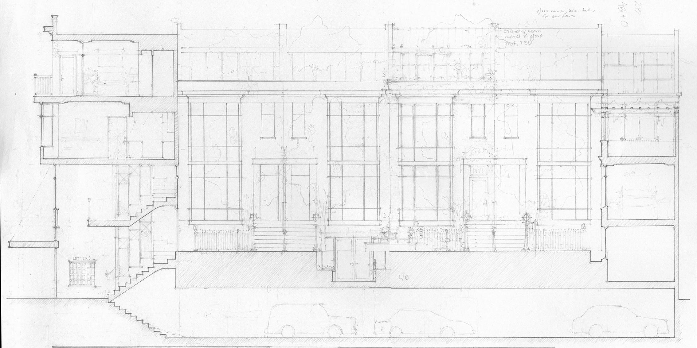
e Langford
2424 Franklin Street, San Francisco, CA | Produced Independently Pencil, SketchUp, Watercolor | Spring 2020
This site on a major arterial in the Cow Hollow neighborhood of San Francisco is currently occupied by a 1960s dingbat-style apartment building. Realizing the potential of this site, I reenvisioned it to house a residential building framing a gracious, tree flled central courtyard. ronting rhe street with a formal brick and copper facade, the building is front loaded with traditional stackd single sided units, then transitions to stacked townhouse style units behind. All of this program sits over a concealed parking structure. he central courtyard is a shared space designed to foster neighborly interaction and community events. Private outdoor spaces are prioriti ed as well, maximi ing connection to the outdoors in a dense urban environment. I went for a fresh take on a traditional early twentieth century architectural language, employing San Francisco’s iconic bay windows.
OTHER SCHOOLWORK IN THE DESIGN STUDIO PROFESSIONAL WORK PERSONAL WORK SKETCHES & WATERCOLORS
 Left: Courtyard view from entry hall, Rooftop terrace from end unit, Living room from kitchen in typical townhouse unit
Above: Street elevation watercolor
Below: Section perspective through typical townhouse unit, Entry hall ceiling detail, Courtyard fence post detail
Left: Courtyard view from entry hall, Rooftop terrace from end unit, Living room from kitchen in typical townhouse unit
Above: Street elevation watercolor
Below: Section perspective through typical townhouse unit, Entry hall ceiling detail, Courtyard fence post detail
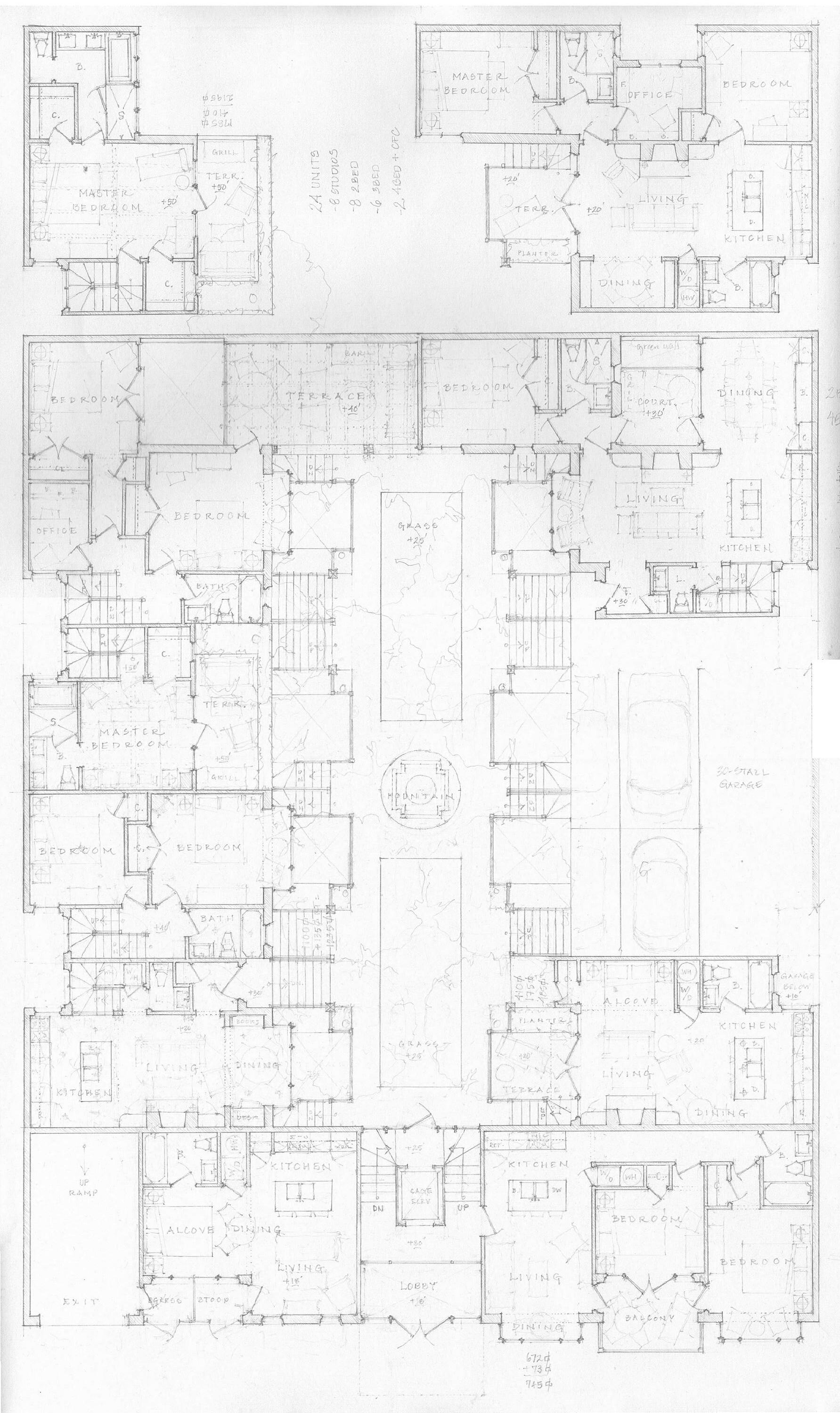
Above: Latitudinal section
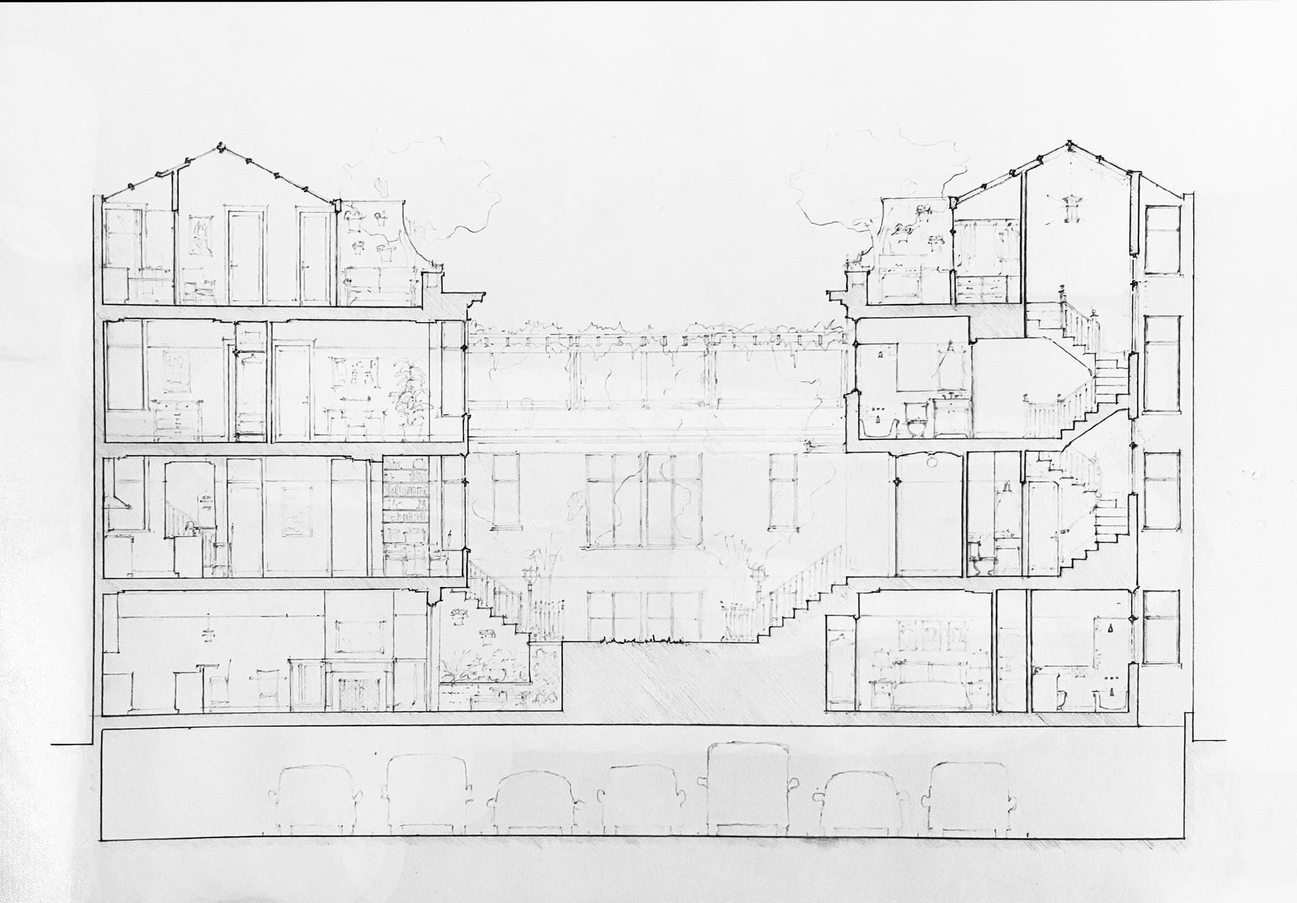
Below: Longitudinal section
 Left: Composite plan of all unit conditions, circulation and parking
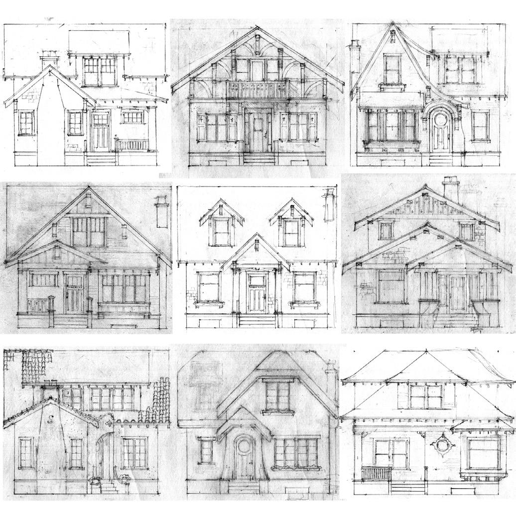
Bungalow Court
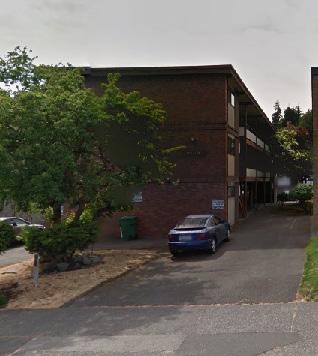
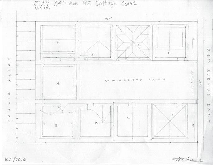
University District, Seattle, WA | Produced Independently Pencil | Summer 2016
Taking advantage of two lots currently occupied by midecentury lowrise apartment buildings in the University District, I reinvisioned this land as a cottage court, as defned by the city’s LR-3 zoning. This was an effort to continue the tradition in the neighborhood of community-centered multi-family housing projects built in the early 20th century. Working with diverse examples of the Craftsman vernacular, these 950 square feet, 3 bedroom, 2 bathroom homes would equally suit a small family or students attending the nearby University of Washington. Arranged around a common lawn, these nine cottages would share parking along the alley.
Above Left: Photo of existing condition- the site has two of these midcentury apartment buildings currently Above Right: Site Plan
Right: Front elevations of the nine bungalows
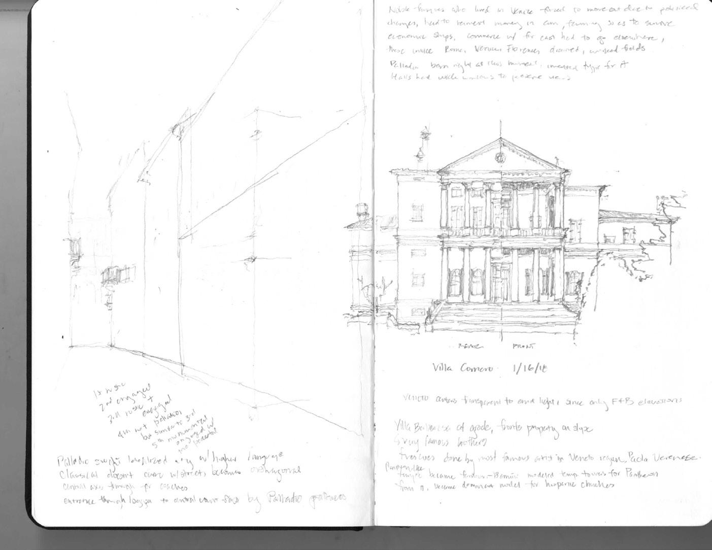
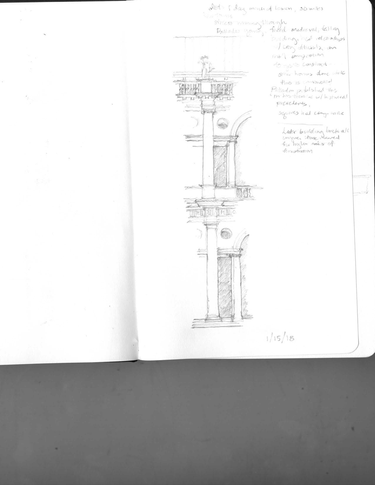
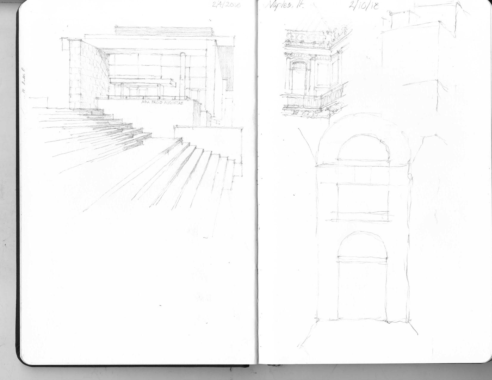
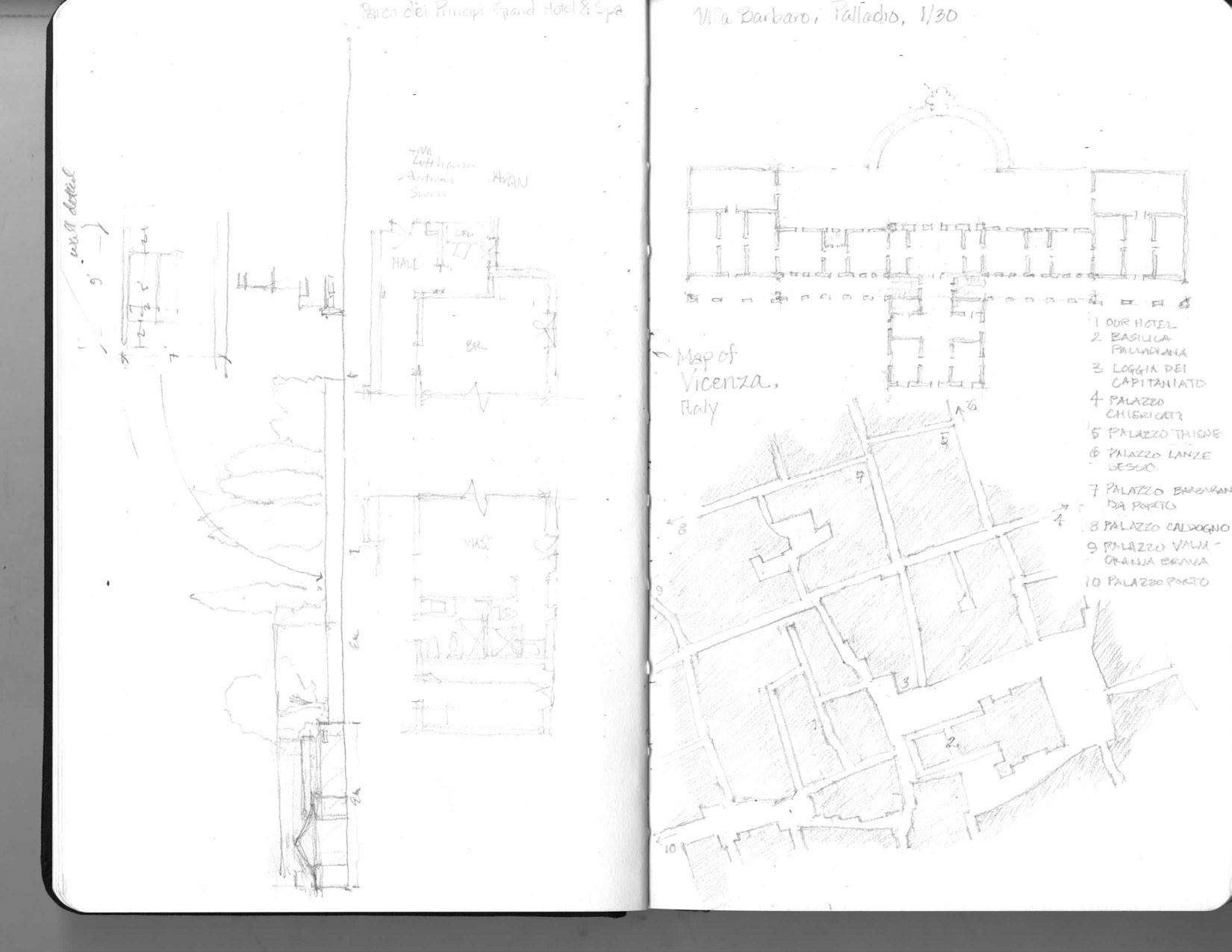
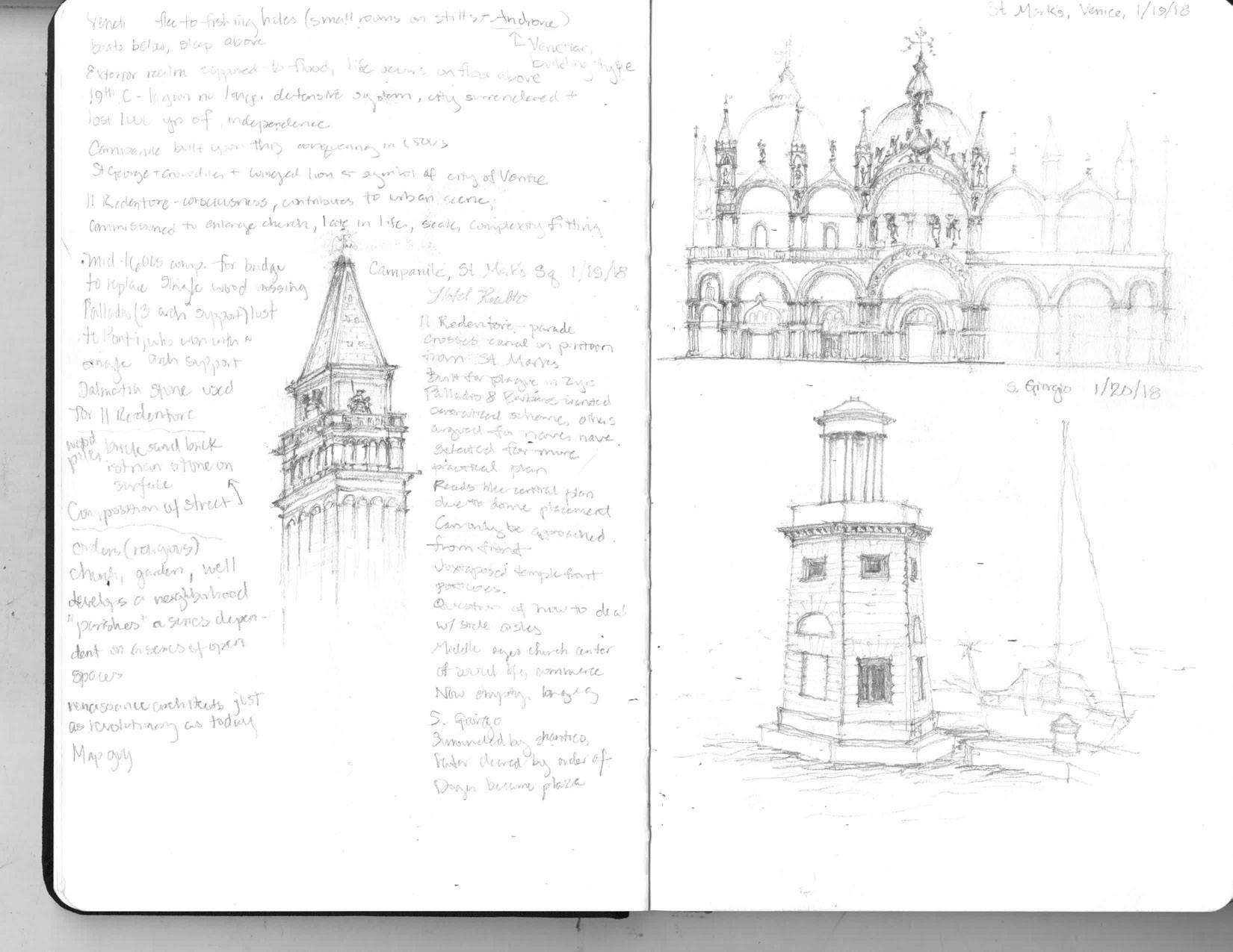
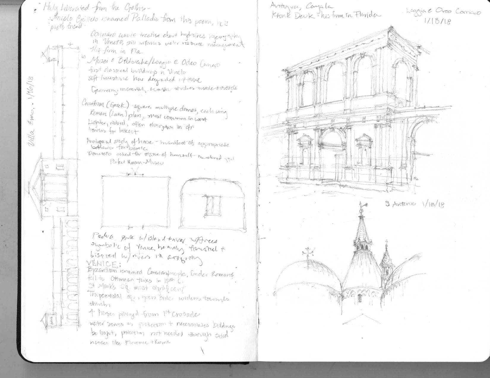
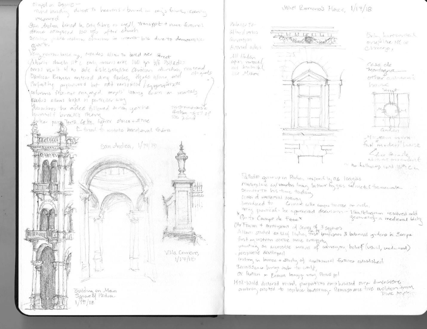
Sketches in Italy

Narrow column on Right:
Wide column on Right:
Above:
Pallado’s basilica in Vicenza, St Mark’s and Villa Cornaro
St Mark’s Campanile, detail of Juliet Romano’s house (Mantua), S. Antonio (Padua)
Museo dell’Ara Pacis, map of sites we visited in Vicenza
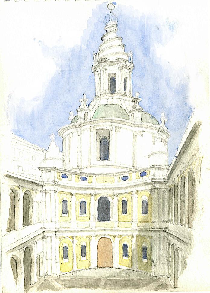
Watercolors in Italy
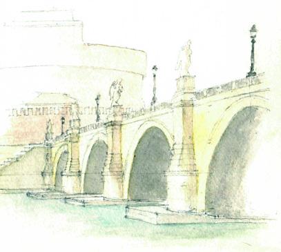
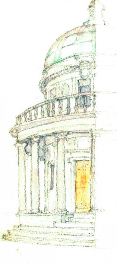
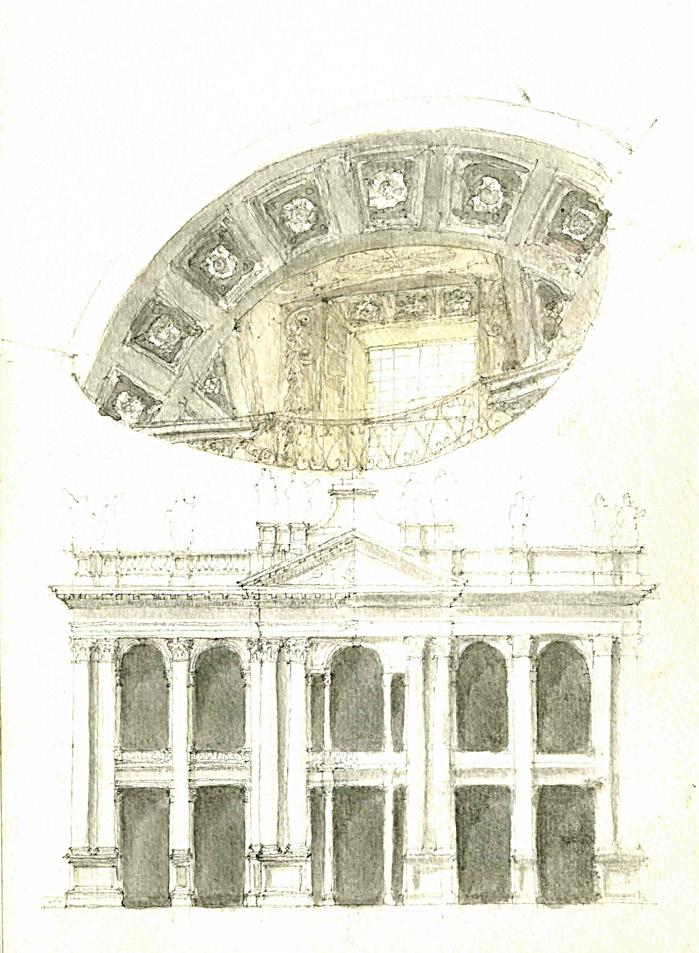
Observational Sketches