

The Near West

The Near West
A History of Grey Lynn, Arch Hill and Westmere
Tania Mace
PREVIOUS PAGES: Map showing extent of residential subdivision in 1924. Parts of Westmere have been subdivided and the remaining land will soon follow.
LIBRARIES
HERITAGE COLLECTIONS, MAP 77
4 | The Near West
AUCKLAND
Preface / 6
Introduction / 11
01. Geological and Māori history / 21
02. Farming / 35
03. Residential development / 57
04. Infrastructure and local government / 91
05. Industry and business / 131
06. Education / 197
07. Sport and recreation / 231
08. Faith / 277
09. The visual arts / 313
10. The performing and literary arts / 343
Afterword / 370 Notes / 372
Acknowledgements / 408 About the author / 409 Index / 410
Contents | 5
Contents
Preface
Sitting on the sun-warmed front steps in the early evening, accompanied by flatmates, glass of wine in hand, looking out across Grey Lynn Park, with the neighbourhood kids playing in the street out front — this is my enduring memory of Grey Lynn in the 1990s. To some extent my flatmates and I lived our lives on those sun-bathed steps. It was the place we drank coffee in the morning and ate breakfast or lunch, and in our non-smoking flat it served as the smoking lounge.
On still days we would hear the opera singer across the park running through her scales, or the neighbours’ kid practising the drums. Just before Christmas the Salvation Army band would perform in our street as part of its tour around the neighbourhood, and when the wind was blowing in the right direction the concerts at Western Springs were clearly audible, as were the screaming engines of the cars at the Speedway.
The day of the Grey Lynn Park Festival was always loud and busy at our house: the windows vibrated with the sound system, and friends arrived to park in the driveway, use the loo or stop for a cup of tea. There was always something going on in the park: games of kilikiti and rugby league, and in the lead-up to the annual Hero Parade (later known as the Pride Parade) the marching boys practised their routines.
It was a flat with the usual collection of people. Some stayed for just a few months while others remained for years. Some flatmates worked regular 40hour weeks, others were students with part-time jobs. Everyone had a creative hobby of some sort. Along with the usual assortment of students and graduates at the beginning of their careers there was a computer programmer and parttime shaman, an art teacher and part-time fire eater and an American Fulbright scholar.
The neighbourhood was a mix. Some nuns lived over the road. Lovely Sister Antoinette was always happy to talk about gardening with me; I was one of the few people my age who attempted to grow vegetables — at first largely unsuccessfully. I had more luck with the grapefruit tree that was already well
6 | The Near West
established when I moved in. It thrived on neglect. In season I would answer the door to one of the neighbourhood kids, who’d ask, ‘Excuse me, miss, can we have some fruits?’ We were always happy to share.
For a while a couple of drag queens lived next door and practised their routines in the driveway. Every time I hear Natalie Imbruglia’s ‘Torn’ I am reminded of them. And on the weekend someone in the neighbourhood would always be having a party.
Life changed for me in the early 2000s. My flatmates were replaced by a husband and children and I experienced my suburb in different ways — now life was dominated by my children’s needs, kindergarten and school. Parenting opened up a different world. I knew lots of children and their parents and some became good friends.
Meanwhile, Grey Lynn, too, was changing. Suddenly everyone was talking about house prices and there was a continuous exodus of the Pasifika families who had lived there for generations, and a subsequent influx of people wellestablished in their professional careers, many of whom had either started, or were about to start, families.
Houses were renovated, there were more late-model cars in the streets, the playground at Grey Lynn Park was increasingly busy. Even the dogs were different: the free-range mongrels of the 1990s giving way to pedigree and designer crossbreeds — cavoodles and wheaten terriers kitted out in fancy collars.
So much has changed in the years I’ve lived here, but so much is also the same. Grey Lynn has always had a quirky vibe — the people are friendly and it’s a great place to live. The history of this area has always interested me and so it’s been an absolute pleasure to write this book. I hope you enjoy reading it.
Tania Mace Grey Lynn 2024Preface | 7
A note on place names
Newton, Newtown, Newton West, Surrey Hills, Richmond, Grey Lynn, Coxs Creek, Arch Hill . . . where?
Parts of the suburbs we now know as Arch Hill, Grey Lynn and Westmere have gone by a variety of names over the past 170 years. In the days when settlers were few and far between, places were often described in relation to the nearest well-settled area. So in the late 1850s and early 1860s when land was subdivided on the southern side of Great North Road, including the streets we now know as Commercial Road and Cooper, Bond, King, Brisbane, Waima, Kirk and Burns streets, subdivision plans were named Newtown West (west of Bond Street) and South Newtown (east of Bond Street), though the area was most commonly known as Newtown/Newton West — the area being west of Newton/Newtown Road. Newtown lost its second ‘w’, becoming Newton, when the area became part of the electorate of Newton in 1861.
This area later became known as Arch Hill when local government came to the area with the election of the Arch Hill Highway Board in 1871 — named after Joseph Young’s farm ‘Arch Hill’ on the eastern side of Tuarangi Road, and at the centre of the extensive Arch Hill Highway Board area which included Newton West (Arch Hill), and also originally stretched west of Young’s farm all the way to Point Chevalier.
On the northern side of Great North Road was the extensive Surrey Hills farm with Richmond beyond. These areas became part of the Newton Highway District in 1868. So there was now the suburb of Newton, south of Karangahape Road, Arch Hill (also known as Newton West), and now the Newton Highway District (later known as the Newton Road District, Newton Borough and Grey Lynn Borough), which included the areas we now know as Grey Lynn and Westmere. These names, when found in nineteenth-century sources, can be the cause of considerable confusion to those unfamiliar with the local history of the area.
Many streets have also been renamed, and in the case of two of our main thoroughfares there have been two significant changes. Great North Road originally ran down the line of Tuarangi Road — steep and difficult to keep in reasonable order. In the early twentieth century Deviation Road was formed, taking the easier line through the valley between Tuarangi Road and Surrey Crescent. This became the new line of Great North Road.
Many an unwary researcher has been tripped up by the three names originally given to sections of Richmond Road. In the nineteenth and early twentieth century Richmond Road was known as Richmond Avenue at the Surrey Crescent end, Richmond Road at the Ponsonby Road end, and Richmond Hill for the section between the two.
8 | The Near West
Other streets were renamed after the amalgamation of the Arch Hill Road Board and Grey Lynn Borough with Auckland City Council in 1913 and 1914 respectively. To avoid confusion, Auckland City Council renamed certain roads where there was duplication of names, including King Street in the former Grey Lynn Borough, which was renamed Kingsley Street to avoid confusion with King Street in Arch Hill.
More recent changes have seen the expansion of the area known as Westmere. The name comes from the 1920s subdivisions on either side of Garnet Road and west of Edgars Creek. In recent times the name Westmere has been given to the adjoining stretch of land between Edgars and Coxs creeks north of Richmond Road, an area formerly known as Coxs Bay, Grey Lynn and, back in 1860s, Richmond Village.
This book tries to be clear when describing locations, particularly where names have changed over time.
Preface | 9

Introduction
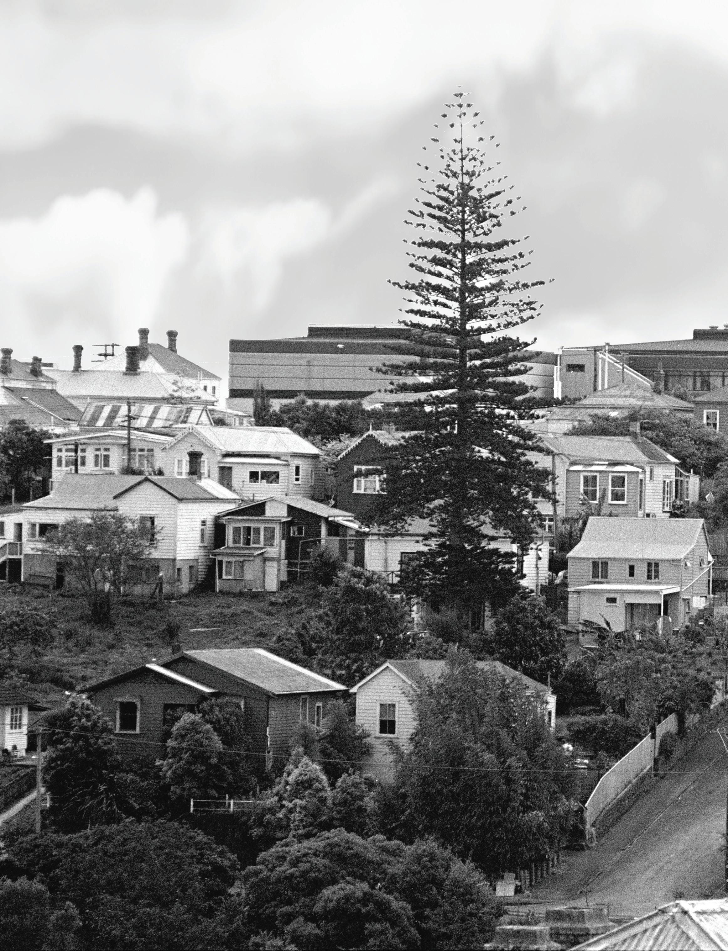
PREVIOUS PAGES: A view of Arch Hill in 1989. Brisbane Street runs diagonally up the hill. Number 10 Home Street can be seen on the left of Brisbane Street, halfway up the hill. Number 12 is obscured by the Norfolk Island pine. AUCKLAND LIBRARIES HERITAGE COLLECTIONS, 273-HAR050-09
12 | The Near West
This book is about three adjoining Auckland suburbs — Grey Lynn, Arch Hill and Westmere — and the people who have lived here.
As in all suburbs, their buildings and places have stories to tell, as two neighbouring houses, 10 and 12 Home Street in Arch Hill, exemplify. One, a modest cottage, is perched on a steep section at the corner of Home Street and Brisbane Street, its façade partly obscured by a picket fence above a retaining wall that appeared long after the house was built, in order to provide a level road and footpath. Its larger neighbour, while still modest, features a hip roof and narrow verandah. Both houses were built just inside the southwest boundary of the 3000-acre block of land that was gifted in 1840 by Ngāti Whātua for the new capital of the young colony, New Zealand. The acreage was initially cut up into town sections with suburban farms beyond.
The land where the houses stand was purchased from the Crown in 1844 by Thomas Poynton, an ex-convict who had arrived in New Zealand from Australia with his wife, Mary, in 1828 and set up a store and sawmill in the Hokianga.1 His property at Arch Hill was one of a number of suburban farms Poynton bought in the 1840s as he took advantage of a government scheme that allowed pre-Treaty land claimants in remote areas to swap their low-value properties for higher-value land in the growing town. This encouraged settlers to relocate to Auckland, where settlers were needed, while also removing them from areas where there was no colonial government presence to protect them or stop them getting into quarrels with local Māori. 2
Poynton didn’t ever settle the land, selling it in 1845 to butcher William Thorne Buckland. In 1853 it was bought by David Burn, who in 1859 subdivided it into residential sections, no doubt hoping to make a good profit. Close to the city, and relatively small, the sections were ideal for city workers. However, Burn was one of many vendors of newly subdivided land near
Introduction | 13
the city, and with supply outstripping demand, it would be decades before his land was all sold. 3 The purchaser of the two adjoining sections fronting Home Street on the southwestern corner of Brisbane Street was Nathaniel Gow, a bootmaker who had recently arrived from Barrhead in Scotland with his wife Margaret and their eight children, and who, like many other plucky immigrants before and since, had made the decision to sail to the opposite side of the world, away from all they had ever known in the hope of building a better future for their family. They arrived in Auckland on the Ganges in 1863 and, not long after, Gow agreed to sell one section to William Baildon, an immigrant from Huddersfield. Evidently love was in the air; in 1867 William Baildon married Nathaniel and Margaret’s third daughter, Isabella, at the Gow residence.4
Like many new Aucklanders, the young couple moved to Thames after gold was discovered there. They returned a few years later and Baildon, a builder, erected a house not far from his in-laws at the western end of Dean Street (then known as Stanley Street), where he and Isabella raised a family. 5
William Baildon and Nathaniel Gow were both active in local body politics, serving on the Arch Hill Highway Board as it struggled to build and maintain roads and keep the area in a sanitary condition.6 This was no easy task in the days before piped water and sewerage; local nuisances included stinking piles of manure and bloated horse carcasses abandoned on roadsides, resulting in letters from the highway board demanding residents clean up their mess. Keeping order and making improvements was difficult when there was limited rating revenue and where the hilly terrain meant that roads could often only be formed by digging away banks and filling in ditches by hand.
On Sundays the Baildons and Gows attended St James Presbyterian Church, a little over 2 kilometres away, on Wellington Street in Freemans Bay.7 From 1877 the children of both families attended nearby Newton West School, a one-room public school on Great North Road that also served a variety of community purposes, from meetings and church services to social events.8
But there was another side to this suburb. William Crowe’s brothel in nearby Waima Street (then known as Oxford Street) disturbed the peace of the quiet neighbourhood in the 1870s and early 1880s, with one neighbour complaining that ‘midnight brawls and curious noises made night hideous, and banished sleep from the locality’.9 At the time the nearest police presence was the solecharge Newton Station in West Street (now West Terrace) off Karangahape Road. The fledgling police force generally left brothelkeepers and prostitutes to their own devices unless there was public misconduct or complaints from neighbours. Crowe’s establishment clearly attracted police attention, as did the larrikins who disrupted the peace of the neighbourhood by swearing, beating kerosene tins and vandalising property.10 By 1887 there was sufficient trouble in the district to warrant a police station, which was located in a rented house
A subdivision plan showing the Gow and Baildon properties in Home Street, c. 1859. Rather confusingly, this subdivision was initially named South Newtown — located east of a subdivision called Newtown West and west of a subdivision called West Newtown. This area would soon become known as Newton West (having lost its second ‘w’ after the electorate of Newton was proclaimed in 1861) and later Arch Hill. Many of the streets would be renamed in the twentieth century.
AUCKLAND LIBRARIES
HERITAGE COLLECTIONS, MAP 4495-8
14 | The Near West

on the north side of Great North Road between Turakina and Ariki streets (then known as Tennyson and Princep streets).11
Alcohol was the cause of many social ills, and the temperance movement grew strong in Arch Hill. In 1886 William Baildon stood as one of five temperance candidates for the Arch Hill Licensing District elections, pledging if elected to close the only hotel in the district.12 Although unsuccessful, he continued to support the temperance cause, and in the early twentieth century Grey Lynn electorate (including Arch Hill, Grey Lynn and Westmere) became the first North Island electorate to ban the sale of alcohol when the residents voted the district ‘dry’. It would remain so for much of the twentieth century; in 1996 it was one of the last areas to vote ‘wet’, ending one of the longest dry spells in New Zealand.13
By the late 1880s the Baildon family was living on the south side of Great North Road between King and Bond streets, the ridge-top position giving magnificent views to the north across the vast Surrey Hills Estate and on to Coxs Creek, with the Waitematā Harbour and North Shore beyond.14
Only a few houses dotted this landscape. Prominent features included the Warnock Brothers’ soap and candle works on the south side of Richmond Road, at the edge of Coxs Creek, and Hellaby’s slaughterhouse and meatworks on the coastal land beyond. To the northwest the distant chimney of the municipal abattoirs towered above Western Springs, where West View Road runs today.15 These were just some of the noxious industries that were no longer tolerated in the increasingly populous city and so were relocated to the open fields beyond.
But the view north from the Baildon’s ridge-top home would change. The belching chimneys were gradually overwritten by residential development that staggered, in fits and starts, across the landscape, and the evolution of less offensive industrial concerns that provided local jobs for residents.
William and Isabella Baildon’s eldest son, George, married Maggie Kerr in 1893 and the couple moved to a house (likely built by George with the help of his father) on the property adjoining the Gows’ in Home Street.16 Two years later George followed his father into local politics. He was elected to the Arch Hill Road Board and later the Grey Lynn Borough Council and Auckland City Council, and served as mayor of both Grey Lynn Borough and Auckland City councils. In the early twentieth century George and Maggie moved to Great North Road, at the western corner of Northland Street (then known as Northcote Street), where they would remain for the rest of their lives.17
16 | The Near West

Subsequent residents of the former Baildon property at 12 Home Street included a tramways company employee who helped transport workers from the suburbs to city workplaces, something that had been part of the pattern of life in Grey Lynn and Arch Hill since 1903 when the first electric trams made their way along Great North Road, stirring up a cloud of dust in their wake.18
In the 1940s Daisy and William Ellis made their home in the former Gow residence at 10 Home Street. During the Second World War William joined the Royal Air Force and flew missions over Germany. When the news came that he had been shot down Daisy was no doubt bereft. The Gows and Baildons knew the feeling — George Baildon had lost a brother and a son in the previous war.19
From the mid-1950s to the mid-1960s, the Baildons’ former home at 12 Home Street was the residence of the artist Theo Schoon, an immigrant of Dutch heritage who had grown up in Indonesia. At this time Arch Hill was home to several departments of the Elam School of Art, which had been relocated to the former Newton West School after fire destroyed part of the art school’s Symonds Street premises. 20 The neighbourhood was becoming more culturally diverse than it had been in William Baildon’s time, and now included people from rural Māori communities and the Pacific Islands.
The government encouraged Pacific Islanders to come to New Zealand to ease the labour shortage, and many Pasifika peoples now made their homes in the increasingly rundown housing of the inner-west suburbs, including Arch Hill and Grey Lynn, where buying or renting were cheap and the commute into the city was relatively easy. In 1961 Niuean timber worker Langi Sipley bought the former Gow residence in Home Street; it would remain connected to the Sipley (Sipeli) family for almost 60 years. 21
Introduction | 17
Numbers 10 (left) and 12 Home Street. PATRICK REYNOLDS

The growth of the local Pasifika population led to a wider variety of vegetables, including those imported from the Pacific Islands, being stocked by shops. Here several tubers of the enormous Tarua taro (Xanthosoma sagittifolium) are displayed at the front of a dairy on Great North Road, Grey Lynn, in 1989. AUCKLAND LIBRARIES HERITAGE COLLECTIONS, 273-HAR009-14
The challenges of adapting to life in New Zealand were eased by the Pacific Island churches and their communities. Grey Lynn and Arch Hill were close to the Pacific Island Presbyterian Church in Newton, where people gathered to worship in their own languages. Other congregations gathered closer to home, raising funds for church buildings including the Sione Uesile (John Wesley) Samoan Methodist Church and community centre in King Street.
Local schools adapted to teaching children who were recent arrivals from the various island nations of the Pacific. Many spoke little or no English, so new methods evolved to help them learn.
Facing discrimination, young members of these communities banded together to support Polynesian people and fight racial prejudice, and formed the Polynesian Panthers, who first met in a house in Keppell Street, just a stone’s throw from the former Gow and Baildon residences in Home Street. 22
Auckland was growing, and better connections between west Auckland and the city were needed. Soon a thick ribbon of black asphalt worked its way along the Arch Hill gully, blanketing part of the Newton Central School playground, and by the late 1970s the hum of cars speeding along the new motorway was added to the sounds of the suburb. The industrial landscape also changed as light industry marched west from the Newton Road end of Arch Hill — many houses at this end of the district were demolished to make way for commercial buildings.
In 1977 Neil French, a car-yard manager, bought 12 Home Street and lived there for several years, and in 1987 the property was purchased by the Presbyterian Church and later became the home of Presbyterian minister Mua Strickson-Pua, who had grown up in Grey Lynn as the son of Samoan immigrants, and his wife Linda. 23
Through the closing decades of the twentieth century and into the twentyfirst, house prices in this part of the city rose dramatically. Many rundown rental properties were sold to owner-occupiers who renovated them, further increasing their value and the desirability of the area.
Well over a century has passed since the little houses at 10 and 12 Home Street were first built. Their survival has been remarkable, and they are a tangible reminder of the history of this part of the city and of the people who have lived here.
Introduction | 19

01

Geological and Māori history
PREVIOUS PAGES: An aerial view from 1946 showing Westmere in the foreground and Te Tokaroa Meola Reef stretching out across the Waitematā Harbour, and almost touching the North Shore. ALEXANDER
TURNBULL LIBRARY, WA02359-G
22 | The Near West
Grey Lynn, Arch Hill and Westmere lie within sight of several of the more than 50 cones that make up Auckland’s volcanic field, formed through a series of eruptions over the past 250,000 years. During this time the earth witnessed two ice ages. As the last of these ended, the earth warmed and ice sheets melted, causing sea levels to rise and inundate the forests that grew on what are now the beds of the Manukau and Waitematā harbours, and defining the coastal edges of the area we know today as Auckland.1
One of the Māori origin stories of the Auckland volcanic field centres on the relationship between two patupaiarehe (mythical fairy people known for their mischievousness) and their respective tribes. Hinemairangi, daughter of the chief of the Hūnua tribe of patupaiarehe, fell in love with Tamaireia, son of the chief of the Waitākere tribe. The couple eloped and went to live with Tamaireia’s people at Hikurangi (Te Rau-o-te-Huia Mount Donald McLean), the highest point in the Waitākere Ranges.
Hinemairangi’s father opposed the union and gathered a war party intent on returning his daughter to her people. As they headed across the isthmus they were seen by the Waitākere tribe, who gathered their tohunga (priests) in a line across Hikurangi, delivering powerful incantations that not only incapacitated the Hūnua war party but also caused the isthmus to erupt, forming the volcanoes and craters of Auckland. 2
Another story tells of the deity Mataaho stepping across from the North Shore to Māngere, where his footsteps left the indentations Ngā Tapuwae (the footsteps), the two lagoons in the vicinity of Barrys Point Road, and Te Pūkaki Tapu Lagoon in Māngere. Volcanoes sprang up in between. 3
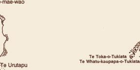
Skirting the west of Grey Lynn and Westmere are the lava flows from Te Kōpuke Mount St John and Te Tātua Riukiuta/Te Tātua o Mataaho Three Kings. Te Kōpuke (the prominent mound) is one of Auckland’s oldest volcanoes and its 11-kilometre lava flow, Auckland’s longest, formed a thick ribbon of stone running west along a valley, through the site where Maungawhau Mount
Geological and Māori history | 23

Eden would later erupt, then turning to the north around where Morningside is today and flowing on to form Te Tokaroa Meola Reef.4
Māori explain the formation of the reef, visible only at low tide, through the story of conflict between two tribes of patupaiarehe. The weaker tribe built a stone causeway across the Waitematā Harbour that would enable them to escape at low tide but would become submerged as the tide rose, foiling any attempt by their enemies to pursue them. However, as they worked to build their escape route the sun rose, destroying the patupaiarehe, who were unable to endure its rays, and leaving the causeway partly finished. 5
An early name of the reef was Te Whakapekapeka o Ruarangi (the pathway or diversion of Ruarangi) recalling an escape over the reef by Ruarangi, of Tainui. Ruarangi had quarrelled with his brother Ohomatakamokamo over cultivations near Rarotonga (Mount Smart), and in the ensuring battle Ruarangi and his people were besieged at Ōwairaka (Mount Albert). They escaped through a lava tunnel and headed north, crossing the Waitematā Harbour over Meola Reef.6 The reef later became known as Te Tokaroa (the long rock).7
A large lava flow from Te Tātua Riukiuta/Te Tātua o Mataaho followed, many thousands of years after Meola Reef was formed. This volcano initially erupted 28,500 years ago. During a second round of eruptions, when a series of cones were formed, lava poured out from a breach in the tuff ring created by the first eruption.
The lava flowed down a stream bed to Western Springs, burying the stream. It continued to flow as a subterranean waterway, percolating through cooling cracks in the lava before emerging to form Te Wai Ōrea (Western Springs lake), named for its plentiful eels.8
These eruptions and others in the Auckland volcanic field provided volcanic rock and fertile soils rich in minerals. Combined with a climate that was warm in summer and cool in winter, with adequate rainfall, these provided ideal conditions for flora and fauna to flourish, and the coastal margins and waterways supported an abundance of aquatic life. This flora and fauna had developed its own unique character in the time since the Aotearoa New Zealand landmass broke away from the edge of the Gondwana supercontinent around 80 million years ago.9
Humans first set eyes on this unique environment around 800 years ago when Polynesian explorers, the ancestors of today’s Māori, began arriving in a series of migrations. The riches of this new land must have been a welcome sight after their arduous sea voyage.10 Known as Tāmaki
Geological and Māori history | 25
An 1859 map of the Auckland volcanic field by Dr Ferdinand von Hochstetter. AUCKLAND LIBRARIES HERITAGE COLLECTIONS, MAP 5694B
Herenga Waka (where waka are tied), the narrow Auckland isthmus became the most heavily populated part of Aotearoa.11
Polynesian navigators brought with them new plants and animals, including the kūmara (sweet potato), and the kiore or Polynesian rat. The kūmara was one of the few Polynesian plants that grew well here, able to survive in the cooler climate. The kiore adapted readily to its new environment and rapidly wreaked havoc on Aotearoa’s ground-nesting birds, reptiles and frogs. But the impact of the kiore on native species was dwarfed by that of humans, who hunted several species of large birds, including moa, to extinction.12 Bones from these avian giants would be found in volcanic caves at Western Springs in the twentieth century, long after their demise.13
With its eight portages connecting the east and west coasts, the isthmus was a frequent transit point for travellers, who made use of local food sources and fresh water.14 The presence of middens across the coastal edges of Westmere and Coxs Bay attests to the enjoyment of plentiful seafood over the centuries. Local place names refer to food sources, including Waitītiko Meola Creek (water of the periwinkles) and Te Wai Ōrea (water of the eels). Eels were an important food source, and both long-finned and short-finned native eels still exist in Te Wai Ōrea.15 The pattern of life revolved around seasonal journeys to carry out gardening, fishing, hunting and harvesting.16
Opoutukeha Coxs Creek originally ran from a spring in upper Pollen Street, wending its way through what is now Grey Lynn Park to Coxs Bay. The part of the creek south of Richmond Road now runs through underground pipes and emerges on the north side of Richmond Road to meander through the Coxs Bay Reserve before spilling into Coxs Bay under West End Road. It was named after Poutukeha (also spelled Poutukeka), an ancestor from the Tainui waka. Opoutukeha formed the boundary between the early tribes Ngāti Riu and Ngāti Huarere.17
Seasonal kūmara plantations flourished on the sun-warmed north-facing slopes of Grey Lynn above Opoutukeha, and flax grew in abundance in the wetlands around Coxs Bay, much of which was later reclaimed to become Coxs Bay Reserve.18 Tukituki Muka (to prepare flax) is the name given to the area where flax harvested from the wetlands was processed and dried, to be turned into rope and clothes. The location of Tukituki Muka is described in different sources as the north-facing slope at the end of Jervois Road in Herne Bay, or the area just east of the cul-de-sac of Webber Street.19
Other locations in the district are associated with intertribal conflict. In the late seventeenth or early eighteenth century, the great Tainui warrior Kāwharu was enlisted to lead Ngāti Whātua on a series of raids that became known as Te Raupatu Tīhore (the stripping conquest). 20 One of the battles in this campaign appears to have occurred at Ngā Kauaewhati (the broken jaw bones), a pā on the
26 | The Near West
A map showing Māori place names in Auckland. AUCKLAND LIBRARIES HERITAGE
COLLECTIONS, MAP 9502


Geological and Māori history | 27
ridge above Western Springs. 21 Kāwharu rested his head on the Surrey Crescent ridge nearby, and the place became known as Te Rae o Kāwharu (Kāwharu’s brow). 22 Grey Lynn School now bears this name and the students connect with this history through their patere (chant), which functions as a school song. 23
In the mid-eighteenth century a series of conflicts between the people of Tāmaki and Kaipara culminated in a battle at Paruroa, west of Titirangi. Here the great Te Wai-o-Hua chief Kiwi Tāmaki was killed, along with many other Te Wai-o-Hua leaders, in a battle known as Te Rangihinganga Tahi (the day when all fell together). 24 Te Taoū, part of the Ngāti Whātua confederation of Kaipara, were now in a position to take Te Wai-o-Hua’s great pā, Maungakiekie One Tree Hill, which they found deserted. 25 Te Taoū became the occupants of the central isthmus. The remaining people of Te Wai-o-Hua were taken in as part of the confederation under the hapū names Ngā Oho and Te Uringutu. 26
The 1820s was a time of unrest across the isthmus as the musket-armed Ngāpuhi came from the north waging a campaign of terror on their way south. Te Taoū and others escaped to the Waitākere Ranges where they were taken in by Te Kawerau. The heavy bush cover of the ranges made this a good place to hide, but food was limited. 27 As soon as they considered it safe to leave, Te Taoū of Tāmaki left the Waitākere Ranges to stay with Te Taoū at Oneonenui, South Kaipara, where they established gardens sufficient to feed them in their exile. 28
By around August 1822 things had settled. Āpihai Te Kawau, grandson of the great Te Taoū chief Tūperiri who led the occupation of Tāmaki following the defeat of Te Wai-o-Hua, considered it safe to return to Tāmaki. Te Kawau’s mother was of Te Wai-o-Hua descent, and through her and his paternal uncle he was related to both Ngā Oho and Te Uringutu. Te Kawau brought Te Taoū, Ngā Oho and Te Uringutu with him to settle on the southern shores of the Waitematā. With them came refugees from South Waikato, who had also sought shelter in Waitākere and South Kaipara and who were invited to stay temporarily on the Waitematā. 29
Archaeologist Agnes Sullivan’s study of Māori gardening in Auckland provides a picture of life at this time for the South Waikato hapū Ngāti Tipa on the Waitematā. Around October 1822, it appears that Ngāti Tipa were clearing and planting gardens and gathering fernroot in the Ōrākei–Ōkahu Bay area. Fish, shellfish and fernroot provided sustenance while they prepared their gardens. The following month these activities were repeated at Te Rehu, on the banks of Waiateao (Motions Creek). Early in 1823 they were fishing at Ōkahu Bay and probably harvesting crops planted the previous year. They then moved
28 | The Near West
again to Te Rehu, likely continuing their harvesting and fishing.
These cycles of planting, fishing and harvesting continued over the next two years. Te Rehu provided the main winter base and the Ōrākei–Ōkahu Bay area the summer base. Periods of planting and harvesting at Te Rehu were interspersed with fishing on the harbour. Eels could be caught in Te Wai Ōrea and pigs were hunted nearby. There were also sojourns to Kaipara to work in the large gardens there for supply to Ngāti Whātua, who were preparing for a regional confederation meeting for which additional supplies of food would be needed. 30 By the end of 1824 Te Taoū and Ngā Oho were living at Te Rehu, Wai Horotiu (Queen Street, Auckland) and Ōkahu. 31 Their seasonal movements were probably similar to those of the other hapū who settled the southern shores of the Waitematā.
In 1825 the pattern of life at Waitematā was broken when Te Kawau’s people were called in to support Ngāti Whātua o Kaipara in the battle against Ngāpuhi at Kaiwaka. The battle was named Te Ika-a-ranganui (the great array of fish laid out), a reference to the many Ngāti Whātua warriors who died and were laid out in lines. 32 Te Kawau and his people arrived too late to take part. Fearing a Ngāpuhi attack, they left the Tāmaki isthmus but returned regularly to fish, plant crops and harvest. 33 In the late 1830s they re-established themselves gradually on the southern shore of the Waitematā. 34 By the beginning of 1840, Te Kawau’s main base was at Ōrākei, where gardens had earlier been planted and habitations built. 35 The three hapū — Te Taoū, Ngā Oho and Te Uringutu — became known as Ngāti Whātua Ōrākei. 36
The wars of the 1820s and 1830s had decimated the local population. Now there was an appetite for peace, something that Ngāti Whātua Ōrākei sought to promote by settling the governor on their land, thereby dissuading rival tribes from launching an attack. 37 Te Kawau’s nephew Te Rewiti was sent to the Bay of Islands to meet with Governor William Hobson and invite him to make his capital on the southern Waitematā. 38 Māori recognised other advantages in having Pākehā nearby: as well as the prestige of having someone as important as the governor living close by, there were increased opportunities for trade and employment. 39
The southern shore of the Waitematā Harbour would soon become the capital of the fledgling colony, chosen for its natural advantages of fertile soils, a warm climate, a safe harbour, and rivers that provided easy access to other parts of the country — features that earlier attracted Māori and earned the isthmus the name Tāmaki-makau-rau (translations include ‘Tāmaki desired by hundreds’ and ‘the bride sought by a hundred suitors’).40
On 20 October 1840, the deed for the first 3000-acre block of land gifted by Ngāti Whātua Ōrākei for the new capital was signed, paving the way for the development of Auckland.41 Colonial settlers flooded in to build homes and
Geological and Māori history | 29
lives for themselves. Most lived in communities separate from Māori. Contact between the races occurred in the centre of town where Māori were frequent visitors, arriving in waka laden with produce to feed the growing population. By the mid-1860s, trade with Māori had decreased dramatically, due in part to the outbreak of war in Waikato and Taranaki. Settlers had established farms and gardens, and there was now less need and willingness to engage with Māori traders.42
Māori presence in the city increased from the 1930s, and gathered pace after the Second World War. The Māori population was growing, and the rural communities where many iwi lived had insufficient land, housing, schooling opportunities and jobs for the expanding population. These factors led many to seek new opportunities in the cities, and Auckland, as New Zealand’s largest, drew more of the rural Māori population than any other.
Māori initially settled mainly in the city centre and the inner suburbs — particularly Freemans Bay, where cheap rental housing was available close to city workplaces.43 In 1951, 12 per cent of residents in Freemans Bay and 9 per cent in Newton were Māori. But changes to the city fringe led to a rise in Māori population in other areas. Auckland City Council’s slum clearance programme, for example, instigated in the 1950s, saw the demolition of a significant area of cheap rental housing to the south of Franklin Road, as did the construction of the motorway through Newton Gully. Over the next two decades the Freemans Bay Māori population more than halved, and in the suburb of Newton the number fell by almost 90 per cent.44
Māori moved to other suburbs, including Grey Lynn, Arch Hill and Westmere. In 1951, just 1 per cent of the 10,997 people living in Grey Lynn were Māori; by 1971 this had grown to around 11 per cent. Arch Hill exhibited a similar pattern of growth: from a Māori population of 72 of the 2402 residents in 1951 (around 3 per cent), by 1971, 14 per cent were Māori. Westmere had a smaller Māori presence: in 1951 just 11 Māori lived among a population of 4818; two decades later the overall population of the area had shrunk to 3917, of whom 147 were Māori.45
Early urban migrants paved the way for chain migration as whānau left their rural homes to join family or friends who were already established in the city. Māori households often experienced a succession of arrivals and departures as family and friends stayed temporarily while getting themselves settled in the city. Some younger migrants boarded at Auckland schools, while others lived in hostels provided to meet the needs of new arrivals to the city. Māori hostels
30 | The Near West