Maryam Ansari
[Urban Planning and Design, Landscape Architecture & Graphic Design Projects] -/Portfolio - 2025/-
[Urban Planning and Design, Landscape Architecture & Graphic Design Projects] -/Portfolio - 2025/-
/ Landscape Architect and Graphic Designer/
My name is Maryam Ansari; I was born in 1993 in Shiraz, Iran. As far as I remember, I have been enthusiastic about environments and how ecosystems connect with people. I was always keen on preserving the environment due to my attraction to nature and its impacts on our minds.
Also, as a native Shirazi, poetry and art are part of our bringing up and culture. Poems like Hafez teaches us how our culture, religion, and nature are intertwined and connect our lives together. This led me to study Engineer Architecture for my undergraduate and further landscape Architecture for my master`s. Through my undergraduate and graduate studies, I have learned how to manage related micro-scale projects, which has nicely paved the way for broader learning and perspective. This preparation also has helped me narrow the field of future study to equip me for a better service to the environment and humanity.
At this point, my education has only deepened my need for learning more. After a comprehensive search, I have decided that studying Urban Design and Planning will broaden my horizon and prepare me for a satisfying future in planning for the coexistence of nature and humans on a different and more impactful scale.

|Master of Urban Planning and Design [2023 - May2025]
>> University of Georgia, Athens, Georgia
GPA: 3.88/4
|Master of Landscape Architecture [2018-2022]
>> Shiraz University of Art and Architecture, Shiraz, Iran
GPA: 4/4
>> Master`s Thesis
Urban landscape design of Shiraz entrance with ecology approach [Case study: North entrance of shiraz; Quran Gate]
|Bachelor of Science in Architectural Engineering [2012-2017]
>> Islamic Azad University, Shiraz Branch, Shiraz, Iran
GPA: 3.93/4
Email /[mary.ansari@hotmail.com /]
>> Master`s Thesis
Mobile phone /[ 17623109064 /]
+
LinkedIn /[ www.linkedin.com/in/Mary-Ansari /]
Art performance center [Dance and Music]

|Graduate Assistant at the University of Georgia, Jan. 2025-Present /Assisting with civic urban design and planning projects for the Classic Center Authority, Athens, GA, under the supervision of Jack Crowley.
|Graduate Instructor at the University of Georgia, Jan. 2024-Dec. 2024 /LAND 2210 Design Communication I - Spring 2024/Fall 2024
|Landscape Design Intern in James Doyle Design Associates, May2024-Aug.2024
/Contribute to predesign, schematic design, development and construction documentation, and project administration project phases
/Assisted with bidding, permitting, and stakeholder coordination.
|Graduate Instructor at the University of Georgia, Aug. 2023-Dec. 2024 /LAND 2010 Landscape Architecture Design I - Fall 2023
|Graduate Teaching Assistant at the University of Georgia, Jan. 2023-May. 2024 /LAND 2320 Landscape Construction Process Mater - Spring 2023
|Architectural intern in Ashari`s Architecture Company, Jan. 2019-Feb. 2019
/Data researcher for the designing process and conceptual diagram designer /Digital Detailed Document of projects (Auto-CAD)

Awards & Honors & Cetrification
|April 2024
/LEED Green Associate, U.S. Green Building Council (Credential ID: 11610656)
|November 2024
/Goergia Planning Association Outstanding Student Project Award.
|April 2023
/Recipient of the CED Alumni Association Graduate Fellowship
|June 2020
/Selected for display in the Archigraph Exhibition at Aban Art Gallery.
|September 2018
/Awarded the Merit Scholarship of Shiraz University of Art and Architecture.

Research Interests
/Urban Planning and Landscape Design
/Landscape Ecology /Climate Change
/Walkable City /Smart City and Sustainability /Land Use and Environmental Design

Publication
/Steffens, A., Ozer, E., LeBleu, C., Nassar, H. (2024). “Status of woman in Landscape Architecture: A Study of ASLA and CELA Career Success Metrics“. Acknowledgement: Ansari M. for contributions to this manuscript.
/Ansari, M., Johnston, Sh. (2023).
“Review and Thrive: Gwinnett County GICH FOcus Area Report“, University of Georgia Library Publication.
/Ansari, M. (2019) “Archi-Graph Design Project”, Honare Memari Journal

Language English[ Fluent Persian[ Native German[ Familiar

Software Skills
/Auto-cad /Rhino /Twinmotion /Autodesk Revit /Lumion /Grasshopper /Photoshop /Arch-GIS /CityEngine /Envi-met /Indesign /Microsoft Office

Other Skills
/Painting /Sketching /Playing piano /Photography /Cooking
References
/Ashley Steffens steffens@uga.edu /Marianne Cramer mcramer@uga.edu /John Crowley jcrowley@uga.edu
/Umit Yilmaz yilmaz@uga.edu
/Stephen J Ramos sramos@uga.edu
What you will see
The following sections are dedicated to my works of art and taste Which I have achieved during the last few years that I have been working in the field of Urban Planning and Design, Landscape Architecture and in the field of Art.
01 Table of Content
Other works >>
Mixed Use Corridores, Planning for Growth in Coastal Georgia Design III
Landscape Architectural Projects
Urban Planning & Design Project >> >>
02
Landscape Regeneration of an Industrial Site Design III
03
Linear Landscape Design of Chamran Boulevard Design II
04 Yasam Park Design I
05
UX Design
06
Parametric Algorithms Patterns
07
Artwork Sketching / Painting
08
Graphic Projects Archigraph / Digital Art
09 Photography Nature / Buildings / Organisms
/Urban Planning and Design III | Educational | Team Work/

My Role
[Presenting, Drawing, 3D Modeling, Rendering, Design concept / Used Software

Date
[Fall 2023 /_
Location
[Coastal Georgia, Bryan, Effingham, Bulloch, GA, USA /_
Supervisor [Dr. Rosanna Rivero /_


[ArcGIS /_ [CityEngine /_ [Photoshop /_
Urban Planning & Design Project
[Design III/-
Summary>> A mixed use corridor (MUC) is composed of commercial spaces, multifamily housing, and educational/community opportunities. The purpose of the MUC corridor is to provide areas for a variety of activities, including commercial, office, and high-density residential uses, or a mixture thereof. Mixed use means that residential and nonresidential uses may be integrated vertically or mixed horizontally. By creating this corridor, we are providing spaces that match our key values of housing, educational facilities, environmental interventions, commercial uses, community spaces, and accommodating different cultures. This corridor will facilitate circulation interconnectedness and maximize walkability within sites and between adjacent developments.
Regional Analysis>>
Coastal Georgia, with its historic charm, natural beauty, and economic vitality, advocates for mixed-use development. The unique landscapes and towns serve as a foundation for an urban fabric integrating residential, commercial, and recreational spaces. As the region grows, a well-planned mixed-use approach is crucial to balance economic expansion while preserving its character and environmental integrity. Strategic implementation can address the demand for diverse amenities, housing, and job opportunities, fostering a sustainable community respecting both history and future needs.
Study Area>>


// Hyundai Plant & Georgia Port Authority:
The Hyundai Plant and Georgia Port Authority drive the need for mixed-use corridors. Housing, commercial spaces, and logistics infrastructure are essential to support the workforce and trade activities.


// Future Cultural Diversity & Economics:
The corridor is designed to embrace cultural diversity and drive economic growth. Cultural events and diverse businesses contribute to both regional prosperity and the creation of a vibrant community.


// Lack of Housing & Zoning:
Tackling housing shortages involves navigating zoning regulations. The mixed-use corridor provides diverse housing options while adhering to local zoning requirements for a seamless approval process.


Key Values>>
// Housing>> Density, Affordability, and Adaptive Reuse


// Educational Facilities>> Vibrant, Diverse, and sustainable community


// Environmental Interventions>> Green Infrustructure, Carbon Footprint


// Commercial Uses>> Economic Vitality, Increased Foot Traffic, Convenience, Diverse Amenities


// Accommodation of different Cultures


The area identified as our MUC is situated starting from the intersection of I-16 and Highway 280 East, to the Ogeechee River. Characterized by their close proximity to major traffic routes such as highway 280 East, Highway 80 and I-16, this Mixed Use Character Area is distributed growth across three county of Effingham, Bulloch, And Bryan. It is well-suited for diverse development and this could involve a mix of highway commercial establishments, multi-family residential housing, and pedestrian-friendly streets. Also, this area is connected to public water and swer infrustructure and by acting as a transitional zone, the mixed-use area serves as a buffer between the predominantly industrial development in the East and the predominantly residential development in the west.

A mixed-use zoning design seamlessly blends commercial and residential spaces, with businesses occupying the ground floor and residences above. Green spaces thoughtfully interspersed within the urban landscape serve as refreshing oases for daily rejuvenation. Furthermore, a surrounding green buffer zone enhances neighborhood safety, providing a natural barrier between the mixed-use lot and the main road. The design prioritizes accessibility by expanding roads to accommodate pedestrians, cyclists, and cars, ensuring a well-connected and pedestrian-friendly environment. This holistic approach not only creates a dynamic and aesthetically pleasing urban setting but also fosters a sense of community and well-being, aligning with principles of sustainable and people-centric urban planning.


My Role
/Landscape Architectural Design III | Educational | Team Work/
[Presenting, Drawing, 3D Modeling, Rendering, Part of design concept /


Date
[Spring 2020 /_

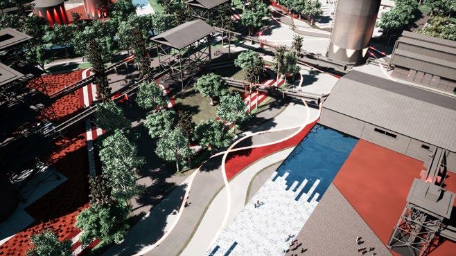
Landscape Architect Project [Design III/-

Location
[Fars Cement Factory, Shiraz, Iran /_
Supervisor [Prof. Mehdi Sheybani /_
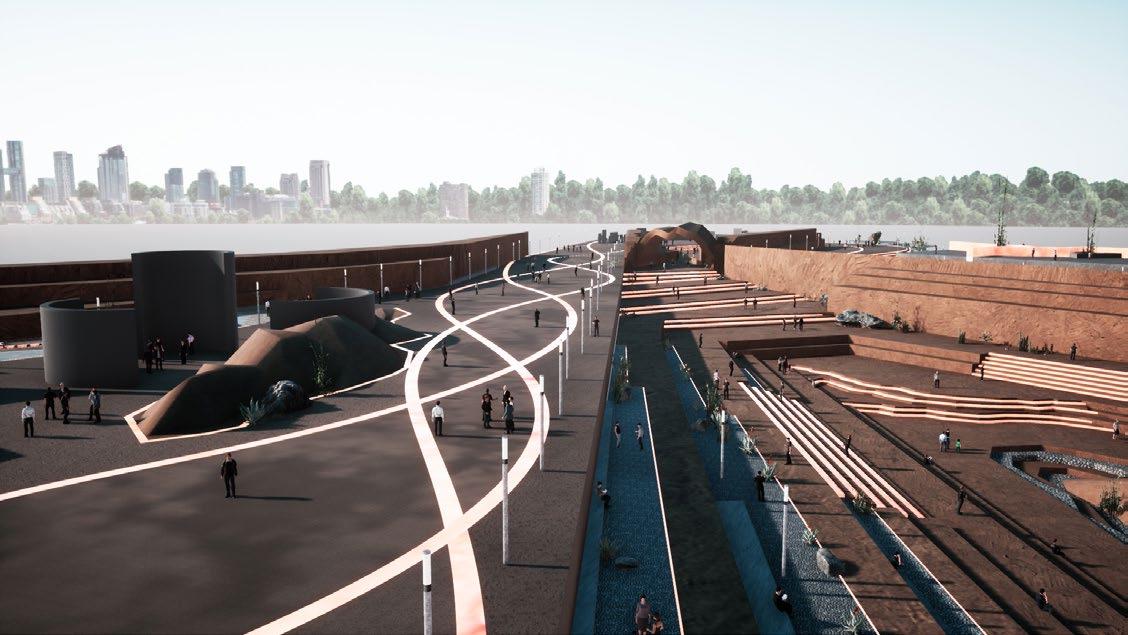
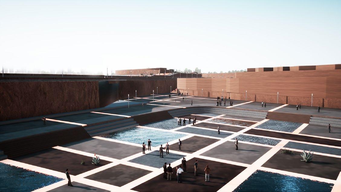
Summary>> Developing a landscape after an industrial site dismantled is a complex process that requires an in-depth understanding of the context in which the site is located as well as careful analysis. The main purpose of this project is to rehabilitate the industrial site so that its devastating effects on the surrounding area and population can be reduced. In order to generate a master plan that would aid in the environmental and ecological redevelopment of the site from the start, the topography and the relevant history of the site, besides the social and economic impacts of the closure of the cement plant were taken into account. The site was divided into two-parts, the industrial and the mining part. In this project, a reintegrated landscape was proposed to offer both an educational function and increase its attractiveness for citizens.
The idea of constructing Shiraz Cement Factory began with the formation of Shiraz Cement Joint Stock Company with the great efforts of men such as Engineer Manouchehr Salvar and Mohammad Namazi and a number of Shirazi philanthropists was proposed in 1947. This factory introduced its production cement to the market in 1955. Afterwards, with the increase in cement consumption, the capacity of the Shiraz factory first increased to 1000 tons in 1967 and 2500 tons per day in 1978
Address: Shiraz, Amir Kabir Boulevard, after Imam Hassan Bridge, at the end of Fakhteh Street


Site plan>> The existing site is divided into two parts: industry and mining. An upper part of the site contains a mine for removing stones and soil and the rest of the materials needed to make cement and factory structures are located in the lower part of the site.

// The site area is about 32,13 hectares

// Current status of the site

/
/ Industrial section /


Ansari-[2024]/Landscape Architecture & Urban Planning & Graphic Design Portfolio]


The path layer is divided into two parts, the main path and the sub-path, so that the main path provides the access to the main functions of the site and the sub-paths give access to less essential and side functions.


The use of native vegetation of the site in the industrial part and in the mining part, vegetation that needs little water.

Installation of fountains and water paths on the site to create a microclimate and modulate the thermal comfort of the space.


Architecture Project /Design III / Industrial site]/-
Industrial site>> For the revival of the Fars Cement Factory, these structures have been converted into book cafes, concert halls, outdoor cinemas, and spaces with educational, cultural, and social functions to encourage interaction between residents and the complex. By using a revitalization approach, the factory history can be kept alive (by creating cultural and educational functions that tell the story of the site and cement) as well as providing useful functions to the nearby residential area.


Utilizing high beam headlights with a large radius of light on the main axis to fully illuminate the path. For different parts, Using linear and spotlighting depending on the function was implemented.


Mineral site>> Three layouts were designed including a metal bridge, rain pool, and entrance of mining zone. Due to the difference in height between the mining and industrial sections, the bridge overlooks the entire area of the industry. The rain garden is a place to collect rainwater and use it to irrigate the complex. And the entrance of the mine, which includes historical and educational information of the mining site, is displayed.


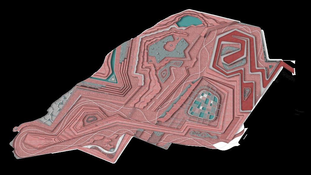

>> The mining part of the design is based on the topographic lines available on the site. Ergo, the least intervention was applied to the zone.


Industrial site / Design III/Landscape Architecture


The lighting of main functions by high beam lights and using hidden linear lighting in stairs and other designed parts for sub-activities and sub-functions of the site.


My Role
/Landscape Architectural Design II | Educational | Team Work/
[ Presenting, Drawing, 3D Modeling, Rendering Part of design concept /

Date
[Winter 2019 /_
Location
[Chamran Blvd, Shiraz, Iran /_
Supervisor [Prof. Mehdi Sheybani /_
[Auto Cad /_ [Photoshop /_ [Rhino/_ [Twinmotion /_
Landscape Architecture Project
[Design II/-
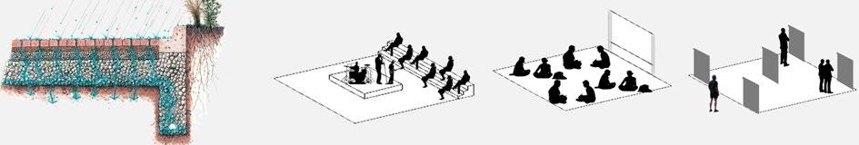
Summary>> The project`s central purpose was to accomplish a complete landscape architecture project in an urban environment that can be used as a pedestrian, different cultural activities and a social area for gathering people. Chamran Boulevard is adjacent to the ancient garden, and some parts of it were designed for public use as a pedestrian. With respect to the fact that people used this area, we decided to design the rest of the site with a multi-cultural function approach. The Khosh River is located across the street, and the site is situated between gardens and the river, creating an ecological zone, so greenery spaces and corridors with waterfalls were added to create a microclimate that increases the desirability of the linear pedestrian in order to create a favorable site for using by people. The site is located in a topographical place. Due to different latitudes, The rout sees some ups and downs to provide a broader view over the Khosh River. In order to provide a safe place, with regards to the presence of roads next to the site, the urban partition of the site was designed to create a distance from the street.

Site plan>> This design includes three cultural, social, and participatory zones; all three layers are designed to meet these functions.

Design process>> In the designing process, the three layers of vegetation, water, and walking paths are utterly compatible with each other so that all aspects of the design, including the creation of a microclimate with optimal heat storage, easy access to the use, and functions, were implemented successfully.


Layout 01 >> Iranian Yard It is a social space that is adjacent to Chamran Gardens. In order to increase the connection between the designing site and adjacent gardens, we designed some openings in walls. Also, native oak and sycamore trees have been planted to provide shade the space. Green infrastructure is embedded in the floor material.


Embedding the sitting space on the water stream as an important element of the landscape and creating a pleasant sound and a favorable space for static.


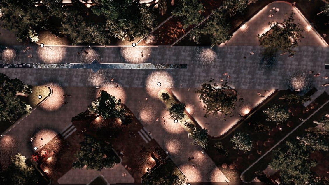
Lighting >> Lighting plan: using LED light strips under the seats and embedded light sources in the floor tiles with soft light to provide a cozy space with light. By Using high beam lights with a high light radius in the main path and less light radius in the side paths, the light completely covers the main and side path range.


Layout02
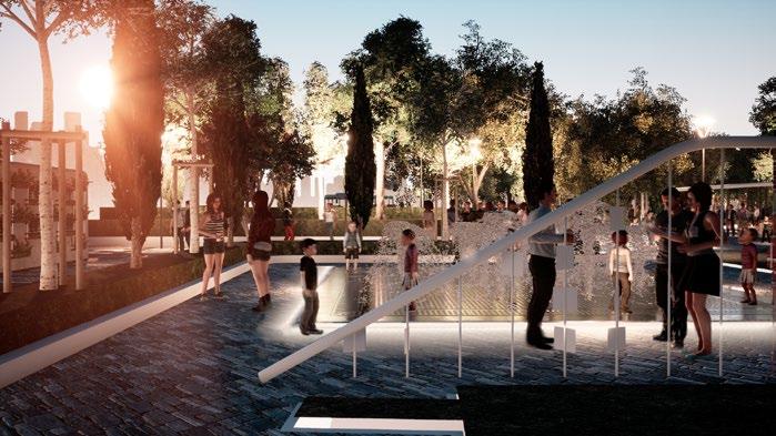
>> This layout is a part of a cultural zone that includes a summer cinema, a Water Garden, and an outdoor theater. A dry fountain is used in the water garden, which allows the children to play with water and touch it. Also, educational plays for children are performed in the outdoor theater areas are away from the street with summer cinema to provide more safety because they are intended for children.


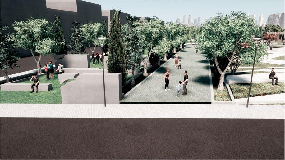
/Landscape Architectural Design I | Educational | Individual Work/

Date
[Spring 2018 /_ Location
[Fazilat Blvd, shiraz, Iran /_
Used Software
Supervisor [Dr. Amin Habibi /_
[Auto Cad /_ [Photoshop /_ [Rhino/_ [Twinmotion /_
Landscape Architecture Project
[Design I/-
Summary>> The project`s main purpose was to design a new public park that could create different and useful public spaces connected to existing services, such as schools, a tennis club, a social forum, and several apartment buildings. In order to reach the project`s concept, the history of people and the place, which was an agricultural field in the past, were analyzed. As a result, the design was able to offer various functions.
>> The story of the place with the development of urbanization: This site was covered with agricultural lands, and these agricultural areas were gradually reduced with the growth of residential units. In 2013, the agricultural area was completely destroyed, and residential blocks were built instead.


absence of residence in the past Agriculture and housing growth


Vineyardsresidential growth Complete destruction of the agricultural area
>> Network story: Each neighborhood has many different aspects, and their situations are affected in connecting to larger networks such as region, city, province, country, and the world.


>> Aspects such as economy, society, technology, environment, culture, road and access network, health, and others are the valuable factors that are assessed to realize the priority of each of them in the design process.
>> This value hierarchy results from a weighting table of values derived from site realities and design needs. Limited economic uses such as supermarkets, cafes, and hairdressers
Strong social interaction in the park for the past two years has been minimized due to urban policies
The site is a favorable agricultural district but this district has been destroyed due to uncontrolled construction, and there are no environmental considerations.

>>Scenarios By reviewing and evaluating the three social and economic factors and technology as the top scenarios Delete it addressed in the plan
01 - Social scenario >>In this section we have tried to design spaces that create the maximum desire in people to have social communication. Because increasing social interaction encourages a sense of belonging, and people do less damage to the environment and also causes more people to participate in neighborhood affairs and lourishing activities.
-[Response to the Value of Social Interaction /[

-[Response to the Value of Economic Interaction /[

-[The answer to the Value of Technology Interaction /[
-[Response to the Value of Environmental Interaction /[

-[Answer the Value of Security Interaction /[ Security

-[The answer to the value of culture and identity/[


02 - Economic scenario >> Creating a productive landscape, followed by a marketplace selling the agricultural products and local products of the residents, increases economic growth and people`s sharing of their productive garden. Using solar energy to generate electricity brings economic and social benefits people are exposed to each other to use electric chargers, for example.
-[Response to the Value of social interaction/[

-[Response to the Value of Economic Interaction/[

-[The Answer to the Value of Technology Interaction/[

-[Response to the Value of Environmental Interaction/[

-[No Residence in the Past /[

-[The Answer to the Value of Culture and Identity/[


03 - Technology scenario >> In this section, technology has been used in water management, electrical energy storage, cultural education, increasing people`s knowledge of the neighborhood through storytelling in digital boards, increasing social interaction through joint viewing of national and international events, flexible structures in different functions.
-[Response to the Value of Social Interaction /[

-[Response to the Value of Economic Interaction /[

-[The answer to the Value of Technology Interaction /[

-[Response to the Value of Environmental Interaction /[

-[Answer the Value of Security Interaction /[

-[The answer to the value of Culture and Identity /[


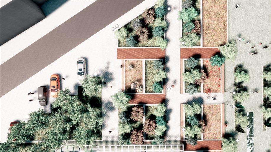

>> In order to respond to the three social, economic, and technological scenarios, the park has various functions, including a children`s play area, picnic, a sport field, local agricultural land, and other activities.


>> The use of local vegetation that provides a chance to have shading in all four seasons in the park site. Plants such as oak, Mediterranean cypress, maple are indigenous to the region, which create a densely green area.


>> The floor is built by permeable materials and Grass decoration in the slut of tiles. Also, the materials are indigenous, which reduces the energy and cost of transporting materials from other places.


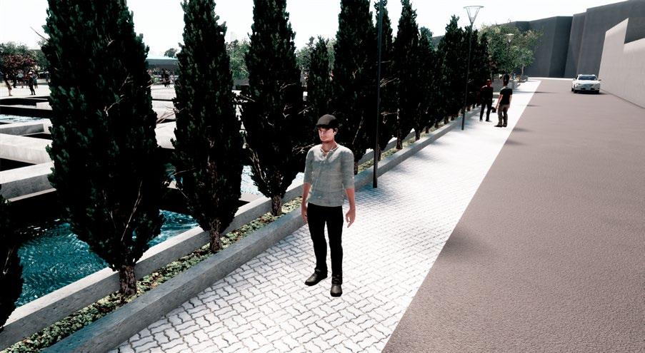


Lighting >> The lighting goal of a landscape design is along with the goals of the site in such a way that it gives a different spirit to the space and creates an attraction for the user to walk along the path. By using different lighting sources according to the value and function of eachspace, the high beam, the high beam is used for full lighting of the path, and in the sub-functions, short and planted beam are used.


/ Details of Connecting Urban Furniture to the Flower Box /


/ Details of the water Crossing in the Participatory Agricultural Landscape / / Details of Surface Water Collection System / / Executive Details of the Pond / / Details of Surface Water Collection System /


>> User Experience (UX) is the overall interaction and satisfaction users experience with a product, service, or system. It involves elements like usability, accessibility, and emotional response. UX design seeks to understand user needs and preferences to create intuitive, enjoyable experiences by considering factors like information architecture and visual aesthetics. Successful UX design leads to enhanced user satisfaction, loyalty, and overall product effectiveness.


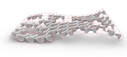
[Patterns/-
>> The grasshopper codes are based on mathematical relations between variables and fundamental parameters. It allows us to have power over all variables and helps us work quickly and make wildly complex patterns. Also, it provides the chance to have unprecedented control over the inputs of the geometry they create.
In mathematics, a Voronoi diagram is a partition of a plane into regions close to each of a given set of objects. In the simplest case, these objects are just finitely many points in the plane (called seeds, sites, or generators). For each seed there is a corresponding region, called a Voronoi cell, consisting of all points of the plane closer to that seed than to any other. The Voronoi diagram of a set of points is dual to its Delaunay triangulation.


In this Grasshopper definition by using the Kangaroo’s Warp & Weft component,we can control different tensile forces on the mesh and then by snapping the naked edge’s point to a series of circles we can control the final tensile tunnel.


In this grasshopper definition you can generate a parametric surface with different truchet patterns. In information visualization and graphic design, Truchet tiles are square tiles decorated with patterns that are not rotationally symmetric. When placed in a square tiling of the plane, they can form varied patterns, and the orientation of each tile can be used to visualize information associated with the tile›s position within the tiling.


Art work [Sketching/-
>> These are some of my sketches during my undergraduate and graduate degree period.
My undergraduate degree was in Architecture Engineering, and by drawing the building and ancient construction, we learned the details and whole structures of the building. Some of them are presented by rapid and the others rando by TOUCH and KURECOLOR marker.
During my graduate degree, which was landscape architecture, we drew some sketches of various gardens and scenes with which we learned the name of a lot of trees and their features. In this vein, we could approach our aim of the landscape major since we recognized the goal of landscape and its connection with people and, actually, urban areas.


[Painting/-
>> These are some of my painting works, which are freehand drawings of some inanimate objects, and landscape scenes with different technics.
/ Color pencil on cardboard
/ Watercolor on pasteboard
/ Pastel on cardboard
/ Charcoal on paper *[>>


Photography [Nature / Buildings / Organisms/-
>> By joining the photography course in 2016, I learned to broaden my horizons which helps me see the architectural building in a different way and to explore some landscape scenes. *[>>

// Nature Firuzabad, Fars, Iran
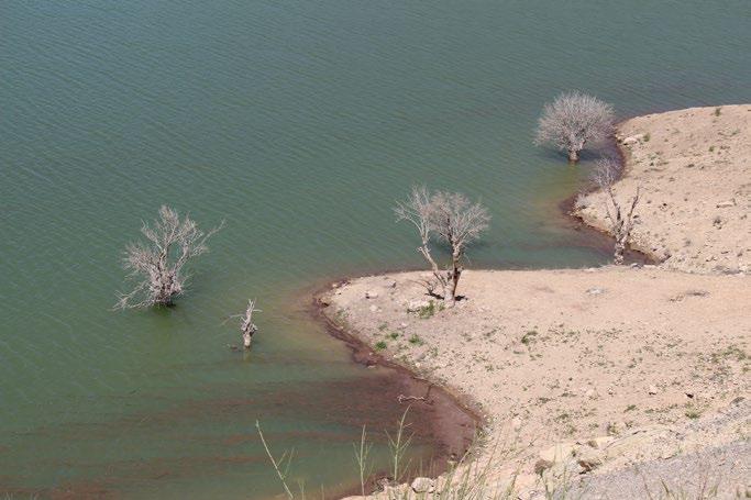
// Nature Firuzabad, Fars, Iran

// Buildings
Afif Abad Garden, Shiraz, Iran

// Organisms
Eram Garden, Shiraz, Iran

// Buildings
Tomb of Saadi, Shiraz, Iran

// Organisms
Tomb of Saadi, Shiraz, Iran

>> It is a workshop, which I attended in 2020. We were taught about visual literacy as a common fine and visual arts, aesthetic, dynamic visual identity, and photography. In this course, our vision through everything has changed and helped us have a more innovative perspective. // RE-Construction
Graphic Projects [Archigraph/-

Section Design


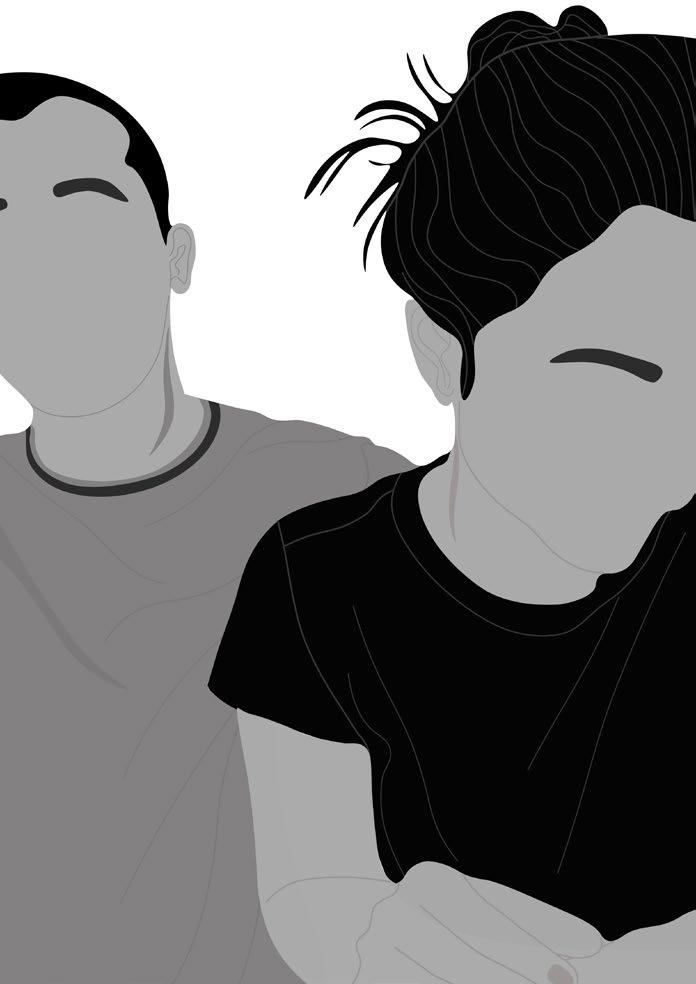
Graphic Projects [Digital Art/-
>> Digital art is a kind of media art that is considered as an artistic work or practice that uses digital technology as part of the creative or presentation process. I use this art to improve my creativity, which helps me imagine everything differently.


Maryam Ansari
Email /[mary.ansari@hotmail.com /]
Mobile phone /[ 17623109064 /]
LinkedIn /[ www.linkedin.com/in/Mary-Ansari /] +
Thank You.