The human scale impact of Dubai's changing global identity

Page 1


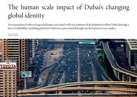
The human scale impact of Dubai’s changing global identity

An assessment of urban design challenges associated with new patterns of development within Dubai through a lens of walkability, including potential solutions as presented through two best practice case studies.

Fidu Properties, 2022)

(Timeout, 2019)

1 Walkability

What is walkability?

The term “walkability” is often contested within academic literature such is the pro-

General Principles of Walkability

Challenge

Speck’s (2012) ‘general theory on walkability’ identifies that in order to be viewed as favourable, walking must be useful, safe, comfortable and interesting. These overarching principles provide a basic framework under which walkability can be understood or assessed.

2

Macro-scale context: Dubai

Dubai faces walkability challenges on a city scale which are mostly attributed to rapid economic and population growth which the city has experienced within the last five decades. The city’s history, rooted in centuries operating as a small trading and fishing settlement, underwent a transformative shift in 1966 with the discovery of significant oil reserves. Subsequent economic diversification and modernization from the 1970s, fueled by oil export revenue, triggered substantial urban expansion and population growth. The images below (Manaugh, 2005) provide a visual representation of the speed and scale of change that has occurred in Dubai.

840

Growth in square kilometres of urban area (1980 - 2012)

1,750,000

Net population increase (1980 - 2012)

(Alawadi and Dooling, 2015)

(Ali et al., 2023)

Types of Urban Growth

‘Bigness’ and City Centre Expansion

‘Bigness’ - an urban model consisting of large-scale, grandiose architecture located within the new city core which has emerged as a successful branding exercise to attract international investment despite flawed urban design principles (Alawadi, 2018).

Urban

Sprawl / Suburban expansion

The most prevelant form of development which Dubai has experienced, consisting of isolated, low-density residential developments segregate neighbourhoods, land uses and the public realm. Critics argue this form of development is institutionalised; the desire for suburban living and the demand for low density is formed by the city’s the cultural and politicalt economy (Alawadi and Benkraouda, 2017a).

(The National, 2023)

(The National, 2020)

Impacts

Unrelenting urban expansion within Dubai presents several challenges from an urban design perspective.

1. Increasing car dependency

Dispersed urban forms and highway-based transport systems have resulted in high levels of car dependency (Hannawi, Jones and Titheridge, 2019) which is compounded by social and environmental factors to result in a cycle of car dependency (Kodukula, 2011).

“Dubai is an automobile-dependent city; most of its urban areas sit inside large super blocks surrounded by multi-lane highways and grade-separated interchanges that restrain accessibility”

(Alawadi, 2016, p. 360).

2. Deterioration of walking environment

Through the car dependency cycle, vehicles become more prevelant and are increasingly prioritised. As a result, infrastructure and urban design solutions are vehicle-oriented and elements of place which contribute to walkability begin to be lost.

(Alawadi and Benkraouda, 2017b)

3. Disconnection with human scale

The fragmentation of urban form has resulted in a disconnect between physicality (ie. buildings) and the human scale. Neighbourhoods are bounded by roads, walls and open spaces, all of which disconnects people with place and eachother (Alawadi, Alameri and Scoppa, 2020; Alawadi, Khaleel and Benkraouda, 2020).

Bigness / City Centre Expansion
Urban Sprawl
(Google Maps)

3 Micro-scale context: Oud al Muteena

The suburban development of Oud al Muteena is located to the east of Dubai’s original city core, beyond Dubai International Airport. The old town of Dubai lies approximately 10 kilometres from the site, with the contemporary developments taking place within downtown and marina areas located in excess of 40 kilometres away. The site was developed in 2016 and is a useful case study as it is typical of the suburban forms of residential development which the city continues to embrace (Alawadi, Khaleel and Benkraouda, 2020).

Scale and Density

Just 1,600 houses have been constructed so far within Oud Al Muteena across an area spanning 239 hectares (Ahmed and Alipour, 2021). Whilst the scale of the development is clear, this also highlights how low the density of development is within Oud Al Muteena .

6.6

Dwellings per Hectare

Block Size and Route Layouts

The scale of the development embeds a range of challenges from an urban design perspective. Block sizes contained within the development are far too large to provide an appropriate number of routes for pedestrians. Some blocks are as much as 400 metres long, with no permeable routes through This results in physically and perceptually longer journeys - a characteristic of poor walkability as identified by Southworth (2005).

Land Use

Urban blocks mostly consist of the same land use, with a high concentration of residential uses confined to specific areas. The lack of mixed uses results in a monotonous street scene and increased journey lengths to access key goods and services which are also often located within the same area.

Human Scale Impacts

It is clear that vehicles are prioritised within the local transport heirarchy Dedicated areas of shading are given over to vehicles, whereas for pedestrians there is no dedicated walkway, regardless of shading. Excessive space is afforded to vehicles and there is no equity between transport modes.

Although walkways are provided, there is no established or formalised network and it appears footpaths are provided as a luxury rather than as a basic requirement.

High perimeter walls and gates create a stong defensive boundary with properties set back from the road. This results

in a poor level of natural surveillance.

(MBRHE, no date)
(MBRHE, no date)
(Images: Google Maps)

4

Best Practice: Msheireb, Doha

The Msheireb Downtown Doha project is a new district of the City created as part of a major regeneration initiative which aims to transform a dilapidated part of the city into a modern, sustainable and culturally rich urban environment. The site is strategically located within the heart of Doha and has successfully delivered a new walkable neighbourhood with mixed uses and a high quality public realm.

Combining privacy and density

• The use of compact urban blocks enables the provision of private inner courtyards from which independent townhouses are accessed. This successfully provides enhanced privacy whilst being land efficient.

• This, in combination with the selective removal of cars for certain routes, provides a good level of enclosure to walkways which naturally then benefit from passive shading and a degree of natural surveillance.

• High quality Green and Blue infrastructure is sustainably integrated into the public realm to help create interest within the street scene for pedestrians as well as helping to cool public areas.

Like Dubai and many other gulf cities, Doha has imported automobile dependent, suburban forms of development similar to Dubai. This development provides a best practice solution as an alternative form of urban expansion which is land efficient and provides a high level of walkable access for users.

• These human scale details are complimented by a sensitive street lighting strategy to improve safety in hours of darkness, passive shading, high quality street furniture and a multi-modal, shared public realm which integrates tram infrustructure without detriment to pedestrians.

Msheirib
Doha Airport
Port of Doha
Central Doha
Sensitive street lighting
Prominent Green and Blue Infrastructure
Multi-modal, shared public realm
High quality street furniture Passive shading
Adequate space given over to pedestrians
Management of Route Heirarchy to ensure no vehicle dominant routes within development
Vehicle free inner core of development (except servicing)
Clear urban block structure
Compact Townhouse housing types form tight urban blocks Combining Privacy and Density
(Squire and Partners, no date)
(Allies and Morrison, no date)
(Archdaily, 2021)
(Monocle, 2022)
(Monocle, 2022)

5 Best Practice: Masdar, Abu Dhabi

Masdar City is an urban development project launched with the aim of being the world’s most sustainable new city, using cutting-edge technology and innovative design principles to create the city of the future. The city aims to be entirely powered by renewable energy, promotes sustainable transport, uses the latest and most innovative forms of building design and adopts sustainable methods of water management, all of which create a city which is unlike any other in the world.

Density and Enclosure

• A layered urban block structure was created in Masdar in order to ensure that spaces were connected with eachother. Traditional grid iron block structures were re-interpreted and contextually applied - creating pedestrian ‘sikkaks’ which act as narrow passageways linking internal courtyards and public spaces.

(Cugurullo and Ponzini, 2018)

Relevance

Masdar City is most known globally for its proven sustainability in every aspect of urban life, facilitated by a significant budget incomparable to any other project. However, Masdar lies within a similar cultural, geographic and climate context to Dubai which makes it an appropriate case study for observation. Observing Masdar solely from the perspective of could significantly improve and enhance walkability within Dubai’s suburbs.

Designing for thermal comfort

Pedestrian focused Building for higher density

• The use of apartments enables higher density development which can have a lower interface distance due to the removal of cars. Overall, this creates a walk ing environment which is safer, more comfortable and more efficient.

Designing for thermal comfort

The absence of cars allows streets to be shorter and narrower, increasing levels of enclosure and passive solar shading which result in streets only receiving 30-45 minutes of direct sunlight per day (Caine, 2014).

In addition, cooling air currents are generated using a contemporary interpretation of the region’s traditional wind towers (Foster and Partners, no date), with the passage of air currents encouraged by a rigid grid block structure.

10 - 15 ° C

Average difference in temperate between Masdar and downtown Abu Dhabi (Caine, 2014).

(Foster and Partners, no date)
(CBT Architects, no date)
(Caine, 2014)

6 Conclusions

Walkability is a naturally problematic urban design challenge within Dubai. It is clear that Dubai is experiencing (and perhaps promoting (Alawadi and Benkraouda, 2017a)) significant suburban sprawl, resulting in negative outcomes for walkability at the micro scale. However, best practice examples indicate that more walkable environments are possible within the same socio-economic and cultural contexts.

Micro-scale interventions

Macro-scale change

The best practice solutions provide a range of possible interventions which can help to improve the walkability of Oud Al Muteena. However, securing the delivery of these important features of urban design to promote walkability can be difficult without change to existing policies. Abu Dhabi’s ‘Urban Street Design Manual’ provides a good example of how this may be achieved, though can only be truly useful if it is consistently applied.

Improving walkability and the pedestrian experience within Dubai also requires a more strategic change in approach. As a typical example of urban sprawl, developments at low density as found within Oud Al Muteena are unsustainable over the long term. A shift toward building neighbourhoods at higher densities is neccessary to provide greater accessibility and efficiency so that walking is also efficient.

Dubai’s old town (above) is socially undesirable and is not marketed as a place to visit or invest but has good walkability. Targetted regeneration would help to provide thousands of homes within neighbourhoods that are truly walkable.
Application of the micro-scale best practice solutions from Masdar and Msheireb could provide immediate improvements to the walkability of Oud Al Muteena (above).
(Dovey and Pafka, 2019)
(Propsearch, 2023)
Taller buildings creates increased levels of enclosure
space given over to pedestrians Increased densities and reduced set backs help to induce passive solar shading

(Adobe Stock, no date)

Bibliography

Adobe Stock. (no date). Al Seef Traditional Historical District Arabic Architecture. Dubai Deira Old Town. United Arab Emirates. Middle East Available at: https://stock.adobe.com/images/al-seef-traditional-historical-district-arabic-architecture-dubai-deira-old-town-united-arab-emirates-middle-east/488605221 [Accessed 9 January 2024].

Ahmed, K. G. and Alipour, S. M. H. (2021). ‘More dense but less walkable: the impact of macroscale walkability indicators on recent designs of emirati neighbourhoods’, City, territory and architecture 8:12, pp. 1-26.

Al-Hagla, K.S. (2009). ‘Evaluating New Urbanism’s walkability performance: a comprehensive approach to assessment in Saifi Village, Beirut, Lebanon’, Urban Design International, 14, pp. 139-151.

Alawadi, K. (2016). ‘Rethinking Dubai’s urbanism: generating sustainable form-based urban design strategies for an integrated neighbourhood’, Cities 60, pp. 353–366.

Alawadi, K. (2018). ‘Whatever happened to Dubai’s public spaces?’, International Journal of Middle East Studies, 50(3), pp. 562 – 567.

Alawadi, K. and Benkraouda, O. (2017a). ‘The debate over neighbourhood density in Dubai: Between theory and practicality’, Journal of Planning Education and Research, 39(1), pp. 18-34.

Alawadi, K. and Benkraouda, O. (2017b). ‘What happened to Abu Dhabi’s urbanism? The question of regional integration’, Journal of Urban Design, 23(3), pp. 367-394.

Alawadi, K. and Dooling, S. (2015). ‘Challenges and opportunities for participatory planning approaches within Dubai’s urban context’, International Research on Placemaking and Urban Sustainability, 9(3), pp. 1-26.

Alawadi, K., Alameri, H., & Scoppa, M. (2020). ‘Reclaiming Alleyways to improve network connectivity: Lessons from Dubai’s neighborhoods’, Journal of Planning Education and Research, 43(4), pp. 917-939.

Alawadi, K., Khaleel, S. and Benkraouda, O. (2020). ‘Design and planning for accessibility: Lessons from Abu Dhabi and Dubai’s neighbourhoods’, Journal of Housing and the Built Environment 36, pp. 487-520.

Ali, M., Ali, T., Gawai, R. and Elaksher, A. (2023). ‘Fifteen-, ten-, or five minute city? Walkability to services assessment: Case of Dubai, UAE’, Sustainability 15, pp. 1-24.

Allies and Morrison. (no date). Msheireb Downtown Doha Available at: https://www.alliesandmorrison.com/projects/msheireb-downtown-doha [Accessed 9 January 2024].

Archdaily. (2021). Msheireb Downtown Doha Masterplan / Allies and Morrison + AECOM + Arup. Available at: https://www.archdaily.com/966087/msheireb-downtown-doha-masterplan-allies-and-morrison-plus-aecom-plus-arup [Accessed 9 January 2024].

ARUP. (No date). Walking cities are better cities Available at: https://www.arup.com/perspectives/walkable-cities-are-better-cities [Accessed 9 January 2024].

Baobeid, A., Koç, M. and Al-Ghamdi, S. G. (2021). ‘Walkability and its relationships with health, sustainability and livability: Elements of physical environment and evaluation frameworks’, Front. Built Environ. 7:721218, pp. 1-17. Caine, T. (2014). Inside Masdar City. Available at: https://www.archdaily.com/517456/inside-masdar-city?adcampaign=normal-tag [Accessed 9 January 2024].

CBT Architects. (no date). Masdar Streetscapes. Available at: https://www.cbtarchitects.com/project/masdar-streetscapes [Accessed 9 January 2024].

Cugurullo, F. and Ponzini, D. (2018). ‘The transnational smart city as urban eco-modernisation: the case of Masdar City in Abu Dhabi’, in Karvonen, A., Cugurullo, F. and Caprotti, F. (eds) Inside Smart Cities: Place, Politics and Urban Innovation London: Routledge, pp. 149-162.

Dovey, K. and Pafka, E. (2019). ‘What is walkability? The Urban DMA’, Urban studies 57(1), pp. 93-108.

Fidu Properties. (2022). ‘Dubai population to surge to nearly 6M in 20 Years amid Urban Transformation’, January 23 [Online]. Available at: https://www.299.com/fidu-news-details/dubai-population-to-surge-to-nearly-6m-in-20-years-amid-urban-transformation [Accessed 29 November 2023].

Forsyth, A. (2015). ‘What Is a Walkable Place? the Walkability Debate in Urban Design’, Urban Design International 20, pp. 274–292.

Foster and Partners. (no date). Masdar Institute. Available at: https://www.fosterandpartners.com/projects/masdar-institute [Accessed 9 January 2024].

Gehl, J. (1980). ‘The residential street environment’, Built Environment, 6(1), pp. 51–61.

Bibliography

Gehl, J. (2010). Cities for People. Washington: Island Press.

Glaeser, E. L. and Kahn, M. E. (2004) .’Sprawl and Urban Growth,’ in Henderson, J. V. and Thisse, J, F. (eds) Handbook of Regional and Urban Economics London: Elselvier, pp. 2481-2527.

Hannawi, N., Jones, P. and Titheridge, H. (2019). ‘Development of transit oriented development in Dubai City and the Gulf States’, in Knowles, R. D. and Ferbrache, F. (eds) Transit Oriented Development and Sustainable Cities. Cheltenham: Edward Elgar, pp. 29-50.

Jacobs, J. (1961). The life and death of Great American Cities New York: Random House.

Kodukula, S. (2011). ‘Rising Automobile Dependency: How to break the trend?’, Sustainable Urban Transport Technical Document 8.

Liu, C. P. and Titheridge, H. (2016). ‘The influence of built environment and perceived walkability on walking behaviour in Taiwan’, Proceedings of the World Conference on Transport Research Shanghai, 10-15 July 2016, pp. 1-16.

Manaugh, G. (2005). ‘Dubai before and after’, BLDGGLOG, 14 November. Available at: https://www.bldgblog.com/2005/11/dubai-before-and-after/ [Accessed 29 November 2023].

MBRHE. (no date). Oud Al Muteena 2007 Available at: https://www.mbrhe.gov.ae/en/Projects/2007-Oud-Al-Muteena [Accessed 9 January 2024].

Monocle. (2022). 3. Mixing the old with the new Available at: https://monocle.com/magazine/msheireb-properties/2/3-mixing-the-old-with-the-new/ [Accessed 9 January 2024].

Nakamura, K. (2020). ‘Experimental analysis of walkability evaluation using virtual reality application’, Environment and Planning B: Urban Analytics and City Science 48(8), pp. 2481–2496.

Nassr, A. K., Blackburn, G. A. and Whyatt, J. D. (2014). ‘Developing the desert: The pace and process of urban growth in Dubai’, Computers, Environment and Urban Systems 45, pp. 50-62.

Othman, Z., Aird, R. and Buys, L. (2015). ‘Privacy, modesty, hospitality, and the design of Muslim homes: A literature review’, Frontiers of Architectural Research, 4(1), pp. 12-23.

Propsearch. (2023). Old Town. Available at: https://propsearch.ae/dubai/old-town [Accessed 9 January 2024].

Southworth, M. (2005). ‘Designing the Walkable City’, Journal of Urban Planning and Development 131, pp. 246–257.

Speck, J. (2012). Walkable City: How Downtown can save America, one step at a time. Berkeley: North Point Press.

Squire and Partners. (no date). Msheireb Downtown Doha (Masterplan) Available at: https://squireandpartners.com/architecture/msheireb-downtown-doha/ [Accessed 9 January 2024].

Sto.com. (no date). Msheireb Downtown Doha Development, Qatar. Available at: https://www.sto.com/en/gallery23361.html?anchor=item4&back=/en/references/references-detailview23616.html [Accessed 9 January 2024].

The National. (2020). Emaar launches new residential tower in Downtown Dubai Available at: https://www.thenationalnews.com/business/emaar-launches-new-residential-tower-in-downtown-dubai-1.962462 [Accessed 9 January 2024].

The National. (2023). Moving to Dubai: Best residential areas to rent by budget. Available at: https://www.thenationalnews.com/uae/2022/11/21/moving-to-dubai-best-residential-areas-by-budget/ [Accessed 9 January 2024].

Timeout. (2019). Best Places to go walking in Abu Dhabi Available at: https://www.timeoutabudhabi.com/sports-wellbeings/sport-features/427462-best-places-to-go-walking-in-abu-dhabi [Accessed 9 January 2024].

Tobin, M., Hajna, S., Orychock, K., Ross, N., DeVries, M., Villuneuve, P. J., Frank, L. D., McCormack, G. R., Wasfi, R., Steinmetz-wood, M., Gilliland, J., Booth, G. L., Winters, M., Kestens, Y., Manaugh, K., Rainham, D., Gauvin, L., Widener, M. J., Muhajarine, N., Luan, H. and Fuller, D. (2022). ‘Rethinking walkability and developing a conceptual definition of active living environments to guide research and practice’, BMC Public Health 22:450, pp. 1-7.

Turn static files into dynamic content formats.

Create a flipbook
Issuu converts static files into: digital portfolios, online yearbooks, online catalogs, digital photo albums and more. Sign up and create your flipbook.